Part 3 Strategic plan - Western Downs Regional Council · Western Downs Planning Scheme | June 2017...
57
Western Downs Planning Scheme | June 2017 3 -1 Part 3 Strategic plan 3.1 Preliminary (1) The strategic plan sets the policy direction for the planning scheme and forms the basis for ensuring appropriate development occurs in the planning scheme area for the life of the planning scheme. (2) Mapping for the Strategic plan is included in Schedule 2. (3) For the purpose of describing the policy direction for the planning scheme, the strategic plan is structured in the following way: (a) the strategic intent; (b) the following five themes that collectively represent the policy intent of the Scheme: (i) Livable Communities and Housing; (ii) Environment and Heritage; (iii) Economic Growth; (iv) Infrastructure; and (v) Safety and Resilience to Hazards. (c) the strategic outcome(s) proposed for development in the planning scheme area of each theme; (d) the element(s) that refine and further describe the strategic outcome(s); (e) the specific outcomes sought for each, or a number, of elements; (f) the land use strategies for achieving these outcomes. (4) Although each theme has its own section, the strategic plan in its entirety represents the policy intent for the planning scheme.
Transcript of Part 3 Strategic plan - Western Downs Regional Council · Western Downs Planning Scheme | June 2017...
Western Downs Planning Scheme | June 2017 3 -1
Part 3 Strategic plan
3.1 Preliminary
(1) The strategic plan sets the policy direction for the planning scheme and forms the basis for ensuring appropriate development occurs in the planning scheme area for the life of the planning scheme.
(2) Mapping for the Strategic plan is included in Schedule 2.
(3) For the purpose of describing the policy direction for the planning scheme, the strategic plan is structured in the following way: (a) the strategic intent; (b) the following five themes that collectively represent the policy intent of the Scheme:
(i) Livable Communities and Housing; (ii) Environment and Heritage; (iii) Economic Growth; (iv) Infrastructure; and (v) Safety and Resilience to Hazards.
(c) the strategic outcome(s) proposed for development in the planning scheme area of each theme;
(d) the element(s) that refine and further describe the strategic outcome(s); (e) the specific outcomes sought for each, or a number, of elements; (f) the land use strategies for achieving these outcomes.
(4) Although each theme has its own section, the strategic plan in its entirety represents the
policy intent for the planning scheme.
Western Downs Planning Scheme | June 2017 3 -2
3.2 Strategic Intent 3.2.1 Regional, local and historical context
(1) The Western Downs is located in the south-west Queensland, its eastern boundary located approximately 75 kilometres north-west of Toowoomba and 200 kilometres west of Brisbane (refer to Figure 1.1 – Local Government Planning Scheme Area and Context ).
(2) The Western Downs stretches across a vast expanse of Queensland’s rich agricultural
heartland, covering a land area of 38,039 square kilometres.
(3) The region comprises the towns of Chinchilla, Dalby, Jandowae, Miles, Tara and Wandoan as well as numerous rural settlements. The regions spatial plan and settlement pattern is reflective of the roles and function that each of these towns play in contributing to the Western Downs activity centre network.
(4) The Western Downs contains a rich and varied cultural landscape that is of particular
significance to local Indigenous communities. The cultural significance of the landscape includes traditional and spiritual associations with a number of places as well as association with living within the landscape.
(5) The predominantly rural landscape of the Western Downs is bordered to the east by the
Bunya Mountains National Park. Rainforest clad peaks shelter the largest remnant stand of ancient Bunya Pines in the world. The temperate mountain climate, waterfalls and grass topped plateaus have a special significance to the local Indigenous population, and contribute to the nature based tourism opportunities in the region.
(6) A number of National Parks and State Forests, including Barakula, the largest State Forest in
Australia protect an arc of vegetation that stretches across the northern parts of the Western Downs region. The Western Downs is also home to the largest stand of Brigalow in the southern hemisphere. A complex system of waterways dominates the predominantly flat landscape, including the Condamine and Moonie Rivers. The Great Artesian Basin and the Condamine Alluvium are critical natural resources that support the Western Downs ecology, economy and community.
(7) The Western Downs was discovered in the mid 1800’s by the explorer Ludwig Leichhardt.
Early European settlers took advantage of the fertile soils and grassy plains to establish a number of large pastoral stations. To this day, the productive lands of the Western Downs provide the foundation for the region's character and economic prosperity by facilitating growth within the grazing, intensive animal industries, extractive industries, cereal crops and forestry activities.
(8) The main transport corridor of the Warrego highway forms the east-west spine supporting
economic development and social exchange across the region, linking to Toowoomba in the east and Roma in the west. The Leichardt Highway is the north-south conduit linking Rockhampton in the north and Melbourne in the south. Passenger rail linkages are currently limited, with the existing east west railway line transporting coal and grain from the region to the strategic port facilities of Brisbane.
(9) The Western Downs represents a significant proportion of the Surat Basin, a rich energy
province extending from central southern Queensland to central northern New South Wales including the Western Downs, Maranoa and Toowoomba Regional Council areas. With significant proven reserves of thermal coal and coal seam gas located in the Surat Basin, the Western Downs has and will continue to undergo change and growth. The changes will not only impact on the economy of the region, but will also have impacts on growth management, including infrastructure provision, environmental protection and the retention of the lifestyle so valued by the existing community. The resource and coal seam gas industries are finite resources and therefore a balance must be achieved in growth management between short and long term land use impacts.
(10) The Western Downs is the energy capital of Queensland supplying a diversity of gas, solar
and coal electricity to the national electricity grid via an array of power stations and high
Western Downs Planning Scheme | June 2017 3 -3
voltage transmission lines that stretch across the landscape. 3.2.2 Opportunities and challenges (1) The following opportunities and challenges are the most significant issues expected to define
future development within the region (but are not limited to), and set out the key matters the strategic plan and/or planning scheme as a whole seek to address.
3.2.2.1 Housing need
(1) As has been the trend in most parts of Australia, the region is anticipated to experience an ageing of its population such that the median age is forecast to increase from 37 years in 2006 to 41 years in 2031 (Foresight Partners, 2010). Typically, this would result in a decline in average household size as older persons are statistically more likely to live in households of two persons or less (“empty nesters”). However, a decline in average household size is predicted to be offset by family migration to the region, such that couples with children are expected to remain the dominant household type (Foresight Partners, 2010). Therefore, for the purposes of the planning scheme, housing need is based on 2.6 persons per household.
(2) With population growth, will come the need for growth in other land uses zonings such as industrial, retail and commercial land. The planning scheme has ensured that there is sufficient land to cater for future development across all zones. Where necessary, mechanisms have been put in place in order to protect land for future uses (i.e. the inclusion of investigation areas).
(3) Fly-in/fly-out (FIFO), drive-in/drive-out (DIDO) non-resident temporary workers may relocate to the region on a temporary basis. Accommodation for these workers is and can be met by the current accommodation providers in the region. It is necessary to ensure that sufficient accommodation options are available for non-resident temporary workers given that housing affordability can become an issue for people in lower low socio-economic brackets should non-resident temporary workers reside in dwellings in residential areas.
(4) Council encourages operational workforces to reside in the region to become residents and to contribute to the social fabric of our community.
3.2.2.2 Managing the growth of the resources and en ergy sector
(1) The Western Downs has and is experiencing growth in the mineral and gas resource sectors, particularly in relation to the development of the coal and coal seam gas (CSG) industry within the Surat Basin.
(2) Mineral, gas and extractive industry activities have the potential to positively and negatively
impact the triple bottom line, including potential: (a) negative environmental impacts, arising from vegetation clearing, salinity, loss of arable
land, ground water and surface water disturbance and loss of air quality through particulate emissions;
(b) positive and negative economic impacts arising from, housing price fluctuation, growth in and emergence of complementary industries and services, social and physical infrastructure demands;
(c) positive and negative social impacts including, increased employment opportunities, shifts in sectorial employment, housing shortages, social instability, lifestyle, health and amenity impacts, and loss of generational farming communities.
(3) The likely impacts of the rapidly expanding resources sector on the Western Downs are
highly dependent on the location, magnitude and operation of individual mining and petroleum projects. Notwithstanding, the flow-on effects of this sector are likely to result in demand spikes in non-resident workforce accommodation and supporting services, including industry, retail and commercial activities.
(4) Whilst the growth of the resources sector provides a significant opportunity to diversify the
economic base of the Western Downs, it is necessary to ensure that rural industries which
Western Downs Planning Scheme | June 2017 3 -4
underpin the cultural identity of the region are protected.
(5) Population growth, including the influx of non-resident workers associated with the mining and resource sectors, is likely to impact on the physical and social fabric of Western Downs. It is important to ensure that individual settlements are maintained as strong and resilient communities that can adapt positively to future opportunities and challenges.
3.2.2.3 Protecting the natural environment
(1) The Western Downs retains large areas of native vegetation that is habitat for fauna communities. Including regionally significant landscapes such as the Bunya Mountains National Park, Barakula State Forest, Southwood State Forest, the wildflower area north-west of Miles, Brigalow country and biodiversity corridors.
(2) Growth pressures present a challenge to maintain the ecological integrity of the natural
environment that underpins the health and prosperity of the region.
(3) Careful management of both surface and groundwater health and supplies is needed to protect the quality and quantity of urban and environmental water resources, including maintenance of flows in the Condamine and Balonne river catchments, as well as significant groundwater reserves that form part of the Great Artesian Basin and Condamine Alluvium.
(4) Support the protection of waterways, waterbodies and other aquatic features, and associated riparian areas and instream habitats, for fisheries productivity and sustainability.
3.2.2.4 Economic resilience
(1) A stable supply of industrial land to 2026 (and beyond) is vital to ensure that the Western Downs is well placed to service local industrial needs and value add to the growing resources sector. Dalby and Chinchilla represent the majority of the established industrial capacity in the Western Downs, and opportunities to strengthen the capability of these industries should be sought in an effort to adapt and expand. Miles has an opportunity to value add to the resources sector and function as multi-modal hub (road, rail and air).
(2) Agriculture, forestry and fishing represents approximately 25% of the Western Downs
economy and therefore the protection of this sector from competing impacts and alienation and fragmentation is necessary to maintain a healthy long-term economy.
(3) There is sufficient opportunity to meet commercial and retail demand within existing Activity
centres to 2026, however future development should give consideration to a need for a second discount department centre anchored by a major supermarket in Dalby, by 2031 (beyond the life of the planning scheme).
(4) The fostering of home based business and other small business enterprise is considered
necessary to advance economic development in the Western Downs and to create emerging industries and entrepreneurship.
(5) The proper protection and management of the landscape character elements of the region
will contribute to economic development through enabling the promotion of tourism based enterprise.
3.2.2.5 Natural hazards and climate change
(1) Flood is a natural hazard facing urban and non-Urban areas in the Western Downs and represents a constraint to the development of existing Urban areas including Dalby, Chinchilla, Miles, Tara and Jandowae. Flood hazard also limits the urban expansion options for many Urban areas.
(2) In 2050, climate change projections for the Western Downs Region indicate:
(a) an increase in the mean temperature of between 1.3 and 2.2 degrees celcius; (b) decreased rainfall in the order of minus 4 to minus 6 percent per annum;

Western Downs Planning Scheme | June 2017 3 -5
(c) increased evaporation in the order of 3 to 6 percent per annum; (d) increased rainfall intensity resulting in a worsening of flood events; (e) increased pressure on water supplies; (f) increased risk of heat related illness; (g) increased frequency and intensity of bushfires; and (h) reduction in grain quality due to increased temperature, evaporation and decreased
rainfall. Source- Climate Change in Queensland – What the Science is Telling Us (2010) Office of Climate Change, Queensland Government
Western Downs Planning Scheme | June 2017 3 -6
3.3 Livable communities and housing 3.3.1 Strategic outcomes
(1) The settlement pattern of the Western Downs supports, enhances and consolidates the existing network of communities and urban areas located on the Warrego highway as the primary locations for future urban growth and service delivery.
(2) The settlement pattern manages projected population growth and distribution by ensuring
sufficient urban land is available that avoids biophysical constraints and natural hazards, protects natural resources, maintains the character and integrity of individual communities and ensures the delivery of necessary infrastructure and services.
(3) The settlement pattern contains urban development within identified boundaries to create
compact, diverse and vibrant communities. Significant urban development for residential purposes takes advantage of the access to existing facilities and services. The settlement pattern maximizes the utilisation of existing infrastructure and maintains and enhances access to services, employment opportunities and recreational and social infrastructure for all residents.
(4) The settlement pattern provides opportunities for industrial growth to cater for the increase in
local businesses required to service the needs of the resource and agricultural sectors. Industrial development is directed to areas separated from land uses that are considered to be sensitive or at risk from the impacts of industrial activity. Industrial land is located in accessible locations supported by transport infrastructure and necessary urban services to efficiently service the needs of the community.
(5) Rural residential development provides an alternative style of living that meets the diverse
lifestyle needs of the regions residents. Rural residential development has good access to necessary infrastructure and services and contained to limit the further fragmentation of productive rural lands. Rural residential development is also located in nodes to avoid long-term constraints to the expansion of Urban areas.
(6) The settlement pattern of the Western Downs contributes to the achievement of sustainable
and resilient communities. Urban development is compact and walkable with pedestrian and cycle linkages connecting residential areas with service and employment nodes minimizing the reliance on private vehicle use.
(7) The future pattern identifies and protects future Urban areas that may potentially
accommodate future urban growth beyond the anticipated life of the planning scheme. Future urban, Rural residential and industrial investigation areas are identified in the event that this land is protected outside the life of the planning scheme.
(8) Where development is not consistent with the purpose and intent of the zone, overriding
community need will need to be demonstrated as well as valid planning justification provided as to why the proposed use cannot be reasonably established in a more appropriate zone.
(9) The unique identity of the urban centres and rural townships in the Western Downs is
recognised and strengthened through complementary development that positively contributes to the regional identity of the Western Downs.
(10) The provision of diverse social and community infrastructure, open space and sport and
recreation facilities network across the Western Downs promotes a happy, active, healthy, and connected community.
(11) The health, wellbeing and safety of the community are fundamental elements of the identity
and character of the communities of the Western Downs. All residents, both temporary and permanent, participate in the rich community life of the region and generate high levels of social capital that promotes community cohesion.

Western Downs Planning Scheme | June 2017 3 -7
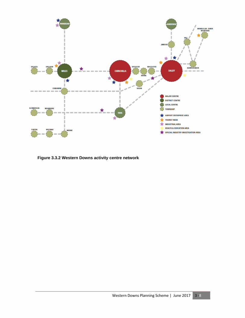
3.3.2 Element - Network of centres
(1) The network of centres identifies a hierarchy of Activity centres and Townships across the Western Downs. The hierarchy ensures that population growth is appropriately managed and coordinated to provide urban services, employment opportunities and social services in accordance with the identified role and function of the Activity centre or Township.
3.3.2.1 Specific Outcomes
(1) Chinchilla and Dalby accommodate the largest concentration of urban land uses and development in a compact, vibrant and active Major centre. Both centres accommodate regionally significant health care facilities, business services, manufacturing and retail markets, education facilities, government services, entertainment and sporting facilities and civic spaces and functions.
(2) Miles functions as a District Centre and has a specialist function as a regional service hub and
industrial centre driven by its proximity to resource sector activity in the surrounding district.
(3) Chinchilla, Miles and Wandoan are the focus for permanent and temporary non-resident worker accommodation and take advantage to the proximity to current and future resource sector activities in the district and the established urban service networks. Larger forms of permanent and temporary non-resident worker accommodation are predominantly located in Dalby, Chinchilla and Miles to minimise the social and economic impacts on other centres.
(4) Miles and Wandoan are transport and service hubs for the resource and agricultural sectors.
Their accessibility to transport corridors, proximity to emerging resource sector activities and availability of well serviced industrial land is utilised to support the supply chain servicing resource sector operations in the Western Downs and throughout the eastern part of the Surat Basin. Development of an intermodal transport and logistics hub is supported in Miles given its location to transportation routes.
(5) Townships provide for limited urban development and serve to meet the daily needs of the
surrounding rural district, consistent with the scale and intensity of existing urban activities
3.3.2.2 Land use strategies
(1) Urban development in Activity centres and Townships is consistent with the intent of the Western Downs Activity centre Network and Township zone hierarchy identified on strategic plan Map 1 – Settlement Pattern:
Major Centre Dalby, Chinchilla
District Centre Miles
Local Centre Tara, Jandowae, Wandoan
Rural township Bell, Brigalow, Condamine, Dulacca, Glenmorgan, Kaimkillenbun, Jimbour, Macalister, Meandarra, Drillham, Moonie, Mowbullan-Bunya Mountains, Warra, Kogan, Westmar and Flinton
Western Downs Planning Scheme | June 2017 3 -8
Figure 3.3.2 Western Downs activity centre network
Western Downs Planning Scheme | June 2017 3 -9
3.3.3 Element - Compact urban form
(1) Urban Centres and Townships in the Western Downs have a compact, functional and efficient urban form that supports the establishment of walkable communities and enhances access to employment, infrastructure and services.
3.3.3.1 Specific outcomes
(1) The predominant Major centres of Chinchilla and Dalby are the most highly urbanised towns in the Western Downs. The settlement pattern in Chinchilla and Dalby facilitates: (a) access to a safe and efficient transport network;
(b) increased use of active transport modes to access employment and services;
(c) a diversity of lot sizes and housing types and tenures; and
(d) appropriate sequencing and development of infrastructure.
(2) The District centre of Miles is flexible to the growth demands of the resource sector but
maintains a compact urban form with safe and convenient physical links to the Activity centre function.
(3) The Local centres of Jandowae, Tara and Wandoan maintain a compact urban form and
reinforce the existing Activity centre function.
(4) Rural townships of the Western Downs retain their current and traditional form and character, with the main street remaining the focus of commercial development that provides localised services and employment opportunities, supported by low density residential living options.
3.3.3.2 Land use strategies
(1) Urban land use and development is contained within the Urban Area identified on strategic plan Map 1 – Settlement Pattern.
(2) Urban development is established in a logical and orderly sequence that is in accordance
with the Local Government Infrastructure Plan and is contiguous to existing urban development.
(3) Infill urban development is encouraged in the major centres of Chinchilla and Dalby and to a
lesser degree Miles. Infill development is located adjacent to, or in proximity to, Activity centres ensuring access to employment, community facilities and public open space. Infill development is required to be consistent with and enhance the desired character and amenity of the surrounding urban area.
(4) The Future Urban Area identified on strategic plan Map 1 – Settlement Pattern indicates
the preferred future urban settlement pattern and is protected from premature development that may negatively impact on the ability to utilise the area for urban development purposes in the future.
(5) Urban purposes within the Future Urban Area identified on the strategic plan Map 1 –
Settlement Pattern must be supported by detailed land use investigations that must demonstrate:
(a) need for additional urban land; (b) compatibility of the proposed use with the intent of the Future Urban Area; (c) mitigation or avoidance of all applicable natural hazards; (d) Where involving ALC Class A and B land:
i. there is no alternative land available that is not ALC Class A and B land; and ii. overriding need for urban purposes represents a public benefit.
(e) suitable mitigation or offset arrangements in respect to impacts on areas of high ecological significance;
(f) infrastructure servicing arrangements and sequencing; and

Western Downs Planning Scheme | June 2017 3 -10
(g) consistency with the strategic plan.

Western Downs Planning Scheme | June 2017 3 -11
3.3.4 Element – Community character
(1) The Western Downs comprises a diversity of settlements that have a unique character and identity that reflect their history, built form typology and location. The character and identity of the individual urban centres and townships collectively contributes to the vibrant character of the Western Downs.
3.3.4.1 Specific outcomes
(1) Urban areas are predominated by a built form typology and landscaping that complements a climatically responsive traditional Queensland vernacular.
(2) The traditional ‘main street’ character values of Activity centres and Rural townships are
conserved, promoted and enhanced through: (a) low-rise built form and setbacks that complement existing development; (b) architectural detailing, structural elements and building materials that are
complementary to the image of the Activity centre or Township; (c) active frontages and a generally pedestrian friendly environment.
(3) Non-resident workers accommodation is complementary to the character of surrounding
residential development by way of scale and appearance.
(4) Low rise development complements and does not detract from the existing character and amenity of the locality.
(5) Development reinforces the gateway effect of Urban Entry areas identified on strategic plan
Map 3 – Community Identity and Landscape Character through high quality built form and landscaping.
(6) Development enhances views and vistas at Waterway crossings identified on strategic plan
Map 3 – Community Identity and Landscape Character.
(7) Where development is not consistent with the purpose and intent of the zone, overriding community need will need to be demonstrated as well as valid planning justification provided as to why the proposed use cannot be reasonably established in a more appropriate zone.
3.3.4.2 Land use strategies
(1) There are no land use strategies for this element.
Western Downs Planning Scheme | June 2017 3 -12
3.3.5 Element – Social infrastructure
(1) Social infrastructure provides the plan for the communities of the Western Downs to gather for educational, health, cultural or community purposes. The timely provision of appropriate social infrastructure underpins the creation and maintenance of healthy and livable communities.
3.3.5.1 Specific outcomes
(1) The social infrastructure available in the urban areas of the Western Downs supports healthy, safe and livable communities that attract and retain high proportions of permanent residents.
(2) The provision of social infrastructure is aligned with population growth to sustain a strong,
resilient and socially self-sufficient community.
(3) Social infrastructure, particularly health and community services, is responsive to the demands of the community to ensure that residents maintain equitable and efficient access to necessary services.
(4) Social infrastructure is conducive to reducing the physical and social isolation of vulnerable
groups such as seniors, the homeless and Indigenous Australians.
(5) Community activities are ideally established within or in proximity to the Activity centres and Townships.
(6) Social infrastructure is protected from the encroachment of incompatible development that
creates land use conflicts in order to protect the health, wellbeing, amenity and safety of the community.
(7) Social infrastructure is adaptable and multi-purpose to meet changing community needs and
purposes over time.
(8) Social infrastructure within Townships is co-located with other community services and facilities to create accessible service hubs and focal points for community activity.
3.3.5.2 Land use strategies
(1) There is no land use strategy for this element
Western Downs Planning Scheme | June 2017 3 -13
3.3.6 Element – Sport and recreation
(1) The Western Downs is known as a region that supports an active and healthy lifestyle. Facilities and places for sport and recreation foster community health and cohesion, and reinforce the accessible outdoor lifestyle and environment that characterises the region.
3.3.6.1 Specific outcomes
(1) Residents and visitors to the Western Downs enjoy equality of access to a range of high quality sport and recreation facilities.
(2) The Major centres of Chinchilla and Dalby support regional scale sporting facilities and hosts
regional and state sporting or recreational events.
(3) Sport and recreation facilities in District centres and Local centres are multi-purpose to cater for the recreational needs at a district and local level.
(4) Major sporting and recreational facilities are protected from encroachment by incompatible
uses.
3.3.6.2 Land use strategies
(1) There are no land use strategies for this element.

Western Downs Planning Scheme | June 2017 3 -14
3.3.7 Element – Safe communities
(1) Safety from natural hazards, nuisances or unsociable behaviour is important in creating safe, healthy and livable communities that encourage community interaction and sociability.
3.3.7.1 Specific outcomes
(1) Development is designed and located to minimise the risk to human safety from natural hazards such as bushfire, flooding or landslide.
(2) Environmental hazards including particulate and noise emissions from land use and
development do not impact on the health and safety of communities.
(3) Development incorporates Crime Prevention through Environmental Design (CPTED) principles.
3.3.7.2 Land use strategies
(1) There are no land use strategies for this element.

Western Downs Planning Scheme | June 2017 3 -15
3.3.8 Element - Housing supply and diversity
(1) Housing across the Western Downs is made affordable through the provision of a range of housing options that suit the needs of residents both currently and in the future.
3.3.8.1 Specific outcomes
(1) The urban centres and Townships of the Western Downs offer a wide range and mix of housing types and tenures, ranging from traditional detached housing through to duplex and multiple dwelling units.
(2) Where located in close proximity to urban centres, non-resident workforce accommodation integrates with the traditional urban character of the locality.
(3) New housing incorporates universal design principles to assist the ageing population of the
Western Downs to ‘age in place’.
(4) Social housing (public housing and housing through community based, not-for-profit entities and housing co-operatives) is provided that meets the needs of residents and is located in areas that are in close proximity to Centre zones.
3.3.8.2 Land use strategies
(1) A minimum residential density of 40 dwellings per hectare is achieved and development has a predominant low to medium rise built form of up to six (6) storeys in height in the Major centre zone.
(2) A minimum residential density of 28 dwellings per hectare is achieved and development has
a predominant low to medium rise built form of up to four (4) storeys in height in the District centre zone.
(3) A minimum residential density of 20 dwellings per hectare is achieved and development has
a low rise built form of up to two (2) storeys in height in the Local centre zone. (4) A minimum residential density of 20 dwellings per hectare is achieved and development has
a low rise built form of up to two (2) storeys in height in the Township zone. (5) A maximum residential density of 25 dwellings per hectare is achieved and development has
a low rise built form of up to two (2) storeys in height in the Low density zone. (6) In the Medium density zone, a minimum residential density of 25 dwellings per hectare is
achieved and development has a low to medium rise built form of up to two (3) storeys in height and six (6) storeys in height in areas identified as mixed use on the applicable zoning map in Schedule.
Western Downs Planning Scheme | June 2017 3 -16
3.3.9 Element - Industrial land use and development
(1) The Western Downs accommodates a broad range of industrial and manufacturing activities in locations where the harmful impacts of industrial activities on community health can be managed.
3.3.9.1 Specific outcomes
(1) Western Downs is responsive to the industrial needs of the resource, energy and agricultural sectors where the long-term health of the environment and wellbeing of communities is protected.
(2) The location of industrial activities avoids or is appropriately separated from sensitive land
uses to protect waterway health and the health, wellbeing, amenity and safety of the community from the impacts of air, noise and odour emissions and hazardous materials.
(3) Industrial development incorporates best practice environmental performance and design to reduce the potential for noise, particulate and odour emissions, stormwater runoff and wastewater generation.
(4) High Impact Industry, renewable energy facilities and special industry uses that require separation distances from sensitive uses and that may have potential to generate off-site impacts are supported in Special Industrial Areas only as identified on Strategic plan Map - Settlement Pattern .
(5) Industrial activities are not located in the Townships of Bell, Brigalow, Dulacca, Glenmorgan,
Kaimkillenbun, Jimbour, Macalister, Drillham, Moonie, Mowbullan-Bunya Mountains and Warra as identified on Strategic plan Map 1—Settlement Pattern , except for where for low impact industry and service industries only that: (a) solely meets the needs of the Township and its surrounding rural district; and
(b) is of a limited scale that is consistent with expectations for residential amenity and character in the Township.
3.3.9.2 Land use strategies
(1) Industrial land use and development is accommodated on land designated for industrial purposes within the Urban Area identified on Strategic plan Map 1 – Settlement Pattern .
(2) Industrial land uses do not encroach upon or interfere with the significant environmental
features identified on Strategic plan Map 2 – Natural Environment .
(3) Industrial activities that service the needs of the resource sector are located in Dalby, Miles and Chinchilla where they have access to regional transport and infrastructure networks.
(4) Industrial development within the Future Industrial Area identified on Strategic plan Map 1 – Settlement Pattern must be supported by detailed land use investigations that must demonstrate: (a) need for additional industrial land; (b) compatibility of the proposed use with the intent of the Future Industrial Area; (c) mitigation or avoidance of impacts on sensitive receiving environments; (d) mitigation or avoidance of all applicable natural hazards; (e) where involving ALC Class A and B land:
i. there is no alternative land available that is not ALC Class A and B land; and ii. overriding need for urban purposes represents a public benefit.
(f) suitable mitigation or offset arrangements in respect to impacts on areas of high ecological significance;
(g) infrastructure servicing arrangements and sequencing; (h) consistency with the strategic plan.
Western Downs Planning Scheme | June 2017 3 -17
(5) The Industrial Investigation Area identified on Strategic plan Map 1 – Settlement Pattern indicates areas where the potential for future industrial areas beyond the life of the planning scheme is to be investigated. Industrial Investigation areas are not developed for industrial purposes unless the industrial land capacity of the relevant Urban Area and/or Future Industrial Area has a supply of less than 10 years and the land use test for urban development in the Future Industrial Area are otherwise met.
Note – The Industrial Investigation Area indicates potential future expansion areas, subject to further detailed land use investigation and is not intended to convey any real or implied land use rights or confirm intent for industrial development.
(6) The Special Industrial Areas identified on Strategic plan Map 1 – Settlement Pattern
indicates where future special industrial development is to be located. Development that is considered to be special industrial includes high impact industry uses, renewable energy facility and special industry as defined in Schedule 1 - Definitions .
(7) It is acknowledged that parts of the strategic plan suggest that Special Industry land uses
(which include manufacturing and storage of explosives) are encouraged to occur within the identified Special Industrial Areas. These statements should not be limit the use of other Rural land for Special Industry land uses as more appropriate locations with the LGA may exist to accommodate the manufacturing and storage of explosives. The Special Industrial Area (Kogan East) show on Strategic plan Settlement Pattern Map 1.3 would not be supported for uses involving manufacturing and storage of explosives due to the adjacent Urban Areas zoning.
(8) It is acknowledged that the this planning scheme has not given regard to land that will cater for High Impact Industry Industrial growth, however, a land use strategy will be undertaken to identified how this issue will be overcome. Any findings of this work will be included within the planning scheme as a consequential planning scheme amendment. This study will also aim to identify mechanisms to attract new industries as well as add value to existing industrial development.
(9) Industrial uses will not be supported where to be established on Rural Land that is considered to be non-productive agricultural land or of an allotment size that is economically unviable for agricultural production. Should development be proposed on allotments as describe above, overriding community need will need to be provided to justify and demonstrate that there is no suitably zoned land available for the use to operate.
(10) Where development is not consistent with the purpose and intent of the zone, overriding
community need will need to be demonstrated as well as valid planning justification provided as to why the proposed use cannot be reasonably established in a more appropriate zone.
Western Downs Planning Scheme | June 2017 3 -18
3.3.10 Element – Rural land use and development
(1) The productive soils that sustain life supporting ecosystem services, and rural production are identified as a valuable resource that is to be protected against the deleterious impacts of urban growth and incompatible land uses.
3.3.10.1 Specific outcomes
(1) ALC Class A and B land is protected from alienation, isolation, diminished productivity, fragmentation and encroachment by incompatible land use.
(2) The soils of the Western Downs are a productive and high quality resource. Rural activities and production take advantage of access to the high quality soils to expand the rural economy. Land managers utilise best management practices to sustainably manage the resource for future generations.
(3) The productive soils of the Western Downs are a valuable asset that underpins rural production and provides the foundation for the rural identity, character and economy of the region. The good management of soils ensures rural and urban activities maintain soil condition and productivity.
3.3.10.2 Land use strategy
(1) Where development is not consistent with the purpose and intent of the zone, overriding community need will need to be demonstrated as well as valid planning justification provided as to why the proposed use cannot be reasonably established in a more appropriate zone.
Western Downs Planning Scheme | June 2017 3 -19
3.3.11 Element - Rural residential land use and dev elopment
(1) Rural residential land use and development provides an alternative lifestyle option in the Western Downs and is a safe and affordable means for residents to have access to and enjoy the rural and semi-rural attributes and amenity of the region.
3.3.11.1 Specific outcomes
(1) Rural residential land use and development provides an alternative housing choice to meet broader community needs, however it is not the predominant form of housing in the Western Downs. Characterised by low density residential uses that take advantage of the rural lifestyle and character of the surrounding landscape, Rural residential development does not have the same convenience and levels of access to urban services and infrastructure, employment opportunities or community facilities that are expected in the towns and villages of the Western Downs.
(2) Rural residential development respects the rural character and landscape of the region and
protects ecologically significant features such as waterways or protected flora and fauna communities.
(3) Rural residential development is concentrated in locations that have reasonable access to
urban conveniences and minimises the need to extend and upgrade trunk infrastructure. Residents that choose to live in Rural residential areas understand and acknowledge that the levels of service and access to facilities are not comparable to levels of service in the Urban area.
(4) The interface between Rural residential development and surrounding land uses
incorporates buffers and provides adequate separation distances to maintain and protect the health and wellbeing of residents and their enjoyment of the prevailing rural amenity while protecting the rights of existing uses.
(5) ALC Class A and B land is an important resource that underpins the economic and cultural
character of the Western Downs and is protected from fragmentation, diminished productivity, encroachment or alienation by Rural residential land use and development.
3.3.11.2 Land use strategies
(1) Rural residential land use and development is contained within the Rural residential area identified on Strategic plan Map 1 – Settlement Pattern .
(2) The Rural residential Investigation area identified on the Strategic plan Map 1
– Settlement Pattern indicates areas where the potential for future Rural residential development beyond the life of the planning scheme is to be investigated. Rural residential Investigation areas are not to be developed for Rural residential purposes unless the Rural residential land capacity of the relevant Rural residential Area has a supply of less than 10 years and is to be supported by detailed land use investigations that must demonstrate:
(a) need for Rural residential land; (b) mitigation or avoidance of impacts on sensitive receiving environments; (c) where involving ALC Class A and B land:
i. there is no alternative land available that is not ALC Class A and B land; and ii. overriding need for urban purposes represents a public benefit.
(d) suitable mitigation or offset arrangements in respect to impacts on areas of high ecological significance; and
(e) consistency with the strategic plan.
Note – The Rural residential Investigation Area indicates potential future growth areas, subject to further detailed land use investigation and is not intended to convey any real or implied land use rights or confirm intent for rural residential development.
(3) Where development is not consistent with the purpose and intent of the zone, overriding
community need will need to be demonstrated as well as valid planning justification provided

Western Downs Planning Scheme | June 2017 3 -20
as to why the proposed use cannot be reasonably established in a more appropriate zone.
Western Downs Planning Scheme | June 2017 3 -21
3.3.12 Element – Parks and public spaces
(1) Public open space is a vital component of any urban environment. It contributes to the identity and well-being of communities and provides a platform for a broad range of recreational opportunities and for the conservation of both natural systems and cultural heritage. Public open space allows opportunities for people to gather and socialize, contributing to a healthy, safe and livable environment in which to live, work and play.
3.3.12.1 Specific outcomes
(1) The Urban areas of the Western Downs enjoy good access to open space, sport and recreation facilities and networks. Public open space is located so as to be easily accessible for residential, accommodation, education and employment based land uses.
(2) The public parks and land for community facilities network identified in Part 4—Local
Government Infrastructure Plan is implemented by development through land or monetary contributions and Council's capital works program;
(3) The open space, sport and recreation facilities network:-
(a) is only minimally located on land subject to flood, bushfire and landslide hazard risk; and,
(b) where located in an area subject to natural hazard risks, incorporates appropriate measures to mitigate the impacts on development from these risks; and
(c) is protected from the encroachment of incompatible development that creates land use conflicts.
(4) Passive environmental parks are promoted on waterways identified on Strategic plan Map 3
– Community Identity and Landscape Character . (5) Where appropriate, open space in the urban areas protects habitat and significant native
vegetation. (6) Parks and public open spaces are designed and constructed to reflect the broader needs of
the community by providing appropriate facilities and amenities, suitable shaded and protected areas and safe environments for people to recreate.
(7) Parks and public open space maintain and enhance open space corridors, contain appropriate
infrastructure and promote active modes of transport. (8) Development promotes strong visual and physical links to open space.
3.3.12.2 Land use strategies
(1) The intent for parks and open space will be aligned with the Open Space Strategy and will be incorporated into the Western Downs Planning Scheme as a consequential planning scheme amendment.
(2) As new development occurs, existing parks will be consolidated, upgraded and embellished
to meet the needs of an increasing population. Where appropriate, additional parkland may be provided in association with new development, where the need is evident and there is an opportunity to provide open space corridors and linkages, protect areas of natural habitat or wetland or contribute to active transport links.
Western Downs Planning Scheme | June 2017 3 -22
3.3.13 Climate change and sustainable urban design
(1) The predicted impacts of climate change will have a significant impact on the growth and development of the Western Downs. The long term sustainability and viability of the Western Downs is dependent upon establishing a region that is water wise, energy efficient and resilient against climate change.
3.3.13.1 Specific outcomes
(1) Development seeks to: (a) minimise the carbon footprint of the Western Downs; (b) incorporate principles of water sensitive urban design to maximise the utilisation of
urban stormwater as a resource;
(c) protect against the anticipated impacts of climate change on quality of life and property through design and location of development;
(d) improve energy efficiency through the siting, orientation, density and design of buildings and their surroundings;
(e) maintain the food security of the region; and (f) minimise dependence on fossil fuels and promote, where practicable, the generation
of energy through renewable sources.
(2) The Western Downs has a sustainable and efficient built form that responds to local climatic conditions and reinforces the identity and character of the urban centres and Townships in the region.
3.3.13.2 Land use strategies
(1) Urban land use and development is contained within the Urban area identified on Strategic plan Map 1 – Settlement Pattern.
Western Downs Planning Scheme | June 2017 3 -23
3.4 Environment and heritage 3.4.1 Strategic outcomes
(1) The natural environment including its unique natural features, ecological processes and biodiversity values are conserved, enhanced and restored to maintain their biological capacity for the benefit of present and future generations.
(2) The productive soils that sustain life supporting ecosystem services and rural production are
identified as a valuable resource that is to be protected against the deleterious impacts of urban and incompatible land uses.
(3) The hydrological network of the Western Downs contributes to the scenic amenity and
biodiversity of the region and downstream catchments including the Murray Darling. The health of the waterways, wetland and the water table of the region is protected from the negative impacts of development to maintain high standards of ecological health and water quality.
(4) The western downs enjoys clean air and quiet ambience that contributes to the health and
wellbeing of the community and this high level amenity is protected from the impacts of noise, particulate or odor emitting land use and development.
(5) The Western Downs celebrates its indigenous and non-indigenous heritage through the
preservation and active use of heritage items and places to create a tangible link with the regions history and past.
(6) The distinctive and attractive landscape qualities of the Western Downs including its
waterways, mountain peaks, upland and lowland landscape character areas are retained as part of the fabric and identity of the Western Downs and provides a unique sense of place and identity.
Western Downs Planning Scheme | June 2017 3 -24
3.4.2 Element – Habitat and biodiversity
(1) The Western Downs contains a rich diversity of environmental values and natural assets. Taking in the southern Brigalow bioregion, as well as a range of other landscapes, vegetation and fauna communities, the Western Downs supports a healthy, resilient ecosystem that is rich in biodiversity and contributes to sustainable economic production and cultural identity.
3.4.2.1 Specific outcomes
(1) The natural environment provides ecosystem services that underpin the health and resilience of the Western Downs. The natural environment is protected, managed and enhanced to support biodiversity and the integrity of natural ecosystems.
(2) The National Parks and State Forests identified on Strategic plan Map 2 - Natural
Environment enhance the landscape character that contributes to the regional identity of the Western Downs. The Barakula and Dunmore State Forests and the Bunya Mountains National Park are valuable habitat and landscape features that are sustainably managed and protected for current and future generations to enjoy.
(3) Broad corridor bands of interconnected habitat provide a regional network of movement
corridors to provide connectivity between pockets of semi-isolated habitat islands. The regional corridor network identified on Strategic plan Map 2 - Natural Environment is protected, managed and enhanced to ensure animals and plants can migrate safely throughout the region and assist in sustaining viable and genetically diverse populations through changing seasons and weather patterns.
(4) Habitat that supports endangered, vulnerable, rare species or species of national, state,
regional or local significance is protected and enhanced by land use and development.
3.4.2.2 Land use strategies
(1) Development is located in areas that avoid significant adverse impacts on matters of state environmental significance (MSES) as well as consider matters of national environmental significance (MNES) identified on Strategic plan Map 2 – Natural Environment .
(2) Development protects and enhances the values of connectivity within a fragmented
landscape, in particular Biodiversity Corridors identified on Strategic plan Map 2 – Natural Environment .
Western Downs Planning Scheme | June 2017 3 -25
3.4.3 Element – Vegetation
(1) Vegetation and vegetation communities in the Western Downs provide habitat for wildlife, shelter and shade for the community, protect land from land degradation, and beautify the environment in both urban and rural landscapes. Protecting and enhancing vegetation has significant benefits in maintaining biodiversity and ecosystem function, as well as contributing to the image and character of the Western Downs.
3.4.3.1 Specific outcomes
(1) Significant vegetation identified on Strategic plan Map 2 - Natural Environment is protected and enhanced in recognition of its ecosystem services and the maintenance of local and regional biodiversity.
(2) In Rural areas, vegetation is recognised and valued as a resource that contributes to
landscape character, rural production, and maintenance of regional biodiversity. In particular, remnant vegetation contributes to regional landscape values and provides habitat that supports biodiversity.
(3) Non-remnant vegetation provides habitat for a wide diversity of flora and fauna and supports
movement between patches of remnant vegetation.
(4) Endangered and of concern regional ecosystems and high value regrowth vegetation is conserved and enhanced and viable network corridors of native vegetation are retained.
(5) Native vegetation is not cleared in remnant endangered regional ecosystems, remnant of
concern regional ecosystems in non-Urban areas, essential habitat, or in proximity to watercourses.
(6) In Urban areas, vegetation is valued as an important element in maintaining the amenity and
character of urban centres and Townships. Urban vegetation is maintained as a buffer to screen sensitive receiving environments from adjoining rural and industrial activities.
3.4.3.2 Land use strategies
(1) There are no land use strategies for this element.

Western Downs Planning Scheme | June 2017 3 -26
3.4.4 Element – Waterways, wetlands and aquifers
(1) The Western Downs supports parts of five major inland catchments including the Condamine and Balonne catchment, Border Rivers catchment, Burnett Basin Catchment, Fitzroy Basin catchment (comprising only part of the Upper Dawson sub- catchment) and Moonie River catchment. The Western Downs also sits atop the vast aquifers of the Great Artesian. The water resources of the region provide clean and safe water for community consumption, recreation, rural and industrial activities, and provide habitat for aquatic flora and fauna.
3.4.4.1 Specific outcomes
(1) Waterways, including the Balonne, Condamine, Moonie and Weir Rivers are healthy aquatic ecosystems and are sustainably managed on a total water cycle basis to provide reliable and safe water supplies for the urban development within the region as well as for agricultural and industrial uses, whilst protecting biological diversity and the ongoing health and functioning of aquatic life, including the life cycle of fish including fish movement.
(2) Urban development is planned, designed, constructed and operated to manage stormwater
and wastewater in ways that help protect the environmental values of waters, including biodiversity and the functioning of the aquatic ecosystem.
(3) The riparian areas of the major waterways and their tributaries are protected and enhanced
to provide bank stability and act as a filter for overland flows entering the waterways.
(4) Wetlands, such as The Gums Lagoon and Lake Broadwater and their values are enhanced; development in or adjacent to wetlands of high ecological significance is planned, designed, constructed and managed to minimise or prevent the loss or degradation of these values.
(5) The waterways of the Western Downs identified on Strategic plan Map 2 - Natural
Environment form the headwaters of the Darling River which is part of the iconic Murray Darling Basin. Although the floodplains are occupied by rural and urban activities, environmentally sustainable flows of a high quality are maintained to contribute to healthy environmental flows within the Murray Darling catchment.
(6) The wetlands of the Western Downs identified on Strategic plan Map 2 - Natural
Environment support a diversity of flora and fauna including habitats and refuges for migratory species. Significant wetlands such as The Gums Lagoon and Lake Broadwater provide valuable breeding grounds for water birds, and contribute to the diversity of landscape forms that attract visitors to the region.
(7) Development in or adjacent to wetlands of high ecological significance in the Upper Dawson
sub-catchment of the Fitzroy Basin catchment is planned, designed, constructed and operated to prevent the loss or degradation of the wetlands or their environmental values and to enhance their values in protecting their values within the Wider Great Barrier Reef catchment.
(8) Groundwater resources are protected from the adverse impacts of land use and
development to ensure a sustainable, safe and equitable supply of water that balances ecological protection with the needs of the community.
(9) Activates in non-sewered localities manage on-site waste disposal in a response and sustainable manner so as to ensure that this infrastructure does not negatively impact upon waterways, wetlands or acquirers.
3.4.4.2 Land use strategies
(1) There are no land use strategies for this element.
Western Downs Planning Scheme | June 2017 3 -27
3.4.5 Element – State forests
(1) State Forests are a valuable and sustainable resource. As well as contributing to the character and identity of the Western Downs, State Forests provide a means to capture and store carbon and contribute to a reduction in atmospheric greenhouse concentrations.
3.4.5.1 Specific outcomes
(1) State Forests in the Western Downs are protected and enhanced. As well as providing valuable habitat, contributing to the regional network of movement corridors and maintaining the rural landscape of the region, State Forests continue to produce timber and provide employment, recreation and scientific exploration opportunities for residents.
3.4.5.2 Land use strategies
(1) Urban development is not located in or adjacent to State Forests identified on Strategic plan Map 4 – Economic Development and Natural Resources.
Western Downs Planning Scheme | June 2017 3 -28
3.4.6 Element – Scenic amenity
(1) The diverse scenery and landscapes of the Western Downs tell the physical and geographic story of the region. From the broad lowland plains of the west to the forested uplands of the east, the physical landscapes of the Western Downs are valuable scenic elements that contribute to the character and identity of the region for the community and visitors alike.
3.4.6.1 Specific outcomes
(1) The location and scale of development complements the scenic amenity values represented by the upland and lowland character types identified on Strategic plan Map 3 – Community Identity and Landscape Character: (a) Forest communities in ‘Forest Uplands’ landscapes are protected and enhanced; (b) Visual buffers between development and Scenic routes are maintained in ‘Grazed
Uplands’ landscapes; (c) Forest and woodland communities in ‘Forested and Woodland Downs’ landscapes are
protected and enhanced; (d) Visual buffers between development and Scenic Routes are maintained in ‘Open
Downs’ landscapes.
(2) Development avoids, where practicable, or otherwise lessens, negative impacts on the visual significance of High Natural Landscape Value Areas identified on Strategic plan Map 3 – Community Identity and Landscape Character .
3.4.6.2 Land use strategies
(1) There are no land use strategies for this element.
Western Downs Planning Scheme | June 2017 3 -29
3.4.7 Element – Cultural heritage
(1) Places and items of cultural and heritage significance maintain a continuous historical link that connects the communities of the present with the rich heritage and history of the Western Downs to ensure that a tangible link is created with the regions past.
Editor's Note - In relation to Indigenous Cultural Heritage, due to the function of the Aboriginal Cultural Heritage Act 2003, the planning scheme does not include Specific Outcomes or Land Use Strategies for areas or sites of Aboriginal Cultural Significance as the planning scheme has no legislative jurisdiction in this regard. 3.4.7.1 Specific outcomes
(1) Development on, or adjoining, places or items of historic cultural heritage significance, are
complimentary to the identified cultural or historic values of the site.
(2) Places and objects of cultural heritage value that contribute to the cultural identity of the Western Downs are protected and respected.
(3) Places and objects of heritage significance are identified, managed, conserved and adaptively re-used.
(4) Development on or adjoining places or objects of historic cultural heritage, has regard to prevailing community sentiment and does not proceed where impacts cannot be adequately managed.
(5) Development of heritage places is appropriate to the historic context and values of the
heritage place.
3.4.7.2 Land use strategies
(1) There are no land use strategies for this element.
Western Downs Planning Scheme | June 2017 3 -30
3.4.8 Element – Soil management and erosion
(1) The productive soils of the Western Downs are a valuable asset that underpins rural production and provides the foundation for the rural identity, character and economy of the region. The management of soils ensures rural and urban activities maintain soil condition and productivity.
3.4.8.1 Specific outcomes
(1) The soils of the Western Downs are a productive and high quality resource. Rural activities and production take advantage of access to the high quality soils to expand the rural economy. Land managers utilise best management practices to sustainably manage the resource for future generations.
3.4.8.2 Land use strategies
(1) There are no land use strategies for this element.

Western Downs Planning Scheme | June 2017 3 -31
3.4.9 Element – Air and noise quality
(1) The air and noise environment of the Western Downs is protected from the negative impacts upon the wellbeing and lifestyle of the Western Downs for both residents and visitors to the region.
3.4.9.1 Specific outcomes
(1) Urban areas enjoy a high level of amenity and are unaffected by unacceptable noise, particulate, odour or other air-borne emissions arising from land use and development.
(2) Land use and development in Rural areas is managed to avoid, if practicable, or otherwise
lessen, noise, particulate, odour or other air-borne emissions on Urban areas and sensitive receiving environments.
3.4.9.2 Land use strategies
(1) There are no land use strategies for this element.
Western Downs Planning Scheme | June 2017 3 -32
3.5 Economic growth 3.5.1Strategic outcomes
(1) The Western Downs supports a diversified and prosperous economy that builds on the existing economic strengths of the region including agriculture and forestry, energy and resource development, manufacturing, tourism and transport.
(2) The Western Downs has an abundance of natural resources, including agricultural, extractive, minerals, coal seam gas, biological, energy and water resources. Natural resources including mineral and energy and extractive resources (MEER) are valued, protected and sustainably managed to ensure the benefits of the resources are equitably distributed across all parts of the region and future generations.
(3) Traditional industries centered on natural resources development and rural production are adaptable and resilient in response to changing market demands and capitalize on the strategic location of the Western Downs to South East Queensland metropolitan markets and assist in responding to strategies to maintain local and national food security.
(4) Rural production and supporting industries remain the predominant economic sector in the Western Downs through the protection and enhancement of ALC Class A and B land that is critical to the sustainability of the sector.
(5) The growth of the resource sector is balanced with environmental protection, social responsibility and advancement in other sectors of the regional economy, fostering a skilled and locally based workforce to improve the economic resilience and employment capital in the region.
(6) The industrial and manufacturing capacity of the Western Downs supports opportunities for growth in the primary production and resource sectors of the regional economy. Industrial development is consolidated in the easily urbanized and accessible locations to maximise the utilisation of transport and other infrastructure.
(7) Business and commercial activities respect and reinforces the hierarchy of the Western Downs Activity centre Network. Employment generating activities and business services support the needs of the urban centres and Townships of the region, with clusters of business and industry sectors co-locating and achieving synergies and economies of scale that support economic expansion.
(8) Tourism and recreation activity development capitalizes on the intrinsic natural assets of the Western Downs. Strategic tourism and recreation focus areas offer attractive urban and natural/rural settings that are protected to facilitate the provisions of attractions, services, facilities and accommodation needs for visitors; and
(9) Home based business economic activity provides complementary employment opportunities and entrepreneurship.
Western Downs Planning Scheme | June 2017 3 -33
3.5.2 Element – Activity centres and employment
(1) The network of centres identifies a hierarchy of Activity centres and Townships across the Western Downs. The hierarchy ensures that commercial and retail activities, employment opportunities and social services are accommodated in accordance with the identified role and function of the Activity centre or Township to ensure that economic growth opportunities are cultivated in robust, active centres.
3.5.2.1 Specific outcomes
(1) The hierarchy of Activity centres encourages compatible business and commercial enterprises to co-locate to create business clusters and achieve synergies that contribute to economic growth and development.
(2) Chinchilla and Dalby accommodate the largest concentration of urban land uses and
development in a compact, vibrant and active Major Centre. Both Chinchilla and Dalby are the key regional focus of employment, government administration, retail, commercial and specialised professional and business services.
(3) Miles functions as a District Centre and has a specialist function as a regional service hub
and industrial centre driven by its proximity to resource sector activity in the surrounding district.
(4) Chinchilla, Miles and Wandoan are the focus for permanent and temporary non-resident
worker accommodation and take advantage to the proximity to current and future resource sector activities in the district and the established urban service networks. Larger forms of permanent and temporary non-resident worker accommodation are predominantly located in Dalby, Chinchilla and Miles to minimise the social and economic impacts on other centres.
(5) Miles and Wandoan are transport and service hubs for the resource and agricultural sectors.
Their accessibility to transport corridors, proximity to emerging resource sector activities and availability of well serviced industrial land is utilised to support the supply chain servicing resource sector operations in the Western Downs and throughout the eastern part of the Surat Basin. Development of an intermodal transport and logistics hub is supported in Miles given its location to transportation routes.
(6) Townships provide for limited urban development and serve to meet the daily needs of the
surrounding rural district, consistent with the scale and intensity of existing urban activities. Business and commercial activities in these townships primarily serves the needs of local residents, tourism and primary production activities, with a limited range of retail and government services.
(7) Home based economic activity provides complementary employment opportunities 3.5.2.2 Land use strategies
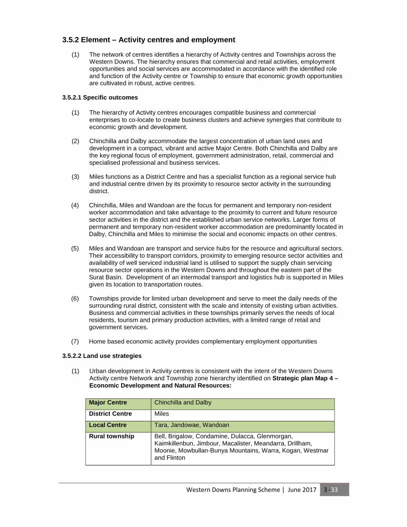
(1) Urban development in Activity centres is consistent with the intent of the Western Downs Activity centre Network and Township zone hierarchy identified on Strategic plan Map 4 – Economic Development and Natural Resources:
Major Centre Chinchilla and Dalby
Distr ic t Centre Miles
Local Centre Tara, Jandowae, Wandoan
Rural township Bell, Brigalow, Condamine, Dulacca, Glenmorgan, Kaimkillenbun, Jimbour, Macalister, Meandarra, Drillham, Moonie, Mowbullan-Bunya Mountains, Warra, Kogan, Westmar and Flinton

Western Downs Planning Scheme | June 2017 3 -34
3.5.3 Element – Agriculture
(1) The long-term sustainability of the rural economy is based on the protection of productive rural lands from fragmentation, encroachment and alienation by incompatible development or diminished productivity.
3.5.3.1 Specific outcomes
(1) ALC Class A and B land identified on Strategic plan Map 4—Economic Development and Natural Resources is protected and its integrity, viability and productivity is protected and maintained for cropping and intensive horticulture, animal husbandry and other appropriate rural uses.
Sensitive land uses that have the potential to generate land use conflict with the current or future economically productive use of ALC Class A and B land are appropriately separated from that land through the use of a buffer.
(2) Rural industry and innovative enterprise is located in Rural areas where:
(a) the use is not more appropriately located in an industry area in a town; (b) off-site impacts on amenity, including the impacts of air, noise and odour emissions,
and hazardous materials on nearby sensitive land uses and infrastructure networks are appropriately managed;
(c) not located on other ALC Class A and B land, unless there is an overriding need for the proposal and it cannot be located on alternative sites of poorer agricultural quality.
(3) The location of intensive animal industries are supported where off-site impacts on land,
water resources, air and noise quality are managed to provide a reasonable level of amenity protection for Urban areas
(4) Sensitive land uses are appropriately separated from existing intensive animal industries.
(5) Rural industries and primary production are located and operated so as not to impact on
water quality and maintain sustainable environmental quantities of surface and groundwater.
(6) Innovative and emerging land uses such as sustainable energy production that are not sensitive to noise, particulate, or odour emitting land uses are promoted in industrial and rural buffer areas.
3.5.3.2 Land use strategies
(1) There are no land use strategies for this element.

Western Downs Planning Scheme | June 2017 3 -35
3.5.4 Element – Industrial development
(1) Industrial land use and development is an important contributor to the economic development of the region. The identification of key industry areas ensures an adequate supply of land suitable to meet current and future needs is protected from incompatible development and provides access to appropriate infrastructure, transport networks and services.
3.5.4.1 Specific outcomes
(1) An adequate supply of fully serviced industrial land is available in highly accessible Urban areas to provide localised employment opportunities and support economic growth.
(2) Regionally significant and high impact industrial development consolidates in Dalby,
Chinchilla and Miles. Serviced by the Warrego Highway, industrial development in these centres supports the heavy manufacturing and industrial needs required to service the resource and energy sectors in the region.
(3) Sensitive urban land uses such as residential development or community facilities do not encroach upon or establish within land identified for industrial development.
(4) Non-industrial land uses in Industrial areas are limited to those that directly support and
service industrial uses or have similar land use requirements and characteristics.
(5) Industrial activities are not located in the Townships of Bell, Brigalow, Dulacca, Glenmorgan, Kaimkillenbun, Jimbour, Macalister, Drillham, Moonie, Mowbullan-Bunya Mountains and Warra identified on Strategic plan Map 1—Settlement Pattern , except where for low impact industry and service industries that: (a) solely meets the needs of the Township and its surrounding rural district; and (b) is of a limited scale that is consistent with expectations for residential amenity and
character in the Township.
(6) Compatible industrial activities take advantage of opportunities for establishing closed loop systems that exchange and re-use industrial waste and by-products as the input of downstream activities.
3.5.4.2 Land use strategies
(1) Industrial land use and development is contained within the Industrial Area identified on Strategic plan Map 4 – Economic Development and Nat ural Resources.
(2) The Industrial Investigation Area identified on Strategic plan Map 1 – Settlement Pattern
indicates areas where the potential for future industrial areas beyond the life of the planning scheme is to be investigated. Industrial Investigation areas are not developed for industrial purposes unless the industrial land capacity of the relevant Urban Area and/or Future Industrial Area has a supply of less than 10 years and the land use tests for urban development in the Future Industrial Area are otherwise met.
(3) The Special Industrial Area identified on Strategic plan Map 1 – Settlement Pattern indicates where the potential for a special industrial uses are to be located. Land uses that are considered to be special industrial include high impact industry, renewable energy facility and special industry.
Western Downs Planning Scheme | June 2017 3 -36
3.5.5 Element – Mining and extractive resources
(1) Extractive resources are an important economic resource that supports construction activity in and beyond the region. Extractive industries play a role in contributing to the economic growth of the region.
3.5.5.1 Specific outcomes
(1) Key Resource Areas (KRA) including buffer area and transport routes are protected and maintained.
(2) Development adjacent to KRA is compatible with the ongoing winning of the resource.
(3) Extractive Industry resources identified on Strategic plan Map 4 – Economic Development
and Natural Resources and applicable overlay map are protected and maintained.
3.5.5.2 Land use strategies
(1) No land use strategies for this element.
Western Downs Planning Scheme | June 2017 3 -37
3.5.6 Element - Mineral resources
(1) The Western Downs is part of the Surat Basin mineral province that has a known abundance
of mineral and energy resources including coal and coal seam gas. It is important to ensure that the region benefits from the potential wealth and prosperity generated by development of the resource whilst maintaining the environmental and social values of the region.
3.5.6.1 Specific outcomes
(1) Mineral and petroleum resources identified on Strategic plan Map 4 – Economic development and Natural Resources contribute significantly to the economic growth and development of the Western Downs. Residential and other urban development is separated from known mineral resources to maintain ongoing access to the resource and ensure the protection of people, property and the environment from adverse impacts from dust, noise, light, odour, traffic and other impacts.
3.5.6.2 Land use strategies
(1) There are no land use strategies for this element.

Western Downs Planning Scheme | June 2017 3 -38
3.5.7 Element – Tourism
(1) The Western Downs is recognised as a tourism destination that offers a range of cultural and nature based tourism opportunities and facilities, including the support of ‘grey nomad’ travel. Tourists enjoy access to the natural features of the region including the wildflower areas, the Bunya Mountains National Park, the Broadwater Wetlands and the Southwood and Eringibba National Parks.
3.5.7.1 Specific outcomes
(1) Existing tourism nodes identified on Strategic plan Map 4 – Economic Development and Natural Resources and events are protected from the impacts of incompatible land use and development.
(2) ‘Grey nomad’ tourists and other tourists that provide their own mobile accommodation by
way of caravan or motor homes are supported by tourism related development.
(3) Ecotourism activities are encouraged where natural values are protected and enhanced.
(4) Rural based tourism is facilitated where it does not impact on the continuing productive use of agricultural land and maintains the predominant rural amenity and landscape character of the region.
3.5.7.2 Land use strategies
(1) There are no land use strategies for this element.
Western Downs Planning Scheme | June 2017 3 -39
3.5.8 Element – Home based business
(1) Home based businesses provide a cost effective opportunity for local service providers and professional service industries to operate at a small scale that is responsive to the need of the community. Home based businesses also provide an alternative employment opportunity for residents that better match their personal circumstances and diversifies the range and scale of business and opportunities in the region.
3.5.8.1 Specific outcomes
(1) Home based business is encouraged in Urban areas, Rural residential areas and Rural areas at a scale and intensity that is consistent with the surrounding character and amenity of the locality and where not in conflict with the ongoing viability of Activity centres.
3.5.8.2 Land use strategies
(1) There are no land use strategies for this element.
Western Downs Planning Scheme | June 2017 3 -40
3.6 Infrastructure 3.6.1 Strategic outcomes
(1) The efficient and timely provision of infrastructure and services across the region is aligned with development to ensure that infrastructure is provided in an orderly and sequential manner.
(2) The provision of infrastructure is consistent with reasonable expectations for the servicing of
Urban, Rural residential, and Rural areas. (3) The Urban areas of Chinchilla, Dalby, Jandowae, Miles, Tara and Wandoan and located in
the Priority Infrastructure Area of Part 4 - Local Government Infrastructure Plan (LGIP ) identifies the Urban areas of Dalby, Jandowae, Mile s, Tara, W are provided with a higher standard of service across the greatest number of infrastructure and service networks, including access to reticulated water supply, sewerage and stormwater networks, due to the favorable costs of infrastructure provision in compact urban form.
(4) Outside the LGIP areas, a limited range of infrastructure networks may be provided and
infrastructure shortfalls are met by development on a site-by site bases. (5) Rail networks are protected from encroachment and incompatible development to ensure
the safe and efficient transport of resources. (6) Air transportation provides a fast and convenient regional links and supports the fly-in/fly-out
workforce as well as increasing business and tourism travel numbers. (7) Road transport networks connect communities, business and industry to local and inter-
regional destinations and promotes active transport with Urban areas.
(8) The following major infrastructure corridors and sites that provide an essential service to the residents of the Western Downs are protected from development that would compromise their function and designed for co-location where possible: (a) Water and wastewater pipelines; (b) Major electricity infrastructure and substations; (c) Transmission substations (d) Power stations' (e) Gas pipelines; and (f) Utility installations of local significance to the Western Downs, including water and
sewerage treatment and waste management facilities.
(9) Renewable energy generation consistent with a low carbon economy and the natural, rural and amenity values of the Western Downs represents a growing proportion of energy production.
(10) Telecommunication infrastructure is provided that supports the local economy. (11) The provision of infrastructure across the Western Downs Region avoids adverse
environmental and amenity impacts. (12) Development in and adjacent to stock routes is managed to prevent or minimise impacts on
the continued and future use of the stock route.
Western Downs Planning Scheme | June 2017 3 -41
3.6.2 Element - Road network
(1) The road network of the Western Downs provides a safe and efficient State and local road transport network that is designed to meet the local transport needs of the community and provides safe inter- regional transportation opportunities to facilitate positive economic growth.
3.6.2.1 Specific outcomes
(1) The operational safety and efficiency of the road corridors identified conceptually on Strategic plan Map 5—Access, Mobility and Infrastru cture are protected from the encroachment of incompatible land use and development, including, but not limited to the following: (a) Warrego Highway; (b) Leichhardt Highway; (c) Dalby-Kogan Road; (d) Chinchilla-Tara Road; (e) Jackson-Wandoan Road; (f) Warra-Kogan Road; (g) Tara-Kogan Road; and (h) Kogan-Condamine Road
(2) Public access to the state-controlled network and development is provided without
compromising the planned function, future planning, road safety and transport efficiency of the whole road network.
(3) The road network is designed to support and maintain the Western Downs Activity centre
Network identified on Strategic plan Map 5 – Access, Mobility and Infrast ructure .
(4) The Warrego Highway is maintained as the major east-west transport route for the region and provides safe and efficient connections between Toowoomba, Dalby, Chinchilla, Miles and Roma. The Warrego Highway safely supports heavy vehicle traffic associated with rural activities and the resource sector including drive in/drive out workers.
(5) The Leichardt Highway is maintained as a safe and efficient north-west arterial link.
Primarily servicing the expansion of the resource sector and supporting industries around Wandoan and Miles. The capacity of the Leichardt highway safely accommodates heavy vehicles.
(6) In Rural areas the road network provides rural communities with safe and convenient all-
weather access to nearby Activity centres and Townships. Rural roads are a mix of gravel and sealed pavement types and accommodate larger freight and haulage vehicles as well as passenger vehicles in a safe and efficient manner.
(7) Road freight transportation remains an important transport mode for moving the region’s
agricultural production to market. The road network provides a network of roads from the farm gate to the major transport routes that is safe and efficient for all road users.
(8) Sensitive land uses are appropriately separated from freight routes identified on Strategic
plan Map 5 – Access, Mobility and Infrastructure.
(9) In Urban areas, the road network supports an integrated network of walking and cycling paths that provide residents and visitors with convenient and safe access to employment and services.
3.6.2.2 Land use strategies
(1) Industrial development is accessed within 500 metres of a freight route identified on Strategic plan Map 5—Access, Mobility and Infrastru cture.
(2) Future Warrego Highway bypasses of Dalby and Chinchilla are to be investigated in
conjunction with an Urban Area growth options analysis of Dalby and Chinchilla.
Western Downs Planning Scheme | June 2017 3 -42
3.6.3 Element – Water supply network
(1) The water supply network services development located in the Local Government Infrastructure Plan area and Townships where within a water supply network service catchment.
(2) Development external to water supply service catchments relies on site based water
collection and treatment or where appropriate, transportation of an available potable water source.
3.6.3.1 Specific outcomes
(1) The long term security of the water supply network in terms of its efficient operation and holding capacity is not compromised.
(2) Urban water supplies in the Western Downs are safe and reliable. Urban areas have a modern and efficient reticulated water supply network that supports the health, safety and wellbeing of the community.
(3) Development in Urban areas located within a Priority Infrastructure Area for water
infrastructure is connected to the reticulated water supply network.
(4) Development outside the Priority Infrastructure Area for water infrastructure is provided with sustainable and reliable potable water supply.
(5) Development maintains an appropriate separation distances to water treatment plants
identified on Strategic plan Map 5 – Access, Mobility and Infrast ructure and applicable overlay maps.
3.6.3.2 Land use strategies
(1) There are no land use strategies for this element.

Western Downs Planning Scheme | June 2017 3 -43
3.6.4 Element – Sewerage network
(1) The reticulated sewerage network services development located in the Local Government Infrastructure plan area and Townships where within a sewerage network service catchment.
(2) Development external to sewerage network service catchments relies on site based
sewerage treatment and disposal.
3.6.4.1 Specific outcomes
(1) Development in Urban areas located within the Priority Infrastructure Area for sewerage infrastructure identified in Part 4—Priority infrastructure plan is connected to the reticulated sewerage network.
(2) Development in Rural areas and Rural residential areas and un-serviced Townships is
provided with a sustainable effluent disposal system that does not impact on sensitive receiving environments.
(3) Development maintains appropriate separation distances to sewerage treatment plants
identified on Strategic plan Map 5 – Access, Mobility and Infrast ructure . 3.6.4.2 Land use strategies
(1) There are no land use strategies for this element.
Western Downs Planning Scheme | June 2017 3 -44
3.6.5 Element – Stormwater management
(1) Stormwater management adopts an integrated water cycle management approach and contributes to the mitigation of adverse impacts of rainfall events on life, property and the environment.
3.6.5.1 Specific outcomes
(1) Stormwater infrastructure provides for the conveyance of stormwater in Urban areas such that hazards to personal safety or property are avoided.
(2) Integrated water cycle management and water sensitive urban design principles are
embodied in development in Urban areas to: (a) avoid adverse impacts on the environmental flows that protect the biological diversity
and health of the natural environment; and (b) maximise opportunities to harvest and re-use stormwater.
3.6.5.2 Land use strategies
(1) There are no land use strategies for this element

Western Downs Planning Scheme | June 2017 3 -45
3.6.6 Element – Energy infrastructure
(1) The Western Downs region is serviced by energy infrastructure that meets the needs of the community and minimises environmental impacts.
3.6.6.1 Specific outcomes
(1) Demand for centralised energy generation and infrastructure is minimised through development incorporating best practice energy efficiency design principles and maximising the use of renewable and sustainable energy supplies and sources.
(2) Development in urban expansion areas provides adequate suitable land for electricity
infrastructure, including land for sub-stations and transmission lines, required to service or traverse the area.
(3) Development for renewable energy projects are facilitated and encouraged where
appropriately located and sensitively designed to respect rural and regional landscape values.
(4) The operational efficiency of electricity infrastructure identified on Strategic plan Map 5 –
Access Mobility and Infrastructure is protected from incompatible development through the provision of appropriate buffers and corridors.
3.6.6.2 Land use strategies
(1) There are no land use strategies for this element.
Western Downs Planning Scheme | June 2017 3 -46
3.6.7 Element - Alternative energy production
(1) As consensus on actions to combat climate change grows internationally, alternative energy production provides an opportunity to diversify the economic base of the region, and reduce reliance on non-renewable sources of energy.
3.6.7.1 Specific outcomes
(1) Renewable energy infrastructure associated with wind, geothermal and solar is supported where natural environment values, landscape character values and natural resource management interests are protected.
(2) Domestic scale renewable energy is supported to provide for localised energy consumption.
3.6.7.2 Land use strategies
(1) There are no land use strategies for this element.
Western Downs Planning Scheme | June 2017 3 -47
3.6.8 Element – Telecommunications
(1) Telecommunications infrastructure meets the needs of the community, contributes to economic development, promotes access to virtual health, education and government services and minimises negative environmental impacts.
3.6.8.1 Specific outcomes
(1) Development is connected to telecommunications infrastructure, including high-speed broadband (where available) in accordance with the requirements of the relevant telecommunications service entity.
(2) Telecommunications facilities are designed and located to maintain existing amenity and
community safety, and are co-located wherever possible.
3.6.8.2 Land use strategies
(1) There are no land use strategies for this element.
Western Downs Planning Scheme | June 2017 3 -48
3.6.9 Element – Infrastructure corridors
(1) The Western Downs contains a number of infrastructure corridors that contain the existing and planned overland oil and gas pipelines, major electricity infrastructure and transport corridors that service the resource sector of the region.
3.6.9.1 Specific outcomes
(1) Infrastructure corridors, including gas and oil pipelines, facilitate the safe and efficient transport of raw materials for distribution to local and international export markets.
(2) Infrastructure corridors traverse Urban areas and Rural areas and are protected from
encroachment by incompatible land uses.
(3) Compatible infrastructure is co-located within existing infrastructure corridors where possible to minimise environmental impact.
(4) Residential development and other sensitive land uses are appropriately separated from
major public infrastructure corridors, including gas and oil pipelines identified on Strategic plan Map 5 – Access, Mobility and Infrastructure .
3.6.9.2 Land use strategies
(1) There are no land use strategies for this element.
Western Downs Planning Scheme | June 2017 3 -49
3.6.10 Element – Rail networks
(1) The railway network of the Western Downs supports the bulk transport of the region’s resource wealth to export markets.
3.6.10.1 Specific outcomes
(1) Development maintains the safety and operational integrity of the existing and future railway network.
(2) The rail corridor between Wandoan and Banana is protected and safely and efficiently
provides a rail connection with the bulk coal export terminal of Gladstone.
(3) The main western rail line between Miles and Dalby is protected and maintained to support the development and transportation of coal reserves in this part of the region.
(4) Rail networks in the region support inter-regional passenger transport, minimising congestion
on road transport networks and lowering greenhouse gas emissions.
(5) Development sensitive to rail transport noise emissions, and located in close proximity to an operational rail corridor, mitigates amenity impacts.
3.6.10.2 Land use strategies
(1) Development on or adjacent to the existing or future railway network identified on Strategic plan Map 5 – Access, Mobility and Infrastructure will be required to preserve the operational efficiency of the railway by incorporating appropriate separation distances or mitigation of railway generated emissions to within acceptable levels.
Western Downs Planning Scheme | June 2017 3 -50
3.6.11 Element - Stock route network
(1) The function, connectivity and pasture productivity of the Stock Route Network is maintained for sustainable use by travelling stock on hoof.
3.6.11.1 Specific outcomes
(1) The Stock Route Network is protected from developments (on or near the stock routes) that have the potential for conflict between use of the network and adjoining areas
(2) The stock route network’s use or capacity for the primary purpose of travelling stock on hoof
is maintained.
(3) Potential for conflict between use of the network and use of adjoining areas is avoided.
3.6.11.2 Land use strategies
(1) There are no land use strategies for this element.
Western Downs Planning Scheme | June 2017 3 -51
3.6.12 Element— Active transport network
(1) The active transport network provides a quality transport option in the urban areas of the Western Downs that efficiently connects residential neighbourhoods to activity centres, Township main streets and other employment areas and contributes to active and healthy local communities.
3.6.12.1 Specific outcomes
(1) Greenfield development in Urban areas: (a) contributes to the establishment of on and off-road corridors that promote safe active
transport; and
(b) incorporates neighbourhood design principles that promotes a high level of connectivity, particularly for pedestrians and cyclists.
(2) End-of-trip cycle facilities are provided by major trip generators in major and district activity centres.
3.6.12.2 Land use strategies
(1) There are no land use strategies for the planning scheme.
Western Downs Planning Scheme | June 2017 3 -52
3.6.13 Element – Airport enterprise and aviation fa cilities
(1) Air transport infrastructure facilitates the fast and convenient transportation of people, goods and services as an alternative to road and rail transportation modes.
(2) Strategic plan Map 5 - Access, Mobility and Infra structure identifies existing airport
facilities in Chinchilla, Dalby, Dulacca, Meandarra, Miles, Tara and Wandoan. Airport facilities within Chinchilla, Dalby and Miles facilitate the movement of passengers both within and outside of the region. The Miles and Chinchilla airports are heavily relied upon to facilitate the movement of passengers associated with resource sector activity.
(3) Strategic plan Map 4 - Economic Development and N atural Resources identifies airport
enterprise areas surrounding the existing Chinchilla, Dalby, Miles and Wandoan airports. The purpose of these areas is to facilitate opportunities for complementary value adding enterprises that have a direct juxtaposition to airport operations and where both uses are able to operate and co-locate and not create land use conflict. Development that creates incompatible intrusion, land use conflict or compromises airport safety will not be supported within airport enterprise areas.
3.6.13.1 Specific outcomes
(1) Air space and obstacle limitation surface areas are protected to maintain the safety and efficiency of aircraft movements.
(2) Appropriate separation distances are maintained to buffer airports and registered landing
areas identified on Strategic plan Map 5 – Access, Mobility and Infrast ructure from the encroachment of incompatible development.
(3) Air transport is responsive to economic growth opportunities presented through the
transportation of non-resident workforce from metropolitan centres and in particular opportunities to expand and accommodate value add activities to aircraft operations in Dalby, Chinchilla, Miles and Wandoan.
(4) Airport enterprise areas identified on Strategic plan Map 4 – Economic Development and
Natural Resources encourage compatible business, industry and commercial enterprises to co-locate to create aviation dependent activity clusters that achieve synergies that contribute to economic growth and development, where:
(a) the hierarchy of the Western Downs Activity centre Network is maintained; and
(b) where aircraft operations are not constrained or limited by land use and development.
(5) Private airstrips are supported where the strip is utilised for private purposes only.
3.6.13.2 Land use strategies
(1) Development of aeronautical masterplans for the Chinchilla, Dalby, Miles and Wandoan airports that incorporate airport enterprise areas and provide strategic direction and further detail as to the nature of development that is to occur in the locality.

Western Downs Planning Scheme | June 2017 3 -53
3.7 Safety and resilience to hazards 3.7.1Strategic outcomes (1) The Western Downs is a vast region that is vulnerable to a range of natural hazards including
flood and bushfire. It is expected that the extreme weather events that drive these natural hazards will be more prevalent in the future due to the predicted impacts of climate change. To ensure the safety of residents and infrastructure, development avoids establishing in these areas.
(2) The potential impacts of climate change and natural hazards can have detrimental impacts to
our regions communities. The location, scale and intensity of development is considered in all land use decisions to minimise the exposure of people and property to natural hazards.
(3) Development within the Western Downs does not expose land to contamination and sensitive
land uses are not located near existing contaminated land sites. (4) Waste management is undertaken utilising best practice and landfill sites are protected from
encroachment incompatible land use and development. (5) Development involving storage and disposal of hazardous materials and hazardous chemicals,
dangerous goods and flammable or combustible substances, is to be located and managed to avoid and mitigate potential adverse impacts on surrounding uses, and minimise the health and safety risks to communities and individuals.
(6) Protecting explosive facilities or explosives reserves from encroachment by development that
would compromise the ability of these land uses to function safely and effectively.
Western Downs Planning Scheme | June 2017 3 -54
3.7.2 Element – Natural hazards
(1) The Western Downs is a vast region that is vulnerable to a range of natural hazards including flood and bushfire. It is expected that the extreme weather events that drive these natural hazards will be more prevalent in the future due to the predicted impacts of climate change. To ensure the safety of residents and infrastructure, it is important that development avoids establishing in areas known to be subject to natural hazards that pose a potential to threat to people and property.
3.7.2.1 Specific outcomes
(1) The risk of loss of life and property due to bushfires is minimised through:
(a) the appropriate use of land having regard to its level of bushfire hazard; and
(b) the incorporation of appropriate siting and design measures that mitigate bushfire risks.
(2) The risk of loss of life and property due to landslides is minimised through:
(a) the appropriate use of land having regard to its level of landslide hazard; and
(b) the incorporation of appropriate siting and design measures that mitigate landslide risks.
(3) The risk of loss of life and property due to flood hazards, including that associated with a greater frequency of extreme weather events and increased rainfall intensities as a result of climate change is minimised.
(4) The flood storage and conveyance capacity of floodplains are protected from earthworks and development that:
(a) significantly alter natural drainage patterns to the detriment of environmental or infrastructure performance;
(b) worsen existing flooding conditions; and
(c) contribute to negative impacts on environmental quality during flood events.
3.7.2.2 Land use strategies
(1) There are no land use strategies for this element
Western Downs Planning Scheme | June 2017 3 -55
3.7.3 Element – Climate change impacts and natural environment vulnerability
(1) Climate change poses potential negative impacts on the natural environment, including changes in ecosystem dynamics beyond the limits of species thresholds and an increase in the frequency and severity of bushfire which has the potential to permanently change flora communities and their dependent fauna.
3.7.3.1 Specific outcomes
(1) The natural environment is protected against the adverse impacts of climate change through: (a) the protection and enhancement of carbon sinks to offset the advancement of climate
change; and (b) reducing the carbon footprint of land use and development through sustainable,
compact urban form.
(2) Urban land use and development is contained within the Urban Area identified on Strategic plan Map 1 – Settlement Pattern.
(3) ALC Class A and B land is protected from alienation, diminished productivity, fragmentation
and encroachment by incompatible development.
3.7.3.2 Land use strategies
(1) There are no land use strategies for this element.

Western Downs Planning Scheme | June 2017 3 -56
3.7.4 Element – Contaminated land
(1) To ensure the health and safety of the community and maintain the economic viability of the region, land in the Western Downs is protected from contamination by land use activities.
3.7.4.1 Specific outcomes
(1) The potential impacts of hazardous and harmful materials used in industrial, rural or other activities are appropriately mitigated to ensure the health and safety of the community.
(2) Sensitive development including residential development and community facilities are not located on land that is identified as being contaminated by previous uses unless remediated to a degree that is acceptable to the health and wellbeing of populations.
(3) Development that uses materials or processes that may potentially introduce contaminants into the landscape is undertaken with appropriate mitigation and any contaminated land is remediated to an acceptable degree.
3.7.4.2 Land use strategies
(1) There are no land use strategies for this element.
Western Downs Planning Scheme | June 2017 3 -57
3.7.5 Element – Waste management and recycling
(1) Population growth and industrial activity will generate an increased amount of waste in the region. Waste is managed in the region holistically to minimize adverse impacts on the environment using the waste hierarch and to ensure the protection of environmental values
(2) Waste is managed to contribute to the protection of environmental values and promote waste
minimisation and recycling.
3.7.5.1 Specific outcomes
(1) Waste disposal is undertaken at landfill sites identified on Strategic plan Map 5 – Access, Mobility and Infrastructure and maintains public health and the health of the environment.
(2) Waste facilities are designed to capture and utilise waste materials as a resource where
possible through recycling or further processing.
(3) Waste disposal activities and facilities are not located in areas with highly permeable soils or a high groundwater table and take account of topography and existing facilities.
(4) Waste management services are provided suitable to the needs of development to minimise
amenity impacts on the surrounding community.
(5) Development maintains appropriate separation distances to public waste management facilities identified on Strategic plan Map 5 – Access, Mobility and Infrast ructure to ensure maintenance of public health and to minimise reverse amenity impacts on infrastructure.
3.7.5.2 Land use strategies
(1) There are no land use strategies for this element.