
PART 12 - TRANSPORTATION - Auckland Council · PART 12 - TRANSPORTATION CITY OF AUCKLAND - DISTRICT...
24
PART 12 - TRANSPORTATION CITY OF AUCKLAND - DISTRICT PLAN ISTHMUS SECTION - OPERATIVE 1999 Page A1 updated 04/10/2011 See key on page 1 of this section CONTENTS ..................................................................................................... PAGE 12.1 CONTENT AND STRUCTURE........................................................... A3 12.2 RESOURCE MANAGEMENT ISSUES .............................................. A3 12.3 RESOURCE MANAGEMENT OBJECTIVES AND POLICIES .......... A6 12.4 RESOURCE MANAGEMENT STRATEGY ....................................... A6 12.5 OTHER SYSTEMS ............................................................................. A8 12.6 ROADING ........................................................................................... A9 12.7 PARKING ......................................................................................... A15 12.8 RULES : DEVELOPMENT CONTROLS .......................................... A16 12.9 TRANSPORTATION ACTIVITIES ...................................................... B7 PART 12 - TRANSPORTATION Plan change annotations - key Indicates where content is affected by proposed plan modification x. Refer to plan modification folder or website for details. Indicates where the content is part of plan modification x, which is subject to appeal. Underlined content to be inserted. Struck through content to be deleted. x x Note re Page Numbering For the purpose of page numbering this Part has been divided into subsections. This assists with the production of updated sections of the Plan for subscribers. It is also in keeping with the format of the on-line version of the Plan. Page numbering is sequenced as follows: Page A1, A2, A3 etc Page B1, B2, B3 etc
Transcript of PART 12 - TRANSPORTATION - Auckland Council · PART 12 - TRANSPORTATION CITY OF AUCKLAND - DISTRICT...

PART 12 - TRANSPORTATION
CONTENTS..................................................................................................... PAGE
12.1 CONTENT AND STRUCTURE........................................................... A3
12.2 RESOURCE MANAGEMENT ISSUES .............................................. A3
12.3 RESOURCE MANAGEMENT OBJECTIVES AND POLICIES .......... A6
12.4 RESOURCE MANAGEMENT STRATEGY ....................................... A6
12.5 OTHER SYSTEMS ............................................................................. A8
12.6 ROADING........................................................................................... A9
12.7 PARKING ......................................................................................... A15
12.8 RULES : DEVELOPMENT CONTROLS .......................................... A16
12.9 TRANSPORTATION ACTIVITIES ...................................................... B7
PART 12 - TRANSPORTATION
Plan change annotations - key
Indicates where content is affected by proposed plan modification x.Refer to plan modification folder or website for details.
Indicates where the content is part of plan modification x, which is subject to appeal.
Underlined content to be inserted.
Struck through content to be deleted.
x
x
Note re Page Numbering
For the purpose of page numbering this Part has been divided into subsections. This assists with the production of updated sections of the Plan for subscribers. It is also in keeping with the format of the on-line version of the Plan.
Page numbering is sequenced as follows:Page A1, A2, A3 etcPage B1, B2, B3 etc
CITY OF AUCKLAND - DISTRICT PLANISTHMUS SECTION - OPERATIVE 1999 Page A1updated 04/10/2011
See key on page 1 of this section

PART 12 - TRANSPORTATION
CITY OF AUCKLAND - DISTRICT PLANPage A2 ISTHMUS SECTION - OPERATIVE 1999
updated 04/10/2011See key on page 1 of this section

PART 12 - TRANSPORTATION
Transportation in terms of its physical components and their conduct is regarded as a major feature in the urban environment. The use and development of the components of the feature (roading network, motorways, rail lines, port facilities, passenger and pedestrian facilities) must be managed in a manner which contributes to the sustainability of the natural and physical resources concerned and at the same time, avoids or mitigates undesirable effects on the environment.
The City's transport system must cater for movement into and across the City from other parts of the region, as well as movement entirely within it. The City is located at the centre of the region and is a net provider of jobs to the other parts of the region. This results in a relatively large inflow of people and vehicles into the City during weekday morning peak periods. The topography results in the concentration of such movements into a small number of transport corridors.
Construction of an extensive motorway network over the last 30 years has accommodated much of the traffic growth in the main transport corridors. This era is, however, coming to an end. It is unlikely that there will be any new additional motorways to those already built or planned for in the District Plan. Peak period traffic congestion has been increasing rapidly. The ability of critical sections of motorway to cater for higher traffic flows is limited. The City's arterial road network will, therefore, need to carry a steadily increasing proportion of peak work related traffic in the congested main corridors. This particularly applies to commuter travel to the Central Area if relative accessibility is to be maintained despite increasing congestion on the road network.
This Part is presented as follow -
• Resource Management Issues
This outlines the principal transportation issues and sets out the scope of the transportation question addressed in the Plan. It acknowledges the different levels of resource conservation concerned, from global to local but recognises that the extent of the Plan's direct influence is limited to local urban circumstances.
• Resource Management Objectives and Policies
This outlines how the Plan intends to deal with the particular issues for transportation.
• Resource Management Strategy
This outlines the strategy for managing the transportation resource and explains the reasons for this approach.
• Implementation
This outlines the different methods adopted to meet the objectives and policies of this Part. It divides the methods into discussions on Roading, Parking and Transportation Activities.
• Rules
This specifies the range of development controls which the Plan adopts to ensure that the actual or potential effects of the use of the transportation resource do not adversely effect the environment.
The promotion of the sustainable management of the transportation resource raises issues which range from global to local concerns. The limitations of the Plan's powers and the geographical constraints it operates under, preclude all but local urban issues from its control. However it is important to recognise that local transportation resource issues have a place within the wider context of global, national and regional concerns. Measures taken to promote sustainable management of the resource at a local level, will need to acknowledge and support where possible these wider issues.
Globally there is concern over the increasing utilisation of non-renewable fossil fuels by all forms of transportation and the consequent impact not only on future sources of these fuels, but also on the earth's atmosphere in terms of pollution and the greenhouse effect. The issues arising from this concern refer to the need to encourage an efficient use of the energy resource associated with transportation. This is probably best achieved through promoting and supporting the efficient utilisation of existing transportation structures, in particular an efficient public transport system, while ensuring that the effect on the environment at a global, national, regional and local level is avoided, reduced or mitigated.
PART 12 - TRANSPORTATION
12.1 CONTENT AND STRUCTURE
12.2 RESOURCE MANAGEMENT ISSUES
12.2.1 GENERAL
CITY OF AUCKLAND - DISTRICT PLANISTHMUS SECTION - OPERATIVE 1999 Page A3updated 04/10/2011
See key on page 1 of this section

PART 12 - TRANSPORTATION
At a national level, issues such as how to encourage the efficient use of the energy resource and how to achieve more environmentally acceptable transportation systems need to be addressed.
At a regional level transportation issues focus on matters such as how to support and promote an efficient mass public transport system, how to ensure the concentration of the urban area rather than its expansion, and how to maintain and promote efficient and accessible linkages between areas of the region.
Locally, transportation issues become more focussed. While the efficient use of the energy resource is still a prime consideration, of specific concern is how to achieve the most efficient sustainable use of the existing transportation infrastructure and how to avoid, mitigate or reduce the effects the use of the transportation resource, has on the local environment
The Auckland Regional Land Transport Strategy (RLTS) was adopted by the Auckland Regional Land Transport Committee, a standing committee of the Auckland Regional Council, in 1999. The ARLTS seeks a balanced approach to addressing transportation issues. It contains objectives and policies that are to be implemented generally across the region in conjunction with policies and projects related to the specific needs of particular areas.
The Passenger Transport Action Plan (PTAP) is a supporting document to the ARLTS. It was created as a result of submissions to the ARLTS and has also been adopted by the Auckland Regional Land Transport Committee. The PTAP summarises the public transport actions outlined in detail in the ARLTS and puts forward a view of the future of Auckland’s public transport.
Concurrently with these two documents, Auckland City in 1998 adopted the Central Isthmus Strategy (CIS).
While the RLTS, PTAP and CIS recognise that there are no simple solutions to the transportation issues of the region, they provide for a range of complementary initiatives as a means to pursue a balanced approach that will keep Auckland moving.
In terms of the district, transportation is an important and valuable resource. Significant investment has been made in its physical infrastructure and facilities. Transportation serves an important link between the Isthmus and other parts of the district and the region. It provides interconnections between activities and communities, and its various forms provide for a variety of changing needs and demands. Transportation has had, and will continue to have, a fundamental influence on the urban form and character of the district and on its environment.
In the current climate of rising car usage and increasing traffic congestion, coupled with an increasing awareness of people's responsibilities to the local and global environment, the need for the sustainable management of the district's transportation system is of immediate concern. A major resource management issue facing the district therefore, is the production of a transportation strategy which recognises the need to provide access, and the safe and efficient movement of vehicles and people, in a way that minimises the adverse effect on the environment of the district and which does not compromise the needs of future generations.
In the built environment of the City, sustainable management, in the context of transportation, must concentrate on two important issues:
• how to achieve the safe and efficient use of the existing infrastructure;
• how to avoid, reduce or mitigate any adverse impact any form of transport may have on the environment and the district.
• how to provide safely and efficiently for additional transport needs resulting from increased population and employment, intensification of land uses, and economic growth.
Inherent in these matters is the need for energy efficiency which at a local level can be promoted through provisions which:
• support increased public transport patronage;
• encourage a reduction in travel distances or a reduced need for the use of cars for travel between activities;
• encourage the concentration of the urban environment rather than its expansion.
• support the reduction of congestion and travel times by improvements to the roading network, where appropriate, which achieve operational efficiencies, greater traffic safety and minimise the adverse effects of vehicle use in the environment.
Energy Efficiency
Promotion of sustainable management of the Isthmus transportation resource should aim at the efficient use of the existing transportation infrastructure. This will contribute significantly towards energy efficiency. Fragmentation of the financial and physical responsibility for transportation, to a large extent reduces the likelihood of new transportation facilities and infrastructure. The very nature of new infrastructure often causes unacceptable disruption to existing communities and habitats. There exist various ways by which an efficient use of the resource can be achieved:
• by ensuring the optimum use of existing facilities through the use of any under utilised capacity which may exist, eg widening of existing roads to their full legal width and the adoption of management techniques;
12.2.2 ISTHMUS TRANSPORTATION ISSUES
CITY OF AUCKLAND - DISTRICT PLANPage A4 ISTHMUS SECTION - OPERATIVE 1999
updated 04/10/2011See key on page 1 of this section

PART 12 - TRANSPORTATION
• by encouraging over time, mechanisms and practices which promote the energy efficient use of private vehicles;
• by encouraging greater patronage of public transport, so that the pressure placed on the City's roads by private vehicles is reduced.
The latter method of increasing efficiency would require a shift in the public's attitude to public transport and the provision of a more effective, adaptable, fast and affordable public transport system, which caters for across-city movement as well as movement to the Central Area. Hand in hand with the provision of such a system may be the need to impose controls which disadvantage the private motorist so as to encourage use of the public transport system.
Auckland's current reliance on private vehicle usage, its low density of development, the recent deregulation of public transport and the lack of available funding, increase the difficulties of achieving an integrated and effective public transport system. The Council has no direct control over the provision of such a public transport system. The Plan must however be supportive of the establishment of an integrated and effective public transport system for the City and the region. In this regard actions, such as higher densities along major transport routes are included in the Plan so as to encourage and support public transport use.
Increasing the capacity of the existing roading system, and increasing patronage of the public transport system both have the potential for adverse impacts on the environment. Increased roading capacity may, in the long term, be absorbed as more private vehicles take advantage of better roads and faster travel. At the same time adverse disruption to existing activities along the main arterials may occur, in the form of a loss of on-street parking, increased noise levels, and reduced safety.
Promoting public transport to an extent that patronage will positively effect the efficient use of transportation resources is likely to require disincentives to the use of private transport which may be publicly unacceptable. What is needed therefore is an approach to efficient energy and resource use which achieves an appropriate balance between private and public transport.
Accessibility
The provision of good accessibility between various activities on the Isthmus is also an important issue that the Plan must address. The vitality and viability of the Isthmus as an area for business activity and growth, for residential location, and for recreation and entertainment activities depends largely on the ability of people and goods to obtain efficient access between different activities, and different areas of the Isthmus.
In the past emphasis has been on the provision of efficient access to the Central Area, because of its dominant role as a centre of business, commerce, entertainment and tourist activity. The importance of maintaining that accessibility remains. Particular attention is given in the CIS document to the Central Isthmus Area, that area within Auckland City bounded by the Southern, South-Western and Western Corridors and the Auckland Central area to the north. The analysis of the transport issues facing this area shows that if intensification continues and if no improvements are made in the road transport network, the level of accessibility within the Auckland Isthmus will decline substantially.
A major issue is the balance between achieving improvements to the public transport network (as addressed in the CIS document) and minimising the impacts of such improvements in the existing roading network.
However in terms of achieving energy efficiency through reduced travel distances, there also exists a need to encourage and provide access to activities within communities as well as to activities within employment areas of the City. In addition, the Plan's provisions should acknowledge that the need for accessibility must be balanced against maintaining the environment and amenity values of particular areas. Residential areas may be faced with lesser accessibility if traffic and its consequential effects are to be restricted.
The City contains substantial tracts of land which have been set aside for roading, and rail lines. These represent a valuable physical resource. In particular these corridors offer the potential for use not only for the transportation of people and trains, but also for new transportation modes and for the distribution of utility services eg telecommunications, gas and power lines. The Plan must adopt provisions which seek to maintain and utilise these tracts of land for such purposes.
To encourage greater patronage of public transport, and higher numbers of the public cycling and walking within the City, it is important that transportation facilities are designed to reduce the potential for crime to occur against people and property.
Control of Effects
Transportation, in its role as both an activity and as an effect of other activities, can impact adversely on the environment of the district. The use of the transportation resource can incur noise and air quality levels above those normally accepted. The construction of the transportation system impact adversely on existing communities and ecological habitats. Road traffic as a prime component of transportation and as an effect of land use activities can impact adversely on the amenities of an area in terms of dust, dirt, fumes, visual intrusion and traffic congestion.
Other transport modes, including passenger transport, can also produce adverse effects. The comparative benefits of
CITY OF AUCKLAND - DISTRICT PLANISTHMUS SECTION - OPERATIVE 1999 Page A5updated 04/10/2011
See key on page 1 of this section

PART 12 - TRANSPORTATION
different transport modes must be weighed in the transportation management approach adopted by the Plan to ensure that adverse effects on the environment and the community are avoided, remedied or mitigated and then the enhancement of the environment is encouraged. An outcome of the traffic management approach may be the identification, protection and enhancement of transportation corridors as the best means to mitigate the effects of future growth in travel demand.
To manage the use and development of the City's transportation resources in a way that promotes the protection and enhancement of the City's environment.
Policies
• By encouraging the efficient use of the existing roading infrastructure.
• By supporting and promoting a transportation system designed and managed to encourage the efficient use of energy.
• By recognising and providing for the interdependence between transportation and the efficiency of other activities.
• By supporting the creation of an efficient public transport network which provides an integrated system, with appropriate levels of convenience and service.
• By taking national and regional energy policies into account in policy development and decision making.
• By minimising the adverse local environmental effects of proposed new roads and other additions to the City's transportation network.
• By adopting planning techniques to discourage traffic in areas where it would have significant adverse environmental effects.
To improve access, ease and safety of movement within the City, while ensuring that adequate provision is made for the various transport needs of the region.
Policies
• By adopting and applying a functional road classification.
• By improving the capacity and safety of existing facilities through the use of appropriate traffic management techniques.
• By providing new roads or other facilities where these are considered essential.
• By relating activity zones to road capacity.
• By controlling access and the intensity of use along particular roads, so as to ensure both vehicle and pedestrian safety.
• By giving priority to service traffic where appropriate.
• By improving passenger transport infrastructures where appropriate.
• By recognising the need for effective public transport and for catering for people without cars.
• By promoting permanent residential accommodation in the Central Area.
• By enhancing public and personal safety through reducing opportunities for crime to occur through appropriate design and management of transportation facilities.
Transportation issues are wide ranging and impact on many features of urban activities. In recognition of this the Council has prepared a Strategic Plan on Transportation Activity for the City, which identifies four options for the future direction of transportation activity. The balanced strategy was selected as the preferred option. It seeks to achieve an appropriate balance in investment between roading and public transport. An adequate level of accessibility is to be maintained through a combination of improvements to public transport and improvements to the road network. The Council's powers for directly influencing transportation in terms of this Plan are however limited and must focus on those elements which are properly within the province of resource management, and which address and attend to the issues over which the Council has influence and control. Even so, the measures adopted by the Plan need to compliment, and are an important part of the wider transportation strategy for the City.
12.3 RESOURCE MANAGEMENT OBJECTIVES AND POLICIES
12.3.1 OBJECTIVE - EFFICIENCY/ENVIRONMENT
12.3.2 OBJECTIVE - ACCESSIBILITY/SAFETY
12.4 RESOURCE MANAGEMENT STRATEGY
12.4.1 THE PLAN
CITY OF AUCKLAND - DISTRICT PLANPage A6 ISTHMUS SECTION - OPERATIVE 1999
updated 04/10/2011See key on page 1 of this section

PART 12 - TRANSPORTATION
Accordingly the Plan focuses on the adoption of measures which seek to encourage efficient use of the transportation resource, and provide access and the safe and efficient movement of vehicles and people in a way that avoids, reduces or mitigates any adverse effect on the environment of the district. Such measures must not compromise the needs of future generations. Particular measures include:
• The location and distribution of a variety of business zones and Mixed Use Zone adjacent to residential areas and the provision for home occupations, so as to reduce travelling time and costs between work and home;
• The requirement of off-street parking for most activities so as to limit on-street congestion;
• The provision of mechanisms to enable the creation of communal parking areas, in centres of high traffic concentration;
• The identification of a roading network which channels heavy traffic into specific corridors away from residential areas, so as to preserve residential amenity;
• The requirement of basic design and operational standards to achieve safety, visibility and access;
• The control of the type and form of activity along major transport routes, so as to ensure conflicts between traffic do not occur;
• The provision of a zone to protect major existing transport corridors and proposed corridors, so as to provide opportunities for future transportation initiatives.
• The implementation of motorway, arterial and passenger transport improvements including protection of rights of way and provision of support infrastructures.
• Adopting a holistic approach in the assessment of transport impacts including requiring an integrated transport assessment for structure plans and major trip generating activities.
• Promoting and investing in walking and cycling infrastructure.
The efficient and viable use of the existing transportation resource is an important factor in achieving energy efficiency. Council's direct role in this process is limited and specific, and this is reflected in the Plan's transportation strategy. Public transport provision and management is outside the Council's responsibility, and thus measures included in the Plan do not directly provide for this element of the resource base. But the Plan does acknowledge the importance of a viable public transport system in achieving energy efficiency. Measures are included that can facilitate
and sustain appropriate changes to transportation initiatives. Furthermore, when a viable public transport system for the City is achieved the Council will vigorously support the introduction of increased densities and the intensification of activities on major public transport corridors.
The Council's main role in monitoring and encouraging the efficient use of the transportation resource rests, however, in the provision and management of the roading infrastructure, and in increasing accessibility through a considered strategy for the location of activities.
The Plan's measures in this regard focus on increasing the existing capacity of selected arterial roads through predominantly low cost improvements and the construction of a limited number of new arterial roads. In addition, the existing rail and motorway corridors and any proposed railways or motorway corridors are considered to be a valuable element of the transportation resource. In the interests of sustainable management these corridors are subject to special zoning, so as to retain them for transportation and servicing needs.
Increased and efficient accessibility on the Isthmus requires the consolidation of the existing urban area, and the provision of linkages between various activities. The Plan therefore supports the Regional Council's Development Strategy, which calls for consolidation on the Isthmus, and favours the development of further housing development on the Isthmus by way of intensification according to the residential provisions of the Plan. More intensive residential development is encouraged, in close proximity to the major bus-based public transport nodes of the present system and within the Central Area of the City. A broad range of activities are provided for in the residential neighbourhood to serve the needs of residents. Opportunities to work from home are provided for in all residential areas, reducing the need to travel. In the business areas of the City, a wide range of activities are permitted, providing greater accessibility to a variety of services for the public.
The adoption of an effective and efficient public transport system to serve the future transportation needs of the Isthmus will have a beneficial effect on the environment. Other transportation measures adopted by the Plan will also contribute to environmental improvement. These measures seek to control any adverse effects transportation, as an activity or as an effect of other activities, may have on the environment of the district. A primary component of these measures is a road classification system, which channels traffic to suitable corridors, influences land use intensity, and facilitates measures aimed at protecting certain areas, particularly residential areas, from significant traffic intrusion.
12.4.2 ENERGY EFFICIENCY
12.4.3 CONTROL OF EFFECTS
CITY OF AUCKLAND - DISTRICT PLANISTHMUS SECTION - OPERATIVE 1999 Page A7updated 04/10/2011
See key on page 1 of this section

PART 12 - TRANSPORTATION
Measures are also placed on all activities to ensure that the effects of the parking required by them are internalised within the particular sites, and therefore do not adversely impact on the surrounding environment. With any new roading proposals particular emphasis will be given to mitigating any adverse impacts on the local environment.
Expected Outcomes
By addressing the resource management issues the strategy will have the effect of securing a measure of sustainability for the transport resource and energy efficiencies.
Other Methods
The Act requires the Council to consider alternative methods of achieving the purposes of the Act in addition to Plan rules. For these methods see ANNEXURE 1.
In addition to the roading system there are other systems and management techniques which can play a vital role in the movement of goods and people in the district.
(a) General
There are no major airports in the district and none are proposed. A small terminal for seaplanes and helicopters exists in the Central Area. On the Isthmus, limited provision is made for aircraft and helicopter facilities.
Auckland International Airport lies adjacent to the district. In order that aircraft may safely arrive and depart from the Airport, the height of obstacles within an area up to twenty (20) kilometres from the Airport must be limited. This is achieved by defined surfaces in the airspace around Auckland International Airport which are termed “Obstacle Limitation Surfaces”.
The obstacle limitation surface for the Airport covers part of the district and is included in the Plan (refer Planning Maps).
(b) Helicopters
Refer Clause 12.9.3 HELICOPTERS
It is recognised that the bicycle is a useful and environmentally friendly form of alternative personal transport and that its use should be encouraged. The establishment of cycle facilities is an ongoing process. (See Clause 12.6.2.6 CYCLEWAYS.)
The cross harbour ferries provide a valuable link to the North Shore and Gulf Islands.
Commuter service ferries link the Isthmus with Devonport, Stanley Bay and Birkenhead, and with Waiheke Island. Ferry services provide the primary link between the Gulf Islands and the Isthmus. Ferries are also a popular visitor attraction.
The Council wishes to encourage greater use of ferries particularly for commuter travel to the Central Area. Studies to date have indicated that ferries are not an economic alternative to relatively high volume systems such as the proposed North Shore Busway. Ferry services to locations such as Te Atatu or Half Moon Bay could, however, prove both attractive and relatively economic. The Council is seeking to improve both passenger loading and goods handling facilities for the Downtown/Harbour Edge area. The linkage between ferries and other forms of public transport in the Central Area is to be improved.
The railways play an important role in the district, moving people and goods, especially bulk goods. Substantial goods movement is associated with the ports. The rail corridors are a valuable resource for the district. If the land is no longer required for railway purposes it could be used for alternative transportation activities and/or the transport of services such as gas, water, electricity, telecommunications. (See PART 10 - SPECIAL PURPOSE ACTIVITY).
Ports are major transport facilities which involve considerable movements of goods and vehicles. This Isthmus section of the Plan applies only to the Port of Onehunga. To ensure its viable and efficient operation the Plan applies, to the Port land, a zone specifically designed to cater for activities associated with the Port.
12.5 OTHER SYSTEMS
12.5.1 AIR SERVICES
12.5.2 CYCLE FACILITIES
12.5.3 FERRIES
12.5.4 RAILWAYS
12.5.5 PORTS
CITY OF AUCKLAND - DISTRICT PLANPage A8 ISTHMUS SECTION - OPERATIVE 1999
updated 04/10/2011See key on page 1 of this section

PART 12 - TRANSPORTATION
Objective
To take full account of the impact of road traffic on the surrounding environment and to minimise adverse effects that may arise.
Policies
• By classifying roads in the City according to their proposed function in the road network.
• By using the road classification system as a framework to which activities will be related to preserve the amenities of particular areas.
• By adopting techniques to discourage traffic in areas where it would have adverse environmental effects.
Objective
To recognise the roading system as a significant urban resource.
Policies
• By making particular provision for the needs of passenger transport on the City’s major arterial roads but balancing those needs against the needs of other modes of transport.
• By providing for, protecting and enhancing the roading system to ensure its long term sustainability.
• By programming for further road works to improve the roading system with appropriate provision in the Plan to this effect.
12.6.2.1 INTRODUCTION
The bulk of transport movements within the City takes place on the roading system. This includes public transport, private cars and cycles which cater for the community's transportation needs, access to shopping, employment, education, entertainment and recreation and the bulk of goods movement in the district.
The roading network is recognised as a valuable element of the transportation resource. Sustainable management of this element is attended to by:
• road classification, according to function;
• introduction of controls on activities where this is necessary to ensure efficient road operation;
• designating land for future road works where necessary and appropriate.
12.6.2.2 ROAD CLASSIFICATION
Roads throughout the City are classified according to their intended function in the form of a hierarchy. The hierarchy comprises primary roads, strategic and regional arterials, which carry interregional traffic as well as traffic around the City and secondary roads, district arterials, collector roads and local roads, which distribute traffic.
The classification of roads determines their elements and controls, their width, street lighting, road signs, parking restrictions, activities, etc. A result of designing a road according to its classification is to make the roading pattern clearer to the motoring public.
The “higher” the classification the more priority is afforded to the movement of through traffic and, conversely, the “lower” the order the more priority given to access (pedestrian, servicing and parking). The higher order roads can also be expected to cater for higher traffic flows, although this is not a universal rule. Higher intensity use should not however impair the operational efficiency or safety of the arterial road concerned. To ensure this does not occur direct access to arterial roads may be controlled and alternative access, via a side or rear (parallel) road provided wherever feasible. A limited increase in traffic generation may be tolerated without alternative access, provided the number of direct access points to the arterial is reduced.
On non-arterial roads, residential density is unlikely to be constrained by capacity, but will be influenced by safety issues and the acceptability of increased flows to existing residents. Safety issues will be influenced principally by carriageway width, alignment, visibility and traffic speed. Where appropriate, techniques will be used to discourage traffic in areas where it would have adverse environmental effects. Such techniques are implemented outside of the Plan, and include road closures, narrowing of carriageways, turn restrictions, one-way roads restrictions, and other bylawbased controls.
The road classification hierarchy is as follows:
A. Primary Roads
i) Strategic Routes
Function
Strategic routes form part of the network of strategic national importance. They include the Southern, South-western, North-western and Northern Motorways. The Proposed Future Strategic Route Network is shown on Figure 12.1.
12.6 ROADING
12.6.1 OBJECTIVES AND POLICIES
12.6.2 STRATEGY
CITY OF AUCKLAND - DISTRICT PLANISTHMUS SECTION - OPERATIVE 1999 Page A9updated 04/10/2011
See key on page 1 of this section
PART 12 - TRANSPORTATION
Traffic and Form
Non-motorway strategic routes have the same traffic characteristics and form as regional arterials.
ii) Regional Arterials
Function
Regional arterials carry the major traffic movements between the principal sectors of the region not catered for by the strategic routes. They predominantly carry through-traffic. The regional arterials are shown on the Planning Maps.
Traffic
Traffic flows may be up to and in excess of 40,000 vehicles/day.
Form
Regional arterials vary from two to six lanes of traffic. Road reserve widths can vary from 20m to 30m or more. On-street parking needs will have to be balanced against the efficient movement of vehicles or road safety. Some degree of access control may be applied to assist the flow of traffic. Where feasible, opposing directions of traffic flow should be separated by a flush median form or in some cases, by a kerbed median.
B. Secondary Roads
i) District Arterials
Function
These roads primarily cater for traffic movement between the major areas of the City, a function partly shared with the regional arterials. District arterials are essential to sustain overall travel within the City.
Traffic
Traffic flows are generally in the range of 5,000 to 25,000 vehicles/day.
Form
District arterials are usually two or four lanes wide. They can generally be accommodated within a 20m road reserve, but at some key intersections local widening may be required for increased capacity. Traffic management measures facilitate most traffic movement and improve road safety.
ii) Collector Roads
Function
These roads collect and distribute traffic to and from the arterial road network, and also act as local main roads supplementing the primary network. They provide the main connections between areas of the
City and the arterial road network. In many instances they provide a direct link between two arterials.
Traffic
Collector roads typically carry traffic flows in the range of 3,000 to 10,000 vehicles/day, although flows on individual roads may lie outside that range. Through-traffic generally makes up a high proportion of the traffic flow.
Form
The typical collector road should provide for two lanes of moving traffic between major intersections plus on-street parking and footpaths. It may be desirable in some cases to extend the kerbs to form indented parking to reduce pedestrian crossing distances and permit improved amenity.
Four traffic lanes may be required on some collector roads.
Road reserve widths of 17m to 20m are appropriate.
iii) Local Roads
Function
Local roads provide direct access to abutting properties. With the exception of cul-de-sacs, they also collect and distribute traffic to and from other streets within, and in some cases beyond the local area.
Traffic
Most local roads carry less than 1,000 vehicles/day. The road network configuration can, however, result in some local roads carrying higher flows of up to approximately 5,000 vehicles/day.
It is desirable to keep through or extraneous traffic flows on local roads to a minimum. Measures may be taken to inhibit such traffic on local roads.
Such measures will, however, only be undertaken where there is an identified problem, there has been full consultation with affected parties and the works are co-ordinated with Council's overall work priorities.
Form
There is seldom the need to provide for more than two traffic lanes plus on-street parking, property access and pedestrian needs on local roads.
Road reserve widths can vary from 14m (12m in short cul-de-sacs) to 20m.
CITY OF AUCKLAND - DISTRICT PLANPage A10 ISTHMUS SECTION - OPERATIVE 1999
updated 04/10/2011See key on page 1 of this section

PART 12 - TRANSPORTATION
Figure 12.1 Proposed Future Strategic Route Network
CITY OF AUCKLAND - DISTRICT PLANISTHMUS SECTION - OPERATIVE 1999 Page A11updated 04/10/2011
See key on page 1 of this section

PART 12 - TRANSPORTATION
iv) Service Lanes
Function
Service lanes are for the purpose of providing side or rear access for vehicular traffic to any land from district arterials or collector roads in business areas. With increasing traffic flows and congestion along main roads, servicing premises from the road is becoming increasingly difficult. The provision of service lanes may be necessary to reduce traffic conflict between service vehicles, pedestrians and other vehicle traffic. Therefore proposed service lanes have been designated where it is necessary and practicable to provide them.
12.6.2.3 ROAD WORKS
Key sections of the Isthmus motorway network, to the immediate north and south of the Central Area are operating at capacity during peak periods. Some extra capacity can be gained. However, the ability of some key sections of motorway to cater for higher traffic demands is limited. No new motorways are currently planned although additions to the key strategic route network on the Isthmus are proposed (Fig. 12.1). The existing arterial road network will be required to accommodate a greater share of future traffic growth. Currently programmed roading construction is not expected to keep pace with demand and traffic congestion can be expected to increase.
Major arterial roading projects are planned in the following corridors -
i) Eastern Corridor
The proposed Eastern Highway will link Panmure-Mt Wellington and Pakuranga-Howick areas with the Central City. Construction of this highway will considerably reduce traffic flows along the Kohimarama-Kepa-Ngapipi Roads route, and will relieve some of the increasing pressure on the Southern Motorway.
As part of the route planning and design process for this highway the Council will require an environment impact assessment be undertaken to determine the effects the works will have on the environment and the most appropriate means of mitigating these effects. Further resource consents for parts of the highway which pass through the coastal marine area will also be gained where necessary at that time.
ii) South-Eastern Corridor
Construction of a new four lane arterial road, linking the Isthmus' southeast with Pakuranga is expected to commence within the next few years. The construction of this route is seen as important, in that it will significantly improve access to the Southern Motorway from the City's large industrial southeast. In addition, congestion along Waipuna Road and the Mt Wellington
Highway north of Aranui Road will be considerably reduced.
iii) South-Western Corridor
This corridor extends from Mangere Bridge to West Auckland. It includes the South-Western motorway expressway which currently terminates at Hayr Road, west of Hillsborough Road. The Council wishes to see decisions taken and future roading route protection issues resolved for the corridor west of Dominion Road. The Council currently favours extending the route west to link with Maioro Street, opposite the Maioro Street/Richardson Road intersection with a spur to Sandringham Road at the intersection with Stoddard Road. The Council will continue to work with the relevant authorities, including Waitakere City, to determine the most appropriate route to link Auckland City, with the western part of the Region.
Existing Arterials
Optimum use is to be made of the City's existing arterial road network for the safe and efficient movement of people and goods. The Council will continue to implement low cost traffic management techniques, on a route by route basis aimed at making more efficient and safer use of the available road space while improving pedestrian safety (eg painted median strips, kerbed central islands, pedestrian refuges). Priority is given to vehicle movements on the arterial network.
Where there is conflict between on-street parking and vehicle movement, priority will be given to vehicle movements. At certain times and locations on-street parking may be restricted.
Consolidation of activities will lead to increased travel demand within the Isthmus. The arterial road network will be steadily upgraded to enable it to deal with the increasing traffic. Road widening will be required at some critical intersections and along some lengths of road experiencing heavy traffic flows. Bus priority measures will be introduced on certain major bus routes, where the overall benefits can be justified.
Road Widening Designations
Land which will be required for road widening in the foreseeable future is designated by way of a building line adjacent to the road.
Where part of a site is designated for a proposed road widening, the designated land cannot be built on or used for required carparking. Where a yard is required, it is measured from the building line which indicates the extent of the designation. However, as long as the designated land remains part of a site, it can be included when calculating density in residential zones.
Where an owner is prepared to enter into a satisfactory legal agreement with the Council, structures such as signs and
CITY OF AUCKLAND - DISTRICT PLANPage A12 ISTHMUS SECTION - OPERATIVE 1999
updated 04/10/2011See key on page 1 of this section
PART 12 - TRANSPORTATION
verandah or canopy overhangs may be permitted within the area covered by the designation provided that it is demonstrated that the development to which these structures relate is able to function in accordance with the requirements of the Plan when the widening takes place and provided that the structures within the designation area are removed without cost to the Council, immediately prior to the commencement of the works involved in widening the road.
In the case of road widening or roading designations initiated by the Council where no acquisition programme has been determined, the policy is to acquire land as needed. The Council will acquire land designated by the Council for proposed road widening where hardship or undue difficulty is caused by the designation. The Council may purchase the whole of a site if the severance of land required for road widening by the Council makes the balance of the site incapable of reasonable use.
Where land designated for proposed road widening is subdivided, the Council may require designated land to be vested as road as a condition of approval of the subdivision.In the absence of a special agreement, consultation and determination of compensation for land to be acquired for roading or road widening will be undertaken with persons having an estate of interest in the land in accordance with the statutory procedures set down in the relevant legislation. Compensation may be in cash or land or both. (See also ANNEXURE 12, Council Designations and Section 86 and Section 185 of the Act, Power to acquire land, Environment Court may order taking of land).
12.6.2.4 SECOND HARBOUR CROSSING
The Council will work with Transit New Zealand, the ARC, and the North Shore City Council to develop and implement measures, designed to optimise the future use of the existing Harbour Bridge and its approaches, for the peak period movement of people. This is to avoid or substantially delay the need to construct a second crossing of the Waitemata Harbour.
12.6.2.5 LOCAL AREA TRAFFIC MANAGEMENT
Local Area Traffic Management (LATM) schemes range from speed humps introduced on individual streets to major area-wide schemes, such as the Ponsonby LATM scheme. Such schemes usually have one or both of the following primary objectives:
• To reduce traffic speeds thus improving the perceived safety and reducing “intimidation” of residents by traffic;
• To reduce traffic volumes by diverting extraneous or through traffic to other streets.
LATM schemes should only be considered on collector or local roads where traffic speeds or the accident rate is
significantly higher than the average for the class of road, or where through traffic volumes are relatively high and form a high proportion of the total traffic flow. The surrounding arterial road network must be capable of absorbing any traffic diverted onto it. The cost of any improvements to the arterial road network required to accommodate such additional traffic, must be included in the cost of the proposed scheme.
The selection of the appropriate LATM measure or measures will depend on a number of factors including the nature of the problem; the general street environment; abutting land uses; traffic flow and cost considerations. It should be noted that speed humps or angle slow points are not considered appropriate on roads carrying more than 3,000 vehicles/day. Most collector roads and some local roads come into this category.
Proposed LATM schemes must meet the approval of a significant majority of residents. It must also be ensured that they do not simply transfer problems from one residential road or area to another. They must be affordable.
12.6.2.6 CYCLEWAYS
The Council wishes to encourage cycling as a means of travel and recreation, and to improve road safety for cyclists.
It is recognised that there are a number of groups of cyclists with differing problems and needs. Cycling can be subdivided into three main types or purposes namely commuter trips, school trips and recreational trips. Commuter cyclists (including tertiary students) are typically adults, often with several years experience in cycling. Arterial roads often provide the shortest and fastest route between home and place of work. School cycle trips mainly use lower volume roads, but frequently must cross or use short sections of busy main roads. Recreational cycling is primarily for fitness, sport and relaxation. Directness of route to a destination is frequently of minor importance.
Separate cycleways may be feasible and appropriate in certain locations. However, in a largely built up area such as the Isthmus, it must be recognised that the opportunities for separate cycleways will be limited.
Many arterial roads on the Isthmus are not sufficiently wide to provide separate facilities for cyclists. In allocating available road space, a balance between overall safety, traffic pressures and public transport considerations as well as cycling needs must be achieved. On two-lane arterial roads improved conditions for cyclists may be achievable through altered lane marking. On multi-lane arterial roads however, major improvements may not always be feasible within existing carriageway widths. In some cases it may be possible to widen the carriageway to provide a kerbside cycle lane or a wider kerbside lane. Such works would have to compete against other projects and may not necessarily have top priority.
CITY OF AUCKLAND - DISTRICT PLANISTHMUS SECTION - OPERATIVE 1999 Page A13updated 04/10/2011
See key on page 1 of this section

PART 12 - TRANSPORTATION
It must be accepted that the large majority of cycle trips, use and will continue to use, existing roads. The use of quiet residential roads will continue to be encouraged, particularly for school cyclists. Traffic calming measures can offer substantial advantages to cyclists and should be considered where appropriate. Where recognised cycle routes cross heavily used roads, new or improved crossing facilities may be warranted. These range from kerbed median islands of sufficient width for cycles, to traffic signal controlled crossings. At locations where a school cycle route follows a heavily used road for some of its length, shared use of existing footpaths by cyclists and pedestrians may be suitable where no reasonable alternative exists.
The design of cycleways shall take into account the personal safety of cycleway users and incorporate methods to reduce opportunities for crime to occur. Features such as wide approaches to the entrances of cycleways, good through-visibility, good lighting, being within view of passing pedestrians, vehicles or surrounding buildings, and providing for frequent exits will all assist in minimising fears about personal safety for cycleway users.
12.6.2.7 PEDESTRIAN FACILITIES
The Council intends to provide a system of pedestrian footways within the district. It is envisaged that the network will mainly use and link existing reserves and open spaces.
A footway is a passageway laid out or intended to be laid out, for the purposes of providing a convenient route for pedestrians from any road or service lane to another, or to any other part of that same road or service lane, or to the foreshore, or esplanade reserve.
The Planning Maps show, by way of distinctive notation, the location of footways within the district. This notation is not a designation. Pedestrian ways linking reserves (other than esplanade reserves) with roads are not identified as footways, but instead are shown as part of the adjacent reserve and zoned accordingly.
Footways come in a number of forms. Most are subject to some form of statutory limitation. Accessways are defined and governed by the Local Government Act 1974 (Section 315 and 11th Schedule) and are solely for pedestrian usage. Reserves are governed by the Reserves Act 1977 and may be held as a reserve for access purposes, or as a plantation reserve or road reserve. Other footways may be legal road, eg Cruise Lane, or may be held by the Council in fee simple.
From time to time the Council receives requests from property owners with land abutting a footway, for permission to use part of the footway for vehicular access to the rear of their property, or even to purchase outright. As footways are primarily for pedestrian usage, such requests will usually be declined. The Council considers that, generally, the safety of pedestrians using footways is paramount.
The design of walkways/footways should take into account the personal safety of walkway users and incorporate
methods to reduce opportunities for crime to occur. Walkways designed to increase personal safety provide for a choice of routes, entries and exits, with clear sightlines to/from the street where possible. Walkways should be wide, clear of hiding places (entrapment spots) and obstructions, and should follow a direct route, with good lighting and directional signs. The provision of lighting and signs will be dependent on the scale and location of the walkway.
Should circumstances exist where the public interest would not be significantly affected by the granting of an easement (right-of-way) or by the sale of the land, then the Council will follow the appropriate statutory procedures. In the case of an accessway, a stopping procedure prescribed by the 11th Schedule to the Local Government Act 1974 will be followed. This also involves public notification. If successfully stopped, an easement may be granted subject to conditions. The full legal administrative costs of granting an easement will be charged to an applicant. A deposit will normally be payable to the Council prior to an application being processed.
The Council has a policy of expanding the network of footways as the opportunity arises. Special attention will be given to all new subdivisions where the provision of footways would be in the public interest. In these cases footways would be vested as accessways and generally have a width of between 1.3 and 6 metres according to circumstances. Where land needs to be acquired for a footway to improve the pedestrian network, or to meet the needs of the public, the Council will introduce provisions in this Plan by way of a Plan Change when appropriate.
12.6.2.8 PASSENGER TRANSPORT FACILITIES
Widely held concerns over increasing traffic congestion and the effects of this in restricting the ease of movement of people and goods around the City have led to the Council’s passenger transport initiatives.
These initiatives are closely aligned to regional and city strategies such as the Regional Land Transport Strategy (RLTS), the Regional Growth Strategy (RGS) and the Passenger Transport Action Plan (PTAP). The Regional Land Transport Strategy (RLTS) and Passenger Transport Action Plan (PTAP) both seek significant increases to passenger transport’s market share over the next ten years.
The Council is seeking to improve passenger transport to the point where it provides Aucklanders with a quality alternative to the single occupant vehicle. This is being pursued through a range of strategies that recognise the direct roles that the Council can play in improving passenger transport service as well as the Council’s influence over the activities of other key transport agencies.
The Council is working with transport agencies such as the Auckland Regional Council and transport operators to improve the passenger transport services operating on the
CITY OF AUCKLAND - DISTRICT PLANPage A14 ISTHMUS SECTION - OPERATIVE 1999
updated 04/10/2011See key on page 1 of this section

PART 12 - TRANSPORTATION
City’s roads. Improvements sought include higher service frequencies, route changes and the introduction of integrated ticketing.
Objective
To ensure that the impact of activities on the capacity and safety of the road system is adequately catered for, so as to avoid adverse impacts on the environment.
Policies
• By requiring activities to provide adequate off-street parking and loading facilities.
• By providing opportunities to alleviate parking deficiencies within existing commercial centres.
12.7.2.1 GENERAL
The demand for parking has been identified as a generated effect of most activities which, in certain circumstances, has the potential to impact adversely on the environment of an area. Adverse impacts are likely to occur when the demand for parking for an activity exceeds that provided on-site and there is an overspill of parking onto the adjacent roadside. The efficient use and capacity of a road can be adversely affected by parked or manoeuvring cars (particularly in an arterial road situation), while the amenity of an area in terms of aural privacy and visual appearance can be adversely affected by a proliferation of on-street parked vehicles (particularly in a low intensity residential area).
To avoid or reduce these adverse effects provision for parking and loading is made in this Plan to ensure that there are adequate off-street parking and loading facilities for all activities.
It is considered that the provision of parking is primarily the responsibility of the property owner or the occupier. The Plan requires that all new development, redevelopment, or change in activity within an existing building, must provide parking and loading facilities in accordance with defined parking standards. In setting the parking standards, provision has been made for a wide range of activities. The parking standards have been set at a level considered necessary to cater for all but the heaviest parking demands of the year (ie around Christmas time). There may be particular developments where it can be demonstrated that a
significantly lower demand for off-street parking, than required by the parking standards, exists. In such situations an application may be made for a resource consent for a discretionary activity, to determine whether a lower parking provision will be accepted. Where an application is for a minor reduction or waiver of required parking spaces the Plan makes provision for these to be considered as restricted discretionary activities in terms of Section 95A(3)(a) of the Act. These will normally be non-notified applications. For the purposes of the provision a minor reduction or waiver has been determined by amenity considerations and potential for adverse effects on adjoining properties. Therefore in the residential zones of the City the limit on ‘minor’ applications is for 3 or fewer parking spaces. In other areas of the City the limit is slightly higher. Any application will be assessed against the criteria outlined in Clause 12.9.1.2 CRITERIA FOR ASSESSING DISCRETIONARY ACTIVITIES.
In situations where large parking areas are proposed or where carparking areas are adjacent to sensitive points in the road network (ie near intersections), traffic moving to and from the parking area may cause adverse effects such as increased congestion and delay, and decreased safety in the adjacent road. The Plan therefore requires that when a parking area is to be provided where the number of spaces exceeds a defined maximum, an application for a resource consent will be required so that the individual impacts of the parking area can be properly identified.
With activities that generate significant parking demand the Council wishes to encourage the provision of off-street bus parking spaces. This is particularly the case with large scale entertainment, recreation and visitor facilities. Where such activities require a resource consent, consideration of parking demand and traffic generation will take into account whether or not the provision of bus parking spaces would avoid or mitigate any adverse effects. Conditions requiring bus parking spaces may be imposed. Factors such as the number of people going to the activity using bus transport, access and on-site manoeuvrability will be important considerations.
In addition, where an activity can satisfactorily demonstrate that a substantial number of its clientele use bus transport, (eg visitor facilities catering for coach tours), then in terms of Clause 12.9.1.2 CRITERIA FOR ASSESSING DISCRETIONARY ACTIVITIES the Council may consent to the provision of bus parking spaces in substitution for fewer carparking spaces.
12.7.2.2 EXISTING COMMERCIAL CENTRES
Problems have been recognised by the Council with regard to traffic and parking within the larger existing commercial centres. Many of these centres are of a linear form, located along the arterial roads, and built at a time when public transport rather than private transport was paramount. Consequently off-street carparking in these areas is often inadequate and difficult to access. Coupled with this is the
12.7 PARKING
12.7.1 OBJECTIVE & POLICIES
12.7.2 STRATEGY
CITY OF AUCKLAND - DISTRICT PLANISTHMUS SECTION - OPERATIVE 1999 Page A15updated 04/10/2011
See key on page 1 of this section

PART 12 - TRANSPORTATION
increasing congestion that many of these centres are experiencing as a result of their arterial road locations. In recent times, this has led to the removal of on-street parking at peak periods. With increasing pressure to maximise the efficiency and capacity of these roads, it is likely that further restrictions to on-street parking will occur.
For these reasons, it is considered that a different approach to off-street parking provision is needed in these centres. Generally all development or activity is required to provide its own individual parking. However, individual provision of off-street parking spaces in these existing centres is not always appropriate. It can create a multitude of separate, small parking areas with individual access to and from the arterial road which can cause delays, congestion and safety problems. Furthermore, these carparks are not always visible to the passing public nor do they always provide easy access through to the centre itself. It is considered that the provision of a centralised, visible and easily accessible (to both pedestrians and vehicles) parking area, to the rear of or adjacent to the centre is a more appropriate way to overcome adverse parking effects in these centres. To achieve this, the Plan offers two solutions:
• Separate Rating Areas;
• Special Parking Zone.
i) Separate Rating Areas
Where it has been identified that the parking problem of a particular commercial centre is best dealt with through the provision of a combined public parking area(s), and a suitable site(s) has been designated for that purpose, or is available in the centre for such a use, then a Separate Rating Area for the centre will be applied. Revenue gained from it will be used for the purchase, provision and maintenance of a comprehensive public carpark. Revenue may also be used to undertake road works which improve the on-street parking situation of the centre.
Where a Separate Rating Area applies, any activity, redevelopment, or development will not be required to provide individual off-street parking spaces except where the size of the proposal would generate the need for parking over the maximum number indicated in Clauses 12.9.1.1A CONTROLLED ACTIVITIES. In those instances the proposal will be required to apply for a resource consent and the number of actual parking spaces to be provided will be determined as part of that application.
ii) Special Parking Zone
The special parking zone provides for off-street parking to be developed on adjacent non-business zoned land under specific circumstances (see Clause 12.9.2 SPECIAL PARKING ZONE). Particular amenity controls are imposed to protect adjacent land uses.
The zone is applied to a particular site once it has been assessed and agreed to as part of the Plan Change procedures. It is considered that the provision of a special parking zone will enable those centres where business zoned land is unavailable for an integrated parking area, to identify and use adjacent non-business zoned land which may be appropriate.
It may be that in some centres neither of the above solutions are available or appropriate, particularly where a centre already has existing public carparking areas.
In such instances the Council may consider applications for a discretionary activity resource consent, to provide fewer or none of the parking spaces required, where it can be demonstrated that the criteria of Clause 12.9.1.2 CRITERIA FOR ASSESSING DISCRETIONARY ACTIVITIES can be met.
12.7.2.3 FINANCIAL CONTRIBUTIONS FOR PARKING
Under Section 108 of the Act, the Council is permitted to take financial contributions for any purpose stated in the Plan. Mechanisms are provided in Part 4B of the Plan for the use of financial contributions for parking purposes.
Financial contributions for parking may be used either to purchase or lease parking spaces in lieu of their provision on site. These spaces may either be part of an existing publicly owned carpark or may be used to provide further public parking areas in the locality of the development making the contribution.
The following provisions shall apply where either:
i) an activity is established on a site; or
ii) there is a change of activity; or
iii) a building(s) is constructed, substantially reconstructed, altered or added to.
Except that these provisions shall not apply in the case of residential units where the reconstruction, alteration or addition is considered to be minor and does not increase the number of units on the site.
In the Residential 1 and 3a zones the parking standard of two spaces for each residential unit set out in Clause 12.8.1.1 shall take effect only upon site redevelopment.
12.8 RULES : DEVELOPMENT CONTROLS
12.8.1 PARKING
CITY OF AUCKLAND - DISTRICT PLANPage A16 ISTHMUS SECTION - OPERATIVE 1999
updated 04/10/2011See key on page 1 of this section

PART 12 - TRANSPORTATION
Nothing in these provisions shall limit the power of the Council to require or impose particular conditions or standards in respect of applications for resource consent.
12.8.1.1 PARKING STANDARDS OTHER THAN IN THE CENTRAL PARKING DISTRICT
Where a particular site supports more than one activity the parking requirement of each activity shall be separately determined. The parking rates for the parts of an activity shall also be separately determined where separate rates are listed in the table which follows. Where the parts of an activity have differing parking rates listed the highest rate shall be applied to all the parts unless they are physically and clearly defined.
If any activity is not represented in the list below, the activity closest in nature to the new activity should be used, or where there are two or more similar activities the activity with the higher parking rate shall apply. Alternatively, application may be made to find a new rate.
Note:
The following shall be the minimum number of parking spaces to be provided at all times for its particular use, in respect of any activity. Except that where a Centre Plan or Concept Plan exists which contains different parking standards for sites within its boundaries, then those standards shall apply.
In the Mixed Use Zone specific parking space standards exist for residential units - those standards shall apply.
Reference to Clause 12.9.1 PARKING should be made to ensure that no additional requirements apply
The requirement for any individual integrated housing development may be adjusted downwards if it can be demonstrated to Council’s satisfaction that a lesser provision would meet all the parking needs of the development without generating any parking beyond the site.
GFA = Gross Floor Area
GLA = Gross Leasable Area
Per Person = Per Person the facility is designed to accommodate.
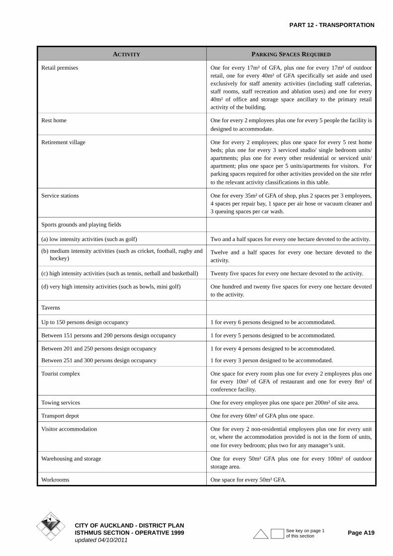
ACTIVITY PARKING SPACES REQUIRED
Boarding house/hostel One for every non-residential employee plus one for every 3 residents the boarding house/hostel is designed to accommodate;
plus 2 for any manager’s unit.
Bulk store One for every 100m² of GFA plus one for every 100m² of outdoor storage.
Buildings used for recreation One for every 4 people the facility (including grandstands) is designed to accommodate.
Building improvement and hire centres One for every 20m² of gross floor area of building and one for every 100m² of outside area used for display purposes.
Camping ground One per camp site or cabin, plus one for every 2 employees.
Care centre One for every member of staff in attendance plus one for every 10 children or people the facility is designed to accommodate.
Community welfare facility One for each 20m² of gross floor area.
Community use of school facilities One for every four people attending the community use activity at any one time. (Note: Existing on site parking provided for school use can be used for community use outside of normal school hours)
Drive-through facility Five queuing spaces per booth or facility.
Education facility Primary, Intermediate and Secondary - Two per classroom.
Tertiary and other facilities - One for every three persons the facility is designed to accommodate.
Electricity generation facility (gas fired) One for every employee who will be working in or at the facility at any one time plus three visitor carparks plus one space for a 99 percentile truck
CITY OF AUCKLAND - DISTRICT PLANISTHMUS SECTION - OPERATIVE 1999 Page A17updated 04/10/2011
See key on page 1 of this section

PART 12 - TRANSPORTATION
Entertainment facility One for every 3 people the facility is designed to accommodate
Funeral parlour One for each employee plus where funeral services, (eg chapel) are performed one for every four persons the facility is designed to accommodate.
Garden centres One for every 20m² of gross floor area of building and one for every 100m² of outside area used for display purposes.
Healthcare services One for every 20m² of GFA.
Hospital One for every three licensed hospital beds in ward areas plus five for every operating theatre plus one for every 25m² of gross floor area of all areas not assessed as ward areas or operating theatres.
Housing development for the elderly or disabled One for every 2 units or, where such accommodation is not provided in the form of separate units, one for every two bedrooms;
plus one visitor space for every 5 units or 5 bedrooms.
Industry (including manufacturing, engineering and servicing) One for every 50m² of GFA plus, in the case of a motor vehicle servicing premises, 4 spaces for each repair or lubrication bay.
Integrated housing development Two spaces for each residential unit; plus one visitor space for every 5 residential units.
Laboratories One for every 50m² of GFA.
Marae One for every 4 people the facility is designed to accommodate.
Motor vehicle sales and service One for 10 vehicle display spaces plus four spaces for each repair
and lubrication bay, plus one for each 50m² of the gross floor area of the remaining building used in the activity.
Motor vehicle wrecking One for every 50m² of GFA plus one for every 200m² of outdoor storage space.
Offices One for every 40m² of GFA.
Places of assembly One space for every four people a community or recreation facility is designed to accommodate, or for churches, one for every 4.5m² of floor area of the auditorium of the church or one for every 4.5m² of the total floor area of all meeting rooms (whichever is the greater). Provided that the term auditorium shall mean the primary place of assembly (including any nave/congregational seating area) and any adjacent gallery or room which is separated by non-permanent partitions, but shall not include any chancel, sanctuary or stage.
Port and harbour facilities, including wharves and premises for the handling of seaborne cargoes, workshops and slipways.
One for every two persons intended to be working in or at the facility at any one time.
Premises for cultural activity or natural display One space for every five people the facility is designed to accommodate.
Residential unit Two spaces for each residential unit.
Restaurants, cafes and other eating places One for every 10m² of GFA, plus one for every 15m² of outdoor eating area.
ACTIVITY PARKING SPACES REQUIRED
CITY OF AUCKLAND - DISTRICT PLANPage A18 ISTHMUS SECTION - OPERATIVE 1999
updated 04/10/2011See key on page 1 of this section
PART 12 - TRANSPORTATION
Retail premises One for every 17m² of GFA, plus one for every 17m² of outdoor retail, one for every 40m² of GFA specifically set aside and used exclusively for staff amenity activities (including staff cafeterias, staff rooms, staff recreation and ablution uses) and one for every 40m² of office and storage space ancillary to the primary retail activity of the building.
Rest home One for every 2 employees plus one for every 5 people the facility is
designed to accommodate.
Retirement village One for every 2 employees; plus one space for every 5 rest home beds; plus one for every 3 serviced studio/ single bedroom units/apartments; plus one for every other residential or serviced unit/apartment; plus one space per 5 units/apartments for visitors. For parking spaces required for other activities provided on the site refer
to the relevant activity classifications in this table.
Service stations One for every 35m² of GFA of shop, plus 2 spaces per 3 employees, 4 spaces per repair bay, 1 space per air hose or vacuum cleaner and 3 queuing spaces per car wash.
Sports grounds and playing fields
(a) low intensity activities (such as golf) Two and a half spaces for every one hectare devoted to the activity.
(b) medium intensity activities (such as cricket, football, rugby and hockey)
Twelve and a half spaces for every one hectare devoted to the activity.
(c) high intensity activities (such as tennis, netball and basketball) Twenty five spaces for every one hectare devoted to the activity.
(d) very high intensity activities (such as bowls, mini golf) One hundred and twenty five spaces for every one hectare devoted to the activity.
Taverns
Up to 150 persons design occupancy 1 for every 6 persons designed to be accommodated.
Between 151 persons and 200 persons design occupancy 1 for every 5 persons designed to be accommodated.
Between 201 and 250 persons design occupancy
Between 251 and 300 persons design occupancy
1 for every 4 persons designed to be accommodated.
1 for every 3 person designed to be accommodated.
Tourist complex One space for every room plus one for every 2 employees plus one for every 10m² of GFA of restaurant and one for every 8m² of conference facility.
Towing services One for every employee plus one space per 200m² of site area.
Transport depot One for every 60m² of GFA plus one space.
Visitor accommodation One for every 2 non-residential employees plus one for every unit or, where the accommodation provided is not in the form of units,
one for every bedroom; plus two for any manager’s unit.
Warehousing and storage One for every 50m² GFA plus one for every 100m² of outdoor storage area.
Workrooms One space for every 50m² GFA.
ACTIVITY PARKING SPACES REQUIRED
CITY OF AUCKLAND - DISTRICT PLANISTHMUS SECTION - OPERATIVE 1999 Page A19updated 04/10/2011
See key on page 1 of this section

PART 12 - TRANSPORTATION
Figure 12.2a Manoeuvring & Parking Space Dimensions
CITY OF AUCKLAND - DISTRICT PLANPage A20 ISTHMUS SECTION - OPERATIVE 1999
updated 04/10/2011See key on page 1 of this section

PART 12 - TRANSPORTATION
Figure 12.2b Manoeuvring & Parking Space Dimensions
All dimensions in metres
Parking Angle
Width of Parking Space
Kerb Overhang
Depth of Parking Space
Manoeuvring Space
Total Depth One Row
Total Depth Two Rows
90º Regular Users*
2.3(1)
2.4(2)
2.5
2.6
2.7
2.75
1.0
“
“
“
“
“
4.9
“
“
“
“
“
8.3
7.1
6.7
6.3
5.9
5.9
13.2
12.0
11.6
11.2
10.8
10.8
18.1
16.9
16.5
16.1
15.7
15.7
90º Casual Users*
2.5
2.6
2.7
2.75
1.0
“
“
“
4.9
“
“
“
8.1
7.1
6.7
6.6
13.0
12.0
11.6
11.5
17.9
16.9
16.5
16.4
75º 2.3(1)
2.4(2)
2.5
2.6
2.7
2.75
1.0
“
“
“
“
“
5.2
“
“
“
“
“
7.0
6.5
6.0
5.7
5.0
4.3
12.2
11.7
11.2
10.9
10.2
9.5
17.4
16.9
16.4
16.1
15.4
14.7
60º
(3)
2.3(1)
2.4(2)
2.5
2.6
2.7
2.75
1.0
“
“
“
“
“
5.2
“
“
“
“
“
5.0
4.6
4.1
3.5
3.3
3.2
10.2
9.8
9.3
8.7
8.5
8.4
15.4
15.0
14.5
13.9
13.7
13.6
45º
(3)
2.3(1)
2.4(2)
2.5
2.6
2.7
2.75
0.8
“
“
“
“
“
4.9
“
“
“
“
“
3.3
2.9
2.7
2.5
2.4
2.3
8.2
7.8
7.6
7.4
7.3
7.2
13.1
12.7
12.5
12.3
12.2
12.1
30º
(3)
2.3(1)
2.4(2)
2.5
2.6
2.7
2.75
0.6
“
“
“
“
“
4.0
“
“
“
“
“
2.5
2.4
2.4
2.4
2.3
2.3
6.5
6.4
6.4
6.4
6.3
6.3
10.5
10.4
10.4
10.4
10.3
10.3
Parallel
(3)
5.9
6.1
6.3
0.4
“
“
2.5
“
“
3.6
3.3
3.0
6.1
5.8
5.5
8.6
8.3
8.0
CITY OF AUCKLAND - DISTRICT PLANISTHMUS SECTION - OPERATIVE 1999 Page A21updated 04/10/2011
See key on page 1 of this section

PART 12 - TRANSPORTATION
*Regular users are people whose regular use gives them a familiarity with the building that permits smaller safe clearances between vehicles and parts of buildings. Casual users are people (usually short-term visitors) who would not be familiar with the building layout.
NOTES:
1. Stall widths of 2.3m should only be used where users are familiar with the carpark, and parking is long-term. This stall width does not meet the requirements of the Building Code.
2. Stall widths of 2.4m should generally only be used where users are familiar with the carpark. This stall width does not meet the requirements of the Building Code for Casual Users.
3. Minimum aisle widths are 3.5m for a one-way aisle, and 5.5m for a two-way aisle. Where an aisle serves more than 50 spaces, it should be designed as a circulation route in which case the minimum width for a two-way aisle increased to 6.5m. Note that the Building Code requires an extra 0.8m width where pedestrians use a vehicle circulation route.
4. Stall widths shall be increased by 0.3m where they abut obstructions such as columns or walls.
5. All overhang areas shall be kept clear of objects greater than 150mm in height.
6. Where parallel end spaces have direct access through the end of the stall the length of the stall may be reduced to 5.4m.
7. One-way traffic is assumed for angle spaces.
8. Carparks shall have a height of at least 2.3m over the full area of the space, except where special provision is made to divert overheight vehicles, in which case the minimum height may be reduced to 2.1m.
9. Note that the Building Code may require carpark spaces to be provided for people with disabilities. Details of the requirements for these spaces may be found in the Building Code or NZS 4121.
10. Linear interpolation is permitted for stall width, parking angle and aisle width.
11. Carpark spaces which comply with the preferred design envelope of Figure 12.2c are deemed to comply with the dimension of Figure 12.2b.
Figure 12.2c Preferred Design Envelope around Parked Vehicle to be kept clear of Columns, Walls and Obstructions
12.8.1.2 LOADING STANDARDS
The following shall be the minimum number of loading spaces to be provided in respect of:
Space width fromFigure 12.2b
CITY OF AUCKLAND - DISTRICT PLANPage A22 ISTHMUS SECTION - OPERATIVE 1999
updated 04/10/2011See key on page 1 of this section

PART 12 - TRANSPORTATION
(a) General Goods Handling (Retail, Wholesale, Manufacturing etc)
(b) Non-Goods Handling (Offices etc)
(c) Printing and Newspaper Distribution
1 per 120m² of printing space, with a minimum of 6 spaces.
Except that:
i) The number of loading spaces required for residential activities shall be such as the Council considers to be reasonable and practicable in the circumstances;
ii) On those sites where access is prohibited under Clause 12.8.2 ACCESS, and alternative access is not possible, the loading requirements of this rule shall be deemed to be satisfied;
iii) Where refuse disposal is by large bins, sufficient space is to be made available to ensure that any truck operations take place entirely on site, and no reversing on or off the road is required.
12.8.1.3 ASSESSMENT AND FORMATION OF PARKING AND LOADING AREAS
Fractional Spaces
Where an assessment of the required parking standards results in a fractional space, any fraction under one half shall be disregarded and any fraction of one half or more shall be counted as one space.
Assessment of Floor Area
The area of any of the following activities, if provided within a building, shall be excluded from the assessment of gross floor area of that building, for the purpose of ascertaining the total number of spaces required or permitted:
i) any parking space or spaces and vehicular access drives, manoeuvring areas and aisles;
ii) any loading space or spaces;
iii) in retail premises, pedestrian circulation areas as defined in Part 13 of the Plan, and trundler storage areas where these are located in areas which are separate from, and not used for, retail sales or display.
Size of and Access to Parking and Loading Spaces
Every parking and/or loading space shall:
i) Have such dimensions in accordance with Figures 12.2a and 12.2b;
ii) Provide parking spaces of larger dimensions than those specified in (i) above for use by disabled persons. Parking spaces which meet the requirements of NZS 4121:1985 “Code of Practice for access and use of buildings and facilities by disabled persons” will be deemed to meet this requirement;
iii) Be provided with such access drives and aisles as are necessary for ingress and egress of vehicles to and from the road, and for the manoeuvring of vehicles within the site. In determining the extent of area required for manoeuvring space, the Council will be guided by the 90 and 99 percentile car and truck tracking curves shown in Figures 12.3a, 12.3b and 12.3c.
In applying the tracking curves:
• the clearances identified in Figures 12.3a and 12.3b shall be maintained between the vehicle tracking area curve and any fixed object;
• for public and customer carparking and for activities in (a) below, the 99 percentile tracking curves shall apply;
iv) Be located on the same site as the activity to which it relates, be available at all times and shall have adequate useable access to that activity or building. Each loading space shall be adjacent to an adequate area for goods handling and shall be convenient to any service area or service lift.
In addition every loading space shall be of useable shape and shall be of the following dimensions:
(a) For transport depots and other similar activities, not less than 9m in depth;
(b) For retail premises, non-permanent accommodation, offices, warehouses, bulk stores, industry, servicing premises residential units in the Mixed Use Zone and other similar uses, not less than 8m in depth;
(c) Offices and other non-goods handling activities, where the gross floor area is not greater than 1500 m², and where on-street space is available for occasional servicing by larger vehicles, 6m long, 3.0m wide, 2.6m high, (Van Loading Space);
0 - 5,000m² 1 space required
5,001 - 10,000m² 2 spaces
> 10,000m² 3 spaces plus 1 space per 7,500m² above 10,000m²
0 - 20,000m² 1 space required
20,001 - 50,000m² 2 spaces
> 50,000m² 3 spaces plus 1 space per 40,000m² above 50,000m²
CITY OF AUCKLAND - DISTRICT PLANISTHMUS SECTION - OPERATIVE 1999 Page A23updated 04/10/2011
See key on page 1 of this section

PART 12 - TRANSPORTATION
(d) Notwithstanding anything to the contrary in the foregoing clauses, where articulated vehicles are used or are intended to be used in connection with any site, sufficient loading spaces not less than 11m in depth shall be provided for the purpose;
(e) No loading space shall be less than 3.5m in width, or such greater width as is required for adequate manoeuvring;
(f) No loading space shall be less than 3.8m in height;
(g) Gradients shall be kept to a minimum. For service and manoeuvring areas the gradient shall not exceed 1:12.5.
Formation and Availability of Parking and Loading Spaces
The whole of the parking and loading space or spaces, access drives, manoeuvring areas and aisles shall, before the commencement of the activity to which those parking and loading spaces relate, and thereafter for as long as that activity is continued, be formed, provided with an all weather surface, drained, marked out or delineated, and maintained, all to the satisfaction of the Council.
Such required parking areas must be kept clear and available at all times, free of charge and impediment, for vehicles used in conjunction with the particular activity to which the parking spaces relate on the site, and must not be used for the deposit or storage of any goods or materials or for any other purpose.
Grades
The maximum gradients for parking surfaces and floors are 1:16 transversely, and 1:20 longitudinally along the direction of the space, although on steep sites a gradient of 1:12.5 will be acceptable for manoeuvring areas.
Screening of Spaces
Where four or more parking spaces are provided on a site which is adjacent to or faces land zoned residential or open space, the area comprising such spaces shall be screened from residential or open space zoned properties by a solid wall or walls or an effective screen or screens not less than 1.8m in height, constructed of concrete, brick, stone, timber or such other materials as are approved by the Council. Any such wall or screen shall be erected in a workmanlike manner and to the satisfaction of the Council.
Kerbs
Where a parking or manoeuvring area is adjacent to a road, a kerb or similar barrier, not less than 150mm high and at least 600mm from the road boundary, shall be provided on those parts of the frontage not used for vehicular access.
Building Line Designations
No required parking or loading spaces, manoeuvring area, or part thereof shall be located between any building line
designation and the road alignment shown on Planning Map No. 2.
SECTION CONTINUED
CITY OF AUCKLAND - DISTRICT PLANPage A24 ISTHMUS SECTION - OPERATIVE 1999
updated 04/10/2011See key on page 1 of this section


