
Parks, Recreation and Open Space Plan - COB Home › Documents › parks ›...
43
PRO Plan City of Bellingham Parks, Recreation & Open Space Plan February 24, 2020 Sehome Hill Arboretum Trail. Photo by Sean Stockburger.
Transcript of Parks, Recreation and Open Space Plan - COB Home › Documents › parks ›...

PRO Plan City of Bellingham
Parks, Recreation & Open Space Plan February 24, 2020
Sehome Hill Arboretum Trail. Photo by Sean Stockburger.

Bellingham Parks, Recreation, and Open Space Plan 2020
Page 1
Table of Contents Chapter I: Introduction, Goals and Objectives ........................... 2
Chapter II: Community Setting ........................................................ 9
Chapter III: Existing Facilities ....................................................... 15
Chapter IV: Land and Facility Demand ...................................... 25
Chapter V: Recommendations ...................................................... 30
Chapter VI: Implementation ................................................................ 39
Appendices:
A. Park Classifications B. Existing Facilities Tables C. Proposed Facilities Table D. Capital Facilities Plan E. Revenue Source Descriptions F. Public Survey Results
Acknowledgements
City Staff Leslie Bryson, Parks & Recreation Director Nicole Oliver, Parks Development Manager (PM) Steve Janiszewski, Park Operations Manager Melissa Bianconi, Recreation Manager Austin Bolstad, Data Technician Jesse Herrick, Systems Analyst
Steering Committee (Parks & Recreation Advisory Board) John Blethen Alexis Blue Janice Carmichael Neha Harle Ellen Howard Peter Hurd Maggi Kriger Michael Kutcher Courtney Lange Staci May Simone Sangster Edmund Sullivan
Greenways Advisory Committee Emily Derenne Skylar Hinkley Michael Maghakian Rick Nishi Seth O’Hara Michael Plummer Daniel Weiland

Bellingham Parks, Recreation, and Open Space Plan 2020
Page 2
I. Introduction, Goals & Objectives
The City's Park, Recreation and Open Space Plan (PRO Plan), an element of the City's Comprehensive Plan, is the overarching document that guides the preservation and expansion of the park, recreation and open space system as the community grows. The PRO Plan must be updated every six years in order for the City to remain eligible for grants administered by the Washington State Recreation and Conservation Office, such as the Washington Wildlife and Recreation Program, Boating Facilities Program, and Land and Water Conservation Fund. The PRO Plan outlines the steps to continue to achieve a quality park and recreation system for the future.
1.1 Growth Management Act and Plan Components The Growth Management Act (GMA) establishes goals for cities and counties to ensure that their quality of life is sustained as their communities grow. One of these goals is to “retain open space, enhance recreational opportunities, conserve fish and wildlife habitat, increase access to natural resource lands and water, and develop parks and recreational facilities” (RCW 36.70A.020(9)). This plan contains the following components:
Establish Goals and Objectives – Identify the goals to be met and objectives to carry out those goals as the PRO Plan is implemented.
Inventory Existing Park System –
List the lands and facilities owned and operated by the City or other public agencies within the City limits and the Urban Growth Area.
Analyze Needs & Opportunities – Determine the needs for future park, recreation, and open space facilities or programs.
Adopt Level-of-Service – Based on
the existing park system and the identified needs, establish level of service standards to help guide development of the park system over the next 10 to 20 years.
Create Implementation Plan – Estimate the overall cost of achieving the proposed level of
service, based on the community’s recommendations, prioritize those recommendations, and develop a plan to pay for them.
Overlooking South Bay Trail at Taylor Dock. Photo by Kenni Merritt.
Mission Statement: Support a healthy community by promoting high quality
parks and recreation services. .

Bellingham Parks, Recreation, and Open Space Plan 2020
Page 3
1.2 Principles, Goals and Objectives Principles These six principles demonstrate the collective community values regarding Bellingham’s park system:
• Preservation: Conserves habitat and open space, enhances native species and creates opportunities to learn about and interact with nature.
• Connection: Supports community connection through enhanced trail corridors protecting wildlife habitat and improving physical, mental and emotional health.
• Play: Inspires imagination and joy. • Equity: Quality and quantity of
amenities equally distributed, easy to safely use year-round and accessible by all modes of travel.
• Resiliency: Stewards a long-term park system that helps reduce the impact of climate change and supports flexible spaces that accommodate traditional, emerging and future recreational use.
• Inclusivity: Responsive to the entire Bellingham community: all ages, abilities, languages, genders, cultures and income levels.
Goals & objectives These eight goals, and their corresponding objectives, reflect the community’s desired outcomes and provide a strategic framework for recommendations in the PRO Plan. Goal 1: Provide high-quality facilities and services that are accessible, inclusive and distributed equitably across Bellingham.
Objectives: a. Provide a system of parks, trails and open space so that all residents live within
one-half mile safe route of a developed park or trail.
b. Proactively upgrade and restore existing facilities to address community needs,
improve resiliency and protect long-term health of existing park assets.
c. Provide adequate staff year-round to maintain and enhance park facilities and
services.
d. Target new park acquisitions and development in areas that are under-served.
Goal 2: Enhance the capacity, quality and variety of use of the existing park and recreation system,
Objectives: a. Evaluate park facilities and infrastructure to ensure adequate capacity can
support existing and future use.
Couple dancing at Boulevard Park. Photo by Dex Horton.

Bellingham Parks, Recreation, and Open Space Plan 2020
Page 4
b. Incorporate art and whimsy
into park facilities.
c. Evaluate opportunities to
renovate existing facilities to
expand use and
accommodate popular
recreational activities such as
pickleball, volleyball, disc
golf, competitive swimming
and alternative sports such as
skate boarding, BMX and
other biking, and
water/paddle sports.
d. Design and prioritize system
upgrades that respond to condition assessments, community vision and
preferences.
e. Acquire and develop additional shoreline access.
Goal 3: Create environments that encourage regular active and passive recreation activities to support health, sense of safety, wellness and social connections.
Objectives: a. Partner and collaborate with local service providers that activate underserved
locations and populations.
b. Work with other City departments and organizations to keep parks safe and
clean.
c. Provide more small gathering spaces, especially in the urban area as infill
occurs.
d. Provide larger event spaces such as enclosed meeting rooms and outdoor
shelters suitable for family gatherings, weddings, festivals, and events.
e. Identify outdoor facilities that may be identified or designated as natural
therapy locations.
Goal 4: Preserve and integrate nature, natural systems and ecological principles throughout the park system.
Objectives: a. Protect environmental features that reflect Bellingham’s natural character,
including ridgelines, critical areas, forests and wildlife corridors.
b. Participate in development and implementation of an Urban Forestry Master
Plan to proactively assess and protect urban tree canopy and undergrowth.
c. Recognize the importance of taking action to reduce the impacts of climate
change and the natural carbon sequestration function of our existing parks.
d. Contribute to the City’s sequestration capacity through continuing to
incorporate principles of preservation in park design and development.
e. Expand dog-waste program and provide additional trash receptacles to improve
self-maintenance and litter control.
f. Implement low impact development measures and integrated pest management to reduce environmental impacts.
Bellingham Farmers Market. Photo by Cynthia St. Clair.

Bellingham Parks, Recreation, and Open Space Plan 2020
Page 5
g. Steward and protect open spaces from invasive species, illegal activity, and
inappropriate use, and revegetate where appropriate.
h. Perform invasive species removal and habitat restoration on open space
properties. i. Provide environmental education opportunities such as interpretive signage or
other educational programs to promote the value of the natural environment
throughout the park system.
Goal 5: Develop innovative programs, services and strategies for expanding recreational opportunies and improving accessibility.
Objectives: a. Involve the community in habitat restoration and maintenance activities
through the Parks Volunteer Program.
b. Explore partnerships that expand services or leverage support for specific
projects.
c. Target service improvements that decrease barriers and expand park and
recreation system use.
d. Evaluate existing scholarship program for low income families with the goal of
expanding participation.
e. Ensure new development invests in and dedicates new parks, trails, street trees
and open space.
f. Target improvements that connects trails with transit stops, key destinations,
bike routes and sidewalks to improve non-motorized transportation options.
g. Coordinate with Public Works to identify opportunities for better trails, habitat
corridors, sidewalks and bike route connectivity.
h. Provide Diversity, Equity and Inclusion (DEI) training opportunities for staff.
i. Provide programs and events that meet the diverse needs of the community-
increasing access to public services in underserved areas.
j. Provide program and service information in multiple languages.
k. Modernize recreation
programs to meet interests and needs
of the community.
l. Redefine “duplication” of
services. There may still be a lack of
services even if other agencies
provide certain opportunities (after-
schools, camps, pre-school, teen,
senior programming etc.).
m. Develop a partnership
agreement with Recreation
Northwest to integrate their
Parkscriptions model into City
recreational programs and curricula.
Goal 6: Connect and unify the community with trail and greenway corridors. Objectives:
Fairhaven Village Green. Photo by Kenni Merritt.

Bellingham Parks, Recreation, and Open Space Plan 2020
Page 6
a. Provide an interconnected trail system so all residents are within a one-half mile
of a safe route.
b. Balance the demand for public access and interpretive education with
protection of environmentally sensitive areas and historic sites. c. Implement the Greenways Strategic Plan and pursue recommended future
parks, open space and trails.
d. Provide safe street crossings (i.e. beacons, raised crossings, signalization,
medians, etc.) that connect to parks and trails.
e. Improve wayfinding.
f. Continue to explore new trail surface alternatives that balance the natural
character of Bellingham's trail system with accessibility requirements, long-
term maintenance, sustainable development practices and availability of local
materials.
g. Promote the use of pedestrian and bike travel and encourage the reduction of
single occupancy vehicle use by providing safe and connected alternative
transportation routes.
Goal 7: Manage Bellingham’s park land and programs effectively, efficiently and sustainably utilizing quantitative and qualitative measures.
Objectives: a. Design and develop facilities that reduce overall maintenance, operation
requirements and costs, while improving resiliency and efficiency.
b. Establish baseline conditions and maintenance standards for park assets and
evaluate and report progress towards meeting standards and improving
conditions.
c. Prioritize capital improvements based on safety, condition, socio-economic
factors and population served.
d. Analyze options for long-term financial sustainability.
e. Explore options to improve enforcement of park rules while ensuring all park
users feel welcome.
f. Provide staff with adequate training, resources and equipment to increase
productivity and efficacy.
g. Assess energy efficiency of park facilities and prioritize energy and system
upgrades.
Goal 8: In 2020, conduct a Community Recreation Needs Assessment guided by the following objectives. Objectives:
a. Explore barriers and/or constraints to recreation participation, such as timing,
location, lack of information, transportation, or money.
b. Evaluate public willingness to pay for services.
c. Identify who we are serving and what demographics have unmet needs.
d. Explore specific recreation programs and services - what will people use vs.
perceived desires.
e. Identify facility needs and/or desires for enhancements or improvements.
f. Explore marketing needs to understand how the public learns about program
opportunities.

Bellingham Parks, Recreation, and Open Space Plan 2020
Page 7
g. Determine what community needs are being met by other service providers.
h. Design the Community Recreation Needs Assessment to achieve the following
implementation tools:
Provide a policy framework for the use of parks and facilities that establishes
methods for effectively tracking service utilization and creates realistic cost
recovery models.
Informs recommendations for the provision of equitable services.
Form the basis for a Recreation Services Strategic Plan that includes staff
guidance, program development, cost recovery models and staffing needs.
1.3 Public Involvement Public input is important to a community-based parks and recreation plan. The members of the Parks and Recreation Advisory Board (PRAB) served as the Steering Committee to help oversee the process, provide input and evaluate the recommendations. Greenways Advisory Committee members tackled the updates to recommended trails and open space. A web-based survey, public workshops and a public open house were also conducted to augment and inform the Committee’s discussions.
A summary of the 2,463 responses to the Parks & Recreation Community Survey is attached as Appendix F. Public hearings were held with the Planning Commission and City Council prior to final adoption. The public involvement process included the following:
Meeting Topic Date
2019
Steering Committee/PRAB Project Launch April
Online Public Survey Community Survey June-July
Public Workshop #1 Goals and Objectives June 4, 2019
All Staff Workshop Priorities and Goals June 6, 2019
City Council Project Update and PEP Tool June 17, 2019
Workshop #2 Maps July 11, 2019
Steering Committee/PRAB Recommendations September 11, 2019
Public Open House Overview of key elements September 19, 2019
Steering Committee/PRAB Final Recommendation October 9, 2019
Planning Commission Public Hearing November 21, 2019
City Council Public Hearing February 10, 2020
Bellingham Parks, Recreation, and Open Space Plan 2020
Page 8
1.4 Plan History and Boundary This PRO Plan, updated every six years, builds on previous comprehensive planning efforts and is an element of the Comprehensive Plan for Bellingham. The PRO Plan considers parks, recreation and open space land, trails, facilities and programs. The planning area for this process includes the Bellingham City Limits and the adopted Urban Growth Area (UGA). Whatcom County is responsible for planning the area outside of the UGA, however, the planning efforts of each agency must be coordinated. Also, for the purposes of the PRO Plan, it is assumed that residents who currently live within the UGA are served by existing parks, and that by the end of the 20-year planning period, or 2040, all UGA areas will be incorporated into the City. The proposed facilities, population, level-of-service and any other recommendations projected to the year 2040 include both the existing City and the entire UGA. If all these areas are not annexed, some of the recommendations would not be implemented. Projects prioritized during the planning process are included in the City's six-year Capital Budget (see Appendix D), which is updated at least bi-annually.

Bellingham Parks, Recreation, and Open Space Plan 2020
Page 9
II. Community Setting
2.1 Location, Topography and Climate Bellingham is located in northwest Washington along the shores of Bellingham Bay. The inland urban area is framed by the slopes of Stewart, Lookout, and Chuckanut Mountains, at the edge of the Cascade foothills with Mount Baker in the background.
Topography ranges from sea level to about 500 feet on the hilltops around Bellingham. Elevation increases to 3,050 feet at the top of Stewart Mountain, and eventually to 10,785 feet at the top of Mount Baker. The land is generally flat to rolling within the urban growth area, though the plateau edge overlooking Bellingham Bay can drop off abruptly in slopes ranging from 40% to 75%.
Bellingham has a mild maritime climate with an average temperature of 50 degrees Fahrenheit. Mean temperatures vary from a high of 74 degrees in July to a low of 32 degrees in January. Average annual precipitation is about 39 inches; approximately 80% of the precipitation occurs from October through March. 2.2 Natural Features The first Greenway Levy passed in 1990 largely in response to citizen interest in protecting valuable wildlife habitat corridors, shoreline, riparian, wetland and unique upland areas and providing public access to those unique areas. The levy was approved again in 1997, 2006 and 2016. In 2005, Bellingham strengthened protection of wetland and streams by adopting the Critical Areas Ordinance in compliance with the requirements of the Washington Growth Management Act (GMA) which also protects steep slopes and frequently flooded areas. The Shoreline Master Program (SMP) was updated in 2013, adding more protection for shorelines and providing habitat restoration guidance while supporting public access. In 2012, the City Council adopted an Environment Element (Chapter 9) of the Comprehensive Plan to address environmental protection and ensure compliance with the GMA. The City developed a Habitat Restoration Technical Assessment and a marine nearshore assessment, which use a science-based prioritization framework to guide the preservation, restoration, and recovery of the City's terrestrial, aquatic and riparian habitats. The recommendations in the PRO Plan were informed by these documents. Following is a list of important environmental features with public recreation elements in and around the Bellingham area.

Bellingham Parks, Recreation, and Open Space Plan 2020
Page 10
2.2.1 Notable Creeks Three major creeks and multiple minor creeks drain the Bellingham area. Squalicum, Whatcom, and Padden Creeks and their tributaries are on the Washington State list of impaired water bodies. Preventing further degradation and improving water quality of the City's creeks is important to ensure the resources they provide to the community are protected.
Squalicum Creek is a major creek that starts at Squalicum Lake and flows southwest to the mouth of Bellingham Bay. The Squalicum Creek Trail is partially built within the creek alignment.
Whatcom Creek is a major creek that drains from the northwest end of Lake Whatcom west into Bellingham Bay. Whatcom Creek Trail and Greenway generally follow the alignment of Whatcom Creek.
Padden Creek is a major creek that drains from the Lake Padden west into Bellingham Bay. Upper and lower Padden Creek Greenway Trail follows the corridor. The 26-acre Connelly Creek Nature Area flows into Padden Creek, preserves valuable habitat and provides walking trails.
Little Squalicum Creek is a minor
perennial creek northwest of Squalicum Creek that flows through Little Squalicum Park and into Bellingham Bay.
Chuckanut Creek is a minor perennial
creek that drains from near Lake Samish west into Chuckanut Bay, through Arroyo Park.
Bear Creek, a tributary of Silver Creek, runs through several northern trail and open space systems.
2.2.2 Lakes, ponds and estuaries in and near Bellingham Lakes are defined here as water bodies greater than 20 acres in size or more than 6 feet in depth.
Lake Whatcom is 10 miles long with a surface area of approximately 5,000 acres. Since 1968, the City has relied on Lake Whatcom for its municipal water supply. The lake is on the Washington State list of impaired water bodies. Public swimming and boating access to the lake is provided at Bloedel Donovan Park, with monitoring for prevention of aquatic invasive species. Other public access within the UGA is available at the Department of Natural Resources leased property located on North Shore Drive, Euclid Park, and several unimproved street rights-of-way.
Lake Samish located south of the urban growth area, is three miles long with a surface area
of approximately 809 acres. Most of the lake shoreline has been developed for private
Whatcom Creek in Whatcom Falls Park. Photo by Evan Bogart.

Bellingham Parks, Recreation, and Open Space Plan 2020
Page 11
residential uses. Whatcom County has developed Lake Samish Park with swimming, fishing, and boat access.
Lake Padden is one mile long with a surface area of approximately 151 acres. The entire
lake is within the boundaries of Lake Padden Park with a perimeter trail, swimming, boating and fishing access.
Toad Lake is a one-half mile long with a surface area of approximately 28 acres.
Washington State Fish & Wildlife has developed swimming, fishing and boat access on the south end of the lake. The rest has been developed with primarily residential uses.
Sunset Pond is a human-made freshwater retention pond at Sunset Pond Park with
improved perimeter trails that connect to Bay to Baker Trail.
Bug Lake is a man-made freshwater retention pond with informal walking trails. It will be restored to a forested wetland in 2020.
Padden Lagoon is a saltwater estuary at
the inlet of Padden Creek into Bellingham Bay. The shoreline has been restored and preserved but has no on-water access.
Hoag’s Pond, located near the Interurban Greenway and Trail, is a small basin surrounded by a trail that flows into Chuckanut Creek.
Most of the other small ponds or lakes in the Bellingham urban area have either been developed for private residential use and/or are too small to support public access activities. 2.3.3 Beaches and Shorelines Bellingham has a wide variety of waterfront access in various places around Bellingham Bay. These include Little Squalicum and Squalicum Beaches, Zuanich Park (Port of Bellingham), the Central Waterfront Trail (ASB), Waypoint Park, Cornwall Beach Park, Boulevard Park, Taylor Dock-area tidelands, Marine Park (Port of Bellingham), and Chuckanut Bay. Trails connect to and from these beaches and shorelines, and the public has strong interest in obtaining future beach and shoreline access and protection.
Lake Padden. Photo by Chris Hughes.

Bellingham Parks, Recreation, and Open Space Plan 2020
Page 12
2.3 Population The 2019 population for Bellingham was estimated to be 90,110. Bellingham’s official census population for 2000 was estimated to be 67,171 resulting in an average annual increase of 1.56% per year over the 19-year period. The unincorporated Urban Growth Area (UGA) for Bellingham contains an estimated 10,457 people for a total UGA population of 100,567 in the year 2019. According to the 2016 Whatcom County Comprehensive Plan, the City’s population will increase to 124,157 persons by the year 2036 assuming all UGA areas are incorporated, or by another 23,590 people from the 2019 population. Estimating the population of Bellingham in 2040 can be done by using the 2019 population estimate of 100,567 and the Comprehensive Plan’s 2036 population estimate of 124,157. The growth rate between 2019 and 2040 would then be an annual average of 1.24% per year. This growth rate can then be used to derive a value of 130,468 people living in the City of Bellingham and the UGA by 2040. 2.4 Recreation Trends Similar to the rest of Washington State, Bellingham has seen a steady increase in organized sports. In Bellingham, that increase has also included new types of activities, such as pickleball, rugby, lacrosse, ultimate frisbee, radio-controlled drones and cars, geocaching, disc golf and paddle boarding. A changing demographic and an increase in cultural diversity in the Bellingham area have brought new types of interests in recreational activities and programs. It has also brought a greater need for
more community recreational activities and financial assistance to lower-income residents for program fees. Similar to trends across the nation, Bellingham residents continue to demand more off-road walking and bicycling trails. As trails increase in popularity and the community grows, there are increased user conflicts, including dogs off leash, and increasing cut-through trails causing erosion and vegetation damage. Additional user conflicts are caused by increasing environmental changes including increased fecal coliform levels in streams, algae blooms and aquatic invasive species.
2019 City Population = 90,110
2019 UGA Population = 10,457
2019 Total Population = 100,567
2040 Projected Population = 130,468
Cornwall Memorial Park pickleball courts. Photo by Neal Bittner

Bellingham Parks, Recreation, and Open Space Plan 2020
Page 13
The census data shows that, much like the rest of the nation, Bellingham's population is aging with the percent of the population over 65 years of age increasing from 13.2% in 2014 to 17.3% in 2017. Ensuring that park facilities provide active recreational opportunities for our aging population is critical to community health. Accessible facilities for those with limited mobility will be key in ensuring access for all groups in our community. Nationally, there has been recognition of the importance of recreation and park systems to overall quality of life, health and well-being especially as related to the growing obesity rate across the nation. Research shows that well-designed and accessible parks and open spaces are correlated with better physical health through increased rates of physical activity and lower rates of depression and stress. Establishing a level of service for parks and trails that ensures equitable access and proximity for all populations within the community is an important step towards addressing health disparities and promoting good health for all. Recreation and sports tourism activities are drivers that support local and regional economic development. As Bellingham continues to grow as a “destination city” it will be important to provide recreation and sports services, events and facilities to keep pace with demand. Such services have potential to provide increased or alternative sources of revenue for both private and public providers and play an important role in economic development and a healthy recreation economy. 2.5 Maintenance Management & Volunteer Program
The existing system of 83 community parks, neighborhood parks, open space, trails and special use sites totaling 3,186 acres is currently maintained by a full-time equivalent (FTE) staff of 47.17 (33 permanent and 14.17 seasonal employees). Approximately 8,000 volunteers contribute over 20,000 hours annually through the Parks Volunteer Program to improve parks by removing invasive species and restoring and planting native plants. Almost one-third (923 acres) of the properties can be classified as developed parks with the remaining 2,263 acres as open space and trail corridors. There is an additional 2,182 acre Recreational Use Easement on Galbraith Mountain managed by the Whatcom Mountain Biking Coalition. In Spring 2019, the City took an important step forward by implementing a new computerized maintenance management system. This GIS-based software provides a unified approach to manage operational work activities and maintain capital assets by recording service requests, work orders, and inspections and allows the City better manage, project and plan park infrastructure into the
Many Hands. Photo by Philip Humphries

Bellingham Parks, Recreation, and Open Space Plan 2020
Page 14
future. As the data is collected, baseline condition assessments for all park facilities can be developed to identify needed improvements as well as additional maintenance staff.

Bellingham Parks, Recreation, and Open Space Plan 2020
Page 15
III. Existing Facilities
An extensive network of park, recreation, trails and open space facilities are available to Bellingham citizens provided by the City and other agencies including the County, School District, Port and State. The inventory of existing facilities is organized into those that are owned or managed by the City along with other agency facilities available to the general public within the City/UGA planning area. These are included in the City’s level-of-service metrics. The inventory of existing facilities is divided into the following park classifications:
Neighborhood Park Community Park Special Use Site Open Space Trail
Each classification is described along with a map locating and identifying each facility. A more detailed description of each park classification type, including approximate size, service area, development, and acquisition guidelines is included in Appendix A of the PRO Plan. A detailed inventory of existing park facilities, organized by ownership and classification, is also included in Appendix B of the PRO Plan. 3.1 Neighborhood Park (NP) Neighborhood parks are the basic recreational focus and center of neighborhoods. They should be developed with both active and passive recreation activities and serve those living within a half-mile walk along a designated pedestrian route, sidewalk or trail (safe route). Neighborhood parks should accommodate a wide variety of ages and user groups: youth, adults, seniors and special needs populations. Creating a sense of place by bringing together the unique character of the site with that of the neighborhood is vital to a successful neighborhood park.
3.2 Community Park (CP)
Community parks are generally larger than neighborhood parks and are intended to serve a broader range of activities and users. Their focus is on meeting the recreation needs of the larger community with more specialized activities, as well as preserving unique landscapes, open spaces or environmental features. They allow for group activities and offer diverse recreation opportunities,
Facility Classification How Many Community Parks 14 (2 undeveloped)
Neighborhood Parks 24 (2 undeveloped)
Special Use Sites 11
Open Spaces 45 (10 County or watershed acquisitions)
Trails 80.25 miles, 24 corridors
Total Facility Acres 3,186 (City only)
Galbraith Mt. Recreation and Conservation Easement (timber harvesting ongoing)
2,182 acres, 60 miles of single-track trail
“The nation behaves well if it treats its natural resources as assets which it must turn over to
the next generation increased, and not impaired, in value.” – Theodore Roosevelt

Bellingham Parks, Recreation, and Open Space Plan 2020
Page 16
such as lighted programmed sports facilities not generally found at the neighborhood level. Due to their larger size, they are often designed to serve both as a neighborhood park function as well as having expanded and unique activities.
3.3 Special Use Site (SU) The special use classification covers a broad range of parks and recreation facilities oriented toward a single-purpose use. They often fall into three general categories:
Cultural Facilities – unique resources offering historical, educational, visual/performance art or other similar experiences. These include gardens, art displays, and historic sites. Indoor Facilities – focused toward indoor uses, such as community centers, teen/senior centers, aquatic centers, etc. Unique Sites – generally, but not necessarily, a single use, of a significance that draws from a larger region. These may include arboretums, cemeteries, plazas, community gardens, golf courses, etc., especially when they are not in conjunction with other typical park amenities.
Woodstock Farm in Summer. Photo by Tore Ofteness.
Bellingham Parks, Recreation, and Open Space Plan 2020
Page 17
EXISTING FACILITIES PLAN • PARKS AND SPECIAL USE SITES

Bellingham Parks, Recreation, and Open Space Plan 2020
Page 18
3.4 Open Space (OS) Open space sites are generally lands set aside for preservation of significant natural resources, unique landscapes, or visually aesthetic or buffer functions. One of the major purposes of open space is to enhance the livability and character of a community by preserving as many of its natural areas as possible, as well as providing wildlife habitat in urban areas. Natural areas are essential to maintaining native plant and wildlife heritage in perpetuity. Examples include sites with steep slopes, old or second-growth forests, wetlands, stream corridors, tidelands, meadows, agricultural lands, shorelines (salt or fresh water), storm water features, and/or watershed or aquifer recharge zones. New open space areas should link to existing open spaces to create a network of wildlife migration corridors and greenway trail corridors. These linked areas visually define and separate developed areas in accordance with the objectives of the Washington State Growth Management Act (GMA). The linked areas should lead to open space anchors: larger open space sites that help visually break up development patterns and preserve large tracts of ecologically important areas.
Open space may include trails and interpretive facilities that increase public awareness and appreciation of significant and visually interesting ecological features. Depending on site specific conditions and feasibility, supporting services such as wildlife viewing areas, trailheads, parking lots and restrooms may also be developed. Open space may be located on independent properties or include portions of other sites provided for parks, recreation, trail corridors or other public facilities. Open space may also be preserved on privately-owned land, subject to public use agreements or easements, or on land acquired for public purposes such as stormwater management, watershed protection, and wastewater treatment sites.
Chuckanut Creek passing through Arroyo Nature Area. Photo by Seam Stockburger.
General Open Space Guidelines:
Protection may occur through acquisition or easements, development rights and other similar non-fee simple arrangements;
Provisions for public access and interpretive use should be included where appropriate;
Conservation of wildlife migration corridors and critical habitats should be considered;
Habitat restoration and invasive species removal should occur; and
Tax incentives, density bonuses, transfer rights and other methods should be encouraged.

Bellingham Parks, Recreation, and Open Space Plan 2020
Page 19
EXISTING FACILITIES PLAN • OPEN SPACE

Bellingham Parks, Recreation, and Open Space Plan 2020
Page 20
3.5 Trails (TR) While trails may be categorized into many different types, for the purpose of the PRO Plan, trails are generally limited to non-motorized off-road linear pathways. Trails are intended to form a network throughout the planning area, linking neighborhoods, parks, schools, open spaces, civic facilities and commercial centers. On-road systems (sidewalks and bike lanes) are included in the transportation element of the Comprehensive Plan which includes a pedestrian plan and a bike plan. Pedestrian and bike facility improvements can increase safe access to existing parks and trails. The community has expressed the desire for all non-motorized elements to be coordinated with an integrated system of directional signage and overlay maps. Therefore, the trail system should be coordinated and connected to the street system. Trails should be developed for a variety of uses including walking, biking, running, and horseback riding. Trail widths and surfacing varies depending on the type of use and location. While multi-use trails are generally desirable, not all trails are appropriate for all uses. Narrower trails or trails in sensitive areas may be suitable for pedestrians only. Trails in
Bellingham are often located within greenway corridors that preserve and enhance native vegetation and wildlife habitat. Trails that parallel established vehicular corridors or other transportation systems should be separated from them with a physical and/or visual barrier (vegetation, low walls, etc.). Trail corridors may include picnic areas, educational features or trailhead development located independently or shared with other types of park facilities. Multipurpose trails should generally be developed to Washington State Department of Transportation (WSDOT) and American Association of State Highway & Transportation Officials (AASHTO) trail standards. Trails may be concrete, asphalt or a fine crushed rock base, provided the material meets the Americans with Disabilities Act (ADA) requirements and is usable by all age and skill groups. Select trail corridors, including those within the Waterfront District, should be concrete or asphalt to allow for a greater flexibility of use and accessibility.
General Trail Guidelines: Conserve natural features;
Define urban identities;
Link community facilities;
Ensure safety/security along trail corridors;
Provide identification, way-finding and directional signage along routes;
Serve people with varied abilities;
Promote commuter and other non-motorized transportation.
Trail in Whatcom Falls Park. Photo by Roberta Hochreiter.
Bellingham Parks, Recreation, and Open Space Plan 2020
Page 21
Off-leash dog use should only be allowed on trails designated appropriate for that use. This may be accomplished through physical designations (e.g., only certain trail corridors) or through time limitations (e.g., late evenings or other non-peak times). Trail corridors may be improved with trailhead services including benches, parking lots, restrooms, drinking water or other facilities. Where the trail is located in association with another park and recreation improvement or public facility, the trailhead may be improved with picnic, playgrounds and informal lawn areas. Shoreline trails may be unimproved and may cross over tidelands. Trails may also include boardwalks developed over wetlands, other water bodies or on top of jetty breakwaters to provide access to waterfront activities and viewpoints along lakes, natural areas, or Bellingham and Chuckanut Bays.

Bellingham Parks, Recreation, and Open Space Plan 2020
Page 22
EXISTING FACILITIES PLAN • TRAILS

Bellingham Parks, Recreation, and Open Space Plan 2020
Page 23
3.6 Galbraith Mountain In July of 2018, the City of Bellingham, Whatcom Land Trust, and Galbraith Tree Farm LLC entered into a purchase and sale agreement that secured the public's recreational use of up to 65 miles of trails on Galbraith Mountain and protected over 2,000 acres from development in perpetuity. Whatcom Land Trust contributed $250,000 to the purchase and the City of Bellingham Greenway Funds contributed $2.75 million for a total of $3 million. The acquisition adjoins 4,250 acres of public land managed by Whatcom County. Galbraith Mountain is a world-renowned mountain biking destination located east of Bellingham between Lake Padden and Lake Whatcom. Mainly used by mountain bikers, the trails are open to horse riders, hikers, and trail runners. For over 30 years the Whatcom Mountain Bike Coalition (WMBC) has worked to keep Galbraith Mountain open for recreational use coordinating with hundreds of volunteers to help maintain and build trails. Due to the topography, size, and number of trails available, Galbraith offers mountain bikers a wide variety of trail experiences for varying skill levels.
With approximately 1,023 acres located directly within the Lake Whatcom Watershed, this agreement provides important protection for Whatcom County's drinking water supply. Galbraith Mountain will remain a working tree farm, with Galbraith Tree Farm continuing to harvest timber in a sustainable fashion. An interactive map (not managed by City of Bellingham) is located here: http://www.galbraithmountainmap.com/. There are currently no E-Bikes or other motorized devices allowed on Galbraith Mountain.
What a View. Photo by Kyle Stitt

Bellingham Parks, Recreation, and Open Space Plan 2020
Page 24
EXISTING FACILITIES PLAN • GALBRAITH MOUNTAIN

Bellingham Parks, Recreation, and Open Space Plan 2020
Page 25
IV. Land and Facility Demand
Level of service (LOS) standards for park, recreation, and open space land and facilities can help a community plan and budget for the demands of a growing and changing population. This plan articulates multiple LOS standards and tools that can be used to ensure a spectrum of measurement possibilities. These standards will help measure specific land and facility demands through the 20-year planning period, or 2040. LOS is expressed several ways in this plan: the proximity of facilities to the population (service area), as a ratio of land to the population (acres per 1,000 people), maintenance and enhancement LOS, and an overall system dollar value per capita.
4.1 Service Area LOS
A park system’s LOS may be measured in a multitude of ways, including quantity of acres per person, walking distance proximity to parks and trails, equitable distribution and maintenance of park facilities, public satisfaction with facilities, participation in parks programs, costs to maintain the park system, and facility service areas. Citizens desire easy access to park and recreation facilities with equitable distribution across the community. The City has adopted a goal that every resident lives within a half-mile walk for both a park and a trail. The recommendations in this plan were developed with this LOS goal in mind.
The Port of Bellingham and Whatcom County provide additional land for park, recreation and open space within the UGA planning area that is included in the service area LOS. School facilities are not included in the service area LOS as they are not always available but are considered when determining the facilities available to a neighborhood. Other major recreational areas, such as the Mount Baker National Recreation Area, North Cascades National Park, and Mount Baker National Forest, also provide a variety of recreational opportunities at a more regional level.
4.2 Population Ratio LOS The National Recreation & Park Association (NRPA) recognizes the limitations of the population ratio methodology, first developed in 1930, and since 1996 has recommended a community-based ratio be developed to reflect the specific conditions and unique nature of each community. The 2019 NRPA Agency Performance Review states that “there is not a single set of standards for parks and recreation because different agencies serve different communities that have unique needs, desires and challenges.”
Multiple Level of service standards ensure a spectrum of
assessment possibilities.
Community input meeting at Bloedel Donovan. Photo by Steven Janiszewski.

Bellingham Parks, Recreation, and Open Space Plan 2020
Page 26
Bellingham’s ratio of population to acres is significantly higher than the average according to the NRPA. The average of reporting agencies is 10.1 acres to 1,000 residents, with 2,181 residents per park. However; no two agencies measure things the same, some only include developed parks in their calculations. The existing ratio of land to population level-of-service standard uses existing population estimates from the average American Community Survey Demographic Profiles. The ratio is calculated by dividing the total City or UGA acres of land in each park classification by the respective population. The same calculation is used for existing or proposed (existing acres divided by existing population and proposed acres divided by proposed population) as expressed per 1,000 people. UGA population includes both the City and UGA 2019 estimated populations. The plan recognizes residents of the unincorporated UGA are already using existing parks and are therefore included in calculating the existing land ratio of acres/1,000. This is detailed in Table 4.6.1. Although several parks are not yet developed, the acreage is part of the park system and is calculated as part of the current land to population ratio (i.e. Cornwall Beach Park, Van Wyck Park, North and South Samish Crest Parks). 4.3 System Value LOS Table 4.6.1 shows the existing park acres per 1,000 and system cost per capita and the 2040 proposed acres per 1,000 and cost per capita within the Bellingham planning area.
The per capita value of the existing park system of $6,189/person was derived by adding total land facility improvements for the existing park system and dividing by the 2019 City population. This is done for City-owned facilities only, since that is the basis for the Park Impact Fee. Cost data used to develop these estimates are defined by each activity type (e.g., cost per acre of land, ball field or playground) in the Existing Facilities Table in Appendix B.
Proposed land and facility quantities were derived by applying average park sizes and facility improvements to the parks, open space, and trails identified through the community input process. Specific recommendations such as the location of each proposed park or trail are described in greater detail in Chapter 5 and specific detail in Appendix C. The values are based on current dollar cost data developed from land sale information, land value data, bid documentation, and other local cost data. Raw land cost and facility improvement or construction costs are included. The total value of the proposed recommendations is divided by the projected 2040 population to determine the proposed value per capita LOS standard. A more detailed description of how these figures relate to the Park Impact Fee calculation can be found in the Bellingham Municipal Code, Chapter 19.04.
Waypoint Park’s Old-School slide. Photo by Robin Eldore.

Bellingham Parks, Recreation, and Open Space Plan 2020
Page 27
The forecast population for Bellingham and the UGA projects an increase from 100,567 people in 2019 to an estimated 130,468 people by the year 2040, an increase of 29,901 people for the 20-year planning period. This number assumes all current UGA areas will be incorporated into the City within the planning period. This forecasted population will require all types of park, recreation and open space lands and facilities within the planning area.
4.4 Maintenance Standards LOS One of the primary goals of the Parks and Recreation Department is to maintain parks that are clean, safe and accessible for all park users. In the past, we lacked a solid methodology to determine the overall costs associated with maintaining parks, Maintenance primarily focused on routine tasks and reactive or emergency repairs to an aging infrastructure as some new facilities were added. Maintenance management principles are now utilized to develop individual maintenance management plans (MMP) for new parks facilities. The MMP identifies maintenance tasks and the frequency, expressed in staff hours per each task, over a calendar year. MMP labor statistics, past budget expenditures for services and supplies, along with an inflation factor have used to develop biennial budget requests to maintain current assets and keep up with system growth. Using this methodology, 4.75 FTE have been added in response to new parks or trail developments, increased workloads from new programs, and to address critical ongoing repairs to aging infrastructure, as well as increased maintenance obligations for mitigation and restoration areas. Further development will include preventative maintenance schedules, assigning maintenance scores to park assets, prioritizing capital maintenance projects based on condition assessments, building reports, and interfacing with the City-wide financial system. Ultimately, maintenance standards for each type of park will be used in developing levels of service for each park or groups of parks. As new recommendations for park, recreation, and open space facilities move forward through the approval process, analytics from the Cityworks software will provide detailed and accurate estimates for staffing, maintenance, and operating costs.
4.5 Park Enhancement Prioritization Tool (PEP Tool) In addition to setting goals to establish park maintenance standards, this plan also creates the first methodology that incorporates socio-economic factors into how upgrades and enhancements to existing facilities are prioritized. Once similar types of existing facilities are inspected and given condition assessments, staff will use the Park Enhancement and Prioritization Tool to sort projects to ensure identified projects located in areas with the most need receive priority. The PEP Tool, similar to prioritization criteria in other City-wide plans, will score similar groups of projects using an equally weighted rescaled value methodology. A simplified example using three
2019 Value City Only = $6,070/Capita
2040 Value All UGA = $5,012/Capita

Bellingham Parks, Recreation, and Open Space Plan 2020
Page 28
neighborhood park playgrounds is as follows. The actual data is rescaled to values based on minimum to maximum range of 1 to 10.
% Multi-family housing ½ mile
% of families on free or reduced school lunches
Population within ½ mile
Final Score
Priority
Playground A 15% = 0.0 20% = 2.9 1245=1.5 4.4 3 Playground B 25% = 2.0 14% = 0 650 = 0 2.0 4 Playground C 50% = 7.0 23% = 4.3 4500 = 10 21.3 2 Playground D 65% = 10 35% = 10 2500 = 4.8 24.8 1
Implementation of this methodology will result in capital repairs and upgrades targeting those areas with the highest population served, lowest income, and highest percentage multi-family housing. Health and safety upgrades always take precedent, but with general upgrades, this method will be very helpful to ensure equitable distribution of limited maintenance funds to those areas that are most in need.
4.6 Projection Summary
Over the 20-year planning period, residents should not experience a noticeable reduction in the LOS for parks. The proposed recommendations, if implemented, require the addition of approximately 103.9 acres of land for neighborhood and community parks, special use sites, trails and open space. Although the overall land acreage ratio is expected to decrease, more of the population are projected to live within a one-half mile walk of a park and a trail. The recommendations, if implemented will provide a balance of passive and active recreational opportunities that are well distributed throughout the community. Special use sites and open space often reflect unique opportunities and environments and may not be equally distributed by neighborhood throughout the community.
Since the PRO Plan is updated every six years, the growth, cost and budget implications can be monitored and adjusted based on revised community preferences and population projections with the 2020 plan update. The City can use community input provided during the regular six-year PRO Plan updates in combination with new LOS tools and population forecasts to adequately plan for future growth. If the proposed recommendations are not
implemented, the City may experience a loss of public accessibility and lack of preservation of more sensitive and appealing environmental sites, particularly within the developing urban growth areas. Likewise, not implanting the plan could preclude the purchase and development of suitable lands for active recreation, such as playgrounds, picnic shelters, athletic fields and courts, and other land-intensive recreational facilities. This may result in crowding of existing recreational facilities and reduce the availability of organized programs requiring travel to other jurisdictions outside the planning area to meet the demand. The following Table 4.6.1 shows a comparison between the existing and 2040 proposed population and park statistics per 1,000 population if the recommendations are implemented.
2019 City Population = 90,110
2019 UGA Population = 10,457
2019 Total Population = 100,567
2040 Projected Population = 130,468

Bellingham Parks, Recreation, and Open Space Plan 2020
Page 29
TABLE 4.6.1
Existing Park System Acres – City & UGA Ownership Total
Land Trail Miles
Neighborhood Parks
Community Parks
Special Use Sites
Open Space
Total value/capita
City of Bellingham
3,186.7 80.25 123.1 1,413.4 295.7 1,354.5 $6,070
Lake Whatcom Watershed
264.8 241.7
Port of Bellingham
37.2 2.1 7.9 4.3 25
Whatcom County
131.1 1.3 6.7 1.5 122.9
Total Existing UGA
3,619.8 83.7 129.8 1,421.3 301.5 1,744.1
Proposed Park System Additions – City & UGA Total
Land Trail Miles
Neighborhood Parks
Community Parks
Special Use Sites
Open Space
Total value/capita
City of Bellingham
103.9 46.25 27 0 0.6 76.3 $6,070
Total Existing UGA by 2040
3,723.7 129.9 156.8 1,421.3 302.1 1,820.4 $5,012
Park System Standard – City & UGA Total
Land Trail Miles
Neighborhood Parks
Community Parks
Special Use Sites
Open Space
Total value/capita
2019 City Existing/1000
35.4 0.9 1.4 15.7 3.3 15 $6,070
2019 City + UGA /1000
35.9 0.8 1.3 14.1 3 17.3
2040 City + UGA /1000
28.5 1 1.2 10.9 2.3 13.9 $5,012

Bellingham Parks, Recreation, and Open Space Plan 2020
Page 30
V. Recommendations
The following recommendations for park, recreation and open space facilities in Bellingham are based on the results of existing inventories, needs analysis (trends, population, level-of-service), public input, workshop, and surveys. A detailed list of each proposed facility is included in Appendix C of the PRO Plan. Items marked with a grey box are listed in the adopted Capital Facilities Plan; those that say “ADD” will be added in subsequent budget cycles. All recommendations presented here are done with the understanding that they will only be implemented as opportunity, funding, and feasibility
allow. All land acquisitions and capital projects are subject to further approval by the City Council. It is specifically NOT the intention of this plan that any recommendation included here limit the City’s ability to act on an opportunity that may arise.
5.1 Neighborhood Parks (NP) Specific recommendations for neighborhood parks in Bellingham include: 5.1.1 Policy Recommendations Neighborhood Parks (NP)
Neighborhood parks should be located within a safe half-mile route of residential development.
Acquire and develop new neighborhood parks in the City limits and as areas annex in the general vicinity shown on the map.
Improve or add restrooms at neighborhood parks where feasible and provide a guide to restrooms that are available during winter months.
Use the Parks Enhancement Prioritization Tool to prioritize enhancements and upgrades to existing facilities.
Birchwood Park. Photo by Sabine Fuller.
Acid Ball at Waypoint Park. Photo by Jerry Legault.
Bellingham Parks, Recreation, and Open Space Plan 2020
Page 31
Evaluate opportunities to enhance or expand existing features to increase potential uses. 5.1.2 Project Recommendations Neighborhood Parks (NP)
Recommendations Funded 2019/2020
High 2021/2022
Medium 2023/2024
Low 2025/2026
Acquire and develop neighborhood park in the Bakerview corridor
Renovate and upgrade Shuksan Meadows Park
Develop Julianna Park
Develop Maplewood/McLeod Park
Add additional park amenities at Sunset Pond Park
ADD
Acquire a Neighborhood Park in Happy Valley
ADD
Plan and develop North Samish Hill Park
ADD
5.2 Community Parks (CP) Specific recommendations for community parks in Bellingham are as follows: 5.2.1 Policy Recommendations Community Parks (CP)
Community parks should be distributed throughout the City with approximately one park for every four square miles, and served by designated pedestrian routes, sidewalks or trails.
Develop waterfront parks according to the Waterfront District Subarea Plan.
Create capital maintenance plans for each Community Park.
Evaluate opportunities to enhance or expand existing features to increase potential uses.
Lake Padden Park. Photo by Sean Stockburger.
Bellingham Parks, Recreation, and Open Space Plan 2020
Page 32
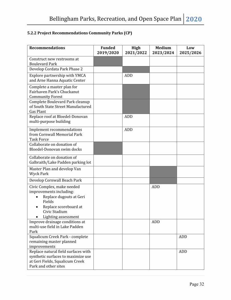
5.2.2 Project Recommendations Community Parks (CP)
Recommendations Funded 2019/2020
High 2021/2022
Medium 2023/2024
Low 2025/2026
Construct new restrooms at Boulevard Park
Develop Cordata Park Phase 2
Explore partnership with YMCA and Arne Hanna Aquatic Center
ADD
Complete a master plan for Fairhaven Park's Chuckanut Community Forest
Complete Boulevard Park cleanup of South State Street Manufactured Gas Plant
Replace roof at Bloedel-Donovan multi-purpose building
ADD
Implement recommendations from Cornwall Memorial Park Task Force
ADD
Collaborate on donation of Bloedel-Donovan swim docks
Collaborate on donation of Galbraith/Lake Padden parking lot
Master Plan and develop Van Wyck Park
Develop Cornwall Beach Park
Civic Complex, make needed improvements including:
Replace dugouts at Geri Fields
Replace scoreboard at Civic Stadium
Lighting assessment
ADD
Improve drainage conditions at multi-use field in Lake Padden Park
ADD
Squalicum Creek Park - complete remaining master planned improvements
ADD
Replace natural field surfaces with synthetic surfaces to maximize use at Geri Fields, Squalicum Creek Park and other sites
ADD

Bellingham Parks, Recreation, and Open Space Plan 2020
Page 33
5.3 Special Use Sites (SU)
As a result of the public process and the needs analysis, specific recommendations for special use sites in the Bellingham park system include: 5.3.1 Policy Recommendations Special Use (SU)
Acquire and develop new hand-carry boat launch or landing facilities in conjunction with park development in the Waterfront District and at other locations.
Identify appropriate location for a north end skate park. Acquire or develop new or improved town square or plaza space downtown and in urban
villages such as Old Town, Samish and at Fountain Plaza. Explore opportunity for pickleball/sports pavilion.
5.3.2 Project Recommendations Special Use (SU)
Recommendations Funded 2019/2020
High 2021/2022
Medium 2023/2024
Low 2025/2026
Acquire and renovate the pier for public access at Little Squalicum Park.
ADD
Add parking, ADA access and trail connectivity to Woodstock Farm and develop a strategic management and maintenance plan.
ADD
Provide identified improvements to community gardens and form a committee to propose a strategic management and maintenance plan.
ADD
Implement master plan improvements at Big Rock Garden, including improved fencing.
ADD

Bellingham Parks, Recreation, and Open Space Plan 2020
Page 34
RECOMMENDED FACILITIES PLAN • PARKS AND SPECIAL USE SITES

Bellingham Parks, Recreation, and Open Space Plan 2020
Page 35
5.4 Open Space (OS) As a result of the public process and the needs analysis, specific recommendations for open space in Bellingham include: 5.4.1 Policy Recommendations Open Space (OS)
Acquire additional greenway corridors as identified on the map following this section. Acquire additional open space anchors in the general vicinity of the areas identified on the
following map. Acquire additional salt waterfront land and tidelands to expand the network of open space
and public access along Bellingham Bay. Evaluate Samish Crest open space for surplus or land swap opportunities. Develop a prioritization strategy and monitoring to guide maintenance and restoration of
open spaces. Expand dog waste program. Participate in development of a City-wide herbicide use plan that incorporates an integrated
pest management approach. Pursue Bakerview/Telegraph habitat restoration opportunities.
5.4.2 Project Recommendations Open Space (OS)
Recommendations Funded 2019/2020
High 2021/2022
Medium 2023/2024
Low 2025/2026
Improve parking and wayfinding at Riley Open Space.
ADD
Prioritize and implement recommendations of Urban Forestry Management Plan on Parks open space.
ADD
Develop access to King and Queen Mountain Greenway.
ADD
Complete Little Squalicum Estuary restoration
ADD

Bellingham Parks, Recreation, and Open Space Plan 2020
Page 36
RECOMMENDED FACILITIES PLAN • OPEN SPACE

Bellingham Parks, Recreation, and Open Space Plan 2020
Page 37
5.5 Trails (TR) Originally based on the North Bellingham Trail Plan, Bellingham’s proposed trail map was updated extensively during this planning process to more accurately reflect development patterns, critical areas and targeted corridors. As a result of the public process and the needs analysis, specific recommendations for multi-purpose trails in Bellingham include: 5.5.1 Policy Recommendations Trails (TR)
Acquire and/or develop new trail connections as shown on the following map in order to provide an off-street trail within a half mile of every resident in Bellingham.
Coordinate with Public Works to identify opportunities for better trail, habitat corridor, sidewalk and bike route connectivity.
Institute a maintenance replacement program to monitor, maintain, improve and/or replace trail features, including bridges, boardwalks and stairs.
Connect Cordata Park, Whatcom Community College and Van Wyck Park. Acquire and/or develop trailheads (parking, signage, restrooms, picnic areas, etc.) at
Galbraith Mountain area, Woodstock Farm, Fairhaven Park’s, Chuckanut Community Forest and North Chuckanut Trailhead.
Acquire and develop a trail corridor to extend the Northridge Park Trail west. Pursue easements to connect Bay to Baker Trail to King and Queen Mountain Greenway. Pursue connections from Little Squalicum Park northwest to Alderwood/Airport area. Develop trails to fulfill the Waterfront District Subarea Plan.
5.5.2 Project Recommendations Trails (TR)
Recommendations Funded 2019/2020
High 2021/2022
Medium 2023/2024
Low 2025/2026
Acquire trail corridor along Squalicum Creek.
Extend trail along Whatcom Waterway as development occurs.
Samish Crest – complete connection to Lake Padden.
Connect Riley Open Space and the Cordata Trail.
ADD
Evaluate and replace bridges – Wildflower, Civic, Silver Creek.
ADD ADD
Acquire and improve trailhead parking and access to Galbraith from the north.
ADD
Complete Locust Beach trailhead and trail improvements.
ADD

Bellingham Parks, Recreation, and Open Space Plan 2020
Page 38
RECOMMENDED FACILITIES PLAN • TRAILS

Bellingham Parks, Recreation, and Open Space Plan 2020
Page 39
VI. Implementation
The financial strategy for Bellingham Parks and Recreation for the next six to 20-year period should generate enough revenue to maintain existing facilities, provide recreational program services, renovate facilities, and implement priority projects from the proposed recommendations. The following forecasts are based on average trends in capital facility fund expenditures by the City during recent years. However, it should be noted that priorities shift over time, responding to new interests, opportunities, and community decision making processes. The City’s six-year Capital Facilities Plan (CFP) is updated at least bi-annually in part to reflect these changes. Recommendations outlined in Chapter 4 of the PRO Plan total approximately $107 million in today's dollars. This includes improvements to existing facilities, as well as additional land and facilities to serve new growth. Projected revenue sources for park system improvements through the year 2040 could provide enough funding for the priority projects with traditional funding sources as estimated with the assumptions shown in the following table. Detailed costs for proposed recommendations are included in Appendix C of the PRO Plan. The 2019 and 2020 approved six-year Capital Facilities Plans are included in Appendix D of the PRO Plan.
6.1 Revenue and Expenditures Table 6.1 outlines options for capital revenue sources and projected expenditures through the year 2040 and corresponds with the adopted level-of-service discussed in Chapter 4 and the recommendations included in Chapter 5 of the PRO Plan. A detailed description of the projects and costs is in Appendix C of the PRO Plan. A description of the funding sources and assumptions made for each item in the tables is listed on the following pages.
Waypoint Park at Sunset. Photo by Robin Eldore.

Bellingham Parks, Recreation, and Open Space Plan 2020
Page 40
TABLE 6.1 PRO Plan Projected Funding and Expenditures
Revenue Funding Estimates for 2020-2040 Notes
REET $5,000,000 Estimated REET funding for park projects
Greenway IV Levy $10,000,000
Existing balance and projected revenue allocated for recommended projects
5th Greenway Levy or Metropolitan Park District $40,000,000 Assumes renewal starts 2024 Grants & donations $5,000,000 Estimate based on 5-year history
Park Impact Fees $5,000,000
Existing balance allocated for recommended projects
Total Revenue $65,000,000 Total Proposed Costs in 2019 $ (107,012,013) Required additional revenue $ 42,012,013
Potential PIF Fees 31% $1,881.70 29,901 $56,264,711
Assumes continued 31% fee assessed for all projected population growth
As this is a long-range strategic plan and not a financing plan, both revenues and expenditures are in estimated 2019 dollars and do not include inflation. This plan assumes that both expenditures and revenues will increase over time and that projects will be implemented as funding becomes available. As each project is scheduled for implementation, costs and revenues will be updated. When new parks are developed, additional staffing will also be required for maintenance and operations. Those costs are not quantified in this estimate. Project improvements (acquisition or facilities) and maintenance and operations costs will be adjusted as needed to match available revenue sources concurrent with the annual Capital Facilities Plan budget process. The PRO Plan is updated every six years with an updated forecast of revenues and expenditures.
Pubic Survey – top 2 Essential budget priorities:
1. Maintaining and improving existing
parks, trails, and facilities
2. Protecting open space and habitat

Bellingham Parks, Recreation, and Open Space Plan 2020
Page 41
Any potential difference between the total revenue and the actual cost of improvements could be made up through a variety of means including an increase in the park impact fee, bonding for specific project improvements, decreasing the LOS, or through the use of development agreements requiring land dedications or improvements as a condition of annexation or rezones.
6.2 Capital Maintenance Needs
The most recent Greenway levy authorized 25% (approximately $1.25 million per year) to be spent on capital maintenance needs. Therefore, the proposed facilities improvements in Appendix C include $20 million in capital maintenance costs over the 20-year planning period. This assumes continued support for maintenance and operations at existing funding levels, and anticipates the significant improvements required to upgrade existing aging infrastructure. Costs for additional staff resources are not included. As described in Section 4.4, the City will be utilizing a computerized maintenance management system to track and manage assets and maintenance plans, with the overall goal of being must more proactive than reactive. 6.3 Funding Sources
6.3.1 REET Real Estate Excise Tax
REET revenue has been used to pay off the Civic Field Bond, help fund large capital maintenance projects, and set aside to fund future waterfront development projects, including parks and roads. As the economy picks up, and bonds are paid off, more REET revenue may be available for capital projects, including development of waterfront parks. A recent change in State law allows more flexibility for using REET funds for maintenance.
6.3.2 Greenway Levies Since 1990, Bellingham citizens have approved four property tax levies to fund acquisition, development and maintenance of Bellingham’s park system. Included in the table are existing levy balances from the fourth levy, as well as future revenues, with no growth in valuation assumed. This plan assumes a continued levy support, either using the existing Greenway Levy model or a Metropolitan Parks District, at similar levy levels for the full plan term.
Taylor Dock at Sunset. Photo by Linda Wright.

Bellingham Parks, Recreation, and Open Space Plan 2020
Page 42
6.3.3 Grants The City has received an average of $1 million annually over the last five years from various sources, including Washington Recreation and Conservation Office grant programs, federal Transportation Enhancement grants and Department of Ecology grants. This plan estimates a total of $5 million in grant funding over a 20-year period. 6.3.4 Park Impact Fees In 2006, the City began assessing a Park Impact Fee on new residential units. Future funding from Park Impact Fees is estimated based on future City population projections and is entirely dependent on new residential development activity. The City expects an additional 29,110 new residents by the year 2040, the difference between the current and projected urban growth area/City population. This calculation assumes that all urban growth areas will incorporate into the City during that time frame.
6.4 Revenue Source Description
A general description of the different types of revenue resources that may be used to fund park, recreation and open space programs or facilities is presented in Appendix E of the PRO Plan. Some are restricted to development only while others may be used for operations and maintenance. These are listed in no particular order and with no reference to the feasibility or recommendation of implementing each revenue source.