
Parcipatory +MRV:+Addressing++ socio ecological ... · Conclusion ! Study the feasibility of PMRV...
12
Par$cipatory MRV: Addressing socioecological context and scale Forest Change 2014 Interna’onal Conference 2 nd 4 th April 2014 Freising / Germany Guillaume Beaudoin Session 1 – Resource Management Systems & Concepts Thursday, 3rd of April 2014, TUM Forest Science Lecture Halls
Transcript of Parcipatory +MRV:+Addressing++ socio ecological ... · Conclusion ! Study the feasibility of PMRV...

Par$cipatory MRV: Addressing socio-‐ecological context and scale
Forest Change 2014 -‐ Interna'onal Conference 2nd -‐ 4th April 2014 -‐ Freising / Germany
Guillaume Beaudoin Session 1 – Resource Management Systems & Concepts Thursday, 3rd of April 2014, TUM Forest Science Lecture Halls

§ REDD+ (Reduc'on of Emissions from Deforesta'on and forest Degrada'on) is a financial mechanism to reward reduced emissions and maintenance of forest carbon stocks.
§ “A cornerstone of any na'onal REDD+ scheme is a reliable, credible system of Measuring, Repor/ng and Verifying (MRV) changes in forest carbon stocks.” (Herold and Skutsch, 2009)
§ UNFCCC recognizes the need for local communi*es’ par*cipa*on in carbon measurements. Addressing some co-‐benefits of REDD+ (social safeguard, benefit sharing…)
§ Community-‐based monitoring is cost effec've, and provide equal data quality as scien'fic for carbon measurement. (Danielsen et al. 2013)
§ Nowadays more literature consider Community forest monitoring for REDD+ MRV.
Is Par/cipatory MRV feasible and sustainable?
INTRODUCTION -‐ BRIEF RATIONAL on PARTICIPATORY -‐ MRV
Feasibility study
No carbon measurement

ACROSS SOCIO-‐ECONOMIC CONTEXT
3 provinces across Indonesia: -‐ PAPUA -‐ WEST KALIMANTAN -‐ CENTRAL JAVA
INTRODUCTION -‐ ACROSS SOCIO-‐ECOLOGICAL CONTEXT IN INDONESIA
ACROSS ECOLOGICAL CONTEXT
Research sites are posi'oned along forest and tree cover transi'on curve
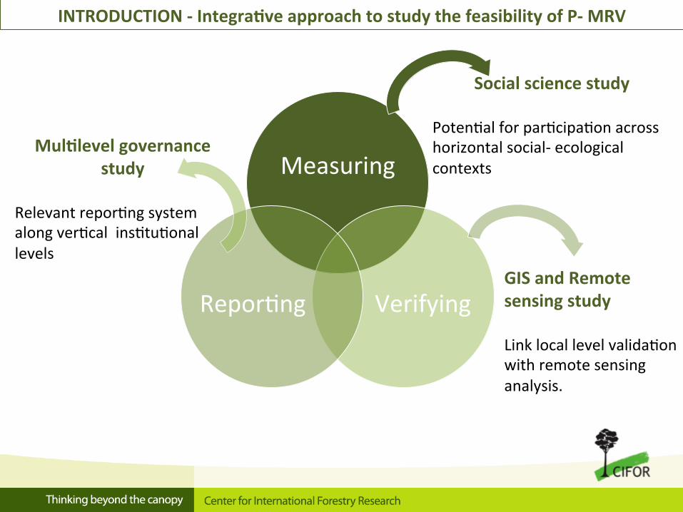
Measuring
Verifying Repor'ng
Social science study Poten'al for par'cipa'on across horizontal social-‐ ecological contexts
Mul$level governance study
Relevant repor'ng system along ver'cal ins'tu'onal levels GIS and Remote
sensing study Link local level valida'on with remote sensing analysis.
INTRODUCTION -‐ Integra$ve approach to study the feasibility of P-‐ MRV

R
V M
SOCIAL SCIENCE STUDY
How community par$cipa$on in Measurement is to be feasible and sustainable?
Looking across socio-‐ecological context in
Indonesia
Cap*on: CIFOR researchers interviewing villager in Papua, August 2013. Source: PMRV project

R
V
HOW TO MAKE PARTICIPATION FEASIBLE (F) AND SUSTAINABLE (S)? REPORTING
Mul/level governance study
WILLINGNESS TO PARTICIPATE (Local incen*ves and forest planning…)
F+S
SUPPORTING ORGANIZATIONS (Village organiza*ons and experiences)
SS
M
SOCIAL SCIENCE STUDY
M: Measurement R: Repor'ng V: Verifica'on F: Feasible S: Sustainable
ENABLING LOCAL CONDITIONS (Relevant human resources, governance,
availability in space and *me…)
F
Spa$al study
ACROSS SITES IN INDONESIA
MEASUREMENT
V
M R
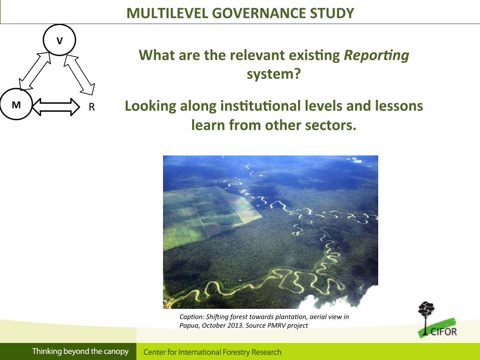
MULTILEVEL GOVERNANCE STUDY
Cap*on: ShiRing forest towards planta*on, aerial view in Papua, October 2013. Source PMRV project
What are the relevant exis$ng Repor/ng system?
Looking along ins$tu$onal levels and lessons learn from other sectors.

HEALTH Data from integrated village healthcare posts
FORESTRY Data from forestry
inventories and outreach ac7vi7es
Village
Province
Na$onal
District
Sub-‐ district
P: Par'cipa'on M:Monitoring R: Repor'ng V: Valida'on Village
What exis$ng repor$ng systems can be relevant for PMRV in the
context of REDD+?
Each ins$tu$onal level
FUNCTIONALITY AND SUSTAINABILITY
(Percep*on on efficiency, recommenda*on…)
DATA VALIDATION (Procedures, human resources involved…)
V
M R EXISTING REPORTING SYSTEMS (Structure of repor*ng system, type of
data, standards of procedures…)
MULTILEVEL GOVERNANCE STUDY

R
M V
GIS/REMOTE SENSING STUDY
Cap*on: CIFOR researchers facilita*on par*cipatory mapping ac*vi*es with villagers, source: PMRV project
Using remote sensing for Verifying the credibility and validity of ground data and together with community finding relevant
sites for measurement
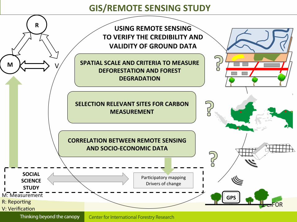
USING REMOTE SENSING TO VERIFY THE CREDIBILITY AND VALIDITY OF GROUND DATA
SOCIAL SCIENCE STUDY
Par'cipatory mapping Drivers of change
M: Measurement R: Repor'ng V: Verifica'on
R
M V
GIS/REMOTE SENSING STUDY
SPATIAL SCALE AND CRITERIA TO MEASURE DEFORESTATION AND FOREST
DEGRADATION
SELECTION RELEVANT SITES FOR CARBON MEASUREMENT
GPS
CORRELATION BETWEEN REMOTE SENSING AND SOCIO-‐ECONOMIC DATA
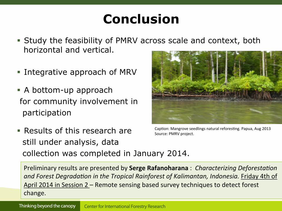
Conclusion
§ Study the feasibility of PMRV across scale and context, both horizontal and vertical.
§ Integrative approach of MRV
§ A bottom-up approach for community involvement in participation
§ Results of this research are still under analysis, data collection was completed in January 2014. Preliminary results are presented by Serge Rafanoharana : Characterizing Deforesta*on and Forest Degrada*on in the Tropical Rainforest of Kalimantan, Indonesia. Friday 4th of April 2014 in Session 2 – Remote sensing based survey techniques to detect forest change.
Cap'on: Mangrove seedlings natural refores'ng. Papua, Aug 2013 Source: PMRV project.