Cheap Parcel Delivery - 10 Biggest Parcel Delivery Companies
Upload
poconnorCategory
view
38download
0
Parcel Fabric Migration Project Status and Overview
Karen Terry, GISP GIS Mapping Supervisor
Harris County Appraisal District June 1, 2016

Harris County, Texas
• Home to Houston, Texas • America’s 4th Largest City
• Largest City in Texas by Population
• Harris County = 14th largest in Texas in terms of size (land area)
• 1.7 Million Parcels in Harris County
• Phenomenal Growth Rate
• Booming Economy
• HCAD is currently considering migrating ESRI’s SDE database to parcel fabric

Houston, Texas

Parcel Fabric Overview
• What exactly is parcel fabric?
• ESRI Product
• Provides a seamless, continuous network of parcels
• 3 Pieces:
• Data Model • Tools • Workflow

Parcel Fabric Overview
• LGIM (Local Government Information Model)
• Data Model
• Defines Parcel Types (similar to subtypes)
• Includes layers common to local
government uses

Parcel Fabric Overview
• Tools • Edit tools designed to be used specifically with Fabric
• Parcel Fabric Editor Toolbar
• Parcel Details Window (Traverse Tool)
• Workflows
• Merge Parcels (Combinations)
• Parcel Split (Splitouts)
• Import DWGS from CAD for New Subs
• Others

Workflow Tasks
• Vary depending on what is selected in Workflow Manager Window
• Import DWGs to subs
• Merge Parcels
• Splits
• Etc.
• Designed to Automate Edits/Processes Step-by- Step
• Pros and Cons to Workflows

Parcel Fabric Overview
• Status of HCAD Project
• Sidwell (an ESRI Business Partner) will do the migration for HCAD
• 2 Pilot Project Test Areas:
• The Heights
• Northwest Harris County (Southwest of New ExxonMobil campus)

Parcel Fabric Pilot Project Areas
Exxon Mobile Campus Pilot
Area
The Heights

“The Heights” Area

Northwest Harris County

Status of Data
• HCAD has had a digital basemap for 20+ years
• Before 1995 pre-ESRI (System 9)
• Early ESRI 1996-2004 (ArcMap Version 8)
• Current ESRI 2005-present
• SDE Data Environment

HCAD Data Status Map

Reasons for Selecting the Pilot Areas
• Several other pilot areas were considered
• Most did not have the right “mix” of data
• Some were rejected because near water
• What was ultimately selected had a good mix of data from the three (3) time periods and curves vs. straight lines

Rejected Areas

Rejected Areas

Chosen Areas For Pilot Project

The Heights Area

Northwest Harris County
Parcel Fabric Overview
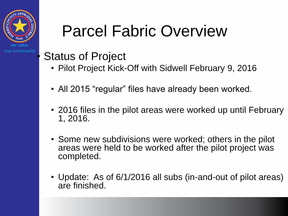
• Status of Project • Pilot Project Kick-Off with Sidwell February 9, 2016
• All 2015 “regular” files have already been worked.
• 2016 files in the pilot areas were worked up until February 1, 2016.
• Some new subdivisions were worked; others in the pilot areas were held to be worked after the pilot project was completed.
• Update: As of 6/1/2016 all subs (in-and-out of pilot areas) are finished.

Parcel Fabric Overview
• Once the pilot is complete, we will section off the County and rotate out areas, holding off working in these areas until the data comes back from Sidwell. (Plan to send off ~50,000 – 100,000 parcels at a time)
• Then we will work them in the fabric.
• Until the migration is completed, we will have 2 production databases: 1) Current Fabric, and 2) Parcel Fabric (New)
• In some cases (ie. high dollar files or property owner requests) we will need to work the current fabric and then work again in the parcel fabric.
• We will continue in this manner until parcel fabric migration is completed.
• Update: We finished working in the pilot areas as of 6/1/2016, and will migrate data by ISD into the parcel fabric starting in September of 2016

Proposed Grid of Harris County by ISD
Approximately 50,000 – 100,000 Parcels can be migrated at one time

Parcel Fabric Overview
• HCAD Data Must be “Prepped” for Migration
• Topology Errors • No errors can be present at all or else parcel fabric import will
fail
• 6 Topology Rules that are required for LGIM: • Line features must be covered by polygons*
• Lines must not self-overlap (line covered by line)
• Lines must not self-intersect*
• Lines must be single part
• Lines must not intersect or touch interior*
• Polygons must be covered by Lines
* HCAD topology rules already in place

Parcel Fabric Requirements
• Data Cleanup • How much do we do in-house vs. How much does Sidwell do?
• Will find that out after the pilot project is completed
• Parcel Fabric Requires True Curves
• 2 Point Curves vs. Multi-Line/Vertices Connected Segments
• Curve Creation/Arc Tools introduced in ArcMap Version 8.3
• Convert data into true curves for migration into parcel fabric
• Use Curves and Lines Toolbar to convert old data to true curves
• Sub lines vs. Polygons • Parcels in Parcel Fabric (vs. lines)
• Lines must be 2-point lines
• ROW Polygons (converted from ROW Lines)
• Closed Polygons – all polys must be closed (no gaps) or import will fail
• Data Accuracy • Control Points for New Subs for Data from 2005 – current
• Control Points are important, but not needed for initial data migration
vs.

Parcel Fabric Overview
• Annotation Layer vs. Labeling in Fabric
• Pros and Cons to each
• Labeling is recommended for the parcel fabric
• Right now there are 4.6 million pieces of Annotation in the HCAD Dimensions layer alone (almost to capacity)
• Annotation offers more flexibility in terms of placement and what text says
• Labels are static
• Labeling labels off of real data in attribute table
• Labels would come from a “DIM” field, which would be the annotation from the current layer
• Use MapPlex for labeling (provides more flexibility)
• Anno takes longer to draw

Annotation vs. Labeling
Pros Cons Pros Cons
Feature-
Linked to SDE
Layers
Dimensions
Layer is
largest layer in
SDE – Long
refresh/draw
times
Takes up less
disk space
(smaller size
of file)
More
Flexibility
Placement is
time-
consuming
Static (Requires
MapPlex Extension
for more flexibility)
Not to Tied to
an ATT Table
Tied to ATT
Table (can’t be
any errors)
Comply with
Texas State
Law for
Basemap
Maintenance
?

P.F. Migration Process
• Site Visits to other Appraisal Districts:
• Dallas County Appraisal District (DCAD)
• Jefferson CAD - Beaumont/Port Arthur, Texas
• January 2016
• Bexar CAD – San Antonio, TX
• February 2016

Map of County Locations in TX

Jefferson
CAD Bexar
CAD
Dallas
CAD
Harris
CAD
Number of
Parcels in
County
121,000 600,000 664,340 1,400,000
Rank
(Population) 20 4 2 1
Platform
Pre-
Conversion
ESRI
Coverages ESRI SDE ESRI
Libraries
ESRI SDE
Time to
Convert/Year 9 Months
2012
9 Months
2011
18 Months
2011-2012
?
2016-2017
Number of
Edits Per Year 4100 (not
including new
subs)
12,000 5000-7000 +
1400 New
Subs
7000-8000
+ 1700
New subs
Used a Third
Party Vendor to
Assist with
Migration Effort
Yes
No
No
Yes
Parcel Fabric Migration Comparison
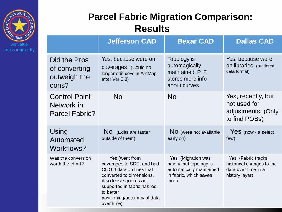
Parcel Fabric Migration Comparison:
Results
Jefferson CAD Bexar CAD Dallas CAD
Did the Pros
of converting
outweigh the
cons?
Yes, because were on
coverages. (Could no
longer edit covs in ArcMap
after Ver 8.3)
Topology is
automagically
maintained. P. F.
stores more info
about curves
Yes, because were
on libraries (outdated
data format)
Control Point
Network in
Parcel Fabric?
No No Yes, recently, but
not used for
adjustments. (Only
to find POBs)
Using
Automated
Workflows?
No (Edits are faster
outside of them)
No (were not available
early on)
Yes (now - a select
few)
Was the conversion
worth the effort?
Yes (went from
coverages to SDE, and had
COGO data on lines that
converted to dimensions.
Also least squares adj.
supported in fabric has led
to better
positioning/accuracy of data
over time)
Yes (Migration was
painful but topology is
automatically maintained
in fabric, which saves
time)
Yes (Fabric tracks
historical changes to the
data over time in a
history layer)

Lessons Learned from Site Visits
• Make sure your vendor is familiar with your data up-front
• Everyone wished they knew more about the process going in.
• More error correction and up-front cleanup on their
data before importing/migrating into parcel fabric.
• More training!!
• Concern – Will ESRI migrate the parcel fabric into ArcGIS Pro platform? (Yes)
Things to Do Better
• Not enough up-front clean up of data
• Conversion Process Itself • Can be painful
• Not enough training afterwards on how to use Parcel Fabric
• Annotation vs. Labels ?

Proposed Benefits Of Migrating to Parcel Fabric for HCAD
• Topology is automatically maintained in parcel fabric
• Consistency in how edits and processes are performed across editors via Automated Workflows
• Time Saved Doing Redraws due to Parcel Fabric Editing Process. Choice to “hold the old” or “force the old to the new” data
• Increased Productivity as a Result of the Above

HCAD Parcel Fabric Migration Status
• Pilot Project Kick-Off February 9-19, 2016
• Sidwell on-site
• Interviews with my editing group to see current workflows. Sidwell needs a workflow from us.
• Sidwell came back for training in March 2016
Summary
• Largest parcel fabric migration attempted – 1.4 - 1.7 million parcels
• Harris CAD 3rd largest CAD behind Los Angeles, CA and Chicago, IL
• Will know how much time required for conversion after pilot parcels are converted
• Will conversion be worth the effort? • Stay tuned . . .

Questions? Karen Terry, GISP
GIS Mapping Supervisor
Harris County Appraisal District
June 1, 2016