Papa Stour - Shetland · Papa Stour was the source of the oldest surviving written document from...
2
Papa Stour Birds The open scattald provides a perfect environment for ground nesting birds such as Ringed Plovers, Arctic Skuas and Arctic Terns which have become regular visitors. Papa Stour is now recognised as an internationally important area for the large number of Arctic Terns that nest on the island in the summer months. Other sea birds are also attracted to Papa Stour. The rocky coastline and cliffs provide suitable nesting spots for 15 species of sea birds to breed. These include Fulmar, Shag, Guillemot, Black Guillemot, Razorbill, Great Black- backed Gull and Kittiwake. Sea Mammals Seals are regular visitors to the shores of Papa Stour, hauling themselves out on rocks in the geos along the west coast. Common Seals come ashore to pup in June and July. They are easily recognisable, lying on the rocks in a characteristic crescent shape with their heads and tails lifted high. The Grey Seals are much larger and have long distinctive roman noses. In October the furry white coats of the Grey Seal pups can be seen dotted across the beaches. Much harder to see are Harbour Porpoises and occasional pods of Killer Whales that swim past Papa Stour. Keep a careful look out to sea as you walk around as you never know when one of these animals might appear. The low rocky shores of the islands and voes provide a home for another sea mammal – the elusive Otter. The kelp forests that grow in shallow waters hide many small fish for them to feed on. But tread softly because otters are very shy creatures. Left: A Ringed Plover. Right: A Grey Seal pup Some Useful Information Accommodation: Backpackers Hostel, Hurdiback Tel: 01595 873 229 Ferry Booking Office: Tel: 01957 722259 Air Booking Office: Tingwall Airport Tel: 01595 840246 Medical Assistance: Waas (Walls) Surgery Tel: 01595 809352 Papa Stour History Group [email protected] Contents copyright protected - please contact Shetland Amenity Trust for details. Whilst every effort has been made to ensure the contents are accurate, the funding partners do not accept responsibility for any errors in this leaflet. Sculpted by the sea Papa Stour Take care when approaching Skua chicks, their parents may be close by and will defend their young by dive- bombing intruders History The name Papa Stour is believed to have been given to the island by the Vikings. Papey Stóra in Old Norse means the big island of priests, and refers to a community of Celtic missionary priests that lived on Papa Stour, perhaps as early as the 6th century. Papa Stour became an important area for Norsemen, providing both a strategic base and safe haven for their boats. By the end of the 13th century the island had become a Norwegian royal farm, the personal property of King Hakon. Although Shetland was pledged to Scotland in 1469 the Lairds of Norway kept their estates on Papa Stour until well into the 17th century. During the 18th century two lairds from the mainland, Thomas Gifford of Busta and Arthur Nicolson of Lerwick, divided Papa Stour between them and the island remained part of these estates until recently when some crofts have passed into private ownership Archaeology Papa Stour is full of prehistoric remains, the evidence of settlement back through the ages to Neolithic and Bronze Age times, 5000 years ago. In the historic era, Papa Stour was the source of the oldest surviving written document from Shetland. It is known as the 1299 document and contains allegations of corruption made by one of the islanders. The settled eastern side of the island has fewer inhabitants today Geology The west coast of Papa Stour contains some of the most exposed coastline in the British Isles. Exposed to the full force of the Atlantic Ocean the island’s Devonian age rocks have been carved into towering vertical cliffs, stacks and arches. Bands of volcanic ash (ignimbrite) and orange solidified lava (rhyolite) can be seen running through the rock faces. At Lamar Banks at the south side of the entrance to Housa Voe, a bed of calcareous mudstone containing broken remains of fossil fish has been discovered. Inland, ridges of glacial moraine – huge boulders carried by glaciers – run across the island, marking the edge of an ancient ice sheet. Flora The island is divided by a hill dyke that separates the fertile in-by land from the moorland of the scattald or common grazings to the west. In the past, turf and peat from the scattald was removed and used by the islanders to provide fertiliser and fuel. This has produced a unique ‘scalped’ heathland of short wind-clipped vegetation growing on gravelly sub-soil. Today the heathland is covered with a variety of plants including Ling, Thyme, Mountain Everlasting, Spring Squill, Plantain, Heath-spotted Orchid and Woolly Hair Moss. In contrast, maritime species such as Sea Pinks and Campions thrive in the salty sea air along the cliff tops. Left: Natural vegetation survives where left un-grazed by sheep Right: Impressive cliffs along the island’s west coast Delicate Sea Pinks thrive on the cliff tops Welcome to Papa Stour This rugged island lies off the west coast of Shetland’s mainland. Some of the most impressive coastline in Shetland can be seen here, including caves, arches, stacks and skerries. For walkers, wildlife enthusiasts and those interested in archaeology, Papa Stour has much to offer. Papa Stour can be reached by plane from Tingwall Airport, 7 miles outside Lerwick. Alternatively, the ferry leaves from West Burrafirth and takes about 35 minutes to reach Housa Voe on the east side of Papa Stour. The ground here is low lying and fertile compared to the moorland and steep vertical cliffs that dominate most of the west coast. This is also the centre of the population where less than 20 people now live. For most islanders crofting is a way of life. Although the ferry to Papa Stour carries cars, there is little need of one as there is only one short road on the island and the best way to see the sights is on foot. Taekin; roofs used to be re-thatched every 3 or 4 years Right: An artist’s impression of a stofa, a medieval Norse house that once stood at Da Biggins Below left: Sheep clipping or rooing, just part of the crofter’s calendar Below right: Pier and ferry terminal The skerries, stacks, arches and caves around Aesha Head are evidence of the powerful wave action of the Atlantic Ocean
Transcript of Papa Stour - Shetland · Papa Stour was the source of the oldest surviving written document from...
Papa StourBirdsThe open scattald provides a perfect environment for ground nesting birds such as Ringed Plovers, Arctic Skuas and Arctic Terns which have become regular visitors. Papa Stour is now recognised as an internationally important area for the large number of Arctic Terns that nest on the island in the summer months.Other sea birds are also attracted to Papa Stour. The rocky coastline and cliffs provide suitable nesting spots for 15 species of sea birds to breed. These include Fulmar, Shag, Guillemot, Black Guillemot, Razorbill, Great Black-backed Gull and Kittiwake.
Sea MammalsSeals are regular visitors to the shores of Papa Stour, hauling themselves out on rocks in the geos along the west coast. Common Seals come ashore to pup in June and July. They are easily recognisable, lying on the rocks in a characteristic crescent shape with their heads and tails lifted high. The Grey Seals are much larger and have long distinctive roman noses. In October the furry white coats of the Grey Seal pups can be seen dotted across the beaches. Much harder to see are Harbour Porpoises and occasional pods of Killer Whales that swim past Papa Stour. Keep a careful look out to sea as you walk around as you never know when one of these animals might appear. The low rocky shores of the islands and voes provide a home for another sea mammal – the elusive Otter. The kelp forests that grow in shallow waters hide many small fish for them to feed on. But tread softly because otters are very shy creatures.
Left: A Ringed Plover. Right: A Grey Seal pup
Some Useful Information
Accommodation: Backpackers Hostel, Hurdiback Tel: 01595 873 229
Ferry Booking Office: Tel: 01957 722259
Air Booking Office: Tingwall Airport Tel: 01595 840246
Medical Assistance: Waas (Walls) Surgery Tel: 01595 809352
Papa Stour History Group [email protected]
Contents copyright protected - please contact Shetland Amenity Trust for details.Whilst every effort has been made to ensure the contents are accurate,the funding partners do not accept responsibility for any errors in this leaflet.
Sculpted by the seaPapa Stour
Take care when approaching Skua chicks, their parents may be close by and will defend their young by dive-bombing intruders
HistoryThe name Papa Stour is believed to have been given to the island by the Vikings. Papey Stóra in Old Norse means the big island of priests, and refers to a community of Celtic missionary priests that lived on Papa Stour, perhaps as early as the 6th century.Papa Stour became an important area for Norsemen, providing both a strategic base and safe haven for their boats. By the end of the 13th century the island had become a Norwegian royal farm, the personal property of King Hakon. Although Shetland was pledged to Scotland in 1469 the Lairds of Norway kept their estates on Papa Stour until well into the 17th century.During the 18th century two lairds from the mainland, Thomas Gifford of Busta and Arthur Nicolson of Lerwick, divided Papa Stour between them and the island remained part of these estates until recently when some crofts have passed into private ownership
Archaeology
Papa Stour is full of prehistoric remains, the evidence of settlement back through the ages to Neolithic and Bronze Age times, 5000 years ago. In the historic era, Papa Stour was the source of the oldest surviving written document from Shetland. It is known as the 1299 document and contains allegations of corruption made by one of the islanders.
The settled eastern side of the island has fewer inhabitants today
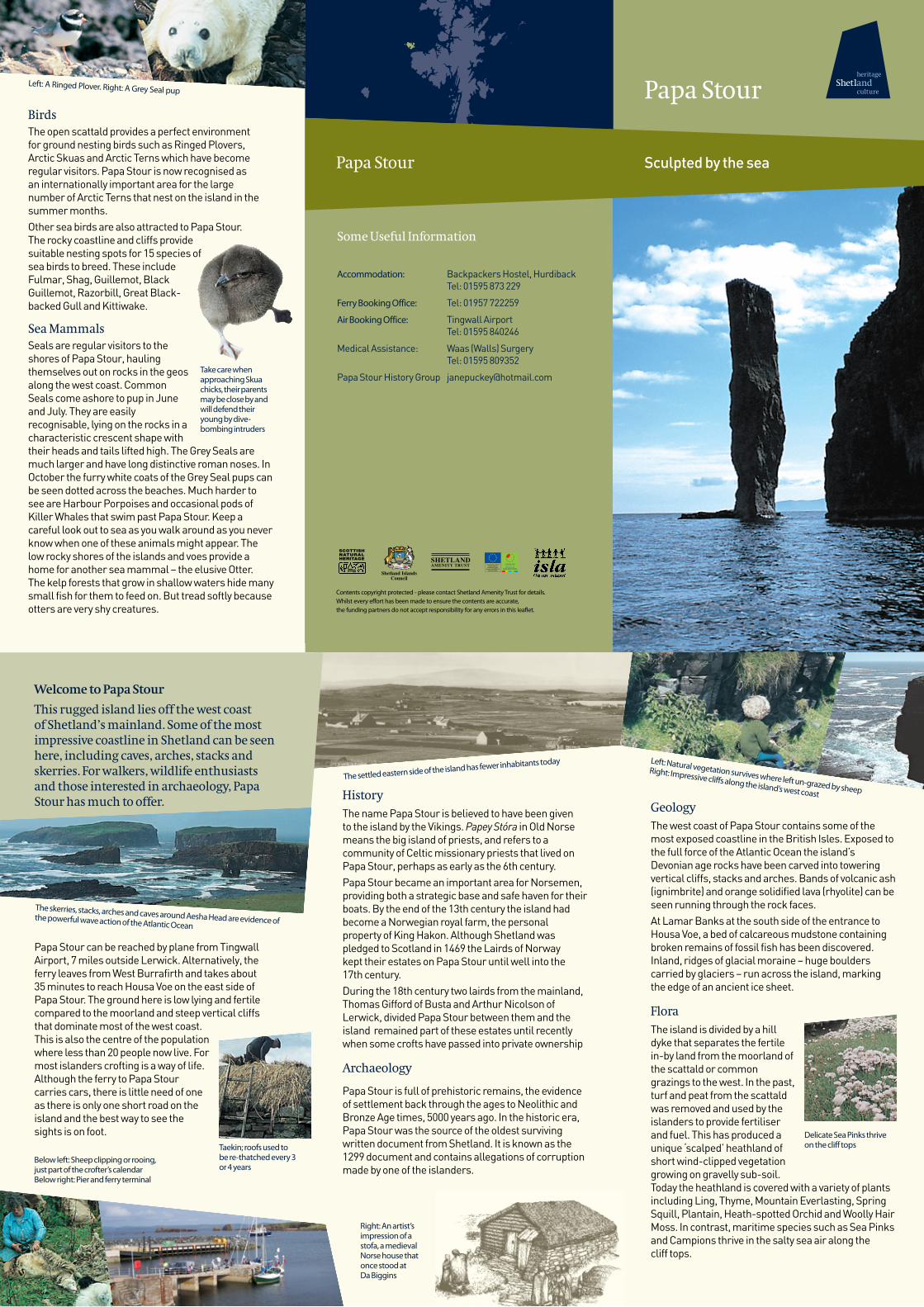
GeologyThe west coast of Papa Stour contains some of the most exposed coastline in the British Isles. Exposed to the full force of the Atlantic Ocean the island’s Devonian age rocks have been carved into towering vertical cliffs, stacks and arches. Bands of volcanic ash (ignimbrite) and orange solidified lava (rhyolite) can be seen running through the rock faces.At Lamar Banks at the south side of the entrance to Housa Voe, a bed of calcareous mudstone containing broken remains of fossil fish has been discovered. Inland, ridges of glacial moraine – huge boulders carried by glaciers – run across the island, marking the edge of an ancient ice sheet.
FloraThe island is divided by a hill dyke that separates the fertile in-by land from the moorland of the scattald or common grazings to the west. In the past, turf and peat from the scattald was removed and used by the islanders to provide fertiliser and fuel. This has produced a unique ‘scalped’ heathland of short wind-clipped vegetation growing on gravelly sub-soil. Today the heathland is covered with a variety of plants including Ling, Thyme, Mountain Everlasting, Spring Squill, Plantain, Heath-spotted Orchid and Woolly Hair Moss. In contrast, maritime species such as Sea Pinks and Campions thrive in the salty sea air along the cliff tops.
Left: Natural vegetation survives where left un-grazed by sheep
Right: Impressive cliffs along the island’s west coast
Delicate Sea Pinks thrive on the cliff tops
Welcome to Papa Stour
This rugged island lies off the west coastof Shetland’s mainland. Some of the most impressive coastline in Shetland can be seen here, including caves, arches, stacks and skerries. For walkers, wildlife enthusiasts and those interested in archaeology, Papa Stour has much to offer.
Papa Stour can be reached by plane from Tingwall Airport, 7 miles outside Lerwick. Alternatively, the ferry leaves from West Burrafirth and takes about 35 minutes to reach Housa Voe on the east side of Papa Stour. The ground here is low lying and fertile compared to the moorland and steep vertical cliffs that dominate most of the west coast. This is also the centre of the population where less than 20 people now live. For most islanders crofting is a way of life.Although the ferry to Papa Stour carries cars, there is little need of one as there is only one short road on the island and the best way to see the sights is on foot.
Taekin; roofs used tobe re-thatched every 3or 4 years
Right: An artist’s impression of a stofa, a medieval Norse house that once stood at Da Biggins
Below left: Sheep clipping or rooing, just part of the crofter’s calendar Below right: Pier and ferry terminal
The skerries, stacks, arches and caves around Aesha Head are evidence of the powerful wave action of the Atlantic Ocean

Wreck
Wreck
Papa Sound
Papa Stour
North Ness
Ting
Hoo Field
Hurdiback
Da Biggins
Breis Holm
Sandness
Ferry to West Burrafirth
Stofa
Kirk
Hill
Dyke
WreckHill o Fiellie
Hamnavoe
Watermills
Burrie Geo
Leera Skerry
Snolda
Virdi Field
Lamaness
Meal Track
Meal Track
Aisha Head
Clubb
Ormal
North Skerry
West Voe
Culla
voe
Housa Voe
ForewickHolm
Muckle Fru (or Maiden) Stack
LamarBanks
Aisha Stack
FuglaSkerry
VeeSkerries
Dutch Loch
KirstanHol
GordiWater
MaunsHill
MelbyHolm
Exploring Papa Stour
On the approach to Papa Stour from West Burrafirth the ferry passes Breis Holm, where you will get your first glimpse of the island’s impressive sea caves. At the foot of Breis Holm a large tunnel cuts right through the holm. In calm weather it is possible to travel through the tunnel by boat.
The tallest of the stacks that cluster around the entrance to Housa Voe, is known as Muckle Fru or Maiden Stack. It was here that the only daughter of a Norwegian Lord was imprisoned by her father for refusing to agree to an arranged marriage. She had given her heart instead to a humble fisherman who, legend has it, rescued her from her solitary confinement on the stack with the help of his friends. The two lovers, reunited once more, fled the island together.Behind the beach at Housa Voe are the supposed remains of Ting, believed to be a site where Norse assemblies were held. It is reputed that Lord Thorvald Thoresson, the man accused of corruption in the 1299 document, fought and won a duel within this circle.Excavations in the 1970s and 1980s at Da Biggins, alongside the road just before the kirk, uncovered the foundations of a medieval Norse house. In 2008 the Papa Stour History Group in partnership with the Norwegian Craft Academy undertook a partial reconstruction of this Stofa. This involved an exchange of students and craftsmen between the two countries. Log timbers were brought over from Norway and assembled on site in Papa Stour. It was officially opened by the Lady Mayor of Hordaland, Norway. Interpretation at the site gives more details of the findings. Papa Stour is renowned for its famous sword dance, last performed in the isle in August 2008 at the Stofa opening.The Papa Stour Kirk was built in 2006 and is still in use. In the west wall is a memorial window to the memory
of six Papa men who lost their lives in the Great War. This stained glass window is the only surviving work of artist Victor Noble Rainbird.Continuing past the kirk and primary school, the road leads to the airstrip and the open scattald. To the south you will find the remains of several Neolithic burial chambers known as heel-shaped cairns because of their shape when viewed from above.The remains of more recent buildings can also be
seen here. Suspected leprosy sufferers from the west mainland used to be sent to live in isolation in the huts whose remains you can see on Hill o Fiellie. To survive, they relied on the islanders to leave food for them by the dyke. However, it is now thought more likely that these people suffered from malnutrition or elephantiasis rather than Leprosy.
The small stone buildings around Dutch Loch are good examples of horizontal water mills. Originally these were two story buildings with turf roofs. They were built into banks to give access to the upper floor where the millstone was sited. Many were still in use on Papa Stour in the early years of the 20th century. To the west of Hamnavoe, the island’s spectacular western cliffs come into view, carved with arches and caves and punctuated with stacks and skerries. Two large holes, set back slightly from the cliff edge, drop through the roof of perhaps the most famous of the Papa Stour caves, known as Kirstan Hol. Look down through the hole and you can see waves breaking on the beach at the back of the cave, but take care, it’s a long way down!Nowhere on the island is the power of the sea more evident than in the three legged Aisha Stack, Aisha Head, pierced by the Hol o Burrie Geo, and the sea caves that penetrate Fugla and Leera Skerries. The waves do not always have their way though and to the north of Leera Skerry the solitary Snolda (whose name comes from the Old Norse word for a pinnacle) reaches precariously out of the sea, with waves crashing around the base and boulders balanced on top.
Solitude on the many miles of Papa Stour’s varied coastline
These water mills around Dutch Loch were still in use at the start
of the 20th centuryThe voes of Papa Stour provide areas of relative shelter in
contrast to the exposed open coastline
Virdi Field is the highest point on Papa Stour, providing a panoramic view of the island. To the north west the tips of the Vee Skerries can be seen, just above the sea surface. From this distance they look small, but the shallow baas (submerged reefs) reach out much further and have proved treacherous on many occasions.This was the scene in December 1977 of Papa Stour’s most recent shipwreck when the Elinor Viking was blown into the Vee Skerries, the rocks tearing a large hole in her side. Fortunately the crew were rescued, but the event prompted the building of the lighthouse on the skerries which is clearly visible from Papa Stour. In contrast to the rugged coastline of the west, the sheltered voes along the north coast, West Voe and Cullavoe provided shelter for 19th century herring fishing stations. Before the advent of refrigeration, herring needed to be processed quickly and packed in salt to preserve them for export to Europe. Herring stations were set up close to the fishing grounds to speed the process and herring gutters and packers came to work in the island from all over Shetland and even mainland Britain.
Continued erosion by the sea has led to the collapse of part of the sea cave, known as Kirstan Hol
Stained glass window by Victor Noble Rainbird
A spectacular sea cave cuts through Breis Holm
A Shetland sixereen at the foot of the Snolda
Partially reconstructed Stofa
Scale 0 1 miles
Trout fishing
Birds
Seals
Whales & dolphins
Otters
Ponies
Viewpoint
Site of interest
Telephone
Air
Leisure Centre
Main roads
Minor roads
Track
Ferry routes
Nature reserve
Beach
Cliffs
Historic building
Museum
Toilet
Broch
Information Point