Panel Report - Amazon Web Servicesvpa-web.s3.amazonaws.com/.../uploads/2013/01/Hume-C198-P… ·...
131
Planning and Environment Act 1987 Panel Report Hume Planning Scheme Amendment C198 Craigieburn North Employment Area PSP and DCP 5 January 2016
Transcript of Panel Report - Amazon Web Servicesvpa-web.s3.amazonaws.com/.../uploads/2013/01/Hume-C198-P… ·...

Planning and Environment Act 1987
Panel Report
Hume Planning Scheme Amendment C198Craigieburn North Employment Area PSP and DCP
5 January 2016

Planning and Environment Act 1987
Panel Report pursuant to Section 25 of the Act
Hume Planning Scheme Amendment C198
Craigieburn North Employment Area PSP and DCP
5 January 2016
Rodger Eade Chair Chris Harty Member

Hume Planning Scheme Amendment C198 | Panel Report | 5 January 2016
ContentsPage
Executive Summary.............................................................................................................1
1 Introduction...............................................................................................................51.1 Panel process..........................................................................................................51.2 The proposal...........................................................................................................61.3 Background to the proposal...................................................................................81.4 Issues dealt with in this report...............................................................................91.5 Issues addressed in the Whittlesea C183 Panel Report........................................101.6 Issues for resolution outside the Panel process...................................................101.7 Procedural matters...............................................................................................111.8 Recommendations................................................................................................12
2 Planning Context......................................................................................................132.1 Policy framework..................................................................................................132.2 Planning scheme provisions.................................................................................152.3 Ministerial Directions and Practice Notes.............................................................162.4 The Melbourne Strategic Assessment..................................................................162.5 Biodiversity Conservation Strategy.......................................................................172.6 Sub regional species strategy for the Growling Grass Frog‐ ..................................172.7 Discussion.............................................................................................................18
3 Proposed application of the Commercial 2 Zone.......................................................193.1 The issues.............................................................................................................193.2 State Policy...........................................................................................................203.3 Local Policy...........................................................................................................233.4 Demand for floor space for ‘restricted retailing’..................................................273.5 Supply of floor space for restricted retailing........................................................273.6 Impact of the activity centre hierarchy.................................................................303.7 Timing of likely development...............................................................................313.8 Statutory tools to manage development of restricted retailing...........................333.9 Interface with adjacent land uses.........................................................................363.10 Conclusions...........................................................................................................403.11 Recommendations................................................................................................42
4 Other unresolved issues...........................................................................................444.1 Amendment Process Issues..................................................................................454.2 Land development................................................................................................484.3 Conservation and open space areas.....................................................................494.4 Infrastructure implementation.............................................................................544.5 Industrial land use, land acquisition and zoning...................................................554.6 Draft schedules.....................................................................................................574.7 Implementation of the Public Land Equalisation Method....................................594.8 Recommendations................................................................................................60
Hume Planning Scheme Amendment C198 | Panel Report | 5 January 2016
Appendix A Submitters to the Amendment
Appendix B Document list
Appendix C Exhibited Schedule 8 to the UGZ
Appendix D Panel Recommended Schedule 8 to the UGZ
List of TablesPage
Table 1 Parties to the Panel Hearing...................................................................................5
Table 2 Distribution of Residual Unmet Demand estimated by SGS.................................28
List of FiguresPage
Figure 1 Craigieburn North Employment Area.....................................................................6
Figure 2 Proposed Commercial 2 Zone, Precincts A and B.................................................19

Hume Planning Scheme Amendment C198 | Panel Report | 5 January 2016
List of Abbreviations
B3Z Business 3 Zone
B4Z Business 4 Zone
BCS Biodiversity Conservation Strategy
C2Z Commercial 2 Zone
CDZ2 Comprehensive Development Zone Schedule 2
CDZ4 Comprehensive Development Zone Schedule 4
CHMP Cultural Heritage Management Plan
CNEA Craigieburn North Employment Area
DCP Development Contributions Plan
DCPO Development Contributions Plan Overlay
DELWP Department of Environment, Land, Water and Planning
DTPLI Department of Transport, Planning and Local Infrastructure (former)
EPBC Environment Protection and Biodiversity Conservation Act 1999
ESO Environmental Significance Overlay
FO Floodway Overlay
GCP Growth Corridor Plans
GGF Growling Grass Frog
GSM Golden Sun Moth
IPO Incorporated Plan Overlay
LPPF Local Planning Policy Framework
LSIO Land Subject to Inundation Overlay
MNES Matters of National Environmental Significance
MOSS Metropolitan Open Space Strategy
MPA Metropolitan Planning Authority
MSA Melbourne Strategic Assessment
MSS Municipal Strategic Statement
NGCP North Growth Corridor Plan
PAO Public Acquisition Overlay
PPTN Principal Public Transport Network
PSP Precinct Structure Plan
Hume Planning Scheme Amendment C198 | Panel Report | 5 January 2016
RCZ Rural Conservation Zone
SBB Southern Brown Bandicoot
SPPF State Planning Policy Framework
SSIP State Significant Industrial Precinct
UDP Urban Development Program
UGZ Urban Growth Zone

Hume Planning Scheme Amendment C198 | Panel Report | 5 January 2016
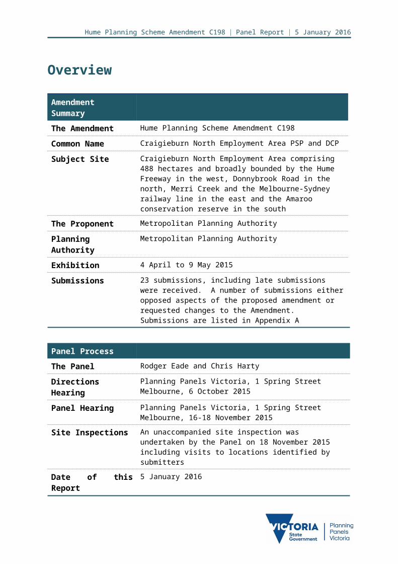
Overview
Amendment Summary
The Amendment Hume Planning Scheme Amendment C198
Common Name Craigieburn North Employment Area PSP and DCP
Subject Site Craigieburn North Employment Area comprising 488 hectares and broadly bounded by the Hume Freeway in the west, Donnybrook Road in the north, Merri Creek and the Melbourne-Sydney railway line in the east and the Amaroo conservation reserve in the south
The Proponent Metropolitan Planning Authority
Planning Authority Metropolitan Planning Authority
Exhibition 4 April to 9 May 2015
Submissions 23 submissions, including late submissions were received. A number of submissions either opposed aspects of the proposed amendment or requested changes to the Amendment. Submissions are listed in Appendix A
Panel Process
The Panel Rodger Eade and Chris Harty
Directions Hearing Planning Panels Victoria, 1 Spring Street Melbourne, 6 October 2015
Panel Hearing Planning Panels Victoria, 1 Spring Street Melbourne, 16-18 November 2015
Site Inspections An unaccompanied site inspection was undertaken by the Panel on 18 November 2015 including visits to locations identified by submitters
Date of this Report 5 January 2016

Hume Planning Scheme Amendment C198 | Panel Report | 5 January 2016
Executive SummaryAmendment C198 to the Hume Planning Scheme seeks to incorporate the Craigieburn North Precinct Structure Plan and the Craigieburn North Development Contributions Plan and Urban Growth Zone Schedule 8 and Development Contributions Plan Overlay Schedule 8 into the Hume Planning Scheme. It makes a number of associated changes to schedules and overlays. The purpose of the Amendment is to apply the Industrial 1 Zone and the Commercial 2 Zone to the precinct to facilitate the future development of the land for employment purposes.
The Amendment seeks to protect the Merri and Kalkallo Creek environs for conservation purposes and in particular to protect the habitat on the endangered Growling Grass Frog. The majority of the precinct is to have the Industrial 1 Zone applied and the Commercial 2 Zone applied to the northern part of the precinct. The Commercial 2 Zone is regarded as providing a better interface with the sensitive creek frontages and to future residential development in the adjacent English Street precinct. The Commercial 2 Zone also facilitates the development of limited floorspace for restricted retailing, taking advantage of the Hume Freeway abuttal.
Key issues raised in submissions include the provision for restricted retailing and its potential impact on the retail hierarchy; the appropriateness of the zones proposed to be applied; the appropriateness of approaches to protecting the conservation values of the creek; the interface treatment between the proposed uses and the conservation area and adjoining residential development to the east of Merri Creek; and a significant number of changes to the Precinct Structure Plan, the Development Contributions Plan and other exhibited documents requested by submitters. Prior to the Hearing the Metropolitan Planning Authority attempted to resolve as many issues as possible with individual submitters and this resulted in amendment tables proposing changes being tabled at the Hearing.
Each chapter of this report includes detailed conclusions drawn by the Panel. Major conclusions drawn include:
That the Amendment is broadly supported by the Panel subject to a number of changes
That provision for limited restricted retailing in the Craigieburn North Employment Area is supported but the amount of space provided for needs to be carefully managed
That the mechanisms proposed to protect the conservation values of the Merri Creek are broadly supported.
Based on the reasons set out in this Report, the Panel recommends:
Hume Planning Scheme Amendment C198 be adopted as exhibited subject to the following:
1. Amend the Precinct Structure Plan, Development Contributions Plan, Schedules and other exhibited documents in line with changes proposed in the tables of responses to submissions and Schedules presented with the Metropolitan Planning Authority’s Part A submission to the Panel, and as updated in tabled
Page 1 of 81
Hume Planning Scheme Amendment C198 | Panel Report | 5 January 2016
documents 1, 2 and 3 at the Hearing, except where those changes are the subject of further recommendations below.
2. Amend Table 2: Use, in Clause 2.4 of Schedule 8 to the Urban Growth Zone as follows:a) Restricted retail and trade supplies being made as of right up to 25,000m2 in
the Commercial Precinct A.b) Trade supplies being a permit required use in the Commercial Precinct B.c) Cinema being a permit required use in the Commercial Precincts A and B.d) Shop, supermarket and cinema entertainment facility being permit required
uses in the Commercial Precincts A and B.e) Add the following to the Use and Requirement columns:
Use: Industry (other than Materials recycling and Transfer station) and Warehouse where the applied zone is Commercial 2 Zone.
Requirement: Must not be a purpose shown with a Note 1 or Note 2 in the table to Clause 52.10.
The land must be at least the following distances from land (not a road) which is in a residential zone or Urban Growth Zone with an applied residential zone: The threshold distance, for a purpose listed in the table to Clause
52.10. 30 metres, for a purpose not listed in the table to Clause 52.10.
Must not adversely affect the amenity of the neighbourhood, including through the: Transport of materials, goods or commodities to or from the land Appearance of any stored goods or materials Emission of noise, artificial light, vibration, odour, fumes, smoke,
vapour, steam, soot, ash, dust, waste water, waste products, grit or oil.
3. Amend the Precinct Structure Plan to add an additional Objective under the heading of ‘employment and town centres’ in section 2.2 and an additional Guideline under the heading of ‘employment guidelines’ in section 3.2.3 with the following intent:a) Restricted retail is encouraged within Commercial Precinct A as shown in
Plan 3 under the provisions set out in table 2.4 of Urban Growth Zone Schedule 8 up to a maximum floorspace not significantly exceeding 25,000 square metres
b) The intent of the provision for limited restricted retail floor space is to take advantage of the exposure to the Hume freeway and not to develop a regional scale or large scale restricted retail centre
c) Higher amenity based office and manufacturing activity is encouraged within Commercial Precinct B as shown in Plan 3 to complement the environmental sensitivity of the Merri Creek environs and any future adjacent residential areas.
Page 2 of 81

Hume Planning Scheme Amendment C198 | Panel Report | 5 January 2016
4. Amend the Precinct Structure Plan as follows:a) Requirement R9 be amended to read - Subdivision and Development of lots
facing Merri Creek Conservation Area 34 must provide for the outcomes illustrated in Figure 2.
b) Figure 2 be amended to show a 3 metre landscape buffer within private lots and insert a note stating - Where practical, landscaping within any private lot should provide canopy trees and shrubs to help minimise the visual impact of industrial buildings from the Conservation Area 34 and residential interface.
c) Requirement R15 be amended to read - Any fencing abutting a local park, whether encumbered or unencumbered, must be visually-permeable to facilitate public safety and surveillance. The words ‘low-scale’ should be deleted as this is likely to be challenged by developers wanting secure fencing.
5. Adopt Schedule 4 to the Rural Conservation Zone as drafted in the Metropolitan Planning Authority’s Part A submission.
6. Retain Environmental Significance Overlay Schedule 10 and delete Environmental Significance Overlay Schedule 2, subject to its contents being applied to the Amendment documentation as follows:a) Translate the Environmental Significance Overlay Schedule 2 objectives
relating to natural systems, waterway function, recreation use, landscape character and heritage directly into the relevant parts of the Craigieburn North Employment Area Precinct Structure Plan.
7. Amend Sub clause 1.0 – Scheduled Area of the Schedule to Clause 52.17 as‐ follows:a) In the first column relating to Area refer only to Urban Growth Zone
Schedule 8 and delete reference to Incorporated Plan Overlay Schedule 2.b) The second column relating to the description of native vegetation for which
no permit is required to remove, destroy or lop is to read: Shown as native vegetation patches that can be removed or scattered
trees that can be removed on Plan 6 in the incorporated Craigieburn North Employment Area Precinct Structure Plan where the removal, destruction or lopping is carried out in accordance with the ‘Final approval for urban development in three growth corridors under the Melbourne urban growth program strategic assessment, 5 September 2013’ pursuant to section 146B of the Environment Protection and Biodiversity Conservation Act 1999 (EPBC Act).
and Any other native vegetation not shown on Plan 6 in the incorporated
Craigieburn North Employment Precinct Structure Plan.
Page 3 of 81

Hume Planning Scheme Amendment C198 | Panel Report | 5 January 2016
8. Amend the Development Contributions Plan to delete from Table 8 the second of the columns headed ‘DCP are required (HA)’ and replace it with a column headed ‘Net Developable Area Required (HA)’. Further Amend Table 7 of the Development Contributions Plan to place the correct data in columns 3 to 10 of the table in the section headed ‘Intersection Projects’. The reference to 4.2% in the last line of the second paragraph of section 3.2.3 of the Development Contributions Plan should be amended to 4.4%.
Page 4 of 81

Hume Planning Scheme Amendment C198 | Panel Report | 5 January 2016
1 Introduction1.1 Panel processHume Planning Scheme Amendment C198 (the Amendment) was prepared by the Metropolitan Planning Authority (MPA) as Planning Authority. As exhibited, the Amendment proposes to implement a Precinct Structure Plan (PSP) and Development Contributions Plan (DCP) for the Craigieburn North Employment Area (CNEA). The details of the changes proposed are set out in section 1.2 of this report.
The Hearing was in the offices of Planning Panels Victoria from 16 - 18 November 2015. Parties to the Panel Hearing are listed in Table 1.
Table 1 Parties to the Panel Hearing
Submitter Represented by
Metropolitan Planning Authority
Ms Joanne Lardner of Counsel instructed by Mr Tim Peggie, Director Structure Planning, MPA and assisted by Ms Zoe Dillon, Senior Strategic Planner, MPA and Mr Matthew Rogers MPA, and who called the following expert witnesses:- Mr Nick Hooper, Planner, of Taylors Development Strategists- Mr Julian Szafraniec, Retail Economist, of SGS Economics and
Planning
Hume City Council Mr Gareth Edgley, Coordinator Strategic Planning assisted by Mr Andrew Johnson, Coordinator Integrated Planning.
Whittlesea City Council Ms Kara Mahoney
MAB Corporation Pty Ltd on behalf of Merrifield Corporation Pty Ltd
Mr Ian Pitt QC and Ms Romy Davidov of Best Hooper, Solicitors, who called the following expert witnesses:- Mark Woodland, Planner, of Echelon Planning- Matthew Lee, Retail Economist, of Deepend Services.
Mr Angelo Votsis
Mr John Tsoutsoulis
Moremac Property Group on behalf of the English Street Development Partners
Mr Martin Gaedke, Project Director, Moremac Property Group
Mr Steven Mustica
Mr Claudio Di Martino
Merri Creek Management Committee
Ms Luisa Macmillan
Page 5 of 81

Hume Planning Scheme Amendment C198 | Panel Report | 5 January 2016
1.2 The proposal
(i) The subject area
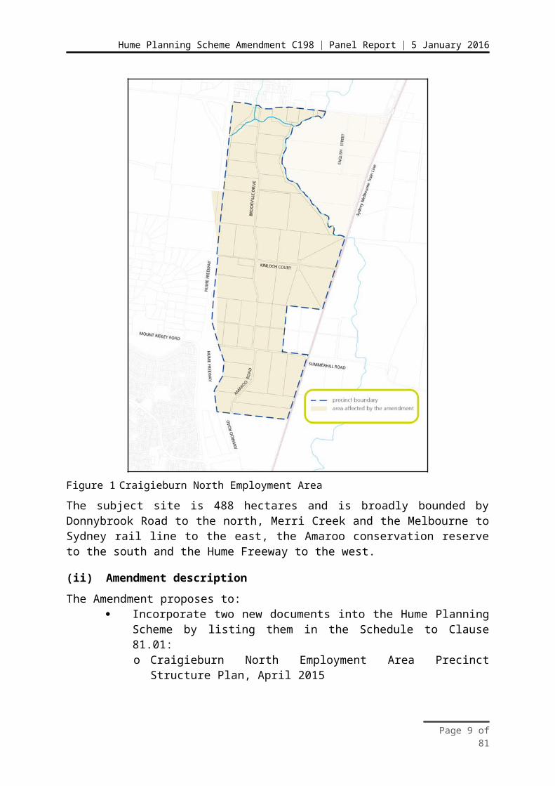
The Amendment applies to land shown in Figure 1.
Figure 1 Craigieburn North Employment Area
The subject site is 488 hectares and is broadly bounded by Donnybrook Road to the north, Merri Creek and the Melbourne to Sydney rail line to the east, the Amaroo conservation reserve to the south and the Hume Freeway to the west.
(ii) Amendment description
The Amendment proposes to: Incorporate two new documents into the Hume Planning Scheme by listing
them in the Schedule to Clause 81.01:o Craigieburn North Employment Area Precinct Structure Plan, April 2015
Page 6 of 81
Hume Planning Scheme Amendment C198 | Panel Report | 5 January 2016
o Craigieburn North Employment Area Development Contributions Plan, April 2015
Insert Urban Growth Zone Schedule 8 (UGZ8) to the Hume Planning Scheme and applies UGZ8 to land in the Amendment area. This zone sets out the land use and development controls for the precinct. The zone requires land use and development to be generally in accordance with the incorporated Craigieburn North Employment Precinct Structure Plan;
Insert Special Use Zone Schedule 8 (SUZ8) to the Hume Planning Scheme and applies SUZ8 to the transmission line within the Amendment area;
Rezone land identified as Conservation Area 34 in the Biodiversity Conservation Strategy along the Merri Creek from Farming Zone (FZ) to Rural Conservation Zone (RCZ)1;
Insert Incorporated Plan Overlay Schedule 2 (IPO2) to the Hume Planning Scheme and applies IPO2 to land within the RCZ which is identified as Conservation Area 34 in the Biodiversity Conservation Strategy along the Merri Creek;
Inserts the Development Contributions Plan Overlay Schedule 8 (DCPO8) into the Hume Planning Scheme and applies DCPO8 to the Amendment area for the purpose of levying contributions for the provision of works, services and facilities in relation to development within the Development Contributions Plan area;
Amend the Public Acquisition Overlay (PAO1) to extend the PAO1 to land south of Donnybrook Road to allow for the widening of Donnybrook Road and to land to the east and west of the Hume Freeway to allow for a future freeway interchange;
Delete the Design and Development Overlay Schedule 1 (DDO1) from the land within the Amendment area. This overlay is no longer required within the precinct area as the incorporated Craigieburn North Employment Area Precinct Structure Plan addresses interface issues along the Hume Freeway;
Amends the Land Subject to Inundation Overlay (LSIO) within the Amendment area to update maps in line with Melbourne Water mapping;
Delete the Rural Floodway Overlay (RFO) from the land within the Amendment area. This overlay is no longer required as the LSIO addresses land which is subject to 1 in 100 year flooding along the Merri Creek;
Delete the Environmental Significance Overlay Schedule 2 & Schedule 10 (ESO2 & ESO10) from the land within the Amendment area. This overlay is no longer required as the proposed RCZ, IPO2 and the Craigieburn North Employment Area Precinct Structure Plan designate and protect areas of environmental significance along the Merri Creek;
Amend the schedule to Clause 52.01 to require public open space contributions in the Craigieburn North PSP area when land is subdivided;
Amend the schedule to Clause 52.17 to identify native vegetation that can be removed without the need for a planning permit;
1 The Panel notes that the RCZ already exists along the Merri Creek, hence the Amendment seeks expansion of the RCZ by rezoning land not only from a small pocket of FZ that fronts Donnybrook Road adjacent to Laffan Reserve, but also from the UGZ, which affects the balance of land in the CNEA.
Page 7 of 81

Hume Planning Scheme Amendment C198 | Panel Report | 5 January 2016
Amend the schedule to Clause 61.03 to update maps included in the Hume Planning Scheme; and
Amend the schedule to Clauses 94 and 95 to include VicSmart provisions for buildings and works, car parking and signage in relation to industrial areas.
(iii) Purpose of the Amendment
The purpose of the Amendment is to facilitate employment related development in the CNEA to complement the significant residential development that has occurred and planned to occur in the northern growth corridor in both the City of Hume and the City of Whittlesea.
The Amendment applies to some 346 developable hectares of land within the PSP area. It will facilitate approximately 261 hectares (54% of developable land) for industrial purposes, approximately 83 hectares for commercial purposes (25% of developable land) with the remaining area of land set aside for conservation or open space purposes. At maturity the CNEA is planned to facilitate some 8,200 jobs.
1.3 Background to the proposalThe CNEA is one of a number of PSP areas contained within the north growth corridor and the initial broad planning for which was the NGCP which identifies the land as ‘industrial’ with ‘bio-diversity values’ along the Merri Creek and its tributaries.
The CNEA is adjacent to the English Street PSP area which was the subject of Amendment C183 to the Whittlesea Planning Scheme, the Hearing for which preceded the Hearing for this Amendment. The predominant land uses envisaged under the English Street PSP were residential and conservation (through the application of the RCZ). The report of the Panel for Amendment C183 was released by the MPA on 5 November 2015, and was available to submitters to this Amendment prior to the Hearing. Initially the MPA had proposed to address the planning for the two PSPs at the same Panel. This was not pursued because each site had distinct issues and a single PSP and DCP crossing municipal boundaries would create administrative issues.
The Amendment implements the outcomes of the CNEA PSP by establishing areas within the precinct for commercial, industrial and conservation related land uses. Biodiversity values associated with the Growling Grass Frog (Litoria raniformis) will be protected through the extension of the RCZ. Industrial and commercial land use is proposed to be facilitated through the use of the Industrial 1 Zone (IN1Z) and Commercial 2 Zone (C2Z) as applied zones under the UGZ8. The Amendment provides an overall structure for the area providing certainty in the development decisions and clarity as to the cost and location of services.
The Amendment provides for conservation of the Growling Grass Frog (GGF), and mitigation of impacts on Matters of National Environmental Significance (MNES) under the Commonwealth Environment Protection and Biodiversity Conservation Act 1999 (EPBC Act ). Provisions in the Amendment facilitate the implementation of an endorsed program report 2 under that Act. The same provisions also manage MNES. These requirements are consistent with the Commonwealth approved Biodiversity Conservation Strategy for Melbourne’s
2 Delivering Melbourne’s Newest Sustainable Communities: Program Report (State of Victoria, December 2009)
Page 8 of 81

Hume Planning Scheme Amendment C198 | Panel Report | 5 January 2016
Growth Corridors, June 2013 (BCS), the production and approval of which was a requirement of the endorsed program report.
The Amendment removes two existing Environmental Significance Overlays (ESO2 & ESO10) from the CNEA and consolidates the provisions in the UGZ Schedule 8, the IPO Schedule 2 and the PSP.
The Amendment does not duplicate any management provisions for land use and development in other acts or regulations.
The Amendment complements, and in some cases replaces, existing provisions of the scheme. In particular the Amendment streamlines and integrates processes for native vegetation management and infrastructure provision.
Mr Harty was a member of the English Street PSP Panel and as such was able to ensure consistency of approach and coherency in the way the two adjacent PSPs were addressed by the respective Panels.
1.4 Issues dealt with in this reportThe Panel considered all written submissions, as well as submissions presented to it during the Hearing. In addressing the issues raised in those submissions, the Panel has been assisted by the information provided to it as well as its observations from inspections of specific sites. The Panel notes that the focus of the Hearing and of this report is on issues which remained unresolved. The Panel has not undertaken an analysis of the proposed PSP and DCP from first principles. As such it makes no comment on these documents except for the unresolved issues listed below and which are addressed in this report.
The exception to this is the application of the Public Land Equalisation Method (PLEM) in the DCP. There were some anomalies between the text and Table 8 in the DCP together with presentation errors in Table 7 which lead the Panel to examine the proposed implementation of the PLEM; this is one of the first times this methodology has been used and unusually there was no major developer carefully scrutinising the DCP. That analysis has resulted in the Panel concluding that the PLEM will be implemented appropriately.
This report deals with the issues under the following headings: Planning Context Proposed application of the Commercial 2 Zone Other unresolved issues relating to:
- the amendment process issues,- land development,- conservation and open space areas,- infrastructure implementation,- industrial land use, acquisition and zoning,- draft schedules, and- implementation of Public Land Equalisation Method.
1.5 Issues addressed in the Whittlesea C183 Panel ReportA number of issues relevant to the CNEA were addressed by the Panel considering Amendment C183 to the Whittlesea Planning Scheme relating to the English Street PSP. The
Page 9 of 81

Hume Planning Scheme Amendment C198 | Panel Report | 5 January 2016
Panel for this Amendment made it clear to submitters that it saw no value in readdressing issues already addressed by the C183 Panel, except where there were additional matters or issues unique to the Hume C198 Amendment. For this reason this Panel has adopted a number of recommendations and observations made by the Whittlesea C183 Panel. These include:
A conclave of engineering experts met prior to the Whittlesea C183 Hearing and agreed a cost of $4.367 million for the proposed bridge across the Merri Creek to connect the two precincts. This costing was agreed for DCP purposes;
Whilst not in the English Street precinct, the zoning of the Laffan Reserve was raised at the Whittlesea C183 Hearing and commented on by that Panel. This Panel accepts that the Laffan Reserve should remain in the Public Park and Recreation Zone (PPRZ);
The area identified in the BCS as Conservation Area 34 and its role in protecting GGF habitat, contribution toward public open space and waterway/stormwater management;
The application of the RCZ and IPO over Conservation Area 34 was appropriate; and
The retention of ESO4 which applies to areas in the RCZ (the equivalent in this Amendment is ESO10) and the deletion of ESO3 (the equivalent in this Amendment is ESO2) subject to Schedule objectives relating to natural systems, waterway function, recreation use, landscape character and heritage being incorporated into the Schedule to the RCZ and relevant sections of the English Street PSP as appropriate. The Panel notes the MPA have proposed a similar arrangement for this Amendment.
1.6 Issues for resolution outside the Panel processAs appendices to its Part A submission, the MPA provided a number of tables which outlined the status of issues raised by submitters. Issues were given one of the following designations in those tables:
Resolved Unresolved – Refer to Panel Decision pending further review.
At the Hearing the MPA tabled an updated version of this table with a further classification as follows:
Resolved in Principle. MPA and Council to agree wording/plans prior to gazettal.
The Panel applauds the MPA for this approach.
Whilst leaving detailed issues to be resolved after the Hearing in this manner is relatively unusual in the Panel process, both the MPA and Council reassured the Panel that the use of appropriate words or changes to plans is all that is outstanding. It was submitted that it was simply the lack of time that had prevented final resolutions being achieved prior to the Hearing. The Panel accepted this at face value and did not pursue any of these issues with the MPA or Council and makes no comment in this report on such issues.
Page 10 of 81
Hume Planning Scheme Amendment C198 | Panel Report | 5 January 2016
The Panel notes that it has put no mechanism in place for resolution of any issues in the event that agreement cannot be reached but notes that parties may call for the Panel to be reconvened if resolution on any matter cannot be reached.
1.7 Procedural mattersAs a result of the closing submission by the MPA which questioned whether the submission by the Hume City Council was consistent with the adopted council position and the Panel concerns about the implementation of the PLEM, at the conclusion of the Hearing the Panel issued the following Directions:
Council is directed to provide an electronic copy of the report to the Hume Council meeting of 11 May 2015 on Amendment C198, the relevant Council paper for that meeting and the relevant Council minute from that meeting, by close of business on Wednesday 25 November 2015.
The MPA and Council are directed to consult and if possible agree on amendments or addition to Requirements and or Guidelines in the Craigieburn North Employment Area PSP which address the issue of building siting and design, and interface treatment between development in the proposed Commercial 2 Zone and the designated conservation area along Merri Creek, by close of business on Wednesday 25 November 2015.
The MPA is directed to provide details of the calculations which underpin the implementation of the Public Land Equalisation Method to the Panel, in an electronic format, by the close of business on Wednesday 25 November 2015.
The MPA subsequently advised that it would not be able to comply with this Direction until Tuesday 8 December 2015. These Directions were subsequently complied with.
As part of its Part A submission the MPA tabled amended versions of the following schedules:
Urban Growth Zone Schedule 8 Rural Conservation Zone Schedule 4 Environmental Significance Overlay Schedule 10 Schedule to Clause 52.17.
At the commencement to the Hearing, the MPA tabled a further version of the UGZ8 (tabled document 3).
The changes tracked in each of the above were made in response to submissions.
The MPA’s Part A submission included, as requested by the Panel, tables proposing changes to other documentation mainly the exhibited Precinct Structure Plan. These were minor corrections and typographical errors, but also included some major changes, the most significant of which was a revised vision statement for the precinct. A further version of these tables was tabled at the commencement of the Hearing (tabled documents 1 and 2).
In keeping with the general approach at the Hearing, the Panel has not examined those changes in detail, except where they were contested as ‘unresolved issues’. The Panel accepts these proposed changes to the exhibited documents except where they have been further contested at the Hearing and are the subject of recommendations made in this report.
Page 11 of 81

Hume Planning Scheme Amendment C198 | Panel Report | 5 January 2016
1.8 RecommendationsThe Panel recommends that the MPA:
1. Amend the Precinct Structure Plan, Development Contributions Plan, Schedules and other exhibited documents in line with changes proposed in the tables of responses to submissions and Schedules presented with the Metropolitan Planning Authority’s Part A submission to the Panel, and as updated in tabled documents 1, 2 and 3 at the Hearing, except where those changes are the subject of further recommendations below.
Page 12 of 81

Hume Planning Scheme Amendment C198 | Panel Report | 5 January 2016
2 Planning ContextThe MPA provided a formal response to the Strategic Assessment Guidelines as part of the exhibited Explanatory Report.
The Panel has reviewed the policy context of the Amendment and made a brief appraisal of the relevant zone and overlay controls and other relevant planning strategies. This section of the report is brief, as a key issue in this Amendment is strategic justification for the application of the C2Z in the northern section of the CNEA. For this reason strategic issues are addressed in more detail as relevant, in later sections of this report.
2.1 Policy framework
(i) State Planning Policy Framework
In its Explanatory Report the MPA submitted that the Amendment is supported by the following clauses in the State Planning Policy Framework (SPPF):
Clauses 11.01 Activity centres, 11.02 Urban growth, 11.03 Open space - The Amendment incorporates a precinct structure plan. These plans set out an orderly structure for development of the precinct including bringing zoned land supply to the market, providing land with good proximity to existing and planned amenities and services, and infrastructure;
Clause 12.01 Biodiversity - Offsets for vegetation removal and habitat areas for nationally and state significant species will be provided in accordance with the BCS;
Clause 17.02 Industrial - The Amendment provides for land supply of industrial and commercial land with good access to existing and proposed road networks and for future employees. The Amendment is consistent with the proposed land uses designated within the North Growth Corridor Plan. The precinct is bound by the Hume Freeway, Donnybrook Road, Merri Creek, the Sydney-Melbourne rail corridor and an existing industrial estate to the south, minimising any amenity impacts to existing residential populations. The precinct takes advantage of key logistic connections with proximity to Tullamarine Airport, principle freight networks and the future Outer Metropolitan Ring Road;
Clause 18.01 Land use and transport planning, 18.02 Movement networks - The CNEA is strongly integrated with the existing and planned arterial road network and Principal Public Transport Network. The proposed road network provides opportunities for future bus capable networks as well as integrated cycle networks across the precinct and connecting to existing communities;
Clause 19.03 Development infrastructure - A DCP has been prepared for the CNEA and forms part of this Amendment. This Amendment provides the strategic basis for the DCP including roads, intersections, bicycle paths, sports facilities and open space. Water, sewer and drainage services are readily connectable from adjacent development into the precinct. The Amendment responds to Clause 11 Settlement by providing for land zoned for commercial use and expansion.
Page 13 of 81

Hume Planning Scheme Amendment C198 | Panel Report | 5 January 2016
(ii) Local Planning Policy Framework
The MPA submitted that the Amendment supports the Local Planning Policy Framework (LPPF) of the Hume Planning Scheme. With respect to relevant policies under the Municipal Strategic Statement (MSS), the MPA referred to the following in the Explanatory Report:
Clause 21.01 Land Use Vision for Hume City. This policy provides an overarching vision for Hume City Council. The policy lists the following key land use objectives:- Community Wellbeing - The Amendment will upgrade the existing Laffan
Reserve as well as provide a network of open space throughout the precinct;
- The Economy - The Amendment provides for significant employment land in close proximity to existing and future residential communities;
- Infrastructure - The Amendment provides road networks, bicycle and walking linkages;
- Environment - The Amendment supports preservation and enhancement of the Merri Creek GGF habitat, retention of significant vegetation, as well as encouraging a well designed built environment for employment uses. The Amendment will facilitate the delivery of jobs in the northern growth corridor, reducing travel times and associated environmental impacts; and
- Local Areas - The PSP will result in encouraging industrial and employment development in Craigieburn through the provision of an employment destination and supporting road network, walking and bicycle paths.
In the Explanatory Report the MPA also demonstrates that the proposed amendment supports the following clauses:
Clause 21.04 – Infrastructure through timely provision of infrastructure through the DCP
Clause 21.05 - Natural Environment and Built Environment through the protection of biodiversity values associated with the Merri Creek and GGF habitat. Through designation in the PSP of the northern portion of the CNEA adjacent to the Merri Creek for commercial uses and the central and southern portions of the CNEA for industrial uses, appropriate treatment of adjoining interfaces will occur.
The MPA further lists the following local planning policies which are relevant to the Amendment:
Clause 22.01 - Industrial Local Policy which manages built form siting and design
Clause 22.19 – Industrial Stormwater Management Policy relating to waterway and stormwater management.
The MPA does not list Clause 21.07 – Activity Centres and Retailing in its Explanatory report but makes reference to it in its Part B submission.
One of the strategies to implement Objective 4 of that Clause was the subject of a number of submissions before the Panel, including a submission by Council. This is discussed in Chapter 3.
Page 14 of 81

Hume Planning Scheme Amendment C198 | Panel Report | 5 January 2016
(iii) Other strategic planning provisions
North Growth Corridor Plan
Amendment C198 must take account of the North Growth Corridor Plan (NGCP) which was approved in 2012. The PSP prepared for the CNEA is the next more detailed level of planning for the area. The extent to which the proposed amendment is consistent with the NGCP was the subject of submissions made to the Panel in relation to commercial land use and is addressed as relevant in later sections of this report. The Panel acknowledges that both the MPA and Hume City Council considered the industrial use designation in the PSP to be consistent with the NGCP.
Plan Melbourne
In its Part B submission to the Panel, the MPA has addressed relevant sections of Plan Melbourne where it responds to submitters. Where relevant, the Panel addresses issues associated with the consistency with Plan Melbourne later in this report. The MPA lists the following initiatives of Plan Melbourne as relevant to the Amendment:
Initiative 1.2.1 - Plan for industrial land in the right locations across Melbourne’s five subregions to support investment and employment
Initiative 1.2.2 - Maintain the competitiveness of employment land in Melbourne’s growth areas
Initiative 1.2.3 - Plan for Commercial land and Activity Centre needs Initiative 1.3.1 - Extend VicSmart in defined Industrial and Employment
Precincts Initiative 1.5.4 - Accelerate investment in Melbourne’s growth areas to
increase local access to employment.
2.2 Planning scheme provisions
(i) Zones
Amendment C198 proposes to apply the UGZ8 across most of the CNEA with the applied zones being the IN1Z and the C2Z.
(ii) Overlays
The following Overlay is inserted into the Hume Planning Scheme: Development Contributions Plan Overlay Schedule 8 (DCPO8).
The following Overlays are proposed to be amended: Public Acquisitions Overlay Schedule 1(PAO1) Design and Development Overlay Schedule 1 (DDO1) Land Subject to Inundation Overlay (LSIO).
Page 15 of 81

Hume Planning Scheme Amendment C198 | Panel Report | 5 January 2016
The following Overlays are to be deleted: Environmental Significance Overlay Schedule 2 and Schedule 10 (ESO2 and
ESO10) Rural Floodway Overlay (RFO).
Further details of the impacted Overlays are provided in section 1.2(ii) of this report.
(iii) Particular and general provisions
There are no general or particular provisions impacted by this Amendment.
2.3 Ministerial Directions and Practice Notes
(i) Ministerial Directions
The MPA submitted that the Amendment meets the relevant requirements of the following Ministerial Directions:
Direction 1 - Potentially Contaminated Land Direction 9 - Metropolitan Strategy Direction 11 - Strategic Assessment Guidelines Direction 12 - Urban Growth Areas S46M(1) - Direction on Development Contributions Plans.
The Amendment is consistent with the Ministerial Direction on the Form and Content of Planning Schemes under Section 7(5) of the Act.
(ii) Planning Practice Notes
The MPA lists no Planning Practice Notes as relevant to the Amendment.
2.4 The Melbourne Strategic AssessmentThe Victorian and Commonwealth governments agreed to undertake a strategic assessment referred to as the Melbourne Strategic Assessment (MSA) of the impacts of expanding Melbourne’s urban growth boundary on MNES under the Commonwealth’s EPBC Act in 2009. The MSA also described conservation outcomes to mitigate the impacts of urban development.
The MSA informed the Victorian government’s Program Report which described the actions necessary to achieve the conservation outcomes described in the MSA. The Program Report remains the overarching description of the conservation obligations resulting from urban development of Melbourne’s growth areas including the north growth corridor of which the CNEA is part. The Victorian government also determined to allow these obligations to be deemed to meet Victoria’s vegetation clearing and habitat protection policies and legislation.
One of the commitments under the endorsed program included preparation of the BCS and various regional strategies for threatened species such as the GGF, Golden Sun Moth (GSM) and the Southern Brown Bandicoot (SBB). The Sub-regional Species Strategy for the GGF was approved in 2013.
Page 16 of 81

Hume Planning Scheme Amendment C198 | Panel Report | 5 January 2016
2.5 Biodiversity Conservation StrategyThe Biodiversity Conservation Strategy (BCS) is the overarching strategy for the protection of biodiversity in the growth corridors and finalises the planning for biodiversity under the MSA. Together with the sub regional species strategies it has informed the NGCP. The BCS‐ identifies areas containing MNES listed under the EPBC Act and matters of state significance listed under the Flora and Fauna Guarantee Act 1988 and/or the Department of Environment, Land, Water and Planning’s (DELWP)’s advisory lists for rare or threatened species. These areas are categorised as conservation areas to be protected within the growth corridors. Conservation Area 34 relates to the threatened GGF, its habitat and protective buffer zone that occurs along the Merri Creek corridor, part of which falls within the CNEA.
The BCS requires conservation areas within the growth corridors of Melbourne to be protected and managed in perpetuity. It also recognises that land not within a conservation area and suitable for urban development may be cleared of native vegetation in accordance with the Commonwealth approval of 5 September 2013, the requirements of the CNEA PSP and amended schedule to Clause 52.17, proposed under Amendment C198.
2.6 Sub regional species strategy for the Growling Grass Frog‐The purpose of the sub regional species strategies is to inform the preparation of the BCS by‐ identifying important populations and areas of habitat to be protected. These strategies influence the design of the precincts during the preparation of precinct structure plans.
The Sub regional Species Strategy for the GGF identifies suitable habitat for the species in‐ two categories:
Habitat of highest conservation significance that will be protected and managed to ensure the conservation of important populations (Category 1 habitat).
Habitat of lesser significance that can be cleared for urban development, subject to providing compensatory habitat (Category 2 habitat).
The Sub regional Species Strategy for the GGF identified the Merri Creek and its confluence‐ with Kalkallo Creek as one of the major streams that contained the most important sites for GGF conservation. The conservation area for the GGF includes a 200 metre buffer distance from a stream where clusters of populations have been recorded. The buffer distances can reduce in width to 100 metres where GGF habitat is present, to enable movement between population clusters.
GGF corridors identified in the sub regional species strategy have been identified in the BCS‐ as conservation areas. These corridors comprise all the land in the area covered by the BCS requiring protection to achieve the MSA conservation outcomes for the GGF.
Page 17 of 81

Hume Planning Scheme Amendment C198 | Panel Report | 5 January 2016
2.7 DiscussionAs indicated above, the strategic justification for the use of the C2Z and in particular the facilitation of restricted retailing provision by the application of that zone, is a key issue before the Panel and is addressed later in the report. Apart from this, and the discussion of the retention of ESOs, the Panel has no comment on the use of zones or the application of overlays which are regarded as appropriate.
The Panel concludes that the Amendment is well founded and is strategically justified subject to addressing the more specific issues raised in submissions as addressed in the following chapters.
Page 18 of 81
Hume Planning Scheme Amendment C198 | Panel Report | 5 January 2016
3 Proposed application of the Commercial 2 Zone3.1 The issuesIn Schedule 8 to the UGZ, the MPA propose to apply the C2Z to some 83 hectares (25% of the net developable area in the precinct or 17% of all land within the precinct) of land in the north of the precinct divided into two sub-precincts each with slightly different provisions. These are designated as Commercial Precincts A and B as set out in Figure 2.
Figure 2 Proposed Commercial 2 Zone, Precincts A and B.
Page 19 of 81

Hume Planning Scheme Amendment C198 | Panel Report | 5 January 2016
The issues considered by the Panel in this section of the report are as follows: Is the application of the C2Z as proposed, consistent with State and local
policy and the NGCP Whether there is a need for the provision for more restricted retailing floor
space in the northern growth corridor in the long term, than is provided for currently
Whether the application of the C2Z has the potential to undermine the retail hierarchy in the region, with respect to restricted retail provision in either the short or long term
What zones and provisions within applied zones are appropriate to facilitate appropriate development in the CNEA and in particular that part of it proposed for C2Z.
The Panel is of the view that there are a significant number of factors which it needs to consider in addressing these issues and drawing conclusions on the appropriate zoning for the area proposed for C2Z. The Panel has approached this task by identifying what it sees to be the relevant factors. It addresses these under the headings below before drawing overall conclusions.
In the submissions and evidence there was reference to both provision for ’bulky goods retailing’ and also ‘restricted retailing’. In some cases the terms were used interchangeably. The Panel uses the term ‘restricted retailing’ for simplicity and consistency. This is the term used and defined in the Planning Scheme. In doing so the Panel understands that there can be some debate about what constitutes bulky goods. The exception is where there is specific use of the term ‘bulky goods’ in submissions or evidence. The Panel is very aware of the very dynamic nature of retailing and how, definitions, needs and provision will change over time.
3.2 State PolicyThis section considers whether the proposal to apply the C2Z is consistent with State Policy including the NGCP. The application of zones in other growth areas designated for ‘Industry’ in Growth Corridor Plans is also considered.
(i) Submissions and evidence
Mr Hooper in presenting planning evidence for the MPA outlined sections of the Clauses 11.02 17.01 and 17.02 of the SPPF, which the PSP implements. Mr Ian Pitt on behalf of Merrifield Corporation submitted that parts of Clauses 11 and 17 and Clause 9.01 (relating to Plan Melbourne) of the SPPF lend support for the focus of retail functions in and around activity centres.
Mr Nick Hooper made no specific reference to Plan Melbourne in his evidence. Mr Pitt quoted from the preamble to Initiative 1.2.3 of Plan Melbourne in supporting his case to concentrate restricted retailing in existing and proposed activity centres.
Ms Joanne Lardner on behalf of the MPA, submitted that the proposed application of the C2Z on the subject site implements State policy and is consistent with the NGCP’s designation of the whole of the CNEA as ‘Industrial’. Ms Lardner submitted that this designation did not necessarily mean that the land would be given an industrial zoning. The
Page 20 of 81
Hume Planning Scheme Amendment C198 | Panel Report | 5 January 2016
Panel requested that the MPA provide information on where a zoning other than one of the ‘industrial’ suite of zones has been applied to land designated for industrial use in one of the growth corridor plans.
In response, Mr Mathew Rogers from the MPA made a presentation at the Hearing which demonstrated that there had been a significant number of instances where a non-industrial zoning had been applied to land designated for industry in the Growth Corridor Plans. The C2Z is used in a number of instances but in most cases it appears to have been translated from the previous Business 3 Zone (B3Z). It appears that prior to the current proposal that only in one instance has the C2Z been directly applied and that was to a relatively smaller precinct in Epping, which the Panel estimates is of the order 30 hectares.
Mr Pitt tabled the ‘purpose’ of each of the former Business 3 and Business 4 zones (B4Z) which make clear that it was the B4Z which made specific reference to ‘bulky goods retailing’ in its purpose statement. The focus of the B3Z was ‘office’ and ‘manufacturing and associated uses’, not restricted retailing.
In his evidence Mr Hooper stated that one of the documents produced by Essential Economics, which informed the Growth Corridor Plans, states:
Employment land within the growth corridors will generally contain a mix of industrial land use zones and the Business 3 Zone as these zones encourage the types of employment uses envisaged for these precincts.
Mr Hooper notes that the B3Z is more restrictive in terms of uses it facilitates than the C2Z which has replaced it.
The Growth Corridor Plans does not contain explicit guidance on appropriate zones.
In his submission, Mr Pitt quoted relevant parts of Clause 11, Clause 17 and Clause 9 of the SPPF in support of his contention that Sate policy supported the provision for restricted retailing in existing and planned activity centres in providing for retail functions. He further quoted Clause 11.02-4 in part to emphasise the importance of the orderly sequencing of development to ensure appropriate services are available to communities.
Mr Pitt submitted that the CNEA is identified in Plan Melbourne as ‘State Significant Industrial Precinct’ and concluded that the proposed zoning was inconsistent with this.
Mr Pitt called expert planning evidence from Mr Mark Woodland who quoted from the Growth Corridor Plans which states:
Bulky Goods (referred to as ‘restricted retail’ in the Planning Scheme) should ideally be located in or adjacent to higher order town centres or in strategic locations within business precincts as part of a cluster of similar uses. Co-location of bulky goods in these locations is preferred and can allow for a more efficient use of infrastructure, greater accessibility by public transport, combined purpose trips and better employment opportunities.
Mr Woodland emphasised the importance of integrating land use and transport and the superior accessibility of town centres to public transport networks and the Principal Public Transport Network (PPTN).
Page 21 of 81
Hume Planning Scheme Amendment C198 | Panel Report | 5 January 2016
(ii) Discussion
It is clear to the Panel that State policy gives considerable weight to the role that higher order activity centres have in providing for retailing, including restricted retailing. However the Panel is of the view that there is little in State policy that mitigates against some restricted retail development in the CNEA, but significant development for such a use finds little support in State policy.
State policy at Clause 11.02-2 calls for planning for growth areas to implement the strategic directions within relevant growth area plans. The NGCP identifies the CNEA for industrial purposes. The NGCP itself requires any PSP to be generally in accordance with it. The NGCP focuses on uses rather than zoning. This is expected as zoning is appropriately considered at the PSP stage of the planning process. The attention on land use rather than zoning permits flexibility with which planning tools are selected to achieve the land use outcomes. It is clear to the Panel that, at the time when the NGCP was approved (around 2012), the intention for nominating areas for industrial use was primarily to provide employment areas where a job would be created for every new household in the growth corridor area. To this end, areas nominated as industrial includes reference to not only manufacturing industry but also integrated office and manufacturing and warehousing with some associated commercial activity. This is clearly reflected in the comment in the Essential Economics report about use of the B3Z as a means of achieving a mix of employment opportunities for the area.
The zoning reforms affecting the former business zones and the new commercial zones and in particular the C2Z have shifted the emphasis of the purposes of the new C2Z to broaden its scope for encouraging not only integrated office and manufacturing but also bulky goods retailing and other retail uses and business and commercial services. This shift places the earlier direction for a mix of employment use based on office and manufacturing activity to one where a greater opportunity becomes available for restricted retail activity to occur where the C2Z is used either directly or in an applied zone.
The Panel believes that while there may be debate about whether the C2Z is an appropriate zone to implement an ‘industrial’ use, it is clear that it is a zone focussed on job facilitation and it appears to have been used a number of times in areas identified as ‘industrial’ in Growth Corridor Plans, albeit most often as a translation from the B3Z. The Panel agrees with Mr Woodland’s contention that Growth Corridor Plans envisage significant concentrations of restricted retailing being mainly located in or near higher order activity centres.
Regarding the NGCP, the Panel notes that it identifies a hierarchy of activity centres, areas for industrial use as well as some areas for business use. The NGCP does make some commentary about bulky goods including that this form of land use should ‘ideally’ locate in or adjacent to higher order town centres or in strategic locations within business precincts. In relation to business precincts, the Plan states at page 22:
Business precincts are expected to deliver more intensive forms of employment generating uses in comparison to industrial areas. They will accommodate a wide range of employment generating uses including service industry, office and commercial activity, and research and development and some bulky goods (restricted retail).
Page 22 of 81

Hume Planning Scheme Amendment C198 | Panel Report | 5 January 2016
It would appear that the intent of the NGCP is that restricted retail be primarily directed around identified activity centres or in designated business precincts. Because the NGCP specifically identifies both of these forms of activity precincts and which do not include the CNEA precinct, it appears the promotion of the northern part of the CNEA precinct for restricted retail is out of sync with the outcomes sought under the NGCP.
Despite this however, the Panel does see merit in promoting forms of employment activity, including limited restricted retail activity, into the northern portion of the CNEA that would not only capitalise on the site’s exposure to the Hume Freeway but also to be sensitive to both the environmental values of the Merri Creek and GGF conservation area and the amenity of residential areas proposed under the English Street PSP. This would be akin to the NGCP’s concept of seeking integrated office and manufacturing activity.
The PSP identifies two commercial precincts. Commercial Precinct A which is located close to the Hume Freeway and which, according to the MPA’s post exhibition revised vision in the PSP, is to provide an opportunity to establish some higher order large floor plate restricted retail development. Such development can take advantage of the high exposure to passing traffic along the Hume Freeway and Donnybrook Road with direct connections to Melbourne. Commercial Precinct B would provide an opportunity to establish higher amenity office and 21st century manufacturing.
The MPA position is that providing for an ‘as of right’ floorspace area of 25,000m 2 for restricted retailing would be sufficient to accommodate a level of supply that would not be significant enough to threaten the opportunities for similar retail activity in or adjacent to activity centres or in the business precincts. It would be sufficient to create an attractive stimulant for other business and industrial activity to occur in the CNEA precinct.
The Panel accepts Mr Woodland’s evidence with respect to public transport accessibility of activity centres and the importance of this for a number of uses which might locate in the C2Z. However it does not accept that this is directly relevant for restricted retailing, particularly for those goods likely to be found in low density uses.
In summary State policy does not lend support for significant restricted retail development in the CNEA, but neither does it lend support for no such development being permitted.
There is the relatively benign support under general State policy for commercial activity in the CNEA. The proposal to use the C2Z as an applied zone under the UGZ8 with modifications to the allocation of permit requirements is not regarded by the Panel as inconsistent with the intent of the NGCP for employment generating uses in the CNEA.
3.3 Local PolicyIn this section, the issue of whether the proposal to apply the C2Z in the northern part of the CNEA is consistent with local policy within the LPPF of the Hume Planning Scheme is considered.
(i) Submissions and evidence
With respect to the issue of the C2Z and the encouragement for restricted retailing in the northern portion of the CNEA, Mr Pitt described the local planning policy relevant to activity
Page 23 of 81

Hume Planning Scheme Amendment C198 | Panel Report | 5 January 2016
centres and retailing at Clause 21.07 and in particular the content of objective 4 relating to bulky goods centres.
Objective 4 states:
Ensure bulky goods centres are appropriately located throughout Hume to meet the needs of existing and growing communities.
The strategies to support the objective are: Distribute bulky goods activity within a hierarchy, with retailers located in centres and
in a selected number of specialized regional bulky goods centres. Encourage smaller scale and/or higher density bulky goods to locate in designated
activity centres where they are integrated in higher density urban formats. Support regional scale specialised bulky goods based activity centres (large scale and
low intensity) that service regional catchments where it can be demonstrated that they are not appropriate in existing and planned Activity Centres.
Mr Pitt submitted that with respect to the last strategy, none of the submissions on behalf of the MPA, the Explanatory Report or the evidence called by the MPA demonstrate that the foreseeable demand for bulky goods is not appropriate nor cannot be accommodated in the planned activity centres.
In contrast, Ms Lardner submitted that, based on the economic evidence of Mr Julian Szafraniec, there can be a net benefit to the community in directing some forms of restricted retailing into ‘out of centre’ locations, or into specialised restricted retailing centres.
Mr Szafraniec’s evidence identified a distinction between high density and low density forms of restricted retail3. This distinction was identified in the 2009 Hume City Retail Strategy and is recognised in local policy at Clause 21.07.
Ms Lardner submitted the land take of bulky goods can be extensive and job density low. This activity is often not well suited for activity centres that focus on high density urban forms including food and convenience retailing, personal and business services, high/medium density housing and public transport activation. If large scale and low density bulky goods in particular are directed to specialised centres, land in core activity centres is released for higher density and higher value land uses.
She submitted that in a growth area context, a supply of land in a secondary location for the development of an employment precinct, which could include some provision for restricted retail, will assist orderly development. This will be achieved by ensuring that retailing, including restricted retailing, does not force out important community facilities such as health and education facilities by consuming all of the cheaper land surrounding an activity centre.
For this reason, Mr Szafraniec’s evidence identifies that high density restricted retailing should be directed to activity centres and low density restricted retailing directed into potentially one or two specialised centres.
3 Low density restricted retailing includes hardware and tool shops, bedding and furniture stores and larger household appliance stores. High density restricted retailing includes smaller linen and household furnishing stores, smaller household appliance stores, phone and electrical stores.
Page 24 of 81

Hume Planning Scheme Amendment C198 | Panel Report | 5 January 2016
Additionally and in terms of forward land supply for activity centre development the planning scheme includes support for business zoned land in multiple ownerships so as to avoid monopoly retail conditions.
In response to the concept of high and low density restricted retailing and the respective locational advantages for each typology, Mr Matthew Lee for Merrifield gave economic evidence that the reference to high and low density restricted retailing and the concept of specialised bulky goods centres in the Hume City Retail Strategy was in the context of discussion about how restricted retail development has spread away from activity centres into highway locations such as Somerton and near Gladstone Park4. The Hume City Retail Strategy related to how specialised bulky goods centres are appropriate highlighting the potential benefits in clustering such uses in appropriate locations where they are accessible to their catchments and where infrastructure such as car parking can be shared. It identified an example with the Nunawading bulky goods, MegaMile centre. In established areas this also frees up land for more intensive activities. Mr Lee expressed the view that the idea of a specialised centre for bulky goods was a preference to the ad-hoc spread of such development along transport corridors.
Mr Gareth Edgley from Hume City Council, expressed the view that the policy under Clause 21.07 identifies that a select number of specialised bulky goods centres should be identified where demand cannot be accommodated in activity centres (Objective 4). He submitted the land take for bulky goods centres can be extensive and job density low so the land use requires a considered approach to maximising the benefits to consumers and minimising the impact on other land uses. He described how the Hume City Retail Strategy sets out some of the benefits of consolidating bulky goods in specialised centres:
Provides for comparison shopping between multiples outlets. Opportunity to provide integrated road and public transport services and
shared car parking solutions. Minimises impacts on other land uses, such as those providing employment
outcomes.
He outlined that Council has developed an activity centre plan that identifies the preferred locations for consolidated restricted retail centres as part of the preparation of the Hume Integrated Growth Area Planning (HIGAP) Spatial Strategy5. It is noted by the Panel that the Spatial Strategy does identify a location where a regional scale specialised bulky goods centre may establish, which does not include the CNEA.
Mr Edgley submitted the use of the C2Z as an applied zone was not preferred as the site within the CNEA is not seen as a prime location for uses such as restricted retailing.
(ii) Discussion
Generally, the PSP supports local planning policy directions for improving access to employment areas for residents and encouraging the generation of new job opportunities to meet the needs of a growing population.
4 Page 101 of the 2009 Hume Retail Strategy.5 Although the Spatial Strategy had not been adopted by Council at the time of the Panel Hearing, it has since been
adopted by Council on the 7 December 2015.
Page 25 of 81
Hume Planning Scheme Amendment C198 | Panel Report | 5 January 2016
Regarding the use of the C2Z as an applied zone under the UGZ8 to the northern portion of the CNEA identified for commercial use, the main focus of dispute revolves around the provision for restricted retail activity both in terms of an ‘as of right’ and a permit required use status.
The objective under Clause 21.07 relating to restricted retailing calls for bulky goods centres to appropriately locate throughout the City of Hume to meet the needs of existing and growing communities. The objective is supported by strategies that refer to a hierarchy of centres including a selected number of specialised regional bulky goods centres which would be supported if land take would compromise existing and planned activity centres.
Despite the evidence of Mr Szafraniec regarding low density restricted retail potentially impacting land availability around activity centres, it is considered that in planning for new activity centres there would be the opportunity to make provision for a range of retail options including the demand for restricted retail floorspace. The Panel finds it difficult to see how the CNEA would rank as a place for a regional scale specialised bulky goods centre or even as a place for limited restricted retail when multiple newly planned activity centres are being contemplated within the Hume growth corridor.
The Panel is not aware of any study that has assessed what form and where any regional scale specialised bulky goods centres should take or locate. Mr Pitt tabled information concerning a similar form of development that had recently been approved by Council to the south of the CNEA at Amaroo Park and also notes that a Bunnings store already exists south of the CNEA. These sites are close to the Hume Freeway and Hume Highway and are no doubt attracted by the exposure and accessibility to such arterial roads. They could represent the type of linear development that the policy at Clause 21.07 seeks to minimise.
For example, the Hume City Retail Strategy identifies the trend for modern bulky goods retailers to develop cost-effective single level buildings at highly visible road locations on sites with ample parking. The amount of land required to accommodate these businesses has resulted in significant dispersion of such activity across the urban landscape, including in industrial zones. Of note, the Strategy identifies a hierarchy for bulky goods retailing where the general dispersal of bulky goods in locations other than in activity centres or in a number of regional scale specialised bulky goods centres should be prohibited unless it can be proven that there is insufficient capacity in the bulky goods hierarchy.
The Panel accepts that local policy distinguishes between high and low density restricted retailing. It seeks to protect the future use of land around activity centres for higher density land uses. The Panel makes further comment on this in section 3.5. Confidence in achieving this aim would be reinforced by the proposed use of Schedule 8 to the UGZ which includes alterations to the permit requirements for restricted retail and other large format land uses to avoid the extent of such land uses becoming too extensive as to begin to threaten planned activity centres. This is discussed further in section 3.8.
As the Panel sees it, a key challenge from a local policy perspective is to manage any provision for restricted retailing in Commercial Precincts A and B to ensure that the CNEA does not develop as a major or regional restricted retail centre. Alternative approaches are addressed in later sections and addressed in the conclusion.
Page 26 of 81

Hume Planning Scheme Amendment C198 | Panel Report | 5 January 2016
3.4 Demand for floor space for ‘restricted retailing’In this section the likely long term demand for restricted retailing floor space is considered.
(i) Submissions and evidence
Each of the experts providing retail economics evidence provided forecasts of likely demand for restricted retailing floor space in the broader trade area for the possible development in the CNEA.
Mr Szafraniec relied on the work that SGS had undertaken for the MPA earlier in 2015, indicating that between 249,400 and 278,800m2 of restricted retail floorspace would be needed by 2051. In his evidence, Mr Lee took issue with the population forecasts used by SGS but concluded that between 230,000 and 248,000m2 of large format retailed floor space would be needed by 2051.
Each of the experts accepted that the differences in their forecasts were not material.
(ii) Discussion
The Panel accepts that using different approaches, which is not unusual in the area of retail economics, the two experts have arrived at forecast levels of demand for restricted retail floor space which are similar. The Panel notes that the difference between the lower limit of Mr Lee’s range and the upper limit of Mr Szafraniec’s range is of the order of 50,000 square metres. Whilst this is a significant amount of floor space, it is twice what is intended to be provided ‘as of right’ on the subject site.
The Panel further notes that the focus of this part of the Hearing was almost entirely on floorspace for restricted retailing, and demand for other uses mentioned in the purpose of the C2Z, for example office, appropriate manufacturing and business services were all but overlooked. The Panel notes that the allocation of some 80 hectares of land for such uses does not appear to be based on any detailed analysis but does note that industrial uses may locate in this zone so there is significant flexibility to utilise the land proposed to have the C2Z applied.
3.5 Supply of floor space for restricted retailingThe issue addressed in this section is whether there is need to provide floor space for restricted retailing in the CNEA to ensure adequate long term supply of such floor space in the area.
(i) Submissions and evidence
The debate about the supply of future floor space was focussed on the provision of new floor space in addition to what already exists in order to accommodate the forecast long term demand discussed in the previous section. According to Mr Szafraniec’s evidence future supply would need to be distributed as set out in Table 2.
Page 27 of 81

Hume Planning Scheme Amendment C198 | Panel Report | 5 January 2016
Table 2 Distribution of Residual Unmet Demand estimated by SGS6
Centre Residual unmet demand (sqm)
Recommended number of Centres Floorspace per centre (m2)
Activity Centre Bulky Goods (High Density)
29,200 to 35,000 1 29,200 to 35,000
Low Density Bulky Goods 47,800 to 60,900 1 or 2 47,800 to 60,900 in one centre
OR23,900 to 30,500 each
across two centres
Ms Lardner, relying on the work of SGS, submitted that there is a distinction between ‘high density bulky goods’ uses which she acknowledged are more likely to be located in activity centres and ‘low density bulky goods’, which may be ‘directed into one or two specialised centres’. The SGS work relied on by Mr Szafraniec, refers to the possibility of two such centres of the order of 23,900 to 30,500 square metres each. The essence of the provision for low density restricted retailing in locations such as in Commercial Precincts A and B in the CNEA is, as indicated in section 3.4, that these more land hungry uses are better located in out of activity centre locations.
Ms Lardner pointed out that the C2Z land in CNEA comprised less than 25% of the total precinct and that land to accommodate 25,000 square metres of restricted retailing would be of the order of 1.0 to 1.5% of the CNEA.
The MPA relied on the report from SGS and the resultant evidence of Mr Szafraniec to present the case for the provision of a low density bulky goods provision in the CNEA. No specific submission was made about the size of the potential provision although the emphasis of the MPA submission was on it being one of the two centres of the size referred to in Mr Szafraniec’s evidence and included in Table 2.
Mr Pitt submitted that the Merrifield Estate of some 770 hectares has Comprehensive Development Zone Schedule 2 (CDZ2) applied to the business park and the Comprehensive Development Zone Schedule 4 (CDZ4) applied to the Town Centre. The Town Centre is designated as a ‘Major Town Centre’ in the NGCP and an ‘Activity Centre’ in the subsequent Plan Melbourne.
The CDZ4 for Merrifield requires the preparation of a Development Co-ordination Plan. This plan was approved by Hume Council on 9 November 2015. Restricted retail development does not appear to be mentioned in that plan. Restricted retail is a Section 2 use in both the CDZ2 and CDZ4.
Mr Pitt submitted that there is adequate land in and around the proposed Merrifield town centre to accommodate significant restricted retailing. He made the same point about the planned Lockerbie town centre. He took the Panel through those precincts in and adjacent to the planned Merrifield town centre where he indicated that restricted retailing would be appropriate and the extensive nature of the land available. Mr Pitt submitted that there is a
6 From Table 3 in Mr Szafraniec’s evidence.
Page 28 of 81
Hume Planning Scheme Amendment C198 | Panel Report | 5 January 2016
more than adequate supply of land to accommodate restricted retailing in or on the periphery of existing or planned town centres.
In his expert evidence, Mr Lee supported the focus of restricted retailing provision being in or adjacent to Merrifield and Lockerbie town centres.
The focus of the submissions and evidence at the Hearing was on Merrifield and Lockerbie and this part of the region. At the Panel’s request the MPA produced a plan showing the distribution of town centres throughout the north growth corridor (document 22). A number of these could accommodate restricted retailing or are at a place in the hierarchy where they are expected to do so.
A further issue is supply of land for high intensity as opposed to low intensity restricted retailing. Ms Lardner submitted that the MPA wanted to see the vibrancy of activity centre locations maintained with a focus on ‘high density urban forms’. She submitted:
If large scale and low density bulky goods in particular are directed to specialised centres, land in core activity centres is released for higher density and higher value land uses.
In his expert evidence, Mr Lee took issue with the concept of ‘high density’ and ‘low density’ formats and stated:
This delineation of large format retailing is not something I have ever come across, and I see little benefit in making such distinctions when undertaking assessments for large format retail development.
Under cross examination by Ms Lardner, Mr Woodland conceded that if low intensity uses were located on the periphery of activity centres and that as a result in 20-30 years time there was pressure to redevelop such sites to accommodate higher intensity uses, that is not sufficient reason to not allow those lower intensity uses now.
Mr Pitt tabled a report to Council indicating that on 24 August 2015 it had approved a Development Plan for land to the south of the CNEA which included a precinct of 51,168 square metres which could include restricted retail development. The relevant precinct was entitled ‘restricted retail’ in the report to Council.
(ii) Discussion
The Panel is of the view that there is most likely adequate supply of land to accommodate the forecast demand for restricted retailing development within the region and subregion without the need to facilitate limited development in the CNEA. This supply is located in and on the periphery of existing or planned activity centres.
The Panel believes that the issue of ‘supply’ of land in the CNEA is focussed on two issues being the quantum of land to be supplied for restricted retailing in the CNEA and the type of restricted retailing to be facilitated. As indicated elsewhere in this section of the report, the Panel is of the view that because of significant constraints, development of the area of the CNEA proposed for restricted retailing is likely to be many years in the future. This is an important aspect of the discussion of supply.
The Panel expresses some surprise that Mr Lee has not heard of the distinction between low and high density restricted retailing. It does nevertheless accept Mr Lee’s contention that it is probably more useful to consider these as part of a retailing hierarchy continuum rather
Page 29 of 81

Hume Planning Scheme Amendment C198 | Panel Report | 5 January 2016
than a dichotomy. This is particularly because of the long time frames involved in this instance and the very dynamic nature of retailing in general, in recent times.
The Panel also accepts that if a particular type of restricted retailing is provided for, in or near one of the existing town centres and if the need for that diminishes or there is market pressure for higher order uses in the longer term, that appropriate redevelopment could occur. In the Panel’s view, the case to ‘supply’ land specifically for low density restricted retailing in the CNEA has not been made. Indeed there is no mechanism to ensure that any restricted retailing which locates in the CNEA is of the low intensity type. This does not mean that the Panel is of the view that some provision for restricted retailing is inappropriate.
The Panel understands that future town centres such as Merrifield and Lockerbie will develop and evolve over many years, both as the catchment population grows and as demand for various retail types and other land uses evolve. It does not see that it is inappropriate for the lower density restricted retail uses to locate in such centres in the short term. No evidence was provided that this would ‘crowd out’ other higher order uses, particularly in the longer term where the market is likely to have a significant influence on what types of restricted retailing uses choose to locate in or near activity centres. The Panel believes that it would be a brave person who confidently forecast both the nature of retailing or restricted retailing and the likely land needed to accommodate them in town centres 20-30 years into the future. As in the past, centres will need to evolve and adapt over such time periods.
The Panel accepts Ms Lardner’s submission that the provision of land to accommodate 25,000 square metres of restricted retailing in the CNEA constitutes only a small percentage of either the proposed C2Z land or the total CNEA precinct. The Panel notes that such provision falls well within the difference between the upper and lower bounds of the forecast demand for restricted retail space in 2051 as determined by the two retail economics experts. For this reason the Panel sees no argument on ‘supply’ grounds to argue against the application of C2Z and the provision for 25,000 square metres of restricted retailing. However based on the forecast demand for restricted retailing and the availability of land for such uses in existing and planned centres, including in the Amaroo business park to the south, the Panel does not support provision for significantly greater floor space than this. From the Panel’s perspective, the issue is how that potential provision should be managed to ensure that the CNEA does not become a significantly larger restricted retail centre than is envisaged.
3.6 Impact of the activity centre hierarchyWhether the provision for restricted retailing in the CNEA has the potential to undermine the proposed activity centre hierarchy, is considered in this section.
(i) Submissions and evidence
Ms Lardner submitted that:
There are a number of physical, locational and commercial factors which will operate to prevent the commercially zoned land within the precinct adversely affecting the existing or planned activity centres, including those in which the submitter has a vested interest.
Page 30 of 81

Hume Planning Scheme Amendment C198 | Panel Report | 5 January 2016
Ms Lardner goes on to discuss access issues and fragmentation of ownership as such issues.
In introducing his submission at the Hearing, Mr Pitt contended that discouraging out of centre development is a long standing and well established approach in the planning scheme. This is to protect activity centre hierarchies.
Further, Mr Pitt submitted:
An area of 80 plus hectares with as-of-right restricted retail to 25,000 square metres and unlimited floor space with a permit clearly constitutes major retail and is not directed to the needs of local residents and workers.
In his expert evidence, Mr Woodland stated that a:
…sizeable mixed use employment precinct (including bulky goods facilities) is inconsistent with the activity centre framework set out in State Planning Policy and the Northern Growth Corridor Plan.
(ii) Discussion
The Panel sees little prospect for any development including restricted retailing in the areas proposed to be zoned C2Z in the CNEA to impact detrimentally on the activity centre hierarchy in the short to medium term. This is mainly because of significant constraints on development in the north of the CNEA discussed elsewhere in this section of the report.
The Panel accepts the contention of Mr Pitt that the use of the C2Z with restricted retailing as a ‘permit required’ use does have some potential to negatively impact the activity centre hierarchy in the longer term. However the Panel is of the view that whilst it is very difficult to predict both the likelihood and nature of that impact, there is a case to ensure that the provision of restricted retail floor space in the CNEA is managed in the longer term so that the integrity of the activity centre hierarchy and the benefits that brings in terms of accessibility, and employment are maintained.
The Panel notes that virtually all of the discussion in submissions and at the Hearing has been focussed on the restricted retailing use in the area proposed for C2Z. In particular there was little discussion of ‘office’ use in the subject site compared as opposed to being located in or near activity centres. The Panel notes but does not comment in detail on the potential for a significant amount of office use in the CNEA to have some detrimental impact on the activity centre hierarchy. Other ‘as of right’ uses in the C2Z, such as industry and warehouse are not likely to impact detrimentally on the activity centre hierarchy.
3.7 Timing of likely developmentFlowing from the arguments over what effects the provision of commercial land use in the northern portion of the CNEA may have on the planned activity centre hierarchy, were submissions and evidence relating to timing of development. The impacts of constraints on the likely timing of development and the issue of what effect that may have on the progress of other planned activity centres is considered in this section.
(i) Submissions and evidence
The PSP identifies that in addition to the existing access afforded by Brookville Drive particularly to the south, the access to Commercial Precincts A and B will be provided by two
Page 31 of 81

Hume Planning Scheme Amendment C198 | Panel Report | 5 January 2016
new road infrastructure projects. As part of the English Street PSP a new road and bridge crossing over the Merri Creek is proposed that would link with Donnybrook Road through the English Street PSP precinct to the east and to the Hume Freeway to the west via a proposed half diamond interchange7.
Although the development costs of the bridge crossing over the Merri Creek is factored into developer contributions in the DCPs, the half diamond freeway interchange is not. It will need to await the funding and project delivery planning processes of VicRoads in due course. This presents a degree of uncertainty with respect to project delivery and timing.
Accordingly, the evidence of Mr Hooper was that, in regards to impacts on activity centre hierarchy and timing, he considered that restricted retail and office uses, although supported for the CNEA would not likely commence in the short term. He considered that access to the site from the Hume Freeway would be likely to be constrained for some time noting that the PSP nominates the half diamond interchange as ‘potential’ and that access to Donnybrook Road via Brookville Drive would be an interim measure8. He considered that without convenient access from the Hume Freeway, restricted retail development would not seek to establish in Commercial Precinct A in the short term.
Ms Lardner also reiterated the same message:
It is acknowledged that achieving the necessary access to the commercially zoned land is likely to be a long term project that will be dependent on a number of factors that “are in play”.
The MPA accepts that the precinct will only come into play when the access improvements associated with the bridge over the Merri Creek and access to and over the Hume Freeway are delivered. The reality is that while the Merri Creek crossing is DCP funded, Brookville Drive (which is also DCP funded) will be delivered from the south. No developer has as yet been identified which is willing to construct the southern sections of Brookville Drive to the PSP standard. This will, in turn, impact on the timing of the development of the northern part of the precinct.
Logically the existing supply of serviced C2Z land to the south of the precinct (Amaroo Business Park would achieve development before the precinct.
The crossing of and connection onto the Hume Freeway will join the list of connections to be developed by VicRoads in order to complete the development of the North Growth Corridor. Land for the interchange ramps has been set aside by VicRoads. Although the physical infrastructure may not presently be funded, it will be reserved as an option for when it is needed in the future. It should be noted that there are a number of projects requiring access onto the Hume Freeway which will rightly compete with the precinct interchange for priority and funding during the next 10 years of development.
Accordingly, Ms Lardner submitted that the timing of commercial development in the CNEA would be significantly behind that envisaged for both the Merrifield Major Town Centre and the Lockerbie Principal Town Centre.
7 The half diamond interchange comprises ramps to the south and is due to the lack of separation with the Donnybrook Road/Hume Freeway interchange ramps to the north.
8 The PSP does not entertain using the northern section of Brookville Drive, that traverses the Conservation Area and crosses Kalkallo Creek, as a key access point to Donnybrook Road.
Page 32 of 81

Hume Planning Scheme Amendment C198 | Panel Report | 5 January 2016
(ii) Discussion
The Panel acknowledges that timing of development of the commercial area of the CNEA will be long term. It is clear that the combination of the following factors will constrain the development of the commercial component of the PSP in the short term:
Interim access from Brookville Drive to the north through the Conservation Area and Kalkallo Creek crossing to Donnybrook Road.
Uncertainty over timing of the construction of a half diamond interchange with the Hume Freeway. The Panel also notes that the design of the half diamond interchange will be limited with access supported only to and from the south with no access provided to vehicles travelling on the Hume Freeway from the north.
Access from the south along Brookville Drive also potentially being a long term prospect given the sequence of development expected to be from the south through the industrial area of the CNEA and the consequential upgrades that would be required for Brookville Drive. The Panel notes the concerns over the condition of this road from Mr Di Martino and the comment from Ms Lardner over the lack of an identifiable developer who would be able to fund the construction of the southern section of Brookville Drive to the relevant PSP standard.
The comment expressed by Mr Martin Gaedke on behalf of the Moremac Property Group for the English Street Property Developers that the uncertainty of the construction of the Hume Freeway half diamond interchange also creates uncertainty over the construction of the Merri Creek bridge crossing. This reinforces the constraints on access to the northern section of the PSP precinct in the short term.
Taken together, the above points lead to a conclusion that it is unlikely any commercial development within the commercial use areas of the CNEA will occur in the short term due to access constraints. Any long term development would most likely occur after commercial development has commenced in other areas such as to the south at Amaroo Park and in other activity centres including Merrifield Major Town Centre.
3.8 Statutory tools to manage development of restricted retailingThe use of provisions within Schedule 8 to the UGZ and other statutory tools to manage the provision of restricted retailing both in the short term and after the C2Z is applied is considered in this section.
(i) Submissions and evidence
The statutory tools under the amendment to manage commercial development include the UGZ8 which identifies applied zones that have force and effect under the planning scheme but where provisions for the use of land under the applied zones are modified under Clause 2.4 of the UGZ Schedule 8.
For the CNEA, UGZ Schedule 8 includes the use of the IN1Z for the industrial precinct identified in the PSP and the C2Z for the Commercial Precincts A and B identified in the PSP.
Page 33 of 81

Hume Planning Scheme Amendment C198 | Panel Report | 5 January 2016
The changed conditions relating to land use in the exhibited amendment under Schedule 8 to the UGZ include:
Making restricted retailing a permit required use in the Commercial Precinct B.
Making restricted retailing an as of right use up to 25,000m2 in the Commercial Precinct A9.
In the evidence of Mr Hooper, the following additional changes were suggested: Restricted retail and trade supplies being made as of right up to 25,000m 2 in
the Commercial Precinct A. Trade supplies being a permit required use in the Commercial Precinct B. Cinema being a permit required use in the Commercial Precincts A and B. Shop, supermarket and cinema entertainment facility being permit required
uses in the Commercial Precincts A and B.
Mr Hooper considered the additional changes, placing restriction on uses such as cinema, shop, supermarket and cinema entertainment facility would be appropriate given they are better suited to activity centres.
In contrast, Mr Woodland considered that one of the primary purposes of the C2Z is to ‘encourage commercial areas for offices, appropriate manufacturing and industries, bulky goods retailing, other retail uses, and associated business and commercial services.’
He stated that the modifications to the permit required status for restricted retailing and other uses with what he termed a ‘soft cap’ of 25,000m2 of restricted retail floorspace in Commercial Precinct A and above which a permit will be required was symptomatic of issues associated with the C2Z. He considered it is recognition that the quantum of retail type uses in the precinct is an issue that needs to be managed, and that the C2Z is not written in a manner which enables this to be achieved.
Mr Woodland was unsure if the PSP and UGZ Schedule would prevent the establishment of very substantial restricted retail uses on the site in future. This was because such proposals might be argued to be consistent with the purpose of the C2Z, and there are no requirements or guidelines within the PSP that directly seek to limit the size of restricted retail uses within the precinct.
He considered the application of the C2Z raises some questions about the likely future expectations in relation to such uses in the longer term. At some point in the future the zoning of the land within the PSP area will revert to the C2Z, whereby there will be no mechanism within the planning scheme to implement the restricted retail floorspace and permit triggers proposed within the UGZ Schedule 8.
Both Mr Edgley from Hume City Council and Ms Kara Mahoney from Whittlesea City Council offered suggestions for further modifications both in terms of the extent of application of the commercial use area and the controls to manage land use activity. Mr Edgley suggested reducing the extent of commercial area to more closely fit the area of land required for 25,000m2 floorspace for restricted retail, while Ms Mahoney suggested additional guidance
9 The MPA identified an error with the exhibited version of UGZ Schedule 8 which incorrectly nominated a 35,000m 2
floorspace for restricted retail being as of right when it should refer to 25,000m2.
Page 34 of 81
Hume Planning Scheme Amendment C198 | Panel Report | 5 January 2016
for industry, warehouse and shipping container storage in terms of amenity effects on the neighbourhood.
Mr Hooper acknowledged under re-examination that the PSP is a key document. The PSP is proposed to become an incorporated document forming part of the Hume Planning Scheme. Accordingly, it has weight in that it requires any permits to be generally in accordance with its directions, including its ‘objectives’, ‘requirements’ and ‘guidelines’. He considered the PSP could have a clearer guidance in how commercial and industrial areas are used and developed.
(ii) Discussion
The Panel acknowledges the concerns of parties in relation to the suite of proposed planning controls relating to commercial land use.
Having regard to issues of timing and interface treatments and acceptance of the land providing employment opportunities, it appears to the Panel that the issue revolves around extent and management of land uses in both the short and long term.
By this, the Panel considers that some designation for commercial activity, including restricted retailing, in terms of offering diversity of employment opportunities is acceptable. The issue remains how that is managed so that impacts on dedicated retail core areas in activity centres are avoided and positive effects on adjacent sensitive interfaces achieved.
The Panel has two suggestions for more effectively managing the amount of restricted retailing in the C2Z land. Firstly, Mr Hooper’s suggestion of providing better guidance in the PSP. Secondly, the suggestion from Hume Council that the area of land proposed for commercial use be reduced in size to match the proposed 25,000m2 ‘as of right’ permission for restricted retail. The Panel prefers the approach suggested by Mr Hooper as the Panel does not believe that it has information before it to allow it to make useful recommendations on the amount of land that should be provided for restricted retail nor exactly where that land should be provided. While the suggestion of Mr Edgley for the location of such land has some appeal it did not appear to be based on any detailed analysis. Mr Hooper’s suggestion also has the advantage of leaving C2Z land at the interface with the Merri Creek and the English Street precinct, an issue addressed in section 3.9.
Eventually the applied zones will most likely take their place in the planning scheme and it is then, when the C2Z becomes operational in its own right, that its greater flexibility to accommodate a larger range of land uses compared to that allowed under the former suite of business zones may make it challenging to manage the extent of commercial land use and development that may ensue. The Panel notes that the timing of this is in the hands of Council.
The Panel acknowledges that these events may take some considerable time to eventuate and that at the time when they might occur, other changes to the planning system may also have occurred thus creating a very different playing field. The Panel is of the view that trying to predict and mitigate long terms potential impacts at this stage is not likely to be a useful exercise.
Page 35 of 81

Hume Planning Scheme Amendment C198 | Panel Report | 5 January 2016
The Panel sees significant benefit in the proposed changes to uses in table 2.4 of UGZ Schedule 8 proposed by Mr Hooper and supports these changes.
3.9 Interface with adjacent land usesThe relationship between commercial and industrial land use and development and adjoining interfaces to areas of environmental sensitivity such as the Merri Creek GGF Conservation Area and the amenity values and sensitivity of the residential areas proposed under the English Street PSP are discussed.
(i) Submissions and evidence
The northern portion of the CNEA precinct follows the Merri Creek and its confluence with Kalkallo Creek. This part of the CNEA borders the Hume Freeway to the west and the Merri Creek and GGF Conservation Area 34 to the east.
A key argument supporting the identification of commercial land use in the northern portion of the CNEA was to better protect the area of environmental significance and the amenity of future adjacent residential communities. Ms Lardner submitted the Amendment delivers a net community benefit by balancing the needs for future employment opportunities with protection of the adjoining interface to the east.
The Part A submission of the MPA states:
The northern part of the CNEA responds to the environmental significance of the Merri Creek and anticipates the need to develop a sensitive interface with the creek environs and the adjacent residential precinct. This will be achieved by encouraging the development of a contemporary business park that includes adaptable commercial floorspace suitable for modern manufacturing and technology based industries with high quality landscaping and built form standards.
This area has been marked as Commercial Precinct B in the PSP.
Mr Pitt submitted the concern about interface sensitivity and the benefit of identifying the land adjacent to the Merri Creek Conservation Area for commercial use is not found in the Explanatory Report.
Mr Hooper in his evidence noted that a post exhibition revised vision in the PSP for the CNEA precinct includes reasoning behind designating commercial use for the northern portion of the precinct. This is the desire to have a more sensitive interface to the Merri Creek environs and adjacent residential area. He states:
This decision appears to be less about strategic designation and more about site specific assessment which one would expect at PSP stage.
Mr Edgley submitted the reasoning behind identification of the applied zones under the UGZ8 has been confused and inconsistent. He noted some of the reasons were to encourage a diversity of employment for industrial and office led business park development and that restricted retail would act as a catalyst for development. Office development would act as a better interface to Merri Creek and adjacent residential development.
The Panel notes that Ms Mahoney also supported the use of the applied C2Z to encourage office type development as a sensitive land use and development interface.
Page 36 of 81
Hume Planning Scheme Amendment C198 | Panel Report | 5 January 2016
However, Mr Edgley pointed out that the zone reforms have resulted in the differences between the IN1Z and C2Z significantly narrowing with respect to the range of permitted uses, compared to the former B3Z.
He also submitted that the amenity controls for industrial and warehouse uses under the C2Z are more relaxed than in the IN1Z. For example, industry is as of right under both the IN1Z and C2Z with the exception that, under the C2Z the condition to the as of right status does not include reference to no adverse effects on the amenity of the neighbourhood from emissions. This has the effect that, unlike in the IN1Z, industry in the C2Z could be as of right without requiring any demonstration that emissions will not adversely affect neighbourhood amenity which may trigger a permit requirement. Only if a permit is required would consideration of amenity impacts become necessary pursuant to the provisions of Clause 34.02-2 of the C2Z.
Mr Edgley considered the desire for office to front the Merri Creek is understandable but not a significant consideration given there is over 200metres of conservation land and frontage roads between any employment in this PSP and the residential uses in English Street. Significantly, as outlined above, C2Z allows the same industrial uses with reduced amenity controls. In terms of visual impact, the requirement in the amended PSP for roads to front the Merri Creek ensures active frontages with further design controls included in the PSP to ensure a high quality interface to the creek and minimal visual impact, no matter what the use.
Accordingly, Mr Edgley considered the merits identified by the MPA and Whittlesea Council for the application of the C2Z over the IN1Z is marginal and advantages largely overemphasised.
Ms Mahoney acknowledged in her submission that the C2Z has the potential to have greater compatibility with the residential use proposed in the English Street PSP if development within the C2Z area was managed properly. This was because the purposes of the C2Z reflect a mix of uses that could provide a sensitive interface with the conservation area and future residential areas beyond. However, she considered more could be done to minimise other potential off site impacts associated with adverse amenity uses through the zoning provisions rather than the inclusion of additional requirements and guidelines in the PSP. She suggested the following changes to Table 2 dealing with land use in Clause 2.4 of Schedule 8 of the UGZ to ensure that uses such as industry, warehouse and shipping container storage also picked up the need to demonstrate protection of neighbourhood amenity:
Use: Industry (other than Materials recycling and Transfer station) where the applied zone is Commercial 2 Zone.
Requirement: Must not be a purpose shown with a Note 1 or Note 2 in the table to Clause 52.10.
The land must be at least the following distances from land (not a road) which is in a residential zone or Urban Growth Zone with an applied residential zone: The threshold distance, for a purpose listed in the table to Clause 52.10. 30 metres, for a purpose not listed in the table to Clause 52.10.
Must not adversely affect the amenity of the neighbourhood, including through the:
Page 37 of 81

Hume Planning Scheme Amendment C198 | Panel Report | 5 January 2016
Transport of materials, goods or commodities to or from the land. Appearance of any stored goods or materials. Emission of noise, artificial light, vibration, odour, fumes, smoke, vapour, steam, soot,
ash, dust, waste water, waste products, grit or oil.
Use: Warehouse (other than Shipping Container Storage) where the applied zone is Commercial 2 Zone
Requirement: Must not be a purpose shown with a Note 1 or Note 2 in the table to Clause 52.10.
The land must be at least the following distances from land (not a road) which is in a residential zone or Urban Growth Zone with an applied residential zone: The threshold distance, for a purpose listed in the table to Clause 52.10. 30 metres, for a purpose not listed in the table to Clause 52.10.
Must not adversely affect the amenity of the neighbourhood, including through the: Transport of materials, goods or commodities to or from the land. Appearance of any stored goods or materials. Emission of noise, artificial light, vibration, odour, fumes, smoke, vapour, steam, soot,
ash, dust, waste water, waste products, grit or oil.
Use: Shipping container storage where the applied zone is Commercial 2 Zone.
Requirement: Must not be a purpose shown with a Note 1 or Note 2 in the table to Clause 52.10.
The land must be at least the following distances from land (not a road) which is in a residential zone or Urban Growth Zone with an applied residential zone: The threshold distance, for a purpose listed in the table to Clause 52.10. 100 metres, for a purpose not listed in the table to Clause 52.10.
The site must adjoin, or have access to, a road in a Road Zone.
Shipping containers must be setback at least 9 metres from a road in a Road Zone. The height of shipping container stacks must not exceed 6 containers or 16 metres, whichever is the lesser.
Must not adversely affect the amenity of the neighbourhood, including through the: Transport of materials, goods or commodities to or from the land. Appearance of any stored goods or materials. Emission of noise, artificial light, vibration, odour, fumes, smoke, vapour, steam, soot,
ash, dust, waste water, waste products, grit or oil.
Ms Mahoney also stressed that if the IN1Z is considered to be used as the applied zone in place of the C2Z then consideration should be given to how it would impact on the adjoining future English Street PSP residential area. She suggested the consideration of the IN3Z as an alternative to the IN1Z because it contains a purpose to provide a buffer to local communities.
(ii) Discussion
The Panel notes with interest that the recognition of the sensitive interface with Merri Creek and the adjacent future residential area to support the designation of commercial land use in the northern portion of the CNEA was not included in the Explanatory Report and has been presented post exhibition of the Amendment. It is also noted how the PSP vision has
Page 38 of 81
Hume Planning Scheme Amendment C198 | Panel Report | 5 January 2016
been amended post exhibition to give greater support for the sensitive interface issue and the designation of commercial development.
These changes could be viewed as a form of retrofitting to strategically support both the commercial use designation and the proposed use of the C2Z as an applied zone under the Amendment.
Despite this criticism, the Panel sees merit in recognising the sensitivity of the environment and future residential use. However, the potential use of land adjacent to Merri Creek for industrial activity remains irrespective of whether the applied zone used is IN1Z or C2Z. The exception to this situation is the difference in emphasis between the zone purposes and the land use vision of the proposed incorporated PSP.
The submission from Hume Council was that neither IN1Z nor C2Z would make much difference. Whilst Whittlesea Council considered the C2Z a better option but which still requires changes to be included in the UGZ Schedule 8.
This circularity results in reverting back to arguments put by Mr Woodland concerning what would happen when the C2Z is translated into the Hume Planning Scheme with the future removal of the UGZ Schedule 8.
Irrespective of this conundrum, the Panel considers the key is to be clear as to what the strategic intent is in terms of final land use outcomes and the form of how land use and development will relate to the environment of the Merri Creek and adjacent future residential areas.
The Panel has considered the response from the MPA and Hume Council with respect to design guidance for built form interface with Merri Creek. The MPA advised that flowing from negotiations with Hume Council, the following amendments to provisions in the PSP have been agreed to as appropriate:
Amend Requirement R9 to read - Subdivision and Development of lots facing Merri Creek Conservation Area 34 must provide for the outcomes illustrated in Figure 2.
Amend Figure 2 to show a 3 metre landscape buffer within private lots and insert a note stating - Where practical, landscaping within any private lot should provide canopy trees and shrubs to help minimise the visual impact of industrial buildings from the Conservation Area 34 and residential interface.
Amend Requirement R15 to read - Any fencing abutting a local park, whether encumbered or unencumbered, must be visually-permeable to facilitate public safety and surveillance. The words ‘low-scale’ should be deleted as this is likely to be challenged by developers wanting secure fencing.
The Panel considers these changes acceptable.
The PSP identifies the land use outcomes sought for the CNEA while the UGZ8 contains a requirement under Clause 37.07-9 relating to the use of land, that any requirement specified in the Schedule to the zone must be met and that a permit granted must be generally in accordance with the PSP applying to the land. This provides certainty, whilst the UGZ8 is in place, over how the land in the PSP is used and developed and how it can be managed appropriately and in accordance with the vision sought.
Given that development in this part of the CNEA is unlikely in the short term and that translation to the applied zones is likely to be many years in the future, means that it may be
Page 39 of 81

Hume Planning Scheme Amendment C198 | Panel Report | 5 January 2016
appropriate to consider implications of any such zone transition at that time given the potential significant changes in both physical and planning scheme contexts.
With regards to the above, the Panel accepts that the C2Z offers the potential to provide an appropriate interface to Merri Creek and the adjacent residential area in the English Street PSP precinct.
The Panel accepts the submission from Whittlesea Council about the desirability of changes to Schedule 8 of the UGZ to ensure any industrial or warehousing activity under the C2Z is sensitive to the adjoining environment. However, with regards to shipping container storage, the Panel considers the need to include reference to this use in the UGZ8 is unnecessary. Shipping container storage is a permit required use under the applied C2Z whereas industry and warehousing are both conditional as of right uses under the zone. Any permit application for shipping container storage would be required to address Clause 34.02-2 of the C2Z with regards to the use of land including neighbourhood amenity as well the provisions contained in Clause 52.33 that deals specifically with shipping container storage under the VPPs. The Panel considers the combination of these provisions are sufficient to address amenity issues associated with this land use.
3.10 ConclusionsBased on the discussion set out in the previous sections the Panel draws the following broad conclusions:
The proposal to apply the C2Z to Commercial Precincts A and B in the north of the CNEA is not inconsistent with State policy
There is little support in local policy for a regional scale restricted retail facility or indeed for any restricted retail provision in the proposed location
The NGCP provides support for employment generating uses in the CNEA of which restricted retailing is such a use
There is significant policy support for restricted retail development being focused in, and on the periphery of, larger activity centres
The major planning challenge for Commercial Precincts A and B in the CNEA is to manage any provision of restricted retailing so that it does not become a regional scale facility or a large activity centre in its own right
There is clear evidence of significant growth in demand for restricted retailing floor space to 2051
Forecasts of demand vary but the provision of 25,000 square metres of floor space in Commercial Precincts A and B is effectively within the variation in and between various forecasts
Because of the dynamic nature of retailing, the Panel does not see a great deal of utility in trying to clearly distinguish between low density and high density restricted retail and believes that seeing it as part of a continuum is at least just as useful
The need to ensure activity centres are available for a range of higher order uses is understood and supported and that in the longer term lower density restricted retail uses in such locations may be less appropriate
Page 40 of 81

Hume Planning Scheme Amendment C198 | Panel Report | 5 January 2016
There appears to be no mechanism other than relative land prices to ensure that the intended lower density restricted retail uses would locate in the CNEA as opposed to activity centre locations
There appears to be no reason why lower density restricted retail uses should not locate in or near the periphery of planned larger activity centres as they develop and that these may be encouraged by market forces to choose more appropriate locations in the longer term
No evidence was provided that the provision of 25,000 square metres of restricted retail floor space in Commercial Precincts A and B in the CNEA would disrupt the planned retail hierarchy in either the short or long term
Constraints associated with the development of the CNEA make it very likely that restricted retail development in Commercial Precincts A and B in the CNEA is likely to be many years away
Restricted retail development which does occur in Commercial Precincts A and B of the CNEA is likely to occur well after competing activity centre development at locations such as Merrifield have significantly progressed
Of the approaches to managing the provision of restricted retailing in Commercial Precincts A and B of the CNEA, doing this through ‘objectives’, ‘requirements’ or ‘guidelines’ in the PSP is preferred for two reasons:- Little evidence was provided that enables recommendations to be made on
the size and location of a reduced area of C2Z land- The use of the C2Z is preferred at the interface with Merri Creek and the
English Street residential interfaces The PSP should be amended via additional Objectives under the heading of
‘employment and town centres’ in section 2.2 and additional Guidelines under the heading of ‘employment guidelines’ in section 3.2.3 with the following intent:- Restricted retail is encouraged within Commercial Precinct A as shown in
Plan 3 under the provisions set out in table 2.4 of UGZ8 up to a maximum floorspace not significantly exceeding 25,000 square metres
- The intent of the provision for limited restricted retail floor space is to take advantage of the exposure to the Hume Freeway and not to develop a regional scale or large scale restricted retail centre
- Higher amenity based office and manufacturing activity is encouraged within Commercial Precinct B as shown in Plan 3 to complement the environmental sensitivity of the Merri Creek environs and any future adjacent residential areas.
The changes to table 2.4 in the UGZ8 set out in the discussion above are generally supported with the exception of inclusion of Shipping Container to table 2.4 in UGZ8. The Panel recommended version of Schedule 8 to the Urban Growth Zone is at Appendix D
The use of the C2Z at the interface with the Merri Creek and the English Street precinct is supported
The following changes to the PSP to enhance the protection of the interface of the CNEA with Merri Creek and the English Street precinct are supported:
Page 41 of 81
Hume Planning Scheme Amendment C198 | Panel Report | 5 January 2016
- Amend Requirement R9 to read - Subdivision and Development of lots facing Merri Creek Conservation Area 34 must provide for the outcomes illustrated in Figure 2
- Amend Figure 2 to show a 3 metre landscape buffer within private lots and insert a note stating - Where practical, landscaping within any private lot should provide canopy trees and shrubs to help minimise the visual impact of industrial buildings from the Conservation Area 34 and residential interface
- Amend Requirement R15 to read ‘Any fencing abutting a local park, whether encumbered or unencumbered, must be visually-permeable to facilitate public safety and surveillance’. The words ‘low-scale’ should be deleted as this is likely to be challenged by developers wanting secure fencing.
3.11 RecommendationsThe Panel recommends that the MPA:
2. Amend Table 2: Use, in Clause 2.4 of Schedule 8 to the Urban Growth Zone as follows:a) Restricted retail and trade supplies being made as of right up to 25,000m2 in
the Commercial Precinct A.b) Trade supplies being a permit required use in the Commercial Precinct B.c) Cinema being a permit required use in the Commercial Precincts A and B.d) Shop, supermarket and cinema entertainment facility being permit required
uses in the Commercial Precincts A and B.e) Add the following to the Use and Requirement columns:
Use: Industry (other than Materials recycling and Transfer station) and Warehouse where the applied zone is Commercial 2 ZoneRequirement: Must not be a purpose shown with a Note 1 or Note 2 in the table to Clause 52.10.The land must be at least the following distances from land (not a road) which is in a residential zone or Urban Growth Zone with an applied residential zone: The threshold distance, for a purpose listed in the table to Clause 52.10. 30 metres, for a purpose not listed in the table to Clause 52.10.
Must not adversely affect the amenity of the neighbourhood, including through the: Transport of materials, goods or commodities to or from the land. Appearance of any stored goods or materials. Emission of noise, artificial light, vibration, odour, fumes, smoke,
vapour, steam, soot, ash, dust, waste water, waste products, grit or oil.
3. Amend the Precinct Structure Plan to add an additional Objective under the heading of ‘employment and town centres’ in section 2.2 and an additional Guideline under the heading of ‘employment guidelines’ in section 3.2.3 with the following intent:
Page 42 of 81
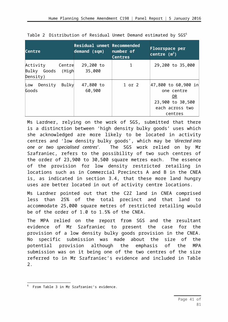
Hume Planning Scheme Amendment C198 | Panel Report | 5 January 2016
a) Restricted retail is encouraged within Commercial Precinct A as shown in Plan 3 under the provisions set out in table 2.4 of UGZ8 up to a maximum floorspace not significantly exceeding 25,000 square metres
b) The intent of the provision for limited restricted retail floor space is to take advantage of the exposure to the Hume freeway and not to develop a regional scale or large scale restricted retail centre
c) Higher amenity based office and manufacturing activity is encouraged within Commercial Precinct B as shown in Plan 3 to complement the environmental sensitivity of the Merri Creek environs and any future adjacent residential areas.
4. Amend the Precinct Structure Plan as follows:a) Requirement R9 be amended to read - Subdivision and Development of lots
facing Merri Creek Conservation Area 34 must provide for the outcomes illustrated in Figure 2.
b) Figure 2 be amended to show a 3 metre landscape buffer within private lots and insert a note stating - Where practical, landscaping within any private lot should provide canopy trees and shrubs to help minimise the visual impact of industrial buildings from the Conservation Area 34 and residential interface.
c) Requirement R15 be amended to read - Any fencing abutting a local park, whether encumbered or unencumbered, must be visually-permeable to facilitate public safety and surveillance.
Page 43 of 81
Hume Planning Scheme Amendment C198 | Panel Report | 5 January 2016
4 Other unresolved issuesAs a result of a Direction from the Panel, the MPA sought to resolve all outstanding issues between the Directions Hearing and the Hearing. The MPA requested a proposed outcome from the submitter and subsequently provided a comment and a suggested resolution of the issue raised. The Panel was forwarded a list of unresolved issues with an updated list being provided on Day 1 of the Hearing.
Issues related to the provision of land for Commercial purposes and zoned C2Z have been discussed in Chapter 3 of this report. As part of its part B submission, the MPA listed the unresolved issues under 19 headings. For ease of presentation in this report, these have been grouped under seven headings as follows:
Report Heading MPA Item MPA Issue Descriptor
Amendment process issues 1 Adequacy of background reports
2 Adequacy of consultation
3 Amendment is premature
Land development issues 4 Development opportunity
5 Alternative land use options
Conservation and open space areas
6 Native vegetation
7 Parkland drainage and wetlands
8 Management of water flows
9 Extent and management of conservation area
Infrastructure implementation 10 Infrastructure implementation
Industrial land use, zoning and acquisition
12 Zoning
14 Oversupply of industrial land
15 Depreciation of assets
16 Oversupply of jobs
17 Land acquisition
Draft schedules 1 UGZ8
2 ESO2 and 10
Public land equalisation method
MPA items 11 and 13 have been addressed in Chapter 3.
UGZ8 issues are only addressed here where they do not relate to the proposed use of the C2Z.
Page 44 of 81
Hume Planning Scheme Amendment C198 | Panel Report | 5 January 2016
4.1 Amendment Process Issues
(i) The issues
The issues addressed in this section of the report are whether adequate background work has been undertaken, the adequacy of consultation and whether proceeding with the Amendment at this stage is premature.
(ii) Submissions
Mr Di Martino submitted that the Restricted Retail Study Craigieburn North prepared by SGS is flawed, in that it has not taken into account age demographics in its projections for likely demand for restricted retailing land. He was also critical of the Valuation Report in that it has not taken into account improvements to land that are likely to be acquired. He is critical of the MPA, which responded that no dwellings are impacted by the land to be acquired for roadworks. Mr Di Martino tabled a schematic proposal for an intersection which clearly shows a dwelling is impacted. Mr Di Martino expressed concerns that the valuation has not taken into account the highest and best use of the land, which he considers to be residential use. The Panel understands that the basis of this aspect of Mr Di Martino’s submission is that there is a potential over supply of industrial land in the north growth corridor and that as a result residential use is more appropriate. This aspect of the issue is addressed in section 4.5.
Ms Lardner submitted that the MPA is satisfied that the consultant, SGS, has used best practice methodology in preparing the Restricted Retail Study Craigieburn North, and that it is a high level study. With respect to the Valuation Report, Ms Lardner further submitted that the Valuation Report was undertaken in line with the MPA’s brief, that is, for the valuations to be based on the zones proposed and not other possible zonings. In her written submission Ms Lardner gives a brief explanation of the implementation of the Public Land Equalisation Method (PLEM) and in what circumstances site specific valuations will be utilised.
Mr Di Martino submitted that more background work is needed to determine the extent of industrial land demanded in the northern growth corridor. He also indicated that a report should be prepared that addresses the perspectives of the land owners and the ‘human economic cost’ involved. In response, Ms Lardner submitted that the MPA is satisfied that adequate background work was undertaken to support the proposed PSP. She further submitted that the Growth Corridor Plans were supported by a range of independent studies. The Panel understands that this included likely long term demand for industrial land which was based on the work of three independent consultants. Because of Mr Di Martino’s concerns, the Panel asked the MPA whether there were any plans to review the Growth Corridor Plans. The MPA responded that they were only completed three years ago and therefore maintain their currency and that there are no plans at this stage for a review.
Mr Di Martino further submitted that there had been inadequate consultation with affected landowners. Ms Lardner responded by providing the details of three direct meetings with landowners and indicated that they had been invited to comment on documents including the draft PSP. She added that the MPA accepts that some landowners do not support the proposed zoning.
Page 45 of 81

Hume Planning Scheme Amendment C198 | Panel Report | 5 January 2016
In her written submission, Ms Macmillan submitted that the Amendment should not proceed at this stage; until the Metropolitan Open Space Strategy (MOSS) is completed; until the standard approach to Aboriginal Cultural Heritage in accordance with the precinct structure planning guidelines is completed; and until best practice guidelines for urban stormwater are completed. Friends of Merri Creek submitted that the Amendment should be delayed until the Growling Grass Frog Masterplan is completed. In response to each of these submissions Ms Lardner submitted that the MPA rejected any proposal to delay the Amendment until the work in progress listed above is completed. She pointed out that similar submissions were made to the Panel considering Amendment C183 to the Whittlesea Planning Scheme and that Panel had rejected them. She further submitted that the Amendment had been prepared on the basis of the policies and guidelines in place at the time.
In appearing at the Hearing, Ms Macmillan acknowledged that the MOSS was not completed in time for the Hearing and that future development would need to adhere to any changes to stormwater guidelines.
Mr Gaedke provided an update on the significant progress that had been made in the preparation of a Cultural Heritage Management Plan (CHMP) for the area around the proposed Merri Creek crossing.
(iii) Discussion
At the Hearing, the Panel acknowledged the significant amount of effort that Mr Di Martino had put into preparing his submission and that acknowledgment is repeated here. Having said that, the Panel has been presented with no evidence that adequate background work has not been undertaken to support the proposed PSP. The Panel acknowledges the point that Mr Di Martino has made about there being no demographic breakdown in the forecasts for likely demand for restricted retailing floor space. Such a breakdown would be expected if this was a proposal for a rezoning to facilitate the development of a particular retail development, but it is not.
The Panel is not aware of any fault with the methodology used by SGS and accepts the MPA’s contention that this is a high level analysis. The Panel further observes that the forecasts are based on a period of some thirty years plus and that this constitutes a full generation of demographic change and on this basis a demographic breakdown as requested by Mr Di Martino is very unlikely to add any greater clarity to the need for restricted retailing floor space. For example, demand for homemaker goods floor space is highest early in a household’s life cycle. However as residential build out in the catchment is likely to proceed over two or three decades there will always be a proportion of households in this early stage. Forecasting this will add little to an understanding of likely demand at the level of detail required here.
The Panel does not accept that there is a need to value properties for alternative possible zonings on the basis that Mr Di Martino does not accept the proposed zoning. As concluded above, the proposed zonings are broadly consistent with policy. The Panel further notes the MPA’s explanation of where site specific valuations will be undertaken under the proposed PLEM. With respect to valuation of improvements on land to be acquired for public purposes, the Panel notes the comment by Ms Lardner that no land is to be acquired for
Page 46 of 81
Hume Planning Scheme Amendment C198 | Panel Report | 5 January 2016
roadworks. Whilst this may not be strictly true in that the dwelling identified by Mr Di Martino appears to be impacted by an intersection, it is not helpful to lay submitters to be relying on information from background reports prepared for DCP costings that depict impacts for which works may only occur as a result of future land development processes.
The Panel asked the MPA about any plans to review the Growth Corridor Plans because of the concerns raised by Mr Di Martino, both under this heading and others. The Panel understands and accepts the response from the MPA that the Growth Corridor Plans are only three years old and are still current despite some of the background work being slightly older than that. The Panel observes that it is not its role to review forecasts that underpin the Growth Corridor Plans nor does it believe that there is any evidence that they need review at this very early stage.
Mr Di Martino submitted that there should be a further economic assessment undertaken from the landholder’s perspective and that no account has been taken of ‘human economic cost’. The Panel notes that the responsibility of the MPA is to prepare PSPs which plan for land use outcomes across the whole of a growth corridor and indeed the whole of Melbourne. It is understood that this will result in outcomes which will not necessarily align with what some landholders perceive to be in their best interests or their best financial interests. The best financial interests of individual landholders is not a factor that the MPA, or indeed this Panel can or should take into account. The Panel therefore rejects the need for a further study from the landholders’ perspective.
The Panel is not entirely clear about Mr Di Martino’s reference to ‘human economic cost’. The Panel acknowledges that the processes of urban development are often lengthy and proceed over a number of years. It is accepted that this can create uncertainty for land owners. This is not ideal, particularly from their perspective, but planning processes are geared to ensuring appropriate outcomes for the broader community and the detailed and complex work involved is necessarily time consuming.
With respect to consultation, the Panel accepts that there have been a number of opportunities for land owners to provide input into this stage of the planning process and no evidence has been provided to the Panel that the opportunities which the MPA say were provided to land owners to have input, did not occur. The Panel has no evidence before it that appropriate consultation has not occurred. The Panel notes the MPA’s acknowledgment that the proposed zonings do not accord with what some of the land owners want. The MPA not agreeing with what land owners would like to see happen to their land, cannot be equated with a failure to consult.
With respect to potentially delaying the progress of the Amendment until certain policy and other policy related work is completed, the Panel agrees with the MPA and notes the significant progress which appears to have been made in the preparation of a CHMP. The Panel notes that there is policy related work being undertaken at any point in time and that it is a Panel’s responsibility to consider relevant policy current at the time. Processes should not normally be delayed because a particular policy is under review.
(iv) Conclusions
In summary the Panel concludes as follows:
Page 47 of 81

Hume Planning Scheme Amendment C198 | Panel Report | 5 January 2016
That no evidence has been presented that the background work undertaken for the preparation of the PSP was inadequate
That no evidence has been presented to the Panel to convince it that inappropriate methodologies have been used in the preparation of the restricted retailing report or the valuation report
That no satisfactory case has been made that further economic analysis is needed before the Amendment proceeds
That the issues of uncertainty for landholders is understood but that the MPA is undertaking processes in a time frame which is appropriate to the complexity of the task they are undertaking
That no evidence has been presented which could lead the Panel to conclude that consultation processes have not been adequate
That no satisfactory case has been made for not proceeding with the proposed Amendment at this stage.
4.2 Land development
(i) The issues
The issues that are addressed in this section of the report are whether development opportunities for various land owners are being appropriately considered and facilitated and whether alternative land uses for the CNEA have been appropriately considered.
(ii) Submissions
Mr and Ms Scarpino submitted that the designation of their property as part of the GGF conservation area has impacted its development potential. They submitted that they are being stopped from making improvements to their land to allow them to develop viable commercial rural type activities which they submit could generate up to 30 jobs. Ms Lardner acknowledged that the Scarpino’s property lies entirely within the GGF Conservation Area. She submitted that commercial activity is not considered compatible with the requirements in the BCS for conservation areas within Melbourne’s growth corridors.
Ms Lardner submitted that land owners such as Mr and Ms Scarpino are no worse off under the zoning proposed as part of this Amendment, than they are currently.
A number of submitters have suggested alternative land uses for the CNEA which they submit were not properly considered. Mr Di Martino submitted that he disagreed with the MPA’s contention that the subject site has been planned as industrial land for a long time. He referred to correspondence from a consultant which said in 2001 that at that time the onus was on land owners to make a case for rezoning.
In his written submission, Mr Di Martino presented five options presenting a range of uses but with an emphasis on residential. Some of the alternative land uses proposed could be accommodated within the proposed C2Z.
Page 48 of 81
Hume Planning Scheme Amendment C198 | Panel Report | 5 January 2016
Ms Lardner submitted that:
The Craigieburn North Employment Area was identified in the Growth Corridor Plans: Managing Melbourne’s growth, approved by the Minister for Planning in 2012, for employment purposes.
(iii) Discussion
The Panel acknowledges that the conservation areas are set down under the BCS and that the MPA has limited ability to amend the boundaries of conservation areas should they wish to. The Panel understands that regardless, the land is at least partially encumbered by the LSIO. The Panel notes the unusual situation in which Mr and Ms Scarpino find themselves, that is, unable to use their land for a range of purposes but with conservation obligations under the BCS. As no part of their land is able to be developed for urban purposes there is little opportunity for new development that could be approved via permits. Hence, no permit triggers are available to activate conservation management requirements under the RCZ or IPO. Their land is to be managed in perpetuity for conservation purposes, no public authority has expressed an interest in acquiring the land and there is no mechanism to provide incentives to manage the land for the conservation purpose for which it is designated. This issue is further addressed at a more general level in section 4.3.
The Panel notes the position of the MPA that landholders such as Mr and Ms Scarpino are no worse off under the proposed zoning than they are currently.
With respect to the alternative land uses suggested by Mr Di Martino, the Panel is of the view that it is not appropriate to consider these, as apart from those which could be accommodated within the proposed C2Z, they are not consistent with the approved NGCP. It is not the Panel’s role to review or indeed consider land uses which are not consistent with approved policy. The Panel cannot attach weight to a speculative proposal in 2001 to rezone the land which was apparently designated as ‘Future Urban Growth’ on a Council structure plan. What is proposed by the MPA as part of this Amendment is consistent with that designation.
(iv) Conclusions
In summary the Panel concludes: That the position of lots entirely within the conservation areas is an issue that
needs to be addressed by government as there is no incentive for the conservation objectives relevant to such land to be met
That alternative uses for land within the CNEA not consistent with the Growth Corridor Plans cannot be considered by the Panel.
4.3 Conservation and open space areas
(i) The issues
The issues that are addressed in this section of the report are whether the conservation and open space areas are appropriate, particularly in terms of any changes to the extent of the conservation area and whether native vegetation management and habitat compensation requirements are appropriate.
Page 49 of 81

Hume Planning Scheme Amendment C198 | Panel Report | 5 January 2016
(ii) Submissions
The PSP identifies the extent of Conservation Area 34 along Merri Creek for the protection of the GGF. In the CNEA, the BCS, Sub-regional Species Strategy for the GGF and habitat compensation arrangements for removal of native vegetation require:
Land along and adjacent to Merri and Kalkallo Creeks to be zoned for the use and development of a conservation area to protect and establish habitat suitable for the threatened GGF
Surveys, salvage and translocation of animals discovered during development Compensation for destruction of habitat to be provided by those developing
land for urban purposes.
The boundary of the conservation area shown in the BCS was amended with the approval of the DELWP so as to be more conducive to orderly urban development without any net change in the overall area of land to be used and developed for conservation. The amended boundary is that shown in the exhibited PSP.
Conservation area
Under the Amendment, the land included in Conservation Area 34 is proposed to be zoned RCZ and the IPO2 applied over the same area. Unlike the English Street precinct where parcels of land were only partly affected by the conservation area, in the CNEA, there are some properties that will be wholly included within the conservation area and affected by the proposed RCZ and IPO2.
The submission from Mr Andrew Johnson from Hume City Council succinctly summarised concerns over equity and the effects of the conservation area and the controls proposed to support its purpose. He submitted that, although the conservation area is justified under the MSA, BCS and GGF Sub-regional Species Strategy, the policy approach to its implementation fails to address issues related to the effects and outcomes on properties that are entirely encumbered. Mr Johnson considered the failures would be reflected through:
Undermining of the State Government’s compliance with the MSA and the BCS
Prevention of the regional open space and metropolitan trail network outcomes identified in Growth Corridor Plan.
The area of land in the CNEA affected is approximately 61 hectares for Conservation Area 34 and a total area of approximately 23 hectares for open space that comprises Laffan Reserve, local parks and waterways, wetlands and retarding basins. Through the Amendment, land that is currently zoned UGZ will become RCZ to protect and create habitat for the nationally threatened GGF.
The UGZ Schedule 8 and the IPO Schedule 2 require that when a permit is granted for development on land identified for conservation in the PSP, landowners enter into a land management co-operative agreement under Section 69 of the Conservation, Forests and Land Act, 1987. The Section 69 agreement will essentially require the landowner to manage the land identified for conservation in accordance with the BCS. Alternatively the landowner can transfer their land to State Government (at no cost and subject to the State Government’s agreement).
Page 50 of 81

Hume Planning Scheme Amendment C198 | Panel Report | 5 January 2016
Mr Johnson submitted the application of both the RCZ and IPO2 would impose limited development potential on the affected properties.
Conservation areas for the GGF are to be protected and managed for conservation in perpetuity. The BCS identifies the achievement of this aim via:
Statutory planning provisions (i.e. including state and local policies, appropriate planning zones, overlays and/or other provisions to restrict urban development)
Acquiring land (e.g. Transfer of land to the Crown) On-title management agreements.
Mr Johnson stated that whilst acquisition of land is listed, there are no proposals for GGF land to be acquired. Accordingly, Mr Johnson considered that, although the intent of the statutory controls appears sound, it is the associated management of conservation areas such as weed control, restoration works and habitat creation etc., that would be lacking and hence the outcomes sought under the Conservation Area 34 designation would not be achieved.
Mr Johnson submitted this is because the affected land is not brought under the control of an appropriate land manager who would be in a position to actively and appropriately protect and manage the land nor are the processes of protection and management required until triggered by a permit for development which may be difficult to pursue given the high limitations for development opportunities afforded by the combination of the RCZ and IPO2. Accordingly, Hume Council considers this creates a perverse outcome given the intent for GGF protection.
Similarly with regards to public open space provision and waterway management, little incentive is present for landowners to provide access to land for the purposes of providing regional public open space and its development.
Mr Johnson submitted that the implementation approach being pursued by State Government assumes that wholly encumbered landowners will willingly manage the land to provide GGF habitat or transfer their land to the Crown to help the State fulfil its BCS obligations. However, there is no incentive for landowners to do either, except to continue with current land use practices.
He submitted that the response from the MPA and DELWP has been that no solution to management and ownership of the GGF land needs to be made now and can be dealt with in the future. Mr Johnson opined that this is perhaps true to comply with the BCS, but it does little to provide the landowners whose properties are entirely encumbered with comfort or a basis on which to plan their futures. It also hinders the realisation of the regional open space outcomes in the Growth Corridor Plans because land is being kept in private ownership with no public access.
Hume Council considers that consideration should be given to the application of a Public Acquisition Overlay (PAO) on those properties encumbered for conservation and regional open space. They consider this would appropriately bring the affected lands into public ownership to achieve appropriate land management, habitat enhancement and habitat creation to occur as required by the MSA/BCS.
Page 51 of 81
Hume Planning Scheme Amendment C198 | Panel Report | 5 January 2016
In contrast, the MPA submitted the area required for the GGF conservation as required by the BCS has been implemented via the provisions of the PSP, RCZ and IPO2 under the Amendment.
Ms Lardner submitted it is not within MPA's jurisdiction to address the acquisition of land included within the conservation area. This is a matter within the jurisdiction of the Commonwealth government. The Amendment provides the statutory planning mechanism to protect land within the designated conservation area and provides a planning framework for both public and private delivery of conservation outcomes consistent with the current scheme for vegetation offsets in Victoria. Any necessary acquisition of land for conservation areas will be considered in the context of the overall delivery of conservation outcomes in the growth areas.
Native vegetation habitat compensation
Native vegetation has been identified and ‘time-stamped’ to establish a dataset showing the type, extent and condition of all native vegetation in the growth corridors. This information has been used, along with information on threatened species habitat from the conservation strategies, to calculate habitat compensation obligations and native vegetation offsets for urban development. For landowners undertaking urban development within Melbourne’s growth corridors, the habitat compensation scheme provides the method for obtaining offsets for the removal of native vegetation and loss of habitat for threatened species protected under the EPBC Act.
The introduction of a flat fee for native vegetation removal and loss of habitat for threatened species affected by urban development in Melbourne’s growth corridors provides a streamlined, predictable and stable offset framework for landowners where they can meet their offset obligations with an in-lieu payment without requiring an assessment or physical form of offset. These arrangements are a conditional requirement of the Commonwealth’s approval of 5 September 2013.
Mr Edgley submitted the Amendment identifies areas of public open space that includes native vegetation which although they will be protected by such designation, will nevertheless remain as vegetation that can be removed meaning that the habitat compensation obligations are triggered. He submitted that Council objects to this and that the relevant habitat compensation obligations need to be removed or reduced and land security obligations added to the Habitat Compensation Statements for the respective land by DELWP.
In response, Ms Lardner submitted that whilst sympathetic to the issue that is being raised, the MPA is not in a position to facilitate a change to the Habitat Compensation scheme. The scheme is managed by DELWP and approval is required from them to exempt native vegetation and habitat proposed to be retained outside conservation areas from habitat compensation fees. Ms Lardner did relate the understanding of the MPA that the areas of native vegetation in question do not meet the criteria specified in DELWP’s guidelines but that DELWP are currently considering how to manage this situation.
Page 52 of 81
Hume Planning Scheme Amendment C198 | Panel Report | 5 January 2016
Appropriateness of open space
In relation to open space, the submission from Mr Messo and Mr Bayrak expressed concern over the extent of land taken for open space and constructed waterway on land in the southern limit of the CNEA. The MPA submission acknowledges approximately one third of the area will be unavailable for development. The site possesses a number of attributes which recommended it for designation as open space. These attributes include the fact that it is located adjacent to a Melbourne Water asset, functions as a buffer to the adjacent Conservation Area 27 and assists in distributing open space across the precinct. This location also has a good coverage of native vegetation that can be retained. The Melbourne Water easements will ultimately be acquired by Melbourne Water so landowners will be compensated for the acquisition of land associated with the Drainage Services Scheme.
(iii) Discussion
The Panel notes that the RCZ already applies to parts of the Merri Creek and that Amendment C198 seeks to extend the application of the zone over the whole of the area identified as Conservation Area 34 within the CNEA. The extension of the RCZ is, in part, linked with the response from the MPA, that those properties affected by the conservation area and the proposed controls under the Amendment were already encumbered by controls that placed some restrictions on opportunities for use and development of these lands. Examples included the FO and LSIO as well as the UGZ where Part A of the zone would apply in circumstances where there is no incorporated PSP and any development would be limited so as to not prejudice any PSP or future urban growth outcomes.
With respect to the position of Hume Council on the difficulty in achieving the outcomes of the conservation area and the need to consider tools such as the PAO to trigger affected land within the designated conservation area being brought into public ownership, the Panel sympathises with their concerns. However, the Amendment is focused on statutory changes to the Hume Planning Scheme.
The primary aims of the combination of the PSP, RCZ, UGZ8 and IPO2 under the Amendment are to put in place an overall framework for strategic direction for Conservation Area 34 under the BCS that ensures protection supported by an appropriate suite of statutory planning controls. Planning controls by their nature activate when development is proposed and hence is a reactive system that is not retrospective in its application. The Panel agrees with the MPA when it submits that the matter of whom the best land owner or manager is to ensure the conservation area is managed to achieve its aims is one that is yet to be determined by government. Accordingly, it is beyond the scope of the Panel to consider how the conservation area might be managed or who might own or manage the land. The Panel considers this is something Council may need to keep lobbying government on in order to progress the long term management of the conservation area.
It is, however within the scope for the Panel to consider whether the suite of planning controls is appropriate to be applied to protect the conservation area. In this regard, the Panel, in line with the findings of the Panel for Amendment C183 to the Whittlesea Planning Scheme for the English Street PSP precinct, considers the PSP and use of zones and overlays
Page 53 of 81

Hume Planning Scheme Amendment C198 | Panel Report | 5 January 2016
such as the RCZ, UGZ and IPO appropriate planning tools to apply for the protection of the Conservation area for GGF habitat.
Currently, the land within the conservation area has limited opportunity for further intensive use and development. The effect of this Amendment will be similar if not more focused because of the link between what the proposed controls (RCZ, UGZ8 and IPO2) do and the purposes of Conservation Area 34 and the protection of habitat for the threatened GGF.
Application of the PAO is considered premature and unnecessary given what the Amendment seeks to do at this point in time.
Regarding Council’s concerns over native vegetation retained in open space areas and habitat compensation obligations, the Panel notes that MPAs sympathy over the situation and considers efforts should continue to avoid perverse outcomes and costs being incurred when vegetation loss is avoided as part of the PSP planning.
The provision of constructed waterways and open space is considered appropriate as it provides for the distribution of open space across the precinct whilst also providing a buffer for adjacent conservation areas which include retention of native vegetation.
(iv) Conclusions
In summary the Panel concludes: That the provision of Conservation Area 34 is appropriate and satisfactory The proposal under Amendment C198 to incorporate the PSP, extend the RCZ
and apply the UGZ8 and IPO2 is appropriate for the protection of Conservation Area 34 and will implement the CNEA PSP
The provision of open space is appropriate and will provide amenity value for the precinct
The transfer of land to public ownership is not within the scope of consideration of the Panel, however, Hume City Council should continue to lobby governments to ensure appropriate achievement of conservation and open space outcomes sought by the vision of the PSP.
4.4 Infrastructure implementation
(i) The issues
The issue addressed by the Panel in this section of the report is that there is an urgent need to provide some of the proposed road infrastructure immediately because of safety issues.
(ii) Submissions
Mr Di Martino submitted that:
The main thoroughfares of Brookeville Drive and Amaroo Road need to be constructed as of now. These roads are now unsafe.
Ms Lardner submitted that the MPA expresses no view as to the accuracy of Mr Di Martino’s claim and notes that he should raise his concerns with the relevant road authority.
Page 54 of 81

Hume Planning Scheme Amendment C198 | Panel Report | 5 January 2016
(iii) Discussion
At the request of Mr Di Martino, the Panel inspected both Brookeville Drive and Amaroo Road as part of its site inspection of the area and drove the full length of each road within the CNEA. The Panel has no specific road or traffic engineering expertise but did note long straight stretches of rural standard road with some evidence of what is colloquially known as ‘hoon behaviour’. The triggers for road construction in Section 2 of the DCP indicate that road construction will be at the time of subdivision. This could be some time away. There is no basis for using DCP funding to bring such work forward and no DCP funds for it until subdivision occurs. The Panel agrees with the MPA that Mr Di Martino should raise this issue with the relevant road authority, which the Panel assumes is Council.
(iv) Conclusions
In summary the Panel concludes that: There is no basis on which to address the road and traffic issues raised by the
submitter using DCP funds.
4.5 Industrial land use, land acquisition and zoning
(i) The issues
The issues that are addressed in this section of the report are whether there is an oversupply of industrial land and whether the use of the IN1Z is appropriate for the southern part of the CNEA. The issue of land acquisition has been previously mentioned and addressed earlier in the report, however the means of any land acquisition is considered in terms of whether the PAO is an appropriate tool that should be considered.
(ii) Submissions
Mr Di Martino submitted that that there is a significant oversupply of industrial land in the corridor and as such there is no basis for applying the IN1Z proposed for the majority of the CNEA. In his written submission he provided an analysis of what he considered to be the relevant data, to back this up. At the Hearing he expanded on and explained his analysis. The essence of his argument for there being an oversupply of industrial land is based on the following:
The annual consumption of industrial land in the North State Significant Industrial Precinct (SSIP) between 2005-06 and 2013-14 was 32.11 hectares per year. This is based on DTPLI data presented by Mr Di Martino. He assumes that one third North SSIP is in Hume, therefore the annual consumption of industrial zoned land in Hume is of the order of 10 hectares per year. Data provided by him from the Urban Development Program (UDP) report shows current supply of industrial zoned land in Hume is 1115 hectares with, he submits, a further 650 hectares which the Council and the MPA wish to rezone. This results in 1765 hectares of potentially available industrial land. At a consumption rate of 10 hectares per year this equates to 176.5 years of supply. On this basis he contends that there is no evidence of demand for industrial land in the CNEA.
Page 55 of 81
Hume Planning Scheme Amendment C198 | Panel Report | 5 January 2016
The low and declining demand for industrial land in the North SSIP is evidenced by the UDP data, which he submitted showed demand in North SSIP declining while demand in SSIPs in other growth corridors is growing.
Mr Mustica submitted that there is already a glut of commercial properties in the area as evidenced by the significant number of ‘for sale’ or ‘for lease’ signs that can be observed in industrial and commercial areas.
In response, Ms Lardner submitted that estimated employment in manufacturing, logistics and related businesses located on industrial land will account for 40%-45% of total future employment in the growth areas. She submitted that the CNEA was planned to facilitate some 8,200 new jobs in the north growth area.
As mentioned earlier, Hume Council referred to the desirability of considering the use of the PAO to support land acquisition in order to better achieve the outcomes regarding land management for the conservation area.
(iii) Discussion
The Panel does not present a detailed commentary on Mr Di Martino’s analysis but makes the following observations about it:
It appears that considerably more than one third of the north SSIP is located in Hume and this has resulted in a significant overestimate of future industrial land supply by Mr Di Martino
The last few years have seen low levels of demand for industrial land, evidenced by the data presented by Mr Di Martino which shows a downturn in consumption around the time of the global financial crisis. For this reason Mr Di Martino is likely to have further significantly underestimated long term demand
The Panel can see no evidence in the UDP industrial land consumption graphs presented by Mr Di Martino, of any long term shift in demand to other growth corridors. There are inevitably short term movements between the corridors.
In response to the submission by Mr Mustica, the Panel observes that the nature of the demand for and supply of industrial premises is such that there will always be significant vacancies at any point in time. Estimates of a ‘normal’ rate of vacancy vary but are likely to be in the range of 10% plus. The Panel further observes that this Amendment is addressing long term provision and that observations about the current market situation are of limited relevance to this.
The Panel further observes that the provision for future industrial land is based on work undertaken for the Growth Corridor Plans. As has been said previously it is not the Panel’s role to review that work. However the Panel does note that no submitter has presented any evidence to suggest that work undertaken for the Growth Corridor Plans is fundamentally flawed.
The Panel does acknowledge that forecasting such demand, particularly in the long term, is an inexact science. It does accept that there are a wide range of factors which influence demand which are difficult to forecast, including technological change and trade patterns. If Mr Di Martino is in fact partially correct in his claims of there being a long term potential
Page 56 of 81

Hume Planning Scheme Amendment C198 | Panel Report | 5 January 2016
oversupply, the time to address this is as part of a review in the longer term. It would not be prudent to risk under supply at this early stage.
In terms of zoning, the Panel considers the selection of the IN1Z as an applied zone under the UGZ8 is satisfactory. The CNEA PSP implements the broad strategic direction of the NGCP for industrial use and for the precinct to provide employment activity. The designation of the central and southern parts of the CNEA precinct for industry is considered appropriate in achieving this purpose.
As the Panel has mentioned earlier, the combination of using the C2Z and IN1Z as applied zones under the UGZ8 is will provide a mix of choice in how the precinct will provide for employment lands for the benefit of the local and broader regional population and support the state significant industrial land designation of the precinct area under Plan Melbourne.
(iv) Conclusions
In summary the Panel concludes: No convincing evidence was put before the Panel that providing employment
based land with applied zones of either C2Z or IN1Z will result in the over-supply of employment land
The use of the IN1Z as an applied zone for parts of the CNEA PSP precinct is appropriate in facilitating employment land for the future
Consideration of the use of the PAO is premature until the direction over land ownership and management have been determined by Government and an appropriate land manager determined for Conservation Area 34 land.
4.6 Draft schedules
(i) The issues
The issues that are addressed in this section of the report are whether the drafting of the Schedules to the RCZ and Clause 52.17 and the changes proposed to the ESO10 and whether deletion of the ESO2 is appropriate.
Post exhibition changes to the UGZ8 have been accepted by the Panel and further changes associated with the applied C2Z have also been considered.
(ii) Submissions
Changes were proposed to the drafting of Schedule 8 to the UGZ by the MPA in response to submissions post exhibition, by Mr Hooper in his planning evidence and by Whittlesea Council. These have been addressed in section 1.7 and 3.8 respectively and are not addressed further here.
The Amendment originally proposed to remove both the ESO2 – Merri Creek and Moonee Ponds Creek and Environs and ESO10 – Rural Conservation Area from the CNEA.
Concerns over these proposed deletions were expressed by Hume Council, the Merri Creek Management Committee and the Friends of Merri Creek group who considered the environmental objectives relating to open space and landscape would be lost.
Page 57 of 81

Hume Planning Scheme Amendment C198 | Panel Report | 5 January 2016
The submission from Ms Lardner was that the ESO2 was created to manage rural development of the land in the context of ongoing farming activities in the absence of a strategic plan.
The Amendment plans for a fully developed urban area with a dedicated conservation area along the Merri Creek that is currently subject to the ESO2. Therefore the development of the creek for conservation outcomes implements the objectives of the ESO2. The specific provisions in the PSP, with which the IPO requires compliance, are the end point of the ESO2 in that they will deliver precisely the type of development the ESO2 always envisioned. In the MPA’s view, the controls in the Amendment are stricter than those in the ESO2 in relation to allowable use and development of land along the creek.
Ms Lardner referred to the considerations of the C183 Panel which recommended that the ESO3 (which was similar to the Hume ESO2) could be deleted but the contents brought out in the text of the PSP and inserted into a Schedule to the RCZ. Ms Lardner advised that the MPA accepts this approach and is comfortable in adopting the same approach with regards to the ESO2. To this end, Appendix 4 to the Part A submission from the MPA included post exhibition changes to amendment documentation which included a proposed Schedule 4 to the RCZ (RCZ4) that incorporated the statement of environmental significance from the ESO2.
Insofar as ESO10 is concerned, the MPA also accepts following the direction from the C183 Panel with respect to similar ESOs found in the Whittlesea Planning Scheme and affected by the English Street PSP. This is reflected in retaining the ESO10 and applying it to the same land covered by the RCZ that is, the conservation area. One change that is proposed to be made to ESO10, being the removal of the exemption for the removal of non-native vegetation as described in the tracked changed version of ESO Schedule 10.
Mr Edgley submitted whilst Council supports the proposal to increase references in the RCZ Schedule and the PSP to refer to regional open space outcomes, Council does not consider the RCZ as drafted adequately describes the importance of the regional open space outcomes in this precinct and on the land to which the Schedule applies. He suggested the Schedule to the RCZ should be further edited and the proposed retained ESO10 re-drafted to include greater reference to regional open space outcomes in addition to conservation outcomes and to give greater recognition of public ownership.
(iii) Discussion
The Panel is satisfied with the MPA’s decision to retain the ESO10 and that Amendment C198 be amended to remove reference to its deletion from the CNEA. The MPA have suggested changes to incorporate aspects of the ESO2 into the Amendment documentation. The statement of environmental significance is proposed to be included in the conservation values of Schedule 4 to the RCZ. The Panel is satisfied this is an appropriate transition. Additional text suggested by Hume Council is not considered necessary. The Panel is satisfied that the intent of the statement of environmental significance from the ESO2 has been appropriately translated into the RCZ4. The RCZ4 applies only to the conservation area land within the CNEA and is considered fit for purpose. The objectives of the ESO2 relating
Page 58 of 81
Hume Planning Scheme Amendment C198 | Panel Report | 5 January 2016
to natural systems, waterway function, recreation use, landscape character and heritage are proposed to be incorporated into modified objectives of the PSP.
The Panel notes that the Whittlesea C183 Panel also supported the above approach, which reinforces the view that this supports the role of Merri Creek for GGF habitat conservation, floodplain management and for passive open space.
With respect to the proposed post exhibition changes to the Schedule to Clause 52.17 regarding permit exemptions for the removal of native vegetation, the Panel considers taking a similar approach to that of the Whittlesea C183 Panel is appropriate. The Panel considers two changes are required to improve the function of the Schedule:
Removal of reference to IPO2 under the Area description. Addition of the words “any other native vegetation” to the second paragraph
to clearly distinguish between that identified in Plan 6 of the PSP from what may occur within the UGZ8 area that is not identified in Plan 6.
(iv) Conclusions
In summary the Panel concludes: That the retention of the ESO10 is appropriate That removal of the ESO2 is satisfactory subject to its contents being
appropriately converted into other aspects of the Amendment documentation as proposed. It is appropriate to include the ESO2 statement of environmental significance into the conservation values of Schedule 4 to the RCZ
ESO2 objectives relating to natural systems, waterway function, recreation use, landscape character and heritage should be directly translated into objectives in relevant parts of the PSP itself
The Schedule to the Clause 52.17 relating to native vegetation permit exemptions be amended to reflect the UGZ8 area and any other native vegetation not shown on Plan 6 in the PSP.
4.7 Implementation of the Public Land Equalisation Method
(i) The issue
There were some anomalies between the text and Table 8 in the DCP which explains the implementation of the Public Land Equalisation Method (PLEM) together with presentation errors in Table 7 which lead the Panel to examine the proposed implementation of the PLEM. This is one of the first times this methodology has been used and unusually there was no major developer carefully scrutinising the DCP.
(ii) Discussion and Conclusion
Not unexpectedly the Panel has no issues with the calculations of the amount of land required for public purposes from each property which are ‘under’ and ‘over’ the average amount of net developable land required from each property. The amount of land ‘under’ and ‘over’ the average required will be valued differently. However the calculation of this is not transparent in Table 8 in the DCP. An understanding of the implementation would be
Page 59 of 81

Hume Planning Scheme Amendment C198 | Panel Report | 5 January 2016
improved significantly if one of the duplicated columns headed ‘DCP Area Required (HA)’ was replaced with a column headed ‘Net Developable Area Required (HA)’. This piece of information is critical to an understanding of the implementation approach, but without it the implementation methodology is quite opaque. The suggested information is in the underlying spreadsheets provided at the Panel’s request so it is easy to add to the table.
The reference to 4.2% in the last line of the second paragraph in section 3.2.3 of the DCP is also incorrect and should be replaced by 4.4% to be consistent with Table 8.
In addition Table 7 in the exhibited DCP has data in the ‘Intersection Projects’ category which is in incorrect columns and should be corrected before approval.
4.8 RecommendationsThe Panel recommends that the MPA:
5. Adopt Schedule 4 to the Rural Conservation Zone as drafted in the Metropolitan Planning Authority’s Part A submission.
6. Retain Environmental Significance Overlay Schedule 10 and delete Environmental Significance Overlay Schedule 2 , subject to its contents being applied to the Amendment documentation as follows:a) Translate the Environmental Significance Overlay Schedule 2 objectives
relating to natural systems, waterway function, recreation use, landscape character and heritage directly into the relevant parts of the Craigieburn North Employment Area Precinct Structure Plan.
7. Amend Sub clause 1.0 – Scheduled Area of the Schedule to Clause 52.17 as‐ follows:a) In the first column relating to Area refer only to Urban Growth Zone
Schedule 8 and delete reference to Incorporated Plan Overlay Schedule 2.b) The second column relating to the description of native vegetation for which
no permit is required to remove, destroy or lop is to read: Shown as native vegetation patches that can be removed or scattered
trees that can be removed on Plan 6 in the incorporated Craigieburn North Employment Area Precinct Structure Plan where the removal, destruction or lopping is carried out in accordance with the ‘Final approval for urban development in three growth corridors under the Melbourne urban growth program strategic assessment, 5 September 2013’ pursuant to section 146B of the Environment Protection and Biodiversity Conservation Act 1999 (EPBC Act).
and Any other native vegetation not shown on Plan 6 in the incorporated
Craigieburn North Employment Precinct Structure Plan.
Page 60 of 81
Hume Planning Scheme Amendment C198 | Panel Report | 5 January 2016
8. Amend the Development Contributions Plan to delete from Table 8 the second of the columns headed ‘DCP area required (HA)’ and replace it with a column headed ‘Net Developable Area Required (HA)’. Further Amend Table 7 of the Development Contributions Plan to place the correct data in columns 3 to 10 of the table in the section headed ‘Intersection Projects’. The reference to 4.2% in the last line of the second paragraph of section 3.2.3 of the Development Contributions Plan should be amended to 4.4%.
Page 61 of 81

Hume Planning Scheme Amendment C198 | Panel Report | 5 January 2016
Appendix A Submitters to the Amendment
No. Submitter
1 Mr Steven Mustica
2 Public Transport Victoria
3 Zaysung Pty Ltd
4a Mr Vincenzo Scarpino and Ms Rita Scarpino
4b Brimbank Real Estate
5 N, A F, Y Messo and G & A Bayrek
6 Ms Kathy Moral
7 Melbourne Water
8 English Street Development Partners
9 Merrifield Corporation
10 Merri Creek Management Committee
11 City of Hume
12 Mr Claudio Di Martino
13 City of Whittlesea
14 Country Fire Authority
15 Environment Protection Authority
16 Mr Angelo and Mr Philip Votsis
17 Mr John Tsoutsoulis
18 Friends of Merri Creek
19 Ms Mary Kiriakou
20 DELWP, Water and Catchments Group
21 VicRoads
23 Department of Economic Development Jobs, Transport and Resources
Page 62 of 81

Hume Planning Scheme Amendment C198 | Panel Report | 5 January 2016
Appendix B Document listNo. Date Description Presented by
1 16/11/15 Update table on unresolved submission issues Ms Lardner, MPA
2 “ Table of unresolved issues “
3 “ Updated changes to UGZ Schedule 8 “
4 “ MPA Part B submission “
5 “ Business 4 Zone Mr Pitt, Merrifield Corporation
6 “ Business 3 Zone “
7 “ Revised instructions for expert witness Mr Szafraniac, SGS Expert witness for MPA
8 “ Extract of Map 3 of Clause 22.09 Whitehorse Planning Scheme – Nunawading MegaMile
Mr Pitt, Merrifield Corporation
9 “ Lockerbie Principal Town Centre UDF Plan & extent “
10 “ Extract of Clause 74 of land use definition for Restricted retail premises
“
11 17/11/15 Document changes matrix with reference to submissions Ms Lardner, MPA
12 “ Merrifield City Centre Co-ordination Plan Mr Pitt, Merrifield Corporation
13 “ Council report dated 24 August 2014 “
14 “ Merrifield Corporation submission “
15 “ Hume City Council submission Mr Edgley, Hume City Council
16 “ Hume City Council submission table of issues “
17 18/11/15 Site inspection itinerary Mr Di Martino
18 “ Hume City Council cross referenced submission Mr Edgley, Hume City Council
19 “ Mr Di Martino submission in 3 parts Mr Di Martino
20 “ Merri Creek Management Committee submission Ms Macmillan
21 “ Whittlesea City Council submission Ms Mahoney, Whittlesea City Council
22 “ Town centres plan of North Growth Corridor Ms Lardner, MPA
Page 63 of 81

Hume Planning Scheme Amendment C198 | Panel Report | 5 January 2016
Appendix C Exhibited Schedule 8 to the UGZ
Page 64 of 81

Hume Planning Scheme Amendment C198 | Panel Report | 5 January 2016
SCHEDULE 8 TO THE URBAN GROWTH ZONE
Shown on the planning scheme map as UGZ8
CRAIGIEBURN NORTH EMPLOYMENT AREA PRECINCT STRUCTURE PLAN
1.0 The Plan
Map 1 shows the future urban structure proposed in the Craigieburn North Employment Area Precinct Structure Plan. It is a reproduction of Plan 3 in the Craigieburn North Employment Area Precinct Structure Plan.
Map 1 to Schedule 8 to Clause 37.07
Page 65 of 81
--/--/20—ProposedC198
--/--/20—ProposedC198

Hume Planning Scheme Amendment C198 | Panel Report | 5 January 2016
2.0 Use and Development
2.1 The land
The use and development provisions specified in this schedule apply to the land within the ‘precinct area’ on Map 1 and shown as UGZ8 on the planning scheme maps.
Note: If land shown in Map 1 is not zoned UGZ and the provisions of this zone do not apply.
2.2 Applied zone provisionsThe provisions of the following zones in this scheme apply to the use and subdivision of land, the construction of a building, and the construction or carrying out of works as set out in Table 1.
Table 1: Applied zone provisions
Connector Street Clause 36.04 – Road Zone – Category 2
2.3 Reference to a planning scheme zone is a reference to an applied zoneA reference to a planning scheme zone in an applied zone must be read as if it were a reference to an applied zone under this schedule.
Note: e.g. The Commercial 2 Zone specifies ‘Shop’ as a Section 1 Use with the condition, ‘The site must adjoin, or have access to, a road in a Road Zone.’ In this instance the condition should be read as, ‘The site must adjoin, or have access to, a road in a Road Zone or an applied Road Zone in the Urban Growth Zone schedule applying to the land’
2.4 Specific provisions - Use and development of land
Table 2: Use
Use Requirement
Restricted Retail Premises where the applied zone is Commercial 2 Zone
Where land is shown as Commercial Precinct B in the Craigieburn North Employment Area PSP:
Restricted retail is a Section 2 use.
Restricted Retail Premises where the applied zone is Commercial 2 Zone
Where land is shown as Commercial Precinct A in the Craigieburn North Employment Area PSP:
A permit is required to use land for a restricted retail premises if the combined leasable floor area of all restricted retail premises exceeds :
35,000 square metres
Page 66 of 81
--/--/20—ProposedC198
--/--/20—ProposedC198
--/--/20—ProposedC198
--/--/20—ProposedC198
Land use/development (carried out or proposed) generally in accordance with the precinct structure plan applying to the land (REFER MAP 1)
Applied zone provisions
Commercial precinct A & B Clause 34.02 – Commercial 2 Zone
Industrial precinct Clause 33.01 – Industrial 1 Zone
Local convenience centre Clause 33.01 – Industrial 1 Zone
Secondary Arterial Road Clause 36.04 – Road Zone – Category 1

Hume Planning Scheme Amendment C198 | Panel Report | 5 January 2016
Shop where the applied zone is Industrial 1 Zone
Where land is shown as Local Convenience Centre in the Craigieburn North Employment Area PSP:
Shop is a Section 2 use.
2.5 Specific provision – Use and development of future public landA permit is not required to use or develop land shown in the Craigieburn North Employment Area Precinct Structure Plan as open space (local parks) provided the use or development is carried out generally in accordance with the Craigieburn North Employment Area Precinct Structure Plan and with the prior written consent of Hume City Council.
3.0 Application requirements
3.1 SubdivisionAny application for subdivision must include:
A land budget table in the same format and methodology as those within the precinct structure plan applying to the land, setting out the amount of land allocated to the proposed uses.
Subdivision and Design Guidelines, prepared to the satisfaction of the responsible authority, which demonstrate how the proposal responds to and achieves the objectives, planning and design requirements, guidelines shown within the Craigieburn North Employment Area Precinct Structure Plan incorporated in this scheme.
A mobility plan that demonstrates how the local street and movement network integrates with adjacent urban development or is capable of integrating with future development on adjacent land parcels.
A Stormwater Management Strategy that addresses the provision, staging and timing of stormwater drainage works, including temporary outfall provisions, to the satisfaction of Melbourne Water and Hume City Council.
3.2 Public Infrastructure PlanAn application must be accompanied by a Public Infrastructure Plan which addresses the following: what land may be affected or required for the provision of infrastructure works; the provision, staging and timing of stormwater drainage works; the provision, staging and timing of road works internal and external to the land consistent with
any relevant traffic report or assessment; the landscaping of any land; what if any infrastructure set out in the Craigieburn North Employment Area Development
Contributions Plan is sought to be provided as "works in lieu" subject to the written consent of Hume City Council;
the provision of public open space and land for any community facilities; any other matter relevant to the provision of public infrastructure required by the responsible
authority3.3 Traffic Impact Assessment
An application that proposes to create or change access to a primary or secondary arterial road must be accompanied by a Traffic Impact Assessment Report (TIAR). The TIAR, including functional layout plans and a feasibility / concept road safety audit, must be to the satisfaction of VicRoads or Hume City Council, as required.
Page 67 of 81
--/--/20--ProposedC198
--/--/20—ProposedC198
--/--/20—Proposed C198
--/--/20--ProposedC198
Hume Planning Scheme Amendment C198 | Panel Report | 5 January 2016
3.4 Development applications on land containing or abutting the Merri Creek its tributaries and environsAn application on land containing or abutting the Merri Creek Corridor, its tributaries and environs must be accompanied by:A plan that shows: Natural features including trees and other significant vegetation, habitat for protected species,
drainage lines, water courses, wetlands, ridgelines, hill tops and features of geomorphic significance; and
Recreation facilities to be provided within public open space; and Storm water facilities that are compliant with the relevant approved drainage strategy; and The retention and removal of vegetation and any re-vegetation;
3.5 Kangaroo Management PlanAny application for subdivision must be accompanied by a Kangaroo Management Plan which includes: strategies to avoid land locking land adjacent to the subdivision that provides habitat to
kangaroos; and management requirements to respond to the containment of kangaroos in an area with no
reasonable likelihood of their continued safe existence; or management and monitoring actions to sustainably manage a population of kangaroos within a
suitable location.Where a Kangaroo Management Plan has been approved in respect to the land to which the application applies, the application must be accompanied by: a copy of the approved Kangaroo Management Plan; and a 'design/management response' statement outlining how the application is consistent with and
gives effect to any requirements of the approved Kangaroo Management Plan.
3.6 Use or development of land for a sensitive purpose – Environmental Site Assessment - 185, 220, 225, 245, 275, 295 Brookville DriveAn application to use or develop land for a sensitive use must be accompanied by an environmental site assessment of the land by a suitably qualified environmental professional to the satisfaction of the responsible authority which provides information including: detailed assessment of the matters outlined as potential contaminants on the land documented
in ‘Precinct Structure Plan Area 25 Growth Areas Authority – Desktop Environmental, Hydrological and Geotechnical Study, 13 September 2012’ by Aurecon.
clear advice on whether the environmental condition of the land is suitable for the proposed use/s and whether an environmental audit of all, or part, of the land is recommended having regard to the ‘Potentially Contaminated Land General Practice Note June 2005, DSE’.
recommended remediation actions for any potentially contaminated land.
4.0 Conditions and requirements for permits4.1 Open Space - Condition
Any permit for subdivision must contain the following condition: Land required for public open space as a local park, as set out in the Craigieburn North
Employment Precinct Structure Plan or Development Contributions Plan, must be transferred to or vested in the responsible authority at no cost to that authority.
Page 68 of 81
--/--/20--ProposedC198
--/--/20--ProposedC198
--/--/20--ProposedC198
--/--/20--ProposedC198

Hume Planning Scheme Amendment C198 | Panel Report | 5 January 2016
4.2 Biodiversity and Threatened Species - ConditionsAny permit for subdivision must contain the following conditions:Kangaroo Management Plan Before the certification of the plan of subdivision, a Kangaroo Management Plan must be
approved by the Secretary to the Department of Environment, Land, Water and Planning. Once approved the plan will be endorsed by the responsible authority and form part of the permit.
The endorsed Kangaroo Management Plan must be implemented to the satisfaction of the responsible authority.
Salvage and Translocation The Salvage and Translocation Protocol for Melbourne’s Growth Corridors (Department of
Environment and Primary Industries, 2014) must be implemented in the carrying out of development to the satisfaction of the Secretary to the Department of Environment, Land, Water and Planning.
Protection of conservation areas and native vegetation during construction A permit granted to subdivide land where construction or works are required to carry out the subdivision, or a permit granted to construct a building or carry out works, where this precinct structure plan shows the land, or abutting land, including a conservation area or a patch of native vegetation or a scattered tree must ensure that: Before the start of construction or carrying out of works in or around a conservation area,
scattered native tree or patch of native vegetation the developer of the land must erect a conservation area/vegetation protection fence that is: highly visible at least 2 metres in height sturdy and strong enough to withstand knocks from construction vehicles in place for the whole period of construction located the following minimum distance from the element to be protected:
ELEMENT MINIMUM DISTANCE FROM ELEMENT
Conservation area 2 metres
Scattered tree twice the distance between the tree trunk and the edge of the tree canopy
Patch of native vegetation 2 metres
Construction stockpiles, fill, machinery, excavation and works or other activities associated with the buildings or works must: be located not less than 15 metres from a waterway; be located outside the vegetation protection fence; be constructed and designed to ensure that the conservation area, scattered tree or patches
of native vegetation are protected from adverse impacts during construction; not be undertaken if it presents a risk to any vegetation within a conservation area; and be carried out under the supervision of a suitable qualified ecologist or arborist.
Land Management Co-operative AgreementA permit to subdivide land shown in the incorporated Craigieburn North Employment Area Precinct Structure Plan as including a conservation area must ensure that, before the issue of a statement of compliance for the last stage of the subdivision, the owner of the land: Enters into an agreement with the Secretary to the Department of Environment, Land, Water
and Planning under section 69 of the Conservation, Forests and Lands Act 1987, which:
Page 69 of 81
--/--/20--ProposedC198
Hume Planning Scheme Amendment C198 | Panel Report | 5 January 2016
Must provide for the conservation and management of that part of the land shown as a conservation area in the Craigieburn North Employment Area Precinct Structure Plan; and
May include any matter that such an agreement may contain under the Conservation, Forests and Lands Act 1987.
Makes application to the Registrar of Titles to register the agreement on the title to the land. Pays the reasonable costs of the Secretary to the Department of Environment, Land, Water and
Planning in the preparation, execution and registration of the agreement.The requirement for a Land Management Co-operative Agreement in this condition does not apply to land or any lot or part of a lot within a conservation area identified in the Precinct Structure Plan that:
is identified in a Precinct Structure Plan as public open space and is vested, or will be vested, in the council as a reserve for the purposes of public open space; or
is identified in a Precinct Structure Plan as a drainage reserve and is vested, or will be vested, in Melbourne Water Corporation or the council as a drainage reserve; or
is within a Conservation Area identified in a Precinct Structure Plan for nature conservation and is vested, or will be vested, in the Secretary to the Department of Environment, Land, Water and Planning for conservation purposes; or
is the subject of an agreement with the Secretary to the Department of Environment, Land, Water and Planning to transfer or gift that land to: the Secretary to the Department of Environment, Land, Water and Planning; the Minister administering the Conservation, Forests and Lands Act, 1987; or another statutory authority.
to the satisfaction of the Secretary to the Department of Environment, Land, Water and Planning.
4.3 Public Transport – ConditionAny permit for subdivision must contain the following condition:Unless otherwise agreed by Public Transport Victoria, prior to the issue of Statement of Compliance for any subdivision stage, bus stop hard stands with direct and safe pedestrian access to a pedestrian path must be consturcted: In accordance with the Public Transport Guidelines for Land Use and Development and be
compliant with the Disability Discrimination Act – Disability Standards for Accessible Public Transport 2002.
At locations approved by Public Transport Victoria, at no cost to Public Transport Victoria, and to the satisfaction of Public Transport Victoria.
4.4 Road Network – ConditionAny permit for subdivision or building and works must contain the following condition:Prior to the certification of a plan of subdivision, the plan of subdivision must show the land affected by the widening of the road reserve which is required to provide road widening and/or right of way flaring for the ultimate design of any adjacent intersection.Land required for road widening including right of way flaring for the ulitamte design of any intersection within an existing or proposed arterial road must be transferred to or vested in council at no cost to the acquiring agency unless funded by the Craigieburn North Employment Area Development Contirbutions Plan.
4.5 Public Infrastructure Plan – Condition
Any permit for subdivision must contain the following condition:Prior to the certification of a plan of subdivision or at such other time which is agreed between Council and the owner, if required by the responsible authority or the owner, the owner must enter into an agreement or agreements under section 173 of the Planning and Environment Act 1987 which provides for: The implementation of the Public Infrastructure Plan approved under this permit.
Page 70 of 81
--/--/20--ProposedC198
--/--/20--ProposedC198
--/--/20--ProposedC198

Hume Planning Scheme Amendment C198 | Panel Report | 5 January 2016
The purchase and/or reimbursement by the responsible authority for any provision of public open space in excess of the amount specified in the schedule to Clause 52.01.
The timing of any payments to be made to the owner having regard to the availability of funds in the open space account.
4.6 Use or development of land for a sensitive use at 185, 220, 225, 245, 275, 295 Brookville DriveAny permit for a sensitive use or development must contain the following condition:Before the plan of subdivision is certified under the Subdivision Act 1988, further testing in accordance with the recommendations of the (Precinct Structure Plan Area 25 Growth Areas Authority – Desktop Environmental, Hydrological and Geotechnical Study, 13 September 2012, by Aurecon) must be carried out to the satisfaction of the responsible authority.Upon completion of the testing the landowner must submit the results and comply with any additional requirements to the satisfaction of the responsible authority, having regard to the guidance set out in the General Practice Note on Potentially Contaminated Land June 2005 (DSE).
5.0 Advertising signsThe advertising sign category for the land is the category specified in the applied zone to the land at Clause 2.2 of this schedule.
5.1 Land sales signsDespite the provisions of Clause 52.05, signs promoting the sale of land on the land (or on adjoining land in the same ownership) may be displayed without a permit provided: the advertisement area for each sign does not exceed 10 square metres; only one sign is displayed per road frontage. Where the property has a road frontage of more
than 150 metres multiple signs may be erected provided there is a minimum of 150 metres distance between each sign, with a total of not more than 4 signs per frontage;
the sign is not animated, scrolling, electronic or internally illuminated sign; the sign is not displayed longer than 21 days after the sale (not settlement) of the last lot; and the sign is setback a minimum of 750mm from the property boundary. A permit may be granted to display a sign promoting the sale of land or homes on the land (or on adjoining land in the same ownership) with an area greater than 10 square metres.
Page 71 of 81
--/--/20--ProposedC198
--/--/20--ProposedC198
--/--/20--ProposedC198

Hume Planning Scheme Amendment C198 | Panel Report | 5 January 2016
Appendix D Panel Recommended Schedule 8 to the UGZ
Note: Panel additions are shown in blue underline.
Page 72 of 81

Hume Planning Scheme Amendment C198 | Panel Report | 5 January 2016
SCHEDULE 8 TO THE URBAN GROWTH ZONE
Shown on the planning scheme map as UGZ8
CRAIGIEBURN NORTH EMPLOYMENT AREA PRECINCT STRUCTURE PLAN
1.0 The Plan
Map 1 shows the future urban structure proposed in the Craigieburn North Employment Area Precinct Structure Plan. It is a reproduction of Plan 3 in the Craigieburn North Employment Area Precinct Structure Plan.
Map 1 to Schedule 8 to Clause 37.07
Page 73 of 81
--/--/20—ProposedC198
--/--/20—ProposedC198
Hume Planning Scheme Amendment C198 | Panel Report | 5 January 2016
2.0 Use and Development
2.1 The land
The use and development provisions specified in this schedule apply to the land within the ‘precinct area’ on Map 1 and shown as UGZ8 on the planning scheme maps.
Note: If land shown in Map 1 is not zoned UGZ and the provisions of this zone do not apply.
2.2 Applied zone provisionsThe provisions of the following zones in this scheme apply to the use and subdivision of land, the construction of a building, and the construction or carrying out of works as set out in Table 1.
Table 1: Applied zone provisions
Land use/development (carried out or proposed) generally in accordance with the precinct structure plan applying to the land (REFER MAP 1)
Applied zone provisions
Commercial precinct A & B Clause 34.02 – Commercial 2 Zone
Industrial Clause 33.01 – Industrial 1 Zone
Local convenience centre Clause 33.01 – Industrial 1 Zone
Secondary Arterial Road Clause 36.04 – Road Zone – Category 1
Connector Street Clause 36.04 – Road Zone – Category 2
2.3 Reference to a planning scheme zone is a reference to an applied zoneA reference to a planning scheme zone in an applied zone must be read as if it were a reference to an applied zone under this schedule.
Note: e.g. The Commercial 2 Zone specifies ‘Shop’ as a Section 1 Use with the condition, ‘The site must adjoin, or have access to, a road in a Road Zone.’ In this instance the condition should be read as, ‘The site must adjoin, or have access to, a road in a Road Zone or an applied Road Zone in the Urban Growth Zone schedule applying to the land’
2.4 Specific provisions - Use and development of land
Table 2: Use
Use Requirement
Restricted Retail Premises, Trade Supplies, Cinema, Shop, Supermarket and Cinema Entertainment Facility where the applied zone is Commercial 2 Zone
Where land is shown as Commercial Precinct B in the Craigieburn North Employment Area PSP:
Restricted retail is a Section 2 use.
Trade supplies is a Section 2 use.
Where land is shown as Commercial Precinct A and B in the Craigieburn North Employment Area PSP:
Cinema is a Section 2 use.
Shop is a Section 2 use.
Supermarket is a Section 2 use.
Cinema Entertainment Facility is a Section 2 use.
Page 74 of 81
--/--/20—ProposedC198
--/--/20—ProposedC198
--/--/20—ProposedC198
--/--/20—ProposedC198

Hume Planning Scheme Amendment C198 | Panel Report | 5 January 2016
Restricted Retail Premises and Trade Supplies where the applied zone is Commercial 2 Zone
Where land is shown as Commercial Precinct A in the Craigieburn North Employment Area PSP:
A permit is required to use land for a restricted retail premises and trade supplies if the combined leasable floor area of all restricted retail premises and trade supplies exceeds:
25,000 square metres
Industry (other than Materials Recycling and Transfer Station) and Warehouse where the applied zone is Commercial 2 Zone
Must not be a purpose shown with a Note 1 or Note 2 in the table to Clause 52.10.
The land must be at least the following distances from land (not a road) which is in a residential zone or Urban Growth Zone with an applied residential zone:
The threshold distance, for a purpose listed in the table to Clause 52.10.
30 metres, for a purpose not listed in the table to Clause 52.10.
Must not adversely affect the amenity of the neighbourhood, including through the:
Transport of materials, goods or commodities to or from the land.
Appearance of any stored goods or materials.
Emission of noise, artificial light, vibration, odour, fumes, smoke, vapour, steam, soot, ash, dust, waste water, waste products, grit or oil.
Shop where the applied zone is Industrial 1 Zone
Where land is shown as Local Convenience Centre in the Craigieburn North Employment Area PSP:
Shop is a Section 2 use.
2.5 Specific provision – Use and development of future public landA permit is not required to use or A pA permit is not required to use or develop land shown in the Craigieburn North Employment Area Precinct Structure Plan as open space (local parks) provided the use or development is carried out generally in accordance with the Craigieburn North Employment Area Precinct Structure Plan and with the prior written consent of Hume City Council
2.6 Specific provision – Environmental Audit or Environmental Site Assessment
On the following land in Craigieburn: 810 Summerhill Road (Lot 5 LP 143296) 30 Amaroo Road (Lot 2 PS 518232) 185 Brookville Drive (Lot 6 LP 205834) 295 Brookville Drive (Lot 22 PS 616391)
Page 75 of 81
--/--/20—Proposed C198
Hume Planning Scheme Amendment C198 | Panel Report | 5 January 2016
before the use or development of land commences for a nursing home, child care centre, primary school, caretaker’s house or residential hotel, either:
A certificate of environmental audit must be issued for the land in accordance with Part IXD of the Environment Protection Act 1970, or
An environmental auditor appointed under the Environment Protection Act 1970 must make a statement in accordance with Part IXD of that Act that the environmental conditions of the land are suitable for the sensitive use;
Or before the use or development (this requirement does not apply to bore holes and excavation associated with an environmental site assessment) of land commences for any other use an environmental site assessment of the land by a suitably qualified environmental professional must be undertaken which provides the following information: The nature of the previous and existing land use/activities on the land. An assessment of the potential level and nature of contamination on the land. Advice on whether the environmental condition of the land is suitable for the proposed use/s
and whether an environmental audit of all or part of the land is recommended having regard to the Potentially Contaminated Land General Practice Note June 2005, DSE.
On the following land in Craigieburn: 85 Amaroo Road (Lot 1 LP 119619) 50 Amaroo Road (Lot 3 LS 518232) 225 Brookville Drive (Lot 5 LP 205834) 245 Brookville Drive (Lot 24 PS 616391) 275 Brookville Drive (Lot 23 PS 616391) 220 Brookville Drive (Lot 8 LP 205834) 720 Donnybrook Road (Lot 1 TP 411428) 920A Hume Highway (Lot 2 PS 518231) 20 Kinloch Court (Lot 12 LP 205835) 60 Kinloch Court (Lot 16 LP 205835) 835 Summerhill Road (Lot 1 PS 518232) 770 Summerhill Road (Lot 3 LP 143296) 790 Summerhill Road (Lot 4 LP 143296) 840 Summerhill Road (Lot 6 LP 143296)Before the use or development of land (this requirement does not apply to bore holes and excavation associated with an environmental site assessment) commences for a nursing home, child care centre, primary school, caretaker’s house or residential hotel an environmental site assessment of the land by a suitably qualified environmental professional must be undertaken which provides the following information: The nature of the previous and existing land use/activities on the land. An assessment of the potential level and nature of contamination on the land. Advice on whether the environmental condition of the land is suitable for the proposed use/s
and whether an environmental audit of all or part of the land is recommended having regard to the Potentially Contaminated Land General Practice Note June 2005, DSE.
Reference document: Precinct Structure Plan Area 25 Growth Areas Authority: Desktop Environmental, Hydrological and Geotechnical Study, Aurecon (September 2012)
Page 76 of 81

Hume Planning Scheme Amendment C198 | Panel Report | 5 January 2016
3.0 Application requirements
3.1 SubdivisionAny application for subdivision must include:
A land budget table in the same format and methodology as those within the precinct structure plan applying to the land, setting out the amount of land allocated to the proposed uses.
Subdivision and Design Guidelines, prepared to the satisfaction of the responsible authority, which demonstrate how the proposal responds to and achieves the objectives, planning and design requirements, guidelines shown within the Craigieburn North Employment Area Precinct Structure Plan incorporated in this scheme.
A mobility plan that demonstrates how the local street and movement network integrates with adjacent urban development or is capable of integrating with future development on adjacent land parcels.
A Stormwater Management Strategy that addresses the provision, staging and timing of stormwater drainage works, including temporary outfall provisions, to the satisfaction of Melbourne Water and Hume City Council.
3.2 Public Infrastructure PlanAn application must be accompanied by a Public Infrastructure Plan which addresses the following: what land may be affected or required for the provision of infrastructure works; the provision, staging and timing of stormwater drainage works; the provision, staging and timing of road works internal and external to the land consistent with
any relevant traffic report or assessment; the landscaping of any land; what if any infrastructure set out in the Craigieburn North Employment Area Development
Contributions Plan is sought to be provided as "works in lieu" subject to the written consent of Hume City Council;
the provision of public open space and land for any community facilities; any other matter relevant to the provision of public infrastructure required by the responsible
authority.3.3 Traffic Impact Assessment
An application that proposes to create or change access to a primary or secondary arterial road must be accompanied by a Traffic Impact Assessment Report (TIAR). The TIAR, including functional layout plans and a feasibility / concept road safety audit, must be to the satisfaction of VicRoads or Hume City Council, as required.
3.4 Development applications on land containing or abutting the Merri Creek its tributaries and environsAn application on land containing or abutting the Merri Creek Corridor, its tributaries and environs must be accompanied by:A plan that shows: Natural features including trees and other significant vegetation, habitat for protected species,
drainage lines, water courses, wetlands, ridgelines, hill tops and features of geomorphic significance; and
Recreation facilities to be provided within public open space; and Storm water facilities that are compliant with the relevant approved drainage strategy; and The retention and removal of vegetation and any re-vegetation.
Page 77 of 81
--/--/20--ProposedC198
--/--/20—ProposedC198
--/--/20--ProposedC198
--/--/20--ProposedC198

Hume Planning Scheme Amendment C198 | Panel Report | 5 January 2016
3.5 Kangaroo Management PlanAny application for subdivision must be accompanied by a Kangaroo Management Plan which includes: strategies to avoid land locking kangaroos including staging of the subdivision; and management requirements to respond to the containment of kangaroos in an area with no
reasonable likelihood of their continued safe existence; or management and monitoring actions to sustainably manage a population of kangaroos within a
suitable location.Where a Kangaroo Management Plan has been approved in respect to the land to which the application applies, the application must be accompanied by: a copy of the approved Kangaroo Management Plan; and a 'design/management response' statement outlining how the application is consistent with and
gives effect to any requirements of the approved Kangaroo Management Plan.
3.6 Retail Impact Assessment
An application to use land for restricted retail premises must be accompanied by a Retail Impact Assessment Report (RIAR) including: An assessment of the impact of the proposal on the surrounding activity centre hierarchy which
considers: Catchment analysis; Analysis of current and forecast demand, visitor levels and drivers of demand; Analysis of existing and planned centres that are likely to compete with the subject site;
and An analysis of potential impacts expected to flow from the use, including:
economic benefits; trading impacts or implications for existing and planned facilities and their possible
consequences.
4.0 Conditions and requirements for permits4.1 Open Space - Condition
Any permit for subdivision must contain the following condition: Land required for public open space as a local park, as set out in the Craigieburn North
Employment Precinct Structure Plan or Development Contributions Plan, must be transferred to or vested in the responsible authority at no cost to that authority.
4.2 Biodiversity and Threatened SpeciesAny permit for subdivision must contain the following conditions:Kangaroo Management Plan Before the certification of the plan of subdivision, a Kangaroo Management Plan must be
approved by the Secretary to the Department of Environment, Land, Water and Planning. Once approved the plan will be endorsed by the responsible authority and form part of the permit.
The endorsed Kangaroo Management Plan must be implemented to the satisfaction of the responsible authority
Salvage and Translocation The Salvage and Translocation Protocol for Melbourne’s Growth Corridors (Department of
Environment and Primary Industries, 2014) must be implemented in the carrying out of development to the satisfaction of the Secretary to the Department of Environment, Land, Water and Planning.
Page 78 of 81
--/--/20--ProposedC198
--/--/20--ProposedC198
--//20--ProposedC198

Hume Planning Scheme Amendment C198 | Panel Report | 5 January 2016
Page 79 of 81
Hume Planning Scheme Amendment C198 | Panel Report | 5 January 2016
Protection of conservation areas and native vegetation during construction Where a precinct structure plan applying to the land shows any part of the land as a conservation area or any type of native vegetation a permit allowing any type of buildings or works on that land must ensure that: Before the start of construction or carrying out of works the developer of the land must erect a
fence that is: highly visible at least 2 metres in height sturdy and strong enough to withstand knocks from construction vehicles in place for the whole period of construction located the following minimum distance from the element to be protected:
ELEMENT MINIMUM DISTANCE FROM ELEMENT
Conservation area 2 metres
Scattered native tree twice the distance between the tree trunk and the edge of the tree canopy
Patch of native vegetation 2 metres
During construction or works, construction stockpiles, fill, machinery, excavation and works or other activities associated with the buildings or works must: be located not less than 15 metres from a waterway; be located outside the vegetation protection fence; be constructed and designed to ensure that the conservation area or native vegetation is
protected from adverse impacts during construction; not be undertaken if it presents a risk to any vegetation within a conservation area; and be carried out under the supervision of a suitable qualified ecologist or arborist.
Land Management Co-operative AgreementA permit to subdivide land shown in the incorporated Craigieburn North Employment Area Precinct Structure Plan as including a conservation area must ensure that, before the issue of a statement of compliance for the last stage of the subdivision, the owner of the land: Enters into an agreement with the Secretary to the Department of Environment, Land, Water
and Planning under section 69 of the Conservation, Forests and Lands Act 1987, which: Must provide for the conservation and management of that part of the land shown as a
conservation area in the Craigieburn North Employment Area Precinct Structure Plan; and
May include any matter that such an agreement may contain under the Conservation, Forests and Lands Act 1987.
Makes application to the Registrar of Titles to register the agreement on the title to the land. Pays the reasonable costs of the Secretary to the Department of Environment, Land, Water and
Planning in the preparation, execution and registration of the agreement.The requirement for a Land Management Co-operative Agreement in this condition does not apply to land or any lot or part of a lot within a conservation area identified in the Precinct Structure Plan that: is identified in a Precinct Structure Plan as public open space and is vested, or will be vested,
in the council as a reserve for the purposes of public open space; or is identified in a Precinct Structure Plan as a drainage reserve and is vested, or will be vested,
in Melbourne Water Corporation or the council as a drainage reserve; or
Page 80 of 81
Hume Planning Scheme Amendment C198 | Panel Report | 5 January 2016
is within a Conservation Area identified in a Precinct Structure Plan for nature conservation and is vested, or will be vested, in the Secretary to the Department of Environment, Land, Water and Planning for conservation purposes; or
is the subject of an agreement with the Secretary to the Department of Environment, Land, Water and Planning to transfer or gift that land to: the Secretary to the Department of Environment, Land, Water and Planning; the Minister administering the Conservation, Forests and Lands Act, 1987; or another statutory authority.
to the satisfaction of the Secretary to the Department of Environment, Land, Water and Planning.4.3 Public Transport – Condition
Any permit for subdivision must contain the following condition:Unless otherwise agreed by Public Transport Victoria, prior to the issue of Statement of Compliance for any subdivision stage, bus stop hard stands with direct and safe pedestrian access to a pedestrian path must be consturcted: In accordance with the Public Transport Guidelines for Land Use and Development and be
compliant with the Disability Discrimination Act – Disability Standards for Accessible Public Transport 2002.
At locations approved by Public Transport Victoria, at no cost to Public Transport Victoria, and to the satisfaction of Public Transport Victoria.
4.4 Road Network – ConditionAny permit for subdivision or building and works must contain the following condition:Prior to the certification of a plan of subdivision, the plan of subdivision must show the land affected by the widening of the road reserve which is required to provide road widening and/or right of way flaring for the ultimate design of any adjacent intersection.Land required for road widening including right of way flaring for the ulitamte design of any intersection within an existing or proposed arterial road must be transferred to or vested in council at no cost to the acquiring agency unless funded by the Craigieburn North Employment Area Development Contirbutions Plan.
4.5 Public Infrastructure Plan – ConditionAny permit for subdivision must contain the following condition:Prior to the certification of a plan of subdivision or at such other time which is agreed between Council and the owner, if required by the responsible authority or the owner, the owner must enter into an agreement or agreements under section 173 of the Planning and Environment Act 1987 which provides for: The implementation of the Public Infrastructure Plan approved under this permit. The purchase and/or reimbursement by the responsible authority for any provision of public
open space in excess of the amount specified in the schedule to Clause 52.01. The timing of any payments to be made to the owner having regard to the availability of funds
in the open space account.
5.0 Advertising signsThe advertising sign category for the land is the category specified in the applied zone to the land at Clause 2.2 of this schedule.
5.1 Land sales signsDespite the provisions of Clause 52.05, signs promoting the sale of land on the land (or on adjoining land in the same ownership) may be displayed without a permit provided: the advertisement area for each sign does not exceed 10 square metres;
Page 81 of 81
--/--/20--ProposedC198
--/--/20--ProposedC198
--/--/20--ProposedC198
--/--/20--ProposedC198
Hume Planning Scheme Amendment C198 | Panel Report | 5 January 2016
only one sign is displayed per road frontage. Where the property has a road frontage of more than 150 metres multiple signs may be erected provided there is a minimum of 150 metres distance between each sign, with a total of not more than 4 signs per frontage;
the sign is not animated, scrolling, electronic or internally illuminated sign; the sign is not displayed longer than 21 days after the sale (not settlement) of the last lot; and the sign is setback a minimum of 750mm from the property boundary.A permit may be granted to display a sign promoting the sale of land or homes on the land (or on adjoining land in the same ownership) with an area greater than 10 square metres.
Page 82 of 81