Panel of Tropical Cyclones - · PDF fileFiles (OOB) Observation data ... •Broadcast for...
52
Country Report Panel of Tropical Cyclones Kamol Promasakha na Sakolnakhon (DBA) Director of Meteorological Radar and Satellite Data Analysis Division, Weather Forecast Bureau, Thai Meteorological Department (TMD) 43 rd Session of WMO/ESCAP Panel on Tropical Cyclones 2-6 May 2016, New Delhi, India
-
Upload
phamkhuong -
Category
Documents
-
view
217 -
download
2
Transcript of Panel of Tropical Cyclones - · PDF fileFiles (OOB) Observation data ... •Broadcast for...

Country Report
Panel of Tropical Cyclones
Kamol Promasakha na Sakolnakhon (DBA) Director of Meteorological Radar and Satellite Data Analysis Division,
Weather Forecast Bureau, Thai Meteorological Department (TMD)
43rd Session of WMO/ESCAP Panel on Tropical Cyclones
2-6 May 2016, New Delhi, India
Outline
- Introduction of Thailand,
- Report on Meteorological component,
- Report on Hydrology component,
- Report on DRR component,
- Report on Training and Research component.

In 2015, Thailand was much warmer and
drier, annual rainfall averaged over the country of
1,419.6 mm, was 168.1 mm (11%) below the 1981-
2010 normal. During early rainy season due to a
combination of the absence of the monsoon trough
influences and El Nino episode, unusual dry and
warm conditions occurred in Thailand.
Introduction of Thailand

Accumulated Rainfall in 2015 Anormally in 2015


The annual mean temperature of 27.9 °C, 0.8 °C above normal, was
the second warmest year in Thailand on 65 years record same as 2010
(the warmest year is 1998). The mean temperature was above normal
for all months especially December and November which was 2.1 and
1.9 °C above normal, respectively. The maximum temperature reached
the new highest record in several areas.

Besides, there was only one tropical cyclone namely
“VAMCO (1519)” that moved into northeastern Thailand
at Ubon Ratchathani province on September 15. The
details are as follow.

Report on Meteorological Component
2.1 Weather Forecasting
TMD’s received the government budget in 2016 will
development of weather forecast system which will
establishment hardware and software in 2016. The model
composed of 3 domains: Domain-1 is resolution grid 18
kilometer square, Domain-2 is resolution grid 6 kilometer
square and Domain-3 is resolution grid 2 kilometer
square. High resolution WRF Bangkok model (resolution
2x2 km. vertical 35 levels) was run at TMD for urban
weather forecasting and improvement for Bangkok and
vicinity short range weather forecast.

Dimension Resolution Grid
640x640x71=29,081,600 18km. 1051x913x71=69,472,151 6km
811x911x71=52,456,291 2km
Detail of WRF Project
Initial storage
Backup data
2.1 Weather Forecasting

(Forecasting System (HPC
+ Model)) Forecasting Process
HPC
Storage (3PB)
Computer graphics
High speed interconnection
GTS/FTP
SYNOP, SHIP, BUOY,…
TEMP, PILOT, WIND-PROFILER
Aircraft (AMDAR, AIREP)
Satellite (ATOVS, AIRS, IASI,
SSMI, HIMAWARI. Etc.)
Decoding Pre/Post Process Sever
API Decoded Files (OOB)
Observation data Preprocessing
Data Assimilation (3/4 DVAR)
OPS: QC Test
VAR: FDDA
SURF: Surface A nalysis
Global (NCEP)
Local (WRF)
Regional Model (WRF)
Post-
preprocessing/ Application models User
internet
High Performance Computer System (Phase I)
2.1 Weather Forecasting

High speed
interconnection
High speed interconnection
System Diagram
2.1 Weather Forecasting

2.2 Operational Room
Operational Room will development for meteorologist can
use observations data, seismic data numerical weather
prediction data and climate model data, to support
expertise and administration to decision making for
weather forecast: the very short range, short range,
medium range and long range forecast to the relevant
authorities, also public and private data to use
management.
TMD’s received the government budget in 2016
will development of War Room at Weather Forecast
Bureau of TMD, to establish hardware and software will
be finish the end of year.

2.3 Meteorological Satellite
The Japan the government trust fund with WMO supported
Himawari Satellite tool for TMD as HimawariCast set.
Himawari Satellite tool established the top TMD’s building can
measure every 10 minute and operate on routine.

Himawari-8/9: Specification of Observation
Channel Central Wavelength
[μm] Spatial
Resolution
1 0.43 – 0.48 1 km
2 0.50 – 0.52 1 km
3 0.63 – 0.66 0.5 km
4 0.85 – 0.87 1 km
5 1.60 – 1.62 2 km
6 2.25 – 2.27 2 km
7 3.74 – 3.96 2 km
8 6.06 – 6.43 2 km
9 6.89 – 7.01 2 km
10 7.26 – 7.43 2 km
11 8.44 – 8.76 2 km
12 9.54 – 9.72 2 km
13 10.3 – 10.6 2 km
14 11.1 – 11.3 2 km
15 12.2 – 12.5 2 km
16 13.2 – 13.4 2 km
RGB Composited True Color Image
O3
SO2
CO2
Water
Vapor
Atmospheric
Windows
Wavebands of the Advanced Himawari Imager (AHI)
Region: Typhoon Interval: 2.5 minutes (4 times in 10 minutes)
Dimension: EW x NS: 1000 x 1000 km
Region: Japan Interval: 2.5 minutes (4 times in 10 minutes)
Dimension: EW x NS: 2000 x 1000 km x 2
Full disk
Interval: 10 minutes (6 times per hour)
Number of Channels: 5 16 Interval: 30/60 min. 10min.
True Color Image

Himawari-8/9 ground segment and operations
Osaka*


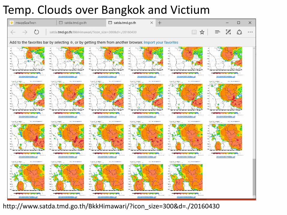
http://www.satda.tmd.go.th/Himawari/?icon_size=300&d=./20160430
Temp. Clouds over Thailand
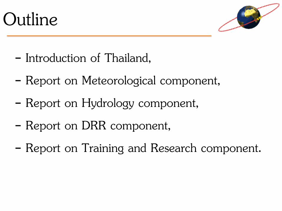
http://www.satda.tmd.go.th/BkkHimawari/?icon_size=300&d=./20160430
Temp. Clouds over Bangkok and Victium
Temp. Clouds over Thailand
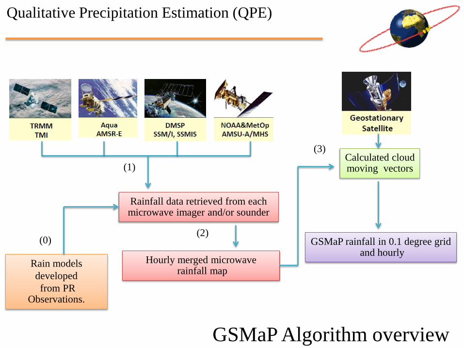
Rain models
developed
from PR Observations.
Rainfall data retrieved from each microwave imager and/or sounder
Hourly merged microwave rainfall map
Calculated cloud moving vectors
GSMaP rainfall in 0.1 degree grid and hourly
(0)
(1)
(2)
(3)
GSMaP Algorithm overview
Qualitative Precipitation Estimation (QPE)

Data sets

http://www.satda.tmd.go.th/

Sakon Nakhon Radar 30 Sep 2013
Estimated Rainfall from Satellite 30 Sep 2013
Comparison Radar to Satellite, 30 SEP 2013

Estimated rainfall from satellite
30 September 2013 29 September 2013

Before, TC “NARI” attack Vietnam, Lao, Thailand
Qualitative Precipitation Estimation (QPE)

During, TC “NARI” attack Vietnam, Lao, Thailand
Qualitative Precipitation Estimation (QPE)
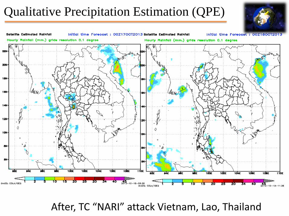
After, TC “NARI” attack Vietnam, Lao, Thailand
Qualitative Precipitation Estimation (QPE)

After, TC “NARI” attack Vietnam, Lao, Thailand
Qualitative Precipitation Estimation (QPE)

QPE from satellite to Basin
Chao Phaya basin
Chi basin
Moon basin

2. TMD’s, Weather Radar Network
TMD has 26 Doppler RADAR stations,
one mobile RADAR and one portable RADAR
as these follows;
• S – Band Doppler RADAR
10 cm 2800 MHz 5 stations
• C – Band Doppler RADAR/Portable
5 cm 5600 MHz 16 stations
• X - Band Doppler RADAR/Mobile
3 cm 9600 MHz 5 stations

Radar Information (C & S-Band 240 KM Range)
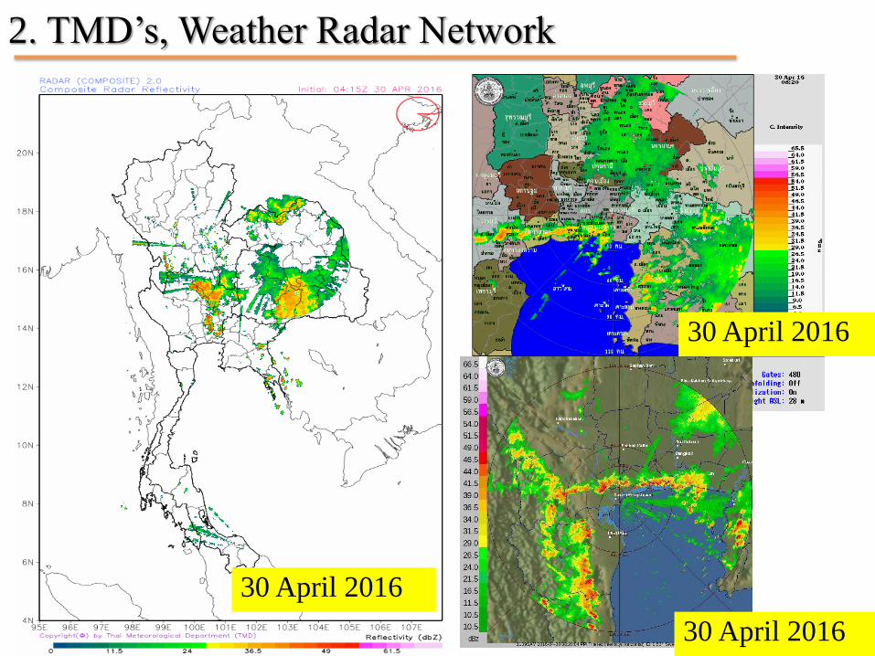
2. TMD’s, Weather Radar Network
30 April 2016
30 April 2016
30 April 2016
www.gts.tmd.go.th
Meteorological Telecommunication Network
• GTS Network
• Volume Meteorology
• Broadcast for Shipping
• Radiofax (HF Fax)
Southeast Asia Meteorological Telecommunication Center
(RTH Bangkok)
TMD’s received the government budget in 2016 will
development the global telecommunication (GTS) to integrate data
support ICAO.

The Global Telecommunication System (GTS)
GTS: The coordinated global system of telecommunication facilities and arrangements for the rapid collection, exchange and distribution of observations and processed information.
The GTS has a hierarchical structure on three levels
• MTN - The Main Telecommunication Network Linking 3 WMCs
and 15 RTHs
• RMTN - The Regional Meteorological Telecommunication Network to integrate network of 6 WMO regions
• NMTN - The National Meteorological Telecommunication
Network to enable NMCs to collect observational data and received and distribute meteorological information on a national level

Vientiane
Baghdad
Doha
Kuwait
Bahrain
Dhaka
Yangon
Kabul
Karachi
Colombo
Male Phnom Penh
PyongYang Ashgabad
Macao
256K
Dushanbe
Almaty
NI
NI
NI
Seoul
NI
NI
512K
14.4-28.8K (V.34)
4M 64K
64K
1200
64K
64K
64k
Offenbach
Offenbach
Cairo
Algiers
Kuala Lumpur
Tashkent
Novosibirsk
Khabarovsk
Bangkok
Washington
NI
24-19.2K (V.34)
19.2-24K (V.34)
Regional Meteorological Telecommunication Network for Region II (Asia) Current status as of 25 November 2011
Bishkek
64K
Singapore
RTH in Region II
NMC in Region II
Centre in other region
MTN circuit Regional circuit Interregional circuit Additional circuit
Non-IP link IP link Internet E-mail transmission
NI No implementation
Tehran
Sanaa
Hong Kong
Moscow
NI
F/R CIR <32/32K>
Manila
Internet
Jeddah
Muscat
64K
64K
64K
Washington
ISDN 128K
64K
via Moscow
64K
64K
Thimpu
New Delhi
NI
64K
64K
64K
128K
9.6K
Ulaanbaatar
Abu-Dhabi 1200
64K
Melbourne
Melbourne
IMTN MPLS
10M
64K
512K IMTN MPLS
IMTN MPLS
IMTN MPLS
IMTN MPLS
IMTN MPLS
MPLS
Internet
Internet
1M
10M
4M
10M
1M
512K
2M
1M
512K
4M
MPLS
2M
128K
MPLS
4M
Internet
Internet
Internet
Internet
Internet
Internet
Internet
Internet Internet
Internet
EUMETSAT MPLS 2M
Toulouse
Internet
64K
64K
64K
NI
Internet
Kathmandu
Internet
Internet
64K
Internet
Hanoi
128K 2M
MPLS
2M
1M
MPLS
128K
2M
64K MPLS
1M
MPLS
64K
64K
64K
64K MPLS MPLS
Internet
8M
Toulouse
Beijing
Moscow
64K
64K
64K
Internet Internet
Internet
2M
4M
3M
IMTN MPLS
10M
1M
Tokyo
Exeter
IMTN MPLS
10M
2M
IMTN MPLS
4M
64K
4M
EUMETSAT
MPLS 4M
10M

RTH
Beijing Tokyo (MPLS-128 kbps)
Jeddah
New Delhi
NC
(Leased line) (Internet)
NC
Vientiane
Hanoi
Taipei
Phnom Penh
Yangon
Nay Pyi Taw
Hong Kong
NC (RA-V)
(Leased line)
Kuala Lumpur (MPLS)
Singapore (MPLS)
GTS Network of RTH Bangkok
(Leased line)
Cambodia
- Circuit bandwidth for all leased line circuits, except Tokyo, is 64 kbps - Current internet bandwidth is 30/6 Mbps (Guaranteed) Starting October 1, 2013 internet bandwidth will be upgraded to 40/10 Mbps (Guaranteed)
Thimphu

Exchange on GTS
The types of meteorological messages containing
observational data to be exchanged on the Main
Telecommunication Network are as follows:
• Surface observations on land and sea, including data
from ships and buoys
• Upper-air observations including data from aircraft
• Climatological data
• Selected satellite data
• Seismic data, tsunami and other types of data as
agreed

Bangkok Volume Met
AMSS
(RTH Bangkok)
GTS
Network
Domestic Communication
Center (METNET)
Bureau of Aeronautical
Meteorology
(AEROMET)
Domestic
Airports
SADIS
Network
Aeronautical Radio
Of Thailand
(AEROTHAI)
AFTN
Network
Email in:
Satellite image
Center
5. Report on Training and Research components
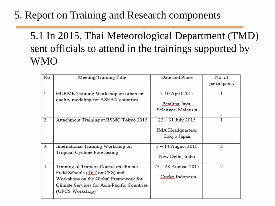
5.1 In 2015, Thai Meteorological Department (TMD)
sent officials to attend in the trainings supported by
WMO

5.1 In 2015, Thai Meteorological Department (TMD) sent
officials to attend in the trainings supported by WMO
(Continuous)

5.1 In 2015, Thai Meteorological Department (TMD) sent
officials to attend in the trainings supported by WMO
(Continuous)
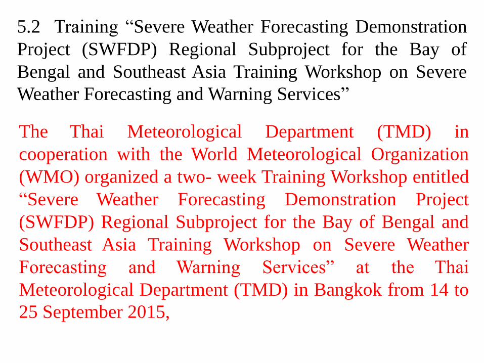
5.2 Training “Severe Weather Forecasting Demonstration
Project (SWFDP) Regional Subproject for the Bay of
Bengal and Southeast Asia Training Workshop on Severe
Weather Forecasting and Warning Services”
The Thai Meteorological Department (TMD) in
cooperation with the World Meteorological Organization
(WMO) organized a two- week Training Workshop entitled
“Severe Weather Forecasting Demonstration Project
(SWFDP) Regional Subproject for the Bay of Bengal and
Southeast Asia Training Workshop on Severe Weather
Forecasting and Warning Services” at the Thai
Meteorological Department (TMD) in Bangkok from 14 to
25 September 2015,

with the aims to facilitate the participation of the
National Meteorological and Hydrological Services
(NMHSs) in the Bay of Bengal and Southeast Asia
involved in the SWFDP Project and enhancing them on the
use of existing Numerical Weather Prediction (NWP)
products for improving meteorological warnings, and
supporting emergency response to hazardous weather
conditions and weather-related hazards. The Workshop
was conducted successfully with participation of all 49
participants from the 9 participating countries in the
SWFDP-Bay of Bengal namely: Bangladesh, Bhutan,
India, Maldives, Myanmar, Nepal, Pakistan, Sri Lanka and
Thailand,

and the five participating countries in the SWFDP-
Southeast Asia namely: Cambodia, Lao PDR, Philippines,
Thailand and Vietnam. Besides there were all 15 resource
persons/lecturers from WMO, Australia, Canada, China,
Hong Kong, New Zealand, India, Japan and Vientnam,
participated in the Training Workshop. The event was
funding supported from WMO and TMD as the host
country.

5.3 In the beginning of 2016, the Thai Meteorological
Department (TMD) in cooperation with the Japan
International Cooperation Agency (JICA) Office in
Bangkok and the Thailand International Cooperation
Agency (TICA) organized a Training course on
Hydrology (Advance Flood Forecasting, Flash Flood
Forecasting, Remote Sensing and GIS) for the Myanmar
Officials from 18 January to 17 February 2016, at TMD
Headquarters, under the Trilateral Cooperation
Framework between Japan, Thailand and Myanmar with
the full financial support from the JICA Office in
Bangkok and the TICA, Ministry of Foreign Affairs of
Thailand.

Picture 1: Mr. Charoon Laohalertchai, Director of Meteorological Development Bureau (TMD)
(who stand in the middle) took a group photo with lecturers, TMD staff and five participants
from DMH, Myanmar after the opening ceremony of the Training course on the morning of 18
January 2016, in front of the statute of Admiral Kromluang Chumporn Khate Udomsakdi, the
Founder of TMD, at TMD Headquarters in Bangkok.
Training course on Hydrology (Advance Flood Forecasting, Flash Flood Forecasting, Remote
Sensing and GIS)

Picture 2: Myanmar participants courtesy called on Dr. Songkran Agsorn, Deputy Director-
General of TMD in charge of Technical Services on the first day of the training.
Training course on Hydrology (Advance Flood Forecasting, Flash Flood Forecasting, Remote
Sensing and GIS)

Picture 3 and 4: Dr. Songkran Agsorn, Deputy Director-General, TMD presided over the closing
ceremony of the training and presented certificates to participants, held in the afternoon of 17
February 2016 at Bussarakham Meeting Room, TMD Headquarters. The Closing ceremony was
attended by Mr. Wattanawit GAJASENI, representative of TICA, Ministry of Foreign Affairs,
Thailand, Mr. Masanari Yanagiuchi, Senior Representative of JICA, Mr. Katsuya Miyoshi,
Representative of JICA, Mr. Thada Sukhapunnaphan, Representative of RID, Mr. Charoon
Laohalertchai, Director of Meteorological Development Bureau, TMD and some of Thai
lecturers.
Training course on Hydrology (Advance Flood Forecasting, Flash Flood Forecasting, Remote
Sensing and GIS)

Picture 5 : Dr. Songkran Agsorn, Deputy Director-General, (who stands in the
middle, second row) took a group photo with TICA and JICA, RID representatives,
TMD staff and five participants from DMH, Myanmar after the closing ceremony.

Conclusions
From the activities 2015, report on meteorological
component,
- TMD’s received the government budget 2016, to develop Weather
Forecast System and develop Operational room,
- TMD’s received HimawariCast established ground
station; hardware and software on the top of TMDD’s building,
- JMA was transfer radar composite technique to TMD’s staffs,
- TMD’s have the Global Telecommunication System (GTS) budget
will development in this year,
- TMD’s cooperation JAXA to QPE satellite data,
- TMD’s cooperation JICA and TICAR had training to member.

Thank You