Panel of Facilitators -...
62
1 Panel of Facilitators INSPIRE Annex II & III Thematic Working Groups INSPIRE Conference 23 June 2010 Krakow, Poland
Transcript of Panel of Facilitators -...

1
Panel of Facilitators
INSPIRE Annex II & III Thematic Working Groups
INSPIRE Conference
23 June 2010
Krakow, Poland

2
19 Themes of Annex II & III
• Terms of Reference for INSPIRE Data Specification development for Themes of Annex II & III
• Call for expression of interest for the stakeholders to participate at development of INSPIRE data specification for themes of Annex II and III
– Domain experts 320, Facilitators and Editors 30– Reference materials: current 125 entries
• User requirement survey: current 596 entries • Facilities for submitting user requirements and
reference materials remain open, but baseline for data specification development - items that arrive till 31 May 2010

3
Grouping of Themes
Annex II1. Elevation2. Land cover3. Ortho-imagery
4. Geology21. Mineral resources (Annex III)
Annex III1. Statistical units10. Population distribution –
demography
2. Buildings3. Soil4. Land use5. Human health and safety6. Utility and governmental services7. Environmental monitoring facilities
8. Production and industrial facilities 9. Agricultural and aquaculture
facilities 11. Area management/restriction
/regulation zones & reporting units12. Natural risk zones
13. Atmospheric conditions14. Meteorological geographical
features
15. Oceanographic geographical features
16. Sea regions
17. Bio-geographical regions18. Habitats and biotopes19. Species distribution
20. Energy Resources

4
Ongoing work
• Kick-off web-conference for Annex II & III: 19-20 April 2010
• Each TWG had a face-to-face kick-off meeting• Currently agreeing about the scope and
overview description, analysis of reference material, user requirements and definition of high level use cases
• Next cross-TWGs + DS DT meeting with Facilitators and Editors in Krakow, 24 June 2010

5
Roadmap Data SpecificationsTW
GD
T D
SC
T/JR
CSD
ICs/
LMO
sM
SEC
DG
s
Preparedocuments
& tools
Provide Userrequirements &
reference material
ReviewDS v1
Consultationand
Testing
Provide Userrequirements &
reference material
Apr – Oct 2010
Phase 1 Phase 2 Phase 3
Nov 2010 – Aug 2011 Sep 2011 – Jan 2012
Data specs(DS) v1
Data specs(DS) v2
Data specs(DS) v3 Release
candidate (RC)
Data specs(DS) v3
ReviewDS v3
Commentresolution

6
TWG experts still welcome!
• Still some communities need reinforcement of domain experts:– Human Health and Safety– Agriculture and Aquaculture facilities– Area Management /restriction/regulation zones and
reporting units– Energy resources

7
Annex II
• Elevation• Land cover• Orthoimagery• Geology

8
TWG-ELElevation
• “Elevation” is a basic reference component and of interest for many users and uses.
• The theme includes terrestrial elevation data (terrain or surface) and bathymetry data.
• Core datasets are Digital Elevation Models (DTM or DSM) for land, ice and sea bottom as regular grids or TINs. But also vector elements like contour lines or break lines represents these kind of surfaces.
• Links and overlaps with other themes :Hydrography, Buildings, Geographical Namesand Administrative Boundaries
• Fundamental for the theme “Elevation” is a common vertical reference system for Europe (=> EVRS2000, (EVRS2007))
• For many applications elevation data is needed as input, for example flood simulation or production of ortho-imagery.
• Shoreline is a important and challenging feature for this theme.The definition of shorelines have to be discussed internally and of course with the other TWGs concerned.

9
TWG-OIOrthoimagery
• This theme covers geo-referenced image data of the Earth's surface, from either satellite or airborne sensors
• Data model might contain rather metadata than “real world objects”
• Geometrical corrected (“orthorectified”) images • No restrictions in terms of used sensors and spatial resolution
(“provide what you have”) unlikely link to TWG Elevation • Data processing is out of scope • In INSPIRE context they OI are mainly used as background
images for numerous applications (also data capturing)• Use cases and user requirements will consider also GMES issues
and controlling of agricultural funding

10
TWG-GE+MRGeology
Surname Name Organisation Country
Asch Kristine BGR DE
Berástegui Batalla Xavier IGC ES
Bergman Stefan SGUS SE
Cassard Daniel BRGM FR
Follestad Bjørn NGU NO
Hugues Andrew BGS UK
Janjou Dominique BRGM FR
Larsen Uffe GEUS DK
Laxton John BGS UK
Nalecz Tomasz PGI PL
Pen Simon TNO NL
Serrano Jean-Jacques BRGM FR
Sörés László ELGI HU
Vuollo Jouni GTK FI
Tomas Robert JRC IT
Facilitator
Editor
Contact point
14 members

11
TWG-GE+MRGeology
• Geology provides basic knowledge about properties of the rocks (physical and chemical composition, genesis, structure);
• It is the basis to locate natural resources (building stones, aggregate materials, industrial minerals, ores, groundwater, oil and gas);
• It provides key information to understand and mitigate natural hazards;
• And for land use planning (protecting groundwater, safe disposal of wastes, safe construction of buildings and infrastructure, CO2storage)
• Geology theme is defined by these core elements:– Geologic Units, Geologic Structures, Earth Material– Geophysics, Geochemistry, Geomorphology – Groundwater aquifers– Depth is a fundamental attribute

12
TWG-GE+MRGeology
Geology and other themes
GeologyGeology
• Elevation• Hydrology• Ortho-imagery• Coordinate Reference Systems• Geographical Grid Systems
Protected Sites:• GeoParks• Geological sites• Groundwater protection
Protected Sites:• GeoParks• Geological sites• Groundwater protection
Energy Resources:• Oil, Gas, Coal, Peat• Uranium deposits• Geothermal energy
Energy Resources:• Oil, Gas, Coal, Peat• Uranium deposits• Geothermal energy
Environmental monitoring facilities:• Groundwater monitoring stations• Water sediments monitoring points • Other networks (seismicity, …)
Environmental monitoring facilities:• Groundwater monitoring stations• Water sediments monitoring points • Other networks (seismicity, …)
Production & Industrial facilities:• Storage sites• GeoEngineering
Production & Industrial facilities:• Storage sites• GeoEngineering
Soil:• Rock composition• Erosion (natural/artificial)• Landfills
Soil:• Rock composition• Erosion (natural/artificial)• Landfills
Mineral ResourcesMineral
ResourcesMineral
Resources
Natural Risk Zones:(Geo-hazards)• Earthquakes• Landslides• Volcanic eruptions• Floods• Subsidence• Radon areas• Shrinking Swelling clays• Coastal dynamics
Natural Risk Zones:(Geo-hazards)• Earthquakes• Landslides• Volcanic eruptions• Floods• Subsidence• Radon areas• Shrinking Swelling clays• Coastal dynamics

13
TWG-GE+MRMineral Resources
• Mineral Resources include various segments according to the nature of materials, the technologies involved in exploration and mining, the markets:
– metal mining, industrial minerals, construction minerals and rocks, ornamental stones, precious and semi-precious stones
• Data refers to:– Occurrences: concentrations of minerals are observed – without
a proven economic potential, – Deposits: areas of mineral concentrations with economic
potential• Mineral Resources theme is defined by these core elements:
– Deposits / Occurrences with commodities, mineral system, deposit model, ore measure (reserve, resource, endowment)
– Mines with product, mined material, mining activity– Depth is a fundamental attribute

14
TWG-GE+MRMineral Resources
Mineral Resources and other themes
• Elevation• Hydrology• Ortho-imagery• Coordinate Reference Systems• Geographical Grid Systems• Geology
Area management:• Prospecting and mining permit areasArea management:• Prospecting and mining permit areas
Mineral ResourcesMineral
Resources
Energy Resources:• Oil, Gas, Coal, Peat• Uranium deposits
Energy Resources:• Oil, Gas, Coal, Peat• Uranium deposits
Production & Industrial facilities:• Location of mines• Storage sites• Sedimentation dams
Production & Industrial facilities:• Location of mines• Storage sites• Sedimentation dams
Land use:• Mining, quarryingLand use:• Mining, quarrying Utilities and government services:
• Mining wastesUtilities and government services:• Mining wastes
Protected Sites:• Mines opening and expansion checkProtected Sites:• Mines opening and expansion check
Population distribution:• Construction rocks consumersPopulation distribution:• Construction rocks consumers
Transport networks:• Availability, capacity, distanceTransport networks:• Availability, capacity, distance

15
Annex III
1. Statistical units2. Buildings3. Soil4. Land use5. Human health and safety6. Utility and governmental
services7. Environmental monitoring
facilities8. Production and industrial
facilities 9. Agricultural and
aquaculture facilities 10. Population distribution –
demography
11. Area management/restriction/ regulation zones & reporting units
12. Natural risk zones13. Atmospheric conditions14. Meteorological geographical
features15. Oceanographic geographical
features16. Sea regions17. Bio-geographical regions18. Habitats and biotopes19. Species distribution20. Energy Resources21. Mineral Resources

16
TWG-SU+PDStatistical Units
• units for dissemination and use of statistical information; • support establishment, aggregation, assessment and display of
statistical information i.e. any numerical representation of someobserved phenomenon;
• geo-reference statistical data from different statistical fields likedemography, economy, environment and natural resources’
• are organized into hierarchy, can have temporal characteristics andtime-dependent relations to other feature types representing unitsof territorial dissemination,
• can be spatially represented by:– areas e.g. NUTs regions, census and statistical districts, urban areas,
management zones, postal codes, reporting units,– points corresponding to the addresses, households,
• can spatially link to administrative units, address, or land cover.

17
TWG-SU+PDPopulation distribution - demography
• geographical distribution of people, including population characteristics and activity levels, aggregated by grid, region, administrative unit or other analytical unit;
• are localized in time regarding both, data collection anddata validity,
• concern:– figures for age classes, gender, mortality, life expectancy, migration, – changes over time e.g. growth/reduction in population,– number of households, rate of employment, education, income,
households with children etc,– figures for economic activities according to the NACE v1.1 eg. :
production, consumption, stocks, income, employment, transport andtraffic,
– geographical aggregations of buildings into settlements, villages, townships, towns, cities;
• must be linked to areal statistical units (area or grid) on relevant aggregation levels.

18
INSPIRE progress 18
TWGTWG--BU : BuildingsBU : Buildings
• Directive: physical location of buildings
• TWG BU: A building is an enclosed construction, used or intended for the shelter of humans, animals or things, for the production of economic goods or for delivery of services. A building refers to any structure permanently constructed or erected on its site.
• 4 major use cases:– Safety, risk management (flood, storm, fire, earthquake, …)– Spatial planning– Environment (noise, air quality, energy, soil, …)– Infrastructure (transport, utilities, …)
• Physical description of buildings under scope of TWG BU
• Functional description of building and/or facility under scope of:– TWG BU - TWG AF -TWG TN– TWG US - TWG PF

19
TWG-SOSoil
Arnold Arnoldussen NO Domain Facilitator
Edoardo Constantini IT Domain, GIS, ISO/OGC
Einar Eberhardt GE Domain, ISO/OGC Co-Editor
Patrick Engels BE Domain, GIS
Jan Dirk Bulens NL GIS, Inspire, ISO/OGC Co-Editor
Christine LeBas Fr Domain
Kees Versluijs NL Domain
Stephan Marahrens GE Domain, GIS
Milan Sanka CZ Domain
Ainara Senar ES Domain, GIS
Marc van Liedekerke JRC Domain, GIS, Inspire, ISO/OGC
Robert Tomas JRC Contact person INSPIRE Team
TWG SO members

20
TWG-SOSoil
Scope• Definition soil is more a description than a
definition.• After a first discussion we decided to focus our
work on:– Soil inventory and soil monitoring– Soil mapping– Derived soil thematic maps.
• In the given draft soil contaminated areas are not mentioned

21
TWG-SOSoil
Planning of work phase DS 1.01. Rephrasing scope 2 August2. Inventory material survey 9 July
– Reference material, User Requirements,Relevant EU legislation, Relevant EU projects
3. In depth analysis – a start 2 August4. Identifying Use cases to be used further in modelling. 9 August
– Challenge: limiting numbers to a workable amount.
5. First draft of objects and features 1 September6. DS version 1.0. 15 September
Challenge: tight timeframe – holyday season: expected problems with using existing networks/contacts

22
TWG-SOSoil
Cross-theme issues• No in depth analysis done yet• So far following issues showed up:
– Soil definition: brought in by TWG Geology– Contaminated sites: what is done by TWG Human
health and safety?– Soil monitoring: what is done by TWG Human Health
and Safety and TWG environmental monitoring facilities?

23
TWG-LULand use
INSPIRE definition• (INSPIRE, 2007) Territory characterised
according to its current and future plannedfunctional dimension or socio–economic purpose(e.g. residential, industrial, commercial, agricultural, forestry, recreational).
• Land use may be characterised as ordinarymapping of existing functions as an objective picture of the use and functions of a territory, but may also be plans characterising how land may be utilised at present and in the future

24
TWG-LULand use
LandAs a resource to manageAs a location for activitiesPiece of land as an agglomerate of land parcels being homogeneous regarding defined criteria
UseFunctional use regarding activities
Land-use Pieces of land having homogeneous functional use regarding human activitiesZoning designates permitted uses of land based on mapped zones which separate one set of land uses from another.

25
TWG-LULand use
Land versus geographical objectHuman activity on a piece of land includes the “infrastructures” necessary for the activity to take place
Car-parks necessary for the peopleGardens necessary for the “well fare” of actorsWarehouses for the stocksFront office – back office
Geographical objectsPart of a piece of landContributing to its functional use

26
TWG-LULand use
Territory of discourse is the area for which information is given (a municipality, a region, etc.)Zoning is a partition of the territory of discourse
divided into cells that do not overlap and that the union of cells covers the Territory of discourse
"cells" are both collectively exhaustive and mutually exclusive with respect to the Territory of discourse .
n
TD= ∪ Ci | ∀i,j i#j Ci ∩ Cj = ØI=1

27
TWG-LULand use
Partition of the territory of discourse, each cell being homogeneous regarding a social / environmental / economic activityLand Use classes = classification scheme
ISIC versus LUCAS

28
TWG-LULand use
elaboration adoption application
Expert Diagnostic scenarios
Suggestion Building permits instruction
Decision maker
Choice between scenarios
Vote Building authorisation
Stake holder
Contribution Suggestion Building permit request
Citizen “public”enquiry
“democratic control”
General public
Building permit request
Existing LUProposed LU
Adopted future LU Planned LUEvolving LU
Planning Process
Leve
l of c
omm
itmen
t

29
TWG-HHHuman Health and Safety
• The theme, as defined in Annex III focuses on health data (pathologies) linked directly and indirectly to the quality of the environment
• A scope of the theme has been roughly grouped into:– Health data– Health determinants: environmental and social– Health services– Security / safety issues
• Selection and specification of ‘Health data’ expected to be addressed solely by TWG HH
• ECHI - considered a starting point for identifying relevant health data for data specification development
• Work on ‘Health determinants’, ‘Health services’ and ‘Safety/security’data expected to require substantial interactions with other TWGs
• The process of identifying relevant TWGs for specific data has started• Relevant data and information sources being identified to complement
available reference material• Definition of core elements of data in TWG HH – still ongoing process
due to the nature of relevant data

30
TWG-USUtility & Governmental Services
• Scope includes services supplied by public authorities (whether national, regional or local), but also by semi-public organizations or even private companies, that were appointed to provided services to population.
• The scope covers physical services, e.g. utility networks:– Pipeline networks (oil & gas, water & sewage, heat)– Wire & Cable networks (electricity, telecommunications)
but also more environment related facilities such as:– Sites for waste deliveries & treatments (sewage sludge, mining, etc.)– Illegal or controlled, hazardous or not, at land and sea
and Administrative & social governmental services:– Education & culture, health & social care, emergency & security– Sports & leisure, economic infrastructure, protection facilities, etc.

31
TWG-USUtility & Governmental Services
• Specific focus will be done during phase 1 on :– Notion of public services vs private sector activities– Aspect of confidentiality vs diffusion (for commercial and
security reasons)– Environmental use vs broad meaning of “environment”
• The wide scope of this theme imposed us to split in 3 sub-themes
– 5 experts dedicated + 1 facilitator + 1 editor + 1 contact point
• Many links with done work (thanks to TWGs TN & HY), but also with current TWGs (BU, LU, HH, EF, PF, NZ, etc.)
• Need to gather use cases & requirements:Please send them to [email protected]

32
Maksim, Katleen,
Norbert, Angel,Frank H.
Pedro, Frank S.,Fred
Utility services / networks
Waste treatment facilities and waste storage
Environmental protection facilities
Administrative and social governmental services
Utility andgovernment services
PIPELINETRANSMISSION
LINE
Electrical *
Communication
Phone
Data
Cable-TV
COUPLING
Oil *
Gas * Water
Sewage
Heat *
* Linked with TWG Energy Resources
PIPELINETRANSMISSION
LINE
Electrical *
Communication
Phone
Data
Cable-TV
COUPLING
Oil *
Gas * Water
Sewage
Heat *
* Linked with TWG Energy Resources Anti-noise constructions
Natural hazards protection facilities
Emergency services (fire
fighter, police, civil protections) *
Government & Municipal offices **
Health & Social care services (hospital,
elderly) *
Education & Culture (schools, libraries,
kindergartens)
Sports & leisure
Local administrationservices (street lighting)
Economic infrastructure
* Linked with TWG Health & Safety
* Linked with TWG Health & Safety
** Linked with TWG Buildings
Anti-noise constructions
Natural hazards protection facilities
Emergency services (fire
fighter, police, civil protections) *
Government & Municipal offices **
Health & Social care services (hospital,
elderly) *
Education & Culture (schools, libraries,
kindergartens)
Sports & leisure
Local administrationservices (street lighting)
Economic infrastructure
* Linked with TWG Health & Safety
* Linked with TWG Health & Safety
** Linked with TWG Buildings
LAND SEA
Controlled waste treatment sites for non-
hazardous waste at land *
Controlled waste treatment facilities for
hazardous waste at land *
Regulated areas for dumping of waste at sea
Illegal or non-controlled dumping of waste - sea and
land
Mining waste
Sewage sludge
Waste treatment and disposal site - hazardous
waste
Renovation / waste delivery sites
* Linked with TWG Production & Industrial facilities
33
TWG-EFEnvironmental monitoring facilities
• IN– monitoring facilities are a basic element to link observations and
measurements to a spatial feature– Monitoring facilities reflect to one or more features of interest– connection to specific networks – related to one or more legal acts
[maybe on different level of administration (local, regional, national or European)]
– Observations and measurements are seen as a self standing thematic area (INSPIRE directive A III, 7)
– Data protection on object level like for natural heritage (e.g. caves) or protected species (e.g. birds breading places)
• Out – Any kind of interpreted or substantial processed data– Observations and measurements are seen as a self standing thematic
area (D2.3)• Linked to:
– Any theme in Annex I, II and III with monitoring– Themes not included in Annexes of INSPIRE (or not visible so far)

34
TWG-PFProduction and Industrial Facilities
• Industrial production sites, water abstraction facilities, mining, storages sites, waste/disposal sites and energy production facilities.
• Needed in modeling and assessment of pressures on the environment, in land use planning, in risk and hazards management.
• Links to Annex Themes:AD*,CP*,RS,HY,PS*,TN*• Links to Annex II Themes: GE*, LC.• Links to Annex III Themes: AF, AM*, BU,ER,EM,
HH*,LU,MR,NZ*,US

35
TWG-AF Agricultural & Aquacultural Facilities
• TWG AF: 6 dedicated experts. 5 Nacionalities (I,DE,NL,BG,ES)• Definition: (INSPIRE,2007) Farming equipment and production
facilities.• Facilities Classification based on NACE1.1 and ISIC:
– Growing of crops; market gardening; horticulture (e.gIrrigation, Greenhouses, Warehouses,…)
Intensive Forestry Plantations Included.– Farming of animals (e.g. Sheepfolds, Stables, Muck-
collectors, …)Hunting not Included.
– Fish farming (e.g. Fish farms, Breeding-places, …)Fishing and Catching in natural environment not included .
• Links with other groups:– Production & Industrial Facilities, Land Use, Cadastral Parcels,
Hydrography, Transport Networks, Buildings, Environmental Monitoring.
• Contact: [email protected] or in the INSPIRE Forum.

36
• Two sides of the definition: general <> specific topics:– general (areas managed, regulated or used for reporting at
different levels; relevant reporting units)– specific “examples”: dumping sites, river basin districts,
restricted areas around drinking water sources, nitrate-vulnerable zones, …)
• Management/restriction/regulation areas are established in different sectors (description in D2.3), used within policies (spatial planning, land use planning, etc.), related to environmental topics
• Defined units used for reporting (from – to, when, what, …)
TWG-AMArea management/restriction/regulation zones and
reporting units

37
TWG-AMArea management/restriction/regulation zones and
reporting units
• Related to legislative background and often implemented at local level
• Designated authorities for management, implementation and reporting
• Setting flexible framework with top level types, extended towards specific topics and elements
• Terminology issue• Need for different thematic input (thematic
communities, legislation)

38
TWG-AMArea management/restriction/regulation zones and
reporting units
Cross-theme relationships• First look: relationships to many INSPIRE themes: protected sites,
hydrography, transport netw., administrative un., statistical un., utilities & governmental serv., land use, environmental monitoring facilities, agricultural and aquacultural facilities,…);
• Expected to receive indications of relationships from other INSPIRE themes
• General open issues:– Link to Annex I themes: how to introduce abstract classes to
existing models?– Identifying the boundaries between the themes (what in which
theme; specific cases) and links?– Working on many relationships between the themes at the
same time might make harmonisation very difficult – is any organisational support foreseen (like core group to support the cross-theme links and harmonisation)?

39
TWG-AMArea management/restriction/regulation zones and
reporting units
Cross-theme relationships• AU Administrative units (existing model):
– Object referencing to the AU model?
• SU Statistical units:– What is covered within SU?– How the limitation between the scopes of SU and AM is
defined/seen?– Specific cases, like: ICES fishing areas (statistical calculations)
are they part of SU?
• LU Land use:– What kind of restriction zones are included (if any)?– National/regional restrictions > local level implementation?– How the “general>extensions approach” is supported within LU:
general model (AM) > specific extensions (details) in LU?

40
TWG-AMArea management/restriction/regulation zones and
reporting units
Cross-theme relationships• TN Transport networks (existing model) – to check:
– Traffic separation schemas, fairways at seas? – How this model covers restriction zones?– Possibility to introduce abstract class to TN model?
• PS Protected sites (existing model) – to check:– How this model covers restriction zones?– Possibility to introduce abstract class to PS model?
• EF Environmental monitoring facilities:– Do links exist (AM -> EF or EF -> AM or AM <-> EF)
• US Utility and governmental services:– Examples: in which theme – police districts, fire-brigade districts,
school districts, …?– Facilities or districts/areas in UG?
• AF Agricultural and aquaculture facilities:– Facilities or districts, restriction zones, area management in AF?

41
Surname Name Landslides Floods Forest Fires
Volcanic activity Earthquakes Droughts Avalanches IT
Bojilov Venco x
Cerba Otakar x x x xx
CanetCastella Raquel x x x x
Exadaktylos George x x x
Giovando Cristiano x x x x
Harrison Matthew x x x x x
Isidro Llorente Miguel x x x x x
Pfeiffer Manuela x
Thomas Florian x x
Tomas Robert x x
TWG-NZNatural Risk Zones

42
TWG-NZNatural Risk Zones
Progress• Kick-off 27-28th May• Teleconference 17th June• Begun Scoping• Developing Classification• Reviewing Reference Material and User
Requirement Responses• Reviewing As-is

43
ClassificationClassificationHazard source Hazard type Hazard group name Description
Transport Hazardous material, traffic accidentTechnological
Facilities Pollution, reservoir failures, residues, mining subsidence
Investments market financesFinancial
Projects research and development projects
Anthropic
Social war, terrorism, intentionally caused firesRadiation solar storms, gamma radiation
Meteorites celestial bodies of any sort through atmosphereCosmic
Gravitational gravity field alterations, ecliptic plane deviations, magnetic storms
Tsunamislong wavelength waterbody waves caused by earthquakes, volcanoes ,landslides
Volcanic ejected material in ballistic trajectory, lava, gases, ash
Seismic elastic waves through rocks, liquefaction
Glacial, periglacial or ice relatedmoving ice bodies, freezing/de‐freezing processes, snow avalanches, permafrost alterations, iceberg movements, instabilisation of gas‐hydrates
Floodsriverine overflow, water table changes, tidal flooding, natural reservoirs failure,jokulhaups
Landslidesrockfalls, landslides, subsidence, karstic or pseudokarstic collapses, sand dunes movement, lahars
Toxic or dangerous materialnatural radioactivity, radon, asbestos, salts, Potentially Harmful Elements, peat/coal/oil spontaneous combustion, Methane and Carbon Dioxide
Rock or Soil propertiesShrink‐swell clays, loessic soil collapse, compressibility, unconsolidated sands, solubility, deficit of minerals
Geologic
Features Navigational hazards caused by natural submarine features
Climatology natural desertification, glaciations, natural nuclear winterAtmospheric
Meteorologicalhurricanes, heat/cold waves, tornados, drought, strong wind, thunder, natural forest fires, storms
Virus and bacteria flue, malariaIllness of non viral nor bacterial origin
cancer, mental disorders
Natural
Biological
Plagues mosquitoes, wasps

44
TWG-NZNatural Risk Zones
• Examine Legislative Framework for each class of hazards– GAP analysis– Look for examples of requirements and
specifications
• Draft at Present
45
TWG-NZNatural Risk Zones

46
TWG-NZNatural Risk Zones

47
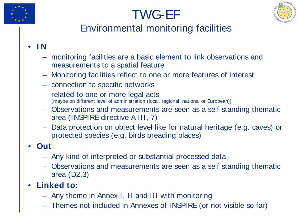
TWG-NZNatural Risk Zones
• Land use• Elevation • Hydrography • Land cover• Geology & Mineral Resources• Soils• Environmental protection facilities• Meteorological geographical features• Oceanographic geographical features• Human Health & Safety• Population Distribution• Atmospheric ConditionsThe list goes on...

48
TWG-AC+MFAtmospheric Conditions + Meteorological Features
Atmospheric Conditions + Meteorological Features
Two critical aspects specific to AC+MF:• Data representation:
– Space (vertical)– Time– Real time aspect– To adapt the current solutions to an interoperable– framework is a challenge
• Coordination:– WMO Inter-Programme effort towards Metadata and Data
Interoperability – OGC Met Ocean Domain Working Group– Efficient cooperation will be vital to ensure feasibility

49
TWG-AC+MFAtmospheric Conditions + Meteorological Features
- Uses data from:- Hydrography- Elevation- Land cover- Oceanographic Geographical Features + Sea Regions- Soil- Land Use- ...
- Provides data to:- Energy resources (solar, wind)- Natural Risk Zones- Human Health and Safety- Environmental Monitoring Facilities- ...

50
TWG-AC+MFAtmospheric Conditions + Meteorological Features
The question of the scope• « The scope of ‘Atmospheric conditions’ thematic data should be limited to
(six-hourly) synoptic analyses and forecasts (typically griddedmodel fields), climatological data, and other integrated and/or summary data. »
• « The scope of ‘Meteorological geographical features’ thematic data shouldbe limited to local-level high-resolution (weather-related) data, typically observations.
– This includes synoptic observations from stations making up the WMO RA VI (European) Regional Basic Synoptic Network. »
(Ref: D2.3 Definition of Annex Themes and scope)
• Yes, but…– This distinction leaves many questions unanswered– And, more importantly, it does not map with the actual content and structure of
meteorological information

51
TWGTWG--BRBR--HBHB--SDSDBioBio--geographicalgeographical RegionsRegions + + HabitatsHabitats and and BiotopesBiotopes
+ + SpeciesSpecies DistributionDistribution
• Scope of the data specifications should be mainly on habitats or species of European interest.
• TWG will deal with all three themes in shared discussions to ensure internal cross-themesconsistency.
• Need for link:– with Natura2000 Expert Group activities to ensure the
consistency with updated Standard Data Form (SDF);– with TWG PS to discuss Full application schema;– other TWGs (EF, others, still to be specified).
• Priority: Collection and analysis of reference material, related references from D 2.3 as well as user requirements/use cases.

52
TWGTWG--BRBR--HBHB--SDSDBioBio--geographicalgeographical RegionsRegions + + HabitatsHabitats and and BiotopesBiotopes
+ + SpeciesSpecies DistributionDistribution
• Open issues:– How to deal with PS Application schemas esp. candidates types,
placeholders– Habitats types/groups - keep it on as simple/generic level as
possible– Why observation was excluded from Species Distribution
Clarification?– Need for use cases from DG ENV– Check the use cases and reference material from the other DGs
• Need to gather use cases & requirements:• Please send them to

53
TWGTWG--BRBR--HBHB--SDSDBioBio--geographicalgeographical RegionsRegions + + HabitatsHabitats and and BiotopesBiotopes
+ + SpeciesSpecies DistributionDistribution

54
TWG-ER Energy Resources
The theme covers:• Non renewable energy resources (oil, gas, coal,
uranium, thorium)– energy resource deposit (shape is controlled by geology and
economic as well as technical parameters)– assessment object of non renewable energy resource (shape
is controlled merely by geologic and tectonic conditions)
• Renewable energy resources (solar, wind, geothermal, biomass, tidal, wave, river hydro energy)
– observing object of renewable energy resource (different geometry - points, line, areas) (discrete approach)
– grid of renewable energy potential (shape controlled by geographic grid system) (continuous approach)

55
TWG-ER Energy Resources
The theme does not cover:• any infrastructure, but where needed there has to be ensured
topological connectivity (e.g. as soon as a deposit is exploited it means it has to be automatically connected either to already defined transport network or future utility network – hydrocarbon schema)

56
TWG-ER Energy Resources

57TWG-SR : Sea Regions
– Sea Regions (INSPIRE, 2007) Physical conditions of seas and saline water bodies divided into regions and sub-regions with common characteristics.
– D2.3 regards "Sea regions" Saline water bodies divided into regions and sub-regions. Each region with common characteristics, concerning water flow/ circulation, adjacent river catchments, bio-chemical or temperature of water, based on scientific criteria.
– Focus is on the local/regional level coastal zone.– The first consideration was that there seemed to be some inconsistency in the
definitions, e.g. Sea Regions means 'coastal'.– D2.3 focused on definitions related to physical characteristics, the cited example
was the WFD reporting units. In this context Sea Region is also a 'Reporting Unit' (another Annex III theme) and this RU Theme defines how sub division of the Sea into regions should be performed.
– The team were aware of many other communities that define Sea Regions such as WMO, IHO and ICES that are not related to physical characteristics

58TWG-OF : Ocean Features
– Ocean Geographic Features (INSPIRE, 2007) Physical conditions of oceans (currents, salinity, wave heights, etc.).
– Are concerned with the high seas and larger oceanic physical/dynamic structures.
– Physical conditions of oceans (e.g. currents, salinity, etc) represented as lines, grids or points. Includes spatial data sets based on measurements, on models or on a combination thereof and includes measurement locations (INSPIRE Scoping, 2004)
– Clearly Ocean Features are directly related to the observation and measurement process for these features
– OF are propertiesOf a Sea Region

59
cd Data Model
LocatedIn
PropertiesOf
SpecialisationOfSeaRegion
«AnnexIII»SeaRegions
+ International+ National
«AnnexI»ProtectedSites
+ Archeology+ Bird_Sanctuary+ Fishing+ Marine_Nature_Reserve+ Natura_2000
«AnnexI»CadastralParcels
+ SeaBed+ Water_Column+ Water_Surface
«AnnexI»AdministrativeUnits
+ Exclusive_Economic_Zone+ National�_Waters+ Territorial_Sea
«AnnexIII»NaturalRiskZones
+ Floods+ Sea_Level_Rise+ Spring_Tides+ Waves
«AnnexIII»AgriculturalAndAquacultureFacilities
+ Fish_Farm+ Mussels_Farm+ Seaweed_Farm
«AnnexIII»AreaManagementRestrictionRegulationZones&ReportingUnits
+ Dredging_Areas+ Dumping_Areas+ Fairway_areas+ Fishery_Areas+ Harbour_Areas+ Military_Areas+ Noise_Restriction_Areas+ Speed_Restriction_Areas+ WFD_Areas+ WindFarm_Areas
«AnnexI»GeographicalNames
+ Ocean_Names+ Regional_Sea_Names+ SandBanks_Names+ Sea_Names
«AnnexIII»OceanographicGeographicalFeatures
+ Currents+ Salinity+ Wave_Heights
«AnnexI»TransportNetworks
+ Navigable_Channels+ Routing_Systems+ Traffic_Zone_Management
«AnnexII»Geology
+ Erosion+ Sedimentation
«AnnexIII»EnergyResources
+ Currents+ Gas+ GeoThermal+ HydroPower+ Oil+ Solar+ Waves+ Wind
«AnnexIII»MineralResources
+ Natural_Stones+ Sand
«AnnexI»Hydrography
+ Coastal_Waters+ Transitional_Waters+ Transport_Routes+ Water_Navigation
«AnnexII»Elevation
+ Bathymetry
«AnnexII»Orthoimagery
+ Airborne_Image_Data+ Satellite_Image_Data
«AnnexIII»StatisticalUnits
+ Collisions_Counts+ Fish_Counts+ Vessel_Counts
«AnnexIII»ProductionAndIndustrialFacilities
+ Buildings+ Collection_Minerals_and_Rocks+ PlatForm_Oil_and_Gas
«AnnexIII»HumanHealthAndSafety
+ Marine_Algal_Blooms+ Marine_Foods
«AnnexIII»UtilityAndGovernmentServices
+ Oil_And_Gas_Pipelines+ Transmission_Lines-Electrical+ Transmission_Lines-Phone/Data/Cable-TV+ Water_Pipelines
«AnnexIII»AtmosphericConditions
+ Atmospheric_Parameters
«AnnexIII»BioGeographicalRegions
+ Biotopes+ Habitats
«AnnexIII»SpeciesDistribution
+ Birds+ Fish+ Plants
«AnnexIII»MeteorologicalGeographicalFeatures
+ Meteorological_Parameters
«AnnexIII»EnvironmentalMonitoringFacilities
+ Air_Quality_Monitoring_Stations+ Bathing_Site+ Marine_Environment_Monitoring_Stations+ Meteorological_Stations+ Other_Water_Related_Monitoring+ Water_Monitoring_Stations
«AnnexI»GeographicalGridSystems
+ Cell_Sizes_100x100m+ Cell_Sizes_10x10m+ Cell_Sizes_16x16km+ Cell_Sizes_1x1km
«AnnexII»LandCover
+ Marine_Waters+ Maritime_Wetlands
PropertiesOf
Includes
1..*
ProprtiesOf0..*
Has
CanRepresent
LocatedIn
canRepresent
Observes
PartOf
definedBy

60Land cover
from feature to abstraction

61Land cover
An abstraction of the (bio)physical cover on the earth’s surface
Can be described, classified and mapped in many different ways
Is different from Land Use
Is available through the Corine Programme

62Land cover
Land cover Land useExtensive (utilization) Intensive