Palynological and macrofossil analyses of lake sediments from
et al., IJSIT, 2015, 4(6), 629-642 Omoboriowo A.O
IJSIT (www.ijsit.com), Volume 4, Issue 6, November-December 2015
629
PALYNOLOGICAL AND PHYTOECOLOGICAL STUDIES OF THE MIDDLE
AND LOWER BENUE TROUGH, NIGERIA
Omoboriowo A.O1, Beka F.T2 and Oloto I.N3
1,2,3Department of Geology, University of Port Harcourt, Port Harcourt, Nigeria
ABSTRACT
Palynological baseline data acquisition and analysis were carried on longitudes 6.49E and 8.33E
and latitudes 4.47N and 8.35N spanning the area from middle to southern Benue Trough for the purpose of
forensic studies A lithologic section was prepared using latitude from the northern to southern axis. The
lithologic and palynological analysis based on field samples were tied up with the vegetation map to generate
phytoecological map. The rocks were compose of shale and sandstone, therefore found to traverse within
middle Benue Trough and lower Benue Trough and Niger Delta. The palynologic analysis yielded
Nympheapollis clarus, Fenestrites spinosus, Cyperaceapollis sp and Stereisporites sp . Echitricolpites spinosus,
Fenetrites spinosus; from middle Benue Trough. Echimonocolpites rarispinosus, Cingulatisporites ornatus,
Macrotyloma brevicaules, Tubistephanocolpites cylindricus, Hexaporotricolpites emelianova, Retidiporities
magdalenensis, Retistephanoclpites gracillis, Elaeis guineensis, Retitriporites heterobrochati, Aspleniumsporites
trivedii, Retistephanocolpites gracillis, Elaeis guineensis, Echitricolporites spinosus, Multiareolites formosus and
Matonisporites sp , Multiarolites formosus. These data were used to generate palaeogeographical distribution
of pollen, spore, fungal spore, dinoflagellate, acritarch, foram test wall lining which were converted into
phytoecological map which shows the comparative occurrences of the different palynomorph groups. The
occurrences of environmental diagnostic palynomorphs within a specific latitude shows that the
paleoecology consists of savanna, freshwater , rainforest and mangrove.

et al., IJSIT, 2015, 4(6), 629-642 Omoboriowo A.O
IJSIT (www.ijsit.com), Volume 4, Issue 6, November-December 2015
630
INTRODUCTION
.Pollen and spore production and dispersion are important considerations in the study of forensic
palynology. First, if one knows what the expected production and dispersal patterns of spores and pollen
(called the pollen rain) are for the plants in a given region, then one will know what type of "pollen
fingerprint" to expect in samples that come from that area (Bryant, 1989). Therefore, the first task of the
forensic palynologist is to try to find a match between the pollen in a known geographical region with the
pollen in a forensic sample. Knowledge of pollen dispersal and productivity often plays a major role in solving
such problems
.Plants are among the best indicators of the environment for forensic studies; floral assemblages of
plants are known to be characteristic of specific ecological zones and the occurrence of the fossils of such
ecological indicator species in sediment is considered a reflection of contemporary ecological conditions for
forensic studies.. The reconstruction of paleo- vegetations from fossil pollen assemblages would show a
reflection of the type of vegetation across the study area
Thus, with adequate evidence in the form of fossils in sedimentological data, it is possible to
reconstruct and interpret past environments and biotic communities based upon processes operative today.
As Davis et al. (1971) pointed out; the usefulness of fossil pollen and spores to palaeoecology is hinged on
their potential for providing quantitative information on recorded ancient vegetation. Therefore, in the
course of this resaecrh work, the reconstruction of these past vegetations and environments from fossil
pollen assemblages, the pollen data is commonly interpreted as a reflection of the type of vegetation and
climate prevalent during the period under study.
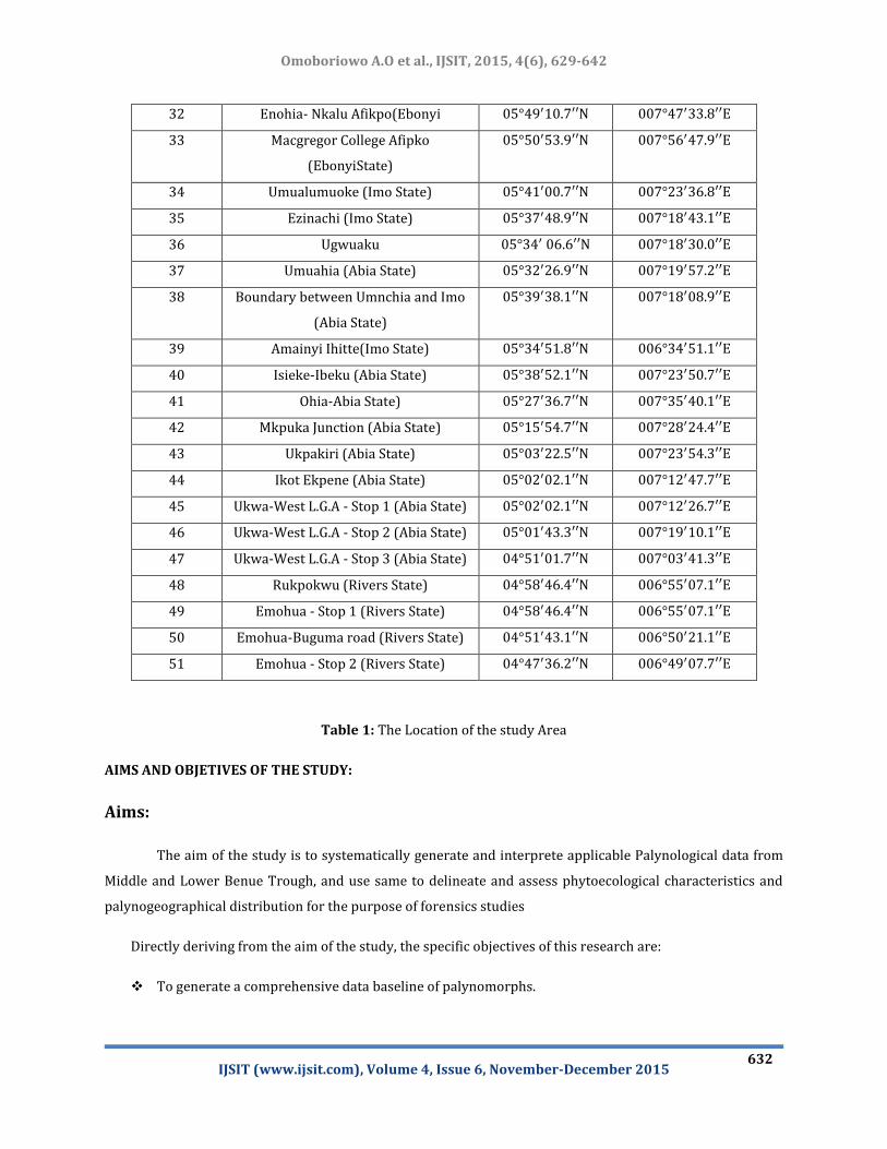
LOCATION OF THE STUDY AREA:
The coordinates of the study areas range from longitudes 6.49 0E and 8.330E and latitudes 4.470 N
and 8.35 0 N. ( Table 1).

et al., IJSIT, 2015, 4(6), 629-642 Omoboriowo A.O
IJSIT (www.ijsit.com), Volume 4, Issue 6, November-December 2015
631
Sample
Number
Towns Latitude Longitude
01 Nassarawa, Markudi Rd.,Maraba
02 Akunza vill,Maraba
03 Akunza Migili (NasarawaState)
04 Duduguru Junction
05 Duduguru Village
06 Acaraju Road
07 Akanga Town
08 Kadarko
09 Ishere (Benue)
10 Markurdi-Yandev Rd
(Tyo-mu Town)
11 Ikpayongo
12 Ikpayongo
13 Igbor
14 Howe
15 Oturkpo (Benue State
16 Oturkpo (Benue State
17 Ozalla (Enugu State) Ozalla (Enugu
State)
18 Agbani (Enugu State)
19 Isi Ewaa
20 Ihe (Enugu State)
21 Ogugu - Stop 1(Enugu State)
22 Ogugu - Stop 2(Enugu State)
23 Agwu (Enugu State)
24 Agwu (Enugu State)
25 Lokpanta (Abia State)
26 Nkalagu (Ebonyi State)
27 Abakaliki-Afikpo Road
28 Amuzu(Amuzu Ezza South L.G.A
29 Abumege (12.6km to Afikpo)
30 Afikpo (Ebonyi State)
31 Afikpo-Mgbom (Ebonyi State)
et al., IJSIT, 2015, 4(6), 629-642 Omoboriowo A.O
IJSIT (www.ijsit.com), Volume 4, Issue 6, November-December 2015
632
Table 1: The Location of the study Area
AIMS AND OBJETIVES OF THE STUDY:
Aims:
The aim of the study is to systematically generate and interprete applicable Palynological data from
Middle and Lower Benue Trough, and use same to delineate and assess phytoecological characteristics and
palynogeographical distribution for the purpose of forensics studies
Directly deriving from the aim of the study, the specific objectives of this research are:
To generate a comprehensive data baseline of palynomorphs.
32 Enohia- Nkalu Afikpo(Ebonyi
33 Macgregor College Afipko
(EbonyiState)
34 Umualumuoke (Imo State)
35 Ezinachi (Imo State)
36 Ugwuaku
37 Umuahia (Abia State)
38 Boundary between Umnchia and Imo
(Abia State)
39 Amainyi Ihitte(Imo State)
40 Isieke-Ibeku (Abia State)
41 Ohia-Abia State)
42 Mkpuka Junction (Abia State)
43 Ukpakiri (Abia State)
44 Ikot Ekpene (Abia State)
45 Ukwa-West L.G.A - Stop 1 (Abia State)
46 Ukwa-West L.G.A - Stop 2 (Abia State)
47 Ukwa-West L.G.A - Stop 3 (Abia State)
48 Rukpokwu (Rivers State)
49 Emohua - Stop 1 (Rivers State)
50 Emohua-Buguma road (Rivers State)
51 Emohua - Stop 2 (Rivers State)
et al., IJSIT, 2015, 4(6), 629-642 Omoboriowo A.O
IJSIT (www.ijsit.com), Volume 4, Issue 6, November-December 2015
633
Attempt palaeoecological reconstruction of the study area.
Establish a Phytoecological map for the study area
SCOPE OF THE STUDY:
Scope of Study:
i). Obtain samples from the sampled locations
ii).Prepare and analyse the samples for their palynological content
iii). Inteprete the analysed samples in line with standard palynological methods
iv). Present the results using statistical models
v). Draw up conclusions from the findings
vi). Present the report as a dissertation.
GEOLOGY AND VEGETATION OF THE STUDY AREA:
(i) The Middle Benue Trough: In the Middle Benue Trough, around the Obi/Lafia area, six Upper
Cretaceous lithogenetic formations comprise the stratigraphic succession. This succession is made up of the
Albian Arufu, Uomba, Gboko Formation, generally referred to as the Asu River Group (Offodile, 1976,
Nwajide, 1990). These are overlain by the Cenomanian Keana and Awe Formations and the Cenomanian-
Turonian Ezeaku Formation. The Ezeaku Formations is conterminous with the Konshisha River Group and
the Wadata Limestone in the Makurdi area. The Late Turonian-Early Santonian coal-bearing Awgu Formation
lies conformably on the Ezeaku Formation. In the Markurdi area, the Makurdi Sandstone interfingers with the
Awgu Formation. The mid-Santonain was a period of folding throughout the Benue Trough. The post-folding
Campano-Maastrichtian Lafia Formation ended the sedimentation in the Middle Benue Trough, after which
widespread volcanic activities tool over in the Tertiary. The Asu River Group outcrops mainly in the Keana
anticline east of Keana town and south of Azara; and in the area around Gboko with a typical section in the
Quarry of the Benue Cement Company near Yandev. The lithologic composition of the group comprises
mainly limestones, shales, micaceous siltstones, mudstones and clays (Offodile, 1976). The average thickness
is estimated to be about 1,800m.
The Awe Formation was deposited as passage (transitional) beds during the Late Albian Early
Cenomanian regression. Its typical sections occur around the town of Awe, where Offodile (1976) estimated
et al., IJSIT, 2015, 4(6), 629-642 Omoboriowo A.O
IJSIT (www.ijsit.com), Volume 4, Issue 6, November-December 2015
634
the thickness to be about 100m. The formation consists of flaggy, whitish, and medium to coarse grained
calcareous sandstones, carbonaceous shales and clays. The Keana Formation resulted from the Cenomanian
regression which deposited fluviodeltaic sediments. The formation consists of cross-bedded, coarse grained
feldsparthic sandstones, occasional conglomerates, and bands of shales and limestones towards the top.
Massive outcrops occur at Keana, Noku, Chikinye, Jangerigeri, Azara and Daudo. The deposition of the Ezeaku
Formation is attributed to the beginning of marine transgression in the Late Cenomanian. The sediments are
made up mainly of calcareous shales, micaceous fine to medium friable sandstones and beds of limestone
which are in places shelly. The deposition took place in a presumably shallow marine coastal environment.
Outcrops of the Ezeaku Formation include those at Ortesh, about 4km east of the village of Jangerigeri where
the sediments are composed mainly of shaley limestone (almost entirely of oyster shells). In the bank of River
Tokura, about 20km east of Keana town, on the Chikinye-Awe road, a typical section of the Ezeaku Formation
occurs, consisting mainly of intercalations of shaley limestone and black shale with brownish fine to coarse
grained feldsparthic sandstones at the top.
(ii) The lower Benue Trough/Anambra Basin: Sedimentation in the Lower Benue Trough commenced
with the marine Albian Asu River Group, although some pyroclastics of Aptian-Early Albian ages have been
sparingly reported (Ojoh, 1992). The Asu River Group in the Lower Benue Trough comprises the shales,
limestones and sandstone lenses of the Abakaliki Formation in the Abakaliki area and the Mfamosing
limestone in the Calabar Flank (Petters, 1982). The marine Cenomanian Turonian Nkalagu Formation (black
shale’s, limestone and siltstones) and the interfingering regressive sandstones of the Agala and Agbani
Formations rest on the Asu River Group. Mid-Santonian deformation in the Benue Trough displaced the major
depositional axis westward which led to the formation of the Anambra basin. Post-deformational
sedimentation in the Lower Benue Trough, therefore, constitutes the Anambra Basin. Sedimentation in the
Anambra Basin thus commenced with the Compano-Maastrichtian marine and paralic shales of the Enugu
and Nkporo Formation, overlain by the coal measures of the Mamu Formation.
(iii) Climate and vegetation The study area lies mostly within mangrove and rainforest (Figure 1). The
climatic condition of the country varies, with rainfall being the major controlling factor. Amount of rainfall
increases southward with a marked alternation of wet and dry seasons all year round. Temperature
throughout Nigeria is generally high; diurnal variations are more pronounced than seasonal ones. Highest
temperature occurs during the dry season, rains and moderate afternoon highs occur during the wet season.
In the study area, average highs and lows are 320C and 240C in January and 300C and 240C in June
(htt://countrystudies.us/Nigeria/33.htm). The rainy season lasts for about eight months and the dry season
lasts for about four months n the area. The annual rainfall within the study area is high ranging from 1400m
in the north to 2500m in the south. It is heaviest between the months of June and September, and driest
between November and February.

et al., IJSIT, 2015, 4(6), 629-642 Omoboriowo A.O
IJSIT (www.ijsit.com), Volume 4, Issue 6, November-December 2015
635
According to Olorode (2002), the study area and its environ lie within the wet rainforest belt of
Nigeria with the presence of emergent tall trees like Tarrieta utilis and Cyanometra ananta. The area is rich in
flora of herbaceous flowering plants like epithytic ferns (Ptycerium sp., Trichomanes sp.), mosses and
liverworts.
The field mapping of the study area was undertaken during the dry season when undergrowths of
the thick vegetation are sparse.
14°N
12°N
10°N
8°N
6°N
4°N
2 ° E 4 ° E 6 ° E 8 ° E 10 ° E 12 ° E 14 ° E
Figure 1: Vegetation Map of Nigeria showing Vegetative Types
(adapted from Iloeje, 1979)

et al., IJSIT, 2015, 4(6), 629-642 Omoboriowo A.O
IJSIT (www.ijsit.com), Volume 4, Issue 6, November-December 2015
636
METHODOLOGY
Palynological samples and slides preparation: Samples were prepared for palynological studies. About 5
gram of each sample was placed in a labeled cup in which 100ml of 70% hydrofluoric acid (HF) was added
with the aim of separating the palynomorphs from the other rock debris by digesting the silica in sample. The
samples were then washed and the slides prepared. A portion of the kerogen was mixed with 0.1% PVA
solution, pipette onto a cover slip and allowed to dry. The remainder of the kerogen was sieved at 20μ. A
portion of the sieved material was mixed with PVA solution pipette onto a cover slip and allowed to dry. The
cover slips were mounted upon a microscope slide using norland adhesive. The slides were properly labeled
and observed under research microscope through which snapshot was taken.
RESULTS AND DISCUSSION
Palynological Baseline data acquisition of surfacial rocks from the Middle and Lower Benue Trough
were carried out. Samples were obtained from 51 Locations covering several States of Nigeria (See Table 1
for co-ordinate). Samples from Location 1 to 8 covered Nasarawa State. The places covered within the state
were Maraba, Akunza village, Akunza Migili , Duduguru Junction, Duduguru Village, Acaraju Road, Akanga
Town, Kadarko.
Location 9 to 16 are in Benue State. The places covered within the state are; Ishere , Tyo-mu Town,
Ikpayongo, Igbor, Howe, Oturkpo,.
Enugu State comprises locations 17 to 24. The places covered are Ozalla, Agbani, Isi Ewaa, Ihe,
Ogugu , Agwu.
Abia state is made up of locations 25, 37,38, 40-47 Lokpanta, Ugwuaku, Umuahia, Boundary between
Umnchia and Imo, Isieke-Ibeku , Ohia-Abia, Mkpuka Junction , Ukpakiri, Ikot Ekpene, Ukwa-West L.G.A - Stop
1, Ukwa-West L.G.A - Stop 2 , Ukwa-West L.G.A - Stop 3 .
Locations 26-33 are in Ebonyi State and comprises Nkalagu , Abakaliki-Afikpo Road, Amuzu,
Abumege , Afikpo.
Locations 34-36 and 39 are in Imo State and comprises Umualumuoke, Ezinachi, Amainyi Ihitte.
Locations 48 to 51 are in Rivers State and comprises; Rukpokwu , Emohua, Emohua-Buguma road.
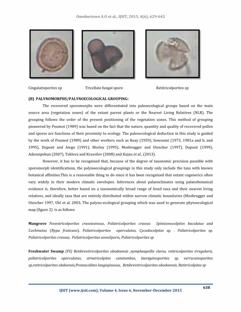
(A) PALYNOMORPHS:
Palynological Analysisiof the samples from the various locations yielded pollen, spores, dinoflagellate
e.t.c Photographs of some of palynomorphs encountered are presented in Plate 1 . Location map are

et al., IJSIT, 2015, 4(6), 629-642 Omoboriowo A.O
IJSIT (www.ijsit.com), Volume 4, Issue 6, November-December 2015
637
superimposed on the vegetational map to establish relationship with vegetational zones and as a result
phytoecological map was generated. Interpretation are based on the Scheme of Sowunmi 1981 Germeraad et
al 1968, Ige 2009 and Hutchinson and Dalziel (1968).
Cingulatisporites sp Leiotriletes sp, Fungal spore
Zonocostites ramonae, Verrucattosporites alienus Laevigatosporites discordatus
Rugulatisporites caperatus Psilatriporites sp Broken pollen
et al., IJSIT, 2015, 4(6), 629-642 Omoboriowo A.O
IJSIT (www.ijsit.com), Volume 4, Issue 6, November-December 2015
638
Cingulatisporites sp Tricellate fungal spore Retitricolporites sp
(B) PALYNOMORPHS/PALYNOECOLOGICAL GROUPING:
The recovered sporomorphs were differentiated into paleoecological groups based on the main
source area (vegetation zones) of the extant parent plants or the Nearest Living Relatives (NLR). The
grouping follows the order of the present positioning of the vegetation zones. This method of grouping
pioneered by Poumot (1989) was based on the fact that the nature, quantity and quality of recovered pollen
and spores are functions of their proximity to ecology. The paleoecological deduction in this study is guided
by the work of Poumot (1989) and other workers such as Keay (1959), Sowunmi (1973, 1981a and b, and
1995), Dupont and Awgu (1991), Morley (1995), Mosbrugger and Utescher (1997), Dupont (1999),
Adeonipekun (2007), Tekleva and Krassilov (2008) and Kujau et al., (2013).
However, it has to be recognized that, because of the degree of taxonomic precision possible with
sporomorph identifications, the palynoecological groupings in this study only include the taxa with known
botanical affinities.This is a reasonable thing to do since it has been recognized that extant cogenerics often
vary widely in their modern climatic envelopes. Inferences about palaeoclimates using palaeobotanical
evidence is, therefore, better based on a taxonomically broad range of fossil taxa and their nearest living
relatives, and ideally taxa that are entirely distributed within narrow climatic boundaries (Mosbrugger and
Utescher 1997, Uhl et al. 2003, The palyno-ecological grouping which was used to generate phytoecological
map (figure 2) is as follows
Mangrove Foveotricolporites crassiexinous, Psilatricolporites crassus Spinizonocolpites baculatus and
S.echinatus (Nypa fruticans). Psilatricolporites operculatus, Cycadocolpites sp, . Psilatricolporites sp,
Psilatricolporites crassus, Psilatricolporites annuliporis, Psilatricolporites sp
Freshwater Swamp (FS) Retibrevitricolporites obodoensis ,nympheapollis clarus, rettricolporites irregularis,
psilatricolporites operculatus, striatricolpites catatumbus, laevigatosporites sp, verrucatosporites
sp,rettricolporites obdoensis,Proteacidites longispinosus, Retibrevitricolporites obodoensis, Retitricolpites sp

et al., IJSIT, 2015, 4(6), 629-642 Omoboriowo A.O
IJSIT (www.ijsit.com), Volume 4, Issue 6, November-December 2015
639
Rainforest Elaeis guineensis, psilatricolporites crassus, echitriporites triangulisformis, podoceiporites sp,
stereisporites sp, . Echipriporites spinosus
Savana Polyadopollenites spp, Striatricolpites catatumbus, Retistephanocolporites gracilis,monoporites
annulatus, multiareolites formosus, cyperceaepollis sp, echitricollporites spinosus, fenestrites spinosus
Multiareolites formosus
Figure 2: Phytoecological map of the study area
et al., IJSIT, 2015, 4(6), 629-642 Omoboriowo A.O
IJSIT (www.ijsit.com), Volume 4, Issue 6, November-December 2015
640
PALEOECOLOGY:
Pollen and spore is slightly more abundant in all the study location the location than any other
palynomorphs (Elaeis guinensis – Echitricloporites spinosus zone). abundant of fungal spore and acritarch
which shows a clear distinctive characteristic of freshwater/rain forest (Retistephanocolpites gracillis)
characteristic of the Benin formation and they are mangrove elements, Zonocostites ramonae and
Psilatricolporites sp, the marine representative (foraminiferal test livings, dinoflagellate, acritarchs and
diatom), indicating coastal and shallow marine environments, close to mangrove vegetation, although more
typical of freshwater environment, can also occur in slightly brackish water, due to its tolerance to salinity
(Rull, 1997b). The main palynomorph that characterize the Nsukka Formation and member of the
Maastrichtian are (Aletepollenites sp, Multiareolites formosus, Magneperiporities spinosus, Psilatricolporites sp,
Echitricolporties spinosus, Retitricolporites sp, Fenestries spinosus, Elaeis guinnesis, Monoporites annuilatus,
Retidiporites magdalenensis, Constructripollenites ineffectus, Echimonocolpites rarispinosus. This is consistent
with the presence of alluvial plain environments flooded by freshwater. From the vegetation point of view,
the Benin formation with age Miocene–Pliocene, it is considered to be a mangrove assemblage which show a
high numerical count of Zonocostites ramonae which is compose of palynomorph of vegetation flooded by
fresh low salinity water and is characterize by transitional / tidal zone environmental conditions. But fungal
spores represent another type of coastal swamps (palm/ fern swamps common in the Neotropics) in the
freshwater swamp/rain forest of alluvial plain beyond the limit of tidal influence. Therefore, this assemblage
is thought to represent the more inland vegetation required in this research work the pollen from mangroves
was believed to have substantially increase to a very high grains, probably transported landward by wind: the
first zone which is Echitricolporites spinosus; therefore, the significant could be due in part to environment
and evolutionally factors, considering that;
(1) it could have originated in these environments, (2) the major transport agents for playnomorphs
in alluvial plain are wind and (3) were deposited in more distal environments freshwater swamp/rain forest,
this can be explained by an increased of wind capacity. Current paleogeographic reconstructions support
these points. Therefore in the study area more work is needed to establish or infer a better vegetational
history. Similar numbers of this pollen occur only inland, in freshwater environment, most probably due to
wind transport (Muller, 1959; ten Broek and Nijssen, 1971).
REFERENCES
1. Avbovbo, A. A., 1978. Tertiary Lithostratigraphy of Niger Delta. Am. Assoc. Petrol. Geol. Bull., 62: 295-306.
2. Amajor, L.C., 1976. Alluvial fan facies in the Miocene – Pliocene coastal plain sands, Niger Delta.

et al., IJSIT, 2015, 4(6), 629-642 Omoboriowo A.O
IJSIT (www.ijsit.com), Volume 4, Issue 6, November-December 2015
641
Sedimentary Geol. Vol. 49, p 1-20.
3. Bryant, V.M, JR., Jones, J., and Mildenhall, D., 1990. Forensic palynology in the United States of America;
Palynology, 14: 193-208.
4. Bradford, M. R. 1975. New dinoflagellate cyst genera from the recent sediments of the Persian Gulf.
Canadian Journal of Botany, 53, 3064 3074.
5. Burke, K., 1972. Longshore drift, submarine canyons and submarine fans in development of Niger Delta:
American Association of Petroleum Geologists Bulletin, V. 56, p 1975-1983.
6. Brenner, G. J. 1963. The spores and pollen of the Potomac Group of Marland. Maryland Dept. Geol. Mines
Water Res., Bull., no.27. 1215, pl .l 43.
7. Cookson, I. C., 1953b. The identification of the sporomorph Phvllocladiditea with Bacrydiu, and its
distribution in southern Tertiary Deposits. Aust. Jour. Bot.,
8. Davis, M.B., L.B. Brubaker and J.M. Beiswenger, 1971. Pollen grains in lake sediments; pollen percentages
in surface sediments from Southern Michigan. Quaternary Res., 1: 450-467.
9. Doust, H., and Omatsola, E., 1990. Niger Delta Bull. Amer. Assoc. Pet. Geol; vol. 48, p 201-238.
10. Evitt, W. R. 1981. The difference it makes that dinoflagellates did it differently. Newsletter of the
International Commission for Palynology, 4, no. 1, 6 7.
11. Germeraad, J.H., Hopping, C.A., and Muller, J., 1968. Palynology of Tertiary sediments from tropical areas.
Rev. Palaeobotan. Palynol., 6, 189-348.
12. Hoque, M., 1984. Pyroclastics from the Lower Benue Trough of Nigeria and their tectonic implications. J.
Afr. Earth Sci., 2, 351-358.
13. Hoeje, N. P. (1981). New Geography of Nigeria. Longman Nigeria Ltd. Ikeja pp 13 – 56.
14. Mildenhall, D.C., 1988. Deer velvet and palynology: An example of the use of forensic palynology in New
Zealand; Tuatara, 30:1-11.
15. Oloto, I.N., 1990. Palynological assemblage from the Danian of south west Nigeria. Acta Palaeobotanica 30
(112); 23 30.
16. Oloto, I.N., 1989. Maastrichtian dinoflagellate cyst assemblage from the Nkporo shale on the Benin flank
of the Niger Delta. Review of Palaeobotany and Palynology, 57: 173-186.

et al., IJSIT, 2015, 4(6), 629-642 Omoboriowo A.O
IJSIT (www.ijsit.com), Volume 4, Issue 6, November-December 2015
642
17. Oloto, I.N., 1984. A palynological study of the late Cretaceous and Tertiary boreholes from southern
Nigerian sedimentary basin. University of Sheffield, England, unpublished thesis, 180pp, 37 plates.