PALEONTOLOGICAL RESOURCE ASSESSMENT MISSION …...Paleontological Resource Assessment, Mission...
36
PALEONTOLOGICAL RESOURCE ASSESSMENT MISSION TRAILS REGIONAL PARK MASTER PLAN UPDATE SAN DIEGO COUNTY, CALIFORNIA Prepared for: RECON ENVIRONMENTAL, INC. 1927 FIFTH AVENUE SAN DIEGO, CALIFORNIA 92101-2358 Prepared by: DEPARTMENT OF PALEOSERVICES SAN DIEGO NATURAL HISTORY MUSEUM P.O. BOX 121390 SAN DIEGO, CALIFORNIA 92112 Thomas A. Deméré, Ph.D., Director Eric G. Ekdale, Ph.D., Staff Paleontologist Shelly L. Donohue, Report Writer revised May 2016
Transcript of PALEONTOLOGICAL RESOURCE ASSESSMENT MISSION …...Paleontological Resource Assessment, Mission...

PALEONTOLOGICAL RESOURCE ASSESSMENT
MISSION TRAILS REGIONAL PARK
MASTER PLAN UPDATE
SAN DIEGO COUNTY, CALIFORNIA
Prepared for:
RECON ENVIRONMENTAL, INC.
1927 FIFTH AVENUE
SAN DIEGO, CALIFORNIA 92101-2358
Prepared by:
DEPARTMENT OF PALEOSERVICES
SAN DIEGO NATURAL HISTORY MUSEUM
P.O. BOX 121390
SAN DIEGO, CALIFORNIA 92112
Thomas A. Deméré, Ph.D., Director
Eric G. Ekdale, Ph.D., Staff Paleontologist
Shelly L. Donohue, Report Writer
revised May 2016
Paleontological Resource Assessment, Mission Trails Regional Park, Master Plan Update i
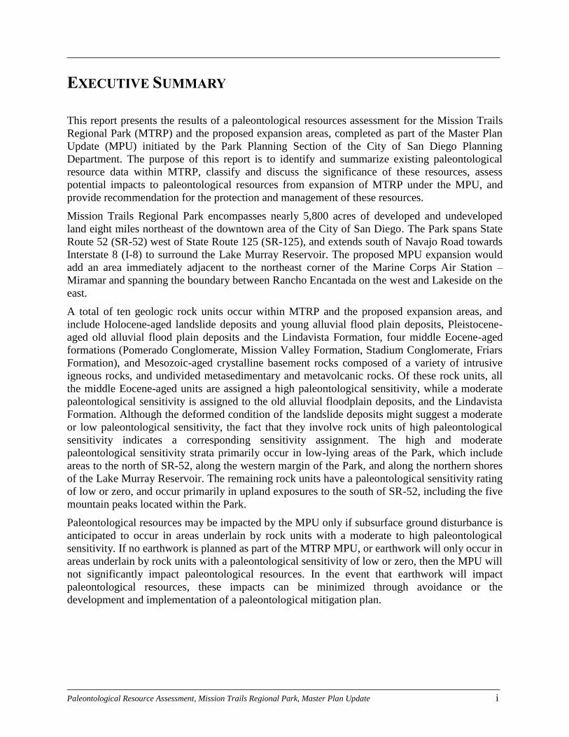
EXECUTIVE SUMMARY
This report presents the results of a paleontological resources assessment for the Mission Trails
Regional Park (MTRP) and the proposed expansion areas, completed as part of the Master Plan
Update (MPU) initiated by the Park Planning Section of the City of San Diego Planning
Department. The purpose of this report is to identify and summarize existing paleontological
resource data within MTRP, classify and discuss the significance of these resources, assess
potential impacts to paleontological resources from expansion of MTRP under the MPU, and
provide recommendation for the protection and management of these resources.
Mission Trails Regional Park encompasses nearly 5,800 acres of developed and undeveloped
land eight miles northeast of the downtown area of the City of San Diego. The Park spans State
Route 52 (SR-52) west of State Route 125 (SR-125), and extends south of Navajo Road towards
Interstate 8 (I-8) to surround the Lake Murray Reservoir. The proposed MPU expansion would
add an area immediately adjacent to the northeast corner of the Marine Corps Air Station –
Miramar and spanning the boundary between Rancho Encantada on the west and Lakeside on the
east.
A total of ten geologic rock units occur within MTRP and the proposed expansion areas, and
include Holocene-aged landslide deposits and young alluvial flood plain deposits, Pleistocene-
aged old alluvial flood plain deposits and the Lindavista Formation, four middle Eocene-aged
formations (Pomerado Conglomerate, Mission Valley Formation, Stadium Conglomerate, Friars
Formation), and Mesozoic-aged crystalline basement rocks composed of a variety of intrusive
igneous rocks, and undivided metasedimentary and metavolcanic rocks. Of these rock units, all
the middle Eocene-aged units are assigned a high paleontological sensitivity, while a moderate
paleontological sensitivity is assigned to the old alluvial floodplain deposits, and the Lindavista
Formation. Although the deformed condition of the landslide deposits might suggest a moderate
or low paleontological sensitivity, the fact that they involve rock units of high paleontological
sensitivity indicates a corresponding sensitivity assignment. The high and moderate
paleontological sensitivity strata primarily occur in low-lying areas of the Park, which include
areas to the north of SR-52, along the western margin of the Park, and along the northern shores
of the Lake Murray Reservoir. The remaining rock units have a paleontological sensitivity rating
of low or zero, and occur primarily in upland exposures to the south of SR-52, including the five
mountain peaks located within the Park.
Paleontological resources may be impacted by the MPU only if subsurface ground disturbance is
anticipated to occur in areas underlain by rock units with a moderate to high paleontological
sensitivity. If no earthwork is planned as part of the MTRP MPU, or earthwork will only occur in
areas underlain by rock units with a paleontological sensitivity of low or zero, then the MPU will
not significantly impact paleontological resources. In the event that earthwork will impact
paleontological resources, these impacts can be minimized through avoidance or the
development and implementation of a paleontological mitigation plan.
Paleontological Resource Assessment, Mission Trails Regional Park, Master Plan Update ii
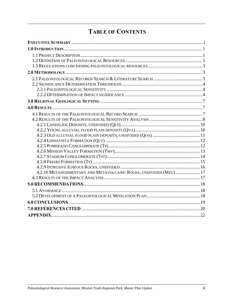
TABLE OF CONTENTS
EXECUTIVE SUMMARY ................................................................................................................... i
1.0 INTRODUCTION ........................................................................................................................ 1
1.1 PROJECT DESCRIPTION .......................................................................................................... 1
1.2 DEFINITION OF PALEONTOLOGICAL RESOURCES ................................................................... 1 1.3 REGULATIONS CONCERNING PALEONTOLOGICAL RESOURCES ............................................... 3
2.0 METHODOLOGY ....................................................................................................................... 3
2.1 PALEONTOLOGICAL RECORDS SEARCH & LITERATURE SEARCH .......................................... 3 2.2 SIGNIFICANCE DETERMINATION THRESHOLDS ...................................................................... 4
2.2.1 PALEONTOLOGICAL SENSITIVITY ................................................................................... 4 2.2.2 DETERMINATION OF IMPACT SIGNIFICANCE ................................................................... 4
3.0 REGIONAL GEOLOGICAL SETTING ......................................................................................... 7
4.0 RESULTS ................................................................................................................................... 7
4.1 RESULTS OF THE PALEONTOLOGICAL RECORD SEARCH ........................................................ 7 4.2 RESULTS OF THE PALEONTOLOGICAL SENSITIVITY ANALYSIS .............................................. 8
4.2.1 LANDSLIDE DEPOSITS, UNDIVIDED (QLS) ..................................................................... 10
4.2.2 YOUNG ALLUVIAL FLOOD PLAIN DEPOSITS (QYA) ........................................................ 10 4.2.3 OLD ALLUVIAL FLOOD PLAIN DEPOSITS, UNDIVIDED (QOA) ......................................... 11
4.2.4 LINDAVISTA FORMATION (QLV) .................................................................................. 12 4.2.5 POMERADO CONGLOMERATE (TP) ............................................................................... 12 4.2.6 MISSION VALLEY FORMATION (TMV) .......................................................................... 13
4.2.7 STADIUM CONGLOMERATE (TST) ................................................................................. 14 4.2.8 FRIARS FORMATION (TF) ............................................................................................. 15
4.2.9 INTRUSIVE IGNEOUS ROCKS, UNDIVIDED ..................................................................... 16 4.2.10 METASEDIMENTARY AND METAVOLCANIC ROCKS, UNDIVIDED (MZU) ..................... 17
4.3 RESULTS OF THE IMPACT ANALYSIS .................................................................................... 17
5.0 RECOMMENDATIONS ..................................................................................................... 18
5.1 AVOIDANCE ........................................................................................................................ 18
5.2 DEVELOPMENT OF A PALEONTOLOGICAL MITIGATION PLAN .............................................. 18
6.0 CONCLUSIONS .................................................................................................................. 19
7.0 REFERENCES CITED ....................................................................................................... 20
APPENDIX ................................................................................................................................. 22
Paleontological Resource Assessment, Mission Trails Regional Park, Master Plan Update 1
1.0 INTRODUCTION
This report presents a paleontological resource assessment for Mission Trails Regional Park
(MTRP) and the proposed expansion areas, completed as part of the Master Plan Update (MPU)
initiated by the Park Planning Section of the City of San Diego Planning Department. The
purpose of this report is to identify and summarize existing paleontological resource data within
MTRP, classify and discuss the significance of these resources, assess potential impacts to
paleontological resources from expansion of MTRP under the MPU, and provide
recommendation for the protection and management of these resources. This report includes the
results of a paleontological records search of the collections at the San Diego Natural History
Museum (SDNHM).
This report was prepared by Eric G. Ekdale, Shelly L. Donohue, and Thomas A. Deméré of the
SDNHM, Department of PaleoServices, under contract to RECON Environmental.
1.1 PROJECT DESCRIPTION
The MTRP MPU update is related to a 1985 Master Plan that was focused on the definition of
the Park’s setting in terms of physical environment, public plans and policies, land use and
ownership; identification of recreational and other open space potentials within the Park;
assessment of existing and potential relationships between MTRP and its immediate
surroundings; determination of MTRP boundaries; and preparation of a Master Development
Plan in consideration of park use, facility sizes, environmental and design concepts, and
environmental mitigations (Mission Trails Regional Park, 2008). As part of the MPU, a Natural
Resource Management Plan (NRMP) is being prepared to facilitate the protection and
management of both environmental and cultural resources that might be impacted during
implementation of the NRMP and recommendations in the MPU for MTRP.
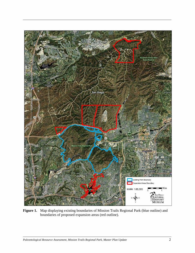
Mission Trails Regional Park encompasses nearly 5,800 acres of developed and undeveloped
land eight miles northeast of the downtown area of the City of San Diego, and it spans State
Route 52 (SR-52) west of State Route 125 (SR-125). The Park extends south of Navajo Road
towards Interstate 8 (I-8) to surround the Lake Murray Reservoir. The proposed MPU expansion
would add an area immediately adjacent to the northeast corner of the Marine Corps Air Station
– Miramar and spanning the boundary between Rancho Encantada on the west and Lakeside on
the east (Figure 1).
1.2 DEFINITION OF PALEONTOLOGICAL RESOURCES
As defined here, paleontological resources (i.e., fossils) are the buried remains and/or traces of
prehistoric organisms (i.e., animals, plants, and microbes). Body fossils such as bones, teeth,
shells, leaves, and wood, as well as trace fossils such as tracks, trails, burrows, and footprints, are
found in the geological deposits (formations) within which they were originally buried. The
primary factor determining whether an object is a fossil or not isn’t how the organic remain or
trace is preserved (e.g., “petrified”), but rather the age of the organic remain or trace. Although
typically it is assumed that fossils must be older than ~10,000 years (i.e., the generally accepted
end of the last glacial period of the Pleistocene Epoch), organic remains of early Holocene age
can also be considered to represent fossils because they are part of the record of past life.
Paleontological Resource Assessment, Mission Trails Regional Park, Master Plan Update 2
Figure 1. Map displaying existing boundaries of Mission Trails Regional Park (blue outline) and
boundaries of proposed expansion areas (red outline).
Paleontological Resource Assessment, Mission Trails Regional Park, Master Plan Update 3
Fossils are considered important scientific and educational resources because they serve as direct
and indirect evidence of prehistoric life and are used to understand the history of life on Earth,
the nature of past environments and climates, the membership and structure of ancient
ecosystems, and the pattern and process of organic evolution and extinction. In addition, fossils
are considered to be non-renewable resources because typically the organisms they represent no
longer exist. Thus, once destroyed, a particular fossil can never be replaced. And finally, for the
purposes of this report, paleontological resources can be thought of as including not only the
actual fossil remains and traces, but also the fossil collecting localities and the geological
formations containing those localities.
1.3 REGULATIONS CONCERNING PALEONTOLOGICAL RESOURCES
Because paleontological resources are considered scientifically and educationally significant
nonrenewable resources, they are protected under a variety of federal (e.g., Antiquities Act of
1906; National Environmental Policy Act of 1969; Federal Land Policy Management Act of
1976; Paleontological Resources Preservation Act of 2009), state (e.g., California Environmental
Quality Act; Public Resources Code), and local (e.g., County of San Diego and City of San
Diego Guidelines) laws, regulations, and ordinances. Additionally, established professional
standards are in place for the assessment and mitigation of paleontological resources (e.g., SVP,
2010; BLM, 2007; Murphey et al., 2014).
The City of San Diego primarily addresses the protection and management of paleontological
resources through CEQA, and has developed specific Significance Determination Thresholds
(City of San Diego, 2002; 2011). These guidelines are summarized below, in Section 2.2.
2.0 METHODOLOGY
2.1 PALEONTOLOGICAL RECORDS SEARCH & LITERATURE SEARCH
A formal paleontological records search of the fossil collections at the SDNHM was conducted
to determine if any known paleontological collection localities exist within a 1-mile radius of the
Project area.
In order to learn more about the specific geologic rock units within the Project area and their
fossil content, a review was conducted of relevant published and unpublished geologic and
paleontological reports (Dusenbury, 1932; Milow and Ennis, 1961; Kennedy and Moore, 1971;
Steineck et al., 1972; Kennedy, 1973; Kennedy, 1975; Kennedy and Peterson, 1975; Golz and
Lillegraven, 1977; Kern, 1978; Givens and Kennedy, 1979; Chandler, 1982; Flynn, 1986; Jefferson,
1991; Roeder, 1991; Squires and Deméré, 1991; Deméré and Walsh, 1993; Majors, 1993; Walsh,
1996; Walsh et al., 1996; Walsh, 1997; Walsh and Gutzler, 1999; Kennedy and Tan, 2005) and
museum paleontological site records (Department of Paleontology, SDNHM; Appendix). This
approach was followed in recognition of the direct relationship between paleontological
resources and the geologic formations within which they are entombed. Knowing the geologic
history of a particular area and the fossil productivity of geologic formations that occur in that
area, it is possible to predict where fossils will, or will not, be encountered.

Paleontological Resource Assessment, Mission Trails Regional Park, Master Plan Update 4
2.2 SIGNIFICANCE DETERMINATION THRESHOLDS
2.2.1 PALEONTOLOGICAL SENSITIVITY
In recognizing the fact that paleontological resources are considered to include not only actual
fossil remains and traces, but also the fossil collecting localities and the rock units containing
those fossils and localities, individual rock units are typically assigned a paleontological
sensitivity rating based on the results of the record search and literature search analyses. Criteria
used in the assessment include the known abundance of vertebrate fossils and significant non-
vertebrate fossils, or the potential for discovery of such fossils. The City of San Diego (2002;
2011) follows the sensitivity ratings outlined below.
HIGH PALEONTOLOGICAL SENSITIVITY – Rock units which, based on previous studies, contain
or are likely to contain paleontological collecting localities with rare, well-preserved, critical
fossil materials for stratigraphic or paleoenvironmental interpretation, and fossils providing
important information about the paleobiology and evolutionary history (phylogeny) of animal
and plant groups. Generally speaking, highly sensitive units produce vertebrate fossil remains or
are considered to have the potential to produce such remains.
MODERATE PALEONTOLOGICAL SENSITIVITY – Rock units which, based on previous studies,
are known to contain paleontological collecting localities with poorly preserved, common
elsewhere, or stratigraphically unimportant fossil material. The moderate sensitivity category is
also applied to geologic formations that are judged to have a strong, but unproven potential for
producing important fossil remains.
LOW PALEONTOLOGICAL SENSITIVITY – This category is assigned to rock units that, based on
their relatively youthful age and/or high-energy depositional history, are judged unlikely to
produce important fossil remains. Typically, low sensitivity units produce poorly-preserved
invertebrate fossil remains in low abundance.
ZERO PALEONTOLOGICAL SENSITIVITY – This category is assigned to geologic units that are
entirely igneous in origin (e.g., plutonic and/or volcanic), which form at temperatures and/or
pressures too high to support complex life, and thus have no potential for producing fossil
remains. Volcanic ash deposits can represent an exception to this general rule, as they may
preserve fossils as either body fossils or natural casts. Additionally, artificial fill material are
typically assigned no paleontological sensitivity, as any fossil they may contain have lost their
original stratigraphic and geographic contextual data, and thus are not scientifically significant.
2.2.2 DETERMINATION OF IMPACT SIGNIFICANCE
Direct impacts to paleontological resources occur when earthwork activities cut into the
geological rock units within which fossils are buried, and physically destroy the fossil remains.
As such, only earthwork activities that will disturb significant fossil-bearing sedimentary rocks
(i.e., those rated with a moderate to high paleontological sensitivity) have the potential to
significantly impact paleontological resources. Under CEQA and City of San Diego guidelines,
paleontological mitigation typically is recommended to reduce any negative impacts to
paleontological resources to less than significant levels. Alternatively, paleontological resource
avoidance is another option to reduce potential impacts.

Paleontological Resource Assessment, Mission Trails Regional Park, Master Plan Update 5
The purpose of the impact analysis is to identify areas where earthwork activities may disturb
potentially fossil-bearing sedimentary rocks, and thus may require avoidance and/or
paleontological mitigation.
Figure 2. Map displaying existing MTRP boundaries and MTRP southern expansion area with
mapped geology based on Kennedy and Tan (2005).

Paleontological Resource Assessment, Mission Trails Regional Park, Master Plan Update 6
Figure 3. Map displaying MTRP northern expansion area with mapped geology based on Kennedy
and Tan (2005).

Paleontological Resource Assessment, Mission Trails Regional Park, Master Plan Update 7
3.0 REGIONAL GEOLOGICAL SETTING
Topographically, the region of San Diego County in which MTRP is located is characterized by
elevated terraces (mesas) punctuated by intervening river valleys, which includes the San Diego
River Valley that extends in a northeast to southwest direction north of Mission Gorge Road through
the center of the Park. Geologically, this area consists of a layer cake sequence of Cenozoic
sedimentary rock units which preserve portions of the last 47 million years of Earth history. These
Cenozoic sedimentary rocks overlie a deeply eroded terrain formed in significantly older crystalline
basement rocks (e.g., metasediments, metavolcanics, gabbros, granites and tonalities) of the massive
Peninsular Ranges Batholith. The oldest sedimentary rocks, which are the rocks in which fossil are
most likely to be found, date from the Eocene Epoch and include the Friars Formation, Stadium
Conglomerate, Mission Valley Formation, and Pomerado Conglomerate. In two small areas along the
western edge of the Park boundaries, the Eocene strata are overlain by Pleistocene-age strata of the
Lindavista Formation. The Eocene strata are further overlain by much younger Pleistocene and
Holocene-age deposits in river valleys and areas of recent landslides west of North and South
Fortuna Mountains (Figures 2 and 3).
4.0 RESULTS
4.1 RESULTS OF THE PALEONTOLOGICAL RECORD SEARCH
A paleontological records search conducted at the San Diego Natural History Museum identified 50
discrete fossil collecting localities within MTRP and vicinity (Appendix Maps 1 through 5, with
annotated listing of localities). The geologic distribution of these localities breaks down as follows:
Friars Formation (27 localities), Mission Valley Formation (13 localities), Pomerado Conglomerate
(one locality), and Lindavista Formation (one locality). Eight localities were discovered in the late
Pliocene/early Pleistocene-age San Diego Formation to the west of MTRP and south of SR-52,
although the San Diego Formation does not crop out within the Park itself.
The vast majority of the localities discovered in the vicinity of MTRP and the proposed expansion
areas do not actually occur within the Park itself. However, three localities were discovered during a
previously conducted paleontological field survey along the western portion of Fortuna Saddle Trail
(Localities 3693, 3694, and 3886; Appendix). Localities 3693 and 3886 were discovered in the Friars
Formation, and Locality 3694 was discovered in the Mission Valley Formation (Appendix). No fossil
localities are recorded within either of the two expansion areas.
It should be emphasized that many of the fossil collecting localities recorded within the vicinity of
MTRP were discovered during monitoring of excavation activities associated with construction of
roadways (e.g., SR-52 and SR-125), construction of residential developments (e.g., Tierrasanta),
installation of water pipelines (e.g., San Diego Aqueduct), and improvements to water treatment
facilities (e.g., Alvarado Water Treatment Plant). This correlation of fossil collecting localities with
construction underscores the fact that paleontological resources may be unknown in a particular
region simply because they are currently buried and inaccessible and it isn’t until construction-related
excavations produce fresh exposures that fossils are unearthed and available for collection.
Paleontological Resource Assessment, Mission Trails Regional Park, Master Plan Update 8
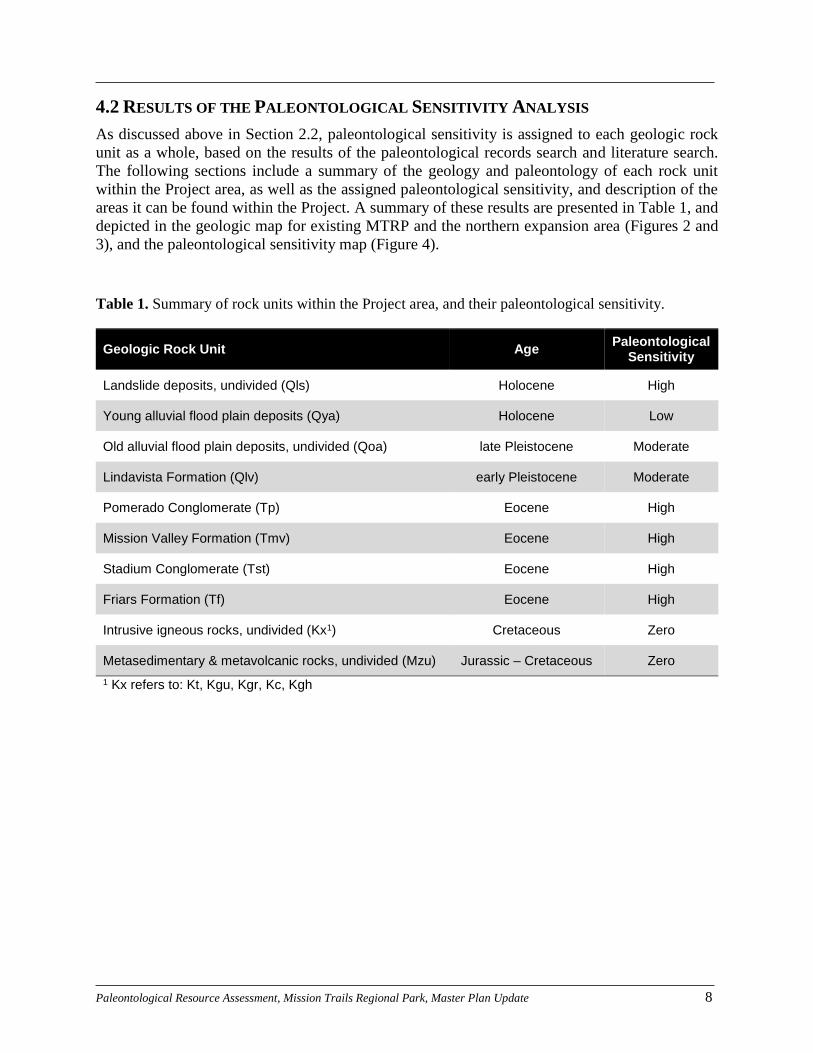
4.2 RESULTS OF THE PALEONTOLOGICAL SENSITIVITY ANALYSIS
As discussed above in Section 2.2, paleontological sensitivity is assigned to each geologic rock
unit as a whole, based on the results of the paleontological records search and literature search.
The following sections include a summary of the geology and paleontology of each rock unit
within the Project area, as well as the assigned paleontological sensitivity, and description of the
areas it can be found within the Project. A summary of these results are presented in Table 1, and
depicted in the geologic map for existing MTRP and the northern expansion area (Figures 2 and
3), and the paleontological sensitivity map (Figure 4).
Table 1. Summary of rock units within the Project area, and their paleontological sensitivity.
Geologic Rock Unit Age Paleontological
Sensitivity
Landslide deposits, undivided (Qls) Holocene High
Young alluvial flood plain deposits (Qya) Holocene Low
Old alluvial flood plain deposits, undivided (Qoa) late Pleistocene Moderate
Lindavista Formation (Qlv) early Pleistocene Moderate
Pomerado Conglomerate (Tp) Eocene High
Mission Valley Formation (Tmv) Eocene High
Stadium Conglomerate (Tst) Eocene High
Friars Formation (Tf) Eocene High
Intrusive igneous rocks, undivided (Kx1) Cretaceous Zero
Metasedimentary & metavolcanic rocks, undivided (Mzu) Jurassic – Cretaceous Zero
1 Kx refers to: Kt, Kgu, Kgr, Kc, Kgh

Paleontological Resource Assessment, Mission Trails Regional Park, Master Plan Update 9
Figure 4. Map of MTRP and proposed expansion areas with paleontological resource sensitivities.

Paleontological Resource Assessment, Mission Trails Regional Park, Master Plan Update 10
4.2.1 LANDSLIDE DEPOSITS, UNDIVIDED (QLS)
INTRODUCTION –Landslides that occurred during the Quaternary Period are common
occurrences in southern California. Although the landslides occurred relatively recently, the
transported sediment may be significantly older based on the age of original deposits that have
been incorporated into the body of the landslide. In general, landslide deposits in coastal San
Diego County contain highly fragmented to largely cohesive, unconsolidated to moderately well
consolidated sediments of Cenozoic age origin (Kennedy and Tan, 2005).
PALEONTOLOGY – Fossil remains have been recovered from landslide deposits that occur in
areas underlain by fossiliferous strata. Depending on the scale of the landslide and the various
rock units through which it cuts, contained fossils can sometimes be well-preserved and more or
less in their original stratigraphic context. However, in other cases fossils contained within
landslide deposits can be severely damaged and their stratigraphic context totally scrambled.
REGIONAL DISTRIBUTION – The undivided landslide deposits occur on slopes in various
locations throughout San Diego County.
DISTRIBUTION WITHIN THE APE – Landslide deposits occur in three major areas within the
existing Mission Trails Region Park boundaries, on the eastern slopes of the ridges west of the
Fortuna Mountains (Figure 2). Given the location of the landslide deposits, as well as the
geologic formations that the deposits were derived from, this unit likely contains a mixture of
rocks from the Pomerado Conglomerate, Mission Valley Formation, Stadium Conglomerate, and
Friars Formation.
RESOURCE SENSITIVITY – If a landslide occurs in an area of fossiliferous strata, then the
landslide deposits likely will contain fossils. However, the stratigraphic context of the fossils
may, or may not be preserved owing to the nature by which these deposits form (transportation
and mixture of sediments from their original areas of deposition). Because of the known fossil-
bearing potential of the Eocene rock units in the Project area and the small-scale nature of the
landslides in the Park, it is suggested that the landslide deposits may contain well-preserved fossils,
and so this rock unit is assigned a high paleontological resource sensitivity.
4.2.2 YOUNG ALLUVIAL FLOOD PLAIN DEPOSITS (QYA)
INTRODUCTION – The modern flood plains occupied by Peñasquitos Estuary, San Dieguito
Estuary, San Elijo Estuary, Batiquitos Estuary, Agua Hedionda, Buena Vista Estuary, and the
estuary at the mouth of the San Luis Rey River are underlain by poorly consolidated alluvial
sediments of Holocene age (i.e., younger than 10,000 years old). Lithologies in these deposits
consist of dark brown to dark gray, loose, silty fine-grained sands, fine-grained sandy silts, and
sandy clayed silts (Kennedy, 1975; Kennedy and Tan, 2005). In general, these deposits were laid
down by the ephemeral streams that seasonally occupy these drainages today.
PALEONTOLOGY – Fossils are generally unknown from the younger alluvial deposits in the
Coastal Plain of San Diego County, although there are two notable exceptions. A single
mammoth tusk was found in Quaternary alluvial deposits in the southwestern portion of El Cajon
Valley (SDNHM paleontological locality records) and a mammoth femur was recovered from
Quaternary alluvial deposits in the Santa Margarita River channel at the south end of the Camp
Pendleton Marine Corps Base. No recorded fossil localities have been discovered in younger

Paleontological Resource Assessment, Mission Trails Regional Park, Master Plan Update 11
alluvium in the vicinity of MTRP.
REGIONAL DISTRIBUTION – Younger alluvial deposits in the Coastal Plain of San Diego County
occur in all of the major river valleys. These deposits are the product of erosional and
depositional processes currently active within the respective watersheds.
DISTRIBUTION WITHIN THE APE – Younger alluvial sediments occur in various places within
the north-to-south oriented river valleys, particularly around the San Diego River and to the west
of Kumeyaay Lake (Figures 2 and 3).
RESOURCE SENSITIVITY – Based on its post-Pleistocene age, younger alluvium is assigned a low
paleontological resource sensitivity.
4.2.3 OLD ALLUVIAL FLOOD PLAIN DEPOSITS, UNDIVIDED (QOA)
INTRODUCTION – Coarse-grained and gravelly sandstone, pebble and cobble conglomerates, and
claystone deposits occur along the margins of many of the larger coastal valleys at levels above
active stream channels. In general, these unnamed river terrace deposits represent the courses of
prehistoric rivers. The exact age of the terrace deposits is uncertain, but they appear to be related
to climatic events of the late Pleistocene (10,000 to 50,000 years old). As mapped, these river
deposits probably represent several depositional systems across different periods of time.
Unfortunately, there is little stratigraphic data to separate the deposition events, and so they are
grouped together here.
PALEONTOLOGY – Fossils have been collected from Pleistocene-age alluvial deposits in various
locations around San Diego County from sediments unearthed during construction-related
activities. One such location was discovered on the south side of Sweetwater Valley, where well-
preserved fossils of pond turtles, passenger pigeons, hawks, moles, gophers, squirrels, rabbits
and horses were collected from fluvial sandstone and siltstone (Chandler, 1982; Jefferson, 1991;
Majors, 1993). A diverse assemblage of “Ice Age” mammals, such as ground sloths, insectivores,
mice, wolves, camels, deer, horses, mastodons, and mammoths, were recovered from the South
Bay Freeway (SR-54). Fossils of ground sloths also were collected from sandstones in the San
Dieguito River Valley (Deméré and Walsh, 1993). No recorded fossil localities have been
discovered in the older alluvium within one mile of MTRP.
REGIONAL DISTRIBUTION – The “unnamed river terrace deposits” occur along the margins of
larger coastal river valleys, such as Otay Valley, Sweetwater Valley, Mission Valley, San
Dieguito River Valley, San Luis Rey River Valley, and Santa Margarita River Valley, as well as
in isolated pockets associated with elevated marine terraces.
DISTRIBUTION WITHIN THE APE – The river terrace deposits occur along the eastern edge of the
expansion area of MTRP immediately north of SR-52 (Figure 2).
RESOURCE SENSITIVITY – The generally coarse-grained nature of the unnamed river deposits
coupled with the paucity of fossil remains might suggest a low paleontological resource
sensitivity. However, significant vertebrate remains have been collected from several areas in
southern California, which indicates that significant sites might occur elsewhere in these
deposits. Because of this, the unnamed river terrace deposits are assigned a moderate
paleontological resource sensitivity.

Paleontological Resource Assessment, Mission Trails Regional Park, Master Plan Update 12
4.2.4 LINDAVISTA FORMATION (QLV)
INTRODUCTION – The Lindavista Formation (Kennedy, 1975) represents a marine and/or non-
marine terrace deposit of early Pleistocene age (approximately 0.5-1.5 million years). Typical
exposures of the formation consist of rust-red, coarse-grained, pebbly sandstone to cobble
conglomerate with common deposits of green claystone in some locations. The Lindavista
Formation has an average thickness of approximately 20 to 30 feet and is thought to have been
deposited under fluvial, aeolian, and shallow nearshore marine conditions (Kennedy 1975). The
Lindavista Formation likely accumulated on a flat, wave-cut platform (i.e., sea floor) during a
period of sea level regression. Today, these deposits form the extensive mesa surfaces
characteristic of the Otay Mesa, San Diego Mesa, Linda Vista Mesa, Kearny Mesa, and Mira
Mesa areas of the County.
PALEONTOLOGY – Fossil collecting localities are rare in the Lindavista Formation and have only
been recorded from a few areas (e.g., Tierrasanta and Mira Mesa). Fossils collected from these
sites consist of remains of nearshore marine invertebrates including clams, scallops, snails,
barnacles, and sand dollars (Kennedy, 1973), as well as sparse remains of sharks, rays, and
baleen whales. According to the records of the SDNHM, one fossil collecting locality (Locality
456) was discovered in the Lindavista Formation within one mile of MTRP in Tierrasanta
(Appendix).
REGIONAL DISTRIBUTION – The Lindavista Formation occurs over a large area from the
International Border north to the City of San Clemente. Over this region, the formation and its
associated series of elevated terraces forms a conspicuous planar surface between the foothills of
the Peninsular Range Region and the western edge of the higher coastal terraces (i.e., minimum
elevation approximately 300 feet). These higher mesa surfaces are best preserved south of Black
Mountain. The higher terraces have been extensively dissected by erosion to the north of Black
Mountain and only remain as small, isolated remnants.
DISTRIBUTION WITHIN THE APE – The Lindavista Formation crops out only in a tiny area along
the southern part of the eastern shore of the Lake Murray Reservoir, as well as a small region
near the Park boundary to the west of the westernmost picnic area (Figure 2).
RESOURCE SENSITIVITY – Based on the scarcity of fossil remains (primarily marine
invertebrates) reported from this rock unit, the Lindavista Formation is assigned a moderate
paleontological resource sensitivity.
4.2.5 POMERADO CONGLOMERATE (TP)
INTRODUCTION – The Pomerado Conglomerate consists of a lower conglomerate member, the
middle Miramar Sandstone member, and an upper conglomerate member (Kennedy and
Peterson, 1975). The lower conglomerate member contacts the Mission Valley Formation with
local erosional and gradational contacts (Walsh, 2011). In turn, the overlying Miramar Sandstone
Member contacts the lower conglomerate member of the Pomerado Conglomerate with a
gradational contact. An erosional surface that separates the Miramar Sandstone from the upper
conglomerate member is best observed in the Scripps Ranch area, where it achieves an erosional
relief of up to five meters (Deméré and Walsh, 1993). The lower and middle members of the
Pomerado Conglomerate are late Uintan in age (Middle Eocene, 41 to 42 million years old),

Paleontological Resource Assessment, Mission Trails Regional Park, Master Plan Update 13
while the upper member has been identified as late Duschenean/ early Chadronian in age (latest
Middle to Late Eocene, 37 million years ago (Walsh and Gutzler, 1999; Walsh, 2011).
PALEONTOLOGY – Abundant terrestrial mammal fossils have been recovered from the lower
conglomerate member of the Pomerado Conglomerate, including insectivores, rodents, primates,
and artiodactyls (Walsh, 1996). The Miramar Sandstone Member has produced marine clams and
snails and a few terrestrial mammals, including artiodactyls and Miacis, an extinct carnivorous
mammal (Walsh, 1996). Fossils recovered from the upper conglomerate member include a
highly significant fossil assemblage of terrestrial mammals, consisting of opossums, artiodactyls,
rodents, and carnivores (Walsh and Gutzler, 1999). A single SDNHM fossil locality (Locality
3614) was discovered in the Pomerado Conglomerate along a portion of SR-52 adjacent to the
western side of MTRP (Appendix).
REGIONAL DISTRIBUTION – The Pomerado Conglomerate is exposed from La Mesa in the south
to Miramar Reservoir in the north, and east to Santee and Lakeside.
DISTRIBUTION WITHIN THE APE – The Pomerado Conglomerate crops out at the highest
elevations along the rim trails in the western third of the existing MTRP (Figure 2), as well as the
highest elevations in the expansion areas north of SR-52 and Marine Air Corps Station –
Miramar (Figure 3).
RESOURCE SENSITIVITY – The Pomerado Conglomerate as a whole, and particularly the upper
member, is assigned a high paleontological resource sensitivity based on discoveries of
scientifically significant fossils from the formation, as well as the close proximity of SDNHM
Locality 3614 (Appendix).
4.2.6 MISSION VALLEY FORMATION (TMV)
INTRODUCTION – The Mission Valley Formation consists of fine- to very fine-grained marine
sandstone in its type area along SR-163 on the south side of Mission Valley. Eastern and
southern exposures of the formation consist of fine- to medium-grained, fluvial sandstones, as
well as green and brown non-marine siltstone and mudstone. The maximum thickness of the
formation is 200 feet near its type location in Mission Valley, although it only reaches a
thickness of 60 feet at Scripps Ranch and 45 feet in Tierrasanta (Deméré and Walsh, 1993).
Strata of the Mission Valley Formation have been dated at 42.83 million years, using the Ar-Ar
radiometric dating method, placing the formation within the middle Eocene Epoch (Walsh,
1996). In fact, this formation is the only Eocene rock unit in southern California to contain fossil
mammal localities that are directly associated with a radiometric date (Deméré and Walsh,
1993).
PALEONTOLOGY – Well-preserved fossils of microorganisms (e.g., foraminiferans), clams,
snails, crabs, sea urchins, sharks, rays, and bony fish have been collected from the marine strata
of the Mission Valley Formation (Kern, 1978; Givens and Kennedy, 1979; Deméré et al., 1979;
Roeder, 1991). In addition, fluvial deposits of the formation have produced well-preserved fossil
remains of wood, as well as a diverse assemblage of terrestrial mammals, including opossums,
insectivores, bats, rodents, primates, artiodactyls, and perissodactyls (Golz and Lillegraven,
1977; Walsh, 1996). In fact, fossils of many of these organisms have been recovered from no
fewer than 13 SDNHM fossil collecting localities within one mile of the MTRP boundaries
(Appendix). One of these localities (Locality 3694) was discovered within the western portion
Paleontological Resource Assessment, Mission Trails Regional Park, Master Plan Update 14
MTRP at “Hill 781” along the Fortuna Saddle Trail (Appendix). The combined marine and non-
marine fossil assemblages that have been recovered from the formation allow for direct
correlation of marine and terrestrial faunas of the Eocene of southern California. In this respect,
the Mission Valley Formation is scientifically important, and it serves as one of a few instances
within North America from which such correlations can be ascertained (Golz and Lillegraven,
1977; Flynn, 1986; Walsh, 1996).
REGIONAL DISTRIBUTION – The Mission Valley Formation is discontinuously exposed between
Otay Valley in the south, Scripps Ranch in the north, Old Town in the west, and Spring Valley,
Fletcher Hills, and Santee in the east (Deméré and Walsh, 1993). Several distinctive sandstone
out crops in the regions of Rancho Bernardo, Rancho Peñasquitos, and Carmel Mountain Ranch
that contain vertebrate fossil remains that have been mapped as the Mission Valley Formation
more likely belong to the upper sandstone tongue of the Friars Formation, based on paleontology
(Walsh, 1996; Walsh et al., 1996).
DISTRIBUTION WITHIN THE APE – The Mission Valley Formation crops out mainly in the
western portion of MTRP, to the west of Fortuna Mountain. A smaller outcrop occurs along the
eastern shore of Lake Murray Reservoir (Figure 2).
RESOURCE SENSITIVITY – Because diverse fossil assemblages of marine invertebrates and non-
marine vertebrates have been recovered from the Mission Valley Formation, particularly within
MTRP and the surrounding area, this rock unit is assigned a high paleontological resource
sensitivity.
4.2.7 STADIUM CONGLOMERATE (TST)
INTRODUCTION – The stratigraphically complex Stadium Conglomerate (Kennedy and Moore,
1971) is divided into two lithologically distinct members – an upper member and a lower
member (Walsh et al., 1996). The lower member is composed of cobble to boulder
conglomerates with interbedded siltstone and mudstone, and disconformably underlies the upper
member, which is composed of sorted cobble and boulder conglomerates with crossbedded
sandstone lenses and thin beds of mudstone. The lower member has a maximum thickness of
approximately 100 feet (Deméré and Walsh, 1993). The upper member has a maximum
thickness of 60 feet (Walsh, 1996).
PALEONTOLOGY – The western exposures of the upper member of the Stadium Conglomerate in
the old Fenton gravel quarry in Mission Valley have yielded microfossils and marine mollusks
(Dusenbury, 1932; Steineck et al., 1972; Givens and Kennedy, 1979), although eastern exposures
of the formation typically are non-marine. The eastern outcrops have produced fossils of plants
and occasional well preserved skeletal remains of opossums, insectivores, primates, rodents,
carnivores, rhinoceroses, and artiodactyls. The vertebrate fossils indicate a late Uintan age
(middle Eocene), approximately 42 million years ago (Walsh, 1996). Sparse marine fossils are
found at the base and near the top of the lower member of the Stadium Conglomerate (Deméré
and Walsh, 1993; Walsh, 1996), although a very scientifically important, and somewhat unusual,
mammalian fauna was also recovered from the lower member of the Stadium Conglomerate
(Walsh, 1996; 1997). The mammal fossil assemblage appears to be transitional between the
underlying Friars Formation and the late Uintan terrestrial mammal fauna of the upper member
of the Stadium Conglomerate. The lower member is approximately 44 million years old.
Although the Stadium Conglomerate has produced numerous scientifically significant fossils,
Paleontological Resource Assessment, Mission Trails Regional Park, Master Plan Update 15
there are no recorded SDNHM fossil collecting localities from within one mile of the MTRP
boundaries (Appendix).
REGIONAL DISTRIBUTION – The Stadium Conglomerate is well exposed along the northern wall
of Mission Valley between SR-163 and Murphy Canyon, with exposures of the upper member
extending eastward from Murphy Canyon to Fletcher Hills, and southward from Mission Valley
to Imperial Avenue (Deméré and Walsh, 1993). The upper member also extends to Tierrasanta in
the north, but pinches out and does not reach SR-52. Exposures of Eocene conglomerates
mapped as the Stadium Conglomerate in the expansion areas north of SR-52 (Kennedy and
Moore, 1971; Kennedy, 1975; Kennedy and Tan, 2005) are likely the conglomerate tongue of the
Friars Formation.
DISTRIBUTION WITHIN THE APE – The Stadium Conglomerate has a limited area of exposure
within the main area of MTRP immediately above the Friars Formation to the west of Fortuna
Mountain south of SR-52 (Figure 2). More extensive outcrops of the Stadium Conglomerate
occur along the northern shore of Lake Murray Reservoir. Although Kennedy and Tan (2005)
identified extensive units north of SR-52 as the Stadium Conglomerate, those exposures more
likely belong to the conglomerate tongue of the Friars Formation as described above (Deméré
and Walsh, 1993; Walsh, 1996, 1997).
RESOURCE SENSITIVITY – Based on the important terrestrial mammal assemblage from the
Stadium Conglomerate, this rock unit is assigned a high paleontological resource sensitivity.
4.2.8 FRIARS FORMATION (TF)
INTRODUCTION – The Friars Formation was named for exposures of sedimentary rocks in
Mission Valley along Friars Road (Kennedy and Moore, 1971; Kennedy, 1975). This rock unit
generally consists of non-marine to lagoonal sandstones and claystones with interbedded
conglomerates. The formation is divided into three members (Walsh et al., 1996), which include
lower and upper sandstone and mudstone tongues that are separated by a middle conglomerate
tongue. The upper sandstone and mudstone members represent terrestrial paleoenvironments for
the most part (Kennedy, 1975), although marginal marine deposits occur within this member in
the west (Givens and Kennedy, 1979). The middle conglomerate tongue member is mainly
fluvial in origin, but as with the upper member, there are marine facies in western exposures. The
middle conglomerate tongue is the thickest of the three members, and is composed of thick
layers of light rust-brown and light gray cobbles and boulders, with common thin beds and rip-up
clasts of multicolored siltstone and mudstone. The lower tongue member lithologically is similar
to the upper member, consisting of light gray, fine- to medium-grained sandstone and greenish
and reddish siltstone and mudstone.
PALEONTOLOGY – All three members of the Friars Formation have produced significant
vertebrate fossils, including remains of opossums, insectivores, primates, rodents, and ungulates
(Golz and Lillegraven, 1977; Walsh, 1996). In addition, microfossils and fossil
macroinvertebrates indicative of marine paleoenvironments have been recovered from the Friars
Formation (Givens and Kennedy, 1979; Squires and Deméré, 1991), as well as fossilized leaf
material (Walsh, 1996). There are 27 SDNHM fossil collecting localities recorded from within a
one mile radius of the MTRP boundaries (Appendix) that have produced fossil plants, freshwater
invertebrates, and terrestrial vertebrates, including turtles, crocodiles, lizards, brontotheres, and
tapirs (in addition to many mammals reported by Golz and Lillegraven [1977] and Walsh
Paleontological Resource Assessment, Mission Trails Regional Park, Master Plan Update 16
[1996]). Two of these localities (Localities 3886 and 3693) were discovered within the western
portion of MTRP along Fortuna Saddle Trail (Appendix).
REGIONAL DISTRIBUTION – The Friars Formation crops out between Mira Mesa and Carmel
Valley in the west and Poway, Santee, and El Cajon in the east.
DISTRIBUTION WITHIN THE APE – The Friars Formation is exposed at lower elevations across
MTRP, particularly in the valleys and immediately west of Fortuna Mountain (Figure 2). The
formation is found on both sides of SR-52, and in a couple of areas along the north side of
Mission Gorge Road. The Friars Formation is exposed in the proposed expansion area north of
Marine Air Corps Station – Miramar (Walsh, 1996; Walsh et al., 1996; Deméré and Walsh,
1993; Figure 3), although geologic mapping by Kennedy and Tan (2005) mistakenly assigned
these strata to the younger Stadium Conglomerate.
RESOURCE SENSITIVITY – Based on the recovery of abundant, well-preserved, diverse, and
scientifically significant terrestrial vertebrate fossils and marine and freshwater invertebrate
fossils, all members of the Friars Formation are assigned a high paleontological sensitivity.
4.2.9 INTRUSIVE IGNEOUS ROCKS, UNDIVIDED
INTRODUCTION – The Cretaceous intrusive igneous rocks of San Diego County comprise part of
the northern end of the Peninsular Ranges Batholith that extends for several hundred miles south
into Baja California, Mexico. This complex mixture of plutonic igneous rocks in San Diego
County ranges in composition from granite to gabbro, and formed during the Cretaceous Period
(about 125 to 95 million years ago), which is coeval with the Sierra Nevada Batholith to the
north (Todd, 2004). These rocks formed due to the development of a major subduction zone off
the west coast of the North American continent during the Mesozoic. Oceanic crust was thrust
below continental crust, and as the cold, water-saturated oceanic crust descended into the earth’s
mantle, it became superheated and melted into buoyant magma bodies called plutons, which then
rose (intruded) through the overlying crust and slowly cooled several miles below the earth’s
surface to form the plutonic rocks now exposed within portions of MTRP.
Due to the similarity in composition and style of formation, all intrusive igneous rocks within the
Project area will be discussed as a single unit. The specific rock formations making up this unit
include: undivided hypabyssal rocks (Kgh), the Cuyamaca Gabbro (Kc), granitoid rocks (Kgr),
undivided tonalite (Kt), and undivided tonalite and granodiorite (Kgu).
PALEONTOLOGY – No fossils have been recovered from intrusive igneous rocks.
REGIONAL DISTRIBUTION – Undivided intrusive igneous rocks occur over large areas in central
San Diego County, and form the eastern margin of the coastal plain in western San Diego
County.
DISTRIBUTION WITHIN THE APE – Undivided intrusive igneous rocks contribute most of the rock
exposures in MTRP south of SR-52 (Figure 2). Furthermore, the five peaks in the Park (North
Fortuna, South Fortuna, Kwaay Paay, Pyles Peak, and Cowles Mountain) are composed of these
igneous rocks. Other isolated pockets of igneous rocks crop out along the eastern edge of the Park to
the north of SR-52 and along the north border of the northern expansion area (Figure 3).
Paleontological Resource Assessment, Mission Trails Regional Park, Master Plan Update 17
RESOURCE SENSITIVITY – Based on the high temperature and pressure conditions under which
intrusive igneous rocks formed, this unit is assigned a paleontological resource sensitivity of zero
(the lowest assignable score).
4.2.10 METASEDIMENTARY AND METAVOLCANIC ROCKS, UNDIVIDED (MZU)
INTRODUCTION – Crystalline basement rocks of late Jurassic to early Cretaceous age (145 to 125
million years old) in western San Diego County consist of low-grade metasedimentary rocks
(derived from siltstones, sandstones, and conglomerates) that are intermixed with metavolcanic
flows, tuffs and volcanoclastic breccias (Kennedy and Tan, 2005). These rocks have traditionally
been referred to as the Santiago Peak Volcanics (Kennedy, 1975).
PALEONTOLOGY – No fossils have been recovered from these rocks in the MTRP.
REGIONAL DISTRIBUTION – The undivided metasedimentary and metavolcanic rocks occur as a
discontinuous band in western San Diego County, extending from the San Ysidro Mountains in
the south to the northern border of the county.
DISTRIBUTION WITHIN THE APE – Outcrops of the metasedimentary and metavolcanic rocks
occur along the western foothills of the North and South Fortuna Mountains and along the north
side of Mission Gorge Road, west of Golfcrest Drive. Additional pockets of these crystalline
rocks crop out along the southwestern borders of Kumeyaay Lake in the east-central region of
the Park, and along the southwestern edge of the Lake Murray Reservoir in the south (Figure 2).
RESOURCE SENSITIVITY – Based on the conditions under which metasedimentary and
metavolcanic rocks form, this unit is assigned a paleontological resource sensitivity score of zero
(the lowest assignable score).
4.3 RESULTS OF THE IMPACT ANALYSIS
As demonstrated by the results of the paleontological records search, literature search, and
paleontological sensitivity analysis, paleontological resources are present within MTRP and
vicinity, and thus may be impacted by future construction associated with the MPU. Specific
impacts to paleontological resources would be in the form of subsurface ground disturbance in
areas underlain by rock units of high paleontological sensitivity (e.g., Pomerado Conglomerate,
Mission Valley Formation, Stadium Conglomerate, Friars Formation, and landslide deposits), or
moderate paleontological sensitivity (e.g., old alluvial flood plain deposits, Lindavista
Formation). The areas of moderate to high sensitivity primarily occur in the low-lying regions of
MTRP to the north of SR-52 (including the northern expansion area), in the western portion of
MTRP, and along the northern shores of the Lake Murray Reservoir, as outlined in Figures 2 – 4.
Such subsurface ground disturbance may include mass grading (e.g., for new buildings, roads, or
trails), trenching (e.g., for underground utilities), drilling with an auger greater than about 18
inches in diameter (e.g., for installation of above ground utility poles), or other miscellaneous
earthwork. If no subsurface ground disturbance is anticipated to occur as part of the MTRP
MPU, then significant impacts to paleontological resources will not occur.
Paleontological Resource Assessment, Mission Trails Regional Park, Master Plan Update 18
5.0 RECOMMENDATIONS
The following strategies are recommended to minimize impacts to paleontological resources. It
should be noted that these strategies only need to be employed during earthwork operations that
will impact areas underlain by rock units of high to moderate paleontological sensitivity (Figure
4). If no earthwork is planned, than paleontological resources will not be significantly impacted
by the MTRP MPU.
5.1 AVOIDANCE
Avoidance of project impacts to paleontological resources can, in some instances, be achieved by
project redesign so that paleontological resources are completely outside the project’s impact
area (e.g., moving the location of a proposed project element to an area away from the resource,
or developing a construction approach that does not involve excavations into potentially
fossiliferous strata).
5.2 DEVELOPMENT OF A PALEONTOLOGICAL MITIGATION PLAN
Development and implementation of a paleontological mitigation plan can minimize impacts
through the recovery and conservation of any fossils unearthed during construction.
Development of a paleontological mitigation plan commonly involves establishing pre-
construction, during-construction, and post-construction procedures and methods designed for
the specific conditions of a given project. Pre-construction measures generally address
professional qualifications, fossil repository selection, meeting attendance, and workers
environmental awareness training. During-construction measures generally address construction
monitoring, data recovery, safety considerations, and fossil discovery and recovery. Post-
construction measures generally address fossil preparation, fossil curation, fossil storage, and
final reporting.
The implementation of the paleontological mitigation plan typically is implemented during
construction (e.g., active monitoring of excavations), but in rare cases, monitoring and fossil
salvage occur prior to construction (e.g., fossils are readily visible in surficial sediments within
the project site, and are collected prior to the start of earthwork). Fossils recovered as a result of
mitigation are prepared and curated into a regional fossil repository.
Paleontological Resource Assessment, Mission Trails Regional Park, Master Plan Update 19
6.0 CONCLUSIONS
1. Portions of the Mission Trails Regional Park Master Plan Update, including the proposed
expansion areas, are underlain by geologic units assigned to moderate and high
paleontological resource sensitivities. These sensitive regions primarily occur in low-
lying areas of the park, which include areas to the north of SR-52, along the western
margin of the park, and along the northern shores of the Lake Murray Reservoir.
2. Paleontological resources may be impacted by the MPU only if subsurface disturbances
are anticipated to occur in paleontologically sensitive areas. Such subsurface ground
disturbance may include mass grading (e.g., for new buildings, roads, or trails), trenching
(e.g., for underground utilities), drilling with an auger greater than about 18 inches in
diameter (e.g., for installation of above ground utility poles), or other miscellaneous
earthwork.
3. If earthwork is anticipated to occur in areas of high to moderate paleontological
sensitivity, potential impacts to paleontological resources can be minimized either
through avoidance, or through the development and implementation of a paleontological
mitigation plan.

Paleontological Resource Assessment, Mission Trails Regional Park, Master Plan Update 20
7.0 REFERENCES CITED
Bureau of Land Management (BLM). 2007. Potential Fossil Yield Classification (PFYC) System for
Paleontological Resources on Public Lands. Instruction Memorandum No. 2008-009,
released October 15, 2007.
Chandler, R.M. 1982. A second record of Pleistocene passenger pigeons from California. Condor
84:242.
City of San Diego. 2002. City of San Diego Paleontology Guidelines. December 1996, Revised July
2002. 11 p.
City of San Diego. 2011. California Environmental Quality Act, Significance Determination
Thresholds. Development Services Department, 84 p.
Deméré, T.A., and S.L. Walsh. 1993. Paleontological Resources, County of San Diego. Prepared for
the Department of Public Works, County of San Diego, 1-68.
Deméré, T.A., F.A. Sundberg, and F.R. Schram. 1979. Paleoecology of a protected biotope from the
Eocene Mission Valley Formation, San Diego County, California. In, P.L. Abbott (ed.),
Eocene Depositional Systems, San Diego, California. Society of Economic Paleontologists
and Mineralogists, Pacific Section, pp. 97-102.
Dusenbury, A.N. 1932. A faunule from the Poway Conglomerate, upper middle Eocene of San Diego
County, California. Micropaleontology 3:84-85.
Flynn, J.J. 1986. Correlation and geochronology of middle Eocene strata from the western United
States. Palaeogeography, Palaeoclimatology, Palaeoecology 55:335-406.
Givens, C.R., and M.P. Kennedy. 1979. Eocene molluscan stages and their correlation, San Diego
area, California. In, P.L. Abbott (ed.), Eocene Depositional Systems, San Diego. Geological
Society of America, fieldtrip guidebook, pp. 81-95.
Golz, D.J., and J.A. Lillegraven. 1977. Summary of known occurrences of terrestrial vertebrates from
Eocene strata of southern California. University of Wyoming, Contributions to Geology
15:43-65.
Jefferson, G.T. 1991. A catalog of late Quaternary vertebrates from California. Natural History
Museum of Los Angeles County, Technical Reports 7:1-129.
Kennedy, G.L. 1973. Early Pleistocene invertebrate faunule from the Lindavista Formation, San
Diego, California. San Diego Society of Natural History, transactions 17:119-128.
Kennedy, M.P. 1975. Geology of the San Diego metropolitan area, California. Section A - Western
San Diego metropolitan area. California Division of Mines and Geology, Bulletin 200:9-39.
Kennedy, M.P., and G.W. Moore. 1971. Stratigraphic relations of upper Cretaceous and Eocene
formations, San Diego coastal area, California. American Association of Petroleum
Geologists, Bulletin 55:709-722.
Kennedy, M.P., and G.L. Peterson. 1975. Geology of the San Diego metropolitan area, California.
Section B, Eastern San Diego metropolitan area. California Division of Mines and Geology,
Bulletin 200:45-56.
Paleontological Resource Assessment, Mission Trails Regional Park, Master Plan Update 21
Kennedy, M.P., and S.S. Tan. 2005. Geologic map of the San Diego 30’ x 60’ quadrangle,
California. California Geological Survey, Regional Geologic Map Series, 1:100,000 Scale,
Map No. 3 (ftp://ftp.consrv.ca.gov/pub/dmg/rgmp/Prelim_geo_pdf/sandiego_map2_ai9.pdf)
Kern, J.P. 1978. Paleoenvironment of new trace fossils from the Eocene Mission Valley Formation,
California. Journal of Paleontology 52:186-194.
Majors, C.P. 1993. Preliminary report on a late Pleistocene vertebrate assemblage from Bonita, San
Diego County, California. In, R.G. Dundas and D.J. Long (eds.), New Additions to the
Pleistocene Vertebrate Record of California. PaleoBios 15:63-77.
Mission Trails Regional Park. 2008. Master Development Plan 1985. San Diego, California.
Murphey, P.C., G.E. Knauss, L.H. Fisk, T.A. Deméré, R.E. Reynolds, K.C. Trujillo, and J.J. Strauss.
2014. A Foundation for Best Practices in Mitigation Paleontology. Dakoterra 6: 243–285.
Roeder, M.A. 1991. A fossil fish fauna from the Upper Eocene Mission Valley Formation at the
Lake Miramar Filtration Plant, San Diego, San Diego County, California. In, P.L. Abbott and
J.A. May (eds.), Eocene Geologic History, San Diego Region. Society of Economic
Paleontologists and Mineralogists, Pacific Section 68:179-180.
Society of Vertebrate Paleontology (SVP). 2010. Standard Procedures for the Assessment and
Mitigation of Adverse Impacts to Paleontological Resources. Society of Vertebrate
Paleontology, p. 1-11.
Squires, R.L., and T.A. Deméré. 1991. A middle Eocene marine molluscan assemblage from the
usually non-marine Friars Formation, San Diego County, California. In P.L. Abbott and J.A.
May (eds.), Eocene Geologic History, San Diego Region. Society of Economic
Paleontologists and Mineralogists, Pacific Section 68:181-188.
Steineck, P.L., J.M. Gibson, and R. Morin. 1972. Foraminifera from the middle Eocene Rose Canyon
and Poway Formations, San Diego. Journal of Foraminiferal Research 2:137-144.
Walsh, S.L. 1996. Middle Eocene mammal faunas of San Diego County, California. In
D.R. Prothero and R.J. Emry (eds.), The Terrestrial Eocene-Oligocene Transition in North
America. Cambrige University Press, pp. 75-119.
Walsh, S.L. 1997. New specimens of Metanoiamys, Pauromys, and Simimys (Rodentia: Myomorpha)
from the Uintan (middle Eocene) of San Diego County, California, and comments on the
relationships of selected Paleogene Myomorpha. Proceedings of the San Diego Society of
Natural History 32:1-20.
Walsh, S.L. 2010. New myomorph rodents from the Eocene of southern California. Journal of
Vertebrate Paleontology 30:1610-1621.
Walsh, S. L., and R. Q. Gutzler. 1999. Late Duchesnean-early Chadronian mammals from the upper
member of the Pomerado Conglomerate, San Diego, California. Journal of Vertebrate
Paleontology 19(3, Supplement):82A.
Walsh, S. L., D.R. Prothero, and D.J. Lundquist. 1996. Stratigraphy and paleomagnetism
of the middle Eocene Friars Formation and Poway Group, southwestern San Diego County,
California. In D.R. Prothero and R.J. Emry (eds.), The Terrestrial Eocene-Oligocene
Transition in North America. Cambridge University Press, pp. 120-154.

Paleontological Resource Assessment, Mission Trails Regional Park, Master Plan Update 22
APPENDIX

SAN DIEGO NATURAL HISTORY MUSEUM
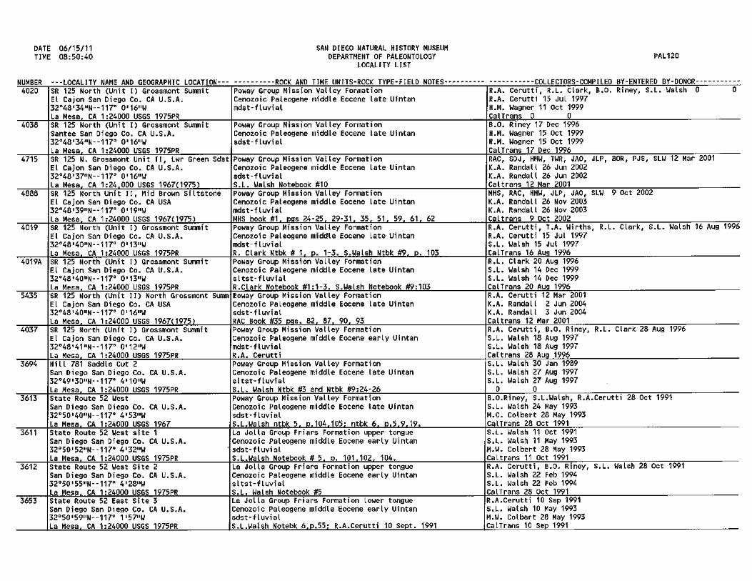
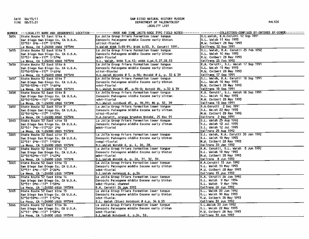
BALBOA PARK - SAN DIEGO SOCIETY OF NATURAL HISTORY - ESTABLISHED 1874 15 June 2011 Mr. Mike Nieto RECON Environmental 1927 Fifth Avenue San Diego, CA 92101-2358 RE: Mission Trails Regional Park Master Plan Update 2011 Dear Mr. Nieto:
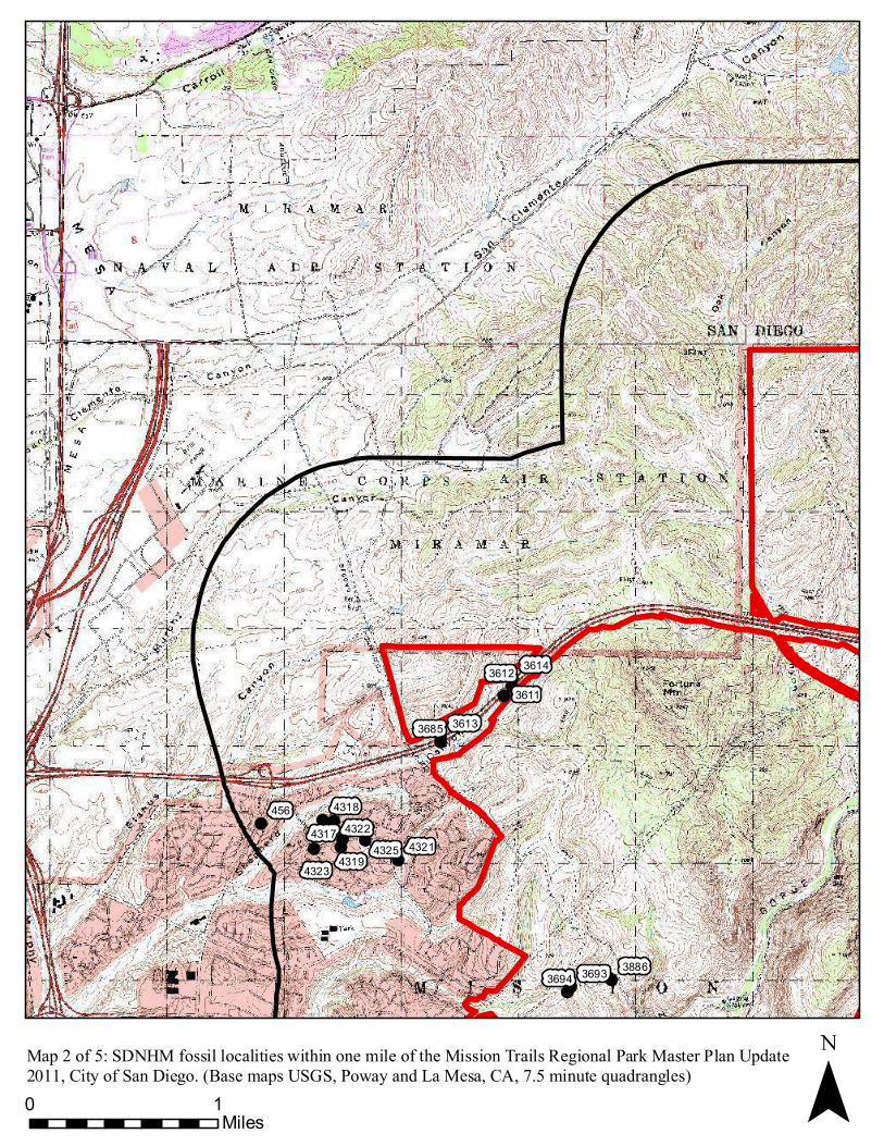
This letter presents the results of a paleontological record search conducted for the Mission Trails Regional Park Master Plan Update 2011, located mostly in eastern City of San Diego. Some small portions of the project do extend east into the Cities of Santee, El Cajon and La Mesa. The project site is within the neighborhoods of Rancho Encantada, Scripps Ranch, Tierrasanta, San Carlos, Lake Murray and Del Cerro and within the Rancho Encantada, East Elliott, Tierrasanta, and Navajo Community Plan Areas of the City of San Diego. The project can be separated into 5 areas. These include the current 5,242 acre Mission Trails Regional Park area, a 1,377 acre portion south of Scripps Poway Parkway and to the west of Sycamore Canyon Open Space Preserve, a 2,697 acre area north of State Route 52 and west of Santee Lakes, a 142 acre area north of State Route 52 and the north of the northwestern corner of the existing Mission Trails Regional Park, and lastly, south of the current park a 378 acre series of open spaces surrounding Lake Murray. The sedimentary rocks underlying the project site have been mapped by Kennedy (1975), Kennedy and Tan (2002), and Tan (2002) and as the Pleistocene-age (approximately 0.5 to 1 million years old) Lindavista Formation, the middle Eocene-age (37 million years old) Pomerado Conglomerate, (43 million years old) Mission Valley Formation, (44 million years old) Stadium Conglomerate and (46-47 million years old) Friars Formation. Walsh, et al. (1996) reassigned the Stadium Conglomerate in the area north of State Route 52 to the older, middle Eocene-age (46 to 47 million years old) Friars Formation based on micro-mammalian fossil assemblages (small rodent teeth).
The San Diego Natural History Museum has fifty recorded fossil localities (see attached list) within a one-mile radius of the project site (see attached maps). One of the localities occurs within the near shore marine deposits of the Lindavista Formation. This locality produced fossils of marine invertebrates (e.g., clams). One locality was in the fluvial Pomerado Conglomerate. This locality produced fossils of flowering plants and freshwater invertebrates (e.g., clams). Thirteen localities were discovered in the marine and fluvial Mission Valley Formation. These localities produced fossils of marine invertebrates (e.g., snails and clams), freshwater invertebrates (e.g. ostacods and insects), marine vertebrates (e.g., sharks), and terrestrial vertebrates (e.g. fish, turtles, crocodiles, lizards, birds, marsupials, insectivores, bats, rodents,
Post Office Box 121390 * San Diego, California 92112-1390 * Telephone 619-232-3821 * FAX 619-232-0248 * www.sdnhm.org

carnivores, primates, tapirs, and oreodonts). Twenty Seven of these localities are from the fluvial Friars Formation. These localities produced fossil of plants (e.g. green alge, sumac, willow, and other flowering plants), fresh water invertebrates (e.g., ostracods and snails), and terrestrial mammals (e.g., turtles, crocodiles, lizards, marsupials, insectivores, rodents, primates, carnivores, brontotheres, tapirs, and oreodonts). No fossil localities were discovered in the Stadium Conglomerate. Eight localities were discovered in the San Diego Formation which does not crop out within the project boundaries.
Depending on the depth of excavation, construction activities associated with the proposed project have the potential to impact sedimentary deposits of the Lindavista Formation, Pomerado Conglomerate, Mission Valley Formation, Stadium Conglomerate, and Friars Formation. Based on fossil localities in the region, Deméré and Walsh (1993) assigned the Lindavista Formation to have a moderate paleontological sensitivity and the Pomerado Conglomerate, Mission Valley Formation, Stadium Conglomerate, and Friars Formation to have a high paleontological sensitivity. Any fossils recovered from the excavations made at the project site are likely to be scientifically significant.
If you have any questions concerning these findings please feel free to contact me at 619-255-0310 or [email protected].
Sincerely,
Kesler A. Randall Collections Manager, Fossil Vertebrates Department of Paleontology
Literature Cited: Deméré, T. A. and S. L. Walsh. 1993. Paleontological Resources, County of San Diego.
Prepared for the San Diego Planning Commission: 1-68. Kennedy, M.P. 1975. Geology of the Western San Diego Metropolitan area, California.
California Division of Mines and Geology Bulletin. 200-A:1-39 Kennedy, M.P. and Tan, S.S. 2005. Geologic Map of the San Diego 30’ X 60’ Quadrangle,
California. California Geological Survey. Tan, S.S. 2002. Geologic map of the El Cajon 75.’ Quadrangle, San Diego County: A Digital
Database. California Geological Survey. Walsh, S.L., Prothero D.R., and Lundquist, D.J. 1996. Stratigraphy and paleomagnetism of the
middle Eocene Friars Formation and Poway Group, southwestern San Diego County, California. The Terrestrial Eocene-Oligocene Transition in North America: 120-154.

!( !(56165615
¯0 1Miles
Map 1 of 5: SDNHM fossil localities within one mile of the Mission Trails Regional Park Master Plan Update 2011, City of San Diego. (Base maps USGS, Poway and San Vicente Reservoir, CA, 7.5 minute quadrangles)
!(!(!(
!(!( !( !(!(
!(!( !(!(
!(!(
!(!(!(
!(!(!(
456
361436123611
36133685
43184322
43254319
4317
43234321
388636933694
¯0 1Miles
Map 2 of 5: SDNHM fossil localities within one mile of the Mission Trails Regional Park Master Plan Update 2011, City of San Diego. (Base maps USGS, Poway and La Mesa, CA, 7.5 minute quadrangles)

!(
!(
!(!(!(!(!(!(!(!(!(!(!(!(
!(!(!(
366736603663 36543655
36643666
36573656
3658
4034
¯0 1Miles
Map 3 of 5: SDNHM fossil localities within one mile of the Mission Trails Regional Park Master Plan Update 2011, City of San Diego. (Base maps USGS, Poway, La Mesa, San Vicente Reservoir, and El Cajon, CA, 7.5 minute quadrangles)

!(!(
!(
!(!(!(
!(!(!(
388636933694
377048184817
3383
37465523
¯0 1Miles
Map 4 of 5: SDNHM fossil localities within one mile of the Mission Trails Regional Park Master Plan Update 2011, City of San Diego. (Base map USGS La Mesa, CA, 7.5 minute quadrangle)
!(!(
!(
!(!(!(!(!(!(!(!(
!(
!(4034
4035
403754354019
4019
4888
40384020
3383
37465523
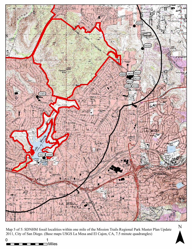
¯0 1Miles
Map 5 of 5: SDNHM fossil localities within one mile of the Mission Trails Regional Park Master Plan Update 2011, City of San Diego. (Base maps USGS La Mesa and El Cajon, CA, 7.5 minute quadrangles)