Paleogene Sediment Character of Mountain Front Central ... 20130304.pdf · Paleogene Sediment...
7
Indonesian Journal of Geology, Vol. 8 No. 3 September 2013: 143-149 Paleogene Sediment Character of Mountain Front Central Sumatra Basin Karakter Batuan Sedimen Paleogen Muka-Pegunungan, Cekungan Sumatra Tengah P. A. SUANDHI 1 , M. ROZALLI 1 , W. UTOMO 1, A. BUDIMAN 1 , and A. BACHTIAR 2 1 GDA Consulting 2 Exploration Think Tank Indonesia (ETTI) Manuscript received: September 24, 2012; revised: Mei 27, 2013; final acceptance: September 2, 2013 Corresponding Author: [email protected] ABSTRACT The SE-NW trending Mountain Front of Central Sumatra Basin is located in the southern part of the basin. The Mountain Front is elongated parallel to the Bukit Barisan Mountain, extending from the Regencies of North Padang Lawas (Gunung Tua in the northwest), Rokan Hulu, Kampar, Kuantan Singingi, and Inderagiri Hulu Regency in the southeast. The Palaeogene sediments also represent potential exploration objectives in Central Sumatra Basin, especially in the mountain front area. Limited detailed Palaeogene sedimentology information cause difficulties in hydrocarbon exploration in this area. Latest age information and attractive sediment characters based on recent geological fieldwork (by chaining method) infer Palaeogene sediment potential of the area. The Palaeogene sedimentary rock of the mountain front is elongated from northwest to southeast. Thickness of the sedimentary unit varies between 240 - 900 m. Palynology samples collected recently indicate that the oldest sedimentary unit is Middle Eocene and the youngest one is Late Oligocene. This latest age information will certainly cause significant changes to the existing surface geological map of the mountain front area. Generally, the Palaeogene sediments of the mountain front area are syn-rift sediments. The lower part of the Palaeogene deposit consists of fluvial facies of alluvial fan and braided river facies sediments. The middle part consists of fluvial meandering facies, lacustrine delta facies, and turbidity lacustrine facies sediments. The upper part consists of fluvial braided facies and transitional marine facies sediments. Volcanism in the area is detected from the occurrence of volcanic material as lithic material and spotted bentonite layers in the middle part of the mountain front area. Late rifting phase is indicated by the presence of transitional marine facies in the upper part of the Palaeogene sediments. Keywords: paleogene, sediments, mountain front, facies, Central Sumatra Basin SARI Area Muka-pegunungan Cekungan Sumatra Tengah, yang berarah tenggara-barat laut, terletak di bagian selatan cekungan tersebut. Muka pegunungan ini berbentuk lonjong dan sejajar dengan Pegunungan Barisan, yang memanjang dari Kabupaten Padang Lawas Utara (Gunung Tua di sebelah barat laut), Rokan Hulu, Kampar, Kuantan Singingi, sampai Inderagiri Hulu di sebelah tenggara. Batuan sedimen Paleogen juga merupakan salahsatu tujuan eksplorasi yang potential di Cekungan Sumatra Tengah, terutama di daerah muka-pegunungan. Informasi sedimentologi Paleogen yang kurang terperinci menimbulkan kesulitan dalam eksplorasi hidrokarbon di daerah ini. Potensi batuan sedimen Paleogen di daerah ini bisa dikaji dari informasi terbaru dan karakter batuan sedimen yang menarik berdasarkan data lapangan (metode chaining). Batuan sedimen muka-pegunungan ini yang sebarannya berbentuk lonjong dengan arah barat laut - tenggara, mem- punyai kisaran ketebalan antara 240 – 900 m. Percontoh palinologi terbaru menunjukkan bahwa umur unit batuan sedimen tertua adalah Eosen Tengah sementara yang termuda adalah Oligosen Akhir. Informasi umur 143
-
Upload
nguyentruc -
Category
Documents
-
view
219 -
download
2
Transcript of Paleogene Sediment Character of Mountain Front Central ... 20130304.pdf · Paleogene Sediment...
Indonesian Journal of Geology, Vol. 8 No. 3 September 2013: 143-149
Paleogene Sediment Character of Mountain Front Central Sumatra Basin
Karakter Batuan Sedimen Paleogen Muka-Pegunungan, Cekungan Sumatra Tengah
P. A. SuAndhi1, M. RozAlli1, W. utoMo1, A. BudiMAn1, and A. BAchtiAR2
1GDA Consulting2Exploration Think Tank Indonesia (ETTI)
Manuscript received: September 24, 2012; revised: Mei 27, 2013; final acceptance: September 2, 2013Corresponding Author: [email protected]
AbstrAct
The SE-NW trending Mountain Front of Central Sumatra Basin is located in the southern part of the basin. The Mountain Front is elongated parallel to the Bukit Barisan Mountain, extending from the Regencies of North Padang Lawas (Gunung Tua in the northwest), Rokan Hulu, Kampar, Kuantan Singingi, and Inderagiri Hulu Regency in the southeast. The Palaeogene sediments also represent potential exploration objectives in Central Sumatra Basin, especially in the mountain front area. Limited detailed Palaeogene sedimentology information cause difficulties in hydrocarbon exploration in this area. Latest age information and attractive sediment characters based on recent geological fieldwork (by chaining method) infer Palaeogene sediment potential of the area. The Palaeogene sedimentary rock of the mountain front is elongated from northwest to southeast. Thickness of the sedimentary unit varies between 240 - 900 m. Palynology samples collected recently indicate that the oldest sedimentary unit is Middle Eocene and the youngest one is Late Oligocene. This latest age information will certainly cause significant changes to the existing surface geological map of the mountain front area. Generally, the Palaeogene sediments of the mountain front area are syn-rift sediments. The lower part of the Palaeogene deposit consists of fluvial facies of alluvial fan and braided river facies sediments. The middle part consists of fluvial meandering facies, lacustrine delta facies, and turbidity lacustrine facies sediments. The upper part consists of fluvial braided facies and transitional marine facies sediments. Volcanism in the area is detected from the occurrence of volcanic material as lithic material and spotted bentonite layers in the middle part of the mountain front area. Late rifting phase is indicated by the presence of transitional marine facies in the upper part of the Palaeogene sediments.
Keywords: paleogene, sediments, mountain front, facies, Central Sumatra Basin
Sari
Area Muka-pegunungan Cekungan Sumatra Tengah, yang berarah tenggara-barat laut, terletak di bagian selatan cekungan tersebut. Muka pegunungan ini berbentuk lonjong dan sejajar dengan Pegunungan Barisan, yang memanjang dari Kabupaten Padang Lawas Utara (Gunung Tua di sebelah barat laut), Rokan Hulu, Kampar, Kuantan Singingi, sampai Inderagiri Hulu di sebelah tenggara. Batuan sedimen Paleogen juga merupakan salahsatu tujuan eksplorasi yang potential di Cekungan Sumatra Tengah, terutama di daerah muka-pegunungan. Informasi sedimentologi Paleogen yang kurang terperinci menimbulkan kesulitan dalam eksplorasi hidrokarbon di daerah ini. Potensi batuan sedimen Paleogen di daerah ini bisa dikaji dari informasi terbaru dan karakter batuan sedimen yang menarik berdasarkan data lapangan (metode chaining). Batuan sedimen muka-pegunungan ini yang sebarannya berbentuk lonjong dengan arah barat laut - tenggara, mem-punyai kisaran ketebalan antara 240 – 900 m. Percontoh palinologi terbaru menunjukkan bahwa umur unit batuan sedimen tertua adalah Eosen Tengah sementara yang termuda adalah Oligosen Akhir. Informasi umur
143

144 Indonesian Journal of Geology, Vol. 8 No. 3 September 2013: 135-141
IntroductIon
Geographically, the mountain front area as defined in this paper comprises the southern margin of the Central Sumatra Basin (CSB). It has an elongate geometry to the southeast-northwest (Figure 1) and is bounded by the Tigapuluh Mountain in the southeast and the Asahan Arch in the northwest. The Barisan Mountain and the Sumatran Fault System form the southwestern margin.
The mountain front is one of the interesting exploration area in Central Sumatra Basin. Several existing oil fields in the southeast part (Japura and Binio Fields) and new discovery in the central
west part (West Kampar) are proved to be potential hydrocarbon accumulations in this area. One of the alternative exploration targets which is unexplored in this area is a Palaeogene play. A series of dry holes or non- economic hydrocarbon well results to date prove that the area is difficult to assess. This problem is also compounded with invalid surface geological map which is needed to localize the potential area and sediment character of Palaeogene sedimentary rocks in their relations to reservoir rock. This paper will discuss the sediment character of Palaeogene sedimentary rocks in the mountain front of Central Sumatra Basin, in their relations to petroleum system (reservoir).
terkini ini akan menimbulkan perubahan yang signifikan terhadap peta geologi permukaan daerah muka-pegunungan yang telah ada. Secara umum, batuan sedimen Paleogen muka-pegunungan adalah endapan syn-rift. Bagian bawah endapan Paleogen ini tersusun oleh fasies fluviatil dari kipas aluvium dan sungai teranyam. Bagian tengah terdiri atas batuan sedimen fasies kekelok fluviatil, delta lakustrin, dan lakustrin turbidit. Bagian atas satuan berupa batuan sedimen fasies teranyam fluviatil dan marin transisi. Kegiatan vulkanisme terdeteksi dari kehadiran bahan vulkanik seperti bahan litik dan lapisan bentonit setempat-setempat dalam bagian tengah dari area muka-pegunungan. Fase pengangkatan terakhir ditunjukkan oleh kehadiran fasies marin transisi pada bagian atas batuan sedimen Paleogen.
Kata kunci: paleogen, batuan sedimen, muka-pegunungan, fasies, Cekungan Sumatra Tengah
Figure 1. Location of study area taken from a satellite aperture radar image that shows its elongate southeast-northwest geometry parallel to the Sumatra Fault System. To the southwest it is bounded by Barisan Mountain and the Sumatra Fault System (SFS) and to the southeast by Tigapuluh Mountain.
E
Bandar Lampung
Bengkulu
JambiPangkal Pinang
Tanjung Pinang
Palembang
Medan
Padang
Pekanbaru
Aceh
3500 m
3774 m
0 200 400
km
3000 m
2500 m
2000 m
1500 m
1000 m
500 m
N
145Paleogene Sediment Character of Mountain Front Central Sumatera Basin (P. A. Suandhi et al.)
Methods
The methods used in this research are pseudo chaining from surface spot mapping data which is integrated with laboratory analyses of biostratigraphy, palinology, and petrography.
During this research, there are seven pseudo chaining traverse lines and three wells are connected into one composite stratigraphic section.
GeoloGy of MountAIn Front AreA
Exploration problems of the mountain front area are the validity of existing surface geological map (Gafoer et al., 1992), ambigiuous of formation name, and ages.
In this paper, the stratigraphy of the area is simplified into time based sedimentary rock units. The results are different to the previous nomenclatures that have been created by Mertosono and Nayoan (1974), De Coster (1974), Wongsosantiko (1976), and the Geological Research and Development Centre (Gafoer et al., 1992), which were done due to the previous use of different formation names in the same time equivalent period and also to avoid ambiguous stratigraphic terminology in the area. The simplified stratigraphic units are: 1. The Gangsal, Mentulu, Pengabuan, Granit Akar,
Kuantan, Kuaro, and Bohorok Formations simplified as Pre-Tertiary Basement Units.
2. The Pematang and Kelesa Formations simplified as Eocene to earliest Late Oligocene Sedimentary Unit.
3. The Lakat, Tualang, Menggala, Bangko, Bekasap, Duri, and Sihapas Formations simplified as latest Late Oligocene to latest Early Miocene Sedimentary Unit.
4. The Telisa and Gumai Formations simplified as earliest Early Miocene to earliest Middle Miocene Sedimentary Unit.
5. The Petani Formation now called mid Middle Miocene to Pliocene Sedimentary Unit.
6. The Air Benakat, Binio, and Lower Palembang Formations simplified as latest Middle Miocene to mid Late Miocene Sedimentary Unit.
7. The Muara Enim, Korinci, and Middle Palembang Formations simplified as mid Late Miocene to Pliocene Sedimentary Unit.
8. The Kasai, Nilo, Upper Palembang, and Minas Formation simplified as Pliocene- Pleistocene Sedimentary Unit.
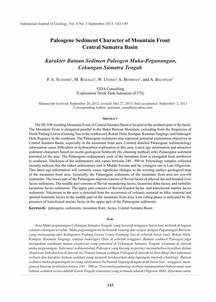
The present day distribution of sedimentary and basement rocks can be related to the present day regional structure of Sumatra. A detailed geological cross section shows a flower structure which is well developed on this area (Figure 2). The Barisan uplift and Sumatran Fault System (SFS) controlled the rock distribution on the mountain front.
Updated palinology and biostratigraphy results give significant changes of previous surface geology map (Gafoer et al., 1992). The significant changes are especially in the Palaeogene time which is shown by the changes of Telisa Formation of Early Miocene, (Wongsosantiko, 1976 and Bachtiar et al., 2010) to become Eocene - Late Oligocene sedimentary units (Figure 3).
Figure 2. Detailed geological cross section across the mountain front area. The section shows that the present day thrust system is related to a dextral right step over an associated strike slip fault. The fault has inverted, rejuvenated, and reactivated along the Barisan Uplift. For location see Figure 1.
Earliest Early Miocene-Earliest Midle Miocene Sedimentary Rock
Latest Late Oligocene-Latest Early Miocenesedimentary Rock
Eocene-Earliest Late Oligocene Sedimentary Rock
Pre-Tertiary Basement
Inversion Fault
Thrust Fault
Dextral Strike Slip Fault
?
0 0.5 2 5 km
W E
146 Indonesian Journal of Geology, Vol. 8 No. 3 September 2013: 135-141
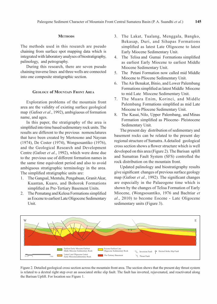
Generally, the Pre-Tertiary basement rock is situated in the most westernmost part, northwest-southeast elongation which is implemented by the presence of Barisan Mountain in the west and Tigapuluh Mountains in the south. A regional gravity map of the mountain front area also shows an elongated high and low configurations paralel to the Barisan High. The high features represent the basement rock which have a northwest-southeast lineament trend, whilst the low features (dark blue colour) are represent of sub basins.
The Eocene - Oligocene sedimentary units are situated close to this Pre-Tertiary Basement unit, while the sedimentary units are getting younger toward the northeast (Figure 3). No Eocene to earliest Late Oligocene (Pematang) equivalence exposed in the north western part of the area (around Gunung Tua) which means that the area was a high during the syn-rift phase (Bachtiar et al., 2010). However, well bore data from the northeast show
that this unit is preserved at deep grabens in this area (Ahmadin, personal communication, 2012).
Geodynamically, the structures that are observed in the area can be divided into four structural systems. These are: 1). a compressional complex system of accreted fragments during the Pre-Tertiary, 2). a trans-tensional rift system developed during the Eocene to Oligocene, 3). a strike- slip system that occurred during the Middle Miocene, and 4). an oblique compressional system that has existed from the Middle Miocene to the present.
The Palaeogene structural system initiated with a segmented half-graben formation during a transtensional rifting phase (Hendrik and Aulia, 1993). The grabens developed due to the reactivation of pre-existing basement structures as an effect of Indian-Eurasian collision. The deposition of lacustrine and fluvial facies of Eocene to Oligocene age subsequently filled the graben system. In Early Miocene time, the transtensional rift phase ceased and the basin started to sag due to thermal relaxation.
Figure 3. Geological map of mountain front area (Central Sumatra Basin) revised from previous study by Gafoer et al. (1992). The rock distribution is similar to the regional structure of Sumatra. The rocks names are standardized.
0 40 80
Kilometres
Legend:
AlluviumRiver AlluviumPliocene-Pleistocene Sedimentary RockMid Late Miocene-Pliocene Sedimentary RockLatest Middle Miocene-Mid Lae Miocene Sedimentary RockMid Middle Miocene-Pliocene Sedimentary RockLate Early Miocene-Early Mid Miocene Sedimentary RockEarliest Early Miocene-Earliest Midle Miocene Sedimentary RockLatest Late Oligocene-Latest Early Miocenesedimentary RockEocene-Earliest Late Oligocene Sedimentary RockPre-Tertiary Metamorphic RockPre-Tertiary Igneous RockQuaternary Volcanics RockMiocene Volcanics Rock
N
147Paleogene Sediment Character of Mountain Front Central Sumatera Basin (P. A. Suandhi et al.)
This was coupled with a gradual change in the depositional facies from fluvio-lacustrine through transitional becoming marine as post-rift sediments. Tectonically this time was relatively quiescent.
The convergence zone of oblique subduction between the Indian and Eurasian Plates that has been active from the beginning of the Neogene generated a combination of compressional and translation forces which are encountered in Sumatra (Ryacudu, 2005). In the mountain front area, the uplift of Barisan began in the Middle Miocene and subsequently culminated during Late Tertiary. The uplift was associated with renewed dextral strike-slip faulting along the NW-SE trending Great Sumatran Fault System, and active arc volcanism along the Barisan Mountain front (Sapiie et al., 2005).
dIscussIon
The studies of the mountain front area are mostly based upon outcrop data. Laboratory analyses and both surface and subsurface geological reconstructions have helped to achieve the objective of this study.
Generally, the Palaeogene sediments have a northwest-southeast lineament trend. Maximum thickness from the stratigraphic section is up to 1,120 m. The oldest age which is found from a pollen analysis is Middle Eocene and the youngest age is Late Oligocene. The Palaeogene sediments are classified as Eocene - Oligocene Sedimentary Unit. This unit is also clustered in three parts; first is lower part, secondly is middle part, and the third one is upper part.
The lower part of Eocene - Oligocene sedimentary unit consists of alluvial fan and fluvial meander deposits. This unit is also called as a red bed deposit, because most of the outcrop are red coloured. The alluvial fan deposits are observed in the northwest and central parts of the research area. This deposit is characterized by coarsening upward unit of coarse- to pebbly coarse-grained sandstone, poorly sorted, grain contact, subangular grain shape, comprising monocrystaline quartz dominated, lithic sediment fragments, and some floating grains. Some of the outcrops show intensive fractures filled with silica vein. The sand thickness of this unit is up to 20 m with sand distribution observed in the
field is up to 500 m thick. The visible porosity of this unit gained from several sample shows a poor porosity (9.50% by volume). Two types of porosity are defined including intergranular (3.50%) and dissolution (6.00%) porosities. The presence of a secondary dissolution has not much influenced reservoir quality. The low porosity is caused by the presence of clay matrix and compaction process.
The oxbow lake deposit is characterized by a coarsening upward sequence of shale, carbonaceous shale, and medium- to very coarse-grained sandstone. Coal seam is also found as part of an oxbow lake deposit in the fluvial meandering channel system. The coal thickness is up to 4 m characterized by black colour, blackish brown streak, minor dull brightness, with amber commonly observed (> 40 %). This character indicates a terrestrial deposit. The sandstone is brownish white, medium- to coarse-grained, subangular, and poorly sorted consisting of quartz (dominant, monocrystaline), with lithic sediment and metamorphic rock fragments. The unit is up to 4 m thick and the geometry of distribution is up to 300 m. Based on petrographic examination, the visible porosity of the rock can be determined as a good one (16.00%). Moreover, on the basis of visible porosity value, type of porosity, and local good relation among pores through both intergranular and dissolution pores, the reservoir quality of the rock can be classified as a relatively good reservoir quality with local good interconnections among pores.
The middle part of Middle Eocene-Oligocene sedimentary unit comprises a lacustrine deposit in association with fluvial meandering, lacustrine delta, and shelf slope lacustrine (turbidite). The lacustrine delta environment is good observed in the northwestern part (Limapuluh Koto Regency) and central part (Kuantan Singingi Regency).
The lacustrine delta environment is composed of three subfacies, those are delta plain, sand bar, and channel subfacies. The lacustrine delta plain subfacies is characterized by alternating shale, carbonaceous shale, sandstone, and thick coal. Parallel lamination is commonly observed, ripple and convolute are spotted observed in the thin interbedded of fine-grained sandstone. The coal
148 Indonesian Journal of Geology, Vol. 8 No. 3 September 2013: 135-141
showing thickness of up to 9 m is characterized by a bright lithotype, blackish brown streak, and blocky-papery cleavage. Papery coal is commonly observed in the bottom and top part of coal seam.
Geochemical analysis of the coal shows a TOC value ranging from 32.41 to 76.23% with PY from 35.26 to 361.47 mg/g.
High value of Hydrogen Index (HI) in several coal samples tends to show a lacustrine environment. The kerogen is included into type II (Rozalli, 2012). The sand bar subfacies is characterized by a coarsening upward unit of medium- to pebbly coarse-grained sandstone, bright brown colour, medium- to very coarse-grained, grain contact, well sorted, subangular - subrounded, consisting of quartz (dominated), clay pellet, and lithic sediments. Cross-bedding and ripple structures are commonly observed. The sand thickness of this unit is up to 6 m with lateral distribution observed in the surface is up to 300 m. Based on petrographic examination, this unit shows a good visible porosity (16.00%) consisting of a secondary intergranular type caused by dissolution of matrix (10%), and partial to total dissolution of grains (6.00%). Based on the presence of preserved intergranular and dissolution porosity with good porosity value and local good pore interconnection, reservoir quality of sandstone is good with local good porosity interconnection .
The shelf slope lacustrine subfacies are characterized by intercalating carbonaceous shale - silt with algae layer, intercalating medium- to coarse-grained sandstone with shale, thick layer of brown shale with thick layer of very coarse-grained sandstone. The intercalating shale - silt and algae layers are an indication of pelagic deposit in the shelf slope morphology of lacustrine. Thick interbedded layers of very coarse-grained sand indicate gravity and turbidite mechanisms. The sandstone is characterized by greyish bright colour, coarse-grained, poorly sorted, subangular, graded bedding, and floating fragmenst commonly observed. The sandstone comprises quar tz (dominant), kaolinite, clay ball, igneous rock, and lithic sediment fragments. Visible porosity of this sandstone is moderate (11.0% of bulk volume), represented by primary intergranular (8.5%), secondary dissolution (2.0%), and fracture (0.5%) pore types. Reservoir quality of the sandstone is
generally poor, in terms of visible porosity value and pore interconnection.
The upper part of Middle Eocene-Late Oligocene Sedimentary Unit consists of braided river facies unit and deltaic facies unit. A series of fluvial -braided river facies unit is just observed in the northern area, especially in the Kelok Indah area, border of Kuantan Singingi and Limapuluh Koto Regencies. This facies is characterized by alternating polymict conglomerate, medium- very coarse-grained sandstone, shale, and thin layers of carbonaceous shale - coaly shale. Trough cross- bedding, ripple, and parallel laminations are commonly observed. The geometry and dimension of the braided channel deposit from the outcrops is up to 100 m with maximum thickness is up to 4 m (single unit). Petrographic analysis from several samples shows the sandstone composition is quartz (dominant), feldspar, mica, and volcanic lithic fragment which is commonly observed in all sandstone samples. Visible porosity, in generall, is good mainly as a primary porosity with inter-granular type and secondary porosity type where it shows the dissolved lithic grain and oversized pores with floating grains. The range of visible porosity of this unit are from 12.0 % - 19.0 %. Some of the porosities decrease, due to the presence of dead oils, filling the pores among grains.
Deltaic subfacies is the most upper part of the Middle Eocene - Late Oligocene sedimentary unit. This unit is well observed in the southern part of study area, especially in the Inderagiri Hulu Regency, and also in the northernmost part of study area, especially in the Muara Takus - Gunung Tua areas. The deltaic facies unit is characterized by a coarsening upward unit of carbonaceous shale with a coal seam in the bottom, intercalating unit of very fine- to medium-grained sandstone and shale and thick layers of medium-grained sandstone with intensive burrowing in the top part. Several coal seams interpreted as a delta plain deposit are observed having thickness from 0.5 m - 2 m. Geochemical analysis of this coal shows TOC values ranging from 32.30 to 42.94% and PY from 28.08 to 49.08 mg/g rock. HI against Tmax shows that the samples are dominantly kerogen type II and I (Rozalli, 2012).
149Paleogene Sediment Character of Mountain Front Central Sumatera Basin (P. A. Suandhi et al.)
The sandstone from coarsening upward unit is characterized by greyish brown, medium- to coarse-grained, poorly sorted, subangular - subrounded, and calcareous characters. The main grains are monocrystalline quartz, with chert, shale rock fragments, metamorphic rock fragments, glauconite, mica, and heavy mineral. The sedimentary structure commonly observed is cross-bedding, ripple, and intensive burrow structure. This sand is interpreted as a delta front mouth bar type. The visible porosity is good (22.00% by- volume), consisting of intergranular (12%), dissolution (8%), and fracture (2%) types. Pores are well connected.
conclusIons
A revised geological map and simplified stratigraphy used provide a better understanding of the geology of the mountain front area.
The Palaeogene sediments of the mountain front area are divided into several depositional environment unit classified in the early rifting (alluvial fan - lacustrine environment) and late - post rift (fluvial - deltaic - shallow marine).
Volcanic terigenous mineral observed from several samples especially in the northwestern part of the area is probably derived from local source of Pre-Tertiary igneous rock.
The Palaeogene sediments has a potential petroleum system to become oil and gas exploration target in mountain front area of Central Sumatra Basin.
Acknowledgements---This study is supported by a GDA Consulting research grant. The authors would like to acknowledge the colleagues who helped to collect data during field study: Gesit Mutiarta, Agus Muryanto, and Budi. Finally, the authors are very grateful to Paleopetro Lab. Staff: Armein Suleiman and Cucuk Candra who helped to analyze the rock samples and provided brief constructive discussion.
reFerences
Bachtiar, A., Rozalli, M., Barus, F., Simanjuntak, K., Gultaf, H., Ansari, I., and Melsa, H, 2010. Tectonics and Sedimentation of Sihapas and Telisa Formations Based on Outcrops Study in Gunung Tua Area, Central Sumatra Basin, Indonesia. Proceedings The 36th HAGI and 40st IAGI, Annual Convention & Exhibition, Makassar.
De Coster, G.G. 1974. The Geology of Central Sumatra and South Sumatra Basin. Proceedings, The 3rd Indonesian Petroleum Association (IPA) Annual Convention & Exhibition, Jakarta, p.77-110.
Gafoer, S., Amin, T.C., and Hermanto, B., 1992. Geological Map of Padang Quadrangle, scale 1:1000.000. Geological Research an Development Centre, Bandung.
Gafoer, S., Amin, T.C., and Samodra, H., 1992. Geological Map of Padang Quadrangle, scale 1:1000.000. Geological Research an Development Centre, Bandung.
Hedrick, T.L. and Aulia, K., 1993. A Structural and Tectonic Models of the Coastal Plains Block, Central Sumatra Basin, Indonesia. Proceedings, The 22nd Indonesian Petroleum Association (IPA) Annual Convention & Exhibition, Jakarta.
Hwang R.J., Heidrick T., Mertani B., Qivayanti, and Li M., 2002. Correlation and Migration Studies of North Central Sumatra Oils. Organic Geochemistry, p.1361-1379.
Mertosono, S. and Nayoan, G.A.S, 1974. The Tertiary Basinal Area of Central Sumatra. Proceedings, The 3rd Indonesian Petroleum Association (IPA) Annual Convention & Exhibition, Jakarta, p.63-74
Rozalli, M., 2012. New Insight into The Petroleum Geology og The Mountain Front Area-Central Sumatra Basin. The 36th Annual IPA Convention and Exhibitation.
Ryacudu, R., 2005. Studi Endapan Syn-Rift Paleogen Di Cekungan Sumatra Selatan. Doctoral Dissertation, Department of Geological Engineering, Institute Technology of Bandung. Indonesia, Unpublished.
Sapiie, B., Hadiana, M., Nugraha, I., and Sayentika, 2005. Analogue Modeling of Rift Mechanism in The Paleogene Graben System of Western Indonesia. Proceedings, The 30th Indonesian Petroleum Association (IPA) Annual Convention & Exhibition, Jakarta.
Wongsosantiko, A., 1976. Lower Miocene Duri Formation Sands, Central Sumatra Basin. Proceedings, The 5th Indonesian Petroleum Association Annual Convention & Exhibition, Jakarta, p.133-150.