Pages 2 Area 1 10 Area 2 14 Area 3 Area 4 Area 5 Area 6 · Hydrotest 20-01-12 03-02-12 Skandi...
22
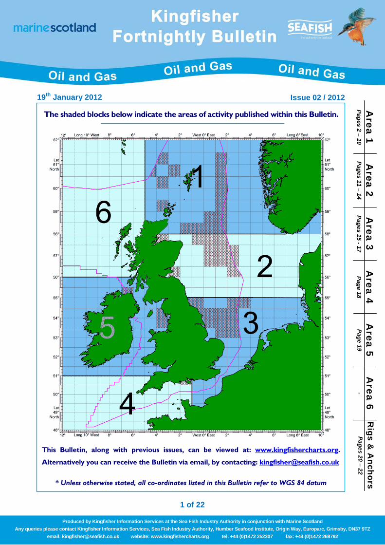
1 of 22 19 th January 2012 Issue 02 / 2012 Produced by Kingfisher Information Services at the Sea Fish Industry Authority in conjunction with Marine Scotland Any queries please contact Kingfisher Information Services, Sea Fish Industry Authority, Humber Seafood Institute, Origin Way, Europarc, Grimsby, DN37 9TZ email: [email protected] website: www.kingfishercharts.org tel: +44 (0)1472 252307 fax: +44 (0)1472 268792 Rigs & Anchors Pages 20 – 22 Area 4 Page 18 Area 6 - Area 2 Pages 11 – 14 Area 1 Pages 2 – 10 Area 3 Pages 15 - 17 Area 5 Page 19 The shaded blocks below indicate the areas of activity published within this Bulletin. This Bulletin, along with previous issues, can be viewed at: www.kingfishercharts.org . Alternatively you can receive the Bulletin via email, by contacting: [email protected] * Unless otherwise stated, all co-ordinates listed in this Bulletin refer to WGS 84 datum
Transcript of Pages 2 Area 1 10 Area 2 14 Area 3 Area 4 Area 5 Area 6 · Hydrotest 20-01-12 03-02-12 Skandi...
1 of 22
19th January 2012 Issue 02 / 2012
Produced by Kingfisher Information Services at the Sea Fish Industry Authority in conjunction with Marine Scotland Any queries please contact Kingfisher Information Services, Sea Fish Industry Authority, Humber Seafood Institute, Origin Way, Europarc, Grimsby, DN37 9TZ
email: [email protected] website: www.kingfishercharts.org tel: +44 (0)1472 252307 fax: +44 (0)1472 268792
Rigs &
Anchors
Pages 20 – 22 A
rea 4 Page 18
Area 6
-
Area 2
Pages 11 – 14 A
rea 1 Pages 2 – 10
Area 3
Pages 15 - 17 A
rea 5 Page 19
The shaded blocks below indicate the areas of activity published within this Bulletin.
This Bulletin, along with previous issues, can be viewed at: www.kingfishercharts.org.
Alternatively you can receive the Bulletin via email, by contacting: [email protected]
* Unless otherwise stated, all co-ordinates listed in this Bulletin refer to WGS 84 datum
19th January 2012 Issue 02 / 2012
2 of 22
For ‘live’ Kingfisher updates of all offshore oil and gas activities, please visit www.fishsafe.eu
Produced by Kingfisher Information Services at the Sea Fish Industry Authority in conjunction with Marine Scotland Any queries please contact Kingfisher Information Services, Sea Fish Industry Authority, Humber Seafood Institute, Origin Way, Europarc, Grimsby, DN37 9TZ
email: [email protected] website: www.kingfishercharts.org tel: +44 (0)1472 252307 fax: +44 (0)1472 268792
Suspended Wellheads New Suspended Wellhead(s) – Additions to Yellow Card (New 19-12-2011) Please note the new suspended wellhead(s) below, which should be marked on your fishing plotter and Kingfisher Yellow Card.
Notice To Fishermen Hazard List – Previously Reported Within the Bulletin Please note the below list of hazards, which have been previously reported within the Bulletin. Further notices will be issued, when additional information is known regarding their recovery. Last Reported in Bulletin No Hazard Type Position Comment
KFB 11 / 2011 12 tonne Bruce Mk. IV FFTS, Length 5.5m x Width 6.5m x Height 3.8m
58° 05.74’N 00°45.75’E Jeff Simon, DECC,
Tel: +44 (0)30 0068 6040 Email: [email protected]
Snagging Hazard – Unexploded WW2 Bomb at FLAGS (New 03-10-2011) Please note that there is an unexploded WW2 Bomb at the position below. A guard vessel is monitoring. Guard vessel to maintain a minimum 500m exclusion zone distance away for all vessels from the pipeline position.
Position: 58° 13.807' N 01° 13.268' W For further information, please contact: Richard Bounds, Shell, Tel +44 (0)1224 880482 email: [email protected]
Brent Bravo – Surface and Subsurface Hazards (New 22-07-2011) Please be advised that we are currently constructing a floating barrier within the 500m zone of the Brent Bravo. This comprises a series of floating bays which are moored through a hybrid catenary (rope and chain) system to 8 x 12t Stevpris anchors. The 5 large yellow surface buoys have a yellow flash every 5 seconds and are fitted with radar reflectors.
Although everything is inside the 500m zone, it must be highlighted to the fishing community operating in the area that the anchors are close to the outer perimeter of the 500m zone and as such could be hazardous to fishing vessels who tow their gear right on the edge. Therefore vessels operating in the area must account for any forces which may cause their gear to go inside the 500m zone - even by just a few meters. The support vessel ‘Ocean Spey’ is stationed at Brents and will be on hand to offer fishing vessels advice regarding their proximity to the safety zone and the above mentioned hazards.
Anchor Number Latitude Longitude Anchor Number Latitude Longitude 1 61° 03.457 ‘N 001° 42.573 ‘E 5 61° 03.105 ‘N 001° 42.415 ‘E 2 61° 03.427 ‘N 001° 42.210 ‘E 6 61° 03.070 ‘N 001° 42.666 ‘E 3 61° 03.281 ‘N 001° 42.178 ‘E 7 61° 03.186 ‘N 001° 43.044 ‘E 4 61° 03.155 ‘N 001° 42.263 ‘E 8 61° 03.362 ‘N 001° 43.106 ‘E
Buoy Latitude Longitude Buoy Latitude Longitude
A 61° 03.324 ‘N 001° 42.438 ‘E D 61° 03.226 ‘N 001° 42.571 ‘E B 61° 03.285 ‘N 001° 42.462 ‘E E 61° 03.214 ‘N 001° 42.652 ‘E C 61° 03.249 ‘N 001° 42.502 ‘E F 61° 03.217 ‘N 001° 42.735 ‘E
For further information, please contact: Tony Moore, Shell, Tel: 01224 880483, Email: [email protected]
Well No OPERATOR LAT LONG 204/10a-4z Hess UK Ltd 60°49.433'N 004°08.031'W 9/02b-5Z Nautical Petroleum 59°54.002'N 001°15.341'E 206/04-2 Total E & P Ltd 60°56.045'N 002°13.968'W
Area 1
Area 1
Area 1
Area 1
Area 1
19th January 2012 Issue 02 / 2012
3 of 22
For ‘live’ Kingfisher updates of all offshore oil and gas activities, please visit www.fishsafe.eu
Produced by Kingfisher Information Services at the Sea Fish Industry Authority in conjunction with Marine Scotland Any queries please contact Kingfisher Information Services, Sea Fish Industry Authority, Humber Seafood Institute, Origin Way, Europarc, Grimsby, DN37 9TZ
email: [email protected] website: www.kingfishercharts.org tel: +44 (0)1472 252307 fax: +44 (0)1472 268792
Seabed Activity Construction Activities – Armada Plat from 22/5b (New 18-01-2012)
Drilling Rig/Ship Start Date Finish Date Installation Name/ Well No Position
Apache 2 23-01-2012 18-02-2012 Gaupe Well South Gaupe Well North
57°57.495'N 001°55.693'E 58°00.680'N 001°55.431'E
The pipelay vessel will be supported by:
Activity From To Vessel Survey Support 20-01-12 28-02-12 Skandi Carla
Trenching and backfill 31-01-12 13-02-12 Normand Ranger DSV Norwegian well tie-in 28-02-12 23-03-12 Skandi Arctic
For further information, please contact: Mark Hains, BG Energy, Tel: +44(0)118 935 3222, email:[email protected]
Islay Field Development – Offshore Construc t ion (Update 18-01-2012) The construction vessel “Skandi Arctic” has completed the installation of PLEMs at the Islay location and at the Forvie Manifold. An umbilical has been laid between these two positions, but it remains unburied. A mid–line Breakout Box has also been installed and is unprotected. A Guard Vessel will be in the close vicinity issuing navigation warnings. Please keep clear of these installations during this phase of the work. The Pipelay vessel “Apache ll” has completed the installation of pipeline from the Islay Well to Forvie Manifold. Survey Support Vessel “Skandi Carla” has also completed “as-laid” surveys.
Activity From To Vessel Hydrotest 20-01-12 03-02-12 Skandi Inspector
Installation Spools and protection structures 03-02-12 11-02-12 Wellservicer
Installation of Controls and Final Hook-up Test 15-02-12 05-03-12 Skandi Arctic
Rock Dumping Vessel 09-01-12 18-01-12 Nordnes A 500m Safety Zone has been established at the Islay location : 60° 33.47’N 01° 56.689’E Key Cordinates: (The umbilical is laid through these points) Existing Islay Well: 60°33.47’N 01°56.69’E Islay PLEM: 60°33.47’N 01°56.66’E Existing Forvie Manifold: 60°31.38’N 01°52.02’E Forvie PLEM: 60°31.36’N 01°51.00’E Mid-line Breakout Box: 60°32.74’N 01°55.06’E Further construction work will follow in the next few months and vessels involved and schedule will be notified through the bulletin. Please give this operation a wide berth. For further information, please contact: Pete Dyson, Total, Tel:01224 297566 email: [email protected]
Andrew Area Development - Andrew Platform - Kinnoull drill-centre (Update 17-01-2012) BP Exploration Operating Company wish to advise that as part of the Andrew Area Development (AAD) Project, a series of four pipeline bundles and a controls umbilical will be installed from the Andrew Platform to the Kinnoull drill centre. The development comprises the tie-back of three production wells at Kinnoull via a 4-slot manifold towhead and bundle system to the Andrew host platform, terminating in a caisson riser. The bundles will be installed using the controlled depth tow method (CDTM) and will be towed to site from Sinclair Bay, Wick. Once in location each bundle will be sunk into place by flooding the carrier pipe. The tow fleet for each bundle will comprise two Lead Tugs and a Trail Tug, accompanied by the ROV Support/Survey vessel (RSV), a flooding vessel and a Guard Vessel.
Continued over page..
Area 1
Area 1
Area 1
Area 1
Area 1
19th January 2012 Issue 02 / 2012
4 of 22
For ‘live’ Kingfisher updates of all offshore oil and gas activities, please visit www.fishsafe.eu
Produced by Kingfisher Information Services at the Sea Fish Industry Authority in conjunction with Marine Scotland Any queries please contact Kingfisher Information Services, Sea Fish Industry Authority, Humber Seafood Institute, Origin Way, Europarc, Grimsby, DN37 9TZ
email: [email protected] website: www.kingfishercharts.org tel: +44 (0)1472 252307 fax: +44 (0)1472 268792
...continued from previous page The launch of Bundle 1 from Wick took place on the 11th July 2011. Bundle 2 was launched on the 19th July 2011. Bundle 4 installation has been completed, but the flowlines have not yet been flooded. Bundle 3 launch is planned for January 2012 after which flowlines for bundles 3 and 4 will be flooded. Appurtenance removal for all four bundles will be carried out by DSV [TBC] in May 2012. The 44” caisson riser will be towed to the site by two tow tugs, lowered to a wet store area, then installed on the Andrew jacket by DSV. The date for this scope is yet to be determined, but is currently envisaged to be March 2012. The date for installation of the umbilical is also yet to be determined, but is currently envisaged to be June 2012 with trenching planned for completion in July 2012. Tie-in spool installation between the four bundles by DSV [TBC] is envisaged to commence in May 2012. Further activities to be completed in 2012 include riser umbilical installation, Andrew and Kinnoull tie-ins and pre-commissioning. Key co-ordinates:
Location Latitude Longitude Andrew Platform 58o 02.81’ N 01o 24.16’ E Andrew SSIV Towhead (start of Bundle 1 and umbilical) 58o 02.80’ N 01o 24.24 ‘E Intermediate Towhead 1 (end of Bundle 1) 58o 06.68’ N 01o 24.23’ E Intermediate Towhead 2 (start of Bundle 2) 58o 06.69’ N 01o 24.26’ E Intermediate Towhead 3 (end of Bundle 2) 58o 10.57’ N 01o 24.25’ E Intermediate Towhead 4 (start of Bundle 3) 58o 10.58’ N 01o 24.21’ E Intermediate Towhead 5 (end of Bundle 3) 58o 12.84’ N 01o 27.37’ E Intermediate Towhead 6 (start of Bundle 4) 58o 12.83’ N 01o 27.40’ E Kinnoull Towhead (end of Bundle 4 and umbilical) 58o 14.30’ N 01o 34.21’ E
Key dates for the above activities:
Activity Expected Dates Vessel Andrew Jacket Member Survey January 2012 TBC
Bundles 3 installation 13/01/12 to 29/02/12
Command Vessel – TBC; Lead Tugs – TBC; Trail Tug – TBC;
Guard Vessel – Various; Flooding Vessel – TBC
Seabed umbilical installation Est June 2012 TBC Caisson riser installation Est March 2012 Seven Atlantic = tugs Bundle tie-ins and testing
Bundle appurtenance removal Est May 2012 TBC
Guard vessels will be providing guard duty during bundle and umbilical installation. Further information may be obtained by contacting Walter Jardine, Tel: +44 (0)1224 833640, Email: [email protected]
Ivanhoe, Rob Roy – Decommiss ioning Operat ions (New 06-01-2012) Please be advised that Hess will be carrying out decommissioning operations from 10th March 2011 through to possibly Mid May 2012. Vessel will be the DSV Acergy Osprey. Guard Area based on the following positions:
Latitude Longitude 58o 12.08’ N 00o 04.67’ E 58o 12.08’ N 00o 08.55 ‘E 58o 10.89’ N 00o 08.57’ E 58o 10.89’ N 00o 04.68’ E
Further information may be obtained by contacting: Graham Smith, Hess Subsea, Tel:01224 269 022, Email:[email protected]
Area 1
Area 1
Area 1
Area 1
Area 1

19th January 2012 Issue 02 / 2012
5 of 22
For ‘live’ Kingfisher updates of all offshore oil and gas activities, please visit www.fishsafe.eu
Produced by Kingfisher Information Services at the Sea Fish Industry Authority in conjunction with Marine Scotland Any queries please contact Kingfisher Information Services, Sea Fish Industry Authority, Humber Seafood Institute, Origin Way, Europarc, Grimsby, DN37 9TZ
email: [email protected] website: www.kingfishercharts.org tel: +44 (0)1472 252307 fax: +44 (0)1472 268792
Dunlin and Thistle Area – New pipeline and subsea facilities (Update 03-01-2012) Fairfield Energy intends to install a new pipeline between Dunlin ‘A’ and Thistle ‘A’. The pipeline will be trenched and buried. New subsea structures will be installed at both ends of the pipeline within the Dunlin and Thistle platform 500m zones. Installation activates activities commenced in September and are planned to complete February 2012 (TBC). The pipeline will be installed by the Navica Pipelay vessel and trenched and buried using the Normand Ranger. Tie-in spools will be installed by the DSV Orelia. A survey vessel will also be onsite. Key co-ordinates are as follows: Dunlin ‘A’ Platform 61°16.457'N 001°35.750'E Thistle ‘A’ Platform 61°21.747'N 001°34.679'E Expected dates for the key activities are as follows: Activity Expected Dates Vessel Pipelay 20/01/12 – 25/01/12 Navica Pipeline trenching 23/01/12 – 31/01/12 Normand Ranger Tie-in spool installation and pre-commissioning 01/02/12 – 12/02/12 Orelia Rockdump 13/02/12 – 18/02/12 TBC Guard Vessel 20/01/12 – 31/01/12 TBC For further information, please contact: Stephen Sapp, Tel: +44 (0)1224 300500 Email: [email protected]
Talisman – Scapa Flexibles Replacement (Update 19-12-2011) Talisman Energy (UK) Limited hereby gives notification of the intent to commence subsea installation works associated with the Scapa Flexibles Replacement. The work will include deoiling, isolations, removal of on and off-template flexibles at Scapa and Claymore platform followed by installation of new flexibles and precommissioning activities. A guard vessel will be used at Scapa during periods when any elements of the works are incomplete and vulnerable to fishing activities when DSV is not on site (interim mobilisations). Completion of the subsea works is anticipated by end January 2012.
Claymore Platform 58°26.919' N 00°15.313' W Scapa Template 58°25.610’ N 00°19.172' W
Activity Planned Start Date Vessel(s) Subsea Construction 26th May 2010 Alliance followed by Orelia
For further information, please contact Dave Allan on Tel: 01224 358867 or email: [email protected]
Dril l ing Operations – Rig move to 48/19a (New 16-12-2011)
Drilling Rig/Ship Start Date Finish Date Installation Name/ Well No Position Ensco 92 Call Sign: C6GD 01-01-2012 31-12- 2012 Moray Firth Beatrice Barvo
Clipper South 48/19 53°24.231'N 001°47.001'E. 58°08.856'N 002°58.746'E.
RWE Dea UK are planning to contract the Ensco 92 jack-up rig for drilling operations alongside the RWE Dea UK operated Clipper South platform, located in southern North Sea UKCS Block 48/19a. The Ensco 92 MODU is currently on-hire in the Moray Firth at Beatrice Bravo, North Sea, UKCS, Block 11/30 . The rig move is scheduled to place at some point between the 1st and the 31st January 2012. The 4-well programme at the Clipper South platform may continue through until Q4 2012 at which point the Ensco 92 MODU will depart from the 500 m safety zone of RWE Dea UK’s Clipper South platform.
Further information, please contact: Hywel Roberts, RWE Dea UK,Tel: +44(0)20 3116 0641, email: [email protected]
Area 1
Area 1
Area 1
Area 1
Area 1
19th January 2012 Issue 02 / 2012
6 of 22
For ‘live’ Kingfisher updates of all offshore oil and gas activities, please visit www.fishsafe.eu
Produced by Kingfisher Information Services at the Sea Fish Industry Authority in conjunction with Marine Scotland Any queries please contact Kingfisher Information Services, Sea Fish Industry Authority, Humber Seafood Institute, Origin Way, Europarc, Grimsby, DN37 9TZ
email: [email protected] website: www.kingfishercharts.org tel: +44 (0)1472 252307 fax: +44 (0)1472 268792
Subsea Christmas Tree – Pelican Field 211/26a-P21(New Entry 15-12-2011) Please note an oil & gas subsea structure (christmas tree) has been installed at the following location:
61°01.997'N 001°07.729'E 211/26a-P21
The top of the X-tree is 22ft above seabed and 4 x 4m in size. For further information, please contact: Paul Williams, TAQA Bratani Limited, Tel: +44(0)1224 275385, email: [email protected]
Pipelay Operations – Shet land to Laggan West Shetland (Update 07-12-2011) A 500m Safety Zones have been established around the Laggan and Tormore wells centred on :-
Laggan : 60 o 56.67’N 02 o 53.62’W Tormore : 60 o 52.28’N 03 o 08.23’W
For further information, please contact: Pete Dyson, Total, Tel:01224 297566 email: [email protected]
BP Explor & Production - Devenick Fie ld Development (Update 07-12-2011) Construction in the Devenick Field for 2011 is now largely complete. Remaining scope is as follows: Pre/post Installation Surveys(ROV/Sonar) - Devenick
Drilling Rig/Ship Start Date Finish Date Installation Name/ Well No Position
Skandi Carla 01/07/2011 12-2011 Devenick Pipeline / Umbilical 58°52.534'N 001°31.526’E
To
59º10.119’N 001º35.918’E Rockdumping
Drilling Rig/Ship Start Date Finish Date Installation Name/ Well No Position
Nordness 15-12-2011 Jan 2012 Devenick S1 Well (9/24b-4) and
pipeline & umbilical areas between Devenick Manifold & East Brae
58°52.534'N 001°31.526’E to
59°10.119'N 001°35.918’E
A Kingfisher Information flyer has been produced to offer greater information on the Devenick Field Development
Kingfisher Awareness Flyer: Devenick Field Development
For further information, please contact: John Colegrave, BP E&P Ltd, Tel +44 1224 851543, Email: [email protected]
I thaca Energy – Athena F ie ld Development (Update 20-12-2011) Mooring, STP buoy, structure, MWA and flexible flowline installation works have now been completed. The Boa Deep C is now progressing with the installation of the umbilicals between the STP buoy and manifold and installation of the dynamic risers between the STP buoy and riser base. The Bibby Topaz is currently infield continuing with diving tie-in works. Mooring and STP Buoy System Description The STP Buoy is a mooring line tethered buoy utilised to locate the BW Athena FPSO at the Athena site. At the centre of the STP buoy is a turret, the outer section of the buoy is free to rotate around the turret. The outer part of the buoy, when pulled into the FPSO, allows the FPSO to rotate or weathervane around the geostationary turret.
Continued over page..
Area 1
Area 1
Area 1
Area 1
Area 1
19th January 2012 Issue 02 / 2012
7 of 22
For ‘live’ Kingfisher updates of all offshore oil and gas activities, please visit www.fishsafe.eu
Produced by Kingfisher Information Services at the Sea Fish Industry Authority in conjunction with Marine Scotland Any queries please contact Kingfisher Information Services, Sea Fish Industry Authority, Humber Seafood Institute, Origin Way, Europarc, Grimsby, DN37 9TZ
email: [email protected] website: www.kingfishercharts.org tel: +44 (0)1472 252307 fax: +44 (0)1472 268792
...continued from previous page
The STP Buoy mooring system comprises of 9 off mooring lines consisting of a Spiral Strand Wire Rope section and a Studless chain section connected to Suction Anchor Piles. The Suction Anchor Piles and chain section will be installed first and the STP Buoy c/w Spiral Strand Wire Ropes will then be towed to the Field and connected to the pre-installed mooring chains. STP Mooring Arrangement:
STP Mooring Buoy circa 7.4m Dia x 14.1m tall 9 off Mooring Lines comprising of 200m Spiral Strand Wire Rope & 715m R4 Studless Chain 9 off Mooring Anchor (Suction Piles), 6 off Dia 5m x 13m, 2 off Dia 6.5m x 10.5m & 1 off Dia 5m x 10.5m
Subsea Facilities Description The subsea flowline system will comprise an 8” insulated production flexible flowline, 3” service flexible flowline and 8” water injection flexible flowline. The flowline systems will run between the Riser Base structure and subsea manifold at the Athena Drill Centre. Flowlines and umbilicals will be trenched to approx. 1m below the seabed with the untrenched ends protected by concrete mattresses. Rigid spools and controls jumpers will be connected between the subsea manifold and the wellheads. These will be protected by concrete mattresses. All dynamic products will be secured over a Mid Water Arch System. Infrastructure positions:
Item Description Co-ordinates 1 Athena FPSO Turret Centre 58o 24.373’N 00o 34.431’W 2 Mid Water Arch 58o 24.426’N 00o 34.345’W 3 Athena Riser Base 58o 24.471’N 00o 34.271’W 4 Athena Manifold Centre 58o 25.210’N 00o 33.065’W 5 Production Well 14/18b-A5 (P1) 58o 25.204’N 00o 33.018’W 6 Production Well 14/18b-A3 (P2) 58o 25.210’N 00o 33.029’W 7 Production Well 14/18b-A4 (P3) 58o 25.230’N 00o 33.063’W 8 Production Well 14/18b-A2 (P4) 58o 25.222’N 00o 33.078’W 9 Water Injection Well 14/18b-A1 (W1) 58o 25.203’N 00o 33.043’W
Installation Dates:
Activity Vessel Start Date End Date Suction anchor & mooring installation Boa Deep C
Completed
STP buoy installation Boa Deep C
Completed Manifold, riser base, mid water arch installation Boa Deep C
Completed
Flexible flowline installation. Flexible riser and umbilical installation
Boa Deep C TBC 07/01/2012
Completed Mid Jan 12
Diving operations Bibby Topaz Ongoing 22/12/2011 Flexible flowline trenching operations Deep Cygnus 20/12/2011 08/01/2012 Flexible umbilical trenching operations - Jan 2012 Jan 2012 Note: Dates based on current installation schedule, and may be subject to slight change
For further information, contact Ewan Grant @ Petrex, Tel +44 1224 452126, E-mail [email protected]
Diving Operations – Stena Carron (New 19-10-2011)
Drilling Rig/Ship Start Date Finish Date Installation Name/ Well No Position Stena Carron 01-11-2011 15-03-2012 - 61°01.892'N 003°26.804'W
For further information, please contact: Allan Murdoch, Chevron Upstream Europe, Tel;+44(0)1224 335731 email: [email protected]
BP Clair Field – Clair Ridge Development Works (New 21-09-2011) BP Exploration Operating Company Limited is continuing to develop the Clair Field in Block 206/8, West of Shetland, through the installation of drilling and production facilities at Clair Ridge. The works to be conducted over the next four years will involve the construction of a fixed installation at Clair Ridge comprising two bridge-linked steel jackets and topsides and the laying of export pipelines for oil and gas. Pipelines will be tied into the existing Clair oil export pipeline and the Clair WOSPS tee respectively. Key locations are:
Continued over page..
Area 1
Area 1
Area 1
Area 1
Area 1
19th January 2012 Issue 02 / 2012
8 of 22
For ‘live’ Kingfisher updates of all offshore oil and gas activities, please visit www.fishsafe.eu
Produced by Kingfisher Information Services at the Sea Fish Industry Authority in conjunction with Marine Scotland Any queries please contact Kingfisher Information Services, Sea Fish Industry Authority, Humber Seafood Institute, Origin Way, Europarc, Grimsby, DN37 9TZ
email: [email protected] website: www.kingfishercharts.org tel: +44 (0)1472 252307 fax: +44 (0)1472 268792
...continued from previous page
Location Coordinates Clair Field 60°41.51' N 02°32.66' W Clair Ridge Drill Centre 60°44.18' N 02°29.65' W Clair Tee 60°36.79' N 02°27.49' W
The Clair Template was installed on 24th June 2011 and the seabed array has been recovered. A guard vessel will remain on site until the PBLJ drill rig arrives in October. For further information, please contact: Walter Jardine, Tel: +44 1224 833640, Mob +44 7563 351140 Email: [email protected]
BP Decommissioning – Don F ie ld (Update 21-09-2011) BP is scheduled to decommission the subsea infrastructure of the Don Field, located in UKCS Blocks 211/18 and 211/19. The work comprises well Plug & Abandonment and the recovery of the Don manifold, wellheads and associated infield flowlines and control jumpers. The exposed sections of the pipelines which run between the Thistle platform and the Don manifold will also be cut and recovered. Key locations are:
Area Co-ordinates Don manifold 61˚ 29.86’ N 01˚ 35.89’ E NLGP crossing 61˚ 29.01’ N 01˚ 33.80’ E Thistle platform 61˚ 21.76’ N 01˚ 34’.64 E
Offshore works are scheduled as follows. Dates are subject to change depending on vessel schedules and weather etc.
Activity From To Vessel Location Well Plug & Abandon Sept 2011 August 2012 Byford Dolphin Rig - Jul / Aug Don manifold
Cut & prepare for recovery Sept 2012 Sept 2012 Seawell (TBC) Thistle & Don Manifold Recovery of wet stored items Sept 2012 Sept 2012 Deep Cygnus (TBC) Localised areas between
Thistle and Don manifold Don manifold recovery Sept 2012 Sept 2012 Seawell (TBC) Don manifold
Further information may be obtained by contacting Walter Jardine, Tel: +44 (0)1224 833640, Email: [email protected]
BP Decommissioning – Hutton F ie ld (Update 21-09-2011) BP’s decommissioning activities at NW Hutton have been suspended for 2011. The remaining work will be conducted in 2012 and subject to a separate update. BP is scheduled to decommission the subsea infrastructure of the North West Hutton Field, located in Block 211/27a. The pipelines involved comprise 13km of trenched 10” gas line (PL147) that runs from NWH to the Ninian tee and 13 km of un-trenched 20” oil line (PL148) that runs from NWH to Cormorant A. The latter includes 3 crossings.
To date, PL148 (20” oil export line from NW Hutton to Cormorant Alpha) has been trenched from KP12.287 at the edge of the Cormorant A 500m zone to KP 6.916 – some 6kms, or approximately 50% of the pipeline. The trench start and end positions are as follows: Start: 61° 06.146′N 01° 04.854′E (KP 12.287 : End 61° 06.311′N 01° 11.606′E (KP6.196) The trench is approximately 0.5m wide and 0.6m deep and has not been backfilled. Some small boulders and pre-existing minor debris (oil industry and non-oil industry related) have been moved away from the immediate vicinity of the pipeline, and are planned to be removed in 2012. The three crossings located on the pipeline, and the remainder of the pipeline from KP 6.916 at NW Hutton remain in their original condition. Key locations are:
Continued over page..
Area 1
Area 1
Area 1
Area 1
Area 1
19th January 2012 Issue 02 / 2012
9 of 22
For ‘live’ Kingfisher updates of all offshore oil and gas activities, please visit www.fishsafe.eu
Produced by Kingfisher Information Services at the Sea Fish Industry Authority in conjunction with Marine Scotland Any queries please contact Kingfisher Information Services, Sea Fish Industry Authority, Humber Seafood Institute, Origin Way, Europarc, Grimsby, DN37 9TZ
email: [email protected] website: www.kingfishercharts.org tel: +44 (0)1472 252307 fax: +44 (0)1472 268792
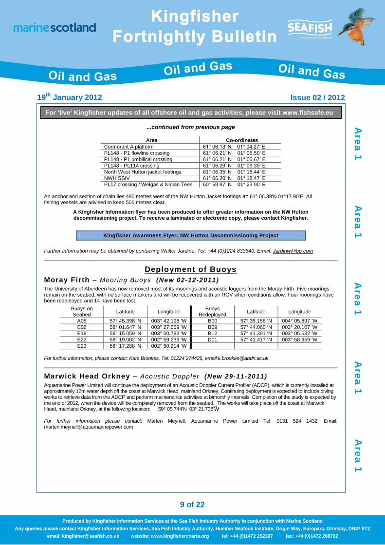
...continued from previous page
Area Co-ordinates Cormorant A platform 61° 06.13′ N 01° 04.27′ E PL148 - P1 flowline crossing 61° 06.21’ N 01° 05.50’ E PL148 - P1 umbilical crossing 61° 06.21’ N 01° 05.67’ E PL148 - PL114 crossing 61° 06.29’ N 01° 09.39’ E North West Hutton jacket footings 61° 06.35’ N 01° 18.44’ E NWH SSIV 61° 06.20’ N 01° 18.47’ E PL17 crossing / Welgas & Ninian Tees 60° 59.97’ N 01° 23.90’ E
An anchor and section of chain lies 490 metres west of the NW Hutton Jacket footings at: 61° 06.39'N 01°17.90'E. All fishing vessels are advised to keep 500 metres clear.
A Kingfisher Information flyer has been produced to offer greater information on the NW Hutton decommissioning project. To receive a laminated or electronic copy, please contact Kingfisher.
Kingfisher Awareness Flyer: NW Hutton Decommissioning Project
Further information may be obtained by contacting Walter Jardine, Tel: +44 (0)1224 833640, Email: [email protected]
Deployment of Buoys
Moray Firth – Moor ing Buoys (New 02-12-2011) The University of Aberdeen has now removed most of its moorings and acoustic loggers from the Moray Firth. Five moorings remain on the seabed, with no surface markers and will be recovered with an ROV when conditions allow. Four moorings have been redeployed and 14 have been lost.
Buoys on Seabed Latitude Longitude Buoys
Redeployed Latitude Longitude
A05 57° 45.398 ‘N 003° 42.198 ‘W B00 57° 35.156 ‘N 004° 05.897 ‘W E06 58° 01.647 ‘N 003° 27.559 ‘W B09 57° 44.060 ‘N 003° 20.107 ‘W E18 58° 15.059 ‘N 003° 00.783 ‘W B12 57° 41.391 ‘N 003° 05.632 ‘W E22 58° 19.002 ‘N 002° 59.233 ‘W D01 57° 41.417 ‘N 003° 58.959 ‘W E23 58° 17.288 ‘N 002° 50.214 ‘W
For further information, please contact: Kate Brookes, Tel: 01224 274425, email:[email protected]
Marwick Head Orkney – Acoust ic Doppler (New 29-11-2011) Aquamarine Power Limited will continue the deployment of an Acoustic Doppler Current Profiler (ADCP), which is currently installed at approximately 12m water depth off the coast at Marwick Head, mainland Orkney. Continuing deployment is expected to include diving works to retrieve data from the ADCP and perform maintenance activities at bimonthly intervals. Completion of the study is expected by the end of 2012, when the device will be completely removed from the seabed. The works will take place off the coast at Marwick Head, mainland Orkney, at the following location: 59° 05.744’N 03° 21.738’W For further information please contact: Marten Meynell, Aquamarine Power Limited Tel: 0131 524 1432, Email: [email protected]
Area 1
Area 1
Area 1
Area 1
Area 1

19th January 2012 Issue 02 / 2012
10 of 22
For ‘live’ Kingfisher updates of all offshore oil and gas activities, please visit www.fishsafe.eu
Produced by Kingfisher Information Services at the Sea Fish Industry Authority in conjunction with Marine Scotland Any queries please contact Kingfisher Information Services, Sea Fish Industry Authority, Humber Seafood Institute, Origin Way, Europarc, Grimsby, DN37 9TZ
email: [email protected] website: www.kingfishercharts.org tel: +44 (0)1472 252307 fax: +44 (0)1472 268792
Survey Activity
Company, Vessel & Call Sign
Towing Cable Length &
Submerged Depth
Area Covered Quadrant Blocks Start Timeframe & Duration
Gardline Geosurvey Ltd L'Espoir PFPY
N/A
Amendment to Issue 01/2012 61° 05.412 'N 001° 01.415 'E 61° 05.343 'N 001° 09.964 'E 60° 58.874 'N 001° 09.727 'E 60° 58.943 'N 001° 01.207 'E
211/26 30/12/2011 - 14/02/2012
For 8 Days
Gardline Geosurvey Ltd Ocean Observer
GHXX N/A
Amendment to Issue 26/2011 61° 34.298 'N 000° 51.066 'E 61° 31.717 'N 001° 02.243 'E 61° 28.325 'N 000° 58.798 'E 61° 30.902 'N 000° 47.637 'E
210/15a 30/12/2011 - 15/02/2012
For 8 Days
Fugro Survey Ltd Fugro Searcher
3EUY6 700m 3m
58° 14.205 'N 001° 31.571 'W 58° 19.054 'N 001° 31.370 'W 58° 19.155 'N 001° 40.585 'W 58° 14.306 'N 001° 40.765 'W
13/23a,22d,22a 29/01/2012 - 15/03/2012
For 5 Days
Fugro Survey Ltd Geo Prospector
HP2038 1300m
3m
61 24.907 N 001 37.192 W 61 31.369 N 001 36.905 W 61 31.495 N 001 50.437 W 61 25.033 N 001 50.677 W
208/17 20/01/2012 - 30/03/2012
For 4 Days
MMT Franklin OZ2102
57°42.33'N 03°01.19'W 58°07.55'N 02°30.91'W 58°13.91'N 02°31.02'W 58°18.84'N 02°38.91'W 58°16.69'N 02°42.65'W 58°13.36'N 02°37.44'W 58°07.81'N 02°37.29'W 58°43.70'N 03°04.62'W 58°31.28'N 03°04.19'W 58°29.15'N 03°03.96'W 58°29.27'N 02°54.19'W 58°31.28'N 03°04.19'W
11,12,17,18 2/01/2012 - 09/02/2012
For 4 Weeks
Gardline Geosurvey Ltd Ocean Researcher
GDLS 1200m
3m
61° 02.740 'N 001° 10.148 'E 61° 05.281 'N 001° 16.584 'E 61° 01.660 'N 001° 23.248 'E 60° 58.895 'N 001° 16.815 'E
211/27a,27c,27e 10/01/2012 - 31/01/2012
For 3 Days
Nexen Petroleum U.K Ltd TBA
1200m 3m
58° 18.457 'N 000° 33.710 'E 58° 12.787 'N 000° 39.606 'E 58° 09.417 'N 000° 27.981 'E 58° 15.078 'N 000° 22.064 'E
15/23a,23b,23d,23e 01/01/2012 - 30/06/2012
For 9 Days
Enquest Heather Ltd Kommandor Stuart
MPOQH3
58° 30.697 'N 000° 19.231 'E 58° 30.782 'N 000° 23.346 'E 58° 28.091 'N 000° 23.546 'E 58° 28.006 'N 000° 19.436 'E
15/12 & 15/17 01/01/2012 - 15/02/2012
For 7 Days
Enquest Heather Ltd Kommandor Stuart
MPOQH3
60° 50.426 'N 00° 52.578 'E 60° 50.319 'N 00° 45.960 'E 60° 52.256 'N 00° 45.825 'E 60° 52.364 'N 00° 52.450 'E
2/4 & 2/5 23/12/2011 - 30/01/2012
For 1 Day
Enquest Heather Ltd Kommandor Stuart
MPOQH3
61° 27.268 'N 001° 33.756 'E 61° 29.961 'N 001° 33.632 'E 61° 30.018 'N 001° 39.266 'E 61° 27.326 'N 001° 39.382 'E
211/19 23/12/2011 - 30/01/2012
For 3 Days
Clydeside Surveys MV Solstice
TBA N/A
58° 10.590 'N 003° 19.131 'W 58° 10.607 'N 003° 10.170 'W 58° 12.978 'N 003° 10.182 'W 58° 12.961 'N 003° 19.152 'W
11/24, 11/25 25/11/2011 - 31/03/2012
For 4 Days
Nexen Petroleum U.K Ltd Kommandor Stuart
MPOQH3 1200m
3m
58° 04.972 'N 001° 02.872 'W 58° 03.773 'N 000° 53.492 'W 57° 58.887 'N 000° 55.721 'W 58° 00.083 'N 001° 05.082 'W
13/30a,30b 14/26a
24/10/2011 - 30/04/2012
For 7 Days
Fugro Survey Limited MV Fugro Discovery
3EKE6 1200m
3m
58° 16.976 'N 000° 11.665 'E 58° 13.024 'N 000° 19.196 'E 58° 10.161 'N 000° 13.797 'E 58° 14.107 'N 000° 06.266 'E
15/21a,21d,22 15/02/2012 - 15/08/2012
For 15 Days
Area 1
Area 1
Area 1
Area 1
Area 1

19th January 2012 Issue 02 / 2012
11 of 22
For ‘live’ Kingfisher updates of all offshore oil and gas activities, please visit www.fishsafe.eu
Produced by Kingfisher Information Services at the Sea Fish Industry Authority in conjunction with Marine Scotland Any queries please contact Kingfisher Information Services, Sea Fish Industry Authority, Humber Seafood Institute, Origin Way, Europarc, Grimsby, DN37 9TZ
email: [email protected] website: www.kingfishercharts.org tel: +44 (0)1472 252307 fax: +44 (0)1472 268792
Suspended Wellheads New Suspended Wellhead(s) – Additions to Yellow Card (New 04-01-2012) Please note the new suspended wellhead(s) below, which should be marked on your fishing plotter and Kingfisher Yellow Card.
Abandoned Suspended Wellhead(s) – Removal from Yellow Card (New 20-12-2011) Please note the previously suspended wellhead(s) below, which have now been plugged and abandoned and should be removed from your fishing plotter and Kingfisher Yellow Card.
Notice to Fishermen
Snagging Hazard – Obstruc t ion (New 17-01-2012) Please note that there is an vibro-corer obstruction which is 3.5 m high and 1m width increasing to 4m wide at it's base, which is expected to be flush to the seabed, there is approximately 100m of 16mm wire rope attached to the corer. Weight in air is 1.25t, although it is our expectation that the core barrel will be extended 3m into the seabed, and that the object is thus firmly anchored to the seabed.
Position: 56° 54.830' N 01° 57.2420' E For further information, please contact: Roland Coomber, Calesurvey, Tel: +44(0)1508528327 email: [email protected]
Banff Oil Field – D isconnect ion of Apol lo Spir i t f rom STL Buoy (New 21-12-2011)
Please find Ugland Stena Storage AS formal notification for relocation of the Apollo Spirit from the STL Buoy at the Banff Oil Field . Please be informed that the Apollo Spirit was disconnected from the Banff STL Buoy and passing the 500 mtrs zone at 19:00 hrs LT 21 December 2011, the towing vessels Bourbon Orca and Boa Mighty will tow the Apollo Spirit to an sheltered location at the west coast of Norway, Boevaagen at Karmoy. The Apollo Spirit mooring at position :57° 00.728’N 01° 19.647’E Block Number: 29/2a & 22/27a) will be guarded by the Banff Oil Field Standby Vessel.
For further information, please contact: Svein Aarvik, BT connect, Tel: +44(0)1224 793400 email: [email protected]
Seabed Activity Dril l ing Operations – Acorn (New 19-12-2011)
Drilling Rig/Ship Start Date Finish Date Installation Name/ Well No Position
Noble Ton van Langeveld 15-01-2012 15-02-2012
14-02-2012
Acorn Well 29-08b-02z Acorn Well 29-08a-6
56°43.702'N 001°32.415'E 56°45.134'N 001°32.283'E
For further information, please contact: Sarah Butcher, Centrica Energy Upstream, Tel: +44 (0)1224 41500 Email:Sarah [email protected]
River Tay – Construc t ion / Survey Act iv i t ies (New 07-12-2011) Please be advised that ground investigation works are to be undertaken within the River Tay (Craig Harbour). In addition to soils information, a bathymetric and geophysical survey is proposed to map both the river bed and the rock head levels. Information
Continued over page..
Well No OPERATOR LAT LONG 21/29d-11Z Antrim Resources 57°09.624'N 000°37.195'E
Well No LAT LONG 30/13-4 56°38.961'N 002°29.743'E 28/09b-2 56°42.993'N 001°41.716'E 29/09b-9z 56°42.697'N 001°41.624'E
Area 2
Area 2
Area 2
Area 2
Area 2

19th January 2012 Issue 02 / 2012
12 of 22
For ‘live’ Kingfisher updates of all offshore oil and gas activities, please visit www.fishsafe.eu
Produced by Kingfisher Information Services at the Sea Fish Industry Authority in conjunction with Marine Scotland Any queries please contact Kingfisher Information Services, Sea Fish Industry Authority, Humber Seafood Institute, Origin Way, Europarc, Grimsby, DN37 9TZ
email: [email protected] website: www.kingfishercharts.org tel: +44 (0)1472 252307 fax: +44 (0)1472 268792
...continued from previous page regarding river current velocities in the vicinity of the site are also to be obtained. Fugro Seacore have been appointed to undertake the investigations with the geophysical and bathymetric surveys scheduled to commence mid December. Boreholes will commence in January 2012 with completion, subject to weather conditions, scheduled for late February / mid March 2012. The site is located at Discovery Point, Dundee, within the area bounded by the following coordinates:
1. 56°27.28'N 002°58.29'W 2. 56°27.54'N 002°57.68'W
3. 56°27.08'N 002°57.98'W 4. 56°27.38'N 002°57.29'W
For further information, please contact: Olivia Williams, Fugro Seacore, Tel. +44(0) 1326 254500, Email:[email protected]
Auk North – Forth Well Project (Update 07-12-2011) The work will include manifold installation, spool and jumper installation, tie-in and pre-commissioning activities. A guard vessel will be used at the drill centre during periods when any elements of the works are incomplete and vulnerable to fishing activities when DSV is not on site (interim mobilisations). Completion of construction is anticipated by end Q1 2012.
Drilling Rig/Ship Start Date Finish Date Installation Name/ Well No Position
Skandi 7/Acergy Discovery
07-12-11
30-03-2012
Auk North Drill Centre
56°26.428'N 002°00.567'E
For further information, please contact Dave Allan on Tel: 01224 358867 or email: [email protected]
Fergus, Fife, Flora, Angus – Decommissioning (New 06-12-2011) Please be advised that Hess will be carrying out decommissioning operations of the subsea infrastructure over a period from circa 15/12/12 through to Mid March 2012. Vessels will be the Bibby Topaz and CSV ACM Connector. Guard Area based on the following positions:
Latitude Longitude 56o 03.00’ N 03o 03.07’ E 56o 03.00’ N 03o 03.15 ‘E 55o 59.00’ N 03o 03.15’ E 55o 59.00’ N 03o 03.07’ E
Further information may be obtained by contacting: Graham Smith, Hess Subsea Operations, Tel:01224 269 022 email:[email protected]
Pipelay & Construction Works – Huntington Development (New 21-11-2011) Field construction workscopes will encompass the following blocks - 22/14b, 22/14a & 22/9a The following structures / pipelines have been installed to date. The Flowlines run from the Huntington Drilling Template to the Future FPSO Location with the FPSO ends of the flowlines at the position shown below.There are also various subsea connections between the end of the flowlines / Pipeline and the structures
Structures Latitude Longitude Drilling Template 57° 35.895 'N 001° 38.417 'E Gas Export Tether Base 57° 36.895 'N 001° 38.403 'E Production Tether Base 57° 36.894 'N 001° 38.384 'E Gas-lift Tether Base 57° 36.894 'N 001° 38.370 'E Control Umbilical Tether Base 57° 36.897 'N 001° 38.344 'E Water Injection Tether Base 57° 36.900 'N 001° 38.322 'E UTA / DUTA 57° 36.846 'N 001° 38.310 'E Gas Export Holdback Clumpweight 57° 36.875 'N 001° 38.400 'E Production Holdback Clumpweight 57° 36.875 'N 001° 38.376 'E Gas-lift Holdback Clumpweight 57° 36.875 'N 001° 38.358 'E Water Injection Holdback Clumpweight 57° 36.885 'N 001° 38.299 'E Production Manifold 57° 35.899 'N 001° 38.465 'E
Continued over page..
Area 2
Area 2
Area 2
Area 2
Area 2
19th January 2012 Issue 02 / 2012
13 of 22
For ‘live’ Kingfisher updates of all offshore oil and gas activities, please visit www.fishsafe.eu
Produced by Kingfisher Information Services at the Sea Fish Industry Authority in conjunction with Marine Scotland Any queries please contact Kingfisher Information Services, Sea Fish Industry Authority, Humber Seafood Institute, Origin Way, Europarc, Grimsby, DN37 9TZ
email: [email protected] website: www.kingfishercharts.org tel: +44 (0)1472 252307 fax: +44 (0)1472 268792
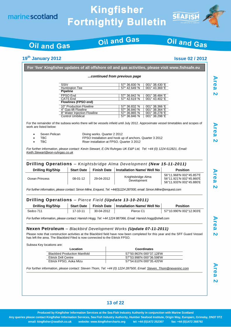
...continued from previous page
SSIV 57° 36.830 'N 001° 38.430 'E Huntington Tee 57° 42.649 'N 001° 43.369 'E Pipeline FPSO End 57° 36.842 'N 001° 38.484 'E CATS End 57° 42.619 'N 001° 43.402 'E Flowlines (FPSO end) 10" Production Flowline 57° 36.832 'N 001° 38.366 'E 4" Gas-lift Flowline 57° 36.840 'N 001° 38.364 'E 8" Water Injection Flowline 57° 36.865 'N 001° 38.278 'E Control Umbilical 57° 36.846 'N 001° 38.298 'E
For the remainder of the subsea works there will be vessels infield until July 2012. Approximate vessel timetables and scopes of work are listed below:
• Seven Pelican Diving works. Quarter 2 2012 • TBC FPSO Installation and hook up of anchors. Quarter 3 2012 • TBC Riser installation at FPSO. Quarter 3 2012
For further information, please contact: Kevin Stewart, E.ON Ruhrgas UK E&P Ltd, Tel: +44 (0) 1224 612821, Email: [email protected]
Drill ing Operations – Knightsbr idge Alma Development (New 15-11-2011)
Drilling Rig/Ship Start Date Finish Date Installation Name/ Well No Position
Ocean Princess 08-01-12 29-04-2012 Knightsbridge Alma Development
56°11.968'N 002°45.857'E 56°11.921'N 002°45.860'E 56°11.933'N 002°45.880'E
For further information, please contact: Simon Milne, Enquest, Tel: +44(0)1224 287000, email: [email protected]
Dril l ing Operations – Pierce F ie ld (Update 13-10-2011)
Drilling Rig/Ship Start Date Finish Date Installation Name/ Well No Position Sedco 711 17-10-11 30-04-2012 Pierce C1 57°10.990'N 002°12.903'E
For further information, please contact: Hamish Hogg, Tel: +44 1224 887066, Email: [email protected]
Nexen Petroleum – Blackbird Development Works (Update 07-11-2011) Please note that construction activities at the Blackbird field have now been completed for this year and the SFF Guard Vessel has left the area. The Blackbird Filed is now connected to the Ettrick FPSO. Subsea Key locations are:
Location Coordinates Blackbird Production Manifold 57°50.963'N 000°37.128'W Ettrick Drill Centre 57°53.998'N 000°36.598'W Ettrick FPSO, Aoka Mizu 57°54.610'N 000°35.420'W
For further information, please contact: Steven Thom, Tel: +44 (0) 1224 287500, Email: [email protected]
Area 2
Area 2
Area 2
Area 2
Area 2
19th January 2012 Issue 02 / 2012
14 of 22
For ‘live’ Kingfisher updates of all offshore oil and gas activities, please visit www.fishsafe.eu
Produced by Kingfisher Information Services at the Sea Fish Industry Authority in conjunction with Marine Scotland Any queries please contact Kingfisher Information Services, Sea Fish Industry Authority, Humber Seafood Institute, Origin Way, Europarc, Grimsby, DN37 9TZ
email: [email protected] website: www.kingfishercharts.org tel: +44 (0)1472 252307 fax: +44 (0)1472 268792
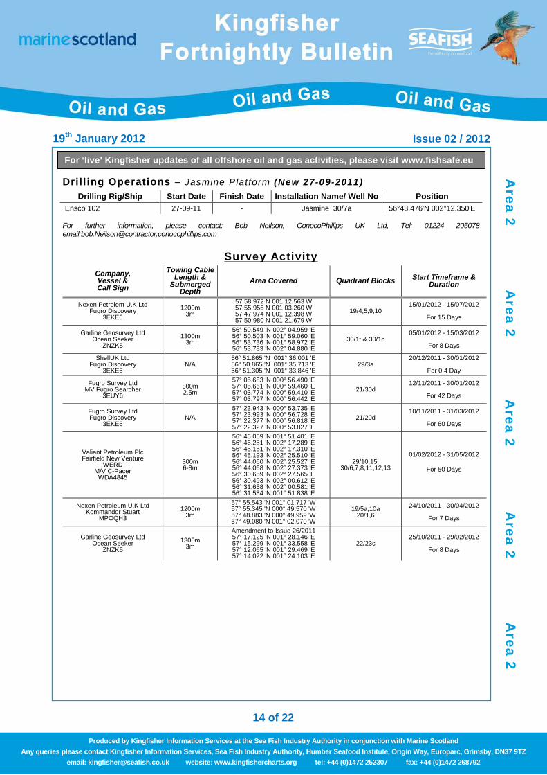
Drill ing Operations – Jasmine Platform (New 27-09-2011) Drilling Rig/Ship Start Date Finish Date Installation Name/ Well No Position
Ensco 102 27-09-11 - Jasmine 30/7a 56°43.476'N 002°12.350'E For further information, please contact: Bob Neilson, ConocoPhillips UK Ltd, Tel: 01224 205078 email:[email protected]
Survey Activity
Company, Vessel & Call Sign
Towing Cable Length &
Submerged Depth
Area Covered Quadrant Blocks Start Timeframe & Duration
Nexen Petrolem U.K Ltd Fugro Discovery
3EKE6 1200m
3m
57 58.972 N 001 12.563 W 57 55.955 N 001 03.260 W 57 47.974 N 001 12.398 W 57 50.980 N 001 21.679 W
19/4,5,9,10 15/01/2012 - 15/07/2012
For 15 Days
Garline Geosurvey Ltd Ocean Seeker
ZNZK5 1300m
3m
56° 50.549 'N 002° 04.959 'E 56° 50.503 'N 001° 59.060 'E 56° 53.736 'N 001° 58.972 'E 56° 53.783 'N 002° 04.880 'E
30/1f & 30/1c 05/01/2012 - 15/03/2012
For 8 Days
ShellUK Ltd Fugro Discovery
3EKE6 N/A
56° 51.865 'N 001° 36.001 'E 56° 50.865 'N 001° 35.713 'E 56° 51.305 'N 001° 33.846 'E
29/3a 20/12/2011 - 30/01/2012
For 0.4 Day
Fugro Survey Ltd MV Fugro Searcher
3EUY6 800m 2.5m
57° 05.683 'N 000° 56.490 'E 57° 05.661 'N 000° 59.460 'E 57° 03.774 'N 000° 59.410 'E 57° 03.797 'N 000° 56.442 'E
21/30d 12/11/2011 - 30/01/2012
For 42 Days
Fugro Survey Ltd Fugro Discovery
3EKE6 N/A
57° 23.943 'N 000° 53.735 'E 57° 23.993 'N 000° 56.728 'E 57° 22.377 'N 000° 56.818 'E 57° 22.327 'N 000° 53.827 'E
21/20d 10/11/2011 - 31/03/2012
For 60 Days
Valiant Petroleum Plc Fairfield New Venture
WERD M/V C-Pacer
WDA4845
300m 6-8m
56° 46.059 'N 001° 51.401 'E 56° 46.251 'N 002° 17.289 'E 56° 45.151 'N 002° 17.310 'E 56° 45.193 'N 002° 25.510 'E 56° 44.060 'N 002° 25.527 'E 56° 44.068 'N 002° 27.373 'E 56° 30.659 'N 002° 27.565 'E 56° 30.493 'N 002° 00.612 'E 56° 31.658 'N 002° 00.581 'E 56° 31.584 'N 001° 51.838 'E
29/10,15, 30/6,7,8,11,12,13
01/02/2012 - 31/05/2012
For 50 Days
Nexen Petroleum U.K Ltd Kommandor Stuart
MPOQH3 1200m
3m
57° 55.543 'N 001° 01.717 'W 57° 55.345 'N 000° 49.570 'W 57° 48.883 'N 000° 49.959 'W 57° 49.080 'N 001° 02.070 'W
19/5a,10a 20/1,6
24/10/2011 - 30/04/2012
For 7 Days
Garline Geosurvey Ltd Ocean Seeker
ZNZK5 1300m
3m
Amendment to Issue 26/2011 57° 17.125 'N 001° 28.146 'E 57° 15.299 'N 001° 33.558 'E 57° 12.065 'N 001° 29.469 'E 57° 14.022 'N 001° 24.103 'E
22/23c 25/10/2011 - 29/02/2012
For 8 Days
Area 2
Area 2
Area 2
Area 2
Area 2
19th January 2012 Issue 02 / 2012
15 of 22
For ‘live’ Kingfisher updates of all offshore oil and gas activities, please visit www.fishsafe.eu
Produced by Kingfisher Information Services at the Sea Fish Industry Authority in conjunction with Marine Scotland Any queries please contact Kingfisher Information Services, Sea Fish Industry Authority, Humber Seafood Institute, Origin Way, Europarc, Grimsby, DN37 9TZ
email: [email protected] website: www.kingfishercharts.org tel: +44 (0)1472 252307 fax: +44 (0)1472 268792
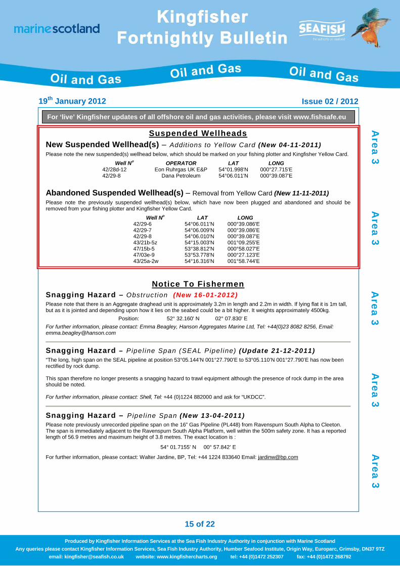
Suspended Wellheads New Suspended Wellhead(s) – Additions to Yellow Card (New 04-11-2011) Please note the new suspended(s) wellhead below, which should be marked on your fishing plotter and Kingfisher Yellow Card.
Abandoned Suspended Wellhead(s) – Removal from Yellow Card (New 11-11-2011) Please note the previously suspended wellhead(s) below, which have now been plugged and abandoned and should be removed from your fishing plotter and Kingfisher Yellow Card.
Notice To Fishermen Snagging Hazard – Obstruc t ion (New 16-01-2012) Please note that there is an Aggregate draghead unit is approximately 3.2m in length and 2.2m in width. If lying flat it is 1m tall, but as it is jointed and depending upon how it lies on the seabed could be a bit higher. It weights approximately 4500kg.
Position: 52° 32.160' N 02° 07.830' E For further information, please contact: Emma Beagley, Hanson Aggregates Marine Ltd, Tel: +44(0)23 8082 8256, Email: [email protected]
Snagging Hazard – Pipel ine Span (SEAL Pipel ine) (Update 21-12-2011) “The long, high span on the SEAL pipeline at position 53°05.144’N 001°27.790’E to 53°05.110’N 001°27.790’E has now been rectified by rock dump. This span therefore no longer presents a snagging hazard to trawl equipment although the presence of rock dump in the area should be noted. For further information, please contact: Shell, Tel: +44 (0)1224 882000 and ask for “UKDCC”.
Snagging Hazard – Pipel ine Span (New 13-04-2011) Please note previously unrecorded pipeline span on the 16” Gas Pipeline (PL448) from Ravenspurn South Alpha to Cleeton. The span is immediately adjacent to the Ravenspurn South Alpha Platform, well within the 500m safety zone. It has a reported length of 56.9 metres and maximum height of 3.8 metres. The exact location is :
54° 01.7155’ N 00° 57.842’ E
For further information, please contact: Walter Jardine, BP, Tel: +44 1224 833640 Email: [email protected]
Well No OPERATOR LAT LONG 42/28d-12 Eon Ruhrgas UK E&P 54°01.998'N 000°27.715'E 42/29-8 Dana Petroleum 54°06.011'N 000°39.087'E
Well No LAT LONG 42/29-6 54°06.011'N 000°39.086'E 42/29-7 54°06.009'N 000°39.086'E 42/29-8 54°06.010'N 000°39.087'E 43/21b-5z 54°15.003'N 001°09.255'E 47/15b-5 53°38.812'N 000°58.027'E 47/03e-9 53°53.778'N 000°27.123'E 43/25a-2w 54°16.316'N 001°58.744'E
Area 3
Area 3
Area 3
Area 3
Area 3

19th January 2012 Issue 02 / 2012
16 of 22
For ‘live’ Kingfisher updates of all offshore oil and gas activities, please visit www.fishsafe.eu
Produced by Kingfisher Information Services at the Sea Fish Industry Authority in conjunction with Marine Scotland Any queries please contact Kingfisher Information Services, Sea Fish Industry Authority, Humber Seafood Institute, Origin Way, Europarc, Grimsby, DN37 9TZ
email: [email protected] website: www.kingfishercharts.org tel: +44 (0)1472 252307 fax: +44 (0)1472 268792
Seabed Activity Indefatigable Platform – Activity (New 02-11-2011) Mariners are advised that the Shell Indefatigable Platforms: Mike, Juliet (JP & JD), Lima, Kilo and November have all been permanently removed. A 500mtr Exclusion Zone still exists on all Platform sites until the surrounding seabed has been surveyed and cleared of any remaining debris. It is anticipated that a Diving Support Vessel (name as yet unknown) will conduct operations between December 2011 and April 2012 removing major items of debris. This will be followed in May 2012 by the Trawler Farnella conducting a debris-clearence sweep, removing smaller objects - after which the site will be declared debris-free. The attachment to this notice gives the positions in WGS84 format of the Cardinal Buoys presently on-station at each Platform site warning mariners of the seabed hazard. It is expected that all Cardinal Buoys will be permanently removed before May 2012.
SHELL INDE FIELD CARDINAL BUOYS AS-LAID POSITIONS – 28th / 29th JULY 2011
Location Buoys Position from centre Latitude Longitude Shell Inde "Mike" North Cardinal 360° x 500 mtrs 53° 21.454 ‘N 002° 36.375 ‘E East Cardinal 120° x 500 mtrs 53° 21.050 ‘N 002° 36.765 ‘E West Cardinal 240° x 500 mtrs 53° 21.050 ‘N 002° 35.985 ‘E Shell Inde “Juliet” East Cardinal 090° x 500 mtrs 53° 19.581 ‘N 002° 38.310 ‘E West Cardinal 275° x 500 mtrs 53° 19.605 ‘N 002° 37.411 ‘E Shell Inde "Lima" East Cardinal 060° x 500 mtrs 53° 18.026 ‘N 002° 37.533 ‘E South Cardinal 180° x 500 mtrs 53° 17.622 ‘N 002° 37.143 ‘E West Cardinal 300° x 500 mtrs 53° 18.026 ‘N 002° 36.754 ‘E Shell Inde "Kilo" North Cardinal 360° x 500 mtrs 53° 17.076 ‘N 002° 41.445 ‘E South Cardinal 120° x 500 mtrs 53° 16.672 ‘N 002° 41.834 ‘E West Cardinal 240° x 500 mtrs 53° 16.672 ‘N 002° 41.055 ‘E Shell Inde "November" North Cardinal 330° x 500 mtrs 53° 17.523 ‘N 002° 43.048 ‘E East Cardinal 090° x 500 mtrs 53° 17.290 ‘N 002° 43.723 ‘E South Cardinal 210° x 500 mtrs 53° 17.056 ‘N 002° 43.048 ‘E For further information, please contact: John Bird, Shell Marine Rep, Tel: +44(0)1502 508000, email: [email protected]
Dril l ing Operations – Wingate Sate l l i te Plat form (Update 10-10-2011)
Drilling Rig/Ship Start Date Finish Date Installation Name/ Well No Position Wingate Satellite Platform (NUI) 06-10-2011 01-02- 2012 44/24b 54°18.950'N 002°37.091'E.
Hereafter the rig will drill an appraisal well (Wingate A-2) Wingate-A2 will be drilled in five sections. A 30” conductor will be hammered into the seabed prior to installation of a diverter. If pilot section is successful, the section will be plugged with cement and the side track drilled.
Further information, please contact: Louise van Wijk, Phone: +31(0)703583282, Email: [email protected]
Deployment of Buoys Liverpool Bay– Extension of Mooring Deployment Dates (New 20-12-2011) A hazard to shipping and fishing will be presented by continuous moorings in Liverpool Bay. Recording oceanographic equipment will continue to be moored at the site below. There will be a copper coloured waverider and a yellow toroidal shaped buoy (2m dia) both displaying a flashing light of 5 flashes in 10 seconds with a repeat rate of 20 seconds. Wave Data is available in real-time from ww.cefas.co.uk/wavenet
53° 32.07’N 003° 21.44’W
To avoid fouling the moorings the Laboratory would be grateful if ships and fishing boats would keep at least 5 cables clear of the moorings. For further information, please contact: Cefas Lowestoft Lab, Tel: +44(0)1502 562244 email:[email protected]
Area 3
Area 3
Area 3
Area 3
Area 3
19th January 2012 Issue 02 / 2012
17 of 22
For ‘live’ Kingfisher updates of all offshore oil and gas activities, please visit www.fishsafe.eu
Produced by Kingfisher Information Services at the Sea Fish Industry Authority in conjunction with Marine Scotland Any queries please contact Kingfisher Information Services, Sea Fish Industry Authority, Humber Seafood Institute, Origin Way, Europarc, Grimsby, DN37 9TZ
email: [email protected] website: www.kingfishercharts.org tel: +44 (0)1472 252307 fax: +44 (0)1472 268792
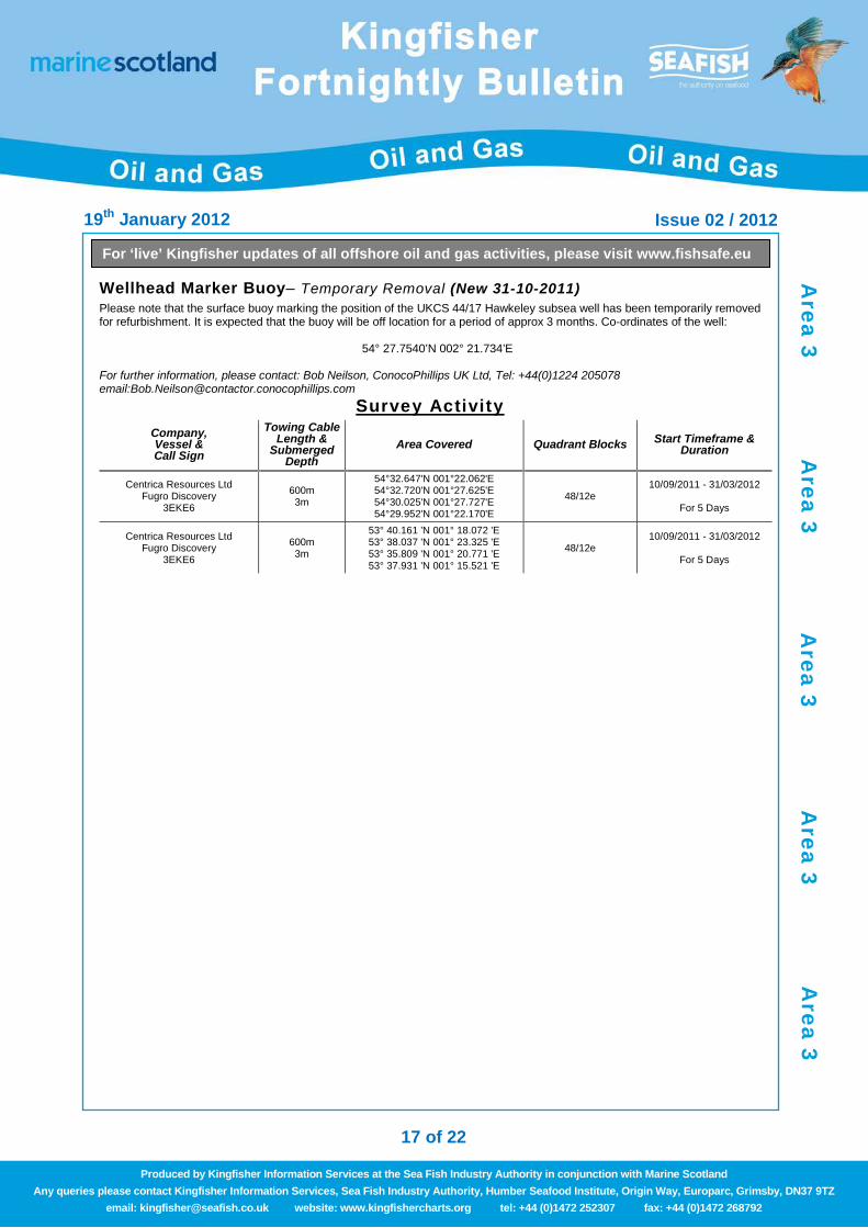
Wellhead Marker Buoy– Temporary Removal (New 31-10-2011) Please note that the surface buoy marking the position of the UKCS 44/17 Hawkeley subsea well has been temporarily removed for refurbishment. It is expected that the buoy will be off location for a period of approx 3 months. Co-ordinates of the well:
54° 27.7540’N 002° 21.734’E For further information, please contact: Bob Neilson, ConocoPhillips UK Ltd, Tel: +44(0)1224 205078 email:[email protected]
Survey Activity
Company, Vessel & Call Sign
Towing Cable Length &
Submerged Depth
Area Covered Quadrant Blocks Start Timeframe & Duration
Centrica Resources Ltd Fugro Discovery
3EKE6
600m 3m
54°32.647'N 001°22.062'E 54°32.720'N 001°27.625'E 54°30.025'N 001°27.727'E 54°29.952'N 001°22.170'E
48/12e 10/09/2011 - 31/03/2012
For 5 Days
Centrica Resources Ltd Fugro Discovery
3EKE6
600m 3m
53° 40.161 'N 001° 18.072 'E 53° 38.037 'N 001° 23.325 'E 53° 35.809 'N 001° 20.771 'E 53° 37.931 'N 001° 15.521 'E
48/12e 10/09/2011 - 31/03/2012
For 5 Days
Area 3
Area 3
Area 3
Area 3
Area 3
19th January 2012 Issue 02 / 2012
18 of 22
For ‘live’ Kingfisher updates of all offshore oil and gas activities, please visit www.fishsafe.eu
Produced by Kingfisher Information Services at the Sea Fish Industry Authority in conjunction with Marine Scotland Any queries please contact Kingfisher Information Services, Sea Fish Industry Authority, Humber Seafood Institute, Origin Way, Europarc, Grimsby, DN37 9TZ
email: [email protected] website: www.kingfishercharts.org tel: +44 (0)1472 252307 fax: +44 (0)1472 268792
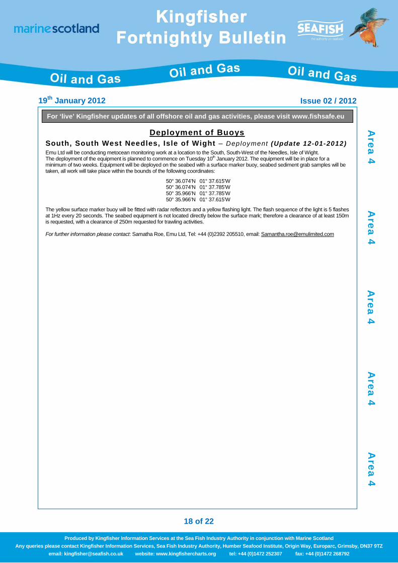
Deployment of Buoys South, South West Needles, Isle of Wight – Deployment (Update 12-01-2012) Emu Ltd will be conducting metocean monitoring work at a location to the South, South-West of the Needles, Isle of Wight. The deployment of the equipment is planned to commence on Tuesday 10th January 2012. The equipment will be in place for a minimum of two weeks. Equipment will be deployed on the seabed with a surface marker buoy, seabed sediment grab samples will be taken, all work will take place within the bounds of the following coordinates:
50° 36.074’N 01° 37.615’W 50° 36.074’N 01° 37.785’W 50° 35.966’N 01° 37.785’W 50° 35.966’N 01° 37.615’W
The yellow surface marker buoy will be fitted with radar reflectors and a yellow flashing light. The flash sequence of the light is 5 flashes at 1Hz every 20 seconds. The seabed equipment is not located directly below the surface mark; therefore a clearance of at least 150m is requested, with a clearance of 250m requested for trawling activities. For further information please contact: Samatha Roe, Emu Ltd, Tel: +44 (0)2392 205510, email: [email protected]
Area 4
Area 4
Area 4
Area 4
Area 4

19th January 2012 Issue 02 / 2012
19 of 22
For ‘live’ Kingfisher updates of all offshore oil and gas activities, please visit www.fishsafe.eu
Produced by Kingfisher Information Services at the Sea Fish Industry Authority in conjunction with Marine Scotland Any queries please contact Kingfisher Information Services, Sea Fish Industry Authority, Humber Seafood Institute, Origin Way, Europarc, Grimsby, DN37 9TZ
email: [email protected] website: www.kingfishercharts.org tel: +44 (0)1472 252307 fax: +44 (0)1472 268792
Survey Activity
Company, Vessel & Call Sign
Towing Cable Length &
Submerged Depth
Area Covered Quadrant Blocks Start Timeframe & Duration
Hydrocarbon Resources Ltd Ocean Discovery
2DAU3
Amendment to Issue 24/2011 53° 46.296 'N 003° 33.914 'W 53° 45.756 'N 003° 33.907 'W 53° 45.752 'N 003° 34.817 'W 53° 46.291 'N 003° 34.824 'W
110/8a 03/12/2011 - 31/01/2012
For 3 Days
Hydrocarbon Resources Limited Fugro Discovery
3EKE6 N/A
54°04.815'N 003°43.059'W 54°04.834'N 003°39.758'W 53°57.065'N 003°39.635'W 53°57.057'N 003°41.081'W 54°03.258'N 003°41.166'W 54°03.247'N 003°43.032'W
113/27b, 110/2a 10/09/2011 - 31/03/2012
For 5 Days
Area 5
Area 5
Area 5
Area 5
Area 5
19th January 2012 Issue 02 / 2012
20 of 22
For ‘live’ Kingfisher updates of all offshore oil and gas activities, please visit www.fishsafe.eu
Produced by Kingfisher Information Services at the Sea Fish Industry Authority in conjunction with Marine Scotland Any queries please contact Kingfisher Information Services, Sea Fish Industry Authority, Humber Seafood Institute, Origin Way, Europarc, Grimsby, DN37 9TZ
email: [email protected] website: www.kingfishercharts.org tel: +44 (0)1472 252307 fax: +44 (0)1472 268792
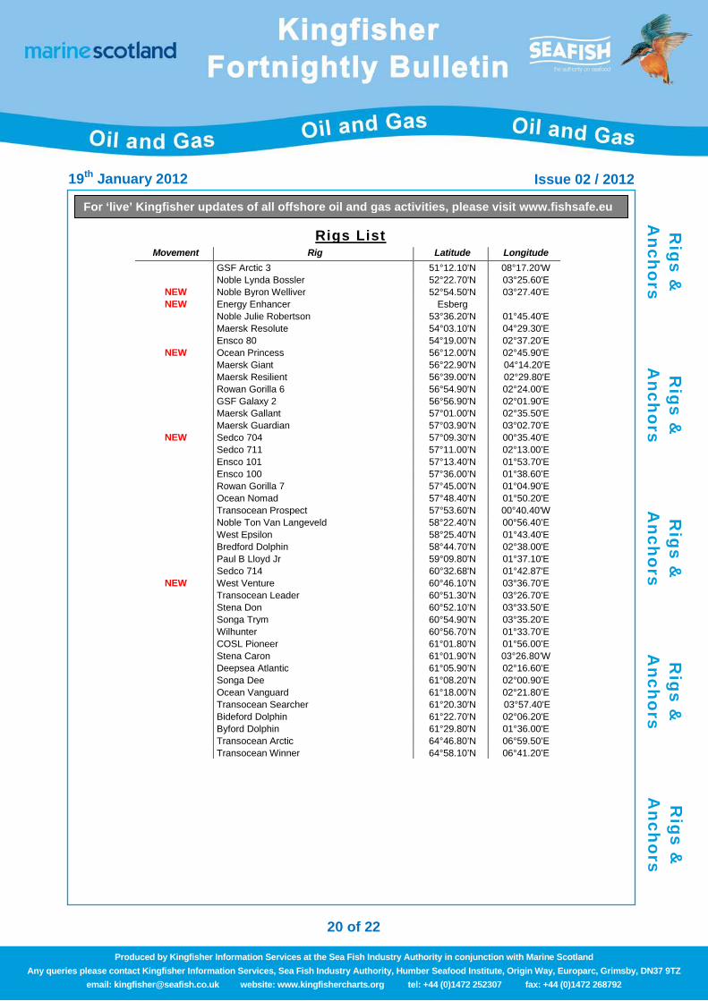
Rigs List Movement Rig Latitude Longitude
GSF Arctic 3 51°12.10'N 08°17.20'W Noble Lynda Bossler 52°22.70'N 03°25.60'E
NEW Noble Byron Welliver 52°54.50'N 03°27.40'E NEW Energy Enhancer Esberg
Noble Julie Robertson 53°36.20'N 01°45.40'E Maersk Resolute 54°03.10'N 04°29.30'E Ensco 80 54°19.00’N 02°37.20’E
NEW Ocean Princess 56°12.00'N 02°45.90'E Maersk Giant 56°22.90'N 04°14.20'E Maersk Resilient 56°39.00'N 02°29.80'E Rowan Gorilla 6 56°54.90'N 02°24.00'E GSF Galaxy 2 56°56.90'N 02°01.90'E Maersk Gallant 57°01.00'N 02°35.50'E Maersk Guardian 57°03.90’N 03°02.70’E
NEW Sedco 704 57°09.30'N 00°35.40'E Sedco 711 57°11.00’N 02°13.00’E Ensco 101 57°13.40'N 01°53.70'E Ensco 100 57°36.00’N 01°38.60’E Rowan Gorilla 7 57°45.00’N 01°04.90’E Ocean Nomad 57°48.40'N 01°50.20'E Transocean Prospect 57°53.60'N 00°40.40'W Noble Ton Van Langeveld 58°22.40’N 00°56.40’E West Epsilon 58°25.40'N 01°43.40'E Bredford Dolphin 58°44.70'N 02°38.00'E Paul B Lloyd Jr 59°09.80'N 01°37.10'E Sedco 714 60°32.68'N 01°42.87'E
NEW West Venture 60°46.10’N 03°36.70’E Transocean Leader 60°51.30’N 03°26.70’E Stena Don 60°52.10’N 03°33.50’E Songa Trym 60°54.90’N 03°35.20’E Wilhunter 60°56.70’N 01°33.70’E COSL Pioneer 61°01.80’N 01°56.00’E Stena Caron 61°01.90’N 03°26.80’W Deepsea Atlantic 61°05.90’N 02°16.60’E Songa Dee 61°08.20’N 02°00.90’E Ocean Vanguard 61°18.00’N 02°21.80’E
Transocean Searcher 61°20.30'N 03°57.40'E Bideford Dolphin 61°22.70'N 02°06.20'E Byford Dolphin 61°29.80'N 01°36.00'E Transocean Arctic 64°46.80’N 06°59.50’E Transocean Winner 64°58.10’N 06°41.20’E
Rigs &
A
nchors
Rigs &
A
nchors
Rigs &
A
nchors
Rigs &
A
nchors
Rigs &
A
nchors

19th January 2012 Issue 02 / 2012
21 of 22
For ‘live’ Kingfisher updates of all offshore oil and gas activities, please visit www.fishsafe.eu
Produced by Kingfisher Information Services at the Sea Fish Industry Authority in conjunction with Marine Scotland Any queries please contact Kingfisher Information Services, Sea Fish Industry Authority, Humber Seafood Institute, Origin Way, Europarc, Grimsby, DN37 9TZ
email: [email protected] website: www.kingfishercharts.org tel: +44 (0)1472 252307 fax: +44 (0)1472 268792
Anchors "Rig anchors may extend up to one mile from the rig position. Anchor buoys not always deployed. Fishing within the anchor pattern should be avoided. Fishermen may contact
the installation or the ERRV (standby vessel) for positions of the anchors."
Transocean Prospect – Ett ic ICB Well – As Laid Anchor Number Latitude Longitude Anchor Number Latitude Longitude
Rig 57° 53.540 ‘N 000° 40.500 ‘W 5 57° 53.000 ‘N 000° 40.180 ‘W 1 57° 54.070 ‘N 000° 40.910 ‘W 6 57° 52.990 ‘N 000° 40.910 ‘W 2 57° 54.040 ‘N 000° 40.050 ‘W 7 57° 53.330 ‘N 000° 41.490 ‘W 3 57° 53.690 ‘N 001° 39.450 ‘W 8 57° 53.780 ‘N 000° 41.420 ‘W 4 57° 53.330 ‘N 001° 39.420 ‘W
Vouageur – Hunt ington F ield - Late Summer 2012
Anchor Number Latitude Longitude Anchor Number Latitude Longitude Rig 57° 37.020 ‘N 001° 37.080 ‘E 7 57° 36.410 ‘N 001° 39.290 ‘E 1 57° 37.750 ‘N 001° 38.590 ‘E 8 57° 36.390 ‘N 001° 39.250 ‘E 2 57° 37.750 ‘N 001° 38.640 ‘E 9 57° 36.830 ‘N 001° 37.120 ‘E 3 57° 37.720 ‘N 001° 38.920 ‘E 10 57° 36.890 ‘N 001° 37.110 ‘E 4 57° 37.710 ‘N 001° 38.970 ‘E 11a 57° 37.980 ‘N 001° 37.090 ‘E 5 57° 36.510 ‘N 001° 39.510 ‘E 11b 57° 37.010 ‘N 001° 37.080 ‘E 6 57° 36.490 ‘N 001° 39.470 ‘E
Flotel Safe Caledonia – North everest 9 t h December – 31st March 2012
Anchor Number Latitude Longitude Anchor Number Latitude Longitude 1 57° 44.601 ‘N 001° 47.076 ‘E 7 57° 45.084 ‘N 001° 49.185 ‘E 2 57° 44.977 ‘N 001° 46.294 ‘E 8 57° 44.844 ‘N 001° 49.016 ‘E 3 57° 45.257 ‘N 001° 45.978 ‘E 9 57° 44.573 ‘N 001° 47.600 ‘E 4 57° 45.858 ‘N 001° 46.045 ‘E 10 57° 46.286 ‘N 001° 46.816 ‘E 5 57° 46.454 ‘N 001° 47.962 ‘E 6 57° 46.300 ‘N 001° 48.345 ‘E
Sedco 714 –
Anchor Number Latitude Longitude Anchor Number Latitude Longitude Rig 60°32.68'N 01°42.87'E 5 60°32.80'N 01°44.60'E 1 60°32.41'N 01°41.63'E 6 60°32.39'N 01°43.85'E 2 60°32.90'N 01°41.64'E 7 60°32.02'N 01°43.17'E 3 60°33.30'N 01°42.32'E 8 60°32.05'N 01°42.53'E 4 60°33.12'N 01°43.49'E
Byford Dolphin – Don 211/18a-N04
Anchor Number Latitude Longitude Anchor Number Latitude Longitude Rig 61°29.86'N 01°35.91'E 7 61°29.08'N 01°36.15'E 1 61°30.61'N 01°35.58'E 8 61°29.08'N 01°35.87'E 2 61°30.61'N 01°35.88'E 9 61°29.10'N 01°35.58'E 3 61°30.61'N 01°36.18'E 10 61°29.73'N 01°34.27'E 4 61°30.02'N 01°36.20'E 11 61°29.87'N 01°34.27'E 5 61°29.83'N 01°37.48'E 12 61°29.98'N 01°34.28'E 6 61°29.65'N 01°37.45'E
Rigs &
A
nchors
Rigs &
A
nchors
Rigs &
A
nchors
Rigs &
A
nchors
Rigs &
A
nchors
19th January 2012 Issue 02 / 2012
22 of 22
For ‘live’ Kingfisher updates of all offshore oil and gas activities, please visit www.fishsafe.eu
Produced by Kingfisher Information Services at the Sea Fish Industry Authority in conjunction with Marine Scotland Any queries please contact Kingfisher Information Services, Sea Fish Industry Authority, Humber Seafood Institute, Origin Way, Europarc, Grimsby, DN37 9TZ
email: [email protected] website: www.kingfishercharts.org tel: +44 (0)1472 252307 fax: +44 (0)1472 268792
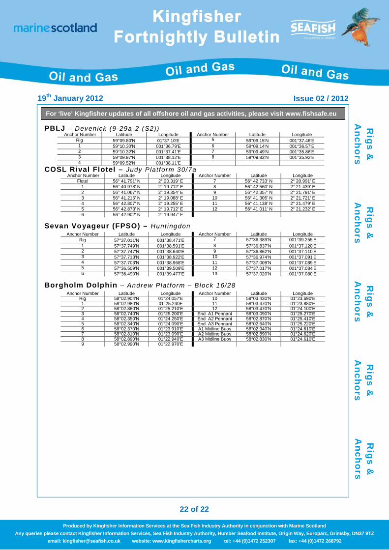
PBLJ – Devenick (9-29a-2 (S2)) Anchor Number Latitude Longitude Anchor Number Latitude Longitude
Rig 59°09.80'N 01°37.10'E 5 59°09.15'N 001°37.46'E 1 59°10.30'N 001°36.79'E 6 59°09.14'N 001°36.57'E 2 59°10.32'N 001°37.41'E 7 59°09.49'N 001°35.86'E 3 59°09.97'N 001°38.12'E 8 59°09.83'N 001°35.92'E 4 59°09.52'N 001°38.11'E
COSL Rival Flotel – Judy Platform 30/7a Anchor Number Latitude Longitude Anchor Number Latitude Longitude
Flotel 56° 41.791' N 2° 20.319' E 7 56° 42.733' N 2° 20.991' E 1 56° 40.978' N 2° 19.712' E 8 56° 42.560' N 2° 21.439' E 2 56° 41.067' N 2° 19.354' E 9 56° 42.357' N 2° 21.791' E 3 56° 41.215' N 2° 19.088' E 10 56° 41.305' N 2° 21.721' E 4 56° 42.807' N 2° 19.255' E 11 56° 41.138' N 2° 21.479' E 5 56° 42.873' N 2° 19.712' E 12 56° 41.011' N 2° 21.232' E 6 56° 42.902' N 2° 19.947' E
Sevan Voyageur (FPSO) – Hunt ingdon Anchor Number Latitude Longitude Anchor Number Latitude Longitude
Rig 57°37.011'N 001°38.471'E 7 57°36.389'N 001°39.255'E 1 57°37.749'N 001°38.591'E 8 57°36.837'N 001°37.120'E 2 57°37.747'N 001°38.640'E 9 57°36.862'N 001°37.110'E 3 57°37.713'N 001°38.922'E 10 57°36.974'N 001°37.091'E 4 57°37.703'N 001°38.968'E 11 57°37.009'N 001°37.089'E 5 57°36.509'N 001°39.509'E 12 57°37.017'N 001°37.084'E 6 57°36.490'N 001°39.477'E 13 57°37.020'N 001°37.080'E
Borgholm Dolphin – Andrew Plat form – Block 16/28 Anchor Number Latitude Longitude Anchor Number Latitude Longitude
Rig 58°02.904'N 01°24.057'E 10 58°03.430'N 01°23.690'E 1 58°02.980'N 01°25.240E 11 58°03.470'N 01°23.880'E 2 58°02.860'N 01°25.210'E 12 58°03.470'N 01°24.100'E 3 58°02.740'N 01°25.200'E End A1 Pennant 58°03.090'N 01°25.270'E 4 58°02.350'N 01°24.250'E End A2 Pennant 58°02.870'N 01°25.410'E 5 58°02.340'N 01°24.090'E End A3 Pennant 58°02.640'N 01°25.220'E 6 58°02.370'N 01°23.910'E A1 Midline Buoy 58°02.940'N 01°24.610'E 7 58°02.810'N 01°23.090'E A2 Midline Buoy 58°02.890'N 01°24.620'E 8 58°02.890'N 01°22.940'E A3 Midline Buoy 58°02.830'N 01°24.610'E 9 58°02.990'N 01°22.970'E
Rigs &
A
nchors
Rigs &
A
nchors
Rigs &
A
nchors
Rigs &
A
nchors
Rigs &
A
nchors