P5a(ii) Satellites, Gravity and Circular Motion You will find out about The uses of artificial...
7
P5a(ii) Satellites, Gravity and Circular Motion You will find out about The uses of artificial satellites Low Polar Orbit satellites www.PhysicsGCSE.co .uk
-
Upload
deonte-hosford -
Category
Documents
-
view
221 -
download
2
Transcript of P5a(ii) Satellites, Gravity and Circular Motion You will find out about The uses of artificial...
P5a(ii) Satellites, Gravity and Circular Motion
You will find out aboutThe uses of artificial satellites
Low Polar Orbit satellites
www.PhysicsGCSE.co.uk
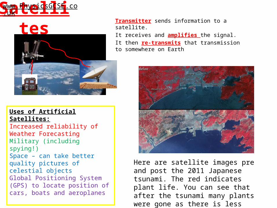
Satellites Transmitter sends information to a satellite. It receives and amplifies the signal.It then re-transmits that transmission to somewhere on Earth
www.PhysicsGCSE.co.uk
Uses of Artificial Satellites:Increased reliability of Weather ForecastingMilitary (including spying!)Space – can take better quality pictures of celestial objectsGlobal Positioning System (GPS) to locate position of cars, boats and aeroplanes Here are satellite images pre and post the
2011 Japanese tsunami. The red indicates plant life. You can see that after the tsunami many plants were gone as there is less red.
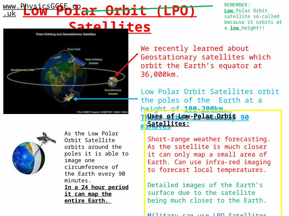
Low Polar Orbit (LPO) Satelliteswww.PhysicsGCSE.co.uk
We recently learned about Geostationary satellites which orbit the Earth’s equator at 36,000km.
Low Polar Orbit Satellites orbit the poles of the Earth at a height of 100-200km. Their orbit is usually 90 minutes
As the Low Polar Orbit Satellite orbits around the poles it is able to image one circumference of the Earth every 90 minutes. In a 24 hour period it can map the entire Earth.
Uses of Low-Polar Orbit Satellites:
Short-range weather forecasting. As the satellite is much closer it can only map a small area of Earth. Can use infra-red imaging to forecast local temperatures.
Detailed images of the Earth’s surface due to the satellite being much closer to the Earth.
Military can use LPO Satellites to track aeroplanes, boats and any other moving object.
REMEMBER:Low Polar Orbit satellite so-called because it orbits at a low height!!
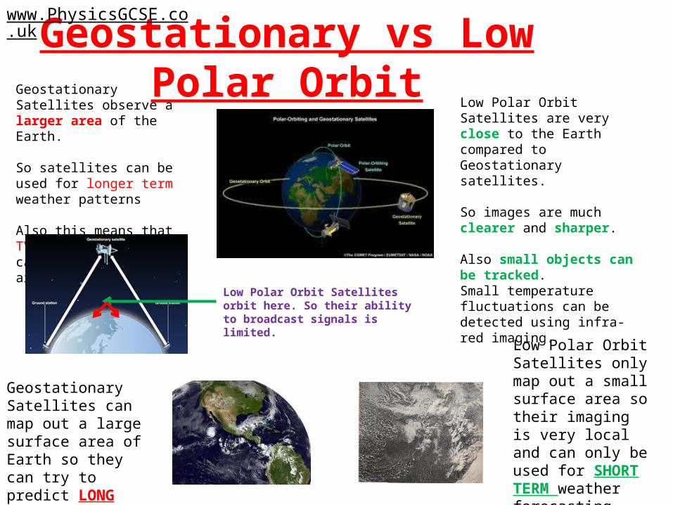
Geostationary vs Low Polar Orbitwww.PhysicsGCSE.co.uk
Low Polar Orbit Satellites are very close to the Earth compared to Geostationary satellites.
So images are much clearer and sharper.
Also small objects can be tracked.Small temperature fluctuations can be detected using infra-red imaging.
Geostationary Satellites observe a larger area of the Earth.
So satellites can be used for longer term weather patterns
Also this means that TV and radio signals can be broadcast all around the Earth.
Low Polar Orbit Satellites orbit here. So their ability to broadcast signals is limited.
Geostationary Satellites can map out a large surface area of Earth so they can try to predict LONG TERM weather forecasting
Low Polar Orbit Satellites only map out a small surface area so their imaging is very local and can only be used for SHORT TERM weather forecasting.
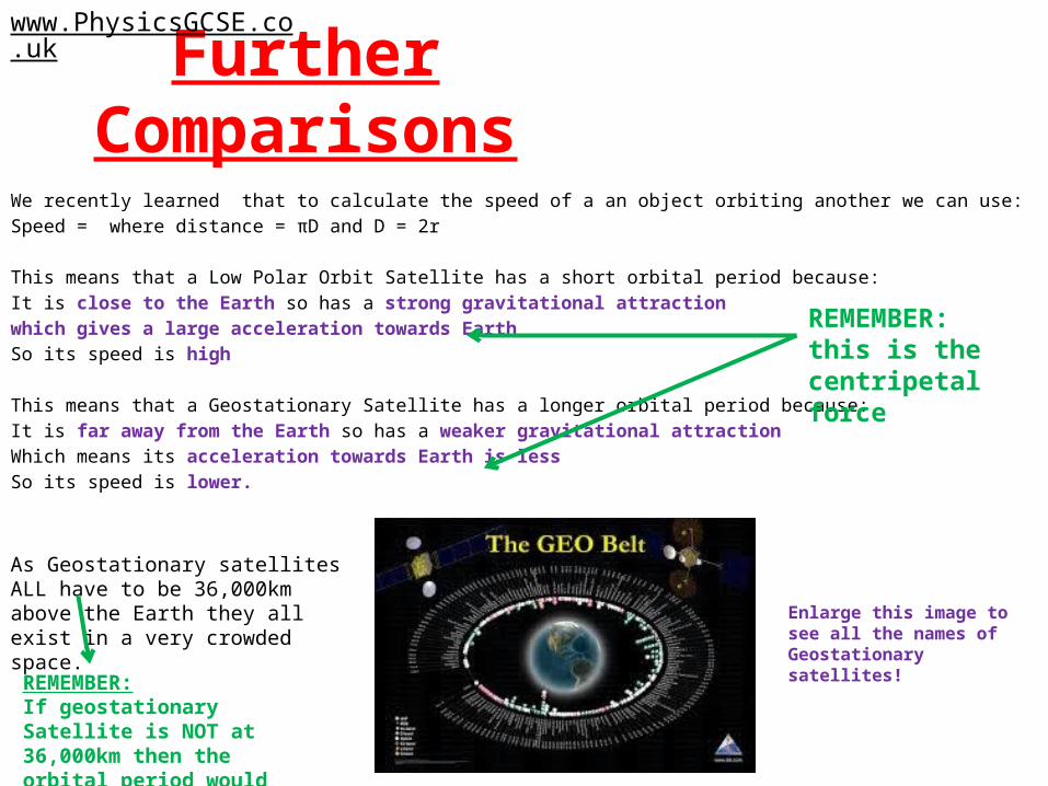
Further ComparisonsWe recently learned that to calculate the speed of a an object orbiting another we can use:Speed = where distance = πD and D = 2r
This means that a Low Polar Orbit Satellite has a short orbital period because:It is close to the Earth so has a strong gravitational attraction which gives a large acceleration towards EarthSo its speed is high
This means that a Geostationary Satellite has a longer orbital period because:It is far away from the Earth so has a weaker gravitational attractionWhich means its acceleration towards Earth is lessSo its speed is lower.
www.PhysicsGCSE.co.uk
REMEMBER:this is the centripetal force
As Geostationary satellites ALL have to be 36,000km above the Earth they all exist in a very crowded space. Enlarge this image to see all the
names of Geostationary satellites!
REMEMBER:If geostationary Satellite is NOT at 36,000km then the orbital period would NOT be 24 hours.
Questions
1. 100 years ago weather forecasting was very difficult. How has it improved since then?
2. What is the point of a GPS system?3. Geostationary satellites orbit much further than
Low Polar Orbit satellites. Why?4. Calculate the speed of a typical Low Polar Orbit
satellite. (Hint: the Earth’s radius is 6,400km)5. Calculate the period of a typical Geostationary
satellite.
www.PhysicsGCSE.co.uk
Questions
1. 100 years ago weather forecasting was very difficult. How has it improved since then? Geostationary and Low Polar Orbit satellites have improved our short AND long term weather forecasting. Temperatures are better predicted with the use of infra-red technology too.
2. What is the point of a GPS system? Can be tracked. Can plan a route. Always know where you are.
3. Geostationary satellites orbit much further than Low Polar Orbit satellites. Why? If they did not their orbital period would not equal 24 hours.
4. Calculate the speed of a typical Low Polar Orbit satellite. (Hint: the Earth’s radius is 6,400km) speed = = = 8,733 km/h
5. Calculate the period of a typical Geostationary satellite. No need to calculate they are all 24 hours!
www.PhysicsGCSE.co.uk