P0029153 - ABORIGINAL CULTURAL HERITAGE ASSESSMENT …
89
P0029153_EISCoverLetterACHA_F01_20210304 4 March 2021 Mr Nathan Stringer Principal Planning Officer Department of Planning, Industry and Environment Dear Mr Stringer, P0029153 - ABORIGINAL CULTURAL HERITAGE ASSESSMENT FOR TAFE NSW CONSTRUCTION CENTRE OF EXCELLENCE, 2-44 O'CONNELL STREET, KINGSWOOD - EIS COVER LETTER Urbis have been engaged by TAFE NSW to produce an Aboriginal Cultural Heritage Assessment (ACHA) for the proposed redevelopment of land at 2-44 O’Connell Street, Kingswood, forming part of the TAFE NSW Nepean Kingswood Campus, for the purposes of development of the TAFE NSW Construction Centre of Excellence (CCoE). The ACHA report (ACHAR), currently in draft stage, will accompany a detailed State Significant Development Application (SSDA)- 8571481 for the development of an educational facility at the TAFE Nepean Kingswood Campus, located at 2-44 O’Connell Street, Kingswood (the site). The legal description of the site is Lot 1 in DP 866081. This purpose of this short letter is to clearly outline the ACHA process undertaken to date in addition to the anticipated delivery timeframe of the ACHA for TAFE NSW CCoE. The ACHA has been prepared according to the statutory guidelines under the NPW Act including: • Aboriginal Cultural Heritage Consultation Requirements for Proponents 2010 (Department of Environment, Climate Change and Water (DECCW), 2010) (the Consultation Guidelines). • Guide to Investigating, Assessing and Reporting on Aboriginal Cultural Heritage in NSW (Office of Environment and Heritage 2011) (the Assessment Guidelines). • Code of Practice for Archaeological Investigation of Aboriginal Objects in New South Wales (DECCW 2010). • The Australia ICOMOS Charter for Places of Cultural Significance, The Burra Charter, 2013 (Burra Charter). The western and southern portions of the subject area have experienced high levels of disturbance in localised areas associated with the construction of TAFE. The eastern and central portions of the subject area, however, have experienced considerably lower disturbance. These areas have been
Transcript of P0029153 - ABORIGINAL CULTURAL HERITAGE ASSESSMENT …

P0029153_EISCoverLetterACHA_F01_20210304
4 March 2021
Mr Nathan Stringer Principal Planning Officer Department of Planning, Industry and Environment
Dear Mr Stringer,
P0029153 - ABORIGINAL CULTURAL HERITAGE ASSESSMENT FOR TAFE NSW CONSTRUCTION CENTRE OF EXCELLENCE, 2-44 O'CONNELL STREET, KINGSWOOD - EIS COVER LETTER
Urbis have been engaged by TAFE NSW to produce an Aboriginal Cultural Heritage Assessment (ACHA) for the proposed redevelopment of land at 2-44 O’Connell Street, Kingswood, forming part of the TAFE NSW Nepean Kingswood Campus, for the purposes of development of the TAFE NSW Construction Centre of Excellence (CCoE).
The ACHA report (ACHAR), currently in draft stage, will accompany a detailed State Significant Development Application (SSDA)- 8571481 for the development of an educational facility at the TAFE Nepean Kingswood Campus, located at 2-44 O’Connell Street, Kingswood (the site). The legal description of the site is Lot 1 in DP 866081.
This purpose of this short letter is to clearly outline the ACHA process undertaken to date in addition to the anticipated delivery timeframe of the ACHA for TAFE NSW CCoE.
The ACHA has been prepared according to the statutory guidelines under the NPW Act including:
• Aboriginal Cultural Heritage Consultation Requirements for Proponents 2010 (Department of Environment, Climate Change and Water (DECCW), 2010) (the Consultation Guidelines).
• Guide to Investigating, Assessing and Reporting on Aboriginal Cultural Heritage in NSW (Office of Environment and Heritage 2011) (the Assessment Guidelines).
• Code of Practice for Archaeological Investigation of Aboriginal Objects in New South Wales (DECCW 2010).
• The Australia ICOMOS Charter for Places of Cultural Significance, The Burra Charter, 2013 (Burra Charter).
The western and southern portions of the subject area have experienced high levels of disturbance in localised areas associated with the construction of TAFE. The eastern and central portions of the subject area, however, have experienced considerably lower disturbance. These areas have been

P0029153_EISCoverLetterACHA_F01_20210304 2
cleared for agricultural practices since c.19th century. Current impacts are proposed within the eastern portion of the subject area, where disturbance has been minimal.
The subject area is located within the Luddenham soil landscape (lu). Soils within this landscape are described as shallow to moderately deep (<100-150cm).
Due to the surrounding hydrology, the subject area retains potential for the presence of Aboriginal archaeological resources. The subject area contains a tributary of Werrington Creek, which is located approximately 900m north of the site. The tributary runs southward from elevated ground and has been dammed. South Creek is located approximately 2km east of the subject area. As the subject area is within 200m of a waterway, this increases the potential for Aboriginal objects and sites.
There are landscape features with potential for Aboriginal objects or archaeological deposits located within the subject area.
Urbis recommend that additional investigation is considered warranted in the form archaeological test excavation to establish the level of disturbance of the A horizon/topsoil in addition to the presence or absence of Aboriginal objects/archaeological resources within the subject area.
The process, undertaken to date and anticipated, for the Aboriginal Cultural Heritage Assessment is outlined in Table 1 below.
Table 1 – ACHA Timeline
Project Stage and Scope Timing and Conditions
Stage 1 Agency notice Sent 6th November 2020, closed 20th November 2020
(Stage 1.2 Agency request sent to DPC 10th November
2020)
Department of Premier and Cabinet provided Stakeholder
List on 17th November 2020
Stage 1 Public notice
Placed in the Koori Mail
Published in the 16th December 2020 edition
Stage 1 Invitation to Register letter
sent to identified stakeholders
Sent 11th December 2020 and closed 31 December 2020
18 Stakeholders registered for the project
Stage 1 Registered Aboriginal Party
notification to Department of Premier
and Cabinet and Deerubbin Local
Aboriginal Land Council
Sent to both DPC and DLALC on 18th January 2021
Stage 2 and 3: Provision of
comments on the provided project
information and proposed
methodology (this document).
Document provided to the RAPs on 21st January 2021.
The consultation period close on 18th February 2021.
This provided 28 days for RAP comment

P0029153_EISCoverLetterACHA_F01_20210304 3
Project Stage and Scope Timing and Conditions
Site survey (Andrew Crisp – Senior
Archaeologist and Site Officer from
Local Aboriginal Land Council).
Undertaken on 23rd February 2021
Test excavation sampling strategy
under Requirement 15B of Code of
Practice for Archaeological
Investigation of Aboriginal Objects in
New South Wales (DECCW 2010).
Requirement 15c – Test excavation
sampling strategy
A sampling strategy must be
developed. This strategy must do the
following:
▪ provide a framework for sampling
all potential archaeological
deposits (PAD) that are at risk of
harm (within the subject area).
▪ describe the differentiation of the
PAD to be test-excavated from
the surrounding archaeological
landscape (i.e. explain why the
PAD is anticipated to be of
higher significance than the
continuous distribution of
archaeological material in which
it exists), and
▪ test those areas of PAD that
have no archaeological exposure
or visibility, or
▪ test the boundaries of known
sites (where appropriate).
▪ confirm areas of low potential
(where relevant).
Provided on 3rd March 2021 to:
Dr Samantha Higgs
Senior Team Leader
Aboriginal Cultural Heritage Regulation - North
Heritage NSW, Department of Premier and Cabinet
Level 6, 10 Valentine Ave
Parramatta NSW 2124

P0029153_EISCoverLetterACHA_F01_20210304 4
Project Stage and Scope Timing and Conditions
▪ comply with the methods
described in the Code
▪ describe how the sampling area
relates to the area that is
proposed to be impacted by the
proposed activity.
Notification of intention to undertake
archaeological test excavation under
Requirement 15C of Code of
Practice for Archaeological
Investigation of Aboriginal Objects in
New South Wales (DECCW 2010).
Requirement 15c – Notification
At least 14 days before undertaking
any test excavations the relevant
Heritage NSW regional office must
be notified, in writing, of the
following:
▪ the location of the proposed test
excavation and the subject area.
▪ the name and contact details of
the legal entity with overall
responsibility for the project.
▪ the name and contact details of
the person who will be carrying
out the test excavations where
this is different to the legal entity
with overall responsibility for the
project.
▪ the proposed date of
commencement, and estimated
date of completion, of the test
excavations.
▪ the location of the temporary
storage location for any
Provided on 3rd March 2021 to:
Dr Samantha Higgs
Senior Team Leader
Aboriginal Cultural Heritage Regulation - North
Heritage NSW, Department of Premier and Cabinet
Level 6, 10 Valentine Ave
Parramatta NSW 2124

P0029153_EISCoverLetterACHA_F01_20210304 5
Project Stage and Scope Timing and Conditions
Aboriginal objects uncovered
during the test excavations.
▪ A copy of the sampling strategy
for test excavation must also be
provided.
Test excavation
The test excavations will be
undertaken in line with the Code of
Practice for Archaeological
Investigation of Aboriginal Objects in
NSW (DECCW 2010) in order to
understand the nature, extent,
integrity and research significance of
the Aboriginal archaeological
resource.
The five-day test excavation of Lot 60 DP 259135 is
proposed to start on Monday 22nd March 2021 and be
completed by Friday 26th March 2021.
Note that this timeframe is dependent on weather
conditions and test excavation results.
Post-excavation tasks: Artefact
analysis, Archaeological Technical
Report (ATR) and update Aboriginal
Cultural Heritage Assessment Report
(ACHAR) with findings from ATR.
Anticipated two weeks of the end of the test excavation.
Earliest 9th April 2021.
Stage 4: Provision of the draft
ACHAR and ATR reports (including
the proposed management and
mitigation measures) to the client for
review.
Provision of the draft ACHAR and
ATR reports (including the proposed
management and mitigation
measures) to the RAPs for review
28-day review.
Draft ACHAR/ATR to client for review anticipated two
weeks of the end of the test excavation.
Earliest 9th April 2021.
Draft ACHAR/ATR to RAPs for review following the
incorporation of client comments.
Anticipated 16th April 2021 with close 14th May 2021
Stage 4: Finalisation of the ACHA
report including the consideration of
all comments and feedback.
Anticipated one week of the closing of the comment period
for the draft ACHA report.
Anticipated 21st May 2021

P0029153_EISCoverLetterACHA_F01_20210304 6
*The length of the test excavation is indicative only. If high density subsurface assemblage(s) and/or rare/significant archaeology is identified during the 5-day program additional excavation shall be warranted. An extended program will be discussed immediately with the client.
Kind regards,
Andrew Crisp Senior Consultant +61 2 8233 7642 [email protected]

P0029153_Requ15c_TestExcavationNotification_F01
3 March 2021
Dr Samantha Higgs Senior Team Leader Aboriginal Cultural Heritage Regulation - North Heritage NSW, Department of Premier and Cabinet Level 6, 10 Valentine Ave Parramatta NSW 2124 E: [email protected]
Dear Samantha,
NOTIFICATION UNDER REQUIREMENT 15C: ARCHAEOLOGICAL TEST EXCAVATION & SAMPLING STRATEGY - STATE SIGNIFICANT DEVELOPMENT APPLICATION - TAFE NSW CONSTRUCTION CENTRE OF EXCELLENCE, 2-44 O'CONNELL STREET, KINGSWOOD NSW
1. SUBJECT AREA & CONTEXT
Urbis have been engaged by TAFE NSW to produce an Aboriginal Cultural Heritage Assessment (ACHA) for the proposed State Significant Development of land at 2-44 O’Connell Street, Kingswood, forming part of the TAFE NSW Nepean Kingswood site, for the purposes of development of the TAFE NSW Construction Centre of Excellence. The Aboriginal Cultural Heritage Assessment Report (ACHAR) will accompany a detailed State Significant Development Application (SSDA)- 8571481 for the development of an educational facility at the TAFE Nepean Kingswood Campus, located at 2-44 O’Connell Street, Kingswood (the site). The legal description of the site is Lot 1 in DP 866081. The site comprises a rectangular lot with an area of approximately 23 hectares (ha).
Specifically, the SSDA seeks development consent for the construction and operation of the TAFE NSW Construction Centre of Excellence (TAFE CCoE) a multi-level, integrated educational facility designed to accommodate specialised training and education for construction-related TAFE NSW courses (the project). The TAFE CCoE will be a new learning environment with an emphasis on flexibility and adaptability, to encourage cross-disciplinary collaboration, industry engagement and educational excellence. On 27 February 2019, the NSW Government announced the delivery and associated funding for the CCoE.
The ACHA is being prepared in accordance with the following guidelines:
‒ Aboriginal Cultural Heritage Consultation Requirements for Proponents 2010 (Department of Environment, Climate Change and Water (DECCW), 2010) (the Consultation Guidelines).
‒ Guide to Investigating, Assessing and Reporting on Aboriginal Cultural Heritage in NSW (Office of Environment and Heritage 2011) (the Assessment Guidelines).
‒ Code of Practice for Archaeological Investigation of Aboriginal Objects in New South Wales (DECCW 2010).
‒ The Australia ICOMOS Charter for Places of Cultural Significance, The Burra Charter, 2013 (Burra Charter.

P0029153_Requ15c_TestExcavationNotification_F01 2
The site comprises a rectangular lot with an area of approximately 23 ha, with an interface to Great Western Highway to the north, O’Connell Street to the west, adjoining residential property to the south and the Western Sydney University (WSU) Werrington campus to the east.
The area in which the development is proposed is located on the eastern boundary of the site. This area comprises of clear grassed fields with no site improvements and is currently utilised by TAFE NSW.
1.1. DEVELOPMENT DESCRIPTION
It is proposed to construct a new TAFE CCoE on the eastern portion of the subject area. The proposed TAFE CCoE will be TAFE NSW’s signature training facility for infrastructure and smart cities at the heart of the TAFE NSW Western Sydney Region. It will accommodate up to 3,500 students annually and will facilitate an active learning environment co-locating building, construction and plumbing and electrical disciplines. The proposed scope of works comprises; site preparation works, including tree removal and excavation; construction of a 2-3 storey CCoE accommodating approximately 8,400m² of GFA and including learning and workshop spaces, workspaces and areas for industry engagement; provision of additional car parking; and landscaping works.

P0029153_Requ15c_TestExcavationNotification_F01 3
Figure 1 – Regional location

P0029153_Requ15c_TestExcavationNotification_F01 4
Figure 2 – Subject area

P0029153_Requ15c_TestExcavationNotification_F01 5
Figure 3 - Site plan showing location of proposed works/impact footprint (blue hatching) in the eastern portion of the subject area (red dashed). Source: Gray Puksand 2020

P0029153_Requ15c_TestExcavationNotification_F01 6
2. NAME AND CONTACT DETAILS OF THE PROPONENT
The proponent can be contacted via
Sam Gibson Project Manager Cadence Australia Pty Ltd (on behalf of TAFE NSW) 1/10 Mallett Street Camperdown NSW 2050 E: [email protected]
3. NAME AND CONTACT DETAILS OF THE EXCAVATION DIRECTOR
The Urbis Excavation Director for the proposed test excavation program can be contacted via:
Andrew Crisp Senior Archaeologist Urbis Pty Ltd Angel Place Level 8, 123 Pitt Street Sydney NSW 2000 E: [email protected]
4. PROPOSED DATE OF TEST EXCAVATION PROGRAMS
The five-day test excavation of Lot 60 DP 259135 is proposed to start on Monday 22nd March 2021 and be completed by Friday 26th March 2021. Note that this timeframe is dependent on weather conditions and test excavation results.
5. SCOPE & METHODOLOGY
5.1. ARCHAEOLOGICAL RESEARCH DESIGN
The below Archaeological Research Design (ARD) has been developed to provide a framework to investigate the nature and origin of the potential archaeological resource within the subject area.
This ARD has been designed based on the results of the Aboriginal Cultural Heritage Assessment Report (ACHAR), particularly the results of the archaeological background research and predictive model.
This ARD has been prepared to cover the following objectives:
‒ Investigate the nature, spatial and stratigraphical extent, condition and integrity of any archaeological deposits that may be present.
‒ If archaeological deposits are identified, apply relevant research questions to interpret the finds and results in context of local and regional archaeological modelling.

P0029153_Requ15c_TestExcavationNotification_F01 7
To fulfil the objectives of the ARD, the following indicative research questions have been formulated:
1. Is there a subsurface archaeological deposit present?
2. If an archaeological deposit present, how can it be interpreted?
‒ What is the spatial and vertical extent of the deposit?
‒ What is the integrity and condition of the deposit?
‒ What are the physical attributes and compositions of the deposit (eg. stone artefacts, features, remains of original environment, contact period artefacts)?
‒ What are the characteristics of the stone artefact assemblage? What types of artefacts are present and what specialisation if any can be detected in the assemblage?
‒ Does the archaeological deposit have evidence of intra-site patterning or various occupational periods?
‒ Should faunal and/or shell material be located, what species present were utilised by Aboriginal people?
3. Can the archaeological deposit be interpreted in a local context?
‒ Are there similarities or differences with nearby archaeological sites?
‒ Is there evidence of connection to nearby sites in terms of raw material, composition and nature of the assemblage?
4. Can the archaeological deposit be interpreted in the regional context?
‒ Where did the raw materials originate from?
‒ Is there any indication of trade in connection of raw material procurement?
‒ How does the assemblage compare to other archaeological sites within the region?
5. Do the results if the archaeological excavation changes the scientific and cultural significance of the site?
‒ What is the scientific and cultural value of the assemblage?
‒ How do the Aboriginal stakeholders view the cultural value of the deposit and assemblage?
5.2. ARCHAEOLOGICAL TEST EXCAVATION
The test excavations will be undertaken in line with the Code of Practice for Archaeological Investigation of Aboriginal Objects in NSW (DECCW 2010) in order to understand the nature, extent, integrity and research significance of the Aboriginal archaeological resource. The test excavation will also aim to sample the various landscape features located within the subject area for any potential sub-surface archaeological deposits.
This section presents the methodology for the proposed test excavation programs. According to the Code of Practice “test excavations should be sufficiently comprehensive to allow characterisation of the Aboriginal objects present without having a significant impact on the archaeological value of the subject area”.

P0029153_Requ15c_TestExcavationNotification_F01 8
The test excavation will include:
▪ The initial Stage 1 of testing will include the excavation of up to 60 (sixty) 50 cm by 50 cm test pits in a systematic grid system at a spacing of 20m. The location of the test pits (Figure 4 below) has been informed by the results of the archaeological survey and the predictive model of the ACHAR.
▪ The location and number of transects and test pits will be further adjusted by on-site observation of localised disturbance and in consultation with the Aboriginal officers on site.
▪ All excavated material will be wet sieved through a 5mm metal sieve station.
5.2.1. Test Excavation Stage 1
▪ The test pits shall be excavated by hand (inclusive of trowels, shovels and other hand tools) along each transects at intervals of 20m.
▪ The first test pit within each transect and/or landform shall be excavated in 5cm spits to establish the depth and nature of soil and any stratigraphy present. Subsequent test pits conducted within the same transect and/or landform and/or potential archaeological deposit shall then be excavated in either 10cm spits or stratigraphic units (whichever is smaller) to the base of Aboriginal object-bearing units being the removal of the A-horizon soil deposit down to the sterile clay layer (B-horizon).
▪ All test pits will be excavated using the above methods in each transect before any further adjustment is made to the transect or additional pits are excavated.
▪ All excavated soil will be sieved through 5mm nested sieves using wet sieving method.
▪ At the completion of Stage 1 Urbis will inform the proponent (TAFE NSW) whether it has been determined that Stage 2 test excavation is required. The Excavation Director (Andrew Crisp) will determine whether it is necessary to excavate additional 50cm by 50 cm test pits in order to identify the spatial extent of identified archaeological resources, or existing pits will be expanded to further excavate those pits that yielded archaeological material or features to better understand the nature, extent and integrity of the identified archaeological resources. This would extend the 5-day test excavation program into a minimum second week. Written sign off from the proponent is required prior to beginning of Stage 2.
5.2.2. Test Excavation Stage 2
▪ Following the completion of Stage 1, the Excavation Director (Andrew Crisp) will make the decision whether it is necessary to excavate additional 50cm by 50 cm test pits in order to identify the spatial extent of identified archaeological resources, or existing pits will be expanded to further excavate those pits that yielded archaeological material or features to better understand the nature, extent and integrity of the identified archaeological resources.
▪ Test pits may be expanded into a 1m x 1m square or other arrangements in line with the Code of Practice at the discretion of the Excavation Director. The additional pits would be excavated in 50cm x 50cm test pit units, to further understand the archaeological resource.
▪ Additional 50cm x 50cm test pits may be placed at an interval of 3, 5 or 10m (or other justifiable and regular spacing appropriate to the scale of the area being tested) from the test pits that yielded archaeological resource to test further the immediate area for artefact concentrations and/or archaeological features, or to define a site boundary. These additional test pits would be excavated using the same methodology outlined above.
▪ Expansion test pits may be combined and excavated as necessary in 50cm x 50cm units for the purposes of further understanding site characteristics. Note that under the Code of Practice, the maximum area that can be excavated in any one continuous area is 3m2.

P0029153_Requ15c_TestExcavationNotification_F01 9
5.2.3. General Procedures
▪ The Code of Practice dictates that the maximum surface area of all test excavation units must be no greater than 0.5% of the Potential Archaeological Deposit or landform unit area being investigated.
▪ All excavated soil shall be sieved in 5 mm sieves using wet sieving method.
▪ Artefacts will be collected, bagged and tagged with a unique identification number according to test pit location, spit or context number.
▪ Each test pit shall be recorded using standard archaeological procedure, including standardised recording forms, coordinates collected using a GPS, photographic recording with scale and stratigraphic / soil profile for each test pit shall be recorded in scale drawings as required by Code of Practice recording requirements.
▪ Test excavation units shall be backfilled as soon as practicable, to be organised by the proponent. Alternatively, if manual collapse of the test pits is deemed appropriate this will be agreed to prior to the test excavation program.
▪ An AHIMS site card shall be prepared and submitted to the AHIMS Registrar for any new sites identified during test excavations.
▪ An AHIMS Site Impact Recording form shall be completed and submitted to the AHIMS Registrar for any sites impacted during test excavations.
▪ In the unlikely event that suspected human remains are identified works will immediately cease and the NSW Police and DPC will be notified.
▪ Test excavations shall cease when enough information* has been recovered to adequately characterise the objects/assemblage(s) present with regard to their nature and significance.
*Enough information is defined by DPC as meaning “that the sample of excavated material clearly and self-evidently demonstrates the deposit’s nature and significance. This may include things like locally or regionally high object density: presence of rare or representative objects: presence of archaeological features: or locally or regionally significant deposits stratified or not” (DECCW 2010a).

P0029153_Requ15c_TestExcavationNotification_F01 10
Figure 4 - Proposed impact footprint (blue hatched area), areas of identified disturbance (red), drainage line/open depression (blue). A systematic grid of test pits will be established at 20m intervals across the remainder of the impact footprint (green).

P0029153_Requ15c_TestExcavationNotification_F01 11
5.3. POST-EXCAVATION ANANLYSIS
All collected materials shall be temporarily held at the Urbis office, where they shall be analysed and catalogued by Urbis archaeological staff using the standard artefact curation protocol of the Australian Museum. Selected artefacts or representative samples will be photographed and included and further analysed in detail in the report. The collection shall be analysed using A Record in Stone (Holdaway & Stern 2004) and other contemporary methods.
5.3.1. Care and control
A strategy for management of Aboriginal artefacts recovered from the site shall be developed through consultation with the RAPs (costs associated with the determined care and control conditions are not covered under the current agreement and would be subject to an outcome specific variation). The RAPs are invited to provide comment on the long-term management of artefacts.
Artefacts identified and collected during test excavations will be temporarily held in a lockable, secure location at the Urbis Sydney office (ANGEL PLACE, LEVEL 8, 123 PITT STREET SYDNEY, NSW 2000, AUSTRALIA) where they shall be catalogued and analysed by an Urbis archaeologist / artefact specialist.
Following completion of artefact cataloguing and analysis any artefacts recovered during test excavations and subsequent salvage excavations (if necessary) will be moved to the agreed long-term keeping place as soon as practicable in accordance with:
▪ Requirement 26 “Stone artefact deposition and storage” in the Code of Practice for Archaeological Investigation of Aboriginal Objects in NSW (24 September 2010)
5.4. ARCHAEOLOGICAL TECHNICAL REPORT
The purpose of the archaeological investigation and accompanying Archaeological Technical Report (ATR) is to understand the presence, nature and extent of the Aboriginal archaeological resource within the areas of proposed works. The cataloguing and analysis of the recovered artefacts will inform the scientific, cultural and historical significance of the site and in turn management of the heritage resource.
The ATR will be produced in accordance with the Code of Practice for Archaeological Investigation of Aboriginal Objects in NSW (DECCW 2010) and attached as an appendix to the Aboriginal cultural Heritage Report (ACHAR).
6. SUMMARY
Please do not hesitate to contact the undersigned on (02) 8233 7642 or 0431 874 011 should you wish to discuss further.
Kind regards,
Andrew Crisp Senior Consultant +61 2 8233 7642 [email protected]

INTERIM ABORIGINAL CULTURAL HERITAGE ASSESSMENT TAFE NSW CONSTRUCTION CENTRE OF EXCELLENCE 2-44 O’CONNELL STREET KINGSWOOD NSW
Prepared for
TAFE NSW 29 January 2021

URBIS STAFF RESPONSIBLE FOR THIS REPORT WERE:
Associate Director Balazs Hansel, MA Archaeology, MA History
Senior Consultant Andrew Crisp, BA Archaeology (Hons), M. ICOMOS
Consultant Meggan Walker, BA Archaeology (Hons) and ancient history.
Consultant Alexandra Ribeny, BA Archaeology (Hons), M. Arch. Sci.
Assistant Aaron Olsen, BSc (Hons), MIP, PhD
Project Code P0029153
Report Number Interim Draft 1
Urbis acknowledges the important contribution that Aboriginal and Torres Strait Islander people make in creating a strong and vibrant Australian society. We acknowledge, in each of our offices the Traditional Owners on whose land we stand.
All information supplied to Urbis in order to conduct this research has been treated in the strictest confidence. It shall only be used in this context and shall not be made available to third parties without client authorisation. Confidential information has been stored securely and data provided by respondents, as well as their identity, has been treated in the strictest confidence and all assurance given to respondents have been and shall be fulfilled. © Urbis Pty Ltd 50 105 256 228 All Rights Reserved. No material may be reproduced without prior permission. You must read the important disclaimer appearing within the body of this report. urbis.com.au

URBIS
P0029153_TAFENSW_TOA_INTERIMACHAR_20210129R
CONTENTS
Executive Summary .......................................................................................................................................... 1
1. Introduction ....................................................................................................................................... 3 1.1. Location and Description ..................................................................................................... 4 1.2. Methodology & Limitations ................................................................................................... 7 1.3. Proposed Works .................................................................................................................. 7
1.3.1. Penrith City Council Local Environment Plan 2010 ............................................10 1.3.2. Penrith Development Control Plan 2014 ............................................................10
1.4. Objectives ..........................................................................................................................10 1.5. Authorship ..........................................................................................................................11
2. Archaeological Assessment ..........................................................................................................12 2.1. Aboriginal Archaeological Context .....................................................................................12
2.1.1. Regional Background .........................................................................................12 2.1.2. Previous Aboriginal archaeological investigations .............................................13 2.1.3. Aboriginal Heritage Information Management System (AHIMS) ........................20
2.2. Landscape Analysis ...........................................................................................................24 2.2.1. Landform and Topography .................................................................................24 2.2.2. Geology and Soils ..............................................................................................24 2.2.3. Hydrology ...........................................................................................................24 2.2.4. Vegetation and Resources .................................................................................25 2.2.5. Topography ........................................................................................................27 2.2.6. Geotechnical Analysis ........................................................................................30
2.3. Past Aboriginal Land Use ..................................................................................................33 2.4. Historical Land Use ............................................................................................................34
2.4.1. Summary ............................................................................................................35 2.5. Archaeological Field Survey ..............................................................................................38 2.6. Archaeological Test Excavation .........................................................................................38 2.7. Predictive Model ................................................................................................................38 2.8. Summary ............................................................................................................................44
3. Aboriginal Consultation..................................................................................................................45 3.1. Stage 1: Notification of Project Proposal and Registration of Interest ...............................46
3.1.1. Government Organisation Contact .....................................................................46 3.1.2. Registration of Interest .......................................................................................46 3.1.3. Public Notice .......................................................................................................47 3.1.4. Stage 1.6 Notice to DPC/LALC ..........................................................................47
3.2. Stage 2: Presentation of Information about the Project .....................................................47 3.3. Stage 3: Gathering Information About the Proposed Project ............................................48
3.3.1. Site inspection and meeting ...............................................................................50 3.4. Stage 4: Review of Draft ACHA report ..............................................................................50 3.5. Summary ............................................................................................................................50
4. Cultural Heritage Values and Statement of Significance ............................................................51 4.1. Methods of assessing Heritage Significance .....................................................................51 4.2. Assessment Framework ....................................................................................................51
4.2.1. Social or Cultural value.......................................................................................51 4.2.2. Historic value ......................................................................................................51 4.2.3. Scientific (Archaeological) value ........................................................................52 4.2.4. Aesthetic value ...................................................................................................52
4.3. Identifying values ...............................................................................................................52 4.4. Assessing Values and Significance ...................................................................................53
4.4.1. Assessment of Cultural Heritage Significance and Values ................................53 4.4.2. Assessment of Scientific (Archaeological) Significance .....................................54
5. Impact Assessment.........................................................................................................................55 5.1. Potential Harm ...................................................................................................................55

5.2. Likely Impacted Values ......................................................................................................55 5.3. Consideration of Inter-Generational Equity........................................................................55
5.3.1. Cumulative Impact Assessment .........................................................................55
6. Avoiding and Minimising Harm .....................................................................................................57
7. Conclusions .....................................................................................................................................58
8. Recommendations ..........................................................................................................................59 Recommendation 1 – Archaeological Test Excavation ...............................................59 Recommendation 3 – Archaeological Chance Find Procedure ..................................59 Recommendation 4 – Human Remains Procedure ......................................................60 Recommendation 5 – RAP Consultation .......................................................................60
9. Bibliography ....................................................................................................................................61
Disclaimer ........................................................................................................................................................62
Appendix A Basic and Extensive AHIMS Search Results Appendix B Registered Aboriginal Party Consultation Log Appendix C Registered Aboriginal Party Consultation Documentation
FIGURES
Figure 1 – Registered Aboriginal sites in extensive search area ...................................................................... 5
Figure 2 – Registered Aboriginal sites in extensive search area ...................................................................... 6
Figure 3 – Proposed site plan showing location of works (blue hatching) in the eastern portion of the site ..................................................................................................................................................................... 7
Figure 4 – Proposed site plan showing functional planning of the spaces. ....................................................... 8
Figure 5 – Proposed render – external. ............................................................................................................. 9
Figure 6 – Proposed render – internal. .............................................................................................................. 9
Figure 7 – Distribution of site types with the extensive AHIMS search area (Client Service ID: 548864) ...... 21
Figure 8 – Registered Aboriginal sites in extensive search area .................................................................... 23
Figure 9 – Soils landscapes and hydrology ..................................................................................................... 26
Figure 10 – Landform type............................................................................................................................... 28
Figure 11 – Landform pattern .......................................................................................................................... 29
Figure 12 – Construction Site – Zone 1 ........................................................................................................... 30
Figure 13 – Reproduction of Table 4 – Summary of inferred subsurface conditions encountered in PSM boreholes ................................................................................................................................................ 31
Figure 14 – Reproduction of Table 5 – Inferred elevation of top of inferred geotechnical units encountered in PSM boreholes ....................................................................................................................... 31
Figure 1 – Location of PSM boreholes within subject area ............................................................................. 32
Figure 16 – Construction of Werrington College of TAFE (now known as TAFE NSW Kingswood Campus), O’Connell St, Kingswood, c.1985. This image demonstrates the disturbance to the subject area resulting from the construction of the buildings. ...................................................................................... 35
Figure 17 – Construction of Werrington College of TAFE (now known as TAFE NSW Kingswood Campus), O’Connell St, Kingswood, c.1985. This image demonstrates the disturbance to the subject area resulting from the construction of the buildings. ...................................................................................... 35
Figure 18 – Historical aerial photographs ........................................................................................................ 36
Figure 19 – Levels of ground disturbance and archaeological potential across subject area. ........................ 37
TABLES
Table 1 – SEARs (SSD-8571481) ..................................................................................................................... 1

URBIS
P0029153_TAFENSW_TOA_INTERIMACHAR_20210129R
Table 2 – SEARs (SSD-8571481) ..................................................................................................................... 3
Table 3 – Summary of previous Aboriginal archaeological investigations relevant to the subject area ......... 14
Table 4 – AHIMS search results (Client Service ID: 548864) ......................................................................... 21
Table 5 – Landform definitions ........................................................................................................................ 27
Table 6 – Analysis of historical aerials ............................................................................................................ 34
Table 7 – Indicative process of determining the likelihood of a given site occurring within a subject area .................................................................................................................................................................. 38
Table 8 – Predictive Model .............................................................................................................................. 40
Table 9 – Contacted Organisations ................................................................................................................. 46
Table 10 – Stage 1 Consultation – Registration of Interest ............................................................................. 46
Table 11 – RAP responses to the Stage 2/3 Information Pack ....................................................................... 49
Table 12 – Scientific (archaeological) significance criteria .............................................................................. 52


URBIS
P0029153_TAFENSW_TOA_INTERIMACHAR_20210129R EXECUTIVE SUMMARY 1
EXECUTIVE SUMMARY This report has been prepared to accompany a detailed State Significant Development Application (SSDA) SSD - 8571481 for the development of an educational facility at the TAFE Nepean Kingswood Campus, located at 2-44 O’Connell Street, Kingswood (the site). The legal description of the site is Lot 1 in DP 866081. The site comprises a rectangular lot with an area of approximately 23 hectares.
The objectives of this ACHA are to:
• Investigate the presence, or absence, of Aboriginal objects and/or places within and in close proximity to the subject area, and whether those objects and/or places would be impacted by the proposed development.
• Investigate the presence, or absence, of any landscape features that may have the potential to contain Aboriginal objects and/or sites and whether those objects and/or sites would be impacted by the proposed development.
• Document the nature, extent and significance of any Aboriginal objects and/or place and sites that may located within the subject area.
• Document consultation with the Registered Aboriginal Parties (RAPs) with the aim to identify any spiritual, traditional, historical or contemporary associations or attachments to the subject area and any Aboriginal objects and/or places that might be identified within the subject area.
• Provide management strategies for any identified Aboriginal objects and/or places or cultural heritage values.
• Provide recommendations for the implementation of the identified management strategies.
• Prepare a final Aboriginal Cultural Heritage Assessment Report (ACHAR) to be accompany SSD-8571481
Specifically, the SSDA seeks development consent for the construction and operation of the TAFE NSW Construction Centre of Excellence (TAFE CCoE) a multi-level, integrated educational facility designed to accommodate specialised training and education for construction-related TAFE NSW courses (the project). The TAFE CCoE will be a new learning environment with an emphasis on flexibility and adaptability, to encourage cross-disciplinary collaboration, industry engagement and educational excellence. On 27 February 2019, the NSW Government announced the delivery and associated funding for the CCoE.
The proposed development is classified as State Significant Development (SSD) on the basis that it falls within the requirements of clause 4, Schedule 19 of the State Environmental Planning Policy (State and Regional Development) 2011 (SRD SEPP), being ‘development for the purpose of a tertiary institution… that has a capital investment value of more than $30 million’.
The Minister for Planning, or their delegate, is the consent authority for the SSDA and this application is lodged with the NSW Department of Planning, Industry and Environment (NSW DPIE) for assessment.
This report has been prepared in response to the requirements contained within the Secretary’s Environmental Assessment Requirements (SEARs) issued for the project. Specifically, this report has been prepared to respond to the following SEARs:
Table 1 – SEARs (SSD-8571481) and relevant Urbis responses
SEARS # Requirement Urbis response
10. Aboriginal
Heritage
Identify and describe the Aboriginal cultural heritage
values that exist across the site and document these in
an Aboriginal Cultural Heritage Assessment Report
(ACHAR). This may include the need for surface
survey and test excavation;
Section 2 and Section 4
Identify and address the Aboriginal cultural heritage
values in accordance with the Guide to investigating,
Section 2 and Section 4

2 EXECUTIVE SUMMARY
URBIS
P0029153_TAFENSW_TOA_INTERIMACHAR_20210129R
SEARS # Requirement Urbis response
assessing and reporting on Aboriginal Cultural
Heritage in NSW (Office of Environment and Heritage
(OEH), 2011) and Code of Practice for Archaeological
Investigations of Aboriginal Objects in NSW (OEH,
2010), and in consultation with Heritage NSW;
Document consultation with Aboriginal people in
accordance with Aboriginal Cultural Heritage
Consultation Requirements for Proponents 2010
(Department of Environment, Climate Change and
Water) (DECCW). The significance of cultural heritage
values of Aboriginal people who have a cultural
association with the land are to be documented in the
ACHAR;
Section 3
Identify, assess and document all impacts on the
Aboriginal cultural heritage values in the ACHAR;
Section 5
Demonstrate attempts to avoid any impact upon
cultural heritage values and identify any conservation
outcomes. Where impacts are unavoidable, the
ACHAR and EIS must outline measures proposed to
mitigate impacts. Any objects recorded as part of the
assessment must be documented and notified to
Heritage NSW and the Environment, Energy and
Science Group of the Department of Planning, Industry
and Environment; and
Section 6
Outline procedures to be followed if Aboriginal objects
are found at any stage of the life of the project to
formulate appropriate measures to manage
unforeseen impacts.
Section 7 and Section 8
Recommendations and Conclusions
[INCLUDE ONCE ACHAR FINALISED]

URBIS
P0029153_TAFENSW_TOA_INTERIMACHAR_20210129R INTRODUCTION 3
1. INTRODUCTION This report has been prepared to accompany a detailed State Significant Development Application (SSDA) SSD - 8571481 for the development of an educational facility at the TAFE Nepean Kingswood Campus, located at 2-44 O’Connell Street, Kingswood (the site). The legal description of the site is Lot 1 in DP 866081. The site comprises a rectangular lot with an area of approximately 23 hectares.
Specifically, the SSDA seeks development consent for the construction and operation of the TAFE NSW Construction Centre of Excellence (TAFE CCoE) a multi-level, integrated educational facility designed to accommodate specialised training and education for construction-related TAFE NSW courses (the project). The TAFE CCoE will be a new learning environment with an emphasis on flexibility and adaptability, to encourage cross-disciplinary collaboration, industry engagement and educational excellence. On 27 February 2019, the NSW Government announced the delivery and associated funding for the CCoE.
The proposed development is classified as State Significant Development (SSD) on the basis that it falls within the requirements of clause 4, Schedule 19 of the State Environmental Planning Policy (State and Regional Development) 2011 (SRD SEPP), being ‘development for the purpose of a tertiary institution… that has a capital investment value of more than $30 million’.
The Minister for Planning, or their delegate, is the consent authority for the SSDA and this application is lodged with the NSW Department of Planning, Industry and Environment (NSW DPIE) for assessment.
This report has been prepared in response to the requirements contained within the Secretary’s Environmental Assessment Requirements (SEARs) issued for the project. Specifically, this report has been prepared to respond to the following SEARs (Table 2):
Table 2 – SEARs (SSD-8571481)
SEARS # Requirement Urbis response
10. Aboriginal
Heritage
Identify and describe the Aboriginal cultural heritage
values that exist across the site and document these in
an Aboriginal Cultural Heritage Assessment Report
(ACHAR). This may include the need for surface
survey and test excavation;
Section 2 and Section 4
Identify and address the Aboriginal cultural heritage
values in accordance with the Guide to investigating,
assessing and reporting on Aboriginal Cultural
Heritage in NSW (Office of Environment and Heritage
(OEH), 2011) and Code of Practice for Archaeological
Investigations of Aboriginal Objects in NSW (OEH,
2010), and in consultation with Heritage NSW;
Section 2 and Section 4
Document consultation with Aboriginal people in
accordance with Aboriginal Cultural Heritage
Consultation Requirements for Proponents 2010
(Department of Environment, Climate Change and
Water) (DECCW). The significance of cultural heritage
values of Aboriginal people who have a cultural
association with the land are to be documented in the
ACHAR;
Section 3
Identify, assess and document all impacts on the
Aboriginal cultural heritage values in the ACHAR;
Section 5

4 INTRODUCTION
URBIS
P0029153_TAFENSW_TOA_INTERIMACHAR_20210129R
SEARS # Requirement Urbis response
Demonstrate attempts to avoid any impact upon
cultural heritage values and identify any conservation
outcomes. Where impacts are unavoidable, the
ACHAR and EIS must outline measures proposed to
mitigate impacts. Any objects recorded as part of the
assessment must be documented and notified to
Heritage NSW and the Environment, Energy and
Science Group of the Department of Planning, Industry
and Environment; and
Section 6
Outline procedures to be followed if Aboriginal objects
are found at any stage of the life of the project to
formulate appropriate measures to manage
unforeseen impacts.
Section 7 and Section 8
1.1. LOCATION AND DESCRIPTION The subject area (Figure 1 and Figure 2) is located at 2-44 O’Connell Street, Kingswood within the local government area (LGA) of Penrith. The site is legally described as Lot 1 of DP 866081.
The site comprises a rectangular lot with an area of approximately 23 ha, with an interface to Great Western Highway to the north, O’Connell Street to the west, adjoining residential property to the south and the Western Sydney University (WSU) Werrington campus to the east.
The area in which the development is proposed is located on the eastern boundary of the site. This area comprises of clear grassed fields with no site improvements and is currently utilised by TAFE NSW.

URBIS
P0029153_TAFENSW_TOA_INTERIMACHAR_20210129R INTRODUCTION 5
Figure 1 – Registered Aboriginal sites in extensive search area

6 INTRODUCTION
URBIS
P0029153_TAFENSW_TOA_INTERIMACHAR_20210129R
Figure 2 – Registered Aboriginal sites in extensive search area

URBIS
P0029153_TAFENSW_TOA_INTERIMACHAR_20210129R INTRODUCTION 7
1.2. METHODOLOGY & LIMITATIONS This ACHAR has been prepared according to the statutory guidelines under the NPW Act including:
• Aboriginal Cultural Heritage Consultation Requirements for Proponents 2010 (Department of Environment, Climate Change and Water (DECCW), 2010) (the Consultation Guidelines).
• Guide to Investigating, Assessing and Reporting on Aboriginal Cultural Heritage in NSW (Office of Environment and Heritage 2011) (the Assessment Guidelines).
• Code of Practice for Archaeological Investigation of Aboriginal Objects in New South Wales (DECCW 2010).
• The Australia ICOMOS Charter for Places of Cultural Significance, The Burra Charter, 2013 (Burra Charter).
This assessment has not considered historical archaeology. Historical archaeology is addressed in the Historical Archaeological Impact Assessment prepared by Urbis under a different cover (Urbis, 2021).
1.3. PROPOSED WORKS It is proposed to construct a new Construction Centre of Excellence (CCoE) in the eastern portion of the subject area (Figure 3). The proposed TAFE CCoE will be TAFE NSW’s signature training hub for infrastructure and smart cities at the heart of the TAFE NSW Western Sydney Region. It will accommodate up to 3,500 students annually and will facilitate an active learning environment co-locating building, construction and engineering disciplines. The proposed scope of works comprises; site preparation works, including tree removal and excavation; construction of a 2-3 storey Construction Hub accommodating approximately 8,400m² of GFA and including learning and workshop spaces, workspaces and areas for industry engagement; provision of additional car parking; and landscaping works.
Figure 3 – Proposed site plan showing location of works (blue hatching) in the eastern portion of the site
Source: Gray Puksand 2020

8 INTRODUCTION
URBIS
P0029153_TAFENSW_TOA_INTERIMACHAR_20210129R
The Design Response from Gray Puksand for the development is outlined below (Figure 4). The design of the new CCoE will provide a venue for learning that points to the future of skills training in the building and construction industry. The built form will both passively and actively contribute to the teaching and learning experience.
Functional programs at WSCH can evolve over time. This will require a structure and service configuration that allows for seamless reconfigurability. Driven by the need to re imagine jobs of the future, the design will ensure that current and future training programs will be supported as continual advancements in construction skills, technology and methodologies emerge. Functionally this will be achieved by organised educational spaces around a series of exhibition areas and social space.
This combined with the logistics required for multi-disciplinary operations, the building will showcase the future of skills training and be prototype for tertiary education, a demonstration to industry within its educational precinct.
To achieve this the design will display a refined and contextually relevant aesthetic. The design is a direct response to place and function. With a prominent entry to the west serving as the TAFE NSW/compass entry, civic presence will be established on the east facade that faces the university precinct. A dual address resulting in legible and welcoming arrival points for students, visitors, industry and the community.
This is a true ‘building in the round’ with all sides being activated with a variety of visible education opportunities, exhibition spaces and settings for student amenity. This is further augmented with prominent event space for industry engagement and civic presence. A facility that is an invitation to students and industry for learning, re- skilling and industry collaboration.
Driven by a desire to create a rational and adaptable program of educational spaces the design is underpinned with the notion of ‘pavilion in the landscape’. A building that will be seen ‘in the round’ within a backdrop of gently undulating grasslands sloping from a high point to the east, westward towards the centre of the campus. A variety of mature trees and an existing dam further augment the natural beauty of the site and opportunities for student amenity, health and wellbeing.
This notion of ‘pavilion in the landscape’ is developed with a simple composition of parts that form a unified aesthetic. Starting with a simple rectangular form, two ground plane levels are split via a north/south delivery and storage axis. A student or campus entry is established on the lower ground floor to the west and a civic/educational precinct entry on upper ground is provided on the east of the building. These main entry points set up a cross axis (east/west) that transverse all levels of building. With this simple circulation planning students, educators and visitors are kept completely separate to loading and logistics. The natural fall of the land has been utilised to provide a variety of double and triple height internal workshops, all visually connect via an internal spine, an atrium activated with passive collaboration settings and social spaces.
Figure 4 – Proposed site plan showing functional planning of the spaces.
Source: Gray Puksand 2020

URBIS
P0029153_TAFENSW_TOA_INTERIMACHAR_20210129R INTRODUCTION 9
Figure 5 – Proposed render – external.
Source: Gray Puksand 2020
Figure 6 – Proposed render – internal.
Source: Gray Puksand 2020

10 INTRODUCTION
URBIS
P0029153_TAFENSW_TOA_INTERIMACHAR_20210129
1.3.1. Penrith City Council Local Environment Plan 2010
As legislated by the Environmental Planning and Assessment Act 1979 (EP & A Act), each LGA is legally obliged to produce a Local Environment Plan (LEP). Within each LEP, Schedule 5 provides relevant information on locally listed heritage items, identifying items and areas of local heritage significance, and outlining consent requirements.
A search of the Penrith City Council LEP 2010 was undertaken on 17th December 2020. The subject area is not listed on the Penrith City Council LEP 2010.
1.3.2. Penrith Development Control Plan 2014
As legislated by the EP & A Act, each LGA is legally obliged to produce a Development Control Plan (DCP). Not all LGAs provide information regarding Aboriginal cultural heritage and specific development controls to protect Aboriginal cultural heritage.
Section 7.2 of the Penrith Development Control Plan 2014 addresses Aboriginal cultural heritage. This section identifies the following objective:
To preserve items and sites of Aboriginal archaeological significance located within the City of Penrith.
The following controls relating to Aboriginal cultural heritage are stated in Section 7.2C of the Penrith DCP 2014:
1) If the development, including subdivision, but not strata subdivision, is on land identified as potentially archaeologically sensitive, an archaeological investigation is required with the development application. The Office of Environment and Heritage should be contacted for advice on survey needs and requirements.
2) Despite (a) above, an archaeological assessment is required if the site area is 5 hectares or more. The archaeological assessment should determine whether or not Aboriginal archaeological resources are present on the site, and where appropriate, identify management principles to be implemented.
3) The requirements stated in (a) and (b) above will not apply to developments where there is no: a) disturbance of the soil, or b) construction works on the land. For the purposes of this section, any internal or external works to an existing building is not deemed to be construction work.
The present report is prepared to determine whether or not Aboriginal archaeological resources are present within the subject area and, if appropriate, identify management principles to be implemented, in fulfilment of the controls of Section 7.2C of the Penrith DCP 2014.
1.4. OBJECTIVES The objectives of this ACHA are to:
• Investigate the presence, or absence, of Aboriginal objects and/or places within and in close proximity to the subject area, and whether those objects and/or places would be impacted by the proposed development.
• Investigate the presence, or absence, of any landscape features that may have the potential to contain Aboriginal objects and/or sites and whether those objects and/or sites would be impacted by the proposed development.
• Document the nature, extent and significance of any Aboriginal objects and/or place and sites that may located within the subject area.
• Document consultation with the Registered Aboriginal Parties (RAPs) with the aim to identify any spiritual, traditional, historical or contemporary associations or attachments to the subject area and any Aboriginal objects and/or places that might be identified within the subject area.
• Provide management strategies for any identified Aboriginal objects and/or places or cultural heritage values.
• Provide recommendations for the implementation of the identified management strategies.

URBIS
P0029153_TAFENSW_TOA_INTERIMACHAR_20210129R INTRODUCTION 11
• Prepare a final Aboriginal Cultural Heritage Assessment Report (ACHAR) to be accompany SSD-9138102.
1.5. AUTHORSHIP This ACHA has been prepared by Aaron Olsen, Urbis Assistant Archaeologist, Alexandra Ribeny and Meggan Walker, Urbis Consultant Archaeologists and Andrew Crisp, Urbis Senior Archaeologist, with review and quality control undertaken by Balazs Hansel, Urbis Associate Director Archaeology.
Aaron Olsen holds a Bachelor of Science (Honours - First Class in Chemistry) and PhD (Chemistry) from the University of Newcastle, a Masters (Industrial Property) from the University of Technology Sydney and is currently completing a Diploma of Arts (Archaeology) at the University of Sydney.
Alexandra Ribeny holds a Bachelor of Arts (Honours - First Class in Archaeology) from the University of Sydney and a Master of Archaeological Science from the Australian National University and is currently a PhD candidate at the Australian National University.
Meggan Walker holds a Bachelor of Arts (Honours – First Class in Archaeology) from the University of Sydney.
Andrew Crisp holds a Bachelor of Arts (Honours - First Class in Archaeology) from the University of Sydney.
Balazs Hansel holds a Masters (History) from the University of Szeged in addition to Masters (Archaeology and Museum Studies) from the University of Szeged and is currently completing a PhD (Archaeology) at the University of Sydney.

12 ARCHAEOLOGICAL ASSESSMENT
URBIS
P0029153_TAFENSW_TOA_INTERIMACHAR_20210129
2. ARCHAEOLOGICAL ASSESSMENT 2.1. ABORIGINAL ARCHAEOLOGICAL CONTEXT This section comprises the summary of the archaeological background research for Aboriginal cultural heritage resources. This includes the search of the Aboriginal Heritage Information Management System (AHIMS) previous archaeological investigations pertinent to the subject area and broader region.
2.1.1. Regional Background
The archaeological record provides evidence of the long occupation of Aboriginal people in Australia and the Sydney region. The oldest generally accepted date for a site in the Sydney basis is 17,800 years before present (BP), recorded in a rock shelter at Shaw’s Creek (Nanson et al 1987), near Castlereagh (approximately 25km north-west of the present subject area). Radiocarbon dating of charcoal samples from sand sheet contexts in proximity to the Cooks River have suggest occupation as early as 40,000 years BP (JMCHM 2005). Older occupation sites along the now submerged coastline would have been flooded around 10,000 years BP, with subsequent occupation concentrating along the current coastlines and Cumberland Plain (Attenbrow 2010).
Due to the absence of written records, it is difficult to infer what Aboriginal life was like prior to the arrival of European settlers. Much of our understanding of Aboriginal life pre-colonisation is informed by the histories documented in the late 18th and early 19th century by European observers. These histories provide an inherently biased interpretation of Aboriginal life both from the perspective of the observer but also through the act of observation. The social functions, activities and rituals recorded by Europeans may have been impacted by the Observer Effect, also known as the Hawthorne Effect. The Observer/Hawthorne Effect essentially states that individuals will modify their behaviour in response to their awareness of being observed. With this in mind, by comparing/contrasting these early observations with archaeological evidence is possible to establish a general understanding of the customs, social structure, languages, beliefs and general of the Aboriginal inhabitants of the Sydney Basin (Attenbrow 2010).
Given the early contact with Aboriginal tribes in the Sydney region, more is known about these groups than those which inhabited regional areas. At the time of European contact, it is believed that the Darug (also spelt as Dharug or Daruk) people inhabited areas from the mouth of the Hawkesbury River west to Mount Victoria, taking in areas around Campbelltown, Liverpool, Camden, Penrith and Windsor (Tindale, 1974). Included within these territories is Kemps Creek and the present subject area. The Darug are considered to have been a woodland people whose diet consisted primarily of hunted land animals, such as kangaroos and emus, and also yams and other roots (Flynn, 1997; Tench 1791).
The archaeological record is limited to materials and objects that were able to withstand degradation and decay. As a result, the most common type of Aboriginal objects remaining in the archaeological record are stone artefacts. Archaeological analyses of these artefacts in their contexts have provided the basis for the interpretation of change in material culture over time. Technologies used for making tools changed, along with preference of raw material. Different types of tools appeared at certain times, for example ground stone hatchets are first observed in the archaeological record around 4,000 BP in the Sydney region (Attenbrow 2010:102). The archaeological record attests to the use of ground edge stone axes by the Darug people in general vicinity of the present subject area (e.g. AHIMS ID# 45-5-5186).
The Aboriginal population in the greater Sydney region at the time of European contact is estimated to have been between around 4000 and 8000 people. After European contact, Aboriginal people of the Cumberland Plain continued to manufacture tools, sometimes with new materials such as bottle glass or ceramics. There are several sites in Western Sydney where flaked glass has been recorded, for example at Prospect (Ngara Consulting 2003).
Based on the above background, it is possible that similar evidence of Aboriginal occupation is present within original and/or intact topsoils throughout the Cumberland plain, including within the present subject area.
The following regional archaeological assessments have informed the development of predictive models for the Cumberland Plain.
Kohen, J. L. 1985, an Archaeological Survey of Industrial Land in the City of Blacktown.
Report for Blacktown City Council
This assessment involved an analysis of archaeological surveys of industrial zoned land around the Blacktown City Council Area. Kohen acknowledged a distinct absence of archaeological information for the

URBIS
P0029153_TAFENSW_TOA_INTERIMACHAR_20210129R ARCHAEOLOGICAL ASSESSMENT 13
area at the time owing to limited interest in the Cumberland Plain prior to the introduction of legislative requirements for archaeological assessments in developments. Kohen established that the vast majority of Aboriginal sites within the area that demonstrate intensive occupation are located along creeks and streams which eventuate at the Hawkesbury River, or on ridges sub-parallel to these waterways. Kohen also stated that extremely poor surface visibility factors inhibit the identification of artefacts, with sites almost always located in areas of erosion or exposure usually associated with creeks or disturbance. This concept has informed subsequent predictive models for the wider Cumberland Plain. Kohen argued that site density reflected the activity undertaken, with less dense sites likely reflective of one-off activities such as of tool repair.
Smith, L., 1989. Liverpool Release Areas: Archaeological Site Survey and Planning Study
Liverpool Survey Report
Archaeological assessment of the Liverpool Release Areas. In this assessment Smith aimed to establish a spatial predictive model for the southern Cumberland Plain and to test whether the conclusions drawn for the northern Cumberland Plain apply. The 5-day survey program identified 26 previously unrecorded archaeological sites, with 19 scatters, 5 isolated finds and 2 scarred trees. Smith hypothesised that artefacts would be located within 50m of water sources and in lower densities than in the northern Cumberland Plain. Smith effectively surveyed 0.63% of the subject area on foot, once visibility conditions were accounted for (incidentally, Smith viewed visibility conditions as a primary factor in the locating of archaeological sites). Smith determined artefact scatters and isolated finds were located on almost all topographic features within the study area, except for slopes. Smith found that 62% of sites occurred within 50m of a water source, with 53% within 10m and only 2 sites located at a distance greater than 100m. This assessment informed early predictive models for the Cumberland Plain and was formative in the development of Jo McDonald’s (1992) predictive model widely applied today.
Jo McDonald Cultural Heritage Management (JMCHM), 1992. Archaeological Investigation of
Project 12603, Cowpasture Rd, Hoxton Park, NSW Hoxton Park Archaeological Report
Archaeological assessment intended to investigate the archaeological potential within Precinct 4 of Hoxton Park Stage II Release Area, establish the archaeological significance of the site and determine any threats to areas of archaeological significance proposed by the development. This assessment was also used as an opportunity to test the predictive model established by Smith and Kohen. This assessment resulted in the recording of 147 artefacts in total, with silcrete the dominant raw material. The spatial location and density of artefacts recovered from these excavations, with highest density approximately 80-90m from the creek on higher ground, disputed previous claims about spatial distribution of sites within the Cumberland Plain region and led to the development of the currently accepted predictive model.
Australian Museum Business Services (AMBS), 1997. Cumberland Plain Regional
Archaeological Study: Stage 1
In this assessment, AMBS identified their aims as to examine and assess the concept of representativeness for Aboriginal sites on the Cumberland Plain, to critically assess the planning framework and to produce guidelines on the recognition of silcrete artefacts. AMBS argued that the earlier developed predictive models were not adequately tested and further that there has been a serious issue with the identification of silcrete artefacts – in that items identified as silcrete artefacts at Plumpton Ridge were instead naturally fractured silcrete gravels. AMBS argue for a more scientific and analytical method of analysis and site predictive modelling, with the valid acknowledgement that lack of scientific method complicates the comparison of results and information. AMBS also argue that the nature of the conservation framework – where sites considered representative are afforded higher protections – is problematic due to subjectivity, with this issue also addressed through creating a more scientific and comparable method of analysis. AMBS advocate for more interpretative research designs rather than descriptive predictive models in archaeological approaches to the Cumberland Plain.
2.1.2. Previous Aboriginal archaeological investigations
Previous archaeological investigations may provide invaluable information on the spatial distribution, nature and extent of archaeological resources in a given area. While there are no readily available assessments of the subject area itself, there have been numerous archaeological investigations carried out in and around Kemps Creek. A summary of findings of the most pertinent to the subject area is provided in Table 3.

14 ARCHAEOLOGICAL ASSESSMENT
URBIS
P0029153_TAFENSW_TOA_INTERIMACHAR_20210129R
Table 3 – Summary of Pertinent Aboriginal archaeological investigations
Report Summary Relevance to Subject Area
2020, Urbis.
Aboriginal Objects Due Diligence
Assessment, 706-752 Mamre Road,
Kemps Creek, NSW.
Aboriginal due diligence for 706-752 Mamre Road, Kemps Creek.
This assessment identified 6 AHIMS sites within the subject area, with two
erroneously recorded sites within the subject area. This is important as it
identifies the potential for errors within the AHIMS system and supports the
need to ground-truth AHIMS search results through field survey. The ar5ea
was also identified as having low disturbance, and landscape features which
identify archaeological sensitivity, with moderate archaeological potential on
the basis of the presence of objects, landscape features, low disturbance
and the survey results.
An ACHA was recommended. This is currently in preparation.
Archaeological deposits may be retained
in land with a history of agricultural use.
Test excavation may be required to
determine the level, significance and
extent of archaeological deposits.
Archaeological deposits may be
associated with waterways and elevated
ground.
Artefact Heritage 2019a Artefact undertook Mamre Road Precinct Aboriginal Constraints
Assessment for Mirvac in relation to one of their sites.
Artefact conducted a search of the AHIMS database, which identified 21
sites within the study area – all identified as of various densities of stone
artefacts. They highlighted #45-5-2552 and #45-2-2553 as two culturally
modified trees present on the western edge of the study area, and comment
on the general rarity of remnant vegetation in the study area.
In terms of sensitivity, they utilised the information from DPIE’s
archaeological guidelines, and highlighted areas in close proximity to water,
as well as areas where intact subsurface deposits were considered to
survive.
In contrast, areas that had experienced extensive ground disturbance, such
as market gardens were deemed less archaeologically sensitive, while
creeks, including ephemeral first order streams were assessed as a
sensitive landform. Where surface artefact sites were recorded on AHIMS,
these locations were deemed to have the potential for additional artefacts
either on the surface or in subsurface deposit.
Archaeological deposits may be retained
in land with a history of agricultural use.
Test excavation may be required to
determine the level, significance and
extent of archaeological deposits.
Archaeological deposits may be
associated with waterways and elevated
ground.

URBIS
P0029153_TAFENSW_TOA_INTERIMACHAR_20210129 ARCHAEOLOGICAL ASSESSMENT 15
Report Summary Relevance to Subject Area
Artefact Heritage 2019b. Artefact Heritage 2019b Artefact undertook a due diligence investigation of
Lots 54-58 DP 259135 Mamre Road.
Investigations consisted of a background review and brief site inspection.
These found a cleared and often moderately disturbed landscape, including
creation of substantial rural dams. Soil profiles presented were generally
shallow, with a topsoil often <20 cm in thickness. These investigations
identified an artefact scatter (MAM AS1901) and an area of archaeological
potential. The artefact scatter consisted of thirteen artefacts adjacent a
tributary on the edge of an artificially created dam. Artefacts included a
ground edge axe, nine silcrete flakes, two IMTC flakes and a quartzite flake.
Based on these findings, and guided by low disturbance, a large area of
archaeological potential was identified throughout the study area.
Surface archaeological expression may
not correlate with subsurface deposits.
Archaeological deposits may be retained
in land with a history of agricultural use.
Test excavation may be required to
determine the level, significance and
extent of archaeological deposits.
Archaeological deposits may be
associated with waterways and elevated
ground
Biosis 2019.
First Estate Access Road: Aboriginal
Cultural
Heritage Due Diligence Assessment,
Final Report.
Aboriginal due diligence for 657-769 Mamre Road, Kemps Creek.
The land use history of the site is consistent with that of the current subject
area, being a semirural property, cleared of the majority of native vegetation
and with a number of medium to large dams and low density residential and
farm structures.
Site surveys identified two artefact scatters and an isolated find within
similar exposures to that found within the current subject area (associated
with dams and similar surface disturbances). Three areas of archaeological
potential were also identified in the western portion of the study area
adjacent to South Creek and the north-eastern portion of the study area
across a low rise adjacent to an open depression. Test excavations
identified subsurface deposits in all three areas of potential, including a
number of backed artefacts (dated to approx. 4,000-1,000 years before
present).
Archaeological assemblages were found a significant distance (over 500 m)
from South Creek and high density subsurface archaeological deposits were
associated with raised ground in proximity to a perennial water source.
Surface archaeological expression may
not correlate with subsurface deposits.
Archaeological deposits may be retained
in land with a history of agricultural use.
Test excavation may be required to
determine the level, significance and
extent of archaeological deposits.
Archaeological deposits may be
associated with waterways and elevated
ground.

16 ARCHAEOLOGICAL ASSESSMENT
URBIS
P0029153_TAFENSW_TOA_INTERIMACHAR_20210129R
Report Summary Relevance to Subject Area
Biosis 2016.
Mamre West Precinct Orchard Hills:
Aboriginal Cultural Heritage
Assessment Report.
Aboriginal Cultural Heritage Assessment for the Mamre West Precinct,
Orchard Hills.
A survey identified a new artefact scatter and areas of archaeological
potential. Subsequent test excavation identified four artefact scatters,
consisting of flakes, flaked pieces and cores. The primary raw material was
silcrete, with a lesser amount of chert. Elevated portions of the area in close
proximity to water sources were considered to have high cultural
significance.
Aboriginal objects associated with
elevated ground and waterways.
Silcrete identified as a common raw
material in the area.
Appleton, J 2002.
The archaeological investigation of
Lot 2, DP 120673, the site of a
proposed new clay and shale
extraction area, Old Walgrove Road,
Horsley Park, west of Sydney, NSW.
Archaeological assessment involving survey at Old Walgrove Road, Horsley
Park.
The study identified two previously unknown sites, both isolated stone
artefacts, and a PAD associated with one of the sites. Two areas were also
identified as Potentially Archaeological Sensitive and further investigation of
these areas was recommended.
Isolated artefact sites may occur near
permanent or semi-permanent creeks.
Sites may survive in disturbed contexts.
Jo McDonald Cultural Heritage
Management 2001.
Survey for Aboriginal Sites, 1503
Elizabeth Drive, Kemps Creek.
Archaeological survey report for a site at 1503 Elizabeth Drive, Kemps
Creek, the development of Nolans Quarry.
One PAD site was identified as a result of the survey, on the basis of land
use disturbance, one one Isolated Find (quartz flake) present on the surface.
The potential for identification of other sites was reduced by previous
activties including land clearance and bulldozing which may have destroyed
archaeological materials.
Test excavation was recommended to understand the density and extent of
artefacts associated with the PAD due to low ground surface visibilty.
Surface archaeological expression may
not correlate with subsurface deposits.
Archaeological deposits may be retained
in land with a history of agricultural use.
Test excavation may be required to
determine the level, significance and
extent of archaeological deposits.
Archaeological deposits may be
associated with waterways and elevated
ground
Jo McDonald Cultural Heritage
Management 2000.
Archaeological Survey for Aboriginal
Sites: Proposed Light Industrial
Subdivision, “Austral Site” – Mamre
Road, Erskine Park, NSW.
Archaeological survey report for the “Austral Brick Company” site, Erskine
Park.
The survey identified six new artefact scatters and three isolated artefacts
within or adjacent to the subject area. All sites were within 150m of a
waterway and were dominated by silcrete artefacts. Aboriginal objects were
Aboriginal objects are frequently
associated with waterways.
Silcrete is the dominant raw material used
for stone artefacts in the area.
Sites may survive in disturbed contexts.

URBIS
P0029153_TAFENSW_TOA_INTERIMACHAR_20210129 ARCHAEOLOGICAL ASSESSMENT 17
Report Summary Relevance to Subject Area
found in areas of disturbance due to vegetation clearance, erosion, vehicle
activity, livestock activity and bulldozing for dam construction.
DSCA 1999.
Archaeological Survey Report for
Land Between Luddenham & Mamre
Roads, Luddenham, New South
Wales
Survey report for a 350ha study area generally bounded by South Creek
and Luddenham Road, but also extending to the east of South Creek.
The survey identified five previously unidentified artefact scatters and one
isolated find. The sites were generally located in association with waterways
and ridges. The artefacts were dominated by silcrete, with chert, mudstone
and quartz and quartzite also present. Aboriginal objects were found in
areas of disturbance due to animal and vehicle traffic and erosion.
Aboriginal objects were found in areas of disturbance due to animal and
vehicle traffic.
Aboriginal objects are frequently
associated with waterways and high
ground.
Silcrete is the dominant raw material used
for stone artefacts in the area.
Sites may survive in disturbed contexts.
Dallas, M 1988.
Preliminary archaeological study:
Luddenham Equestrian Centre,
Luddenham Road, Erskine Park,
NSW
Archaeological report for a 354ha study area in Erskine Park bounded by
South Creek and Luddenham Road.
A survey identified 12 artefact scatter sites located within the study area.
The sites were located in association with Cosgrove Creek or South Creek,
or on the ridge to the west of South Creek. The artefacts were dominated by
silcrete, with chert, mudstone and quartz and quartzite also present.
Aboriginal objects were found in areas of disturbance due to animal and
vehicle traffic and erosion.
Aboriginal objects are frequently
associated with waterways and high
ground.
Silcrete is the dominant raw material used
for stone artefacts in the area.
Sites may survive in disturbed contexts.
Smith, L-J. 1988
Aboriginal Site Planning Study in the
Sydney Basin, Stage 1: The
Cumberland Plain
This report, commissioned by the National Parks and Wildlife Service,
details survey work undertaken as part of the first stage of a management
study of Aboriginal sites on the Cumberland Plain.
The majority of previous studies had been carried out within he northern
third of the Plain, making it difficult to identify the variation of sites and their
association with micro-environments.
15 areas were surveyed in the northern section of the Cumberland Plain. 79
open sites stone artefact scatters and 29 isolated finds were located. Sites
were fairly homogeneous across the study area, although they varied in
terms of their size and artefact density. Sites dominated by either debitage
were found over most of the study area, whereas there was a tendency for
Surface archaeological expression may
not correlate with subsurface deposits.
Archaeological deposits may be retained
in land with a history of agricultural use.
Test excavation may be required to
determine the level, significance and
extent of archaeological deposits.
Archaeological deposits may be
associated with waterways and elevated
ground

18 ARCHAEOLOGICAL ASSESSMENT
URBIS
P0029153_TAFENSW_TOA_INTERIMACHAR_20210129R
Report Summary Relevance to Subject Area
sites dominated by block fracture pieces to be associated with raw material
sources.
McDonald, J. 1986
Preliminary Archaeological
Reconnaissance of the Proposed
Schofields Regional Depot,
Plumpton NSW
Report commissioned by the Metropolitan Waste Disposal Authority
(MWDA) which details preliminary archaeological reconnaissance of the
proposed Regional Waste Disposal Depot at Schofields.
Previous investigations had established that Plumpton Ridge is a major
silcrete outcrop on the Cumberland Plain which was extensively exploited by
Aborigines as a raw material source for stone tool manufacture. Previous
investigations had also identified evidence of quarrying.
The report concluded that:
- the proposed development would destroy the majority of the
archaeological site;
- because of the preliminary nature of the investigations, is was not
possible to state what a representative sample of sites in this area would
be;
- because of the nature of the proposed development, and presence of a
range of site types, retention of a sample of each site type would not be
possible; and
- the area which would be suitable for the proposed conservation area
overlapped completely with the site and would suffer maximum impact.
Surface archaeological expression may
not correlate with subsurface deposits.
Archaeological deposits may be retained
in land with a history of agricultural use.
Test excavation may be required to
determine the level, significance and
extent of archaeological deposits.
Archaeological deposits may be
associated with waterways and elevated
ground
Dallas, M. 1982
An Archaeological Survey at
Riverstone, Schofields and Quakers
Hill, NSW
Report commissioned by the Land Commission of NSW, which included an
archaeological survey of Quakers Hill, Riverstone and Schofields. The
survey was commissioned as part of the first stage of a 3-stage
development plan which would guide the future development of the study
area.
The survey results found that the sites located fell into two groups:
- open campsites associated with the small eastern tributaries of Eastern
Creek; and
Surface archaeological expression may
not correlate with subsurface deposits.
Archaeological deposits may be retained
in land with a history of agricultural use.
Test excavation may be required to
determine the level, significance and
extent of archaeological deposits.

URBIS
P0029153_TAFENSW_TOA_INTERIMACHAR_20210129 ARCHAEOLOGICAL ASSESSMENT 19
Report Summary Relevance to Subject Area
- stone tool manufacturing and campsites above and alongside Eastern
Creek itself where there is abundant stone and permanent water.
Many sites had been destroyed by development and all sites had some
degree of disturbance. Two sites were identified as having archaeological
significance. Both sies had an abundance of raw materials used for tool
making and a likelihood of undisturbed subsurface material.
Archaeological deposits may be
associated with waterways and elevated
ground

20 ARCHAEOLOGICAL ASSESSMENT
URBIS
P0029153_TAFENSW_TOA_INTERIMACHAR_20210129R
2.1.3. Aboriginal Heritage Information Management System (AHIMS)
The Aboriginal Heritage Information Management System (AHIMS) database comprises previously registered Aboriginal archaeological objects and cultural heritage places in NSW and it is managed by the Department of Premier and Cabinet (DPC) under Section 90Q of the National Parks and Wildlife Act 1974 (NPW Act). Aboriginal objects are the official terminology in AHIMS for Aboriginal archaeological sites. The terms ‘Aboriginal sites’, ‘AHIMS sites’ and ‘sites’ are used herein to describe the nature and spatial distribution of archaeological resources in relation to the subject area.
A search of the AHIMS database was carried out on the 10th November 2020 (AHIMS Client Service ID: 548864) for an area of approximately 6km2. The basic and extensive AHIMS search results are included in Appendix A. A summary of all previously registered Aboriginal sites within the extensive search area is provided in Table 4 and the relative distribution of site type show in Figure 7. The spatial distribution of sites identified in the extensive search area and in proximity to the subject area are shown in Figure 8. The results of the AHIMS search are discussed below.
It should be noted that the AHIMS register does not represent a comprehensive list of all Aboriginal objects or sites in a specified area as it lists recorded sites only identified during previous archaeological survey effort. The wider surroundings of the subject area have been the subject of various levels and intensity of archaeological investigations during the last few decades. Most of the registered sites have been identified through targeted, pre-development surveys for infrastructure and maintenance works, with the restrictions on extent and scope of those developments.
2.1.3.1. Registered Sites in the Extensive Search Area
Altogether 81 Aboriginal objects and 0 Aboriginal places were identified within the search area.
The search found no registered Aboriginal objects within or adjacent to the subject area.
Aboriginal objects are the official terminology in AHIMS for Aboriginal archaeological sites. From this point in the assessment forward the terms of ‘Aboriginal sites’, ‘AHIMS sites’ or ‘sites’ will be used to describe the nature and spatial distribution of archaeological resources in relation to the subject area.
Within the broader AHIMS search area, a total of 81 registered Aboriginal sites were identified. One site was subsequently identified as not a site, reducing the total count to 80 (Table 4). A further 9 sites did not have site cards available through AHIMS, however, these have been considered for the purpose of the below analysis.

URBIS
P0029153_TAFENSW_TOA_INTERIMACHAR_20210129R ARCHAEOLOGICAL ASSESSMENT 21
Table 4 – AHIMS search results (Client Service ID: 548864)
Site Type Context Number Percentage
Artefact Scatter Open 18 22.5%
Artefact Scatter – Destroyed Open 18 22.5%
Isolated Find – Destroyed Open 16 20%
Isolated Find Open 12 15%
Artefact Scatter with PAD Open 9 11.25%
Artefact Scatter with PAD – Destroyed Open 3 3.75%
Isolated Find with PAD Open 2 2.5%
PAD Open 1 1.25%
Grinding Grooves with Artefact Scatter Open 1 1.25%
Total 80 100%
Figure 7 – Distribution of site types with the extensive AHIMS search area (Client Service ID: 548864)

22 ARCHAEOLOGICAL ASSESSMENT
URBIS
P0029153_TAFENSW_TOA_INTERIMACHAR_20210129R
‘Closed context’ sites are those which occur within rock shelters, and include site types such as shelters by themselves, or with art, middens, and/or artefact scatters. The occurrence of outcroppings of sandstone is generally low within the search area, with the underlying geology primarily Wianamatta Group Ashfield Shale and Bringelly Shale formations. This accounts for the absence of registered closed-context sites across the surrounding area, or sites such as engravings or grinding grooves (of which there was 1 site registered within the search area, comprising 1.25% of results) which occur upon sandstone outcrops. ‘Open context’ sites, sites which occur outside of rock shelters, comprised 100% (n=80) of identified site types.
99% (n=79) of sites contained confirmed culturally modified lithics. The remaining site was a Potential Archaeological Deposit (PAD). PADs typically represent areas where the environmental context and level of disturbance are such that subsurface remains are deemed to be likely, and the registering of PADs is usually followed by test excavation which will either realise this potential through the identification of sites, or result in the de-registering of the area due to the absence of materials. PADs are typically registered within areas where deposits indicative of habitation are anticipated to occur.
Artefact scatter sites are sites with multiple culturally modified lithics within a 10m area. This is the most frequently identified site type across the search area, comprising 61% (n=49) of identified sites. Artefact scatters range in size; from small, low intensity, ‘background’ scatter, to large scatters of hundreds of artefacts, with accompanying materials which would indicate use of the area for long term habitation purposes. Accompanying materials include Potential Archaeological Deposits (PADs), comprising 15% (n=12) of sites; and grinding grooves, comprising 1.5% (n=1) of sites.
Isolated find sites are sites which contain only one artefact, typically located in a disturbed context. They are also common throughout the search area, comprising 38% (n=30) of identified site types, where they occurred either on their own or with PADs.
No midden or burial sites are present within the search results. Middens are common in coastal areas, or areas in close proximity to waterways where aquatic subsistence resources could be extracted and processed. Burials are typically located within proximity to culturally modified trees or buried in sand dunes.
There is one site registered adjacent to the subject area, in the lot to the north, in proximity to the waterway. This is AHIMS ID# 45-5-2406. This site is identified as an Artefact Scatter, with the site card location description stating the following:
“Site is located 80min north along eastern boundary fence of army signals depot at Kingswood on access road (enter from SE Corner).”
This site contained three artefacts across a 20 x 3m area on access road/fence break, at the bottom of a slope, with the suggestion that artefacts had washed down from up slope.
It is important to note that the results of the AHIMS search do not represent a definitive list of sites across search area, but rather reflect where archaeological investigations have been undertaken and sites identified. Aboriginal sites may still occur in other areas where investigation has not yet been undertaken. In rural areas, where development has been limited, investigations have not been undertaken and therefore limited site identified.

URBIS
P0029153_TAFENSW_TOA_INTERIMACHAR_20210129R ARCHAEOLOGICAL ASSESSMENT 23
Figure 8 – Registered Aboriginal sites in extensive search area

24 ARCHAEOLOGICAL ASSESSMENT
URBIS
P0029153_TAFENSW_TOA_INTERIMACHAR_20210129R
2.2. LANDSCAPE ANALYSIS The environmental context of the subject area is significant as the current predictive model for the Cumberland Plain (within which the subject area falls) predicates that Aboriginal sites are more or less likely to occur on the basis of the presence or absence of environmental factors such as topography, geology and soils, hydrology and disturbance.
2.2.1. Landform and Topography
The subject area resides upon an undulating terrain. The subject area is atop a crest to the east, with simple slope to the west, with a minimal mid-slope. There is evidence that the topography of the subject area has been modified, with mounding visible from the A44 Motorway (Great Western Motorway) to the north of the site.
Archaeologically, regional predictive models for the Cumberland Plain identify crests and flats in proximity to water ways as the most sensitive landforms for Aboriginal archaeological materials, on the basis of knowledge surrounding land use. Different landforms were utilised in different ways by Aboriginal communities. For example, alluvial plains provided easy access to resources for camping, while ridgelines provided safe travel routes and depressions provided shelter for ceremonial activities.
2.2.2. Geology and Soils
Soils Landscapes can inform the archaeological potential of a site, due to anticipated depth of natural soils and level of disturbance. Where disturbance extends below the anticipated depth of natural soils, for example basements to a depth >2m generally, this will likely have resulted in their removal and thus the removal of any associated archaeological materials. Where sand bodies are present, for example the Sydney and Parramatta Sand Sheets, their undulations and depth result in the retention of archaeological potential despite disturbance activities as typically natural soils extend 10-20m+ in these contexts and disturbance is unlikely to have removed these natural soils.
The subject area is located within the Sydney Basin, upon the Cumberland Plain. The Cumberland Plain lies on Triassic shales and overlain by Hawkesbury sandstone. The region consists of mostly low rolling hills and wide valleys.
The subject area is located within the Luddenham soil landscape (lu) (Figure 9). This soil landscape is described as residing upon Wianamatta Group Ashfield Shale and Bringelly Shale formations. The Ashfield Shale consists of laminite and dark grey shale. Bringelly Shale consists of shale, calcareous claystone, and laminite. Between these two shale members is the Minchinbury Sandstone consisting of fine to medium-grained lithic quartz sandstone. Soils are described as shallow (<100cm) dark podzolic soils (Dd3.51) or massive earthy clays (Uf6.71) on crests; moderately deep (70-150cm) red podzolic soils (Dr2.11, Dr2.41, Dr3.11) on upper slopes; moderately deep (<150cm) yellow podzolic soils (Dy4.22) and prairie soils (Gn3.26) on lower slopes and drainage lines. Dominant soil materials include Friable dark brown loam, Hard setting brown clay loam, whole coloured strongly pedal clay, mottled grey plastic clay and apedal brown sandy clay.
The depth of natural soils is an important factor in determining if disturbance will have impact archaeological materials. Given the depth of natural soils present within the subject area, disturbance <150cm will likely have left remnant natural soils intact, whereas disturbance >150cm will likely have removed all naturals soils and any associated archaeological deposits, or at least disturbed their integrity.
2.2.3. Hydrology
Hydrology is an important factor in any analysis of environmental factors and their contribution to archaeological potential. The predictive model for the Cumberland Plain developed across the 1980s-late 1990s and supported by more recent assessments theorises that proximity to permanent watercourses was a primary factor in the determination of locations for habitation. While the primacy of environmental determinism as a theory for the determination of predictive models to understand Aboriginal use of the land has been challenged in recent years (Owen, 2015), areas in proximity to watercourses are generally considered to be archaeologically sensitive. This includes the alluvial plains of watercourses and ridgelines and elevated areas above waterways.
The subject area contains a tributary of Werrington Creek, which is located approximately 900m north of the site. The tributary runs southward from elevated ground and has been dammed for agricultural purposes. South Creek is located approximately 2km east of the subject area. As the subject area is within 200m of a waterway, this increases the potential for Aboriginal objects and sites.

URBIS
P0029153_TAFENSW_TOA_INTERIMACHAR_20210129R ARCHAEOLOGICAL ASSESSMENT 25
2.2.4. Vegetation and Resources
The subject area currently comprises cleared agricultural land with replanted trees along roads and in the vicinity of buildings.
Vegetation within the Luddenham Soil Landscape is typified by extensively cleared open forest (dry sclerophyll forest). Dominant tree species include Eucalyptus maculate (spotted gum) and E. moluccana (grey box). Lesser occurrences of E. fibrosa (broad-leaved ironbark), E. crebra (narrow-leaved ironbark), E. tereticornis (forest red gum) and E. longifolia (woollybutt) occur. Understorey shrub species include Bursaria spinosa (blackthorn), Breynia oblongifolia (coffee bush), Allocasuarina torulosa (forest oak), Acacia implexa (hickory) and Clerodendrum tomentosum (hairy clerodendrum).
The open forests of the Luddenham Soil Landscape would likely have provided a suitable hunting ground for Aboriginal people.
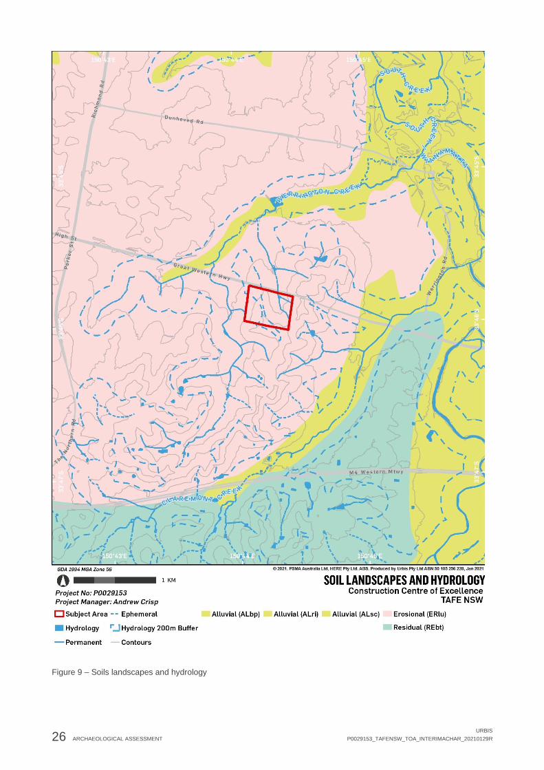
26 ARCHAEOLOGICAL ASSESSMENT
URBIS
P0029153_TAFENSW_TOA_INTERIMACHAR_20210129R
Figure 9 – Soils landscapes and hydrology
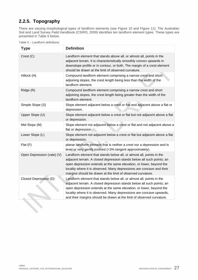
URBIS
P0029153_TAFENSW_TOA_INTERIMACHAR_20210129R ARCHAEOLOGICAL ASSESSMENT 27
2.2.5. Topography
There are varying morphological types of landform elements (see Figure 10 and Figure 11). The Australian Soil and Land Survey Field Handbook (CSIRO, 2009) identifies ten landform element types. These types are presented in Table 5 below.
Table 5 – Landform definitions
Type Definition
Crest (C) Landform element that stands above all, or almost all, points in the
adjacent terrain. It is characteristically smoothly convex upwards in
downslope profile or in contour, or both. The margin of a crest element
should be drawn at the limit of observed curvature.
Hillock (H) Compound landform element comprising a narrow crest and short
adjoining slopes, the crest length being less than the width of the
landform element.
Ridge (R) Compound landform element comprising a narrow crest and short
adjoining slopes, the crest length being greater than the width of the
landform element.
Simple Slope (S) Slope element adjacent below a crest or flat and adjacent above a flat or
depression.
Upper Slope (U) Slope element adjacent below a crest or flat but not adjacent above a flat
or depression.
Mid Slope (M) Slope element not adjacent below a crest or flat and not adjacent above a
flat or depression.
Lower Slope (L) Slope element not adjacent below a crest or flat but adjacent above a flat
or depression.
Flat (F) planar landform element that is neither a crest nor a depression and is
level or very gently inclined (<3% tangent approximately).
Open Depression (vale) (V) Landform element that stands below all, or almost all, points in the
adjacent terrain. A closed depression stands below all such points; an
open depression extends at the same elevation, or lower, beyond the
locality where it is observed. Many depressions are concave and their
margins should be drawn at the limit of observed curvature.
Closed Depression (D) Landform element that stands below all, or almost all, points in the
adjacent terrain. A closed depression stands below all such points; an
open depression extends at the same elevation, or lower, beyond the
locality where it is observed. Many depressions are concave upwards,
and their margins should be drawn at the limit of observed curvature.

28 ARCHAEOLOGICAL ASSESSMENT
URBIS
P0029153_TAFENSW_TOA_INTERIMACHAR_20210129R
Figure 10 – Landform type Source: CSIRO, 2009

URBIS
P0029153_TAFENSW_TOA_INTERIMACHAR_20210129R ARCHAEOLOGICAL ASSESSMENT 29
Figure 11 – Landform pattern Source: CSIRO, 2009
The subject area resides upon an undulating terrain. The subject area is atop a crest to the east, with simple slope to the west, with a minimal mid-slope. There is evidence that the topography of the subject area has been modified, with mounding visible from the A44 Motorway (Great Western Motorway) to the north of the site.
Archaeologically, regional predictive models for the Cumberland Plain identify crests and flats in proximity to water ways as the most sensitive landforms for Aboriginal archaeological materials, on the basis of knowledge surrounding land use. Different landforms were utilised in different ways by Aboriginal communities. For example, alluvial plains provided easy access to resources for camping, while ridgelines provided safe travel routes and depressions provided shelter for ceremonial activities.

30 ARCHAEOLOGICAL ASSESSMENT
URBIS
P0029153_TAFENSW_TOA_INTERIMACHAR_20210129R
2.2.6. Geotechnical Analysis
Pells Sullivan Meynink (PSM) undertook a geotechnical investigation for the proposed development and prepared a report (PSM 2021) to accompany a detailed SSDA (8571481). The geotechnical investigation area addressed by this report is classified by PSM as the ‘Construction Site – Zone 1’. bound by the boundary shown below in Figure 12 (9.5-hectare L-shaped site).
Figure 12 – Construction Site – Zone 1
Source: PSM
Ten boreholes were drilled over two days (18-19 November 2020) using a track mounted geotechnical drill rig. The boreholes were drilled to a final depth of between 1m and 14.5m. All boreholes were advanced to practical refusal using auger.
At the time of the geotechnical field work the following observations were made:
• The majority of the Construction Site – Zone 1 consisted of greenfield regions (grassy areas with some trees) with the southern areas covered mainly by existing buildings, paved on-grade car parking and access roads
• The surface elevation increased from west to east, and from north to south of the site

URBIS
P0029153_TAFENSW_TOA_INTERIMACHAR_20210129R ARCHAEOLOGICAL ASSESSMENT 31
Figure 13 – Reproduction of Table 4 – Summary of inferred subsurface conditions encountered in PSM boreholes
Source: PSM
Figure 14 – Reproduction of Table 5 – Inferred elevation of top of inferred geotechnical units encountered in PSM boreholes
Source: PSM
In summary the geotechnical investigation conducted by PSM (2021) confirms the presence of a shallow natural soil profile within the subject area.

32 ARCHAEOLOGICAL ASSESSMENT
URBIS
P0029153_TAFENSW_TOA_INTERIMACHAR_20210129R
Figure 15 – Location of PSM boreholes within subject area
Source: PSM

URBIS
P0029153_TAFENSW_TOA_INTERIMACHAR_20210129 ARCHAEOLOGICAL ASSESSMENT 33
2.3. PAST ABORIGINAL LAND USE Aboriginal people have lived in the Sydney area for more than 20,000 years. The oldest securely dated site in the greater Sydney region is 17,800 years before present (yBP), which was recorded in a rock shelter at Shaw’s Creek (Nanson et al 1987), near Castlereagh. Evidence of Aboriginal occupation has been found dated to 50-60,000 years before present (yBP) at Lake Mungo in western NSW, so it is likely that Aboriginal people have lived in the Sydney region for even longer than indicated by the oldest recorded dates we have at present. The archaeological material record provides evidence of this long occupation, but also provides evidence of a dynamic culture that has changed through time.
Aboriginal groups were not known to keep written records prior to the arrival of European colonisers in 1788. Therefore, the historical record is dominated by European views on Aboriginal people following settlement, rather than the voices of these groups and individuals themselves, and it is difficult to ascertain details of life prior to European arrival. These histories provide an inherently biased interpretation of Aboriginal life, which is not only distorted by the European lens but also by the observer effect wherein individuals are known to behave differently when being observed as opposed to when on their own. Archaeological data and ethnographic information provides additional records for how Aboriginal people may have utilised the landscape.
The subject area falls within the traditional lands of the Dharug (also spelt Darug or Dharuk) Aboriginal group. This name refers to the language spoken by groups who resided within the wider area and was attributed to this area following 1870 (Attenbrow, 2010). The Aboriginal groups which occupied the greater Penrith region were Darug speaking groups of the hinterland dialect. R. H. Matthews described the boundaries of Dharug land as follows:
“The Dharruk speaking people adjoined the Thurrawal on the north, extending along the coast to the Hawkesbury River, and inland to what is now Windsor, Penrith, Campbelltown and intervening town…Dialect was spoken at Campbelltown, Liverpool, Camden, Penrith and possibly as far as east Sydney” (R. H. Matthews, cited in Attenbrow, 2010).
Like all Aboriginal groups, the Darug people lived on and with Country – the land provided and was protected. Coastal Darug groups subsisted on primarily shellfish and employing different hunting techniques to those who occupied the Hinterland (Biosis, 2019). Floral resources available included various Acacia, melaleuca banksia, grevillea and hakea species, providing food but also gum and wood for the manufacture of tools and implements (Dixson, 1999). Vegetation communities and waterways such as Kemps and South Creeks also supported a variety of faunal resources including kangaroos, possums, wombats, birds, reptiles and aquatic animals (DSCA, 2004).
With the arrival of European colonists, the Cumberland Plain was progressively cleared to form agricultural land. As the bushland was removed, Aboriginal groups were displaced following conflict and violence between settlers and Aboriginal people competing for the same resources. Europeans also brought with them disease, such as smallpox, which had a heavy toll on the Aboriginal communities (Evidence, 1835; Collins, 1798).
While European settlement did heavily impact the Traditional Owners of the wider Penrith region, it did not decimate populations as popular narrative would suggest. Aboriginal people continued to live in the area, adapting to the changes brought by settlement. The fight for recognition was a political one. On 26th January1938, a “Day of Mourning” protest was held, following campaigns by Aboriginal individuals including Jack Patten, William Cooper and Pearl Gibbs who fought for civil rights including the right to vote and representation in Parliament. This struggle was long fought, and Aboriginal and Torres Strait Islanders were granted the right to vote Australia wide by 1965. Aboriginal people were recognised in the census and subject to Commonwealth laws following the referendum for Indigenous Rights in 1967. Aboriginal people across Australia continue to fight for recognition. In February 2008, then Prime Minister Kevin Rudd delivered an address apologising for the mistreatment of Aboriginal people throughout history and committing to closing the gap, recognising Aboriginal cultures as “the oldest continuing cultures in human history” (Rudd, 2008). In contemporary times, respect for Aboriginal people and connection to Country continues to grow. Despite attempts to eradicate Aboriginal people throughout the 19th and 20th centuries, Aboriginal communities continue to thrive across Australia, and Aboriginal individuals play a vital role in all levels of society.

34 ARCHAEOLOGICAL ASSESSMENT
URBIS
P0029153_TAFENSW_TOA_INTERIMACHAR_20210129R
2.4. HISTORICAL LAND USE Ground disturbance caused by historical land use may significantly reduce Aboriginal archaeological potential. Aerial images 1975, 1986,1991 & 2004 (Figure 18) were visually analysed to develop an understanding of historical land use and ground disturbance within the subject area (Table 6).
It is apparent from the historic aerial imagery that the historical land use of the subject area has been used primarily for agricultural purposes. Historical development of the subject area has caused localised high levels of ground disturbance (dam construction), while the majority of the subject area has been subject to low to moderate levels of physical impact (vegetation clearance, agricultural uses and building construction). In conjunction with the shallow soil profile of the present subject area, the observed levels of historical ground disturbance may reduce archaeological potential. An assessment of ground disturbance and archaeological potential across the subject area is mapped in Figure 19 below (TBC).
Table 6 – Analysis of historical aerials
Year Observation
1975 In the 1975 aerial, the subject area has been cleared and is utilised as agricultural land.
There is evidence of ploughing and other ground disturbing farming practices across the
subject area. The centre and portions of the western section of the subject area contain a
few buildings, including sheds and farm buildings. There is also a central access road
within the subject area at this time.
1986 In the 1986 aerial, development for the TAFE has commenced in the south western
portion of the subject. There are several buildings and a carpark within this portion of the
subject area at this time. Further imagery from c.1985 (see Figure 16 and Figure 17)
demonstrates the high levels of disturbance involved in the construction of the TAFE
buildings, with cutting, filling and stockpiling evident.
The north western portion appears to have been recently burnt. The eastern portion of the
subject area has experienced minimal change from 1975, with a central corridor of farm
buildings bordering the agricultural land. There is an access path through the eastern
portion o the site at this time.
1991 By 1991, the eastern portion of the subject area remains agricultural land, with a more
formalised series of access paths and a small farm building to the south eastern corner.
The western portion of the subject, however, has undergone extensive change by this
time. This includes the construction of several TAFE buildings to the south west, and a
carpark and roads to the north west.
2004 By 2004, the development associated with the TAFE site has spread from the western
portion of the site to the southern and northern portions. This includes landscaping and the
construction of several buildings and carparks across the subject area. The eastern portion
is no longer used as agricultural land at this time, but instead forms fields and open
grassed areas for the TAFE.

URBIS
P0029153_TAFENSW_TOA_INTERIMACHAR_20210129 ARCHAEOLOGICAL ASSESSMENT 35
Figure 16 – Construction of Werrington College of TAFE (now known as TAFE NSW Kingswood Campus), O’Connell St, Kingswood, c.1985. This image demonstrates the disturbance to the subject area resulting from the construction of the buildings.
Source: Penrith Library, 000267.
Figure 17 – Construction of Werrington College of TAFE (now known as TAFE NSW Kingswood Campus), O’Connell St, Kingswood, c.1985. This image demonstrates the disturbance to the subject area resulting from the construction of the buildings.
Source: Penrith Library, 000266/.
2.4.1. Summary
The subject area has experienced high levels of disturbance in localised areas associated with the construction of TAFE facilities to the western and southern portions. The eastern and central portions of the subject area, however, have experienced considerably lower disturbance. These areas have been cleared with their primary use being for agricultural practices since c.19th century (see Heritage Impact Statement and Historical Archaeological Impact Assessment, prepared by Urbis under different covers, 2020). Current impacts are proposed within the eastern portion of the subject area, where disturbance has been minimal. It should also be noted that to the north east, a dam has been constructed recently, not visible in the historical aerials.

36 ARCHAEOLOGICAL ASSESSMENT
URBIS
P0029153_TAFENSW_TOA_INTERIMACHAR_20210129R
Figure 18 – Historical aerial photographs

URBIS
P0029153_TAFENSW_TOA_INTERIMACHAR_20210129 ARCHAEOLOGICAL ASSESSMENT 37
[INSERT FIGURE]
Figure 19 – Levels of ground disturbance and archaeological potential across subject area.

38 ARCHAEOLOGICAL ASSESSMENT
URBIS
P0029153_TAFENSW_TOA_INTERIMACHAR_20210129R
2.5. ARCHAEOLOGICAL FIELD SURVEY {INSERT DESCRIPTION OF FIELD SURVEY AND RELATIONSHIP TO DESKTOP ASSESSMENT FOLLOWING SURVEY}
2.6. ARCHAEOLOGICAL TEST EXCAVATION {TBC FOLLOWING TEST EXCAVATION}
2.7. PREDICTIVE MODEL The Code of Practice for Archaeological Investigation of Aboriginal Objects in New South Wales requires that an appropriate predictive model be used when undertaking an ACHA. A predictive model is used to estimate the nature and distribution of evidence of Aboriginal land use in a subject area. The results produced by a predictive model can be used to identify potential archaeological deposits (PADs).
A predictive model should consider variables that may influence the location, distribution and density of sites, features or artefacts within a subject area. Variables typically relate to the environment and topography, such as soils, landscape features, slope, landform and cultural resources. The following predictions for the subject area have been formulated on the basis of previous assessments, regional models and the AHIMS data provided in Section 2.1.3.
There are several site types which are known to occur within New South Wales. These site types and their likelihood to occur within the subject area are evaluated in Table 8 below.
The general process archaeologists employ to determine the likelihood of any particular site type (artefact scatter, shelter, midden etc) to occur within a given subject area requires the synthesis of information for general distribution of archaeological sites within the wider area including:
• Detailed analysis of previous archaeological investigations within the same Region.
• Presence or absence of landscape features that present potential for archaeological resources (human occupation, use) such as raised terraces adjacent to permeant water.
• Analysis of the geology and soil landscape within the subject area which allows for a determination to be made of the type of raw material that would have been available for artefact production (silcrete, tuff, quartz etc) and the potential for the accumulation of archaeological resource within the subject area.
• Investigation of and determination of the level of disturbance/historical land use within the subject area which may impact on or remove entirely any potential archaeological material.
The combination of these would give us an indication of various levels of possibility of finding archaeological resource within a given area. Please refer to Table 7 below for an example of the indicative process of determining the likelihood of a given site occurring within a subject area.
Table 7 – Indicative process of determining the likelihood of a given site occurring within a subject area
Likelihood Indicative subject area context Indicative action
High Low level of disturbance, presence of one or more
archaeologically sensitive landforms (raised terrace
adjacent to permanent water, sand dunes, rock
shelter etc), presence of archaeologically sensitive
soil landscape (Tuggerah, Blacktown, South Creek
etc), presence of previously recorded archaeological
site(s) and/or identification of previously unrecorded
archaeological site(s) within the subject area
Detailed archaeological
investigation including but not
limited to survey, test
excavation and potentially
(depending on density and/or
significance of archaeological
deposit) salvage excavation.

URBIS
P0029153_TAFENSW_TOA_INTERIMACHAR_20210129R ARCHAEOLOGICAL ASSESSMENT 39
Likelihood Indicative subject area context Indicative action
Moderate Moderate level of disturbance, presence of one or
more archaeologically sensitive landforms (raised
terrace adjacent to permanent water, sand dunes,
rock shelter etc), presence of archaeologically
sensitive soil landscape (Tuggerah, Blacktown, South
Creek etc), presence of previously recorded
archaeological site(s) and/or identification of
previously unrecorded archaeological site(s) within
the subject area
Detailed archaeological
investigation including but not
limited to survey, test
excavation and potentially
(depending on density and/or
significance of archaeological
deposit) salvage excavation.
Low High level of disturbance, presence of one
archaeologically sensitive landform (raised terrace
adjacent to permanent water, sand dunes, rock
shelter etc), presence of archaeologically sensitive
soil landscape (Tuggerah, Blacktown, South Creek
etc).
Employ chance finds procedure
and works can continue without
further archaeological
investigation.
Nil Complete disturbance, complete removal of natural
soil landscape, zero archaeologically sensitive
landform, geological or soil features. Zero previously
recorded archaeological sites.
Employ chance finds procedure
and works can continue without
further archaeological
investigation.

40 ARCHAEOLOGICAL ASSESSMENT
URBIS
P0029153_TAFENSW_TOA_INTERIMACHAR_20210129R
Table 8 – Predictive Model
Site type Description Potential Justification
Artefact Scatters/
Camp Sites
Artefact scatters/camp sites represent past Aboriginal occupation and
possible stone knapping activities and include archaeological remains such
as stone artefacts and potentially hearths. This site type usually appears as
surface accumulation of stone artefacts in areas where vegetation is limited,
and ground surface visibility increases. Such scatters of artefacts are also
often exposed by erosion, agricultural events such as ploughing, and the
creation of informal, unsealed vehicle access tracks and walking paths.
These types of sites are often located on dry, relatively flat and elevated land
along or adjacent to rivers and creeks.
Moderate to
high
• The distribution of artefact sites in
the region suggests that there
would be archaeological potential
for these site types within the
subject area.
• The subject area contains
archaeologically sensitive
landforms: elevated ground and
hill slopes associated with
waterways.
• Areas of low historical ground
disturbance in the subject area
increase the potential that these
site types would remain intact.
Isolated Finds Isolated finds represent artefactual material in singular, one off occurrences.
Isolated finds are generally indicative of stone tool production, although can
also include contact sites.
Isolated finds may represent a single item discard event or be the result of
limited stone knapping activity. The presence of such isolated artefacts may
indicate the presence of a more extensive, in situ buried archaeological
deposit, or a larger deposit obscured by low ground visibility. Isolated
artefacts are likely to be located on landforms associated with past Aboriginal
activities, such as ridgelines that would have provided ease of movement
through the area, and level areas with access to water, particularly creeks
and rivers.
Moderate to
high
• The distribution of artefact sites in
the region suggests that there
would be archaeological potential
for these site types within the
subject area.
• The subject area contains
archaeologically sensitive
landforms: elevated ground and
hill slopes associated with
waterways.
• Areas of low historical ground
disturbance in the subject area
increase the potential that these
site types would remain intact.

URBIS
P0029153_TAFENSW_TOA_INTERIMACHAR_20210129R ARCHAEOLOGICAL ASSESSMENT 41
Site type Description Potential Justification
PAD Potential Archaeological Deposits (or PADs) are areas where there is no
surface expression of stone artefacts, but due to a landscape feature there is
a strong likelihood that the area will contain buried deposits of stone
artefacts. Landscape features which may feature in PADs include proximity
to waterways, particularly terraces and flats near 3rd order streams and
above; ridge lines, ridge tops and sand dune systems.
Moderate to
high
• The distribution of artefact sites in
the region suggests that there
would be archaeological potential
for these site types within the
subject area.
• The subject area contains
archaeologically sensitive
landforms: elevated ground and
hill slopes associated with
waterways.
• Areas of low historical ground
disturbance in the subject area
increase the potential that these
site types would remain intact.
Scarred Trees Scarred trees are the results of the stripping-off the bark by Aboriginal people
for various reasons, including the construction of shelters (huts), canoes,
paddles, shields, baskets and bowls, fishing lines, cloaks, torches and
bedding, as well as being beaten into fibre for string bags or ornaments
(sources cited in Attenbrow 2002: 113). The removal of bark exposes the
heart wood of the tree, resulting in a scar that can heal by the regrowth of the
bark or remain an exposed scar for a prolonged period. Such scars, when
they occur, are typically described as scarred trees. These sites most often
occur in areas with mature, remnant native vegetation. The locations of
scarred trees often reflect an absence of historical clearance of vegetation
rather than the actual pattern of scarred trees. Carved trees are different
from scarred trees, and the carved designs may indicate totemic affiliation
(Attenbrow 2002: 204); they may also have been carved for ceremonial
purposes or as grave markers.
Nil ▪ Historical vegetation clearance in
the subject area has removed all
original trees.
Axe Grinding
Grooves
Grinding grooves are the physical evidence of tool making or food processing
activities undertaken by Aboriginal people. The manual rubbing of stones
against other stones creates grooves in the rock; these are usually found on
Low ▪ It is unlikely that the exposed
sandstone outcrops required for

42 ARCHAEOLOGICAL ASSESSMENT
URBIS
P0029153_TAFENSW_TOA_INTERIMACHAR_20210129R
Site type Description Potential Justification
flat areas of abrasive rock such as sandstone. They may be associated with
creek beds, or water sources such as rock pools in creek beds and on
platforms, as water enables wet grinding to occur.
this site type would occur within
the subject area.
Bora/Ceremonial Aboriginal ceremonial sites are locations that have spiritual or ceremonial
values to Aboriginal people. Aboriginal ceremonial sites may comprise
natural landforms and, in some cases, will also have archaeological material.
Bora grounds are a ceremonial site type, usually consisting of a cleared area
around one or more raised earth circles, and often comprised of two circles
of different sizes, connected by a pathway, and accompanied by ground
drawings or mouldings of people, animals or deities, and geometrically
carved designs on the surrounding trees.
Low ▪ Historical land-use in the subject
area is likely to have destroyed
any bora grounds or ceremonial
sites.
Burial Aboriginal burial of the dead often took place relatively close to camp site
locations. This is due to the fact that most people tended to die in or close to
camp (unless killed in warfare or hunting accidents), and it is difficult to move
a body long distances. Soft, sandy soils on, or close to, rivers and creeks
allowed for easier movement of earth for burial; and burials may also occur
within rock shelters or middens. Aboriginal burial sites may be marked by
stone cairns, carved trees or a natural landmark. Burial sites may also be
identified through historic records or oral histories.
Low • The subject area is not situated
on soft, sandy soils.
• The subject area does not include
any visible rock overhangs
suitable as shelters.
Contact site These types of sites are most likely to occur in locations of Aboriginal and
settler interaction, such as on the edge of pastoral properties or towns.
Artefacts located at such sites may involve the use of introduced materials
such as glass or ceramics by Aboriginal people or be sites of Aboriginal
occupation in the historical period.
Low • Contact sites in the area are
possible due to early European
settlement.
• Historical land-use in the subject
area reduces the potential for
these sites.
Midden Midden sites are indicative of Aboriginal habitation, subsistence and resource
extraction. Midden sites are expressed through the occurrence of shell
deposits of edible shell species often associated with dark, ashy soil and
charcoal. Middens often occur in shelters, or in eroded or collapsed sand
dunes. Middens occur along the coast or in proximity to waterways, where
Nil to low • The subject area is not situated
near the coast.
• The lower order tributary within
the subject area is not conducive
to this type of site.

URBIS
P0029153_TAFENSW_TOA_INTERIMACHAR_20210129R ARCHAEOLOGICAL ASSESSMENT 43
Site type Description Potential Justification
edible resources were extracted. Midden may represent a single meal or an
accumulation over a long period of time involving many different activities.
They are also often associated with other artefact types.
Art Art sites can occur in the form of rock engravings or pigment on sandstone
outcrops or within shelters (discussed below). An engraving is some form of
image which has been pecked or carved into a rock surface. Engravings
typically vary in size and nature, with small abstract geometric forms as well
as anthropomorphic Figures and animals also depicted (DECCW, 2010c). In
the Sydney region engravings tend to be located on the tops of Hawkesbury
Sandstone ridges where vistas occur. Pigment art is the result of the
application of material to a stone to leave a distinct impression. Pigment
types include ochre, charcoal and pipeclay. Pigment art within the Sydney
region is usually located in areas associated with habitation and sustenance.
Nil to low • The subject area does not include
any visible sandstone outcrops or
rock overhangs.
• It is unlikely that the exposed
sandstone outcrops required for
this site type would occur within
the subject area.
Shelters Shelter sites are places of Aboriginal habitation. They take the form of rock
overhangs which provided shelter and safety to Aboriginal people. Suitable
overhangs must be large and wide enough to have accommodated people
with low flooding risk. Due to the nature of these sites, with generic rock over
hangs common particularly in areas with an abundance of sandstone, their
use by Aboriginal people is generally confirmed through the correlation of
other site types including middens, art, PAD and/or artefactual deposits.
Nil to low • The subject area does not include
any visible rock overhangs.
• It is unlikely that the exposed
sandstone outcrops required for
this site type would occur within
the subject area.

44 ARCHAEOLOGICAL ASSESSMENT
URBIS
P0029153_TAFENSW_TOA_INTERIMACHAR_20210129R
2.8. SUMMARY Conclusions from analysis of the AHIMS results, previous archaeological reports, preliminary site inspection, landscape analysis and predictive modelling are as follows:
• There are no Aboriginal sites registered within the subject area and two sites registered within 1km of the subject area.
• Archaeological sites can be found across a variety of landforms in the Cumberland Plain, with greater frequency in the vicinity of waterways, lower slopes and river terraces.
• {Ground disturbance}
• {Overall assessment of archaeological potential / specific site types following survey and test excavation}
• The subject area resides upon an undulating terrain. The subject area is atop a crest to the east, with simple slope to the west, with a minimal mid-slope.
• The subject area is located within the Luddenham soil landscape (lu). Soils within this landscape are described as shallow to moderately deep (<100-150cm).
• The subject area contains a tributary of Werrington Creek, which is located approximately 900m north of the site. The tributary runs southward from elevated ground and has been dammed for agricultural purposes. South Creek is located approximately 2km east of the subject area. As the subject area is within 200m of a waterway, this increases the potential for Aboriginal objects and sites.
• The subject area is cleared agricultural land with replanted trees forming vegetation barriers from roads and buildings.
Due to the surrounding hydrology, the subject area retains potential for the presence of Aboriginal archaeological resources.

URBIS
P0029153_TAFENSW_TOA_INTERIMACHAR_20210129R ABORIGINAL CONSULTATION 45
3. ABORIGINAL CONSULTATION In administering its statutory functions under Part 6 of the NSW National Parks and Wildlife Act 1974, the Department of Premier and Cabinet (DPC) requires that Proponent consult with Aboriginal people about the Aboriginal cultural heritage values (cultural significance) of Aboriginal objects and/or places within any given development area in accordance with Clause 80c of the NSW National Parks and Wildlife Regulation, 2009.
The DPC maintains that the objective of consultation with Aboriginal communities about the cultural heritage values of Aboriginal objects and places is to ensure that Aboriginal people have the opportunity to improve ACHA outcomes by (DECCW 2010a):
• Providing relevant information about the cultural significance and values of Aboriginal objects and/or places.
• Influencing the design of the method to assess cultural and scientific significance of Aboriginal objects and/or places.
• Actively contributing to the development of cultural heritage management options and recommendations for any Aboriginal objects and/or places within the proposed subject area.
• Commenting on draft assessment reports before they are submitted by the Proponent to the DPIE.
Consultation in line with the Consultation Requirements (DECCW 2010) is a formal requirement where a Proponent is aware that their development activity has the potential to harm Aboriginal objects or places. The DPC also recommends that these requirements be used when the certainty of harm is not yet established but a proponent has, through some formal development mechanism, been required to undertake a cultural heritage assessment to establish the potential harm their proposal may have on Aboriginal objects and places.
The Consultation Requirements outline a four-stage consultation process that includes the following:
• Stage 1 – Notification of project proposal and registration of interest.
• Stage 2 - Presentation of information about the proposed project.
• Stage 3 - Gathering information about the cultural significance.
• Stage 4 – Review of draft cultural heritage assessment report.
The document also outlines the roles and responsibilities of the DPC, Registered Aboriginal Parties (RAPs) including Local and State Aboriginal Land Councils, and proponents throughout the consultation process.
To meet the requirements of consultation it is expected that proponents will:
• Bring the RAPs, or their nominated representatives, together and be responsible for ensuring appropriate administration and management of the consultation process.
• Consider the cultural perspectives, views, knowledge and advice of the RAPs involved in the consultation process in assessing cultural significance and developing any heritage management outcomes for Aboriginal objects(s) and/or places(s).
• Provide evidence to the DPIE of consultation by including information relevant to the cultural perspectives, views, knowledge and advice provided by the RAPs.
• Accurately record and clearly articulate all consultation findings in the final ACHAR.
• Provide copies of the cultural heritage assessment report to the RAPs who have been consulted.
The consultation process undertaken to seek active involvement from relevant Aboriginal representatives for the project followed the current NSW statutory guideline, namely, the Consultation Requirements. Section 1.3 of the Consultation Requirements describes the guiding principles of the document. The principles have been derived directly from the principles section of the Australian Heritage Commission’s Ask First: A guide to respecting Indigenous heritage places and values (Australian Heritage Commission 2002).
The following outlines the process and results of the consultation conducted during this assessment to ascertain and reflect the Aboriginal cultural heritage values of the subject area.

46 ABORIGINAL CONSULTATION
URBIS
P0029153_TAFENSW_TOA_INTERIMACHAR_20210129R
3.1. STAGE 1: NOTIFICATION OF PROJECT PROPOSAL AND REGISTRATION OF INTEREST
3.1.1. Government Organisation Contact
The aim of Stage 1 is to identify, notify and register Aboriginal people who hold cultural knowledge relevant to determining the cultural significance of Aboriginal objects and/or places in the subject area.
A search of the Native Title Tribunal was undertaken on 2nd November 2020. This search identified the subject area as freehold tenure, which extinguishes Native Title.
To identify Aboriginal people who may be interested in registering as Aboriginal parties for the project, the organisations stipulated in Section 4.1.2 of the Consultation Guidelines were contacted (refer to Table 9).
Table 9 – Contacted Organisations
Organisation Date notification sent Date Response Received
National Native Title Tribunal 10 November 2020 2 November 2020
Office of the Registrar, Aboriginal Land Rights Act
1983
6 November 2020 17 November 2020
Heritage NSW, Department of Premier and Cabinet 10 November 2020 17 November 2020
NTS Corp 6 November 2020 N/A
Deerubbin Local Aboriginal Land Council 6 November 2020 N/A
Local Land Services, Greater Sydney 6 November 2020 N/A
Penrith City Council 6 November 2020 N/A
The template for the emails sent to the above-mentioned organisations is at Appendix C. A total of 61 Aboriginal groups and individuals with an interest in the subject area were identified following this stage. These groups were contacted, with further information presented at Section 3.1.2 below.
3.1.2. Registration of Interest
In accordance with Section 4.1.3 of the Consultation Guidelines, letters were sent to the 61 Aboriginal groups and individuals via email or express post on 11 December 2020 (depending on the method identified by each group), to notify them of the proposed project. A total of 57 were sent via email, with 4 by express post. The letters included a brief introduction to the project and the project location and set a deadline of 31 December 2020 for registration, in accordance with the 14-day minimum requirement. The letter template is included in Appendix C.
A total of 18 groups registered interested in the project as a result of this phase (Table 10). Acknowledgement emails were sent by Urbis to all respondents to confirm registration had been received.
Table 10 – Stage 1 Consultation – Registration of Interest
Organisation/Individual Contact Person
Deerubbin Local Aboriginal Land Council Steven Randall
Barking Owl Aboriginal Corporation Jody Kulakowski
Biamanga Seli Storer
Cullendulla Corey Smith
Clive Freeman Clive Freeman

URBIS
P0029153_TAFENSW_TOA_INTERIMACHAR_20210129R ABORIGINAL CONSULTATION 47
Organisation/Individual Contact Person
Goobah Developments Basil Smith
Gulaga Wendy Smith
Kamilaroi Yankuntjatjara Working Group Phil Khan
Murramarang Roxanne Smith
Ngambaa Cultural Connections Kaarina Slater
Waawaar Awaa Aboriginal Corp Rodney Gunther
Muragadi Heritage Indigenous Corporation Jesse Johnson
Didge Ngunawal Clan Lillie Carroll / Paul Boyd
Gunjeewong Cultural Heritage Aboriginal Corporation Cherie Carroll Turrise
Aragung Aboriginal Cultural Heritage Site Assessments Jamie Eastwood
Butucarbin Aboriginal Corporation Jennifer Beale
Woronora Plateau Gundangara Elders Council Kayla Williamson
Wurrumay Pty Ltd Vicky Slater
3.1.3. Public Notice
In accordance with Section 4.1.3 of the Consultation Guidelines, an advertisement was placed in a local newspaper, The Koori Mail. The advertisement was published in the 16th December 2020 edition, and registration was open until 31st December 2020, providing 14 days to register an interest in accordance with the Consultation Requirements. A copy of the advertisement is included in Appendix C.
3.1.4. Stage 1.6 Notice to DPC/LALC
The list of Registered Aboriginal Parties (RAPs) was provided to DPC – Aboriginal Branch and the Deerubbin Local Aboriginal Land Council on the 18th January 2021 (see Appendix C).
3.2. STAGE 2: PRESENTATION OF INFORMATION ABOUT THE PROJECT The aim of Stage 2 is to provide registered Aboriginal parties with information about the scope of the proposed project, and the proposed cultural heritage assessment process. A Stage 2/3 Information Pack which included a brief introduction to the project, the project location, and AHIMS search result to provide understanding of the registered cultural sites in the local area, was sent to registered Aboriginal parties via email on the 21st January 2021. A response to the Stage 2/3 Information Packet was requested by 18th February 2021.
The Information Pack was prepared as a combination of Stage 2 and 3 of the Consultation Guidelines, and included the following information:
• Project overview, location and purpose.
• Proposed works.
• Brief environmental and historical background.
• Notification of the site inspection.
• Protocol of gathering information on cultural heritage significance.
• Request for comment on methodology and recommendations for site investigation, and request for any cultural information the respondent wished to share.

48 ABORIGINAL CONSULTATION
URBIS
P0029153_TAFENSW_TOA_INTERIMACHAR_20210129R
• The letter is included in Appendix C of this report.
3.3. STAGE 3: GATHERING INFORMATION ABOUT THE PROPOSED PROJECT Stage 3 is concerned with gathering feedback on a project, proposed methodologies, and obtaining any cultural information that registered Aboriginal parties wish to share. This may include ethno-historical information, or identification of significant sites or places in the local area.
{Number} responses were received to the Stage 2 and 3 Information Pack. These responses are included in Appendix C and addressed in Table 11 below.

URBIS
P0029153_TAFENSW_TOA_INTERIMACHAR_20210129 ABORIGINAL CONSULTATION 49
Table 11 – RAP responses to the Stage 2/3 Information Pack
RAP Response Urbis Response

50 ABORIGINAL CONSULTATION
URBIS
P0029153_TAFENSW_TOA_INTERIMACHAR_20210129R
3.3.1. Site inspection and meeting
[INSERT following Survey]
3.4. STAGE 4: REVIEW OF DRAFT ACHA REPORT The aim of Stage 4 is to prepare and finalise an ACHAR with input from registered Aboriginal Parties.
A draft ACHAR was sent to registered Aboriginal parties via email on the XX 2021 with comment on the draft ACHAR requested prior to XX 2021. It is noted that the time allowed for comment should reflect the size and complexity of the project.
{INSERT FOLLOWING CLOSE OF STAGE 4}
3.5. SUMMARY {INSERT SUMMARY OF CONSULTATION SECTION}

URBIS
P0029153_TAFENSW_TOA_INTERIMACHAR_20210129R CULTURAL HERITAGE VALUES AND STATEMENT OF SIGNIFICANCE 51
4. CULTURAL HERITAGE VALUES AND STATEMENT OF SIGNIFICANCE
4.1. METHODS OF ASSESSING HERITAGE SIGNIFICANCE Heritage significance is assessed by considering each cultural, or archaeological site, against the significance criteria set out in the Assessment Guidelines. In all case, the assessment of significance detailed below is informed by the Aboriginal community, which is documented in this report. If any culturally sensitive values were identified they would not be specifically included in the report, or made publicly available, but would be documented and lodged with the knowledge holder providing the information.
4.2. ASSESSMENT FRAMEWORK The Burra Charter (Australia ICOMOS 1999) defines the basic principles and procedure to be observed in the conservation of important places. It provided the primary framework within which decisions about the management of heritage sites should be made. The Burra Charter defines cultural significance as being derived from the values listed below.
4.2.1. Social or Cultural value
Social or cultural value refers to the spiritual, traditional, historical or contemporary associations and attachments the place or area has for Aboriginal people. Social or cultural values is how people express their connection with a place and the meaning that place has for them.
Places of social or cultural value have associations with contemporary community identity. These places can have associations with tragic or warmly remembered experiences, periods, or events. Communities can experience a sense of loss should a place of social or cultural value be damaged or destroyed.
There is not always a consensus about a place’s social or cultural value. When identifying values, it is not necessary to agree with or acknowledge the validity of each other’s values, but it is necessary to document the range of values identified.
Social or cultural values can only be identified through consultation with Aboriginal people. This could involve a range of methodologies, such as cultural mapping, oral histories, archival documentation and specific information provided by Aboriginal people specifically for the investigation.
When recording oral history:
• Identify who was interviewed and why.
• Document the time, place and date the interview was conducted.
• Describe the interview arrangements (the number of people present, recording arrangements, information access arrangements).
• Provide a summary of the information provided to the person being interviewed.
• Summarise the information provided by each person interviewed.
More information on conducting oral history projects can be found in OEH’s publication Talking history: oral history guidelines.
Occasionally information about social value may not be forthcoming. In these circumstances, document the consultation process but make it clear in the discussions and conclusions about social value that this was the case.
4.2.2. Historic value
Historic value refers to the associations of a place with a historically important person, event, phase or activity in an Aboriginal community. Historic places do not always have physical evidence of their historical importance (such as structures, planted vegetation or landscape modifications). They may have ‘shared’ historic values with other (non-Aboriginal) communities.

52 CULTURAL HERITAGE VALUES AND STATEMENT OF SIGNIFICANCE
URBIS
P0029153_TAFENSW_TOA_INTERIMACHAR_20210129R
Places of post-contact Aboriginal history have generally been poorly recognised in investigations of Aboriginal heritage. Consequently, the Aboriginal involvement and contribution to important regional historical themes is often missing from accepted historical narratives. This means it is often necessary to collect oral histories along with archival or documentary research to gain a sufficient understanding of historic values.
4.2.3. Scientific (Archaeological) value
This refers to the importance of a landscape, area, place or object because of its rarity, representativeness and the extent to which is may contribute to further understanding and information (Australian ICOMOS 1988).
Information about scientific values will be gathered through any archaeological investigation undertaken. Archaeological investigations must be carried out according to OEH’s Code of practice for archaeological investigation of Aboriginal objects in NSW.
Scientific significance, also referred to as archaeological significance, is determined by assessing an Aboriginal heritage site or area according to archaeological criteria. The assessment of archaeological significance is used to develop appropriate heritage management and impact mitigation strategies.
Criteria for archaeological significance have been developed in accordance DPIE guidelines, as shown in, Table 12 below.
Table 12 – Scientific (archaeological) significance criteria
Significance Criteria Description
Research Potential Does the evidence suggest any potential to contribute to an understanding
of the area and/or region and/or state’s natural and cultural history?
Representativeness How much variability (outside and/or inside the subject area) exists, what is
already conserved, how much connectivity is there?
Rarity Is the subject area important in demonstrating a distinctive way of life,
custom, process, land-use, function or design no longer practised? Is it in
danger of being lost or of exceptional interest?
Education Potential Does the subject area contain teaching sites or sites that might have
teaching potential?
Condition What is the condition of the site? Does it appear to have been
impacted/altered?
4.2.4. Aesthetic value
This refers to sensory, scenic, architectural, and creative aspects of the place. It is often closely linked with the social values. It may consider form, scale, colour, texture and material of the fabric or landscape, and the smell and sounds associated with the place and its use (Australian ICOMOS 1988).
4.3. IDENTIFYING VALUES The information collected in the background review of the project can be used to help identify these values. The review of background information and information gained through consultation with Aboriginal people should provide insight into past events. These include how the landscape was used and why any identified Aboriginal objects are in this location, along with contemporary uses of the land.
Information gaps are not uncommon and should be acknowledged. They may require further investigation to adequately identify the values present across the subject area. It may be helpful to prepare a preliminary values map that identifies, to the extent of information available, the:
• Known places of social, spiritual, cultural value, including natural resources of significance.
• Known historic places.
• Known Aboriginal objects and/or declared Aboriginal places.

URBIS
P0029153_TAFENSW_TOA_INTERIMACHAR_20210129R CULTURAL HERITAGE VALUES AND STATEMENT OF SIGNIFICANCE 53
• Potential places/areas of social, spiritual, cultural value, including natural resources, historic or archaeological significance.
Places of potential value that are not fully identified or defined should be included as ‘sensitive’ areas to target further investigation.
4.4. ASSESSING VALUES AND SIGNIFICANCE This stage is used to assess and discuss the cultural significance of the values identified during the identification and assessment of cultural significance by consulting Aboriginal people and to prepare a statement of significance. The assessment of values is a discussion of what is significant and why. An assessment of values is more than simply restating the evidence collected during the background review and identification of values stages of the project. Rather, the assessment should lead to a statement of significance that sets out a succinct summary of the salient values that have been identified.
The assessment and justification in the statement of significance must discuss whether any value meets the following criteria (NSW Heritage Office 2001):
• Does the subject area have a strong or special association with a particular community or cultural group for social, cultural or spiritual reasons? – social value.
• Is the subject area important to the cultural or natural history of the local area and/or region and/or state? – historic value.
• Does the subject area have potential to yield information that will contribute to an understanding of the cultural or natural history of the local area and/or region and/or state? – scientific (archaeological) value.
• Is the subject area important in demonstrating aesthetic characteristics in the local area and/or region and/or state? – aesthetic value.
• Assessment of each of the criteria (above) should be graded in terms that allow the significance to be described and compared; for example, as high, moderate, or low. In applying these criteria, consideration should be given to:
• Research potential: does the evidence suggest any potential to contribute to an understanding of the area and/or region and/or state’s natural and cultural history?
• Representativeness: how much variability (outside and/or inside the subject area) exists, what is already conserved, how much connectivity is there?
• Rarity: is the subject area important in demonstrating a distinctive way of life, custom, process, land-use, function or design no longer practised? Is it in danger of being lost or of exceptional interest?
• Education potential: does the subject area contain teaching sites or sites that might have teaching potential?
Then discuss what is significance and why – this should be summarised into a statement of significance. Thus, the statement of significance is a succinct summary of the salient values drawn from the identification of values.
4.4.1. Assessment of Cultural Heritage Significance and Values
An assessment of cultural heritage significance and values incorporates a range of values which may vary for different individual groups and may relate to both the natural and cultural characteristics of places or sites. Cultural significance and Aboriginal cultural views can only be determined by the Aboriginal community using their own knowledge of the area and any sites present, and their own value system. All Aboriginal heritage evidence tends to have some contemporary significance to Aboriginal people, because it represents an important tangible link to their past and to the landscape.
Consultation with members of the local Aboriginal community (project RAPs) was undertaken to identify the level of spiritual/cultural significance of the subject area and its components. In acknowledgment that the Aboriginal community themselves are in the best position to identify levels of cultural significance, the project RAPs were invited to provide comment and input into this ACHAR and to the assessment of cultural heritage significance and values presented therein.

54 CULTURAL HERITAGE VALUES AND STATEMENT OF SIGNIFICANCE
URBIS
P0029153_TAFENSW_TOA_INTERIMACHAR_20210129R
Comments received from the representatives of the project RAPs indicate that [INSERT COMMENTS & ASSESSMENT]
4.4.2. Assessment of Scientific (Archaeological) Significance
In accordance with the Guide to Investigating, Assessing and Reporting on Aboriginal Cultural Heritage in NSW, and in consultation with representatives of the local Aboriginal community, the following assessment of the scientific (archaeological) significance of identified sites within the subject area has been prepared.
[INSERT ASSESSMENT]

URBIS
P0029153_TAFENSW_TOA_INTERIMACHAR_20210129R IMPACT ASSESSMENT 55
5. IMPACT ASSESSMENT {INSERT ASSESSMENT}.
5.1. POTENTIAL HARM This section identifies the potential impacts to cultural heritage arising from the proposal, including demolition, excavation, and construction phases. Harm can be direct or indirect, defined by the Assessment Guidelines as:
• Direct harm – may occur as the result of any activity which disturbs the ground including, but not limited to, site preparation activities, installation of services and infrastructure, roadworks, excavation, flood mitigation measures.
• Indirect harm – may affect sites or features located immediately beyond or within the area of the proposed activity. Examples include, but are not limited to, increased impact on art in a shelter from increased visitation, destruction from increased erosion and changes in access to wild food resources.
The nature, extent and level of harm (indirect or direct) cannot be identified at this stage due to the lack of sufficient information on the presence or absence of Aboriginal objects and archaeological resources within the subject area. This ACHA has concluded that there is moderate to high archaeological potential for subsurface Aboriginal archaeological deposits. However, should Aboriginal archaeological resources found within the subject area, the proposed development will have direct impact on those resources and potentially remove the archaeological resource completely.
The level, nature and extent of potential harm cannot be ascertained until the results of archaeological excavation is undertaken.
5.2. LIKELY IMPACTED VALUES The level of archaeological potential of subsurface Aboriginal objects and archaeological resources that still may exist within the subject area can only be further assessed by archaeological test excavation.
These potential Aboriginal objects and/or sites may represent various scale camping events and Aboriginal utilisation of the land in the form of hearths and/or stone artefacts.\
The level, nature and extent of potential harm cannot be ascertained until the results of archaeological excavation is undertaken.
5.3. CONSIDERATION OF INTER-GENERATIONAL EQUITY
5.3.1. Cumulative Impact Assessment
The principle of inter-generational equity (IGE) holds that the present generation should make every effort to ensure the health, diversity and productivity of the environment – which includes cultural heritage – is available for the benefit of future generations.
Cumulative impact of any development on Aboriginal sites assesses the extent of the proposed impact on the site and how this will affect both the proportion of this type of Aboriginal site in the area and the impact this destruction will have on Aboriginal cultural heritage values generally in the area. For example, if an artefact scatter is destroyed in the course of a proposed development, how many artefact scatters are likely to remain in that area and how will the destruction of that site affect the overall archaeological evidence remaining in that area? If a site type that was once common in an area becomes rare, the loss of that site (and site type) will affect our ability to understand past Aboriginal land uses, will result in an incomplete archaeological record and will negatively affect intergenerational equity.
As the ACHA identified that further investigation is needed in the form of subsurface archaeological test excavation, the principles of the IGE can only be partially assessed at this stage and further information will be provided following the archaeological test excavation.
This assessment has established that the current subject area does not contain any previously identified Aboriginal sites.

56 IMPACT ASSESSMENT
URBIS
P0029153_TAFENSW_TOA_INTERIMACHAR_20210129R
The level, nature and extent of potential harm cannot be ascertained until the results of archaeological excavation is undertaken.

URBIS
P0029153_TAFENSW_TOA_INTERIMACHAR_20210129R AVOIDING AND MINIMISING HARM 57
6. AVOIDING AND MINIMISING HARM The nature, extent and level of harm (indirect or direct) cannot be identified at this stage due to the lack of sufficient information on the presence or absence of subsurface archaeological resources within the subject area. The ACHA concluded that there is potential for subsurface Aboriginal objects and archaeological resources within the underlaying soil landscape and recommends additional investigation in the form of archaeological test excavations. This test excavation is to establish the presence/absence and extent of subsurface archaeological resources that may be present within the subject area.
The nature and complexity of mitigation measures to avoid and/or minimise harm to any Aboriginal objects and archaeological resources that might be identified will be provided in context of the nature, extent and significance of those any resources uncovered during the proposed test excavation program.

58 CONCLUSIONS
URBIS
P0029153_TAFENSW_TOA_INTERIMACHAR_20210129R
7. CONCLUSIONS This ACHAR was prepared as per the relevant section of the National Parks and Wildlife Act 1974 (NPW Act) and the National Parks and Wildlife Regulations 2009 (NPW Reg) and in accordance to the following guidelines:
• Aboriginal Cultural Heritage Consultation Requirements for Proponents 2010 (Department of Environment, Climate Change and Water (DECCW), 2010) (the Consultation Guidelines).
• Guide to Investigating, Assessing and Reporting on Aboriginal Cultural Heritage in NSW (Office of Environment and Heritage 2011) (the Assessment Guidelines).
• Code of Practice for Archaeological Investigation of Aboriginal Objects in New South Wales (DECCW 2010).
• The Australia ICOMOS Charter for Places of Cultural Significance, The Burra Charter, 2013 (Burra Charter.
The ACHA process included:
• A comprehensive background research of all available archaeological and cultural heritage information for the subject area in context with the scope of the project.
• Analysis and interpretation of the background research.
• Archaeological field survey of the subject area (to be conducted).
• Consultation with the Registered Aboriginal Parties (RAPs).
• Site inspection and meeting with the RAPs.
• Summarising of results and providing recommendations for the proposed development in relation to Aboriginal cultural heritage and archaeological resources.
The ACHAR concluded that:
• {INSERT CONCLUSIONS}

URBIS
P0029153_TAFENSW_TOA_INTERIMACHAR_20210129R RECOMMENDATIONS 59
8. RECOMMENDATIONS Based on the conclusions of this assessment the proposed activity can proceed under the following recommendations:
{TO BE REVISED FOLLOWING SITE VISIT AND TEST EXCAVATION}
Recommendation 1 – Archaeological Test Excavation
An Archaeological Research Design (ARD) and Methodology should be prepared for the sub-surface Archaeological test excavation must be carried out in XX of the subject area
An Archaeological Research Design (ARD) and Methodology should be prepared for the sub-surface investigation of the identified landscape features and their potential for retaining Aboriginal objects and archaeological resources. The purpose of the archaeological test excavation is to confirm the presence or absence and potential extent of Aboriginal objects and archaeological resources within the subject area.
The archaeological test excavation must be undertaken according to the developed ARD and with the participation of the nominated Aboriginal RAPs and appropriately qualified archaeologists. The ARD must be developed in line with the Code of Practice for Archaeological Investigation of Aboriginal Objects in New South Wales (DECCW 2010) (the Code of Practice).
The results of the test excavations must be incorporated into the ACHAR or addendum document and supplied to the project RAPs for comment in accordance with Aboriginal Cultural Heritage Consultation Requirements for Proponents 2010 (Department of Environment, Climate Change and Water (DECCW), 2010) (the Consultation Guidelines).
Recommendation 2 – Aboriginal Cultural Heritage Induction
It is recommended that induction materials be prepared for inclusion in site inductions for any contractors working at the subject area. The induction material should include an overview of the types of sites to be aware of (i.e. artefact scatters or concentrations of shells that could be middens), obligations under the NPW Act, and the requirements of an archaeological finds’ procedure (refer below). This should be prepared for the project and included in any site management plans.
The induction material may be paper based, included in any hard copy site management documents; or electronic, such as “PowerPoint” for any face to face site inductions.
Recommendation 3 – Archaeological Chance Find Procedure
Although considered highly unlikely, should any archaeological deposits be uncovered during any site works, a procedure must be implemented. The following steps must be carried out:
1. All works stop in the vicinity of the find. The find must not be moved ‘out of the way’ without assessment.
2. Site supervisor, or another nominated site representative must contact either the project archaeologist (if relevant) or DPC to contact a suitably qualified archaeologist.
3. The nominated archaeologist examines the find, provides a preliminary assessment of significance, records the item and decides on appropriate management, in conjunction with the RAPs for the project. Such management may require further consultation with DPC, preparation of a research design and archaeological investigation/salvage methodology and preparation of AHIMS Site Card.
4. Depending on the significance of the find, reassessment of the archaeological potential of the subject area may be required, and further archaeological investigation undertaken.
5. Reporting may need to be prepared regarding the find and approved management strategies. Any such documentation should be appended to this ACHAR and revised accordingly.
6. Works in the vicinity of the find can only recommence upon relevant approvals from DPC.

60 RECOMMENDATIONS
URBIS
P0029153_TAFENSW_TOA_INTERIMACHAR_20210129R
Recommendation 4 – Human Remains Procedure
In the unlikely event that human remains are uncovered during any site works, the following must be undertaken:
1. All works within the vicinity of the find immediately stop.
2. Site supervisor or other nominated manager must notify the NSW Police and DPC.
3. The find must be assessed by the NSW Police, and may include the assistance of a qualified forensic anthropologist.
4. Management recommendations are to be formulated by the Police, DPC and site representatives.
5. Works are not to recommence until the find has been appropriately managed.
Recommendation 5 – RAP Consultation
A copy of the final ACHA must be provided to all project RAPs. Ongoing consultation with RAPs should occur as the project progresses, to ensure ongoing communication about the project and key milestones, and to ensure the consultation process does not lapse, particularly with regard to consultation should the CFP be enacted.

URBIS
P0029153_TAFENSW_TOA_INTERIMACHAR_20210129R BIBLIOGRAPHY 61
9. BIBLIOGRAPHY Attenbrow, V. 2002. Sydney’s Aboriginal Past. University of New South Wales Press, Sydney: Australia.
Attenbrow, V. 2010. Sydney’s Aboriginal Past, 2nd Edition, University of New South Wales Press, Sydney: Australia.
Biosys, 2018. Mamre South State Significant Development Application. Statement of Heritage Impact.
Department of Environment, Climate Change and Water NSW (DECCW) 2010 Aboriginal cultural heritage consultation requirements for proponents 2010: Part 6 National Parks and Wildlife Act 1974, Department of Environment, Climate Change and Water NSW.
DECCW 2010 Code of Practice for Archaeological Investigation of Aboriginal Objects in New South Wales: Part 6 National Parks and Wildlife Act 1974, Department of Environment, Climate Change and Water NSW.
DECCW 2010 Guide to investigating, assessing and reporting on Aboriginal cultural heritage in New South Wales: Part 6 National Parks and Wildlife Act 1974, Department of Environment, Climate Change and Water NSW.
Dominic Steele Consulting Archaeology (DSCA) 2010. Aboriginal and non-Aboriginal Cultural Heritage Impact Assessment, LOGOS Kemps Creek Logistics Project.
Flynn, M 1997. Holroyd history and the Silent Boundary Project, Holroyd City Council.
ICOMOS, 2013. The Burra Charter.
JMCHM, 2005. Archaeological testing and salvage excavation at Discovery Point, Site #45-5-2737, in the former grounds of Tempe House.
MacLaurin, ECB. 1966. 'Fitzgerald, Richard (1772–1840)', Australian Dictionary of Biography, National Centre of Biography, Australian National University.
Nanson, GC, Young, RW and Stockton, ED 1987, Chronology and palaeoenvironment of the Cranebrook Terrace, near Sydney, containing artefacts more than 40,000 years old, Archaeology in Oceania, vol. 22, pp. 72-78.
Ngara Consulting Pty Ltd, 2003. Archaeological Assessment of Aboriginal Heritage: Reservoir Entry Lands (AHIMS#102059), Prospect. Unpublished report to Conybeare and Morrison.
Tench, W. 1789. A Narrative of the Expedition to Botany Bay, p. 53. Cited in Flannery, 2012. Watkin Tench: 1788, The Text Publishing Company, Melbourne: Australia.
Tindale, NB. 1974. Aboriginal Tribes of Australia. Their Terrain, Environmental Controls, Distribution, Limits and Proper Names. ANU Press, Canberra: Australia.

62 DISCLAIMER
URBIS
P0029153_TAFENSW_TOA_INTERIMACHAR_20210129R
DISCLAIMER This report is dated 29 January 2021 and incorporates information and events up to that date only and excludes any information arising, or event occurring, after that date which may affect the validity of Urbis Pty Ltd (Urbis) opinion in this report. Urbis prepared this report on the instructions, and for the benefit only, of TAFE NSW (Instructing Party) for the purpose of an Aboriginal Cultural Heritage Assessment (Purpose) and not for any other purpose or use. To the extent permitted by applicable law, Urbis expressly disclaims all liability, whether direct or indirect, to the Instructing Party which relies or purports to rely on this report for any purpose other than the Purpose, and to any other person which relies or purports to rely on this report for any purpose whatsoever (including the Purpose).
In preparing this report, Urbis was required to make judgements which may be affected by unforeseen future events, the likelihood and effects of which are not capable of precise assessment.
All surveys, forecasts, projections and recommendations contained in or associated with this report are made in good faith and on the basis of information supplied to Urbis at the date of this report, and upon which Urbis relied. Achievement of the projections and budgets set out in this report will depend, among other things, on the actions of others over which Urbis has no control.
In preparing this report, Urbis may rely on or refer to documents in a language other than English, which Urbis may arrange to be translated. Urbis is not responsible for the accuracy or completeness of such translations and disclaims any liability for any statement or opinion made in this report being inaccurate or incomplete arising from such translations.
Whilst Urbis has made all reasonable inquiries it believes necessary in preparing this report, it is not responsible for determining the completeness or accuracy of information provided to it. Urbis (including its officers and personnel) is not liable for any errors or omissions, including in information provided by the Instructing Party or another person or upon which Urbis relies, provided that such errors or omissions are not made by Urbis recklessly or in bad faith.
This report has been prepared with due care and diligence by Urbis and the statements and opinions given by Urbis in this report are given in good faith and in the reasonable belief that they are correct and not misleading, subject to the limitations above.

URBIS
P0029153_TAFENSW_TOA_INTERIMACHAR_20210129R BASIC AND EXTENSIVE AHIMS SEARCH RESULTS 63
APPENDIX A BASIC AND EXTENSIVE AHIMS SEARCH RESULTS

64 REGISTERED ABORIGINAL PARTY CONSULTATION LOG
URBIS
P0029153_TAFENSW_TOA_INTERIMACHAR_20210129R
APPENDIX B REGISTERED ABORIGINAL PARTY CONSULTATION LOG

URBIS
P0029153_TAFENSW_TOA_INTERIMACHAR_20210129R REGISTERED ABORIGINAL PARTY CONSULTATION DOCUMENTATION 65
APPENDIX C REGISTERED ABORIGINAL PARTY CONSULTATION DOCUMENTATION

66 REGISTERED ABORIGINAL PARTY CONSULTATION DOCUMENTATION
URBIS
P0029153_TAFENSW_TOA_INTERIMACHAR_20210129R