Owens Lake BACM Book
13
STATUS: COVERAGE: WATER USE: REQUIRES: CONSTRUCTION: LAYOUT: DESIGN POSSIBILITIES: HABITAT VALUE: OTHER PUBLIC TRUST VALUE: COST: PUBLIC TRUST GRADE: COST GRADE: LATERAL SHALLOW FLOOD In lateral shallow flood, water flows downhill and creates a mosaic of saturated surfaces with occasional pooling, resulting in water gathering in tailwater ponds. POND SHALLOW FLOOD In pond shallow flood, water is deeper and dust control cells form one continuous pond. ponding 1’-2’ deep bubblers berm for access rip rap lines berms to prevent erosion berms with arizona spillways control overflow into the next cell saturated surfaces 1”-6” deep rip rap lines berms to prevent erosion berms with arizona spillways control overflow into the tailwater ponds tailwater ponds 1’-2’ deep berm for access bubblers ENJOYING THE SHALLOW FLOOD SECTIONS Approved Best Available Control Measure (BACM) 35.6 square miles 3-5 acre feet of water per foot per year Clay soils and ideally, proximity to seeps and springs Infrastructure for water transmission, outlets, electrical wiring, piping, berms for access, flood control, and to protect against wave erosion, sprinkler heads and bubblers placed at least once every 70’. Sequential pools follow flow from edges of the lake inward towards brine pool. Shape and size of berms and pools for views and accessability. High. Shallow flood allows for the resurrection of Owens Lake habitat and foodweb for resident shorebirds, migratory birds, and invertebrates such as brine flies and brine shrimp. It can also provide ideal conditions for algae and microscopic bacteria such as halobacteria and dunaliella, which cause water to take on reddish, brownish, or greenish hues. Moderate. Shallow flood cells are the most aesthetically pleasing BACM with stunning reflections and interesting colored pools. Bird habitat leads to birdwatching; however, access is limited to berms and the water in most pools are unsafe for human contact, limiting recreation potential. $12,900,000 per square mile, water cost is $1,240,000 per square mile, and 1 full time employee per 580 acres of flooded area is required. A C 0 30’ 0 30’ EXISTING BACM SHALLOW FLOOD [Controlling dust by saturating and covering soils with water] 100% coverage REQUIRED DUST CONTROL COVERAGE Water must cover or saturate at least 75% of the ground to achieve required dust control. The image above shows a lateral shallow flood with saturated ground in black, and dry areas in white. 75% coverage 1/7 BACM STUDIES SHALLOW FLOOD 1/1 USC Landscape Morphologies Lab // Owens Lake Research // Last Modified 7/23/2012
-
Upload
alexander-robinson -
Category
Documents
-
view
224 -
download
1
description
Description of Owens Lake BACM for landscape architecture design.
Transcript of Owens Lake BACM Book

/7 BACM STUDIES / /7 BACM STUDIES /
STATUS:
COVERAGE:
WATER USE:
REQUIRES:
CONSTRUCTION:
LAYOUT:
DESIGN POSSIBILITIES:
HABITAT VALUE:
OTHER PUBLIC TRUST VALUE:
COST:
PUBLIC TRUST GRADE:
COST GRADE:
LATERAL SHALLOW FLOODIn lateral shallow �ood, water �ows downhill and creates a mosaic of saturated surfaces with occasional pooling, resulting in water gathering in tailwater ponds.
POND SHALLOW FLOODIn pond shallow �ood, water is deeper and dust control cells form one continuous pond.
ponding1’-2’ deep
bubblersberm for access
rip rap lines berms to prevent erosion
berms with arizona spillways control over�ow into the next cell
saturated surfaces1”-6” deep
rip rap lines berms to prevent erosion
berms with arizona spillways control over�ow into the tailwater ponds
tailwater ponds1’-2’ deep
berm for access
bubblers
ENJOYING THE SHALLOW FLOOD
SECTIONS
Approved Best Available Control Measure (BACM)
35.6 square miles
3-5 acre feet of water per foot per year
Clay soils and ideally, proximity to seeps and springs
Infrastructure for water transmission, outlets, electrical wiring, piping, berms for access, �ood control, and to protect against wave erosion, sprinkler heads and bubblers placed at least once every 70’.
Sequential pools follow �ow from edges of the lake inward towards brine pool.
Shape and size of berms and pools for views and accessability.
High. Shallow �ood allows for the resurrection of Owens Lake habitat and foodweb for resident shorebirds, migratory birds, and invertebrates such as brine �ies and brine shrimp. It can also provide ideal conditions for algae and microscopic bacteria such as halobacteria and dunaliella, which cause water to take on reddish, brownish, or greenish hues.
Moderate. Shallow �ood cells are the most aesthetically pleasing BACM with stunning re�ections and interesting colored pools. Bird habitat leads to birdwatching; however, access is limited to berms and the water in most pools are unsafe for human contact, limiting recreation potential.
$12,900,000 per square mile, water cost is $1,240,000 per square mile, and 1 full time employee per 580 acres of �ooded area is required.
A
C
0 30’
0 30’
1/7 BACM STUDIES
USC Landscape Morphologies Lab // Owens Lake Research // Last Modi�ed 7/9/12
EXISTING BACM SHALLOW FLOOD[Controlling dust by saturating and covering soils with water]
SHALLOW FLOOD 1/1
100% coverageREQUIRED DUST CONTROL COVERAGEWater must cover or saturate at least 75% of the ground to achieve required dust control. The image above shows a lateral shallow �ood with saturated ground in black, and dry areas in white.
75% coverage
1/7 BACM STUDIES 1/1
USC Landscape Morphologies Lab // Owens Lake Research // Last Modified 7/23/2012
1/7 BACM STUDIES SHALLOW FLOOD 1/1
USC Landscape Morphologies Lab // Owens Lake Research // Last Modified 7/23/2012

REQUIRED DUST CONTROL COVERAGEVegetation must cover at least 50% of the ground to achieve required dust control. The image above shows vegetation coverage (in black) while uncovered areas are in white.
STATUS:
COVERAGE:
WATER USE:
REQUIRES:
CONSTRUCTION:
LAYOUT:
DESIGN POSSIBILITIES:
HABITAT VALUE:
COST:
PUBLIC TRUST GRADE:
COST GRADE”
MATURE PLANTINGS
SALTGRASS PLUGS IN GREENHOUSE
2/7 BACM STUDIES
[Controlling dust by maintaining irrigated patches of vegetative growth]
MANAGED VEGETATION 1/2
Approved Best Available Control Measure (BACM)
3 square miles
1.5 acre-feet per acre. The water requirements are one-third as much as is required for Shallow Flood.
Ideally, sandy soils with low salinity as well as proximity to seeps and springs.
Includes infrastructure for subsurface water transmission, millions of plants, sustained vegetative propagation, greenhouses, pump stations, berms, roads, and the construction of subsurface drainage systems which collect irrigation rows and remove high salinity, shallow groundwater.
Brine storage ponds must be located next to managed vegetation to capture saline water from subsurface drainage system. Slightly saline water is re-used for irrigation in order to keep soil from hardening.
Pattern, grouping, and placement of vegetation.
Medium. Promotes growth of native plant species and presents opportunities for establishment, which increases habitat functions and values. This welcomes diversity from shorebird species as well as small mammals such as rabbits, mice, foxes, coyotes, and gophers. Native plant species observed on saltgrass test plots include several saline and alkaline habitat adapted species of grass, saltbush, small perennial herbaceous plants and annual wild�owers. The species typical of transmontane alkaline meadows elsewhere in the Owens Basin, would also be expected to appear where soil leaching is most complete, adding diversity and wildlife habitat value to the �elds
$15,000,000 per square mile for capital costs. Water cost is $460,000 per square mile. Requires 1 full-time employee per 230 acres of vegetated area.
B
C+
MANAGED VEGETATION SECTIONThe section below shows the infrastructure required to support a managed vegetation system, including subsurface drip irrigation, sub surface saline drainge system, and 5 foot spacing between rows.
0 10’
50% coverage
native saltgrass speciesberms for accessbrine storage pond
subsurface saline drainage
subsurface drip irrigation leads to main pipeline
5’
groundwater basin
USC Landscape Morphologies Lab // Owens Lake Research // Last Modi�ed 7/9/12
0 10’
EXISTING BACM MANAGED VEGETATION 2/7 BACM STUDIES MANAGED VEGETATION 1/2
USC Landscape Morphologies Lab // Owens Lake Research // Last Modified 7/23/2012

USC Landscape Morphologies Lab // Owens Lake Research // Last Modi�ed 7/9/12
0 20’
0.2% slope0.2% slope
Furrows capture excess water from the broadbeds, which is channeled into a saline sink
Raised broadbeds hold drainage, managed vegetation, and are slightly sloped inward to direct water towards vegetation
18”18”
24’ 6’
Access road Managed vegetationSprinkler
MANAGED VEGETATION modi�ed MANAGED VEGETATION 2/2
Managed vegetation as one of the older BACMs, has undergone some improvements in order to better conserve water and allow for more design potential. Rather than being on a �at surface, this managed vegetation alternative has raised broadbeds alternating with furrows which capture excess water and channel it into a nearby saline sink.
This kind of managed vegetation still requires 50% coverage to maintain dust control.
MODIFIED MANAGED VEGETATION
modi�ed plan
Excess water collects in the furrows which lead downslope to a saline sink. A strip of gravel separates the managed vegeation from direct contact with the saline sink. Furrows can be straight or curved, as long as water can �ow downslope.
modi�ed section
furrowsbroadbeds
drain outletgravel bu�er
saline sink
slop
e
SALINE SINKEXAMPLE OF VEGETATION GROWING ON BROADBEDS (STRAWBERRIES)
USC Landscape Morphologies Lab // Owens Lake Research // Last Modified 7/23/2012

EXISTING BACM GRAVEL
STATUS:
COVERAGE:
WATER USE:
REQUIRES:
CONSTRUCTION:
LAYOUT:
DESIGN POSSIBILITIES:
HABITAT VALUE:
COST:
PUBLIC TRUST GRADE:
COST GRADE:
REQUIRED DUST CONTROLGravel must cover 100% of the soil to be e�ective with a thickness of at least 4"
SECTION CLOSEUP
4” of .5” - 1.5” diameter gravel
permeable geotextile fabric
e�ective on any type of soil surface
gravel4” deep
road for access
3/7 BACM STUDIES
[Prevents salt crust formation and protects underlying soil from wind movement]
GRAVEL 1/1
USC Landscape Morphologies Lab // Owens Lake Research // Last Modi�ed 7/9/12
Approved Best Available Control Measure (BACM)
2 square miles
None
E�ective on any type of soil surface, although sandy soils with high groundwater levels require a permeable geotextile fabric to prevent settling.
Dumptrucks, a minimum size of 1/2”-1 1/2” diameter gravel obtained from F. W. Aggregates’ Dolomite Mine and other mines located within the Inyo Mountains, as well as a shale pit.
Best away from wetlands, saturated soils, West/Northwest perimeter of Owens Lake. Graveled areas should be surrounded by non-emissive areas to minimize windborne depositions into the Gravel Blanket. Should also be protected from �ood deposits with �ood control berms, drainage channels and desiltation/retention basins.
Type of gravel, color, and layout of gravel types. Size and shape of gravel blanket. Location and form of �ood control berms and drainage channels.
None.
Expensive to install with low annual resource costs of water and maintenance.
C+
B-
0 10’ 0 8”
GRAVEL TEST SITE
GRAVEL MOVING
GRAVEL SECTIONGravel seems like a fairly simple BACM to install, however, it requires huge amounts of energy to transport tons gravel from mines miles away to form a 4” thick layer. In addition, it needs to be maintained by being vacuumed of dust particullates regularly. However, the advantages are that works on any type of soil and does not require water.
100% coverage
1/7 BACM STUDIES 1/1
USC Landscape Morphologies Lab // Owens Lake Research // Last Modified 7/23/2012
3/7 BACM STUDIES GRAVEL 1/1
USC Landscape Morphologies Lab // Owens Lake Research // Last Modified 7/23/2012

STATUS:
COVERAGE:
WATER USE:
REQUIRES:
CONSTRUCTION:
LAYOUT:
DESIGN POSSIBILITIES:
HABITAT VALUE:
COST:
PUBLIC TRUST GRADE
COST GRADE:
Text to Fill
Text to Fill
shallow �ood
4/7 BACM STUDIES HYBRID 1/1
POTENTIAL BACM HYBRID[Controlling dust by combining one or more approved BACMS]
USC Landscape Morphologies Lab // Owens Lake Research // Last Modi�ed 7/9/12
0 30’
managed vegetation /saltgrass growing on soil
managed vegetation /saltgrassgravel bar protects vegetation from high salinity in pond water
shallow �ood
gravel
brine pool berm for access and boundary
REQUIRED DUST CONTROL COVERAGEEach of the hybrid parts must meet the dust control coverage of their primary BACM.
RENDERED PERSPECTIVEThe image above depicts a hybrid cell with areas of gravel and vegetation interspersed with shallow �ood. This allows for greater variation in microtopography and supports several types of birds and habitat.
REQUIRED DUST CONTROLDepending on the dominant BACM in an area, hybrid cells must maintain dust control standards for managed vegetation, gravel, and shallow �ood respectively. By using a grid overlay, it can be quickly determined how much of the cell is managed vegetation, gravel, or shallow �ood.
Potential BACM, comprised of 3 existing BACMs: shallow �ood, managed vegetation, and gravel.
Currently being tested in a few cells
Depends on combination of BACMS used.
Each site has to be determined individually.
Combination of shallow �ood, managed vegetation, and gravel. Shallow �ood requires infrastructure for water transmission, outlets, electrical wiring, piping, berms for access, �ood control, and to protect against wave erosion, sprinkler heads and bubblers; managed vegetation requires infrastructure for subsurface water transmission, millions of plants, sustained vegetative propagation, greenhouses, pump stations, berms, roads, and subsurface drainage systems which collect irrigation rows and remove high salinity, shallow groundwater.; and gravel requires dumptrucks to carry a minimum size of 1/2”-1 1/2” diameter gravel obtained from F. W. Aggregates’ Dolomite Mine and other mines located within the Inyo Mountains.
Each site has to be determined individually.
Placement of shallow �ood, managed vegetation, and gravel. Type of gravel, color, and layout of gravel types. Size and shape of gravel blanket. Location and form of �ood control berms and drainage channels. Shape and size of berms and pools for views and accessibility in shallow �ood zones.
High. Would probably work best in a high habitat suitability area.
Infrastructure for 3 BACMS needed; costs 25% more.
A
C-
HYBRID SECTIONThe section belows shows what a possible hybrid combination would look like, composed of a combination of shallow �ood, gravel, and managed vegetatoin. In order for vegetation to grow, it must be surrounded or protected by a gravel barrier to separate it from the highly saline water of the shallow �ood.
1/7 BACM STUDIES 1/1
USC Landscape Morphologies Lab // Owens Lake Research // Last Modified 7/23/2012
4/7 BACM STUDIES HYBRID 1/1
USC Landscape Morphologies Lab // Owens Lake Research // Last Modified 7/23/2012
STATUS:
COVERAGE:
WATER USE:
REQUIRES:
CONSTRUCTION:
LAYOUT:
DESIGN POSSIBILITIES:
HABITAT VALUE:
OTHER PUBLIC TRUST VALUE:
COST:
PUBLIC TRUST GRADE:
COST GRADE:
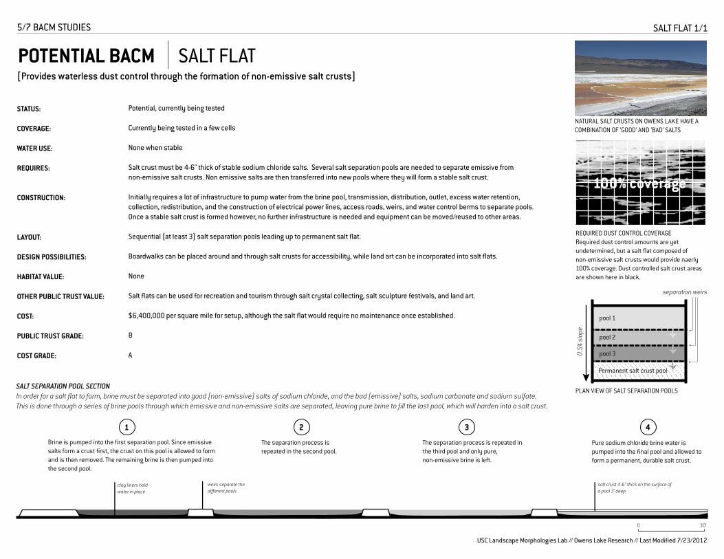
REQUIRED DUST CONTROL COVERAGERequired dust control amounts are yet undetermined, but a salt �at composed of non-emissive salt crusts would provide naerly 100% coverage. Dust controlled salt crust areas are shown here in black.
SALT SEPARATION POOL SECTIONIn order for a salt �at to form, brine must be separated into good (non-emissive) salts of sodium chloride, and the bad (emissive) salts, sodium carbonate and sodium sulfate. This is done through a series of brine pools through which emissive and non-emissive salts are separated, leaving pure brine to �ll the last pool, which will harden into a salt crust.
clay liners hold water in place
Potential, currently being tested
Currently being tested in a few cells
None when stable
Salt crust must be 4-6" thick of stable sodium chloride salts. Several salt separation pools are needed to separate emissive from non-emissive salt crusts. Non emissive salts are then transferred into new pools where they will form a stable salt crust.
Initially requires a lot of infrastructure to pump water from the brine pool, transmission, distribution, outlet, excess water retention, collection, redistribution, and the construction of electrical power lines, access roads, weirs, and water control berms to separate pools. Once a stable salt crust is formed however, no further infrastructure is needed and equipment can be moved/reused to other areas.
Sequential (at least 3) salt separation pools leading up to permanent salt �at.
Boardwalks can be placed around and through salt crusts for accessibility, while land art can be incorporated into salt �ats.
None
Salt �ats can be used for recreation and tourism through salt crystal collecting, salt sculpture festivals, and land art.
$6,400,000 per square mile for setup, although the salt �at would require no maintenance once established.
B
A
0 30’
5/7 BACM STUDIES
USC Landscape Morphologies Lab // Owens Lake Research // Last Modi�ed 7/9/12
POTENTIAL BACM SALT FLAT[Provides waterless dust control through the formation of non-emissive salt crusts]
SALT FLAT 1/1
weirs separate the di�erent pools
salt crust 4-6” thick on the surface of a pool 3’ deep
1
Brine is pumped into the �rst separation pool. Since emissive salts form a crust �rst, the crust on this pool is allowed to form and is then removed. The remaining brine is then pumped into the second pool.
The separation process is repeated in the second pool.
The separation process is repeated in the third pool and only pure, non-emissive brine is left.
Pure sodium chloride brine water is pumped into the �nal pool and allowed to form a permanent, durable salt crust.
2 3 4
NATURAL SALT CRUSTS ON OWENS LAKE HAVE A COMBINATION OF ‘GOOD’ AND ‘BAD’ SALTS
pool 1
pool 2
pool 3
Permanent salt crust pool
0.5%
slo
pe
PLAN VIEW OF SALT SEPARATION POOLS
separation weirs
100% coverage
1/7 BACM STUDIES 1/1
USC Landscape Morphologies Lab // Owens Lake Research // Last Modified 7/23/2012
5/7 BACM STUDIES SALT FLAT 1/1
USC Landscape Morphologies Lab // Owens Lake Research // Last Modified 7/23/2012

STATUS:
COVERAGE:
WATER USE:
REQUIRES:
CONSTRUCTION:
LAYOUT:
DESIGN POSSIBILITIES:
HABITAT VALUE:
COST:
PUBLIC TRUST GRADE:
COST GRADE:
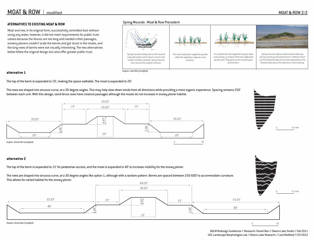
The original moat and row BACM was tested and although was e�ective in waterless dust control, did not meet the requirements for public trust. However, with some modi�cations, its public trust value may be improved.
None.
None.
Works on all di�erent kinds of soil types, although exactly height and width of spacing of moat and row depends on which kind of soil and size of particualate matter found on site.
5-foot tall, earthen berms are constructed with bulldozers and a sand fence is built on top. The moat and row method works by building rows of berms �anked by ditches to create moats. The moats are designed to capture moving soil particles, while rows will physically shelter the lake bed from the wind.
Spacing of each individual moat and row element generally vary from 250 to 1000 feet, depending on the surface soil type and the PM10 control e�ectiveness. Berms and fences should be built perpendicularly to wind direction (similar to tillage).
Spacing and curvature of earthen berms and sand fence can be modi�ed for aesthetic purposes.
Very low. Fences provide perches for bird predators like hawks, and entrap bird and snowy plovers.
$5,120,000 (per square mile)
C
B
7/7 BACM STUDIES
PROPOSED BACM MODIFIED MOAT & ROW[Controlling dust by creating rows of berms �anked by ditches to block wind carrying soil and sand]
MOAT & ROW 1/2
24.5’24.5’
15’ 15’9.5’9.5’
17’
5’ 6’6’5’ 6’6’
4’
5’
4’4’
17’
83’
ORIGINAL MOAT AND ROW SECTIONThe section below shows the construction of one moat and row area with a sand fence on top. The direction of the wind is represented by arrows and the section shows how dust is trapped and stopped by the moats and sand fence.
USC Landscape Morphologies Lab // Owens Lake Research // Last Modi�ed 7/9/12
0 10’
MOAT AND ROW DEMONSTRATION SITEThe two images above are examples of what moat and row looks like constructed like the section below.
1/7 BACM STUDIES 1/1
USC Landscape Morphologies Lab // Owens Lake Research // Last Modified 7/23/2012
6/7 BACM STUDIES MODIFIED MOAT & ROW 1/2
USC Landscape Morphologies Lab // Owens Lake Research // Last Modified 7/23/2012
1/7 BACM STUDIES 1/1
USC Landscape Morphologies Lab // Owens Lake Research // Last Modified 7/23/2012
MOAT & ROW modi�ed MOAT & ROW 2/2
Moat and row, in its original form, successfully controlled dust without using any water, however, it did not meet requirements for public trust values because the fences are too long and needed critter passages, snowvy plovers couldn’t scale the berms and got stuck in the moats, and the long rows of berms were not visually interesting. The two alternatives below follow the original design but also o�er greater public trust.
alternative 1
The top of the berm is expanded to 10’, making the space walkable. The moat is expanded to 20’.
The rows are shaped into sinuous curve, at a 30 degree angles. This may help slow down winds from all directions while providing a more organic experience. Spacing remains 250’ between each unit. With this design, sand fence rows have creature passages although the moats do not increase in snowy plover habitat.
40’
55.03’55.03’
40’
30.03’
60.03’
15’ 15’
5.06
’
5.06
’
4.97
’
alternative 2
The top of the berm is expanded to 15’ for pedestrian access, and the moat is expanded to 40’ to increase visibility for the snowy plover.
The rows are shaped into sinuous curve, at a 30 degree angles like option 1, although with a random pattern. Berms are spaced between 250-600’ to accommodate curvature. This allows for varied habitat for the snowy plover.
0 0.5 mile
0 0.5 mile
BACM Redesign Guidelines // Research: Daniel Neri // Fall 2011 // Owens Lake Studio
USC Landscape Morphologies Lab // Owens Lake Research // Last Modi�ed 6/19/12
Graphic: Daniel Neri (modi�ed)
15’
10’
25.03’
20’
35.03’
20’
15’
55.03’4.
97’
5.06
’
5.06
’
35.03’
Graphic: Daniel Neri (modi�ed) 0 20’
0 20’
Spring Mounds : Moat & Row PrecedentATERNATIVES TO EXISTING MOAT & ROW
Spring mounds initially start as the result of subsurface �ows which reach a crack in the surface and �ow upwards. Spring mounds
form around this surface moisture.
The moist soil fosters vegetation growth, while the vegetation captures sand
particles .
It is important for the vegetation to grow deep roots quckly, so it doesn’t become su�ocated by the sand. They grow as the mounds grow
around them.
Spring mounds capture airborne particulates by forcing wind to go around and over it. Particles travel up the windward slope but are then deposited on the
leeward side, due to the reduction in wind velocity.
Graphic: Cate Rilla (modi�ed)
15’
BACM Redesign Guidelines // Research: Daniel Neri // Owens Lake Studio // Fall 2011USC Landscape Morphologies Lab // Owens Lake Research // Last Modified 7/23/2012

STATUS:
COVERAGE:
WATER USE:
REQUIRES:
CONSTRUCTION:
LAYOUT:
DESIGN POSSIBILITIES:
HABITAT VALUE:
COST:
PUBLIC TRUST GRADE
COST GRADE:
SURVEYING TILLAGE AREA
BIRDS-EYE VIEW
Straight Path 30˚ Curved Path
18-36”12-24”
15-20’ 1000’
(NTS)
tilled row
USC Landscape Morphologies Lab // Owens Lake Research // Last Modi�ed 7/9/12
Potential BACM; currently being tested
Currently being tested in a few cells
None unless pulse �ooding is included to increase habitat.
No infrastructure requirements unless pulse �ooding is included. Preferably clay soils to produce higher and stronger ridges that do not need to be re-tilled as much as sandy soils
Bulldozers needed for construction. Surface would have to be "reset" by irrigation when tillage alone no longer produces an erosion-resistant surface. Once irrigated, area would have to be re-tilled. Requires high control e�ciencies (99%).
Tillage direction is determined by prevailing winds. Erosion control tillage ridges are formed at right angles to prevailing winds to maximize friction and velocity reduction. Soil conditions in�uence depth and spacing of tillage.
Tillage path and pattern.
None. Tillage alone without water does not provide an ideal surface for birds or other wildlife.
Moderately inexpensive to install with low annual resource costs of water and maintenance.
C+
A
TILLAGE SECTIONThe section below shows the typical size and formation of tillage rows, which are spaced 1-2 feet apart.
TILLAGE PLANAlthough tillage is currently in straight lines, rows may increase e�ectiveness as well as improve aesthetics.
0 10’
TILLAGE WITH PULSE FLOODING
wind direction wind directionCurved rows can reduce wind velocity
6/7 BACM STUDIES
POTENTIAL BACM TILLAGE[Controlling dust by creating clodded soils to block or bury emissive soils]
TILLAGE 1/1 1/7 BACM STUDIES 1/1
USC Landscape Morphologies Lab // Owens Lake Research // Last Modified 7/23/2012
7/7 BACM STUDIES TILLAGE 1/1
USC Landscape Morphologies Lab // Owens Lake Research // Last Modified 7/23/2012

PUBLIC TRUST ANALYSIS Under the Common Law Public Trust Doctrine, Owens Lake is required to provide bene�ts to all people through recreation, commerce, open space, or other recognized public trust purposes. The areas most relevant to Owens Lake and its current BACMS are related to aesthetic potential, renewable energy potential, recreation, education, and habitat potential, each of which is given a numeric value below relative to other BACMs.
GRAVEL
5
1
SALT FLAT
8
MOAT & ROW
4
TILLAGE
5
MANAGED VEGETATION
8
(hybrid)SHALLOW FLOOD,
MANAGED VEG,GRAVEL
12
HABITATDoes it provide an ideal habitat for birds, insects, or other wildlife?
EDUCATIONIs there potential to learn about the natural, scienti�c, or cultural values?
RECREATION POTENTIALCan it be used for tourism, bird watching, sports activities, or other activities?
RENEWABLE ENERGY / AGRICULTURECan it be used with solar panels, or for grazing or mining?
AESTHETIC POTENTIALIs it beautiful or does it have the potential to be through design?
KEY
SHALLOWFLOOD
11
1
1
1
2
1
1
2
1
1
1
1 2 2
2
2
2
3
3
3
3
3 3
3
3
3
1
Numeric Values
2
3
4
1
1
No public trust value added or negative value
Little value
Some value
Ideal public trust value
USC Landscape Morphologies Lab // Owens Lake Research // Last Modi�ed 7/9/12
2
HYBRIDS
USC Landscape Morphologies Lab // Owens Lake Research // Last Modi�ed 7/9/12
EXISTING HYBRIDS OTHER HYBRIDSBASIC BACMS
BACMs come in many di�erent elements, forms, and methods. “Basic BACMs” here deal with only one element (like water, gravel, vegetation, salt crust, earth). “Existing Hybrids” are combinations of Basic BACMs that are currently being tested for dust control use. “Other Hybrids” are combinations not currently being tested, but are interesting to consider.
GRAVEL w/ SALT FLAT
TILLAGE w/GRAVEL
MOAT & ROW w/ MANAGED VEG
SALT FLAT w/ TILLAGE
MOAT & ROW w/ GRAVEL
MOAT & ROW w/ SALT FLAT
HYBRID*
TILLAGE WITH PULSE FLOODING*
SHALLOW FLOOD WITH BRINE*
Items in gray stripes are hybrids
Items in black are existing BACMs
*
KEY
Asterisk indicates potential BACM
SHALLOW FLOOD
GRAVEL
MANAGED VEGETATION
TILLAGE*
SALT FLAT*
MODIFIED MOAT & ROW*
USC Landscape Morphologies Lab // Owens Lake Research // Last Modified 7/23/2012

PUBLIC TRUST ANALYSIS Under the Common Law Public Trust Doctrine, Owens Lake is required to provide bene�ts to all people through recreation, commerce, open space, or other recognized public trust purposes. The areas most relevant to Owens Lake and its current BACMS are related to aesthetic potential, renewable energy potential, recreation, education, and habitat potential, each of which is given a numeric value below relative to other BACMs.
GRAVEL
5
1
SALT FLAT
8
MOAT & ROW
4
TILLAGE
5
MANAGED VEGETATION
8
(hybrid)SHALLOW FLOOD,
MANAGED VEG,GRAVEL
12
HABITATDoes it provide an ideal habitat for birds, insects, or other wildlife?
EDUCATIONIs there potential to learn about the natural, scienti�c, or cultural values?
RECREATION POTENTIALCan it be used for tourism, bird watching, sports activities, or other activities?
RENEWABLE ENERGY / AGRICULTURECan it be used with solar panels, or for grazing or mining?
AESTHETIC POTENTIALIs it beautiful or does it have the potential to be through design?
KEY
SHALLOWFLOOD
11
1
1
1
2
1
1
2
1
1
1
1 2 2
2
2
2
3
3
3
3
3 3
3
3
3
1
Numeric Values
2
3
4
1
1
No public trust value added or negative value
Little value
Some value
Ideal public trust value
USC Landscape Morphologies Lab // Owens Lake Research // Last Modi�ed 7/9/12
2
USC Landscape Morphologies Lab // Owens Lake Research // Last Modified 7/23/2012USC Landscape Morphologies Lab // Owens Lake Research // Last Modified 7/23/2012

The total cost of each BACM over its lifetime is equal to its capital costs (cost of construction and other start up expenses), and the cost it takes to main-tain each BACM. Maintenance costs include personnel, repairs and replace-ment parts, and resource costs such as water. Since these dust control projects may continue inde�nitely, maintenance costs and e�ectiveness over time are important factors to consider.
Each factor is given a numeric value relative to other BACMs to show how it compares.
TILLAGE
4
MOAT & ROW
7
GRAVEL
6
1.5
MANAGED VEGETATION
11
HYBRID
13.5
SHALLOWFLOOD
13
SALT FLAT
KEY
COSTS AFTER 20 YEARSCumulative costs from capital, water, and maintenance over 20 years
COSTS AFTER 10 YEARSCumulative costs from capital, water, and maintenance over 10 years
MAINTENANCE COSTSincludes personnel and man hours required to maintain BACM
WATER COSTIncludes the price of water
CAPITAL COSTSIncludes construction costs and other one-time set up expenses.
1
1
1
1
1
.5
1
1
1
3
1
2
2
2
2
2
2
2
3
2
2
3
3
3
3
3
3
3
1
1 Does not cost anything
Minimally expensive
Moderately expensive
Extremely expensive
Numeric Values
2
3
4
USC Landscape Morphologies Lab // Owens Lake Research // Last Modi�ed 7/9/12
COST ANALYSIS
USC Landscape Morphologies Lab // Owens Lake Research // Last Modified 7/23/2012

HIGH PUBLIC TRUST
LOW PUBLIC TRUST
LOW
COS
T HIGH COSTPUBLIC TRUST/COST MATRIX
shallow �ood
tillage w/pulse �ooding*
managed vegetation
managed veg w/moat & row
moat & row w/ salt �at
tillage*
modi�ed moat & row*
graveltillage w/gravel
gravel w/salt �at
salt �at*
shallow �ood w/brine*
Items in gray stripes are hybrids
Items in black are approved BACMs
Asterisk indicates potential BACM*
The diagram to the right positions all of the BACMs and several hybrid combinations on a matrix rating the relative values of public trust and cost.
From the matrix, it can be seen that hybrid is the highest cost and o�ers the highest public trust value, while salt �at is the lowest cost overall with moderate public trust values.
USC Landscape Morphologies Lab // Owens Lake Research // Last Modi�ed 7/9/12
KEY
hybrid*
moat & row w/gravel
salt �at w/tillage
USC Landscape Morphologies Lab // Owens Lake Research // Last Modified 7/23/2012USC Landscape Morphologies Lab // Owens Lake Research // Last Modified 7/23/2012USC Landscape Morphologies Lab // Owens Lake Research // Last Modified 7/23/2012