Overview of the IWAYA Dam project Specifications · 1 gate High water level of Masegawa No.2 Dam....
8
Transcript of Overview of the IWAYA Dam project Specifications · 1 gate High water level of Masegawa No.2 Dam....


The Iwaya dam, as a comprehensive development project, plays an important role on flood control in Kisogawa River system, as well as is used for irrigation, water supply for domestic and industrial use and hydropower (Chubu Electric Power Co.).In 1969, the project was inherited by Water Resources Development Public Corpora-tion from the Construction Ministry and the construction was performed by Chubu Electric Power Co. After the completion of construction in 1976, Japan Water Agency has been responsible for its management.
Overview of the IWAYA Dam project Specifications
Location
RiverType
Elevation of CrestHeightLength
Width of CrestVolume of embankment
Spillway capacity
Location
Catchment Area
Total CapacityEffective Capacity
Sedimentation CapacityDead Storage CapacityFlood Control Capacity
Water Utilization Capacity
Unogen and Onbara, Kanayama Town, Gero City, Gifu PrefectureMaze river of Kiso River water systemTilt impervious core type rock-fill damEL427.50m127.5m366.0m10.0m 5,780,000㎥2,400㎥/s
Kanayama Town and Gero Maze, Gero City, Gifu Prefecture(Direct:264.9㎢) (Indirect:770.0㎢)173,500,000㎥150,000,000 ㎥13,800,000 ㎥ 9,700,000 ㎥ 50,000,000 ㎥ 61,900,000 ㎥
Specifications of DamSpecifications of DamSpecifications of Dam
Specifications of ReservoirSpecifications of ReservoirSpecifications of Reservoir
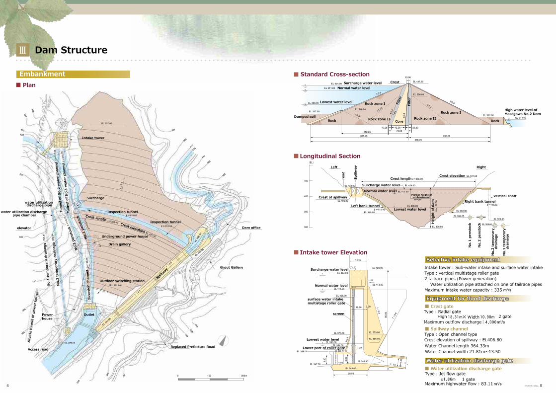
Dam Structure
Embankment
Selective intake equipmentSelective intake equipmentSelective intake equipment
Equipment for flood dischargeEquipment for flood dischargeEquipment for flood discharge
Water utilization discharge gateWater utilization discharge gateWater utilization discharge gate
Plan
Standard Cross-section
Longitudinal Section
Intake tower Elevation
Tunn
el o
f No.
2 w
ater
cha
nnel
No.
1 te
mpo
rary
dra
inag
e
No.
2 te
mpo
rary
dra
inag
e
dive
rsio
n ch
anne
lN
o.1
pens
tock
No.
2 pe
nsto
ckTu
nnel
of N
o.1
wat
er c
hann
el
Intake tower
Surcharge water level
Surcharge water level
Normal water level
Normal water level
Lowest water level
Lowest water level
Dumped soil
Left
Surcharge water level
Normal water level
surface water intake multistage roller gate
screen
Lowest water level
Lower part of roller gate
Spill
way
road
Crest of spillway
Left bank tunnelRight bank tunnel
Margin height of embankment
Crest elevation
Right
Vertical shaft
Crest length
Hei
ght
of d
am
No.
1 pe
nsto
ck
No.
2 pe
nsto
ck
No.
2 te
mpo
rary
dra
inag
e
No.
1 te
mpo
rary
dra
inag
e
Rock Rock zone II
Rock zone I
Crest
Filte
r
Filte
r
CoreRock zone II
Rock zone I
Rock
water utilization discharge pipe
water utilization discharge pipe chamber
elevator
Surcharge
Crest lengthCrest elevation
Inspection tunnelDam office
Grout Gallery
Replaced Prefecture Road
Inspection tunnel
Drain gallery
Outdoor switching station
Power house
Acce
ss tu
nnel
of p
ower
hou
se
Access road
Spillw
ay
Underground power house
Outlet
Intake tower : Sub-water intake and surface water intakeType : vertical multistage roller gate2 tailrace pipes (Power generation) Water utilization pipe attached on one of tailrace pipesMaximum intake water capacity : 335
Crest gate
Spillway channel
Water utilization discharge gate
Type : Radial gate
Type : Jet flow gate
Type : Open channel type
High Width 2 gateMaximum outflow discharge
Maximum highwater flow : 83.11
Crest elevation of spillway : EL406.80Water Channel length 364.33mWater Channel width 21.81m~13.50
1 gate
High water level ofMasegawa No.2 Dam

Purposes of the dam
Flood Control New water supply
Power Generation
The flood regulation for Kiso River is cutting basic high water flow rate of 16000 m3 / sec by 3500 m3 / sec at Inuyama reference point, which is achieved by regulations of Iwaya Dam, Agigawa Dam and Misogawa Dam respectively. Iwaya Dam is planned to cut the plan high water flow rate of 2400 m3 / sec by 2100 m3 / sec.Reservoir water level of Iwaya dam is lowered 13m from normal maximum water level to ensure a flood regulation capacity of 50 million m3 which is about 30% of the total storage capacity.
Image of plan high water flow allocation
Iwaya Dam flood control plan
Details of new water supply
Image of allocation of the storage capacity of Iwaya Dam
IWAYA Dam
Misogawa Dam
Agigawa Dam
Maruyama Dam
Maze River
Hida River
Kiso River
Inuyama point
A new water supply capacity of maximum 45.69m3 is yielded and using for irrigation, domestic and industrial water supply in the area of Aichi, Gifu, and Mie Prefecture and Nagoya City. The allocation of water quantity is shown as the right table.
Unit
Area suppliedIrrigation
(agriculture)
Agriculture6.13
Domestic water supply
Domestic water supply
Industrial water supply
Industrial water supply
Total
Aichi Pref.
Gifu Pref.
Mie Pref.
Nagoya City
Total
Note : The maximum capacities are shown for irrigation and domestic supply.
Maze Gawa No.1 and No.2 power plant, one sits in the underground on the right bank and another downstream of the dam respectively, brings the maximum generation capacity of 288 megawatts and 66.4 megawatts respectively.
Surcharge water level
Normal water level
Lowest water level
Flood control capacity
Power and water supply capacity
Sediment and dead water Bedrock
Height of dam
water supplyDesign flood hydrograph (inflow)
Design outflow discharge
Time
amount to be controlled
flowrate
GifuAichi
GifuMie
Nagoya CityAichi
Gifu
Mie

Hydrographic Map and Beneficiary Area Map of the Dam
Higashiueda dam
Nishimura dam
Yugake dam
Iwaya Dam
Mazegawa No.2 Dam
Ofunato Dam
Beneficiary Area MapHydrographic Map
Gifu Prefecture
Aichi Prefecture
Mie Prefecture
Iwaya Dam
Direct catchment area
Indirect catchment area
Direct catchment basinIndirect catchment basinFlooded basin
LegendDomesticwater supplyIndustrialwater supplyAgriculturalwater supply
Main road
Highway

Dam Management
There are three types of operation in the dam management; they are flood control operation, low water operation, and facility management. These operations are carried out according to respective operation rules or management provisions
Flood Control Operation
Low water operation
Facility operation
Collection of meteorological and hydrological information
Provision of meteorological and hydrological information Maintenance and inspection
of facilitiesMaintenance and improvement work
Verification, documentation and report
Investigation of water qualityObservation of displacement of dam body
Patrolling of the reservoir
Improvement of environment
Administration
Public affairs
Consultations with related organizations
Release of supplied water
Prediction of inflow amount
Report to related organizations
Patrolling and discharge warning in the downstream
Discharge start
Flood control
Completing of flood control
Inspect of discharge equipment
Operation facilities
Communication equipment Control facility Warning apparatus Power facilities
Monitoring device
Sediment storage dams
Boats and other equipment
Observation equipment
Multiplex wireless equipmentTelemeter observation equipmentData transmitting device
Observation instrumentsRainfall observation deviceWater level observation deviceWater quality monitoring instrument
Dam operation control system Water discharge warning systemWater discharge warning station
Power receiving equipment
Mazegawa sediment storage dam
Patrol boat and workboatWarning vehicleElevator Driftwood stopping facility
Yugakegawa sediment storage dam
Preliminary power generation equipment
CCTV device
Driftwood stopping facility
Investigation of water quality
Patrolling of the reservoir
Operator console
Measuring leakage (inside of Inspection tunnel)
Control room
Parabolic antenna
wireless equipment
Mazegawa sediment storage dam

Utilization of Dam for the environmental improvement
Iwaya dam is adjacent to tourist spots including Kiso River Kokuti park, Gero hot spring, Seseragi street. A lot of people visit the places seeking for rich nature.“Reservoir Environment Improvement Project”, which aiming to develop locations for camp, hiking, fishing utilizing the natural reservoir environment, is consigned from the MLIT and implemented.
Iwaya Dam
Iwaya dam exhibition hall
Kanayama Lake camp site
Tennis court
Oshidou camp siteUnohara Area
Yugake Area
Shirahata Area
Iwaya Area
Iwaya dam exhibition hall
Iwaya dam exhibition hall sits beside of reservoir and opens to the public. The project construction and completion, outline of the dam are shown in an easily understood way. Photos and panels are used to make the importance of water resource clearly.

Dam management facilities Reservoir conservation project
Rainfall station Tyuro outlet Management office
Warning board
Warning station
Maze river Dam No.2Iwaya Dam
Confluence
Maze river Hida river
Two sediment dams were con-structed at the end of reservoir to reduce sediment amount flowing into the reservoir and maintain its functions.
LegendDam management office, control stationRainfall observation stationRainfall and snow observation stationWater level gaugeTurbidimeter and water temperature gaugeSiren and speaker stationSpeaker stationSpeaker wire stationWireless relay station
Yugakegawa sediment dam
Mazegawa sediment dam
Yugakegawa sediment dam
Mazegawa sediment dam
Iwaya Dam
Mazegawa No.2 Dam
Completion: Crest length:
Height: Crest elevation:
Sediment storage capacity: Length of fish passage:
Completion: Crest length:
Height: Crest elevation:
Sediment storage capacity:
March 199088.1m10.6mEL.410.6170,000m3
March 199782.0m9.5mEL.415.079,000m3 94.1m