Overview of GIS - etiuppcl.org · (SAP) ## CIM Data for integration with smart technologies Windows...
20
Overview of GIS Tarun Batra, HoG- GIS & Field Force Automation
Transcript of Overview of GIS - etiuppcl.org · (SAP) ## CIM Data for integration with smart technologies Windows...

Overview
of
GIS
Tarun Batra, HoG- GIS & Field Force Automation
2
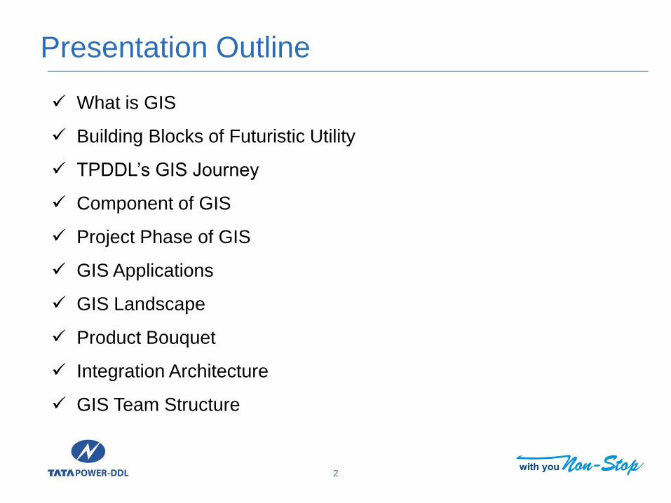
What is GIS
Building Blocks of Futuristic Utility
TPDDL’s GIS Journey
Component of GIS
Project Phase of GIS
GIS Applications
GIS Landscape
Product Bouquet
Integration Architecture
GIS Team Structure
Presentation Outline

What is GIS?
3
• GIS is Geographical Information
System which gives information on
geography on your Laptop/ tablet/
mobile even when you are not
physically present in that area.

Building Blocks of Futuristic Utility
4
• Robust Network • Adequate for present and mid term load growth, firm plan for long term
• Whether independent
• Inbuilt Redundancy
• Monitoring and Control • Remote monitoring to avoid outage, maintain tech. loss and Voltage level
• Remote control of network elements in Grid Sub station (33/11KV)
• Facilitate switching and automated control of 11 KV network beyond 33/11
KV substation too in both U/G and O/H lines
• Positively Engage Customers and enrich experience• Proactive Sharing of planned outage information to customer through
SMS and website
• Integrated CRM to take all customer calls and update them on outage
status rather than taking just complaints
• Update on real time outage of the customers in case of known outages

Building Blocks of Futuristic Utility
5
• Advanced Distribution Asset Management – To harness full potential of the technologies implemented, integration is must
– Integrated SCADA—DMS—OMS---GIS---CRM--ERP
– Integrated ERP, GIS Design Manager, SCADA and Network Planning Tools
– Field Force Automation integrated with CRM, SCADA/DMS/OMS, Work
Management
• Smart Technologies– Advance Metering Infrastructure
– Auto Demand Response
– Home Area Network
– DER (Solar, Tidal, Wind)
– Enterprise Service Integration
– Data Historian
– Data Analytics

World
TPDDL’s GIS Journey
2004-2006
GIS Roll out
Custom data model
2006-2008
Integration with SAP
Point to Point Integration
2008-2010
GIS-SCADA/DMS Syncing
Off line/ Manual Syncing
2010-till date
GIS-OMS integration
Customized Integration
2016
SOA/CIM compliant GIS (Smallworld-EO)
## Standard Adapter for OT (ADMS), IT (SAP)
## CIM Data for integration with smart technologies
Windows 2003,Windows XP Windows 2012, Windows 8
Windows CE Android
Gradual Sunset
Windows XP & Server 2003
Offline Maps (Eicher) Online Maps OGC Maps
Closed Architecture SCADA/DMS/OMSStandard (CIM) based
SCADA/DM/OMS
Operation with
Risk of
unsupported OS

7
Sub
-Tran
smissio
n1
1K
V D
ISTIBU
TION
0.4KV
Network Hierarchy Network terminology Technology
SCADA
OMS
66 or 33KV
11KV
0.4KV
Distribution Network…Monitoring & Control
DMS/DA
Geo
graph
ic Info
rmatio
n System
Communication Network

Components of GIS
Land base Land base of Licensed areas is developed using
satellite image, total station and field survey.This includes road network, built up & Non-built up Consumers and NDPL buildings, parks,footpath, road center line, water area etc.
Electrical Network Entire EHV, HT and LT Network from grid station
to consumer feed points is developed. Electrical equipments are mapped across
geography with reference to X, Y coordinates.
Consumers Customer are mapped in their respectivebuilding and its connectivity with Poles/FP/SP.

Snapshot of Created Landbase- Road, building, Park

Snapshot of Created Network – Substations, Network, service
Line and Consumers

Snapshot of Landbase, Network and consumers

• Development of RFP and evaluation of tenders
• Evaluation of Satellite Images
• Project Management
Phase I Conceptualization
Phase
• Field Survey for capturing the land base, electricalnetwork and customers along with attributesinformation
• Digitization of Land base and electrical networkalong with different attributes, information andattachment of customers.
• Application development design and testing andstudy of other business system
• IT Related Activities
• Project Management
Phase II Implementation Phase
• Integration of development data with other businesssystem(e.g. SAP, CRM, DM, Cymedist)
• Delta updation of GIS System
• Change Management (training to users)
• Project Management
Phase III
System Integration and Change Management 12
Project Phases of GIS

GIS Applications -Consumer Management
Input
• Pole No. from MMG (New Connections)
• Pole No. from Zone (Left out cases)
Processing in GIS
• Consumer Mapping through Pole No.
• Connectivity of consumer with
• LT Feeder
• Transformer
• HT Feeder
• ST Feeder
Output
• Integration with
• Energy auditing
• Revenue Protection
• Integration with OMS
• List of affected consumers
• Location of affected consumers
• Crew management
• Ref. - GIS-P-01 – Process for updation of Consumers in GIS
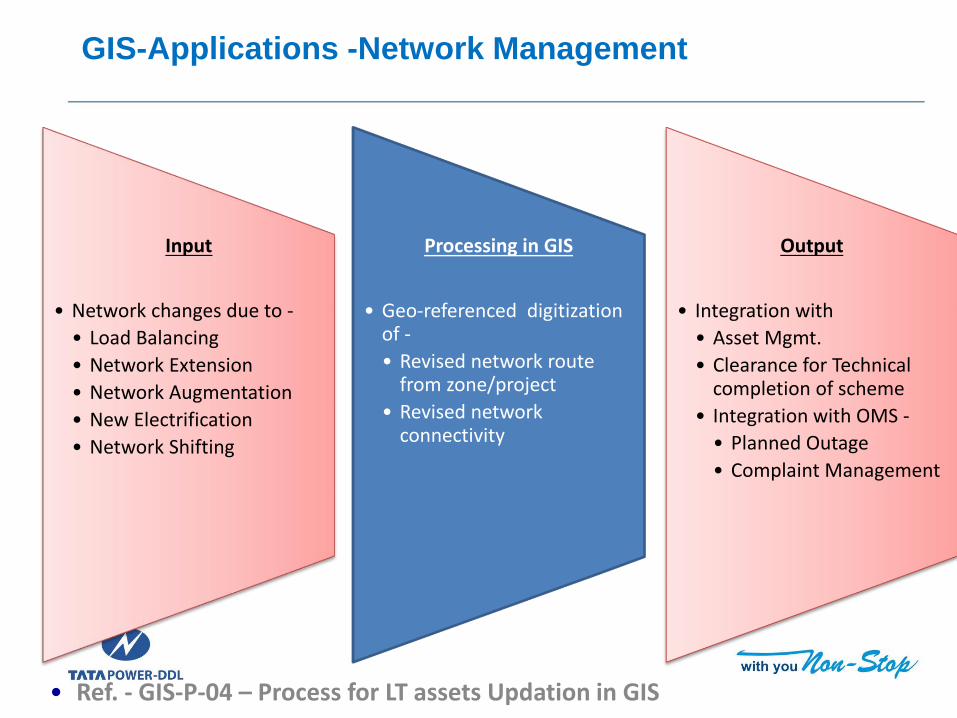
GIS-Applications -Network Management
Input
• Network changes due to -
• Load Balancing
• Network Extension
• Network Augmentation
• New Electrification
• Network Shifting
Processing in GIS
• Geo-referenced digitization of -
• Revised network route from zone/project
• Revised network connectivity
Output
• Integration with
• Asset Mgmt.
• Clearance for Technical completion of scheme
• Integration with OMS -
• Planned Outage
• Complaint Management
• Ref. - GIS-P-04 – Process for LT assets Updation in GIS

GIS-Applications - Asset Management
Input
• Notification for -
• Network changes (ST/HT)
• New Installation / Augmentation
• Movement
• Retirement
• Scheme clearance requests
Processing in GIS
• Geo-referenced mapping of Assets
• Tagging of Scheme
Output
• Integration with
• Asset Mgmt.
• Clearance for Technical completion of scheme
• Integration with OMS -
• Planned Outage
• Complaint Management
• Ref. - GIS-P-03 – Process for Asset Management

GIS Landscape
As-Built update
(User-GIS Team)Proposed Design
(User- NEG Team)
Intranet /
InternetEO -Web
Network
SAN
Land base
SAP
CYME
OMS
SBI Integrator
(SOA)
JDBC
Cyme Adapter
Customized OMS
Integrator
Interface
Server
Application
ServerJob Server
Web Server
CIM Adapter ADMS
Maps, Reports, Redlining
(User- Everyone)
Mobile Clients
GIS data capture
(User – GIS team)
EO- Core EO- DM
Cloud based 3rd Party
Maps
SmallWorld- Electric Office (EO)

Product Bouquet
Product Smallworld Electric Office Product Suite
Base Version 4.3.4
OEM GE
Implementation Partner CYIENT
License Summary Number
EO Core Desktop for Data Update
45
EO Design Manager for Network Design
EO Web for map view, reports & Redlining (sketching)
Enterprise
(200 concurrent)
Geo Spatial Analytics 5
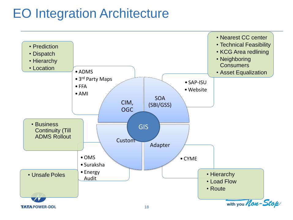
EO Integration Architecture
18
•CYME•OMS
• Suraksha
•Energy Audit
• SAP-ISU
•Website
•ADMS
•3rd Party Maps
• FFA
•AMI
CIM, OGC
SOA (SBI/GSS)
AdapterCustom
GIS
• Nearest CC center
• Technical Feasibility
• KCG Area redlining
• Neighboring Consumers
• Asset Equalization
• Prediction
• Dispatch
• Hierarchy
• Location
• Hierarchy
• Load Flow
• Route
• Business Continuity (Till ADMS Rollout
• Unsafe Poles

19C
ore
Clie
nt
Digitizer 1
Digitizer 2
Digitizer 3
Digitizers 4
Digitizers 5
Digitizers 6
Digitizers 7Thin
Clie
nt
(web
Se
rver
)/St
agin
g A
rea
GIS group
New Consumer Mapping
Zonal Coordinator for
Network
Asset Management
Landbase Development
Data Analysis of GIS
Training to users
Zone
Projects
MMG
GIS Team Structure
Surveyor Team