Overview of Arctic Region Communications Small Satellite ... · 20.11.2013 · operations in the...
39
1 TheArcticRegionalCommunicationssmallSATellite(ARCSAT) Joseph Casas 1 , Martin Kress 2 , William Sims 1 , Stephen Spehn 3 , Talbot Jaeger 4 and Devon Sanders 1 1 NASA Marshall Space Flight Center, USA; 2 The Von Braun Center for Science & Innovation, USA; 3 HQ USEUCOM,ECJ8-Q; 4 Novawurks Inc., USA [email protected] Traditional satellite missions are extremely complex and expensive to design, build, test, launch and operate. Consequently many complementary operational, exploration and research satellite missions are being formulated as a growing part of the future space community capabilities using formations of small, distributed, simple to launch and inexpensive highly capable small scale satellites. The Arctic Regional Communications small SATellite (ARCSAT) initiative would launch a Mini-Satellite “Mothership” into Polar or Sun Sync low-earth-orbit (LEO). Once on orbit, the Mothership would perform orbital insertion of four internally stored independently maneuverable nanosatellites, each containing electronically steerable antennas and reconfigurable software-defined radios. Unlike the traditional geostationary larger complex satellite communication systems, this LEO communications system will be comprised of initially a five small satellite formation that can be later incrementally increased in the total number of satellites for additional data coverage. ARCSAT will provide significant enabling capabilities in the Arctic for autonomous voice and data communications relay, Maritime Domain Awareness (MDA), data-extraction from unattended sensors, and terrestrial Search & Rescue (SAR) beacon detection missions throughout the “data starved desert” of the Arctic Region. Key Words: Small satellites, Communications, Formation flying, Arctic, Software defined radios 1. Introduction The objective of the Arctic Regional Communications small SATellite (ARCSAT) initiative which is an element of arctic enabling mission capability study within the joint Department of Defense and NASA Arctic Collaborative Environment (ACE) Project is to provide the Arctic Region with near timeframe lower cost communications and data relay capabilities that have greater messaging throughput and reliability through the use of multiple redundancy of satellites. An ARCSAT mission capability would result in enhancing international humanitarian, societal and economic benefits to enable safer land, maritime and air movement; increased coordination and collaboration for search and rescue operations, and more robust data extraction for research support throughout the Arctic. Communications is a critical infrastructure for all operations in the Arctic Region, to include search and rescue operations, environmental spill responses, or day-to-day maritime and aircraft domain awareness. As the Arctic continues to become more accessible due to changing climate and changes in the priorities of governmental interest, there is and will continue to be insufficient infrastructure to safely conduct Arctic operations and research. Existing traditional LEO and MEO commercial satellite systems such as Iridium, Thuraya, and INMARSAT do not provide high bandwidth capabilities and quality of service response required in this region, and cannot interrogate unattended sensors systems adequately to support improved research and situational awareness. In addition, these commercial communications satellites are unique for each system and require single purposed transceiver units. In addition frequently there are multiple licensing and technical signal compensation issues related to satellite to satellite operational use which increase cost of service and delays in deployment of these systems. For example other large traditional satellite systems such as the proposed Polar Communications and Weather (PCW) satellite supported by the Canadian government will in fact become an important key communications asset as being proposed for the Arctic region. However, these traditional programs have typically experienced multiple schedule slippages resulting in delays of 5 to 10 years for the operational deployment and cost increases resulting in price tags greater than $500,000,000 USD for each system. A reality of today’s weak economic environment worldwide is that since key planned communication assets currently under development and planned to support the Arctic capabilities are costly. These traditional satellite systems have experienced multiple schedule delays not due to technical requirements but due to the funding requirements that are in the range of 400 million to 800 million USD. The existing limited communications assets in the region cannot support the current increasing level of Arctic international activities in particular in light of the conservative future predictions of rate of change of the increasing activities in the Arctic. This dynamic environment creates a high risk situation and collectively the Arctic nations need to formulate a complementary portfolio risk mitigation approach for providing communications in the near timeframe at initial and recurring cost values that are more affordable. Such a plan will require low-cost gap filler satellite missions of three to five years duration each supporting operations using lower cost systems solutions costing in the tens of millions of USD that will capitalize on emerging mini, micro, and nano technologies, such as incorporated into small scale satellite systems. The ARCSAT technical approach uses such a plan https://ntrs.nasa.gov/search.jsp?R=20140011670 2019-12-31T14:00:21+00:00Z
Transcript of Overview of Arctic Region Communications Small Satellite ... · 20.11.2013 · operations in the...

1
The�Arctic�Regional�Communications�small�SATellite�(ARCSAT)� �Joseph Casas1, Martin Kress2, William Sims1, Stephen Spehn3, Talbot Jaeger4 and Devon Sanders1�
1NASA Marshall Space Flight Center, USA; 2The Von Braun Center for Science & Innovation, USA; 3HQ USEUCOM,ECJ8-Q; 4Novawurks Inc., USA [email protected]
Traditional satellite missions are extremely complex and expensive to design, build, test, launch and operate. Consequently many complementary operational, exploration and research satellite missions are being formulated as a growing part of the future space community capabilities using formations of small, distributed, simple to launch and inexpensive highly capable small scale satellites. The Arctic Regional Communications small SATellite (ARCSAT) initiative would launch a Mini-Satellite “Mothership” into Polar or Sun Sync low-earth-orbit (LEO). Once on orbit, the Mothership would perform orbital insertion of four internally stored independently maneuverable nanosatellites, each containing electronically steerable antennas and reconfigurable software-defined radios. Unlike the traditional geostationary larger complex satellite communication systems, this LEO communications system will be comprised of initially a five small satellite formation that can be later incrementally increased in the total number of satellites for additional data coverage. ARCSAT will provide significant enabling capabilities in the Arctic for autonomous voice and data communications relay, Maritime Domain Awareness (MDA), data-extraction from unattended sensors, and terrestrial Search & Rescue (SAR) beacon detection missions throughout the “data starved desert” of the Arctic Region.
Key Words: Small satellites, Communications, Formation flying, Arctic, Software defined radios
1. Introduction
The objective of the Arctic Regional Communications small SATellite (ARCSAT) initiative which is an element of arctic enabling mission capability study within the joint Department of Defense and NASA Arctic Collaborative Environment (ACE) Project is to provide the Arctic Region with near timeframe lower cost communications and data relay capabilities that have greater messaging throughput and reliability through the use of multiple redundancy of satellites. An ARCSAT mission capability would result in enhancing international humanitarian, societal and economic benefits to enable safer land, maritime and air movement; increased coordination and collaboration for search and rescue operations, and more robust data extraction for research support throughout the Arctic. Communications is a critical infrastructure for all operations in the Arctic Region, to include search and rescue operations, environmental spill responses, or day-to-day maritime and aircraft domain awareness. As the Arctic continues to become more accessible due to changing climate and changes in the priorities of governmental interest, there is and will continue to be insufficient infrastructure to safely conduct Arctic operations and research. Existing traditional LEO and MEO commercial satellite systems such as Iridium, Thuraya, and INMARSAT do not provide high bandwidth capabilities and quality of service response required in this region, and cannot interrogate unattended sensors systems adequately to support improved research and situational awareness. In addition, these commercial communications satellites are unique for each system and require single purposed transceiver units. In addition frequently there are multiple licensing and technical signal compensation issues
related to satellite to satellite operational use which increase cost of service and delays in deployment of these systems. For example other large traditional satellite systems such as the proposed Polar Communications and Weather (PCW) satellite supported by the Canadian government will in fact become an important key communications asset as being proposed for the Arctic region. However, these traditional programs have typically experienced multiple schedule slippages resulting in delays of 5 to 10 years for the operational deployment and cost increases resulting in price tags greater than $500,000,000 USD for each system. A reality of today’s weak economic environment worldwide is that since key planned communication assets currently under development and planned to support the Arctic capabilities are costly. These traditional satellite systems have experienced multiple schedule delays not due to technical requirements but due to the funding requirements that are in the range of 400 million to 800 million USD. The existing limited communications assets in the region cannot support the current increasing level of Arctic international activities in particular in light of the conservative future predictions of rate of change of the increasing activities in the Arctic. This dynamic environment creates a high risk situation and collectively the Arctic nations need to formulate a complementary portfolio risk mitigation approach for providing communications in the near timeframe at initial and recurring cost values that are more affordable. Such a plan will require low-cost gap filler satellite missions of three to five years duration each supporting operations using lower cost systems solutions costing in the tens of millions of USD that will capitalize on emerging mini, micro, and nano technologies, such as incorporated into small scale satellite systems. The ARCSAT technical approach uses such a plan
https://ntrs.nasa.gov/search.jsp?R=20140011670 2019-12-31T14:00:21+00:00Z

2
that capitalizes on previous multi-organizational investments in small scale satellite and unmanned aircraft technology developments, space flight demonstrations, extensive ground testing and balloon flights for each of the critical subsystem elements. Some of these critical subsystem elements include orbital insert capabilities such as the mini satellite Mothership, highly capable nanosat systems, autonomous formation flying operational control systems, low power high band rate software defined radios, compact high gain antennas, and advanced ground station receiver transmitter capabilities.
2. Technical Approach
The ARCSAT system would provide both spacecraft and ground station configurable communications support for the Arctic Region on a regular, but not on continuous basis at any location within the region. The ARCSAT minisatellite Mothership would deploy four maneuverable cubesats which would function as a virtual large phased array antenna that is dynamically configurable based upon the mission requirements for orientation of the formation of the satellite to optimize communications support. Additional cubesat satellites would added incrementally to the formation using a variety of cost effective small satellite launch approaches. Both the satellites and ground stations use software defined radio communications that have waveform and frequency agility to support existing and developing communication systems, and would support international participation and provide for open access usage depending on the mission objectives.
2.1. General Operational View
The ARCSAT system is an innovative use of proven small scale satellite systems and subsystems integrated into a communications mission configuration that can provide significant improvements in the communications and relay of low rate voice and high rate data information in the Arctic using new mission configurations and autonomous tasking approaches to enable broad operational capabilities.
Mission Concept• 1 Minisatellite Mothership
• CubeSat Launcher • AIS, Data-X, & EPIRB Receivers • Multi-band SDR Communications
packages with SAR capabilities • 4 Communications CubeSats • 625-750 km low-earth-orbit (LEO) • Circular orbit (eccentricity = 0) • 90-98° Inclination • Up to Mbps total data throughput • UHF,S,C and X bend pipe or network hub
• EPIRB relay supports Search & Rescue Payload Configuration
• Mothership launches CubeSats and has extensive computational, control, and data store-and-forward capacity
• Mothership and 4 CubeSats each with 2 software-defined radios
• Mothership candidate payloads • AIS provides global Maritime Domain
Awareness (MDA) • Data-X provides data collection from
unattended sensors • Imagery
2.2. Unique Mission Tailoring of Characteristics
Powerful• 6 Software-Defined Radios (SDRs) total
• 2 SDR payload on each of 4 cube-sats • 2 SDR payload on the mothership • 2 SDR for primary network
communications • Multiple Voice Channels per CubeSat ( bended pipe
and network) • > 10 Mbps per payload SDR for some mission
configurations • Mothership has S-Band and X-Band network
downlinks for combined for > 150 Mbps • Example mission provides 13.48 minutes in
satellite foot-print for overhead Arctic pass Compatible
• Joint Tactical Radio System (JTRS) • Airborne & Maritime/Fixed Station (AMF) • UHF Satellite Communications • Wideband Network Waveform • Soldier Radio Waveform (SRW)
• Mobile User Objective System (MUOS) • Standard Voice protocol channels and data
Flexible• Controllable Virtual Beam
• Each SDR has wide-Beam for total-area coverage
• Steerable Beams for greater link margin and higher throughput
• Reprogrammable in-flight from the ground
2.3. Arctic Search and Rescue Example Scenario
Sequence of Events1. Ship suffers an engineering casualty and is dead in
the water (DIW) 2. Ship activates 406 MHz digital Emergency Position
Indicating Radio Beacon (EPIRB) 3. Ship begins sending Automatic Identification System
(AIS) distress message 4. ARC-Sat detects EPIRB beacon and forwards ship’s
location and information to USCG District 17 5. ARC-Sat feeds the AIS distress message into the
Volpe Center’s global AIS system 6. ARC-Sat provides communications relay support
1. CubeSats re-orient to provide priority support to distress vessel

3
2. CubeSats re-orient to provide priority support to response team
3. Mothership provides general support 7. ARC-Sat provides data link between response force
and the National Ice Center (NIC) for updates on sea-ice, sea surface conditions, and surface weather via the Arctic Collaborative Environment (ACE) system
3. Conclusion
Complex international problems such as the lack of communication capabilities in the Arctic often require more than a single approach solution to address these critical changing infrastructure requirements. The ARCSAT is an innovative low cost system that can offer near term operational response elements of the solution to this larger Arctic infrastructure deficient. There are several major considerations with respect to this concept which are as follows.
� The Arctic is an important geographical region of the world with respect to the world environment, international economics, and humanitarian interest.
� Low cost and effective communications in the Arctic is critical now and will significantly increase in importance in the near future
� Traditional larger satellite system approaches to addressing gaps in communications and data acquisition requirements in the Arctic are costly and require significant time to become reality in today’s economic pressures
� Current small scale satellite system technologies are mature and can be integrated into a mission to potentially address required effective communications and data exchange in the Arctic
� The total initial cost of a small scale satellite communication system would be significantly lower than the traditional large satellite systems and recurring cost of replacement systems would be considerably lower
� Uniquely configured formations of small scale satellites used for future Arctic communication missions offer near term, low cost, redundant capabilities to address at least 70 percent of the data exchange and communication critical needs.
In summary, innovative formations of small scale satellites can be an important, cost effective and timely component of the solution approach portfolio for many space based missions including Arctic communications. Unlike the traditional geostationary, Leo and MEO larger complex satellite communication systems, this LEO communications system will be comprised of initially a five small satellite formation that can be later incrementally increased in the total number of satellites for redundancy and for additional data coverage. ARCSAT will provide significant enabling capabilities in the Arctic for autonomous voice and data
communications relay, Maritime Domain Awareness (MDA), data-extraction from unattended sensors, and terrestrial Search & Rescue (SAR) beacon detection missions throughout the “data starved desert” of the Arctic Region

1
The Arctic Regional Communications small SATellite (ARCSAT)
Joseph Casas1, Martin Kress2, William Sims1, Stephen Spehn3, Talbot Jaeger4 and Devon Sanders1
1NASA Marshall Space Flight Center, USA; 2The Von Braun Center for Science & Innovation, USA; 3HQ USEUCOM,ECJ8-Q; 4Novawurks Inc., USA
5th Nano-Satellite Symposium“Missions and Enabling Technologies towards Future”
November 20 - 22, 2013Takeda Hall, University of Tokyo
Tokyo, Japan
11/20/2013

Outline for Discussion
• Background for Concept of Small Satellite Arctic Mission
• Status of Communications Gap• Desired Capabilities• Integration of Proven Technologies• Concept of Operations• Summary of Conclusions
11/20/2013 2

The Arctic is increasingly important to regional economic and national security
Our challenge is to frame a systems solution for very complex technical , societal and political issues – to think differently about the region and our options – capitalize on the full portfolio of regional capabilities and assets – provide a suite of traditional and new innovative approaches for needed services and capabilities - a well balanced invested portfolio approach of solutions
This all starts with the basics – sharing, working together, prioritizing, adapting, innovating ,comprising…….
11/20/2013 3

Arctic Collaborative Environment (ACE) Operational Problem
• No overarching operational architecture or universal core system for data & tool integration
• No common integrator of varied data sources• Inadequate environmental visualization to support development of
cooperative Arctic policies• Inadequate access to models to support planning• Insufficient integration of environmental data to support ongoing
and future research and operations (e.g., exploration, SAR, Humanitarian Response, Economic Activities, Environmental Response, Recovery Operations, Strategic Movement, Training)
11/20/2013 4
There exists no Arctic awareness, decision-support system to enable long-term environmental planning, near-term cooperative actions, and real-time
responses to humanitarian, environmental, and security issues in the Arctic
The ACE JCTD will provide immediate capabilities and jump-start new solutions to common problems shared across the Arctic Community

Mini-Overview of Arctic Collaboration Environment (ACE) Project
• The ACE Joint Capabilities Technology Demonstration will provide a web-based, open-access, Arctic-focused, environmental research and decision-support system that integrates data from existing remote sensing assets and in situ observations to provide monitoring, analysis, and visualization based on earth observation data and modeling. The ACE JCTD will enable local, regional, and international cooperation and coordination on long-term environmental planning and near-term actions in response to climatic and environmental changes occurring in the Arctic Region.
• The ACE software tool capitalizes on prior earth science applications work done at NASA MSFC: RTMM, SPoRT, SERVIR, AMSR-E, etc.
• ACE was designed to capitalize on the IPY, foster and promote the exchange of data and models for use in the Arctic Region – create a common area of interest for the Arctic Nations.
• The ACE tool is directly applicable to other regions and applications.• The ACE Team is committed to “give” its tool to any Arctic Nation or organization – in
return the ACE Team would hope it facilitates the exchange of data and models through the use of this tool , other related tools, unique capability studies and new enabling mission formulations
• Sustaining Arctic Observing Network (SAON) needs each activity and project it endorses as part of an integrated set of capabilities that meet the needs of multiple Arctic nations
511/20/2013

Seven Key Dimensions of ACE• Create an open access tool to integrate disparate data sets in
response to key user requirements in the Arctic Region• Facilitate data and model sharing and the creation of new
and/or enhanced products for end users• Transition the System to the National Ice Center to sustain its
viability and value to regional operators & researchers• Open source the tool to other regions and potential
applications • Get the next generation of researchers working together• Serve as the first step to additional collaborative projects and
activities• Identify and define new data sets, instruments and
infrastructure for situational awareness and missions that will be provide enhanced societal benefits within the arctic 611/20/2013

A Gap: Communications Operational Problem
• Organizations are unable to support near- and mid-term Arctic operations and research to include: Humanitarian Response, Environmental Response, International Search & Rescue (SAR), Climate Change and Counter-Trafficking
• Shortfalls to these missions include:– Inadequate coverage and throughput of communications relay to support Arctic
operations and research– Inadequate Maritime Domain Awareness (MDA) in the Arctic Region to
coordinate responses to regional security issues– No capability for near-real time data-extraction of unattended sensors in the
Arctic Region• Existing and planned capabilities cannot satisfy these shortfalls
– Iridium, Thuraya, and INMARSAT do not meet growing requirements for tactical communications and cannot interrogate unattended sensors
– Existing AIS collection has gaps and restrictions to data dissemination and sharing that inhibit collaborative Maritime Domain Awareness
Organizations with operational responsibility in the Arctic lack the capabilities necessary to meet emerging challenges and operational requirements in the Region
ARC-Sat will provide near term capabilities through responsive small satellite orbital assets to support emergent operational and research requirements in the Arctic Region 711/20/2013

Example of Technology Push
Bandwidth (Kbps)250 500 750 1,000 1,250 1,500 1,750 2,000 2,250 2,500 2,750 3,0000
Iridium2400 bps
Thuraya9600 bps
INMARSATup to 452 Kbps
ARC-Sat~50 Kbps to >10 Mbps
• Current commercial systems are simultaneous multi-user but have max data rate limitations• ARC-Sat integrates a MiniSat and two or four CubeSats to provide robust, adaptable communications relay• DARPA algorithms enable formation flying and precision spotlighting of directional beams• ARC-Sat can tailor the link margin to the mission and environment through SDR band selection beam-forming, precision
spotlighting, waveform shaping, and channel bundling
ARC-Sat provides greater bandwidth by capitalizing onlow-cost, advanced CubeSat technology
811/20/2013

Some Desired Capabilities
• Technical – Communications relay to support Arctic operations
• Periodic coverage to support voice relay and high rate data communications• Communications relay with waveform and frequency agility to support existing and
developing systems– Enhanced Maritime Domain Awareness (MDA) in the Arctic– Remote data extraction from unattended sensors– Reception and relay of emergency position-indicating radio beacon (EPIRB)
transmissions– Satellite fractionation for LEO long-baseline interferometry
• Operational: CONOPS and TTP– Arctic Environmental Awareness to plan and execute collaborative international
response– Communications to coordinate international response to Arctic environmental
and humanitarian issues
ARC-Sat will enable collaboration and cooperation through enhanced communications and data sharing in the Arctic Region
U.S. and its Arctic partners contribute to the peaceful opening of the Arctic in a manner that strengthens international cooperation
911/20/2013

Activities of Interest : Integration of Innovative Proven Technologies
• “Mothership” spacecraft capability for formation flying mission to support lower vehicle integration, launch and orbital deployment cost while still reducing total mission development schedule. Mothership also provides additional capabilities to support imagery , AIS , data extraction, SAR and other potential instruments
• Highly capable nanosatellites( each 10 X 10 X 30 cm and less than 10 kg) with advanced capabilities in power generation, autonomous tasking flight control, high energetic green fuel propulsion and multi-functional spacecraft arrays. Small satellites in formation flying that can perform elements of fractionalization to enhance overall mission capabilities.
• Incorporation of RF communications capabilities reconfigurable for UHF, S , C , X and future Ka band that focus on a reprogrammable software defined radio(SDR) which includes a cost effective SAR radio capability with a total low power, mass and size requirements that can then be used as an infusion path for subsequent developments and missions
• Maintaining compatibility with most current heritage communication systems while infusing the enhanced capabilities of new light weight portable ground antenna systems compatible with the Arctic
• ARC-Sat and its associated systems are transferrable to the Antarctic Region communications
11/20/2013 10

1111
Mini satellite FASTSAT – Proven on STP-S26 MissionScheduled for 12 month mission
( Actual November, 2010 through May 2013)
Kodiak – Nov 19, 2010 Minotaur IV
Designed and Built in Huntsville, AL
Supported 6 Separate Experiments
Met all NASA cost, schedule and performance targets

1212
NASA & USNA Plasma Impedance Spectrum Analyzer (PISA)
(Permit better predictive models of space weather effects on communications and GPS signals)
NASA & USNA Thermospheric Temperature Imager (TTI)
(Increase accuracy of orbital predictions for low-earth orbiting assets)
AFRL Light Detection System(Evaluate atmospheric propagating characteristics on coherent light generated from known ground stations)
NASA & USNA Miniature Imager for Neutral Ionospheric Atoms and Magnetospheric Electrons (MINI-ME)
(Improve space weather forecasting for operational use)
NASA + ARMY + AFRL NanoSail-D
(Demonstrate deployment of a compact 10-m2 solar sail ejected as CubeSat)
Six Instruments on One Platform
AFRL + NASA + AFMiniature Star Tracker (MST)
(Demonstrate small and low-power star tracker)

• ESPA Class ridesharing
• Current Options
• Future Options
Launch Options
11/20/2013 13

FASTSAT TYPE “Mothership”Total Mass (kg) 180
Orbit400 – 850 km
30° - 99°Stabilization 3-Axis Attitude Control 0.1°Attitude Knowledge 0.02°
Downlinks (Mbps)>5 (S-band)
>150 (X-band)Uplink (kbps) 300 max (S-band)Ground Networks STDN, SGLSEncryption AES, COMSECMission Life 2 - 4 yr
Number Payloads4 x 3U CubeSat4 x Integrated
Payload Mass (kg) 45 - 50Payload Power (W) 30 – 50 W Avg.
Payload Interface
RS-422 (5)SpaceWire (2)
Digital (20 in/40 out)Payload Data (GB) store & forward 100
• Deploy Four 3U CubeSatsor Two 6U CubeSats
• On-Demand, On-orbit Assets, • Constellation Deployment • Communications and imagery “Mothership”• On-Orbit Charging, Status, & SW Upgrades• System Design In Process

Example Challenge Progress Goalsp g g
Near-term
through 2016
Mid-term
2017 – 2022Far-term
2023 – 2028
• Remove Comm. as a Constraint
• Minimize Impact of Latency
• Minimize User Burden
• Integrity and Assurance
• Lower Lifecycle
• Lack of Demo’s
• 200 Mbps from 1 AU• 30 Gbps from LEO
• Navigation/timekeeping to support:• Micrometer-level formation control
• Reduction of 50% in transponder mass
• Unconditional information security techniques employed with LEO and some deep space missions
• 40% reduction from current
• Multi-function SDR demo
• 20 Gbps from 1 AU• 3 Tbps from LEO
• Navigation/timekeeping to support:• Nanometer-level formation control
• Reduction of 75% in transponder mass
• Global information trust relationships• Internationally-standard unconditional
information security with all missions
• 80% reduction from current
• Deep-space relay tech demo
• Millimeter-level formation control
• Validate unconditional information security techniques to low-Earth orbit (LEO)
• 20% Reduction from current
• Reduction of 50% in transponder mass
Already Completed
• 80% reduction from current
Already Completed
Challenge
SDR Achievements
SDR Goals
Al d C l t d
• Reduction of 50% in transponder mas
U diti l i f ti it
•• ReR duction of 50% in transponder massss
ecurity
s
Al d C l t d
• 80% reduction from current
D l h d
•• 8080% reduction from current• 40% reduction from current
• Multi-function SDR demo
sssssssss
• NASA Near Earth Network (NEN) certification (FY 2013)
• Hope Hero Balloon Flight (FY 2014)
• TRL 7 or 8 (FY 2013)
• Begin Generation 3 – Ka–Band SDR (FY 2014)
• Begin SDR Ground Station (FY 2014)
• Lunar missions
11/20/2013 15

SDR Comparable Comm Systems• From the OCT “Communication and Navigation Systems Roadmap” - large issues
currently impact planned missions that will require slight to moderate improvements in the communication link. The SDR - will provide major communication advancements in the communication link TODAY.
• As depicted in the Roadmap TA05 - development of a reprogrammable software defined radio that can then be used as an infusion path for subsequent developments.
• Software Defined Radio (SDR) technology offers potential to revolutionize satellite transponder technology by increasing science data through-put capability by at least an order of magnitude.
• This project will leverage existing radiation tolerant MSFC SDR TRL-4 hardware and increase it to a TRL-5.
Manufacturer Freq Band
Input DC Power
(W)
Uplink Data Rate
(kbps)
Downlink Data Rate
(Mbps)
Radiation Tolerance
(kRads)
Mass (kg) Cost Rcvr Bits/Watt
(b/W)Trx Bits/Watt
(b/W)
General Dynamics S >30 2 10 50 3.3 $1.6M 66 b/W 333 Kb/W
Cubic S 26 32 1 50 3.2 $2.2M 1.2Kb/W 38.5 Kb/W
L3-Comm S 35 2 8 100 2.5 $1.5M 55 b/W 227 Kb/W
Thales S 49 16 40 2.9 $12M 333 b/W 833 Kb/W
1970’s Cellphone “Transponder”
SDR “Transponder”
MSFC SDR
S-, C-, X- <15 300 150 100 1.5 $100K 20Kb/W 10 Mb/W
Deltas Δ2↓ Δ10x↑ Δ4x ↑ Δ2↓ Δ15x ↓ Δ16.7x↑ Δ44x↑11/20/2013 16

First generation telemetry module made for Micro-satellites.
Uplink data rate is 50kbpsDownlink data rate is 1Mbps
Interfaces to the flight computer via a source synchronous 422 interface. This means , data , and clock are coming from
the flight computer.
Power is ~ 200mWTelemetry is CCSDS compatible.
Reed- Solomon encoding (255,223,1) is done in an ASIC from GSFC.
FPGA handles all CCSDS encoding , decoding and bit –synchronization as well as interfacing to flight
computer.
On-board processor handles housekeeping and interfaces to flight computer through 422 interface.
Low Cost < $10K
SDR Flight Heritage – Gen 1
11/20/2013 17

SDR Current Design – Gen 2
• SDR is a modular design and is comprised of slices or decks.– S-Band Command Receiver– S-Band Telemetry Transmitter– X-Band Telemetry Transmitter– Processor– Power Supply
• Transponder can be built “al La Cart” as missions requirements dictate.– Typical size is 4.25” x 4.25” x 3” (L x W x H) for S-band command,
telemetry, power supply and processor slices– Add 0.75” in height for each additional slice.
11/20/2013 18

Sat-Elevation 5 Deg 7.5 Deg 10 Deg 20 Deg Sat-Sat&(Min distance, Max distance)
S-Band** 2.7Mbps 6Mbps 10Mbps 40Mbps 10Mbps, 700Kbps
C-Band*** 10Mbps 22Mbps 40Mbps 150Mbps 21Mbps, 1.4Mbps
X-Band**** 24Mbps 55Mbps 95Mbps 350Mbps 20Mbps, 1.3Mbps
GATR 2.4M Dish
Example Data Rate Throughput with Inflatable Ground System
11/20/2013 19

5 Deg 7.5 Deg 10 Deg 20 Deg
S-Band** 1.9Mbps 4.3Mbps 7.5Mbps 30Mbps
C-Band*** 3.25Mbps 7Mbps 13Mbps 50Mbps
X-Band**** 26Mbps 57Mbps 100Mbps 400Mbps
1.8M Dish
5 Deg 7.5 Deg 10 Deg 20 Deg
S-Band** 0.85Mbps 1.9Mbps 3.5Mbps 13Mbps
C-Band*** 1.7Mbps 3.8Mbps 6.9Mbps 26Mbps
X-Band**** 3.4Mbps 7.6Mbps 13.8Mbps 52Mbps
1.2M Dish
Example Data Rate Throughput with Inflatable Ground System
11/20/2013 20

ARC-Sat Operational ViewAn innovative, multi-agency collaboration that provides MDA, communications relay, and data-extraction and imagery
Mission Concept• 1 Minisatellite Mothership• CubeSat Launcher• AIS, Data-X, & EPIRB Receivers• Multi-band SDR
Communications packages with SAR capabilities
• 4 Communications CubeSats• 650 km low-earth-orbit (LEO)• Circular orbit (eccentricity = 0)• 90-98° Inclination• Up to Mbps total data
throughput• UHF,C,S and X bend pipe or
network hub• EPIRB relay supports Search &
RescuePayloads• Mothership launches CubeSats
and has extensive computational, control, and data store-and-forward capacity
• Mothership and 4 CubeSats each with 2 software-defined radios
• Mothership candidate payloads• AIS provides global Maritime
Domain Awareness (MDA)• Data-X provides data
collection from unattended sensors
• Imagery
Ships
SensorBuoys
GroundStations
imagery
A/C One-day of coverage
NASA Near-Earth Network and DoD GIG
SSeSSeBu
NASA NN
AA/C
A/C
UASs
Shhhhippi s
r
ShipsShhhhiiipipipi s
2111/20/2013

Mission-Tailored CommunicationsPowerful• 6 Software-Defined Radios (SDRs) total• 2 SDR payload on each of 4 cube-sats• 2 SDR payload on the mothership• 2 SDR for primary network communications
• Multiple Voice Channels per CubeSat ( bended pipe and network)
• > 10 Mbps per payload SDR for some mission configurations
• Mothership has S-Band and X-Band network downlinks for combined for > 150 Mbps
• Example mission provides 13.48 minutes in satellite foot-print for overhead Arctic pass
Compatible• Joint Tactical Radio System (JTRS)• Airborne & Maritime/Fixed Station (AMF)• UHF Satellite Communications• Wideband Network Waveform• Soldier Radio Waveform (SRW)
• Mobile User Objective System (MUOS)• Standard Voice protocol channels and data
Flexible• Controllable Virtual Beam• Each SDR has wide-Beam for total-area coverage• Steerable Beams for greater link margin and higher
throughput • Reprogrammable in-flight from the ground
ShipsSensorBuoys
GroundStations
A/C
NASA Near-Earth Network and DoD GIG
SenBuo
dns
AA/C
A/C
UASs
2211/20/2013

Use Scenario: Arctic Search & Rescue
Sequence of Events
1. Ship suffers an engineering casualty and is dead in the water (DIW)
2. Ship activates 406 MHz digital Emergency Position Indicating Radio Beacon (EPIRB)
3. Ship begins sending Automatic Identification System (AIS) distress message
4. ARC-Sat detects EPIRB beacon and forwards ship’s location and information to USCG District 17
5. ARC-Sat feeds the AIS distress message into the Volpe Center’s global AIS system
6. ARC-Sat provides communications relay support1. Two CubeSats re-orient to provide priority support to
distress vessel2. Two CubeSats re-orient to provide priority support to
response force3. Mothership provides general support
7. ARC-Sat provides data link between response force and the National Ice Center (NIC) for updates on sea-ice, sea surface conditions, and surface weather via the Arctic Collaborative Environment (ACE) system
ShipsSensorBuoys
GroundStations
A/C
NASA Near-Earth Network and DoD GIG
SenBuo
dns
AA/C
A/C
UASs
2311/20/2013

Orbit Parameters and Daily Ground TrackOne Day of Coverage
Orbit• Altitude: 650 km• Eccentricity: 0 (Circular)• Inclination: 98°• Period: 97.7 minutes
Ground Track• Diameter: 5,529 km• Area: 24 million km2
• Speed Over Ground: 6.836 km/s
With a track overlap of 50.8% at the Equator, ARC-Sat will cover the Earth twice per day
ARC-Sat will provide service to each point on the Earth from 4 times per day at the Equator, up to 14 times per day at the Poles
2411/20/2013

Example ARC-Sat Mission Provides Year-Round Global
Capability, with a Polar Focus
Typical ground coverage and track
Orbit• Altitude: 650 km (LEO)• Eccentricity: 0 (Circular)• Inclination: 98°• Period: 97.7 minutes
Ground Track• Diameter: 5,529 km• Area: 24 million km2
• Speed Over Ground: 6.836 km/s
• With a track overlap of 50.8% at the Equator, ARC-Sat will cover the Earth twice per day
• ARC-Sat will provide service to each point on the Earth• Minimum of 4 times per day at the Equator• Up to 14 times per day at the Poles
2511/20/2013

Sun Sync vs. PolarIndividual Day of Access
Polar – 600 km Sun Synch – 600 km
11/20/2013 26

Sun Sync vs. PolarAverage Daily Accesses
Polar orbit
Sun Sync orbit11/20/2013 27

Sun Sync vs. PolarMaximum Revisit Time (seconds)
Polar – 600 km Sun Synch – 600 km
11/20/2013 28
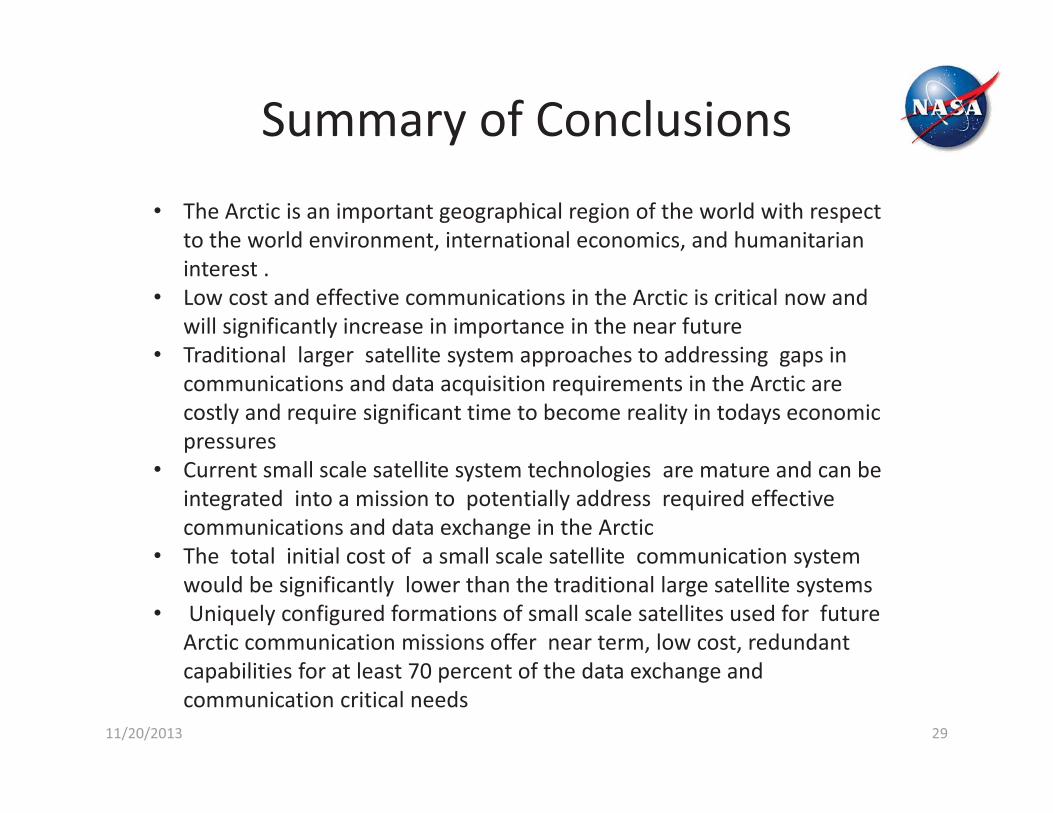
11/20/2013 29
Summary of Conclusions• The Arctic is an important geographical region of the world with respect
to the world environment, international economics, and humanitarian interest .
• Low cost and effective communications in the Arctic is critical now and will significantly increase in importance in the near future
• Traditional larger satellite system approaches to addressing gaps in communications and data acquisition requirements in the Arctic are costly and require significant time to become reality in todays economic pressures
• Current small scale satellite system technologies are mature and can be integrated into a mission to potentially address required effective communications and data exchange in the Arctic
• The total initial cost of a small scale satellite communication system would be significantly lower than the traditional large satellite systems
• Uniquely configured formations of small scale satellites used for future Arctic communication missions offer near term, low cost, redundant capabilities for at least 70 percent of the data exchange and communication critical needs

30
ACE
FASTSAT-HSV01
ARCSat
Innovative Formations of Small Scale Satellites Can Be an Important, Cost Effective and Timely Component of the
Solution Set Portfolio for Many Missions
11/20/2013

Thank you for your interest, Questions ?
3111/20/2013

32
BACKUP
11/20/2013

Single Spacecraft Results• Duration of contact to a
ground station with a ground station elevation angle constraint
• Contact times increase with altitude
• Contact times decrease with increase in elevation angle constraint
0
5
10
15
0 5 10 15 20
Cont
act D
urat
ion
(min
)
Minimum Elevation Angle (deg)
Single Spacecraft Coverage
600 km
650 km
700 km
11/20/2013 33

Coverage in Other Critical Regions
Central America Antarctic
3411/20/2013

35
Acknowledgements
William “Herb” Sims, NASA MSFCKosta Varnavas, NASA MSFCDevon Sanders, NASA MSFCMarty Kress, VCSI Stephen Spehn , US EUCOMHal Moore, US NORTHCOM
11/20/2013

Arctic Collaborative Environment Team International and Growing
• We have an incredible team – been able to integrate some of the best people and organizations in the business– Pablo Clemente-Colón, National Ice Center– Thorsten Markus, NASA Goddard– John Calder, NOAA– Corky Clinton, NASA Marshall – John Farrell, Arctic Commission – John Frim, Canadian Embassy – Julie Gourley, State Department, Arctic Council – Brendan Kelly, OSTP– John Walsh, UAF – Julie Payette, Government of Quebec – EUCOM, NORTHCOM, NORAD, USCG, Navy Task Force Climate Change, Navy, AMRDEC,
DLR, CRREL, ORNL, NOAA, NSF, ONR, OSTP, ERMA, NWS, State Department – Norwegian Polar Institute, DLR, German Embassy, Finnish Meteorological Institute, Inuit
Circumpolar Council, SAON– University of Alabama in Huntsville (NASA MSFC -EUCOM), University of Alaska Fairbanks
(AARI & Environment Canada), University of Maryland (NASA GSFC), University of Delaware (NIC), Aurora Research Institute (Inuit Nation), Universities Space Research Association
– Working to Fully Integrate Canada and Russia into Project
3611/20/2013