Overview - infrastructurevictoria.com.au€¦ · Web viewThe settlement was endowed with a name...
48
LEARNING FROM THE PAST A History of Infrastructure Planning in Victoria Infrastructure Victoria February 2016
Transcript of Overview - infrastructurevictoria.com.au€¦ · Web viewThe settlement was endowed with a name...

LEARNING FROM THE PAST
A History of Infrastructure Planning in Victoria
Infrastructure Victoria
February 2016

OVERVIEW
Victoria’s infrastructure landscape as we know it today has not come about by chance. Rather, it is a result of historical decisions and planning throughout the state’s relatively rapid development during nineteenth and twentieth centuries. Developments such as the gold rush era and its aftermath, the granting of statehood and self-government, war, economic downturns, technological advancements and political change all affected infrastructure planning decisions.
Melbourne in the 1890s had not only become one of the largest cities in the western world, but also a leader in infrastructure development, with public and private railways and tramways;1 a major sewerage scheme (the Melbourne and Metropolitan Board of Works (MMBW) pipes, pumping stations and Werribee farm); electric street lighting and comprehensive storm-water drainage.
Since the second half of the twentieth century, urban and regional planning in Victoria has been formalised through a series of land use and infrastructure strategies that have shaped the state’s settlements.
Throughout our history of planning, the challenge for leaders, planners and engineers has essentially remained the same: how best to maintain and provide infrastructure to service development generated by population growth and new economic investment, while managing competing demands on limited resources and preserving amenity and environmental values.
These challenges have been tackled through a number of formal plans and strategies produced since the 1920s, starting with the famous 1929 Plan for General Development for Melbourne, the first of its kind in Australia.
In the period of the post-World War II population boom, plans such as the 1954 Melbourne and Metropolitan Planning Scheme and the 1971 Planning Policies for the Melbourne Metropolitan addressed rapidly changing urban circumstances. These plans were significant on account of their breadth, depth and enduring impact.
In the late nineteenth and early twentieth centuries strong, independent statutory bodies with high-level engineering capabilities were made responsible for the funding and delivery of major state infrastructure. The Melbourne and Metropolitan Board of Works (MMBW) dealt with Melbourne’s water supply, sewerage and main drainage systems. The State Rivers and Water Supply system constructed dams, water supply and irrigation schemes across the state. The Country Roads Board created much of the state’s major road system. In Melbourne, the Tramways Board consolidated and operated the city tram networks. And the State Electricity Commission took up the role of building the state’s major coal mines and power stations, generating and supplying electricity throughout Victoria.
1 Infrastructure Victoria Learning from the past
Outside Melbourne, the Town and Country Planning Board worked with the major cities, towns, and rural municipalities to help them address their own land use and infrastructure planning needs. Those large statutory authorities of the pre-war period continued to plan for and provide new infrastructure well into the last two or three decades of the twentieth century when almost all had their responsibilities absorbed into government departments, privatised, or passed on to smaller statutory bodies. The notable exception is VicRoads, which is the successor organisation to the Country Roads Board and MMBW in developing and managing the state’s major road networks where these have not been privatised.
The decisions and investments of these agencies both served and shaped the state and its towns and cities as Victoria developed into the mid-twentieth century
While the story of how the state has grown is a complex one, an analysis of the history of Victoria’s development in respect to its infrastructure landscape gives perspective to the process of development through the decades. A brief examination of the legacy of strategies and plans provides an insight into the human and financial capital that has been invested in the Victorian infrastructure landscape of 2016.
Lessons from the past A number of lessons can be learned from the legacy of strategic plans. Plans that have endured have integrated land use planning and infrastructure planning, enabling land use planning to inform infrastructure planning, while infrastructure plans and investment costs frequently influenced the decisions about the nature and location of urban land use.
Infrastructure Victoria’s 30-year strategy will, accordingly, encourage the close alignment of infrastructure and land use planning in the interests of urban efficiency, sustainability and amenity.
Estimating future population growth has been integral to Victoria’s plans. Yet it is not possible to know for certain the direction the future will take, nor the scale or distribution of population growth this will entail. History has shown that the best plans have been flexible and have taken a long-term approach without being tied to a particular population forecast for a particular year. With this in mind, Infrastructure Victoria will consider a variety of near term and long-term scenarios, will plan on the basis of population capacity for given scenarios, and will tailor its recommendations accordingly.
Public consultation has increasingly been a fundamental element of plans for Victoria’s development. Infrastructure Victoria will not only publish regular updates and run workshops and forums, but will conduct extensive consultations with the community throughout 2016 to inform developments of its 30-year strategy.
Most infrastructure plans have been project focused. While it is important to have this project perspective and prioritise investment, Infrastructure Victoria will take a deliberate approach of considering non-build options such as policy changes and better use of existing infrastructure before committing to new projects.
2 Infrastructure Victoria Learning from the past

The major strategic plans to date have tended to focus on Melbourne and its metropolitan region. Melbourne 2030 was the first plan that sought to integrate regional Victoria and Melbourne and its metropolitan region, by addressing future development along the corridors to Geelong, Ballarat, Bendigo and the Latrobe Valley and advocating for strong linkages between Melbourne and the provincial cities. Plan Melbourne currently builds on this approach. Infrastructure Victoria proposes to go further, and will consider the infrastructure needs of the whole state.
Summary of lessonsIntegrated Planning: The enduring strategic plans have attempted to integrate land-use planning with infrastructure planning. Infrastructure Victoria’s 30-year strategy will encourage the close alignment of infrastructure and land use planning.
Flexible Plans: Many of the best plans have been flexible, have factored in unexpected events and taken a long-term approach. Most plans and schemes have estimated population growth but they have not always been accurate. Infrastructure Victoria will take both near-term and long-term approaches and will consider a range of future development scenarios, tailoring its recommendations accordingly.
Public Consultation: Meaningful public consultation is a fundamental part of infrastructure planning. Infrastructure Victoria will conduct extensive consultation with the community to inform development of its strategy.
Broader Options: Many plans have been project focused. The more successful plans are those which considered broader options for change. Infrastructure Victoria will take a deliberate approach of considering non- build options such as policy changes and better use of existing infrastructure.
Wide Scope: Most of the strategic plans have focused on Melbourne and its Metropolitan Region. Infrastructure Victoria will consider the infrastructure needs of the whole state of Victoria.
3 Infrastructure Victoria Learning from the past
TIMELINE OF VICTORIA’S HISTORY AND PLANNING DOCUMENTS
Historical Victorian events, eighteen thirty five to nineteen twenty nine1835: Foundation of Melbourne
1847: Melbourne raised to status of city
1851: Establishment of State of Victoria
1850s: Gold Rush
1880s: Land boom
1890s: Depression
1914-18: World War I
1929: The Great Depression
1929: City Loop conceived
Victorian planning document, nineteen twenty ninePlan for general development
Historical Victorian events, nineteen thirty nine to nineteen fifty four1939-45: World War II
1947: Post-war immigration
1950s: Baby boom
1954: Western Ring Rd conceived, decline in public transport usage
Victorian planning document, nineteen fifty fourMelbourne Metropolitan Planning Scheme
Historical Victorian events, nineteen sixties1960s: Inner-city slum clearance; construction of freeways, ring roads, car parks, decline in public transport usage
1968: West Gate Bridge commenced
1969: CityLink conceived
Victorian planning documents, nineteen sixties1967: The future growth of Melbourne
1968: The future shape of Melbourne
1968: Planning policies for the metropolitan region
1969: Melbourne transportation study
4 Infrastructure Victoria Learning from the past

Historical Victorian events, nineteen seventies1970s: Economic downturn, further decline in public transport usage
1971: City Loop commenced
1978: West Gate Bridge completed
Victorian planning documents, nineteen seventies1970-1976: Statements of planning policy
1971: Planning policies for the Melbourne metropolitan region
Historical Victorian events, nineteen eighties1980s: Expansion of road network, continued decline in public transport usage
1985: City Loop completed
1989: Western Ring Rd commenced
Victorian planning documents, nineteen eighties1980: Metropolitan strategy report
1980: Victorian transport study
1981: Melbourne strategy implementation
1984: Central Melbourne: framework for the future
1987: Shaping Melbourne’s future
1989:Metropolitan activity centres
Historical Victorian events, nineteen ninetiesEarly 1990s: Economic downturn; slowdown in immigration
Late 1990s: Reinvigoration CBD, population growth, redevelopment of Southbank and docklands
1996: CityLink commenced
1999: Western Ring Rd completed
Victorian planning documents, nineteen nineties1991: South east and Werribee growth plans
1992: Cities in the suburbs
1994: Creating prosperity: Victoria’s capital city policy
1995: Living suburbs
1998: From doughnut city to café society
1999: Linking Victoria
5 Infrastructure Victoria Learning from the past

Historical Victorian events, early two thousands2000s: Rise in rail patronage, CBD continues to grow as centre of professional services, increase in immigration
2000: CityLink completed
2008: EastLink completed
2015: Regional Rail Link completed
Victorian planning documents, early two thousands2002: Melbourne 2030: Planning sustainable growth
2002 and 2005: Growing Victoria Together
2004: Linking Melbourne: Metropolitan transport plan
2005: A plan for Melbourne’s growth areas
2006: G21 Geelong regional plan
2006: Meeting our transport challenges
2008: Victorian transport plan
2008: Investing in transport – east west link needs assessment
2008: Melbourne at 5 million
2009: Delivering Melbourne’s newest sustainable communities
2013: G21 growth plan
2014: Plan Melbourne
2014: Regional growth plans
2014: G21 economic development strategy
2016: Plan Melbourne refresh
6 Infrastructure Victoria Learning from the past

REVIEWING VICTORIA’S INFRASTRUCTURE HISTORY
1800sThe decision to establish a settlement on the banks of the Yarra River in 1835 was made by a group of profit-seeking Tasmanian squatters and land speculators who chose this site based upon the availability of water for both domestic and commercial use. The land was already occupied by Aboriginal people, there being about 700 members of three clans living within 50 km of the new settlement, chiefly members of the Wurundjeri clan of the Woi Wurrung people.2
Unlike most other Australian cities Melbourne was established as a commercial, rather than administrative centre. When Governor Bourke arrived from England in 1837, he found a weatherboard settlement on the north bank of the city, its inhabitants making a living from exporting wool to England. The settlement was endowed with a name and a plan, the latter courtesy of Robert Hoddle, Assistant Surveyor General. Hoddle’s grid design, laid out parallel to the Yarra, followed strict regulations that stipulated that all buildings must be of brick and within boundaries.3 Incorporated as a town in 1842, Melbourne was endowed with a town council, which in turn provided essential services such as drains, street lights and water supply.
In 1851, Victoria was established as a state, with Melbourne as its capital. Just months later gold was discovered and there followed a dramatic increase in population and wealth. The population explosion lead to the development of essential infrastructure services and encouraged innovation in transport (trains and trams) and communications (telegraph). The consequences of the gold rush as well as migration also caused ‘a major expansion of public education.’4 As an increasingly wealthy, self-governing state, Victoria invested heavily and rapidly in its public infrastructure and buildings, and by the end of the 1880s, ‘the city was intoxicated with the idea of growth for growth’s sake.’5
View from St Kilda Road, looking towards Melbourne, c. 1870-80: State Library of Victoria Collection
7 Infrastructure Victoria Learning from the past

The establishment of Victoria as a colony and then the state of Victoria, was part of a worldwide process of European colonial expansion during which the settlers transferred their European values, institutions and knowledge onto the landscape.6 The Victorian government, which met for the first time in 1856, not only borrowed from Britain to pay for the infrastructure, but it also adopted the British style of public administration, which was ‘down to earth in its concerns with public health, sanitation and with meeting the functional requirements of industry and transport.’7 By the end of the century, most of Victoria’s towns and cities, such as Ballarat, Bendigo and Geelong had been established, the pattern of their development shaped by geography, function and transport technology and networks.
Early 1900sBy the turn of the twentieth century, Victoria’s population had reached 1.2 million, with some 500,000 resident in Melbourne.8 The early part of the century was characterised by intermittent periods of growth, prosperity, recession and depression during which the government continued to build and invest in infrastructure.
The passing of the Water Act in 1905 led to the establishment of the State Rivers and Water Supply Commission of Victoria in 1906.9 This body oversaw the irrigation works in the country towns. The Country Roads Board was formed in 1912 and was responsible for the construction and maintenance of Victoria’s roads, many of which were in such an appalling state that Board members were compelled to inspect them on horseback.10
The 1920s was particularly productive in regards to infrastructure investment. As a result of complaints about water quality and lack of water pressure in Melbourne's eastern suburbs, a large-scale dam construction program begun in the 1920s, with three reservoirs – Maroondah, O'Shannassy and Silvan, all completed by 1932.
In 1921, the government created the State Electricity Commission, which generated its electricity supply from the Yallourn coal-fired power station in the Latrobe Valley that opened in 1928.11 This in turn allowed the consolidation and electrification of the metropolitan train network that had been constructed with both private and public funds from the 1880s onwards. Approved by Parliament in 1912, the electrification project was completed in 1923, some £6 million later12 (approximately $460 million today).13
Melbourne, in the meantime, continued to be a dominant rail and tram city, its growth following the rail networks. Land that had been privately subdivided in the 1880s (with, in the case of Brighton, a private railway to serve the subdivision) was busily being built upon. By the 1910s, there existed a divide between the wealthy inner-southeast and bay-side areas and the traditionally working-class inner northern and adjacent suburbs of Richmond, Collingwood and Fitzroy.
8 Infrastructure Victoria Learning from the past

Early in the century, it had become apparent that some areas of the city had become so poor that government intervention would be necessary to improve the living conditions of residents. A major inquiry into living conditions was launched by a Joint Select Committee of Parliament. In its report entitled Housing of the People in the Metropolis (1913), the Committee concluded that the ‘housing of people in a portion of the metropolis is most disgraceful, and that the conditions are…a menace not only to themselves [the residents] but to the health of the community at large.’14 This inquiry was swiftly followed by a Royal Commission in 1915 which also concerned itself with the existence of slums in parts of Melbourne.
1929 Plan for General Development (Metropolitan Town Planning Commission)These inquiries, together with a growing feeling that the towns and cities of Victoria had been developing rather haphazardly, culminated in the establishment in 1922 of the Metropolitan Town Planning Commission whose work resulted in the publication of Melbourne’s first formal strategic plan, the 1929 Plan for General Development for Melbourne. This powerful planning authority and development corporation represented municipal councils and various government agencies and was the first agency in Australia to prepare a plan for an entire metropolitan region, including both land use and infrastructure.
Nearly seven years in the making, this 308 page volume has been described as a ‘triumph of data collection and pragmatic, trend-style planning’15 as well as a ‘classic specimen of the ‘City Beautiful’ genre which concentrated on proposals for large scale road widening on the model of Haussmann’s Paris.’16
The Plan for General Development was, in essence, a land use strategy which integrated expertise in architecture, surveying and engineering, labour productivity, open space and recreation. Its approach was that ‘prevention is invariably better than the cure, and mistakes can be avoided now which will be tremendously costly to undo even in ten years’ time, and provision for the future can be made at a tithe of the cost if taken in hand now.’17 To accurately make ‘provision for the future’, the Commission produced a growth chart which forecast the future population of Melbourne to be 2.2 million by 1948. By 1948, the population reached just 1.2 million as Australia had closed its ports and immigration had halted during the Second World War.
The Plan for General Development not only accurately identified a number of future infrastructure problems but it also suggested solutions, many of which were realised decades later:
Traffic congestion: Between 1924 and 1929, cars on Melbourne’s roads had increased from around 70,000 to 150,000, and were discussed by the Commission in part as a nuisance that impeded the operations of the public transport network. In anticipation of continued increase in car usage, the planners suggested a series of works such as road widening, the reconstruction of bridges and constructions of new roads, including a bypass of Melbourne’s CBD. It also highlighted traffic problems at St Kilda junction, suggesting the construction of a roundabout followed by more substantive road works when required. This was finally addressed in the late 1960s when the MMBW managed a Victorian government project to redevelop St Kilda Road.
9 Infrastructure Victoria Learning from the past

Public health: The Commission made the connection between population density and health, acknowledging that ‘the provision of sufficient open spaces for the enjoyment of the community in large cities is now generally accepted as a vital part of the city development.’18 A significant discussion was dedicated to the location and necessity of children’s playgrounds, linking population density to children’s health. Interestingly, however, the plan failed to address the twin problems of slum housing and poverty, which had led to the plans’ commissioning. The Commission’s early idea of ‘open space’ was taken up in the 1954 Melbourne scheme, which devoted a section to recreation in terms of parks, gardens and children’s playgrounds. Since then, the ongoing challenge of maintaining open spaces been considered in infrastructure planning.
Land use conflicts: In terms of land use planning, the plan sought to prevent the haphazard intermingling of land uses by introducing a zoning scheme. Zoning schemes seek to separate incompatible land uses (such as residences and noxious industries) and to determine the best current and future uses of land to promote economic, social and environmental benefits. The concept of land use planning and zoning is one that has formed the basis of metropolitan planning in Victoria ever since.
Public transport: Half a century before the City Loop was opened in 1985, the planners proposed the construction of an underground rail network in response to the problem of overcrowding on trains.
Whilst the 1929 plan was an exemplary strategic land use planning model integrated with transport, health and environment, due to a combination of political opposition and the financial effects of the Great Depression, it was never implemented. The painstaking work of the Commission was shelved and the opportunity to create an organisation that could have coped with growth that took place after the Depression was lost. Nonetheless, the basic land use structure for metropolitan Melbourne (industry in the west, for example, new suburbs in the east and southeast) was embedded in later plans, starting with the 1954 plan, while its significant infrastructure proposals also shaped future plans.
Table showing timeframes from conception to completion for three major infrastructure projects:
City Loop: conceived in 1929, started in 1971, finished in 1985.
Western Ring Road: conceived in 1954, started in 1989, finished in 1999.
City Link: conceived in 1969, started in 1996, finished in 2000.
10 Infrastructure Victoria Learning from the past

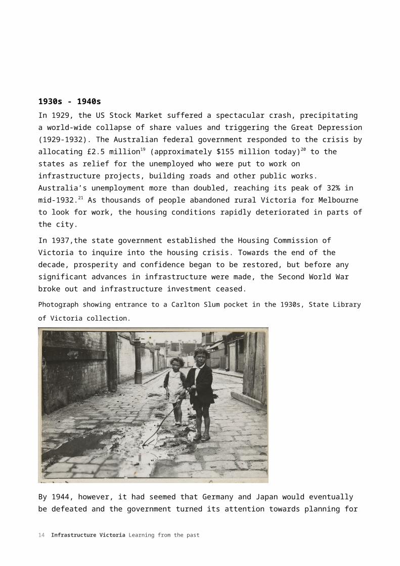
1930s - 1940sIn 1929, the US Stock Market suffered a spectacular crash, precipitating a world-wide collapse of share values and triggering the Great Depression (1929-1932). The Australian federal government responded to the crisis by allocating £2.5 million19 (approximately $155 million today)20 to the states as relief for the unemployed who were put to work on infrastructure projects, building roads and other public works. Australia’s unemployment more than doubled, reaching its peak of 32% in mid-1932.21 As thousands of people abandoned rural Victoria for Melbourne to look for work, the housing conditions rapidly deteriorated in parts of the city.
In 1937,the state government established the Housing Commission of Victoria to inquire into the housing crisis. Towards the end of the decade, prosperity and confidence began to be restored, but before any significant advances in infrastructure were made, the Second World War broke out and infrastructure investment ceased.
Photograph showing entrance to a Carlton Slum pocket in the 1930s, State Library of Victoria collection.
By 1944, however, it had seemed that Germany and Japan would eventually be defeated and the government turned its attention towards planning for the post-war years. In Britain, there had been a series of town and country planning reports. The Victorian Government followed suit by establishing its own Town and Country Planning Board in 1944, henceforward responsible for ‘the preparation and submission for approval of any planning scheme.’ This marked the commencement of statutory planning in Victoria.22
The end of the war in 1945 signalled a new era of increased prosperity, fuelled by high prices for Victoria's wool, as well as increased government spending on transport, education and hospitals.
11 Infrastructure Victoria Learning from the past

In 1947, thousands of immigrants from war-torn Europe began to arrive in Australia, the population of Victoria reaching 2.2 million in 1950.23 At this time the use of public transport for daily travel was at very high levels – consumer credit for buying cars did not exist, petrol was costly, and the population was growing rapidly. New water supplies had become a matter of urgency and the construction on the Upper Yarra Reservoir was begun in 1948. Naturally, the government turned its attention to meeting the infrastructure needs of the growing population.
In rural Victoria, the government also re-introduced the soldier re-settlement scheme of the First World War, subdividing rural lands and constructing irrigation and land drainage schemes to support small-scale farming. This supported the expansion of many country towns.
1950sMelbourne suffers from congestion in the inner areas and a sprawling development on the outskirts. Its land is not being put to the most appropriate use, public transport is loaded to strap-hanging capacity while the roads are so crowded that there is a constant danger to life and economic loss through long delays and slow movement of traffic.
1954 Melbourne Metropolitan Planning Scheme.24
The 1950s was an era of rapid growth, the population rising from 2.2 million in 1950 to 2.8 million in 1960.25 This put immense pressure on housing, education and health infrastructure. For twenty years, housing supply had not kept up with demand, resulting in an acute shortage. Thanks to subsidies provided at both state and federal level through the provision of housing finance, the increasing availability of consumer credit from the banks, absence of capital gains tax, as well as the popularity of the car, new suburbs came into being. However, the provision of infrastructure services had generally lagged behind this suburban expansion. Land subdivisions did not require services paid for by the developers, so new suburbs often had unmade streets, no sewerage or drainage and few amenities.26 New homes were no longer within easy walking distance of train stations or tram stops. Furthermore, as the popularity of the car increased, so did the pressure on local unmade roads and streets, further reducing amenity. Public transport use declined rapidly as well. Passenger numbers in Melbourne fell from nearly 180 million in 1947 to 150 million in 1957.27
Schools were crowded and under resourced. In the new suburbs of Melbourne, children were crowded into large classes in church halls and other temporary accommodation until new schools could be completed, while the old brick schools of the inner suburbs struggled to accommodate large numbers of children from non-English-speaking backgrounds.
The responsibility to provide extra resources and funding was viewed as a national rather than state government matter as the Commonwealth government had taken over income taxation during the War and had become increasingly involved in education funding thereafter.
Hospitals also felt the effect of the post-war baby boom and immigration. Dandenong Hospital for example, was compelled to incorporate a children’s ward in 1955 to accommodate the higher birth rate.
12 Infrastructure Victoria Learning from the past

1954 Melbourne Metropolitan Planning Scheme (Melbourne Metropolitan Board of Works)
In 1949, the Town and Country Planning Board along with local councils requested a metropolitan planning strategy from the MMBW. Five years later, the MMBW published the Melbourne Metropolitan Planning Scheme. The document built on the scope of the 1929 planning strategy in terms of the integration of transport and social infrastructure, the planners seeking to establish a ‘complete understanding of the city both as a physical and social entity.’28 Remarkable in its breadth of scope, the plan considered broader social infrastructure issues within the health (distribution of hospitals, infant welfare centres and cemeteries), education (distribution of primary and secondary schools) and community sectors.
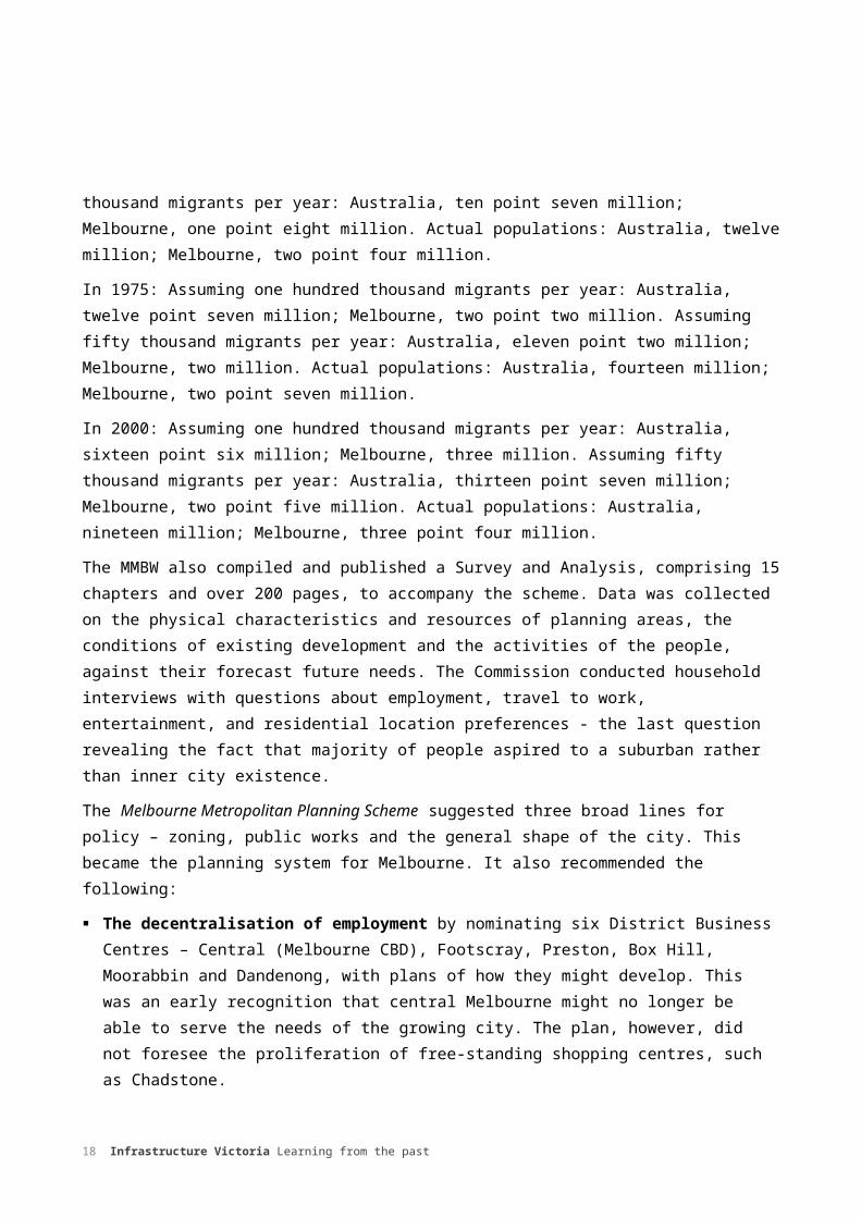
The scheme identified a number of existing infrastructure problems such as low-density urban sprawl, declining amenities in the inner suburbs, and the lack of a ‘proper location’ of industry as well as provision for expansion. It also commented on chronic congestion in the CBD, and noted the increasingly difficult movement of people and goods as well as lack of sites for schools, hospitals and recreation.29 As shown in Figure 1, the planners attempted to forecast future populations 45 years into the future by employing two scenarios. The repercussions of what proved to be a significant underestimation of growth were felt in the following decades in managing urban expansion and the provision of infrastructure ahead of what had been anticipated as necessary.
Figure 1: Population projections from 1954 for Australia and Melbourne to the year 2000 versus actual numbers.
In 1955: Assuming one hundred thousand migrants per year: Australia, nine point two million; Melbourne, one point six million. Assuming fifty thousand migrants per year: Australia, eight point nine million; Melbourne, one point four million. Actual populations: Australia nine point two million, Melbourne one point six million.
In 1960: Assuming one hundred thousand migrants per year: Australia, ten point one million; Melbourne, one point seven million. Assuming fifty thousand migrants per year: Australia, nine point five million; Melbourne, one point seven million. Actual populations: Australia, ten million; Melbourne, one point eight million.
In 1965: Assuming one hundred thousand migrants per year: Australia, eleven million; Melbourne, one point nine million. Assuming fifty thousand migrants per year: Australia, ten point one million; Melbourne, one point seven million. Actual populations: Australia, eleven million; Melbourne, two point two million.
In 1970: Assuming one hundred thousand migrants per year: Australia, eleven point nine million; Melbourne, two million. Assuming fifty thousand migrants per year: Australia, ten point seven million; Melbourne, one point eight million. Actual populations: Australia, twelve million; Melbourne, two point four million.
In 1975: Assuming one hundred thousand migrants per year: Australia, twelve point seven million; Melbourne, two point two million. Assuming fifty thousand migrants per year: Australia, eleven point two million; Melbourne, two million. Actual populations: Australia, fourteen million; Melbourne, two point seven million.
13 Infrastructure Victoria Learning from the past
In 2000: Assuming one hundred thousand migrants per year: Australia, sixteen point six million; Melbourne, three million. Assuming fifty thousand migrants per year: Australia, thirteen point seven million; Melbourne, two point five million. Actual populations: Australia, nineteen million; Melbourne, three point four million.
The MMBW also compiled and published a Survey and Analysis, comprising 15 chapters and over 200 pages, to accompany the scheme. Data was collected on the physical characteristics and resources of planning areas, the conditions of existing development and the activities of the people, against their forecast future needs. The Commission conducted household interviews with questions about employment, travel to work, entertainment, and residential location preferences - the last question revealing the fact that majority of people aspired to a suburban rather than inner city existence.
The Melbourne Metropolitan Planning Scheme suggested three broad lines for policy – zoning, public works and the general shape of the city. This became the planning system for Melbourne. It also recommended the following:
The decentralisation of employment by nominating six District Business Centres – Central (Melbourne CBD), Footscray, Preston, Box Hill, Moorabbin and Dandenong, with plans of how they might develop. This was an early recognition that central Melbourne might no longer be able to serve the needs of the growing city. The plan, however, did not foresee the proliferation of free-standing shopping centres, such as Chadstone.
The concept of development corridors. The scheme focused on the tendency for growth to take place in eastern and south eastern corridors. This concept of urban growth was accepted in principle in the 1967 state government’s The Future Growth of Melbourne, and re-emphasised in 1971 Planning Policies for Melbourne Metropolitan Region, when constraints around Melbourne was first considered and the ‘corridor approach’ adopted. The land between corridors is now known as ‘green wedge land.’
Easing traffic congestion. The scheme proposed an inner ring road around the CBD, a series of freeways to the east, south east, north west as a well as a series of bypasses. This network was later identified in 1969 Melbourne Transportation Study.
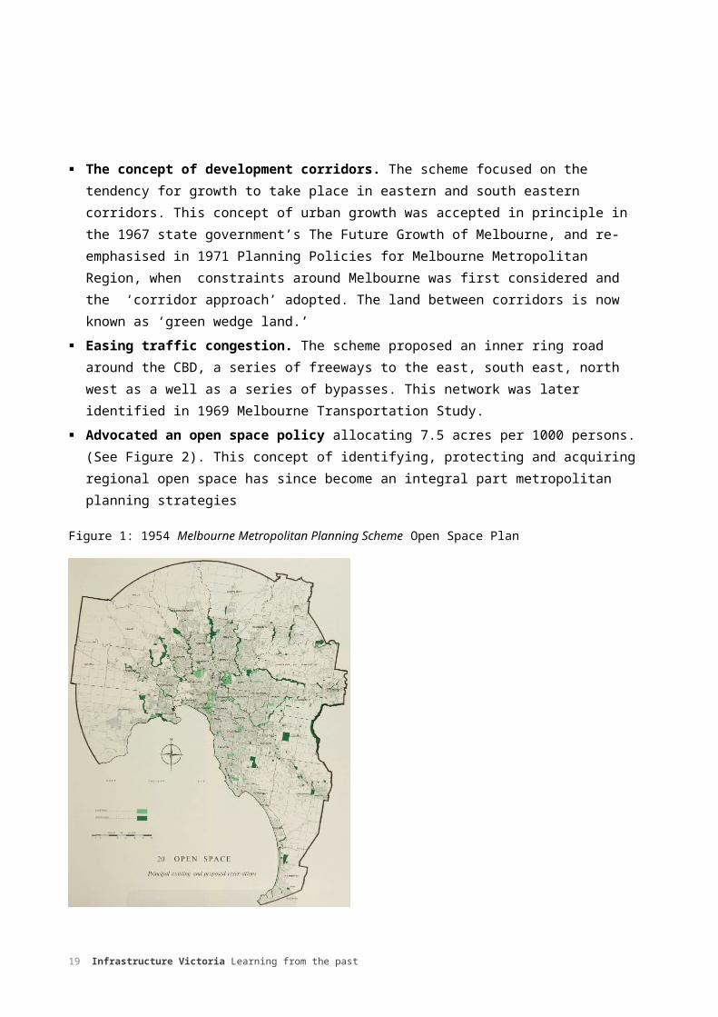
Advocated an open space policy allocating 7.5 acres per 1000 persons. (See Figure 2). This concept of identifying, protecting and acquiring regional open space has since become an integral part metropolitan planning strategies
14 Infrastructure Victoria Learning from the past

Figure 1: 1954 Melbourne Metropolitan Planning Scheme Open Space Plan
In November 1953 the scheme was put on public exhibition but was immediately withdrawn due to a defect of legislation. The scheme, with some amendments was put on display again in 1954 and received 4000 objections and some 15,000 applications were considered. 30 Four years later, the MMBW submitted the report to the Minister for Local Government. The 1954 scheme itself was not established by statute until 1968, nearly two decades years after it had been commissioned. By this time, the state government had approved the basic principles for a completely new metropolitan plan, the 1968 Planning Policies for the Metropolitan Region.
1960sThe 1960s was defined by high-rise public housing, freeways and modernist plans for Melbourne involving ring roads, car parks and sky-scrapers. During this period, the Housing Commission of Victoria undertook extensive, inner-city ’slum clearance’ programs aimed at improving housing conditions for the poor. High rise public housing towers in garden settings replaced slums. This ‘brutalism’ became the style of choice for government and institutional clients who sought more efficient use of real estate, but ultimately led to major public protests against slum clearance and resulted in Heritage Protection legislation – a first in Australia.
These were also the years in which freestanding shopping centres, readily accessible by car, became popular. Few additions were being made to the public transport network whilst attention was turned to the construction of major freeway and arterial roads.
15 Infrastructure Victoria Learning from the past

From the late 1960s onwards, the dominant model of dispersed population and employment growth along with ‘flight to the suburbs’ and mass suburbanisation was set. The urban footprint extended as far as Doncaster and Templestowe in the east, Frankston in the south, Eltham in the north and Sunshine in the west. This was reflected by the city’s planners, who began to plan for a greatly expanded city as well as the predominance of the car.
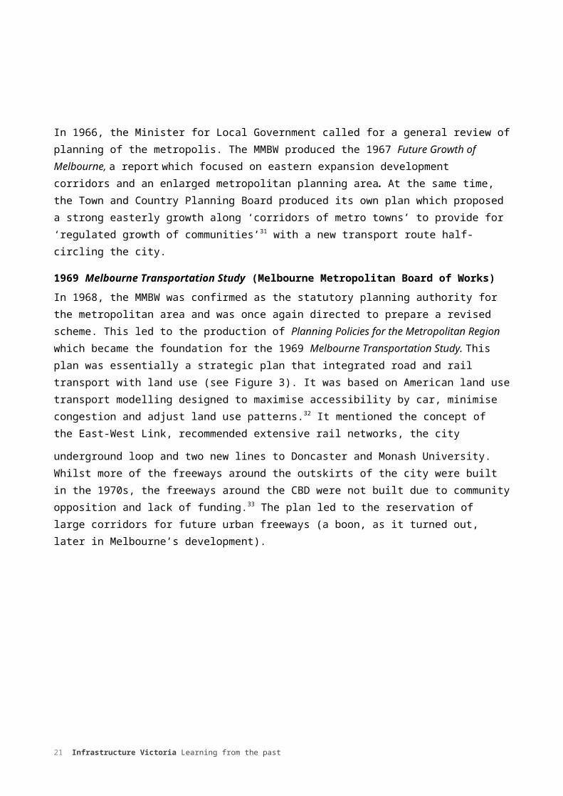
In 1966, the Minister for Local Government called for a general review of planning of the metropolis. The MMBW produced the 1967 Future Growth of Melbourne, a report which focused on eastern expansion development corridors and an enlarged metropolitan planning area. At the same time, the Town and Country Planning Board produced its own plan which proposed a strong easterly growth along ‘corridors of metro towns’ to provide for ‘regulated growth of communities’31 with a new transport route half-circling the city.
1969 Melbourne Transportation Study (Melbourne Metropolitan Board of Works)In 1968, the MMBW was confirmed as the statutory planning authority for the metropolitan area and was once again directed to prepare a revised scheme. This led to the production of Planning Policies for the Metropolitan Region which became the foundation for the 1969 Melbourne Transportation Study. This plan was essentially a strategic plan that integrated road and rail transport with land use (see Figure 3). It was based on American land use transport modelling designed to maximise accessibility by car, minimise congestion and adjust land use patterns.32 It mentioned the concept of the East-West Link, recommended extensive rail networks, the city
underground loop and two new lines to Doncaster and Monash University. Whilst more of the freeways around the outskirts of the city were built in the 1970s, the freeways around the CBD were not built due to community opposition and lack of funding.33 The plan led to the reservation of large corridors for future urban freeways (a boon, as it turned out, later in Melbourne’s development).
16 Infrastructure Victoria Learning from the past

Figure 2: 1969 Transport Plan in 1971 Planning Policies for Melbourne Metropolitan Region
1970sThe 1970s was marked by ‘distinctly chilly economic conditions, growing dissatisfactions, new patterns of urban development and powerful challenges to the body politic and its planning roles.’34 The population of Victoria had grown to 3.4 million, with 2.4 million living in Melbourne.35 The pattern of urban and regional development in the 1960s continued to endure as the metropolitan area continued to expand, the popularity of the car continued to rise and public transport usage continued to fall. The 1970s was also characterised by the Housing Commission Land deals scandal in which land was purchased by speculators and developers at low prices then sold to the Housing Commission at a ‘handsome profit.’36 This left insufficient funds for infrastructure development at the actual sites.
The CBD experienced a decline in employment in manufacturing and wholesale trade. However, there appeared some glimmers of interest in renewing the inner city.
1971 Planning Policies for Melbourne Metropolitan Region (Melbourne Metropolitan Board of Works)The Planning Policies for the Melbourne Metropolitan Region was essentially a combination of two major planning reports from the previous decade, the 1967 The Future Growth of Melbourne and the Town and Country Board’s Organisation for Strategic Planning which had come about after the Minister for Local Government had called for a general review of planning. In contrast to the 1954 plan, which had underestimated growth, the 1971 version planned for larger population increases,
17 Infrastructure Victoria Learning from the past
but over-estimated. It forecast 3.3 to 3.5 million people in Melbourne by 1985 and 4.5 to 4.7 million by 2000, whereas the actual populations reached 2.9 million and 3.4 million respectively.37
The focus of the plan was containment of the expanding suburban growth areas and prioritisation of the increasingly car dependent nature of the city’s structure. Its major recommendations were:
A corridor scheme combined with two satellite towns at Melton and Sunbury. The centres of these corridors were broadly identified as Melbourne CBD, Craigieburn, Dandenong, Frankston, Ringwood, Sunshine, Werribee, Mernda and Lilydale. The idea of district policy was not introduced until the 1980s.38 Melton and Sunbury were declared satellite cities in 1974.
The identification of urban growth corridors along with a series of ‘green wedges’ which were to be protected for other uses such as conservation and major infrastructure (airport, sewerage treatment.) This was essentially the introduction of the idea of long-term conservation. It also contained growth on the edges of the city.
Encourage growth of the CBD by relieving traffic congestion and allowing expansion along St Kilda Rd, Kingsway and Royal Parade. The Victorian government acquired land around St Kilda Junction and commenced the demolition of over one hundred and fifty dilapidated buildings in 1973.
Approval for the 1969 Transport Plan freeway grid. This generated opposition from some members of the public, and the some of the major segments of the freeway were taken out of the plan
Figure 4: Melbourne Region Framework Plan, 1971 Planning Policies for the Melbourne Metropolitan Region
18 Infrastructure Victoria Learning from the past
The proposals were put forward to the 1954 Melbourne Metropolitan Planning Scheme in the form of two amendments. Until 1987, this was the only planning scheme to which all necessary changes were made through formal amendments. The amendments were place on public exhibition and approximately 4000 objections were made to them. The hearings by the MMBW commenced in 1972 and culminated in 1974 with the Report on General Concept Objections, which the MMBW presented to the Minister for Planning.39 The public was concerned that the MMBW plan focused on physical, spatial and land development to the apparent detriment of social, economic and equity issues. The public also expressed doubt concerning the corridor concept itself and the idea that the ‘lopsided’ development of Melbourne towards the east needed to be corrected.
People called for much greater public involvement in the formative stages and the supply of cost-benefit information on alternatives. The public also questioned the MMBW’s ‘technocratic’ approach to land-development as well as some of its ideas such as inner suburban freeways.40
The MMBW refused to scrap the corridor concept but instead disaggregated each corridor into three types of areas. These were ‘proposed urban zones’ for immediate growth, ‘investigation areas’ for potential growth, and other areas which were for long-term growth.
In 1968, the Town and Country Planning Board was given a new function, which was to plan policies for the entire state in terms of demographic, social and economic factors, conservation of natural resources, characteristics of land and land use, the environment, communications and the development requirements of public authorities. For the first time, the Board’s role was ‘to provide a co-ordinated outline of Government planning policy for responsible authorities who previously had to guess at such policy in the preparation of planning schemes.’41
Between 1970 and 1976, the Town and Country Board issued a series of Statements of Planning Policies, the general focus being the preservation of the environment and protection of natural beauty.42 However, the Board was criticised for having failed to properly consult with the public on its strategic and statutory planning regime.
Town and Country Board Statements of Planning Policies 1970-1976
Table summarising various planning policy statements.
1970 Statement of Policy Planning No. 1- Westernport: Planning Westernport primarily as a specialised port and heavy industry complex.
1970 Statement of Policy Planning No. 2-Mornington Peninsula: Introduced policies to protect areas of natural beauty and conservation of importance to the east and south of the metropolitan area beyond the areas of administered by MMBW.
1971 Statement of Policy Planning No. 3- Dandenong Ranges: Introduced policies to protect areas of natural beauty and conservation importance in the Dandenong Ranges.
1971 Statement of Policy Planning No.4- Yarra River: Introduced policies to protect the significant physical feature of Melbourne as a major social and conservation attribute for the whole city. The area east of Warrandyte is identified as a potential water catchment.
1973 Statement of Policy Planning No. 7- Geelong: Geelong region to be planned to accommodate a greatly increased share of the expected growth.
19 Infrastructure Victoria Learning from the past

1975 Statement of Policy Planning No.8- Macedon Ranges and surrounds: Sought to protect the values of the ranges.
1976 Statement of Policy Planning No.1 Westernport (as varied): Varied to preserve the opportunities for selected ports and industrial purposes. A more balanced approach following a major environmental study.
1980sBy 1980, the population of Victoria had reached 3.9 million, with 2.8 million living in Melbourne.43 The expansion plans for Melbourne conceived in the 1950s and 1960s had begun to take shape, as the Tullamarine and Eastern freeways (first suggested in the 1954 Planning Scheme), Western, Princess, Westgate, Hoddle, and Monash freeways recommended in the influential 1969 Melbourne Transport Plan were built. Freeways had become the focus of urban transport infrastructure. The new extensive road network encouraged further expansion, outward growth and decentralisation. Decline in public transport patronage continued as the car continued its ascendancy. In Melbourne, railway passenger numbers had halved from the post-war peak dropping to just 86 million journeys per year, even though the population had doubled.44 The City Loop was finally completed in 1985.
Figure 3: Historic Passenger Trends, 1907-2011, Melbourne and Sydney, Grattan Institute
1980 Melbourne Strategy Report (Melbourne Metropolitan Board of Works)The MMBW’s Metropolitan Strategy Report advocated a policy of incremental growth, setting out its objectives for housing, transport, jobs, community facilities and ‘activity centres’ in the suburbs.
20 Infrastructure Victoria Learning from the past
Although there was a greater focus on social infrastructure, the report failed to mention exactly how the strategy would be implemented. It also suggested upgrading public transport while at the same time accepting the government’s proposal to close several public transport hubs and invest in roads.
1981 Metropolitan Strategy Implementation Report (Melbourne Metropolitan Board of Works)This report was published by the MMBW, in response to criticism regarding implementation in particular. The 124-page document, complete with coloured illustrations, set out objectives, zone and land use control changes, as well as the means for putting the strategy into action. In this case, Amendment 150 marked a turning point in infrastructure planning as it proposed that local councils, other authorities and the general public should be involved in metropolitan planning and implementation. This was also the beginning of the district centre policy, summarised by the MMBW in its 1983 New District Centres policy and zones, which concentrated on housing, transport and community facilities in places that were already accessible on public transport.
1980 Victorian Transport Policy Study This study looked into freight and transport within Victoria. It recommended closing a number of lines, replacing almost half of the tram network with buses and closing country rail passenger services with the exception of the Geelong line. Such was the outcry from the public that virtually all of the recommendations were abandoned. Instead, the government started investing in new trains and trams as well as re-investing in the country passenger network.
The 1984 Central Melbourne: Framework for the Future was the first plan published by the state government rather than the MMBW or Town and Country Board. The government followed up its first plan with the 1987 Shaping Melbourne’s Future, intended to guide development for the next decade. The 1984 Central Melbourne plan identified a number of opportunities that have since been realised:
‘La Trobe Central’ which lead to the development of Melbourne Central and the QV Centre Station Pier Southbank, and Jolimont: Federation Square, the Melbourne Park Tennis Centre and housing on relocated rail
yards.45
During 1983-85 the City of Melbourne was also preparing its City of Melbourne Strategic Plan for central Melbourne, including the CBD, and incorporated an ambitious scheme to turn around population decline in the City and to dramatically increase its housing stock and population by the year 2000.
1990sBetween 1990 and 1992, Victoria’s economy shrank by five per cent while its population growth had slowed, growing to 4.9 million, with 3.2 million living in Melbourne.46 In contrast to the 1970s and 1980s, however, the mid to late 1990s was characterised by a re-invigoration of population
21 Infrastructure Victoria Learning from the past

growth and employment. The outward expansion of Melbourne slowed and inner city and locations along public transport corridors began to attract development, which increased urban densities. The CBD also began to experience a substantial increase in jobs as the economy began shifting from a manufacturing to knowledge-based economy. There was increased private sector investment in retail, office and residential construction in the CBD while inner Melbourne began to become more popular as a place to live and work. This was a time of major inner city redevelopment such as Southbank and urban renewal projects of the docklands with a focus on connective infrastructure such as CityLink (first noted as a route in 1954 Planning Scheme) and the Western Ring Road.
Building on the City of Melbourne’s Postcode 3000 initiative to increase population in the city, the Commonwealth Government’s Better Cities program provided funds to overcome one of the key barriers to inner-city population growth – capacity constraints in the inner-city sewerage system. Once these were removed, the program worked to support demonstration projects in urban renewal that contributed significantly to the resurgence in private investment in inner-city housing sought by Postcode 3000, and dramatically evident today.47 This turnaround during the 1990’s from declining inner-city populations to major population growth marked a transformation not just in Melbourne but across Australia’s cities.
The 1990s also saw significant changes in the entities responsible for provision of infrastructure in Melbourne, with the government privatising a number of state-owned infrastructure agencies responsible for public transport and energy. In the 1990s, the Melbourne Metropolitan Board of Works merged with a number of smaller urban water authorities to form Melbourne Water while its other functions were handed over to other bodies. The Board had been the subject of an external inquiry in 1979, had lost its planning functions in the early 1980s and was finally abolished in 1991. Planning responsibility was taken up by the Ministry for Planning and Environment in 1985.
1994 Creating Prosperity: Victoria’s Capital City Policy (Victorian State Government)This plan was prepared jointly by the State Government and the Melbourne City Council. It focussed on the much needed revitalisation of central Melbourne and local planning and introduced a number of projects and ideas which have shaped Melbourne’s infrastructure landscape of 2016. These included: Demolishing the Gas and Fuel buildings at Flinders Street and building Federation Square Building the Melbourne Exhibition Centre at Southbank Completing the Melbourne Casino Extending the National Tennis Centre Commencing redevelopment of Docklands Building a new museum in Carlton Expanding the Postcode 3000 project to encourage central city residential development Providing new housing in the Docklands and at Lynch’s Bridge in Kensington Restoring the Old Customs House (now the Immigration Museum) Restoring the Regent Theatre and opening it to the public, and
22 Infrastructure Victoria Learning from the past

Creating new open space in the redevelopment of the Jolimont Rail yards (Birrarung Marr)48
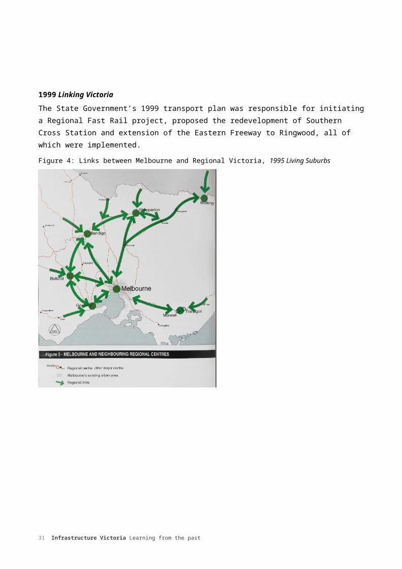
1995 Living Suburbs: A Policy for Metropolitan Melbourne into the 21st CenturyPublished by the government, this policy referred to Melbourne as one of world’s most liveable cities. It sought, among other things, to ‘strengthen links between Melbourne and regional Victoria…to enhance Melbourne’s environment and liveability... and create a more functional city by better managing Melbourne’s infrastructure and urban development.’49 This plan provided a schematic showing Melbourne’s links to regional centres, accompanied by a number of policies, as well as setting out a policy of developing an open space network of bicycle paths, waterways, parks and habitat corridors.
1999 Linking VictoriaThe State Government’s 1999 transport plan was responsible for initiating a Regional Fast Rail project, proposed the redevelopment of Southern Cross Station and extension of the Eastern Freeway to Ringwood, all of which were implemented.
Figure 4: Links between Melbourne and Regional Victoria, 1995 Living Suburbs
23 Infrastructure Victoria Learning from the past

The 2000sAt the turn of the century, the population of Victoria reached 4.7 million, with 3.4 million Melbournians.50 The legacy of infrastructure investments from the previous decades, such as Western Ring Rd, Citylink and Melbourne City Loop had provided a substantial boost to the economy. During the 1990s, growth to the city’s fringes had slowed, the residential population increasingly settling in the Western suburbs. Transport links from Melbourne were improved, with the completion of the Regional Rail link project in which metropolitan and regional services through the West were separated by dedicated tracks for Geelong, Bendigo and Ballarat trains.
There has been a significant rise in rail patronage in Melbourne, with initial passenger boarding almost doubling between 1998-99 and 2010-11, from 118 million to 229 million.51 This growth coincided with a rapid increase of jobs in inner Melbourne as the CBD continued to grow as the centre of professional services.52
The last fifteen years has been marked by frequent revision and re-issues of plans (see Figure 7) with each change of government.
The 2002 Melbourne @2030 was the first plan to explicitly commit the Government to an Urban Growth Boundary approved by Parliament, and to the establishment of growth targets and housing targets for established urban areas of Melbourne. It advocated Activity Centres supported by higher-density, mixed use development, and the concentration of outer urban expansion along growth corridors aligned to the transportation routes. It was the first Melbourne plan to focus attention on maximising the use of established infrastructure through higher density development. Because of this focus on increasing density in established areas, the plan was met with concerns from the public regarding lack of consultation and potential destruction of neighbourhood character. 53
Melbourne 2030 also supported investment in public transport, and identified priority tram, train and bus improvements and investments. It set a target of 20 percent of motorised travel to be by public transport by the year 202054 – later dropped by Government, but, in reality, potentially achievable. Melbourne 2030 also provided the impetus for the preparation of Infrastructure Coordination Plans within the Victorian Government, first by the Department of Infrastructure and then by the Department of Treasury and Finance.
Melbourne 2030 did not specifically forecast a population for 2030 but rather planned for a city with ‘an extra million people’. Within a few years it was clear that this additional million people would be added sooner rather than later, so the Government prepared an update titled Melbourne@5 million to deal with the needs of faster growth. There have also been a number of local transport strategies that identify key issues affecting their municipalities, working independently from the government. This plethora of plans contrasts starkly with the earlier, more enduring influence of the 1929 and 1954 plans.
24 Infrastructure Victoria Learning from the past

Figure 7: shows a table summarising Victorian Strategic Plans released during the 2000s.
Department of Infrastructure, 2002, ‘Melbourne 2030: Planning Sustainable Growth.’ Three years in the making, and boasting wide community consultation, the plan strove to achieve a broad strategic vision. Created the Urban Growth Boundary and focussed on increased urban densities and maximum use of existing infrastructure. Created Activity Centres with higher-density, mixed-use development.
Victorian State Government, 2002 and 2005, ‘Growing Victoria Together.’ The plans made a specific commitment to linking Victoria through transport and communications infrastructure.
Victorian State Government, 2004, ‘Linking Melbourne: Metropolitan Transport Plan.’ This plan consolidated a number of metropolitan regional transport studies. Proposed Eastlink which had originally been designated as a ‘south-east integrated transport corridor’ but never designed to integrate public transport.
Department of Sustainability and Environment, 2005, ‘A Plan for Melbourne’s Growth Areas.’ Outlined plans to managed outward growth following the release of Melbourne 2030.
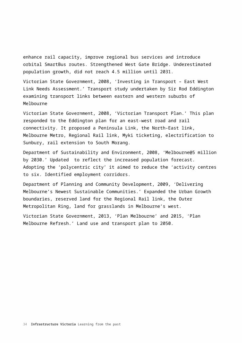
Victorian State Government, 2006, ‘Meeting our Transport Challenges.’ Followed a ten year plan which aimed to provide additional trains, enhance rail capacity, improve regional bus services and introduce orbital SmartBus routes. Strengthened West Gate Bridge. Underestimated population growth, did not reach 4.5 million until 2031.
Victorian State Government, 2008, ‘Investing in Transport – East West Link Needs Assessment.’ Transport study undertaken by Sir Rod Eddington examining transport links between eastern and western suburbs of Melbourne
Victorian State Government, 2008, ‘Victorian Transport Plan.’ This plan responded to the Eddington plan for an east-west road and rail connectivity. It proposed a Peninsula Link, the North-East link, Melbourne Metro, Regional Rail link, Myki ticketing, electrification to Sunbury, rail extension to South Morang.
Department of Sustainability and Environment, 2008, ‘Melbourne@5 million by 2030.’ Updated to reflect the increased population forecast. Adopting the ‘polycentric city’ it aimed to reduce the ‘activity centres to six. Identified employment corridors.
Department of Planning and Community Development, 2009, ‘Delivering Melbourne’s Newest Sustainable Communities.’ Expanded the Urban Growth boundaries, reserved land for the Regional Rail link, the Outer Metropolitan Ring, land for grasslands in Melbourne’s west.
Victorian State Government, 2013, ‘Plan Melbourne’ and 2015, ‘Plan Melbourne Refresh.’ Land use and transport plan to 2050.
25 Infrastructure Victoria Learning from the past

Aerial photograph of Southbank, 1967
Aerial photograph of Southbank, 2000s
26 Infrastructure Victoria Learning from the past

Regional VictoriaRegional Victoria has a long history of state and region infrastructure investments which have come about through long-term strategic planning with relevant agencies. The State Rivers and Water Supply Commission early twentieth century damn construction program and expansion of irrigation districts is currently being modernised by the Water Authorities. Military airports established during World War Two are being developed by municipalities assisted by Commonwealth funds. Investments are being made in port upgrades, notably in Geelong and Portland, to support exports and industry.55
The twenty first century has also seen a greater focus on planning infrastructure for Victoria’s regions. In 2014, eight Regional Growth Plans were developed in partnership between local government and the state government, focusing largely on land use. Each plan was aligned to the objectives detailed in Plan Melbourne in that they sought to: deliver a permanent boundary around Melbourne rebalance Victoria’s population growth from Melbourne to rural and regional Victoria integrate metropolitan, peri-urban and regional planning implementation.56
Regional Development Victoria’s plans considered environmental social, economic and transport infrastructure. From 2006-2007, the five G21 municipalities (Greater City of Geelong, Colac Otway shire, Surf Coast Shire, Borough of Queenscliff and the southern portion of Golden Plains Shire) collaborated with the state government, peak bodies and environmental, community and business organisations from across the region. The 2006 G21 Geelong Regional Plan attempted to identify and address the environmental, settlement, land use, community and economic challenges. It was followed by the 2013 G21 Growth Plan released by the Victorian Planning Minster in 2013 and the G21 Economic Development Strategy, which was adopted by the G21 Board in 2014.
27 Infrastructure Victoria Learning from the past
CONCLUSION
It is important to consider the past when planning for the future. All planners have faced an uncertain future, highlighted in the first half of the twentieth century when the Great Depression and Second World War temporarily halted both the planning and building of infrastructure in Victoria. Since then, generations of planners have produced a body of strategic plans, schemes and reports. We can draw lessons from this legacy when making strategic decisions about the future of Victoria’s infrastructure landscape.
Some of the plans have endured on account of their breadth, depth and lasting impact on Victoria’s infrastructure. The planners responsible for both the 1929 Plan for General Development and the 1954 Melbourne Metropolitan Planning Scheme responded to the challenges of providing essential infrastructure by compiling and analysing data, which in turn provided a solid basis for longer term planning. A number of recommendations, such as the City Loop (1929) and the concept of growth corridors (1954) were realised in the proceeding decades.
These early plans have also endured as a result of their approach to integrated planning. Although the 1929 plan was never fully implemented, it sought to integrate town planning and transport with open space and recreation. This concept was adopted and expanded upon twenty-five years later in 1954 Melbourne Metropolitan Planning Scheme, which aimed to integrate transport with education and culture, health and recreation. The 1954 scheme began the planning system for Melbourne. Infrastructure Victoria’s 30- year strategy will consider opportunities that will encourage the close alignment of infrastructure and land use planning.
Estimating population growth has been integral to Victoria’s planners. Not all estimations however, have been accurate. The 1954 scheme underestimated growth following the end of the Second World War and the baby boom (see Figure 8 for Victoria’s long term population story). This had repercussions in the following decades, as the government attempted to provide infrastructure for a greater number of people than it had planned for.
The 2002 Melbourne 2030 plan for an extra million people in Melbourne was soon overtaken by a population boom, resulting in the publication of Melbourne@5 million just six years later, which, while adhering to Melbourne 2030’s fundamentals (such as the Urban Growth Boundary) sought to add new growth areas and simplify the polycentric structure proposed in Melbourne @ 5 million by 2030. In contrast, population growth, or at least the time that the growth took to be realised, was overestimated in the 1971 Planning Policies. This was ultimately advantageous for planners in the 1980s and 1990s as it allowed them to take a longer-term view.
28 Infrastructure Victoria Learning from the past

Figure 8: Population Growth, 1852-2014
Infrastructure planning should receptive to new technologies and unforeseen opportunities as well as being open to sectorial perspectives and investments. Victoria has benefited from a transformation in telecommunications networks including the high capacity cable networks, the City Loop, city shaping investment and the West Gate Bridge which changed the shape of the city. The best plans therefore, are not only flexible but also take into account unexpected events and the likelihood that projections about the future will be wrong, whether it be estimating or underestimating population growth. Melbourne 2030 dealt with this issue by not forecasting a specific year when Melbourne would grow by an additional 1 million people.
As demonstrated in Figure 8, Infrastructure Victoria recognises that in less than a decade, the projections for Victoria’s population have been revised up from 8.0 million to 9.4 million, reflecting higher birth and migration rates. With this in mind, Infrastructure Victoria will consider different near term and long-term scenarios and will tailor recommendations accordingly.
Public consultation and support for plans is important. While the 1971 Planning Policies and the 2002 Melbourne 2030 were released to the public, a common objection was a lack of community ownership. This was more in opposition to some of the plan’s proposals about higher density than to the lack of a consultation program, which was, in fact, extensive. IV recognises that it is not only a valuable exercise to consult with the public but also advantageous to seek wide consensus. Infrastructure Victoria will not only publish regular updates and run workshops and forums, but will
29 Infrastructure Victoria Learning from the past

conduct an extensive consultation with the community throughout 2016. Beginning with an online consultation and face-to-face workshops, the community will set objectives and identify needs. This will be followed by a consultation on options to meet these needs. Towards the end of 2016, there will be an opportunity for the public to comment on the draft strategy, prior to its finalisation and release.
Most plans have been project focused. While it is important to have this vision and prioritise, IV will take a deliberate approach of also considering options such as policy changes and better use of existing infrastructure.
Finally, the major strategic plans to date have tended to focus on Melbourne and its metropolitan area. They have also been concerned with a particular sector or sectors such as transport or urban planning. Whilst regional Victoria has benefited from a series of recent development plans, a strategic, state-wide strategy which integrates energy, water, transport, education, justice, culture, science and IT infrastructure has yet to be published. Melbourne and Victoria must be understood and planned for in terms of interaction rather than isolation. IV’s 30-year strategy will recognise the infrastructure needs of all Victorians.
30 Infrastructure Victoria Learning from the past
BIBLIOGRAPHY
Australian Bureau of Statistics, http://www.abs.gov.au
Australian Government Productivity Commission, Public Infrastructure Report, vol. 2, 2014.
Baker D., and Freestone, R., Reconciling Public and Private Interests in the Planning and Development of Airports: The Australian Experience 1995-2008, School of Urban Development Queensland University of Technology, 2008.
Beed, C., Melbourne’s Development & Planning, Melbourne, Victoria, Clewara Press, 1981.
Department of Infrastructure and Regional Development,The Evolution of Australian Towns, Report 136. Canberra, 2014.
Butlin, N.G., Investment in Australian Economic Development, Canberra, Department of Economic History, Research school of Social Sciences, ANU, 1964.
Daley, J., et al., Investing in Regions: Making a Difference, Grattan Institute, Report No.2011-4, Melbourne, 2011.
David, A., ‘Path dependence -a foundational concept for historical social science’, Cliometrica, Journal of Historical Economics and Econometric History, vol.1, No.2, 2007, pp.91–114.
Davison, G., The Rise and Fall of Marvellous Melbourne, Carlton, Victoria, Melbourne University Press, 1978.
Davison, G., How the Car Won Our Hearts and Conquered Our Cities, NSW, Allen & Unwin, 2004.
Department of Infrastructure and Regional Development, State of Australian Cities 2014-2015. Progress in Australian Regions, 2015
Department of Planning and Community Development, Managing Melbourne: Review of Melbourne Metropolitan Region, April 2012
Doyle, H., et al., Victorian Water Supply Heritage Study, Thematic Environmental History, vol.1, Melbourne, Context, 2007
Hamnett S., and Freestone R., (eds) The Australian Metropolis, NSW, Allen & Unwin, 2000
Gleeson, B. et al., Australian Urban Planning. New Challenges, New Agendas , St Leonards, NSW, Allen & Unwin, 2000
Gleeson B., and Beza B.,(eds) The Public City. Essays in Honour of Paul Mees, Carlton, Victoria, Melbourne University Press, 2014
Government of Victoria, Progress Report from the Joint Selection Committee on the Housing of the People in the Metropolis together with Minutes and Appendix, 19th December, 1913
Grabosky, P., Wayward Government :Illegality and its Control in the Public Sector, Canberra, Australian Institute of Criminology, 1989
31 Infrastructure Victoria Learning from the past

Lee, R., The Railways of Victoria. 1854-2004, Carlton, Victoria, Melbourne University Press, 2007
Logan, T., Urban and Regional Planning in Victoria; Analysis and Policy Issues, Malvern, Victoria, Sorrett, 1981
Newman, P., and Thornley, A., Planning World Cities. Globalisation and Urban Politics, Basingstoke, UK, Palgrave Macmillan, 2011
Maccallum, D., and Hopkins, D., ‘The Changing Discourse of City Plans: Rationalities of Planning in Perth, 1955–2010,’ Planning Theory & Practice, Vol 12:4, pp. 485-510
Macintyre, S., et al., The Cambridge History of Australia, Melbourne, Cambridge University Press, 2013
Mares, P., Can we afford to get out cities back on the rails? Melbourne, Grattan Institute, 2012
McLoughlin, J. B., Shaping Melbourne’s Future, Melbourne, Cambridge University Press, 1992
Mees, P., A Very Public Solution. Transport in the Dispersed City, Melbourne, Melbourne University Press, 2000
Mees, P., ‘What happened to the systems approach? Evaluation of alternatives in planning for major transport projects’, 26th Australasian Transport Research Forum, Wellington, New Zealand, 1-3 October 2003, p. 1
Moran, A., The Tragedy of Planning. Losing the Great Australian Dream, Melbourne, Institute of Public Affairs, 2006
Melbourne Metropolitan Board of Works, 1929 Plan for General Development
Melbourne Metropolitan Board of Works, 1954 Melbourne Metropolitan Planning Scheme
Neilson, L., The ‘Building Better Cities’ program 1991-96: a nation-building initiative of the Commonwealth Government, in Butcher, J., Australia Under Construction – Nation Building Past Present and Future, Canberra ,ANU, EPress, 2008
Progress Report from the Joint Selection Committee on the Housing of the People in the Metropolis together with Minutes and Appendix , 19th December, 1913
Prud’homme, R., Infrastructure and development, Paper prepared for the Annual Bank Conference on Development Economics, May 3–5, Washington, 2004
Salt, B., The Big Shift: Welcome to the third Australian Culture: the Bernard Salt report, South Yarra, Victoria, Hardie Grant Books, 2003
Stretton, H., Ideas for Australian Cities, Sydney, NSW, Transit Australia, 1989
Tonts, M., ‘The restructuring of Australia’s rural communities’, in Land of discontent: the dynamics of change in rural and regional Australia, Pritchard, B and McManus, P (eds). Sydney, NSW, University of New South Wales Press, 2000
Troy, P. N., The structure and form of the Australian city: prospects for improved urban planning, Urban Policy Program, Issues Paper 1, Brisbane, Griffith University, 2004
32 Infrastructure Victoria Learning from the past

ENDNOTES
33 Infrastructure Victoria Learning from the past
1 Department of Infrastructure and Regional Development, State of Australian Cities 2014-2015. Progress in Australian Regions, 2015 p. 322 The City Past and Present, Retrieved 5 January 2016 from http://www.emelbourne.net.au.3 Robert Hoddle’s Grid and the Birth of Melbourne, Interview with architectural Historian, Miles Lewis, Retrieved 5 January 2016 from http://www.abc.net.au.4 Macintyre, S., et al., The Cambridge History of Australia, Melbourne, Cambridge University Press, 2013, p. 201.5 Davison, G., The Rise and Fall of Marvellous Melbourne, Carlton, Melbourne University Press, 1978, p.72.6 Macintyre, The Cambridge History of Australia, p, 189.7 Moran, A., The Tragedy of Planning. Losing the Great Australian Dream, Melbourne, Institute of Public Affairs, 2006, p. 18.8 Australian Bureau of Statistics, Australian Historical Population Statistics, 2014, 3. Population Distribution,. 3.3. Population, urban and rural split, states and territories, 30 June 1901 to 2011, Retrieved on 12 January 2016 from http://www.abs.gov.au9 Doyle, H., et al., Victorian Water Supply Heritage Study, Thematic Environmental History, Vol.1, Melbourne, Context, 2007, p. 36.10 McCormack, William Thomas Bartholomew, Retrieved on 13 January 2016 fromhttp://adb.anu.edu.au11 Bureau of Infrastructure, Transport and Regional Economics, Report 136. The Evolution of Australian Towns, 2014, p. 15812 Mares, P., Can we afford to get out cities back on the rails? Melbourne, Grattan Institute, 201213 IV calculations based on Retail Price index developed by the Australian Bureau of Statistics14 Government of Victoria, Progress Report from the Joint Selection Committee on the Housing of the People in the Metropolis together with Minutes and Appendix, 19th December, 191315 The City Past and Present, Retrieved 5 January 2016 from http://www.emelbourne.net.au 16 Mees, P., A Very Public Solution. Transport in the Dispersed City, Melbourne, Melbourne University Press, 2000, p. 170.17 Melbourne Metropolitan Board of Works, 1929 Plan for General Development, p. 1, Retrieved 7 February 2016 from http://www.dtpli.vic.gov.au/18 Ibid., p. 18719 The Great Depression, Retrieved on 8 January 2016 from http://www.australia.gov.au/20 IV calculations based on Retail Price index developed by the Australian Bureau of Statistics21 The Great Depression, Retrieved on 8 January 2016 from http://www.australia.gov.au/22 Public Record Office Victoria, Agency VA 516 Town and Country Planning Board, Retrieved on 28 December 2015 from http://access.prov.vic.gov.au/23 Australian Bureau of Statistics, Australian Historical Population Statistics, 2014, 3. Population Distribution,. 3.3. Population, urban and rural split, states and territories, 30 June 1901 to 2011, Retrieved on 8 February 2016 from http://www.abs.gov.au/24 Department of Transport, Planning and Local Infrastructure, Planning for Melbourne. Melbourne’s Strategic Planning History, Retrieved 27 December 2015 from http://www.dtpli.vic.gov.au.25 Australian Bureau of Statistics, Australian Historical Population Statistics, 2014, 3. Population Distribution,. 3.3. Population, urban and rural split, states and territories, 30 June 1901 to 2011, Retrieved 18 January 2916 from http://www.abs.gov.au/26 http://www.monash.vic.gov.au/About-Us/Monash-Heritage/Detailed-History/1946-1995/4.-Pattern-of-Subdivision27 Mares, Can we afford to get our cities back on the rails?28 Melbourne Metropolitan Board of Works, 1954 Melbourne Metropolitan Planning Scheme, p. 1, Retrieved 7 February 2016 from http://www.dtpli.vic.gov.au/29 McLoughlin, J. B., Shaping Melbourne’s Future, Melbourne, Cambridge University Press, 1992, p. 40.30 Ibid., p. 44.31 Morrison, I., ‘The corridor city; planning for growth in the 1960s’ in S. Hamnett and R. Freestone (eds.), The Australian Metropolis, NSW, Allen & Unwin, 2000, p. 125.32 Mees, P., ‘What happened to the systems approach? Evaluation of alternatives in planning for major transport projects’, 26th Australasian Transport Research Forum, Wellington, New Zealand, 1-3 October 2003, p. 133 Australian Government Productivity Commission, Public Infrastructure Report, vol 2 (2014) , p. 64334 McLoughlin, Shaping Melbourne’s Future, p. 50.35 Australian Bureau of Statistics, Australian Historical Population Statistics, 2014, 3. Population Distribution,. 3.3. Population, urban and rural split, states and territories, 30 June 1901 to 2011. Retrieved on 22 December 2015 from36 Grabosky, P., Wayward Government :Illegality and its Control in the Public Sector, Canberra, Australian Institute of Criminology, 1989, p. 197.

37 Australian Bureau of Statistics, Australian Historical Population Statistics, 2014, 3. Population Distribution,. 3.3. Population, urban and rural split, states and territories, 30 June 1901 to 2011, Retrieved on 28 December 2015 from http://www.abs.gov.au/38 Department of Planning and Community Development, Managing Melbourne: Review of Melbourne Metropolitan Region, Melbourne, 2012, p. 18.39 McLoughlin, Shaping Melbourne’s Future, p. 53.40 Ibid., p. 54.41 Victoria. Town and Country Planning Board, Retrieved on 22 December 2015 from http://trove.nla.gov.au/42 Managing Melbourne: Review of Melbourne Metropolitan Strategic Plans, p. 38.43 Australian Bureau of Statistics, Australian Historical Population Statistics, 2014, 3. Population Distribution, 3.3. Population, urban and rural split, states and territories, 30 June 1901 to 2011, Retrieved on January 4 2016 from http://www.abs.gov.au/44 Mares, Can we afford to get out cities back on the rails? 45 Managing Melbourne: Review of Melbourne Metropolitan Strategic Plans, p. 29.46 Australian Bureau of Statistics, Australian Historical Population Statistics, 2014, 3. Population Distribution,. 3.3. Population, urban and rural split, states and territories, 30 June 1901 to 2011, Retrieved on 28 December 2015 from http://www.abs.gov.au/47 Neilson, L., The ‘Building Better Cities’ program 1991-96: a nation-building initiative of the Commonwealth Government, in Butcher, John, Australia Under Construction – nation building past present and future, Canberra ANU E Press, 2008.48 Managing Melbourne: Review of Melbourne Metropolitan Strategic Plans, p. 30.49 Government of Victoria, 1995 Living Suburbs, Retrieved on January 6 2016 from http://www.dtpli.vic.gov.au/50 Australian Bureau of Statistics, Australian Historical Population Statistics, 2014, 3. Population Distribution,. 3.3. Population, urban and rural split, states and territories, 30 June 1901 to 2011, Retrieved on 28 December 2015 from http://access.prov.vic.gov.au.51 Mares, Can We Afford to Get Our City Back on the Rails?52 Ibid 53 Government of Victoria, Melbourne 2030 Audit Expert Group Report, March 2008 p.1754 Government of Victoria Melbourne 2030. Planning for Sustainable Growth, Initiative 8.2.1, Retrieved 7 February 2016 from http://www.dtpli.vic.gov.au/55 Baker D., & Freestone, R., Reconciling Public and Private Interests in the Planning and Development of Airports: The Australian Experience 1995-2008, School of Urban Development Queensland University of Technology, 2008, p. 356 Government of Victoria, Plan Melbourne, Retrieved 7 February 2016 from http://www.planmelbourne.vic.gov.au/Plan-Melbourne