Vocabulary Preview. Physical Features A physical feature is a type of land or waterway.

INTERNATIONAL HYDROGRAPHIC ORGANIZATION
IHO GEOSPATIAL STANDARDFOR MARINE TRAFFIC MANAGEMENT
Edition 1.0.0
Release Candidate 1
December 2018
Special Publication No. S-127
Marine Traffic Management - Product Specification
Published by the International Hydrographic Organization
MONACO

II

© Copyright International Hydrographic Organization December 2018
This work is copyright. Apart from any use permitted in accordance with the Berne Convention for the Protection of Literary and Artistic Works (1886), and except in the circumstances described below, no part may be translated, repro-duced by any process, adapted, communicated or commercially exploited without prior written permission from the International Hydrographic Organization Secretariat (IHO Secretariat). Copyright in some of the material in this publica-tion may be owned by another party and permission for the translation and/or re-production of that material must be obtained from the owner.
This document or partial material from this document may be translated, repro-duced or distributed for general information, on no more than a cost recovery basis. Copies may not be sold or distributed for profit or gain without prior written agreement of the IHO Secretariat acting for the IHO and any other copyright holders.
In the event that this document or partial material from this document is repro-duced, translated or distributed under the terms described above, the following statements are to be included:
“Material from IHO publication [reference to extract: Title, Edition] is repro-duced with the permission of the International Hydrographic Organization Secretariat (IHO Secretariat) (Permission No ……./…) acting for the Interna-
tional Hydrographic Organization (IHO), which does not accept responsibility for the correctness of the material as reproduced: in case of doubt, the IHO’s authentic text shall prevail. The incorporation of material sourced from IHO
shall not be construed as constituting an endorsement by IHO of this product.”
“This [document/publication] is a translation of IHO [document/publication] [name]. The IHO has not checked this translation and therefore takes no re-sponsibility for its accuracy. In case of doubt the source version of [name] in [language] should be consulted.”
The IHO Logo or other identifiers shall not be used in any derived product without prior written permission from the IHO Secretariat.
III

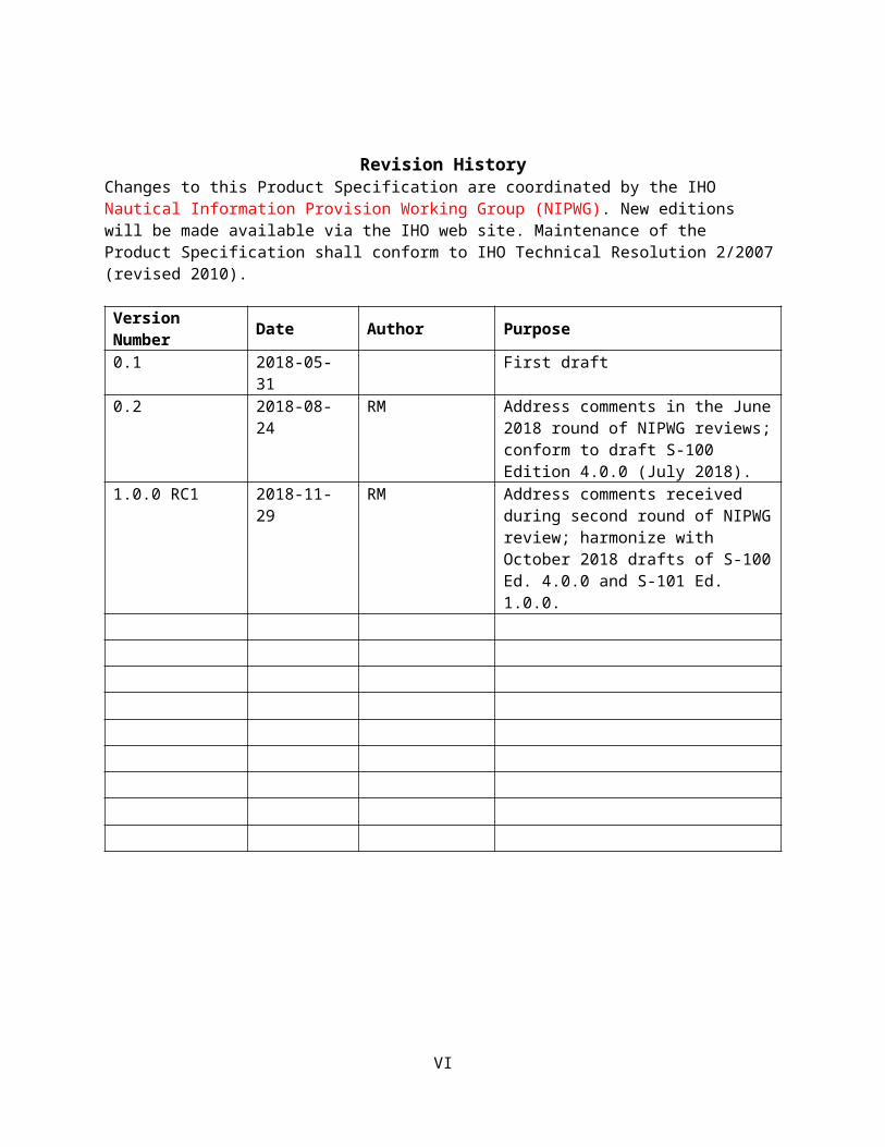
Revision HistoryChanges to this Product Specification are coordinated by the IHO Nautical Information Provision Working Group (NIPWG). New editions will be made available via the IHO web site. Maintenance of the Product Specification shall conform to IHO Technical Resolution 2/2007 (revised 2010).
Version Number Date Author Purpose0.1 2018-05-31 First draft
0.2 2018-08-24 RM Address comments in the June 2018 round of NIPWG reviews; conform to draft S-100 Edition 4.0.0 (July 2018).
1.0.0 RC1 2018-11-29 RM Address comments received during second round of NIPWG review; harmonize with October 2018 drafts of S-100 Ed. 4.0.0 and S-101 Ed. 1.0.0.
IV

TABLE OF CONTENTS
1 Overview.........................................................................................................................................................1.1 INTRODUCTION......................................................................................................................................
2 References.....................................................................................................................................................2.1 NORMATIVE...........................................................................................................................................2.2 INFORMATIVE.........................................................................................................................................
3 Terms, Definitions and Abbreviations.........................................................................................................3.1 TERMS AND DEFINITIONS.......................................................................................................................3.2 ABBREVIATIONS.....................................................................................................................................3.3 USE OF LANGUAGE................................................................................................................................3.4 UML NOTATIONS...................................................................................................................................
4 Specification Description..............................................................................................................................4.1 INFORMAL DESCRIPTION OF DATA PRODUCT...........................................................................................4.2 DATA PRODUCT SPECIFICATION METADATA..............................................................................................4.3 PRODUCT SPECIFICATION MAINTENANCE................................................................................................
4.3.1 Introduction............................................................................................................................. 64.3.2 New Edition............................................................................................................................. 64.3.3 Revisions................................................................................................................................ 64.3.4 Clarification............................................................................................................................. 64.3.5 Version Numbers....................................................................................................................7
4.4 SPECIFICATION SCOPE..........................................................................................................................
5 Data product identification...........................................................................................................................6 Data Content and Structure..........................................................................................................................
6.1 INTRODUCTION......................................................................................................................................6.2 APPLICATION SCHEMA.........................................................................................................................
6.2.1 Domain model....................................................................................................................... 106.2.2 Meta features........................................................................................................................ 376.2.3 Spatial quality information type.............................................................................................386.2.4 Cartographic features...........................................................................................................39
7 Feature Catalogue.......................................................................................................................................7.1.1 Introduction........................................................................................................................... 39
7.2 FEATURE TYPES..................................................................................................................................7.2.1 Geographic........................................................................................................................... 407.2.2 Meta...................................................................................................................................... 407.2.3 Feature Relationship.............................................................................................................407.2.4 Information Types................................................................................................................. 407.2.5 Attributes............................................................................................................................... 40
7.3 COMPLEX ATTRIBUTES.........................................................................................................................7.4 UNITS OF MEASURE.............................................................................................................................7.5 GEOMETRIC REPRESENTATION.............................................................................................................
8 Coordinate Reference System (CRS).........................................................................................................8.1.1 Introduction........................................................................................................................... 438.1.2 Horizontal reference system.................................................................................................438.1.3 Projection.............................................................................................................................. 438.1.4 Vertical coordinate reference system....................................................................................438.1.5 Temporal reference system..................................................................................................438.1.6 Marine Traffic Management data and scale..........................................................................44
9 Data Quality..................................................................................................................................................9.1 INTRODUCTION....................................................................................................................................
9.2 QUALITY MEASURE ELEMENTS..............................................................................................................9.3 TEST METHODS...................................................................................................................................
9.3.1 Accuracy computations.........................................................................................................479.4 DATA QUALITY TESTING AND REPORTING...............................................................................................
10 Data Capture and Classification.............................................................................................................10.1 DATA ENCODING AND PRODUCT DELIVERY.......................................................................................
10.1.1 Data Encoding...................................................................................................................... 4910.1.2 Types of Datasets................................................................................................................. 4910.1.3 Content of Update Datasets..................................................................................................49
10.2 ENCODING OF LATITUDE AND LONGITUDE..........................................................................................10.2.1 Encoding of coordinates as decimals....................................................................................50
10.3 NUMERIC ATTRIBUTE ENCODING.......................................................................................................10.4 TEXT ATTRIBUTE VALUES.................................................................................................................10.5 MANDATORY ATTRIBUTE VALUES......................................................................................................10.6 UNKNOWN ATTRIBUTE VALUES.........................................................................................................10.7 STRUCTURE OF DATASET FILES.........................................................................................................
10.7.1 Sequence of objects.............................................................................................................5110.8 OBJECT IDENTIFIERS........................................................................................................................10.9 DATA COVERAGE.............................................................................................................................10.10 DATA OVERLAP................................................................................................................................10.11 DATA QUALITY.................................................................................................................................10.12 DATA EXTENT..................................................................................................................................
11 Data Delivery............................................................................................................................................11.1 DATA PRODUCT DELIVERY INFORMATION..............................................................................................
11.1.1 Dataset loading..................................................................................................................... 5211.1.2 New editions......................................................................................................................... 53
11.2 DATASET SIZE.....................................................................................................................................11.3 EXCHANGE SET...................................................................................................................................11.4 SUPPORT FILES...................................................................................................................................11.5 SUPPORT FILE NAMING CONVENTION...................................................................................................11.6 DATASET NAMING CONVENTION...........................................................................................................11.7 UPDATE DATASET NAMING CONVENTION................................................................................................11.8 CATALOGUE FILE NAMING CONVENTION...............................................................................................
12 Data Maintenance.....................................................................................................................................12.1 INTRODUCTION.................................................................................................................................12.2 PRODUCTION PROCESS FOR BASE AND UPDATE DATASETS.................................................................12.3 DATASET UPDATES AND CANCELLATION.............................................................................................12.4 SUPPORT FILE UPDATES...................................................................................................................12.5 FEATURE AND PORTRAYAL CATALOGUES...........................................................................................12.6 FEATURE HISTORY, VERSIONS, AND CHANGE TRACKING.....................................................................12.7 DATASET ENCRYPTION.....................................................................................................................
13 Portrayal...................................................................................................................................................14 Metadata...................................................................................................................................................
14.1 INTRODUCTION.................................................................................................................................14.2 DATASET METADATA........................................................................................................................
14.2.1 Metadata for new datasets and new editions........................................................................6014.2.2 Update and cancellation dataset metadata...........................................................................62
14.3 SUPPORT FILE METADATA.................................................................................................................14.4 EXCHANGE SET CATALOGUE AND METADATA.....................................................................................
14.4.1 Exchange catalogue file........................................................................................................6514.5 METADATA ABOUT FEATURE AND OTHER CATALOGUES.......................................................................
15 Appendix D-1. GML Data Format Overview...........................................................................................

1 Overview1.1 IntroductionThis document has been produced by the IHO Nautical Information Provision Working Group (NIPWG) in response to a requirement to produce a data product that can be used as a Nautical Publication Information Overlay (NPIO) within an Electronic Chart Display and Information Systems (ECDIS). It is based on the IHO S-100 framework specification and the ISO 19100 series of standards. It is a vector product specification that is primarily intended for encoding the extent and nature of Marine Traffic Management, for navigational purposes.Marine Traffic Management (MTM) datasets describe the availability and reliability of vessel traf-fic services, pilotage, routing measures, and ship reporting systems. This includes their service areas, services offered, and instructions for contacting or utilizing these services. MTM is in-tended to be a supplement to ENC, and therefore does not describe the geographic information in detail equal to ENC, rather it is shown as a simplified geometry to indicate location, and to be a means of geolocating more regulatory information than the typical ENC.
2 References2.1 NormativeThe following normative documents contain provisions that, through reference in this text, constitute provisions of this document.
IHO S-100 IHO Universal Hydrographic Data Model Edition 4.0.0 (December 2018).
ISO 639-2/T Codes for the representation of names of languages – Part 2: Alpha-3 code
ISO 8601:2004. Data elements and interchange formats - Information interchange - Representation of dates and times. 2004.
ISO 3166-1. 1997. Country Codes. 1997.
ISO/TS 19103:2005 Geographic Information - Conceptual schema language
ISO 19106:2004 Geographic Information – Profiles
ISO 19107:2003 Geographic Information – Spatial schema
ISO 19109:2005 Geographic Information - Rules for Application Schema
ISO 19111:2003 Geographic Information - Spatial referencing by coordinates
ISO 19115-1 Geographic information – Metadata – Part 1 - Fundamentals. As amended by Amendment 01 (2018)
ISO/TS 19115-3 Geographic information - Metadata - XML schema implementation for fundamental concepts
ISO 19131:2007 Geographic Information - Data product specifications
ISO 19136:2007 Geographic Information – Geography Markup Language
ISO 19136-2:2015, Geographic Information – Geography Markup Language.
1

2.2 InformativeThe following informative documents provide additional information, including background information, but are not required to develop applications for data conforming to this specification.
ISO/IEC 19757-3, Information technology – Document Schema Definition Languages (DSDL) – Part 3: Rule-based validation – Schematron.
IHO S-101 IHO Electronic Navigational Chart Product Specification Edition 1.0.0 (December 2018).
ISO 19115:2006 ISO 19115:2003 Geographic Information – Metadata. As amended by Amendment 1 (2006).
IHO S-97 IHO Guideline for creating S-100 product specifications – Part C. (Draft 0.2, August 2018).
3 Terms, definitions, and abbreviations3.1 Terms and definitionsThe S-100 framework is based on the ISO 19100 series of geographic standards. The terms and definitions provided here are used to standardize the nomenclature found within that framework, whenever possible. They are taken from the references cited in clause 2.1. Modifications have been made when necessary.
applicationmanipulation and processing of data in support of user requirements (ISO 19101)
application schemaconceptual schema for data required by one or more applications (ISO 19101)
conceptual modelmodel that defines concepts of a universe of discourse (ISO 19101)
conceptual schemaformal description of a conceptual model (ISO 19101)
coveragefeature that acts as a function to return values from its range for any direct position within its spatial, temporal or spatiotemporal domain (ISO 19123)EXAMPLE Raster image, polygon overlay, digital elevation matrix.
data productdataset or dataset series that conforms to a data product specification
data product specificationdetailed description of a dataset or dataset series together with additional information that will enable it to be created, supplied to, and used by another partyNOTE: A data product specification provides a description of the universe of discourse and a specification for mapping the universe of discourse to a dataset. It may be used for production, sales, end-use, or other purpose.
2
datasetidentifiable collection of data (ISO 19115:2006)NOTE: A dataset may be a smaller grouping of data which, though limited by some constraint such as spatial extent or feature type, is located physically within a larger dataset. Theoretically, a dataset may be as small as a single feature or feature attribute contained within a larger dataset. A hardcopy map or chart may be considered a dataset.
dataset seriescollection of datasets sharing the same product specification (ISO 19115:2006)
domainwell-defined set (ISO/TS 19103)NOTE: Well-defined means that the definition is both necessary and sufficient, as everything that satisfies the definition is in the set and everything that does not satisfy the definition is necessarily outside the set.
featureabstraction of real world phenomena (ISO 19101)NOTE: A feature may occur as a type or an instance. Feature type or feature instance shall be used when only one is meant.
feature associationrelationship that links instances of one feature type with instances of the same or a different feature type (ISO19110)NOTE 1; A feature association may occur as a type or an instance. Feature association type or feature association instance is used when only one is meant.NOTE 2: Feature associations include aggregation of features.
feature attributecharacteristic of a feature (ISO 19101)NOTE 1: A feature attribute may occur as a type or an instance. Feature attribute type or feature attribute instance is used when only one is meant.NOTE 2: A feature attribute type has a name, a data type and a domain associated to it. A feature attribute for a feature instance has an attribute value taken from the domain.
geographic datadata with implicit or explicit reference to a location relative to the Earth (ISO 19109)NOTE: Geographic information is also used as a term for information concerning phenomena implicitly or explicitly associated with a location relative to the Earth.
metadatadata about data (ISO 19115:2006)
modelabstraction of some aspects of reality (ISO 19109)
portrayalpresentation of information to humans (ISO 19117)
quality
3

totality of characteristics of a product that bear on its ability to satisfy stated and implied needs (ISO 19101)
universe of discourseview of the real or hypothetical world that includes everything of interest (ISO 19101)
3.2 Abbreviations
This product specification adopts the following convention for symbols and abbreviated terms:
ASCII American Standard Code for Information InterchangeECDIS Electronic Chart Display and Information SystemsENC Electronic Navigational ChartGML Geography Markup LanguageIHO International Hydrographic OrganizationIOC International Oceanographic CommissionISO International Organization for StandardizationJPEG Joint Photographic Experts GroupMTM Marine Traffic ManagementNIPWG Nautical Information Provision Working GroupNPIO Nautical Publication Information OverlayPNG Portable Network GraphicsSVG Scalable Vector graphicsTIFF Tagged Image File FormatUML Unified Modelling LanguageURI Uniformed Resource IdentifierURL Uniform Resource LocatorWGS World Geodetic SystemXML eXtensible Markup LanguageXSD XML Schema DefinitionXSLT eXtensible Stylesheet Language Transformations
3.3 Use of languageWithin this document, including appendices and annexes:
• “Must” indicates a mandatory requirement.• “Should” indicates an optional requirement, that is the recommended process to be
followed, but is not mandatory.• “May” means “allowed to” or “could possibly”, and is not mandatory.
3.4 UML notationsIn this document, conceptual schemas are presented in the Unified Modelling Language (UML). Several model elements used in this schema are defined in ISO standards or in IHO S-100 documents. In order to ensure that class names in the model are unique ISO TC/211 has adopted a convention of establishing a prefix to the names of classes that define the TC/211 defined UML package in which the UML class is defined. The IHO standards and this product specification make use of classes derived directly from the ISO standards. This convention is also followed in this document. In the IHO standards class names are identified by the name of the standard, such as "S100" as the prefix optionally followed by the bi-alpha prefix derived from
4

ISO standard. In order to avoid having multiple classes instantiating the same root classes, the ISO classes and S-100 classes have been used where possible; however, a new instantiated class is required if there is a need to alter a class or relationship to prevent a reverse coupling between the model elements introduced in this document and those defined in S-100 or the ISO model.
4 Specification description4.1 Informal description of data productThis clause contains general information about the data product.
Title: Marine Traffic Management Product Specification.
Abstract: Marine Traffic Management (MTM) datasets describe the availability and reliability of vessel traffic services, pilotage, routing measures, and ship reporting systems. This includes their service areas, services offered, and instructions for contacting or utilizing these services. MTM is intended to be a supplement to ENC, and therefore does not describe the geographic information in detail equal to ENC, rather it is shown as a simplified geometry to indicate location, and to be a means of geolocating more regulatory information than the typical ENC.
Content: Datasets conforming to this specification will contain all relevant MTM information for the area of coverage. Additionally, there will be relevant metadata data quality, production authority, data sources, and publication date.
Spatial Extent: Global coverage of maritime areas.
Specific Purpose: Describing traffic management in the maritime domain for utilization in ECDIS, and to allow the producer to exchange marine traffic management information with interested stakeholders.
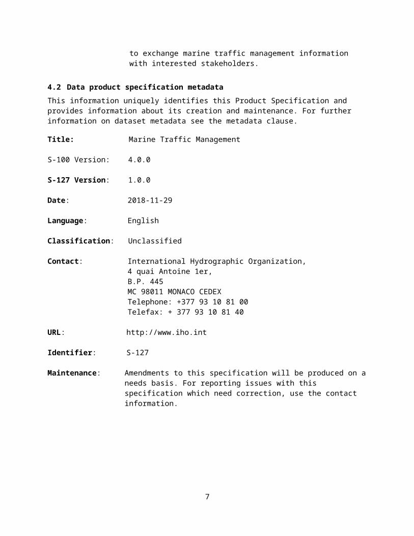
4.2 Data product specification metadataThis information uniquely identifies this Product Specification and provides information about its creation and maintenance. For further information on dataset metadata see the metadata clause.
Title: Marine Traffic Management
S-100 Version: 4.0.0
S-127 Version: 1.0.0
Date: 2018-11-29
Language: English
Classification: Unclassified
5

Contact: International Hydrographic Organization, 4 quai Antoine 1er,B.P. 445MC 98011 MONACO CEDEXTelephone: +377 93 10 81 00Telefax: + 377 93 10 81 40
URL: http://www.iho.int
Identifier: S-127
Maintenance: Amendments to this specification will be produced on a needs basis. For reporting issues with this specification which need correction, use the contact information.
4.3 Product specification maintenance4.3.1 IntroductionChanges to S-127 will be released by the IHO as a new edition, a revision, or as a document that includes clarification. These are described below.
4.3.2 New editionNew Editions introduce significant changes. New Editions enable new concepts, such as the ability to support new functions or applications, or the introduction of new constructs or data types. New Editions are likely to have a significant impact on either existing users or future users of S-127.
4.3.3 RevisionsRevisions are defined as substantive semantic changes. Typically, revisions will introduce change to correct factual errors; introduce necessary changes that have become evident as a result of practical experience or changing circumstances. A revision must not be classified as a clarification. Revisions could have an impact on either existing users or future users of this specification. All cumulative clarifications will be included with the release of approved corrections revisions.
Changes in a revision are minor and ensure backward compatibility with the previous versions within the same Edition. Newer revisions, for example, introduce new features and attributes. Within the same Edition, a dataset of one version could always be processed with a later version of the feature and portrayal catalogues. In most cases a new feature or portrayal catalogue will result in a revision of this specification.
4.3.4 ClarificationClarifications are non-substantive changes. Typically, clarifications: remove ambiguity; correct spelling, punctuation, or grammar errors; amend or update cross references; insert improved graphics. Clarification must not cause any substantive semantic changes.
6

Changes in a clarification are minor and ensure backward compatibility with the previous versions within the same Edition. Within the same Edition, a dataset of one clarification version could always be processed with a later version of the feature and portrayal catalogues, and a portrayal catalogue can always rely on earlier versions of the feature catalogues.
Changes in a clarification are minor and ensure backward compatibility with the previous versions.
4.3.5 Version numbersThe associated version control numbering to identify changes (n) to this specification must be as follows:
New Editions denoted as n.0.0Revisions denoted as n.n.0Clarifications denoted as n.n.n
4.4 Specification scopeThis product specification describes one data product and therefore requires only one scope which is described below:
Scope ID: Marine Traffic Management datasets.
Hierarchical level: MD_ScopeCode - 005 (dataset)
Hierarchical level name: MTM dataset
Level description: information applies to the dataset
Extent: EX_Extent.description: Global coverage of maritime areas
5 Data product identificationThis clause describes how to identify data sets that conform to the specification. A dataset that conforms to this Product Specification may be identified by its discovery metadata as defined in clause 12 of this specification. The information identifying the data product may include the following items from S-100 4.0.0 clause 11-6 (adapted from ISO 19115-1).
title Marine Traffic Management
abstract Marine Traffic Management dataset is a vector dataset containing all maritime navigationally relevant information regarding the traffic management within a defined geographical area.
alternate title MTM
content Marine Traffic Management information, such as the availability and reliability of vessel traffic services, pilotage, routing measures, and ship reporting systems. This includes their service areas, services offered, and instructions for
7
contacting or utilizing these services.
geographicDescription EX_GeographicDescription: E.g., official name of region
spatialResolution MD_Resolution>equivalentScale.denominator (integer) or MD_Resolution>levelOfDetail (CharacterString). E.g.: “All scales”
purpose Describing traffic management in the maritime domain for utilization in ECDIS, and to allow the producer to exchange Marine Traffic Management information with interested stakeholders.
language EN
Additional values, if any, use CharacterString values from ISO 639-2
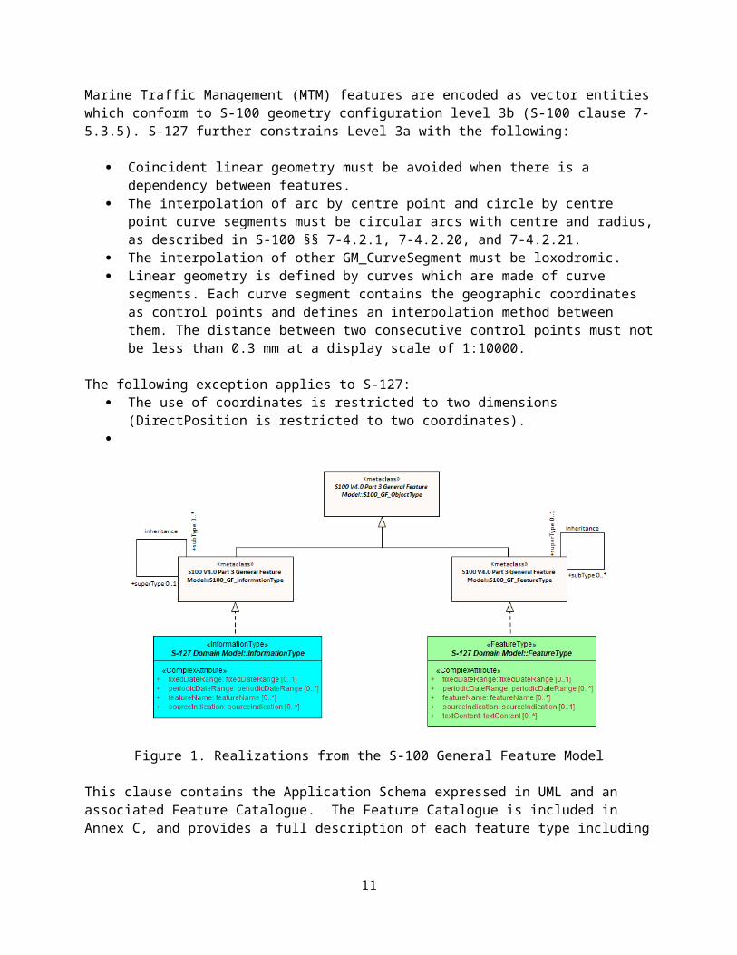
6 Data content and structure6.1 Introduction The S-127 product is based on the S-100 General Feature Model (GFM), and is a feature-based vector product. Figure 1 shows how the S-127 application schema is realized from the S-100 GFM. All S-127 features and information classes are derived from one of the abstract classes FeatureType and InformationType defined in the S-127 application schema, which realize the GFM meta-classes S100_GF_FeatureType and S100_GF_InformationType respectively.Marine Traffic Management (MTM) features are encoded as vector entities which conform to S-100 geometry configuration level 3b (S-100 clause 7-5.3.5). S-127 further constrains Level 3a with the following:
Coincident linear geometry must be avoided when there is a dependency between features.
The interpolation of arc by centre point and circle by centre point curve segments must be circular arcs with centre and radius, as described in S-100 §§ 7-4.2.1, 7-4.2.20, and 7-4.2.21.
The interpolation of other GM_CurveSegment must be loxodromic. Linear geometry is defined by curves which are made of curve segments. Each curve
segment contains the geographic coordinates as control points and defines an interpolation method between them. The distance between two consecutive control points must not be less than 0.3 mm at a display scale of 1:10000.
The following exception applies to S-127: The use of coordinates is restricted to two dimensions (DirectPosition is restricted to two
coordinates).
8

Figure 1. Realizations from the S-100 General Feature Model
This clause contains the Application Schema expressed in UML and an associated Feature Catalogue. The Feature Catalogue is included in Annex C, and provides a full description of each feature type including its attributes, attribute values, and relationships in the data product. Figure 2 shows an overview of the S-127 application schema.
Figure 2. S-127 Data model overview
The classes comprising the S-127 application schema are divided into three packages. The first package, the Domain model, contains the features and information types that model the MTM application domain specifically. Meta-features that provide quality and coverage information are contained within their own package. The last package is Cartographic Features, which allow dataset creators to provide cartographically necessary placements where required. Geographic features in all packages use the spatial types from S-100 Part 7, which are imported as-is into the S-127 spatial types package and therefore can be used as types for S-127 spatial attributes. The Geometry package also contains definitions of ‘union types’ (combinations of the S-100
9
spatial types). S-100 allows features to have different kinds of geometry, however UML does not allow an attribute of a class to have multiple types. The S-127 application schema models spatial attributes as attributes of feature classes.
6.2 Application schemaThe UML models in this clause are segments of the overall S-127 application schema, and include overviews of the feature classes, information classes, meta features, spatial types, and the relationships between them.
This clause contains a general overview of the classes and relationships in the S-127 application schema. Detailed information about how to use the feature types and information types to encode Marine Traffic Management information is provided in the S-127 Data Classification and Encoding Guide (DCEG).
The following conventions are used in the UML diagrams depicting the application schema:
Standard UML conventions for classes, associations, inheritance, roles, and multiplicities apply. These conventions are described in Part 1 of S-100.
Italic font for a class name indicates an abstract class. Feature classes are depicted with green background; the dark shade for abstract feature
classes and the light shade for ordinary (non-abstract) feature classes. Information type classes are depicted with blue background; the dark shade for abstract
information type classes and the light shade for ordinary information types. Association classes are depicted with a white background. Complex attributes are depicted with a pink background. Enumeration lists and codelists are depicted with a tan background. The numeric code
corresponding to each listed value is shown to its right following an ‘=’ sign. No significance attaches to the colour of associations. (Complex diagrams may use
different colours to distinguish associations that cross one another.) Where the association role or name is not explicitly shown, the default rules for roles and
names apply:o The role name is ‘the<CLASSNAME>’ where <CLASSNAME> is the name of the
class to which that association end is linked.o The association name is ‘<CLASSNAME1>_<CLASSNAME2>’ where
<CLASSNAME1> is the source and <CLASSNAME2> the target. In case of a feature/information association the feature is the source. For feature/feature or information/information associations without explicit names the source/target are indicated by an arrowhead.
Subclasses inherit the attributes and associations of their superclasses at all levels, unless such inheritance is explicitly overridden in the subclass.
6.2.1 Domain modelThe S-127 domain model has two base classes (‘root classes’) from which all the domain-specific geographic features and information type classes are derived. The base classes are shown in Figure 3 below. The base class for geographic features is FeatureType and the base class for information types is InformationType. Each of the two base classes has a set of attributes which are therefore inherited by all domain-specific features. The approximate area features in S-127 are also derived from the geographic feature root class. Both base classes are abstract classes and do not have direct instances in S-127 data – instead, S-127 feature and
10

information type data objects are instantiations of a non-abstract class derived from one of these base classes.
S-127 meta- and cartographic features are not derived from these base classes – S-127 instead incorporates meta- and cartographic feature definitions originally prepared for S-101 in the interests of harmonization and interoperability with other S-100-based data products, especially S-101 ENCs.
Figure 3. Base classes in S-127 and their attributes
6.2.1.1 Overview of domain features and information typesMarine Traffic Management data products include tracks and routes, vessel traffic services, pilot services, underkeel clearance, and certain types of specially designated areas which affect ships routeing. It does not include protected areas, radio services (radio stations, NAVTEX, weather or ice forecasts, NAVAREAs, METAREAs, etc.), natural conditions, or harbour services. The broad categories of geographic features included in the S-127 domain are:
Tracks and routes, including IMO and non-IMO routeing measures and recommended tracks.
Vessel traffic services and related features such as calling-in points, radar ranges, and signal stations.
Pilot districts, pilot boarding places, and pilot services. Water level information features, including underkeel clearance information features and
waterways. Specially designated locations which affect navigation or provide traffic services, such as
military practice areas, security areas, places of refuge, and areas needing special caution for reasons other than natural hazards or environmental protection.
Figure 4 contains all the geographic features in the S-127 application schema with their attributes. Figure 5 is a simplified version of Figure 4.
11

Figure 4. Overview of S-127 Feature Types
12

Figure 5. Overview of features (without attributes)
13
The abstract class FeatureType is an abstract class from which the geographic feature classes in the application schema are derived. FeatureType has attributes for fixed and periodic date ranges indicating the effective dates of the feature, name of the feature, source information, and a textContent attribute that allows text notes or references to be provided for individual feature instances where appropriate. The attributes defined in FeatureType are inherited by all S-127 geographic feature types. All the attributes in FeatureType are optional. A derived class may impose additional constraints, which will be described in the definition of the derived class or the S-127 DCEG.
Geographic features use spatial types defined in the geometry package for spatial attributes. Datasets comprised of S-127 features are described by metadata as defined in the S-127 metadata package. Metadata uses selected spatial types (specifically, it uses the polygon type to describe the coverage of a dataset).
Figure 6. Overview of S-127 Information Types
14

The abstract class InformationType is an abstract class from which the information type classes in the S-127 domain model are derived. InformationType has attributes for fixed and periodic date ranges, name associated with the individual information object if any, source information, and a textContent attribute that allows text notes or references to be provided for individual instances where appropriate. The attributes defined in InformationType are inherited by all S-127 information type classes. All the attributes of InformationType are optional. A derived class may impose additional constraints, which will be described in the definition of the derived class or in the S-127 DCEG.
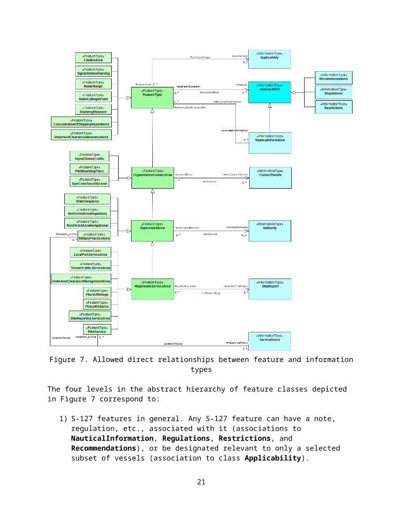
6.2.1.2 Relationships between features and information typesThe hierarchy of geographic features is designed around the features’ associations to information types as well as inheritance of attributes. There is a 4-level hierarchy of abstract feature classes. Each level in the abstract feature class hierarchy is associated with one or more information type classes. Subclasses inherit the associations of their super-classes. The result is that feature classes can have the associations of their direct parent abstract super-class as well as associations inherited by the direct parent. For example, PilotBoardingPlace can be associated to a ContactDetails object (with a SrvContact association) as well as with a Regulations object (with an AssociatedRxN association, inherited via the generalization relationship between OrganisationContactArea and FeatureType).
15

Figure 7. Allowed direct relationships between feature and information types
The four levels in the abstract hierarchy of feature classes depicted in Figure 7 correspond to:
1) S-127 features in general. Any S-127 feature can have a note, regulation, etc., associated with it (associations to NauticalInformation, Regulations, Restrictions, and Recommendations), or be designated relevant to only a selected subset of vessels (association to class Applicability).
2) Features associated with a source that may or must be contacted. The abstract feature superclass for these features is OrganisationContactArea, which adds an association to the information type ContactDetails.
3) Features that may be supervised or controlled in some sense by an organization. The abstract feature superclass for these features is SupervisedArea, which adds an association to the information type Authority. It inherits the associations of
16

OrganizationContactArea and FeatureType, so instances of these feature classes can have associations to ContactDetails, NauticalInformation, Regulations, Restrictions, and Recommendations, or be designated relevant to only a selected subset of vessels (association to class Applicability).
4) Features that also involve some kind of reporting (in the broad sense). The abstract feature superclass for these features is ReportableServiceArea, which adds an association to the information type ShipReport. These features also inherit the allowed associations of FeatureType, OrganizationContactArea, and SupervisedArea.
In addition to the associations allowed through inheritance, features can have direct relationships to other information types. The S-127 application schema contains two such associations, between MilitaryPracticeArea and PilotService on the feature side and ServiceHours on the other.
Note that Figure 7 shows only feature/information associations. Feature associations and information/information associations are allowed as defined elsewhere in the application schema – for example, the operating hours of a PilotService on holidays will be indicated by a NonStandardWorkingDay instance associated with the ServiceHours instance which is in turn associated with the relevant PilotService instance.
6.2.1.3 Regulations, information notes, etc.There are three main information types which represent regulations, restrictions, and recommendations, respectively, and a fourth information type for general or unclassifiable information.
The Regulations class represents information derived from laws, national shipping regulations, navigation rules, etc.
Class Restrictions is intended for restrictions that are not derived from regulatory sources.
Class Recommendations is intended for information that is recommendatory in nature; in S-127 this may be recommendations for maintenance of listening watches, AMVER reporting, etc., that are either voluntary or have not been issued as formal regulations.
The fourth class, NauticalInformation, is intended for general notes or other information that cannot be categorized as one of the other three classes.
These information types all inherit the attributes of their immediate abstract superclass AbstractRxN, which provides attributes textContent and graphic for textual and pictorial material respectively. The sub-attributes of its complex attribute rxnCode allow optional classification of the material encoded in textContent/graphic according to the type of material and the kind of nautical activity affected by it. They also inherit the attributes of abstract superclass InformationType, which allows encoding of the effective and expiry dates, if any, and the source of information, if it is necessary to encode that data.
These classes are intended primarily for encoding text information, such as that which derives from textual source material such as national or local laws or official publications. Where specific attributes such as the simple attribute restriction are permitted, they must be used. For example, if a geographic feature class has the restriction attribute, it should be used instead (explanations, details, paragraphs from regulations, etc., can be encoded in an associated Regulations, NauticalInformation, etc., object).
17

The use of these information types to associate regulatory and other information to individual features is described elsewhere in clause 6.2.1. Figure 8 depicts the Regulations, Restrictions, Recommendations, and NauticalInformation classes, their class hierarchy, and the attributes of their generalizations AbstractRxN and InformationType (which are inherited by the classes).
Figure 8. Structure of regulations and note information types
6.2.1.4 Contact informationThe detailed model of contact information is shown in Figure 9 below.
18

The ContactDetails class uses a condensed form of the complex attribute radiocommunications compared to S-123 (Marine Radio Services). When used as an attribute of ContactDetails, the sub-attributes of radiocommunications are restricted to those shown in Figure 9. The complex attribute telecommunications is analogous to radiocommunications, but describes telephone (and email, telegraph, etc.) contact data.
Figure 9. Contact information - detail
19

6.2.1.5 Supervising organizations, schedules and business hoursThe SupervisedArea class models areas which may have an associated organization (government or private) that exercises some kind of control or supervision over the area. Operating schedules and business hours of organizations are modeled by associating the ServiceHours class to an Authority. The ServiceHours class is a container for the complex attribute describing daily schedules for different weekdays (scheduleByDayOfWeek). This complex attribute contains another complex attribute for time intervals and the days to which they apply, and category sub-attribute to model whether the schedule describes opening hours, closures, etc. Exceptions to the schedule such as fixed or movable holidays are modeled by a NonStandardWorkingDay class with attributes allowing indication of the dates or days which are holidays or exceptions.
Working times and schedules for service features are modeled by an analogous association from the feature object (association LocationHours). When a ServiceHours is thus linked to a service feature, the service hour information applies to the feature as a whole (e.g., all services described in a PilotService).
Working times for MilitaryPracticeArea features are to be interpreted as the hours of military activity. Practice times of 24 hours/day are explicitly encoded (from 00:00:00 to 24:00:00 hrs., in accordance with ISO 8601 conventions for midnight at the beginning and end of a day). The dates of activity are indicated by attributes fixedDateRange or periodicDateRange as appropriate. Special cases such as unknown practice times can be explained in the textContent or information attribute of MilitaryPracticeArea or ServiceHours.
The model for both kinds of schedules is shown in Figure 10.
20

Figure 10. Working times and schedules
All the service features in S-127 can be associated to a supervising organization using the SrvControl association. The authority should be encoded only if its presence in the dataset conveys information that is useful to the end user.
Since Authority also has an information association to ContactDetails (Figure 11), it is in principle possible to link a VesselTrafficServiceArea (for example) to both an Authority and ContactDetails as well as linking the VesselTrafficServiceArea to the same ContactDetails. Such linking is permissible but will generally be redundant and should, if possible, be avoided as unnecessary duplication. It may be done in situations where contact details for an operating authority are different from contact details for the service it operates.
Figure 10 also shows associations between service features and Authority. Authority-ContactDetails associations are omitted to reduce clutter.
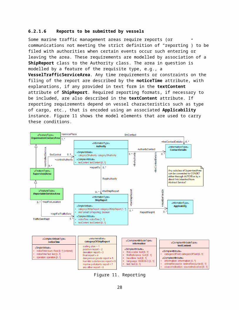
6.2.1.6 Reports to be submitted by vesselsSome marine traffic management areas require reports (or communications not meeting the strict definition of “reporting”) to be filed with authorities when certain events occur such entering or leaving the area. These requirements are modelled by association of a ShipReport class to the Authority class. The area in question is modelled by a feature of the requisite type, e.g., a VesselTrafficServiceArea. Any time requirements or constraints on the filing of the report are described by the noticeTime attribute, with explanations, if any provided in text form in the textContent attribute of ShipReport. Required reporting formats, if necessary to be included, are also described in the textContent attribute. If reporting requirements depend on vessel characteristics such as type of cargo, etc., that is encoded using an associated Applicability instance. Figure 11 shows the model elements that are used to carry these conditions.
21

Figure 11. Reporting
6.2.1.7 Regulations applying in specific geographic featuresThe AssociatedRxN association between a feature type and a Regulations, Restrictions, Recommendations, or NauticalInformation object (see Figure 12) indicates that the Regulation, etc., is applicable within the associated feature. If it is necessary to identify an authority or organization related to a particular regulation (restriction, etc.) object, this may be done using the RelatedOrganisation association between Regulations, etc., and an Authority object. This should be included only when the connection to the Authority conveys useful information to the end user – it is not intended to encode the issuing or controlling authority for every regulation. Note also that while Authority can be associated to geographic features as well as Regulations, etc., encoding both associations is not mandatory even when the same Authority is associated to a service area as well as a Regulations object (or NauticalInformation, etc.).
22

Figure 12. Regulations, etc., relevant to specific features
6.2.1.8 Regulations applying only to vessels with specific characteristics or cargoesCertain regulations apply only to vessels of specified dimensions, types, or carrying specified cargo, etc.
This is modelled by first defining the relevant subset of vessels according to the dimension, type, cargo, etc., and then associating that subset to the appropriate feature or information type. The subset of vessels is modelled using the Applicability class, which contains attributes for the most common vessel characteristics used in nautical publications. These include measurements (length, beam, draught), type of cargo, displacement, etc. Constraints which cannot be modelled using the attributes of Applicability can be described in plain text in its information attribute.
23
Conditions relating to vessel dimensions are modelled by the complex attribute vesselsMeasurements, which has sub-attributes for naming the dimension and indicating the limit (whether the condition applies to a vessel which exceeds or falls below the limit). For example, the combinations below describe the condition “length overall > 50 m” (Condition 1) and “length overall < 90 m” (Condition 2):
Condition 1 Condition 2 Condition 3vesselsCharacteristics length overall length overall breadth
vesselsCharacteristicsUnit metre metre metre
comparisonOperator greater than less than greater than
vesselsCharacteristicsValue
50 90 20
Table 6.1 - Conditions relating to vessel dimensions
The logicalConnectives attribute is used to indicate how to interpret the case where multiple conditions are encoded using attributes of measurements - whether the conditions described by condition attributes are cumulative (conjunctive, AND) or alternatives (disjunctive, OR). A logicalConnectives=AND combined with Conditions 1 and 2 above describes a vessel of length between 50 and 90 metres; logicalConnectives=OR combined with conditions 1 and 3 describes a vessel of length greater than 50 metres or beam greater than 20 metres.
This modelling cannot represent subsets defined by both AND and OR combinations of conditions, but it is always possible to convert such complex conditions into multiple combinations each using only AND (‘conjunctive normal form’) or OR (‘disjunctive normal form’), and model the subset using more than one Applicability object.
Figure 13 depicts the classes and attributes that can be used to define subsets of vessels according to specified characteristics.
24
Figure 13. Vessel subsets characterized by cargo and dimensions
Given the relevant subset of vessels, it can be associated to the appropriate feature, regulation, or report by a PermissionType, or InclusionType association. These are association classes, whose single attribute models the nature of the relationship between the vessel subset and feature or information type. Figure 14 depicts the use of vessel subsets in PermissionType or InclusionType associations.
The association classes PermissionType and InclusionType basically characterize the relationship. For example:
i. A specified set of vessels is COVERED by a regulation and another set of vessels is EXEMPT from the regulation.
ii. Vessels with specified cargo & dimensions MUST use a specified pilot boarding place, vessels of smaller dimensions are RECOMMENDED to use the boarding place, and warships are EXEMPT from using the pilot boarding place.
“COVERED” and “EXEMPT” are different kinds of relationship between different subsets of vessels characterized by different dimensional limits, etc., and a given regulation.
25

“MUST use”, “RECOMMENDED to use”, and “EXEMPT from use” are relationships between different subsets of vessels characterized by different dimensional limits, etc., and a given feature or service.
Figure 14. Applicability of reporting requirements, rules, etc. to vessel categories
PermissionType links a feature to an Applicability, and models a requirement, recommendation or prohibition on entry into a feature, by the specified subset of vessels.Inclusion links a Regulation, Recommendation, Restriction, or NauticalInformation instance to a subset defined by an Applicability object, and indicates whether the content of the Regulation, etc., applies to the vessels (membership=included), or whether it explicitly does not apply (membership=excluded).
Informally:a) Applicability describes the set of vessels: i.e., whob) Regulations provides the text of the regulation: i.e., whatc) The association class InclusionType describes the relationship between who and what.
That is, who “must (or can)” / “need not” do what.And:-
d) A geographic feature defines a location or physical facility: i.e., wheree) The association class PermissionType describes the relationship between who and
where. That is, who can / must / should / need not use (or sail) where.
6.2.1.9 Routeing measuresThe routeing measures model defines only one generalized routeing measure feature. The type of routeing is indicated by a category attribute. The geometry may be area or line (area
26

geometry should be encoded in preference to line geometry, if possible). The geometry is expected to be the spatial combination of relevant geometries from the ENC. The original features need not be the same class, e.g., an S-127 RouteingMeasure feature may combine Inshore Traffic Zone and TSS Lane Part geometries from S-101 data.
Figure 15. Routeing measures
Additional attributes can be encoded in a RouteingMeasure depending on the type of measure. For features that derive from a range system, leading lines, or transit lines (i.e., categoryOfRouteingMeasure = 4 (recommended route)), the categoryOfNavigationLine attribute may also be encoded to describe the type of routeing measure. For features that derive from a traffic separation scheme, (i.e., categoryOfRouteingMeasure = 5 (traffic separation scheme)), the categoryOfTrafficSeparationScheme attribute may also be encoded to describe whether is IMO-adopted or not.
Regulations, etc., can be associated with the feature and requirements relating to use by specific classes of vessels indicated by an associated Applicability instance. If different parts of the routeing measure have different information associated with them, the geometry can be divided into parts as needed.
6.2.1.10 Vessel traffic service areas and related featuresFigure 16 depicts the S-127 features relevant to VTS areas and features associated to VTS. Associations to information types are also shown.
It is not necessary to associate non-VTS features in this part of the model to a VTS. They may be included independently of VTS areas if they are relevant to traffic management on their own.
27

Figure 16. Vessel traffic service areas and associated classes
28

6.2.1.11 PilotagePilot boarding places, districts, and services are depicted in Figure 17 below, along with associated information types.
Figure 17. Pilotage features and associated classes
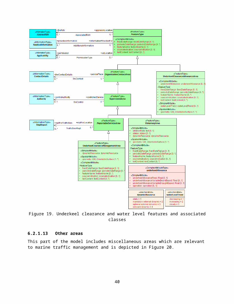
6.2.1.12 Water levels and underkeel clearancesIn some locations, up-to-date information may be available, or required to be obtained, from an off-vessel source, or required to be computed in near-real-time using software. This is indicated by the dynamicResource attribute. Constraints related to this attribute are:
Value Definition Requirement
static The information is static, or a source of up-to-date information is
None – vessels can use the water level or
29

unavailable or unknown. clearance information encoded in the feature.
mandatory external dynamic
An external source of up-to-date information is available and interaction with it to obtain up-to-date information is required.
The external source must be encoded in an associated ContactDetails. Vessels are required to access this external source for up-to-date information.
optional external dynamic
An external source of up-to-date information is available but interaction with it to obtain up-to-date information is not required.
The external source must be encoded in an associated ContactDetails. Vessels are not required to access this external source.
onboard dynamic
Up-to-date information may be computed using only onboard resources.
No external source is encoded. Vessels are required to compute water level or clearance information using onboard software. The controlling authority may specify the allowed software.
Table 6.2 . Types of dynamic resources
In general, dynamic resources are realizations of a common metaclass as depicted in Figure 18.
Figure 18. Feature classes modeling dynamic resources
This metaclass binds the dynamicResource attribute described in Table 6.2 and allows an association to ContactDetails for pointers to the location of external resources where the information can be obtained. It also allows an optional association to Authority objects, for coding the responsible authority. Further, since it is a feature type, it has the same attributes and associations as generic feature classes, i.e., atttributes fixedDateRange, etc., and associations to the information types NauticalInformation, etc.
30
The metaclass represents the structural characteristics of all features which represent dynamic information. Individual feature classes representing dynamic resources should have the attributes and associations of the metaclass, and may, in addition, bind attributes and have associations specific to the particular concepts represented by the realization. For example, WaterwayArea adds the attributes siltationRate and status to those of the metaclass.
The S-127 features related to underkeel clearance and dynamic water level information are depicted in Figure 19 below.
Figure 19. Underkeel clearance and water level features and associated classes
31

6.2.1.13 Other areasThis part of the model includes miscellaneous areas which are relevant to marine traffic management and is depicted in Figure 20.
Figure 20. Cautionary and other specially designated areas
6.2.1.14 S-127 Enumerations and codelistsFor completeness, the enumerations and codelists in the S-127 domain are provided in Figures 21–23. They are divided into multiple figures for convenience.
32

Figure 21. Category enumerations
33

Figure 22. Other enumerations and codelists
34
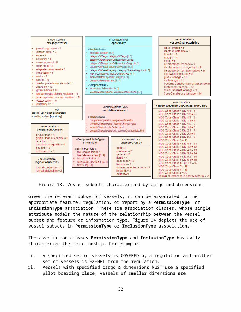
Figure 23. Enumerations for meta-features
6.2.1.15 Uncategorized additional informationThe domain model also provides a method for attaching to any feature or information type data in the form of a text note, graphic, or Internet reference which cannot be categorized using an appropriate feature or information type. This consists of defining a NauticalInformation object and referencing it from the feature or information type using the AdditionalInformation association. This method is intended to be a last resort and every effort should be made to use a more specific feature or information type to encode the information to be attached, including splitting the information in question across more than one type of feature or information object as needed and/or using the AssociatedRxN association instead of AdditionalInformation, wherever the nature of the content allows it. See Figure 24.
35
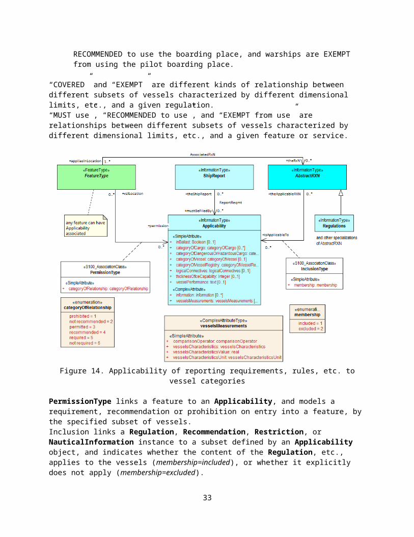
Figure 24. Attachment of uncategorizable information to any feature or information type
The AdditionalInformation association must not be used to chain NauticalInformation, Regulations, Restrictions, or Recommendations objects, whether they are of the same class or different classes.
6.2.2 Meta featuresS-127 has two meta feature classes. The first one is QualityOfNonbathymetricData and is derived from QualityOfTemporalVariation, which in turn is derived from DataQuality. The second is DataCoverage. See Figure 25.
36

Figure 25. Overview of Meta feature classes and enumerations
6.2.3 Spatial quality information typeS-127 spatial quality is composed of two information types, namely SpatialQuality and SpatialQualityPoint, which is derived of the first. As the name indicates, the latter is for spatial points, while SpatialQuality is for curves. The attributes are for temporal quality and qualitative and quantitative horizontal quality. See Figure 26.
37

Figure 26. Spatial quality
6.2.4 Cartographic featuresS-127 utilizes a cartographic feature called TextPlacement that is used in association with the featureName attribute to optimise text positioning, such as at smaller scales to prevent cluttering. This feature can be associated to any geographic feature and gives the location of a text string relative to the location of the feature. See Figure 27.
Figure 27. Text placement
7 Feature Catalogue7.1.1 IntroductionThe Feature Catalogue describes the feature types, information types, attributes, attribute values, associations and roles which may be used in the product. The S-127 Feature Catalogue is available in an XML document which conforms to the S-100 XML Feature Catalogue Schema and can be downloaded from the IHO website (http://www.iho.int/). Simple attributes used in this specification are listed in Table 7.1 below.
Name: Marine Traffic Management Feature CatalogueScope: Ocean, Coastal, Ports, Harbors, and Inland watersVersion Number: 1.0.0
38

Version Date: 2018-11-29Producer: International Hydrographic Organization Secretariat,
4 quai Antoine 1er,B.P. 445MC 98011 MONACO CEDEXTelephone: +377 93 10 81 00Telefax: + 377 93 10 81 40URL http://www.iho.int
Language: English
7.2 Feature TypesFeature types contain descriptive attributes that characterize real-world entities. The word ‘feature’ may be used in one of two senses – feature type and feature instance. A feature type is a class and is defined in a Feature Catalogue. A feature instance is a single occurrence of the feature type and represented as an object in a dataset. A feature instance is located by a relationship to one or more spatial instances. A feature instance may exist without referencing a spatial instance.
7.2.1 Geographic A geographic (Geo) feature type carries the descriptive characteristics of a real-world entity.
7.2.2 MetaMeta features contain information about other features within a dataset. Information defined by meta features override the default metadata values defined by the dataset descriptive records. Meta attribution on individual features overrides attribution on meta features.
7.2.3 CartographicCartographic features contain information about the cartographic representation (including text) of real world entities.
7.2.4 Feature relationshipA feature relationship links instances of one feature type with instances of the same or a different feature type.
7.2.5 Information TypesInformation types are identifiable pieces of information in a dataset that can be shared between other features. They have attributes but have no relationship to any geometry; information types may reference other information types.
7.2.5.1 Spatial qualitySpatial quality attributes are carried in two information class called Spatial Quality (for curves) and Spatial Quality Points (for points). Currently no use case for associating surfaces with spatial quality attributes has been identified, therefore this is prohibited.
39

7.2.6 AttributesS-127 defines attributes as either simple or complex.
7.2.6.1 Simple attributesThe simple attribute value types used in S-127 are listed in Table 7.3:
Type Definition Enumeration A fixed list of valid identifiers of named literal values Boolean A value representing binary logic. The value can be either True or False.
The default state for Boolean type attributes (i.e. where the attribute is not populated for the feature) is False.
Real A signed Real (floating point) number consisting of a mantissa and an exponent
Integer A signed integer number. The representation of an integer is encapsulation and usage dependent.
CharacterString or Text1
An arbitrary-length sequence of characters including accents and special characters from a repertoire of one of the adopted character sets.
Date2 A date provides values for year, month and day according to the Gregorian Calendar. Character encoding of a date is a string which must follow the calendar date format (complete representation, basic format) for date specified by ISO 8601. EXAMPLE 19980918 (YYYY-MM-DD)
Time A time is given by an hour, minute and second. Character encoding of a time is a string that follows the local time (complete representation, basic format) format defined in ISO 8601. EXAMPLE 183059 or 183059+0100 or 183059Z
Codelist A type of flexible enumeration. A code list type is a list of literals which may be extended only in conformance with specified rules.
Truncated date One or more components of the Date type are omitted.URI2 A uniform resource identifier as defined in RFC 3986. Character encoding
of a URI shall follow the syntax rules defined in RFC 3986.EXAMPLE http://registry.iho.int
URL A uniform resource locator (URL) is a URI that provides a means oflocating the resource by describing its primary access mechanism (RFC3986).EXAMPLE http://registry.iho.int
Table 7.3 – Data types for simple attributes
7.3 Complex attributesComplex attributes are aggregations of other attributes that are either simple or complex. The aggregation is defined by means of attribute bindings.
1 Simple attributes in feature and information types use Text; metadata attributes use CharacterString.2 The Date and URI types are not used in S-127 1.0.0, but are described because they are referenced by other types.
40

7.4 Units of measureThe following units of measure is used in Marine Traffic Management datasets;
Orientation is given in decimal degrees Radio frequency is given in hertz Uncertainty is given in metres Distances are given in metres or nautical miles Depths are given in metres.
7.5 Geometric representationGeometric representation is the digital description of the spatial component of an object as described in S-100 and ISO 19107. This product specification uses three types of geometries: GM_Point, GM_OrientableCurve, and GM_OrientableSurface.
Figure 29. Geometric primitives
41
class FeatureTypes
« F e a tu re T yp e »FeatureType
« C o m p le xAttrib u te »+ fe a tu re N a m e : fe a tu re N a m e [0 ..* ]+ fixe d D a te R a n g e : fixe d D a te R a n g e [0 ..1 ]+ p e rio d icD a te R a n g e : p e rio d icD a te R a n g e [0 ..* ]+ s o u rce In d ica tio n : s o u rce In d ic a tio n [0 ..1 ]+ te xtC o n te n t: te xtC o n te n t [0 ..* ]
« S im p le Attrib u te »+ s c a le Ma xim u m : In te g e r [0 ..1 ]+ s c a le M in im u m : In te g e r [0 ..1 ]
« C o m p le xAttr ib u te T yp e »featureName
« S im p le Attr ib u te »+ d is p la yN a m e : B o o le a n [0 ..1 ]+ la n g u a g e : IS O 6 3 9 -3 [0 ..1 ]+ n a m e : te xt
« Fe a tu re Typ e »MarineProtectedArea
« S im p le Attrib u te »+ ca te g o ryO fMa rin e P ro te c te d Are a :
ca te g o ryO fMa rin e P ro te c te d Are a+ ca te g o ryO fR e s tric te d Are a :
ca te g o ryO fR e s tric te d Are a [0 ..* ]+ ju r is d ic tio n : ju r is d ic tio n+ re s tric tio n : re s tr ic tio n [0 ..* ]+ s ta tu s : s ta tu s [0 ..* ]
« S p a tia lAttr ib u te »+ g e o m e try: C u rve O rS u rfa ce [0 ..* ]
« Fe a tu re Typ e »RestrictedAreaNavigational
« S im p le Attrib u te »+ ca te g o ryO fR e s tric te d Are a :
ca te g o ryO fR e s tric te d Are a [0 ..* ]+ re s tric tio n : re s tr ic tio n [1 ..* ]+ s ta tu s : s ta tu s [0 ..* ]
« S p a tia lAttr ib u te »+ g e o m e try: G M_ O rie n ta b le S u rfa ce [0 ..* ]
« Fe a tu re Typ e »TrafficControlService
« S im p le Attrib u te »+ ca te g o ryO fTra fficC o n tro lS e rvice :
ca te g o ryO fTra fficC o n tro lS e rvice« S p a tia lAttr ib u te »
+ g e o m e try: G M_ O rie n ta b le S u rfa ce [0 ..* ]
S-122 Geometry
(from S-122 V 1.0.0)
S-122 Metadata
(f rom S-122 V1.0.0)
« C o m p le xAttrib u te Typ e »sourceIndication
« S im p le Attrib u te »+ ca te g o ryO fAu th o ri ty: c a te g o ryO fAu th o ri ty [0 ..1 ]+ co u n try: te xt [0 ..1 ]+ re p o rte d D a te : S 1 0 0 _ Tru n ca te d D a te [0 ..1 ]+ s o u rce : te xt [0 ..1 ]+ s o u rce Typ e : s o u rce Typ e [0 ..1 ]
« C o m p le xAttrib u te »+ fe a tu re N a m e : fe a tu re N a m e [0 ..* ]
« C o m p le xAttrib u te Typ e »fixedDateRange
« S im p le Attr ib u te »+ d a te E n d : S 1 0 0 _ Tru n c a te d D a te [0 ..1 ]+ d a te S ta rt: S 1 0 0 _ T ru n ca te d D a te [0 ..1 ]
« C o m p le xAttrib u te Typ e »periodicDateRange
« S im p le Attr ib u te »+ d a te E n d : S 1 0 0 _ Tru n c a te d D a te+ d a te S ta rt: S 1 0 0 _ T ru n ca te d D a te
« C o m p le xAttrib u te Typ e »information
« S im p le Attrib u te »+ fi le L o ca to r : te xt [0 ..1 ]+ fi le R e fe re n ce : te xt [0 ..1 ]+ h e a d lin e : te xt [0 ..1 ]+ la n g u a g e : IS O 6 3 9 -3 [0 ..1 ]+ te xt: te xt [0 ..1 ]
« C o m p le xAttrib u te Typ e »textContent
« S im p le Attrib u te »+ ca te g o ryO fTe xt: c a te g o ryO fT e xt [0 ..1 ]
« C o m p le xAttrib u te »+ in fo rm a tio n : in fo rm a tio n [0 ..* ]+ o n l in e R e s o u rce : o n l in e R e s o u rc e [0 ..1 ]+ s o u rce In d ica tio n : s o u rc e In d ic a tio n [0 ..1 ]
« Fe a tu re Typ e »RestrictedAreaRegulatory
« S im p le Attrib u te »+ ca te g o ryO fR e s tric te d Are a :
ca te g o ryO fR e s tric te d Are a [0 ..* ]+ re s tric tio n : re s tr ic tio n [0 ..* ]+ s ta tu s : s ta tu s [0 ..* ]
« S p a tia lAttr ib u te »+ g e o m e try: G M_ O rie n ta b le S u rfa c e [0 ..* ]
Content of featureName is source authority name
«use»
Figure 28. textContent - a complex attribute

8 Coordinate reference system (CRS)8.1.1 IntroductionThe location of an object in the S-100 standard is defined by means of coordinates which relate a feature to a position. The coordinate reference system used for this product specification is World Geodetic System 1984 (WGS 84) which is defined by the European Petroleum Survey Group (EPSG) code 4326, (or similar - North American Datum 1983 / Canadian Spatial Reference System).
Spatial data are expressed as latitude (φ) and longitude (λ) geographic coordinates. Latitude values are stored as a negative number to represent a position south of the Equator. Longitude values are stored as a negative number to represent a position west of the Prime Meridian. Coordinates are expressed as real value, degree / degree decimal format. Datasets conforming to this product specification are not projected.
Horizontal coordinate reference system: WGS 84
Projection: None
Vertical coordinate reference system: None3
Temporal reference system: Gregorian calendar
Coordinate reference system registry: EPSG Geodetic Parameter Registry
Date type (according to ISO 19115-1): 002 - publication
8.1.2 Horizontal reference systemPositional data is expressed in latitude and longitude geographic coordinates to one of the reference horizontal reference systems defined in the HORDAT attribute. Unless otherwise defined, the World Geodetic System 84 (WGS 84) will be used for MTM data products.
8.1.3 ProjectionMarine Traffic Management data products are un-projected.
8.1.4 Vertical coordinate reference systemMarine Traffic Management data products do not provide detailed vertical information.
8.1.5 Temporal reference systemTime is measured by reference to Calendar dates and Clock time in accordance with ISO 19108:2002 Temporal Schema clause 5.4.4.
3 Not used in any of the feature classes, therefore not needed.
42
8.1.6 Marine Traffic Management data and scaleMTM data must be compiled in the best applicable scale. The use of the data itself is "scale independent". That means that the data can be used at any scale. S-100 allows the association of multiple spatial attributes to a single feature instance. In principle, each of these spatial attributes can be qualified by maximum and minimum scales.
For example, it is possible, within one dataset, to have a single instance of a feature that has more than one area geometry. Each of these geometries has different scale max/min attributes. Moreover, due to cluttering in smaller scales, the scale minimum attribute may be used to turn off portrayal of some features at smaller scales.
9 Data quality9.1 IntroductionData quality allows users and user systems to assess fitness for use of the provided data. Data quality measures and the associated evaluation are reported as metadata of a data product. This metadata improves interoperability with other data products and provides usage by user groups that the data product was not originally intended for. The secondary users can make assessments of the data product usefulness in their application based on the reported data quality measures.For S-127 the following data quality elements have been included:
Conformance to this Product Specification; Intended purpose of the data product; Completeness of the data product in terms of coverage; Logical Consistency; Positional Uncertainty and Accuracy; Thematic Accuracy; Temporal Quality; Aggregation measures; Elements specifically required for the data product (none currently identified for S-127); Validation checks or conformance checks including:
o General tests for dataset integrity;o Specific tests for a specific data model;
9.2 Quality measure elementsThe data quality measures recommended in S-97 (Part C) and their applicability in S-127 are indicated in Table 9.4 below. NA indicates the measure is not applicable. This table reproduces the first 4 columns of the data quality checklist recommended elements and replaces the final column with descriptions of the scope of the element in the context of S-127 datasets.
No. Data quality element and sub element
Definition DQ measure / description Evaluation scope
Scope in S-127
1 Completeness / Commission
Excess data present in a dataset, as described by the scope.
numberOfExcessItems / This data quality measure indicates the number of items in the dataset, that should not have been present in the dataset.
dataset/dataset series
All features and info types
2 Completeness / Commission
Excess data present in a
numberOfDuplicateFeatureInstances / This data quality measure indicates
dataset/dataset
All features and info types
43

No. Data quality element and sub element
Definition DQ measure / description Evaluation scope
Scope in S-127
dataset, as described by the scope.
the total number of exact duplications of feature instances within the data.
series
3 Completeness / Omission
Data absent from the dataset, as described by the scope.
numberOfMissingItems / This data quality measure is an indicator that shows that a specific item is missing in the data.
dataset/dataset series/spatial object type
All features and info types
4 Logical Consistency / Conceptual Consistency
Adherence to the rules of a conceptual schema.
numberOfInvalidSurfaceOverlaps / This data quality measure is a count of the total number of erroneous overlaps within the data. Which surfaces may overlap and which must not is application dependent. Not all overlapping surfaces are necessarily erroneous.
spatial object / spatial object type
Features with surface geometry; spatial objects of type surface
5 Logical Consistency / Domain Consistency
Adherence of the values to the value domains.
numberOfNonconformantItems / This data quality measure is a count of all items in the dataset that are not in conformance with their value domain.
spatial object / spatial object type
All features and info types
6 Logical Consistency / Format Consistency
Degree to which data is stored in accordance with the physical structure of the data set, as described by the scope
physicalStructureConflictsNumber / This data quality measure is a count of all items in the dataset that are stored in conflict with the physical structure of the dataset.
dataset/dataset series
All features and info types
7 Logical Consistency / Topological Consistency
Correctness of the explicitly encoded topological characteristics of the dataset, as described by the scope.
rateOfFaultyPointCurveConnections / This data quality measure indicates the number of faulty link-node connections in relation to the number of supposed link-node connections. This data quality measure gives the erroneous point-curve connections in relation to the total number of point-curve connections.
spatial object / spatial object type
Features with curve geometry; spatial objects of curve types
8 Logical Consistency / Topological Consistency
Correctness of the explicitly encoded topological characteristics of the dataset, as described by the scope.
numberOfMissingConnectionsUndershoots / This data quality measure is a count of items in the dataset within the parameter tolerance that are mismatched due to undershoots.
spatial object / spatial object type
Features with curve geometry; spatial objects of curve types
9 Logical Consistency / Topological Consistency
Correctness of the explicitly encoded topological characteristics of the dataset, as described by the scope.
numberOfMissingConnectionsOvershoots / This data quality measure is a count of items in the dataset within the parameter tolerance that are mismatched due to overshoots.
spatial object / spatial object type
Features with curve geometry; spatial objects of curve types
10 Logical Consistency / Topological Consistency
Correctness of the explicitly encoded topological characteristics of the dataset, as described by the scope.
numberOfInvalidSlivers / This data quality measure is a count of all items in the dataset that are invalid sliver surfaces. A sliver is an unintended area that occurs when adjacent surfaces are not digitized properly. The borders of the adjacent surfaces may
dataset / dataset series
Features with surface geometry; spatial objects of type surface
44

No. Data quality element and sub element
Definition DQ measure / description Evaluation scope
Scope in S-127
unintentionally gap or overlap to cause a topological error.
11 Logical Consistency / Topological Consistency
Correctness of the explicitly encoded topological characteristics of the dataset, as described by the scope.
numberOfInvalidSelfIntersects / This data quality measure is a count of all items in the dataset that illegally intersect with themselves.
spatial object / spatial object type
Features with surface geometry; spatial objects of type surface or curve
12 Logical Consistency / Topological Consistency
Correctness of the explicitly encoded topological characteristics of the dataset, as described by the scope.
numberOfInvalidSelfOverlap / This data quality measure is a count of all items in the dataset that illegally self-overlap.
spatial object / spatial object type
Features with surface geometry; spatial objects of type surface or curve
13 Positional Accuracy / Absolute or External Accuracy
Closeness of reported coordinative values to values accepted as or being true.
Root Mean Square Error / Standard deviation, where the true value is not estimated from the observations but known a priori.
spatial object / spatial object type
objects that have coordinative values associated.
14 Positional Accuracy / Vertical Position Accuracy
Closeness of reported coordinative values to values accepted as or being true.
linearMapAccuracy2Sigma / Half length of the interval defined by an upper and lower limit in which the true value lies with probability 95%.
spatial object / spatial object type
NA. S-127 does not include vertical measurements.
15 Positional Accuracy / Horizontal Position Accuracy
Closeness of reported coordinative values to values accepted as or being true.
linearMapAccuracy2Sigma / Half length of the interval defined by an upper and lower limit in which the true value lies with probability 95%.
spatial object / spatial object type
objects that have a horizontal coordinate values associated.
16 Positional Accuracy / Gridded Data Position Accuracy
Closeness of reported coordinative values to values accepted as or being true.
Root mean square error of planimetry / Radius of a circle around the given point, in which the true value lies with probability P.
spatial object / spatial object type
NA. S-127 does not have features with gridded geometry
17 Temporal Quality / Temporal Consistency
Consistency with time.
Correctness of ordered events or sequences, if reported.
dataset/dataset series/spatial object type
Features with time intervals, fixed/periodic date ranges, schedules.
18 Thematic Accuracy / ThematicClassificationCorrectness
Comparison of the classes assigned to features or their attributes to a universe of discourse.
miscalculationRate / This data quality measure indicates the number of incorrectly classified features in relation to the number of features that are supposed to be there. [Adapted from ISO 19157] This is a RATE which is a ratio, and is expressed as a REAL number representing the rational fraction corresponding to the numerator and denominator of the ratio. For example, if there are 1 items that are classified incorrectly and there are 100 of the items in the dataset then the ratio is 1/100 and the reported rate = 0.01.
dataset/dataset series/spatial object type
All features and info types
45

No. Data quality element and sub element
Definition DQ measure / description Evaluation scope
Scope in S-127
19 Aggregation Measures / AggregationMeasures
In a data product specification, several requirements are set up for a product to conform to the specification.
DataProductSpecificationPassed / This data quality measure is a boolean indicating that all requirements in the referred data product specification are fulfilled.
dataset/dataset series/spatial object type
Dataset as a whole
20 Aggregation Measures / AggregationMeasures
In a data product specification, several requirements are set up for a product to conform to the specification.
DataProductSpecificationFailRate / This data quality measure is a number indicating the number of data product specification requirements that are not fulfilled by the current product/dataset in relation to the total number of data product specification requirements.
dataset/dataset series/spatial object type
Dataset as a whole
Table 9.4 - IHO recommended quality elements and their relevance to S-127
9.3 Test methodsTest methods consist of executing the relevant tests from Annex E (Validation Checks) for each quality element in Table 9.4 and counting the number of instances in the dataset which fail the checks for that quality element.
Note that in some cases “executing the relevant test” may involve comparing the encoded S-127 dataset to the source material by visual means (e.g., for measures 17 and 18). For tests requiring visual comparison of encoded data to source material, sampling methods may be used if the volume of data precludes checking all the relevant data objects.
9.3.1 Accuracy computationsRecommendations for Positional Accuracy / Absolute or External Accuracy:Maximum RMSE (horizontal) = E / 10000
Where:E = Denominator of intended scale of mapping
9.4 Data quality testing and reportingS-127 products must be tested with the S-127 specific checks prior to release by the data producer. The data producer must review the check results and address any issues to ensure sufficient quality of the data products. The checks are a mix of data format validation checks, conformance to standard checks and logical consistency checks. The checks are listed in Annex E.
Production and certification processes for S-127 data should include a standalone quality report which provides full information on the original results (with evaluation procedures and measures applied).
The dataset or exchange set metadata that is distributed with the exchange set may describe only the aggregated result with a reference to the original results described in the standalone quality report. The aggregated Data Quality result provides an indication if the dataset has passed conformance to the Data Product Specification.
46

Data Quality Measure Aggregation results should be included to indicate if the dataset/dataset series have passed the Product Specifications. The elements which must be included are described in Table 9.5.
Data quality element and sub element
Definition DQ measure / description Evaluation scope
Applicable to spatial representation types
Aggregation Measures / AggregationMeasures
In a data product specification, several requirements are set up for a product to conform to the specification.
DataProductSpecificationPassed / This data quality measure is a boolean indicating that all requirements in the referred data product specification are fulfilled.
dataset All features and information types of the dataset
Aggregation Measures / AggregationMeasures
In a data product specification, several requirements are set up for a product to conform to the specification.
DataProductSpecificationFailRate / This data quality measure is a number indicating the number of data product specification requirements that are not fulfilled by the current product/dataset in relation to the total number of data product specification requirements.
dataset All features and information types of the dataset
Table 9.5 - Elements of data quality aggregated report (extract from S-97 Part C checklist)
10 Data capture and classification
Data source: S-127 products must be based on data sources released by an appropriate MTM defining authority. Data source must be described in each data product.
The production process used to generate MTM products may be described in the comment attribute of the dataset metadata.
10.1 Data encoding and product delivery10.1.1 Data encodingThe principal encoding will be the Open Geospatial Consortium (OGC), Geography Markup Language (GML) format. GML is an XML grammar designed to express geographical features. It serves as a modelling language for geographic systems as well as an open interchange format for geographic transactions.
10.1.2 Types of datasetsA dataset is a grouping of features, attributes, geometry and metadata which comprises a specific coverage. Table 10.6 lists the types of MTM datasets which may be produced and contained within an exchange set:
Dataset ExplanationsNew dataset (base dataset) Data for an area different (in coverage and/or extent) to
existing datasets.New Edition of a dataset A re-issue plus new information which has not been
previously distributed by Updates. Each New Edition of a dataset must have the same name as the dataset that it
47

replaces and should have the same spatial extents. The edition number in the dataset discovery metadata must increment up by one from the previous edition.
Update dataset A delta change of the latest edition of a dataset. If there is more than one update dataset, the subsequent update will be a delta of the base dataset + earlier update datasets.
Cancellation Used to cancel dataset and any related update datasets.
Table 10.6 MTM dataset types
10.1.3 Content of update datasetsUpdate datasets can only contain replacements, deletions, and additions of whole feature instances or information instances. This means that when a feature or information instance is updated, the new version must contain all the attributes of the old instance, including any inline spatial attributes (i.e., inline geometry), except those attributes that are being removed.
An association to an instance of a feature or information type is treated as an attribute of the referring instance, and therefore adding or deleting an association means the original referring instance must be replaced with a new version. The instance at the other end of the association needs to be replaced if and only if it contains a reference to the first instance.
Spatial objects that are not inline (i.e., geometry that is encoded as an independent spatial object in the dataset) is treated like any other object, i.e., it needs to be updated if and only if the primitive has changed (e.g., a coordinate is updated).
Feature and information type instances are deleted without replacement by setting the fixedDateRange.dateEnd attribute of the instance to the date of deletion, which will usually be the issue date of the update.
10.2 Encoding of latitude and longitude Values of latitude and longitude must be accurate to 7 decimal places. Coordinates must be encoded as decimals in the format described in clause 10.2.1. The encoding is indicated by multiplication factor fields defined in the dataset identification record.
10.2.1 Encoding of coordinates as decimalsValues should be coded as decimal numbers with 7 or fewer digits after the decimal. The normative encoding is in degrees, with an accuracy of 10-7 degrees, i.e., 7 digits after the decimal point.
The decimal point must be indicated by the “.” character.
Trailing zeroes after the decimal point (and the decimal point itself if appropriate) may be omitted at producer discretion, but the accuracy must still be as indicated (e.g., 10-7 degrees for coordinates of default accuracy).
Latitude and longitude multiplication factors held in the Dataset Structure Information field under [coordMultFactorX] and [coordMultFactorY] must be set to a value corresponding to the encoding, i.e., {1} for coordinates encoded in decimal degrees.
48
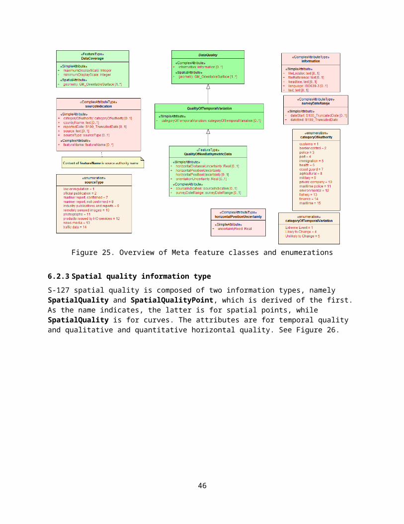
EXAMPLE 1 A longitude = 42.0000 is converted into X = longitude * coordMultFactorX = 42.0000 * 1 = 42.0000000.10.3 Numeric attribute encodingFloating point and integer attribute values must not contain leading zeros. Floating point attribute values must not contain non-significant trailing zeros.
10.4 Text attribute valuesCharacter strings must be encoded using the character set defined in ISO 10646-1, in Unicode Transformation Format-8 (UTF-8). 10.5 Mandatory attribute valuesThere are four reasons why attribute values may be considered mandatory:
They determine whether a feature is in the display base, Certain features make no logical sense without specific attributes, Some attributes are necessary to determine which symbol is to be displayed, Some attributes are required for safety of navigation.
All mandatory attributes are identified in the Feature Catalogue and summarised in Annex A – Data Classification and Encoding Guide.10.6 Unknown attribute valuesWhen a mandatory attribute code or tag is present but the attribute value is missing, it means that the producer wishes to indicate that this attribute value is unknown. Missing mandatory attributes must be “nilled.”
Optional attributes must be omitted altogether if the value is unknown or missing. They must not be “nilled.”
EXAMPLE A landmark feature has unknown category of landmark (mandatory attribute) and function (optional attribute). The feature could be coded as:
<Landmark> <categoryOfLandmark xsi:nil="true"/> <function>radio</function> … other attributes… … <status> is NOT coded …<Landmark>
10.7 Structure of dataset files10.7.1 Sequence of objectsThe order of data objects in each dataset file is described below:
Dataset Identification InformationDataset structure informationSpatial records for by-reference geometries
PointMulti pointCurve Composite Curve
49
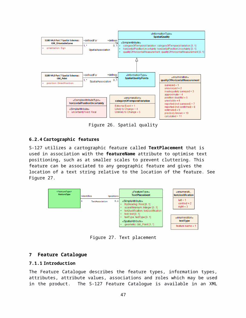
Surface Information objectsFeature objects (Geometry may be encoded inline or by reference.)
Meta featuresGeo features
10.8 Object identifiersThe “name” of feature records must provide a unique world-wide identifier of feature records. The “name” of the record is the combination of the subfields agency, featureObjectIdentifier, and featureIdentificationSubdivision elements of the featureObjectIdentifier element of the object.
Features, information types, collection objects, meta features, and geometries (inline or external) are all required by the schema to have a gml:id attribute with a value that is unique within the dataset. The gml:id values must be used as the reference for the object from another object in the same dataset or another dataset.
MRN identifiers are not included in this version due to ongoing development of the IHO guidelines in the use of MRN for product specifications.
10.9 Data coverageAll areas of a dataset must be covered by a DataCoverage meta feature.
An update dataset must not change the limit of a Data Coverage feature for the base dataset. Where the limit of a Data Coverage feature for a base dataset is to be changed, this must be done by issuing a new edition of the dataset.
10.10Data overlapS-127 datasets must not overlap other S-127 datasets.
10.11 Data qualityOne or more QualityOfNonBathymetricData features must cover the dataset.
10.12Data extentDatasets must not cross the 180° meridian of longitude
11 Data delivery11.1 Data product delivery informationThis data product specification defines GML as the primary format in which MTM data products are delivered. The delivery format is described in Table 11.7 by the following items (from ISO 19131:2005): format name, version, specification, language, character set.
Name ISO 19131 Elements Value
Format DPS_DeliveryInformation.deliveryFormat > GML*
50

name DPS_DeliveryFormat.formatName
VersionDPS_DeliveryInformation.deliveryFormat >
DPS_DeliveryFormat.version3.2.1
Specification
description
DPS_DeliveryInformation.deliveryFormat >
DPS_DeliveryFormat.specificationGML*
LanguageDPS_DeliveryInformation.deliveryFormat >
DPS_DeliveryFormat.languageEnglish
Character
set
DPS_DeliveryInformation.deliveryFormat >
DPS_DeliveryFormat.characterSet > MD_CharacterSetCode004 – utf8
Table 11.7 Data product delivery
* GML is an XML encoding for the transport and storage of geographic information, including both the geometry and the properties of geographic features, between distributed systems. The XML Schema for the GML application schema is provided in a schema document S127.xsd which imports other schema(s) defining common types. (All files are available on the S-100 distribution site https://github.com/IHO-S100WG ). Feature instances must validate against S127.xsd and conform to all other requirements specified in this data product specification including all constraints not captured in the XML Schema document.
11.1.1 Dataset loadingDatasets must always be loaded in the order of base dataset first, then update datasets in the corrected sequential order. Systems are not to load updates out of order, for example if update 1-5 is present, then 6 is missing, update 7 must not be loaded.
11.1.2 New editionsWhen a new edition of a dataset is received, the system must replace the previous edition, along with any updates with the new edition of the dataset. Loading of subsequent updates follow the same rule as above.
11.2 Dataset sizeMTM datasets must not exceed 20MB.
Update datasets must not exceed 500KB.
11.3 Exchange setData which conforms to this product specification must be delivered by means of an exchange set.
An exchange set will consist of one or more MTM datasets. An exchange set may also include one or more support files containing supplementary information encoded in separate files. These are linked to the MTM dataset features, by feature and information type attributes defined in the application schema, e.g., fileReference. Each exchange set will include a single (XML) catalogue file, S-127 exchange set catalogues conform to S-100 4.0.0 Figure 4a-D-2 without modification, containing discovery metadata for each MTM dataset as well as support files. S-127 Exchange set structure conforms to S-100 4.0.0 Figure 4a-D-3 without modification.
51

Figure 30 - Exchange set structure
11.4 Support filesSupport files contain ancillary textual or graphic information in separate (linked to the dataset) files. The following formats are allowed for support files:
Plain text files must contain only general text as defined in this standard. Files must use the UTF-8 character set encoding.
HTML and XML files must contain only text and markup as defined in the relevant W3C standards. Files must use the UTF-8 character set encoding. References in datasets to HTML and XML support files must treat them as text files (i.e., they should not be referenced using attributes intended for picture files).
Picture files must be in the Tagged Image file Format (TIFF) [Edition 6.0].
Table 11.8 describes the constraints on support file formats and provides the corresponding file extensions.
File type Extension DescriptionText TXT
HTM HTML files must only include inline or embedded Cascading Style Sheet (CSS) information and must not contain embedded Javascript or other dynamic content, for example DHTML, Flash etc.
XML XML documents must only be included in accordance with guidance provided within the Data Classification and Encoding Guide (Annex A) and must not contain embedded Javascript or other dynamic content.
Picture TIF Baseline TIFF 6.0.
Table 11.8 Support file formats and extensions
52

11.5 Support file naming conventionAll support files will have unique world-wide file identifiers. The file identifier of support information should not be used to describe the physical content of the file. The support file metadata that accompanies the file will inform the user of the name and purpose of the file (new, replacement and deletion).
In this encoding the support files are named according to the specifications given below:
127CCCCXXXXXXXX.YYY
The main part forms an identifier where: The first three characters are always “127” and identify the dataset as an S-127 dataset. The next four characters identify the issuing agency by its alphanumeric agency code in
the IHO producer code register in the IHO GI Registry (i.e., the IHO is identified as “AA”, not “1810”). Where the agency code consists of fewer than four characters, sufficient zeros must be suffixed to make the length exactly four characters (e.g., “AA00” for IHO).
The eighth up to the fifteenth character can be used in any way by the producer to provide a unique file name for the dataset. The following characters are allowed in the dataset name, A to Z, 0 to 9 and the special character _ (underscore). The ninth through fifteenth characters are optional (i.e., at least one character must be used).
.YYY – support file extension. The YYY portion must conform to the file format as described in Table 11.8.
11.6 Dataset naming conventionAll dataset files will have unique world-wide file identifiers. The file identifier of the dataset should not be used to describe the physical content of the file. The dataset file metadata that accompanies the file will inform the user of the name and purpose of the file (new, replacement, and deletion). In this encoding the dataset files are named according to the specifications given below:
127CCCCXXXXXXXXXX.GML
The main part forms an identifier where: The first three characters are always “127” and identify the dataset as an S-127 dataset. The next four characters identify the issuing agency by its alphanumeric agency code in
the IHO producer code register in the IHO GI Registry (i.e., the IHO is identified as “AA”, not “1810”). Where the agency code consists of fewer than four characters, sufficient zeros must be suffixed to make the length exactly four characters (e.g., “AA00” for IHO).
The eighth up to the seventeenth character can be used in any way by the producer to provide a unique file name for the dataset. The following characters are allowed in the dataset name, A to Z, 0 to 9 and the special character _ (underscore). The ninth through seventeenth characters are optional (i.e., at least one character must be used).
11.7 Update dataset naming conventionAll update dataset files will have an identical name to the base dataset, aside from the separator and update number sequence.
53

In this encoding the update dataset files are named according to the specifications given below:
127CCCCXXXXXXXXXX_XXX.GML
The main part forms an identifier where:
The first up to the seventeenth characters are the same as the dataset being updated and therefore conform to the rules described in clause 11.6.
The next character must be an underscore “_”. The next three characters must be numerical (0-9) characters to indicate the place of
the update dataset in the update sequence.
11.8 Catalogue file naming conventionThe exchange catalogue acts as the table of contents for the exchange set. The catalogue file of the exchange set must be named CATALOG.XML. No other file in the exchange set may be named CATALOG.XML. The content of the exchange catalogue file is described in Clause 14.
12 Data maintenance12.1 IntroductionDatasets are maintained as needed and must include mechanisms for MTM updating. Data updates will be made by new editions. The maintenance and update frequency of MTM datasets should be defined by the producers (official national authority) implementing this specification. Data Producers must use applicable sources to maintain and update data and provide a brief description of the sources that were used to produce the dataset in the appropriate metadata field.Error: Reference source not found
12.2 Production process for base and update datasetsData Producers should follow their established production processes for maintaining and updating datasets. Data is produced against the DCEG and checked against the appropriate set of validation rules in Appendix E.
12.3 Dataset updates and cancellationThe purpose of issue of the dataset is indicated in the “purpose” field of the dataset discovery metadata. In order to terminate a dataset, an update dataset file is created for which the edition number must be set to 0. This convention is only used to cancel a base dataset file.
Where a dataset is cancelled and its name is reused at a later date, the issue date must be greater than the issue date of the cancelled dataset.
When the dataset is cancelled it must be removed from the system along with all related update datasets and support files.
An exchange set may contain base dataset files and update dataset files for the same datasets. Under these circumstances the update dataset files must follow in the correct sequential order from the last update applied to the base dataset file.
54

12.4 Support file updatesThe purpose of issue is indicated in the “purpose” field of the support file discovery metadata. Support files carrying the “deletion” flag in metadata must be removed from the system. When a feature or information type pointing to a text, picture, or application file is deleted or updated so that it no longer references the file, the system software must check to see whether any other feature or information type references the same file before that file is deleted.
Updates or deletions of a support file may require concurrent updates to feature or information type instance attributes that depend on the file, e.g., pictorialRepresentation, fileReference, and fileLocator attributes.12.5 Feature and portrayal cataloguesFor each new version of the S-127 Product Specification a new feature and portrayal catalogue will be released. The system must be able to manage datasets and their catalogues that are created on different versions of the S-127 Product Specification.12.6 Feature history, versions, and change trackingIf applications or production systems require versioning of individual instances of feature or information types, maintenance of histories, or change tracking, the methods for versioning, history management, and change tracking and display are left to the application or production system.
12.7 Dataset encryptionDetails about dataset encryption are still to be determined, and may mirror the method described in S-101.
13 PortrayalPortrayal is not defined in this version of S-127 Marine Traffic Management Product Specifications. Users are free to choose the means and methodology of portrayal as they see best suited for their needs. It should be noted that future versions of S-127 may include a portrayal catalogue, and any implementer should therefore anticipate this, and make sufficient provisions in any system supporting S-127.
14 Metadata14.1 IntroductionThe MTM metadata specification conforms to the S-100 metadata specification in Part 4a, which is a profile of the ISO 19115-1 standard. These documents provide a structure for describing digital geographic data and define metadata elements, a common set of metadata terminology, definitions, and extension procedures.
The overall structure of metadata in S-127 exchange sets is the same as in S-100, and is depicted in Figure 31. Metadata in exchange sets consists of discovery metadata for the datasets and support files in the exchange set (classes S100_DatasetDiscoveryMetadata and S100_SupportFileDiscoveryMetadata), metadata in ISO 19115-1 format for datasets, and metadata about any feature, portrayal, or interoperability catalogues which are in the exchange set (S100_CatalogueMetadata).
55

The discovery metadata classes have numerous attributes which enable important information about the datasets and accompanying support files to be examined without the need to process the data, for example decrypt, decompress, load etc. Other catalogues such as feature and portrayal catalogues can be included in the exchange set in support of the datasets.
More detailed information for the classes is depicted in Figure 32 and details about the metadata classes are provided in clauses 14.2–14.5.
Figure 31. Metadata in exchange catalogue
56

Figure 32. S-127 Exchange catalogue and discovery metadata
NOTE 1: Types with CI_, EX_, and MD_ prefixes are from packages defined in ISO 19115-1 and 19115-3 and adapted by S-100. Types with S100_ prefix are from packages defined in S-100.
NOTE 2: When a dataset is terminated, the purpose metadata field is set to 3 (terminated), and the editionNumber metadata field is set to 0. All inapplicable but mandatory metadata fields must be nilled.
In Figure 32 and the following clauses, classes show only those attributes which are used in S-127 exchange catalogues. Similarly, enumerations show only those values which are allowed in S-127 exchange catalogues.
14.2 Dataset metadataDataset metadata is intended to describe information about a dataset. It facilitates the management and exploitation of data and is an important requirement for understanding the characteristics of a dataset. Whereas dataset metadata is usually fairly comprehensive, there is
57

also a requirement for a constrained subset of metadata elements that are usually required for discovery purposes. Discovery metadata are often used for building web catalogues, and can help users determine whether a product or service is fit for purpose and where they can be obtained.
14.2.1 Metadata for new datasets and new editions Dataset discovery metadata for new datasets and new editions of published datasets is described in Table 14.9.
Name Multiplicity
Value Type Remarks
S100_DataSetDiscoveryMetadata
Class The following S-100 attributes are not used: verticalDatum, soundingDatum, optimumDisplayScale, maximumDisplayScale, minimumDisplayScale.
fileName 1 CharacterString Dataset file name (see 11.6)
filePath 1 CharacterString Full path from the exchange set root directory
description 1 CharacterString Short description of the area covered by dataset, e.g., area, harbour, or port name, between two named locations etc.
dataProtection 0..1 Boolean TRUE: EncryptedFALSE: Unencrypted
protectionScheme 0..1 S100_ProtectionScheme See Figure 32 and S-100 Appendix 4a-D.
digitalSignatureReference
1 S100_DigitalSignature Specifies the algorithm used to compute digitalSignatureValue.See Figure 32 and S-100 Appendix 4a-D.
digitalSignatureValue 1 S100_DigitalSignatureValue
The value resulting from application of digitalSignatureReference.Implemented as the digital signature format specified in S-100 Part 15.
copyright 0..1 MD_LegalConstraints>MD_RestrictionCode<copyright> (ISO 19115-1)
“copyright” for copyrighted datasets, omitted otherwise
classification 0..1 (one of the literals from the ISO codelist)
ClassMD_SecurityConstraints>MD_ClassificationCode (codelist)ISO 19115-1
1. unclassified2. restricted3. confidential4. secret5. top secret6. sensitive but unclassified7. for official use only8. protected9. limited distribution
purpose 1 {1}, {2} MD_Identification>purpose (character string)
1. New dataset2. New edition
58

specificUsage 1 MD_USAGE>specificUsage(character string)MD_USAGE>userContactInfo(CI_Responsibility)
brief description of the resource and/or resource series usage
editionNumber 1 CharacterString When a dataset is initially created, the edition number “1” is assigned to it. The edition number is increased by one with each new edition.
issueDate 1 Date Date on which the dataset was generated.
issueTime 0..1 Time Encoded only if time of issue is significant.
productSpecification 1 S100_ProductSpecification See Notes below this table for constraints on values.
producingAgency 1 CI_Responsibility>CI_Organisation orCI_Responsibility>CI_Individual
Party responsible for generating the dataset.See Part 4a Tables 4a-2 and 4a-3.
horizontalDatumReference
1 EPSG CharacterString
horizontalDatumValue 1 4326 Integer WGS84
epoch 0..1 CharacterString For example, G1762 for the 2013-10-16 realization of the geodetic datum for WGS84
dataType 1 GML S100_DataFormat The only value allowed is “GML”.
dataTypeVersion 1 3.2.1 CharacterString
dataCoverage 1..* S100_DataCoverage See Figure 32 and S-100 Appendix 4a-D. A new or new-edition S-127 dataset must have at least one coverage.
comment 0..1 CharacterString Any additional Information
layerID 1..* S-101 CharacterString Dataset must be used with ENC in an ECDIS.Mandatory for S-127 new datasets and new editions.
defaultLocale 1 PT_Locale See Figure 32 and S-100 Appendix 4a-D.
otherLocale 0..* PT_Locale See Figure 32 and S-100 Appendix 4a-D.
metadataFileIdentifier 1 CharacterString For example, identifier for ISO 19115-3 metadata file
metadataPointOfContact
1 CI_Responsibility>CI_Individual orCI_Responsibility>CI_Organisation
See S-100 Part 4a Tables 4a-2 and 4a-3.
metadataDateStamp 1 Date Metadata creation date, which may or may not be the dataset creation date
59

metadataLanguage 1..* CharacterString
-- 0..* Aggregation S100_SupportFileDiscoveryMetadata
One for each support file linked to this dataset and present in the exchange set.
Table 14.9 Dataset discovery metadata
NOTES:
1) Attribute productSpecification: The values of sub-attributes name and version must correspond to this version of the S-127 product specification. (Clause 4.2). The value of sub-attribute number must be the number assigned to this version of the S-127 product specification in the GI registry.
14.2.2 Update and cancellation dataset metadataUpdate dataset metadata (Table 14.10) is intended to describe information about an update dataset. It facilitates the management and exploitation of data and is an important requirement for understanding the characteristics of an update dataset. Whereas dataset metadata is usually fairly comprehensive, metadata for update datasets only describe the issue date and sequential relation to the base dataset.
Update dataset discovery metadata omits the dataCoverage, specificUsage and layerID metadata attributes.
Name Multiplicity
Value Type Remarks
S100_DataSetDiscoveryMetadata
Class The following S-100 attributes are not used for update datasets: verticalDatum, soundingDatum, optimumDisplayScale, maximumDisplayScale, minimumDisplayScale, dataCoverage, specificUsage, layerID.
fileName 1 CharacterString Dataset file name (see 11.7)
filePath 1 CharacterString Full path from the exchange set root directory
description 1 CharacterString Brief description of the update.
dataProtection 0..1 Boolean Value must be same as base dataset.
protectionScheme 0..1 S100_ProtectionScheme Value must be same as base dataset.
digitalSignatureReference
1 S100_DigitalSignature Specifies the algorithm used tocompute digitalSignatureValue.See Figure 32 and S-100 Appendix 4a-D.
digitalSignatureValue 1 S100_DigitalSignatureValue
The value resulting from application of digitalSignatureReference.Implemented as the digital signature format specified in S-
60

100 Part 15.
copyright 0..1 MD_LegalConstraints>MD_RestrictionCode<copyright> (ISO 19115-1)
Value must be same as base dataset.
classification 0..1 (one of the literals from the ISO codelist)
ClassMD_SecurityConstraints>MD_ClassificationCode (codelist)
Value must be same as base dataset.
purpose 1 {3}, {4} CharacterString 3. Update4. Cancellation
editionNumber 1 CharacterString Value must be same as base dataset.
updateNumber 1 CharacterString Update sequence number, must match file name.
updateApplicationDate 1 Date Date of update
issueDate 1 Date Date on which the dataset was generated.
issueTime 0..1 Time Encoded only if time of issue is significant such as when more than one update is planned in a day.
productSpecification 1 S100_ProductSpecification Value must be same as base dataset.
producingAgency 1 CI_Responsibility>CI_Organisation orCI_Responsibility>CI_Individual
Party responsible for generating the dataset.See Part 4a Tables 4a-2 and 4a-3.
horizontalDatumReference
1 EPSG CharacterString
horizontalDatumValue 1 4326 Integer WGS84
epoch 0..1 CharacterString Must be same as base dataset
dataType 1 GML CharacterString
dataTypeVersion 1 3.2.1 CharacterString
comment 0..1 CharacterString Any additional Information
defaultLocale 1 PT_Locale Must be same as base dataset.See Figure 32 and S-100 Appendix 4a-D.
otherLocale 0..* PT_Locale Must be same as base dataset.See Figure 32 and S-100 Appendix 4a-D.
metadataFileIdentifier 1 CharacterString For example, for ISO 19115-3 metadata file
metadataPointOfContact 1 CI_Responsibility>CI_Individual orCI_Responsibility>CI_Organisation
See S-100 Part 4a Tables 4a-2 and 4a-3.
metadataDateStamp 1 Date Metadata creation date, which may or may not be the dataset creation date
61
metadataLanguage 1..* CharacterString Must be same as base dataset
-- 0..* Aggregation S100_SupportFileDiscoveryMetadata
One for each support file that is referenced by the update dataset and present in the exchange set.
Table 14.10 Update dataset metadata
14.3 Support file metadataSupport file metadata (Table 14.11) is intended to describe information about a data resource. It facilitates the management and exploitation of data and is an important requirement for understanding the characteristics of a data resource.
Name Multiplicity
Value Type Remarks
S100_SupportFileDiscoveryMetadata
Class
fileName 1 CharacterString
fileLocation 1 CharacterString Path relative to the root directory of the exchange set. The location of the file after the exchange set is unpacked into directory <EXCH_ROOT> will be<EXCH_ROOT>/<filePath>/<filename>
purpose 1 S100_SupportFilePurpose
new, replacement, or deletion.Values "replacement” and “deletion” are allowed only in update datasets.
editionNumber 1 CharacterString When a dataset is initially created, the edition number 1 is assigned to it. The edition number is increased by 1 at each new edition. Edition number remains the same for a re-issue
issueDate 1 Date
supportFileSpecification 1 S100_SupportFileSpecification
See Figure 32 and S-100 Appendix 4a-D.
dataType 1 S100_SupportFileFormat
The only values allowed for support files referenced in datasets are: ASCII (for text files), TIFF, and HTML.Values XML, XSLT, and LUA are reserved for portrayal catalogue files.
otherDataTypeDescription 0..1 CharacterString
comment 0..1 CharacterStringdigitalSignatureReference 0..1 S100_DigitalSignature Specifies the algorithm used to
compute digitalSignatureValue.See Figure 32 and S-100 Appendix 4a-D.
digitalSignatureValue 0..1 S100_DigitalSignatureV The value resulting from
62

alue application of digitalSignatureReference.Implemented as the digital signature format specified in S-100 Part 15.
defaultLocale 1 PT_Locale See Figure 32 and S-100 Appendix 4a-D.
otherLocale 0..* PT_Locale See Figure 32 and S-100 Appendix 4a-D.
Table 14.11 Support file metadata
14.4 Exchange set catalogue and metadataFrequently datasets are packaged and distributed as composite exchange sets by third party vendors. An exchange set could contain datasets sourced from different data producers. For example, an exchange set may contain numerous dataset files, ancillary data files, discovery metadata files and others. Exchange set metadata contains metadata about the contents of the exchange set and metadata about the data distributor.
14.4.1 Exchange catalogue fileAll S-127 Exchange Catalogue files must contain at least the mandatory metadata elements in Table 14.12.
Name Multiplicity
Value Type Remarks
S100_ExchangeCatalogue
Class
identifier 1 S100_CatalogueIdentifier See Notes below this table.
contact 1 S100_CataloguePointOfContact
No special constraints on the S-100 class.
productSpecification 0..1 S100_ProductSpecification
Conditional on all the datasets using the same product specification. See note below this table for constraints on values.
metadataLanguage 1 English CharacterString All datasets conforming to this PS must use English language. A catalogue in English must be provided. Discovery metadata elements within catalogues have their own locale attributes and may be repeated in languages other than English.
exchangeCatalogueName
1 CATALOG.XML
CharacterString Catalogue filename
exchangeCatalogueDescription
1 CharacterString
exchangeCatalogueComment
0..1 CharacterString Any additional Information
compressionFlag 0..1 Boolean TRUE: compressedFALSE: not compressed
63

If compressed, the method must be that specified in S-100 Part 15.
sourceMedia 0..1 CharacterString
replacedData 0..1 Boolean
dataReplacement 0..1 CharacterString
datasetDiscoveryMetadata
0..* Aggregation S100_DatasetDiscoveryMetadata
-- 0..* Aggregation S100_CatalogueMetadata
Metadata for the feature, portrayal, and interoperability catalogues, if any
supportFileDiscoveryMetadata
0..* Aggregation S100_SupportFileDiscoveryMetadata
Table 14.12 S100_ExchangeCatalogue
NOTES:
1) Attribute productSpecification: Class S100_ProductSpecification is depicted in Figure 32 and defined in S-100 Appendix 4a-D. The values of sub-attributes name and version must correspond to this version of the S-127 product specification. (Clause 4.2). The value of sub-attribute number must be the number assigned to this version of the S-127 product specification in the GI registry.
2) Attribute catalogueIdentifier: Class S100_CatalogueIdentifier is depicted in Figure 32 and defined in S-100 Appendix 4a-D. The value of sub-attribute S100_CatalogueIdentifier>identifier must be chosen so that a 1/1 mapping from exchange set name to catalogue identifier is recommended. This assumes a system for assigning unique names to exchange sets – as opposed to datasets – is developed, either by the producer or in this specification. Note that an exchange set may contain multiple datasets.
14.5 Metadata about feature and other cataloguesS100_CatalogueMetadata describes feature, portrayal, and interoperability catalogues. This is an optional element that allows for descriptions of feature, interoperability, and portrayal catalogues that are delivered within the exchange set. This class is described in S-100 Part 4a Appendix 4a-D. S-127 uses the S-100 class without modification, with the following constraints on allowed values:
1) Attribute productSpecification: For feature and portrayal catalogues, the values of sub-attributes name and version must correspond to this version of the S-127 product specification. (Clause 4.2). For interoperability catalogues, the values of sub-attributes name and version must correspond to the appropriate version of the S-98 product specification.
2) Attribute productSpecification: The value of sub-attribute number must be the number assigned to this version of the S-127 product specification in the GI registry. For interoperability catalogues, the values of sub-attribute number must correspond to the appropriate version of the S-98 product specification.
64

15 Appendix D-1. GML Data Format Overview
This data format conforms to the profile described in S-100 Part 10b, which is based on GML. Each dataset in the XML dataset format consists of a root or container element DataSet, whose structure is shown in Figure 33 below. A Dataset contains of optional header information identifying the dataset (contained in element DatasetIdentificationInformation) and providing parameters (within element DatasetStructureInformation), followed by 0 or more spatial objects (points, curves, or surfaces – these replace the S100:Geometry box in the figure), then information and feature objects (within imember and member container elements respectively). Dataset, imember, and member elements are format constructs and not part of the application schema. Also, the root Dataset element is derived from gml:AbstractFeatureType (another GML data format idiom). Figure 33 shows the top-level structure of a dataset.
The top-level Dataset element includes the dataset bounding box (gml:boundedBy - not required by the application schema, but used by GML off-the-shelf software).
Figure 33 - Top-level structure of dataset
Feature and information type instances are placed in <member> and <imember> containers respectively. The figures that follow show the allowed feature (Figure 34) and information instances (Figure 35) respectively. Following GML idiom, the schema uses the XML substitution groups mechanism to include the allowed feature and information types.
65
Figure 34. Features in the data format
Note that even when abstract feature types are included in the substitution groups, they act only as stand-ins for their non-abstract sub-types. This means that for example, there cannot
66

be any instances of ReportableServiceArea itself – instead, it acts as a stand-in for its non-abstract subtypes VesselTrafficServiceArea, PiracyRiskArea, etc,
Figure 35. Information types in the data format
The structure of an example feature is shown in Figure 36. The PilotageDistrict feature inherits the attributes of the S-127 abstract feature FeatureType, which in turn is derived from generic S-100 type defined in the GML profile described in S-100 Part 10b; that in turn derives from the GML AbstractFeature type. PilotageDistrict therefore inherits attributes from S-127 abstract type FeatureType (attributes fixedDateRange, periodicDateRange, featureName, sourceIndication, textContent) as also its association roles (permission, providesInformation, positions.) It also inherits the generic attributes and associations bound in the S-100 GML profile (featureObjectIdentifier, etc.). Attributes and association roles bound locally in the PilotageDistrict (communicationChannel, serviceProvider) are shown below the parent’s type in the figure.
67

Detailed documentation generated from the XSD file accompanies this specification as a separate document (Appendix D-2).
Figure 36. Structure of Marine Traffic Management feature in the GML data format
Figure 37 shows an example of a PilotageDistrict feature instance. This feature is associated to a PilotBoardingPlace feature instance (the tag <consistsOf with the target feature instance indicated by the xlink:href=”…” attributes). The consistsOf tag also contains an xlink:role XML attribute whose value indicate the role. It is also associated with two pilot services (the <serviceProvider tags, with the target feature instances indicated by the xlink:href=”…” attribute in each).
68

Figure 37 - Extract from sample GML dataset
Notes:1) Directed associations in the application schema may be encoded only in the instance
at the source end. Encoding the reverse link (target to source) is optional. This is for compatibility with other encodings.
2) In S-100 edition 4.0.0, feature catalogues do not allow feature bindings to be added to information types because the S-100 GFM does not permit information types to have feature bindings, nor does the ISO 8211 encoding in S-100 Part 10a permit such. In the interests of consistency across encodings, reverse links between information types and feature types are not used in GML format. If it is necessary to encode such reverse links from an information type to a feature type, the generic invInformationAssociation element, which is defined in S100:AbstractInformationType in the S-100 profile for Edition 4.0.0 and is the base type for all information types.
The format for update datasets is the same as for base datasets. A replacement feature instance, information type instance, or spatial object will have the same gml:id XML attribute as the instance it replaces – GML applications can still distinguish between original and replacement by using the update dataset file name as a prefix to the gml:id value.
69
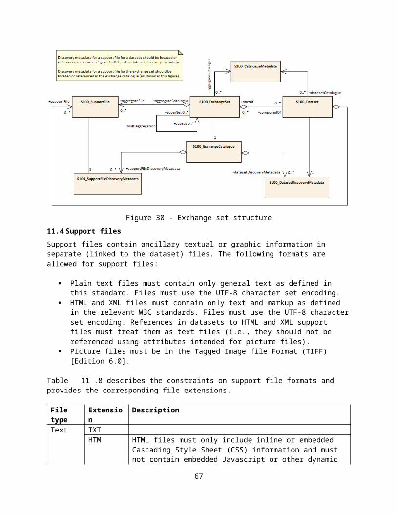
Feature Catalogue
Name: Marine Traffic Management Feature CatalogueScope: Version Number: 1.0.0Version Date: 2018-11-29Producer:
International Hydrographic Organization, 4 quai Antoine 1er,B.P. 445MC 98011 MONACO CEDEXTelephone: +377 93 10 81 00Telefax: + 377 93 10 81 40
Language: English
(See Annex with review print of Feature Catalogue.)
70