OVER RELIANCE ON NAV EQIUPMENT.pdf
30
Overreliance on Modern Navigation Aids: The Role of Traditional Methods of Navigation and Case Studies
-
Upload
clarence-pietersz -
Category
Documents
-
view
218 -
download
2
Transcript of OVER RELIANCE ON NAV EQIUPMENT.pdf

Overreliance on Modern Navigation Aids: The Role of Traditional Methods of Navigation and Case Studies

GPS and “Radar Hypnosis”
• GPS becomes especially limiting when no other navigation techniques are used to verify readouts
• The almost complete fixation on one instrument, to the exclusion of other data, disregards important principles of navigation
• In most cases, it is the human element which causes a maritime incident, no matter how sophisticated the suite of electronic aids
• “Radar hypnosis” was a recognized danger and this human frailty is no less apparent today with GPS

A Generational Issue?
GPS versus the Sextant Each method has its merits and there exists a human element in how modern navigational systems are applied Prime navigation principles are not replaced by new technology
http:/ / www.marineinsight.com/ misc/ marine-navigation/ revolutionising-marine-travel-marine-vhf-radios-marine-gps-and-marine-autopilots/

Proper Watchkeeping
Relies on three basic inputs
1. Bodily senses (primarily sight)
2. The complete suite of instrumentation
3. Training and experience

Principles of Navigation
I. The redundancy principle
I I . Cross- checking with other navigation methods

I . The Redundancy Principle
Each electronic aid and navigational system should have a backup in case of failure
The human senses as a backup to instrumentation
Experience or gut- level instinct as the final catch-all
Presenter
Presentation Notes
This protection is incomplete and has not been applied uniformly by courts. Furthermore, these protections require the involvement of attorneys. For companies that conduct audits on a routine basis, this can be prohibitively expensive. Therefore, a mechanism must be in place to identify particular events as beyond the real of a typical audit, even if it should occur during an audit. Attorneys should be involved solely for audits in response to a specific crisis or larger claim. Examples include larger Hull & Machinery failures, severe personal injury or death.

I I . Cross- checking and Verifying
Navigational tools should
not be used in isolation
Certainty based on multiple inputs
Identification of errors and
faults

Upgrading the Sextant
Will there ever exist a negotiated truce between old- school adherents of celestial navigation and
the new generation of navigators?

The Electronic Sextant
1. Point at the celestial body (sun, moon, planet, star)
2. Shoot Initiate acquisition by pressing a button 3. Fix plot your position by USB cable from the device
By permission from SOWILO Technologies

Case Studies
The most advanced electronic systems are only as good as the individuals who use them If navigation officers fail to realize there are other tools at their disposal, the ship may eventually encounter difficulties Human errors are introduced by:
• fatigue from long working hours • unfamiliarity with latest generation devices • overreliance on certain instruments to the detriment of others • lack of awareness of how these instruments interrelate
Presenter
Presentation Notes
Experts should minimize the use of permanent notes and have disclaimers on what notes they do keep.
Case Study I – Royal Majesty
On June 10, 1995, the ship grounded on Rose and Crown Shoal ten miles East of Nantucket Island while en route from Bermuda to Boston
Source: National Transportation Safety Board http:/ / www.ntsb.gov/ doclib/ reports/ 1997/ mar9701.pdf
Presenter
Presentation Notes
Ensure that consultants are contractually obligated to not divulge what they are working on, or who their clients are. This should be done at the time of retention of consultants and experts, and they should be instructed by the attorney on the rules of discretion.

Case Study I – Royal Majesty
Graphic representation of the GPS display at 2000 hours on the night of the grounding. The arrows show the DR (dead reckoning) and SOL (faulty solution)
Source: http:/ / ti.arc.nasa.gov/ m/ profile/ adegani/ Grounding%20of%20the%20Royal%20Majesty.pdf
Presenter
Presentation Notes
Ensure that consultants are contractually obligated to not divulge what they are working on, or who their clients are. This should be done at the time of retention of consultants and experts, and they should be instructed by the attorney on the rules of discretion.

Source: http://ti.arc.nasa.gov/m/profile/adegani/Grounding%20of%20the%20Royal%20Majesty.pdf
Case Study I - Actual and intended route of the Royal Majesty
Presenter
Presentation Notes
Ensure that consultants are contractually obligated to not divulge what they are working on, or who their clients are. This should be done at the time of retention of consultants and experts, and they should be instructed by the attorney on the rules of discretion.

Case Study I – Royal Majesty
Superimposition of the radar picture and buoy rendering over the nautical chart
The reflected echo from the “AR” buoy matched the expected location of the “BA” (entrance) buoy
Source: http:/ / ti.arc.nasa.gov/ m/ profile/ adegani/ Grounding%20of%20the%20Royal%20Majesty.pdf
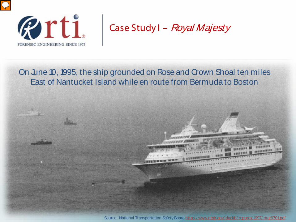
Case Study I – Royal Majesty
• Cursory Loran-C readings were taken at the beginning of the voyage to verify the accuracy of the GPS unit
• Loran-C receiver was of the variety where TD measurements are automatically translated to digital Latitude and Longitude readings
• Continued comparisons would have been a simple matter to achieve
Raytheon RAYSTAR 920 GPS Receiver Raytheon RAYNAV 780 LORAN-C Receiver
Source: http:/ / www.ntsb.gov/ doclib/ reports/ 1997/ mar9701.pdf
Presenter
Presentation Notes
Ensure that consultants are contractually obligated to not divulge what they are working on, or who their clients are. This should be done at the time of retention of consultants and experts, and they should be instructed by the attorney on the rules of discretion.

Case Study I – Royal Majesty
Radars Radar map is displayed as derived from the GPS data Radar image relies on what the radar scanner sees Underlying the radar map is the actual radar image Officer failed to: 1. Run a second radar set on longer range or 2. Inter-switch the single radar to a longer range

Case Study I – Royal Majesty
Light patterns and sound signals for buoys were not sought and recognized

Case Study I – Royal Majesty
Fathometer Restricted use of the fathometer is no longer necessary
when a digital readout is possible
Source: http:/ / www.marinemegastore.com/ product.asp?pf_id=SMG_523_CLIP_DEPTH& jump=0& cat_id=ELEINS001& cid=VWLIE909HTFGA1TU1NWJU9V4H3W8CP9Q
Source: http:/ / www.marinebio.net/ marinescience/ 01intro/ tomeas.htm

Case Study I – Royal Majesty
Channel 16 The investigation did
not reveal whether this channel was being monitored.
Why would the second
officer have assumed there existed needless conversation on a restricted frequency when his ship was being hailed?
http:/ / commons.wikimedia.org/ wiki/ File:Marit ime_VHF_Sailor_RT144.JPG

Case Study I – Royal Majesty
Lookouts The port lookout reported blue and white water to the
officer of the watch, who acknowledged but did not verify the sighting, and did not act accordingly
http:/ / screen-wallpapers.com/ wallpapers/ view/ 108

Case Study I I – Bermuda Star
Navigational Holding Pattern Cruise ship ran aground two miles off the Cape Cod Canal
in dense fog, forcing the evacuation of 680 passengers • Under these circumstances the ship is expected to “mill about
smartly,” turn small circles, or perhaps go to anchor
• Radar was not used to take bearings and ranges to land promontories
• A ship is never just “parked” somewhere

Case Study I I – Bermuda Star Estimated grounded position

Case Study I I I – Kora
Autopilot Failure Tanker grounding on semi-submerged coral at full speed, in
daylight, with running radar, and the watch officer and lookout present
The vessel was reportedly swept further westward onto the reef by
seas associated with heavy weather
Source: Author

Case Study I I I – Kora
Autopilot Failure The autopilot had malfunctioned after an hourly
position fix with the GPS had been taken The navigation watch should have:
• taken GPS position fixes more frequently in proximity to “ land” • supplemented GPS readings with piloting techniques

Case Study I I I – Kora
Quita Sueño Bank and grounded position of the Kora at Lat 14-24.22 North, Long 081-06.55 West
Source of map: http:/ / www.gpsvisualizer.com/ map?output_google Source of grounded position: Author

Conclusions
The modern bridge environment is an integrated system of instruments that speak with each other
Intuitively, a second GPS is commonly purchased from a
different manufacturer for the reason of creating redundancy
Perhaps dual monitoring GPS receivers would be
feasible as well, where a discrepancy of more than one nautical mile would trigger an alarm
Conclusions
The human-machine interface and the interrelated nature of communications among navigation aids must be better understood, and taught
The compartmentalized way of teaching and thinking
must be reappraised Navigation practices should be instructed in a holistic
fashion
Conclusions
Instruct • how instruments communicate with each other
• how they obtain their data
• how the readouts should be interpreted

Conclusions
New Habits • Verification by another suitable method will be required, especially
with the dominant position of importance GPS now holds
• Real-time, pre-departure bridge equipment check list could be instituted using a laptop or tablet program
• The revamped electronic sextant and apps should be integrated into the suite, not merely smuggled on board
• Questioning and verification of data should be encouraged and rewarded

www.rtiforensics.com
ANNAPOLIS | LONDON | SAN FRANCISCO | PANAMA
510 921 5357
Ralph J. Bruni, B.S., M.S.M.M. Lead Marine Casualty Investigator
Presenter
Presentation Notes
Final Slide – Discussion


![Home [agencyonline.sbilife.co.in]...SBI Life - Smart Performer Daily Protect ICICI Pru Pinnacle II Reliance- Highest NAV Advantage Fund-Series-I Birla Platinum Advantage Plan HDFC](https://static.fdocuments.in/doc/165x107/6013c7fdb3435b114760c351/home-sbi-life-smart-performer-daily-protect-icici-pru-pinnacle-ii-reliance-.jpg)