Outline Application Environmental Statement (ES) - IEMA - Home · Outline Application Environmental...
22
PLOT E AND TELECOM HOUSE Outline Application Environmental Statement (ES) Non-Technical Summary Waterman August 2015
Transcript of Outline Application Environmental Statement (ES) - IEMA - Home · Outline Application Environmental...

PLOT E AND TELECOM HOUSEOutline ApplicationEnvironmental Statement (ES)
Non-Technical Summary
WatermanAugust 2015


Waterman Infrastructure & Environment Ltd
South Central 11 Peter Street Manchester M2 5QRtelephone +44 16 18 39 83 92web watermangroup.com
Telecom House / Plot E & Station Hill 3, Reading
ENVIRONMENTAL STATEMENT: NON-TECHNICAL SUMMARY
Page 1 of 18
1. INTRODUCTION
In January 2015, Sackville Developments (Reading) Limited (the ‘Applicant’) was granted outline planning permission for the redevelopment of an under-used and largely vacant plot of land adjacent to Reading Mainline Station in Reading town centre. The development, known as Station Hill 3 (and
hereafter referred to as the SH3 Scheme), encompasses land between Station Hill, Greyfriars Road, Friar Street and Station Road (hereafter referred to as the SH3 Site). The SH3 Scheme includes the demolition of all the existing buildings and structures within the SH3 Site, excluding the existing multi -
storey NCP car park, and replacement with four new commercial buildings (referred to as Building Plots A - D) and two new primarily residential buildings (referred to as Building Plots E and F). The existing NCP Car-Park would be reconfigured and refurbished.
In addition, the Applicant has been granted full planning permission for the development of 0.35 hectares of land within the north of the SH3 Site for the creation of a temporary landscaped area and multipurpose events platform, which would form an interim condition on the Site as the SH3 Scheme is
built out. This is hereafter referred to as the Temporary Events Space.
Since submission of the SH3 Scheme and Temporary Events Space Applications in 2013, the Applicant has acquired a plot of land adjacent to Plot E of the SH3 Scheme, known as Telecom House, and is
now seeking outline planning consent for a development which encompasses both the Telecom House Site and Plot E (hereafter referred to as the Telecom House / Plot E Scheme). This is intended to replace Plot E of the consented SH3 scheme.
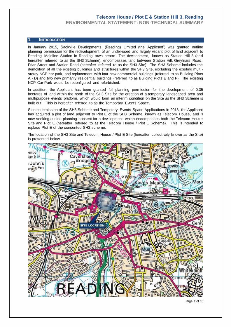
The location of the SH3 Site and Telecom House / Plot E Site (hereafter collectively known as the Site) is presented below.

Telecom House / Plot E & Station Hill 3, Reading
ENVIRONMENTAL STATEMENT: NON-TECHNICAL SUMMARY
Page 2 of 18
The Telecom House / Plot E Scheme occupies approximately 0.77 ha of land bounded by Garrard Street to the north, 40 Friar Street to the east, Friar Street to the south and 52 Friar Street to the west.
The proposals comprise demolition of 41 to 51 Friar Street and the buildings behind and erection of new buildings to provide primarily residential uses together with a range of town centre uses including shops.
As part of the outline planning application for the Telecom House / Plot E Scheme, an Environmental Impact Assessment (EIA) has been undertaken to assess the likely significant environmental effects of the SH3 Scheme (without Plot E) and Telecom House / Plot E Scheme in combination (hereafter
collectively referred to as the Development). The EIA has looked at the effects of both developments together because they are interlinked and the Telecom House / Plot E Scheme would only be built out as part of the SH3 Scheme. As the Temporary Events Space also forms part of the wider Development
proposals, the EIA has also considered an interim condition with the Temporary Events Space in place.
The findings of the EIA are reported in an Environmental Statement (ES) which has been prepared and submitted to Reading Borough Council (RBC) to accompany the outline planning application. The ES
will assist RBC and other statutory consultees in making their planning decision and providing comments on the application respectively. As the ES is an update of the one submitted as part of the SH3 Scheme planning application, it sets out the differences between the findings of the ES of the SH3
Scheme and that of the updated ES which relates to the SH3 Scheme together with the Telecom House / Plot E Scheme. This is to provide clarity to RBC and consultees on the changes brought about as a result of inclusion of the Telecom House / Plot E Scheme. It is for this reason that, whilst demolition
works are currently ongoing at the Site, the EIA has considered the Site prior to commencement of demolition to enable a meaningful comparison of effects.
This document provides a summary of the ES in non-technical language.
2. ENVIRONMENTAL IMPACT ASSESSMENT METHODOLOGY
EIA is a formal process which aims to ensure that the likely significant environmental effects of a new
development (which can be beneficial or adverse) are taken into account by a local planning authority in the deciding whether to grant planning permission for certain redevelopment proposals. The EIA of the Development has been undertaken in accordance with legal requirements , best practice guidelines,
and established assessment methodologies. This involved visits to the Site, Site surveys, data reviews, consultation with a number of relevant statutory authorities, computer modelling and specialist assessment undertaken by a team of qualified and experienced consultants.
In consultation with RBC and other statutory consultees it was agreed with RBC that the following environmental topic areas would be addressed as part of the EIA:
Demolition and construction;
Socio-economics;
Archaeology;
Transportation and access;
Air quality;
Noise and vibration;
Ground conditions and contamination;
Surface water drainage and flood risk;
Ecology;
Wind;
Daylight, sunlight and overshadowing;
Townscape, conservation and visual assessment; and
Cumulative Effects (the likely significant combined effects of different effects resulting from the
Development itself and the likely significant combined effects of the Development with other
consented or reasonably foreseeable schemes).

Telecom House / Plot E & Station Hill 3, Reading
ENVIRONMENTAL STATEMENT: NON-TECHNICAL SUMMARY
Page 3 of 18
The assessment of each environmental topic set out above is reported in a separate chapter of the ES. The ES also sets out measures to avoid, reduce, or offset any identified likely significant adverse effects
of the Development, known as mitigation measures, and measures to enhance the likely significant beneficial effects. The resulting effects (known as ‘residual effects’), following the implementation of the mitigation and enhancement measures are described.
3. LAND USES AND ACTIVITIES
The Site comprises an area of approximately 2.53 ha. The boundary of the Site (comprising the SH3
Site and the Telecom House / Plot E Site) is shown on the Figure below (which also shows the existing layout of the Site).
The majority of the Site is vacant. Only the existing multi-storey car-park, Xafinity House offices in the western part of the Site and a small number of small-scale retail units fronting Friar Street are currently in use. Consequently, much of the Site is underused, derelict, and in a general state of disrepair.
The tallest building on the Site is the Western Tower. This stands at fifteen storeys. Other buildings on the Site are low rise and range between three and eight storeys.
Photographs of the Site are shown below.

Telecom House / Plot E & Station Hill 3, Reading
ENVIRONMENTAL STATEMENT: NON-TECHNICAL SUMMARY
Page 4 of 18
Western Tower and Xafinty House Garrard Street and Friars Walk Car Park
Entrance to Underground Car Park Station Hill Retail Units
Land uses surrounding the Site are varied and include:
Reading Mainline Station and transport interchanges;
Temporary taxi rank and bus stops;
Occupied offices;
Vacant offices;
Shops, cafes, restaurants and bars;
Residential properties;
Hotels; and
Public open space.
The existing land uses within and around the Site are shown on the figure below.

Telecom House / Plot E & Station Hill 3, Reading
ENVIRONMENTAL STATEMENT: NON-TECHNICAL SUMMARY
Page 5 of 18
Existing Surrounding Land Uses
4. ALTERNATIVES
In line with the EIA regulations, the ES provides a description of the main alternatives considered by
the Applicant. It should be noted that since the Development is a response to site-specific guidance and
policies, no alternative sites have been considered by the Applicant.
Without redevelopment, the Site would likely remain under-utilised and derelict, thereby attracting
vandalism and forfeiting the many potential benefits associated with redevelopment. This would go
against planning policy which emphasises the need to encourage extensive sustainable redevelopment
through the re-use of previously developed urban sites. Overall, it is considered that the negative effects
as a result of leaving the Site undeveloped considerably outweigh any beneficial effects that would arise
from the status-quo.
On the basis that the Site is redeveloped, an alternative would be for the renovation and refurbishment
of the existing buildings on the Site. However, this option would not include the comprehens ive
redevelopment of the Site and without new buildings there would be limited opportunities to improve
permeability through the Site. The negative issues associated with the Site would also not be resolved
with this alternative and the aspirations and vision of RBC for this area would not be realised. Therefore
this option was not considered by the Applicant to be a viable redevelopment solution.
The evolution of the Development has responded to a number of design, environmental and economic
issues. During the design process the following key considerations have influenced the selection of the
final design:
Pedestrian permeability from Reading Mainline Station, through the Site to Friar Street and
surrounding destinations;
Options for the NCP car-park included the retention and refurbishment or the demolition and re-
building;
The creation and enlargement of a Central Square and enclosure of an Arcade;
Appropriate building massing and the establishment of long-distance views through the Site;
Telecom House / Plot E & Station Hill 3, Reading
ENVIRONMENTAL STATEMENT: NON-TECHNICAL SUMMARY
Page 6 of 18
Building massing and the provision of daylight and sunlight to residential accommodation as well as
surrounding residential receptors; and
Provision of high quality public realm and private amenity space.
The Development has resulted from careful consideration of policy objectives for the wider Reading
area and the Site, the Applicant’s commercial objectives, and following consultation with RBC ,
statutory consultees, other interested parties and the public, together with prevailing environmental
constraints.
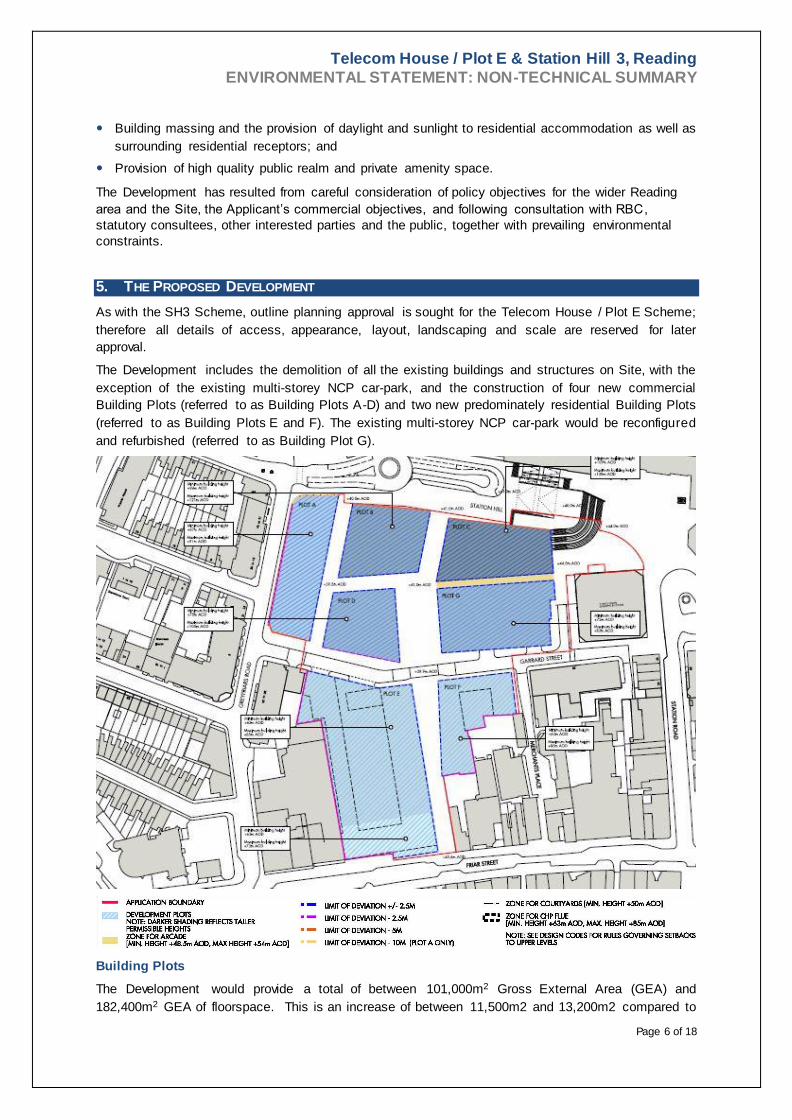
5. THE PROPOSED DEVELOPMENT
As with the SH3 Scheme, outline planning approval is sought for the Telecom House / Plot E Scheme;
therefore all details of access, appearance, layout, landscaping and scale are reserved for later
approval.
The Development includes the demolition of all the existing buildings and structures on Site, with the
exception of the existing multi-storey NCP car-park, and the construction of four new commercial
Building Plots (referred to as Building Plots A-D) and two new predominately residential Building Plots
(referred to as Building Plots E and F). The existing multi-storey NCP car-park would be reconfigured
and refurbished (referred to as Building Plot G).
Building Plots
The Development would provide a total of between 101,000m2 Gross External Area (GEA) and
182,400m2 GEA of floorspace. This is an increase of between 11,500m2 and 13,200m2 compared to

Telecom House / Plot E & Station Hill 3, Reading
ENVIRONMENTAL STATEMENT: NON-TECHNICAL SUMMARY
Page 7 of 18
the consented SH3 Scheme. This is largely an increase in residential floorspace. Whilst shops would
be provided in the Telecom House / Plot E Scheme, these could be accommodated within the maximum
floorspace area consented as part of the SH3 Scheme. The total floorspace areas for the SH3 Scheme
and Telecom House / Plot E Scheme combined is broken down as follows :
Between 69,000m2 and 122,000m2 GEA of office floorspace;
Between 6,000m2 and 13,500m2 GEA of retail floorspace;
Between 0m2 and 2,200m2 GEA of leisure uses;
Between 300 and 475 residential units (an increase of up to 175 units compared to the consented
SH3 Scheme);
Up to 1000 car parking spaces (between 550 - 900 within the reconfigured and refurbished car-park
and up to 200 within Telecom House / Plot E); and
Two new areas of public space referred to as Central Square and Station Square:
- Central Square: located between Building Plots D and G; and
- Station Square: located to the east of Building Plot C, north of Thames Tower (adjacent to the
east of the Site).
The Development comprises a range of Building Plot heights across the Site, which gives variety in the
form of the Development. The tallest Building (within Plot C) would reach a height of between 109m
AOD and 128m AOD. The lowest Building (within Telecom House / Plot E, Plot F or Plot G) would reach
a height of between 63m AOD and 83m AOD. The taller building elements of the Development would
be located towards the north of the Site whilst the lowest building elements would be located to the
south. The building heights would also increase from west to east.
The main vehicle access into the Development would be from Greyfriars Road and via Garrard Street.
The majority of the vehicular parking would be accommodated in the reconfigured and refurbished car-
park. Access and egress to/from the reconfigured and refurbished car-park would also be from Garrard
Street.
The Development proposes two key pedestrian routes across the Site. The major pedestrian route
would run north-south to connect the new Station Hill Bus Interchange and Reading Mainline Station
with the existing retail centre of Reading located south of the Site. A second key pedestrian route would
run east-west between Reading Mainline Station and Greyfriars Road to the west of the Site, through
Building Plot A and between Building Plots B and D in the west and through a new covered arcade in
the east of the Site between building Plots C and G.
Located between Plots D and G, it is envisaged that the Central Square would be the main pedestrian
focal point of the Development. In addition, a new Station Square would be created to the east of
Building Plot C. This new space would provide a gateway from Reading Mainline Station to Reading
town centre.

Telecom House / Plot E & Station Hill 3, Reading
ENVIRONMENTAL STATEMENT: NON-TECHNICAL SUMMARY
Page 8 of 18
Vehicle and Pedestrian Access Routes
The Development includes the provision of private and shared amenity spaces for residents within
balconies, roof terraces and / or a central courtyard area. Roof terraces are also proposed on the
commercial Building Plots (Building Plots A-D) for the future occupants of these buildings.
Green and / or brown roofs would be located throughout the Site. The total green / brown roof provision
would cover a minimum of 25% of the total roof area of each Plot within the Development. A green wall
would also be created on the southern side of the reconfigured and refurbished car-park. All trees
removed during demolition works would be replaced and additional trees planted. In addition, seating,
litter and re-cycling bins, cycle racks, signage and wayfinding features, information boards and lighting
would be provided.
Energy efficiency measures have been incorporated into the design of the Development. These include
passive design measures (for example, through insulation to reduce heating requirements and solar
shading to reduce cooling requirements); and the provision of energy efficient building services .
Combined Heat and Power (CHP) may also be implemented to provide heating and hot water to the
residential units.

Telecom House / Plot E & Station Hill 3, Reading
ENVIRONMENTAL STATEMENT: NON-TECHNICAL SUMMARY
Page 9 of 18
Public Realm Plan
6. DEVELOPMENT PROGRAMME, DEMOLITION AND CONSTRUCTION
The current expectation is that the demolition of the existing buildings on the Site and the construction
of the Development would take approximately 60 to 70 months. This is an increase of up to 10 months
which may be required to accommodate the addition of the Telecom House Site. It is anticipated that
the demolition and construction works would comprise the following main stages:
Enabling works;
Site preparation and demolition;
Excavation;
Foundation works;
Construction of the sub-structure;
Construction of the super-structure;
Cladding;
Fit-out; and
Landscaping.
A Construction Environmental Management Plan (CEMP) would be in place during the demolition and
construction works. This would include all details of relevant environmental management controls
Telecom House / Plot E & Station Hill 3, Reading
ENVIRONMENTAL STATEMENT: NON-TECHNICAL SUMMARY
Page 10 of 18
necessary for environmental protection during the works. This would follow all relevant legislative
requirements and best practice guidelines. The CEMP would be agreed with RBC prior to the
commencement of demolition and construction works.
7. TOWNSCAPE, CONSERVATION AND VISUAL ASSESSMENT
An assessment has been undertaken to determine the likely significant effects of the Development upon
the existing townscape and 33 key views around the Site. Three additional views were undertaken
compared to those for consented the SH3 Scheme to show additional views of the Telecom House /
Plot E Scheme.
The view selection was made in consultation with RBC and the assessment has been undertaken in
accordance with published best practice. The assessment of views has been informed by accurate
computer generated images of the Development inserted into them.
There are no conservation areas or listed buildings within the Site. However, there are a number of
listed buildings and conservation areas in the close and wider surrounding area. Including:
Market Place / London Street Conservation Area, St Mary’s Butts / Castle Street Conservation Area
and Russell Street / Castle Hill Conservation Area. These are located between 120m east, 250m
south-west and 350m south-west of the Site, respectively;
Grade I listed Greyfriars Church and Grade I listed Church of St Laurence located approximately
120m south-west and 280m east of the Site, respectively; and
Grade II listed buildings / structures including 39 Friar Street, adjacent to the south-east corner of
the Site, Grade II listed Reading Mainline Station (Three Guineas Public House) 30m north of the
Site and King Edward Statue located 30m east of the Site, Grade II listed Great Western House 50m
south-east and Grade II Listed 13 & 15 Station Road 60m east of the Site.
The demolition and construction works would give rise to inevitable visual intrusion. However, the likely
effect would be temporary and of minor to moderate adverse significance. The significance of effects
is the same as that of the SH3 Scheme.
The existing poor quality and run-down buildings of the Site do not positively contribute to the setting of
the nearby built heritage. Overall, the removal of the existing structures and their replacement with a
new landmark Development of sensitive design would enhance the setting of listed buildings and
conservation areas in the locality resulting in a substantial beneficial effect. In addition, on completion
of Development, the townscape character and quality of the Site would be improved. Furthermore, the
Development would significantly improve pedestrian accessibility to, from and through the Site and
bring vitality to the streetscape. This would transform the existing neglected and poor quality townscape
character resulting in a negligible to moderate beneficial effect.
With regards to views, it is concluded that the Development would result in changes to a number of key
views. It is considered that, in general, the Development would create a landmark feature on the skyline
that would clearly mark the redeveloped Reading Mainline Station and new bus interchange, assisting
local orientation and identifying the Site as a centre of regeneration. The effect is therefore negligible
to substantial beneficial depending upon the view in question. All the Townscape, Conservation and
Visual Effects remain the same as those of the consented SH3 Scheme. This is because, although the
Telecom House / Plot E Scheme occupies a larger area of land, the maximum and minimum heights
would remain the same as those of Plot E of the consented SH3 Scheme.

Telecom House / Plot E & Station Hill 3, Reading
ENVIRONMENTAL STATEMENT: NON-TECHNICAL SUMMARY
Page 11 of 18
8. SOCIO-ECONOMICS
A socio-economic assessment has been undertaken using a wide range of information sources. These
sources include planning policies and guidance, population and Census data, information provided by
RBC and professional experience of similar schemes.
The assessment found that the demolition and construction would generate in the region of 370 full time
jobs. This is greater than those calculated for the SH3 Scheme (250 jobs) because of the addition of
the Telecom House Site. However, the overall effect would remain negligible because of the mobile
nature of construction employment. There are approximately 42 existing employees currently working
at the Site and these would be lost as a result of demolition of the existing buildings on Site. This is
considered to be a minor adverse effect. Once the Development is completed and operational, it is
estimated that between 4,900 to 8,845 jobs would be created. This is the same as for the consented
SH3 Scheme because the floorspace areas of the main employment generating uses (shops and
offices) would not change with the inclusion of the Telecom House / Plot E Scheme. The effect is
assessed as substantial beneficial.
The Development is expected to give rise to a new on-Site residential population of between 540 and
855 individuals. This is an increase compared to the SH3 Scheme (255 to 510 residents) because of
the increase in residential units within the Telecom House / Plot E Scheme. Of this population, it is
estimated that there would be a minimum of 61 and a maximum of 96 primary school aged children, a
minimum of 11 and a maximum of 17 secondary school children and a minimum of 4 and a maximum
of 7 post -16 aged children living within the new residential units.
In terms of local services, financial contributions would be made towards primary healthcare and
primary education, thereby helping to address potential capacity issues and therefore a negligible
residual effect.
Together with the new employees and residents it is estimated that the Site would give rise to additional
local expenditure totalling approximately £15.6 million to £27.3 million annually. This is assessed as a
minor to moderate beneficial effect.
New public spaces, pedestrian routes and ground floor retail frontages would generate a significant
amount of pedestrian activity. It is envisaged that the Site would be highly active and vibrant, with a
high degree of natural surveillance. This would result in a high quality and safe environment suitable
for living, working, shopping and visiting resulting in a minor beneficial effect.
Telecom House / Plot E & Station Hill 3, Reading
ENVIRONMENTAL STATEMENT: NON-TECHNICAL SUMMARY
Page 12 of 18
9. ARCHAEOLOGY
A desk-based archaeological assessment of the likely significant effects of the proposed Development ,
and the temporary events space, on buried heritage assets (archaeology) at the Site has been
undertaken. This included a review of various historical information sources and consultation with
Berkshire Archaeology (archaeological advisor to RBC).
The results of the desk-based archaeological assessment reveal that the southern part of the Site falls
within the RBC designated ‘Area of Archaeological Potential’. The desk -based archaeological
assessment also established that the Site has yielded direct archaeological evidence in the form of a
pit and two layers, all likely to be of medieval/early post-medieval date. Evidence also makes reference
to medieval pottery on the OS plan of 1957 and the line of the Civil War ditch which crosses the Site.
A range of archaeological finds are present in the immediate vicinity of the Site, predominantly in the
southern area around Friar Street and Merchants Place.
In the northern part of the Site the construction of existing basements appears to have been undertaken
in such a way that the historic ground surface is likely to have suffered significant disturbance. In the
southern part of the Site, existing basements have been cut into the slope of the hill and would therefore
have caused significant disturbance to any archaeological deposits.
Consequently it can be concluded that, overall, the Site has a low to moderate potential for
archaeological remains.
The potential impact of the Development is the loss, disturbance and/or truncation of locally, regionally
or nationally important archaeological deposits from the Prehistoric, Saxon/Viking, Medieval and Post-
Medieval periods. This is likely to result in a permanent, regional, moderate adverse effect with limited
potential for substantial adverse effect on national resources. Mitigation is recommended through
archaeological evaluation post-demolition with an watching brief during embankment reduction and/or
strip, map and sample works during/after site clearance. Localised archaeological excavation and
archaeological watching brief, as appropriate, during construction on areas. Preservation in situ is
unlikely to be required unless nationally important features are identified. The precise methodologies
would be agreed in consultation with the archaeological advisors to Reading Borough Council. The
residual effects after mitigation would be permanent, regional effects of minor adverse significance, with
a negligible effect on national resources.
10. TRANSPORTATION AND ACCESS
A detailed study of the likely significant effects of the proposed Development upon transportation and
access including, local highways, public transport, pedestrians and cyclists has been undertaken.
All demolition and construction related traffic would enter and exit the Site through pre-agreed routes
which would avoid the use of Reading’s central areas. The main demolition and construction traffic
route to the Site would be via the Tudor Road / Inner Distribution Road (IDR) (Caversham Road) from
the north and via the grade separated Chatham Street roundabout onto Greyfriars Road from the south.
The average volume of Heavy Goods Vehicles (HGVs) movements associated with the demolition and
construction activities of the proposed Development have been assessed to be in the region of 35
vehicles per day. This level of traffic generation is not considered to be significant when compared to
the existing traffic flows / volumes of the existing surrounding highway network resulting in a negligible
effect. However, there is potential for delays to drivers and pedestrians and a reduction in pedestrian
amenity resulting in a minor adverse effect.
The provision of new public spaces and pedestrian routes within the proposed Development would
increase the Site’s permeability and attractiveness for pedestrian journeys. In addition, the new routes
would increase direct accessibility to and from the public transport services located at Reading Mainline
Station and central Reading beyond the South of the Site.
Telecom House / Plot E & Station Hill 3, Reading
ENVIRONMENTAL STATEMENT: NON-TECHNICAL SUMMARY
Page 13 of 18
The proposed Development would also provide up to 750 to 800 cycle parking spaces for occupants
and users of the whole site. This would further encourage more sustainable modes of travel to and from
the Site. A wide raised crossing facility is proposed at Garrard Street to accommodate the increased
pedestrian flows between Friar Street and the Railway Station and raise driver awareness of
pedestrians in this location. The proposed Development would provide up to 1,000 car parking spaces.
The proposed Development would result in predominantly negligible effects with some minor beneficial
effects predicted as a result of improvements in pedestrian permeability and a reduction in driver delay
on Greyfriars Road. A Framework Travel Plan has been produced to encourage sustainable travel to
and from the proposed Development and further enhance the beneficial effects of the proposed
Development.
11. AIR QUALITY
The Site is included within RBC’s designated Air Quality Management Area (AQMA). The RBC AQMA
has been designated as a result of relatively high levels of pollutants in the air. These pollutants are
mainly caused by exhaust emissions from road vehicles.
A detailed air quality assessment has considered the likely significant effects of the Development in
relation to demolition and construction activities and the completed and operational Development.
Predicted traffic flow data and other information has been analysed using a computer model which has
calculated and predicted the likely resultant changes in local air quality.
During demolition and construction works, best practice measures would be implemented to minimise
the risk of dust causing a potential nuisance, in particular, to local residents. These measures would
form part of the aforementioned CEMP and would include damping down surfaces, the covering of all
construction materials and the regular clearing of frequently used areas. Similarly, emissions from
construction plant would be minimised through measures in the CEMP, for example, switching off
engines at all times when not in use. With these measures in place, at worst, a minor adverse residual
effect is anticipated. This is the same as the residual effect for the consented SH3 Scheme.
The additional traffic movements resulting from the demolition and construction works are considered
insignificant in relation to the volume of existing traffic flows on the surrounding road networks.
However, given the town centre AQMA it is considered that there would be the potential for a minor
adverse effect on air quality from construction vehicles, in the peak construction period and negligible
outside the peak construction period. This is the same as for the consented SH3 Scheme.
Assessment of the completed Development has shown that there would not be any breaches of the
National Air Quality Objectives (which are the maximum values for a number of ‘problematic ’
atmospheric pollutants in the UK, based on EU standards). It can therefore be concluded that traffic
generated by the Development and emissions from the Development ’s heating and cooling plant would
have a negligible effect upon local air quality. This is the same as for the consented SH3 Scheme.
12. NOISE AND VIBRATION
The likely significant noise and vibration effects of the Development proposed have been assessed in
accordance with published guidelines. The assessment included the monitoring of existing noise levels
informed by a Site survey and the identification of local receptors which would be most sensitive to
noise and vibration. Such local receptors include future Site occupants and occupants / users of the
surrounding residential and commercial properties.
The only potential source of noticeable environmental vibration in the vicinity of the Site is associated
with Reading Mainline Station, located approximately 50m to the north of the Site. However, it is very
unusual for rail related vibration to be noticeable when it is 50m or more from railway tracks.
Furthermore, as the trains are generally moving slowly into or out of the station, they produce relatively

Telecom House / Plot E & Station Hill 3, Reading
ENVIRONMENTAL STATEMENT: NON-TECHNICAL SUMMARY
Page 14 of 18
low levels of vibration and a site visit concluded that vibration levels in the vicinity of the Site would be
imperceptible.
During the demolition and construction works, a number of measures would be taken to minimise the
amount of noise and vibration arising from the Site. These measures would be included in the CEMP
and would include: the careful selection of quiet plant and machinery; the erection of suitable hoardings
around the Development to screen noise generated by equipment on-Site; adhering to pre-agreed
working hours; and prescribing noise levels limits which would be agreed with RBC. The demolition
and construction activities could lead to an increase in vibration at the nearest buildings to the Site such
as Thames Tower and the Grade II Listed, 39 Friar Street. However, it has been assumed that
construction techniques would be discussed with RBC’s Environmental Health Department to ensure
that vibration effects would be minimised as much as possible. The overall effect of the demolition and
construction works on noise and vibration range from negligible to moderate adverse at the nearest
properties. The range of effects is the same as for the consented SH3 Scheme.
A review of the traffic flows associated with the demolition and construction, and an assessment of
flows associated with the completed Development, concludes that there would be no perceptible
increase in noise levels as a result of traffic related to the Development ; a negligible effect.
All proposed buildings would be designed to minimise significant adverse noise effects resulting from
the operation of building plant and services and from external influences such as road traffic. In this
respect, the Site would provide an environment suitable for residential uses and would not adversely
affect nearby existing noise sensitive receptors. The noise levels in Station Square would be noisier
than guideline values but this is not unusual for urban environments. The effects range from minor
beneficial to moderate adverse and are the same as for the consented SH3 Scheme.
13. GROUND CONDITIONS AND CONTAMINATION
An assessment of the potential for ground contamination to exist at the Site has been undertaken based
on information obtained from historical maps, geological maps and previous investigations. An intrusive
Site Investigation has also been undertaken on the northern part of the Site, between Garrard Street
and Station Hill.
Chemical analysis of environmental samples (soils and groundwater) collected as part of the intrusive
Site Investigation of the northern part of the Site did not identify widespread contamination of soils and
groundwater. However, further investigation would be undertaken in the southern part of the Site prior
to development of this area. If necessary, remediation would be carried out at the Site in order to ensure
that contamination is appropriately dealt with in order to not cause harm to humans or the environment.
All demolition and construction works would be undertaken in accordance with legislative requirements
and a CEMP. This would minimise the risk of spillages, creation of dust, uncontrolled run off or other
activities which could cause or mobilise existing contamination. The resulting effect would be negligible
to at worst minor adverse. This is the same as for the consented SH3 Scheme.
On completion of the Development, the risk posed by any remaining residual contamination to future
Site occupants, soil, groundwater, and flora and fauna would be very low. This would be due to the
remediation employed (as necessary), and the fact that the majority of the completed Development
would be covered in hard surfacing, which would serve to act as a physical barrier between the residual
contamination source and potential receptors. Landscaped areas would be provided with a clean growth
medium to reduce risks of exposure to soil contaminants and fuel storage tanks for backup generators ,
where required, would be stored on hardstanding. The residual effect of the completed Development
is therefore assessed to be negligible with minor beneficial effects due to remediation of potentially
contaminated soil. This is the same as for the consented SH3 Scheme.
Telecom House / Plot E & Station Hill 3, Reading
ENVIRONMENTAL STATEMENT: NON-TECHNICAL SUMMARY
Page 15 of 18
14. SURFACE WATER DRAINAGE AND FLOOD RISK
In accordance with government guidance, a Flood Risk Assessment (FRA) for the Site has been
undertaken. This has been informed by a Site survey, topographical data for the Site, a review of
geological maps and information provided by the Environment Agency and Thames Water.
There are no surface water features on the Site. The closest watercourses to the Site are the River
Thames (located approximately 420m to the north-east of the Site) and the River Kennet (located
approximately 600m to the south-east of the Site). The Site is classified by the Environment Agency
as being at low risk of flooding from rivers and the sea. However, their Risk of Flooding from Surface
Water map shows that there is some potential for surface water flows / ponding within the highways
within and surrounding the Site.
During the demolition and construction works, temporary Site drainage associated with const ruction
traffic routes, temporary car parks and dewatering all have the potential to give rise to changes in
surface water run-off, including peak flows and low flows. However, assuming the adoption of best
practice construction techniques, it is considered that the residual effect would be negligible.
At the detailed design stage, site levels would be reviewed to ensure that no new low points are created
where surface water could pond. Finished floor levels would be above the level of the surrounding
highway. The risk of surface water flooding is therefore considered low and the effect negligible. The
Development would attenuate surface water runoff through the provision of attenuation tanks. This
would ensure that the surface water discharge would be no greater than the existing situation and would
also cater for the effects of climate change. In addition, areas of hard standing would be reduced from
the existing areas of water-resistant land surfaces through the provision of green / brown roofs. The
effect of the Development on flood risk would therefore be negligible.
The Development would not cause an obstruction to groundwater flows and hence would not cause
any increase in the level of the water table.
Works to the foul water drainage system would be undertaken in consultation and agreement with
Thames Water. Such works would be subject to standard best practice and mandatory regulatory
controls and would be designed to cope with the future population of the Site.
The effects of the proposed Development on flood risk and drainage remain the same as for the SH3
Scheme.
15. ECOLOGY
To assess the likely significant ecological effects of the proposed Development, an ecological appraisal
has been undertaken. This included desk-based ecological research, a range of ecological Site surveys
including surveys for bats and black redstart (a protected bird species), and consultation with relevant
wildlife organisations.
The habitats present at the Site comprise mostly buildings and hard-standing, with only very small areas
of the Site in the north and north-west covered in grassland, ornamental shrubs and scattered trees.
All on-Site habitats are considered to be of low quality and value with the exception of habitats for black
redstarts, a protected species of bird, which are considered to be of district to county value.
Within the surrounding area there are a number of non-statutory designated sites of wildlife interest and
the nearest of these is located 700m from the Site. As such, it is considered that the proposed
Development would have no effect on any designated or non-designated sites.
The 2005, 2012, 2014 and 2015 black redstart surveys confirmed that black redstarts are using the
Site, having bred on the Site in 2012 and holding territory in 2015. No direct evidence of nesting or
breeding black redstarts was recorded during most recent surveys in 2015 however it is considered
likely that black redstarts are breeding within the Site due to current activity observed during surveys in

Telecom House / Plot E & Station Hill 3, Reading
ENVIRONMENTAL STATEMENT: NON-TECHNICAL SUMMARY
Page 16 of 18
2015. Peregrine falcons were recorded potentially perching on the Western Tower within the Site. The
Site also has limited potential to be utilised by some ecologically valuable breeding birds including
starlings, although the Site in its current form does not provide optimal habitat for this species.
A bat survey of the Site found that the Site does not provide suitable habitat for bats.
In order to protect against disturbance to black redstarts and other breeding birds, demolition and Site
clearance works would be undertaken outside the main bird breeding season where practicable (i.e.
within the months September to February inclusive). If these works cannot be restricted to within this
period, an Ecological Watching Brief would be put in place during the main bird breeding season to
ensure that nesting birds are not adversely affected. This would include a pre demolition check to check
if any birds including black redstarts and peregrines are breeding on Site. In addition, netting has been
placed on Western Tower to discourage peregrine falcons from nesting on this structure prior to its
demolition. The effects of demolition and construction would range from minor adverse (due to
temporary loss of a peregrine perch on Western Tower) to minor beneficial (due to creation of additional
habitats during demolition that are favoured by the black redstart). The majority of effects would
however, be negligible. These effects are the same as for the SH3 Scheme.
The creation of new habitats within the completed Development, particularly brown roofs, would provide
new habitat for black redstart. Very little suitable foraging habitat is present on the Site currently, and
so the provision of this habitat, coupled with the provision of new nest boxes for black redstart, house
sparrow, starling and peregrine falcon, would be a minor beneficial effect. This is the same as for the
consented SH3 Scheme.
Habitat Plan
16. WIND
The likely significant effects of the proposed Development and the Temporary Events Space on wind
conditions have been assessed in relation to the comfort and safety of pedestrians within and around
Telecom House / Plot E & Station Hill 3, Reading
ENVIRONMENTAL STATEMENT: NON-TECHNICAL SUMMARY
Page 17 of 18
the Site. The assessment of likely demolition and construction effects was based on professional
judgement and experience. However, the assessment of the Temporary Events Space interim condition
and completed and operational Development has been informed by the use of a 3-dimensional scale
model of the Development which was exposed to the simulated wind and weather conditions of the Site
within a wind tunnel.
Once the Site is cleared following demolition, the wind would blow across the open Site. However,
demolition would be undertaken in phases and the presence of hoarding and temporary construction
buildings would mitigate the effects to some degree. It is therefore considered that the demolition and
construction would likely result in negligible effects.
Wind tunnel testing of the completed Development revealed that the wind microclimate at most areas
surrounding the Site would remain suitable for the existing (and future) pedestrian uses. The one
significant exception is the existing thoroughfare at the northwest corner of the site which was found to
be one category too windy for its intended use (a minor adverse effect). However, it is anticipated that
the detailed design of Building Plot A would return this area to suitable conditions for thoroughfare use.
This would be confirmed through further testing during the detailed design of Plot A and if necessary,
additional mitigation such as soft landscaping would be provided to ensure the wind conditions were
suitable.
Similarly, testing revealed that the majority of locations within the Site would also experience wind
microclimate conditions which would be suitable (or better) for the intended pedestrian uses.
Exceptions exist at Station Square and Central Square, certain Building Plot entrances and on roof
terraces where the effects range from minor adverse to moderate adverse . However, various
mitigation options such as the use of landscaping, localised screening and recessing of entrances would
be tested at the detailed design stage to ensure that all areas within the Site experience a satisfactory
wind microclimate suitable (or better) for the Development ’s proposed pedestrian uses. Such mitigation
would be ‘designed into’ the Development at subsequent detailed design stages.
The wind conditions are consistent with those for the consented SH3 Scheme.
17. DAYLIGHT, SUNLIGHT AND OVERSHADOWING
An assessment has been undertaken to establish the likely significant effects of the Development
proposed upon the amount of daylight and sunlight received by properties adjacent to the Site and the
proposed residential properties of the Development itself. An analysis of the amount of overshadowi ng
of new public spaces within the Development has also been undertaken. The assessment has involved
the use of a three-dimensional computer model of the Development and its relevant immediate
surroundings.
Following demolition of the existing buildings, daylight and sunlight levels at the Site and the immediate
surrounds are likely to temporarily increase. As the construction works continue the levels of daylight,
sunlight and overshadowing received by neighbours for the Site would reduce as the effects progress
to those of the proposed Development.
Following completion of the Development, many of the surrounding residential properties would
experience no perceptible change to sunlight or daylight availability. However, a number of rooms,
mostly in Projection East and West would experience a reduction in daylight and sunlight. Some
properties already have low existing levels of daylight and sunlight for which a reduction beyond the
levels recommended in relevant guidelines is inevitable. Furthermore, the urban location of these
properties would mean that residents are likely to have a lower expectation for high levels of daylight
and sunlight.
The residential units proposed within the Development would be designed to maximise daylight whilst
acknowledging the urban location.

Telecom House / Plot E & Station Hill 3, Reading
ENVIRONMENTAL STATEMENT: NON-TECHNICAL SUMMARY
Page 18 of 18
The assessment concludes that the majority of overshadowing would be restricted to the north of the
Site along Station Hill, and the Reading Mainline Station buildings and track to the north. Additional
shadowing beyond that experienced in the Baseline Scenario would not affect surrounding amenity
spaces.
The levels of daylight and sunlight in the proposed Development Scenario are largely in line with those
in the Consented SH3 scheme. There is an insignificant difference between the scale and magnitude
of the impacts for the proposed Development compared with the Consented SH3 Scheme. The degree
of alteration is unlikely to be noticeable, so the likely additional effect of extending Plot E to cover the
Telecom House Site is considered to be negligible. In addition, the levels of shadow as a result of the
proposed Development are similar to those from the Consented SH3 scheme and as there are only
slight differences the effect is considered unlikely to be noticeable.
18. CUMULATIVE EFFECTS
Two types of cumulative effects have been assessed in relation to the Development and the temporary
events space proposed:
The interaction of individual effects from the Development upon a set of defined sensitive receptors;
and
The combined effects of the Development / temporary events space and other reasonably
foreseeable schemes.
The demolition and construction of the Development in isolation would result in some temporary
adverse combined effects. These would be predominantly associated with dust, noise, vibration, traffic
and visual effects. The CEMP would ameliorate these construction-related effects as far as possible.
The likely cumulative effects of the Development with other consented and reasonably foreseeable
schemes were generally found to be minimal. Exceptions include:
Additional job creation and local expenditure;
The provision of new homes;
Air quality and noise and vibration effects during potentially overlapping demolition and construction
works. These would generally be restricted to relatively short periods; and
A further reduction in available daylight to 1-41 Icon House.
If you would like to receive further copies of this Non-Technical Summary, or would like to purchase a copy of the Environmental Statement, accompanying Figures or Technical Appendices, please contact:
Waterman Infrastructure & Environment Ltd Pickford’s Wharf Clink Street
London SE19DG
Tel: (020) 7928 7888 Email: [email protected]