Outer Cape Bicycle and Pedestrian Master Plan Final Report The Outer Cape Bicycle and Pedestrian...
108
Outer Cape Bicycle and Pedestrian Master Plan Final Report PREPARED FOR NATIONAL PARK SERVICE BY CAPE COD COMMISSION SEPTEMBER 2016 UPDATED FEBRUARY 2017
Transcript of Outer Cape Bicycle and Pedestrian Master Plan Final Report The Outer Cape Bicycle and Pedestrian...

Outer Cape Bicycle and Pedestrian Master PlanFinal Report
PRePaRed FOR NaTIONaL PaRK SeRVICeBY CaPe COd COMMISSION
SePTeMBeR 2016uPdaTed FeBRuaRY 2017

Prepared by the Cape Cod Commission: Martha Hevenor, Planner/Bicycle & Pedestrian Coordinator SarahKorjeff,Planner/PreservationSpecialist,ProjectCoordinator Glenn Cannon, Transportation Program Manager Heather Cormier, GIS Analyst Heather McElroy, Natural Resources Specialist Gary Prahm, GIS Analyst Anne Reynolds, GIS Director Patrick Tierney, Transportation Planner Steven Tupper, Technical Services Planner
Steering Committee members: Eric Larson, Town of Provincetown Roger Chauvette, Provincetown Bicycle Committee Charleen Greenhalgh, Town of Truro Jay Norton, Town of Truro Karen Snow, Truro Bike and Walkways Committee SuzanneGroutThomas,TownofWellfleet SaraHutchings,WellfleetBicycleCommittee
NationalParkStaff/Consultants Lauren McKean, Park Planner, Cape Cod National Seashore Karst Hoogeboom, Cape Cod National Seashore Laurie Domler, Natural Resource Specialist, Denver Service Center Patricia Sacks, Project Manager/Landscape Architect, Denver Service Center Lee Terzis, Cultural Resource Specialist, Denver Service Center Tracy Littell, Environmental Planner, VHB Erin Leatherbee, Preservation Planner, VHB
The Outer Cape Bicycle and Pedestrian Master Plan was funded by a Paul S. Sarbanes Transit in the Parks (TRIP) grant. Cooperative Agreement #P14AC00612

Outer Cape Bicycle and Pedestrian Master Plan - February 2017 update i
executive Summary 1Introduction Background and Purpose of Master Plan 7 BenefitsofBicycling 10 Guide to Terminology 13 Bicycle and Pedestrian Facility Types 15existing Outer Cape Bicycle Facilities National Park Service Trails 21 designated On-Road Bicycle Routes 22 Roads 23 ChallengesandProblemIdentification 29Route development Process Goals of Master Plan 31 Steering Committee 33 Public Involvement/Workshops 33 evaluation Criteria 34 evaluation of alternatives 36 IssuesRequiringFurtherConsideration 39 AlternativeSurfaceTreatments 39 Potential Route 6 Lane Reduction/Road diet 40 Route 6/Main Street/Cahoon Hollow Road -Wellfleet 42Recommendations Network 45 Primary Route - Narrative description 45 PrimaryRoute-DesignFeatures 49 Secondary Routes 57 WellfleetSecondaryRoutes 59 Truro Secondary Routes 65 Provincetown Secondary Routes 71 Maintenance 74 Support Facilities 75 education and Safety Programs 78Implementation Priorities 84 Cost estimates 86 PotentialFundingSources 89appendices
Table of Contents

Highland
Beach
Ballsto nBeach
Cahoo n
Ho ll ow
Bea ch
Whi t e
Cres t B
e achM
ag u ireL an d iu ng
Be ac h
Marconi B
each
Great H
ollow B
each
Duck H
arbor Beach
The Gut
Mayo Beach
Sunken M
eadow B
eachCoast Guard Beach
New
com
bH
ollo
wB
e ach
Paine'sCampground
Horton'sCampingResort
North TruroCamping Area
North ofHighlandsCamping Area
Dunes' EdgeCampground
Coastal AcresCamping Court
WellfleetAudubonCampground
Maurice'sCampground
Marconisite
Atwood-Higginshouse
HighlandLight
HighlandCenter andPayomet Tent
Province LandsVisitor Center
Old LifeSavingMuseum
BeechForest
PametHarbor
White CedarSwamp Trail
GreatIslandTrail
WellfleetHarbor
West EndRotary
ProvincetownMonument
BikeRestArea
TruroCentralSchool
WellfleetElementarySchool
WellfleetCouncilon Aging
WellfleetPublicLibrary
TruroCommunityCenter
Provincetown CommunityCenter
Provincetown LibraryVeteransMemorial ElementarySchool
South WellfleetPost Office
PostOffice
PostOffice
PostOffice
WellfleetWellfleetTown HallTown Hall
TruroTruroTownTownHallHall
Provincetown Town HallProvincetown Town Hall
The information depicted on these maps is for planning purposes only. It is not adequate for legal boundary definition, regulatory interpretation, or parcel level analysis. It should not substitute for actual on-site survey, or supersede deed research.
Outer Cape Bicycle and Pedestrian Master Plan Study AreaUser: heather.cormierDate: 5/24/2016
¸
0 0.5 1 1.5 2
Miles
Data collected September 2014
D R A F T
4 DestinationsExisting RoadwaysBike/Multiuse PathsBike LaneTrails / Sand RoadsMarked Trails

Outer Cape Bicycle and Pedestrian Master Plan - February 2017 update 1
executive SummaryPuRPOSeBicycling is popular throughout the communities of Outer Cape Cod, both as a transportation mode and a recreational activity. Local residents and visitors alike bicycle along area roads and off-road paths to reach shops and services, town centers, workplaces, beaches, and attractions within Cape Cod National Sea-shore (CCNS). Outer Cape bicycle trails attract thousands of cyclists each year. Bicycling is the second most popular activity in the Seashore. Despite bicycling’s popularity and the number of bicyclists on Outer Cape roads, bicycle accommo-dations are minimal, leaving bicyclists in many areas with no option but to share the road space with motor vehicles. Confident cyclists may be comfortable travelling in shared space, especially on low traffic volume roads, but less expe-rienced cyclists tend to feel stressed and uncomfortable riding in close proximity to motor vehicles. The need and planning for better and safer bicycle connec-tions between the three towns is not a new issue – studies from the 1980s and earlier identified similar concerns, but with larger passenger cars today and the rise of distracted driving from cell phone use, bicyclists face additional hazards.
The purpose of the Outer Cape Bicycle and Pedestrian Master Plan (OCBPMP) is to create a framework for an interconnected bicycle and pedestrian network linking the towns of Wellfleet, Truro, and Provincetown with the Cape Cod Rail Trail (CCRT), CCNS, and other destinations within the three communities. The plan provides a recommended primary route for extending the CCRT from its terminus in South Wellfeet to Truro and Provincetown, as well as a list of sec-ondary routes within each community that connect to popular destinations.
PaRTNeRSHIPThe OCBPMP is the result of a partnership between the National Park Service (NPS) and CCNS, the Cape Cod Commission (CCC), and the towns of Provinc-etown, Truro, and Wellfleet. NPS provided funding for the plan through a Paul Sarbanes Transit in the Parks grant and contracted with the CCC to develop the plan in conjunction with the three towns and CCNS. A steering committee com-prised of representatives from each community and staffed by CCNS and CCC staff guided development of the plan.

Outer Cape Bicycle and Pedestrian Master Plan - February 2017 update 2
GOaLS aNd OBJeCTIVeSThe Outer Cape Bicycle and Pedestrian Master Plan was developed over the course of two years with input from town staff, committee members, elected officials and members of the public. The work builds on prior research by CCNS and the CCC, as well as work done by bicycle and pedestrian committees in the towns of Provincetown, Truro and Wellfleet.
Early in the planning process, goals and objectives were developed to serve as guiding principles for developing the Master Plan. The goals and objectives bal-ance the need for a system of connected bicycle and pedestrian facilities that serve a wide range of users, with the desire to limit adverse impacts to cultural and environmental resources. They also seek to build on planned and ongoing projects and to use funds and assets efficiently. The goals of the master plan are listed on page 36.
PuBLIC INVOLVeMeNTRecognizing the importance of public input from local residents, officials and people knowledgeable and interested in bicycling in the area, a variety of means were used to gather public comment during the Master Plan process. A steering committee met monthly to guide development of the plan, and a series of public workshops were held throughout the planning process. In addition, the project team met with CCNS staff to review natural and cultural resource concerns, met with MassDOT staff to discuss Route 6, attended meetings with bicycle and pedestrian committees in the towns of Wellfleet, Truro and Provincetown to discuss project objectives, and met with town staff and Boards of Selectmen in each of the three towns to coordinate the regional and local routes. The CCC also established a website for the OCBPMP that provided information on the project and an email address to submit comments.
eVaLuaTION OF aLTeRNaTIVeSThe plan explains the process for developing potential primary route alternatives and the criteria used in evaluating those alternatives. In some cases, potential route segments were dismissed due to concern about environmental impacts from new development in otherwise undeveloped areas. In other cases, routes were dropped from consideration because of sensitive cultural resources, com-munity character concerns, topography, or lack of public support. Once three primary route alternatives were developed, the project team compared features and costs of the three alternatives, reviewed public comment, and conducted additional site visits to re-examine problematic locations. The project team identified issues related to Primary Route recommendations that are unresolved due to their complexity and will require additional analysis and consideration before completing the route design. These issues include: use of alternative
Outer Cape Bicycle and Pedestrian Master Plan - February 2017 update 3
surface treatments in areas that currently are unpaved paths or drives; the potential for a reduction in the number of travel lanes (or “road diet”) on Route 6 in North Truro and Provincetown; and the best route to bring bicyclists and pedestrians safely through the commercial area around Route 6/Main Street/Cahoon Hollow Road in Wellfleet.
ReCOMMeNded NeTWORKThe Outer Cape Bicycle and Pedestrian Master Plan provides a primary or ‘spine’ route that extends the Cape Cod Rail Trail from its current terminus in South Wellfleet to Provincetown. It also includes secondary routes that connect the spine to community destinations, and link together popular bicycle routes and trails in the region. The network balances an efficient and direct route through the region with a wider range of travel experiences through scenic and natural areas that characterize the Outer Cape towns. Combining primary and second-ary routes makes a variety of loop routes possible. All routes are proposed to use existing road public rights-of-way.
PRIMaRY ROuTeThe recommended Primary Route takes the form of a separated multi-use path within the Route 6 right-of-way for much of its length in an effort to accom-modate the greatest variety of users and to provide a direct route through the region with minimal impact to natural and cultural resources. It also provides a multi-use path along segments of currently unpaved railroad bed in South Well-fleet, owned by the Massachusetts Department of Conservation and Recreation (DCR), and in Provincetown, owned by the town of Provincetown. The Primary Route includes both interim and long-term segments in South Truro, North Truro and Provincetown, acknowledging the complexity and cost of implementing a multi-use path along Route 6 and the existence of other viable alternatives on local roads and paths. In these areas, where interim Primary Route segments are proposed along local roads with limited traffic, the route takes the form of paved shoulders and, in some cases, uses existing road space with “share-the-road” pavement markings and signage.
The report discusses design features along the Primary Route, including safety improvements at Route 6 crossings, and cross sections to illustrate how the multi-use path can be accommodated within the Route 6 right-of-way.
SeCONdaRY ROuTeSSecondary Routes through the region provide important means of access from the primary route to destinations and neighborhoods. The secondary routes in each town are based on input from town officials and staff members, town bicycle and pedestrian committees, and from public workshop and meeting

Outer Cape Bicycle and Pedestrian Master Plan - February 2017 update 4
attendees. A variety of accommodation types are proposed for the secondary routes, acknowledging the variety of existing conditions, different needs, and varying levels of concern about protecting scenic, historic and natural character along these routes. A summary table of secondary routes is included for each town. Any recommendations for improved accommodations along secondary routes would occur within existing road rights-of-way, and would require town plans and town support. No land takings are proposed. The majority of town-owned roads in Wellfleet, Truro and Provincetown have a 40 foot public right-of-way and the paved road is located within this area.
IMPLeMeNTaTION aNd PRIORITIeSThe Implementation section identifies how to move forward with various seg-ments of the project. Additional analysis is needed to address the primary route through the central part of Wellfleet, and the potential for a lane reduction or in Truro and Provincetown. Opportunities to fund these studies should be pur-sued. Primary Route segments that are the highest priorities for construction due to existing safety concerns, and priority locations for safe crossing improve-ments on Route 6, are also identified. The four high priority segments are: the railroad bed multi-use path in South Wellfleet, the multi-use path segment along Route 6 in northern Wellfleet, the multi-use path segment along Route 6 in Truro center, and the multi-use path along Route 6 in Truro’s Beach Point area.
Secondary Route priorities are discussed in the individual town sections. Well-fleet’s priorities include pavement markings and possible shoulders along Ocean View Drive and LeCount Hollow Road, and Route 6 crossing improvements at Main Street and LeCount Hollow Road. Truro’s priorities include Route 6 cross-ing improvements at Standish Way and Head of the Meadow Road, Stott’s Cross-ing, and Castle Road, as well as lane markings along Head of the Meadow Road. Provincetown’s priorities include climbing lanes on Bradford Street, a bicycle shoulder on Shank Painter Road, and Route 6 crossing improvements at Shank Painter Road and Conwell Street/Race Point Road.
COST eSTIMaTeS aNd FuNdING SOuRCeSThe master plan report discusses additional efforts that are necessary to com-plete the proposed network, including maintenance, support facilities such as wayfinding, multi-modal connections, bicycle and vehicle parking facilities, and education and safety programs. Finally, cost estimates are provided for the proposed Primary Route segments, with the complete Interim Primary Route estimated to cost $22.2 million and the complete Long-Term Primary Route estimated to cost $28.3 million dollars. A brief description of potential funding sources, both from the Federal Highway Administration and the National Park Service, ends the report.

Outer Cape Bicycle and Pedestrian Master Plan - February 2017 update 5

Outer Cape Bicycle and Pedestrian Master Plan - February 2017 update 6
Coast Guard Beach in Truro
aCRONYMS: CCC - Cape Cod Commission CCNS - Cape Cod National Seashore CCRT - Cape Cod Rail Trail dCR - Massachusetts department of Conservation and Recreation FHWa - Federal Highway administration MaSSdOT - Massachusetts department of Transportation NPS - National Park Service OCBPMP - Outer Cape Bicycle and Pedestrian Master Plan
Outer Cape Bicycle and Pedestrian Master Plan - February 2017 update 7
IntroductionBaCKGROuNd aNd PuRPOSe OF MaSTeR PLaN
Bicycling is popular throughout the Outer Cape, both as a mode of transporta-tion and a recreational activity. Local residents and visitors alike bicycle along area roads and off-road paths to reach local shops and services, town centers, workplaces, beaches, and attractions within Cape Cod National Seashore (CCNS). Outer Cape Cod bicycle trails attract thousands of cyclists each year. Bicycling is the second most popular activity in the Seashore. Seasonal workers, many from other countries, use area roads to bike to and from their jobs, including late night restaurant shifts. For much of the summer workforce, bicycling is the only way to get around.
Despite bicycling’s popularity and the number of bicyclists on Outer Cape roads, bicycle accommodations are minimal, leaving bicyclists in many areas with no option but to share the road space with motor vehicles. Confident cyclists may be comfortable travelling in shared space, especially on low traffic volume roads, but less experienced cyclists tend to feel stressed and uncomfortable riding in close proximity to motor vehicles. Route 6, the main (and only) road connecting the three Outer Cape towns, is a convenient and direct travel route, but because of its high summer traffic volumes, speeds, and lack of crossing accommoda-tions, it can be hazardous for bicyclists. The need and planning for better and safer bicycle connections between the three towns is not a new issue – studies from the 1980s and earlier identified similar concerns, but with larger passen-ger cars today and the rise of distracted driving from cell phone use, bicyclists face additional hazards.
The purpose of the Outer Cape Bicycle and Pedestrian Master Plan (OCBPMP) is to create a framework for an interconnected bicycle and pedestrian network linking the towns of Wellfleet, Truro, and Provincetown with the Cape Cod Rail Trail (CCRT), CCNS, and other destinations within the three communities. The plan provides a recommended primary route for extending the CCRT from its terminus in South Wellfeet to Truro and Provincetown, as well as a list of sec-ondary routes within each community that connect to popular destinations.

Outer Cape Bicycle and Pedestrian Master Plan - February 2017 update 8
PaRTNeRSHIPThe OCBPMP is the result of a partnership between the National Park Service (NPS) and CCNS, the Cape Cod Commission (CCC), and the towns of Provinc-etown, Truro, and Wellfleet. NPS provided funding for the plan through a Paul Sarbanes Transit in the Parks grant and contracted with the CCC to develop the plan in conjunction with the three towns and CCNS. As discussed later in the plan, a steering committee comprised of representatives from each community and staffed by CCNS and CCC staff, guided development of the plan.
PReVIOuS STudIeS/PLaNSThis plan builds on previous studies that examined options for improving bicycle safety and enhancing the bicycle facility network on the Outer Cape, from Well-fleet to Provincetown. CCNS/NPS produced a plan in 1987 to provide bicycle network connections on the Outer Cape (“Bicycle Trail Plan: Cape Cod National Seashore, Massachusetts 1987). It is interesting (though perhaps dismaying as well) to note that road conditions and bicycle safety concerns are similar to-day to those identified in the 1987 plan. With the exception of Massachusetts Department of Conservation and Recreation’s (DCR) extension of the CCRT from Eastham to South Wellfleet in 1994, no significant new bicycle accommodations have been constructed on the Outer Cape. Other NPS/CCNS Outer Cape bicycle planning studies include the Cape Cod National Seashore General Management Plan (NPS 1998) , the Bicycle Feasibility Study: Integrated Bicycle Plan for Cape Cod (NPS 2010), and Multi-Use Path and Bike Route Opportunities in the Outer Cape: Pre-Screening Analysis Report (Alexander 2013). CCC has conducted several bicycle and pedestrian and related transportation studies throughout Cape Cod. The following table provides a list of CCC studies and plans relevant to bicycle/pedestrian planning on the Outer Cape.
STUDY/REPORT NAME WEBSITE LINKClaire Saltonstall Bikeway: Cape Cod Segment Route Revision
http://www.capecodcommission.org/resources/transportation/csaltonstall-final.pdf
Connecting Town Centers to the Regional Pedestrian and Bicycling Network on Cape Cod
http://www.capecodcommission.org/resources/transportation/Townctrcon-nect3.pdf
Closing the Gaps: Connecting Cape Cod’s Bicycle/Pedestrian Network to Transit Routes
http://www.capecodcommission.org/resources/initiatives/TRIPfinalrpt.pdf
Town Centers Bicycle and Pedestrian Level of Service Report
http://www.capecodcommission.org/resources/transportation/townctrb-losrep.pdf

Outer Cape Bicycle and Pedestrian Master Plan - February 2017 update 9
STUDY/REPORT NAME WEBSITE LINKCape Cod Regional Bicycle Wayfinding Design Guidelines
http://www.capecodcommission.org/resources/transportation/FINAL_BIKE_GUIDELINES_REPORT_2012.pdf
Regional Transportation Plan 2012-2035
http://www.capecodcommission.org/resources/transportation/rtp/05_BikePed_08222011.pdf
A Guide to Public Transportation and Bike Route Options on Cape Cod (map 2011)
http://www.capecodcommission.org/resources/transportation/2011CCRTA-bike-bus.pdf
Bicycle Feasibility Study: Integrated Bicycle Plan for Cape Cod 2010
http://www.capecodcommission.org/resources/transportation/2010_CCNS_Bike_Feasibility.pdf
Information/Commentary on Alterna-tive Routes for Bikeways from South Wellfleet to Provincetown (1987)Provincetown Parking and Circulation Study 2015
Provincetown_Parking_and_Circula-tion_Study/PCS_Report.pdf
Wellfleet Route 6 Safety Study http://www.capecodcommission.org/resources/transportation/2012-Well-fleet-Rt6_12272012.pdf
Shank Painter Road Corridor Study Provincetown
http://www.capecodcommission.org/resources/transportation/SPR2012_report.pdf
A Plan for Improved Motor Vehicle Ac-cess Railroad Ave Provincetown
http://www.capecodcommission.org/resources/transportation/RailroadAv-enuePtown_032811.pdf
2009 Safety Report (includes Truro Central School zone and Provinc-etown/Shank Painter Road
http://www.capecodcommission.org/resources/transportation/2009safety_FINAL.pdf
2004 Outer Cape Safety & Traffic Flow Study
http://www.capecodcommission.org/resources/transportation/Route6Safe-tyTrafficFlow_Final.pdf
Outer Cape Bicycle and Pedestrian Master Plan - February 2017 update 10
BeNeFITS OF BICYCLING
Bicycling for transportation or recreational purposes is beneficial in numerous ways, and investing in bicycle infrastructure is an important consideration for communities. Residents, businesses, and visitors all benefit from bicycling – on an individual level, and on a community level - from the associated economic, environmental, and health benefits. Bicycle and pedestrian infrastructure re-quires relatively low investment, and expanding bicycle (and pedestrian) facili-ties on the Outer Cape would likely provide an overall benefit to the region.1 TRaNSPORTaTIONBicycling provides a needed form of transportation, particularly for those with-out cars or driver’s licenses who might depend on the bicycle as their main form of transportation. Bicycling (and walking) is an easy way to complete short trips, while helping to reduce automobile travel. Potential benefits from reduced au-tomobile travel include less traffic congestion, increased traffic safety, road and parking facility savings, and reduced air pollution. Outer Cape roads are clogged with cars in the summer months, and beach and municipal parking lots fill to capacity at peak times. Encouraging more people to bicycle, rather than drive, by providing comfortable and safe accommodations, could help ease Outer Cape summer traffic conditions.
HeaLTHBicycling (and walking) is an excellent form of physical activity to prevent and/or control detrimental health conditions and also enhance overall fitness. Physical activity reduces the risk of cardiovascular disease, type 2 diabetes, some can-cers, and a variety of other chronic conditions. Exercise such as bicycling is also beneficial for mental health and stress management.
eCONOMICSState and national economic impact studies have shown that bicycling -includ-ing the bicycle industry (bike manufacturing, distribution, retail, etc.), bicycle tourism, and the health benefits from cycling – generates significant revenue and cost savings for regional and local economies.2 Bicycle and pedestrian in-frastructure requires smaller rights-of-way and less overall financial investment
1 Litman, Todd, Evaluating Non- Motorized Transportation Benefits and Cost, Victoria Transport Policy Institute May 2013. This article is a useful reference foridentifying benefits and costs of non-motorized‖ forms of transportation, noting that conventional economic evaluation tends to overlook the benefits of bicycling and walking and thus undervalues providing infrastructure that supports them.2 Flusche, Darren, Bicycling Means Business: The Economic Benefits of Bicycle Infrastructure, League of American Bicyclists and the Alliance for Bike &Walking, June 2009, updated and expanded July 2012.

Outer Cape Bicycle and Pedestrian Master Plan - February 2017 update 11
than roadways.3 Bicycling also creates jobs – both within the industry and from bicycle/pedestrian infrastructure projects, which create more jobs per dollar than road projects. Evidence suggests that bicycling and walking projects create 11-14 jobs per $1 million spent, compared to just 7 jobs created per $1million spent with highway projects.4
Studies conducted in Iowa, Minnesota, and Vermont have shown significant state revenue generation from bicyclists’ spending on goods and services, and job creation supported by that spending.5 A study conducted on the Outer Banks in North Carolina (like Cape Cod, a coastal region where tourism is a primary revenue source) found that bicycle tourism there generates $60 mil-lion annually, and that a one-time $6.7 million bicycle infrastructure investment resulted in that annual nine-to one return. The study also indicated that the
3 2012 Cape Cod Regional Transportation Plan.p.345 4 Peletier, Heidi Garrett, Pedestrian and Bicycle Infrastructure: A National Study of Employment Impacts, Political Economy Research Institute, Universityof Massachusetts, Amherst, June 2011.5 See Flusche (footnote 2) for citations and links to the studies.
Bicyclists access the Province Lands Bike Trail from Cape Cod National Seashore Province Lands Visitor Center

Outer Cape Bicycle and Pedestrian Master Plan - February 2017 update 12
quality of bicycling in the area influenced visitors’ vacation planning.6
Cycling destinations benefit from bicyclists’ spending in the local economy. Cy-clists eat, shop, and vacation in communities that are bike-friendly and are ben-eficial visitors: a 2012 study shows that bicyclists spend more than car drivers per month at restaurants, bars, and convenience stores.7 The study’s findings are important for businesses to consider, suggesting that providing amenities and parking spaces for bicycles may be beneficial economically.
Bicycle trails also tend to increase property value of abutting and nearby prop-erties. Several studies, some conducted or funded by the real estate sector, show that proximity and convenient access to multi use paths (including “rails to trails”) generally is beneficial for both residential and commercial property values. The following link provides a list of reports related to bicycle/pedestrian trails/facilities and property values: https://www.nar.realtor/field-guides/field-guide-to-effects-of-trails-and-green-ways-on-property-values
6 North Carolina Department of Transportation, Pathways to Prosperity, Economic Impacts of Investments in Bicycle Facilities, 2004.7 Kelly J. Clifton, Sara Morrissey, and Chloe Ritter, Business Cycles: Catering to the Bicycling Mar-ket, TR News (May – June 2012) contains links and references to recent studies.
Bike lane along Herring Cove Beach access road in Provincetown

Outer Cape Bicycle and Pedestrian Master Plan - February 2017 update 13
GuIde TO TeRMINOLOGY
The following terms have the following meanings in this report:
Bikeway - A generic term that refers to a travelled way upon which bicycles can travel. A street where people can ride bicycles is a bikeway. Not all bikeways are bicycle facilities (see definition below).
Bicycle facility - a new or improved lane, path, or shoulder for use by bicyclists. Bicycle facilities also include associated bicycle accommodations such as bicycle shelters, parking, and bicycle oriented traffic control devices.
Bicycle lane (Class II facility) – A portion of the roadway that has been designat-ed by striping, signing, and pavement markings for the preferential and exclusive use of bicyclists. Bike lanes are striped at the outer edge of vehicle travel lanes, on the shoulder or between a vehicle travel lane and parking or turn lanes.
Bicycle path - A right of way, separate from a roadway, designated for bicycle or other non-motorized use. The term bicycle path is used interchangeably with ”shared-use path” and “multi-use path” in this report.
Bicycle route - A suggested route for bicycle travel. It may be an on-road route where bicyclists and motor vehicles share the travel way, and it may include stretches of other designated bicycle facilities. In general, a bicycle route desig-nation does not require that the road include any special bicycle facilities. (See also ”signed shared route.”)
Full separation – This refers to a bicycle facility where the bicycle travel area is separated from the motor vehicle area by a physical barrier such as guard rail, curbing, bollards, etc. A fully separated facility may be located adjacent to the roadway alignment (e.g protected bike lane) or in a location away from a road (such as the Cape Cod Rail Trail).
Multi-Use Path – See Shared-Use Path. These terms are used interchangably in this report.
Partial Separation – This refers to a bicycle facility (e.g. bike lane) that provides a designated space for bicycling with pavement markings but is located within the roadway footprint without a physical barrier from the motor vehicle area.
“Share the road” program – A public education initiative directed at cyclists and motorists to encourage safe roadway behavior and promote safe travel spaces

Outer Cape Bicycle and Pedestrian Master Plan - February 2017 update 14
for all road users. State and local transportation departments throughout the country promote such programs through signage, workshops, brochures and other informational materials.
Shared Use Path (Class I facility) - A path or trail that is physically separated from motor vehicle traffic located either within the road right of-way or within an independent right-of-way. Also referred to as multiuse pathways, they include bicycle paths, rail-trails or other facilities built for bicycle and pedestrian traffic and allowing other non-motorized travel modes such as skateboards and horses.
Sharrow - A shared-lane (share + arrow) marking used to indicate that bicycles and cars operate in the same lane. Sharrow placement – depending on the width of the travel lane – guides bicyclist position in the roadway.
Shoulder – The portion of a roadway contiguous with vehicle travel lanes, for accommodation of stopped vehicles and emergency use, often used by cyclists where paved.
Signed Shared Route – A bicycle route that has been identified as a preferred route with signage (see also Bicycle Route).
Cyclists make their way from the Cape Cod Rail Trail to Marconi Beach in Wellfleet

Outer Cape Bicycle and Pedestrian Master Plan - February 2017 update 15
BICYCLe aNd PedeSTRIaN FaCILITY TYPeS
Bicyclists with different levels of experience, confidence, and purpose for riding have varied accommodation needs. The OCBPMP seeks to meet the needs of bi-cyclists with varied abilities through a combination of facility types, both on and off-road. Bicycle facility planners and designers typically consider these three levels/groups when planning a facility:
Group A - Advanced Bicyclists: Experienced riders who have confidence riding under most traffic conditions and who desire direct routes and higher speeds.
Group B - Basic Bicyclists: Casual or new adult and teenage riders who may lack skill and confidence to integrate with fast or heavy traffic and desire low-speed, low-volume streets or designated bicycle facilities, either partially separated or fully separated from motor vehicles.
Group C - Children: Pre-teen riders whose key destinations are within or adja-cent to residential streets/areas and who prefer low volume streets with slow traffic or clearly defined separate bicycle paths.
Other factors such as traffic volumes, vehicle speeds, right-of-way width, and topography are also important factors in planning and design of bicycle facilities. FaCILITY TYPeS aNd TReaTMeNTS
Paved Shoulders Paved shoulders are the areas at the sides of the road that are outside of the vehicular travel lanes, but are paved. Shoulders are distinguished from the travel lanes by striping. Paved shoulders should be at least four feet wide to accom-modate bicycle travel, and MassDOT specifications require 5 feet for a Bicycle Lane, but if that is not possible, any additional shoulder width is better than none at all. Curbs can be hazardous to cyclists; in areas where curbs are present, additional shoulder space should be provided if possible to protect the cyclist from hitting the curb. Paved shoulders should be provided in both directions on a roadway, with bike traffic travelling in the same direction as motor vehicle traf-fic in the adjacent lane. Riding in the shoulder area may be challenging for inex-perienced bicyclists who lack the skills and confidence to ride in close proximity to cars.
Road paving and reconstruction projects provide ideal opportunities to add or improve shoulders for bicyclists. Paved shoulders also can be added to existing roads as a separate construction project, but that is generally more expensive

Outer Cape Bicycle and Pedestrian Master Plan - February 2017 update 16
than adding them during other road work projects. It also may be possible to create shoulders within the existing road footprints (i.e. no widening necessary) through a lane or road “diet” that reduces the number of vehicle lanes and/or their width to produce room for a shoulder or a bike lane.
Paved Shoulders Suitability FactorsRural roadways where bicycle travel is commonSecondary roadways without curb and gutter Roadways with few commercial driveways and intersectionsRoads already heavily used by cyclistsDesignated bike routes without improvementsRoads that establish a network or close a gap
Bicycle Lane (traditional)A bicycle lane is a portion of a roadway that has been designated by striping, signing, and pavement markings for the preferential and exclusive use of bicy-clists. Striped bike lanes can be effective as a safety treatment, especially for less-experienced bicyclists. Streets with bicycle lanes should be part of a con-nected bikeway system rather than being an isolated feature.
Bicycle Lane Suitability FactorsRight of way can accommodate minimum bike lane width of 4 feet (for roads without curbs or gutters; 5 feet if there are).Bike lane will be at least one-half mile in length.Two-lane residential/collector streets with lower traffic volumes, low-posted speed limit, and an absence of complicated intersections.
Paved shoulders on Route 6 in South Truro Bicycle Lane on Moors Road/Province Lands Road in Provincetown

Outer Cape Bicycle and Pedestrian Master Plan - February 2017 update 17
Advisory Bicycle LaneAn advisory bike lane is a treatment option for roads that may be too narrow for standard bike lanes. Using dashed lines that create a separate space for bikes, it can be used by motor vehicles when no bike is present. Advisory bike lanes may be appropriate treatments on Cape Cod roads where bike lanes are desired but sufficient pavement width is not available. Center-line removal may accompany advisory lanes to encourage motorists to give more space to bicyclists when passing them by moving closer to the center (and slowing down).
Protected Bicycle LaneA “protected” bicycle lane (aka cycle track) is separated from vehicle travel lanes, parking lanes, and sidewalks by pavement markings and coloring, bol-lards, curbs/medians, or a combination of these elements. Protected bike lanes provide increased comfort for bicyclists since they provide a separate space that, unlike traditional bike lanes, is protected from vehicles. Protected bike lanes are growing in popularity as preferable options to standard bike lanes. They gener-ally are found in urban areas on high traffic volume roads.
Protected Bicycle Lane in Austin, TX.http://www.peopleforbikes.org/green-lane-project/pages/austin-tx
Advisory Bicycle Lane in Hanover, NH. Photo by Danny Kim, from The Dartmouth, Septem-ber 25, 2014
Shared/Multi Use PathShared or multi-use paths are often preferred facilities for less experienced bicyclists and children because they do not have to share the path with motor vehicles. Design standards require adequate width for two-directional use by both cyclists and pedestrians, provision of good sight distance, avoidance of steep grades and tight curves that force bicyclists to make awkward movements, and minimal cross-flow by motor vehicles. Multi-use pathways need continuity with other facilities.

Outer Cape Bicycle and Pedestrian Master Plan - February 2017 update 18
Shared Path Suitability FactorsPathway will have connection/continuity with other bike/ped facilities so that cyclists are not stranded without a nearby bikeway connection.Minimal road cross-flow from motor vehicles (i.e. driveways, road intersec-tions). Sufficient land area to accommodate minimum width standards, while avoid-ing steep grades and tight curves.
SharrowSharrows delineate the “shared” lane for motor vehicles and bicycles and guide bicycle position in the road. They are a potential treatment option on roads that lack the width needed for a bike lane or shoulder. Sharrows may be appropri-ate on roads where motor vehicle speeds are less than 35 miles per hour (mph) but not on busy roads where the bicyclist constantly has to negotiate the shared space with passing motor vehicles. They are best on low traffic volume, low-speed roads. Sharrows are not a substitute for bike lanes but are a benefit on narrower streets where bikes and motor vehicles must share space.
Sharrow Suitability FactorsPosted speed limit 35 mph or lessLow traffic volume, “quiet” roads are best.Placement should be at least 12 feet from curb if parking lane is present.
Sharrow on Conwell Sreet in Provincetownhttps://www.facebook.com/Provincetown 365/
Cape Cod Rail Trail (CCRT) shared/multi-use path in Wellfleet

Outer Cape Bicycle and Pedestrian Master Plan - February 2017 update 19
Signage (for bicyclists and pedestrians)“Wayfinding” signage provides directional information to guide travelers to destinations. It is useful for directing bicyclists and walkers to the safest route to their destination. “Safety” signage communicates safety regulations and warn-ing (i.e. “yield to bicycles,” “stop,” “Share the Road,” “use shoulder only,” “bikes ride single file” etc.). Both types of signage are important features of bicycle routes.
Signed shared bicycle routeSigned routes are a cost-effective way to inform bicyclists of the best route to reach their destinations and should be part of a comprehensive, connected bikeway network. Routes should be located on roads with physical or opera-tional characteristics that are favorable to bicycling such as wide travel lanes, bike lanes, paved shoulders, and/or low traffic speeds and volumes. Directional signage and/or pavement markings should be provided along the route to guide riders.
Cartoon used by Provincetown Bike Committee, courtesy of bikeyface.com, https://www.facebook.com/Provincetown365/

Outer Cape Bicycle and Pedestrian Master Plan - February 2017 update 20
Signed Shared Route Suitability FactorsRoutes should be located on roads with physical or operational characteris-tics that are favorable to bicycling such as wide travel lanes, bike lanes, paved shoulders, and/or low traffic speeds and volumes.Route connects to destination(s)Signage and/or pavement markings should be provided along route to guide riders.
Questions about potential liability issues can discourage towns from designat-ing routes, and town officials should consult with legal counsel for advice. In general, liability for designating bike routes should not be a concern, provided the route is generally compliant with state and national standards and policies8. MassDOT’s policy (for roads under its jurisdiction) provides useful guidance to consider when designating a route. It can be viewed at: http://www.massdot.state.ma.us/Portals/8/docs/engineeringDirectives/policy/p-98-003.pdf
Conflict Zones“Conflict” zones are painted (or thermoplastic) road surface areas that guide cyclists through locations where motor vehicles might cross into a bike lane or shoulder area occupied by bicycles. Blue or green paint alerts bicyclists that they are entering a “conflict” area (such as right-turning lanes, merging lanes, etc.) and provides a visible “zone” to guide them through it. Painted conflict zones also alert motorists of cyclists’ presence and their right of travel.
8 MassBike Executive Director David Watson (email October 16, 2013). A useful resource on liabil-ity and bicycle facilities can be found in: http://www.bikeleague.org/sites/bikeleague.org/files/bikeleague/bikeleague.org/programs/bi-cyclefriendlyamerica/communities/pdfs/nchrp_liability_aspects_of_bikeways.pdf
Painted conflict zone in Milwaukee, WIhttp://urbanmilwaukee.com/2014/09/19/bike-czar-new-bike-trails-and-ride-rules/
Signed shared route on Castle Road in Truro

Outer Cape Bicycle and Pedestrian Master Plan - February 2017 update 21
existing Outer Cape Bicycle FacilitiesThe Cape Cod Rail Trail (CCRT) is the region’s primary multi-use path and owned by Massachusetts Department of Conservation and Recreation (DCR). It runs 22 miles from Route 134 in Dennis, just north of Great Western Road, to LeCount Hollow Road in South Wellfleet. A major objective of the OCBPMP is to provide a connection from the current terminus at LeCount Hollow Road to Truro and Provincetown. A western extension from Dennis to Peter Homer Park in Yar-mouth is under construction now; and an extension to Mary Dunn Road Hyannis is programmed for construction in 2020. Additional extensions are planned to Route 132 in Hyannis and continuing westerly, connecting to the Service Road which runs through Barnstable and Sandwich.
NaTIONaL PaRK SeRVICe TRaILS
Province Lands Bicycle Trail (Provincetown)The 7.3 mile long Province Lands Bicycle Trail, that includes a 5.45 mile loop, was created in 1967. It provides a scenic, though twisty and hilly, loop trail from the Province Lands visitor center through the Beech Forest to Race Point and Her-ring Cove beaches. The trail passes through rolling terrain, open dunes, dense woods, and provides pond and marsh views, and beach access.
The width of the trail varies from 8-10’. Full depth reconstruction and widen-ing occurred in two phases between 2008 and 2012; widening did not occur in sensitive wetland locations. Two roadway tunnels under Province Lands Road were reconstructed in 2014-15 due to inadequate drainage and head room. At present, an entry portion of the bike path along Race Point Road to Beech Forest is closed due to poor condition.
Head of the Meadow Bicycle Trail (Truro)The 2-mile Head of the Meadow Bicycle Trail was created in 1967. This bike trail provides a connection between Head of the Meadow Beach and High Head Road at East Harbor, passing through flat terrain, marsh views, and beach access. Al-though it is an easy trail due to lack of curves and road crossings, poor condition currently makes travel difficult for road bikes.

Outer Cape Bicycle and Pedestrian Master Plan - February 2017 update 22
The bike path varies in width from 6-8’ feet, and is in need of repair, with low wet areas, overgrown vegetation and cracking and heaving pavement. It is slated for reconstruction and widening in the next 2-3 years.
deSIGNaTed ON-ROad BICYCLe ROuTeS
Claire Saltonstall BikewayThe Claire Saltonstall Bikeway (also known as “MassBike 1” and the “Boston to Cape Cod Bikeway”) consists of a series of interconnected on road segments and multi-use paths that form a bike route beginning in Boston and ending in Provincetown. (A secondary leg extends from Bourne to Falmouth). The Mas-sachusetts General Court established the route in 1978 as a memorial to Claire Saltonstall, daughter of Senator William Saltonstall, who was killed in a bicycle accident in 1974. Green oval bike route signs with the number “1”are located along the route (though many are faded or missing). The existing route through the Outer Cape follows the CCRT to its terminus in South Wellfleet, then follows Lecount Hollow Road, Ocean View Drive, and Long Pond Road, continuing onto Main Street, West Main Street, Pole Dike Road, and Bound Brook Island Road to the Truro town line, where it continues along Old County Road, Depot Road, Truro Town Center Road, Castle Road, to Route 6. The route continues along Route 6 to Shore Road/Route 6A into Provincetown, where it follows Commer-cial Street to Arch Street.
As a long distance route, it was intended to serve more experienced riders and is not suitable for all. In response to concerns that segments of the route are
Walkers on Cape Cod National Seashore’s Head of the Meadow Trail in Truro

Outer Cape Bicycle and Pedestrian Master Plan - February 2017 update 23
ROadS
The following roads represent the primary existing bikeways on the Outer Cape. Roadway characteristics are also shown in the Table of Road Characteristics in Appendix A.
Route 6 U.S. Route 6 is the primary road corridor that serves the Outer Cape and is the main (and only) highway between Wellfleet and Provincetown. Secondary roads off of Route 6 provide access to the town centers, beaches, residences and other destinations. The road layout and right-of-way width varies. From Wellfleet to Shore Road/Route 6A in North Truro, it is a two-lane undivided road, with a ROW ranging from 100 feet and 200 feet. At Shore Road in North Truro, Route 6 becomes 4 lanes, undivided until Provincetown, where it becomes a 4-lane divided road. The ROW in the 4-lane portion is approximately 200 feet. Shoulder width in the two-lane section ranges from 5-8 feet (though in several locations, the shoulder width decreases to 1 -2 feet. Route 6 has some of the highest ve-hicle volumes on the Outer Cape. The posted speed limit ranges between 45-50, though speeding is a concern particularly in the 4-lane section.
Route 6 is a popular travel route for bicyclists due to its direct north-south route through the Outer Cape towns. With high traffic volumes in the summer months, high vehicle speeds, and only partial separation from motor vehicles, Route 6 can be uncomfortable for even experienced cyclists. The 4-lane section,
outdated given the change in development patterns, traffic/road conditions, and new (or proposed) bicycle paths, the CCC produced a report that provides recommendations for revising segments of the route. On the Outer Cape portion, the recommended changes at the request of each community’s bicycle com-mittee include: replacing the Welfleet Long Pond Road segment with Cahoon Hollow Road once the Main Street/Route 6 intersection improvement project is constructed; in Truro, using South Highland and Highland Road to access Shore Road for bicyclists heading north (rather than crossing Route 6 at Shore Road); and in Provincetown, continuing the route all the way to Macmillan Wharf, rather than stop-ping at Arch Street. Claire Saltonstall bikeway signage

Outer Cape Bicycle and Pedestrian Master Plan - February 2017 update 24
with its minimal shoulders, is particularly stressful. At the request of the towns of Truro and Wellfleet, MassDOT plans to restripe the existing Route 6 shoulder and add pavement markings and signage to designate that area for bicycle use. New striping and markings will be important in places where the shoulder has been narrowed to accommodate an area for left-turning vehicles. MassDOT is planning to enhance the existing paved shoulders with new line striping and bike lane signage between North Truro and Wellfleet center in 2017.
West Main Street, Pole Dike Road, Bound Brook Island RoadWest Main Street, Pole Dike Road, and Bound Brook Island Road together pro-vide an alternative to Route 6 and form part of the “back way” route through Wellfleet to Truro for bicyclists traveling between the Outer Cape towns on the bay side. They are relatively low traffic volume and low speed roads, with narrow pavement width (generally 18-21’) and provide a scenic ride through the Herring River wetland system. As with all local roads in Wellfleet, bicycles share lane space with motor vehicles, as the roads lack shoulders. These roads are part of the Claire Saltonstall Bikeway but may be challenging for inexperi-enced bicyclists and children due to poor sight lines and hills. The Herring River restoration project will raise water levels and affect areas of Pole Dike Road and Bound Brook Island Road.
LeCount Hollow RoadLeCount Hollow Road provides a connection to Maguire Landing/Lecount Hollow Beach and the CCRT and is popular with both bicyclists and pedestrians. It is a relatively flat two lane road, with high summer traffic volumes and low speeds. It is also part of the Claire Saltonstall Bikeway route. Sand drift can be a problem along sections of the roadway.
Wide shoulders along Route 6 in South Truro

Outer Cape Bicycle and Pedestrian Master Plan - February 2017 update 25
Ocean View DriveOcean View Drive runs parallel to the Atlantic Ocean and is Wellfleet’s ocean side connector road. It is a popular bike route to the beaches and offers a scenic ride, overlooking the dunes and the ocean. It is two-lanes and ranges from about 20-24 feet in width. As with all other town owned roads in Wellfleet, it has no bicycle accommodations, and bicyclists share lane space with motor vehicles. Sharing the road can create conflicts in the peak summer season, par-ticularly on the hills. Ocean View Drive is part of the Claire Saltonstall Bikeway route and is popular with bicyclists seeking a scenic alternative to Route 6 into downtown Wellfleet and points beyond.
Cahoon Hollow Road Cahoon Hollow Road connects Route 6 to Wellfleet’s ocean side. Like other ocean side roads, it has low traffic volumes and speeds most of the year but higher summer volumes. The section east of Old Kings Highway (OKH) lies within CCNS, with sloped woodlands and a scenic tree canopy on both sides of the road. West of OKH the road is residential. Road width varies from about 19-22’ generally. Cahoon Hollow has moderate grades in sections and curves on the eastern portion. Bicycles sharing the road with motorists can result in con-flicts during the peak summer season, particularly on the hills. Bicyclists travel-ling between Main Street/Route 6 and Ocean View Drive use Cahoon Hollow as a connector, but it is challenging for inexperienced bicyclists and children.
Long Pond RoadLong Pond Road connects Wellfleet’s ocean side to Main Street. Most of it is lo-cated within CCNS, and Its configuration is similar to Cahoon Hollow, with similar summertime vehicle volumes. It is part of the Claire Saltonstall Bikeway, though
LeCount Hollow Road in Wellfleet

Outer Cape Bicycle and Pedestrian Master Plan - February 2017 update 26
the Wellfleet Bike and Walkways Committee has recommended re-routing the bikeway to Cahoon Hollow following completion of the Main Street/Route 6 intersection project due to poor sight lines.
Old County RoadOld County Road in Truro provides a scenic alternative to Route 6 and connects with Bound Brook Island Road in Wellfleet to form the back way through the towns. It is a narrow (about 20’ in width) two-lane road with challenging hills and poor sightlines in sections. It is part of the Claire Saltonstall Bikeway and is popular with bicyclists travelling between the three Outer Cape towns. Like other local roads in Truro, it lacks bicycle accommodations, with bicycles and motor vehicles sharing space.
Castle Road Castle Road provides a scenic alternative to Route 6, providing connections to Truro Center, Corn Hill Beach Road and Route 6. It is also part of the Claire Saltonstall Bikeway route. With steep grades, curves, and poor sightlines, it is most suitable for experienced cyclists, though it is a popular bike route, espe-cially in summer.
South Highland RoadSouth Highland Road is a two lane road in Truro that provides a low stress ride through a residential neighborhood that also includes the Highlands Center, campgrounds, Highland Light, and other attractions. It provides a connection between Highland Road and Route 6.
Truro Center with “share the road” signage

Outer Cape Bicycle and Pedestrian Master Plan - February 2017 update 27
Highland RoadHighland Road provides a connection from South Highland Road and Coast Guard beach to North Truro Village Center. It is a popular route in the summer-time between the oceanside and Route 6A/Shore Road. MassDOT has plans to provide sharrows along the road in the near future in conjuntion with its Route 6 pavement marking project.
Route 6A/Shore Road Shore Road a 2-lane undivided road that provides a direct connection between Truro and Provincetown on the bay side. It provides a scenic alternative to the four-lane section of Route 6 from North Truro through residential areas and the seasonal lodgings Beach Point. It is a very popular bicycle route but can be challenging during peak season given the narrow lane width and high traffic volumes.
Commercial StreetCommercial Street is Provincetown’s main street through the downtown and provides the primary access to the waterfront. It is extremely busy in the sum-mer with high bicycle and pedestrian volumes (peak hour bike counts of 350 have been recorded), but like much of Provincetown and the whole Outer Cape, the number drops drastically in the winter). Commercial Street has no marked lanes and is a one way street for motorists; bicyclists may use it as a two-way street. A sidewalk runs along most of its length, but bicycles, pedestrians, and motor vehicles all use the road space.
Commercial Street in Provincetown is a narrow space shared by cars, bikes and walkers
Outer Cape Bicycle and Pedestrian Master Plan - February 2017 update 28
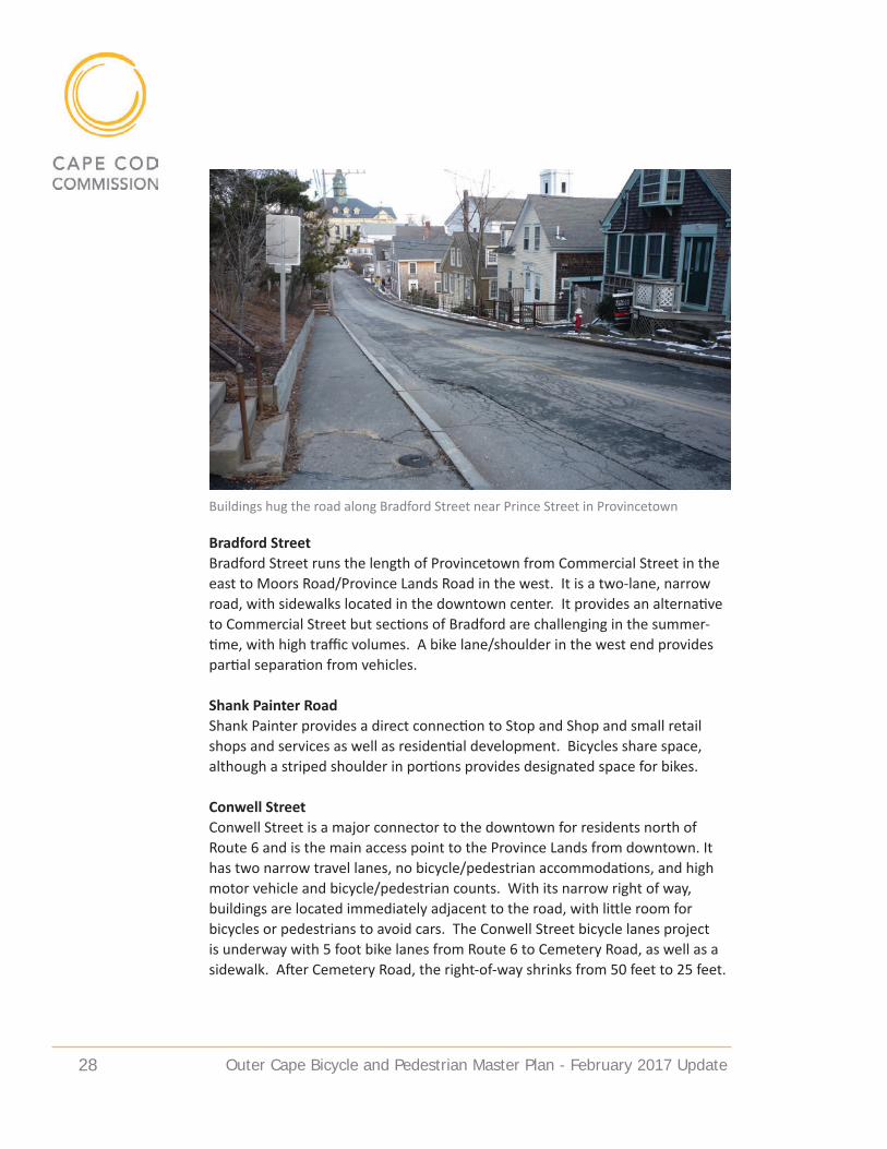
Bradford StreetBradford Street runs the length of Provincetown from Commercial Street in the east to Moors Road/Province Lands Road in the west. It is a two-lane, narrow road, with sidewalks located in the downtown center. It provides an alternative to Commercial Street but sections of Bradford are challenging in the summer-time, with high traffic volumes. A bike lane/shoulder in the west end provides partial separation from vehicles.
Shank Painter RoadShank Painter provides a direct connection to Stop and Shop and small retail shops and services as well as residential development. Bicycles share space, although a striped shoulder in portions provides designated space for bikes.
Conwell StreetConwell Street is a major connector to the downtown for residents north of Route 6 and is the main access point to the Province Lands from downtown. It has two narrow travel lanes, no bicycle/pedestrian accommodations, and high motor vehicle and bicycle/pedestrian counts. With its narrow right of way, buildings are located immediately adjacent to the road, with little room for bicycles or pedestrians to avoid cars. The Conwell Street bicycle lanes project is underway with 5 foot bike lanes from Route 6 to Cemetery Road, as well as a sidewalk. After Cemetery Road, the right-of-way shrinks from 50 feet to 25 feet.
Buildings hug the road along Bradford Street near Prince Street in Provincetown

Outer Cape Bicycle and Pedestrian Master Plan - February 2017 update 29
CHaLLeNGeS aNd PROBLeM IdeNTIFICaTION
The greatest challenge for bicyclists on the Outer Cape is motor vehicle conflict. This generally is not a problem in the off season (particularly for experienced bicyclists), when traffic volumes are low and conditions on most local roads al-low for bicycles and motorists to share lane space in reasonable comfort, but it is a problem in the summer months. Crossing Route 6 is difficult for bicyclists in the summer, with heavy traffic and few breaks between cars to get across. Many cyclists ride on Route 6 in the wrong direction as a result. Summer months also bring many visitors and workers to the Outer Cape who are inexperienced and/or unfamiliar with Massachusetts rules of the road. Separate facilities for bicycles, such as the CCRT and CCNS bicycle paths offer bicycling opportunities free from motor vehicle conflict, but none exist for north- south travel through the three towns or to destinations within them.
HaZaRdOuS/CHaLLeNGING LOCaTIONSThe following locations were identified during the planning process as the most hazardous intersections and road segments. Many involve concerns about safety in crossing or travelling along Route 6.
• Route 6 crossings: Stotts/High Head (Truro); Standish Way/Head of the Meadow (Truro); Corn Hill (Truro); LeCount Hollow Road (Wellfleet); Cahoon Hollow Road/Main Street area (Wellfleet); Shore Road/Route 6A (Truro).
A map of hazard areas produced during Workshop 1 of the master plan process

Outer Cape Bicycle and Pedestrian Master Plan - February 2017 update 30
• Route 6 Truro: Four lane section from Shore Road to Provincetown town line. No/minimal shoulders and high speeds.
• Route 6 Truro and Wellfleet: Locations opposite a left turn/road intersec-tion, where the fog line shifts right, eliminating shoulder space.
• Route 6A/Beach Point (Truro and Provincetown): Popular beach route, with motorists, bicycles, and pedestrians sharing narrow road space.
• Conwell Street (Provincetown): Limited space, main entrance to town and to Race Point from town, with bikes, pedestrians, and motorists sharing narrow lanes and right of way.
• Bradford Street (Provincetown): Sections with hills and narrow shared space.
• Cahoon Hollow Road at Route 6 (Wellfleet): Steep hill with narrow shared space; turning conflicts at intersection adjacent to business curb cuts and minimal (and crumbling) road shoulder on Route 6. Difficult crossing.
• Ocean View Drive (Wellfleet): Summer beach traffic and bicycles and pedes-trians share narrow space with vehicles (particularly between Cahoon Hollow and White Crest Beach), which can be stressful for bicyclists, especially on hills.
Intersection of Route 6 and Route 6A/Shore Road in Truro
Outer Cape Bicycle and Pedestrian Master Plan - February 2017 update 31
Route development Process
The Outer Cape Bicycle and Pedestrian Master Plan was developed over the course of two years with steering committee meetings, public workshops, and input from town staff, committee members and elected officials. The work builds on prior research by the Cape Cod National Seashore and Cape Cod Commission, as well as work done by bicycle and pedestrian committees in the towns of Provincetown, Truro and Wellfleet.
GOaLS OF MaSTeR PLaN
Early in the planning process, the following goals and objectives were developed to serve as guiding principles for developing the Master Plan.
Family biking at the Beech Forest in Provincetown
Outer Cape Bicycle and Pedestrian Master Plan - February 2017 update 32
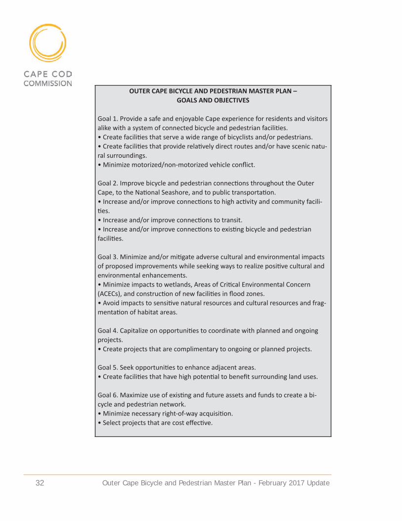
OUTER CAPE BICYCLE AND PEDESTRIAN MASTER PLAN – GOALS AND OBJECTIVES
Goal 1. Provide a safe and enjoyable Cape experience for residents and visitors alike with a system of connected bicycle and pedestrian facilities.• Create facilities that serve a wide range of bicyclists and/or pedestrians.• Create facilities that provide relatively direct routes and/or have scenic natu-ral surroundings.• Minimize motorized/non-motorized vehicle conflict.
Goal 2. Improve bicycle and pedestrian connections throughout the Outer Cape, to the National Seashore, and to public transportation.• Increase and/or improve connections to high activity and community facili-ties.• Increase and/or improve connections to transit.• Increase and/or improve connections to existing bicycle and pedestrian facilities.
Goal 3. Minimize and/or mitigate adverse cultural and environmental impacts of proposed improvements while seeking ways to realize positive cultural and environmental enhancements.• Minimize impacts to wetlands, Areas of Critical Environmental Concern (ACECs), and construction of new facilities in flood zones.• Avoid impacts to sensitive natural resources and cultural resources and frag-mentation of habitat areas.
Goal 4. Capitalize on opportunities to coordinate with planned and ongoing projects.• Create projects that are complimentary to ongoing or planned projects.
Goal 5. Seek opportunities to enhance adjacent areas.• Create facilities that have high potential to benefit surrounding land uses.
Goal 6. Maximize use of existing and future assets and funds to create a bi-cycle and pedestrian network.• Minimize necessary right-of-way acquisition.• Select projects that are cost effective.

Outer Cape Bicycle and Pedestrian Master Plan - February 2017 update 33
STeeRING COMMITTee
An Outer Cape Bicycle and Pedestrian Master Plan Steering Committee was established to guide development of the plan. It is comprised of two represen-tatives (a designated town official and a bicycle committee chair) from each of the three towns of Provincetown, Truro, and Wellfleet, as well as two CCC staff members, and two CCNS staff members. The town representatives served as community contacts/project liaisons and represented town bicycle and pedes-trian matters in the plan’s development. CCC and CCNS served as staff to the committee and were responsible for addressing interests and tasks identified in the project Scope of Work and for guiding the committee in its participation and review of project-related information. The Steering Committee provided guid-ance on development of alternatives for bicycle/pedestrian routes and facilities, and on how to garner diverse public input. The Steering Committee met almost monthly from August 2014 through the spring of 2016.
PuBLIC INVOLVeMeNT/WORKSHOPS
Recognizing the importance of public input from local residents, officials and people knowledgeable and interested in bicycling in the area, a variety of means were used to gather public comment during the Master Plan process. Four public workshops were held at various locations throughout the planning pro-cess. Workshop 1 on October 30, 2014 at the Truro Community Center, asked the approximately 50 attendees to help identify desired routes and destinations, hazards and areas of concern, and town priorities for bicycle and pedestrian ac-
Group mapping exercise during Workshop 1 at Truro Community Center

Outer Cape Bicycle and Pedestrian Master Plan - February 2017 update 34
commodation. At Workshop 2 on March 26, 2015 at the Wellfleet Public Library, approximately 35 attendees identified preferred primary routes through the region and then indicated the type of pedestrian and bicycle accommodation they preferred along various routes. Workshop 3 was held on November 12, 2015 at Provincetown Town Hall. Approximately 25 attendees at this workshop identified primary route preferences in each of seven segments in the region. At Workshop 4, on June 15, 2016 at the Truro Community Center, approximately 35 attendees helped identify priorities for secondary routes and brainstormed solu-tions for trouble spots along the primary route.
In addition to the workshops, the project team met with Cape Cod National Sea-shore staff to review natural and cultural resource concerns, met with MassDOT staff to discuss Route 6, attended meetings with bicycle and pedestrian commit-tees in the towns of Wellfleet, Truro and Provincetown to discuss project objec-tives, and met with a town staff workgroup prior to briefing the Boards of Select-men in each of the three towns to coordinate the regional and local routes.
eVaLuaTION CRITeRIa
The project team identified criteria, derived from the Master Plan goals, to use in its development and evaluation of potential primary and secondary routes. The criteria are presented below.
Workshop 3 participants at Provincetown Town Hall

Outer Cape Bicycle and Pedestrian Master Plan - February 2017 update 35
OUTER CAPE BICYCLE AND PEDESTRIAN MASTER PLAN EVALUATION CRITERIA
Users and Connectivity1. Does it accommodate varied types of bicyclists: “utilitarian” riders (i.e. bik-
ing for work or errands), and recreational riders; as well as various skill lev-els (A) “experienced,” who have high confidence riding in traffic, (B) “basic adult” bicyclists who lack skill to integrate with fast or heavy traffic, and (C) children – who may be prone to sudden movements.
2. Does it accommodate varied pedestrian users: “utilitarian” riders (i.e. bik-ing for work or errands), and recreational walkers; people with disabilities.
3. Does it facilitate a direct north/south route through the region?4. Does it provide access to key destinations (i.e. transit, town centers, civic/
community services buildings, Park attraction, existing bike/pedestrian facili-ties, other services)?
Resource Issues5. Does it impact sensitive natural resources (i.e. wetlands, ACEC, flood zone,
habitat, wellhead protection area)?6. Does it impact significant known or potential cultural resources (i.e. archae-
ological sites, cultural landscapes)?7. Does it have minimal topography and grades?8. Does it create a developed path in otherwise undeveloped area?
Character/Experience9. Does it seem consistent with the surrounding area’s character?10. Does it provide a scenic route for recreational riding/walking?11. Does it provide opportunities for interpretation?12. Does it provide connections to amenities (ie. food/bathrooms/visitor, and
parking facilities)?
Safety13. Does it provide a low-stress travel experience or provide separation from high traffic roads?
14. Does it provide safe and comfortable access through an area with safety hazards/unsafe crossings?
15. Does it include segments that work better in one direction than others?
Implementation Issues16. Is there adequate right-of-way? (i.e. no land acquisition is needed)17. What is the land ownership? (i.e. are there multiple owners?)18. Are there partnership opportunities for funding?19. What is the approximate cost? (i.e. design/engineering/build)20. Is it easy to implement? (i.e. is there local support?)

Outer Cape Bicycle and Pedestrian Master Plan - February 2017 update 36
eVaLuaTION OF aLTeRNaTIVeS
INITIaL SCReeNING/POTeNTIaL ROuTeSThe project team identified potential primary and secondary routes for further review based on road inventory/data collection, public input, and guidance from the Steering Committee. These potential routes were divided into discrete segments and screened against the evaluation criteria to for consistency with project objectives. Following this initial evaluation, the project team screened out several segments from consideration as the primary route due to commu-nity concern about potential character and natural resource impacts from road widening, or due to grades/topography.
Prior to commencing the OCBPMP, a CCNS Transportation Scholar conducted a preliminary study of potential routes for extending the Cape Cod Rail Trail (Alex-ander, 2012). The study identified several potential route segments that CCNS determined were not suitable alternatives following the report’s presentation to the three towns in the Spring of 2013. With more suitable alternatives available, these segments were re-categorized as “considered and dismissed” due to lim-ited north-south potential; private property ownership; community opposition; grades in excess of 15%; motorized access (i.e. dirt roads providing residential access); and/or probable cultural resource impacts. A final version of the report identified the following route segments as “considered and dismissed”:• Utility ROW from Cahoon Hollow Rd. to Long Pond Rd.• Utility ROW from Gull Pond Rd to Collins Rd.• Old King’s Highway – Gull Pond Rd. to Collins Rd.• Old King’s Highway – N. Pamet Rd. to Higgins Hollow Rd.• Dyer Hollow Rd./Higgins Hollow fire road – N. Pamet Rd. to Longnook Rd.• Old King’s Highway – Longnook Rd. to Old Dewline Rd. • South Hollow Road to Head of the Meadow was later added to the above list
due to ownership and regulatory issues related to creating a new trail there.
While Truro’s Bike and Walkways Committee requested some of these seg-ments be reconsidered as an alternative to creating a facility along Route 6, the project team did not conduct impact analyses for these segments because they had been previously dismissed and because of implementation difficulties due to private property and location on NPS land, which would require invoking the federal rulemaking process (see below). It may be desirable, however, to reconsider the Wellfleet utility ROW segment in the Cahoon Hollow Road area in conjunction with additional analysis to finalize the preferred primary route described later in the master plan.
NaTIONaL PaRK SeRVICe BICYCLe ReGuLaTIONSThe NPS regulations for designating bicycle routes and managing bicycle use within park units throughout the National Park System are known as the “bike
Outer Cape Bicycle and Pedestrian Master Plan - February 2017 update 37
rule” (36 CFR Section 4.3 as amended August 2012). It authorizes park super-intendents to open existing trails to bicycles under specific conditions, in accor-dance with appropriate plans and in compliance with applicable law. It also re-tains the existing requirement for a special regulation to authorize construction of trails outside of developed areas. NPS uses a multi-step analysis to determine the appropriateness of bicycle use on existing roads, administrative roads, walk-ing trails, and the creation of new bicycle trails. During the route development process, NPS staff determined that the potential routes under consideration would be located on administrative or public roads and therefore would not re-quire undertaking a structured National Environmental Policy Act (NEPA) analy-sis process. Such determination simplifies the implementation process, as the federal rulemaking process for special regulations can be complex and lengthy.
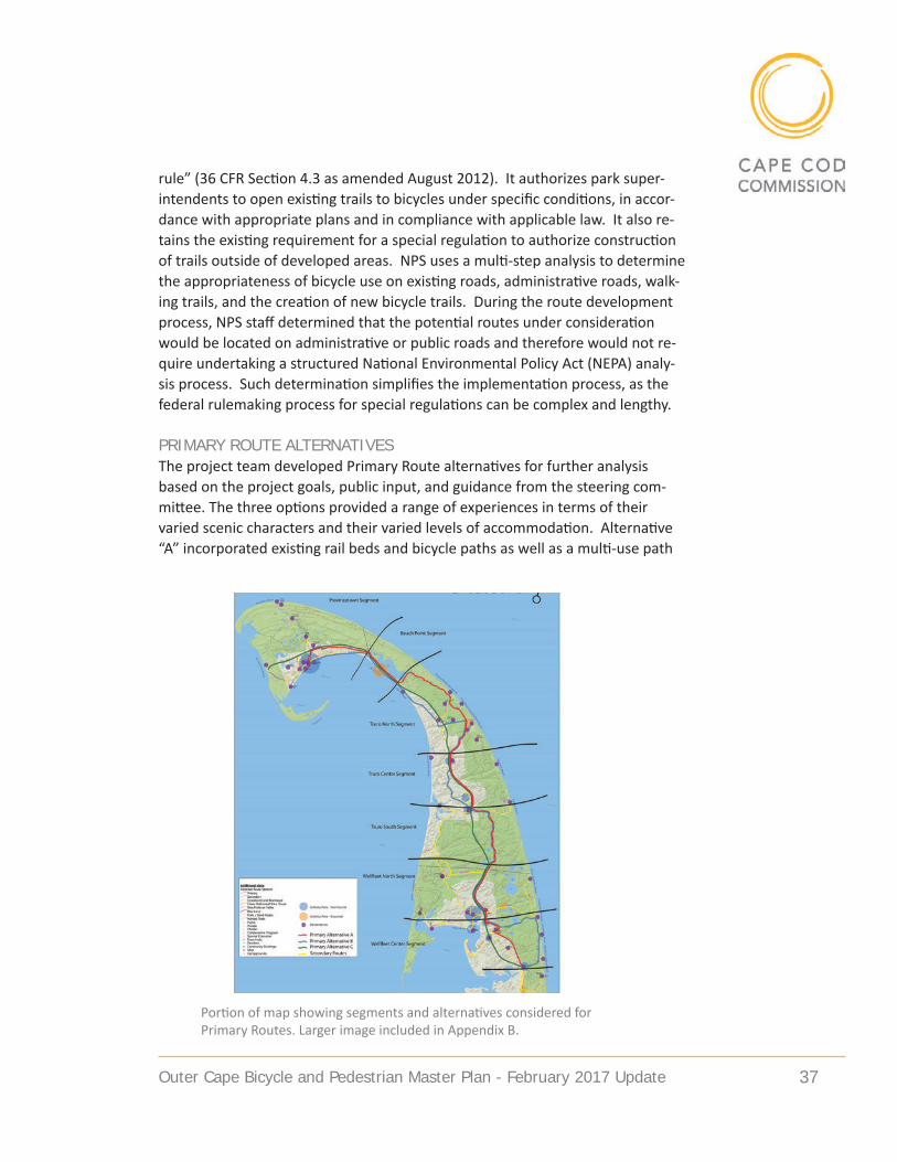
PRIMaRY ROuTe aLTeRNaTIVeSThe project team developed Primary Route alternatives for further analysis based on the project goals, public input, and guidance from the steering com-mittee. The three options provided a range of experiences in terms of their varied scenic characters and their varied levels of accommodation. Alternative “A” incorporated existing rail beds and bicycle paths as well as a multi-use path
Portion of map showing segments and alternatives considered for Primary Routes. Larger image included in Appendix B.

Outer Cape Bicycle and Pedestrian Master Plan - February 2017 update 38
along some segments of Route 6, Alternative “B” incorporated bike shoulders along local scenic roads with a multi-use path along some segments of Route 6, and Alternative “C” followed a multi-use path along Route 6 for its entire length. A map showing the 3 primary route alternatives is included in Appendix B.
COMPaRISON OF PRIMaRY ROuTe aLTeRNaTIVeSThe project team compared features and costs of the three Primary Route Alter-natives to assist in identifying the preferred primary route. The team reviewed public comments and conducted additional site visits to re-examine problematic locations and investigate opportunities for route revision. Additional analysis and comparison of the alternatives is detailed in the Alternatives Development Report for the Outer Cape Bicycle and Pedestrian Master Plan issued May 2016. The three Primary Route Alternatives intersected at seven locations, making it possible to consider the alternatives by segment and create “Hybrid” Alterna-tives combining segments from different alternatives.
HYBRId aLTeRNaTIVeS CONSIdeRedThe original proposed alternatives did not provide (nor did the analysis consider) a multi-use path along the east side of Route 6 in all areas, but the routes evalu-ation process showed that providing a path along the east side could reduce Route 6 crossings. For this reason, the project team added a multi-use path following the east side of Route 6 for consideration in the Truro South segment and the Truro North segment. In another effort to minimize Route 6 crossings, use of the Highland Road underpass to cross Route 6 was added as an option for consideration.
While evaluating the Primary Route Alternatives, the project team recognized that none of the alternatives stood out as a clear “best option” to meet all the criteria, and that a hybrid alternative combining segments from different alternatives would likely provide the best route. Focusing on safety, a hybrid combination of Alternatives A and C was considered with a goal of providing the greatest length of multi-use path while also avoiding heavily developed sections of Route 6. A second hybrid combination of Alternatives A and C was considered in an effort to include greater distance along scenic local roadways and bicycle trails. In both of the hybrid options, keeping to the east side of Route 6 in Wellfleet and much of Truro was preferred because it provides access to various National Seashore destinations and connections to Atlantic Ocean beaches, and also avoids conflicts with more commercial driveways.
INTeRIM aNd LONG-TeRM ROuTeSGiven the complexity and cost of implementing a multi-use path along Route 6, and the existence of other viable alternatives that could be easier to implement in some segments, the project team considered the possibility of making the

Outer Cape Bicycle and Pedestrian Master Plan - February 2017 update 39
Route 6 multi-use path segment a long-term goal and following some local road-ways as an interim proposal. To avoid potential character and natural resource impacts the project team considered less intrusive accommodation designs where appropriate, such as lane striping, sharrows, and other safety enhance-ments such as signage.
ISSueS ReQuIRING FuRTHeR CONSIdeRaTION
The project team identified several issues related to Primary Route recommen-dations that are unresolved due to their complexity and will require additional analysis and consideration before completing the route design. A summary of these issues is included below.
aLTeRNaTIVe SuRFaCe TReaTMeNTSNon-asphalt treatments are suggested for three segments that are currently unpaved dirt roads or trails. The intent in suggesting an unpaved surface is to retain the rural character of these areas and limit resource impacts associated with asphalt use while also providing a hardened surface to accommodate most
High Head Road in Truro (top) and the railroad bed in Wellfleet (bottom) are recom-mended as Primary Routes where alternative surface materials are considered

Outer Cape Bicycle and Pedestrian Master Plan - February 2017 update 40
bicycle riders. Adding new paved areas could fragment sensitive plant and wild-life habitat. Unpaved surfaces, often stone dust (decomposed granite) are used successfully on a number of bicycle and multi-use trails throughout the country, including areas with similar weather conditions to Cape Cod. CCNS is examining non-asphalt treatments for the dirt Old Kings Highway road segment in Truro, and does not plan to pave the unpaved High Head Road in Truro. Non-asphalt surfaces should also be considered for the existing unpaved rail bed segments in Wellfleet and Provincetown. These rail bed segments are both located in mapped rare species habitat areas and have a rural feel due to existing tree canopy and surrounding vegetation. Asphalt installation may require greater initial excavation (which can be harmful to trees) to provide rock base depth. The project team heard concern at the public workshops about us-ing asphalt on the Wellfleet rail bed because of its existing natural character, and heard support in Provincetown for non-asphalt surfaces on the rail bed there. However, some commenters also voiced concern that non-asphalt surfaces would limit some users. Hard packed stone dust trails may feel like pavement and be universally accessible when compacted and dry. Under wet conditions, however, the surface can be difficult for narrow bike tires and wheelchairs. Initial installation for stone dust may be cheaper than asphalt, as it requires less excavation depth. Annual maintenance costs may be less too, provided the path has proper drainage and is not located in a flood prone area which could cause erosion damage. Research on successful examples should continue.
POTeNTIaL ROuTe 6 LaNe ReduCTION/”ROad dIeT”At the request of representatives from Truro and Provincetown, the project team explored the concept of a Route 6 lane reduction or “road diet” (i.e removal of one or more travel lanes from the four-lane section in Truro and Provincetown) to determine its feasibility and potential to reduce construction costs and natural resource impacts if a separated multi-use path was installed within the existing pavement/lane area. A road diet in this location could result in a two-lane highway with one lane of travel in each direction, or a three-lane highway with two lanes in one direction.
Traffic counts showed the four lane section of Route 6 between Shore Road in Truro and the Provincetown/Truro town line with the highest measured traffic volumes in the summer months ranging from 618 to 1,018 vehicles per hour in one direction. On the four lane section of Route 6 between the town line and Herring Cove Beach in Provincetown, the highest measured traffic volumes in the summer months ranged from 190 to 852 vehicles per hour in one direction. Observation and past data show that year-round counts are significantly lower. Speed measurements on the four lane sections show 85th percentile speeds

Outer Cape Bicycle and Pedestrian Master Plan - February 2017 update 41
as high as 63 mph. The posted speed limit is 50 mph. Measurements show top speeds of over 65 miles per hour, and town officials have identified speeding as a problem.
The Federal Highway Administration (FHWA) states that typically the traffic threshold for considering lane reduction from four lanes to two is 875 vehicles per hour in one direction or average daily traffic as high as 24,000 vehicles per day in both directions. This is a guideline, not a standard, and does not account for special conditions/features such as seasonal population swings or geography. Route 6 in Truro has a maximum directional volume higher than the FHWA hour-ly volume threshold. Vehicle volumes for Route 6 in Provincetown do not exceed the thresholds. The summer average daily traffic volumes for the entire four lane segment fall below the daily volume threshold of 24,000 vehicles. In addition, sections of Route 6 that have two lanes in Truro and Wellfleet show higher traffic volumes than those that have four lanes in North Truro and Provincetown.
Decreasing the number of lanes could impact vehicle flow during peak sum-mer hours because the peak hour volumes are near or above the feasibility threshold. Outside of the peak summer hours and the summer months, traffic volumes are significantly lower than the thresholds. Traffic flow would likely be
Four-lane sections of Route 6 in North Truro (top) and in Provincetown (bottom), with center median, are possible locations for a lane reduction

Outer Cape Bicycle and Pedestrian Master Plan - February 2017 update 42
similar to the two lanes sections of Route 6 in Truro and Wellfleet. With ap-propriate intersection design, including carrying sufficient through lanes and incorporating turning lanes with sufficient storage, impacts to level of service at intersections may be mitigated.
In relation to roadway speeds, FHWA states that municipalities typically reduce the number of lanes to reduce extreme and 85th percentile speeds. Case studies and traffic simulation suggest that the 85th percentile could decrease between 3 to 5 mph and the number of speeders that violate the posted speed limit could decrease by 7 percent. Actual impacts will vary based on abutting land use and roadway geometry. A review of safety literature suggests that the number of crashes is typically reduced when a four lane road is reduced to two or three lanes. Specific case studies include reduction on roadways with turning lanes, low density and segments with 8 or fewer intersections per mile. Since lane reductions typically result in lower speeds, implementation could also have posi-tive impacts on crash severity. FHWA states that a difficult aspect of implement-ing a lane reduction is public perception. One method to address concern could be to conduct a trial period.
Sometimes lane reduction occurs during construction and a trial marking plan could be consistent with previous roadway projects. The impacts to congestion can be observed rather than estimated and the public gets a chance to drive the roadway under the proposed conditions. To have a positive impact to public perception, the trial period should last a reasonable amount of time, such that perception can adjust to the change and react to the impacts. The discontinued travel lanes could allow for designated space for bicycles and pedestrians and/or include a shoulder, as on the two lane portions of Route 6 in Wellfleet and Truro. A shoulder could allow vehicles to maneuver around vehicles turning left off Route 6. Bicycles could use the shoulder, as occurs on the two lane sections in Truro and Wellfleet. As a longer term project, a multi-use path physically removed from the travel lanes and shoulder is proposed. A lane reduction would allow the new path to be closer to the roadway centerline, minimizing the im-pacts to local ecology. Concerns include summer southbound afternoon/evening commute traffic, which could be further examined to identify available forms of mitigation. Any consideration of reducing the number of lanes needs to ad-dress how to deal with freezing fog or blowing snow along East Harbor that has required public safety officers to close some eastbound travel lanes up to a few times a year. A memo to public safety officers is included in the appendix.
ROuTe 6/MaIN STReeT/CaHOON HOLLOW ROad aRea IN WeLLFLeeTA more detailed evaluation of possible route designs between the Wellfleet railbed and the Route 6/Main Street area in Wellfleet is needed. Extending the
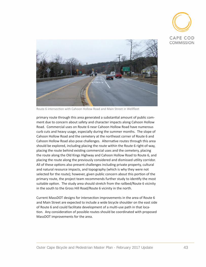
Outer Cape Bicycle and Pedestrian Master Plan - February 2017 update 43
primary route through this area generated a substantial amount of public com-ment due to concern about safety and character impacts along Cahoon Hollow Road. Commercial uses on Route 6 near Cahoon Hollow Road have numerous curb cuts and heavy usage, especially during the summer months. The slope of Cahoon Hollow Road and the cemetery at the northeast corner of Route 6 and Cahoon Hollow Road also pose challenges. Alternative routes through this area should be explored, including placing the route within the Route 6 right-of-way, placing the route behind existing commercial uses and the cemetery, placing the route along the Old Kings Highway and Cahoon Hollow Road to Route 6, and placing the route along the previously considered and dismissed utility corridor. All of these options also present challenges including private property, cultural and natural resource impacts, and topography (which is why they were not selected for the route); however, given public concern about this portion of the primary route, the project team recommends further study to identify the most suitable option. The study area should stretch from the railbed/Route 6 vicinity in the south to the Gross Hill Road/Route 6 vicinity in the north.
Current MassDOT designs for intersection improvements in the area of Route 6 and Main Street are expected to include a wide bicycle shoulder on the east side of Route 6 and could facilitate development of a multi-use path in that loca-tion. Any consideration of possible routes should be coordinated with proposed MassDOT improvements for the area.
Route 6 intersection with Cahoon Hollow Road and Main Street in Wellfleet

Outer Cape Bicycle and Pedestrian Master Plan - February 2017 update 44

Outer Cape Bicycle and Pedestrian Master Plan - February 2017 update 45
RecommendationsNeTWORK
The Outer Cape Bicycle and Pedestrian Master Plan provides a primary or ‘spine’ route that extends the Cape Cod Rail Trail from its current terminus in South Wellfleet to Provincetown. It also includes secondary routes that connect the spine to community destinations, and link together popular bicycle routes and trails in the region. The network balances an efficient and direct route through the region with a wider range of travel experiences through scenic and natural areas that characterize the Outer Cape towns. Combining primary and second-ary routes makes a variety of loop routes possible. All routes are proposed to use existing road rights-of-way.
Long range planning documents generally provide adaptation measures to ad-dress climate change at this time, and the next level of design will need to incor-porate hazard mitigation. This project advocates working with existing trans-portation corridors on the Outer Cape, and some pre-existing roads and travel corridors identified in the network may be vulnerable to storm surge, flooding, sea level rise or coastal erosion in the future. It is understood that the exposure, sensitivity and adaptive capacity of some route segments will need to be consid-ered and strategies analyzed to reduce or eliminate vulnerability.
PRIMaRY ROuTe - NaRRaTIVe deSCRIPTION
The following section describes the primary route’s path through all seven segments of the study area. The secondary routes are then described in more detail by town. Issues that require further consideration, as discussed in the Evaluation of Alternatives section of the plan, are noted and addressed in the Primary Route - Design Details section.
WeLLFLeeT CeNTeR SeGMeNTThe primary route follows the DCR-owned railroad bed as a multi-use path north from the Cape Cod Rail Trail terminus at LeCount Hollow Road for approximately 1.75 miles. The railroad bed provides the greatest distance separated from mo-

Outer Cape Bicycle and Pedestrian Master Plan - February 2017 update 46

Outer Cape Bicycle and Pedestrian Master Plan - February 2017 update 47
tor vehicles, and has a natural scenic character, making it the preferred route. It is also a direct route and the lowest cost alternative considered. A hardened but unpaved surface should be considered for this segment of the route, ac-knowledging the area’s rural character and its current unpaved condition. Where the railroad bed meets Route 6 is an area of concern due to the large number of commercial curb cuts and heavy traffic volumes. Further study is needed to identify the best route for bicyclists for the approximately half mile between the railroad bed and the Route 6/Main Street intersection (see discussion in Issues Requiring Further Consideration in previous section, pp.42-43).
WeLLFLeeT NORTH SeGMeNTThe primary route takes the form of a separated multi-use path along the east side of Route 6 for 2.32 miles. This side was selected because it has the least wetland buffer impacts and also provides continuity to the preferred route further north. The multi-use path would require a special design when passing over the Herring River culvert.
TRuRO SOuTH SeGMeNTThis segment includes both an Interim Primary Route and a Long Term Primary Route in an effort to provide trail sections that could function as regional routes in the short term. The interim primary route follows bicycle shoulders along Col-lins Road and South Pamet Road for 3 miles, as the low traffic volume and scenic character of these roads provides a welcome break from travel along Route 6. The appropriate width of bicycle shoulders and any pavement widening will need to be determined by the town, given concerns about historic and scenic character impacts. Advisory bicycle shoulder markings and re-striping should be considered to provide space for bicyclists without necessarily requiring major widening of the roadways.
The long term primary route in this segment takes the form of a separated multi-use path running along the east side of Route 6 for 2.3 miles. It would provide a continued multi-use path while avoiding wetland buffer and character impacts associated with potential widening along Collins Road and South Pamet Road. Because the interim primary route option is believed to be sufficient by some members of the Steering Committee and the public, this should be one of the last segments of multi-use path to be pursued or constructed, particularly if funding for the entire path cannot be obtained.
TRuRO CeNTeR SeGMeNTThe primary route again takes the form of a separated multi-use path running along the east side of Route 6 for 2.47 miles. This side of Route 6 has fewer curb cuts than the west side and better connectivity to the Truro Elementary School and other routes leading to beaches within Cape Cod National Seashore.
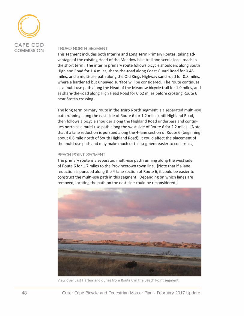
Outer Cape Bicycle and Pedestrian Master Plan - February 2017 update 48
TRuRO NORTH SeGMeNTThis segment includes both Interim and Long Term Primary Routes, taking ad-vantage of the existing Head of the Meadow bike trail and scenic local roads in the short term. The interim primary route follows bicycle shoulders along South Highland Road for 1.4 miles, share-the-road along Coast Guard Road for 0.48 miles, and a multi-use path along the Old Kings Highway sand road for 0.8 miles, where a hardened but unpaved surface will be considered. The route continues as a multi-use path along the Head of the Meadow bicycle trail for 1.9 miles, and as share-the-road along High Head Road for 0.62 miles before crossing Route 6 near Stott’s crossing.
The long term primary route in the Truro North segment is a separated multi-use path running along the east side of Route 6 for 1.2 miles until Highland Road, then follows a bicycle shoulder along the Highland Road underpass and contin-ues north as a multi-use path along the west side of Route 6 for 2.2 miles. [Note that if a lane reduction is pursued along the 4-lane section of Route 6 (beginning about 0.6 mile north of South Highland Road), it could affect the placement of the multi-use path and may make much of this segment easier to construct.]
BeaCH POINT SeGMeNTThe primary route is a separated multi-use path running along the west side of Route 6 for 1.7 miles to the Provincetown town line. [Note that if a lane reduction is pursued along the 4-lane section of Route 6, it could be easier to construct the multi-use path in this segment. Depending on which lanes are removed, locating the path on the east side could be reconsidered.]
View over East Harbor and dunes from Route 6 in the Beach Point segment

Outer Cape Bicycle and Pedestrian Master Plan - February 2017 update 49
PROVINCeTOWN SeGMeNTThis segment includes both Interim and Long Term Primary Routes, utilizing por-tions of the existing railroad bed in the eastern half of town to provide a scenic alternative and provide an alternative to sharing the road with vehicles. The Long Term Primary Route takes the form of a separated multi-use path run-ning along the west/south side of Route 6 for 2.25 miles until Conwell Street. It continues 0.55 miles along the west/south side of Route 6 until Shank Painter Road, where it crosses and becomes a separated multi-use path running along the north/east side of Route 6 for 1.2 miles until the Herring Cove Beach parking lot. [Note that if a lane reduction is pursued along the 4-lane section of Route 6, it could make it easier to construct the multi-use path in this segment. Locating the path on the east side of Route 6 could also be reconsidered.]
The interim primary route follows the multi-use path along Route 6 then turns south and follows bicycle shoulders along Snail Road for 0.1 mile to the rail-road bed. It then follows the railroad bed as a multi-use path for 0.96 miles to Howland Street, where a hardened but unpaved surface should be considered. Further research is needed to determine the preferred option for continuing into the center of Provincetown, possibly following paved shoulders along Howland Street for 0.1 mile to Route 6, following a separated multi-use path along Route 6 for 0.45 miles to Conwell Street, then following Conwell Street, Cemetery Road, Alden Street/ Bradford Street and Standish Street as paved shoulders and share-the-road for 0.67 miles to Lopes Square. This project is already underway. An alternative being explored by the Provincetown bike committee follows Harry Kemp Way as a bicycle shoulder until Conwell Street, then follows an easement or dedicated path through Riley’s parking lot to the town center.
PRIMaRY ROuTe – deSIGN FeaTuReSThe following issues will require additional design and engineering in conjunc-tion with development of the Primary Route.
ROuTe 6 BICYCLe/PedeSTRIaN CROSSING deSIGNSMaking Route 6 crossings easier and safer is a primary concern for town officials and committees. Key Route 6 crossings needing for safety improvements are:• Main Street/Cahoon Hollow Road, Wellfleet• LeCount Hollow Road, Wellfleet• West Road, Wellfleet• Head of the Meadow Road/Standish Way, Truro• Stott’s Crossing, Truro• Castle Road, Truro• Conwell Street, Provincetown• Shank Painter Road, Provincetown

Outer Cape Bicycle and Pedestrian Master Plan - February 2017 update 50
These locations are discussed further in the Secondary Routes section and shown on the Wellfleet and Truro Proposed Network maps. Possible improve-ments where bicyclists cross Route 6 to access the Primary Route include HAWK signals and median/pedestrian refuge islands (for the four-lane sections). A HAWK beacon (High-Intensity Activated crossWalK beacon) is a traffic control device used to stop road traffic and allow pedestrians and bicyclists to cross safely. The beacon is located above the roadway and is not illuminated until it is activated by a pedestrian. Once activated, it triggers first a warning flashing yellow light, then a solid yellow light, and then a solid red light for motorists. Pe-destrians are shown an upraised hand symbol and a countdown display inform-ing them of the time left to cross.
Pedestrian refuge islands are located between travel lanes on a roadway and create a protected space surrounded by raised curbing where pedestrians can wait to cross traffic. A pedestrian refuge island between north and south bound lanes on Route 6 would allow pedestrians and bicyclists to cross one direction of traffic and then wait in a safe area for an opportunity to cross the other lanes of traffic. The minimum width of a refuge island is typically 6 feet, based on the length of a bicycle or a person pushing a stroller.
ROuTe 6 MuLTI-uSe PaTH CROSS SeCTIONSThe design for a multi-use path along Route 6 includes separation between the bicycle path and the highway, with a physical barrier/guardrail and landscaped area to protect cyclists and prevent motor vehicles from encroaching on the path. The four cross sections shown in the figures reflect the four different layouts of Route 6 through the study area and are designed to illustrate the
HAWK beacon http://ocnjdaily.com/ocean-city-activates-new-bike-crossing-signal/
Pedestrian refuge island http://www.mlive.com/news/ann-arbor/index.ssf/2013/10/yp-silanti_to_construct_pedestr.html
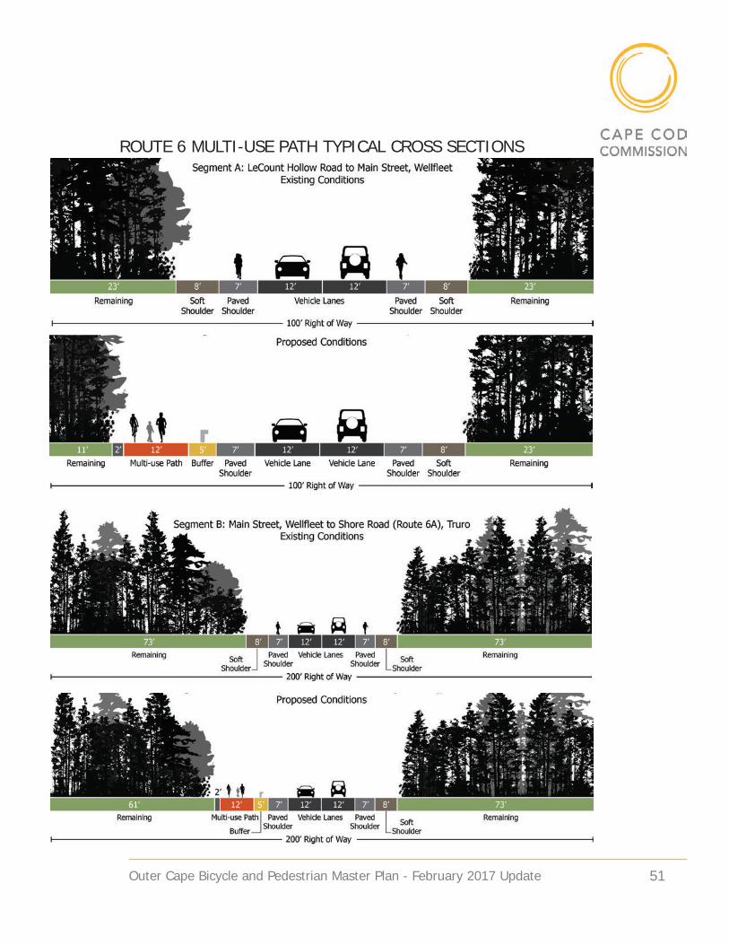
Outer Cape Bicycle and Pedestrian Master Plan - February 2017 update 51
ROuTe 6 MuLTI-uSe PaTH TYPICaL CROSS SeCTIONS

Outer Cape Bicycle and Pedestrian Master Plan - February 2017 update 52
ROuTe 6 MuLTI-uSe PaTH TYPICaL CROSS SeCTIONS

Outer Cape Bicycle and Pedestrian Master Plan - February 2017 update 53
typical situation in each of these layouts. Special conditions exist in each of the four areas and would require variation from the typical cross section, such as physical constraints along Route 6 at the Herring River bridge in Wellfleet and at the Pamet River bridge/overpass in Truro. Areas with guard rails and slope constraints such as near Mt. Gilboa in Provincetown may also require a revised cross section.
MuLTI uSe PaTH dRIVeWaY aNd ROad CROSSINGSThe multi-use path will cross driveways and side streets in numerous locations along the Primary Route. The crossings pose safety concerns due to turning ve-hicles and through-bicyclists traveling in both directions. Installation of addition-al warning signs and pavement markings is needed. FHWA provides guidance on pavement marking treatments to improve visibility of a separated bicycle path and signage on side streets and driveways to alert drivers to look both directions before proceeding across the path.
ROuTe 6 POTeNTIaL LaNe ReduCTION/”ROad dIeT” The possibility of a lane reduction in the four-lane section of Route 6 in Truro and Provincetown is discussed in Issues Requiring Further Consideration, pp.40-42. A Route 6 lane reduction, either in the western-most portion of the highway or along the entire length of the four-lane section, should be fully explored in recognition of potential cost savings and reduced natural resource impacts. Input from all public safety staff will be critical in this discussion. Options to consider include removing one lane from each direction of traffic, or removing one lane from a single direction. If a lane reduction is implemented and a single lane of travel is removed, it would provide an additional 12 feet of paved surface in which the multi-use path could be located. This would significantly reduce the construction cost of the multi-use path in this area by avoiding the need to expand the paved shoulder or to shift the paved vehicle travel lanes further to one side of the right-of-way to accommodate the multi-use path.
aLTeRNaTIVe SuRFaCe TReaTMeNTSNon-asphalt treatments should be considered for several segments of the Prima-ry or Interim Primary Route that are currently dirt roads or trails and are within mapped rare species habitat. The potential cost, including both construction and maintenance costs, and the environmental benefits of various non-asphalt surfaces should be further evaluated to determine the appropriate surface treat-ment for these segments of the route. (See Issues Requiring Further Consider-ation, pp.39-40).

Outer Cape Bicycle and Pedestrian Master Plan - February 2017 update 54
PRIMARY ROUTE SEGMENTS - SUMMARY TABLESegment Proposed Route and Accommodation Approx.
Existing Pavement Width
Approx. ROW
Approx. Expansion Width (within ROW)
Wellfleet Center
[further study is needed for options north of the railbed]
--Multi-use path along railbed, 1.75 miles, unpaved but hardened surfaceOption A--Marked bicycle shoulder along Old County/Old Kings Highway, 0.35 mile segment)--Marked bicycle shoulder along Cahoon Hollow Road, 0.57 mile segment)Option B--Continue multi-use path along railbed to Route 6, then follow Route 6 (east side) to Cahoon Hollow RoadOption C--Identify another possible route through the area
11 ft
22 ft
Railbed: 11 ft (dirt)Route 6: 24-60 ftNA
90 ft
40 ft
Railbed: 90 ftRoute 6: 70-120 ftNA
5 ft
0-8 ft [town to decide width]
Railbed: 5 ft
Route 6: 11 ft
NA
Wellfleet North
Separated multi-use path along Route 6 (east side) 2.32 miles, from Main Street/Cahoon Hollow Rd to Rose Rd
32-40 ft 80-160 ft 11 ft
Truro South (Interim Primary Route)
--Marked Bicycle shoulder along Rose Rd/Collins Rd, 2.3 miles--Marked Bicycle shoulder along South Pamet Rd, 0.76 miles
20-22 ft 40 ft 0-5 ft [town to decide width]
Truro South (Long Term Primary Route)
Separated multi-use path along Route 6 (east side) 2.3 miles, from Rose Rd to South Pamet Rd
32-38 ft 120-150 ft 11 ft
Truro Center Separated multi-use path along Route 6 (east side) 2.47 miles, from South Pamet Rd to South Highland Rd
32-38 ft 120-150 ft 11 ft
Truro North (Interim Primary Route)
--Marked Bicycle shoulder along South Highland Road, 1.4 miles --Share the Road along Coast Guard Rd, 0.48 miles --Multi-use path along Old Kings Highway sand road, 0.8 miles --Existing Head of the Meadow bike trail, 1.9 miles --Share the Road along High Head Rd, 0.62 miles
25 ft
25 ft
10-12 ft (unpaved) 10-12 ft
20 ft (un-paved)
60 ft
40 ft
(NPS owned) (NPS owned) 35 ft
0-7 ft [town to decide width] 0 ft
0 ft
2 ft
0 ft

Outer Cape Bicycle and Pedestrian Master Plan - February 2017 update 55
PRIMARY ROUTE SEGMENTS - SUMMARY TABLESegment Proposed Route and
AccommodationApprox. Existing Pavement Width
Approx. ROW
Approx. Expansion Width (within ROW)
Truro North (Long Term Primary Route)[study lane reduction]
Separated multi-use path along Route 6 (east side) 1.2 miles, from South High-land Rd to Highland Rd exit and under-pass, then along Route 6 (west side) 2.2 miles from Highland Rd to Stott’s Crossing
32-38 ft 120-150 ft 11 ft [none if lane re-duction; lane reduc-tion may also effect path placement]
Beach Point[study lane reduction]
Separated multi-use path along Route 6 (west side) 1.7 miles, from Stott’s Cross-ing to Provincetown town line
50 ft (undi-vided)26 & 26 ft (divided)
100-150 ft 14 ft [none if lane reduction; lane reduction may effect path placement]
Province-town (Inter-im Primary Route)[study lane reduction]
--Separated multi-use path along Route 6 (west side) 0.85 miles --Marked bicycle shoulder along Snail Road, 0.1 mile to railroad bed --Multi-use path along railroad bed, hard-ened but unpaved surface, 0.96 miles to Howland St. Option A--Marked bicycle shoulder along How-land Avenue for 0.1 mile to Route 6 --Separated multi-use path along Route 6 for 0.45 miles to Conwell St. --Marked bicycle shoulder and share-the-road along Conwell St, Cemetery Rd, Alden St/ Bradford St and Standish St, 0.67 miles to Lopes Square. (This project is already underway) Option B--Marked bicycle shoulder along Harry Kemp Way to Conwell St. --Dedicated bike route on easement through Riley’s parking lot to town center
26 & 26 ft (divided) 23 ft
11 ft (dirt)
25 ft
26 & 26 ft (divided) 25 ft (varies)
--
--
200 ft
--
--
90 ft
200 ft
(varies)
--
--
14 ft [none if lane reduction] 9 ft [assumes 4 ft shoulder] 5 ft
3 ft [assumes 3 ft shoulder]14 ft [none if lane reduction] 0 ft
0
0
Provinc-etown (Long Term Primary Route)
--Separated multi-use path along Route 6 (west/south side) 2.25 miles from town line to Conwell St. --Separate multi-use path along Route 6 (west/south side) 0.55 miles further to Shank Painter Rd, then crossing and along Route 6 (north/east side) 1.2 miles to Herring Cove Beach parking lot
26 & 26 ft (divided)
200 ft 14 ft [none if lane reduction]

Outer Cape Bicycle and Pedestrian Master Plan - February 2017 update 56

Outer Cape Bicycle and Pedestrian Master Plan - February 2017 update 57
SeCONdaRY ROuTeS
Secondary Routes through the region provide important means of access from the primary route to destinations and neighborhoods. The secondary routes in each town are based on input from town officials and staff members, town bicycle and pedestrian committees, and from public workshop and meeting at-tendees. Road segments that were originally considered as primary routes but later dropped out of consideration are included as potential secondary routes. A variety of accommodation types are proposed for the secondary routes, acknowledging the variety of existing conditions, different needs, and varying levels of concern about scenic, historic and natural character along these routes. Maps of Secondary Routes for each town (shown on the following pages) il-lustrate the various accommodation types in different colors. Accommodation types are also included in the summary table of secondary routes for each town.
There was concern amongst town officials at several meetings about the po-tential impact of improvements on abutting property owners. Any recommen-dations for improved accommodations along secondary routes would occur within existing road rights-of-way, and would require town plans and town support. No land takings are proposed. The majority of town-owned roads in Wellfleet, Truro and Provincetown have a 40 foot right-of-way and the paved road is located within this area. Pavement width on most roads ranges from 20 to 25 feet, typically with two 11’ foot travel lanes and sometimes with a narrow marked shoulder. It is common for property owners to maintain the area in the right-of-way between their property and the pavement, and in some cases, abut-ters have placed plantings or mailboxes within the town-owned right-of-way.
Pamet Harbor in Truro is reached by a secondary route

Outer Cape Bicycle and Pedestrian Master Plan - February 2017 update 58

Outer Cape Bicycle and Pedestrian Master Plan - February 2017 update 59
WeLLFLeeT SeCONdaRY ROuTeSWellfleet’s secondary routes provide access to popular ocean-side beaches as well as to the historic village center and harbor area. They also include a popu-lar back road route into Truro, and connect several residential neighborhoods to the primary or spine route. The area of greatest concern in Wellfleet revolves around the intersection of Main Street and Route 6, which includes the intersec-tion of several roads and commercial businesses. Improvements to the Main Street intersection are currently being designed by MassDOT, and work on any secondary routes in the area will be coordinated with that project design. Cross-ing Route 6 at other locations is a concern due to high traffic volumes (especially during summer months) and vehicle speeds. Town officials have an interest in making Route 6 safer for bicyclists and pedestrians, acknowledging that many people must travel along portions of Route 6 to get to work. In the short term they support providing a continuous breakdown lane marked for bicycle use, with special attention to treatment where side roads access Route 6 and break-down lanes have disappeared to provide room for turning vehicles. The town has also indicated that they would like to limit widening on most of their second-ary routes to limit impacts to scenic character and natural resources, including along Pole Dike Road.
HIGHeST PRIORITY• Main Street/Route 6 intersection area – this area is planned for pedestrian
improvements and a crossing signal, but needs to be coordinated with plans for the primary bicycle route.
• LeCount Hollow Road – primary beach access route from Cape Cod Rail Trail. Need to accommodate bicyclists without harming scenic character. Consider marking bicycle shoulders within the existing paved area. Improve safety at the Route 6 crossing.
• Ocean View Drive from LeCount to Cahoon Hollow Road – this is a major beach access road and a scenic route. Safety improvements are needed to address pedestrians and cyclists when summer traffic volumes are high. Consider using a dashed line to mark bicycle shoulders within existing paved areas on the roadway.
MOdeRaTe PRIORITY• Ocean View Drive from Cahoon Hollow to Gross Hill Road – re-stripe this sec-
tion of roadway with a bicycle shoulder.• Marconi Beach Road CCNS may consider advisory bike lanes as a test. If ef-
fective in improving safety for cars and bicyclists, it can serve as a model for other roadways in the region.
• East Commercial Street – provide pedestrian path where feasible from town pump to Uncle Tim’s Bridge along the water side.

Outer Cape Bicycle and Pedestrian Master Plan - February 2017 update 60
• Briar Lane – provide sidewalk in a way that preserves the rural character of this roadway. Consider coordinating design with water main installation.
• Cove Road – provide sidewalk from Route 6 to Pilgrim Spring’s Road to im-prove access to town center for neighborhood residents.
Marconi Beach in Wellfleet in reached by a secondary route

Outer Cape Bicycle and Pedestrian Master Plan - February 2017 update 61
WELLFLEET SECONDARY ROUTESRoad or Trail Name
Location (south-north)
Route Length
Right of Way Width (feet)
Approx. Pave-ment Width (feet)
Suggested Accommodation
Road/Land Owner(s)
Additional Description
LeCount Hollow Road
From CCRT- Ocean View Drive
0.66 mile
40 21 Shoulders – width to be determined by town and road characteristics; Safety improve-ments at Route 6/LeCount Hol-low Rd crossing
Town of Wellfleet
Popular bike route. Consider speed reduction measures such as traffic calming. Sand drift/accu-mulation issue.
Ocean View Drive
From LeCount Hollow to Cahoon Hollow Road
1.72 miles
30-40 20-24 Shoulders – width to be determined by town and road characteristics
Town of Wellfleet
Consider speed reduc-tion/ traffic calming mea-sures (e.g. speed bumps, geometric changes). Sand issues –especially at LeCount intersection.
Ocean View Drive
Cahoon Hollow to Gross Hill Road
1.15 miles
30-40 20-24 Shoulders – width to be determined by town and road characteristics
Town of Wellfleet
Beach area access.
Route 6 LeCount Hollow Road to Railbed/Main Street area
2.27 miles
70-150 32-40 4’ minimum shoulders both sides; Safety improvements at Route 6/LeCount Hollow Road crossing
MassDOT Numerous curb cuts. Area between Cove Road and Main St has com-mercial driveways and conflict points. Main St and Route 6 intersection improvements in design phase.
Route 6 West Road to LeCount Hollow Road
2.4 miles
150 32 4’ minimum shoulders both sides; Safety improvements at Route 6/West Road crossing
MassDOT Segment has existing four-foot shoulders. Used by high speed bicyclists as alternative to CCRT.
Marconi Beach Road
Route 6 to beach
1.7 miles
90 22 4’ shoulders both sides
NPS Consider 4- foot “advi-sory” (dashed line) bike lanes within existing footprint. Potential pilot project.

Outer Cape Bicycle and Pedestrian Master Plan - February 2017 update 62
WELLFLEET SECONDARY ROUTESRoad or Trail Name
Location (south-north)
Route Length
Right of Way Width (feet)
Approx. Pave-ment Width (feet)
Suggested Accommodation
Road/Land Owner(s)
Additional Description
Main Street, West Main, Pole Dike, Bound Brook2
Higgins Lane to Truro line
3.8 miles
35-40 20-22; 16 @ Bound-brook
Share the road and minor safety improvements such as narrow vehicle lanes and fog line for added bicycle safety area
Town of Wellfleet
Claire Saltonstall Bikeway route from Long Pond Road through Truro.
Cahoon Hollow Road
From Ocean View Drive to Route 6
2 miles 40-50; 30 by cem-etery
19-22 Share the road Town of Wellfleet
Consider speed reduction measures
Marconi Site Road
Marconi Beach Road to overlook (Marconi site)
1 mile 90 22 Share the road NPS Access to Marconi his-toric site, overlook and White Cedar Swamp Trail.
Indian Neck Road
Pilgrim Spring Road – Indian Neck
1 mile 20-22 40 Share the road Town of Wellfleet
Conservation area access.
Long Pond Road
Main Street to Ocean View Drive
2.15 miles
40 20 Share the road Town of Wellfleet
Existing Claire Saltonstall route. Wellfleet bike committee considering re-routing it to Cahoon Hollow once Main Street improvements are com-plete.
Kendrick Avenue – Cheques-set Neck Road
Com-mercial Street – Griffin Island Road
2.71 miles
30-50 18-23 Share the road Town of Wellfleet
Bicycle and walking route from harbor to Great Island.
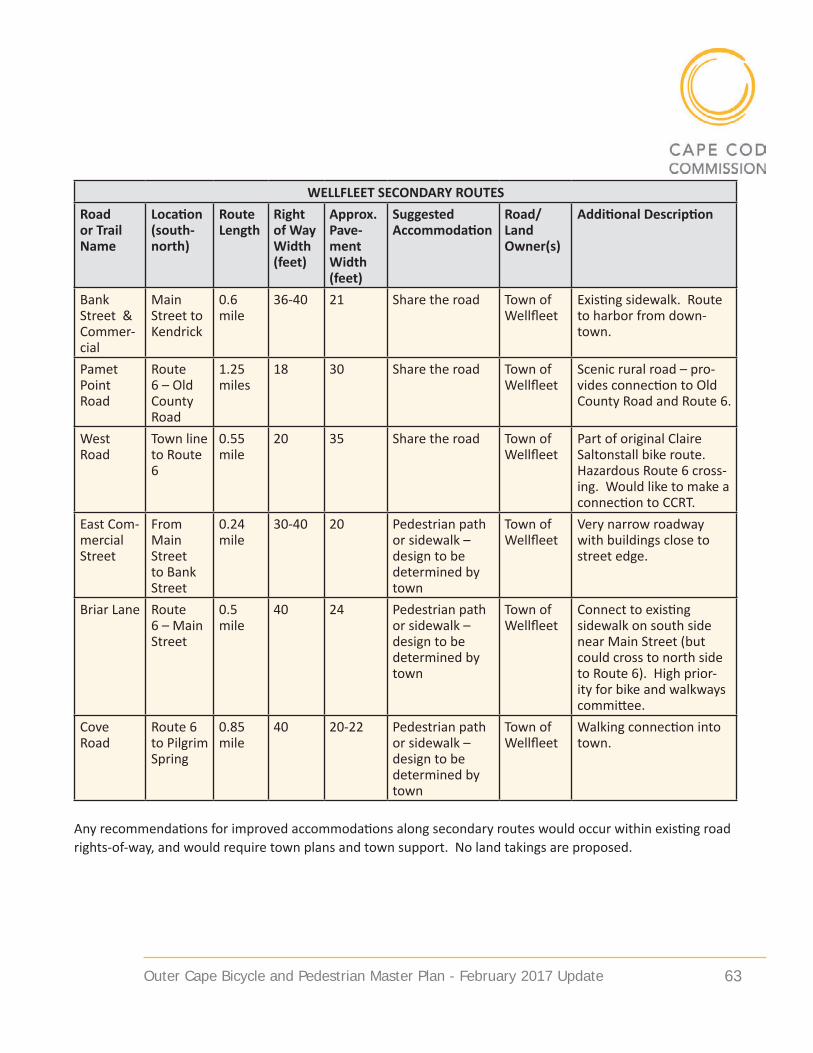
Outer Cape Bicycle and Pedestrian Master Plan - February 2017 update 63
WELLFLEET SECONDARY ROUTESRoad or Trail Name
Location (south-north)
Route Length
Right of Way Width (feet)
Approx. Pave-ment Width (feet)
Suggested Accommodation
Road/Land Owner(s)
Additional Description
Bank Street & Commer-cial
Main Street to Kendrick
0.6 mile
36-40 21 Share the road Town of Wellfleet
Existing sidewalk. Route to harbor from down-town.
Pamet Point Road
Route 6 – Old County Road
1.25 miles
18 30 Share the road Town of Wellfleet
Scenic rural road – pro-vides connection to Old County Road and Route 6.
West Road
Town line to Route 6
0.55 mile
20 35 Share the road Town of Wellfleet
Part of original Claire Saltonstall bike route. Hazardous Route 6 cross-ing. Would like to make a connection to CCRT.
East Com-mercial Street
From Main Street to Bank Street
0.24 mile
30-40 20 Pedestrian path or sidewalk – design to be determined by town
Town of Wellfleet
Very narrow roadway with buildings close to street edge.
Briar Lane Route 6 – Main Street
0.5 mile
40 24 Pedestrian path or sidewalk – design to be determined by town
Town of Wellfleet
Connect to existing sidewalk on south side near Main Street (but could cross to north side to Route 6). High prior-ity for bike and walkways committee.
Cove Road
Route 6 to Pilgrim Spring
0.85 mile
40 20-22 Pedestrian path or sidewalk – design to be determined by town
Town of Wellfleet
Walking connection into town.
Any recommendations for improved accommodations along secondary routes would occur within existing road rights-of-way, and would require town plans and town support. No land takings are proposed.

Outer Cape Bicycle and Pedestrian Master Plan - February 2017 update 64

Outer Cape Bicycle and Pedestrian Master Plan - February 2017 update 65
TRuRO SeCONdaRY ROuTeS
Truro’s secondary routes provide connections to the town center and to popular beaches and other Cape Cod National Seashore destinations in the Highlands and along Beach Point. As in Wellfleet, Route 6 crossings are a primary concern due to heavy traffic volumes, high travel speeds, and the four-lane configuration of Route 6 in the northern half of town. Pedestrian refuge islands should be considered in many of these crossings. Other priorities focus on finding the right level of accommodation for local scenic roads like South Pamet Road, which has a high volume of beach traffic in the summer months. Signage and pavement markings are the preferred accommodation in areas with natural resource and character constraints.
HIGHeST PRIORITY• Head of the Meadow and Standish Way – Head of the Meadow Road
provides access to two beaches so is heavily used. It is wide enough to ac-commodate bicycles and the pavement is in good condition, but needs a crossing accommodation at Route 6. Consider shoulders or advisory bike lanes on Head of the Meadow Road. Standish Way is a busy biking area because it provides a connector between Shore Road and Route 6 at Head of the Meadow. The town library, community center and senior center are also located there. This adds to the importance of this Route 6 road crossing. Consider alternative crossing from the community center property directly across to Head of the Meadow Road.
• Stott’s Crossing – this is a major Route 6 crossing to access Shore Road, High Head, and the Head of the Meadow bicycle trail. It is very difficult to cross these four lanes of traffic in the summer and improvements are needed. A road safety audit should be conducted. A protected crossing with a median to create a protected location between lanes of Route 6 and a Hawk signal should both be considered.
• Castle Road/Route 6 crossing – this is a popular but difficult crossing in sum-mer months due to high traffic volumes. Need to make safety improvements here.
MOdeRaTe PRIORITY• South Pamet Road – this roadway has high summer traffic volumes because
it provides access to the beach. Town officials would like to provide some kind of accommodation on this roadway but acknowledge there are con-cerns about character impact. Consider possible minimal pavement widen-ing options.
• Old County Road/Depot Road – hill by Mill Pond is a visibility problem and condition of road is poor in sections. Repair poor pavement at the bridge

Outer Cape Bicycle and Pedestrian Master Plan - February 2017 update 66
and consider widening to allow for a climbing lane on both uphill lanes from Mill Pond crossing, possibly in conjunction with new culvert construction.
• Route 6A/Shore Road study needed to evaluate and identify pedestrian and bicycle safety measures along this narrow roadway. Also identify a con-nection from Shore Road to Route 6 multi-use path between Provincetown town line and Stott’s Crossing. Consider a Unified Planning Work Program (UPWP) project to coordinate transportation and comprehensive planning around these issues.
Highland Light and the Highlands are popular destinations in Truro

Outer Cape Bicycle and Pedestrian Master Plan - February 2017 update 67
TRURO SECONDARY ROUTESRoad or Trail Name
Location (south-north)
Route Length
Right of Way Width (feet)
Approx. Pave-ment Width (feet)
Suggested Accommodation
Road/Land Owner(s)
Additional Description
Head of the Meadow Road
Route 6 to bike path
0.9 mile
48 25 Shoulder or ad-visory bike lane, up to 4 feet each side -- width to be determined by NPS; Safety improvements at Route 6 crossing
NPS Crossing problem be-tween Head of Meadow & Standish (0.25 mile). Con-sider HAWK signal. Con-sider Route 6 crossing at Community center/Head of the Meadow Road, with bike/ped connection to Standish Way through public land. HIGHEST PRI-ORITY CROSSING for Truro bike committee (see also Standish Way below).
Standish Way
Route 6A to Route 6
0.15 mile
26 36-40 Share the road Town of Truro
This segment goes to-gether with Head of the Meadow Road
Stott’s Crossing
At Route 6 inter-section
Safety improve-ments at Route 6 crossing
MassDOT Major access to Shore Road, High Head, and Head of the Meadow Bicycle Trail. Consider HAWK signal.
Castle Road
From Truro Center Road to Route 6 north
2.10 miles
40 21 Share the road; Safety improve-ments at Route 6/Castle Road crossing
Town of Truro
Narrow winding roadway with scenic rural charac-ter. Access to Corn Hill beach and alternative to Route 6.
South Pamet Road
Truro Center Road to Ballston beach
1 mile 36 22 Share the road and possible shoulder im-provements - width to be determined by town and road characteristics
Town of Truro
(Overlaps with interim primary route) Top prior-ity as a secondary route, especially eastward to Ballston Beach.
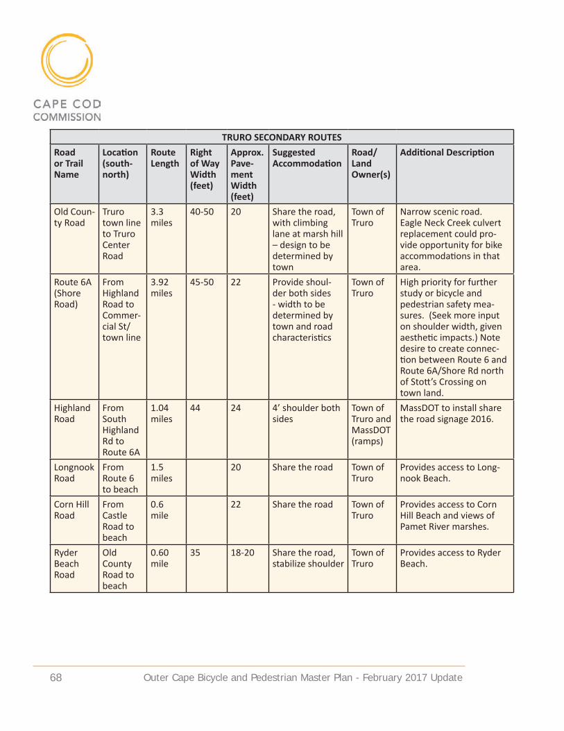
Outer Cape Bicycle and Pedestrian Master Plan - February 2017 update 68
TRURO SECONDARY ROUTESRoad or Trail Name
Location (south-north)
Route Length
Right of Way Width (feet)
Approx. Pave-ment Width (feet)
Suggested Accommodation
Road/Land Owner(s)
Additional Description
Old Coun-ty Road
Truro town line to Truro Center Road
3.3 miles
40-50 20 Share the road, with climbing lane at marsh hill – design to be determined by town
Town of Truro
Narrow scenic road. Eagle Neck Creek culvert replacement could pro-vide opportunity for bike accommodations in that area.
Route 6A (Shore Road)
From Highland Road to Commer-cial St/town line
3.92 miles
45-50 22 Provide shoul-der both sides - width to be determined by town and road characteristics
Town of Truro
High priority for further study or bicycle and pedestrian safety mea-sures. (Seek more input on shoulder width, given aesthetic impacts.) Note desire to create connec-tion between Route 6 and Route 6A/Shore Rd north of Stott’s Crossing on town land.
Highland Road
From South Highland Rd to Route 6A
1.04 miles
44 24 4’ shoulder both sides
Town of Truro and MassDOT (ramps)
MassDOT to install share the road signage 2016.
Longnook Road
From Route 6 to beach
1.5 miles
20 Share the road Town of Truro
Provides access to Long-nook Beach.
Corn Hill Road
From Castle Road to beach
0.6 mile
22 Share the road Town of Truro
Provides access to Corn Hill Beach and views of Pamet River marshes.
Ryder Beach Road
Old County Road to beach
0.60 mile
35 18-20 Share the road, stabilize shoulder
Town of Truro
Provides access to Ryder Beach.

Outer Cape Bicycle and Pedestrian Master Plan - February 2017 update 69
TRURO SECONDARY ROUTESRoad or Trail Name
Location (south-north)
Route Length
Right of Way Width (feet)
Approx. Pave-ment Width (feet)
Suggested Accommodation
Road/Land Owner(s)
Additional Description
Depot Road
From Old County Road– Pamet Harbor
0.65 miles
40-50 19-20 Share the road/possibly in-crease shoulders – width to be determined by town and road characteristics
Town of Truro
Provides access to Pa-met Harbor. More space needed for bicycles due to boats in tow. Seek more input on shoulder width given aesthetic impacts.
Rail bed From Bound Brook Is-land Road to Ryder Beach Road
1.2 miles
Continue as un-paved pedestrian trail
NPS Existing pedestrian trail. Consider possible signage.
Any recommendations for improved accommodations along secondary routes would occur within existing road rights-of-way, and would require town plans and town support. No land takings are proposed.
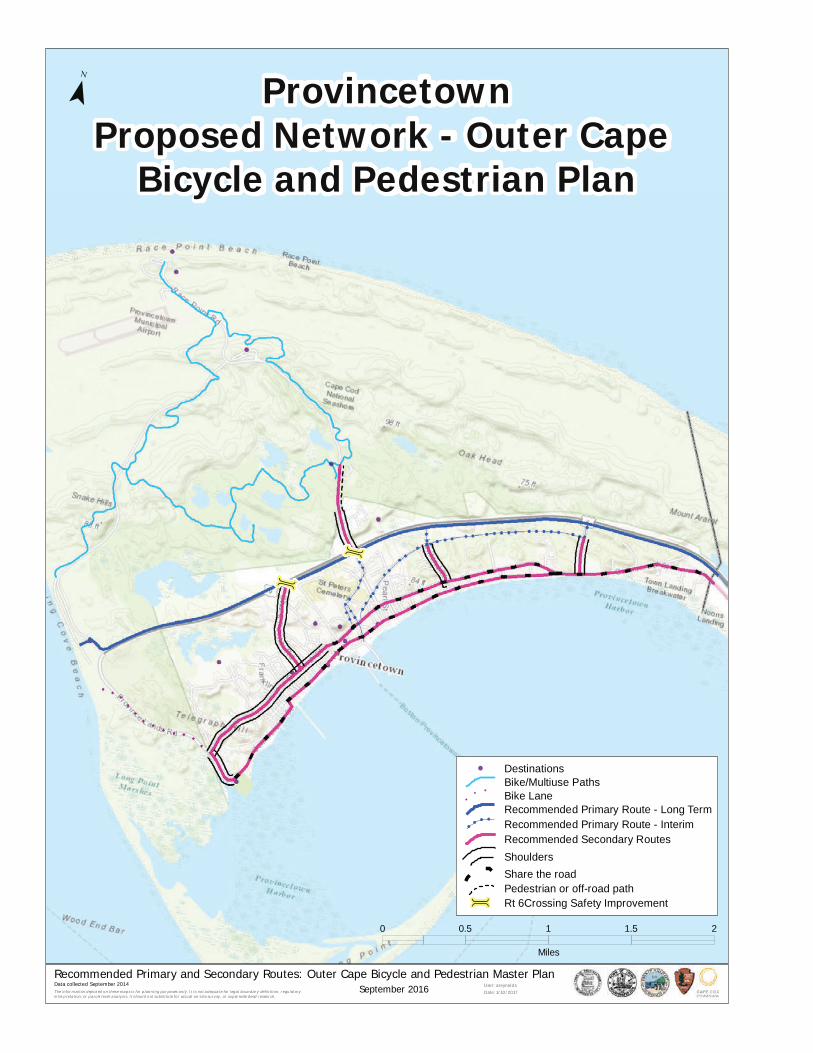
Outer Cape Bicycle and Pedestrian Master Plan - February 2017 update 70
ú
ú
The inform ation depicted o n thes e maps is for planning purpo ses only. It is no t adequate for legal bo undary definition, regulatory interpretation, or parcel level analys is. It s hould not substitute fo r actual on-s ite surv ey, or supersede deed research.
Recommended Primary and Secondary Routes: Outer Cape Bicycle and Pedestrian Master PlanUser: areynold s
Date: 1/10/2017
¯
0 0.5 1 1.5 2
Miles
Data collected September 2014
ProvincetownProposed Network - Outer Cape
Bicycle and Pedestrian Plan
September 2016
4 DestinationsBike/Multiuse PathsBike LaneRecommended Primary Route - Long Term
!!
! !
Recommended Primary Route - InterimRecommended Secondary RoutesShouldersShare the roadPedestrian or off-road path
ú Rt 6Crossing Safety Improvement

Outer Cape Bicycle and Pedestrian Master Plan - February 2017 update 71
PROVINCeTOWN SeCONdaRY ROuTeS
Provincetown’s secondary routes provide access through the downtown area and connections to popular beaches and bicycle trails within the adjacent Cape Cod National Seashore. Accommodating the high volume of bicyclists on very narrow roadways is a major concern in Provincetown. Various education efforts are being considered in addition to providing additional accommodations along key travel routes. The highest priority is getting bicyclists safely into the central downtown and pier, potentially using Harry Kemp Way in addition to the primary route along Cemetery Road. The town is also proposing climbing lanes in some areas of Bradford Street to better accommodate cyclists in hilly sections of this narrow roadway which could not easily fit bicycle shoulders throughout.
HIGHeST PRIORITY• Bradford Street – Since this road varies in character along its length, bike ac-
commodations will also vary. In some areas, a bike shoulder of 4 feet could be provided, but where there is currently on-street parking and a narrower layout a more limited accommodation is appropriate. The town discussed creating climbing lanes where the grade warrants it. Sharrows will be painted on Bradford Street this spring in an effort to educate both motorists and bicyclists to share the road.
• Harry Kemp Way - The town requested that Harry Kemp Way also be con-sidered as a potential primary route segment because there is a possibil-ity of working with the owner of Riley’s parking lot to bring a bicycle path through that property to the center of town that would create a more direct route from the existing rail bed segment and could provide separation from vehicles if designed appropriately.
• Shank Painter Road - Town staff indicated their preference to accommodate bicycles along Shank Painter Road with a 5 foot bicycle lane.
• Commercial Street – This road is heavily traveled by bikes and vehicles. The narrowness of the street and the proximity of historic buildings on either side make new accommodation difficult. The Bike Committee has encour-aged the town to paint sharrows along all of Commercial Street in the com-ing spring as part of an educational campaign.
MOdeRaTe PRIORITY• Shank Painter Road – Route 6 crossing improvement will be needed to facili-
tate connection to primary route on north side of Route 6.• Conwell Street/Race Point Road – Improve bicycle facilities at this Route 6
crossing.

Outer Cape Bicycle and Pedestrian Master Plan - February 2017 update 72
PROVINCETOWN SECONDARY ROUTESRoad or Trail Name
Location (south-north)
Route Length
Right of Way Width (feet)
Approx Pave-ment Width (feet)
Suggested Accommodation
Road/Land Owner(s)
Additional Description
Bradford Street
Commer-cial Street split to Conwell Street
1.15 miles
45 24 Share the road & 4’ climbing lane, if feasible; Width to be determined by town and road characteristics
Town of Provinc-etown
Climbing lane on uphill, share the road on downhill.
Bradford Street
Conwell Street to Prince Street
0.4 mile
30-45 22-26 Share the road, with climbing lane Winslow to Prince - width to be determined by town and road character-istics
Town of Provinc-etown
Climbing lane on uphill, share the road on downhill.
Bradford Street
Prince Street to Moors Road
1 mile 30-45 22-26 4’ bike lane where feasible
Town of Provinc-etown
Access to west end, Herring Cove Beach and NPS trails.
Harry Kemp Way
Howland Street to Conwell Street
Bike shoulder or lane - width to be determined by town and road character-istics
Town of Provinc-etown
Road follows the original rail bed toward town center. Existing layout includes paved shoulders.
Shank Painter Road
Bradford Street to Route 6
0.53 mile
50 24 Bike lane - width to be deter-mined by town and road charac-teristics
Town of Provinc-etown
Town is working on plan for Shank Painter Road improvements – accom-modation type to be determined.
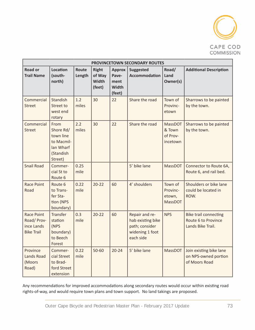
Outer Cape Bicycle and Pedestrian Master Plan - February 2017 update 73
PROVINCETOWN SECONDARY ROUTESRoad or Trail Name
Location (south-north)
Route Length
Right of Way Width (feet)
Approx Pave-ment Width (feet)
Suggested Accommodation
Road/Land Owner(s)
Additional Description
Commercial Street
Standish Street to west end rotary
1.2 miles
30 22 Share the road Town of Provinc-etown
Sharrows to be painted by the town.
Commercial Street
From Shore Rd/town line to Macmil-lan Wharf (Standish Street)
2.2 miles
30 22 Share the road MassDOT & Town of Prov-incetown
Sharrows to be painted by the town.
Snail Road Commer-cial St to Route 6
0.25 mile
5’ bike lane MassDOT Connector to Route 6A, Route 6, and rail bed.
Race Point Road
Route 6 to Trans-fer Sta-tion (NPS boundary)
0.22 mile
20-22 60 4’ shoulders Town of Provinc-etown, MassDOT
Shoulders or bike lane could be located in ROW.
Race Point Road/ Prov-ince Lands Bike Trail
Transfer station (NPS boundary) to Beech Forest
0.3 mile
20-22 60 Repair and re-hab existing bike path; consider widening 1 foot each side
NPS Bike trail connecting Route 6 to Province Lands Bike Trail.
Province Lands Road (Moors Road)
Commer-cial Street to Brad-ford Street extension
0.22 mile
50-60 20-24 5’ bike lane MassDOT Join existing bike lane on NPS-owned portion of Moors Road
Any recommendations for improved accommodations along secondary routes would occur within existing road rights-of-way, and would require town plans and town support. No land takings are proposed.

Outer Cape Bicycle and Pedestrian Master Plan - February 2017 update 74
MaINTeNaNCe
Maintenance of the primary and secondary routes in the proposed network will require coordination between several agencies and entities. Different segments of the proposed network are owned by MassDOT, CCNS, DCR, and the towns of Provincetown, Truro and Wellfleet.
The majority of the primary route is located along Route 6 on property owned by MassDOT. The proposed primary route multi-use path however, would more likely be the responsibility of DCR (assuming DCR agrees to own it) and the individual towns, following the model used on the existing CCRT in other parts of Cape Cod. A combination of volunteers, sponsoring organizations and DCR staff should be considered to address basic maintenance needs such as trim-ming encroaching vegetation, clearing sand from paved surfaces, line painting, and maintenance of route and safety signage. The unpaved railbed segment in Wellfleet is the only segment of this network currently owned by DCR. DCR’s June 2015 Resource Management Plan notes their interest in forming partner-ships to help maintain the existing CCRT and they would likely pursue partner-ships for maintenance of additional segments. The unpaved railbed segment in Provincetown is owned by the town and could be maintained by the town in partnership with other entities. Because the two railbed segments are proposed to have alternative unpaved surfaces, maintenance needs could also include maintenance and replenishment of the surface material.
Route segments that follow local roads (both on primary and secondary routes) would be the responsibility of the individual towns, working through their De-partment of Public Works and/or Recreation Department. Those few segments that travel along CCNS roadways and trails would be the responsibility of CCNS maintenance staff. Since routes along local roads are mostly recommended as bicycle shoulders or share-the-road, little additional maintenance is expected in these areas. Any future repaving or surface maintenance projects could be ad-dressed through the DPW budget or coordinated with the TIP process.
Maintenance of restroom facilities, parking areas, signage and any other support features along the route should be formally coordinated between the towns and other entities. In locations where no town or CCNS bathroom facilities currently exist, cooperation with adjacent commercial entities should be considered. Re-stroom facilities provided at Arnold’s Restaurant in Eastham are a good example of a successful and well-used amenity provided by a commercial entity border-ing the CCRT.

Outer Cape Bicycle and Pedestrian Master Plan - February 2017 update 75
SuPPORT FaCILITIeS
WaYFINdING SIGNaGeWayfinding is the system of signs, visual cues, landscaping and pavement mark-ings that help pedestrians and bicyclists orient themselves and navigate from place to place. Signage and wayfinding are critical to assist trail users, both in directing them to the trail and in providing a guide to local destinations and transit. Use of common signage features, especially along the primary route, is recommended. Signage can take various forms, including pavement markings, bollard signs, and pole signage. Universal bicycle signage has been developed for Cape Cod routes and it should be continued on this network. The signage follows accepted MUTCD standards for dimensions, color and size in order to streamline the potential permitting hurdles of sign placement.
The goal of bicycle wayfinding signage on Cape Cod is to unite the incongruous system of bicycle facilities with a unified signage system that promotes a sense of place and gives users a clear direction as to where they are in relation to a regional bicycle route. This supports local economic development and com-munity character efforts to promote Cape Cod as a destination. In addition to these considerations, a unified signage system will improve the safety of bicy-clists by giving them a greater sense of where they are and how they can stay safe on the road. Finally, signage will give motorists the visual cues necessary to be aware that they are sharing a Right of Way with bicyclists. The more unified this signage appears, the more identifiable it is to both bicyclists and motorists. Types of signs proposed include confirmation signs, turn signs, decision signs and regulatory signs.
Cape Cod Bike Route signage and Cape Cod National Seashore signage (left). Claire Saltonstall Bikeway sign - green oval (right).

Outer Cape Bicycle and Pedestrian Master Plan - February 2017 update 76
MuLTI-MOdaL CONNeCTIONSA diverse transportation system provides multiple travel mode options – in-cluding bicycling, walking, public transit, automobile travel and, on Cape Cod, ferry accessibility. Pedestrian and bicycle access to and integration with transit services is a critical component of a public transportation system. Coordinating pedestrian and bicyclist needs with transit planning expands mobility options for travelers, which is especially important for young people, the elderly, and people who do not own cars or prefer not to drive. Providing non-automobile choices for travelers also creates a robust public transportation system that helps reduce traffic congestion, energy use, personal transportation costs and, with expanded bicycle and pedestrian options, increased health benefits.
The primary locations/opportunities for providing multi-modal connections on the Outer Cape are at bus stops, Macmillan Pier in Provincetown, and Province-town Airport. The Cape Cod RTA’s Flex bus (which accommodates bicycles) runs regularly between Harwich and Provincetown. It travels along Route 6 in Well-fleet and Truro, with stops in downtown Wellfleet, Truro’s Cobb Library, Whit-manville Road, and Highland Road/North Truro Center. In Provincetown the Flex stops at Stop & Shop and Macmillan Pier. Summer shuttle service (the “North Truro Shuttle” which also accommodates bikes) runs between Provincetown and Truro, also along secondary routes, to the bay and ocean beaches, Macmil-lan Pier, Provincetown Airport, and campgrounds. All of the RTA bus stops are located on recommended primary or secondary bicycle routes. Proposed bicy-clist/pedestrian safety improvements associated with route implementation will also enhance bike/ped access to transit.
Flex bus stop at MacMillan wharf in Provincetown (left) and along Route 6 in Wellfleet

Outer Cape Bicycle and Pedestrian Master Plan - February 2017 update 77
PaRKING (BICYCLe aNd MOTOR VeHICLe)No new parking lots are proposed for the OCBPMP. Existing parking areas in the towns and CCNS could serve people who might drive to access the primary route, and signage could direct users to existing parking lots that may be suitable for additional vehicles. Within the study area, public lots exist in Wellfleet at the end of the Cape Cod Rail Trail, Marconi Site (CCNS), and Wellfleet Elementary School; in Truro at Truro Elementary School, Truro Community Center/Library, Pilgrim Springs (CCNS), and High Head (CCNS); in Provincetown at the MacMillan Pier municipal lot, Grace Hall lot, Veteran’s Memorial Community Center, and Je-rome Smith Road lot; and also at beach parking lots (town and CCNS) in all three towns. NPS conducted a beach parking study in 2010 that examined potential satellite parking areas on the Lower Cape (https://www.nps.gov/caco/learn/management/upload/ccns-integrated-parking-and-transit-study-reduced-2.pdf). The study may be useful for identifying potential areas for bike route parking, if needed. A safe, comfortable, and interconnected bicycle facility network, supplemented by convenient access to transit, should help reduce the need to drive and park to access bicycle facilities.
Providing convenient and secure areas for bicycle parking at popular destina-tions, including beaches, businesses, trail heads and work places, helps encour-age people to bike to these locations (and perhaps reduce motor vehicle trips and parking needs). Providing bicycle racks also creates a designed location for parking and discourages people from locking bikes to signs and trees. Town bicycle and pedestrian committees, working with public works staff, are knowl-edgeable about the community’s bicycle parking needs and are useful resources for developing a town wide bike parking plan. Bicycle racks are available to
Bicycle racks at Herring Cove Beach in Provincetown
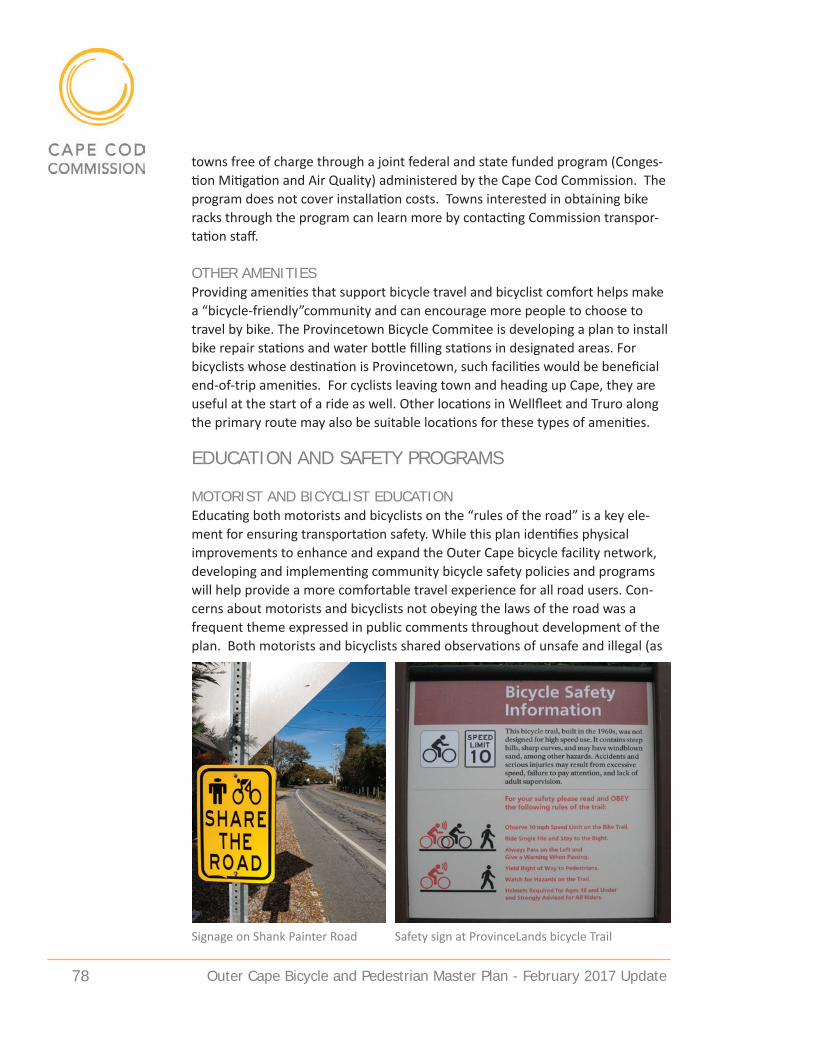
Outer Cape Bicycle and Pedestrian Master Plan - February 2017 update 78
towns free of charge through a joint federal and state funded program (Conges-tion Mitigation and Air Quality) administered by the Cape Cod Commission. The program does not cover installation costs. Towns interested in obtaining bike racks through the program can learn more by contacting Commission transpor-tation staff.
OTHeR aMeNITIeSProviding amenities that support bicycle travel and bicyclist comfort helps make a “bicycle-friendly”community and can encourage more people to choose to travel by bike. The Provincetown Bicycle Commitee is developing a plan to install bike repair stations and water bottle filling stations in designated areas. For bicyclists whose destination is Provincetown, such facilities would be beneficial end-of-trip amenities. For cyclists leaving town and heading up Cape, they are useful at the start of a ride as well. Other locations in Wellfleet and Truro along the primary route may also be suitable locations for these types of amenities.
eduCaTION aNd SaFeTY PROGRaMS
MOTORIST aNd BICYCLIST eduCaTIONEducating both motorists and bicyclists on the “rules of the road” is a key ele-ment for ensuring transportation safety. While this plan identifies physical improvements to enhance and expand the Outer Cape bicycle facility network, developing and implementing community bicycle safety policies and programs will help provide a more comfortable travel experience for all road users. Con-cerns about motorists and bicyclists not obeying the laws of the road was a frequent theme expressed in public comments throughout development of the plan. Both motorists and bicyclists shared observations of unsafe and illegal (as
Signage on Shank Painter Road Safety sign at ProvinceLands bicycle Trail

Outer Cape Bicycle and Pedestrian Master Plan - February 2017 update 79
well as discourteous) bicycling and driving behavior. Many suggested the towns (police and bike committees) provide more bicycle safety education programs and better enforcement of the rules. Given the large population of seasonal visi-tors to this region, improved educational efforts are needed to reach the wide range of road users. Safety signage and other programs would be beneficial to address confusion and conflicts between users that occur today, and would be valuable as visitor numbers in the region continue to increase.
OuTeR CaPe SaFeTY ISSueSThe biggest safety concern for most bicyclists and pedestrians is conflicts with motor vehicles. Not all bicyclists are aware that they must follow traffic laws, and not all motorists are aware that bicyclists have a legal right to use the road for travel. Outer Cape communities face additional safety challenges related to the seasonal economy – particularly heavy summer traffic volumes and the influx of visitors, many from out of state and/or from other countries, who are unfamiliar with the rules of the road, local traffic conditions, and motorist be-havior. Following the rules of the road (i.e. the law) is a critical piece of bicycle, pedestrian, and motorist safety.
The top concerns about unsafe bicycle behavior include the following: travelling in the wrong direction on the road (i.e. against traffic); ignoring stop signs and red lights; poor visibility: riding at night without lights and wearing dark clothes (particularly seasonal workers leaving their jobs); riding several abreast in traffic. Some of these safety issues may be due to lack of knowledge or unfamiliarity with the rules and could be addressed through education and enforcement. Safety signage could also help guide bicyclists and inform them of the rules. A
Bike Safety Day at Cape Cod National Seashore included helmet fitting and distribution
Outer Cape Bicycle and Pedestrian Master Plan - February 2017 update 80
contributing factor to riding the wrong way on Route 6 is the difficulty for cyclists to cross during the summer due to high traffic volumes and lack of crossing sig-nals. Enhanced crossing facilities could help address this.
The top concerns about unsafe motorist behavior include the following: exces-sive speed, distracted driving, travelling too close to cyclists, and aggressive driving. Motorist safety issues may be due in part to unfamiliarity with the rules and how to drive around bicycles. Better driver education and law enforce-ment could address this. Safety signage to alert motorists about the presence of bicycles and the requirement to share the road with them could also enhance safety and reduce conflicts.
Bicyclists on Route 6 face a significant safety hazard from motor vehicles that swerve into the shoulder space to go around left turning cars. Informing drivers about bicycles using the shoulder space and directing drivers to watch for bicy-cles and use caution when passing should be included in educational programs. The proposed MassDOT Route 6 shoulder enhancement project in Truro and Wellfleet, with accompanying signage, also should help alert drivers to bicycles.
eduCaTIONaL PROGRaMS/ReSOuRCeSPublic education programs on the rules of the road help inform road users of their responsibilities. Town bicycle committees, police, and CCNS all participate in bicyclist safety education through their websites, social media, sponsoring of bike safety events, and distribution of lights, helmets, and other equipment. Each bike committee has developed a rules of the road information sheet.
The towns and CCNS all have developed outreach efforts to make sure riders are aware of the safety rules and have proper equipment for bicycling. Distributing informational brochures with beach stickers, at lodging facilities, local shops, on community TV/radio, and through Facebook are examples of existing outreach efforts. Local chambers of commerce and employers have also supplemented outreach efforts to provide educational materials and equipment to summer workers. Stronger safety education efforts are encouraged for international students who come to the Outer Cape on work travel visas and often commute by bicycle.
Continued bike safety education efforts by the towns (police and bike commit-tees) and chambers of commerce/employers are needed to reach new visi-tors and workers as well as local residents. Electronic message boards, safety signage, pavement markings, and driver education through local media outlets (print, radio, and social media) would all help remind motorists that bicycles are using the road and to drive with caution.

Outer Cape Bicycle and Pedestrian Master Plan - February 2017 update 81
Town of Truro Bike and Walkways Committee Safety Brochure http://www.truro-ma.gov/sites/truroma/files/file/file/bike_brochure_0.pdf

Outer Cape Bicycle and Pedestrian Master Plan - February 2017 update 82
Adding a sharrow to roadwayCape Cod Rail Trail, South Wellfleet
Bikers on Moors Road/Province Lands Road in Provincetown

Outer Cape Bicycle and Pedestrian Master Plan - February 2017 update 83
ImplementationThe Outer Cape Bicycle and Pedestrian network will be implemented through a combination of efforts, acknowledging the various federal, state and town entities that own the land in question. To the greatest extent possible, im-provements will be incorporated into existing transportation and infrastructure projects. Incorporating planned improvements into intersection upgrades and roadway maintenance projects in the study area will maximize cost effective-ness. Utility installations, road maintenance, bridge/culvert projects, and adja-cent real estate development all may provide opportunities. Funding for specific segments of the Primary Route will also be pursued through MassDOT, Massa-chusetts DCR, and CCNS funding sources, with priority given to those segments with the greatest safety concerns. The Steering Committee should continue to play a role in promoting the project and moving it forward.
Some portions of the network are already scheduled to be included in other transportation projects that have received funding. Cape Cod National Seashore has requested and may receive funding for improvements to the Head of the Meadow bike trail in Truro and creation of a trail on the dirt segment of the Old Kings Highway for 2017-2018. MassDOT has committed to making Route 6 shoulder improvements in Truro and Wellfleet in 2017 as a short-term safety im-provement. Intersection improvements at Route 6 and Main Street in Wellfleet are under design, with proposed construction in 2019.
The towns of Wellfleet, Truro and Provincetown will play the key role in mak-ing improvements to Interim Primary and Secondary Routes. Towns will choose where to apply transportation funds on town-owned routes and how to design accommodations, but many may be addressed as part of resurfacing and striping projects.

Outer Cape Bicycle and Pedestrian Master Plan - February 2017 update 84
PRIORITIeS
Questions remain about where to locate the primary route through the central part of Wellfleet, and about the potential for a lane reduction in Truro and Prov-incetown. Both of these issues require additional analysis and funding opportu-nities should be pursued at regional and state levels to resolve these questions.
The highest priorities for Primary Route implementation include segments/loca-tions where no route alternative exists, and where there are greatest safety con-cerns due to high vehicle volumes and curb cut conflict points. The four priority segments are:
• Wellfleet Center Segment – multi-use path along the existing railbed pro-vides an alternative to the most heavily developed section of Route 6. (The design of the section between the railbed and the Main Street intersection requires further study as discussed on pp.42-43.)
• Wellfleet North Segment – multi-use path on Route 6, east side, provides the only direct north-south route between Wellfleet and Truro.
• Truro Center Segment – multi-use path on Route 6, east side, provides the best north-south route through central Truro.
• Beach Point Segment – multi-use path on Route 6, west side, provides alter-native to narrow Route 6A between Truro and Provincetown, as no shoulder exists on this portion of Route 6. (A potential lane reduction as discussed on pp.40-42 would impact design and facilitate creation of a multi-use path in this area.)
These priorities for study and implementation, as well as priorities for crossing improvements along Route 6, are highlighted on the Network Priorities graphic on the following page. Design of some of the priority crossing improvements could be affected by a Route 6 lane reduction.
Secondary Route priorities are enumerated in the individual town sections, but summarized here. Wellfleet’s priorities include pavement markings and possible shoulders along heavily travelled Ocean View Drive and LeCount Hollow Road, and Route 6 crossing improvements at Main Street and LeCount Hollow Road. Truro’s priorities include Route 6 crossing improvements at Head of the Meadow Road and Standish Way, Stott’s Crossing, and Castle Road, as well as lane mark-ings along Head of the Meadow Road. Provincetown’s priorities include climb-ing lanes on Bradford Street, a bicycle shoulder on Shank Painter Road, and Route 6 crossing improvements at Shank Painter Road and Conwell Street/Race Point Road.

Outer Cape Bicycle and Pedestrian Master Plan - February 2017 update 85
NETWORK PRIORITIES -Primary Route Segments, Areas of Further Study, &Crossing Improvements
Priority Segment - Beach Point AreaRoute 6 Multi-Use Path
Priority Segment - Truro Center AreaRoute 6 Multi-Use Path
Priority Segment - Well�eet North AreaRoute 6 Multi-Use Path
Priority Segment - Well�eet Center AreaRailbed Multi-Use Path
Area of Further StudyRoute 6 Lane Reduction in Truro and Provincetown
Area of Further Study Well�eet Center Area Primary Route
Priority SegmentArea for Further StudyCrossing Improvement

Outer Cape Bicycle and Pedestrian Master Plan - February 2017 update 86
COST eSTIMaTeS
Relative cost estimates were developed for each segment considered as a possible primary route, and these conceptual level estimates were used to help compare the different route alternatives. Design details have not been developed for any of the proposed routes, so the estimates use several recent multi-use path and bicycle accommodation projects to estimate the unit cost of providing different accommodations. In some cases, the type of accommoda-tion proposed in the Alternatives Development Report has been modified, and the cost estimate has been adjusted to reflect that change. The cost estimates in the tables on the following pages were based on the following averages:
Multi-use path along existing roadway: $220 per linear footWiden existing multi-use path: $160 per linear footMulti-use path on existing railbed –
Hardened surface, unpaved $75 per linear footHardened surface, unpaved with structural base $125 per linear footPaved $185 per linear foot
Construct 4-foot paved bicycle shoulders: $110 per linear footShare-the-Road markings and signage: $2 per linear foot
Each cost estimate was then adjusted with a 40% increase for design and contin-gency charges.
Additional elements such as crossing improvements, flashing beacons, and easements are not included in the Primary Route Cost Estimate. As an estimate of these additional costs, the 2010 Cape Cod National Seashore Bike Feasibility Study includes $1,500 per location for a striped crosswalk. FHWA identifies the cost for flashing beacons as $15,000 per location. The only potential easements discussed are near commercial properties in Provincetown center to create a path to the pier, and in Wellfleet along Route 6 near the Main Street intersec-tion. In both cases, it is possible that a bicycle trail will provide benefits to existing businesses and be a desirable amenity that can be worked out with the property owner.

Outer Cape Bicycle and Pedestrian Master Plan - February 2017 update 87
PRIMARY ROUTE COST ESTIMATESegment Proposed Route and Accommodation Cost EstimateWellfleet Center
--Multi-use path along railbed, 1.75 miles, un-paved but hardened surfaceOption A--Marked bicycle shoulder along Old County/Old Kings Highway, 0.35 mile--Marked bicycle shoulder along Cahoon Hollow Rd (30,000 sq ft of disturbance estimated along 0.57 mile segment)Option B--Continue multi-use path along railbed 0.25 mile to Route 6, then follow Route 6 (east side) to Cahoon Hollow RoadOption C--Identify another possible route through area
$1.6 million
$280,000 (assumes 4 ft shoulder)$460,000 (assumes 4 ft shoulder)
$415,000
NAWellfleet North Separated multi-use path along Route 6 (east
side) 2.32 miles, from Cahoon Hollow Rd to Rose Rd
$3.8 million
Truro South (Interim Pri-mary Route)
--Marked Bicycle shoulder along Rose Rd/Collins Rd, 2.3 miles--Marked Bicycle shoulder along South Pamet Rd, 0.76 miles
$1.9 million (assumes 4 ft shoulder)$600,000 (assumes 4 ft shoulder)
Truro South (Long Term Primary Route)
Separated multi-use path along Route 6 (east side) 2.3 miles, from Rose Rd to South Pamet Rd
$3.7 million
Truro Center Separated multi-use path along Route 6 (east side) 2.47 miles, from South Pamet Rd to South Highland Rd
$4 million
Truro North (Interim Pri-mary Route)
--Marked Bicycle shoulder along South Highland Rd, 1.4 miles--Share the Road along Coast Guard Rd, 0.48 miles--Multi-use path along Old Kings Highway sand road, 0.8 miles--Existing Head of the Meadow bike trail, 1.9 miles--Share the Road along High Head Rd, 0.62 miles
$1.1 million (assumes 4 ft shoulder)$7,000
$700,000 (CCNS)
$2.2 million (CCNS)
$9,000 (CCNS)

Outer Cape Bicycle and Pedestrian Master Plan - February 2017 update 88
PRIMARY ROUTE COST ESTIMATESegment Proposed Route and Accommodation Cost EstimateTruro North (Long Term Primary Route)
Separated multi-use path along Route 6 (east side) 1.2 miles, from South Highland Rd to High-land Rd exit and underpass, then along Route 6 (west side) 2.2 miles from Highland Rd to Stott’s Crossing.
$5.5 million [lane diet would significantly reduce cost estimate]
Beach Point Separated multi-use path along Route 6 (west side) 1.7 miles, from Stott’s Crossing to Provinc-etown town line
$2.8 million [lane diet would significantly reduce cost estimate]
Provincetown (Interim Primary Route)
--Separated multi-use path along Route 6 (west side) 0.85 miles--Marked bicycle shoulder along Snail Road, 0.1 mile to railroad bed--Multi-use path along railroad bed, hardened but unpaved surface, 0.96 miles to Howland St. Option A--Marked bicycle shoulder along Howland St. for 0.1 mile to Route 6--Separated multi-use path along Route 6 for 0.45 miles to Conwell St.--Marked bicycle shoulder and share-the-road along Conwell St, Cemetery Rd, Alden St/ Bradford St and Standish St, 0.67 miles to Lopes Square. (This project is already underway) Option B--Marked bicycle shoulder along Harry Kemp Way to Conwell St.--Dedicated bike route on easement through Riley’s parking lot to town center
$1.4 million
$81,000 (assumes 4 ft shoulder)$900,000
$81,000 (assumes 3 ft shoulder)$700,000
$1,000
$4,000
NA
Provincetown(Long Term Primary Route)
--Separated multi-use path along Route 6 (west/south side) 2.25 miles from town line to Conwell St. --Separate multi-use path along Route 6 (west/south side) 0.55 miles further to Shank Painter Rd, then crossing and along Route 6 (north/east side) 1.2 miles to Herring Cove Beach parking lot
$3.7 million
$2.8 million ($2 million CCNS)[lane diet would sig-nificantly reduce cost estimate]
TOTAL INTERIM PRIMARY ROUTE $22.2 MILLIONTOTAL LONG TERM PRIMARY ROUTE $28.3 MILLION

Outer Cape Bicycle and Pedestrian Master Plan - February 2017 update 89
POTeNTIaL FuNdING SOuRCeS
FedeRaL HIGHWaY adMINISTRaTION FuNdING POSSIBILITIeSTo be eligible for federal funding, projects need to be listed on the Transporta-tion Improvement Plan (TIP), the regional document which sets the basis for acquiring federal funds. Towns are encouraged to contact Cape Cod Commission transportation staff about developing strategies for funding projects.
• Federal Highway Administration, Surface Transportation Program’s Enhance-ment Program (STP-E): funds bicycle and pedestrian facilities and preserva-tion of abandoned railway corridors for bicycle/pedestrian trails. May be ap-propriate source for improvements to rail corridor segments of the Primary Route in Wellfleet and Provincetown.
• Surface Transportation Program (STP): funds construction of bicycle and pedestrian facilities primarily for transportation rather than recreation, and safety-related maps and brochures. May be appropriate source for con-struction of multi-use path segments along Route 6.
• Highway Safety Improvement (HSIP): funds projects that improve safety for bicyclists and pedestrians. May be appropriate source for construction of multi-use path segments along Route 6.
• Congestion Mitigation and Air Quality Improvement Program (CMAQ): funds projects that seek to increase use of non-motorized forms of transportation to reduce airborne pollutants. May be appropriate source for construction of multi-use path segments along Route 6 or for areas with congestion such as Provincetown and areas of Wellfleet.
• National Highway System: funds construction of bicycle and pedestrian facilities adjacent to highways within the National Highway System. May be appropriate source for constructing multi-use path segments along Route 6.
• Recreational Trails Program: funds construction and improvements to recre-ational trails. May be appropriate source for improvements to rail corridor segments.
• Safe Routes to School Program: funds projects that enable and encourage children to walk or bicycle to school. This program is administered by Mass-DOT and can provide training and consulting service to improve walking and bicycling safety. May be appropriate source for multi-use path segments near the Wellfleet Elementary School and Truro Central School.
• Federal Transit Administration Program: funds bicycle and pedestrian improvements related to accessing transit, including shelters, bike racks and signage. May be appropriate source for support facilities, especially where primary route passes through town centers and coincides with transit routes.
• Chapter 90/Local State Aid Program: funds local roadway improvement

Outer Cape Bicycle and Pedestrian Master Plan - February 2017 update 90
projects and may be used as local match for other federal or state funding programs. May be appropriate source for interim primary route segments in Truro and Provincetown, and possibly for secondary route improvements.
• MassDOT Complete Streets Program: provides training and infrastructure funding opportunities for towns that participate in the program. Certified communities could be eligible for crossing upgrades, sidewalks, bicycle ac-commodations, or other elements of complete streets. Cape Cod Commis-sion transportation staff can provide additional information. See also the program’s website: http://www.massdot.state.ma.us/highway/DoingBusi-nessWithUs/LocalAidPrograms/CompleteStreets.aspx
NPS FedeRaL FuNdING POSSIBILITIeSCape Cod National Seashore competes with other national park units for NPS funds and Federal Lands Highway funds for their roads, bicycle trails and other transportation improvements. National Seashore staff will request funds for each of the improvements recommended on NPS-owned roads to implement this plan; some follow-on project funds have already been requested.
The OCBPMP was funded by the US Department of Transportation (US DOT) TRIP grant funds awarded to the NPS, which the NPS was able to spend on lands inside and outside the National Seashore. That grant source has expired. At this time, there is no other available transportation fund source that authorizes the NPS to fund projects on lands it does not hold title to. NPS staff will monitor whether future US DOT fund sources allow such activity so that they can com-pete for any forthcoming grant funds to advance OCBPMP projects, as available.
Bikers along the Province Lands Bicycle Trail

Outer Cape Bicycle and Pedestrian Master Plan - February 2017 update 91
appendix aTable of Road Characteristics

Outer Cape Bicycle and Pedestrian Master Plan - February 2017 update 92
POTE
NTI
AL S
ECO
NDA
RY R
OU
TE C
HARA
CTER
ISTI
CS -
FOR
DISC
USS
ION
PU
RPO
SES
- Fal
l 201
5
Segm
ent
Road
N
ame
Addi
tiona
l De
scrip
tion
(sou
th-n
orth
)
Segm
ent
Leng
thSu
gges
ted
Acco
mm
odat
ion
Sum
mer
Ve
hicl
e Vo
lum
es1
Sum
mer
Bi
cycl
e Vo
lum
es1
Sum
mer
Pe
dest
rian
Volu
mes
1
Lane
Co
nfig
urat
ion
Bicy
cle/
Pede
stria
n Ac
com
mod
atio
n2
Spee
d Li
mit
(mph
)3
Appr
ox
Pave
men
t W
idth
(ft)
4
Appr
ox
ROW
(ft
)4
Sum
mer
Ve
hicl
e LO
S1
Pave
men
t Co
nditi
on5
Land
/Roa
d O
wne
r
Leng
th
insi
de N
PS
Boun
dary
(m
ile)
W-A
XW
est R
oad
Tow
n lin
e to
Rou
te 6
0.55
mile
s S
hare
the
road
Low
2-la
ne
undi
vide
dN
o/m
inim
al sh
ould
erN
o sid
ewal
ks30
2035
Fair
Good
Tow
n of
Wel
lflee
t
W-A
1Ro
ute
6W
est R
oad
to L
eCou
nt
Hollo
w R
oad
2.4
mile
s4’
min
imum
shou
lder
s bo
th si
des
High
Low
Low
2-la
ne
undi
vide
d4'
shou
lder
s45
2415
0M
assD
OT
W-B
Mar
coni
Be
ach
Road
Rout
e 6
to b
each
1.7
mile
s4’
shou
lder
s bot
h sid
es;
pilo
t rem
ovin
g ce
nter
lin
e on
road
LMM
LM
2-La
ne
undi
vide
dN
o/m
inim
al sh
ould
erN
o sid
ewal
ks30
P22
90Ve
ry G
ood
Very
Goo
dN
PS1.
7
W-C
Mar
coni
Site
Rd
Mar
coni
Bea
ch R
oad
to
over
look
(Mar
coni
site
)1
mile
Shar
e th
e ro
adL
ML
2-La
ne
undi
vide
dN
o/m
inim
al sh
ould
erN
o sid
ewal
ks30
P22
90Ve
ry G
ood
Good
NPS
1- m
ile
W-H
Cove
Roa
dRo
ute
6 to
Pilg
rim
Sprin
g0.
85 m
lePe
dest
rian/
sidew
alk
LMLo
wLo
w2-
Lane
un
divi
ded
No/
min
imal
shou
lder
No
sidew
alks
30P
20-2
230
*+Ve
ry G
ood
Good
Tow
n of
Wel
lflee
t
W-H
2In
dian
Nec
kPi
lgrim
Spr
ing
Road
–
Indi
an N
eck
1-m
ileSh
are
the
road
LMLo
wLo
w
2-La
ne
undi
vide
dN
o/m
inim
al sh
ould
erN
o sid
ewal
ks30
P20
-22
40Ve
ry G
ood
Fair-
Good
Tow
n of
Wel
lflee
t
WC-
6Lo
ng P
ond
Road
Mai
n St
reet
to O
cean
Vi
ew D
rive
2.15
mile
sSh
are
the
road
LM
Med
Low
2-La
ne
undi
vide
dN
o/m
inim
al sh
ould
erN
o sid
ewal
ks40
2040
Very
Goo
dFa
ir-Go
odTo
wn
of W
ellfl
eet
1.5
WC-
3Le
coun
t Ho
llow
Roa
dFr
om C
CRT-
Oce
an V
iew
Dr
ive
0.66
mile
4’ sh
ould
ers
M
HM
2-La
ne
undi
vide
dN
o/m
inim
al sh
ould
erN
o sid
ewal
ks40
2130
*+Go
odVe
ry G
ood
Tow
n of
Wel
lflee
t1.
5
WC-
3O
cean
Vie
w
Driv
eFr
om L
eCou
nt H
ollo
w to
Ca
hoon
Hol
low
Roa
d1.
72 m
iles
3’ sh
ould
ers
MM
M
2-La
ne
undi
vide
dN
o/m
inim
al sh
ould
erN
o sid
ewal
ks30
P20
-24
40Go
od
Tow
n of
Wel
lflee
t
WC-
4Ca
hoon
Ho
llow
Roa
dFr
om O
cean
Vie
w D
rive
to R
oute
62
mile
sSh
are
the
road
ML
L
2-La
ne
undi
vide
dN
o/m
inim
al sh
ould
erN
o sid
ewal
ks40
19-2
240
Very
Goo
dGo
odTo
wn
of W
ellfl
eet
W-E
Oce
an V
iew
Dr
ive
Long
Pon
d Ro
ad to
N
ewco
mb
Hollo
w B
each
pa
rkin
g lo
t1.
35 m
iles
Shar
e th
e ro
ad
Med
Med
Med
2-La
ne
undi
vide
dN
o/m
inim
al sh
ould
erN
o sid
ewal
ks30
P20
-24
40Go
odFa
ir-Go
odTo
wn
of W
ellfl
eet
1.35
W-M
Pam
et P
oint
Ro
adRo
ute
6 –
Old
Cou
nty
Road
1.25
mile
sSh
are
the
road
Low
Low
Lo
w2-
lane
un
divi
ded
No/
min
imal
shou
lder
No
sidew
alks
3518
30Go
odVe
ry G
ood
Tow
n of
Wel
lflee
t1.
25
W-I
Kend
rick
– Ch
eque
sset
t N
eck
Com
mer
cial
Str
eet –
Gr
iffin
Isla
nd R
oad
2.71
mile
sSh
are
the
Road
LMLM
LM
2-La
ne
undi
vide
dN
o/m
inim
al sh
ould
erN
o sid
ewal
ks40
16-2
330
-50
Good
- V.
Go
odVe
ry G
ood
Tow
n of
Wel
lflee
t0.
35
W-J
Bank
Str
eet
&
Com
mer
cial
Mai
n St
reet
to K
endr
ick
0.6
mile
sSh
are
the
Road
Med
-Hig
hM
ed-H
igh
Med
-Hig
h2-
lane
un
divi
ded
4-5'
side
wal
k30
2136
Very
Goo
dVe
ry G
ood
Tow
n of
Wel
lflee
t
W-K
Bria
r Lan
eRo
ute
6 –
Mai
n St
reet
0.5
mile
sPe
dest
rian/
sidew
alk
Low
-Med
Low
Low
2-La
ne
undi
vide
dN
o/m
inim
al sh
ould
erSi
dew
alk
in p
ortio
n30
2440
Very
Goo
dFa
irTo
wn
of W
ellfl
eet
W-L
East
Co
mm
erci
al
Stre
et
From
Mai
n St
reet
to
Bank
Str
eet
0.24
mile
sPe
dest
rian/
sidew
alk
Med
Hig
hM
ed-H
igh
Med
-Hig
h
2-La
ne
undi
vide
d
No/
min
imal
shou
lder
4-5
foot
side
wal
k on
nor
th
side
of C
omm
eric
al30
P20
30*
Fair-
Good
Good
Tow
n of
Wel
lflee
t
WN
-1
Mai
n St
reet
, W
est M
ain,
Po
le D
ike,
Bo
und
Broo
k2
Higg
ins L
ane
to T
ruro
lin
e3.
35 m
iles
Shar
e th
e ro
ad a
nd
min
or sa
fety
im
prov
emen
ts su
ch a
s na
rrow
lane
s and
fog
line
Low
Med
Low
2-la
ne
undi
vide
dN
o/m
inim
al sh
ould
er. M
ain
& W
est M
ain
have
side
wal
k30
-35
16 (B
ound
Br
ook)
-22
35-4
0
Fair-
Good
(to
be ra
ised
for
Herr
ing
Rive
r w
ork)
Tow
n of
Wel
lflee
t1.
3
WEL
LFLE
ET 1

Outer Cape Bicycle and Pedestrian Master Plan - February 2017 update 93
Trur
o PO
TEN
TIAL
SEC
ON
DARY
RO
UTE
CHA
RACT
ERIS
TICS
- DR
AFT
FOR
DISC
USS
ION
PU
RPO
SES
Mar
ch 2
016
Segm
ent
Road
N
ame
Addi
tiona
l D
escr
iptio
n (s
outh
-no
rth)
Segm
ent
Leng
thSu
gges
ted
Acco
mm
odat
ion
Sum
mer
Ve
hicl
e Vo
lum
es1
Sum
mer
Bi
cycl
e Vo
lum
es1
Sum
mer
Pe
dest
rian
Volu
mes
1
Lane
Co
nfig
urat
ion
Bicy
cle/
Pede
stria
n Ac
com
mod
atio
n2
Spee
d Li
mit
(mph
)3
Appr
ox
Pave
men
t W
idth
(ft)
4
Appr
ox
ROW
(ft)
4
Sum
mer
Ve
hicl
e LO
S1
Pave
men
t Co
nditi
on5
Land
/Roa
d O
wne
r
Leng
th
insid
e N
PS
Boun
dary
(m
ile)
TS-1
Old
Cou
nty
&
Depo
t Roa
dTr
uro
tow
n lin
e to
Tru
ro
Cent
er R
oad
3.3
mile
sSh
are
the
road
Low
Med
Low
2-La
ne u
ndiv
ided
No/
min
imal
shou
lder
No
sidew
alks
25-3
5P19
-20
40-5
0Ve
ry G
ood
Fair-
Good
Tow
n of
Tru
ro
T-B
Ryde
r Bea
ch
Road
Old
Cou
nty
Road
to
beac
h0.
60 m
iles
Shar
e th
e ro
adLo
wLo
wLo
w2-
lane
und
ivid
edN
o/m
inim
al sh
ould
er. N
o sid
ewal
k18
-20
35To
wn
of T
ruro
T-A
Rail
bed
&
Dian
a’s P
ath
RR b
ed fr
om B
ound
Br
ook
Isla
nd R
oad
to
Ryde
r Bea
ch R
oad
.1.
2 m
iles
Pede
stria
n –
exist
ing
trai
l. S
igna
ge–
Low
Low
wal
king
pat
hUn
pave
d -s
and
trai
l
Trur
o Co
nser
vatio
n Tr
ust,
NPS
0.94
T-C
Sout
h Pa
met
Ro
adTr
uro
Cent
er R
oad
to
Balls
ton
beac
h1
mile
Shar
e th
e ro
adLo
wM
edLo
w-M
ediu
m2-
Lane
und
ivid
edN
o/m
inim
al sh
ould
erSi
dew
alk
in p
ortio
n40
PF22
36Ve
ry G
ood
Tow
n of
Tru
ro1-
mile
T-D?
Depo
t Roa
dO
ld C
ount
y Ro
ad–
Pam
et
Harb
or0.
65 m
iles
4' sh
ould
ers
Low
?Lo
wLo
w2-
lane
und
ivid
edN
o/m
inim
al sh
ould
er. N
o sid
ewal
k25
-35P
1940
-50
Very
Goo
dFa
ir-Go
odTo
wn
of T
ruro
T-F
Head
of t
he
Mea
dow
Rout
e 6
to b
ike
path
0.9
mile
Shar
e th
e ro
adLo
w?
Med
Low
2-la
ne u
ndiv
ided
No/
min
imal
shou
lder
, No
sidew
alk
3025
48N
PS0.
86
T-G
Stan
dish
Way
Rout
e 6A
to R
oute
60.
15 m
leSh
are
the
road
2-la
ne u
ndiv
ided
No/
min
imal
shol
uder
No
sidew
alk
2636
Tow
n of
Tru
ro
TC-1
Trur
o Ce
nter
Ro
ad/C
astle
Ro
ad
From
Tru
ro C
ente
r Roa
d to
Rou
te 6
nor
th2.
10 m
iles
Shar
e th
e ro
adLo
wM
edLo
w2-
lane
und
ivid
edN
one
-21
40Go
odGo
odTo
wn
of T
ruro
TN-4
High
land
Roa
dFr
om S
outh
Hig
hlan
d Rd
to
Rou
te 6
A1.
04 m
iles
4' sh
ould
er b
oth
sides
Med
Med
Low
2-la
ne u
ndiv
ided
Non
e45
2444
Very
Goo
dFa
irM
assD
OT,
Tow
n of
Tru
ro0.
68
TN-1
Rout
e 6A
(S
hore
Roa
d)Fr
om H
ighl
and
Road
to
Com
mer
cial
St/
tow
n lin
e3.
92 m
iles
4 'sh
ould
er b
oth
sides
M
edM
edM
ed2-
lane
und
ivid
edN
one
3522
45-5
0Ve
ry G
ood
Good
Tow
n of
Tru
ro
3 - B
ased
on
the
spee
d lim
it no
ted
in th
e M
assD
OT
road
way
inve
ntor
y or
P
- Ba
sed
on th
e po
sted
spee
d lim
it or
PF
- bas
ed o
n pr
ima
faci
e sp
eed
limit
is lis
ted
per M
GL
Chap
ter 9
0, S
ectio
n 17
4 - B
ased
on
data
in th
e M
assD
OT
road
way
inve
ntor
y fil
e, a
eria
l pho
togr
aphy
, or o
n sit
e m
easu
rem
ent.
5 - B
ased
on
data
from
Cap
e-w
ide
pave
men
t man
agem
ent i
nitia
tive
TRU
RO
Not
es:
All s
cale
s are
rela
tive
to th
e ov
eral
l Out
er C
ape
road
s1
- Bas
ed o
n tr
affic
cou
nt d
ata,
fiel
d ob
serv
atio
ns, a
nd lo
cal k
now
ledg
e2
- Bas
ed o
n fie
ld o
bser
vatio
ns. C
ondi
tions
may
var
y th
roug
hour
the
corr
idor
.
1
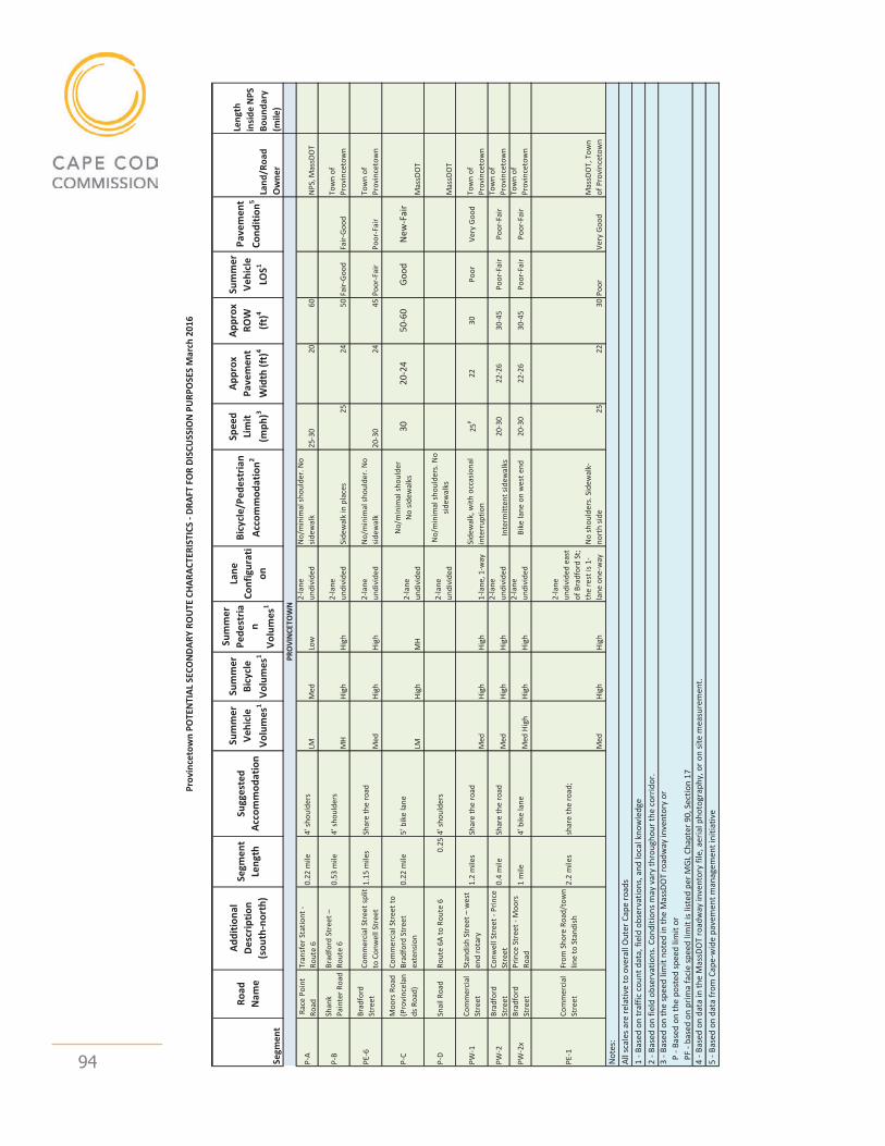
Outer Cape Bicycle and Pedestrian Master Plan - February 2017 update 94
Prov
ince
tow
n PO
TEN
TIAL
SEC
ON
DARY
RO
UTE
CHA
RACT
ERIS
TICS
- DR
AFT
FOR
DISC
USS
ION
PU
RPO
SES
Mar
ch 2
016
Segm
ent
Road
N
ame
Addi
tiona
l D
escr
iptio
n (s
outh
-nor
th)
Segm
ent
Leng
thSu
gges
ted
Acco
mm
odat
ion
Sum
mer
Ve
hicl
e Vo
lum
es1
Sum
mer
Bi
cycl
e Vo
lum
es1
Sum
mer
Pe
dest
rian
Volu
mes
1
Lane
Co
nfig
urat
ion
Bicy
cle/
Pede
stria
n Ac
com
mod
atio
n2
Spee
d Li
mit
(mph
)3
Appr
ox
Pave
men
t W
idth
(ft)
4
Appr
ox
ROW
(ft
)4
Sum
mer
Ve
hicl
e LO
S1
Pave
men
t Co
nditi
on5
Land
/Roa
d O
wne
r
Leng
th
insid
e N
PS
Boun
dary
(m
ile)
P-A
Rac
e Po
int
Road
Tran
sfer
Sta
tiont
- Ro
ute
60.
22 m
ile4'
shou
lder
sLM
Med
Lo
w2-
lane
un
divi
ded
No/
min
imal
shou
lder
. No
sidew
alk
25-3
020
60N
PS, M
assD
OT
P-B
Shan
k Pa
inte
r Roa
dBr
adfo
rd S
tree
t –
Rout
e 6
0.53
mile
4’ sh
ould
ers
MH
High
Hi
gh2-
lane
un
divi
ded
Side
wal
k in
pla
ces
2524
50Fa
ir-Go
odFa
ir-Go
odTo
wn
of
Prov
ince
tow
n
PE-6
Brad
ford
St
reet
Com
mer
cial
Str
eet s
plit
to C
onw
ell S
tree
t1.
15 m
iles
Shar
e th
e ro
adM
edHi
gh
High
2-la
ne
undi
vide
dN
o/m
inim
al sh
ould
er. N
o sid
ewal
k20
-30
2445
Poor
-Fai
rPo
or-F
air
Tow
n of
Pr
ovin
ceto
wn
P-C
Moo
rs R
oad
(Pro
vinc
elan
ds R
oad)
Com
mer
cial
Str
eet t
o Br
adfo
rd S
tree
t ex
tens
ion
0.22
mile
5’ b
ike
lane
LMHi
gh
MH
2-la
ne
undi
vide
d
No/
min
imal
shou
lder
No
sidew
alks
3020
-24
50-6
0Go
odN
ew-F
air
Mas
sDO
T
P-D
Snai
l Roa
dRo
ute
6A to
Rou
te 6
0.25
4' sh
ould
ers
2-la
ne
undi
vide
d
No/
min
imal
shou
lder
s. N
o sid
ewal
ksM
assD
OT
PW-1
Com
mer
cial
St
reet
Stan
dish
Str
eet –
wes
t en
d ro
tary
1.
2 m
iles
Shar
e th
e ro
adM
edHi
gh
High
1-la
ne, 1
-way
Side
wal
k, w
ith o
ccas
iona
l in
terr
uptio
n25
P22
30Po
orVe
ry G
ood
Tow
n of
Pr
ovin
ceto
wn
PW-2
Brad
ford
St
reet
Conw
ell S
tree
t - P
rince
St
reet
0.4
mile
Shar
e th
e ro
adM
edHi
gh
High
2-la
ne
undi
vide
dIn
term
itten
t sid
ewal
ks20
-30
22-2
630
-45
Poor
-Fai
rPo
or-F
air
Tow
n of
Pr
ovin
ceto
wn
PW-2
xBr
adfo
rd
Stre
etPr
ince
Str
eet -
Moo
rs
Road
1 m
ile4'
bik
e la
neM
ed H
igh
High
Hi
gh2-
lane
un
divi
ded
Bike
lane
on
wes
t end
20-3
022
-26
30-4
5Po
or-F
air
Poor
-Fai
rTo
wn
of
Prov
ince
tow
n
PE-1
Com
mer
cial
St
reet
From
Sho
re R
oad/
tow
n lin
e to
Sta
ndish
2.2
mile
ssh
are
the
road
;
Med
High
High
2-la
ne
undi
vide
d ea
st
of B
radf
ord
St;
the
rest
is 1
-la
ne o
ne-w
ay
No
shou
lder
s. S
idew
alk-
nort
h sid
e25
2230
Poor
Very
Goo
dM
assD
OT,
Tow
n of
Pro
vinc
etow
n
1 - B
ased
on
traf
fic c
ount
dat
a, fi
eld
obse
rvat
ions
, and
loca
l kno
wle
dge
2 - B
ased
on
field
obs
erva
tions
. Con
ditio
ns m
ay v
ary
thro
ugho
ur th
e co
rrid
or.
3 - B
ased
on
the
spee
d lim
it no
ted
in th
e M
assD
OT
road
way
inve
ntor
y or
P
- Ba
sed
on th
e po
sted
spee
d lim
it or
PF
- bas
ed o
n pr
ima
faci
e sp
eed
limit
is lis
ted
per M
GL
Chap
ter 9
0, S
ectio
n 17
4 - B
ased
on
data
in th
e M
assD
OT
road
way
inve
ntor
y fil
e, a
eria
l pho
togr
aphy
, or o
n sit
e m
easu
rem
ent.
5 - B
ased
on
data
from
Cap
e-w
ide
pave
men
t man
agem
ent i
nitia
tive
PRO
VIN
CETO
WN
Not
es:
All s
cale
s are
rela
tive
to o
vera
ll O
uter
Cap
e ro
ads
1

Outer Cape Bicycle and Pedestrian Master Plan - February 2017 update 95
appendix BPotential Primary Route alternativesdraft Map

Outer Cape Bicycle and Pedestrian Master Plan - February 2017 update 96
Outer Cape Bicycle and Pedestrian Master Plan - February 2017 update 97
appendix CMemotoPublicSafetyOfficialsregarding Route 6 Lane Reduction
Outer Cape Bicycle and Pedestrian Master Plan - February 2017 update 98
Memorandum
DATE: APRIL 29, 2016 TO: KYLE TAKAKJIAN, TRURO CHIEF OF POLICE DAVID GARDNER, PROVINCETOWN ASSISTANT TOWN MANAGER FROM: MARTHA HEVENOR, PLANNER RE: LANE REDUCTION
At our meetings last month with town staff members on the Outer Cape Bicycle and Pedestrian Master Plan (OCBPMP), you had requested information on potential impacts to traffic flow from lane reduction along the four-lane section of Route 6 in Truro and Provincetown. In response to your request, CCC transportation staff conducted an analysis of a lane “diet” in this location, as provided in the attached document.
Please feel free to contact Patrick Tierney ([email protected]) if you have any questions about the analysis.
Thank you for your time and input on the OCBPMP. Please let me know if you have any questions or would like further information about the project.

Outer Cape Bicycle and Pedestrian Master Plan - February 2017 update 99
1
Introduction As part of its discussion of route alternatives, the Outer Cape Bicycle and Pedestrian Master Plan steering committee members requested that Cape Cod Commission (CCC) staff explore the concept of a “lane diet” for the four-lane section of Route 6 in Truro and Provincetown to determine its feasibility and potential to reduce construction costs and natural resource/habitat impacts from installation of a separated multi-use path within the Route 6 right-of-way. A lane diet in this location could result in a two-lane highway with one lane of travel in each direction, or a three-lane highway with two lanes in one direction.
Existing Conditions CCC performed traffic counts at multiple points along the roadway as presented in the attached table. The table shows the highest measured directional traffic volumes, summer average daily traffic volumes, and 85th percentile speeds on Route 6 from North Eastham to Provincetown. On the four lane section of Route 6, between Shore Road in Truro and the Provincetown/Truro town line, the highest measured traffic volumes in the summer months ranged from 1,018 to 618 vehicles per hour in one direction. On the four lane section of Route 6 between the town line and Herring Cove Beach in Provincetown, the highest measured traffic volumes in the summer months ranged from 852 to 190 vehicles per hour in one direction. (The analysis uses summer traffic volumes as these are the peak conditions and recent counts are available. Recent year round counts are not available, but observation and past data shows that they are significantly lower.) Speed measurements on the four lane sections show 85th percentile speeds as high as 63 mph. The posted speed limit is 50 mph. Measurements show top speeds of over 65 miles per hour, and town officials have identified speeding as a problem. The four-lane sections of Route 6 do not provide bicycle or pedestrian accommodations. The two-lane sections in Truro and Wellfleet have 6 to 8 foot paved shoulders that are frequently used by bicycles and pedestrians.
Land Reduction Feasibility and Impacts The Federal Highway Administration (FHWA) states that typically the traffic threshold for considering lane reduction from four lanes to two is 875 vehicles per hour in one direction or average daily traffic as high as 24,000 vehicles per day in both directions1. This is a guideline, not a standard, and does not account for special conditions/features such as seasonal population swings or geography. As shown in the graph and table attached, Route 6 in Truro has a maximum directional volume higher than the FHWA hourly volume threshold. Vehicle volumes for Route 6 in Provincetown do not exceed the thresholds. The summer average daily traffic volumes for the entire four lane segment fall below the daily volume threshold of 24,000 vehicles. In addition, sections of Route 6 that have two lanes in Truro and Wellfleet show higher traffic volumes than those that have four lanes in North Truro and Provincetown. Decreasing the number of lanes could impact vehicle flow during peak summer hours because the peak hour volumes are near or above the feasibility threshold. Outside of the peak summer hours and the
Outer Cape Bicycle and Pedestrian Master Plan - February 2017 update 100
2
summer months, traffic volumes are significantly lower than the thresholds. Traffic flow would likely be similar to the two lanes sections of Route 6 in Truro and Wellfleet. One question raised is the impacts to level of service at intersections. With appropriate intersection design, including carrying sufficient through lanes and incorporating turning lanes with sufficient storage, impacts may be mitigated. In relation to roadway speeds, FHWA states that municipalities typically reduce the number of lanes to reduce extreme and 85th percentile speeds. Case studies and traffic simulation suggest that the 85th percentile could decrease between 3 to 5 mph and the number of speeders that violate the posted speed limit could decrease by 7 percent. Actual impacts will vary based on abutting land use and roadway geometry. A review of safety literature suggests that the number of crashes is typically reduced when a four lane road is reduced to two or three lanes. Specific case studies include reduction on roadways with turning lanes, low density and segments with 8 or fewer intersections per mile2. Since lane reductions typically result in lower speeds, implementation could also have positive impacts on crash severity. FHWA states that a difficult aspect of implementing a lane reduction is public perception. One method to address concern could be to conduct a trial period. Sometimes lane reduction occurs during construction and a trial marking plan could be consistent with previous roadway projects. The impacts to congestion can be observed rather than estimated and the public gets a chance to drive the roadway under the proposed conditions. To have a positive impact to public perception, the trial period should last a reasonable amount of time, such that perception can adjust to the change and react to the impacts. The discontinued travel lanes could allow for designated space for bicycles and pedestrians and/or include a shoulder, as on the two lane portions of Route 6 in Wellfleet and Truro. A shoulder could allow vehicles to maneuver around vehicles turning left off Route 6. Bicycles could use the shoulder, as occurs on the two lane sections in Truro and Wellfleet. As a longer term project, a multi-use path physically removed from the travel lanes and shoulder is proposed. A lane reduction would allow the new path to be closer to the roadway centerline, minimizing the impacts to local ecology.
Conclusion It is appropriate to consider a reduction in lanes on Route 6 in Truro and Provincetown. The disadvantages are negligible and there are reasonable advantages. Benefits include reducing speeding and providing space for bicycle and pedestrian accommodation. The peak summer directional roadway volumes on the four lane section of Route 6 in Truro are near or above the suggested maximum hourly threshold from FHWA; however, vehicle volumes for Route 6 in Provincetown do not exceed the thresholds, and the summer average daily traffic volumes for the entire four-lane segment fall below the daily volume threshold of 24,000 vehicles. In addition, sections of Route 6 with two lanes in Truro and Wellfleet show higher traffic volumes than those with four lanes, demonstrating that a two-lane configuration can accommodate the traffic levels. 1http://safety.fhwa.dot.gov/road_diets/info_guide/ 2http://www.cmfclearinghouse.org/

Outer Cape Bicycle and Pedestrian Master Plan - February 2017 update 101
3 3
mea
sure
d th
roug
h th
e Ca
pe C
od C
omm
issio
n Tr
affic
Cou
ntin
g Pr
ogra
m. D
ata
shee
ts a
re a
vaila
ble
by re
ques
t.
4 data
pre
sent
ed in
the
Cape
Cod
Com
miss
ion
Traf
fic C
ount
ing
Web
Vie
wer
. htt
p://
gis-
serv
ices.c
apec
odco
mm
issio
n.or
g/ap
ps/P
ublic
/tra
nspo
rtat
ion-
coun
ts/
Loca
tion
Tow
n M
ile fr
om S
tart
Co
unt
Star
t Dat
e SB
Pea
k Ho
ur3
High
est
mea
sure
d so
uthb
ound
pe
ak h
our
volu
me3
NB
Peak
Ho
ur3
High
est
mea
sure
d no
rthb
ound
pe
ak h
our
volu
me3
Conf
igur
atio
n
Hist
orica
l es
timat
ed
4pm
-5pm
pea
k di
rect
iona
l tr
affic
vol
ume3
Hist
orica
l es
timat
ed
sum
mer
av
erag
e da
ily
traf
fic4
85th
pe
rcen
tile
spee
d3
Rt 6
W o
f Sha
nk
Pain
ter R
oad
Prov
ince
tow
n 0
8/11
/201
5 5p
m
197
10am
19
0 4
lane
div
ided
15
0 30
87
50
Rt 6
W o
f Con
wel
l Pr
ovin
ceto
wn
0.48
8/
11/2
015
5pm
54
4 11
am
528
4 la
ne d
ivid
ed
522
1067
8 54
Rt 6
E o
f Con
wel
l Pr
ovin
ceto
wn
0.77
7/
22/2
009
4pm
73
2 12
pm
730
4 la
ne d
ivid
ed
663
1268
9
Rt 6
E o
f How
land
Pr
ovin
ceto
wn
1.28
8/
11/2
015
3pm
85
2 11
am
807
4 la
ne d
ivid
ed
748
1692
0 56
Rt 6
TL
Prov
ince
tow
n/Tr
uro
2.93
8/
11/2
015
10am
84
5 12
pm
670
4 la
ne
undi
vide
d 61
8 13
744
63
Rt 6
N o
f Rt 6
A Tr
uro
7.2
8/4/
2014
4p
m
882
5pm
10
18
4 la
ne
undi
vide
d 97
9 19
297
Rt 6
S o
f Rt 6
A Tr
uro
7.7
8/7/
2012
5p
m
1105
5p
m
1053
2
lane
un
divi
ded
926
1933
2
Rt 6
N o
f Tru
ro
Cent
ral S
choo
l Tr
uro
8.12
8/
1/20
06
5pm
10
36
12pm
89
6 2
lane
un
divi
ded
639
1657
4 53
Rt 6
S o
f Uni
on
Fiel
d Rd
Tr
uro
10.0
5 7/
16/2
012
4pm
80
4 12
pm
787
2 la
ne
undi
vide
d 76
4 16
384
Rt
6 S
of P
rince
Va
lley
Rd
Trur
o 11
.67
7/20
/200
9 4p
m
858
12pm
84
4 2
lane
un
divi
ded
804
1623
5
Rt 6
TL
Trur
o/W
ellfl
eet
13.0
9 7/
13/2
015
4pm
73
2 1p
m
881
2 la
ne
undi
vide
d 77
2 16
583
Rt
6 S
of L
ong
Pond
Roa
d W
ellfl
eet
14.5
5 8/
19/2
014
4pm
99
0 12
pm
923
2 la
ne
undi
vide
d 94
8 19
633
Rt
6 S
of M
ain
Stre
et
Wel
lflee
t 14
.96
8/19
/201
4 4p
m
1146
10
am
1210
2
lane
un
divi
ded
942
2316
4
Rt 6
S o
f Lec
ount
Ho
llow
Roa
d W
ellfl
eet
17.3
8 8/
19/2
014
4pm
12
28
11am
11
00
2 la
ne
undi
vide
d 11
05
2471
0 48
Rt 6
N o
f Lie
uten
ant I
sland
Rd
W
ellfl
eet
18.3
1 7/
13/2
009
4pm
10
49
12pm
12
72
2 la
ne
undi
vide
d 10
06
2362
1
Rt 6
TL
Wel
lflee
t/Ea
stha
m
20
7/13
/201
5 6p
m
1094
1p
m
1319
2
lane
un
divi
ded
1000
22
501
Rt
6 N
of N
ause
t Ro
ad
East
ham
20
.71
7/13
/201
5 5p
m
1086
11
am
1148
4
lane
un
divi
ded
1069
25
487
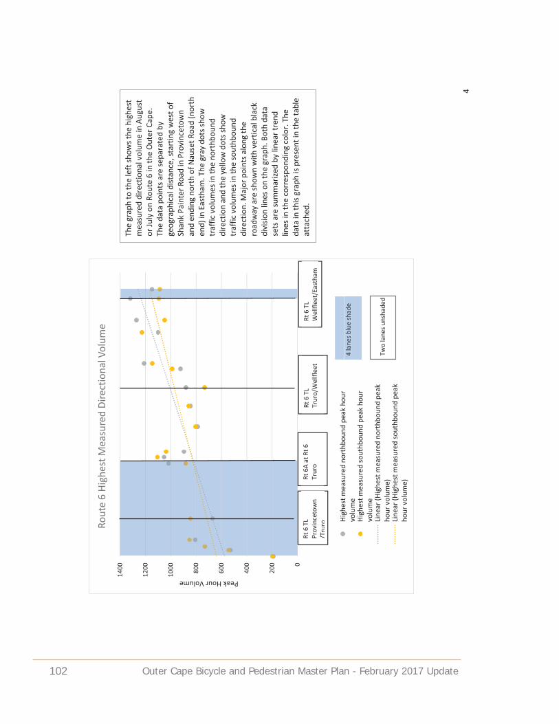
Outer Cape Bicycle and Pedestrian Master Plan - February 2017 update 102
4
0
200
400
600
800
1000
1200
1400
Peak Hour Volume
Rout
e 6
High
est M
easu
red
Dire
ctio
nal V
olum
e
High
est m
easu
red
nort
hbou
nd p
eak
hour
volu
me
High
est m
easu
red
sout
hbou
nd p
eak
hour
volu
me
Line
ar (H
ighe
st m
easu
red
nort
hbou
nd p
eak
hour
vol
ume)
Line
ar (H
ighe
st m
easu
red
sout
hbou
nd p
eak
hour
vol
ume)
Rt 6
TL
Prov
ince
tow
n/T
ruro
Rt 6
A at
Rt 6
Tr
uro
Rt 6
TL
Wel
lflee
t/Ea
stha
m
Rt 6
TL
Trur
o/W
ellfl
eet
4 la
nes b
lue
shad
e Tw
o la
nes u
nsha
ded
4 la
nes b
lue
shad
e
The
grap
h to
the
left
show
s the
hig
hest
m
easu
red
dire
ctio
nal v
olum
e in
Aug
ust
or Ju
ly o
n Ro
ute
6 in
the
Out
er C
ape.
Th
e da
ta p
oint
s are
sepa
rate
d by
ge
ogra
phic
al d
istan
ce, s
tart
ing
wes
t of
Shan
k Pa
inte
r Roa
d in
Pro
vinc
etow
n an
d en
ding
nor
th o
f Nau
set R
oad
(nor
th
end)
in E
asth
am. T
he g
ray
dots
show
tr
affic
vol
umes
in th
e no
rthb
ound
di
rect
ion
and
the
yello
w d
ots s
how
tr
affic
vol
umes
in th
e so
uthb
ound
di
rect
ion.
Maj
or p
oint
s alo
ng th
e ro
adw
ay a
re sh
own
with
ver
tical
bla
ck
divi
sion
lines
on
the
grap
h. B
oth
data
se
ts a
re su
mm
arize
d by
line
ar tr
end
lines
in th
e co
rres
pond
ing
colo
r. Th
e da
ta in
this
grap
h is
pres
ent i
n th
e ta
ble
atta
ched
.

Outer Cape Bicycle and Pedestrian Master Plan - February 2017 update 103

Cape Cod Commission3225 Main Street, PO Box 226Barnstable, Ma 02630
www.capecodcommission.org
a department of Barnstable County Regional Government, Massachusetts