Our Counties · sary of the birth of John Bunyan, preacher and author from Bedfordshire. and...
16
Our Counties The Association of British Counties Annual 2015 Government Statement 1974: “The new county boundaries are administrative areas and will not alter the traditional boundaries of counties, nor is it intended that the loyalties of people living in them will change.”
Transcript of Our Counties · sary of the birth of John Bunyan, preacher and author from Bedfordshire. and...

Our Counties The Association of British Counties Annual 2015
Government Statement 1974:
“The new county boundaries are administrative areas and
will not alter the traditional boundaries of counties,
nor is it intended that the loyalties of
people living in them will change.”

2
Association of British Counties
President: Michael Bradford
Chairman: Peter Boyce
Vice-chairman: Rupert Barnes
Treasurer: Colin Foster
Patrons: Russell Grant, Esq.
Peter Luff MP John Randall MP
Andrew Rossindell MP Angela Watkinson MP
Flag and County News
Several new flags have been introduced since the
last annual. Bedfordshire, Northamptonshire,
Norfolk and Surrey were all registered in September
2014, with Merioneth, Cambridgeshire and
Flintshire following in early 2015.
County flags are now
seen everywhere! A
Durham businessman
took that county’s flag
all the way to the
Solomon Islands. The
flag of Dorset was also
recently seen at the UK Open Darts in Minehead.
ABC member Brady Els designed the winning
Northamptonshire flag which depicts the Tudor
Rose on a cross of gold with a claret field. Hopefully
this flag will be seen flying across Peterborough as
well as the rest of the county.
This year marks the 750th anniversary of the
Montfort Parliament, where elected representatives
of the shires and boroughs came together for the
first time. To mark the occasion, the 2015 Flag
Project invited primary school children aged 7-11
across the UK to design a flag to represent their
constituency.
In an exciting development of the project, a
selection of the flags have been chosen to represent
the historic counties of the UK. These flags will be
Flintshire Merioneth
Cambridgeshire
ABC 2015 Annual
Editor: Mari Foster
Postal Address: 340 Warrington Road,
Glazebury, Warrington, Lancashire, WA3 5LB
Email: [email protected]
Joining the Association of British Counties
Membership costs just £5 a year.
You can join ABC via our website
www.abcounties.com where you can pay by
standing order, direct debit or PayPal.
Front cover photo: Shap Summit, Westmorland
320km above sea level-highest point on M6
All pictures contained herein are copyright free as
far as the editor has been made aware.
Norfolk

3
sewn to fly at a special event in Parliament Square
in the spring, with support from the Department of
Culture, Media and Sport.
The flags will also be flown at the Magna Carta
Foundation of Liberty, a special event to be held at
Runnymede, Surrey on 15 June 2015, to celebrate
800 years since the sealing of the Magna Carta. The
event is to be managed by the National Trust and
Surrey County Council.
It is terrific to see the Department for Culture,
Media and Sport and the National Trust taking
such positive steps to celebrate and promote our
historic counties, especially as it involved school
children designing the flags for them.
To see the other flags, visit:
http://flags.parliament.uk/galleries/flags.
The Friends of Bedfordshire Society
ABC was proud to welcome a new member
organisation to our family in 2014-
the Friends of Bedfordshire Society
(www.friendsofbedfordshire.co.uk). The society aims
to promote and celebrate all things Bedfordshire,
taking pride in everything from the major towns to
its smallest villages, the countryside, its traditions
and its people. They hope to instil passion and pride
in the people of Bedfordshire for their beautiful
county. The society has already been successful at
having a Bedfordshire flag registered with the Flag
Institute (see photo below) and has more recently
been conducting a public vote on a date for a county
day. The winning date is 28 November, the anniver-
sary of the birth of John Bunyan, preacher and
author from Bedfordshire.
Groups like these are the lifeblood of our
movement at a county level. So much can be
achieved by local enthusiasts as nationally ABC
simply does not have the time for individual
counties. Setting up a group, developing a flag and
nominating a county day are tried and trusted ways
to raise the profile of your county. If your county
currently has no such group and you would like to
set one up then get in touch with ABC Chairman
Peter Boyce ([email protected]) for some
advice on how to get started.
Ordnance Survey to Produce Historic County
Border Data
On 10 March 2015, Lord Ahmad of the Department
of Communities and Local Government announced
that:
“from May, a dataset of the traditional,
historic counties based on 19th century
boundaries will be available on the OS
OpenData portal. These datasets are
compatible with the OS Boundary-Line
product which is available to all, free of
charge. Ordnance Survey is also going to pro-
vide a viewing map window on their website
showing both the historic and ceremonial
county boundaries on top of a base map.
Later in the year Ordnance Survey is hoping
to publish a paper map of the Historic
Counties of England, Scotland and Wales (as
defined in the Local Government Act 1888 for
England and Wales and the Local Govern-
ment (Scotland) Act 1889), which will be
available to the general public to purchase
and proudly display.”
Both of these developments are warmly welcomed
by ABC. ABC already supplies digital boundary
data of the historic counties from our website.
However, having the Government’s National
Mapping Agency also producing such data cannot
help but be seen as giving the historic counties a
further mark of endorsement by the Government.
Having some kind of official point of reference to
borders will be useful in placing border signs, in
postal addressing, etc. It will also be much easier to
persuade publishers of guide books and the like to
use the historic counties if there is “official” OS
data giving their borders.
Whilst we may end up with the odd quibble over
borders, in general this announcement is something
to be enthusiastically welcomed.
The newly registered Bedfordshire flag
flying at the stand of the
Royal British Legion Riders Branch
4
Redcar and Cleveland Council
shows its Yorkshire pride
Redcar and Cleveland Council have voted through
two measures which show its pride in being part of
Yorkshire. On 11 March 2015 a direction went out
to all parts of the council to include the word
‘Yorkshire’ in their postal address. The boundary
signs around the council’s boundary are to be
replaced shortly, the new signs bearing the words
‘Redcar and Cleveland on the Yorkshire Coast’.
Why the Historic Counties were never abolished
This is the title of a new piece on County-Wise in
which we try to present, in as short and lucid a
form as possible, an answer to the usual
“Weren’t the historic counties abolished back in…”
sort of question. Our intention was to give a quick
answer to such questions, especially from the
media. ABC members and member organisations
may find this a useful format to follow or even a
place to which they can refer these questions.
The piece presents this concise answer: “The
simple answer is that local government areas were
created in 1888 and, although initially based on the
historic counties, they were always understood to
be separate from them. Hence, subsequent changes
to local government areas have not affected the
historic counties, something the Government has
consistently re-affirmed.”
It also provides a ‘reasonably short answer’ with
more on the relationship between local government,
ceremonial counties and the historic counties
without overcomplicating the issue and causing any
further confusion.
ABC press packs now available
We have recently developed two new press packs,
the aim of which is to make it easier for the media
to find out about ABC and our work.
An Introduction to the Association of British
Counties does exactly what it says on the tin! It
describes who we are and what we do.
A Guide to the Historic Counties for the Press and
Media explains what the counties are, what they
are not, and their relevance and importance to our
culture, history and geography. It provides some
useful county facts and county quotes and also an
FAQ section.
Both press packs are available as PDFs from
http://abcounties.com/press-and-media/press-
packs/. When dealing with the media as members
of ABC or our member organisations, you may find
it useful to point them in the direction of these
press packs.
The Historic Counties Convention 2014
A review by ABC Chairman, Peter Boyce
The Historic Counties Convention 2014 was held on
Saturday 24 October at the town hall in
Lutterworth, Leicestershire. Those attending were
treated to a packed programme. We were especially
pleased to welcome three guest speakers to this
gathering.
Starting us off was guest speaker Peter Aylmer,
walker, Essex enthusiast and author of Walking in
Essex (Cicerone, 2013), 25 day walks across the
whole of the historic county. Peter gave a
well-delivered talk entitled ‘Influx and Uprising:
the Other Side of Essex’. This looked at a broad
sweep of 1500 years of the county’s history and told
the stories of some of the many groups who have
moved in, made Essex their home and made their
mark on the county. Peter’s talk led to many
questions which he answered artfully and a general
debate about the state of Essex’s identity in the
metropolitan part of the county.
Following on from Peter, Michael Garber, ABC’s
Communications Officer, gave an update on the
latest developments on the ABC website, such as
the new ‘Press and Media’ page. Our social media
pages have continued to grow and we are now on
Facebook, Twitter and Google+. Michael also
offered a glimpse into our upcoming project to
revamp County-Wise, bringing in new features and
consolidating our county place-name, mapping and
border data offerings. The first phase of this project
saw the launch of the County-Wise Activities Zone
with the interactive “UK County Map Quiz” as its
first activity. You can test your county knowledge

5
at http://activities.county-wise.org.uk and have
some fun in the process.
Peter Boyce then gave a review of some of the
main achievements of ABC during the previous 12
months. Highlights included the incorporation of
specific provision for historic county border signs
within the Traffic Signs Regulations and General
Directions revised draft, the registration of seven
more county flags and the formation of the Friends
of Bedfordshire Society.
It was then a great pleasure to welcome our
second guest speaker: veteran journalist, author
and former Wisden’s editor Matthew Engel.
Matthew described the background to his new book
Engel’s England (Profile Books Ltd, 2014) which
tells of his three-year journey through, as he puts
it, ’deepest England’. He travelled to each of the 39
counties, searching for the nation’s soul. The book
is partly an elegy for a lost land, but also a celebra-
tion of what remains. The book has a chapter on
each county as well as an additional chapter on
London. Matthew read extracts from his book with
the audience suggesting some counties. The
extracts, like the whole book, were often perceptive,
sometimes poignant, and frequently very funny.
We all enjoyed a free buffet lunch which provided
time for chat and to view the exhibits brought along
by members and member organisations. Matthew
also sold and signed copies of his book over the
lunch break and seemed very happy with his sales
for the day!
After lunch we all took part in the Great County
Quiz 2014 where prizes were given for first and
second place. Many thanks to Mari Foster for
setting the questions and acting as quiz master.
ABC Vice-chairman Rupert Barnes triumphed,
possessing an apparently encyclopaedic knowledge
of all thing county related.
We were then pleased to welcome back to ABC
Graham Bartram, Chief Vexillologist of the Flag
Institute. Graham last gave a presentation to ABC
at our 21st birthday celebration in 2010. His 2014
subject was the same but of course there has been
massive progress in the development of flags since
he last spoke. In 2010 only 15 county flags had been
registered with the Flag Institute for inclusion in
the UK Flag Registry, but by October 2014 this
number had grown to 35. Graham reviewed all the
county flags registered and discussed some ongoing
ideas and campaigns for further county flags
(including those in Cambridgeshire, Merioneth,
Flintshire and Norfolk which have subsequently
been registered.) There followed a wide-ranging
discussion about how to encourage further flags to
be developed and how to encourage the flying and
other usage of registered flags.
Finally, Edward Keene of the Oxfordshire
Association gave an interesting talk on
’The Counties and Diocesan Boundaries’. In many
areas the dioceses’ boundaries still follow the
historic borders whilst local government boundaries
are now very different. Several attempts have been
made in recent years to amend diocesan boundaries
to match local government. Such proposals are
voted on by the diocese itself and most have been
resisted.
The meeting concluded with a further period for
tea, coffee and chat.
The Historic Counties Convention 2015 will
be held from 11-4 on Saturday, 24 October in
the Denham Room in the Priory Street Centre
in York. We are hoping that a venue in a
major tourist destination, close to public
transport and park-and-ride facilities will
encourage a good attendance. The event is
free for anyone to attend.
There would be no perception these days that Yorkshire people are any more dishonest than anyone
else. But wilful, canny heading towards tight, and combative? All of these, and more, are part not just
of their image but of their self-image. Boastful too.
“What’s the biggest county in England?” one of my favourite Yorkshiremen asked over dinner.
“Yorkshire,” I replied.
“What’s the second biggest?”
I began to get suspicious. “We are talking traditional counties?”
“Of course.”
“Well, Lincolnshire, then.”
“Wrong! The West Riding!” he announced triumphantly. (True, I now think, but only just.)
Excerpt from Engel’s England, Yorkshire chapter

6
Discovering the True Historic County TopsDiscovering the True Historic County TopsDiscovering the True Historic County Tops
Gerry Bowes
On 5 November 2014, whilst others were celebrat-
ing the fact that Parliament and James I were not
blown sky high, I was celebrating reaching my
final historic county top. Stood on Merrick, the
county top of Kirkcudbrightshire, it was hard to
imagine a more fitting place to finish my quest to
stand on the high point of each of the 92 historic
counties of the UK. On a beautifully calm and
cloudless autumn afternoon, I was able to look out
over the Firth of Clyde and view the
unmistakeable shape of Ailsa Craig which lies
within Ayrshire, Goatfell on Arran, which lies
within Buteshire and the Mull of Kintyre which
lies within Argyllshire. Beyond the Mull of
Kintyre, the Antrim coast was also visible, albeit
rather hazy. Turning to the south east, it was
possible to make out the Cumberland coast of
England. Therefore of the four countries of the UK
only Wales remained out of my sight. Apparently,
the 144 mile view between Merrick and Snowdon
is the longest line of sight in the British Isles.
Needless to say, I didn’t get a sighting-a shame
really as Snowdon was my first historic county
top, climbed back in April 1976.
Stood on the summit of Snowdon almost 40 years
ago, the thought of completing the historic county
tops never entered my head; I was just interested
in getting to the top of as many high mountains as
possible. It wasn’t until the summer of 2012 that
my interest in historic county tops was aroused. I
got hold of a copy of Jonny Muir’s book, The UK’s
County Tops which contains detailed descriptions
and maps of how to reach the top of 91 historic
counties. When looking down the list of tops, it
was evident that I has already climbed all the
county tops above 3000ft and most of the county
tops in England and Wales above 2000ft. Of the 91
historic counties listed, I could put ticks against 25
of them (over a quarter of the way there) with 25
of the most demanding county tops already
visited. The challenge was on!
Given this interest in the traditional counties, it
wasn’t long before I came across the ABC website,
paid my subscription and attended the 2012 AGM.
At the AGM I had the opportunity to meet Andy
Strangeway who had recently become the first
person to spend a night on each of the 52 county
tops of England and Wales. He pointed out a
number of errors in Muir’s book, namely those
relating to Berkshire, Hampshire, Cambridgeshire
and Warwickshire in England, and Selkirkshire in
Scotland. Andy also informed the that Ross-shire
and Cromartyshire were two separate counties,
giving a total of 92 not the 91 listed in Muir’s book.
Finally, it was recommended that I use the
Wikishire list of historic county tops as my source
of reference.
Fortunately, at the time of the AGM I hadn’t
visited the county tops of the aforementioned
counties of England. Before doing so, I felt the
need to do some research to explain the discrepan-
cies between the Wikishire list and the other
historic county top lists. It soon became clear that
whilst the Wikishire list relates to the counties as
they have existed since well before the introduc-
tion of administrative areas in 1888, the other lists
related to the administrative areas as they existed
immediately prior to the local government
reorganisation in 1974. Using a range of internet
sources, most especially the Historic County
Borders Project, parish records on GENUKI and
six-inch maps available on the National Library of
Scotland website, it was fascinating to discover
how and when the divergence between the historic
county boundaries/county tops and the adminis-
trative county boundaries/county tops (pre-1874)
took place.
Following the Local Government Act of 1894,
administrative counties were encouraged to
My final county top:
Merrick, Kircudbrightshire

7
‘tidy up’ their boundaries and this resulted in the
exchange of parishes between neighbouring
counties. It was the transfer of Combe from
Hampshire to Berkshire and Great Chishill from
Essex to Cambridgeshire that accounts for the
discrepancy in the listed county tops of Berkshire,
Hampshire and Cambridgeshire. Both these
transfers took place in 1895. With regard to
Warwickshire, it was the 1895 transfer of
Admington from Gloucestershire to Warwickshire
that has led to the discrepancy in the listed county
top of Warwickshire. In Scotland, most lists name
Broad Law as the historic county top of both
Peeblesshire and Selkirkshire, even though it is
located 6 or 7 miles west of Selkirkshire. The
reason for the difference between these lists and
the WikiShire list is again due to a parish transfer.
In 1891 Megget, part of the parish of Lyne, was
transferred from Peeblesshire to Selkirkshire.
Finally, the historic county of Cromartyshire dates
back to medieval times. However, in 1890 the
administrative area of Ross and Cromarty was
created and all lists, apart from the WikiShire list,
fail to recognise Ross-shire and Cromartyshire as
two separate historic counties, each with its own
county top.
Although I gained pleasure from visiting all of the
UK’s 92 historic county tops, there was something
special about setting foot on the true historic county
tops of Berkshire, Hampshire, Cambridgeshire,
Warwickshire and Selkirkshire. Had I not joined
ABC and met Andy Strangeway, I would have
remained unaware that despite all the changes to
the administrative ‘county’ boundaries, the historic
county boundaries have remained unchanged. As a
consequence, I would have been stood in Hampshire
believing I was in Berkshire, stood in Gloucester-
shire believing I was in Warwickshire, stood in
Essex believing I was in Cambridgeshire, and stood
in Peeblesshire believing I was on the boundary
with Selkirkshire. Given the excellent promotional
work that is being carried out by bodies such as
ABC and the Historic Counties Trust, I am
optimistic that increasing numbers of walkers will
choose to use the Wikishire list and visit the true
historic county tops rather than use lists that
include administrative tops masquerading as
historic tops.

8
Notes on Northern IrelandNotes on Northern IrelandNotes on Northern Ireland
Rupert Barnes
Our family holiday last summer took us to
Northern Ireland, which we found to be one of the
loveliest corners of this land, both familiar and
unfamiliar, and where it is unfamiliar it is
generally to excel.
Those who grew up with grim tales about the
place should put that aside for it is a delight. The
place has visibly changed a lot since my first visit
there and all for the better. It is a distinctly divided
society, but one which now accepts its division.
Each side marks its territory openly, but even in
the solidly Protestant heartland there are Roman
Catholic churches and within the nationalist
villages near the border there are Presbyterian
churches and Orange Order halls. Overall there is
more to unite than to divide for this is a quite
distinctive place. One thing on which all agree:
there are six counties, and everyone knows where
they are.
While there we visited three of the nine counties of
Ulster: Antrim, Down and Armagh. It was a
holiday, not a hunting expedition, so I only bagged
a couple of county tops and I have had to supple-
ment my knowledge with the help of a local expert.
The first thing to observe is how rural these
counties are. Outside Belfast, there are no big
towns, and stepping a little beyond the city the
countryside is just that; it not slathered in
suburban townscapes as the equivalent land would
be near the cities of Great Britain. The growth of
towns is therefore not obliterating ancient
boundaries.
Administrative change in Northern Ireland
followed much the same pattern as elsewhere in
1972. All county councils were replaced by a single
regional authority (the local parliament) and 26
“local government districts”. Interestingly, the 1972
Act did not talk of the abolition of any counties,
even the “administrative counties” that had been
created by the Local Government (Ireland) Act
1898. instead, it declared that “every county and
every county borough shall cease to be an adminis-
trative area for local government purposes”. The
Ordnance Survey maps changed, but there is no
sense in public perception that the six counties of
Northern Ireland have vanished or changed.
The counties are not signposted, their bounds are
obscured on maps, but we have not seen the loss of
the counties in the public mind. It helps that the
1972 districts bear no similarity to the counties
(with the exception of Fermanagh) and they do not
pretend to be counties nor successors. Perhaps it
helps also that the district councils have far less
power. Another factor may be the very identity of
Northern Ireland as a region formed of six counties;
six of the nice counties of the province of Ulster.
The counties are accepted, but finding their
boundaries is not so straightforward. The ordinary
Discoverer series of Ordnance Survey maps do show
county boundaries but the tiny dotted lines are
hard to discern. The boundaries shown are those of
administrative counties as in 1972, so they have the
county boroughs of Belfast and Londonderry, and
the Antrim/Down boundary creeps south of the
Lagan in Lisburn. The boundary in Newry is
completely obscured as the line is lost in the
townscape-there is a fascinating boundary point
here though as the old town hall stands on a bridge
in order that it should show no favouritism between
County Armagh on the western bank and County
Down on the eastern; this must surely be a unique
solution.
The most recent Discoverer maps also show town-
lands on the reverse side. This needs a little
explaining. Each county is divided into baronies (as
some English counties are divided into hundreds)
and is further divided into townlands. A townland
is a traditional division of land, purely
Edenagarry, County Down

9
geographical, typically between 200 and 400 acres
(though the smallest, McCricket in County Down is
just 4 acres). It might contain a village or a hamlet,
or it might not. They are more visible on the ground
than they once were; for example, some street signs
give the name of the townland. Some in the Mourne
Mountains have inscribed stones with their name
and etymology. The townlands appear to predate
the Plantation of Ulster and in Northern Ireland
some 90% have names that derive from the Gaelic.
The townlands are part of local culture, irrespective
of community identity and their re-emergence is
supported by all parties.
I saw not a single county boundary sign anywhere
on my travels. I am assured that there are some (if
you know where to look) but all I could see were
local authority signs, welcoming me to such places
as ‘Newry and Mourne’. Nor are there any signs
welcoming one back into Northern Ireland from the
south either. (Apparently there were, but they kept
disappearing in the night.)
Notwithstanding the invisibility of boundaries,
there is no problem with county identity in North-
ern Ireland. No one is in any doubt about which
county they stand in. All will appreciate the Glens
of Antrim, the orchards of Armagh, the Mournes of
Down, the lakes of Fermanagh, the walls of
Londonderry or the Sperrins of Tyrone.
When I returned home I called the Department of
the Environment and had a good yarn with the
chief traffic signs engineer. He informed me that
his department does not erect signs for county
boundaries as these are not considered traffic signs
and are not within the Regulations. Any county
signs would come under the Department of
Enterprise, Trade and Investment as a tourism
matter. Northern Ireland’s traffic sign regulations
mirror those in Great Britain, but there are no
plans to emulate the latest changes to the Traffic
Signs Regulations, which would allow the historic
counties to be marked there.
Were the Association of British Counties to lobby
for such signs it would be as a tourism issue. The
DETI seems not to have considered it a priority, but
can we change their minds?
I cannot forebear to refer to county flags, since
they have come to prominence in the last few years.
No Northern Irish county has its own flag nor are
they likely to have them soon. Flags are badges of
identity and are a burning political issue: in 2012
there were days of rioting in Belfast when the
Union Flag was not flown from City Hall, and
protests continue still. There is no shortage of flags
in Ulster and the art of marking territory is played
out with them so
that in mainly Un-
ionist areas the
lamp posts are fes-
tooned with Union
Flags, the Ulster
banner, the Orange
Order flag and oth-
ers. In Nationalist
areas the main flag is the GAA county flag.
Kerbstones and bridges are painted red, white and
blue or the county GAA colour, depending on social
leaning.
The county flags of the Gaelic Athletics Associa-
tion are commonplace in border areas but they are
used exclusively by one community; the GAA was,
from the beginning, an organisation bound up with
Irish national identity and anathema to
Protestants. Any new, neutral flag will be greeted
with suspicion and if it becomes associated with one
side then it will be rejected by the other. Given that
there is no difficulty with county identity in Ulster,
I do not think we need to force the issue.
In every sphere of life the traditional counties of
Northern Ireland are predominate. No place will be
described but by reference to its county. Though
abolished administratively, the counties appear on
every map and remain the essential division of the
land accepted by all. Local government districts
might erect signs on their boundaries, but they gain
no traction as identities.
The Association of British Counties has hitherto
not spent much time or effort on the six counties of
Northern Ireland, simply because there is no
problem with them. Our main focus on those
counties therefore should continue to be to look to
their example and to replicate it across the United
Kingdom.
Armagh’s GAA flag
County Fact
More than a third of County Fermanagh lies under water.

10
LeapLeapLeap---frogging with the National Trustfrogging with the National Trustfrogging with the National Trust
ABC President Michael Bradford
Public use of counties in postal addresses can make
you squirm nowadays-or smile. It’s many years
since I last amused myself with the National Trust
Members’ Handbook but I’ve just had a look at this
year’s. How are the counties faring in 2015? Well,
some of the old favourites are there, ‘helpful’
addresses like Warwick, Warwickshire; Derby,
Derbyshire; Stafford, Staffordshire, etc. Some old
‘leap-froggers’ are there too, where the property
jumps a town to impose its own county on the
address. This has startling results like Maiden-
head, Buckinghamshire; Banbury, Warwickshire;
Newbury, Hampshire and Sheffield...Derbyshire!
Wolverhampton, where there are two properties,
switches from Staffordshire to ‘West Midlands’ in
only 10 pages. Elsewhere there is consolation in old
postal counties like Barking, Essex; Richmond,
Surrey and Bexleyheath, Kent. The Assembly Rooms
are placed in Bath, Somerset, perhaps reflecting
tradition or possibly the local lieutenancy. Maybe
they would have liked to use the local authority’s
name as they did with nearby Clevedon which is
placed in ‘North Somerset’ but Bath’s local authority
‘Bath and North East Somerset’ was perhaps too
much of a mouthful.
Nearer home for me is York, and here the Trust’s
Regional Headquarters ‘Goddards’, the home of the
Terry chocolate family, finds itself in York, ‘North
Yorkshire’ -a clear use of the lieutenancy. But the
gem of this year’s collection is in north-eastern
Yorkshire where a fine stately home called
Ormesby Hall is given the address Ormesby, near
Middlesbrough, ‘Redcar and Cleveland’! Here the
claims of the lieutenancy (‘North Yorkshire’) are
ignored. Instead we have leap-frogging and this
time the property, having jumped over Middles-
brough ends up in that odd administrative
concoction Redcar and Cleveland. Middlesbrough is
a large town of which the handbook’s compilers may
have just heard. So Ormesby is said to be near it.
The hall is not, however, actually in Middlesbrough
but in ‘Redcar and Cleveland’. A natural reading of
the address given here would suggest that that is
where Middlesbrough is too (whereas it is in
another local authority all together, one called
‘Middlesbrough’). Welcome to the world of Lewis
Carroll…
I’m reminded (with a sigh) of the time nearly 25
years ago when members of the infant ABC were
naïve enough to hope that an organisation devoted
to preserving landscape and buildings might see the
point of preserving their geographical settings. A
coupe of us turned up at the NT’s annual assembly
held in Llandudno on 2 November 1990 to speak to
the motion: ‘That this meeting instructs the Council
of the National Trust to ensure that traditional
county names are used by the National Trust in all
its literature, correspondence and audio-visual
presentations and at all other times except when
referring to local government.’ On a re-reading
many years later maybe words like ‘instruct’ and
‘ensure’ sounded a bit cheeky to such an august
body as the Trust. We were too little aware of its
ethos of deference and conformity. It’s true that
members-well over 2 million of them even then-vote
on matters referred to them but they do so only
after receiving ‘advice’ from the Council. And the
advice in this case was to vote “no” (no rocking the
boat, please) and given the respectful stance of NT
members towards its Council perhaps we did well to
get 43,000 postal votes for with 90,000 against. At
the meeting itself the vote was lost by 375 to 400.
To be fair, the National Trust had then, and still
has, far higher priorities than this one-tasks like
getting people to its properties and here (sadly)
maps and addresses are no longer needed. Satnav
with postcodes is what people use-and the NT
Handbook ensures that they have the codes.
In my judgement this is not a matter to be raised
with the Trust again.
County Quote
“Neither in Wales nor in England, but simply in Radnorshire”
George Borrow (1803-81), English travel writer

11
All Is Not LostAll Is Not LostAll Is Not Lost
Mari Foster
I have lived in Lancashire for 12 years now and
consider myself a Lancastrian although I was not
born in this county nor indeed even in this country.
However, my loyalty remains unwavering.
I am an easily annoyed person, I’ll admit, but the
rising of my temper at the constant use of adminis-
trative areas is certainly justified. The words
‘Greater Manchester’ or ‘Merseyside’ or any other
made-up place name uttered on the
television cause me to reach angrily for the remote
control. I’ve done this during the news, quiz
programmes, you name it. University Challenge is
particularly frustrating because, really...they ought
to know better. There is a real lack of understand-
ing by the general population which is fuelled by
misinformation in the media.
Upon seeing an administrative area being used as
a county when reading online news, one’s first
instinct is to write in the comments section below it
to correct the error. But often, when the article
describes a criminal act or loss of life, further reflec-
tion leads one to think that perhaps now is not the
time to make that correction as it might be consid-
ered petty. Certainly it would be ill-advised to make
the point in that forum.
However, there are still some glimmers of hope.
Evidence of county pride is still around us. An
example local to me: despite my village being
dumped in the administrative ‘Cheshire’ the neigh-
bouring village is having a ‘Lancashire Evening’
soon so why bother if we are not really in
Lancashire? Somebody must still think that we are.
I have seen and heard other instances where I
have thought that we still have some hope. Reading
a link to a letters page in the Telegraph online I
noticed that one of the correspondents listed his
hometown as ‘Peterborough, Northamptonshire’.
Imagine my surprise-and delight! If only that city’s
council felt the same way we might get them to fly
the Northamptonshire flag one day.
Other instances of county loyalty come to mind.
On a recent coach holiday a couple introduced
themselves as coming from Hartlepool in County
Durham and were proud to say they hailed from
that county. Another fellow traveller regaled us
with facts and stories from Northamptonshire; he
made that county sound more interesting than it
had ever seemed before. I also made the
acquaintance of a lady in her 70s after I loaned her
a few Czech koruna for the toilets. She later told me
a story about how she was on a holiday once and
came across a lady who lived in the same village as
she did. (Unfortunately, I forget which village she
named.) However, whilst my companion told people
that she came from Essex, the other woman told
them that she came from London. When this
discrepancy was pointed out, the woman said that
she did not want people to think that she was from
Essex! When telling this anecdote my travel
companion remarked that she was proud to come
from Essex and would never dream of telling people
otherwise.
Sport also occasionally holds onto its county links.
Lisa Ashton, a champion ladies darts player from
Bolton, styles herself as ‘the Lancashire Rose’.
Somehow the ‘Greater Manchester Rose’ just
doesn’t have the same ring to it. And it is always
satisfying to hear a football fixture of say, Bolton v
Wigan labelled as a Lancashire derby. Now if we
could just hear the same thing said about
Manchester United v Liverpool!
And of course my passion, cricket, still maintains
its strong county links and rivalries. Any talk of a
20/20 franchise system is quickly shot down by true
fans of the game. People from Manchester and
Liverpool will happily support Lancashire together
but call a team Manchester Maidens and see how
many supporters from Liverpool you get in attend-
ance. (Okay, perhaps ‘Maidens’ isn’t the best nick-
name, but you can see where I’m going with this.)
So, I would say, do not despair. For every ‘South
Devon’, ‘Dumfries & Galloway’ or ‘Powys’ to set the
teeth grinding there are plenty of instances to make
you smile and think that all is not lost.
County Fact
Mystery writer Edith Pargeter (also known as Ellis Peters) never lived more than three miles from
where she was born in Horsehay, Shropshire in 1913.

12
Wikishire’s New HorizonsWikishire’s New HorizonsWikishire’s New Horizons
Rupert Barnes
Wikishire has passed a significant milestone: in
February 2015 it reached 10,000 articles. From a
catalogue of information on British counties it has
swollen into an encyclopaedia of all the places of
Britain, Ireland and their overseas territories, and
it is unique in that it uses traditional counties and
only traditional counties. Wikishire is now a
substantial resource, but there is plenty of room to
grow even beyond this.
If you have not had a look at the Wikishire website
for a while, do so and see how it has come up in the
world. The expanded number of articles has meant
better coverage overall and fewer inchoate red
links. The aesthetics have been improved too: we
now have a daily featured article on the front page
not just a weekly one with an overall better look
and feel. It has a Twitter feed now too, thanks to
Owain Vaughan.
If Wikishire began as a website on counties and
their main towns, it has expanded immeasurably
beyond that original, timid beginning. It has an
article on every county of the British Isles and each
overseas territory, and also on every city and town,
and an increasing number of village articles. It has
enlarged its concerns too to islands, castles, hills,
rivers, waterfalls, lochs, caves, dales, long-distance
footpaths, country houses, canals, flags, and many
more. The articles on mountains and hills are
keenly compiled, given the interests of some of
ABC’s members. All are categorised by county as
well as by range. The National Trust supplied a list
of their properties to the Historic Counties Trust,
and these and National Trust for Scotland
properties are gradually being added.
It is uneven coverage, inevitably. The towns and
villages of Berkshire and Hertfordshire currently
have 333 and 283 articles respectively, while
Leicestershire has just 22. This needs work.
There is much more too, behind the articles. It has
its own zoomable map, now linked to each article.
On http://wikishire.co.uk/lookup is a wide rang of
resources compiled by Owain. Here is a gazetteer,
not just of villages but of all sorts of geographical
features. Here too are boundary line datasets for
mapping as well as population figures. There are
SVG county outlines to be found too, and variants
with towns and other details. All of these are
resources provided free for anyone to use.
Wikishire and you
In the meantime, Wikishire has endless room for
growth. If there are subjects Wikishire does not yet
tackle, let me know and we can expand in that
direction. I have long thought that we ought to
have some historical articles for example.
This is your canvas. If you have a field of interest,
be it castles, abbeys, history, railways, culture or
anything else, maybe things we have never thought
of, the site is open for you to write what you will.
One of Wikishire’s 10,000+ entries

13
All are welcome to contribute, and please do, as
manpower is in short supply. You might correct or
improve existing articles, or add new ones (there is
no need to ask first, just click and type). Putting an
article together looks daunting on the screen but
the ’wiki’ system makes it simple: log on, click
“Edit” and type. Pre-programmed templates make
it easier, and practically self-categorising. There are
guidance pages on the site about formatting and
inserting pictures, but text is the main thing.
Imperfections can be sorted out later but material
is required now to help reach the site’s potential.
Wikishire is open: come and see if you can make it
better.
Legendary Creatures of Argyllshire’s FolkloreLegendary Creatures of Argyllshire’s Folklore
Mari Foster
I admit, I’m a born sceptic-I’ll thoroughly question
anything that cannot be backed up by science.
However, there is still something compelling about
mythology and folklore. How do the individual
stories come about? Are they based on actual
events which have been corrupted by the many
voices that have related them through the ages like
a game of Chinese Whispers? Is there really
anything tangible about them? To this end I would
like to examine the folklore of Argyllshire: from the
isles of the Hebrides which line it to the lochs and
castles which occupy it.
A figure which runs through much of the lore of
the county and indeed Scotland, is the glaistig. A
mournful figure: half-woman, half-goat, it was said
to be a very bad thing
indeed to criticise or
dismiss her in any way.
These creatures were
more likely to be attached
to a household rather
than to a particular
person or family. Such
was the one at Auchin-
darroch who looked after
the cows of a farmhouse,
keeping the calves from
their mothers at night so
that milk was available for human consumption in
the mornings. As a sort of sacrifice, some of the
milk was poured out for her each evening on the
Glaistig Stone. When this was not done the calves
were found in with the cows on the next morning
and the milk supply was absent. This particular
glaistig was said to be a former dairymaid, which
accounts for her care of the cattle but not much
more is known about how she became a glaistig in
the first place.
Another female presence in Scottish folklore are
fairies, often known to kidnap new mothers who
were then used to provide nourishment for ill fairy
babies. In Argyllshire the women were often taken
to Beinnn Iadain, entering into the mountain
through what was known as the ’Black Door’. Magic
could be used as protection against these creatures
who were especially repelled by dirk grass
(Bruchorcan) or the knots in the wood of the Rowan
tree. Foul language was also another way in which
they could be resisted.
Brownies were often, unlike glaistig, attached to a
family rather than a particular house and were
very rarely female. But one such was the Brownie
of Cariskey on the Mull of Kintyre who served the
MacNeill family and in particular was a good luck
charm for Lt-Colonel Malcolm O’Neill, saving his
life during a battle in Jersey (which may or may not
have actually occurred). This particular entity had
both the traits of a glaistig and a brownie but is
generally referred to as the latter.
A less salubrious creature, seen around the shores
of Loch Creran, was the Sac Bàn (White Sack),
which killed men by wrapping itself around their
feet to bring them to ground where it would then
proceed to murder them. These beings had a piece
of sack-like clothing known as a luman without
which, it was powerless to cause harm.
Humans being transformed into animals either by
themselves or others is a central theme in Scottish
14
folklore. Witches could apparently turn themselves
into hares and if injured while in this guise, the
wound was seen to appear on the same place on the
witch’s person. A notable example happened on the
isle of Lismore which lies in Loch Linnhe. A lad was
out hunting and upon shooting his gun at a hare
heard a harrowing scream. It then occurred to him
that there were no hares on the island and so he
fled in terror. Later he was told that a local witch
was laid up with a broken leg. This witch made the
boy’s life a misery thereafter and he was said to
have become a wastrel because of it.
People, most likely women, being turned into
swans occurs often in the folklore of the county
although often lacking a specific location in the
tale. This results in the likely event that the tale
will not survive the passing of time. However, one
such of these surviving tales was said to occur at
the Iron Age hill fort of Dun Ghallain which sits on
the shore of Loch Sunart. This was the location of a
sad but romantic tale (depending on your outlook).
Here a girl, the object of a laird’s affection, was
turned into a swan by the fellow’s jealous mother.
While out hunting one day he killed a swan which,
upon its death, reverted back to the form of the
woman. In his grief the laird took his own life and
the remains of the two are said to lie together
amongst the walls of Dun Ghallain. The precise
location of this tale has led to its preservation and
retelling.
There are so many more tales associated with the
county of Argyll, too many to possibly relay here.
From the Maiden of Inverawe, one of the most
famous glaistig tales, to the adventures of Fionn
mac Cumhaill, the creatures of Argyllshire are
indeed legendary.
Reference: Westwood, Jennifer & Kingshill, Sophia, The Lore of Scotland: A Guide to Scottish Legends
(Arrow Books, 2011)
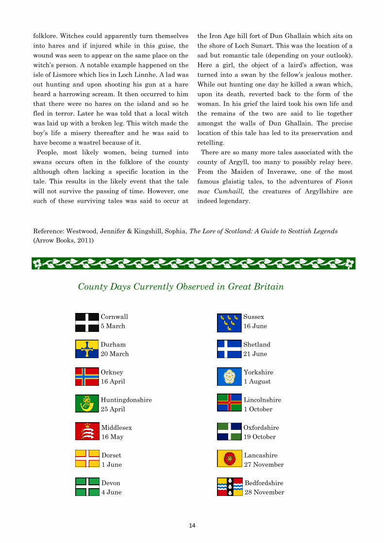
County Days Currently Observed in Great Britain
Cornwall
5 March
Durham
20 March
Orkney
16 April
Huntingdonshire
25 April
Middlesex
16 May
Dorset
1 June
Devon
4 June
Sussex
16 June
Shetland
21 June
Yorkshire
1 August
Lincolnshire
1 October
Oxfordshire
19 October
Lancashire
27 November
Bedfordshire
28 November
15
County Quiz
The first letter of each answer (surnames only) will make up a quote by writer Charles Lamb (1775-1834).
___ Which Pembrokeshire town sits on the River Cleddau and was the birthplace of the artist Gwen John?
___ Which Morayshire town is the ancient capital of Moray and has a cathedral which is known as
“The Lantern of the North”?
___ Which county boasts the towns of Arbroath, Brechin, Montrose and the Carnoustie golf club?
___ Which county, known in Welsh as Sir Faesyfed, is the home of Knighton, the only town which stands
right on Offa’s Dyke?
___ Built by Thomas Tresham in 1597, what shape is the lodge in the grounds of Rushton Hall in
Northamptonshire?
___ Which Somerset town near to the border with Dorset is named for the river upon which it lies?
___ The village of Tarbert is the main settlement on which Inverness-shire island?
___ Which island county gets its name from the Norse for “whale island”?
___ Which Derbyshire town was the home of Victorian Prime Minister William Lamb, who gave his name
to a city in Australia?
___ Which 20th century Prime Minister was born in County Durham in 1897 and died in Wiltshire in 1977?
___ Alice Liddell, the inspiration for Alice in Wonderland, spent her summer holidays in which
Caernarfonshire town, where a statue of the White Rabbit was unveiled in 1933?
___ Which colour makes up the background of the flag or Somerset, setting off the red dragon in the
centre?
___ Which Carmarthenshire village is the final resting place of the poet Dylan Thomas?
___ The planned Lanarkshire town of New Lanark, established by David Dale in the late 18th century, was
run by which Welshman, Dale’s son-in-law?
___ Which abbey, founded in Denbighshire in 1201, was the last Cistercian abbey to be built in Wales ?
___ Pre-dating the Romans and one of the four highways of the Middle Ages, which ancient trackway runs
from Berkshire to Suffolk?
___ Which Nottinghamshire home, founded by Henry the II in the early 13th century, was later inherited
by George Gordon, Lord Byron?
___ The poet William Wordsworth wrote much of his best work there and is buried in the churchyard of
which Westmorland village?
___ Which team won the Division 2 cricket County Championship in 2014?
___ What is an alternative name sometimes used for the county of Midlothian?
___ Which area, part of Aberdeenshire, was given its name because it was the summer home of Queen
Victoria and Prince Albert?
(Quiz continues on back page)

16
Quiz Answers
Haverfordwest
Elgin
Angus
Radnorshire
Triangular
Yeovil
Harris
Orkney
Melbourne
Eden
Llandudno
Yellow
Laugharne
Owen
Vale Crucis
Icknield Way
Newstead Abbey
Grasmere
Hampshire
Edinburghshire
Royal Deeside
Tyrone
Four
Orwell
Rathlin
Darwin
Salt
Handsworth
Inverness-shire
Rutland
Everest
(Quiz continued)
___ The Red Hand of Ulster appears on the badge of which county’s Gaelic Football team?
___ How many counties in England begin with the letter H?
___ Which author (1903-1950) took his pen name from a river in Suffolk?
___ Which island off the coast of Ballycastle, County Antrim was disputed between Ireland and Scotland
until the 17th century?
___ Down House in Kent, built between 1730 and 1740, was home and workplace of which man, 4th on the
list of Greatest Britons?
___ The word “wych” or “wich”, seen as a suffix in many Cheshire town names, relates to which mineral,
mined since Roman times?
___ Which small Warwickshire town, now a suburb of Birmingham, was the home of Matthew Boulton,
James Watt and William Murdock, leaders in the Industrial Revolution?
___ The 1746 battle at Culloden, the last pitched battle on British soil, was fought in which Scottish
county?
___ Uppingham School, which has the largest playing field of any school in England, can be found in which
county?
___ Born near Crickhowell, Breconshire in 1790, which Surveyor-General of India has a mountain peak
named for him?
Submissions Needed for Future Editions
Submissions for the 2016 Association of British Counties Annual
are urgently needed. Contributions from members are the lifeblood
of this magazine and it cannot be sustained without them. Please submit
personal recollections, travelogues, history, poems or whatever you would like.
Any submissions are to be sent to the editor at the address on page 2.
They can be either by email or hand/typewritten and photos are always welcome.