ORTHOS Laser Tunnel Scanner - Geodata
9
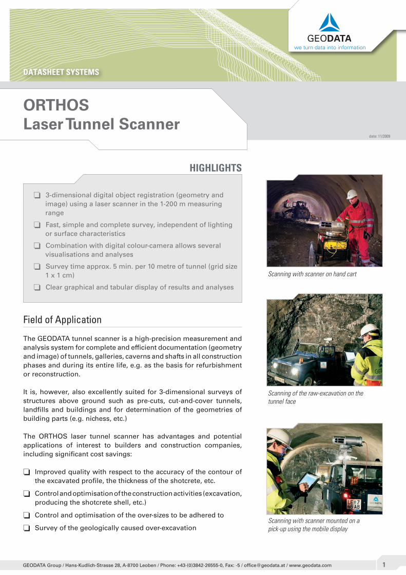
DATASHEET SYSTEMS we turn data into information GEODATA Group / Hans-Kudlich-Strasse 28, A-8700 Leoben / Phone: +43-(0)3842-26555-0, Fax: -5 / [email protected] / www.geodata.com ORTHOS Laser Tunnel Scanner o 3-dimensional digital object registration (geometry and image) using a laser scanner in the 1-200 m measuring range o Fast, simple and complete survey, independent of lighting or surface characteristics o Combination with digital colour-camera allows several visualisations and analyses o Survey time approx. 5 min. per 10 metre of tunnel (grid size 1 x 1 cm) o Clear graphical and tabular display of results and analyses HIGHLIGHTS Field of Application The GEODATA tunnel scanner is a high-precision measurement and analysis system for complete and efficient documentation (geometry and image) of tunnels, galleries, caverns and shafts in all construction phases and during its entire life, e.g. as the basis for refurbishment or reconstruction. It is, however, also excellently suited for 3-dimensional surveys of structures above ground such as pre-cuts, cut-and-cover tunnels, landfills and buildings and for determination of the geometries of building parts (e.g. nichess, etc.) The ORTHOS laser tunnel scanner has advantages and potential applications of interest to builders and construction companies, including significant cost savings: o Improved quality with respect to the accuracy of the contour of the excavated profile, the thickness of the shotcrete, etc. o Control and optimisation of the construction activities (excavation, producing the shotcrete shell, etc.) o Control and optimisation of the over-sizes to be adhered to o Survey of the geologically caused over-excavation date: 11/2009 Scanning with scanner on hand cart Scanning with scanner mounted on a pick-up using the mobile display Scanning of the raw-excavation on the tunnel face
Transcript of ORTHOS Laser Tunnel Scanner - Geodata
DATASHEET SYSTEMS
we turn data into information
�GEODATA Group / Hans-Kudlich-Strasse 28, A-8700 Leoben / Phone: +43-(0)3842-26555-0, Fax: -5 / [email protected] / www.geodata.com
ORTHOSLaser Tunnel Scanner
o 3-dimensional digital object registration (geometry and image) using a laser scanner in the 1-200 m measuring range
o Fast, simple and complete survey, independent of lighting or surface characteristics
o Combination with digital colour-camera allows several visualisations and analyses
o Survey time approx. 5 min. per 10 metre of tunnel (grid size 1 x 1 cm)
o Clear graphical and tabular display of results and analyses
HIGHLIGHTS
Field of Application
The GEODATA tunnel scanner is a high-precision measurement and analysis system for complete and efficient documentation (geometry and image) of tunnels, galleries, caverns and shafts in all construction phases and during its entire life, e.g. as the basis for refurbishment or reconstruction.
It is, however, also excellently suited for 3-dimensional surveys of structures above ground such as pre-cuts, cut-and-cover tunnels, landfills and buildings and for determination of the geometries of building parts (e.g. nichess, etc.)
The ORTHOS laser tunnel scanner has advantages and potential applications of interest to builders and construction companies, including significant cost savings:
o Improved quality with respect to the accuracy of the contour of the excavated profile, the thickness of the shotcrete, etc.
o Control and optimisation of the construction activities (excavation, producing the shotcrete shell, etc.)
o Control and optimisation of the over-sizes to be adhered to
o Survey of the geologically caused over-excavation
date: 11/2009
Scanning with scanner on hand cart
Scanning with scanner mounted on a pick-up using the mobile display
Scanning of the raw-excavation on the tunnel face
ORTHOSLaser Tunnel Scanner
DATASHEET SYSTEMS we turn data into information
�GEODATA Group / Hans-Kudlich-Strasse 28, A-8700 Leoben / Phone: +43-(0)3842-26555-0, Fax: -5 / [email protected] / www.geodata.com
o Completion documentation, accounting basis and inventory documentation (geometry, component dimensions, surfaces, volumes, supports, image documentation)
o Accounting assisted by photo documentation with statistical evaluations
o Preservation of evidence
System description
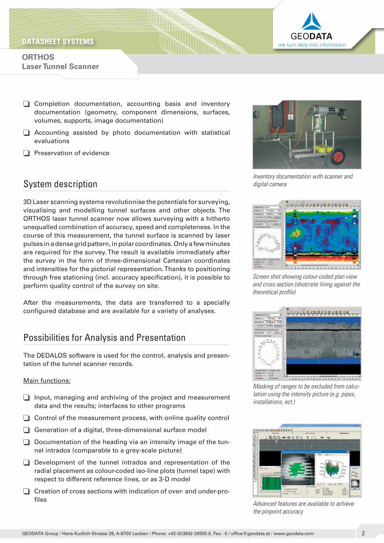
3D Laser scanning systems revolutionise the potentials for surveying, visualising and modelling tunnel surfaces and other objects. The ORTHOS laser tunnel scanner now allows surveying with a hitherto unequalled combination of accuracy, speed and completeness. In the course of this measurement, the tunnel surface is scanned by laser pulses in a dense grid pattern, in polar coordinates. Only a few minutes are required for the survey. The result is available immediately after the survey in the form of three-dimensional Cartesian coordinates and intensities for the pictorial representation. Thanks to positioning through free stationing (incl. accuracy specification), it is possible to perform quality control of the survey on site.
After the measurements, the data are transferred to a specially configured database and are available for a variety of analyses.
Possibilities for Analysis and Presentation
The DEDALOS software is used for the control, analysis and presen-tation of the tunnel scanner records.
Main functions:
o Input, managing and archiving of the project and measurement data and the results; interfaces to other programs
o Control of the measurement process, with online quality control
o Generation of a digital, three-dimensional surface model
o Documentation of the heading via an intensity image of the tun-nel intrados (comparable to a grey-scale picture)
o Development of the tunnel intrados and representation of the radial placement as colour-coded iso-line plots (tunnel tape) with respect to different reference lines, or as 3-D model
o Creation of cross sections with indication of over- and under-pro-files
Masking of ranges to be excluded from calcu-lation using the intensity picture (e.g. pipes, installations, ect.)
Screen shot showing colour-coded plan view and cross section (shotcrete lining against the theoretical profile)
Advanced features are available to achieve the pinpoint accuracy
Inventory documentation with scanner and digital camera
ORTHOSLaser Tunnel Scanner
DATASHEET SYSTEMS we turn data into information
�GEODATA Group / Hans-Kudlich-Strasse 28, A-8700 Leoben / Phone: +43-(0)3842-26555-0, Fax: -5 / [email protected] / www.geodata.com
o Graphical comparison and calculation of the differential volumes in the profiles of two construction phases (computation of the concrete cubature)
o Graphical and tabulated presentation of the results
o Interface for data export and import for the EUPALINOS tunnel surveying software
o Optimisation of concrete for the inner lining in accordance with project-specific requirements (cost saving “concrete”) – special solutions
In case of inventory documentation with digital camera:
o Geo-referenced inventory documentation with photo
o Export in CAD-format
o Definition of all possible installations prior to inventory survey (with individual labelling)
o Semi-automatic recognition of recurrent patterns (e.g. ceiling lamps, ventilators etc.)
o Simple referencing and recovering of the installations of the pro-ject
o Completion of installations with individual annotation text
Procedure
The RIEGL LMS-Z390i laser scanner rotates steadily around its lon-gitudinal axis during the measurement. A rotating mirror simultane-ously deflects a laser beam through 90° cone angles. If the scanner is mounted vertically, it is therefore possible to do 360° panoramic surveys (e.g. for landfill surveys).
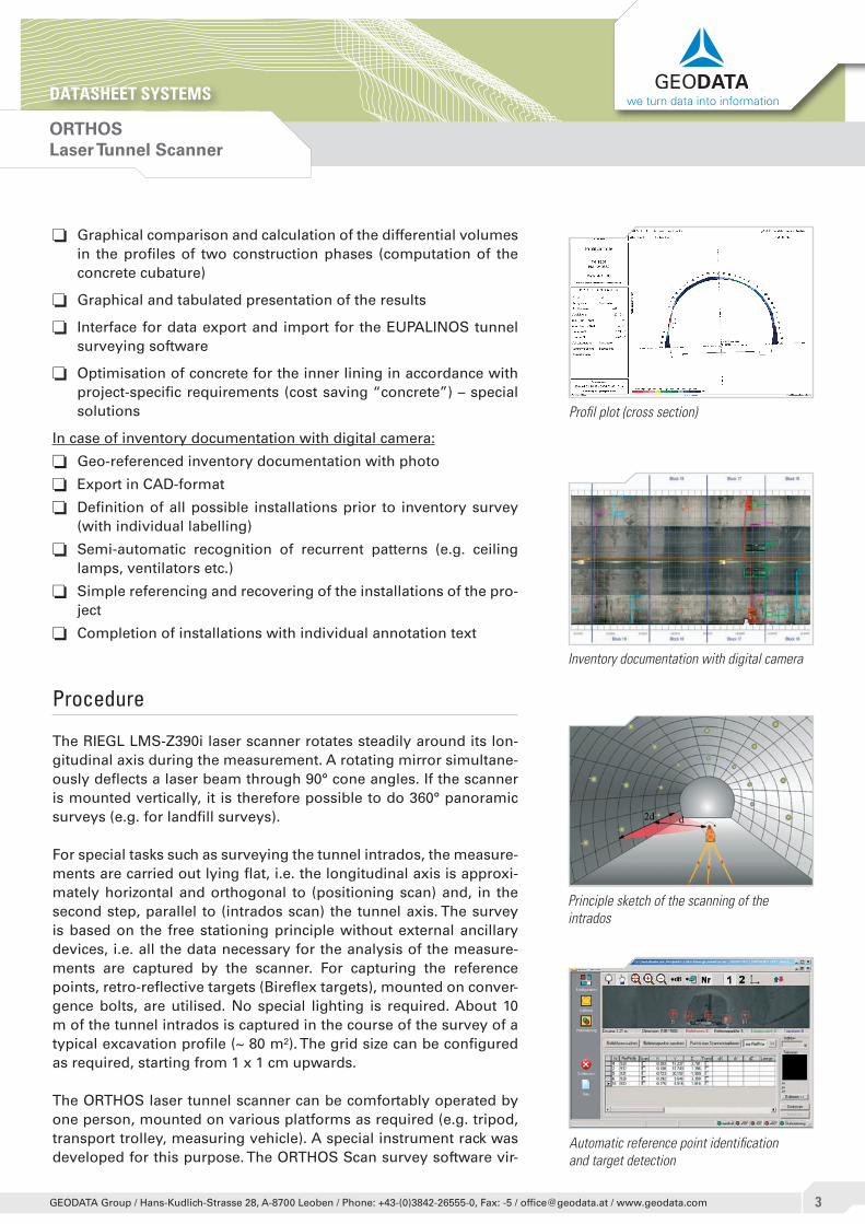
For special tasks such as surveying the tunnel intrados, the measure-ments are carried out lying flat, i.e. the longitudinal axis is approxi-mately horizontal and orthogonal to (positioning scan) and, in the second step, parallel to (intrados scan) the tunnel axis. The survey is based on the free stationing principle without external ancillary devices, i.e. all the data necessary for the analysis of the measure-ments are captured by the scanner. For capturing the reference points, retro-reflective targets (Bireflex targets), mounted on conver-gence bolts, are utilised. No special lighting is required. About 10 m of the tunnel intrados is captured in the course of the survey of a typical excavation profile (~ 80 m²). The grid size can be configured as required, starting from 1 x 1 cm upwards.
The ORTHOS laser tunnel scanner can be comfortably operated by one person, mounted on various platforms as required (e.g. tripod, transport trolley, measuring vehicle). A special instrument rack was developed for this purpose. The ORTHOS Scan survey software vir-
Profil plot (cross section)
Principle sketch of the scanning of the intrados
Automatic reference point identification and target detection
Inventory documentation with digital camera
ORTHOSLaser Tunnel Scanner
DATASHEET SYSTEMS we turn data into information
�GEODATA Group / Hans-Kudlich-Strasse 28, A-8700 Leoben / Phone: +43-(0)3842-26555-0, Fax: -5 / [email protected] / www.geodata.com
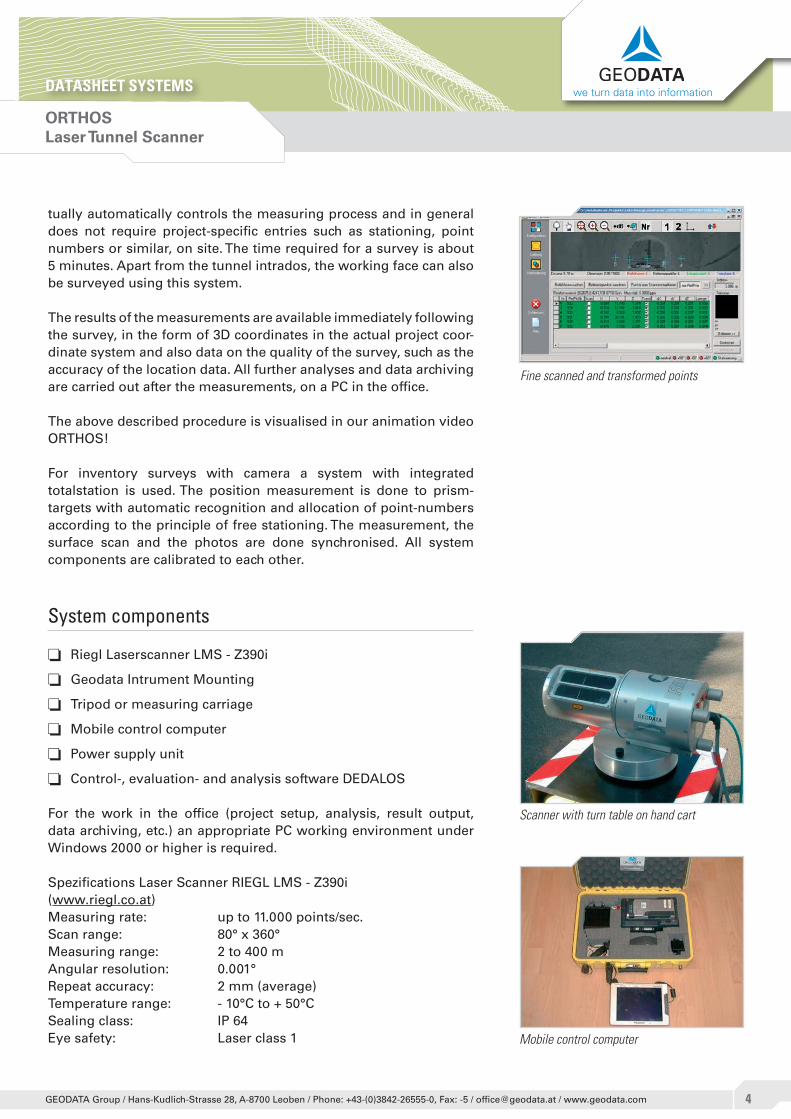
tually automatically controls the measuring process and in general does not require project-specific entries such as stationing, point numbers or similar, on site. The time required for a survey is about 5 minutes. Apart from the tunnel intrados, the working face can also be surveyed using this system.
The results of the measurements are available immediately following the survey, in the form of 3D coordinates in the actual project coor-dinate system and also data on the quality of the survey, such as the accuracy of the location data. All further analyses and data archiving are carried out after the measurements, on a PC in the office.
The above described procedure is visualised in our animation video ORTHOS!
For inventory surveys with camera a system with integrated totalstation is used. The position measurement is done to prism-targets with automatic recognition and allocation of point-numbers according to the principle of free stationing. The measurement, the surface scan and the photos are done synchronised. All system components are calibrated to each other.
System components
o Riegl Laserscanner LMS - Z390i
o Geodata Intrument Mounting
o Tripod or measuring carriage
o Mobile control computer
o Power supply unit
o Control-, evaluation- and analysis software DEDALOS
For the work in the office (project setup, analysis, result output, data archiving, etc.) an appropriate PC working environment under Windows 2000 or higher is required.
Spezifications Laser Scanner RIEGL LMS - Z390i (www.riegl.co.at)Measuring rate: up to 11.000 points/sec.Scan range: 80° x 360°Measuring range: 2 to 400 mAngular resolution: 0.001°Repeat accuracy: 2 mm (average)Temperature range: - 10°C to + 50°CSealing class: IP 64Eye safety: Laser class 1
Scanner with turn table on hand cart
Fine scanned and transformed points
Mobile control computer
ORTHOSLaser Tunnel Scanner
DATASHEET SYSTEMS we turn data into information
�GEODATA Group / Hans-Kudlich-Strasse 28, A-8700 Leoben / Phone: +43-(0)3842-26555-0, Fax: -5 / [email protected] / www.geodata.com
The following other data sheets are associated with this data sheet:
Services: Inventory Surveying Profile checksSoftware: DEDALOS
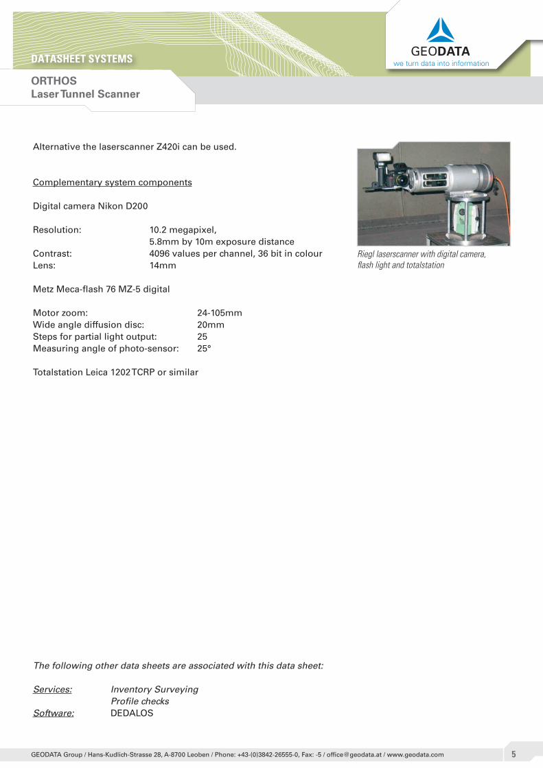
Alternative the laserscanner Z420i can be used.
Complementary system components
Digital camera Nikon D200
Resolution: 10.2 megapixel, 5.8mm by 10m exposure distanceContrast: 4096 values per channel, 36 bit in colourLens: 14mm
Metz Meca-flash 76 MZ-5 digital
Motor zoom: 24-105mmWide angle diffusion disc: 20mmSteps for partial light output: 25Measuring angle of photo-sensor: 25°
Totalstation Leica 1202 TCRP or similar
Riegl laserscanner with digital camera, flash light and totalstation
ORTHOSLaser Tunnel Scanner
DATASHEET SYSTEMS we turn data into information
�GEODATA Group / Hans-Kudlich-Strasse 28, A-8700 Leoben / Phone: +43-(0)3842-26555-0, Fax: -5 / [email protected] / www.geodata.com
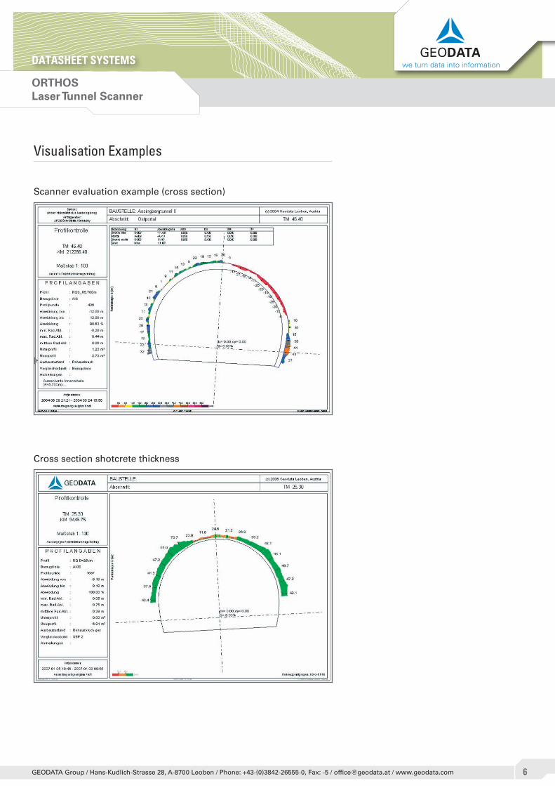
Visualisation Examples
Scanner evaluation example (cross section)
Cross section shotcrete thickness
ORTHOSLaser Tunnel Scanner
DATASHEET SYSTEMS we turn data into information
�GEODATA Group / Hans-Kudlich-Strasse 28, A-8700 Leoben / Phone: +43-(0)3842-26555-0, Fax: -5 / [email protected] / www.geodata.com
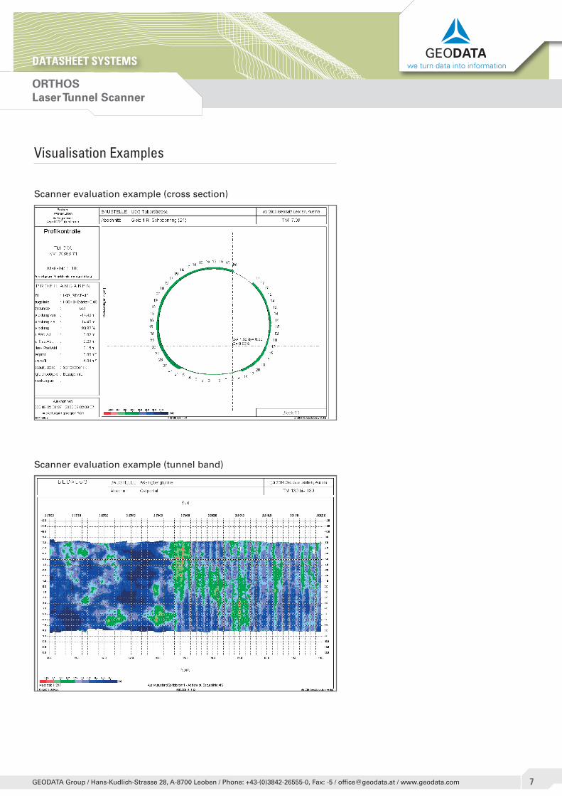
Visualisation Examples
Scanner evaluation example (cross section)
Scanner evaluation example (tunnel band)
ORTHOSLaser Tunnel Scanner
DATASHEET SYSTEMS we turn data into information
�GEODATA Group / Hans-Kudlich-Strasse 28, A-8700 Leoben / Phone: +43-(0)3842-26555-0, Fax: -5 / [email protected] / www.geodata.com
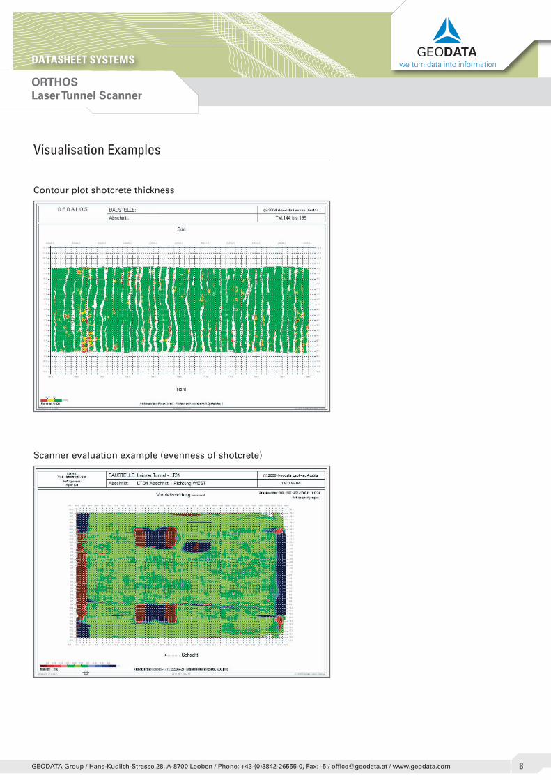
Visualisation Examples
Contour plot shotcrete thickness
Scanner evaluation example (evenness of shotcrete)
ORTHOSLaser Tunnel Scanner
DATASHEET SYSTEMS we turn data into information
�GEODATA Group / Hans-Kudlich-Strasse 28, A-8700 Leoben / Phone: +43-(0)3842-26555-0, Fax: -5 / [email protected] / www.geodata.com
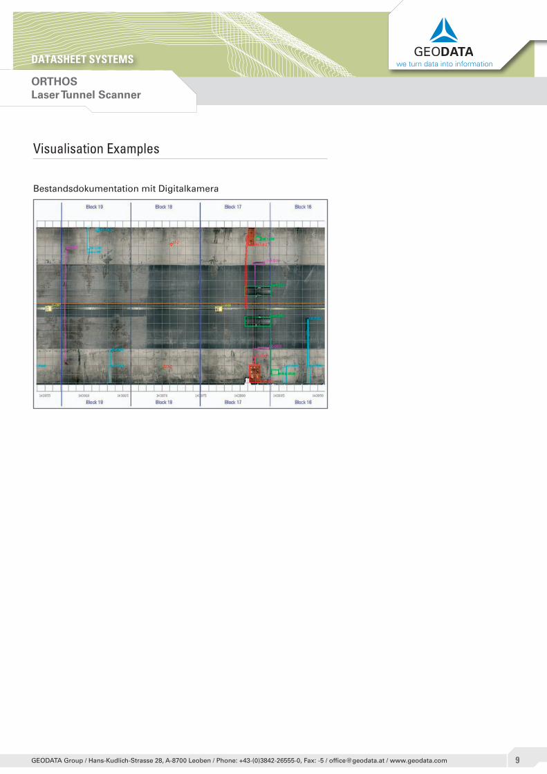
Visualisation Examples
Bestandsdokumentation mit Digitalkamera


![Orthos: A Trustworthy AI Framework For Data Acquisition · 2020. 4. 17. · Orthos: A Trustworthy AI Framework For Data Acquisition Moin Hussain Moti1[0000 0002 4614 6940], Dimitris](https://static.fdocuments.in/doc/165x107/60297e74c0909218fb2841be/orthos-a-trustworthy-ai-framework-for-data-acquisition-2020-4-17-orthos-a.jpg)