^orkin^ Cirotip Water Colutnii rcchnical W orking Group · of ship/ROV time for the survey as...
7
Mhst^isippi Cunvnn 252 Irtcidcitt NR DA Sampling Plan QuanUfyitig the Oistribittmn. Abiindanei- and Riodi\eri>tt) nfBenthie Megufaumi and Mesupclagic/Bathjpelagie MegaptunkUm in the V'icinil^ of the \1C252 Spill Plan Vddcndnm Dccpwaier Bonlhic Connnuniucft Icohtiical \^orkin^ Cirotip Water Colutnii rcchnical W orking Group Final Draft: August 15, 2011 Vppm^ at ot this wolk pbn is tor l I k - iiiirpuM.-;- o I itbtaiiiiiiy ilala tor ihc NjUinit Kcsource Dainaijc AssessniLni liach rt'scncs its nyht in iis msn mdcpcndcnl iiitcrnrclaiioii and .inalysis ot any djia cotlceied pitrsnani to tills work plan APPROVED: r3cp;inmcnl ol ( onimcrcc I'aistcc RcpresL'iitLiliic bale U ^ (f I I lAik- Date Final -* Aug 15 2011 Bemhtc Megafauna and Mesopelagic/Bathypeiagic Megaplanltton Plan Addendum Page i DWH-AR0103400
Transcript of ^orkin^ Cirotip Water Colutnii rcchnical W orking Group · of ship/ROV time for the survey as...
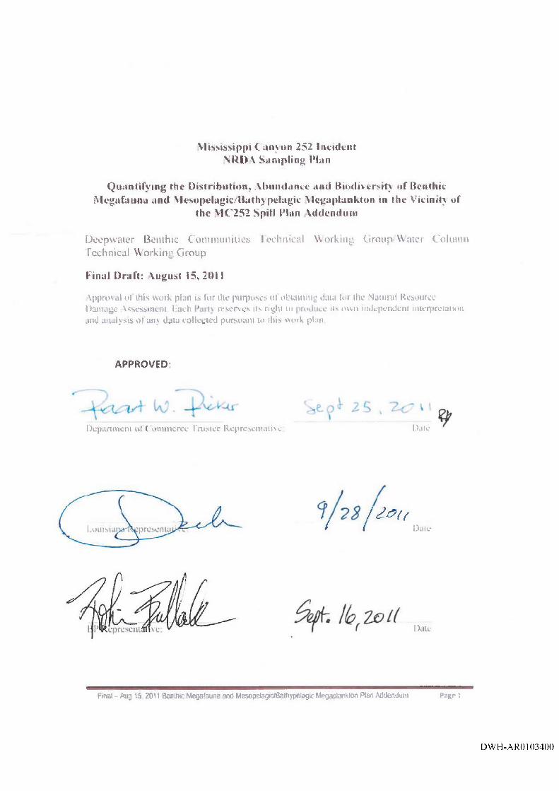
Mhst^isippi Cunvnn 252 Irtcidcitt NR DA Sam pling Plan
QuanUfyitig the Oistribittmn. Abiindanei- and Riodi\eri>tt) n fB enth ie Megufaumi and M esupclagic/Bathjpelagie MegaptunkUm in the V'icinil^ of
the \1C 252 Spill Plan Vddcndnm
D c c p w a i e r Bo n lh i c C o n n n u n i u c f t Ic oht i ic a l \ ^ o r k i n ^ Cirotip W a t e r Colu tn i i r c c h n i c a l W o r k i n g G r o u p
Final Draft: A ugust 15, 2 0 1 1
Vppm^ at o t th i s w o l k p b n is t o r lIk - iiiirpuM.-;-o I i tb ta ii i i i iy i la la t o r ih c N jU in i t K c s o u r c e D a in a i j c A s se s sn iL n i l i a c h r t ' s c n c s its n y h t in iis m s n m d c p c n d c n l i i i tc rn rc la i io i ian d . in a ly s i s o t a n y d j i a c o t l c e i e d p i t r s n a n i to tills w o r k p la n
APPROVED:
r3cp;inmcnl ol ( onim crcc I'aistcc RcpresL'iitLiliic bale
U ^ ( fI I lAik-
Date
Final -* Aug 15 2011 Bemhtc Megafauna and Mesopelagic/Bathypeiagic Megaplanltton Plan Addendum Page i
DWH-AR0103400
Mississippi Canyon 252 Incident NRDA Sampling Plan
Quantifying the Distribution, Abundance and Biodiversity of Benthic Megafauna and Mesopelagic/Bathypelagic Megaplankton in
the Vicinity of the MC252 Spill Plan Addendum
Draft: August 15, 2011
Proposed Cruise Dates: August 10 - 24, 2011
Prepared by: Mark Benfield (LSU), Darcy Metzler, Carly Spahr (Cardno ENTRIX)
Reviewed by: Wayne Kicklighter, Laura Riege (Cardno ENTRIX)
Reviewed by: Trustees: Deborah French McCay (ASA), John Quinlan (NOAA), Christopher Lewis (lEc), Amanda Vincent (LA)
1.0 Bac kg ro und and O bjectives
1.1 Background
From June 8 through June 22, 2011, BP (with Dr. Benfield as Chief Scientist) and the Trustees implemented the cooperative Natural Resource Damage Assessment (NRDA) sampling plan titled ROV Benthic Megafauna and Mesopelagic/Bathypelagic Megaplankton Work Plan (June, 2011), hereinafter referred to as the Plan.
The Plan targeted ten sites (Table 1) with the potential addition of an eleventh site should time permit. These included sites in close proximity (<4 km) of the Macondo Blowout Preventer (BOP) as well as more distant sites. Sites #1-6 were established in August 2010 by BP-sponsored cruises lead by Dr Benfield. Four of these sites (#1-4) were previously surveyed by the Olympic Challenger during August 2010. Two of these four (the sites 2000 meters North and 2000 meters West of the Macondo BOP) were again surveyed by the Development Driller III (DD3)Remotely Operated Vehicle (ROV) in March 2011. One site (MC-252 Well #2) was surv'eyed by the ROVs on the Development Driller II (DD2) at approximately weekly intervals from August to November 2010 and again by the DD3 ROV in March 2011. The final site (approximately 3.3 kilometers north of the BOP) was located in MC208 that had been sampled with a megacorer during the Response and where the BP “Abandonment Autonomous Underwater Vehicle (AUV) Survey” was performed in April 2011. With the exception of the MC208 site, these sites (Table I, Figure 1) were located within a 2000 meter radius of the BOP. In addition, four other more distant sites (with one more should time permit) were proposed. These sites were chosen after consideration of historic sampling and other data collected during the NRDA studies. Selected sites (1-11) are shown in Figure 1 and all are listed in Table 1.
Final - Aug 15, 2011 Benthic Megafauna and Mesopelagic/Bathypelagic Megaplankton Plan Addendum Page 2
DWH-AR0103401
The Plan was based on the assumption that water column surveys would initially take 1 hour per depth because the pilots would have to become familiar with the demands of flying these surveys. Experience working with industrial ROV pilots indicated that it takes several hours of practice to become proficient with these surveys. Therefore, the time estimate for the completion of the first set of water column surveys was 10 hours with fewer hours required to complete each of the additional surveys.
Due to a variety of factors, including equipment issues, weather delays, and time constraints, a total of five of the eleven study sites were sampled. This addendum proposes to visit and sample the remaining six study sites (study sites 4, 7, 8, 9, 10, and 11), as well as re-visit additional study sites as time perm its\ For purposes of identification and clarity, the cruise proposed under this addendum is referred to as “Leg 2” or the “second leg.”
Except as amended herein, all provisions of the Plan remain in effect.
1.2 Objectives
The main objective of this addendum is to initiate Leg 2 of the Plan. Leg 2 will complete the survey based on the Plan’s original survey rationale and criteria. By and large, the original target sampling grid, approach, and methodologies remains unchanged (Table 1, Figure 1).
2.0 Stu d y Plan
The tentative cruise dates for this benthic megafauna and mesopelagic / bathypelagic megaplankton survey are August 9 - 22, 2011.
The sampling design and approach outlined in the Plan (Appendix A) will be maintained during the Leg 2 of this survey. For a full description of the approach and survey methodology, see section 2.2 and Attachment A of the Plan (Appendix A). The approach performed during cruise 2 will include water column and seafloor and surveys. As outlined in the Plan:
■ Water column survey methods will deploy the ROV in the Tethered Management System (TMS) and lower the TMS to an appropriate altitude above the target depth (150 meters if working from the surface);
■ ROV seafloor survey design will consist of 24 x 250 meters long transects flown outwards from the station coordinates at headings separated by 15° flying just above the seafloor;
■ Video will be recorded continuously along each transect; and
■ Fligh-quality, representative still images of every organism that is encountered will be taken.
2.1 Study Sites
The study sites established by the Plan remain unchanged except in the case of site 11 (originally proposed as Red Crab station 6L). Table 1, Figure 1 outline and illustrate the locations of the
' The five sites sampled in the first craise were all sites BP identified. Five of the eight sites to be sampled in the addendum craise are sites identified by the Trustees
Final - Aug 15, 2011 Benthic Megafauna and Mesopelagic/Bathypelagic Megaplankton Plan Addendum Page 3
DWH-AR0103402
(revised) study sites. Table 2 summarizes the rationale for why certain study sites have been selected to be re-visited. Table 2 also outlines the priority in which the study sites will be visited during the cruise 2 as described in this addendum. If time permits, all study sites outlined in Table 2 will be sampled, however the cruise will not be extended if all study sites listed in Table 2 are not completed within the fourteen days allotted for this cruise. It is reasonable to complete 6 to 8 sites in the allotted timeframe barring subsea weather and mechanical failures.
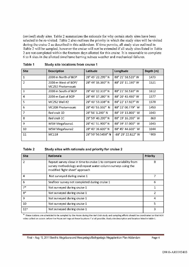
Table 1 Study site locations from cruise 1
Site Description Latitude Longitude D epth(m )
1 2000 m North of BOP 28° 45' 22.295" N 88° 21' 58.520" W 1473
2 2000 m W est of BOP/ MC252 Photom osaic
28° 44' 16.360" N 88° 23' 11.190" W 1521
3 2000 m South of BOP 28° 43' 12.310" N 88° 21 '56 .530" W 1612
4 2000 m East of BOP 28° 44' 17.280" N 88° 20' 43.490" W 1577
5 MC252 Well #2 28° 43 '53 .338" N 88° 22' 17.927" W 1578
6 MC208 Photom osaic 28° 45 '55 .102" N 88° 22 '00 .779" W 1450
7 Red crab ID 28° 56' 1.200" N 88° 19' 13.800" W 1043
8 Red crab 10 28° 59' 40.200" N 88° 19' 16.200" W 860
9 WSW M egafaunal 28° 41 '51 .900" N 88° 39' 37.000" W 1043
10 WSW M egafauna2 28° 43 '36 .600" N 88° 45' 44.600" W 1044
11 MCI 18 28° 50'50 .5458" N -88° 29' 22.822" W -9 0 0
Table 2 Study sites with rationale and priority for cruise 2
Site Rationale Priority
2 Repeat survey close in tim e to cruise 1 to com pare variability from survey m ethodology and repeat w ater column surveys using the m odified 'light sheet' approach
8
4 Not surveyed during cruise 1 7
6 Seafloor survey not com pleted during cruise 1 6
7* Not surveyed during cruise 1 1
8* Not surveyed during cruise 1 2
9 Not surveyed during cruise 1 4
10 Not surveyed during cruise 1 5
11* Not surveyed during cruise 1 3
T h e se s ta tio n s a re sch ed u led to be sam p led by th e Pisces du ring th e Red Crab s tu d y and sam p ling effo rts sh o u ld b e co o rd in a te d so th a t ROV v id eo collection occu rs b e fo re th e P isces s e t tra p s a t th e s e locations if a t all possib le . S tudy s ite d esc rip tio n an d location listed in ta b le 1.
Final - Aug 15, 2011 Benthic Megafauna and Mesopelagic/Bathypelagic Megaplankton Plan Addendum Page 4
DWH-AR0103403
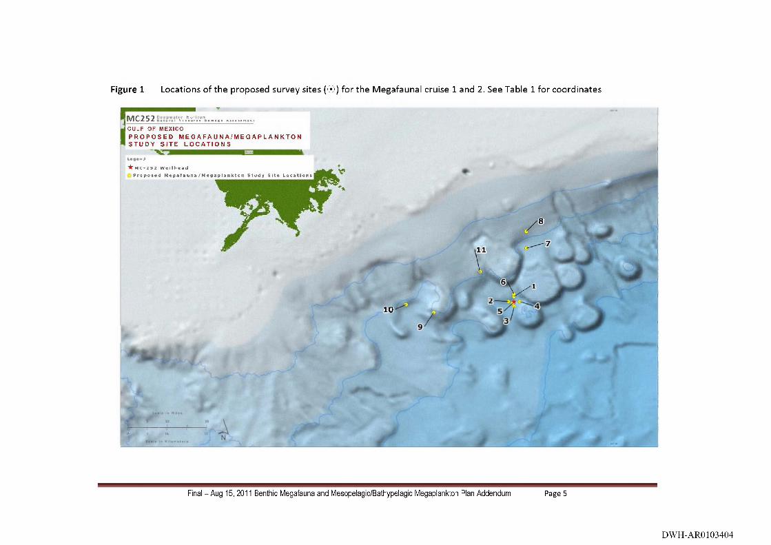
Figure 1 Locations of the proposed survey sites ( ® ) for the Megafaunal cruise 1 and 2. See Table 1 for coordinates
iM C2 s 2 y. .'it','.'?'',,. .............G U L F O F M E X I C O
P R O P O S E D M E G A F A U N A / M E G A P L A N K T O N S T U D Y S I T E L O C A T I O N S
n i)
'^MC’252 WellheadP r o p o s e d M e g e f a u n e / M o g a p l a n k c o n S t u d y S i t e L o c a t i o n s
(% 6 16
10-
f>
\
I .
Final - Aug 15, 2011 Benthic Megafauna and Mesopelagic/Bathypelagic Megaplankton Plan Addendum Page 5
DWH-AR0103404
2.2 Field Methods and Equipment, Record Keeping, and Reporting
All remaining aspects of Leg 2 of this Plan will be conducted as described in the original Plan. These aspects include:
Navigation and survey equipment and field procedures;
Logs and records keeping;
Digital and shipboard data chain-of-custody;
Post cruise analysis and reporting;
Health and safety procedures and ship-to-shore communications.
3.0 Schedule and B udget
3.1 SCHEDULE
The Leg 2 of the Plan is currently proposed for 14 days in August 2011. Because the sampling effort is now divided into two Cruise legs, a single survey report that includes the metadata describing the sampling efforts conducted during both survey legs will be completed within four weeks of the completion of Leg 2 by the Chief Scientist. This descriptive report will be followed by a more comprehensive analysis of the data, pending approval of a cooperative analysis Plan.
3.2 BUDGET
The costs summarized below are associated with the collection of the ROV data during this project. National Oceanic and Atmospheric Administration’s (NOAA) costs are in Budget Chart #1. Costs for vessel charter and ROV time as well as Louisiana State University (LSU) labor and equipment costs are included in Budget Chart #2. The project will require approximately 14 days of ship/ROV time for the survey as provided in Budget Chart #2.
The field survey costs, miscellaneous costs, and travel costs indicated in Budget Chart # 1 below shall be reimbursed by BP America upon receipt of written invoices submitted by the Trustees. The Vessel Costs and LSU labor and equipment costs indicated in Budget Chart # 2 shall he paid directly by BP America.
Costs are based on use of the M/V HOS Sweetwater pending availability through the Vessel Coordination Committee. Costs are representative of vessels in the NRDA Fleet. Mobilization and demobilization of the M/V HOS Sweetwater (or similar vessel) will be conducted by Continental Shelf Associates, Inc. (CSA), at the Bordelon Yard in Houma, Louisiana. Vessel costs are inclusive of CSA personnel. Cardno ENTRIX will provide scientists and data managers for surveys (Cardno ENTRIX costs provided separately). Costs of CSA mobilization, participation in the surveys and reporting are included below.
The Parties acknowledge that this budget is an estimate, and that actual costs may prove to be higher. BP’s commitment to fund the costs of this work includes any additional reasonable costs
Final - Aug 15, 2011 Benthic Megafauna and Mesopelagic/Bathypelagic Megaplankton Plan Addendum Page 6
DWH-AR0103405

within the approved scope of this work plan that may arise. The Trustees will make a good faith effort to notify BP in advance of any such increased costs.
Budget Chart #1 Trustee Labor
Field Survey Costs Hrs/Days/TripsDay/Hr
Rate Total
NOAA Labor (days):
2 NOAA scientists 15 X 2 $1,500 $45,000
2 NOAA Data Managers 15 X 2 $1,500 $45,000
Travel 4 $10,000 $10,000
TOTAL $100,000
Days/Trips based on 15 potential cruising days. Labor is estimated cost and honrs.
Budget Chart #2
Cruise Cost Table Total
LSU Personnel, supplies and equipment $261,959
Mobilization Costs $283,500
Vessel Costs $3,626,478
Fleet Mgmt / Shore Support $420,000
Total Estimated Cruise Cost $4,591,937
Total Costs: $4,691,937
Final - Aug 15, 2011 Benthic Megafauna and Mesopelagic/Bathypelagic Megaplankton Plan Addendum Page 7
DWH-AR0103406