Origins of the Kuroshio and Mindanao · PDF fileOrigins of the Kuroshio and Mindanao currents...
12
1 Origins of the Kuroshio and Mindanao currents Background The boundary currents off the east coast of the Philippines are of critical importance to the general circulation of the Pacific Ocean. The westward flowing North Equatorial Current (NEC) runs into the Philippine coast and bifurcates into the northward Kuroshio and the southward Mindanao Current (MC) (Figure 1; Nitani, 1972). The partitioning of the flow into the Kuroshio and MC is an important observable. Quantifying these flows and understanding bifurcation dynamics are essential to improving predictions of regional circulation, and to characterizing property transports that ultimately affect Pacific climate. Fluctuations in the Kuroshio and MC can significantly impact variability downstream. For example, the Kuroshio penetrates through Luzon Strait into the South China Sea and onto the East China Sea shelf. The Kuroshio front dramatically alters stratification and may impact internal wave climate. The study proposed here incorporates observation, theory, and modeling to make fundamental advances in our knowledge of the origins of the Kuroshio and Mindanao currents. Figure 1. Region of study. The major currents of the region are identified: the North Equatorial Current (NEC), the Kuroshio, and the Mindanao Current (MC).
Transcript of Origins of the Kuroshio and Mindanao · PDF fileOrigins of the Kuroshio and Mindanao currents...

1
Origins of the Kuroshio and Mindanao currents
Background
The boundary currents off the east coast of the Philippines are of critical importance to
the general circulation of the Pacific Ocean. The westward flowing North Equatorial Current
(NEC) runs into the Philippine coast and bifurcates into the northward Kuroshio and the
southward Mindanao Current (MC) (Figure 1; Nitani, 1972). The partitioning of the flow into the
Kuroshio and MC is an important observable. Quantifying these flows and understanding
bifurcation dynamics are essential to improving predictions of regional circulation, and to
characterizing property transports that ultimately affect Pacific climate. Fluctuations in the
Kuroshio and MC can significantly impact variability downstream. For example, the Kuroshio
penetrates through Luzon Strait into the South China Sea and onto the East China Sea shelf. The
Kuroshio front dramatically alters stratification and may impact internal wave climate. The study
proposed here incorporates observation, theory, and modeling to make fundamental advances in
our knowledge of the origins of the Kuroshio and Mindanao currents.
Figure 1. Region of study. The major currents of the region are identified: the North
Equatorial Current (NEC), the Kuroshio, and the Mindanao Current (MC).

2
Figure 2. Tracks of drifters color-coded by instantaneous (6 hourly) speed.

3
Drifter observations of currents at 15 m depth form a comprehensive dataset of direct
observations . According to these observations (Figure 2), the roots of the Mindanao Current can
be located at approximately 11° N, 1.5° south of the latitude at which the mean NEC takes a
southward and a northward bend (Centurioni et al., 2004) while approaching the Philippine
Archipelago. The Kuroshio however, appears to become a stable, detectable boundary current
(with speeds in excess of 0.8 m s-1
) between 16°N and 18°N. Although the drifter data are too
sparse to allow a definitive picture of the annual cycle in the region, the available data suggest
that the two-dimensional circulation pattern north of 11° N changes seasonally. A region of
complex and highly variable near surface flow exists off the western (Philippines) boundary and
north of the roots of the Mindanao Current, i.e. between 12°N and 16-18°N. Regions
characterized by intermittently high speeds (Figure 2) extend eastward and away from the
region’s western boundary from 24°N to 18°N and between12°N and 9°N. Those are also the
regions of relatively large, seasonally variable , Eddy Kinetic Energy (EKE), while lower EKE is
generally found between those two latitude bands.
North Equatorial Current and Bifurcation
The bifurcation of the NEC has been the subject of a number of studies, as its position
varies seasonally and with depth (Kim et al., 2004: Qu and Lukas, 2003: Yaremchuk and Qu,
2004). The location of the bifurcation also depends on the data and models used in its definition.
General statements are difficult to make, but the following description is supported by the weight
of the published material. In the annual average, the bifurcation trends north with depth, with the
surface expression near 14°N sloping to 17°N near 500 m. The bifurcation is at its northernmost
position in the fall and at its southernmost position in spring, with an annual excursion of about
2° in latitude.
The mechanisms governing the excursions of the bifurcation and the strengths of the
currents are topics of active research. Local wind forcing through the wind stress curl, and
remote forcing through Rossby waves are both possibly important (Qiu and Lukas, 1996).
Interannual changes may have some relationship to ENSO, shifting northward during El Niño
years and southward during La Niña years. The interplay of local and remote forcing, and the
rich array of time scales make this region an interesting site for study.
Kuroshio
The Kuroshio forms in the NEC bifurcation region (12° - 18°N), though energetic
mesoscale eddy variability often obscures the current in region east of the Philippine
Archipelago. Data availability limits understanding of Kuroshio formation, with the upstream
Kuroshio having received far less attention than the regions to the northeast. Although
observations reveal an increasingly distinct Kuroshio northward toward Luzon Strait, the
formation mechanism remains unclear. Should the upstream Kuroshio be considered as an eddy-
driven current or as a laminar boundary flow, and from where does it draw its source waters?
The Kuroshio typically flows northward with a slight westward incursion through the
deep channels (2400 m sill depth) of Luzon Strait, but occasionally turns westward to form
significant intrusions into the South China Sea. These intrusions modify Kuroshio structure
through entrainment of South China Sea waters and impact mesoscale and internal wave

4
variability within the South China Sea. The region experiences intense, seasonally reversing
wind forcing by the Asian Monsoon, with strong wintertime winds from the northeast, weaker
summertime winds from the southwest and relatively calm intermonsoon periods. Although
observational evidence remains scarce, Kuroshio loop current events appear more common
during the winter monsoon (Wang and Chern, 1987). Competing theories attempt to explain the
dynamics governing these intrusions, the simplest invoking westward Ekman transport produced
by the winter monsoon to drive the Kuroshio through the Strait (Farris and Wimbush, 1996).
Weak (strong) wintertime (summertime) density contrasts across the Kuroshio-South China Sea
front may accelerate (retard) westward translation of the front (Chern and Wang, 1998).
Numerical investigations suggest that strong meridional windstress curl gradients across Luzon
Strait may generate sharp contrasts in thermocline depth and enhance Kuroshio penetration
(Metzger and Hurlburt, 2001), but find little direct correlation between winds and loop current
formation. Sheremet (2001) finds that inertia carries western boundary currents across gaps for
strong flows, but at slower speeds effect dominates, driving a westward turn. These dynamics
exhibit several characteristics consistent with observed loop current formation, including
preferential wintertime formation (when monsoon winds may weaken the Kuroshio) and lack of
direct correlation with local winds, possibly the result of response hysteresis. Both observations
and theoretical results feature energetic meandering and mesoscale eddy generation.
Though mesoscale variability complicates quantification of Kuroshio transports south of
Luzon Strait, Gilson and Roemmich (2002) employ an eight-year record of repeated XBT
surveys to characterize transports off the southern end of Taiwan, after interactions with the
South China Sea but prior to passage over the Ilan Ridge. Annual mean volume transport was
22±1.5 Sv with 8±6 Sv seasonal variation, with the strongest currents confined close to the
Taiwan coast, in the upper 700 m of the water column. Kuroshio transport is strongest in
winter/spring and weakest in autumn, in phase with NEC seasonal variations. Kuroshio transport
exhibits 12±6 Sv interannual variability, well in excess of its seasonal range. The Kuroshio often
exhibits a dual-core structure east of Taiwan (Chern and Wang, 1998), collapsing to a single
current prior to passing over Ilan Ridge. Analysis of historical hydrographic measurements
suggests that this two-core structure is a consistent feature of the Kuroshio offshore of Taiwan
(Lien, personal communication).
After leaving the Luzon Strait region, the Kuroshio flows along the east coast of Taiwan,
eventually encountering the Ilan Ridge where it can enter the East China Sea though the East
Taiwan Channel or turn northeastward along the east side of the Ryukyu Islands. East of Taiwan,
the Kuroshio exhibits annual mean transport of roughly 20 Sv with large 10 Sv variations at
timescales of days to months (Johns et al., 2001). The mean transport profile is significantly
sheared in the upper 500 m, with 40% (60%) of the transport occurring in the upper 100 (200) m.
Meanders induced by anticyclonic eddies impinging from the Philippine Sea drive strong
transport variability at ~100 day timescales (Zhang et al., 2001). During strong transport periods,
the Kuroshio passes through the East Taiwan Channel and enters the East China Sea, impacting
circulation and internal wave variability within the marginal sea. Zhang et al. (2001) associate
low transport periods with impinging eddies that steer the current toward the eastern side of the
Ryukyu Islands. Mesoscale-induced transport variability exceeds seasonal fluctuations (Johns et
al., 2001), and eddy interactions may thus exert a controlling influence on the Kuroshio’s
interactions with the East China Sea.

5
Mindanao Current
The MC has not been as well observed as has the Kuroshio. The most extensive series of
observations took place during 1987-1990 as part of two efforts: the Western Equatorial Pacific
Ocean Circulation Study (WEPOCS) and a joint United States/People’s Republic of China
Tropical Ocean Global Atmosphere (TOGA) program. Hydrographic and Acoustic Doppler
Current Profiler (ADCP) measurements were made in a series of 8 cruises. These observations
were synthesized by Wijffels et al. (1995), which found a remarkably steady MC. While the core
of the MC was stable, the flows offshore of the MC were extremely variable. For example,
recirculation indicative of the Mindanao Eddy was found in only 2 of the 8 cruises, and the
northward flowing Mindanao Undercurrent (Hu et al., 1991: Qu et al., 1998) was not apparent in
the mean. The possibility remains that the Mindanao Eddy is strongly modulated on seasonal or
shorter time scales (Toole et al., 1990).
A single mooring observation of the MC was made over the period from 1999-2002 by
Kashino et al. (2005). They reported that the existence of a strong shallow surface current with a
speed of over 1.3 m/s at 100 m, with a remarkably low variability of less than 0.2 m/s. The
velocity was highest during boreal summer, and the strength was apparently modulated by the
onset of the 2002 El Nino. However, the mooring observations left open several unanswered
questions. As with previous hydrographic observations, there was no evidence found of a
northward flowing Mindanao Undercurrent. Furthermore, the deep western boundary current that
should exist there in theory was left unobserved.
Predictability
The ocean processes over the shelf and slope water off the Philippines and Taiwan are
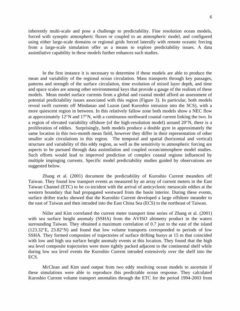
Figure 3. Currents from two ocean models: the Navy Coastal Ocean Model (NCOM) and the
Hybrid Coordinate Ocean Model (HYCOM).
6
inherently multi-scale and pose a challenge to predictability. Fine resolution ocean models,
forced with synoptic atmospheric fluxes or coupled to an atmospheric model, and configured
using either large-scale domains or regional grids forced laterally with remote oceanic forcing
from a large-scale simulation offer us a means to explore predictability issues. A data
assimilative capability in these models further enhances such studies.
In the first instance it is necessary to determine if these models are able to produce the
mean and variability of the regional ocean circulation. Mass transports through key passages,
patterns and strength of the surface circulation, time evolution of mixed layer depth, and time
and space scales are among other environmental keys that provide a gauge of the realism of these
models. Mean model surface currents from a global and coastal model afford an assessment of
potential predictability issues associated with this region (Figure 3). In particular, both models
reveal swift currents off Mindanao and Luzon (and Kuroshio intrusion into the SCS), with a
more quiescent region in between. In this relatively fallow zone both models show a NEC flow
at approximately 12N and 17N, with a continuous northward coastal current linking the two. In
a region of elevated variability offshore (of the high-resolution model) around 20N, there is a
proliferation of eddies. Surprisingly, both models produce a double gyre in approximately the
same location in this two-month mean field, however they differ in their representation of other
smaller scale circulations in this region. The temporal and spatial (horizontal and vertical)
structure and variability of this eddy region, as well as the sensitivity to atmospheric forcing are
aspects to be pursued through data assimilation and coupled ocean/atmosphere model studies.
Such efforts would lead to improved prediction of complex coastal regions influenced by
multiple impinging currents. Specific model predictability studies guided by observations are
suggested below.
Zhang et al. (2001) document the predictability of Kuroshio Current meanders off
Taiwan. They found low transport events as measured by an array of current meters in the East
Taiwan Channel (ETC) to be co-incident with the arrival of anticyclonic mesoscale eddies at the
western boundary that had propagated westward from the basin interior. During these events,
surface drifter tracks showed that the Kuroshio Current developed a large offshore meander to
the east of Taiwan and then intruded into the East China Sea (ECS) to the northeast of Taiwan.
Niiler and Kim correlated the current meter transport time series of Zhang et al. (2001)
with sea surface height anomaly (SSHA) from the AVISO altimetry product in the waters
surrounding Taiwan. They obtained a maximum correlation of 0.7 just to the east of the island
(123.32E, 23.82N) and found that low volume transports corresponded to periods of low
SSHA. They formed composites of trajectories of surface drifting buoys at 15 m that coincided
with low and high sea surface height anomaly events at this location. They found that the high
sea level composite trajectories were more tightly packed adjacent to the continental shelf while
during low sea level events the Kuroshio Current intruded extensively over the shelf into the
ECS.
McClean and Kim used output from two eddy resolving ocean models to ascertain if
these simulations were able to reproduce this predictable ocean response. They calculated
Kuroshio Current volume transport anomalies through the ETC for the period 1994-2003 from

7
the global 0.1 Parallel Ocean Program (POP) forced with synoptic atmospheric fluxes. They
released numerical drifters to the east of Taiwan during selected low and high transport anomaly
events during that period. The outcome was that during the low transport event the Kuroshio
Current meandered offshore of Taiwan and then intruded into the ECS while during the high
transport event the drifter trajectories closely followed the continental shelf. The intrusions into
the ECS however occurred further to the north than is observed. Consequently, they repeated the
numerical drifter exercise using the global 1/12 Hybrid Coordinate Ocean Model/ Navy
Coupled Ocean Data Assimilation (HYCOM/NCODA) output. During low sea level events the
Kuroshio Current meandered offshore and then intruded further into the ECS and its intrusion
location is closer to that observed. Predictability of the variability of the paths and strengths of
the Kuroshio and Mindanao Currents can likewise be examined offshore of the Philippines.
Science Questions
The region where the NEC terminates and the Mindanao Current and Kuroshio originate
along the low-latitude North Pacific western boundary is where time-varying oceanic signals
generated in the eastern interior Pacific, or locally in the Philippine Basin, ultimately accumulate.
The incoming, time-varying signals are either forced by the time-varying surface wind stress
forcing, or are a result of intrinsic instability of ocean circulation.
Existing observational evidence from satellite altimeter, repeat hydrography, and high-
resolution XBT/XCTD measurements reveals that the NEC bifurcation region of 12N~18N
corresponds to a dynamic transition zone: in the lower latitude domain (i.e, the southern half of
the NEC), the observed oceanic variability has predominantly annual-to-interannual timescales
and some of these signals can be understood and hindcast by wind-driven linear vorticity
dynamics. Oceanic variability does increase in amplitude again along the NECC band existing
further to the south.
In the northern NEC latitudes, the observed oceanic signals are dominated by
intraseasonal mesoscale eddy variations. The source of the eddy variability is likely the
baroclinic instability of the vertically-sheared NEC and STCC (Subtropical Countercurrent)
system (Qiu, 1999: Roemmich and Gilson, 2001). As a consequence of the enhanced mesoscale
eddy variability, the formation of the upstream Kuroshio is much less well-defined than that of
the upstream Mindanao Current. Indeed, a relevant theoretical framework is needed that allows
us to understand how the upstream Kuroshio forms and to predict the regional circulation
variability in the NEC bifurcation region. These issues suggest the following scientific questions
for focusing the proposed research program:
1. Rather than an inertial laminar WBC, should we consider the upstream Kuroshio as an
eddy-driven, turbulent, confluence flow?
2. Do the incoming eddies interact to drive the time-mean boundary currents or to affect
regional water mass properties?
3. Why is the MC apparently much more steady that the Kuroshio at similar distance from
the bifurcation region?
4. Does the Luzon Strait opening impact Kuroshio structure either downstream or upstream.
5. How is potential vorticity conserved from the NEC, through the bifurcation region, and
8
upon establishment of the Kuroshio and MC.
6. What is the fate of the incoming eddies and anomalies: Do they transmit southward in
form of Kelvin waves, or northward via mean flow advection, or westward into the SCS
through the Luzon Strait?
Given a programmatic goal of applying new understanding of the NEC-MC-Kuroshio
system to improve predictability, two additional questions provide integrative metrics of success:
7. Given observations of oceanic forcing to the east in the form of the NEC and westward
propagating eddies, can numerical models predict fluxes in the MC and Kuroshio?
8. Can the program’s results suggest a design for an observational and predictive system?
Implementation
The objectives of this program include quantifying flows and water properties, improving
understanding of the dynamics of a bifurcation region, and establishing predictability of the three
major currents in the region. The observational approach will have two major thrusts: (1)
quantifying the fluxes of mass, heat, and salt in the NEC, Kuroshio, and MC, and (2) establishing
Lagrangian patterns of flow. To quantify the seasonal cycle and to obtain an initial measure of
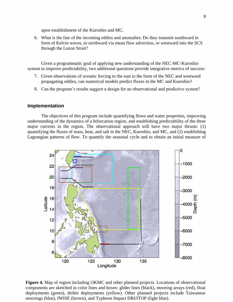
Figure 4. Map of region including OKMC and other planned projects. Locations of observational
components are sketched in color lines and boxes: glider lines (black), mooring arrays (red), float
deployments (green), drifter deployments (yellow). Other planned projects include Taiwanese
moorings (blue), IWISE (brown), and Typhoon Impact DRI/ITOP (light blue).

9
interannual variability, these observations will be sustained over a three-year period. The
bifurcation region is an interesting target, but the stagnation point of a turbulent flow is not an
easy quantity to observe. The sustained observations will provide a test for models of the
regions, and at the same time will be available for assimilation in models.
The proposed observing system employs a suite of complementary platforms to meet the
challenges posed by this vast, highly variable study area. Guided by previous studies and by
directed analysis of historical data, long-endurance autonomous gliders will be tasked to collect
repeat occupations of key sections across the NEC, MC and Kuroshio. Because previous
observational programs show that the Kuroshio sometimes reaches nearly to the coast, where
glider operations can be difficult and risky, small arrays of moored instruments will augment
glider sections to resolve the nearshore regions. Drifters and floats will be used to illuminate the
pathways by which the NEC ultimately forms the Kuroshio and MC. Numerical efforts will aid
interpretation and explore the predictive capabilities of regional models.
Historical data analysis (Niiler, Centurioni, Lee)
Analysis of historical data will pave the way for the observational program. The
combination of satellite sea surface height and drifter data yields a comprehensive surface
topography. Subsurface observations include data available from NODC and Taiwan. Analysis
completed during the first year will guide observations to follow.
Figure 5. Salinity (shading) and potential density (contours, 0.25 kg/m3 interval) sections
crossing the Kuroshio through the Luzon Strait. The shallow salinity maximum includes water of
southern origin. The western limit of the maximum marks the edge of the Kuroshio. The salinity
minimum near 500 dbar is reminiscent of North Pacific Intermediate Water. The patchy structure
in this minimum is indicative of stirring by mesoscale eddies.

10
Gliders (Rudnick, Lee)
Fluxes will be quantified using gliders at strategic locations (Figure 4). These locations
are chosen because the currents are well established, and to define the eastern boundary
conditions of the NEC. Locations along the western boundary are in the MC at about 8°N, at the
northern tip of Luzon where the Kuroshio enters the Luzon Strait, at the southern tip of Taiwan
where the Kuroshio exits the South China Sea, and off the east coast of Taiwan where the
Kuroshio is well established. A glider line at 135°E defines the eastern boundary of the study
region. Gliders will cycle from the surface to 1000 m, and will measure velocity, temperature,
salinity, and optical water properties. Some recent glider sections show that autonomous
observation of the Kuroshio is practical (Figure 5).
Moorings (Sanford, Lien, Jayne)
Moorings will complement gliders at some lines, with an emphasis on shallower regions
with strong velocities. The Kuroshio off of Taiwan is expected to be covered by moorings set by
Taiwanese scientists. The first priority for US moorings is the southern Luzon Strait. The next
priority is a line near 8°N across the Mindanao Current. If resources are available, a line in the
Ilan strait would complete the moored observations. Moorings will measure velocity,
temperature, and salinity, and may include Pressure Inverted Echo Sounders (PIES).
Drifters (Centurioni, Niiler)
The Lagrangian component of the experiment will focus on identifying the pathways and
patterns of flow from the NEC to the fully formed Kuroshio and MC. Drifters drogued at 15 m
will be released in a broad region spanning the bifurcation region from the coast of the
Philippines to 135°E. The best deployment option is from ships, especially considering the
research vessel activity in the area. If an adequate deployment plan from ship is not possible, air
deployments are possible.
Floats (Sanford, Lien, Qiu, Rudnick)
Profiling floats will be deployed in a band just west of 135°E. The floats, profiling from
the surface to 500-1000 m, will provide displacements at depth and hydrographic measurements
along their paths. As with drifters, ship deployments are the preferred mode, but air is possible.
The floats and drifters, combined with satellite altimetry will allow a comprehensive description
of circulation in the area.
Modeling (McClean, Cornuelle)
The combination of observations will prove a fertile test bed for studying the value and
limitations of regional numerical models. Predictability experiments may involve using or
withholding data from assimilating models, and comparing metrics such as fluxes and the
partitioning of flow into the Kuroshio and MC. Patterns of variability from Lagrangian
measurements are another target for prediction. CCSM (fine resolution), HYCOM (1/12 degree)
results are available for analysis.

11
Linkages
Taiwanese investigators have proposed a 3-year Kuroshio study with focus on the region
between Ludao Island off the west coast of Taiwan and Ilan Ridge. The study area may be
extended to south of Ludao if resources become available. Three mooring arrays are planned
extending west, north, and east from Ludao. Each array will have ~5 subsurface ADCP
moorings. One land-based radar on Ludao will monitor surface waves. Shipboard ADCP survey
is also proposed. A zonal mooring array south of Ilan ridge, ~24 oN, may be implemented in
2010-2011, depending on the funding support. The West and North mooring arrays will be
deployed in 2009, and the East mooring array in 2010. The potential Taiwanese mooring lines
are colored in blue in Figure 4.
ONR-sponsored programs planned for the region in the same time frame include the
Internal Wave in Straits Experiment (IWISE), the ONR Typhoon Impacts DRI and the
Taiwanese Integrated Typhoon-Ocean Program (ITOP). The observations proposed here will
provide a large scale context to IWISE and the two typhoon programs. Intense typhoon systems
exert significant impact on the ocean variability in the Western Pacific. The combined data sets
could be exploited to understand the impacts of typhoon forcing on NEC-MC-KC evolution.
References
Centurioni, L. R., P. P. Niiler, and D. K. Lee, 2004: Observations of inflow of Philippine Sea
surface water into the South China Sea through the Luzon Strait. J. Phys. Oceanogr., 34, 113-
121.
Chern, C. S. and J. Wang, 1998: The spreading of South China Sea water to the east of Taiwan
during summertime. Acta Oceanographica Taiwanica, 32, 97-109.
Farris, A. and M. Wimbush, 1996: Wind-induced Kuroshio intrusion into the South China Sea. J.
Oceanogr., 52, 771-784.
Gilson, J. and D. Roemmich, 2002: Mean and temporal variability in Kuroshio geostrophic
transport south of Taiwan (1993-2001). J. Oceanogr., 58, 183-195.
Hu, D. X., M. C. Cui, T. D. Qu, and Y. X. Li, 1991: A subsurface northward current off
Mindanao identified by dynamic calculation. Oceanography of Asian Marginal Seas, K. Takano,
Ed., 359-365.
Johns, W. E., T. N. Lee, D. X. Zhang, R. Zantopp, C. T. Liu, and Y. Yang, 2001: The Kuroshio
east of Taiwan: Moored transport observations from the WOCE PCM-1 array. J. Phys.
Oceanogr., 31, 1031-1053.
Kashino, Y., A. Ishida, and Y. Kuroda, 2005: Variability of the Mindanao Current: Mooring
observation results. Geophys. Res. Lett., 32, -.

12
Kim, Y. Y., T. D. Qu, T. Jensen, T. Miyama, H. Mitsudera, H. W. Kang, and A. Ishida, 2004:
Seasonal and interannual variations of the North Equatorial Current bifurcation in a high-
resolution OGCM. Journal of Geophysical Research-Oceans, 109, -.
Metzger, E. J. and H. E. Hurlburt, 2001: The nondeterministic nature of Kuroshio penetration
and eddy shedding in the South China Sea. J. Phys. Oceanogr., 31, 1712-1732.
Nitani, H., 1972: Beginning of the Kuroshio. Kuroshio: Its Physical Aspects, H. Stommel and K.
Yoshida, Eds., University of Tokyo Press, 129-163.
Qiu, B., 1999: Seasonal eddy field modulation of the North Pacific subtropical countercurrent:
TOPEX/Poseidon observations and theory. J. Phys. Oceanogr., 29, 2471-2486.
Qiu, B. and R. Lukas, 1996: Seasonal and interannual variability of the North Equatorial Current,
the Mindanao Current, and the Kuroshio along the Pacific western boundary. Journal of
Geophysical Research-Oceans, 101, 12315-12330.
Qu, T., H. Mitsudera, and T. Yamagata, 1998: On the western boundary current in the Philippine
Sea. J. Geophys. Res., 103, 7537-7548.
Qu, T. D. and R. Lukas, 2003: The bifurcation of the North Equatorial Current in the Pacific. J.
Phys. Oceanogr., 33, 5-18.
Roemmich, D. and J. Gilson, 2001: Eddy transport of heat and thermocline waters in the North
Pacific: A key to interannual/decadal climate variability? J. Phys. Oceanogr., 31, 675-687.
Sheremet, V. A., 2001: Hysteresis of a western boundary current leaping across a gap. J. Phys.
Oceanogr., 31, 1247-1259.
Toole, J. M., R. C. Millard, Z. Wang, and S. Pu, 1990: Observations of the Pacific North
Equatorial Current Bifurcation at the Philippine Coast. J. Phys. Oceanogr., 20, 307-318.
Wang, J. and C. S. Chern, 1987: Warm core eddy in the northern South China Sea, Pt. 2, Simple
mechanism for the establishment and development of the warm core eddy. Acta Oceanographica
Taiwanica, 18, 104-113.
Wijffels, S., E. Firing, and J. Toole, 1995: The Mean Structure and Variability of the Mindanao
Current at 8-Degrees-N. Journal of Geophysical Research-Oceans, 100, 18421-18435.
Yaremchuk, M. and T. D. Qu, 2004: Seasonal variability of the large-scale currents near the
coast of the Philippines. J. Phys. Oceanogr., 34, 844-855.
Zhang, D. X., T. N. Lee, W. E. Johns, C. T. Liu, and R. Zantopp, 2001: The Kuroshio east of
Taiwan: Modes of variability and relationship to interior ocean mesoscale eddies. J. Phys.
Oceanogr., 31, 1054-1074.