ORIGINATING DEPT. APPROVAL 1Zf - Granicus
52
REQUEST FOR COUNCIL ACTION October 5, 2015 DATE AGENDA ITEM ORIGINATING DEPT. AGENDA ITEM CITY ADMINISTRATOR APPROVAL Community Development 1Zf_ The Village at Arbor Lakes PUD Concept Stage Plan PREVIOUS ACTIONS: At their meeting of Monday, August 17, the City Council tabled this item to have a traffic study done. At their meeting of Monday, August 10,2015, the Planning Commission recommended that the City Council direct the City Attorney to draft a Resolution approving the PUD Concept Stage Plan for The Village at Arbor Lakes, subject to: 1. The remaining pertinent recommendations contained in the memorandums from the Superintendent of Parks and Planning; Assistant City Engineer; Transportation Operations Engineer and Deputy Fire Chief dated July 1, July 2, August 10, and July 24,2015, respectively. 2. Engineering review and approval of the proposed intersection shown on Hemlock Lane North between Elm Creek Boulevard and Arbor Lakes Parkway. We note that at this time we do not recommend approval of this full movement access and any approval of this plan does not imply approval of this full movement access. 3. Access off Hemlock Lane will require an analysis of the free right from Elm Creek Boulevard and Hemlock Lane. Past analysis has recommended that this be reconfigured to remove the free right. 4. The extension of Fountains Drive shall be a public street. 5. Any future comments from Hennepin County regarding the accesses proposed that may impact current and future county roads. 6. Engineer review and approval of the tum-around shown on the right-inlright-out on Hemlock Lane, north of Arbor Lakes Parkway that accesses the residential area on the north side of the development. 7. Development Stage Plans shall conform to fire access standards. 8. Any Development Stage Plan with less parking than required by code shall demonstrate to the City's satisfaction as to why less parking will not create a parking shortage. 9. Development Stage Plans for Lots 2 & 3, Block 1 shall show a more robust pedestrian corridor should be shown between the hotel and the coffee shop when development stage plans are submitted to help create the pedestrian connection between the central spine and the coffee shop. 1 0. Development Stage Plans for lots 7-11, Block 1 shall show an additional sidewalk along the south side of the E/W road to better facilitate pedestrian movement through the area. 11. The applicant shall work to fill the proposed retail building on Lot 6 with uses or a use that demonstrates strong synergy with the adjacent uses, especially the residential to the north. 12. A full traffic study based on the approved concept plan shall be submitted with the first subsequent Development Stage plan. This may require modifications to the conceptual tum lane and ROW configurations. 13. A greenspace calculation shall be submitted to determine if any changes are necessary in the storm ponding that the site will use. g:\cases\20 IS\the village at arbor lakes\staff reports\caf\the village at arbor lakes pud concept IO-OS-IS.docx 6A
Transcript of ORIGINATING DEPT. APPROVAL 1Zf - Granicus

REQUEST FOR COUNCIL ACTION October 5, 2015
DATE AGENDA ITEM
ORIGINATING DEPT. AGENDA ITEM CITY ADMINISTRATOR APPROVAL
Community Development
1Zf_ The Village at Arbor Lakes PUD Concept Stage Plan
PREVIOUS ACTIONS:
At their meeting of Monday, August 17, the City Council tabled this item to have a traffic study done.
At their meeting of Monday, August 10,2015, the Planning Commission recommended that the City Council direct the City Attorney to draft a Resolution approving the PUD Concept Stage Plan for The Village at Arbor Lakes, subject to:
1. The remaining pertinent recommendations contained in the memorandums from the Superintendent of Parks and Planning; Assistant City Engineer; Transportation Operations Engineer and Deputy Fire Chief dated July 1, July 2, August 10, and July 24,2015, respectively.
2. Engineering review and approval of the proposed intersection shown on Hemlock Lane North between Elm Creek Boulevard and Arbor Lakes Parkway. We note that at this time we do not recommend approval of this full movement access and any approval of this plan does not imply approval of this full movement access.
3. Access off Hemlock Lane will require an analysis of the free right from Elm Creek Boulevard and Hemlock Lane. Past analysis has recommended that this be reconfigured to remove the free right.
4. The extension of Fountains Drive shall be a public street. 5. Any future comments from Hennepin County regarding the accesses proposed that may impact
current and future county roads. 6. Engineer review and approval of the tum-around shown on the right-inlright-out on Hemlock
Lane, north of Arbor Lakes Parkway that accesses the residential area on the north side of the development.
7. Development Stage Plans shall conform to fire access standards. 8. Any Development Stage Plan with less parking than required by code shall demonstrate to the
City's satisfaction as to why less parking will not create a parking shortage. 9. Development Stage Plans for Lots 2 & 3, Block 1 shall show a more robust pedestrian corridor
should be shown between the hotel and the coffee shop when development stage plans are submitted to help create the pedestrian connection between the central spine and the coffee shop.
1 0. Development Stage Plans for lots 7-11, Block 1 shall show an additional sidewalk along the south side of the E/W road to better facilitate pedestrian movement through the area.
11. The applicant shall work to fill the proposed retail building on Lot 6 with uses or a use that demonstrates strong synergy with the adjacent uses, especially the residential to the north.
12. A full traffic study based on the approved concept plan shall be submitted with the first subsequent Development Stage plan. This may require modifications to the conceptual tum lane and ROW configurations.
13. A greenspace calculation shall be submitted to determine if any changes are necessary in the storm ponding that the site will use.
g:\cases\20 IS\the village at arbor lakes\staff reports\caf\the village at arbor lakes pud concept IO-OS-IS.docx
6A

The Village at Arbor Lakes PUD Concept Stage Plan Request for Council Action October 5,2015 Page 2
14. Residential to North shall have a maximum unit count of 700 and buildings of 4 story or more.
The applicant shall acknowledge that Park Dedication requirements are based on staff review and recommendation to the Park and Recreation Board and their subsequent Board Action. Board meetings are held on the third Thursday of each month.
Application Received: June 12, 2015 60 Day Review Deadline: August 11, 2015 Additional 60 Day Review Deadline: October 10, 2015 Extension by Applicant: October 20,2015 Location: Elm Creek Blvd/Hemlock Lane
RECOMMENDED COUNCIL ACTION:
If the City Council finds that the proposal is in conformance with the goals and objectives of the Gravel Mining Area Special Area Plan and that the findings of the traffic study are acceptable, staff suggests a:
Motion to direct the City Attorney to draft a Resolution approving the PUD Concept Stage Plan for The Village at Arbor Lakes, subject to:
1. The remaining pertinent recommendations contained in the memorandums and/or emails from: a. The Superintendent of Parks and Planning dated July 1,2015 b. Assistant City Engineer dated July 2, 2015 and September 30, 2015 c. Transportation Operations Engineer, dated August 10, 2015 d. Deputy Fire Chief dated July 24,2015 e. Hennepin County Transportation Planner August 12,2015
2. Engineering review and approval of the proposed intersection shown on Hemlock Lane North between Elm Creek Boulevard and Arbor Lakes Parkway. We note that at this time we do not recommend approval of this full movement access and any approval of this plan does not imply approval of this full movement access.
3. Access off Hemlock Lane will require an analysis of the free right from Elm Creek Boulevard and Hemlock Lane. Past analysis has recommended that this be reconfigured to remove the free right.
4. The extension of Fountains Drive shall be a public street. 5. Any further comments from Hennepin County regarding the accesses proposed that may
impact current and future county roads. 6. Engineer review and approval of the tum-around shown on the right-inlright-out on Hemlock
Lane, north of Arbor Lakes Parkway that accesses the residential area on the north side of the development.
7. Development Stage Plans shall conform to fire access standards. 8. Any Development Stage Plan with less parking than required by code shall demonstrate to the
City's satisfaction as to why less parking will not create a parking shortage. 9. Development Stage Plans for Lots 2 & 3, Block 1 shall show a more robust pedestrian corridor
should be shown between the hotel and the coffee shop when development stage plans are
g:\cases\20 IS\the village at arbor lakes\staff reports\caf\the village at arbor lakes pud concept 10-05-15 .docx

The Village at Arbor Lakes PUD Concept Stage Plan Request for Council Action October 5,2015 Page 3
submitted to help create the pedestrian connection between the central spine and the coffee shop.
10. Development Stage Plans for lots 7-11, Block 1 shall show an additional sidewalk along the south side of the E/W road to better facilitate pedestrian movement through the area.
11. The applicant shall work to fill the proposed retail building on Lot 6 with uses or a use that demonstrates strong synergy with the adjacent uses, especially the residential to the north.
12. Any Development Stage Plans shall conform to the appropriate recommendations in the Traffic Study by SRF Consulting dated September 30, 2015.
13. A greenspace calculation shall be submitted to determine if any changes are necessary in the storm ponding that the site will use.
14. Residential to North shall have a maximum unit count of 700 and buildings of 4 story or more.
The applicant shall acknowledge that Park Dedication requirements are based on staff review and recommendation to the Park and Recreation Board and their subsequent Board Action. Board meetings are held on the third Thursday of each month.
(Simple majority vote for passage)
COMMENTS:
At its meeting of August 17,2015, the City Council tabled the application for a Planned Unit Development - Concept Stage Plan for property located at Elm Creek Boulevard and Hemlock Lane to allow time to conduct a traffic study.
The traffic study is now complete and attached for the City Council's review. In addition an updated memo from the Assistant City Engineer is also attached for your review. In summary, the traffic study notes the following:
1. Based on the proposed development, the traffic study estimates 7,616 new trips on the roadway network. This is significantly less than the initial estimate of over 14,000 trips that appeared in our initial report. This is due to the traffic study being able to more accurately estimate the number of shared trips and pass by trips. This also is very similar to the estimate in the AUAR of 7332 trips.
2. The study also estimates 723 p.m. peak hour trips (again with estimated reductions built in) which is less than the 838 peak hour trips estimated in the AUAR.
3. In general all intersections can operate at an acceptable level of service once this project is fully built out with the exception of the proposed full movement intersection on Hemlock between Elm Creek Boulevard and Arbor Lakes Parkway.
4. For the proposed full movement intersection (which the traffic study identifies as Hemlock Lane/Office Driveway), significant delays would be expected (over three minutes per vehicle) for left turns out of either side. These types of delays will create backups into the site. The most concerning aspect of this is that drivers experiencing such long delays will become inpatient and force their way into traffic on Hemlock creating exceptionally dangerous situations on this high volume, high speed road. In addition, it would greatly impact the existing left tum movements
g:\cases\201 S\the village at arbor lakes\staffreports\caf\the village at arbor lakes pud concept IO-OS-IS.docx

The Village at Arbor Lakes PUD Concept Stage Plan Request for Council Action October 5,2015 Page 4
from the Medical Office Building across the street as these would also experience over three minute delays and this is the only option for northbound movement (at this time) out of the Medical Office Building. Even with a % intersection (right-in, right-out, left-in) the Medical Office Building would have over three minute delays per vehicle significantly negatively impacting that site.
5. The report also recommends that the right-out movement be eliminated as it creates potential conflicts at Arbor Lakes Parkway and Hemlock with drivers wishing to make a U-turn. If a right-out movement is allowed it recommends that either a "no U-turn" or "no-tum on red" sign be installed for eastbound Arbor Lakes Parkway drivers at Hemlock to avoid right turning cars colliding with U-turning vehicles.
6. To summarize the report recommends that the left tum movements into and out ofthe site be removed and that the Hemlock Lane/Office Driveway intersection should become a right-in only (for this site) along with removing the free right from Elm Creek Blvd to Hemlock Lane.
7. While not completely tied to this proposal, the report does recommend that by 2030, an alternative access be developed for the Medical Office Building (likely north to Arbor Lakes Parkway) and that the current full movement access be changed to a right-in only.
8. The report recommends that at least 350 feet ofleft turning bay be provided at Arbor Lakes Parkway and Hemlock Lane intersection (for turning southbound onto Hemlock) and staff sees inadequate room to do this in one turning bay. Staff recommends that adequate ROW be provided to have two left turning bays to accommodate this movement.
9. Lastly, the report recommends a number of items relating to the internal traffic movement in the site. These are best dealt with at the Development Stage and we have modified condition # 12 to reflect this.
COMMENTS FROM PREVIOUS REPORT:
The applicant is requesting PUD Concept Stage Plan approval for a mixed-use development at the northeast comer of Hemlock Lane and Elm Creek Blvd. The proposal calls for apartments, hotels, restaurants, a grocery store, pharmacy, a variety of small retail and the potential for medical office, office, and/or senior units.
The Gravel Mining Area Special Area Plan (GMA Plan) guides this property as High Density Residential on the north side and Regional Mixed Use-Non Retail Focus on the south side. A Neighborhood Commercial Node is also shown at the intersection of Hemlock Lane North and Arbor Lakes Parkway. An extension of Arbor Lakes Parkway is anticipated in the GMA Plan to bisect the property.
Applicant's Proposal
General Design Discussion:
Staff notes that the loose leaf plan should be used for this review rather than the plans inside the booklet provided by the applicant.
g:\cases\20 I 5\the village at arbor lakes\staff reports\caf\the village at arbor lakes pud concept 10-05- I 5.docx

The Village at Arbor Lakes PUD Concept Stage Plan Request for Council Action October 5, 2015 Page 5
The applicant is proposing High Density Residential on the north side of the development, a mix of uses with some retail, but a fairly low percentage (19.7%) on the south side and an extension or Arbor Lakes Parkway between the two parts.
A roundabout on Arbor Lakes Parkway provides access to a central north and south spine that serves the two parts of the project. Arbor Lakes Parkway is shown to be constructed up to the roundabout with ROW dedicated for a future extension when development occurs to the east. Decorative arbors are shown around the roundabout.
A private drive that extends from a proposed full movement intersection at Hemlock Lane North and travels across the site before linking up with the intersection of Fountains Drive and Elm Creek Boulevard provides additional access to the south portion. Private drives with additional right-inlright out accesses provide traffic circulation in the interiors of the two portions.
A right-in only is proposed along Elm Creek Boulevard to provide further access into the southern portion of the site.
Hennepin County Transportation Planning Staff has responded with an email which has been added to the report for Council review.
We will discuss more specifics with the numbers below but in general they appear to be in conformance with the GMA Plan.
The comer of Elm Creek Boulevard and Hemlock Lane shows a decorative monument that will complement the other three comers.
Staff Comments: 1. In general the plan appears to be consistent with the GMA Plan for the High Density
Residential, Regional Mixed Use-Non Retail Focus and the Neighborhood Commercial Node. 2. Specifics on necessary tum lanes and ROW width will come as part of a full traffic study that
can come at a later date. It is likely that Arbor Lakes Parkway east of the roundabout will need more ROW.
3. The general plan of extending Arbor Lakes Parkway to the roundabout with any Development Stage is acceptable with a future extension occurring at a later date when development to the east occurs.
4. Staff has strong concerns about a full movement intersection on Hemlock Lane between Arbor Lakes Parkway and Elm Creek Boulevard. A full movement, uncontrolled intersection would not meet access spacing standards, and staffs initial analysis is that this would create a very unsafe intersection with little benefit to the area. At this point we do not recommend approval of a full movement intersection at this location and note that any approval of this plan does not imply approval of a full movement intersection at this location. We also note that Hennepin County has preliminarily responded that they also would not support a full movement intersection at this location but would be open to a right-inlright-out.
5. Engineering staff will review the proposed private drive extending north from the intersection of Fountains Drive and Elm Creek Boulevard and if this is acceptable or if it should be a public
g:lcases\20ISlthe village at arbor lakeslstaffreportslcat\the village at arbor lakes pud concept IO-OS-IS.docx

The Village at Arbor Lakes PUD Concept Stage Plan Request for Council Action October 5, 2015 Page 6
ROW. Regardless of its final status, access to the parcel to the east must be provided from this roadway. We note that the Planning Commission has recommended that this be a public road.
6. Any further comments from Hennepin County will need to be taken into account.
North Side Proposal and Discussion: The applicant is proposing between 650-700 apartment units on the 17.8 acres on the north side of the development. The Concept Plan shows 5 apartment buildings and a central two-story clubhouse at the center of the site.
A notable feature is that the applicant is proposing that this be a gated community, with a staffed guard house at the main entrance. An additional gated entrance is proposed at a right-in/right-out off of Hemlock Lane.
The applicant's narrative states that they intend the apartments to be luxury apartments and that the proposed 25,000-30,000 s.f. clubhouse would have a number of amenities associated with it.
Traffic circulation would be provided by a private road network with green spaces and small surface parking lots near the buildings. Each building would also have underground parking.
Staff Comments: 1. The proposed high density housing is generally in conformance with the GMA Plan however
we note the max density is 33 units per acre which would calculate to a max of 587 units. The proposed density is 36.5 to 39.3 units per acre. The GMA Plan does allow for densities to go higher than 33 units per acre if the City determines that the project has extraordinary design, attributes, and/or amenities. The Planning Commission ultimately recommended to support the higher density, with a maximum of 700 units on the north side, so long as the buildings were at least four stories in height.
2. There are currently no gated communities in the city and so it would be good to discuss this at a general level. We do note that all of the proposed roads are private in this area so no public streets would be impacted by the gated community.
3. The placement of buildings along Hemlock Lane creates a nice match for the taller residential buildings on the other side of the street and creates a gateway effect along this road.
4. The buildings along Arbor Lakes Parkway and the main entrance have a very good urban form. 5. The buildings on the east side will be in close proximity to active gravel mining for an
indeterminate time and the applicant may wish to move these away from the eastern boundary. 6. The clubhouse will serve as an excellent terminus of view along the central spine. 7. The fence along Hemlock may prevent fire trucks from using Hemlock as a fire access road. A
separate fire access road around the buildings may be necessary. 8. The fence along the back side of the units may also prevent fire trucks from using the proposed
pedestrian trail/fire access road. 9. Any turn-arounds and curves would need to meet fire access standards. 10. We note that the proposed parking is under what code requires. While this can be dealt with
further at the Development Stage, staff recommends that ifthe applicant does come forward with plans showing less parking than required by code, they should demonstrate to the City why this will work and not create a parking shortage.
g:\cases\20 lS\the village at arbor lakes\staff reports\caf\the village at arbor lakes pud concept 10-0S-lS.docx

The Village at Arbor Lakes PUD Concept Stage Plan Request for Council Action October 5, 2015 Page 7
For this review, the main items staff sees as discussion items are the proposed density (1) and the general idea of a gated community (2). These should be specifically addressed in the discussion and direction given as part of any recommendation to the City Council. Items 3-6 are simply commentary and items 7 -10 can be dealt with at the Development Stage and can be noted as a condition of approval to be incorporated into the Development Stage.
South Side Proposal and Discussion: The applicant is proposing a mix of commercial uses on the south side of the development including two hotels, two restaurants, a small grocery store, a pharmacy, a coffee shop, a bank, a retail building and one mixed use building with an undermined use. The proposal shows a very strong urban form along a central spine. The north portion of this spine is a private roadway. The southern portion is shown as a large plaza area with restaurants on the north end of it. A private east/west road extends off of Hemlock Lane on the west before turning south towards the intersection of Fountains Drive and Elm Creek Boulevard. The central spine and E/W road create four quadrants that we will discuss below.
Regarding the mix of retail and non-retail, by square footage and percentage staff calculates the following
Use S.F. % of total Retail (Grocery, Pharmacy, 53,000 19.7% Restaurants, Coffee, Mixed Retail Building) Non Retail (Hotels, Bank, 215,600 80.3% Office/Medical Office/Hotel/Senior)
NW Quadrant: The applicant is showing a four-story, 108 room hotel along the central spine that will provide a great urban feel to this area and a desirable verticality to the development. In addition, a 14,000 s.f. grocery store is shown at the comer of Arbor Lakes Parkway and Hemlock Lane, and a coffee shop is shown with a surrounding drive-through.
Access comes from both a right-in/right-out off of Arbor Lakes Parkway and from the main E/W drive.
SW Quadrant: The applicant is showing a 13,000 s.f. pharmacy at the comer of Elm Creek Blvd and Hemlock Lane N, a 3,200 s.f. bank situated along the E/W drive and a 6,500 s.f. restaurant along the central spine.
Access comes from the main E/W drive into the parking areas.
SE Quadrant: The applicant is showing an additional 6,500 s.f. restaurant on the central spine and an 11,000 s.f. retail building along an extension of Fountains Drive that would mimic the form of the retail buildings to the south in The Fountains at Arbor Lakes. A drive-through is shown on the north side of this building.
g:\casesI20 IS\the village at arbor lakes\staff reports\caf\the village at arbor lakes pud concept 10-05-15 .docx

The Village at Arbor Lakes PUD Concept Stage Plan Request for Council Action October 5,2015 Page 8
Access comes from the main E/W drive into the parking areas as well as from a right-in off of Elm Creek Boulevard.
NE Quadrant: Along the central spine, the applicant is four-story, 98 room hotel and a 71,600 s.fbuilding (17,900 s.f. footprint) on the east side, adjacent to the storm pond, of an undetermined use. The plan labels this eastern building as hotel, office, medical office, senior housing. Staff will discuss this further below
Access comes from the main E/W drive into the parking areas. A trail is shown on the east side between the eastern building and the adjoining storm water pond that will provide pedestrian access through the area.
Staff Comments: 1. In general the applicant is showing great urban form, especially along the central spine. We
think that the tall buildings on the north end and the restaurants on the southern portion will create an enticing pedestrian realm and will create a true sense of place in that this will be a unique environment for people to work, stay, shop, eat and live. The strong central spine ties together with the north side to create a unified, although distinct, development.
2. Along with the great central feature, each comer is also framed by a building so there is an urban design element both internally and externally. This helps block the view of the necessary, but not always visually appealing, parking lots.
3. Non-retail uses are the dominant use by square footage and the retail uses that are proposed (and identified) work very well with the internal and adjoining uses. We have some further comments on each of the quadrants below.
4. NW Quadrant: a. We appreciate the strong urban form created by the four-story hotel along the central
spine and the excellent pedestrian corridor this will create. b. The small grocery store is a type of retail that works exceptionally well with the
adjoining uses. Every person living in the residential area proposed on the north side of this development will need to shop for groceries and having a neighborhood scale store in such close proximity will allow easy pedestrian and vehicular access. The small size and location on the comer fits in well with urban design form that was missing from previous proposals for this site. We feel this is consistent with the types and form of retail envisioned in the Neighborhood Commercial Node shown in the GMA Plan.
c. The coffee shop is another use that works well with the adjoining uses. It is somewhat removed from these adjacent uses but there appears to be an opportunity to make a strong pedestrian connection between the use and the central spine. We recognize the desire, and likely market need, for a drive-thru which creates some of the separation. Staff recommends that a more robust pedestrian corridor should be shown between the hotel and the coffee shop when development stage plans are submitted to help create the pedestrian connection between the central spine and the coffee shop.
d. As noted above, any access from Hemlock Lane will require Engineering review and approval and staff s initial reaction to a full movement intersection is one of great concern.
5. SW Quadrant: g:\cases\20 15\the village at arbor lakesxstaff reports\caf\the village at arbor lakes pud concept 10-05-15 .docx

The Village at Arbor Lakes PUD Concept Stage Plan Request for Council Action October 5, 2015 Page 9
a. The continuation of the central spine with a restaurant and pedestrian plaza will help create a very dynamic and exciting environment here. The restaurants have excellent synergy with the hotels and adjacent residential. Their proximity to both the hotels and the residential to the north invites a great deal of non-vehicular travel which will help create a lively environment here.
b. The pharmacy is a type of retail that works well with the adjoining uses, especially the residential to the north. Pharmacies act as a comer store with a variety of daily goods available besides medicines. It is a bit removed from the residential uses but with some additional sidewalks along the south side of the E/W street, there will still be good pedestrian connections along with good vehicular access. We note that there will be a drive-thru, but it is tucked away on the side and that the building is shown on the comer, creating a presence at this key intersection.
c. As alluded to above, we recommend that an additional sidewalk be built along the south side of the E/W road to better facilitate pedestrian movement through the area.
d. The bank is a non-retail use that does have some possible synergy with the adjacent residential.
6. SE Quadrant: a. As with above, the restaurant and plaza helps create a great urban space in this area. b. The proposed 11,000 retail building has a nice urban form, extending the form of the
buildings along Fountains Drive to the south. Depending on the end uses that lease in this building, there could be additional synergy with the adjacent residential. We do note that the Trip Generation Analysis shows a fast food restaurant with a drive-through which may not be the most ideal use at this site, though this doesn't necessarily mean that it will ultimately be a fast food use.
c. As with the SW Quadrant, staff recommends that an additional sidewalk be constructed on the south side of the E/W road.
7. NE Quadrant a. As with the hotel across the street, the four-story hotel helps create a great urban form
and feel to the northern part of this mixed use area. b. The building shown on Lot 5 is speculative as far as use goes but does show a further
commitment to a non-retail use as well as multiple stories. If it were to develop as an office or medical office building, there would likely be a need for some type of structured parking which the applicant has acknowledged.
c. Regarding the proposed uses listed for the building shown on Lot 5, all could potentially work with the senior housing being a slightly more unusual use at this site. With that said, high density housing is listed as a possibility in the GMA Plan for the Regional Mixed Use Non-Retail Focus area and ifthere is a market for it, it could add additional vitality to this area.
g:\casesI20 l5\the village at arbor lakes\staff reports\caf\the village at arbor lakes pud concept 1O-05-15.docx

The Village at Arbor Lakes PUD Concept Stage Plan Request for Council Action October 5, 2015 Page 10
Trip Generation and Discussion: The applicant and staff have compiled a basic trip generation analysis which is attached for the Planning Commission's review. The AUAR for this area estimated trips based on 300,000 s.f. of office and 510 apartments. In summary:
Gross Trips Per Day AM Peak PM Peak Applicant's Proposal 14,437 1,267 1,299 AUAR Total 7,332 836 838
Staff notes a few main items with this: 1. There are no reductions for pass-by trips, diverted trips and internal trips. These are trips that
go into and out of the site but don't actually increase traffic on adjacent streets. A use such as a coffee shop would expect to have a significant amount of pass-by trips (trips already on the adjacent streets), diverted trips (trips near-by on the system that go here instead of somewhere else (increasing traffic on adjacent streets but decreasing it elsewhere), and internal trips (trips from the hotels or office/med office/senior buildings.)
2. Trip generation science is only beginning to look at pedestrian or bicycle trips which could also be a decent amount in this location with the good synergy between the various uses.
3. Staff recently reviewed the total trip generation in the AUAR, both existing and proposed, and found that we are currently estimating 25,000 fewer trips per day than what was initially anticipated, so there is room to add additional trips. For the peak hour we are currently estimating 1,300 fewer trips than what was initially anticipated.
4. A full traffic analysis will need to be completed to determine the specifics of lane needs in the project and on the public roads proposed, but staff feels that there is enough room to accommodate the proposed traffic. At this time we feel that the road system will continue to operate as expected.
g:lcases\20I Slthe village at arbor lakeslstaffreportslcaf\the village at arbor lakes pud concept IO-OS-IS.docx

The Village at Arbor Lakes PUD Concept Stage Plan Request for Council Action October 5,2015 Page 11
STAFF SUMMARY:
Overall, staff anticipates a very dynamic, exciting, and unique environment in the City of Maple Grove with this proposal. There is a strong urban form, a commitment to multiple multi-story buildings, and the proposal appears to us to meet the requirements and guidelines of the Gravel Mining Area Special Area Plan.
At this point the three main issues of concern are the type of access off of Hemlock Lane North between Elm Creek Boulevard and Arbor Lakes Parkway, the nature of the road extending north from the Fountains Drive and Elm Creek Boulevard intersections, and the maximum density for the residential portion of the project.
Staff does have a few recommended conditions for some minor items and we feel most or all of these can be dealt with at the Development Stage level.
Authored by: Peter Vickerman I Dick Edwards
g:\cases\20l5\the village at arbor lakes\staffreports\caf\the village at arbor lakes pud concept IO-OS-IS.docx

Consulting Group, Inc.
ENGINEERS PLANNERS o ESIGNERS Memorandum
SRF No. 0159012
From:
Jupe Hale, Assistant City Engineer City of Maple Grove
Matt Pacyna, PE, Senior Associate Tom Sachi, EIT, Engineer
September 30, 2015
Village at Arbor Lakes Traffic Study
To:
Date:
Subject:
I ntrod uction
SRF has completed a traffic study for the proposed Village at Arbor Lakes mixed-use development located in the northeast quadrant of the Hemlock Lane/Elm Creek Boulevard intersection in Maple Grove, MN (see Figure 1: Project Location). The main objectives of this study are to review existing operations within the study area, evaluate development traffic impacts to the adjacent roadway network, including the proposed access and circulation, and recommend any necessary improvements to accommodate the proposed developments. This study will also include a long-term view (i.e. year 2030) of the area to ensure the proposed roadway network can accommodate additional area development. The following information provides the assumptions, analysis, and recommendations offered for consideration.
Existing Conditions
The existing conditions were reviewed to establish a baseline in order to identify any future impacts associated with the proposed development. The evaluation of existing conditions includes turning movement, field observations, and an intersection capacity analysis.
Data Collection
Peak hour turning movement counts were provided by Alliant Engineering Inc., which were collected as part of an area signal re-timing project in year 2014 at the following study intersections:
a) Hemlock Lane and Arbor Lakes Parkway b) Hemlock Lane and Elm Creek Boulevard c) Elm Creek Boulevard and Fountains Drive
Supplemental p.m. peak hour 1 5-minute pulse counts were collected by SRF at private driveways along Hemlock Lane within the study area to understand general travels patterns and the order of magnitude of the driveway volumes. It should be noted that additional intersections within the study area were provided by Alliant and included as part of the analysis. However, these intersections are not significantly impacted by the proposed development and are not shown within this document.
ONE CARLSON PARKWAY, SUITE 150 I MINNEAPOLIS, MN 55447 I 763.475.0010 I WWW.SRFCONSULTING.COM

Project Lo~tion
Project Location Figure 1
0059012 September 2015
Village at Arbor Lakes Traffic Study City of Maple Grove, MN
Consulting Group, Inc.

Jupe Hale City of Maple Grove
September 30, 2015 Village at Arbor Lakes Traffic Study
In addition to the intersection turning movement counts and average daily traffic volumes (provided by the Minnesota Department of Transportation), observations were completed to identify roadway characteristics within the study area (i.e. roadway geometry, posted speed limits, and traffic controls). Both Elm Creek Boulevard and Hemlock Lane are primarily four-lane divided roadways immediately adjacent to the proposed development. The posted speed limit along these roadways is 45 miles per hour, except for Elm Creek Boulevard east of Hemlock Lane, which has a 50 mph posted speed limit. Arbor Lakes Parkway is a two lane roadway with turn lanes and a 35 mph posted speed limit. The three primary study intersections are all signalized, while the existing office development access to Hemlock Lane has side-street stop control. Existing geometries, traffic controls, and volumes in the study area are shown in Figure 2.
Intersection Capacity Analysis
An existing intersection capacity analysis was completed for the p.m. peak hour to establish a baseline condition to which future traffic operations can be compared. It should be noted that only the p.m. peak hour was reviewed since the proposed development is expected to primarily impact p.m. peak hour operations due to the type of land uses proposed.
The study intersections were analyzed using Synchro/SimTraffic (V8). Capacity analysis results identify a Level of Service (LOS), which indicates the quality of traffic flow through an intersection. Intersections are given a ranking from LOS A through LOS F. The LOS results are based on average delay per vehicle, which correspond to the delay threshold values shown in Table 1. LOS A indicates the best traffic operation, with vehicles experiencing minimal delays. LOS F indicates an intersection where demand exceeds capacity, or a breakdown of traffic flow. Overall intersection LOS A through LOS D is generally considered acceptable in the Twin Cities Metro Area.
Table 1 Level of Service Criteria for Signalized and Unsignalized Intersections
LOS Designation Signalized Intersection Unsignalized Intersection Average DelayjVehicle (seconds) Average DelayjVehicle (seconds)
A :0; 10 :0;10
B > 10 - 20 > 10 -15
C > 20 - 35 > 15 - 25
D > 35 - 55 > 25 - 35
E > 55 - 80 > 35 - 50
F > 80 > 50
For side-street stop controlled intersections, special emphasis is given to providing an estimate for the level of service of the side-street approach. Traffic operations at an un signalized intersection with side-street stop control can be described in two ways. First, consideration is given to the overall intersection level of service. This takes into account the total number of vehicles entering the intersection and the capability of the intersection to support these volumes.
Page 3

xx IX,xxxl
P.M. Peak Hour Volume Estimated Average Daily Traffic (ADT) Volume Side-Street Stop Control Traffic Signal Control
Existing Conditions Figure 2 Village at Arbor Lakes Traffic Study City of Maple Grove, MN
Consulting Group, Inc.
00159012 September 2015

Jupe Hale City of Maple Grove
September 30, 2015 Village at Arbor Lakes Traffic Study
Second, it is important to consider the delay on the minor approach. Since the mainline does not have to stop, the majority of delay is attributed to the side-street approaches. It is typical of intersections with higher mainline traffic volumes to experience high levels of delay (i.e. poor levels of service) on the side-street approaches, but an acceptable overall intersection level of service during peak hour conditions.
Results of the existing intersection capacity analysis shown in Table 2 indicate that all study intersections currently operate at an acceptable overall LOS D or better during the p.m. peak hour with the existing geometric layout and traffic controls. The only location where queues currently extend beyond the available turn lane storage is the northbound left-turn movement at the Elm Creek Boulevard/Fountains Drive intersection. The 95th percentile queues in this location extend approximately 350 feet during the p.m. peak hour. No other delay or queuing issues were identified.
Table 2 Existing Intersection Capacity Analysis
P.M. Peak Hour Intersection
LOS Delay
Hemlock Lane/Arbor Lakes Parkway A 9 sec.
Hemlock Lake/Office Driveway (1) A/C 18 sec.
Hemlock Lane/Elm Creek Boulevard D 40 sec.
Elm Creek Boulevard/Fountains Drive C 24 sec.
(1) Indicates an unsignalized intersection with side-street stop control, where the overall LOS is shown followed by the worst approach LOS. The delay shown represents the worst side-street approach delay.
Proposed Development
The proposed Village at Arbor Lakes mixed-use development, shown in Figure 3, is located in the northeast quadrant of the Hemlock Lane/Elm Creek Boulevard intersection. The proposed development is expected to include a mixture of uses, including multi-family apartments, office, hotel, grocery, pharmacy, bank, restaurant, and other service retail type uses. For purposes of this study, the proposed development was assumed to be fully operational by the year 2020. Access to the proposed development is proposed at the following locations:
d) Hemlock Lane
o 800 feet north of Arbor Lakes Parkway (proposed as right-in/right-out)
o Arbor Lakes Parkway (proposed as full-access)
o 450 feet north of Elm Creek Boulevard (proposed as full-access)
e) Elm Creek Boulevard
o 650 feet east of Hemlock Lane (proposed as right-in only)
o Fountain Drive (proposed as full-access)
Further discussion regarding site access is documented later in this study.
Page 5

" ./
its
Site Plan Figure 3
00159012 September 2015
Village at Arbor Lakes Traffic Study City of Maple Grove, MN
Consulting Group, Inc.

Jupe Hale City of Maple Grove
September 30, 2015 Village at Arbor Lakes Traffic Study
Year 2020 Conditions
To identify potential impacts associated with the proposed development, traffic forecasts for year 2020 conditions (i.e. year of full development) were reviewed. The year 2020 conditions take into account general area background growth and traffic generated by the proposed development. The following sections provide details on the background traffic forecasts, estimated trip generation, and intersection capacity analysis for year 2020 conditions.
Background Traffic Growth
To account for general background growth and known adjacent developments in the area, an annual growth rate of one-half percent was applied to the existing peak hour traffic volumes to develop year 2020 background traffic forecasts. This growth rate is consistent with historical growth rates in the study area since 2007 when the majority of the adjacent Arbor Lakes development was complete.
Trip Generation
To account for traffic impacts associated with the proposed development, trip generation estimates for the p.m. peak hour and on a daily basis were developed. These trip generation estimates, shown in Table 3, were developed using the ITE Trip Generation Manual, Ninth Edition.
Table 3 Trip Generation Estimates
Land Use Type P.M. Peak Hour Trips Lot (Block) (IrE Code) Size Daily Trips
In Out
Lot 1 (Block 1) Super Market (850) 14,000 SF 68 65 1,431
Lot 2 (Block 1) Coffee Shop (937) 2,000 SF 43 43 1,637
Lot 3 (Block 1) Hotel (310) 108 Rooms 33 32 882
Lot 4 (Block 1) Hotel (310) 98 Rooms 30 29 801
Lot 5 (Block 1) Office Building (710) 71,600 SF 18 89 790
Lot 6 (Block 1) Undeveloped -- 0 0 0
Lot 7 (Block 1) Shopping Center (720) 11,000 SF 20 21 470
Lot 8 (Block 1) Restaurant (932) 6,500 SF 38 26 826
Lot 9 (Block 1) Restaurant (920) 6,500 SF 38 26 826
Lot 10 (Block 1) Bank (912) 3,200 SF 39 39 474
Lot 11 (Block 1) Pharmacy (881) 13,000 SF 64 64 1,260
Lot 1 (Block 2) Apartments (220) 700 Dwelling Units 282 152 4,655
Total Proposed Development Trips 673 586 14,052
Multi-Use Trip Reductions (20%) (135) (117) (2,810)
Total Site Trips I 538 469 11,242
Pass-By Trip Reductions I (142) (142) (3,626)
Total New Roadway Network Trips I 396 327 7,616
Page 7

Jupe Hale City of Maple Grove
September 30,2015 Village at Arbor Lakes Traffic Study
Results of the trip generation estimates indicate the proposed development is expected to generate a total of approximately 1,007 p.m. peak hour and 11,242 daily trips. This accounts for a 20 percent multi-use reduction, which was developed based on the methodology within the ITE Trip Generation Manual, Ninth Edition. However based on the proposed land uses, a portion of the trips using the site are expected to be from motorists already traveling along Hemlock Lane and/ or Elm Creek Boulevard within the study area. These trips are considered "pass-by" type trips. When accounting for the "pass by" trip reductions (once again developed based on the ITE Trip Generation Manual, Ninth Edition), the total new roadway network trip generation is expected to be approximately 723 p.m. peak hour and 7,616 daily trips.
Trips generated by the proposed development were distributed throughout the study area based on the directional distribution shown in Figure 4, which was developed based on existing travel patterns and engineering judgment. The resultant year 2020 traffic forecasts, which include general background growth and trips generated by the proposed development, are shown in Figure 5.
Year 2020 Intersection Capacity Analysis
To determine if the existing roadway network can accommodate the year 2020 traffic forecasts, a detailed intersection capacity analysis was completed using Synchro/SimTraffic software. In addition to the study intersections, development driveways and internal intersections were analyzed to identify any site or access issues. It should be noted that the roadway geometry as shown on the proposed site plan was used as the basis for this analysis, which includes a multi-lane roundabout.
Results of the year 2020 intersection capacity analysis shown in Table 4 indicate that all study intersections and proposed access locations are expected to operate at an acceptable overall LOS D or better during the p.m. peak hour with the existing roadway geometry and traffic controls. However, exiting motorists making a left-turn from the office development to the west of Hemlock Lane, as well as the proposed development access opposite of this location, are expected to experience significant delays attempting these maneuvers during the p.m. peak hour. In particular, the westbound left-turn maneuver in this location is expected to be extremely difficult and results in queuing on site.
Table 4 Year 2020 Intersection Capacity Analysis
P.M. Peak Hour Intersection
LOS Delay
Hemlock Lane/Apartment Driveway (1) A/A 4 sec.
Hemlock Lane/Arbor Lakes Parkway C 20 sec.
Hemlock Lane/Office Driveway (1) D/F >3 min.
Hemlock Lane/Elm Creek Boulevard D 53 sec.
Elm Creek Boulevard/Fountains Drive C 30 sec.
Village Drive/Apartment Driveway Roundabout (2) A 4 sec.
(1) Indicates an unsignalized intersection with side-street stop control, where the overall LOS is shown followed by the worst approach LOS. The delay shown represents the worst side-street approach delay.
(2) The roundabout was assumed to be a multi-lane roundabout as shown on the proposed site plan.
Page 8

Directional Distribution Figure 4
00159012 September 2015
Village at Arbor Lakes Traffic Study City of Maple Grove, MN
Consulting Group, Inc.

Year 2020 Conditions
xx IX,xxxl
P.M. Peak Hour Volume Estimated Average Daily Traffic (ADT) Volume Side-Street Stop Control Traffic Signal Control Roundabout Control
Figure 5 Village at Arbor Lakes Traffic Study City of Maple Grove, MN
Consulting Group, Inc.
00159012 September 2015

Jupe Hale City of Maple Grove
September 30, 2015 Village at Arbor Lakes Traffic Study
To address the poor operations at the Hemlock Lane/Office Driveway intersection, modification of the proposed development access to right-in only is recommended. This recommendation would also require converting the existing westbound right-turn lane at the Hemlock Lane/Elm Creek Boulevard intersection from a free movement to yield control. The following access modification guidance was considered when determining these recommendations:
• The City of Maple Grove access spacing guidelines, which are based on Hennepin County's guidelines, state that spacing for full-access intersections should be restricted to one-quarter mile spacing along minor arterials. Therefore, the proposed development driveway north of Elm Creek Boulevard should be restricted to a partial access location.
• The existing office driveway to the west should remain full-access. o The office development does not have an alternative roadway connection to access
northbound Hemlock Lane. If a connection to Arbor Lakes Parkway is eventually provided, the west leg of this intersection should be modified or closed.
• The adjacent intersections at Hemlock Lane/ Arbor Lakes Parkway and Elm Creek Boulevard/Fountains Drive, where traffic from the recommended access modification would likely divert, have sufficient capacity to accommodate additional traffic.
• The addition of a southbound left-turn lane could physically be constructed by modifying the current median, which could provide up to 150 feet of storage. However, the 95th percentile queue is approximately 100 feet under year 2020 conditions and is expected to increase under year 2030 conditions. These queues would limit the available deceleration distance for southbound motorists and result in vehicles slowing in the through lane. Other considerations include: o The recommended stopping sight distance for a 45 mph roadway is 360 feet. o Providing this movement in the proposed development introduces additional conflicts,
particularly for motorists from the office driveway destined to the north along Hemlock Lane, making the eastbound left-turn maneuver more difficult.
o Due to the left-turn offset, sight-distance may be limited while trying to identify vehicles along Hemlock Lane in both the north and south directions.
• If a right-out were to be provided, the possibility of northbound to southbound U-turn maneuvers at the Hemlock Lane/Arbor Lakes Parkway intersection increases, which creates safety concerns. o The right-out would need to be designed to physically direct motorists to reduce/eliminate
the possibility of illegal maneuvers. o Either "no u-turn" or "no-turn on red" signage would need to be added to the Hemlock
Lane/ Arbor Lakes Parkway intersection to reduce potential conflicts. Since enforcement of the "no-turn on red" can be difficult, the "no u-turn" condition would be preferred.
Year 2020 Intersection Capacity Analysis - with Recommended Improvements
An additional year 2020 intersection capacity analysis was completed to illustrate how the proposed access modification to right-in only access impacts traffic operations within the study area. Results of the additional intersection capacity analysis indicate the access modification would significantly improve operations at the proposed site access while having minimal impacts to adjacent intersection. The year 2020 conditions with the recommended access modification is shown in Figure 6.
Page 11

t__ 30 ~ 1405
xx IX,xxxl
Q & o
P.M. Peak Hour Volume Estimated Average Daily Traffic (ADT) Volume Side-Street Stop Control Traffic Signal Control Roundabout Control
Year 2020 Conditions with Recommended Improvements Figure 6
00159012 September 2015
Village at Arbor Lakes Traffic Study City of Maple Grove, MN
Consulting Group, Inc.

Jupe Hale City of Maple Grove
September 30, 2015 Village at Arbor Lakes Traffic Study
Table 5 Year 2020 Intersection Capacity Analysis - with Recommended Improvements
Originally Proposed Recommended (3) Intersection
LOS Delay lOS Delay
Hemlock Lane/Apartment Driveway (1) A/A 4 sec. A/A 5 sec.
Hemlock Lane/Arbor Lakes Parkway C 20 sec. C 25 sec.
Hemlock Lane/Office Driveway (1) D/F >3 min. A/E 43 sec.
Hemlock Lane/Elm Creek Boulevard D 53 sec. D 53 sec.
Elm Creek Boulevard/Fountains Drive C 30 sec. C 30 sec.
Village Drive/Apartment Driveway Roundabout (2) A 4 sec. A 5 sec. (1) Indicates an unsignalized intersection with side-street stop control, where the overall LOS is shown followed by the worst approach
LOS. The delay shown represents the worst side-street approach delay.
(2) The roundabout was assumed to be a multi-lane roundabout as shown on the proposed site plan.
(3) Includes the east approach access modification at the Hemlock Lane/Office Driveway intersection to a right-in only.
Year 2030 Conditions
To identify impacts associated with potential future adjacent development to the east, traffic forecasts for year 2030 conditions were reviewed. The goal of the year 2030 conditions review is to ensure that the segments of Arbor Lakes Parkway (east of Hemlock Lane) and Fountains Drive (north of Elm Creek Boulevard) are designed appropriately to accommodate the long-term needs and to minimize the potential for future impacts to the proposed development. The year 2030 conditions take into account general area background growth and traffic generated by both the proposed and future adjacent developments to the east. The following sections provide details on the background traffic forecasts, estimated trip generation, and intersection capacity analysis for year 2030 conditions.
Background Traffic Growth
To account for general background growth in the area between year 2020 and year 2030 conditions, an annual growth rate of one-half percent was once again applied to the existing peak hour traffic volumes to develop year 2030 background traffic forecasts. This growth rate is consistent with historical growth rates in the study area since year 2007 when the majority of the adjacent Arbor Lakes development was complete.
Proposed Development Trip Generation
The proposed development trip generation identified in Table 3 was included as part of the year 2030 conditions. Due to the extension of Arbor Lakes Parkway to the east of the proposed development, minor modifications to the internal routing of the proposed development trips was completed to account for the adjacent roadway network modifications and new connections. It should be noted that the previously recommended access modifications at the office driveway were assumed to be included as part of the year 2030 conditions.
Page 13

Jupe Hale City of Maple Grove
September 30,2015 Village at Arbor Lakes Traffic Study
Adjacent Development Trip Generation
To account for traffic impacts associated with adjacent development to the east, traffic volume estimates for the p.m. peak hour and on a daily basis were developed based on the future land use planned for the area. Future land use provided by City staff was then compared to previously assumed future land use within the Twin Cities Regional Travel Demand Model. Results of this comparison indicate relatively minimal change in the overall trip generation from the adjacent development to what was previously assumed.
Therefore, utilizing the Twin Cities Regional Travel Demand Model indicates that the adjacent development is expected to generate an additional 3,150 daily trips that are expected to travel along Arbor Lakes Parkway within the immediate study area. These trips were then incorporated into the year 2030 conditions, along with the general background growth and proposed development trip generation. The resultant year 2030 traffic forecasts are shown in Figure 7.
Year 2030 Intersection Capacity Analysis
To determine if the existing roadway network can accommodate the year 2030 traffic forecasts, a detailed intersection capacity analysis was completed using Synchro/SimTraffic software. Results of the year 2030 intersection capacity analysis indicate that all of the study intersections except the Hemlock Lane/Elm Creek Boulevard intersection are expected to operate at an acceptable overall LOS C or better during the p.m. peak hour with the proposed geometric configuration and traffic controls. The Hemlock Lane/Elm Creek Boulevard intersection is expected to operate at LOS E during the p.m. peak hour, although the operations are near the LOS D /E threshold.
Table 6 Year 2030 Intersection Capacity Analysis
P.M. Peak Hour Intersection
LOS Delay
Hemlock Lane/Apartment Driveway (1) A/A 7 sec.
Hemlock Lane/Arbor Lakes Parkway C 30 sec.
Hemlock Lane/Office Driveway (1) B/F 72 sec. Hemlock Lane/Elm Creek Boulevard E 56 sec; Elm Creek Boulevard/Fountains Drive C 25 sec.
Village Drive/Apartment Driveway Roundabout (2) A 5 sec. (1) Indicates an unsignalized intersection with side-street stop control, where the overall LOS is shown followed by the
worst approach LOS. The delay shown represents the worst side-street approach delay.
(2) The roundabout was assumed to be a multi-lane roundabout as shown on the proposed site plan.
Side-street delays at the Hemlock Lane/Office Driveway intersection are expected to increase as the eastbound to northbound left-turn maneuver will get increasingly more difficult as volumes along Hemlock Lane continue to increase. In other words, as traffic volumes increase, there are less available gaps to make this maneuver. No other significant delay or queueing issues area expected.
Page 14

Assumed Adjacent Area Development
...
-t_ 30 := 1470
830 ____. ____.
xx IX,xxxl
P.M. Peak Hour Volume Estimated Average Daily Traffic (ADT) Volume
- Side-Street Stop Control Traffic Signal Control Roundabout Control
Year 2030 Conditions Figure 7
00159012 September 2015
Village at Arbor Lakes Traffic Study City of Maple Grove, MN
Consulting Group, Inc.
Jupe Hale City of Maple Grove
September 30,2015 Village at Arbor Lakes Traffic Study
Year 2030 Recommended Improvements
To address the identified issues under year 2030 conditions and improve operations and safety, the following improvements, which are also shown in Figure 8, should be considered:
1) Restripe the northbound approach at the Hemlock Lane/Elm Creek Boulevard intersection to include a third northbound thru lane. This may require modification of the existing traffic signal.
2) Convert the free westbound right-turn lane at the Hemlock Lane/Elm Creek Boulevard intersection to a yield condition, if not completed as part of the proposed development. Additional turn lane design modifications may be needed.
3) Consider providing a new access roadway between the office development west of Hemlock Lane and Arbor Lakes Parkway to provide an alternative access to northbound Hemlock Lane. a. If this access roadway is provided, the current access to Hemlock Lane should be modified or
closed altogether. 4) Ensure a minimum of 350 feet of storage is provided for the westbound to southbound movement
at the Hemlock Lane/Arbor Lakes Parkway intersection.
Site Plan Review
A review of the proposed site plans was completed to identify any issues and recommend potential improvements with regard to site access, circulation, and parking. The follow improvements are offered for consideration, which are in addition to the improvements previously identified as part of the intersection capacity analysis. A summary of the recommended site plan improvements are shown in Figure 9, which correspond to the bullet labeling as follows:
a) General: Incorporate traffic controls, signing and striping based on guidelines established in the Manual on Uniform Traffic Control Devices (11UTCD).
b) Modify and sign the access between the pharmacy and coffee shop to reduce the potential for wrong-way maneuvers due to the access restriction recommended (right-in only).
c) Remove parking spaces near the west full-service restaurant to limit conflicts between entering/ exiting vehicles and parking vehicles.
d) Close the median to the first parking aisle between the east full-service restaurant and the retail building to limit conflicts between entering/ exiting vehicles.
e) Sign the entrance closest to the grocery store immediate south of Arbor Lakes Parkway as truck or delivery only.
£) Consider the design of the roundabout along Arbor Lakes Parkway and the functionality of this traffic control. May require modification of the design to more typical design standards for a roadway.
g) Either eliminate the mid-block pedestrian crossing along the eastern edge of the proposed development or modify/enhance based on the Uncontrolled Pedestrian Crossing Evaluation guidebook published by the Local Road Research Board (LRRB).
Page 16

Year 2030 Recommended Improvements Figure 8
00159012 September 2015
Village at Arbor Lakes Traffic Study City of Maple Grove, MN
Consulting Group, Inc.

General Comment 0: Incorporate traffic controls, signing and striping based on guidelines established in the MUTCD.
- See Site Plan Review section on Page 16 for specific recommendations.
/
j /
Consulting Group, Inc.
Recommended Site Plan Improvements Figure 9
00159012 September 2015
Village at Arbor Lakes Traffic Study City of Maple Grove, MN

Jupe Hale City of Maple Grove
September 30, 2015 Village at Arbor Lakes Traffic Study
Summary and Conclusions
The following study conclusions and recommendations are offered for your consideration:
1) Results of the existing intersection capacity analysis indicate that all study intersections currently operate at an acceptable overall LOS D or better during the p.m. peak hour with the existing geometric layout and traffic controls.
a. The only location where queues currently extend beyond the available turn lane storage is the northbound left-turn movement at the Elm Creek Boulevard/Fountains Drive intersection.
2) The proposed development is expected to include a mixture of uses, including multi-family apartments, office, hotel, grocery, pharmacy, bank, restaurant, and other service retail type uses. For purposes of this study, the proposed development was assumed to be fully operational by the year 2020.
3) The proposed development is expected to generate a total of approximately 1,007 p.m. peak hour and 11,242 daily trips. However, when accounting for the "pass-by" trips, the total new roadway network trip generation is expected to be approximately 723 p.m. peak hour and 7,616 daily trips.
4) To account for general background growth and known adjacent developments in the area, an annual growth rate of one-half percent was applied to the existing peak hour traffic volumes to develop year 2020 background traffic forecasts.
5) Results of the year 2020 intersection capacity analysis indicate that all study intersections and proposed site access locations are expected to operate at an acceptable overall LOS D or better during the p.m. peak hour with the existing roadway geometry and traffic controls. a. However, exiting motorists making a left-turn from the office development to the west of
Hemlock Lane, as well as the proposed development opposite of this location, are expected to experience significant delays attempting these maneuvers during the p.m. peak hour.
6) To address the poor operations at the Hemlock Lane/Office Driveway intersection under year 2020 conditions, modification of the proposed development access to right-in only is recommended. This recommendation would also require converting the existing westbound right turn lane at the Hemlock Lane/Elm Creek Boulevard intersection from a free movement to yield control. a. The existing office driveway to the west should remain full-access until an alternative roadway
connection to access northbound Hemlock Lane is provided. b. If a right-out were to be allowed (not recommended), additional mitigation/signage at the
Hemlock Lane/Arbor Lakes Parkway intersection should be considered.
7) Results of the year 2030 intersection capacity analysis, which accounts for adjacent developments to the east, general background growth, and the proposed development, indicate that all of the study intersections except the Hemlock Lane/Elm Creek Boulevard intersection are expected to operate at an acceptable overall LOS C or better during the p.m. peak hour with the proposed geometric configuration and traffic controls.
Page 19

Jupe Hale City of Maple Grove
September 30, 2015 Village at Arbor Lakes Traffic Study
a. The Hemlock Lane/Elm Creek Boulevard intersection is expected to operate at LOS E during the p.m. peak hour.
b. Side-street delays at the Hemlock Lane/Office Driveway intersection are expected to increase as the eastbound to northbound left-turn maneuver will get increasingly more difficult as volumes along Hemlock Lane continue to increase.
8) To address the identified issues under year 2030 conditions and improve operations and safety, the following improvements, which are also shown in Figure 8, should be considered: a. Restripe the northbound approach at the Hemlock Lane/Elm Creek Boulevard intersection
to include a third northbound thru lane. b. Convert the free westbound right-turn lane at the Hemlock Lane/Elm Creek Boulevard
intersection to a yield condition, if not completed as part of the proposed development. c. Consider providing a new access roadway between the office development west of Hemlock
Lane and Arbor Lakes Parkway to provide an alternative access to northbound Hemlock Lane. d. Ensure a minimum of 350 feet of storage is provided for the westbound to southbound left
turn movement at the Hemlock Lane/Arbor Lakes Parkway intersection.
9) A summary of the recommended site plan improvements are shown in Figure 9, which correspond to the bullet labeling as follows: a) General: Incorporate traffic controls, signing and striping based on guidelines established in
the Manualon Uniform Trqfjic Control Devices (MUTCD). b) Modify and sign the access between the pharmacy and coffee shop to reduce the potential for
wrong-way maneuvers due to the access restriction recommended (right-in only). c) Remove parking spaces near the west full-service restaurant to limit conflicts between
entering/ exiting vehicles and parking vehicles. d) Close the median to the first parking aisle between the east full-service restaurant and the retail
building to limit conflicts between entering/exiting vehicles. e) Sign the entrance closest to the grocery store immediate south of Arbor Lakes Parkway as
truck or delivery only. £) Consider the design of the roundabout along Arbor Lakes Parkway and the functionality of
this traffic control. May require modification of the design to more typical design standards for a roadway.
g) Either eliminate the mid-block pedestrian crossing along the eastern edge of the proposed development or modify/enhance based on the Uncontrolled Pedestrian Crossing Evaluation guidebook published by the Local Road Research Board (LRRB).
i-i:\ProjedJ\90 I 2\ T5\Report\9012_FINAL_ VillageAtArborLakcs_ U_' 50930. docx
Page 20

~ - Cityof Maple Grove MEMORANDUM
TO: Peter Vickerman, City Planner
FROM: Jupe Hale, PE, Assistant City Engineer / Transportation Operations Engineer
DATE: September 30, 2015
SUBJECT: Village at Arbor Lakes - PUD Traffic Study
SUMMARY
This memorandum summarizes the results of the traffic study (dated September 28,2015) performed by SRF Consulting Group. The traffic study analyzed existing traffic on adjacent streets, proposed traffic increase due to the proposed development, and the future traffic expected from undeveloped parcels to the east. Proposed access points and configurations were analyzed with this traffic in mind, and recommendations were presented. The study generally supports the proposed accesses and configurations proposed by the developer, with the following exceptions:
1. Developer proposed a full access approximately 450 feet north of Elm Creek Boulevard. Study recommends this access be a Right In only. Staff agrees with this recommendation, as stated in my previous Memorandum dated August 10,2015; and
2. Developer proposed a single westbound left tum lane on Arbor Lakes Parkway and Hemlock Lane. This is adequate for traffic generated by the Village at Arbor Lakes, but future development to the east will require additional westbound left capacity. Staff recommends that sufficient right of way width be provided such that a second left tum lane can be added in the future when necessary;
The results of the traffic study do not suggest that any of the recommendations provided in the August 10,2015 Memorandum be altered at this time. Thus, all of those recommendations remain in place, regardless of whether the traffic study specifically addresses them.
PROPOSED ACCESS TO HEMLOCK LANE (450 FEET NORTH OF ELM CREEK BLVD)
In summary, staff concurs with the study's recommendation for this access to be a right-in only (NB right movement). Please refer to Page 11 of the traffic study, which makes this recommendation. Staff feels that all other movements (left in, left out and right out) are a matter of convenience, as there are multiple accesses elsewhere with full turning movements on the site that have adequate capacity to accommodate these movements in a much safer manner. Thus, it is staff s opinion that the safety and congestion impacts that these movements would bring are not warranted. A detailed discussion of each separate movement is provided below:
Right In (northbound right): Staff supports providing Right In access at this location, as it will provide a convenient entrance for northbound traffic (35% of the traffic generated by the development is estimated

to approach from the south). To do so safely, the conflict that will occur from the free right movement on westbound Elm Creek Boulevard must be eliminated by creating a yield condition, as recommended in previous memoranda and the traffic report.
Right Out (westbound right): A significant portion of the estimated 35% of the traffic that approaches from the south will wish to ultimately head south and will intuitively exit where they entered. Assuming Left Out is not allowed (see below), the first available location will be a U-turn at Arbor Lakes Parkway, and staff (as well as the study) anticipates this to be significant. U-turns such as this are known to be safety conflicts with right turns (in this case the eastbound right tum at Arbor Lakes Parkway). These movements can be controlled via signage (no U-turn), but history suggests that signage does not prevent determined vehicles from making their desired move, and thus relies on enforcement to be effective. As the Right Out provides no substantial benefit other than convenience, and introduces a safety issue that could be avoided using the internal streets to exit the site, staff recommends not allowing this movement.
Left Out (westbound left): Table 4 indicates a Level of Service (LOS) F for both the westbound and eastbound (side street) movements, with delays greater than 3 minutes (software maximum delay time). Once delays reach LOS E (35 seconds), driver impatience and frustration lead to more chances being taken, which severely impacts safety. Both rear end crashes and side impact (T-bone) crashes increase in these instances. Staff strongly recommends that this movement not be allowed.
Left In (southbound left): Study indicates a southbound left tum lane of 100 feet would be required to accommodate this movement in 2020 (assuming full build-out of Village at Arbor Lakes). Growth of traffic by 2030 (buildout of east area) would require additional storage length. In order to accommodate storage lengths of 100 feet or more, substandard tapers would be required (for the southbound left at the access as well as the northbound left turns at Arbor Lakes Parkway) which will result in cars slowing down in the left-most through lanes and less-than-recommended stopping sight distances. And, delays for the left out at the medical office building (eastbound left) would be LOS F, with delays still exceeding 3 minutes. This is intuitive, as eastbound left turns here (exiting the medical office building) must now find a gap between southbound through traffic, southbound left tum traffic, and northbound traffic. It bears noting that this access is the only option for exiting traffic from the medical office building to go north. Staff strongly recommends that this movement not be allowed.
ARBOR LAKES PARKWAY
The study finds that 350 feet of storage for westbound left turns at Arbor Lakes Parkway will be required when development occurs to the east. Generally, any storage beyond 250 feet cannot be cleared by a single signal cycle. This will be particularly true at Hemlock Lane, which acts as a major north-south arterial and is governed by corridor timing between Weaver Lake Road and Elm Creek Boulevard. This corridor timing is such that green time for side streets (like Arbor Lakes Parkway) is restricted in order to avoid major congestion on the arterial street. Thus, staff recommends that sufficient right of way be dedicated to allow for two left tum lanes on Arbor Lakes Parkway. Preferably, the extra width (if not constructed now) would exist in the center median, which will allow for low-impact expansion when necessary.

Village at Arbor lakes - Development Summary
Use Summary:
Lot I, Block 1
lot 2, Btock 1
Lot 3, Block 1 Lot 4, Block 1
lot 5, Block 1
Lot 6, Block 1
lot 7, Block 1
lot 8, Block 1
Lot 9, Block 1
Lot 10, Block 1
lot 11, Block 1
lot 1, Block 2
Area Summary:
Gross Site Area
Lot I, Block 1 Lot 2, Block 1
Lot 3, Block 1 Lot 4, Block 1
lot 5, Block 1
lot 6, Block 1
lot 7, Block 1
Lot 8, Block 1 lot 9, Block 1
lot la, Block 1
lot 11, Block 1
Lot 1, Block 2
Use:
Neighborhood Commercial (Grocery)
Neighborhood Commercial (Coffee)
Regional Mixed Use (Hotel)
Regional Mixed Use (Hotel)
Regional Mixed Use (Hotel, Office,
Medical, Senior, Housing)
Undeveloped
Regional Mixed Use (Retail)
Regional Mixed Use (Full Service Restaurant)
Regional Mixed Use (Full Service Restaurant)
Regional Mixed Use (Bank)
Regional Mixed Use (Pharmacy)
High-Density Residential
Acres:
42.5 ac.
1.7 ac. 0.7 ac. 3.2 ac. 2.1 ac. 2.3 ac.
0.5 ac. 1.7 ac. 2.0 ac.
2.5 ac.
0.6 ac. 1.9 ac. 17.8 ac.
Elm Creek Boulevard (77th Ave. N.) R-O-W 2.7 ac.
Arbor lake Parkway R-O-W 2.6 ac.
Total 42.5 ac.
Parking Summary: Required:
Lot 1, Block 1 70 stalls
Lot 2, Block 1 30 stalls
lot 3, Block 1 113 stalls
lot 4, Block 1 103 stalls
lot 5, Block 1 150-600 stalls
lot 6, Block 1
Lot 7, Block 1 72 stalls
Lot 8, Black 1 135 stalls
Lot 9, Block 1 135 stalls
Lot 10, Black 1 18 stalls
lot 11, Block 1 75 stalls
Lot 1, Black 2 1300-1400 stalls
Provided:
78 stalls
15 stalls
134 stalls
106 stalls
106 stalls··
na
Building Sq. Ft./ Unit No.:
14,000 sf
2,000 sf
108 rooms
98 rooms
17,900 sf/floor /100-120 units
N/A
11,000 sf
6,500 sf
6,500 sf
3,200 sf
13,000 sf
650-700 units
Percentage:
100%
4.0%
1.6%
7.5%
4.9%
5.4%
1.2%
4.0%
4.7%
5.9%
1.5%
4.8%
41.9%
6.4%
6.1%
100%
74 stalls
137 stalls
147 stalls
22 stalls
92 stalls
900-1000 stalls = 1.4 stall/unit
*"May or may not include underground or structured parking
NORTH
Village at Arbor Lakes - PUD Development Concept
zoe
""
07.31.2015

Project Narrative South Development Node
The Village at Arbor Lakes is the continuation of the City's Vision Plan that has built Arbor Lakes into a destination for the residents of Maple Grove and the broader region. Consistent with the City's vision, The Village of Arbor Lakes has a thoughtful balance of pedestrian and vehicle circulation routes that provides convenient routes between residential, hospitality, retail and restaurant uses. Continuity with previous Arbor Lakes development phases is accomplished by similar building massing across Elm Creek Boulevard as well as corner monument feature and landscape amenities of equal scale and quality. The amenities, pedestrian and vehicle circulation and tenant mix makes the Village of Arbor Lakes a fitting addition to the City's vision for the development of the Gravel Mining Area plan.
Amenities • The Village at Arbor lakes Gateway Amenity: at the intersection of Elm Creek
Boulevard and Hemlock Lane, the gateway element provides a gathering point for visitors and completes the last quadrant of the Gateway Amenity (Arbor Lakes Tower, The Shoppes at Arbor Lakes, The Fountains at Arbor Lakes) that started years ago. With a design approach that is complementary to the design work of the other three corners, The Village at Arbor Lakes Gateway Amenity will provide an entry plaza that frames the entry to the north on Hemlock Lane and diagonally to the full services restaurants uses proposed in the southwest corner of the site. The paver path will wind between the outdoor eating patios and welcome residents and guests into the southwest development node.
• Urban Promenade: the Urban Promenade is a physical and visual element to the site. Physically, the bermed and planted median will provide an over-sized green spine down the "Urban Promenade". The promenade will include on-street diagonal parking, large plaza pedestrian areas for seating with an overhead tree
Doran Companies I The Village at Arbor Lakes I 19

Project Narrative South Development Node
canopy. Ground planters will add additional color along the undulating four story facades with shrubs and perennials. The on-street parking provides easy access to hotel guests and those that require a brief stop in the area in association with the future development to the east of the promenade. Visually, the Urban Promenade will create a visual connection to the residential development node to the north of Arbor Lakes Parkway. The three and four story building massing along the Urban Promenade will relate to each other and also create a sense of place to the high-density residential development node to the north of Arbor Lakes Parkway.
• Neighborhood Commercial Node: consistent with the Maple Grove Gravel Mining Area Plan, the location and uses proposed in the southeast quadrant of the intersection of Hemlock Lane and Arbor Lakes Parkway provide a viable community amenity. With a mix of retail and service oriented uses, the Neighborhood Commercial node will provide walkable access to commercial goods and services for the local residents. Walks to the coffee shop for a cup of coffee and a conversation with a good friend on the landscaped patio and a short trip to the local drug store are the convenience the Neighborhood Commercial Node intends to provide to the local residents. A wide median south of the coffee shop, and generous landscaping will be provided at the right-in only from Hemlock Lane.
20 I Doran Companies I The Village at Arbor Lakes

Project Narrative South Development Node
Pedestrian and Vehicle Circulation: A prominent feature of the development is the extension of Arbor Lakes Parkway. The development of this public roadway will create the framework for development nodes to the north and south, along with creating a link for the future development of the gravel mining area to Arbors Lake in the future. The benefits of the Arbor Lake Parkway can be summarized as follows:
• Consistent with the Gravel Mining Special Area Plan, the extension of Arbor Lakes Parkway will bisect the development and create two distinct development nodes; a high-density gated residential community to the north, and a regional mix-use development to the south. The roadway sections will be consistent with the existing parkway design approach west of Hemlock Lane and will include narrowing travel lanes, landscaped median, boulevard trees, and pedestrian and biking trails along the north and south side of the roadway. In lieu of a traditional traffic signal, a roundabout is proposed as a traffic control measure. Roundabouts reduce vehicle speeds, minimize vehicle weaving, automatically establish right-of-way, and reduce conflict points of a traditional intersection. The circulatory vehicle movements at roundabouts drastically reduce the critical conflicts resulting from red light running, left-turns against opposing traffic, right-angle conflicts at corners, and rear-end collisions. As a result, roundabouts significantly reduce vehicular crashes. The roundabout will provide access to the regional mixed-use development node to the south and allow traffic to continue through and access the high-density residential development node to the north. With respect to pedestrian circulation, roundabouts have defined crosswalk locations with splitter islands. The splitter island provides refuge to pedestrians and allows them to cross one direction of traffic at a time. While not included in the current development proposal, the R-O-W will be dedicated to the City of Maple Grove for the future extension of Arbor Lakes Parkways into the Gravel Mining Area to the east.
In addition to the extension of Arbor Lakes Parkway, the development provides a thoughtful and convenient vehicle circulation through the following access points:
• At the southeast corner of the proposed development, Fountain Drive will be extended to the north and terminate with a roundabout. This roundabout will provide an easterly connection to the south development node along with creating a connection to a future development node located north of Elm Creek Boulevard south and west of the City's storm water pond. This roadway section will include a landscape median and a retail oriented boulevard design similar in nature to the retail development adjacent to Fountain Drive south of Elm Creek Boulevard.
f)
Doran Companies I The Village at Arbor Lakes I 21

Project Narrative South Development Node
• Along the south property line, a right-in only is proposed from Elm Creek Boulevard. This entry will allow westbound vehicles on Elm Creek Boulevard to conveniently enter the development onto the north-south central drive. The right in only will also reduce the number of vehicles making a right turn at the intersection of Elm Creek Boulevard and Hemlock Lane, which is a benefit to the level of service of that intersection.
• Along the west, a right-in only is proposed from Hemlock Lane. This allows northbound vehicles on Hemlock Lane to conveniently enter the south development node onto the east-west drive. The right-in only will also reduce the number of vehicles making a right turn at the intersection of Hemlock Lane and Arbor Lakes Parkway, which is a benefit to the Level of Service of that intersection.
• Internal to the south development, a strong axial layout will provide logical traffic patterns and convenient access to the proposed uses. The axial layout is comprised of an urban street concept running north-south and a strong east-west connection. The urban street will include on street parking, landscaped median, and pedestrian plazas between the street and buildings. The east-west roadway will focus on convenient traffic movements into and out of the four quadrants of the south development area.
• In the Neighborhood Commercial node (NW quadrant), a right-in/right-only is proposed from Arbor Lakes Parkway. This entrance provides convenient access for the local residents to and from the retail and service oriented uses.
22 I Doran Companies I The Village at Arbor Lakes

Project Narrative North Development Node
Situated on 17 acres surrounded by the City of Maple Grove, The Village at Arbor Lakes is a development of six structures within a gated community is expected to contain approximately 650-700 luxury apartment (rental) units. The promenade, established in the south node, extends to the north development, terminating at the centralized Clubhouse, which houses the extensive amenity package. These complementary sites of high density residential and mixed use commercial will allow local residents to form habits of urban living while in the suburbs.
The proposed northern node has two points of ingress and egress to help traffic movement within the site. The design of The Village is consistent with the City vision for land use and density. The main access point is a strictly controlled entrance with a staffed guard house that is located to keep traffic flowing while providing a secure entry.
Residential buildings are sited in a way to define the edges and establish a physical border simulating an urban designed gated community. The building footprints have a meandering design of complex irregular shapes that allows for pocket parks while evoking a sense of intimacy on such a large site. Each building will have resident dedicated underground parking with additional on grade parking. This conveniently located on grade parking will be shielded by berms and mature trees so not to diminish the campus feel.
Doran Companies I The Village at Arbor Lakes I 23

Project Narrative North Development Node
Varying building heights, undulating facades, and landscaped walks create visual interest. Design aesthetic will be a material combination predominately comprised of brick with secondary brick, stone accents, and stucco. Residential density, frequency and variety of buildings, and the presence of trees and vegetation all enhance the walkability of the site leading to improved social interaction, reduced crime, and increased sense of pride.
Within the two-story, 25,000-30,000 square foot Clubhouse residents can enjoy an indoor pool, spa, sauna, state of the art fitness center, group fitness, coffee bar, game room, media room, golf simulator, community room, card room, private entertaining suites, and a business center. Outdoor amenities include an outdoor pool, community gardens, grilling stations, putting green, bocce ball court, fire pits, and dog park. Each building will also have its own car washing station and pet spa.
The units will showcase granite countertops, individual washer and dryers, most have patios or decks, some units have four and five fixture bathrooms and many have separate dining areas. There will be diverse housing options offering variations for any lifestyle. The entire project will have high resolution security cameras to offer continued monitoring and safety for its residents. A suburban retreat, The Village at Arbor Lakes, will provide unparalleled quality of life and healthy living. The high quality of construction, unique design criteria and unmatched level of amenities will make it a draw for residents along the entire tier of northern suburbs.
24 I Doran Companies I The Village at Arbor Lakes

NEIGHBORHOOD LOCATION MAP
• M~ple Grove o 250 500 1.000 Feet I I I I I I I I I

'II'
':'\/1 '
~~:I: Vg- - •
o "
III C o E "C C o u (U .~ '" bO C +" III >< LIJ

• ~ ~ • NORTH
Village at Arbor Lakes - Existing Zoning Category and Present Use Map 06.11,2015

.. - Cityof _ Maple Grove
Maple Grove Parks and Recreation MEMORANDUM
TO: Dick Edwards - Community Development Director ~
Chuck Stifter - Superintendent of Parks and Planning if_" FROM:
DATE: July 1,2015
SUBJECT: The Village at Arbor Lakes - PUD Concept Stage Plan Review
After reviewing the above-mentioned submittal, the Park & Recreation Board staff has the following comments:
• The Park Dedication ordinance applies to this subdivision which requires a land dedication or a cash equivalent per unit based on the current rate.
• Staff recommends a cash dedication be accepted for The Village at Arbor Lakes based on the Park System Comprehensive Plan
• Park dedication fees for a mixed use subdivision area as follows: • Commercial rates are $11,000 per acre • Residential rates:
• Multi-dwelling are $3194 per unit • Single family are $3993 per unit • Affordable are $2995 per unit
• Fees will apply to all platted acres in the subdivision.
• This proposed subdivision is in Park Service Area 24. Park facilities are undeveloped in this service area at this time.
General • The recommendations above are that of the Parks and Recreation staff Final park dedication
requirements are acted on by the Parks and Recreation Board at their regularly scheduled monthly meetings.
• Applicants may pay the park dedication fee at any time after the final plat has been approved by the City Council and Park Board but it must be paid before the plat is released by the City for filing.
• Park dedication rates are reviewed annually in February by the City Council. The rate is applied at the time the plat is released to the County for filing.

~ - Cityof _ Maple Grove MEMORANDUM
Dick Edwards, Community Development Director
Terry R. Muller, P.E., Assistant City Engineer ~~.
DATE: July 2,2015
TO:
FROM:
SUBJECT: Village of Arbor Lakes - PUD Concept Stage Plan
I have reviewed the above-subject PUD Concept plan and have the following comments:
1. Transportation. The development proposes a public street system of Arbor Lakes Parkway that runs east and west through the center of the development, including a roundabout feature and the extension of Fountain Drive to the north. Also, there is a right-in only entrance from Elm Creek Boulevard and from Hemlock Lane. The right-in access from Elm Creek Boulevard needs to be evaluated by City and Hennepin County staff to determine if it can be approved. The right-inlright-out from the north development area may be problematic because visitors pulling up to the gate will have to back out to get to the attended gate. There is a sliver of land between Fountain Drive and the Tiller property to the east that should be shown as right-of-way. There will be the need to obtain street right-of-way from the Tiller property for the construction of the proposed roundabout. There needs to be a trail constructed along the north side of Elm Creek Boulevard adjacent to this development. The proposed development shall establish a trail corridor in this area.
2. Utilities. There is an existing IS" sanitary sewer pipe that is extended to the northeast corner of the intersection of Hemlock Lane and Elm Creek Boulevard. Also, there is a 12" sanitary sewer pipe that was extended to Forestview Lane on the east side of Hemlock Lane. Both of these sanitary sewer systems are available to serve the proposed development. There is a 20" trunk watermain located on Hemlock Lane that will be extended to the east to serve the proposed development. Storm water from this development will be directed to a storm water pond located south of Arbor Lakes Parkway and east of Fountains Drive on the adjacent Tiller property.
3. This development is located in the Shingle Creek Drainage District, sub-district SC-A51 and SC-A64, as designated in the Maple Grove Storm Water Management Plan. The watershed may require infiltration basins and the developer should be prepared to provide them if required.
4. A feasibility study will be required to be prepared to estimate proposed costs and conduct a preliminary design review for this project. The applicant will be required to submit a surety to the Engineering Department that will guarantee payment for the preparation of the report by a City consultant.
cc: Ken Ashfeld, P.E., Director of Public Works/City Engineer Jupe Hale, P.E., Transportation Operations Engineer Rick Lestina, Water Resources Engineer

~ - Cityof Maple Grove MEMORANDUM
TO: Peter Vickerman, City Planner
FROM: Jupe Hale, PE, Assistant City Engineer / Transportation Operations Engineer
DATE: August 10,2015
SUBJECT: Village at Arbor Lakes - PUD Development Concept Review
SUMMARY
This memorandum is the response to the development concept dated July 31,2015. I find the proposed concept to be less acceptable in terms of configuration of access and streets than the previous version, dated July 7, 2015. While some modifications to the concepts were made as suggested in my previous Memorandum (specifically related to the Elm Creek Boulevard/ Hemlock Lane intersection and internal circulation), several were not. Most troubling is the modification of the access off of Hemlock Lane between Elm Creek Boulevard and Arbor Lakes Parkway. My previous concerns that were unaddressed are re-stated below, along with my response to the Hemlock Lane access.
PREVIOUS UNDERSTANDING OF OVERALL TRAFFIC IMPACT
I understand you have reviewed their uses as it pertains to Trip Generation, and concur with the volumes they produce using the ITE Manual. I also understand that you have compared these volumes to the 2010 AUAR for the Gravel Mining Area, and have concluded the following: 1) The trips generated by this site significantly exceed the volumes anticipated for this site in the AUAR; but also 2) The overall Gravel Mining Area (existing uses plus projected uses) are under planned volumes, and that the volumes from this site do not increase us beyond planned volumes. While the uses are now slightly different, I still concur with your original assessment. However, a more detailed traffic analysis, including Trip Distribution Analysis and queue analysis will still be required of the development in order to ensure adequate capacity along roadways and intersections.
HEMLOCK LANE ACCESS NORTH OF ELM CREEK BOULEVARD
As with previous submittals, I support the concept of a right-in access off of Hemlock Lane north of Elm Creek Boulevard (ECB) in order to relieve congestion at the signalized intersections, as long as the free westbound right tum lane at ECB is removed. I do not support the concept of a Right Out at this location, as it will certainly lead to significant northbound U-turn traffic at Arbor Lakes Parkway. Unfortunately, the submitted PUD Development Concept indicates a full access at this location, which is unacceptable. Applicant requests that a full access remain an option for consideration as part of their traffic study. Regardless of any traffic volumes and

distributions that a study might yield, anything more than a right-in presents a safety concern. If this concept is to be approved, I strongly recommend that it be conditional upon the understanding that a full access, or even a right-out, is specifically omitted from the approval.
HEMLOCK LANE ACCESS NORTH OF ARBOR LAKES PARKWAY
As stated previously, the proposed right in/right out access north of Arbor Lakes Parkway is also acceptable to relieve signal congestion, but will require a deceleration/right tum lane. The addition of the internal turnaround between Hemlock Lane and the gate as shown on the concept is acceptable to allow safe tum around without backing out to Hemlock Lane and blocking traffic.
ARBOR LAKES PARKWAY
As stated previously, I support the configuration of Arbor Lakes Parkway and the proposed roundabout. As part of the traffic analysis, we will need to confirm that queues on the westbound approach to Hemlock Lane do not back up into the roundabout. Similarly, the details of the roundabout, such as number of lanes in each direction, should be determined.
FOUNTAINS DRIVE
The Fountains Drive/ECB intersection is currently quite congested. The traffic study should utilize existing volumes and signal timing in order to ensure the intersection operates efficiently and safely. In addition, it is noted that striping and/or signing modifications SOUTH of ECB (or possibly east and west of Fountains Drive on ECB) may be required to accommodate the opening of the north leg of the intersection.
On this most recent concept, Fountains Drive is shown as a private drive. Without a defined access point for the property to the east, I cannot recommend that this road be private. I suspect that the parcel titled "Lot 6, Block 1" is intended as an outlot that will be sold to the property to the east for access when development occurs. However, given the public nature of all the other legs of the Fountains Drive/ECB intersection and the known congestion issue here, the City must establish ownership of the N-S segment of this roadway. Further, the City must also be able to provide access to the parcel to the east without it being subject to negotiation by private ownership.
ELM CREEK BOULEVARD ACCESS BETWEEN FOUNTAINS DRIVE AND HEMLOCK LANE
Concept shows a right-in access at this location, which I support as beneficial to the site circulation.

INTERNAL ROADWAYS AND DRIVE- THROUGHS
Both the pharmacy and coffee shop appear to have drive-through windows. Now that they are separated, the circulation appears to be improved. Appropriate signage/striping will still be necessary to ensure safe circulation.
The configuration of the area between the l08-room hotel and the hotel/office/medical building is a stronger pedestrian plaza/corridor, separated from ECB by parking lot and the right-in access. This should alleviate previous concerns with jaywalking across ECB.
Fountains Drive between ECB and Hemlock Lane has a high potential for cut-through traffic to avoid the signal. Furthermore, vehicles could tum north between the hotels and use the roundabout to avoid waiting for a green light for northbound Hemlock Lane at Arbor Lakes Parkway. I recommend Fountains Drive be required to have several impediments and traffic calming measures, including a 3-way stop south of the roundabout, to make cut-through difficult and encourage slower speeds.

Fri 7/24/2015
Site Plan Review for the Village at Arbor Lakes:
1. Fire Apparatus Access Roads: Approved fire apparatus access roads shall be provided for every facility, building, or portion of a building hereafter constructed or moved into or within the jurisdiction. The fire apparatus access road shall extend to within 150 feet of all portions of the facility or any portion of the exterior wall of the first story of the building as measured by an approved route around the exterior of the building.
Buildings with occupancies other than Residential or Assemblvand which have a fire sprinkler system throughout, the dimension of 150 feet may be reduced and must be approved by the fire department.
Design: Fire apparatus roads shall be designed to a 20 foot width and maintained to support the imposed loads of fire apparatus (7 ton) and shall be provided with a surface so as to provide all-weather driving capabilities. Longitudinal grade shall not exceed 6 percent or lateral grade shall not exceed 2 percent. Both grades shall not be used together. Fire apparatus access roads shall be a minimum of 30 feet and a maximum of 80 feet from buildings and shall be positioned parallel to the side of the building. A 20-foot inside and a 40-foot outside turning radius shall be provided for fire apparatus access and approved turnarounds. (The City of Maple Grove allows gravel fire apparatus roads that are used solely for fire apparatus roads.) Maple Grove City Code, Chapter 18, Article III, Policy FPB-4
2. Water Supplies For Fire Protection: Section 508.5.1 of the 2003 Minnesota State Fire Code is hereby amended by adding the following language: Where a portion of the facility or building hereafter constructed or moved into or within the jurisdiction is more than 150 feet from a hydrant on a fire apparatus road, as measured by an approved route around the exterior of the facility or building, on site fire hydrants and mains shall be provided where required by the code official.
a. For buildings equipped throughout with an approved fire sprinkler system installed in accordance with NFPA 13 or NFPA 13R, the distance requirement shall be one fire hydrant within 150 feet of the fire department connection and 600 feet for all other fire hydrants.
b. In buildings with high piled combustible storage or buildings that are inherently hazardous in nature because of hazardous to life (large number of people, people sleep in building), hazardous processes or which store, use, or handle flammable, combustible or hazardous materials, additional fire hydrants may be required by

the code official. Maple Grove City Code, Chapter 18, Article III, Fire Prevention Code, Sec. 18-81
3. Number of Fire Hydrants: Appendix C, Section C1 03.1 of the 2003 Minnesota State Fire Code is hereby amended by adding the following language: Number of Fire Hydrants. The minimum number of fire hydrants available to a building shall not be less than that listed in Table C105.1 unless the required fire flow can be obtained from fewer hydrants. This fire flow shall be demonstrated using flow-testing procedures as approved by the Fire Marshal. The number of fire hydrants available to a complex or subdivision shall not be less than that determined by spacing requirements listed in Table C1 05.1 when applied to fire apparatus access roads and perimeter public streets from which fire operations could be conducted.
4. Looped Water Service Lines: The combination domestic/fire line serving the fire protection system should be a looped line for increased reliability and improved hydraulics. Loop systems should be sectionalized by placing valves at branches and at strategic locations to minimize the extent of impairments. A minimum of two independent connection points should be made in case of a problem with one, domestic and fire protection will not be severed. NFPA 24, Section 2-2.1 & A-2-2.3
5. Combination Water Service Lines: In buildings where a high water usage is likely or when the maximum size of domestic water on combination fire sprinkler / domestic water line in the building exceeds 1/4 size of the water supply line, an electric solenoid valve shall be installed on the domestic side of the service, including the lawn sprinkler system. This valve shall be normally powered open and shall close on loss of electric power or signal from the automatic fire sprinkler system water flow indicator. Maple Grove City Code, Chapter 18, Article III, Fire Prevention Code, FPB-Policy 3.
e.g. 6" combination service -1 % inch domestic maximum 8" combination service - 2 inch domestic maximum
6. Fire sprinkler water mains must be brought into a one-hour fire resistive room and must have exterior access, a drain, an emergency light pack, and a sidewalk to the public way. If the water main enters into a basement level the main may be extended to the first floor into a one-hour fire resistive room with the above requirements. In lieu of the one-hour fire resistive room one of the following options may be provided:
a. A yard post indicator valve must be down stream from the domestic (at the point where the domestic and fire split, on the fire side) or

provide a separate fire main. A gate valve domestic side.
shall be installed on the
a. A wall post indicator valve
Yard post indicator valves and wall post indicator valves must meet requirements of NFPA 24. Yard post indicator valves shall be located not less than 40 feet from the building. Exception: When post indicator valves cannot be placed at this distance, they shall be permitted to be located closer, or wall post indicator valves used, provided they are in locations by blank walls or located diagonally at a corner of the building were the possibility of injury by falling walls is unlikely and from which people are not likely to be driven away by smoke or heat. Installation shall be in accordance with NFPA 24. Maple Grove City Code, Chapter 18, Article III, Fire Prevention Code, FPB-Policy 3.
Please let me know if you have any questions or concerns, Marilyn Arnlund
Marilyn Arnlund, Deputy Fire Chief [email protected]
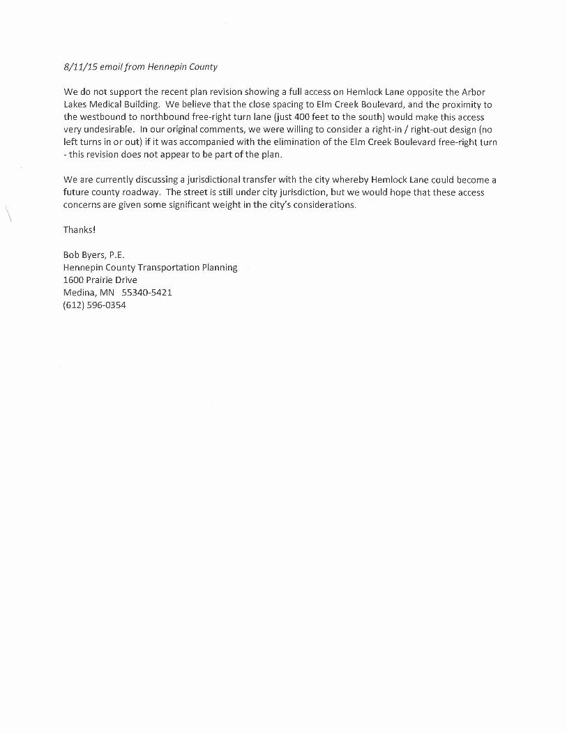
8/11/15 email from Hennepin County
We do not support the recent plan revision showing a full access on Hemlock Lane opposite the Arbor Lakes Medical Building. We believe that the close spacing to Elm Creek Boulevard, and the proximity to the westbound to northbound free-right turn lane (just 400 feet to the south) would make this access very undesirable. In our original comments, we were willing to consider a right-in / right-out design (no left turns in or out) if it was accompanied with the elimination of the Elm Creek Boulevard free-right turn - this revision does not appear to be part of the plan.
\
We are currently discussing a jurisdictional transfer with the city whereby Hemlock Lane could become a future county roadway. The street is still under city jurisdiction, but we would hope that these access concerns are given some significant weight in the city's considerations.
Thanks!
Bob Byers, P.E. Hennepin County Transportation Planning 1600 Prairie Drive Medina, MN 55340-5421 (612) 596-0354