Oregon State Soil
6
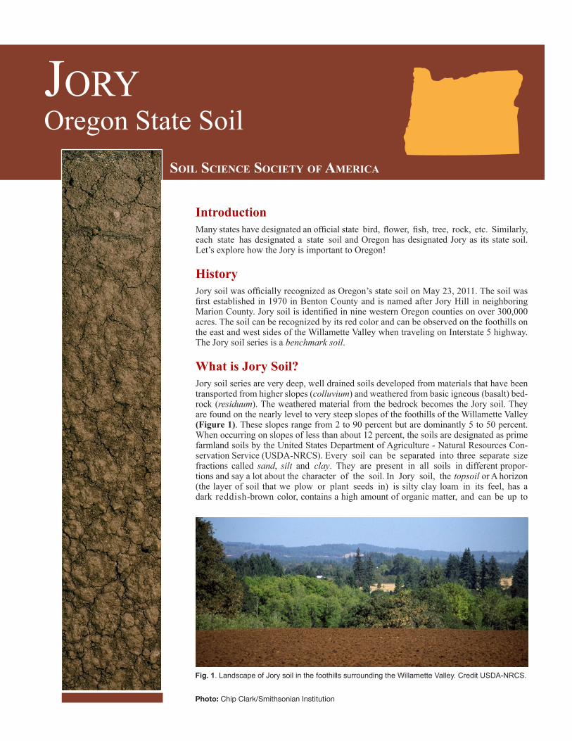
JORY Oregon State Soil Introduction Many states have designated an official state bird, flower, fish, tree, rock, etc. Similarly, each state has designated a state soil and Oregon has designated Jory as its state soil. Let’s explore how the Jory is important to Oregon! History Jory soil was officially recognized as Oregon’s state soil on May 23, 2011. The soil was first established in 1970 in Benton County and is named after Jory Hill in neighboring Marion County. Jory soil is identified in nine western Oregon counties on over 300,000 acres. The soil can be recognized by its red color and can be observed on the foothills on the east and west sides of the Willamette Valley when traveling on Interstate 5 highway. The Jory soil series is a benchmark soil. What is Jory Soil? Jory soil series are very deep, well drained soils developed from materials that have been transported from higher slopes (colluvium) and weathered from basic igneous (basalt) bed- rock (residuum). The weathered material from the bedrock becomes the Jory soil. They are found on the nearly level to very steep slopes of the foothills of the Willamette Valley (Figure 1). These slopes range from 2 to 90 percent but are dominantly 5 to 50 percent. When occurring on slopes of less than about 12 percent, the soils are designated as prime farmland soils by the United States Department of Agriculture - Natural Resources Con- servation Service (USDA-NRCS). Every soil can be separated into three separate size fractions called sand, silt and clay. They are present in all soils in different propor- tions and say a lot about the character of the soil. In Jory soil, the topsoil or A horizon (the layer of soil that we plow or plant seeds in) is silty clay loam in its feel, has a dark reddish-brown color, contains a high amount of organic matter, and can be up to Photo: Chip Clark/Smithsonian Institution SOIL SCIENCE SOCIETY OF AMERICA Fig. 1. Landscape of Jory soil in the foothills surrounding the Willamette Valley. Credit USDA-NRCS.
Transcript of Oregon State Soil
JoryOregon State Soil
IntroductionMany states have designated an official state bird, flower, fish, tree, rock, etc. Similarly, each state has designated a state soil and Oregon has designated Jory as its state soil. Let’s explore how the Jory is important to Oregon!
HistoryJory soil was officially recognized as Oregon’s state soil on May 23, 2011. The soil was first established in 1970 in Benton County and is named after Jory Hill in neighboring Marion County. Jory soil is identified in nine western Oregon counties on over 300,000 acres. The soil can be recognized by its red color and can be observed on the foothills on the east and west sides of the Willamette Valley when traveling on Interstate 5 highway. The Jory soil series is a benchmark soil.
What is Jory Soil?Jory soil series are very deep, well drained soils developed from materials that have been transported from higher slopes (colluvium) and weathered from basic igneous (basalt) bed-rock (residuum). The weathered material from the bedrock becomes the Jory soil. They are found on the nearly level to very steep slopes of the foothills of the Willamette Valley (Figure 1). These slopes range from 2 to 90 percent but are dominantly 5 to 50 percent. When occurring on slopes of less than about 12 percent, the soils are designated as prime farmland soils by the United States Department of Agriculture - Natural Resources Con-servation Service (USDA-NRCS). Every soil can be separated into three separate size fractions called sand, silt and clay. They are present in all soils in different propor-tions and say a lot about the character of the soil. In Jory soil, the topsoil or A horizon (the layer of soil that we plow or plant seeds in) is silty clay loam in its feel, has a dark reddish-brown color, contains a high amount of organic matter, and can be up to
Photo: Chip Clark/Smithsonian Institution
Soil Science Society of AmericA
Fig. 1. Landscape of Jory soil in the foothills surrounding the Willamette Valley. Credit USDA-NRCS.
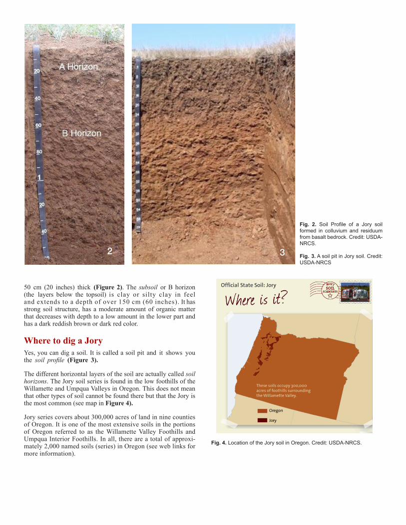
50 cm (20 inches) thick (Figure 2). The subsoil or B horizon (the layers below the topsoil) is clay or silty clay in feel and extends to a depth of over 150 cm (60 inches). It has strong soil structure, has a moderate amount of organic matter that decreases with depth to a low amount in the lower part and has a dark reddish brown or dark red color.
Where to dig a JoryYes, you can dig a soil. It is called a soil pit and it shows you the soil profile (Figure 3).
The different horizontal layers of the soil are actually called soil horizons. The Jory soil series is found in the low foothills of the Willamette and Umpqua Valleys in Oregon. This does not mean that other types of soil cannot be found there but that the Jory is the most common (see map in Figure 4).
Jory series covers about 300,000 acres of land in nine counties of Oregon. It is one of the most extensive soils in the portions of Oregon referred to as the Willamette Valley Foothills and Umpqua Interior Foothills. In all, there are a total of approxi-mately 2,000 named soils (series) in Oregon (see web links for more information).
Fig. 2. Soil Profile of a Jory soil formed in colluvium and residuum from basalt bedrock. Credit: USDA-NRCS.
Fig. 3. A soil pit in Jory soil. Credit: USDA-NRCS
2 3
Fig. 4. Location of the Jory soil in Oregon. Credit: USDA-NRCS.
3
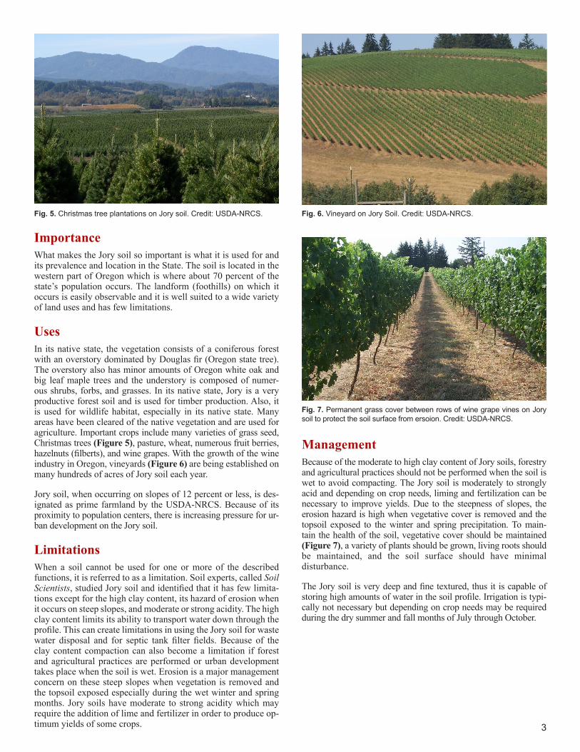
Fig. 5. Christmas tree plantations on Jory soil. Credit: USDA-NRCS.
Importance What makes the Jory soil so important is what it is used for and its prevalence and location in the State. The soil is located in the western part of Oregon which is where about 70 percent of the state’s population occurs. The landform (foothills) on which it occurs is easily observable and it is well suited to a wide variety of land uses and has few limitations.
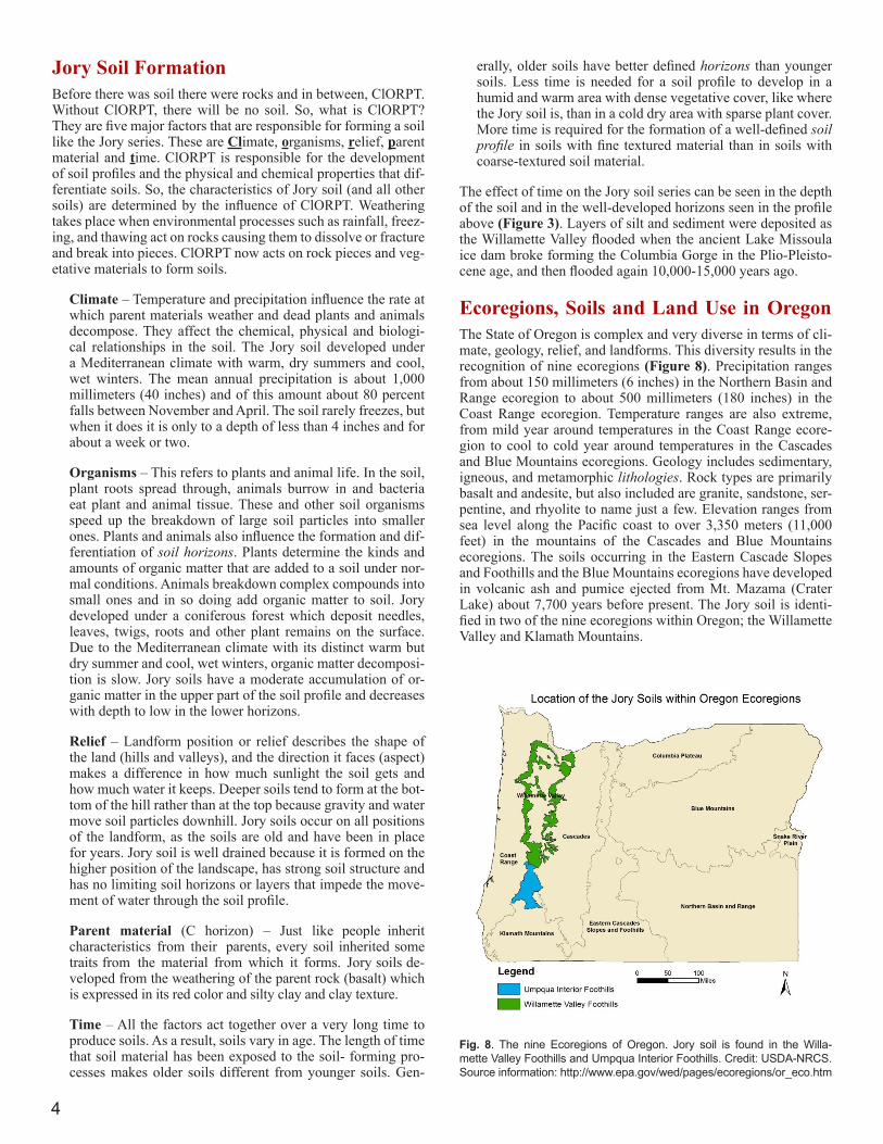
UsesIn its native state, the vegetation consists of a coniferous forest with an overstory dominated by Douglas fir (Oregon state tree). The overstory also has minor amounts of Oregon white oak and big leaf maple trees and the understory is composed of numer-ous shrubs, forbs, and grasses. In its native state, Jory is a very productive forest soil and is used for timber production. Also, it is used for wildlife habitat, especially in its native state. Many areas have been cleared of the native vegetation and are used for agriculture. Important crops include many varieties of grass seed, Christmas trees (Figure 5), pasture, wheat, numerous fruit berries, hazelnuts (filberts), and wine grapes. With the growth of the wine industry in Oregon, vineyards (Figure 6) are being established on many hundreds of acres of Jory soil each year.
Jory soil, when occurring on slopes of 12 percent or less, is des-ignated as prime farmland by the USDA-NRCS. Because of its proximity to population centers, there is increasing pressure for ur-ban development on the Jory soil.
LimitationsWhen a soil cannot be used for one or more of the described functions, it is referred to as a limitation. Soil experts, called Soil Scientists, studied Jory soil and identified that it has few limita-tions except for the high clay content, its hazard of erosion when it occurs on steep slopes, and moderate or strong acidity. The high clay content limits its ability to transport water down through the profile. This can create limitations in using the Jory soil for waste water disposal and for septic tank filter fields. Because of the clay content compaction can also become a limitation if forest and agricultural practices are performed or urban development takes place when the soil is wet. Erosion is a major management concern on these steep slopes when vegetation is removed and the topsoil exposed especially during the wet winter and spring months. Jory soils have moderate to strong acidity which may require the addition of lime and fertilizer in order to produce op-timum yields of some crops.
Fig. 6. Vineyard on Jory Soil. Credit: USDA-NRCS.
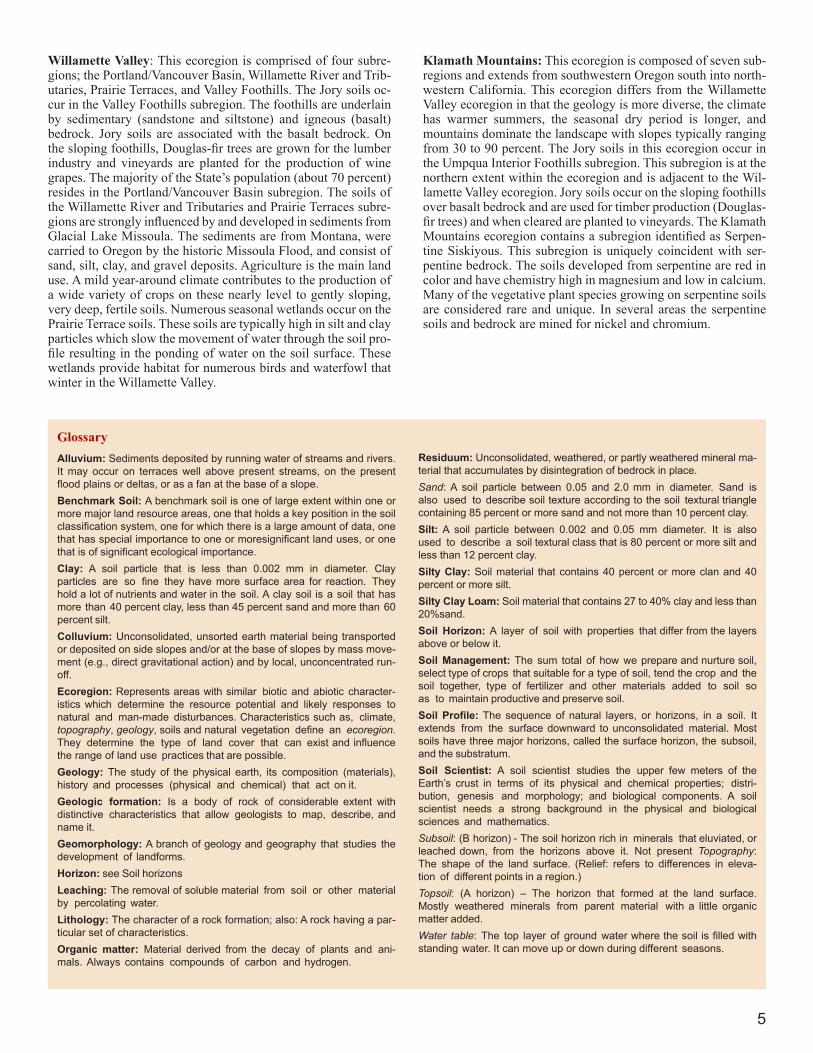
ManagementBecause of the moderate to high clay content of Jory soils, forestry and agricultural practices should not be performed when the soil is wet to avoid compacting. The Jory soil is moderately to strongly acid and depending on crop needs, liming and fertilization can be necessary to improve yields. Due to the steepness of slopes, the erosion hazard is high when vegetative cover is removed and the topsoil exposed to the winter and spring precipitation. To main-tain the health of the soil, vegetative cover should be maintained (Figure 7), a variety of plants should be grown, living roots should be maintained, and the soil surface should have minimal disturbance.
The Jory soil is very deep and fine textured, thus it is capable of storing high amounts of water in the soil profile. Irrigation is typi-cally not necessary but depending on crop needs may be required during the dry summer and fall months of July through October.
Fig. 7. Permanent grass cover between rows of wine grape vines on Jory soil to protect the soil surface from ersoion. Credit: USDA-NRCS.
4
Jory Soil FormationBefore there was soil there were rocks and in between, ClORPT. Without ClORPT, there will be no soil. So, what is ClORPT? They are five major factors that are responsible for forming a soil like the Jory series. These are Climate, organisms, relief, parent material and time. ClORPT is responsible for the development of soil profiles and the physical and chemical properties that dif-ferentiate soils. So, the characteristics of Jory soil (and all other soils) are determined by the influence of ClORPT. Weathering takes place when environmental processes such as rainfall, freez-ing, and thawing act on rocks causing them to dissolve or fracture and break into pieces. ClORPT now acts on rock pieces and veg-etative materials to form soils.
Climate – Temperature and precipitation influence the rate at which parent materials weather and dead plants and animals decompose. They affect the chemical, physical and biologi-cal relationships in the soil. The Jory soil developed under a Mediterranean climate with warm, dry summers and cool, wet winters. The mean annual precipitation is about 1,000 millimeters (40 inches) and of this amount about 80 percent falls between November and April. The soil rarely freezes, but when it does it is only to a depth of less than 4 inches and for about a week or two.
Organisms – This refers to plants and animal life. In the soil, plant roots spread through, animals burrow in and bacteria eat plant and animal tissue. These and other soil organisms speed up the breakdown of large soil particles into smaller ones. Plants and animals also influence the formation and dif-ferentiation of soil horizons. Plants determine the kinds and amounts of organic matter that are added to a soil under nor-mal conditions. Animals breakdown complex compounds into small ones and in so doing add organic matter to soil. Jory developed under a coniferous forest which deposit needles, leaves, twigs, roots and other plant remains on the surface. Due to the Mediterranean climate with its distinct warm but dry summer and cool, wet winters, organic matter decomposi-tion is slow. Jory soils have a moderate accumulation of or-ganic matter in the upper part of the soil profile and decreases with depth to low in the lower horizons.
Relief – Landform position or relief describes the shape of the land (hills and valleys), and the direction it faces (aspect) makes a difference in how much sunlight the soil gets and how much water it keeps. Deeper soils tend to form at the bot-tom of the hill rather than at the top because gravity and water move soil particles downhill. Jory soils occur on all positions of the landform, as the soils are old and have been in place for years. Jory soil is well drained because it is formed on the higher position of the landscape, has strong soil structure and has no limiting soil horizons or layers that impede the move-ment of water through the soil profile.
Parent material (C horizon) – Just like people inherit characteristics from their parents, every soil inherited some traits from the material from which it forms. Jory soils de-veloped from the weathering of the parent rock (basalt) which is expressed in its red color and silty clay and clay texture.
Time – All the factors act together over a very long time to produce soils. As a result, soils vary in age. The length of time that soil material has been exposed to the soil- forming pro-cesses makes older soils different from younger soils. Gen-
erally, older soils have better defined horizons than younger soils. Less time is needed for a soil profile to develop in a humid and warm area with dense vegetative cover, like where the Jory soil is, than in a cold dry area with sparse plant cover. More time is required for the formation of a well-defined soil profile in soils with fine textured material than in soils with coarse-textured soil material.
The effect of time on the Jory soil series can be seen in the depth of the soil and in the well-developed horizons seen in the profile above (Figure 3). Layers of silt and sediment were deposited as the Willamette Valley flooded when the ancient Lake Missoula ice dam broke forming the Columbia Gorge in the Plio-Pleisto-cene age, and then flooded again 10,000-15,000 years ago.
Ecoregions, Soils and Land Use in OregonThe State of Oregon is complex and very diverse in terms of cli-mate, geology, relief, and landforms. This diversity results in the recognition of nine ecoregions (Figure 8). Precipitation ranges from about 150 millimeters (6 inches) in the Northern Basin and Range ecoregion to about 500 millimeters (180 inches) in the Coast Range ecoregion. Temperature ranges are also extreme, from mild year around temperatures in the Coast Range ecore-gion to cool to cold year around temperatures in the Cascades and Blue Mountains ecoregions. Geology includes sedimentary, igneous, and metamorphic lithologies. Rock types are primarily basalt and andesite, but also included are granite, sandstone, ser-pentine, and rhyolite to name just a few. Elevation ranges from sea level along the Pacific coast to over 3,350 meters (11,000 feet) in the mountains of the Cascades and Blue Mountains ecoregions. The soils occurring in the Eastern Cascade Slopes and Foothills and the Blue Mountains ecoregions have developed in volcanic ash and pumice ejected from Mt. Mazama (Crater Lake) about 7,700 years before present. The Jory soil is identi-fied in two of the nine ecoregions within Oregon; the Willamette Valley and Klamath Mountains.
Fig. 8. The nine Ecoregions of Oregon. Jory soil is found in the Willa-mette Valley Foothills and Umpqua Interior Foothills. Credit: USDA-NRCS. Source information: http://www.epa.gov/wed/pages/ecoregions/or_eco.htm
5
Willamette Valley: This ecoregion is comprised of four subre-gions; the Portland/Vancouver Basin, Willamette River and Trib-utaries, Prairie Terraces, and Valley Foothills. The Jory soils oc-cur in the Valley Foothills subregion. The foothills are underlain by sedimentary (sandstone and siltstone) and igneous (basalt) bedrock. Jory soils are associated with the basalt bedrock. On the sloping foothills, Douglas-fir trees are grown for the lumber industry and vineyards are planted for the production of wine grapes. The majority of the State’s population (about 70 percent) resides in the Portland/Vancouver Basin subregion. The soils of the Willamette River and Tributaries and Prairie Terraces subre-gions are strongly influenced by and developed in sediments from Glacial Lake Missoula. The sediments are from Montana, were carried to Oregon by the historic Missoula Flood, and consist of sand, silt, clay, and gravel deposits. Agriculture is the main land use. A mild year-around climate contributes to the production of a wide variety of crops on these nearly level to gently sloping, very deep, fertile soils. Numerous seasonal wetlands occur on the Prairie Terrace soils. These soils are typically high in silt and clay particles which slow the movement of water through the soil pro-file resulting in the ponding of water on the soil surface. These wetlands provide habitat for numerous birds and waterfowl that winter in the Willamette Valley.
GlossaryAlluvium: Sediments deposited by running water of streams and rivers. It may occur on terraces well above present streams, on the present flood plains or deltas, or as a fan at the base of a slope.Benchmark Soil: A benchmark soil is one of large extent within one or more major land resource areas, one that holds a key position in the soil classification system, one for which there is a large amount of data, one that has special importance to one or moresignificant land uses, or one that is of significant ecological importance.Clay: A soil particle that is less than 0.002 mm in diameter. Clay particles are so fine they have more surface area for reaction. They hold a lot of nutrients and water in the soil. A clay soil is a soil that has more than 40 percent clay, less than 45 percent sand and more than 60 percent silt.Colluvium: Unconsolidated, unsorted earth material being transported or deposited on side slopes and/or at the base of slopes by mass move-ment (e.g., direct gravitational action) and by local, unconcentrated run-off.Ecoregion: Represents areas with similar biotic and abiotic character-istics which determine the resource potential and likely responses to natural and man-made disturbances. Characteristics such as, climate, topography, geology, soils and natural vegetation define an ecoregion. They determine the type of land cover that can exist and influence the range of land use practices that are possible.Geology: The study of the physical earth, its composition (materials), history and processes (physical and chemical) that act on it.Geologic formation: Is a body of rock of considerable extent with distinctive characteristics that allow geologists to map, describe, and name it.Geomorphology: A branch of geology and geography that studies the development of landforms.Horizon: see Soil horizonsLeaching: The removal of soluble material from soil or other material by percolating water.Lithology: The character of a rock formation; also: A rock having a par-ticular set of characteristics.Organic matter: Material derived from the decay of plants and ani-mals. Always contains compounds of carbon and hydrogen.
Residuum: Unconsolidated, weathered, or partly weathered mineral ma-terial that accumulates by disintegration of bedrock in place.Sand: A soil particle between 0.05 and 2.0 mm in diameter. Sand is also used to describe soil texture according to the soil textural triangle containing 85 percent or more sand and not more than 10 percent clay.Silt: A soil particle between 0.002 and 0.05 mm diameter. It is also used to describe a soil textural class that is 80 percent or more silt and less than 12 percent clay.Silty Clay: Soil material that contains 40 percent or more clan and 40 percent or more silt.Silty Clay Loam: Soil material that contains 27 to 40% clay and less than 20%sand.Soil Horizon: A layer of soil with properties that differ from the layers above or below it.Soil Management: The sum total of how we prepare and nurture soil, select type of crops that suitable for a type of soil, tend the crop and the soil together, type of fertilizer and other materials added to soil so as to maintain productive and preserve soil.Soil Profile: The sequence of natural layers, or horizons, in a soil. It extends from the surface downward to unconsolidated material. Most soils have three major horizons, called the surface horizon, the subsoil, and the substratum.Soil Scientist: A soil scientist studies the upper few meters of the Earth’s crust in terms of its physical and chemical properties; distri-bution, genesis and morphology; and biological components. A soil scientist needs a strong background in the physical and biological sciences and mathematics.Subsoil: (B horizon) - The soil horizon rich in minerals that eluviated, or leached down, from the horizons above it. Not present Topography: The shape of the land surface. (Relief: refers to differences in eleva-tion of different points in a region.)Topsoil: (A horizon) – The horizon that formed at the land surface. Mostly weathered minerals from parent material with a little organic matter added.Water table: The top layer of ground water where the soil is filled with standing water. It can move up or down during different seasons.
Klamath Mountains: This ecoregion is composed of seven sub-regions and extends from southwestern Oregon south into north-western California. This ecoregion differs from the Willamette Valley ecoregion in that the geology is more diverse, the climate has warmer summers, the seasonal dry period is longer, and mountains dominate the landscape with slopes typically ranging from 30 to 90 percent. The Jory soils in this ecoregion occur in the Umpqua Interior Foothills subregion. This subregion is at the northern extent within the ecoregion and is adjacent to the Wil-lamette Valley ecoregion. Jory soils occur on the sloping foothills over basalt bedrock and are used for timber production (Douglas-fir trees) and when cleared are planted to vineyards. The Klamath Mountains ecoregion contains a subregion identified as Serpen-tine Siskiyous. This subregion is uniquely coincident with ser-pentine bedrock. The soils developed from serpentine are red in color and have chemistry high in magnesium and low in calcium. Many of the vegetative plant species growing on serpentine soils are considered rare and unique. In several areas the serpentine soils and bedrock are mined for nickel and chromium.
Additional ResourcesSoil! Get the Inside Scoop. David Lindbo and others. Soil Science Society of America, Madison, WI.Know Soil, Know Life. David L. Lindbo, Deb A. Kozlowski, and Clay Rob-inson, editors. Soil Science Society of America, Madison, WI.
Web Resources SOIL SCIENCE LINKS:Soils for Teachers—www.soils4teachers.orgSoils for Kids—http://www.soils4kids.org/Have Questions? Ask a Soil Scientist—https://www.soils4teachers.org/askSoil Science Society of America—https://www.soils.org/
OREGON LINKS:Important Oregon Soils (list of additional soils)—http://www.nrcs.usda.gov/wps/portal/nrcs/detail/nj/soils/?cid=nrcs141p2_018874NRCS,OregonHomepage —http://www.nrcs.usda.gov/wps/portal/nrcs/site/or/home/NRCS—http://www.nrcs.usda.gov/wps/portal/nrcs/main/national/soils/NRCS, Educational Resources—http://soils.usda.gov/education/re-sources/ k_6/Oregon Agricultural Experiment Station, Oregon State University—http://agsci.oregonstate.edu/Oregon Association of Conservation Districts (Envirothon & other programs) http://www.oacd.org/
ReferencesLindbo, D.L. 2008. Soil! Get The Inside Scoop. Soil Science Society of America. Madison, Wisconsin.
NRCS,USDA. Jory – Oregon State Soil. http://www.nrcs.usda.gov/wps/portal/nrcs/detail/soils/edu/?cid=steplprdb1236841/
USDA-NRCS. 2009. Soil Survey of Benton County, Oregon.USDA, Soil Conservation Service. 1985. Soil Survey of Clackamas Area, OR.USDA-NRCS. 2003. Soil Survey of Douglas County Area, OR.USDA, Soil Conservation Service. 1987. Soil Survey of Linn County Area, OR.USDA, Soil Conservation Service. 1987. Soil Survey of Lane County Area, OR.USDA, Soil Conservation Service. 1972. Soil Survey of Marion County Area, OR.USDA, Soil Conservation Service. 1982. Soil Survey of Polk County, OR.USDA Soil Conservation Service. 1982. Soil Survey of Washington County, OR.USDA, Soil Conservation Service. 1974. Soil Survey of Yamhill Area, OR.Thorson, T.D., S.A. Bryce, D.A. Lammers, A.J. Woods, J.M. Omernik, J. Kagan, D.E. Pater, and J.A. Comstock. 2003. Ecoregions of Oregon (col-or poster with map, descriptive text, summary tables, and photographs). United States Department of the Interior, Geological Survey, Reston, Vir-ginia. Scale 1:500,000.
Authors: Thor Thorson and Chad McGrath, retired USDA-NRCS Soil Scientists; Tracy Wilson, Oregon State University, Central Oregon Agri-cultural Research Center
5585 Guilford RoadMadison WI 53711-5801Tel. 608-273-8080 • Fax 608-273-2021www.soils.org • [email protected]
This state soil booklet was developed under the auspices of the Soil Science Society of America’s K-12 Committee—their dedication to developing outreach materials for the K-12 audience makes this material possible.