Ordinary Meeting of Council - City of Greater Bendigo · The public question time is held at the...
112
PAGE 1 AGENDA Ordinary Meeting of Council 6.00pm Wednesday 19 July 2017 *** Broadcast live on Phoenix FM 106.7 *** VENUE: Reception Room, Bendigo Town Hall, Hargreaves Street, Bendigo NEXT MEETING: Wednesday 16 August 2017 Bendigo Town Hall Copies of the City of Greater Bendigo Council’s Agendas & Minutes can be obtained online at www.bendigo.vic.gov.au
Transcript of Ordinary Meeting of Council - City of Greater Bendigo · The public question time is held at the...

PAGE 1
AGENDA
Ordinary Meeting of Council
6.00pm Wednesday 19 July 2017
*** Broadcast live on Phoenix FM 106.7 ***
VENUE:
Reception Room,
Bendigo Town Hall,
Hargreaves Street, Bendigo
NEXT MEETING:
Wednesday 16 August 2017
Bendigo Town Hall
Copies of the City of Greater Bendigo Council’s Agendas & Minutes
can be obtained online at www.bendigo.vic.gov.au

PAGE 2
This Council Meeting is conducted in accordance with Local Law No. 8. It is an offence for any
person to engage in improper or disorderly conduct at the meeting.
Council Vision
Greater Bendigo - creating the wold's most liveable community.
Council Values Six values inform everything we as Council do in working together to be the best we can for all of our community. Seeking to achieve the best value for our use of the community’s public funds and resources, by:
We Lead;
We Learn;
We Contribute;
We Care;
We Respond;
We Respect.
Goals Presentation and Managing Growth
Wellbeing and Fairness
Strengthening the Economy
Environmental Sustainability
Embracing our Culture and Heritage
Lead and Govern for All
PAGE 3
ORDINARY MEETING WEDNESDAY 19 JULY 2017
ORDER OF BUSINESS:
ITEM PRECIS PAGE
ACKNOWLEDGEMENT OF COUNTRY 5
PRAYER 5
PRESENT 5
APOLOGIES 5
SUSPENSION OF STANDING ORDERS 5
PUBLIC QUESTION TIME 5
RESUMPTION OF STANDING ORDERS 6
CR METCALF'S REPORT 6
DECLARATIONS OF CONFLICT OF INTEREST 7
CONFIRMATION OF MINUTES 8
1. PETITIONS AND JOINT LETTERS 9
1.1 Response to Petition: Continuation of Works Around
Pedestrian Bridge Over Bendigo Creek at High Street,
Golden Square
9
2. PRESENTATION AND MANAGING GROWTH 13
2.1 120-150 Sullivans Road, Strathfieldsaye - Staged
Subdivision (173 Lots); Construction of Dwellings, Fences
and Roads within the Land Subject to Inundation Overlay;
Removal of Native Vegetation; Removal of Easement and
Creation of Easements
13
2.2 8 Julian Court, Epsom - The Construction of Three
Dwellings on the Land; and the Staged Subdivision of the
Land into Three Lots and Common Property, in
Accordance with the Endorsed Plans
43
2.3 79 Olinda Street, Quarry Hill - Extensions and Additions to
Former Mt Edgecombe Hotel, Change of Use to Food and
Drink Premises, Changes to Liquor Licence, Alteration to
Access via a Road Zone 1, and Reduction in Car Parking
59
2.4 Tannery Lane Road Reserve in the Vicinity of Nankervis
Road and Tannery Heights Drive, Mandurang - Removal of
81

PAGE 4
Vegetation and Roadworks
3. WELLBEING AND FAIRNESS 94
3.1 Gender Equity Strategy 94
4. STRENTHENING THE ECONOMY 105
5. ENVIRONMENTAL SUSTAINABILITY 105
6. EMBRACING OUR CULTURE AND HERITAGE 105
7. LEAD AND GOVERN FOR ALL 106
7.1 Record of Assemblies 106
8. URGENT BUSINESS 112
9. NOTICES OF MOTION 112
10. COUNCILLORS' REPORTS 112
11. MAYOR'S REPORT 112
12. CHIEF EXECUTIVE OFFICER'S REPORT 112
13. CONFIDENTIAL (SECTION 89) REPORTS 112
____________________________
CRAIG NIEMANN CHIEF EXECUTIVE OFFICER

Ordinary Meeting - 19 July 2017
PAGE 5
ACKNOWLEDGEMENT OF COUNTRY
PRAYER
PRESENT
APOLOGIES
SUSPENSION OF STANDING ORDERS
That Standing Orders be suspended to allow a presentation to members of the Valkyrie Care Group and the conduct of Public Question Time.
PUBLIC QUESTION TIME
Public Question Time – Purpose Council has provided the opportunity for members of the public to ask questions of broad interest to Council and the community. Matters relating to routine Council works should be taken up with Council’s Customer Service Officers through its Customer Request System. By the time planning matters have reached the council agenda, they have been through an extensive process as required by the Planning and Environment Act. In addition, in most instances mediation has been held between the parties involved. Throughout the process there are many opportunities for the people to ask questions. Therefore, no questions relating to planning matters on the Agenda will be accepted. Public Question Time – Where, When And Who The public question time is held at every Ordinary Meeting of Greater Bendigo City Council. Meetings of Council commence at 6.00pm in the Reception Room, Bendigo Town Hall, Hargreaves Street, Bendigo. The public question time is held at the start of the meeting as close as practical to 6:00pm. A maximum of 30 minutes has been provided for registered and unregistered questions. Residents are encouraged to lodge questions in advance so that a more complete response can be provided. Questions will be put to the Council by the individual posing the question; the question will be answered by the Mayor or CEO, or where appropriate, Councillors or Council Officers.
Ordinary Meeting - 19 July 2017
PAGE 6
Acceptance of Questions Each person asking a question of Council is required to stand, state their name, and address the Mayor. Public Question Time is not an opportunity for making of statements or other comments. Council’s Meeting Procedure Local Law does not allow for other questions or comments during the remainder of the meeting. 1. An individual may only ask one question per meeting, a follow-up question may be
permitted at the discretion of the Mayor. 2. In the event that the same or similar question is raised by more than one person,
an answer may be given as a combined response. 3. In the event that time does not permit all questions registered to be answered,
questions will be answered in writing or referred to the next meeting if appropriate. 4. The Mayor and or CEO have the right to decline registration on basis of:
Legal proceedings;
More appropriately addressed by other means;
Vague or lacking in substance, irrelevant, frivolous, insulting offensive, improper, defamatory or demeaning;
Answer likely to compromise his / her position;
Confidential, commercial-in-confidence. 5. Each individual whose registration form has been accepted or declined will be
advised by the Friday of the week prior to the scheduled meeting. 6. In the event of a registration form being declined the registration form will be
circulated to the Mayor or Councillors for information.
RESUMPTION OF STANDING ORDERS
That Standing Orders be resumed.
CR METCALF'S REPORT

Ordinary Meeting - 19 July 2017
PAGE 7
DECLARATIONS OF CONFLICT OF INTEREST
Pursuant to Sections 77, 78 and 79 of the Local Government Act 1989 (as amended) direct and indirect conflict of interest must be declared prior to debate on specific items within the agenda; or in writing to the Chief Executive Officer before the meeting. Declaration of indirect interests must also include the classification of the interest (in circumstances where a Councillor has made a Declaration in writing, the classification of the interest must still be declared at the meeting), i.e. (a) direct financial interest (b) indirect interest by close association (c) indirect interest that is an indirect financial interest (d) indirect interest because of conflicting duties (e) indirect interest because of receipt of an applicable gift (f) indirect interest as a consequence of becoming an interested party (g) indirect interest as a result of impact on residential amenity (h) conflicting personal interest A Councillor who has declared a conflict of interest, must leave the meeting and remain outside the room while the matter is being considered, or any vote is taken. Councillors are also encouraged to declare circumstances where there may be a perceived conflict of interest.

Ordinary Meeting - 19 July 2017
PAGE 8
CONFIRMATION OF MINUTES
Minutes of the Ordinary Meeting of Wednesday 21 June 2017. The following items were considered at the Ordinary Council meeting held on Wednesday 21 June 2017 at 6:00pm.
Community Plan 2017-2021 - Final for Adoption
Adoption of 2017-2018 Budget Report
Response to Petition: Request to Extend Construction of Railway Street, Kangaroo Flat
(Lot 1LP66913) 186 Barnard Street, Bendigo - 3 Lot Subdivision: Demolition of Garage and Fencing; Construction of Garage and Construction of 2 Dwellings
Tannery Lane Road Reserve in the Vicinity of Nankervis Road and Tannery Heights Drive, Mandurang - Removal of Vegetation and Roadworks
524 Heathcote-Redesdale Road, Heathcote - Construction of a Shed, Removal of Native Vegetation and Creation of an Access to a Road in a Road Zone 1
Implementation of the Greater Bendigo Housing Strategy
Revitalising the Sustainable Building Policy
Draft Plan Greater Bendigo Discussion Paper - Community Engagement Summary
Review of Twelve Month Trial Closure of Empire Road, Long Gully
Council Plan 2016-2017 - Third Quarter Report to 31 March 2017
Finance Report as at 31 March 2017
The Wellington at Botanical Gardens Hotel - Application to the VCGLR for a New Club Gaming Premises with 44 Electronic Gaming Machines
Insurance Tender
Contracts Awarded Under Delegation
Record of Assemblies The unconfirmed minutes have also been posted on the City of Greater Bendigo website pending confirmation at this meeting. RECOMMENDATION That the Minutes of the Ordinary Meeting of Council held on Wednesday 21 June 2017, as circulated, be taken as read and confirmed.

Petitions and Joint Letters - Reports Ordinary Meeting - 19 July 2017
PAGE 9
1. PETITIONS AND JOINT LETTERS
1.1 RESPONSE TO PETITION: CONTINUATION OF WORKS AROUND PEDESTRIAN BRIDGE OVER BENDIGO CREEK AT HIGH STREET, GOLDEN SQUARE
Document Information
Author Mark Atkinson, Co-ordinator Infrastructure Development Responsible Craig Lloyd, Director Presentation and Assets Director
Purpose
The purpose of this report is to respond to a petition submitted by the community requesting urgent attention to the continuation of works commenced around the bridge over High Street, Golden Square.
Summary
The community has submitted a petition calling for urgent attention to the completion of works around the bridge in High Street, Golden Square. The existing pedestrian bridge over Golden Gully Creek and part of the footpath in High Street has been fenced off for many months, due to deterioration of the bridge and erosion and subsidence in the creek. The City has considered various options, consulted various parties and progressed to a detailed design of a new footpath and upgrade of the existing drainage channel.
RECOMMENDATION
That Greater Bendigo City Council, in consideration of the petition received: 1. Note inclusion of works along Golden Gully Creek to address bank erosion and the
reconstruction of the footpath High Street, Golden Square in the recently adopted the 2017/18 Council budget.
2. Note further community consultation will be undertaken on the project design in
coming months. 3. Notify the submitter of the petition of Council's decision.
~~~~~~~~~~~~~~~~~~~~~~~~~

Petitions and Joint Letters - Reports Ordinary Meeting - 19 July 2017
PAGE 10
Policy Context
Community Plan Reference: City of Greater Bendigo Community Plan 2017-2021:
Goal 4 Presentation and Managing Growth
Planning, developments and infrastructure that increase our liveability and pride in where we live.
Objective 4.5 Provide and maintain urban and rural infrastructure to support the liveability of our community.
Strategy Reference: Connecting Greater Bendigo - Integrated Transport & Land Use Strategy, https://www.bendigo.vic.gov.au/About/Document-Library/connecting-greater-bendigo-integrated-transport-and-land-use-strategy Council Policy Reference : Asset Management Policy https://www.bendigo.vic.gov.au/About/Document-Library/asset-management-policy
Background Information
Previous Council Decision(s) Date(s): The following petition was tabled at Council's Ordinary Meeting on 17 May 2017 from residents in High Street, Golden Square (back from the intersection of Cedar Street), requesting a continuation of works that had commenced in this area, but have not been finalised, as outlined below:
"For the safety and convenience of cyclists and local residents we, the undersigned, request urgent attention to the continuation of works commenced around the bridge over High St in Golden Square which has been closed off for several months. We request: restoration of the walkway, repair of the footpath & beautification of the tributary to Bendigo Creek so that it becomes an area to be proud of when entering the City".
The petition contained 13 signatures. Council resolved "that the petition be received and a response be prepared within two (2) meetings."
Report
This project became a priority as a result of identified deterioration of the pedestrian bridge over Golden Gully Creek from a routine inspection and subsidence of the embankment adjacent to High Street which led to failures in the footpath.

Petitions and Joint Letters - Reports Ordinary Meeting - 19 July 2017
PAGE 11
The existing pedestrian bridge of Golden Gully links High Street with crown land to the east of Golden Gully and south of Bendigo Creek. The City is the Committee of Management over the crown land for the creeks and adjoining areas. The replacement of the existing pedestrian bridge was considered, however there is no direct connection of the bridge to the south east of the creek to other pedestrian paths. The underpass of High Street via the Bendigo Creek provides for those people using the Bendigo Creek Trail and wishing to cross High Street at this point. Pedestrian access to other attractors in the area is well serviced by Thistle Street and Cedar Street. It was considered that benefits of constructing a replacement bridge over Golden Gully in accordance with current standards were low and other facilities are in place to serve the area, therefore replacement of the pedestrian bridge was not warranted. The bridge option would have also necessitated a large retaining wall which was not considered the best approach. The City has progressed an alternative design which will convey up to 1 in 10 year stormwater flows in Golden Gully Creek to Bendigo Creek via concrete box culverts. The box culverts will be covered and grassed, lessening the slope of the embankments. The grassed area will be simpler to maintain, less likely to erode and more cost effective long term compared to restoring the shape of the existing gully. Stormwater flows in excess of the 1 in 10 year event will flow via the grassed area to Bendigo Creek. The footpath along High Street will be reconstructed and pedestrian fencing along the Golden Gully Creek embankment replaced. The works are scheduled to commence in the second half of the 2017/18 financial year.
Consultation/Communication
Consultation has been undertaken with Department of Environment, Land, Water & Planning (DELWP) as the Golden Gully Creek is Crown Land, with the City as Committee of Management. A permit for Works Within a Waterway from North Central Catchment Management Authority (NCCMA) has been obtained. As High Street is part of the VicRoads arterial road network, a Works Within Road Reserve permit is required. A planning permit for the removal of native vegetation is also required. The adjoining property owners received a letter advising that investigation activities would be carried out onsite. Further consultation with the community is planned. The redesign of the Golden Gully Creek has been discussed with the City's Parks and Natural Reserves team who are responsible for the management of the Creek and surrounds who were concerned about ongoing maintenance of the creek in its current form and are supportive of the draft design.
Resource Implications
This project has been included in Council's 2017/18 budget and is estimated to cost approximately $357,000.

Petitions and Joint Letters - Reports Ordinary Meeting - 19 July 2017
PAGE 12
Attachments
1. Final Detailed Design (extract) - Proposed High Street Footpath and Channel Works, Golden Square.

Presentation and Managing Growth - Reports Ordinary Meeting - 19 July 2017
PAGE 13
2. PRESENTATION AND MANAGING GROWTH
2.1 120-150 SULLIVANS ROAD, STRATHFIELDSAYE 3551 - STAGED SUBDIVISION (173 LOTS); CONSTRUCTION OF DWELLINGS, FENCES AND ROADS WITHIN THE LAND SUBJECT TO INUNDATION OVERLAY; REMOVAL OF NATIVE VEGETATION; REMOVAL OF EASEMENT AND CREATION OF EASEMENTS
Document Information
Author Peter O'Brien, Coordinator – Planning. Responsible Bernie O’Sullivan, Director Strategy and Growth Director
Summary/Purpose
Application details: Staged subdivision of land (173 lots); construction of dwellings, fences and roads within the Land Subject to Inundation Overlay; removal of native vegetation (remnant patches and 5 scattered trees); removal of easement (E-1 on PS 419383 V); and creation of easements
Application No: DS/23/2016
Applicant: Spiire Australia Pty Ltd
Land: 120-150 Sullivans Road, STRATHFIELDSAYE 3551
Zoning: General Residential Zone
Overlays: Land Subject to Inundation Overlay and Environmental Significance Overlay 1
No. of objections: 4
Consultation meeting:
24 February 2017; attended by Crs. Flack and Wrigglesworth (Mayor O’Rourke was an apology).
Key considerations: Is there policy support (State and Local) for a subdivision in this location (includes consideration of the Strathfieldsaye Township Plan 2009; residential character and vegetation impacts on the site and road reserve)?
Can the lots be appropriately serviced, accessed (including consideration of impacts on the broader road network) and meet the requirements of clause 56?
Flooding impacts (including treatment of the interface with Sheepwash Creek);
The provision of open space; and
Issues raised by the objections.

Presentation and Managing Growth - Reports Ordinary Meeting - 19 July 2017
PAGE 14
Conclusion: The application is recommended for approval on the basis that it represents an acceptable outcome with regards to the requirements of the Greater Bendigo Planning Scheme.
RECOMMENDATION
Pursuant to section 61 of the Planning and Environment Act (1987), Greater Bendigo City Council resolve to issue a Notice of Decision to Grant a Permit for the: staged subdivision of land (173 lots); construction of dwellings, fences and roads within the Land Subject to Inundation Overlay; removal of native vegetation (remnant patches and 5 scattered trees); removal of easement (E-1 on PS 419383 V); and creation of easements at 120-150 Sullivans Road, STRATHFIELDSAYE 3551 subject to the conditions at the end of this report:
~~~~~~~~~~~~~~~~~~~~~~~~~
Policy Context
City of Greater Bendigo Community Plan 2017-2021
Goal 4: Presentation and managing growth
Planning, developments and infrastructure that increase our liveability and pride in where we live.
Goal 6: Embracing our culture and heritage
Recognise and celebrate our unique history and diverse cultures.
Report
Subject Site and Surrounds
The applicant has appropriately described the application site and surrounding area as follows:
The subject site comprises of two land parcels located at No. 120 – 150 Sullivans Road, Strathfieldsaye which are more formally described as follows:
No 120 Sullivans Road, Strathfieldsaye: Lot 2 on Plan of Subdivision No. 419383 (Volume 10405/Folio 213);
No. 150 Sullivans Road, Strathfieldsaye: Lot 1 on Plan of Subdivision No. 419383 (Volume 10405/Folio 212).
The site is irregular in shape and encompasses an overall site area of approximately 17.3 hectares. In addition, the site has a frontage to Sullivans Road of 593.86 metres, a 514.78 metre frontage to the east, a 286.62 metre frontage to the south and a 414.27 metre frontage along the western boundary. The site is largely vacant however is occupied by a rural residential property within the north east portion of the site which comprises a dwelling, associated outbuildings and a dam. Old cattle yards, scattered trees and a large dam (within the north western portion of the site) also occupy the subject site.

Presentation and Managing Growth - Reports Ordinary Meeting - 19 July 2017
PAGE 15
An open water channel, identified as the ‘Emu Valley No.1’ rural water supply channel, runs parallel with the north western boundary.
Figure 1: Location map showing subject site. Objectors' properties marked with a star.
The subject site is located within an existing residential area within Strathfieldsaye. St Francis of the Fields Primary School, recreation reserves and other services and facilities are all located within proximity of the subject site. To the north of the site (over the opposite side of Sullivans Road) is low density residential development located within the GRZ. There is a range of dwelling types on standard sized residential allotments within this area and the majority of dwellings are single story with pitched roofs, and minimal landscaping or front fencing. Approximately 490 metres north is land located in the Rural Conservation Zone (RCZ). Immediately south of the site is Emu Creek which is located within the Public Park and Recreation Zone (PPRZ). South of Emu Creek is vacant land on Lot 2 of Plan of Subdivision 324054 and land currently being developed for conventional residential purposes. St Francis of the Fields is located approximately 220 metres to the south west and the Strathfieldsaye commercial precinct is located approximately 674 metres, also to the south west. Land abutting the site to the west is zoned general residential and contains larger allotments, with dwellings setback from the road and boundaries. These lots also predominately contain outbuildings and high amounts of vegetation. Further west over Somerville Road is more conventional style residential development.

Presentation and Managing Growth - Reports Ordinary Meeting - 19 July 2017
PAGE 16
Directly abutting the site’s eastern boundary (for its entire length) is Emu Creek which is located in the PPRZ. Over the opposite side is No. 53-59 Duke Street which is also located in the GRZ and developed for rural residential purposes. The site is largely vacant however does contain an existing dwelling, associated outbuildings and infrastructure, some remnant patches of vegetation and two dams. South east of the site is land located along Strathfieldsaye Road which is zoned general residential and has been subdivided and is currently being developed for conventional residential purposes.
Proposal
The proposal is for a 173 lot subdivision of land; dwellings and works on the parts of the site currently covered by the Land Subject to Inundation Overlay; the removal of native vegetation; and removal and creation of easements. The subdivision is proposed to be undertaken in 8 stages. The proposed lots will range from 427 to 1,338 square metres in size. The average lot size across the estate will be 725 square metres. Proposed lot 143 will house the existing dwelling on the land. A bio-retention basin is proposed towards the eastern boundary of the site; the existing dam towards the north western boundary will be filled in. Access to the subdivision is proposed to occur at two points along Sullivans Road and can be seen in figures 2 and 3. The lots will front Sullivans Road, the newly created internal roads (as yet unnamed) and/or Sheepwash Creek. The concept landscape plan identifies a crossing point for Sheepwash Creek that would provide a pedestrian/cycle linkage from the proposed subdivision to the ‘Imagine’ estate and existing open space network contained within. Existing easements are proposed to be removed and replaced with new easements, as shown on the plan below. All the lots in the subdivision will be fully serviced by reticulated water, sewerage and electricity.

Presentation and Managing Growth - Reports Ordinary Meeting - 19 July 2017
PAGE 17
Figure 2: Proposed plan of subdivision.

Presentation and Managing Growth - Reports Ordinary Meeting - 19 July 2017
PAGE 18
Figure 3: Concept landscape plan.

Presentation and Managing Growth - Reports Ordinary Meeting - 19 July 2017
PAGE 19
Planning Controls - Greater Bendigo Planning Scheme
The reasons why a permit is required are as follows:
General Residential Zone - states that a permit is required to subdivide land.
Environmental Significance Overlay/Land Subject to Inundation Overlay – states that a permit is required to subdivide land and undertake building and works.
Clause 52.02 – states a permit is required to create, vary or remove an easement; and
Clause 52.17 states a permit is required to remove Native Vegetation. The following clauses are relevant in the consideration of this proposal: State Planning Policy Framework
11 Settlement
11.05 Regional development
11.12 Loddon Mallee South Regional Growth
12.01 Biodiversity
13.02 Floodplains
14.02 Water
15.01 Urban environment
15.02 Sustainable development
15.03-2 Aboriginal Cultural Heritage
16.01 Residential development
18.02 Movement networks
19.03 Development infrastructure Municipal Strategic Statement
21.01 Municipal profile
21.02 Key issues and influences
21.04 Strategic directions
21.05 Compact Greater Bendigo
21.10 Reference documents (Strathfieldsaye Township Plan, 2009) Local Planning Policies
22.22 Strathfieldsaye Township Residential Character Policy (Precinct 4) Other Provisions
32.08 General Residential Zone
42.01 Environmental Significance Overlay
44.04 Land Subject to Inundation Overlay
52.01 Public Open Space Contribution and Subdivision
52.02 Easements
52.17 Native vegetation
56 Residential Subdivision
65 Decision Guidelines

Presentation and Managing Growth - Reports Ordinary Meeting - 19 July 2017
PAGE 20
Consultation/Communication
Referrals The following authorities and internal departments have been consulted on the proposal:
Referral Comment
Powercor No objection subject to conditions.
Coliban Water No objection subject to conditions.
Telstra No objection subject to conditions.
Downer Utilities Australia P/L
No objection subject to conditions.
Department of Environment, Land, Water and Planning
No objection subject to conditions.
North Central Catchment Management Authority
No objection subject to conditions.
Goulburn Murray Water No objection subject to conditions.
Public Transport Victoria Unconditional consent.
Country Fire Authority No objection subject to conditions.
Traffic & Design No objection subject to conditions.
Drainage No objection subject to conditions.
Landscape/Open Space No objection subject to conditions.
Parks and Natural Environment
Unconditional consent.
Public Notification The application was advertised by way of notice on the site and letters to adjoining and nearby owners and occupiers. As a result of advertising, 4 objections were received, with the grounds of objection/ issues raised (in summary) being:
Number of lots should be reduced and lot sizes increased (in particular along Sullivans Road);
Concerns about increases in traffic and impacts on existing residents on the opposite side of Sullivans Road;
Adverse impacts on Sheepwash Creek and ambient amenity;
Anecdotal advice from residents is that the site is flood prone and should not be developed.
The planning merits of the proposal (taking in the issues raised by the objectors) are discussed below.

Presentation and Managing Growth - Reports Ordinary Meeting - 19 July 2017
PAGE 21
Planning Assessment
Is there policy support (State and Local) for a subdivision in this location (includes consideration of the Strathfieldsaye Township Plan 2009; residential character; and vegetation impacts on the site and road reserve)? The State Planning Policies which are relevant to this application are previously identified in this report. Clause 11 (Settlement) states that planning is to anticipate and respond to the needs of existing and future communities through provision of zoned and serviced land for housing, employment, recreation and open space, commercial and community facilities and infrastructure. It also states that planning is to facilitate sustainable development that takes full advantage of existing settlement patterns, and investment in transport and communication, water and sewerage and social facilities.
The proposal supports these objectives.
Clause 11.05-4 (Regional planning strategies and principles) aims to promote the sustainable growth and development of regional Victoria through a network of settlements identified in the Regional Victoria Settlement Framework plan. One of the strategies is to direct urban growth into the major regional cities, including Bendigo. Clause 11.12 (Loddon Mallee South Regional Growth Plan) identifies Bendigo as a regional city and strategies include supporting Bendigo as the major population and growth hub for the region, and facilitating increased commercial and residential densities, mixed use development and revitalisation projects for underutilised sites and land in Bendigo.
The proposed subdivision will support the demand for housing as a result of population growth in the municipality. Clause 12.01 (Biodiversity) relates to the protection of Victoria’s biodiversity and native vegetation management, with the objective of Clause 12.01-2 (Native vegetation management) being to ensure that permitted clearing of native vegetation results in no net loss in the contribution made by native vegetation to Victoria’s biodiversity.
Native vegetation on the site will be deemed as lost as a result of this proposal, however it will be appropriately offset, with permit conditions (as a result of consultation with the Department of Environment, Land, Water and Planning) outlining offset requirements. The applicant has not applied for vegetation removal in the road reserve (note non-native vegetation does not need planning permission to be removed) however the issue of vegetation is further explored below. The importance of energy and resource efficiency is referenced in Clause 15.02 (Sustainable development).
The proposal will make efficient use of existing utilities, and will provide sufficient solar access for new dwellings. Clause 15.01 (Urban environment) contains objectives and strategies relating to the design of subdivisions which achieve attractive, liveable, walkable, cyclable, diverse and sustainable neighbourhoods.

Presentation and Managing Growth - Reports Ordinary Meeting - 19 July 2017
PAGE 22
The proposal will contribute to a liveable and sustainable community through the provision of a range of lot sizes, and it will support existing activity centres and public transport networks. Clause 15.03-2 (Aboriginal Cultural Heritage) has the objective of ensuring the protection and conservation of places of Aboriginal cultural heritage significance.
In this case, the site is within a mapped area of cultural heritage significance; as such a Cultural Heritage Management Plan was required to be prepared and approved by the Dja Dja Wurrung Aboriginal Clans Corporation in their role as the Registered Aboriginal Party under the Aboriginal Heritage Act (2006) for this part of the municipality. Clause 16.01 (Residential development) promotes a diverse range of housing that meets community needs in locations that offer good access to services and transport and that is energy efficient.
The subdivision of the site into 173 lots will support an increased residential density which can be appropriately facilitated through the provision of services and infrastructure. The subdivision will increase the availability of housing in a developing part of Strathfieldsaye that sits between the new development area (currently being developed by Villawood for the ‘Imagine’ estate to the south and east of the application site) and the township.
The site is reasonably well serviced in terms of proximity to the village centre, St Francis of the Fields Primary School and open spaces for passive and active recreation, including the interface with the Sheepwash Creek walking/cycling track and a proposed pedestrian link/bridge to the Villawood ‘Imagine’ estate. Clause 18.02 (Movement networks) promotes sustainable personal transport, cycling and public transport.
The proposal supports these policies as the site is well located to take advantage of existing public transport, and the subdivision will provide for a pedestrian/cycle link and footpaths. Clause 19.03 (Development infrastructure) identifies the need to provide for social and physical infrastructure in a way that is efficient, equitable, accessible and timely, and encourages the efficient use of existing infrastructure and services.
The site is located in an area which can be fully serviced by utilities and is within proximity to a range of established social infrastructure. Clause 21.08 (Environment) recognises the importance of Box Ironbark forests in the municipality. This clause notes that “heavily forested areas along with areas of native vegetation on roadsides and waterways, provide an important framework of remnant habitat and wildlife corridors surrounding Bendigo.”
The creek interface of the site is a notable feature of the application and it appropriately recognises this interface by having development that actively will front the waterway.
Presentation and Managing Growth - Reports Ordinary Meeting - 19 July 2017
PAGE 23
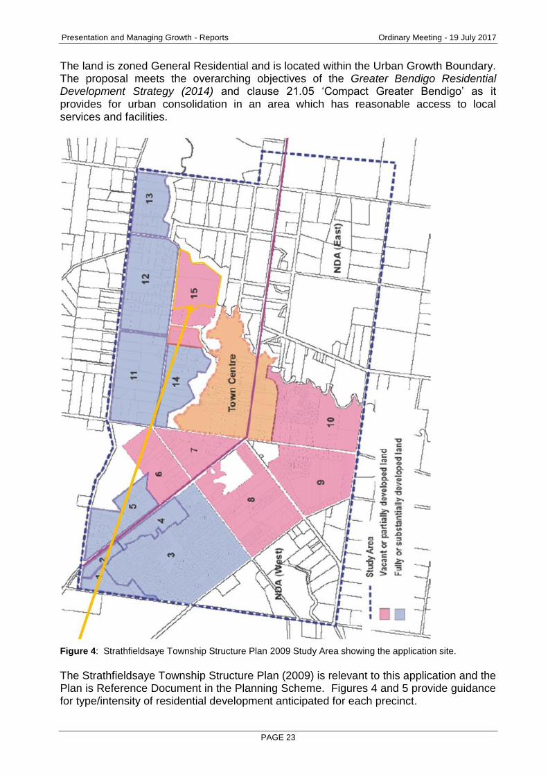
The land is zoned General Residential and is located within the Urban Growth Boundary. The proposal meets the overarching objectives of the Greater Bendigo Residential Development Strategy (2014) and clause 21.05 ‘Compact Greater Bendigo’ as it provides for urban consolidation in an area which has reasonable access to local services and facilities.
Figure 4: Strathfieldsaye Township Structure Plan 2009 Study Area showing the application site. The Strathfieldsaye Township Structure Plan (2009) is relevant to this application and the Plan is Reference Document in the Planning Scheme. Figures 4 and 5 provide guidance for type/intensity of residential development anticipated for each precinct.

Presentation and Managing Growth - Reports Ordinary Meeting - 19 July 2017
PAGE 24
Figure 5: Precinct 12 (northern side of Sullivans Road) and precinct 15 (southern side) (Pg. 90).

Presentation and Managing Growth - Reports Ordinary Meeting - 19 July 2017
PAGE 25
Figure 6: Plan 1 highlighting where the ‘larger suburban lots/ frontage treatment’ apply and application site.

Presentation and Managing Growth - Reports Ordinary Meeting - 19 July 2017
PAGE 26
Page 29 of the Plan notes one of its strategies as being to encourage “…larger than average lots fronting roads that are located on high points in the landscape or where significant roadside vegetation contributes to the character of the streetscape (as shown in Plan 1)”. As can be seen in Figure 6 on the previous page, the application site (and Sullivans Road for that matter), is not shown on the plan as being a site where those strategy statements are proposed to apply.
The Township Plan is the guiding tool for formulating and assessing applications in the study area. The Plan is very clear in that it anticipates a conventional ‘suburban’ type of subdivision for this site. Whilst strictly speaking, ‘character’ is not a consideration for subdivisions over 60 lots (according to clause 56.03-5) a purpose of the General Residential Zone and Decision Guidelines note character as being a relevant planning consideration.
The City’s character policies date from a study conducted in 2001. It is fair to say that Strathfieldsaye has grown significantly in that time and that growth continues. The character study must be balanced with aspirations of the more recent Township Plan. Clause 22.22 sets out the Strathfieldsaye Township Residential Character Policy. Under the policy the site is within ‘Precinct 4’ and the statement of desired future character for that precinct is: "The spacious semi-rural open bushland character will be maintained and enhanced”. The proposal addresses the majority of the policy objectives as follows:
Objectives Preferred Design Response
To maintain and strengthen the native and indigenous vegetation dominated streetscapes.
Retain established, indigenous tree and understorey species.
Replace any indigenous trees lost due to the development with similar species and sized trees.
Buildings should be sited and designed to incorporate space for the planting of substantial vegetation (locate footings outside root zone).
Prepare a landscape plan to accompany all development proposals.
Assessment: The subdivision meets, or can meet the majority of the preferred design response; notwithstanding the fact that vegetation removal on the application site is part of the proposal. A landscape master plan (figure 3 in this report) shows a concept treatment for the creek interface with the subdivision site. The intention on that concept is to blur the line where the application land ceases and the public land commences. Conditions of the permit will require that street trees (both on Sullivans Road and the proposed internal roads) to be locally indigenous. The average lot size in the subdivision of 725 sq.m. presents opportunity for canopy tree plantings within the proposed lots.
To maintain the bush setting of the dwellings.
Buildings should be set back substantial distances from front and side boundaries.

Presentation and Managing Growth - Reports Ordinary Meeting - 19 July 2017
PAGE 27
Objectives Preferred Design Response
Assessment: The policy does not set out what a ‘substantial’ setback is, and the more recent Township Plan does not nominate a setback for Sullivans Road. In terms of addressing the objective, the application has responded by having many of the lots fronting Sullivans Road as being 20 metres or greater in width. The developer has also provided Officers with information as to the proposed covenants that would apply in the subdivision. The covenants would require that no side fencing be permitted forward of the front wall of the dwellings, nor would front fencing be permitted. This would have the effect of the subdivision appearing to be more spacious as a result of property boundaries not being defined by fences, when viewed from the public realm. An option available to Council would be to require a condition on permit to have a building exclusion area for a nominated distance to ensure that no walls get built to side boundaries of lots. The permit recommends that this measure be implemented for the lots fronting Sullivans Road only.
To ensure that adequate space is available on private land for the retention and planting of vegetation.
The total hard surface site coverage (including outbuildings, swimming pools, tennis courts, driveways and all non-permeable surfaces), should not exceed 40%.
Proposals that exceed the specified site coverage maximums must demonstrate that the site coverage objective and all remaining objectives and design responses have been met.
Assessment: The land in question is not an exemplar of the ‘bushland’ character, being largely cleared and historically farmed. It is unlikely that the preferred design response of not exceeding 40% is realistic for this proposal; but this criteria must be balanced with the more detailed (and current) strategic work the City undertook that resulted in the Strathfieldsaye Township Plan recommending that conventional lot sizes apply in this precinct. Had it been the City’s strategic intent to limit density and site coverage for this site (or others in the precinct) the City could have elected to back-zone the land to say a Low Density Residential Zone; or apply a Significant Landscape Overlay to formally control density/site coverage (as opposed to simply note it in the Policy).
To ensure that buildings and extensions do not dominate the streetscape and wider landscape setting.
Buildings should not protrude above the predominant tree canopy height.
Assessment: It is unlikely that conventional residences of single or two storey will protrude above tree canopies.
To use materials and finishes that harmonise with the semi-rural open
Use earthy toned building materials, finishes or colours.

Presentation and Managing Growth - Reports Ordinary Meeting - 19 July 2017
PAGE 28
Objectives Preferred Design Response
bushland setting.
Assessment: The materials, finishes or colours of future dwellings will be guided by individual taste. It would not be appropriate for this permit to seek to control this.
To maintain and enhance the continuous flow of vegetation across the landscape.
Provide no fencing or post and wire style only to the front, sides and rear.
Assessment: As noted previously, the developer’s intention is to not allow front or side fences (forward of the front wall of the dwellings).
The proposal will have an excellent and well resolved interface with the creek and the lots fronting Sullivans Road will create a different character to that which exists on the opposite side of Sullivans Road. The character will also be defined by a more ‘urban’ treatment than is currently the case as the subdivision will include kerb, channel and footpath, which will contrast with the earthen swales on the opposite side of the road. The application has not identified that vegetation (whether native, or the poplars at the eastern end of the Sullivans Road frontage) will be removed outside of the application site. Officers recommend that vegetation (in particular the poplars) be retained. The majority of the poplars could be retained as most are within the frontage of proposed lot 134. In balancing competing objectives, it is concluded that the subdivision has a high level of compliance with planning policy for housing and the more specific guidance found in the Township Plan and Character Policy. The site is zoned appropriately and is within the City’s Urban Growth Boundary, with the result being there is no compelling reason as to why the site should not be developed as proposed, having regard to policy. Can the lots be appropriately serviced, accessed (including consideration of impacts on the broader road network) and meet the requirements of clause 56? A part of the processing of an application for subdivision involves a mandatory referral to all services authorities (with the exception of telecommunications). The function this referral has is an important one in determining whether a site should be developed or not. Each service has the power to either consent, with or without conditions, or object to the granting of the permit. If a service, for example Coliban Water or Powercor were to object to the permit (on the basis that the land cannot be serviced) Council would have to refuse the application. In this case, all service authorities consent conditionally to the granting of the permit. The developer is required to construct and fund infrastructure that would become assets for the respective services and this must occur with their full approval, inspection and ultimate signoff.

Presentation and Managing Growth - Reports Ordinary Meeting - 19 July 2017
PAGE 29
With respect to access and impacts on the road network, the City’s Engineers conditionally consents to the proposal, subject to the requirements noted in the recommended conditions which include turn lanes to meet established the standards, Traffic impacts are very real impacts that result from subdivision and a significant concern to objectors. The City, as the manager of the road in question, requires a high standard of design and construction to ensure the road functions appropriately and not unreasonably impacts on amenity or safety. City Officers have had the benefit of a Transport Impact Assessment Report (prepared by the proponent) to review which assisted Officers in their consideration of the impacts of the proposal. Clearly the changes resulting from each lot having driveway access to Sullivans Road and the two entrance points to the wider estate also being from Sullivans Road, will have a real impact on residents. The traffic impacts have been assessed by expert City officers who have formed a view that the impacts on the road network are acceptable, can meet City standards (subject to the conditions being applied to the permit as recommended) and the proposal does not warrant refusal on traffic issues as a result of this. The requirements of Clause 56 apply to this subdivision. A response to the key objectives is provided as follows. Clause 56.02 Policy Implementation The objective is to ensure the layout and design of a subdivision is consistent with an implements any objective, policy, strategy or plan for the area set out in this scheme. The proposed subdivision is consistent with strategic plans which apply to the area. The Southern Loddon Mallee Regional Strategic Plan identifies that the majority of new urban development will need to be contained within existing small towns and settlements or designated growth areas. It is considered that the site at Strathfieldsaye is suitably located and zoned for residential development and is therefore consistent with the Southern Loddon Mallee Regional Strategic Plan. In addition to the above, broad scale strategic plan, it is considered the proposal is consistent with the Greater Bendigo Residential Strategy. Clause 56.03-2 Activity Centre Objective The objective is to provide for mixed-use activity centres, including neighbourhood activity centres, of appropriate area and location. The village centre of Strathfieldsaye (as it is designated by clause 21.07-1) is located within 700 metres (as the crow flies at its closest point) of the site and can be appropriately accessed through the existing road and pedestrian networks.

Presentation and Managing Growth - Reports Ordinary Meeting - 19 July 2017
PAGE 30
The existing activity centre (for which the City has completed an Urban Design Framework to guide its growth) is considered to be appropriately located to support the future residential growth proposed by this subdivision. The additional residential development will create a demand and promote the need for additional commercial and community services growth. Clause 56.04-1 Lot Diversity and Distribution Objectives The objective is:
To achieve housing densities that support compact and walkable neighbourhoods and the efficient provision of public transport services.
To provide higher housing densities within walking distance of activity centres.
To achieve increased housing densities in designated growth areas.
To provide a range of lot sizes to suit a variety of dwelling and household types. The subdivision will create 173 lots ranging in size between 427 to 1,338 square metres, with the average lot size being 725 square metres. The layout does not provide a range of lot sizes and will be unlikely to result in a variety of dwelling and household types as requested by this clause. The lot sizes are conventional in size and would facilitate detached, single dwellings comfortably. Should community needs change in the future; some lots (for example corner lots) may be suitable for further subdivision and dwellings. Whilst the proposal could be improved with greater diversity in lot sizes, the proposal has been assessed as being acceptable. Clause 56.05-1 Integrated Urban Landscape Objectives The objective is:
To provide attractive and continuous landscaping in streets and public open spaces that contributes to the character and identity of new neighbourhoods and urban places or to existing or preferred neighbourhood character in existing urban areas.
To incorporate natural and cultural features in the design of streets and public open space where appropriate.
To protect and enhance native habitat and discourage the planting and spread of noxious weeds.
To provide for integrated water management system and contribute to drinking water conservation.
The proposed subdivision will result in the creation of a number of local roads which are linked to the broader road network by Sullivans Road. A concept landscape plan has been prepared to accompany the application that demonstrates the sensitive creek interface will be appropriately treated and have dwellings actively fronting it, as opposed to turning away from it. Existing and proposed

Presentation and Managing Growth - Reports Ordinary Meeting - 19 July 2017
PAGE 31
road reserves will be landscaped utilizing a mixture of native plant species, creating a visually attractive vegetated network. Detailed landscape plans will be required to be submitted to the City of Greater Bendigo prior to each stage of the subdivision. An integrated water management system will be designed for the subdivision to ensure the quality and quantity of water run-off meets the relevant required standards and will not have an adverse impact on the broader area. Clause 56.07-4 Urban Run-Off Management Objective The objective is:
To minimise damage to properties and inconvenience to residents from urban run-off.
To ensure that the street operates adequately during major storm events and provides for public safety.
To minimise increases in stormwater run-off and protect the environmental values and physical characteristics of receiving waters from degradation by urban run-off.
Stormwater run-off from each new allotment will be directed to a legal point of discharge; with larger events catered for by the drainage reserve, road network and bio-retention basin. Stormwater discharge from the site will ultimately outfall to Sheepwash Creek. The applicant was required to prepare a drainage strategy to demonstrate that the subdivision will not have impacts downstream of the development site. A water quality treatment facility will be provided in the drainage reserve and designed to meet current best practice performance standards. All detailed stormwater design will be required to be to the satisfaction of the City of Greater Bendigo's Engineers and the North Central Catchment Management Plan. Flooding impacts (including treatment of the interface with Sheepwash Creek); Objectors have raised concerns about flooding and anecdotal evidence about the levels of flooding that have occurred historically on the site. The site is currently subject to a Land Subject to Inundation Overlay and was also within the study area for the Bendigo Flood Study. The Flood Study is to be implemented by Planning Scheme Amendment C221, for which a Panel Report has been received, though Council is yet to consider a report on whether to forward the Amendment to the Minister for approval. The extent of the existing and proposed Land Subject to Inundation Overlay is shown in the Figure below. The extent of the Overlay will contract as a result of the proposed changes to overlay.

Presentation and Managing Growth - Reports Ordinary Meeting - 19 July 2017
PAGE 32
Figure 7: Extent of the existing (left) and proposed (right) Land Subject to Inundation Overlay. The application was referred to the North Central Catchment Management Authority (NCCMA), Goulburn Murray Water, and the City’s Engineering and Open Space units. The CMA required extensive further information around flooding and drainage impacts. Two separate technical reports dealing with these issues were prepared by the applicant for assessment by the regulators, including the City’s Development Engineer. The result of the assessments undertaken by the regulators and the City’s Development Engineer is that the drainage concept is acceptable, subject to review of detailed design plans, and all bodies consent (conditionally) to this aspect of the application. As can be seen on the landscape concept, the proposed method of treating stormwater and flooding includes a Water Sensitive Urban Design that includes a bio-retention basin. The development has been designed so that appropriate separation (an average of 30 metres from the top of bank of Sheepwash Creek) is achieved and that 30 of the lots will have frontage to the creek (separated by a proposed road and its verge). No fencing is proposed between the application site and the creek (which takes in the Strathfieldsaye Community Enterprise funded pedestrian path) and a sensitive landscape treatment is proposed which will serve as an appropriate transition from and to the existing Crown land. The road, its verges and the landscape treatment will be vested in Council who will manage the existing reserve as well as the proposed addition to it. The provision of open space: The application does not propose to provide a dedicated area of open space; though the verge, which will be added to the existing creek reserve will provide for passive recreation. The reason why the application does not propose an area of open space is that officers (Parks, Open Space and Statutory Planning) determined that the broader open space requirement for this development is best served by providing a direct link from this estate to the open space network provided in the Imagine Estate. The open space network vested in Council will meet the open space needs for residents of both estates. This is the reason why the permit recommends that an open space contribution of up to 5% of the pre-developed value of the land be made to Council in lieu of providing an area of open space. The funds that the City receives (prior to a statement of compliance for
Presentation and Managing Growth - Reports Ordinary Meeting - 19 July 2017
PAGE 33
Stage 1 of the subdivision) will be used by the City to construct the pedestrian bridge shown on the landscape master plan and associated works. Issues raised by the objections. The issues raised by objectors all relate to relevant questions of merit raised by the application. The report above has given due consideration to the applicant's submission, expert advice from regulators, City Officers and the objections received. The view formed by the Planning Unit is that whilst existing residents will be impacted by the proposal, the merits of the application are strong and there is a high degree of compliance with the Planning Scheme. Some conditions are proposed to moderate the proposal, however on the whole the impacts of the proposal are acceptable and that a net community benefit will result from the approval of the application.
Conclusion
The application is recommended for approval on the basis that it represents an acceptable outcome with regards to the requirements of the Greater Bendigo Planning Scheme
Options
Council, acting as the responsible authority for administering the Planning Scheme, may resolve to: grant a permit, grant a permit with conditions, or refuse to grant a permit.
Attachments
Objections received.
Permit applicant correspondence regarding proposed restrictive covenants.
Traffic Impact Assessment Report (commissioned by the permit applicant, prepared by SALT3
Proposed Notice of Decision Conditions
1. PLANS TO BE ENDORSED The plans to be endorsed and which will then form part of the permit are the Revision 15 plans dated 25 November 2016 submitted with the application.
2. LAYOUT MUST NOT BE ALTERED The layout of the subdivision as shown on the endorsed plans must not be altered without the written consent of the responsible authority.
3. STAGING PLAN Before a statement of compliance is issued for the first stage of the subdivision a staging plan to the satisfaction of the responsible authority must be submitted to and approved by the responsible authority.
4. ORDER OF STAGES The subdivision of the land must proceed in the order of stages as shown on the

Presentation and Managing Growth - Reports Ordinary Meeting - 19 July 2017
PAGE 34
endorsed plan except with the written consent of the responsible authority.
5. CREATION OF RESTRICTION (a) Prior to the certification of stages 1, 4 and 9 with respect to Lots 1-15 and
Lots 121-134 (both inclusive) a restriction, in the form of building envelopes must be shown on the plans of subdivision. The building envelope is to show a 1 metre setback off each side boundary (for the first 12 metres of the lots); and a 5 metre front setback.
(b) Prior to the certification of any plan, a restriction in accordance with Goulburn Murray Water Condition 24 (c) is recorded.
6. LANDSCAPE PLAN
(a) Prior to the certification of the first stage of the subdivision, the landscape masterplan prepared by Sentient Design dated 28 February 2017 is required to be modified as follows:
Remove all bollards adjacent perimeter road and substitute with barrier kerb.
Remove all references to natural play areas.
Remove 1.5m path connection to picnic table, picnic table on concrete slab to be retained in current location.
Tree planting in reserve only, all references to shrub and grass planting to be removed.
(a) Before a statement of compliance is issued for each stage of the subdivision a landscape plan to the satisfaction of the responsible authority must be submitted to and approved by the responsible authority for the relevant stage. When approved, the plan will be endorsed and then form part of the permit.
(b) Unless the prior written consent of the responsible authority is given, the poplar trees in Sullivan Road adjoining proposed lot 134 (in stage 4) are required to be retained, and protected (with the exception of provision of a driveway to that lot as required by condition 5 (a)). The plan for that stage must show how the trees will be protected during construction.
7. COMPLETION OF LANDSCAPING
Before a statement of compliance is issued for each stage of the subdivision the landscaping works shown on the endorsed must be carried out and completed for that stage to the satisfaction of the responsible authority.
8. LANDSCAPING MAINTENANCE The landscaping works shown on the endorsed plans must be maintained to the satisfaction of the responsible authority for 24 months after the works are completed, including that any dead, diseased or damaged plants are to be replaced.
9. DWELLING PLANS REQUIRED Prior to the development of dwellings and fences of lots that are within the Land Subject to Inundation Overlay, site, floor and elevation plans showing the finished floor level of each dwelling (in accordance with North Central CMA condition 23) must be submitted and approved by the Responsible Authority. Once endorsed, the plans must not be amended without the prior written consent of the Responsible Authority.
Presentation and Managing Growth - Reports Ordinary Meeting - 19 July 2017
PAGE 35
10. PUBLIC OPEN SPACE CONTRIBUTION
Before a statement of compliance is issued the applicant or owner must pay to the responsible authority a sum equivalent to a maximum of 5% of the site value of all the land in the subdivision.
11. DETAILED DRAINAGE Prior to the certification of the plan of subdivision under the Subdivision Act 1988, plans to the satisfaction of the responsible authority must be submitted to and approved by the responsible authority. When approved, the plans will be endorsed and then will form part of the permit. The plans must be drawn to scale with dimensions. The plans must include: (a) Direction of stormwater run-off. (b) A point of discharge for each lot. (c) Independent drainage for each lot. (d) Approval from the relevant authority for the point of discharge.
12. DRAINAGE EASEMENTS The subdivision must provide easements for drainage within and through the subject land for external outfall drainage to a point of lawful discharge to the satisfaction of the responsible authority.
13. STORMWATER DETENTION Before a statement of compliance is issued for the subdivision the developer must provide onsite surface and stormwater detention to pre-development levels in accordance with plans and specifications to the satisfaction of the responsible authority.
14. STORMWATER QUALITY Before the subdivision starts the developer must provide a stormwater treatment system to achieve the Best Practice Environmental Guidelines storm water quality (Victoria Stormwater Committee 1999) in accordance with plans and specifications to the satisfaction of the responsible authority.
15. CONSTRUCTION OF WORKS Road works, drainage and other civil works must be constructed in accordance with the Infrastructure Design Manual and plans and specifications approved by the responsible authority and must include: (a) Fully sealed pavement with kerb and channel. (b) Paved footpaths. (c) Underground drainage. (d) Underground conduits for water, gas, electricity and telephone. (e) Appropriate intersection and traffication measures. (f) Appropriate street lighting and signage. (g) High stability permanent survey marks. Sullivans Road (h) Construct southern carriageway to collector street level 1 standard road
including SM2 kerb and channel. (i) 1.5m concrete shared footpath. (j) Underground drainage. (k) Underground conduits for water, gas, electricity and telephone.

Presentation and Managing Growth - Reports Ordinary Meeting - 19 July 2017
PAGE 36
(l) Appropriate street lighting and signage. (m) Basic Right Turn treatment (BAR) must be provided in Sullivans Road at both
entrances (eastern and western) in accordance with Section 4.5 of the Guide to Road Design Part 4A: Unsignalised and Signalised Intersections.
16. DECORATIVE LIGHTING
If decorative lighting is to be used within the subdivision: (a) Before the certification of a plan of subdivision, or any other time agreed to by
the responsible authority, a decorative lighting plan must be submitted to and approved by the responsible authority. When approved the decorative lighting plan will be endorsed and then form part of the permit.
(b) All decorative lighting within the subdivision must be constructed in accordance with the approved decorative lighting plan.
(c) Before a statement of compliance is issued the developer must make a decorative lighting payment to the responsible authority in accordance with Table 15 of the Infrastructure Design Manual.
17. PUBLIC ASSETS
Before the subdivision starts the developer must submit to the responsible authority a written report and photos of any prior damage to public infrastructure. Listed in the report must be the condition of kerb and channel, footpath, seal, street lights, signs and other public infrastructure fronting the property and abutting at least two properties either side of the development. Unless identified with the written report, any damage to infrastructure post construction will be attributed to the development. The owner or developer of the subject land must pay for any damage caused to any public infrastructure caused as a result of the development or use permitted by this permit.
18. CONSTRUCTION MANAGEMENT PLAN Prior to commencement of works the owner or applicant must submit a Construction Management Plan (CMP) for approval by the responsible authority. The plan must include: (a) A site specific plan showing proposed erosion and sedimentation control
works. (b) Techniques and intervention levels to prevent a dust nuisance. (c) Techniques to prevent mud and dirt being transported from the site to
adjacent streets. (d) The protection measures taken to preserve any vegetation identified for
retention. During construction of works associated with the subdivision, the must employ and provide the protection methods contained in the CMP to the satisfaction of the responsible authority and the Environment Protection Agency.
19. COLIBAN WATER (a) The owner is required to provide reticulated water and sewerage services to
each of the lots within the subdivision. Services are to be provided in accordance with Coliban Water’s specifications.
(b) All Coliban Water assets within the subdivision, both existing and proposed, are to be protected by an easement in favour of Coliban Region Water Corporation.

Presentation and Managing Growth - Reports Ordinary Meeting - 19 July 2017
PAGE 37
(c) The Emu Valley No. 1 Rural Channel traverses the development site. The developer and their nominated consultant must liaise with Coliban Water prior to submission of a design for the piping of the channel.
(d) The developer and their nominated consulting engineer must liaise with Coliban Water prior to submission or preparation of a design for sewer and water infrastructure.
20. POWERCOR
(a) The plan of subdivision submitted for certification under the Subdivision Act 1988 shall be referred to Powercor Australia Ltd in accordance with Section 8 of that Act.
(b) The plan of subdivision submitted for certification under the Subdivision Act 1988 shall be referred to Powercor Australia Ltd in accordance with Section 8 of that Act.
(c) The applicant shall:- Provide an electricity supply to all lots in the subdivision in accordance with Powercor’s requirements and standards, including the extension, augmentation or re-arrangement of any existing electricity supply system, as required by Powercor (A payment to cover the cost of such work will be required). In the event that a supply is not provided the applicant shall provide a written undertaking to Powercor Australia Ltd that prospective purchasers will be so informed.
(d) Where buildings or other installations exist on the land to be subdivided and are connected to the electricity supply, they shall be brought into compliance with the Service and Installation Rules issued by the Victorian Electricity Supply Industry. You shall arrange compliance through a Registered Electrical Contractor.
(e) Any buildings must comply with the clearances required by the Electricity Safety (Installations) Regulations.
(f) Any construction work must comply with Energy Safe Victoria’s “No Go Zone” rules.
(g) Set aside on the plan of subdivision for the use of Powercor Australia Ltd reserves and/or easements satisfactory to Powercor Australia Ltd where any electric substation (other than a pole mounted type) is required to service the subdivision. Alternatively, at the discretion of Powercor Australia Ltd a lease(s) of the site(s) and for easements for associated powerlines, cables and access ways shall be provided. Such a lease shall be for a period of 30 years at a nominal rental with a right to extend the lease for a further 30 years. Powercor Australia Ltd will register such leases on the title by way of a caveat prior to the registration of the plan of subdivision.
(h) Provide easements satisfactory to Powercor Australia Ltd, where easements have not been otherwise provided, for all existing Powercor Australia Ltd electric lines on the land and for any new powerlines required to service the lots and adjoining land, save for lines located, or to be located, on public roads set out on the plan. These easements shall show on the plan an easement(s) in favour of "Powercor Australia Ltd" for “Power Line” pursuant to Section 88 of the Electricity Industry Act 2000.
(i) Obtain for the use of Powercor Australia Ltd any other easement external to the subdivision required to service the lots.
(j) Adjust the position of any existing easement(s) for powerlines to accord with the position of the line(s) as determined by survey.
(k) Obtain Powercor Australia Ltd’s approval for lot boundaries within any area

Presentation and Managing Growth - Reports Ordinary Meeting - 19 July 2017
PAGE 38
affected by an easement for a powerline and for the construction of any works in such an area.
(l) Provide to Powercor Australia Ltd, a copy of the version of the plan of subdivision submitted for certification, which shows any amendments which have been required.
21. TELECOMMUNICATIONS
(a) The owner of the land must enter into an agreement with: • A telecommunications network or service provider for the provision of
telecommunication services to each lot shown on the endorsed plan in accordance with the provider’s requirements and relevant legislation at the time.
• A suitably qualified person for the provision of fibre ready telecommunication facilities to each lot shown on the endorsed plan in accordance with any industry specifications or any standards set by the Australian Communications and Media Authority, unless the applicant can demonstrate that the land is in an area where the National Broadband Network will not be provided by optical fibre.
(b) Before the issue of a statement of compliance for any stage of the subdivision under the Subdivision Act 1988, the owner of the land must provide written confirmation from:
• A telecommunications network or service provider that all lots are connected to or are ready for connection to telecommunications services in accordance with the provider’s requirements and relevant legislation at the time.
• A suitably qualified person that fibre ready telecommunication facilities have been provided in accordance with any industry specifications or any standards set by the Australian Communications and Media Authority, unless the applicant can demonstrate that the land is in an area where the National Broadband Network will not be provided by optical fibre.
22. COUNTRY FIRE AUTHORITY
Hydrants: (a) Prior to the issue of a Statement of Compliance under the Subdivision Act
1988 the following requirements must be met to the satisfaction of the CFA:
Above or below ground operable hydrants must be provided. The maximum distance between these hydrants and the rear of all building envelopes (or in the absence of building envelopes, the rear of the lots) must be 120 metres and the hydrants must be no more than 200 metres apart. These distances must be measured around lot boundaries.
The hydrants must be identified with marker posts and road reflectors as applicable to the satisfaction of the Country Fire Authority.
Roads: (a) Roads must be constructed to a standard so that they are accessible in all
weather conditions and capable of accommodating a vehicle of 15 tonnes for the trafficable road width.
(b) Proposed roads must have a suitable trafficable width to allow the unimpeded access of emergency fire fighting vehicles (notwithstanding any parking restrictions that Council may apply) to the satisfaction of CFA.
(c) The average grade must be no more than 1 in 7 (14.4%) (8.1 degrees) with a maximum of no more than 1 in 5 (20%) (11.3 degrees) for no more than 50

Presentation and Managing Growth - Reports Ordinary Meeting - 19 July 2017
PAGE 39
metres. Dips must have no more than a 1 in 8 (12%) (7.1 degree) entry and exit angle.
(d) Curves must have a minimum inner radius of 10 metres. (e) Dead end roads and cul-de-sac’s more than 60m in length from the nearest
intersection must have a turning circle with a minimum radius of 8m (including roll-over kerbs if they are provided); T or Y heads of dimensions specified by the CFA may be used as alternatives.
23. NORTH CENTRAL CATCHMENT MANAGEMENT AUTHORITY
(a) Unless otherwise agreed in writing with the Responsible Authority and the North Central CMA, all new allotments must be filled to at least 300 millimetres above the applicable 1% AEP flood level(s). Prior to issuing a statement of compliance a certified survey plan of the finished surface levels prepared by a licensed surveyor must be submitted to the Responsible Authority and North Central CMA for its approval.
(b) Unless otherwise agreed in writing with the Responsible Authority and the North Central CMA, the proposed development must not reduce the available flood storage on the site. A balance of cut and fill must be achieved on the site. Any proposed cut must be self-draining. Prior to the commencement of works detailed plans and computations demonstrating how this condition will be achieved must be provided to the North Central CMA for approval.
(c) All buildings and works (including roads) must be setback an average of at least 30 metres from the top of bank of Sheepwash Creek.
(d) Prior to the commencement of works detailed engineering plans and computations must be submitted to North Central CMA and the Responsible Authority demonstrating that any flow along the road achieves the following safety criteria:
Depth ≤ 0.35 metres; and
Velocity ≤ 1.5 metres/second; and
Depth x Velocity ≤ 0.35 metres2/second (e) Prior to issuing a statement of compliance a certified survey plan of the
finished road surface levels prepared by a licensed surveyor must be submitted to the responsible authority and North Central CMA for its approval.
(f) Stormwater runoff arising from the site must be treated to best practice standards prior to discharging to the waterway. Prior to the commencement of works, detailed plans of the proposed stormwater treatment method must be submitted to the Responsible Authority and North Central CMA for its comment/approval
(g) The number of new stormwater connections to the waterway must be limited and prior to the commencement of drainage works, a separate “Works on Waterway” permit must be obtained directly from North Central CMA. Please contact North Central CMA on (03) 5440 1896 to obtain a full understanding of the Authority’s requirements.
(h) A landscape plan must be prepared for the waterway reserve by a suitably qualified professional and approved by the Responsible Authority and North Central CMA. Prior to issuing a statement of compliance, the waterway reserve must be shaped and landscaped to the satisfaction of North Central CMA and the Responsible Authority.
(i) Unless otherwise agreed in writing, prior to issuing a statement of compliance, unauthorised vehicle access and parking on the reserve must be prevented by the use of suitable fencing such as bollard or post and rail, or
Presentation and Managing Growth - Reports Ordinary Meeting - 19 July 2017
PAGE 40
non-mountable kerb. Additionally, bollards or impenetrable planting must be used to restrict access into potentially hazardous areas around the proposed sediment pond.
(j) Prior to the commencement of any works, appropriate silt control measures must be installed to prevent sediment laden runoff from entering the waterway. The silt control measures must be maintained throughout the construction period.
(k) Prior to the commencement of any works, an exclusion fence must be installed to delineate the required 30 metre setback from the top of bank of the waterway. No works or fill material are permitted within the exclusion zone during the construction period.
24. GOULBURN MURRAY WATER
(a) Each lot must be provided with connection to the reticulated sewerage system in accordance with the requirements of the relevant urban water authority, including the existing dwelling.
(b) All works within the subdivision must be done in accordance with EPA Publication 960 “Doing It Right on Subdivisions, Temporary Environmental Protection Measures for Subdivision Construction Sites”, September 2004.
(c) The Plan of Subdivision must show a 30 metre wide buffer zone adjacent to Emu Creek and Sheepwash Creek. No buildings are to be constructed within this zone.
(d) Prior to Certification of the Plan of Subdivision, Goulburn Murray Water requires a Stormwater Management Plan be prepared to the satisfaction of the Responsible Authority and Goulburn Murray Water. The Plan must be prepared in accordance with the principles outlined in Urban Stormwater: Best Practice Environmental Management Guidelines’ (Victorian Stormwater Committee, 1999). The Stormwater Management Plan must show through the application of MUSIC modelling or similar that the development can meet post construction objectives for environmental management of stormwater, as specified in Table 2.1 of the Urban Stormwater: Best Practice Environmental Management Guidelines’ (Victorian Stormwater Committee, 1999).
25. DEPARTMENT OF ENVIRONMENT, LAND, WATER AND PLANNING
Native Title (a) Works on the Crown land must not commence until the requirements of the
Dja Dja Wurrung Land Use Activity Agreement have been satisfied. Construction Management (b) Prior to the commencement of works, works engineers, design engineers,
surveyors, works crews, contractors and particularly plant operators must be properly briefed on all environmental requirements of the planning permit. A copy of the permit is to be made available to all employees working on the project.
Water Quality (c) No polluted and/or sediment laden run-off or other concentrated flow of water
is to be discharged directly or indirectly into the adjoining Crown land. Overland flows into the Reserve must be maintained at the same rate post-development as at present.
(d) No stormwater is to be discharged to the adjoining Crown land without the consent of the Department of Environment, Land, Water and Planning.
Reducing Risks of Pollution by Work
Presentation and Managing Growth - Reports Ordinary Meeting - 19 July 2017
PAGE 41
(e) To protect the nearby waterways, no works office, toilet and service facility is to be established within 100 metres of any creek, channel or drainage line. Oils, greases, used grease cartridges, used oil filters, air filters and other construction works refuse, including old fencing wire and fence posts removed to undertake the works, will be properly disposed of away from the waterway according to EPA requirements.
Notification of permit conditions (f) Before works start, the permit holder must advise all persons undertaking the
vegetation removal and works on site of all conditions of this permit. Protection of vegetation to be retained (g) Before works start, a protection fence must be erected around all native
vegetation to be retained within 15 metres of the works area. This fence must be erected at a minimum of:
12 times the diameter of the tree trunk at 130 cm above ground level (to a maximum
Distance of 15 metres) but no less than 2 metres from the base of the trunk, and
2 metres from remnant patches of native vegetation. (h) The protection fence must be constructed of star pickets and paraweb or
similar to the satisfaction of the Department of Environment, Land, Water and Planning. The protection fence must remain in place at least until all works are completed to the satisfaction of the department. Except with the written consent of the department, none of the following may occur within this area:
Vehicular or pedestrian access, trenching or soil excavation
Storage or dumping of tools, equipment or waste
Construction of entry and exit pits for underground services. Native vegetation offsets (i) In order to offset the removal of 0.162 hectares of native vegetation and 5
scattered trees (total 0.513ha) approved as part of this permit, the applicant must provide a native vegetation offset that meets the following requirements, and is in accordance with the Permitted clearing of native vegetation – Biodiversity assessment guidelines and the Native vegetation gain scoring manual. The offset must:
Contribute gain of 0.108 general biodiversity equivalence units;
Be located within the North Central Catchment Management Authority boundary or Greater Bendigo municipal district; and
Have a strategic biodiversity score of at least 0.602. Offset evidence (j) Before any native vegetation is removed, evidence that an offset has been
secured must be provided to the satisfaction of the responsible authority. This offset must meet the offset requirements set out in this permit and be in accordance with the requirements of the Permitted clearing of native vegetation – Biodiversity assessment guidelines and the Native vegetation gain scoring manual. Offset evidence can be either:
A credit register extract from the Native Vegetation Credit Register; or
A security agreement, to the required standard, for the offset site or sites, including a 10- year offset management plan to the satisfaction of the Department of Environment, Land, Water and Planning and approved by the Responsible Authority. Every year, for ten years, after the responsible
Presentation and Managing Growth - Reports Ordinary Meeting - 19 July 2017
PAGE 42
authority has approved the offset management plan, the applicant must provide notification of the management actions undertaken towards implementing the offset management plan, to the department. An offset site condition statement, including photographs must be included in this notification.
26. EXPIRY OF THE PERMIT - STAGED SUBDIVISION This permit will expire unless: (a) All stages of the approved subdivision have been certified within five years of
the date of this permit; (b) Any stage of the approved subdivision is not completed within five years of
the certification of the plan of subdivision under the Subdivision Act 1988; or (c) All dwellings, fences and works requiring a permit under the Land Subject to
Inundation Overlay are not completed within 10 years of the date of this permit.
The responsible authority may extend the time for certification of a plan of any stage of the subdivision or development may be completed if a request is made in writing before the permit expires, or thereafter, within the period allowed by section 69 of the Planning and Environment Act 1987.
North Central CMA Note Flood levels for the 1 % AEP (100 year ARI) flood event have been determined for this area under provisions of the Water Act 1989. The applicable 1% AEP flood level for the location described above is 195.5 metres AHD at the upstream property boundary down to 193.2 metres AHD at the downstream property boundary, which was obtained from the Bendigo Urban Flood Study 2013. Country Fire Authority Note: CFA’s requirements for identification of hydrants are specified in “Identification of Street Hydrants for Firefighting Purposes” available under publications on the CFA web site (www.cfa.vic.gov.au) Department of Environment Land Water and Planning Note:
Prior to the commencement of works, a Protected Flora Permit must be obtained from the Department of Environment, Land, Water and Planning to remove protected flora during works. Please contact the department’s regional office.
The adjoining Crown land is not to be used for access, storage of materials or rubbish. Any private use of Crown land requires consent and/or licensing from the Department of Environment, Land, Water and Planning.
To assist applicants meet permit condition requirements, Meeting permit conditions – third party offsets Fact sheet (DEPI 2013) and First party general offset kit (DEPI 2013) are available, Please visit www.depi.vic.gov.au/nativevegetation for further information.

Presentation and Managing Growth - Reports Ordinary Meeting - 19 July 2017
PAGE 43
2.2 8 JULIAN COURT, EPSOM 3551 - THE CONSTRUCTION OF THREE DWELLINGS ON THE LAND; AND THE STAGED SUBDIVISION OF THE LAND INTO THREE LOTS AND COMMON PROPERTY, IN ACCORDANCE WITH THE ENDORSED PLANS
Document Information
Author Bryce Kilian, Statutory Planner Responsible Bernie O’Sullivan, Director Strategy and Growth Director
Summary/Purpose
Application details: The construction of three dwellings on the land; and the staged subdivision of the land into three lots and common property, in accordance with the endorsed plans.
Application No: DSD/659/2016
Applicant: Langdon Building Pty Ltd
Land: 8 Julian Court, EPSOM 3551
Zoning: General Residential Zone
Overlays: None
No. of objections: 7
Consultation meeting:
10 November 2016
Key considerations: Whether the proposal is consistent with Planning Scheme policy regarding housing, design and infill residential development;
Whether the proposal is consistent with the provisions of the General Residential Zone;
Whether the proposal is consistent with the car parking provisions of the Scheme;
Compliance with ResCode and whether the impacts on neighbours are acceptable.
Conclusion: Planning Scheme policy and the General Residential Zone supports construction of additional dwellings on the lot. The design is found to be appropriate with regards to vehicle parking and the proposal is compliant with all ResCode standards and objectives. Overall the development is an appropriate and orderly planning outcome.

Presentation and Managing Growth - Reports Ordinary Meeting - 19 July 2017
PAGE 44
RECOMMENDATION
Pursuant to section 61 of the Planning and Environment Act (1987), Greater Bendigo City Council resolve to issue a Notice of Decision to Grant a Permit for the construction of three dwellings on the land; and the staged subdivision of the land into three lots and common property, in accordance with the endorsed plans at 8 Julian Court, EPSOM 3551 subject to the conditions at the end of this report:
~~~~~~~~~~~~~~~~~~~~~~~~~
Policy Context
City of Greater Bendigo Community Plan 2017-2021
Goal 4: Presentation and managing growth
Planning, developments and infrastructure that increase our liveability and pride in where we live.
Goal 6: Embracing our culture and heritage
Recognise and celebrate our unique history and diverse cultures.
Background Information
Previously submitted application plans The application originally applied for four dwellings and a four lot subdivision. That application received a number of objections relating primarily to the same grounds that this amended application has received, which are discussed in greater detail in the body of this report. Previous VCAT hearing which applied to this area The subject site once formed part of a larger, longer lot that extended from Station Street to behind the Epsom Village shopping centre. This lot was a ‘balance’ lot from when Robbins, Julian and Marnie Courts along with Tobin Crescent were created in 2011. An application was received (DS/884/2011) to subdivide this land into 26 lots and construct a new road joining Robbins, Julian and Marnie Courts together as shown below:
Presentation and Managing Growth - Reports Ordinary Meeting - 19 July 2017
PAGE 45
That application attracted approximately 43 objections based on similar grounds to this present proposal. At the time, Council resolved to refuse to grant a permit for the application after which the proponent appealed the decision to VCAT. The Tribunal issued an order on the 18 March 2013 to uphold the Council's decision to refuse the application, and noted that
Court bowls should be afforded a higher level of amenity than a ‘regular’ street which makes them somewhat unique. Despite this however it does not exempt them from any form of higher density development.
The Tribunal concluded that the likely traffic increases in Robbins Court which would ‘bear the brunt’ of the traffic movements would result in an unacceptable amenity impact to those residents who bought in a court for a higher level of amenity.
Report
Subject Site and Surrounds
The subject site is a rectangular shaped parcel of land located on the south-western side of Julian Court, with a shared southern boundary with Epsom Village shopping centre. As the site is at the end of Julian Court the frontage is only approximately 9.6 metres. The land’s total area is 1,100m² and its topography is almost entirely flat. The site is currently vacant land formed as part of a larger subdivision approved in 2015, which in itself formed part of a much larger subdivision which approved Julian Court prior to 2003.

Presentation and Managing Growth - Reports Ordinary Meeting - 19 July 2017
PAGE 46
Surrounding land uses are mostly residential in nature. There is consistency in built form and dwelling types and sizes in the area. The most noticeable traits of dwellings in the area include their detached nature, mostly single storey heights, pitched roofs and weatherboard cladding. Examples of infill unit development exist in the area. The site abuts the Epsom Village retail complex and also a pedestrian accessway linking Julian Court to Market Garden Circuit.
Figure 1: Location map showing subject site.
Figure 2: Broader locality map showing subject site with objectors' properties marked with a star. Note – not all objecting parties are shown due to their locality to the site.

Presentation and Managing Growth - Reports Ordinary Meeting - 19 July 2017
PAGE 47
Proposal
The application proposes a three lot subdivision with common property and the construction of three dwellings on the site. Subdivision The lot in question is approximately 1,120 square metres in size. The proposal seeks to divide this into three lots with common access. The lots proposed will measure 308 square metres, 184 square metres and 261 square metres respectively with the common property measuring 205 square metres. The lots will be oddly shaped owing to the shape of the parent property, the common property and placement of dwellings. The common property will access from Julian Court and will serve all three properties. The plans have demonstrated that all vehicles can enter and exit the site in a forwards direction.
Figure 3: Subdivision plan
Dwellings All dwellings will be three bedroom with combined kitchen, meals, lounge areas along with associated bathrooms and laundries. They will be built from brick and feature Colorbond roofing along with double attached garages accessing off the common property and all will be located centrally on their respective allotments.
Presentation and Managing Growth - Reports Ordinary Meeting - 19 July 2017
PAGE 48
Figure 4: Site plan
Figure 5: 3 dimensional image
Planning Controls - Greater Bendigo Planning Scheme
The following clauses are relevant in the consideration of this proposal: Permit Triggers
Clause 32.08-4 General Residential Zone: Construction of two or more dwellings on a lot and residential subdivision

Presentation and Managing Growth - Reports Ordinary Meeting - 19 July 2017
PAGE 49
State Planning Policy Framework
Regional development (cl. 11.05)
Urban environment (cl. 15.01)
Sustainable development (cl. 15.02)
Residential development (cl. 16.01)
Movement networks (cl. 18.02)
Municipal Strategic Statement
Municipal profile (cl. 21.01)
Key issues and influences (cl. 21.02)
Strategic directions (cl. 21.04)
Compact Bendigo (cl. 21.05)
Reference documents (cl. 21.10)
Other Provisions
General Residential Zone (cl. 32.08)
Car Parking (cl. 52.06)
ResCode – Two or more dwellings on a lot (cl. 55)
ResCode – Subdivision (cl. 56)
Decision guidelines (cl 65)
Referral and notice provisions (cl. 66)
Consultation/Communication
Referrals The following authorities and internal departments have been consulted on the proposal:
Referral Comment
Powercor No objection subject to conditions
Coliban Water No objection subject to conditions
Tenix No objection subject to conditions
North Central Catchment Management Authority
No objection subject to conditions
Traffic & Design No objection subject to conditions
Drainage No objection subject to conditions
Public Notification The application was advertised twice, once for the original proposal and a second time for the revised proposal, by way of notice on the site and letters to adjoining and nearby owners and occupiers.

Presentation and Managing Growth - Reports Ordinary Meeting - 19 July 2017
PAGE 50
As a result of advertising, seven objections were received, with the grounds of objection being:
Vehicle parking;
Vehicle manoeuvring;
Too many units/subdivisions already in the court;
Safety hazards;
Loss of business to Epsom shops as a result of the pathway removal;
Detrimental impact to Neighbourhood Character;
Excessive bins in the court bowl for bin collection day;
Drainage issues;
Undesirable behaviours due to increased density of development;
Non-compliance with a previous VCAT decision.
The objections are discussed below. Consultation was held after the first round of notice and objections were received. As a result of that consultation, the applicant reduced the proposal by removing one dwelling and one lot and creating on site visitor parking spaces. After these changes were made a second round of notice was given which attracted the same grounds of objection. This being the case, it was deemed unnecessary to formally consult again.
Planning Assessment
Is the proposal consistent with Planning Scheme policy regarding housing, design and infill residential development? Clause 11.05 (Regional development) seeks to promote the sustainable growth and development of regional Victoria. Clause 15.01 (Urban environment) seeks to create urban environments that are safe, functional and provide good quality environs with a sense of place and cultural identity. Clause 16.01 (Residential development) seeks to provide for housing diversity, affordability and to ensure the efficient provision of supporting infrastructure. Clause 21.02 (Key issues and influences) recognises the growing population of Greater Bendigo and the need to provide more diversified housing options. This clause also highlights the importance of neighbourhood character and the benefits of integrated land use and transport planning (i.e. providing housing in established urban areas which have good access to services and recreational spaces).

Presentation and Managing Growth - Reports Ordinary Meeting - 19 July 2017
PAGE 51
Clause 21.05 (Compact Greater Bendigo) builds on the aims of Clause 11 and 16 in seeking to improve liveability and promote a compact urban Bendigo. Key strategies include implementing the urban growth boundary to ensure development occurs within the established urban area, encouraging development within “10 minute neighbourhoods” to promote active lifestyles and utilization of existing services and infrastructure and promoting higher density development along key arterials and within activity centres. The policy also recognises the importance of good design to achieve good built form / character outcomes. Comment: Infill development of this style is broadly supported by State policy at Clause 11 (Settlement) and 16 (Housing), the Loddon Mallee South Regional Growth Plan (Cl. 11.12) and by the Compact Greater Bendigo policy at Clause 21.05. The proposed development would allow for urban consolidation which would utilise existing services, infrastructure and residential land. The proposal would also assist in implementing the urban containment policy aims found within the MSS Compact Bendigo Policy (Cl. 21.05), as well as the residential diversification aims of this policy and the General Residential Zone. The urban context of the site is suitable for further development, particularly due to the existing connections to service infrastructure, the site’s location in close proximity to a main arterial road, the good proximity to recreational public open space (within 50 metres) of Epsom Village Green accessed by a dedicated walkway between Julian Court and backs on to the commercial services offered at Epsom Village. It is also noted that the land falls well within the Urban Growth Boundary, is zoned for residential purposes and is located in an established residential neighbourhood. Public transport options are also available to the site, with buses stopping nearby on Station Street and Howard Street (Routes 5 and 50) along with Epsom Train Station being approximately a 400 metre walk from the site. The proposal is also appropriate with regards to design and neighbourhood character, due mostly to the detached nature of the buildings and the use of traditional cladding materials and traditional roof forms (see full discussion below). Will the proposal be respectful of the character of the area? At times applications require careful consideration of many competing interests. In this case, Julian Court contains largely single family homes with only a handful of subdivision and multiple dwellings. Lots are consistent in size, as are the general sizes and positioning of dwellings relative to site boundaries. This proposal seeks approval to subdivide a larger block into three with common property and whilst the end result will be single storey dwellings on their own titled allotments. This development will retain dwellings on their own allotments however they will be accessed via a common driveway and they have an average lot size of 250 square metres as opposed to the average in the court of 714 square metres.

Presentation and Managing Growth - Reports Ordinary Meeting - 19 July 2017
PAGE 52
That being said, the policy support for higher density, infill development in close proximity to public transport, schools, shops, recreation spaces in an existing residential area is significant. Three are some concerns about the amount of concreting and vehicle manoeuvring areas in front of Unit 1 which will be the most prominent of the units so far as presentation to the court is concerned. This level of concrete is not required to the extent shown on the plans. As such, a condition of the permit will relate to minimizing this concreted area and increasing the space available for more meaningful landscaping to soften the development's presentation to the court. In this case, it is the opinion of the assessing officer that any potential detriment to the built form character of the area is overcome by the site’s excellent location and access to facilities. Does the proposal comply with ResCode? Compliance with the objectives of Clause 55 (ResCode) is a mandatory requirement for developments of two or more dwellings on General Residential Zone land. ResCode seeks to ensure minimum standards are achieved for urban design, onsite amenity provision and protection of offsite amenity (i.e. impacts to neighbours). To achieve this, Clause 55 includes 34 objectives which must be met. These objectives cover issues such as overlooking, overshadowing, maximum site coverage, wall heights, wall setbacks, total building heights, site permeability, design detail, energy efficiency, solar access, etc. To achieve compliance with an objective, a number of standards are detailed within Clause 55. Also, the new garden area standards applied through VC110 introduced on 27 March 2017 do not apply to this application as the application and plans were submitted prior to this date. A thorough assessment has been carried out on the proposed development against ResCode. The development has been shown to comply with all standards and objectives. Will vehicle movements and on site vehicle parking be a problem? One of the main grounds of objection received relates to vehicle movements and vehicle parking within the court. It is claimed that a significant number of vehicles, owned by both residents and visitors, park within the street. At present, eight properties use Julian Court as their primary point of access, however not all lots are developed. Assuming this application was approved, along with single dwellings on all other lots, the total number of properties that would have primary access to the court would be 16.

Presentation and Managing Growth - Reports Ordinary Meeting - 19 July 2017
PAGE 53
The court has a trafficable width of approximately 6.5 metres within a 16 metre road reserve. Based on the City’s Infrastructure Design Manual (IDM), a road of this nature has a maximum capacity of 300 vehicles per day (VPD). The IDM goes on to say that there is an average of 10 VPD per dwelling. Based on a figure of 16 dwellings this would equate to 160 VPD total for the court which is well within the design parameters of the road construction standard. The above assumes that home owners use their own garages, driveways and sheds as applicable rather than parking their vehicles on the street. It is accepted that if a significant number of vehicles are parked within the street, it may at times be awkward to manoeuvre. This is no different to any other modern, residential street where cars are parked within the road reserve; it simply means that at times care will be required when traversing the street. In an effort to minimise vehicles parking on the street and being at the end of a court bowl, this application not only provided the required number of vehicle spaces for the dwellings but provides four additional visitor spaces which are not required by the Scheme. It is acknowledged that whilst it is advantageous to include visitor spaces, these spaces have been included at the detriment of landscaping to the site and subsequently the level of liveability provided for any future residents. This is a trade-off between attempting to resolve issues raised by the objecting parties and the look and feel of the site itself. Some of the proposed (not required) visitor spaces will also prejudice efficient vehicle movements out of proposed garages such as those between unit 2 and unit 3. Conditions of the permit will address two of these visitor spaces to allow efficient vehicle reversing from the garage of unit 3. The proponent has made reasonable efforts to reduce the impact that this development will have on the street, most significantly reducing the development from four units down to three. Landscaping The landscaping proposed on plan is very minimal, especially how the proposal presents to the court and along the common property accessways. Because of this, and to create a better aesthetic for both the street and the residents of the development, conditional changes will be required to increase the amount and quality of landscaping proposed. Can drainage and flooding adequately be addressed? The site is not currently within a Land Subject to Inundation Overlay (LSIO) however amendment C221 – Bendigo Urban Flood Study indicates the site is proposed to be within an LSIO1. This being the case, the application was referred to the North Central Catchment Management Authority (NCCMA) for their advice on finished floor levels. The NCCMA provided finished floor levels for the proposed dwellings which will be imposed as part of the permit conditions should the application be approved. The application has also been referred internally to the City’s Drainage Engineers to ensure the site can appropriately deal with stormwater drainage.

Presentation and Managing Growth - Reports Ordinary Meeting - 19 July 2017
PAGE 54
In both cases, conditional consent was granted from the authorities indicating the proposal is acceptable and appropriate given these considerations. Other issues There is concern regarding a number of other issues such as the loss of the walking path between the subdivision and the shops, garbage bins within the court and undesirable behaviours. The walking path between the court and the Epsom Village and Epsom Village Green will be retained without alteration as it is owned by the City. During bin collection days there will be up to an additional six bins in the court. This is no different to any other court bowl and whilst some may deem this unsightly the bins will only be out for one day per week and the City has a Local Law which states bins must not be left out for more than 24 hours. So far as unit developments attracting ‘undesirable behaviours' is concerned, this is not something that is considered as part of the Planning Scheme requirements and can’t be controlled through a planning permit.
Conclusion
For the reasons discussed above, the application is found to comply with the Planning Scheme and a permit should be granted. The proposal is compliant with ResCode, the general character of the area and is supported by State and local housing policies. The proposal represents an orderly and sustainable land use and development outcome which will utilise existing, serviced residential land.
Options
Council, acting as the responsible authority for administering the Planning Scheme, may resolve to: grant a permit, grant a permit with conditions, or refuse to grant a permit.
Attachments
Objections
Proposed Notice of Decision Conditions
1. MODIFIED PLAN REQUIRED
Before the use and/or development start(s), amended plans to the satisfaction of the responsible authority must be submitted to and approved by the responsible authority. When approved, the plans will be endorsed and will then form part of the permit. The plans must be drawn to scale with dimensions and two copies must be provided. The plans must be generally in accordance with

Presentation and Managing Growth - Reports Ordinary Meeting - 19 July 2017
PAGE 55
the plans submitted with the application but modified to show: (a) Delete visitor parking spaces between Unit 2 and Unit 3 to allow efficient
vehicle reversing from the Unit 3 garage (b) Removal of the parking space shown in front of the Unit 1 garage (c) Revision to the subdivision plan to allow room within the property
boundaries of each unit for landscaping areas.
2. PLANS MUST NOT BE ALTERED
The development as shown on the endorsed plans must not be altered without the written consent of the Responsible Authority.
3. LANDSCAPING
Before the development starts, a landscape plan to the satisfaction of the responsible authority must be submitted to and approved by the responsible authority. When approved, the plan will be endorsed and will then form part of the permit. The plan must be drawn to scale with dimensions and two copies must be provided. The plan must show: (a) Details of surface finishes of pathways and driveways
i. The driveway surfaces must not be a ‘raw concrete’ finish i.e. must be textured, coloured or treated in an appropriate manner.
(b) Planting schedule of all proposed trees, shrubs and ground covers, including botanical names, common names, pot sizes, sizes at maturity, and quantities of each plant
(c) The ‘hard stand’ concrete area in front of Unit 1 must be reduced to the minimum extent necessary for vehicle manoeuvring and the landscaped area to Julian Court enlarged.
(d) Locally indigenous shrubs with a minimum fully grown height of 1.2 metres must be planted in the landscaped area proposed to Julian Court.
(e) Landscaping must be provided in front of all units. All species selected must be to the satisfaction of the responsible authority.
4. ORDER OF STAGES
The subdivision of the land must proceed in the order of stages shown on the endorsed plan, except with the written consent of the Responsible Authority.
5. DWELLING CONSTRUCTION
Before a statement of compliance is issued under the Subdivision Act for the subdivision:
(a) The dwellings approved under this permit must be constructed to a state of practical completion to the satisfaction of the Responsible Authority, or
(b) The owner must enter into an agreement under section 173 of the Planning and Environment Act that covenants that the lots created by the subdivision will only be developed in accordance with the plans endorsed under this permit. The agreement will end upon completion of the development shown on the endorsed plans.

Presentation and Managing Growth - Reports Ordinary Meeting - 19 July 2017
PAGE 56
6. DETAILED DRAINAGE
Before a plan is certified under the Subdivision Act for the subdivision, detailed drainage plans to the satisfaction of the Responsible Authority must be submitted to and approved by the Responsible Authority. When approved, the plans will be endorsed and then will form part of the permit. The plans must include: (a) Direction of stormwater runoff (b) A point of discharge for each lot (c) Independent drainage for each lot (d) Stormwater detention (allowable discharge: Q5 = 8 l/s).
7. CONSTRUCTION OF WORKS
Road works, drainage and other civil works must be constructed in accordance with the Infrastructure Design Manual and plans and specifications approved by the Responsible Authority and must include underground drainage.
8. TRAFFIC
(a) The subdivision must ensure minimum sight lines for pedestrian safety are provided at the driveway frontage to comply with 52.06-8
(b) The driveway between the property boundary and the kerb must be constructed in accordance with the Infrastructure Design Manual. A Works Within Road Reserve Permit must be obtained from Councils Engineering and Public Open Space Unit prior to commencing this work.
(c) Vehicle crossings must be at 90 degrees to the road and the property boundary.
(d) All vehicles must enter and exit the site in a forwards direction.
9. SECTION 173 AGREEMENT
If a stormwater detention system or a water quality treatment system is required to be installed on the site, the owner must enter into an agreement with the Responsible Authority under Section 173 of the Planning and Environment Act before a statement of compliance is issued. The agreement must provide for the following: (a) The land owner must maintain the stormwater detention system and/or
water quality system and must not modify the system(s) without the written approval of the Responsible Authority
(b) The land owner must allow authorised Council officers to inspect the stormwater detention system and/or water quality system on the site at any time
(c) The land owner must pay all costs associated with the construction and maintenance of the stormwater detention system and/or water quality system on the site.
10. PUBLIC ASSETS
Before the development starts, a written report and photos of any prior damage to public infrastructure must be submitted to the Responsible Authority. Listed in the report must be the condition of kerb and channel, footpath, seal, street lights, signs and other public infrastructure fronting the land and abutting at least two properties either side of the development. Unless identified within the
Presentation and Managing Growth - Reports Ordinary Meeting - 19 July 2017
PAGE 57
written report, any damage to infrastructure post-construction will be attributed to the development. The land owner must pay for any damage caused to any public infrastructure as a result of the development.
11. COLIBAN WATER CONDITIONS
(a) The owner is required to provide reticulated water and sewerage services to each of the lots within the subdivision. Services are to be provided in accordance with Coliban Water’s specifications.
(b) All Coliban Water assets within the subdivision, both existing and proposed, are to be protected by an easement in favour of Coliban Region Water Corporation.
(c) The developer is required to replace the existing 63mm diameter PE water main in the court bowl with a 125mm outside diameter PE PN16 water main to cater for the additional demand created by this subdivision.
(d) A new sewer mains extension along the southern boundary of the land is required to connect units 1, 2 and 3 to sewerage.
12. POWERCOR CONDITIONS
(a) The plan of subdivision submitted for certification under the Subdivision Act must be referred to Powercor Australia Ltd in accordance with Section 8 of that Act.
(b) The applicant must provide an electricity supply to all lots in the subdivision in accordance with Powercor’s requirements and standards, including the extension, augmentation or re-arrangement of any existing electricity supply system, as required by Powercor.
(c) Where buildings or other installations exist on the land to be subdivided and are connected to the electricity supply, they shall be brought into compliance with the Service and Installation Rules issued by the Victorian Electricity Supply Industry. The applicant shall arrange compliance through a Registered Electrical Contractor and provide to Powercor Australia Ltd a completed Electrical Safety Certificate in accordance with Electricity Safe Victoria’s Electrical Safety System.
(d) The applicant must provide to Powercor Australia Ltd, a copy of the version of the plan of subdivision submitted for certification, which shows any amendments which have been required.
(e) The applicant must provide to Powercor Australia Ltd, a copy of the version of the plan of subdivision submitted for certification, which shows any amendments which have been required.
(f) Any buildings must comply with the clearances required by the Electricity Safety (Installations) Regulations.
(g) Any construction work must comply with Energy Safe Victoria’s ‘No Go Zone’ rules.
13. AUSNET SERVICES (GAS) CONDITION
The plan of subdivision submitted for certification must be referred to SP AusNet (Gas) in accordance with Section 8 of the Subdivision Act.
14. Telecommunications
The owner of the land must enter into an agreement with:

Presentation and Managing Growth - Reports Ordinary Meeting - 19 July 2017
PAGE 58
(a) A telecommunications network or service provider for the provision of telecommunication services to each lot shown on the endorsed plan in accordance with the provider’s requirements and relevant legislation at the time
(b) A suitably qualified person for the provision of fibre ready telecommunication facilities to each lot shown on the endorsed plan in accordance with any industry specifications or any standards set by the Australian Communications and Media Authority, unless the applicant can demonstrate that the land is in an area where the National Broadband Network will not be provided by optical fibre.
15. STATEMENT OF COMPLIANCE
Before the issue of a statement of compliance for any stage of the subdivision under the Subdivision Act 1988, the owner of the land must provide written confirmation from: (a) A telecommunications network or service provider that all lots are
connected to or are ready for connection to telecommunications services in accordance with the provider’s requirements and relevant legislation at the time
(b) A suitably qualified person that fibre ready telecommunication facilities have been provided in accordance with any industry specifications or any standards set by the Australian Communications and Media Authority, unless the applicant can demonstrate that the land is in an area where the National Broadband Network will not be provided by optical fibre.
16. NORTH CENTRAL CATCHMENT MANAGEMENT AUTHORITY CONDITION
The finished floor level of the proposed dwellings must be constructed a minimum of 300mm above the 1% AEP flood level of 185.8m AHD, ie. no lower than 186.1m AHD.
17. EXPIRY OF THE PERMIT
The permit will expire if: (a) The dwelling construction is not completed within 2 years from the date of
the permit, or (b) A plan for each stage of the approved subdivision is not certified within 2
years from the date of the permit, or (c) Any stage of the approved subdivision is not completed within 5 years from
the date that a plan for that stage was certified. The Responsible Authority may extend the times stated in this condition, in accordance with section 69 of the Planning and Environment Act.
Note: Flood levels for the 1% AEP (100 year ARI) flood event have been determined for this area under provisions of the Water Act. The determined 1% AEP flood level for the location described above is 185.8m AHD, which was obtained from the Bendigo Urban Flood Study 2013.

Presentation and Managing Growth - Reports Ordinary Meeting - 19 July 2017
PAGE 59
2.3 79 OLINDA STREET, QUARRY HILL 3550 - EXTENSIONS AND ADDITIONS TO FORMER MT EDGECOMBE HOTEL, CHANGE OF USE TO FOOD AND DRINK PREMISES, CHANGES TO LIQUOR LICENCE, ALTERATION TO ACCESS VIA A ROAD ZONE 1, AND REDUCTION IN CAR PARKING
Document Information
Author Shannon Rosewarne, Senior Planner Responsible Bernie O’Sullivan, Director Strategy and Growth Director
Summary/Purpose
Application details: Use of land for food and drink premises, partial demolition, construction of extension, construction of first floor dwelling, external alterations, increase in area of liquor licence and increase in maximum capacity, alter access to a road in a Road Zone 1, and reduction in car parking.
Application No: DC/863/2016
Applicant: R J Blakemore
Land: 79 Olinda Street, QUARRY HILL 3550
Zoning: General Residential Zone Road Zone 1
Overlays: Heritage Overlay 30
No. of objections: 8
Consultation meeting:
26 April 2017
Key considerations: Zoning of the land and whether the use is appropriate;
Capacity of on-street parking and demand generated by the use;
Traffic impacts;
Heritage significance of the site and the development's design;
Amenity impacts; and
Changes to the existing liquor licence.
Conclusion: The application is recommended for approval on the basis that it represents an acceptable outcome with regards to the requirements of the Greater Bendigo Planning Scheme.

Presentation and Managing Growth - Reports Ordinary Meeting - 19 July 2017
PAGE 60
The report considers the permit application and recommends that the Council issues a Notice of Decision to Grant a Planning Permit.
RECOMMENDATION
Pursuant to Section 61 of the Planning and Environment Act (1987), Greater Bendigo City Council resolve to issue a Notice of Decision to Grant a Permit for use of land for food and drink premises, partial demolition, construction of extension, construction of first floor dwelling, external alterations, increase in licensed area, increase in maximum capacity, alteration to access to a road in a Road Zone 1, construction of fences, and reduction in car parking at 79 Olinda Street, QUARRY HILL 3550 subject to the conditions at the end of this report:
~~~~~~~~~~~~~~~~~~~~~~~~~
Policy Context
City of Greater Bendigo Community Plan 2017-2021
Goal 4: Presentation and managing growth
Planning, developments and infrastructure that increase our liveability and pride in where we live.
Goal 6: Embracing our culture and heritage
Recognise and celebrate our unique history and diverse cultures.
Report
Subject Site and Surrounds
The site is located at the intersection of Olinda Street and Pyke Street in Quarry Hill. It is an irregular shaped parcel of 516 square metres developed with a single storey brick building dating to 1885, previously used for a hotel known as the Mt Edgecombe Hotel. The site has frontages of 35.41 metres to Pyke Street and 30.38 metres to Olinda Street, with a curve of 13.88 metres. It has a fall of approximately 2 metres across the site from the south west to the north east. The building is a single storey masonry building with no verandah that is built to the boundaries on two sides to address a sweeping corner, with a curved/segmented end and vertical piers spaced at regular intervals on the facade. Some of the door and window openings have been adapted over time and the building currently has a painted finish. The building’s roof is concealed behind a simple parapet and cornice with dentals. The land is zoned General Residential Zone and is affected by Heritage Overlay 30 (Quarry Hill Precinct).

Presentation and Managing Growth - Reports Ordinary Meeting - 19 July 2017
PAGE 61
The site adjoins one property to the north east which is affected by the same planning controls and is developed with a modern single storey brick dwelling. The surrounding area on both Pyke and Olinda Streets is characterised by predominantly single storey heritage dwellings dating from the 1880s onwards to the Interwar period, with some later constructions interspersed throughout. Much of the area is covered by the same heritage precinct as the subject site, with the exception of some individually listed heritage buildings. Pyke Street is zoned Road Zone Category 1 and is managed by VicRoads. It has a single lane of traffic in each direction with a bicycle lane on both sides of the street. No parking is permitted along Pyke Street, except within the dedicated parking lane on the southern side of the street. Olinda Street is a local road with bluestone kerbing. The pavement is not fully sealed for the full length of the road between Olinda Street and Kilwinning Street, with a gravel shoulder along part of the northern side of the street. Ten (10) line-marked parking spaces exist within the road reserve immediately outside the subject site on the southern side of the street.
Figure 1: Aerial photograph showing subject site and surrounds
Figure 2: Location map showing subject site. Objector’s properties marked with a star.
Presentation and Managing Growth - Reports Ordinary Meeting - 19 July 2017
PAGE 62
Proposal
The proposal involves:
Using the existing building for a food and drink premises;
Demolition of the rear part of building which is a weatherboard extension to the original building and demolition of a shed;
Construction of a new extension at ground level, a cellar and a first floor dwelling;
External alterations;
Replacement of fences;
An increase in the area covered by the liquor licence and an increase in the maximum capacity of patrons;
An alteration to the existing access and a reduction in car parking. The proposed food and drink premises will comprise a restaurant and bar facilities, function rooms, café/delicatessen and bakery.
The proposed dwelling will be a caretaker's dwelling and will comprise two bedrooms, a study, lounge, dining and kitchen area and a bathroom. It will be positioned above the new extension and its entrance will be via Pyke Street.
The external alterations include filling in an existing door and 3 windows on the south east elevation with brick to match the building and removal of the existing painted and rendered finishes to expose the original red brick.
The extension and first floor addition will be a contemporary design, with a maximum height of 8.07 metres. Proposed materials for the extension and addition include vertical cladding in a charcoal finish, Cemintel Barestone cladding, timber batten screens, with steel awnings.
A new outdoor dining area is proposed to be established within the road reserve with works comprising retaining walls, paving and bicycle racks. The proposal also involves planting new street trees along the site’s frontages to Pyke and Olinda Streets.
The proposed delivery bay will be one way only, with the entrance off Pyke Street and exit via Olinda Street. Proposed delivery hours are 7.00am to 5.00pm Monday to Friday and 8.00am to 4.00pm on Sundays.
Proposed changes to the existing liquor licence for the premises include an increase in the maximum number of patrons and an increase to the licensed area to include the new extension and outdoor dining area. The proposed hours of operation are Monday and Tuesday 7.00am to 4.00pm and Wednesday to Sunday 7.00am to 11.00pm. A reduction of 7 car parking spaces is sought and ten staff will be employed in the business.

Presentation and Managing Growth - Reports Ordinary Meeting - 19 July 2017
PAGE 63
Figure 3: Proposed site plan showing licensed ‘red line’ area.
Figure 4: Floor plan of proposed cellar

Presentation and Managing Growth - Reports Ordinary Meeting - 19 July 2017
PAGE 64
Figure 5: Proposed ground floor layout
Figure 6: Proposed first floor plan for dwelling

Presentation and Managing Growth - Reports Ordinary Meeting - 19 July 2017
PAGE 65
Figure 7: Proposed elevations
Figure 8: Proposed elevations

Presentation and Managing Growth - Reports Ordinary Meeting - 19 July 2017
PAGE 66
Figure 9: Perspective images (Olinda Street (left) and Pyke Street (right)
Planning Controls – Greater Bendigo Planning Scheme
The following clauses are relevant in the consideration of this proposal: State Planning Policy Framework
Clause 11 Settlement
Clause 11.07 Regional Victoria
Clause 11.14 Loddon Mallee South
Clause 13.04-1 Noise abatement
Clause 15.03 Heritage conservation
Clause 17 Economic development
Clause 17.01 Business
Clause 18.02-5 Car parking Municipal Strategic Statement
Clause 21.07 Economic development
Clause 21.08 Environment Local Planning Policies
Clause 22.06 Heritage policy
Clause 22.27 Licensed Premises policy Other Provisions
Clause 52.06 Car parking
Clause 52.27 Licensed Premises
Clause 52.29 Land adjacent to a Road Zone Category 1, or a Public Acquisition Overlay for a Category 1 Road
The site was previously used as a hotel under an existing use right, however this use has now ceased and the existing use right has expired.

Presentation and Managing Growth - Reports Ordinary Meeting - 19 July 2017
PAGE 67
A planning permit is required to use land for a food and drink premises within the General Residential Zone under Clause 32.08-2 of the Planning Scheme. It is considered that the use is best characterised as a ‘food and drink premises’, which is defined as “land used to prepare and sell food and drink for immediate consumption on, or off, the premises,” as opposed to ‘hotel’ and ‘restaurant’ whereby food and drink is prepared for consumption on the premises. While the bakery and delicatessen would be classified as a ‘shop’ and are prohibited as stand-alone uses in the General Residential Zone, prohibited uses may be permitted where it can be demonstrated that they are ancillary to another permitted use. In this case, the main use is food and drink premises. A planning permit is required for buildings and works associated with a Section 2 – permit required use in the General Residential Zone under Clause 32.08-8. Buildings and works, fences, external alterations and demolition require a permit under Clause 43.01-1 of the Heritage Overlay. A reduction of car parking requires a permit under Clause 52.06-3 of the Car Parking provisions. Changes to the licensed area and an increase in the number of patrons allowed under a licence require a planning permit under Clause 52.27 (Licensed Premises). Alterations to an access on a road in a Road Zone 1 require a permit under Clause 52.29 of the Planning Scheme. No physical alteration to the road access on Pyke St is proposed, however changes to traffic will result from the use.
Consultation/Communication
Referrals The following authorities and internal departments have been consulted on the proposal:
Referral Comment
VicRoads No objection, subject to conditions requiring provision of additional plans demonstrating appropriate access for delivery vehicles, restriction on the hours of delivery to avoid peak traffic periods and requirements for waste collection location.
Traffic No objection, but noted that the proposal will result in the loss of 3 on street spaces and there will be no car space for the proposed dwelling. Recommended conditions be placed on permit regarding the construction of the new access onto Olinda St, and locating the outdoor dining area behind the Olinda St boundary and the installation of bollards for this area.
Drainage No objection, no conditions requested.

Presentation and Managing Growth - Reports Ordinary Meeting - 19 July 2017
PAGE 68
Referral Comment
Environmental Health and Local Laws
No objection, recommended notes be included on the permit regarding requirements under the Food Act 1984, requirements of Coliban Water regarding grease traps, and requirements under the Tobacco Act 1987.
Parking Unit No objection or concerns raised.
Heritage Advisor No objection, recommended some changes to the elevations to reduce the extent of the timber screens over the function room windows.
Public Notification The application was advertised by way of notice on the site and letters to adjoining and nearby owners and occupiers. As a result of advertising, 8 objections were received, with the grounds of objection summarised as follows:
Insufficient parking as the proposal does not provide for on-site parking and patron numbers will be significantly increased.
Amenity impacts from increased on-street parking, including noise and increased activity in Pyke and Olinda Streets.
Concern about potential increase in noise and amenity impact on nearby residents, in particular from music, outdoor dining area and the proposed coolroom.
Concerns about hours of operation and amenity impacts on the surrounding residential properties.
Concern about amenity impacts from outdoor smoking areas, anti-social behaviour from patrons, rubbish and noise when people leave the venue.
Concerns regarding privacy impacts on 73 and 67 Olinda Street.
Request for higher boundary fences constructed from soundproof materials.
Request for disability access to be provided at the premises.
The objections are discussed below. A consultation meeting was held with the applicant and objectors, however the objections were not resolved.
Planning Assessment
Planning Policy
Clause 11 (Settlement) states that planning is to anticipate and respond to the needs of existing and future communities through provision of zoned and serviced land for housing, employment, recreation and open space, commercial and community facilities and infrastructure. Planning is to recognise the need for, and as far as practicable contribute towards, amongst other considerations, economic viability, a high standard of urban design and amenity, energy efficiency and land use and transport integration. Planning is also to prevent environmental problems created by siting incompatible land uses close together.

Presentation and Managing Growth - Reports Ordinary Meeting - 19 July 2017
PAGE 69
Clause 13.04-1 (Noise abatement) seeks to assist the control of noise effects on sensitive land uses. Strategies to achieve this objective include ensuring that development is not prejudiced and community amenity is not reduced by noise emissions, using a range of building design, urban design and land use separation techniques as appropriate to the land use functions and character of the area. Clause 15.01-3 (Heritage conservation) seeks to ensure the conservation of places of heritage significance. Strategies to achieve this objective include encouraging appropriate development that respects places with identified heritage values and creates a worthy legacy for future generations, retaining those elements that contribute to the importance of the heritage place, encouraging the conservation and restoration of contributory elements and supporting adaptive reuse of heritage buildings whose use has become redundant. Clause 17.01-1(Business) aims to encourage development which meet the communities’ needs for retail, entertainment, office and other commercial services and provides net community benefit in relation to accessibility, efficient infrastructure use and the aggregation and sustainability of commercial facilities. Clause 18.02-5 (Car parking) has an objective of ensuring an adequate supply of car parking that is appropriately designed and located.
One of the aims of Clause 21.05 (Compact Greater Bendigo) of the Municipal Strategic Statement is to create 10 minute neighbourhoods by providing a mix of land uses which will meet many of residents’ daily needs, within reasonable walking and cycling distance. Strategies to achieve 10 minute neighbourhoods include supporting proposals for uses such as convenience shops, food and drink premises, childcare centres, schools, home offices and the other uses that are consistent with 10 minute neighbourhood principles, and reducing or waiving car parking requirements where sites are highly accessible and attractive, safe and functional, and where pedestrian and/or cycling infrastructure is provided. The proposal is consistent with these principles. Clause 21.07 (Economic development) notes that Greater Bendigo is a key regional city and major population and economic growth hub for the Loddon Mallee South region. The proposal will be make a positive contribution to the local economy and provide employment opportunities in the hospitality industry. Clause 22.06 (Heritage Policy) seeks to maintain and enhance the significance of heritage places while accommodating the needs of residents to adapt and develop such places. Objectives of the policy include retaining heritage assets for the enjoyment, education and experience of residents, visitors and future generations of the municipality, ensuring that new development is sympathetic with the appearance and character and maintains the significance of heritage places, including surrounding precincts, and encouraging the sympathetic re-use and adaptation of heritage places so that such places are maintained and enhanced. The proposal is consistent with these objectives. An assessment of the proposal against the policy is provided below.

Presentation and Managing Growth - Reports Ordinary Meeting - 19 July 2017
PAGE 70
The Clause 22.27 (Licensed Premises Policy) aims to manage licensed premises within the City of Greater Bendigo, including location, patron capacity and hours of operation to protect the amenity of surrounding areas and to reduce the incidence of anti-social behaviour and the subsequent impact on the amenity of the area. The application generally meets the requirements of this policy, with the licensee currently a signatory to the Bendigo Liquor Accord. While the policy discourages licensed premises within 100 metres of a residential area, this site is an existing licensed premises and there will be no change to the licensed hours of operation. Measures to limit noise from the venue include an acoustic fence along the boundary. While the application seeks approval for 230 patrons at the site, the number of patrons able to be accommodated will be governed by the Liquor Licence issued by the Victorian Commission for Gambling and Liquor Regulation and the relevant Building Regulations, which include amenities and exits. It is therefore not recommended that the permit include a condition referring to patron numbers. The policy states that licensed premises are to provide car parking as required in accordance with the Clause 52.06 (Car Parking). No car parking is proposed in this case. It can be argued that there are many other examples of licensed premises which don’t provide for on-site car parking within the municipality. Sufficient on street parking is available within the vicinity of the site and no adverse traffic impacts are envisaged. The site is located outside the identified Entertainment Precinct within the Bendigo CBD. No change is proposed to the hours of operation within the existing liquor licence. The current permitted hours for consumption on the premises are:
Sunday 10.00am – 11.00pm Good Friday 12 noon – 11.00pm Anzac Day (not being a Sunday) 12 noon – 11.00pm Any other day 7.00am – 11.00pm As noted below, it is recommended the use of the outdoor dining area be limited to 10.00pm to minimise noise to the surrounding area late in the evenings. Change of use The application has been assessed against the decision guidelines for non-residential use and development under the General Residential Zone and is considered satisfactory. The zoning of the land allows for a limited range of non-residential uses to serve local community needs in appropriate locations. The site is located on a main road and was previously used as a hotel up until recently. Food and drink premises are generally compatible with residential use and this proposal will serve local community needs. The scale, design and appearance of the development is appropriate to the site and surrounds. Additional street tree planting will increase amenity and make a positive contribution to the streetscape. Bicycle parking is proposed adjacent to the outdoor dining area which will encourage visitors to the site to use alternative modes of transport. The application makes appropriate provision for a delivery bay. While no car parking is provided on site, there is sufficient unrestricted on-street parking available in the area to meet the demand generated, as discussed below.

Presentation and Managing Growth - Reports Ordinary Meeting - 19 July 2017
PAGE 71
Traffic impacts have been considered by the City’s Traffic Engineer and VicRoads who had no objection to the proposal subject to conditions. Car parking One of the main concerns objectors have raised about the proposal is the proposed reduction in parking and amenity impacts associated with increased on street parking. Some objections have queried the capacity of Olinda Street to provide for the parking demand generated by the proposal and note other uses in the vicinity which also rely on on-street parking, including Queens Arms Hotel, South Bendigo Bowling Club, St Joseph’s Primary School, in addition to train travellers and CBD workers. Concerns have also been raised about the road pavement and construction in Olinda Street, with regard to deep bluestone gutters and unsealed surfaces. Some of the objections have suggested ‘resident only’ parking permits. No car parking is proposed to be provided on site as part of the proposal. The existing premises currently provides for one car space. This will be lost if this area is used for a drive through delivery bay. The car parking rate for food and drink premises is 4 spaces per 100 square metres of leasable floor space under Clause 52.06-5 of the Planning Scheme. The requirement for a three bedroom dwelling (study counts as a bedroom in this case) is 2 spaces. The new extension and cellar will have a floor area of 132 square metres, therefore generating a requirement for 5 spaces for the additional floor area for the food and drink premises. The proposal therefore seeks approval for a reduction of 7 spaces. It is noted that the application refers to a reduction of 4 spaces as the cellar floor space wasn’t taken into account. The application has been assessed against the decision guidelines at Clause 52.06-6 of the Planning Scheme. A parking survey was submitted as part of the application. The survey recorded occupied parking spaces over the course of a week within Olinda Street, Kilwinning Street, Gladstone Street, Palmerston Street, Howard Street, Brodie Street, Pine Street, Pyke Street and Hoskin Street. The survey was undertaken between 8.30am and 7.00pm at various times throughout the day and it recorded a total of 469 on-street spaces within this area. The survey found that the existing on-street parking spaces were occupied at a rate of approximately 25%. The business will employ up to 10 staff. As such, there will be some demand for all day parking, but the majority of visitors to the site will require short term parking for up to a few hours. Parking along Olinda Street is unrestricted. There are currently 10 sealed and line-marked angled spaces immediately in front of the subject site. The proposed vehicle access from the site onto Olinda Street will result in the loss of three on-street spaces, however on-street spaces are not included in the reduction of parking calculation.

Presentation and Managing Growth - Reports Ordinary Meeting - 19 July 2017
PAGE 72
There is no scope for on-street parking along Pyke Street immediately in front of, and to the east of the subject site, as there is a bicycle lane with no standing signs. There are some indented car spaces within the naturestrip on Pyke Street between Russell Street and Olinda Street, and there is a dedicated lane of indented parallel spaces on the southern side of this section of Pyke Street. It is likely that the majority of patrons travelling to the site by car will park in Olinda Street. Parking along the western end of Pyke Street is already heavily used by residents and patrons of the nearby Queens Arms Hotel. Public transport is available in the area, with bus route No.64 located on nearby Russell Street and the Bendigo Railway Station approximately 500 metres from the site. As such, there is potential for patrons and staff to use public transport to access the site. The proposal also makes provision for bicycle spaces adjacent to the outdoor dining area. In response to objectors' requests for resident parking permits, these permits are only issued where properties do not have off-street parking (ie no driveway), have no reasonable opportunity to modify the property to provide parking and where directly adjacent on-street parking is time restricted. None of these circumstances apply in this case. The City’s Parking and Engineering Units have not raised any concerns regarding on street parking capacity in relation to this application. The proposed reduction of 7 spaces and the loss of 3 on street spaces is considered acceptable given there is sufficient capacity within the surrounding streets to accommodate the likely demand generated by the use. It is recommended that a condition of the permit require that staff employed at the site be directed to leave the spaces immediately adjacent to the site in Olinda Street free during opening hours, to ensure the spaces closest to the venue are available to patrons, which will minimise noise impacts on residents elsewhere in the street. Access and traffic impacts Objectors have raised concerns about increased traffic to the area, citing existing safety concerns in Pyke Street in particular. The application was referred to VicRoads who had no objection to the application, subject to conditions of the permit requiring further plans to be prepared demonstrating appropriate turning movements can be achieved for vehicles accessing the delivery bay; an upgrade to the existing access on Pyke Street to accommodate the largest vehicle that is likely to access the site; waste collection via Olinda Street only and limitations on the hours the delivery bay can be accessed to avoid peak traffic periods. Deliveries will not be permitted via the delivery bay between 8am-9am and 3pm-6pm weekdays. Amenity impacts Concerns have been raised about potential amenity impacts including privacy/overlooking, hours of operation, noise, smoking areas, rubbish and anti-social behaviour from patrons of the premises.
Hours of operation The proposed hours of operation are Monday and Tuesday 7.00am to 4.00pm and Wednesday to Sunday 7.00am to 11.00pm.
Presentation and Managing Growth - Reports Ordinary Meeting - 19 July 2017
PAGE 73
The proposed hours of operation are considered reasonable within a residential context. However, as noted previously it is recommended that the use of the outdoor dining area be limited to 10.00pm to limit noise late in the evenings. This requirement is in keeping with restrictions on some other venues outdoor dining areas within residential areas. Whilst it is acknowledged that there will be a change in the intensity of the use of the site in comparison to the previous hotel use, where peak periods were lunchtimes and evenings, the proposed hours of operation are generally consistent with those of other food and drink premises, such as cafes and hotels, operating within residential areas.
Delivery hours The proposed delivery hours are 7.00am – 5.00pm Monday to Friday and 8.00am to 4.00pm Sundays. Objectors have raised concerns about noise from deliveries affecting their amenity. The proposed acoustic fence will minimise noise to the immediate neighbour and delivery hours could be further limited to 9.00am – 4.00pm on Sundays. As noted above, VicRoads have requested a condition of permit preventing deliveries during peak times on weekdays for traffic management reasons.
Privacy Impacts on the adjoining residential property have been considered. This property is developed with a single storey dwelling that fronts Olinda Street. The proposed development will have upper storey windows for bedrooms on the north eastern elevation at a height of 1.5 metres above floor level. To ensure no overlooking to the adjoining property, either sill heights should be raised to a minimum of 1.7 metres above floor level, or obscure fixed glazing should be provided to any part of the window below this height. The study window will be screened with timber battens to prevent direct views to the adjoining property. New timber fencing is proposed along the eastern boundary of the site at a height of 2 metres. A condition of the permit will require this fence to be an acoustic fence.
Noise Objectors have raised concerns about potential noise from patrons parking in the street and entering and exiting the premises as well as music played at the premises. It is agreed that there will be additional pedestrian and vehicle movements in the street as a result of this proposal, however it is not expected that this will cause unreasonable amenity impacts on the surrounding area. Several objections request that noise from outdoor areas cease by 10.00pm given the residential location. It is agreed that the use of the outdoor dining area should be limited to 10.00pm to minimise noise impacts on nearby residents. The applicant has advised that there may be live acoustic music played at the venue, particularly at functions, or background music may be played via speakers for ambience, however no rock bands are proposed at the venue. Commercial premises must comply with the State Environment Protection Policy (Control of Music Noise from Public Premises) No. N-2, and this requirement will be included as a condition of permit.

Presentation and Managing Growth - Reports Ordinary Meeting - 19 July 2017
PAGE 74
Smoking areas Smoking will not be permitted within an outdoor dining area under legislation to be introduced in August this year, but will be permitted within an outdoor area where drinking only is permitted. As such it is possible that smoking may occur within this outdoor area and in the streets outside the premises. Smoking on the footpath is legal. A designated smoking area could be established by the operator, in consultation with the City’s Environmental Health Unit, as a condition of permit to encourage people to smoke in appropriate locations to minimise impacts on adjoining residents.
Rubbish Conditions of the permit will include a requirement for the site to be kept in a neat and tidy state, and waste bins for the premises to be kept out of view from the street.
Patron behaviour The nature of the proposed use is different to the previous hotel use. The new use will primarily have a focus on serving meals. Given the operators of the premises will reside on the site in the caretaker’s dwelling, this could also result in amenity impacts such as noise and anti-social behaviour being better managed. Heritage Some of the objections state that the new additions are not sympathetic to the original heritage building as they are a contemporary design and will adversely affect the streetscape, as well as set a precedent for further developments in this style in the area. The application has been assessed against the City’s Heritage Policy at Clause 22.06 of the Planning Scheme and the decision guidelines of the Heritage Overlay, and the proposed buildings and works are considered an appropriate outcome. The site forms part of Heritage Overlay 30 which relates to the Quarry Hill Precinct identified within the Eaglehawk and Bendigo Heritage Study (1993). The site is identified as a key site but is not listed as an individually significant site within the Heritage Overlay. The precinct is significant because of its hilly terrain, high percentage of Edwardian and late Victorian era housing and its proximity to major cultural sites such as the Bendigo Cemetery. The precinct has a strong period character expressed in its housing and picturesque view to and from the housing stock, which enhances its sense of place. The City’s Heritage Advisor has noted that building is significant as it is one of only two surviving hotels in Quarry Hill and appears to be reasonably intact when viewed from the street. It makes a strong contribution to the street. The Heritage Advisor had no objection to the application, although a reduction in the screening on the ground floor windows for the proposed extension on the north west elevation was recommended. “The proposed addition is quite severe but this is appropriate to the austere lightly decorated style of the existing pub. The rawness of the materials should complement the existing building if the paint is removed to reveal the original face brickwork.”

Presentation and Managing Growth - Reports Ordinary Meeting - 19 July 2017
PAGE 75
“The warmth of the brick should balance the coldness of the cement sheet. It will not be as successful if the paint is not removed from the building. The timber screens will provide some warmth to the composition but some adaptation of the screening is recommended to provide greater scrutiny of the street and a better relationship between the street and the activity inside.” The proposal meets the intent of the policy and Heritage Overlay as the extent of demolition will be limited to a later addition to the building. The proposal will retain and protect the main architectural style of the original building and the significance of the heritage place. The contemporary design of the extension will clearly delineate it as a new addition to the site. The location of the new addition in the north eastern part of the site will maintain the prominence of the existing building on the corner of Pyke and Olinda Streets. Overall, the proposal will not adversely affect the significance of the heritage place. The location, bulk, form and appearance of the proposed addition is acceptable within the streetscape and the changes to door and window openings will not have a significant impact on the original building. The removal of the current painted finish to the original building to the expose the original red brick is supported. Disability access One of the objections requested that provision be made in the proposal for disability access. This matter will be considered at the Building permit stage by the relevant Building Surveyor. Devaluation One of the objections was concerned that the proposed development will devalue nearby properties as the proposed extension will not be built in a heritage style. VCAT has held that devaluation is not a planning consideration.
Conclusion
Overall, the proposal will have positive economic and social impacts for the city and is a good planning outcome. The change in use to a food and drink premises supports the principles of a 10 minute neighbourhood. There is sufficient capacity within the surrounding streets to cater for the anticipated demand for car parking, with provision for alterative transport modes such as cycling and public transport. The heritage significance of the original building will not be adversely affected by the proposed additions and changes to the site. Appropriate conditions on the permit will ensure amenity impacts can be effectively managed. It is therefore recommended that Council support the proposal and issue a Notice of Decision to Grant a Permit, subject to conditions.
Options
Council, acting as the responsible authority for administering the Planning Scheme, may resolve to: grant a permit, grant a permit with conditions, or refuse to grant a permit.

Presentation and Managing Growth - Reports Ordinary Meeting - 19 July 2017
PAGE 76
Attachments
Objections
Proposed Notice of Decision Conditions
1. MODIFIED PLAN REQUIRED Before the use and/or development start(s), amended plans to the satisfaction of the responsible authority must be submitted to and approved by the responsible authority. When approved, the plans will be endorsed and will then form part of the permit. The plans must be drawn to scale with dimensions and two copies must be provided. The plans must be generally in accordance with the plans submitted with the application but modified to show: (a) 2m high timber acoustic fence along the north eastern boundary of the site (b) The outdoor dining area is to be located wholly behind the Pyke Street
boundary (c) Provision of energy absorbing bollards around the outdoor dining area (d) The location of a designated smokers’ area following consultation with the
City’s Environmental Health Unit. (e) Screening to any part of the upper storey windows on the north eastern
elevation that are below 1.7m from floor level, or sill heights raised to be a minimum of 1.7m above floor level.
(f) Modification to the screens to windows at ground level on the Olinda Street elevation to provide for activation of the street.
2. OPERATING HOURS The use permitted by this permit must only be open to the public between the following times:
Monday and Tuesday 7am to 4pm
Wednesday to Sunday 7am to 11pm. No outdoor dining (including the consumption of alcohol) is permitted to occur after 10pm.
3. SERVICE OF ALCOHOL
Except with the prior written consent of the responsible authority, the serving of liquor permitted by this permit may only occur between the following times:
Sunday between 10 am and 11 pm. Good Friday and Anzac Day between 12 noon and 11 pm. On any other day between 7 am and 11 pm. Within the outdoor dining area between 10 am and 10 pm.
4. DELIVERY HOURS Deliveries to the subject land must only occur between the following times:
Monday to Friday 7am – 8am and 10am - 3pm
Sunday 9am – 4pm
5. PLANS NOT TO BE ALTERED The use permitted by this permit as described in the endorsed documents and shown in the endorsed plans must not be altered or modified (for any reason) except with the prior written consent of the responsible authority.

Presentation and Managing Growth - Reports Ordinary Meeting - 19 July 2017
PAGE 77
6. ACCESS The driveway between the property boundary and the kerb must be constructed in accordance with the Infrastructure Design Manual SD250. A Works Within Road Reserve Permit must be obtained from City of Greater Bendigo’s Engineering and Public Space Unit prior to commencing this work. (A planning permit is not a Works Within Road Reserves Permit.) The proposed driveway must adjoin the existing footpath, not replace it.
7. SEALED CAR PARK Areas set aside for the parking of vehicles together with the aisles and drives must be properly formed to such levels that they can be utilised in accordance with the endorsed plan and must be drained and provided with an impervious all weather seal coat. The areas must be constructed, drained and maintained in a continuously useable condition to the satisfaction of the responsible authority.
8. USE OF LOADING AREAS Areas set aside for the parking and movement of vehicles as shown on the endorsed plan must be made available for such use and must not be used for any other purpose.
9. VEHICLE MOVEMENTS All vehicles must be enter and exit the property in a forward direction.
10. LOADING AND UNLOADING The loading and unloading of vehicles and the delivery of goods must at all times be undertaken within the boundaries of the subject land.
11. PEDESTRIAN SIGHTLINES The minimum sight line for pedestrian safety must be provided at the exit lane frontage so as to accord with Clause 52.06-8 of the City of Greater Bendigo Planning Scheme.
12. PARKING IN STREETS Vehicles under the control of the operator under this permit or his/her staff must not be parked in the car spaces immediately adjoining the site in Olinda Street during opening hours.
13. VICROADS Before the development starts; amended plans must be submitted to and approved by the Roads Corporation. When approved by the Roads Corporation, the plans may be endorsed by the Responsible Authority and will then form part of the permit. The plans must be drawn to scale with dimensions. The plans must be generally in accordance with the Brandrick Architects Plan No. 08P4, Issue No.4, date stamped 10/11/2016 but modified to show: (a) Submission of swept path analysis for the appropriate design vehicle (plus
0.3 metres on each side of the design vehicle) for all movements associated within all the proposed access points, including how the largest design vehicle that could be reasonably anticipated to use the site may enter and exit the development in a forward direction.
(b) Access from the Golden Square-Quarry Hill Road (Pyke Street) must be:
Left in vehicular access only

Presentation and Managing Growth - Reports Ordinary Meeting - 19 July 2017
PAGE 78
For delivery vehicles and non-customer use only.
Delivery vehicle access must only occur outside of the following times:
o 8:00-9:00am weekdays, and
o 3:00-6:00pm weekdays.
14. VICROADS
Prior to the development coming into use the following works must be provided to the satisfaction of the Responsible Authority: (a) Upgrade of exiting access, as approved by the Roads Corporation, on the
Golden Square-Quarry Hill Road (Pyke Street) to allow the largest design vehicle that could be reasonably anticipated to use the site to enter and exit the development in a forward direction.
15. VICROADS
All municipal waste collection must only be from Olinda Street.
16. LANDSCAPE PLAN Before the development starts, a landscape plan to the satisfaction of the responsible authority must be submitted to and approved by the responsible authority. When approved, the plan will be endorsed and will then form part of the permit. The plan must be drawn to scale with dimensions and two copies must be provided. The plan must show: (a) Details of surface finishes of paved areas and retaining walls (b) Planting schedule of all proposed trees including botanical names, common
names, pot sizes, sizes at maturity, and quantities of each plant All species selected must be to the satisfaction of the responsible authority.
17. LANDSCAPING WORKS Before the use/occupation of the development starts or by such later date as is approved by the responsible authority in writing, the landscaping works shown on the endorsed plans must be carried out and completed to the satisfaction of the responsible authority.
18. LANDSCAPING MAINTENANCE The landscaping shown on the endorsed plans must be maintained for a period of 24 months to the satisfaction of the responsible authority, including that any dead, diseased or damaged plants are to be replaced.
19. GENERAL DRAINAGE The proposed building(s) and works must be drained to the satisfaction of the City of Greater Bendigo as the responsible drainage authority.
20. GENERAL EXTERIOR TREATMENT The exterior treatment of the building(s) permitted by this permit including all exterior decoration, materials, finishes and colours must be to the satisfaction of the responsible authority. The exterior treatment of the building(s) must be maintained to the satisfaction of the responsible authority.

Presentation and Managing Growth - Reports Ordinary Meeting - 19 July 2017
PAGE 79
21. REFRIGERATION AND AIR CONDITIONING EQUIPMENT Any equipment required for refrigeration, air-conditioning, heating and the like must be suitably insulated to EPA standards for the purpose of reducing noise emissions and must be located so as to not be highly visible from the street to the satisfaction of the responsible authority.
22. FENCING OF SITE Prior to the commencement of the use, the fence(s) as shown on the endorsed plans(s) must be erected by the developer at their own cost to the satisfaction of the responsible authority, and maintained to the satisfaction of the responsible authority.
23. CONSTRUCTION PHASE All activities associated with the construction of the development permitted by this permit must be carried out to the satisfaction of the responsible authority and all care must be taken to minimise the effect of such activities on the amenity of the locality.
24. GARBAGE STORAGE Provision must be made on the land for the storage and collection of garbage and other solid waste. This area must be screened from public view to the satisfaction of the responsible authority.
25. CONTROL OF MUSIC NOISE Noise levels emanating from the premises must comply with the recommended levels as set out in the guidelines for the Control of Music Noise from Public Premises State Environment Protection Policy No. N-2 to the satisfaction of the responsible authority.
26. ACOUSTIC FENCING Before the use starts, an acoustic fence must be erected along the north eastern boundary of the site to a minimum height of 2 metres above natural ground level. The design of the fence must be prepared in consultation with a suitably qualified acoustic engineer. The details of the design and acoustic qualities of the fence must be to the satisfaction of the responsible authority.
27. AMENITY OF LOCALITY The use permitted by this permit must not, in the opinion of the responsible authority, adversely affect the amenity of the locality by means of noise emissions, and / or patron behaviour.
28. GENERAL EXTERIOR TREATMENT The exterior treatment of the building(s) permitted by this permit including all exterior decoration, materials, finishes and colours must be to the satisfaction of the responsible authority. The exterior treatment of the building(s) must be maintained to the satisfaction of the responsible authority.
29. CONSTRUCTION PHASE All activities associated with the construction of the development permitted by this permit must be carried out to the satisfaction of the responsible authority and all care must be taken to minimise the effect of such activities on the

Presentation and Managing Growth - Reports Ordinary Meeting - 19 July 2017
PAGE 80
amenity of the locality.
30. FLOOR PLAN A floor plan showing the layout of the venue inside and outside to demonstrate the licensed area of the venue must be submitted and approved by the responsible authority prior to the commencement of the use.
31. LIQUOR LICENCE DOCUMENT The applicant must provide (for Council records) an original copy of any new liquor licence within 1 month of issue by Liquor Licensing Victoria.
32. BAFFLED LIGHTING Outdoor lighting, where provided, must be designed, baffled and located to the satisfaction of the responsible authority such that no direct light is emitted outside the boundaries of the subject land.
33. NO FLASHING LIGHTS Flashing or intermittent light must not be displayed on the subject land.
34. EXPIRY DATE This permit will expire if the development permitted by this permit is not completed and the use permitted by this permit is not commenced within 2 years from the date hereof or if the use is discontinued for a period of 2 years. The time within which the development must be completed and the use must commence may, on written request made before or within 6 months after the expiry of this permit where the development has not yet started or 12 months where the development has commenced, be extended by the responsible authority.

Presentation and Managing Growth - Reports Ordinary Meeting - 19 July 2017
PAGE 81
2.4 TANNERY LANE ROAD RESERVE IN THE VICINITY OF NANKERVIS ROAD AND TANNERY HEIGHTS DRIVE, MANDURANG - REMOVAL OF VEGETATION AND ROADWORKS
Document Information
Author Shannon Rosewarne, Senior Planner Responsible Bernie O’Sullivan, Director Strategy and Growth Director
Summary/Purpose
Application details: Removal of vegetation and roadworks
Application No: DP/675/2016
Applicant: City of Greater Bendigo - Council Projects
Land: Tannery Lane Road Reserve in the vicinity of Nankervis Road and Tannery Heights Drive, MANDURANG
Zoning: Road Zone 2
Overlays: Heritage Overlay 796 Bushfire Management Overlay
No. of objections: 4
Consultation meeting:
31 January 2017
Key considerations: Need for the proposed road upgrade
Extent of and need for removal of native vegetation
Impacts of vegetation loss on the area’s biodiversity
Traffic and drainage impacts
Heritage significance of the site
Conclusion: The application is recommended for approval on the basis that it represents an acceptable outcome with regards to the requirements of the Greater Bendigo Planning Scheme. The report considers the permit application and recommends that the Council issues a Notice of Decision to Grant a Planning Permit.

Presentation and Managing Growth - Reports Ordinary Meeting - 19 July 2017
PAGE 82
RECOMMENDATION
Pursuant to section 61 of the Planning and Environment Act (1987), Greater Bendigo City Council resolve to issue a Notice of Decision to Grant a Permit for removal of vegetation and roadworks at Tannery Lane Road Reserve in the vicinity of Nankervis Road and Tannery Heights Drive, Mandurang subject to the conditions at the end of this report:
~~~~~~~~~~~~~~~~~~~~~~~~~
Policy Context
City of Greater Bendigo Council Plan 2013 – 2017 (2016-2017 Update)
Sustainability
The built and natural qualities that make Greater Bendigo an attractive and appealing place are valued and conserved.
Background Information
A planning permit was issued for Stage 1 of upgrade works to Tannery Lane in 2015. These works involved replacement of a bridge, widening of the road pavement and removal of native vegetation in the western section of Tannery Lane between Mandurang Road and Nankervis Road and have now been completed. Stage 2 of the upgrade works, which is the subject of this application, was listed on the City’s 2016/17 Capital Works program and has been carried forward to the 2017/18 financial year.
Report
Subject Site and Surrounds
The development site is located along Tannery Lane, Mandurang, to the east of Sheepwash Creek extending to Tannery Heights Drive for a distance of approximately 1.41 kilometres. Tannery Lane is a sealed road with gravel shoulders, with no kerb and channelling or footpaths in place. The speed limit is 80 kilometres per hour. The majority of vegetation within the road reserve is on the northern side as powerlines have been installed on the southern side of the road reserve. Native trees and understorey exist within the road reserve, with some exotic species also.

Presentation and Managing Growth - Reports Ordinary Meeting - 19 July 2017
PAGE 83
Figure 1: Location map showing subject site. Objectors' properties marked with a star, with the exception of one objector who resides in Emu Creek.
Proposal
The proposal forms Stage 2 of the Tannery Lane upgrade. The proposed works involve roadworks and pavement reconstruction, road widening and drainage upgrades, with vegetation removal to create a clear zone for safety improvements. The proposal requires the removal of 9 patches of remnant native vegetation and three scattered trees within the works area along the northern side of the road. The extent of the native vegetation proposed to be removed is 0.551 hectares. Some non-native vegetation will also require removal. The majority of the vegetation removal will be on the northern side of the road. The pavement will be widened by 3.5m either side to include a bicycle lane, shoulder and either a table drain or constructed kerb. Clear zones will also be created. The plan below shows the extent of the works area.
Figure 2: Project extents
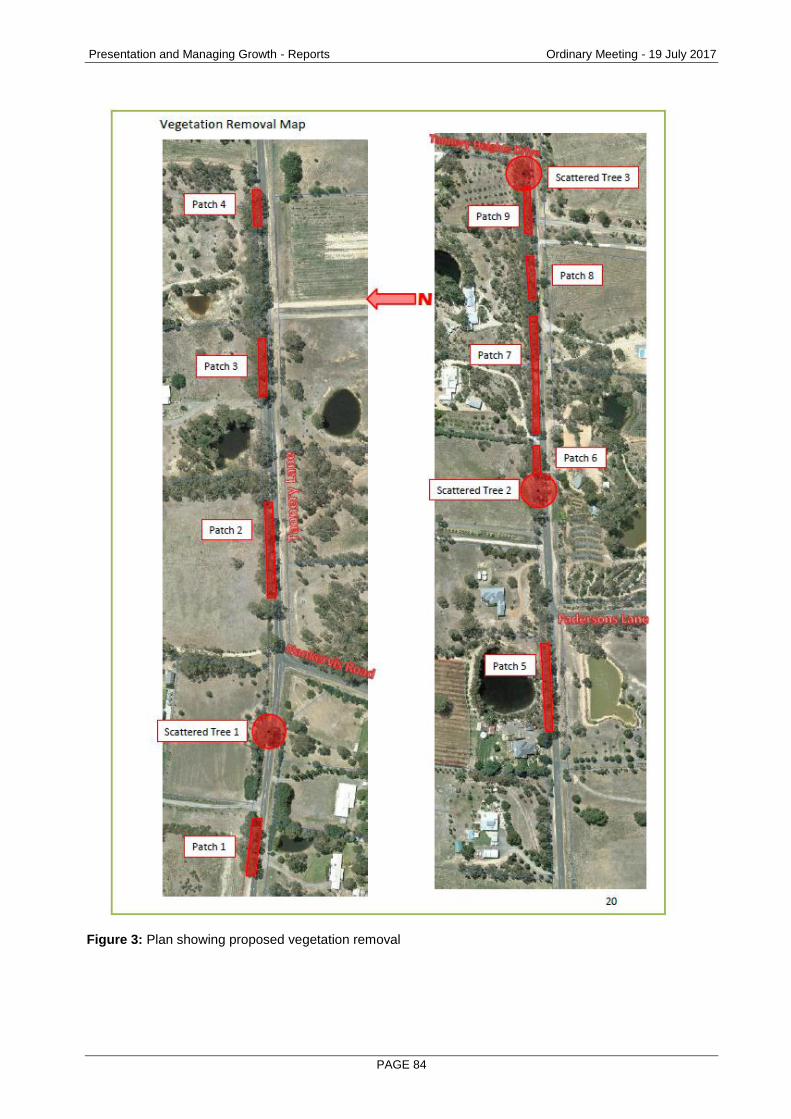
Presentation and Managing Growth - Reports Ordinary Meeting - 19 July 2017
PAGE 84
Figure 3: Plan showing proposed vegetation removal

Presentation and Managing Growth - Reports Ordinary Meeting - 19 July 2017
PAGE 85
Planning Controls - Greater Bendigo Planning Scheme
The subject site is zoned Road Zone 2 and is affected by a Heritage Overlay (HO796) and Bushfire Management Overlay. A permit is required to carry out works and remove vegetation under Clause 43.01-1 of the Heritage Overlay and to remove native vegetation under Clause 52.17 of the Native Vegetation provisions of the planning scheme. The following clauses are relevant in the consideration of this proposal: State Planning Policy Framework
Clause 12.01 Biodiversity
Clause 15.03-1 Heritage conservation
Clause 18.02-4 Management of the road system Municipal Strategic Statement
Clause 21.08 Environment Local Planning Policies
Clause 22.06 Heritage Policy Zone
Road Zone 2
Overlays
Clause 43.01 Heritage Overlay
Other Provisions
Clause 52.17 Native vegetation
Consultation/Communication
Referrals The following authority and internal department have been consulted on the proposal:
Referral Comment
DELWP No objection subject to conditions.
Heritage Advisor No objection.

Presentation and Managing Growth - Reports Ordinary Meeting - 19 July 2017
PAGE 86
Public Notification The application was advertised by way of notice on the site; letters to adjoining and nearby owners and occupiers and a public notice was published in the Bendigo Advertiser. A consultation meeting was held with objectors and further correspondence was undertaken with them following the meeting, however the objections were unable to be resolved. As a result of advertising, 4 objections were received, with the grounds of objection summarised as follows:
Lack of detail about fauna impacts with loss of vegetation, particularly the impact on threatened species Brush-tailed Phascogale. Nesting sites exist in the Greater Bendigo National Park located on both sides of Tannery Lane. Removing road side vegetation will add to the risk of local extinction.
Concern about the impact of loss of native vegetation on bird species including Painted Honeyeater and Swift Parrot, which are nomadic nectar feeders. It is important to protect critical habitat.
A desktop vegetation assessment does not accurately reflect the area’s biodiversity.
Concern about impacts on Tannery Lane as an important wildlife corridor.
Removal of native vegetation will diminish the natural values of the area.
No detail has been provided as to how the proposal fits with Council’s strategic plans.
Concern about excessive loss of vegetation between Fadersons Lane and Tannery Heights Drive for limited benefit as the road upgrades will terminate at Tannery Heights Drive.
A cost benefit analysis of the proposal has not been demonstrated in comparison with a basic re-seal of the existing surface.
Concern about potential drainage issues from the proposed change at Fadersons Lane.
Concern about lack of planning around the long term plans for further works to fully develop Tannery Lane to Guys Hill Road.
Concern about modelled future outcomes of road widening.
Widening the road will encourage more traffic and faster speeds, which will diminish the amenity of the area and be more dangerous for road users, particularly cyclists and pedestrians.
The road is fine as it is, and is better as a country lane which is a quiet, vegetated country lane and popular cycle route.
Concern about lack of consultation with residents. The objections are discussed below.
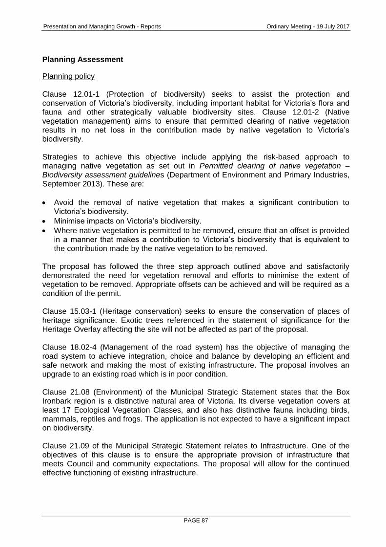
Presentation and Managing Growth - Reports Ordinary Meeting - 19 July 2017
PAGE 87
Planning Assessment
Planning policy Clause 12.01-1 (Protection of biodiversity) seeks to assist the protection and conservation of Victoria’s biodiversity, including important habitat for Victoria’s flora and fauna and other strategically valuable biodiversity sites. Clause 12.01-2 (Native vegetation management) aims to ensure that permitted clearing of native vegetation results in no net loss in the contribution made by native vegetation to Victoria’s biodiversity. Strategies to achieve this objective include applying the risk-based approach to managing native vegetation as set out in Permitted clearing of native vegetation – Biodiversity assessment guidelines (Department of Environment and Primary Industries, September 2013). These are:
Avoid the removal of native vegetation that makes a significant contribution to Victoria’s biodiversity.
Minimise impacts on Victoria’s biodiversity.
Where native vegetation is permitted to be removed, ensure that an offset is provided in a manner that makes a contribution to Victoria’s biodiversity that is equivalent to the contribution made by the native vegetation to be removed.
The proposal has followed the three step approach outlined above and satisfactorily demonstrated the need for vegetation removal and efforts to minimise the extent of vegetation to be removed. Appropriate offsets can be achieved and will be required as a condition of the permit. Clause 15.03-1 (Heritage conservation) seeks to ensure the conservation of places of heritage significance. Exotic trees referenced in the statement of significance for the Heritage Overlay affecting the site will not be affected as part of the proposal. Clause 18.02-4 (Management of the road system) has the objective of managing the road system to achieve integration, choice and balance by developing an efficient and safe network and making the most of existing infrastructure. The proposal involves an upgrade to an existing road which is in poor condition. Clause 21.08 (Environment) of the Municipal Strategic Statement states that the Box Ironbark region is a distinctive natural area of Victoria. Its diverse vegetation covers at least 17 Ecological Vegetation Classes, and also has distinctive fauna including birds, mammals, reptiles and frogs. The application is not expected to have a significant impact on biodiversity. Clause 21.09 of the Municipal Strategic Statement relates to Infrastructure. One of the objectives of this clause is to ensure the appropriate provision of infrastructure that meets Council and community expectations. The proposal will allow for the continued effective functioning of existing infrastructure.

Presentation and Managing Growth - Reports Ordinary Meeting - 19 July 2017
PAGE 88
The City’s Heritage Policy at Clause 22.06 of the Local Planning Policy Framework contains the following objectives include retaining heritage assets for the enjoyment, education and experience of residents, visitors and future generations of the municipality and encouraging the preservation, maintenance, restoration and where appropriate, reconstruction of heritage places. The City’s Heritage Advisor has considered the heritage significance of the site and advised that the proposal will not have a significant impact on the heritage values of the place. Need for road upgrade The proposed works are required to upgrade a section of Tannery Lane as the existing pavement is in poor condition. Improvements to road safety are also required which will involve relocating assets to satisfy Austroads standards. The proposed works involve reconstructing this section of road. The City has considered other options to upgrade the road including resealing the existing pavement, however this would only be a short term solution as the poor condition of the road warrants reconstruction in the long term. It is the City’s view that any upgrade to the road should meet current engineering standards. Native vegetation One of the objectors’ main concerns is the extent of vegetation removal and the impact of vegetation loss on fauna in the area, in particular the Brushed Tailed Phascogale (Phascogale tapoatafa) which is a nocturnal, tree dwelling marsupial that is classified as a threatened species in Victoria under the Flora and Fauna Guarantee Act 1988. The concern was that removing trees within the road reserve would restrict the movement of the Phascogale along and across Tannery Lane. Data about the presence of Phascogales in the area has been reviewed by Council’s Environment Officer. The data indicated that there are Phascogales active within the Greater Bendigo National Park either side of Tannery Lane and on private property to the north of Tannery Lane. A permit is required to remove the vegetation under Clause 52.17 (Native Vegetation) of the Planning Scheme. It is necessary to remove some vegetation within the road reserve to facilitate the proposed road upgrades. The minimum extent of native vegetation will be removed to ensure the safe and efficient functioning of the road. A Biodiversity Impact and Offset Report (BIOR) was prepared and submitted with the application in accordance with the requirements of Permitted clearing of native vegetation – Biodiversity assessment guidelines (Department of Environment and Primary Industries, September 2013). The site falls within the Goldfields Bioregion Ecological Vegetation Class (EVC) 61 Ironbark Forest. The vegetation is within Location Risk A and the application is classed as a Low Risk based pathway application. Some of the objections were concerned that the BIOR report does not accurately reflect the area’s biodiversity, however an ecological assessment and habitat hectare assessment was not required to be undertaken for this proposal under Clause 52.17 as the application is not a Moderate or High risk-based pathway application.

Presentation and Managing Growth - Reports Ordinary Meeting - 19 July 2017
PAGE 89
The application states that the loss of the vegetation will not have a significant impact on habitat. The BIOR report states that ‘at this location, native vegetation removal of this size is not expected to have a significant impact on the habitat of any rare or threatened species.” Following the consultation meeting, The City’s Environment Officer undertook further assessments to ensure requirements under the Flora and Fauna Guarantee Act 1988 and the Environment Protection and Biodiversity Conservation Act 1999 were met. Based on characteristics of the study area and its surrounds and known data of rare or threatened species, no further permits or considerations are required. Further advice on the impact on the habitat of the Brushed Tailed Phascogale was also sought from an external flora and fauna consultant, who advised that if Brushed Tailed Phascogales do occur in the area, then the proposed works will have little if any effect on them. With regard to the extent of vegetation required to be removed, following the consultation meeting an assessment was undertaken to determine the extent of vegetation removal if speed along the road was reduced to 60 kilometres per hour. This speed reduction would result in the retention of 7 trees. However VicRoads advised that a reduction in the speed zone to 60 km/h was not supported and would not be permitted. The application was referred to the Department of Environment, Land, Water and Planning (DELWP). DELWP had no objection to the application subject to conditions of permit relating to protection of vegetation to be maintained during the construction period, provision of offsets and evidence of offsets. Appropriate offsets will be required as a condition of permit. The offset requirement will be 0.155 general biodiversity equivalence units to be provided within the NCCMA catchment area and achieving a minimum strategic biodiversity score of 0.390. Overall, it is considered that the three step approach of avoid, minimise and offset has been followed and the vegetation removal is necessary in order to enable upgrades to this section of Tannery Lane. Traffic impacts Concerns have been raised that the proposed road upgrade will encourage more traffic, faster speeds and be more dangerous for road users, particularly cyclists and pedestrians. The current traffic volume along Tannery Lane is 705 vehicles per day, however to ensure treatments remain appropriate over time, the road design needs to take into account expected traffic volume increases. Based on expected future traffic growth, Tannery Lane will carry 1,048 vehicles per day by 2036. As noted above, no change to the current speed limit is proposed as this is not supported by VicRoads. The proposed road upgrade will allow for the sealed shoulder of the road to be used by cyclists and pedestrians, which will improve safety as there is currently a gravel shoulder in this section of the road.

Presentation and Managing Growth - Reports Ordinary Meeting - 19 July 2017
PAGE 90
Strategic planning for Mandurang Some of the objections query how the proposal fits with strategic planning for the area, including Amendment C217 (Big Hill and Mandurang Valley Landscape Assessment), Strathfieldsaye Town Centre Urban Design Framework and transportation strategies and suggest that there is a lack of detailed planning around the long term plans to fully redevelop Tannery Lane to Guys Hill Road. These strategic documents have been reviewed, together with the Strathfieldsaye Traffic Management Plan (2015) and the City of Greater Bendigo’s Integrated Transport and Land Use Strategy (2015), however there is no current proposal to change the status and classification of Tannery Lane as a Road Zone 2 City managed road. Amendment C217 was adopted by Council on 29 June 2016 and this amendment proposes to introduce a Significant Landscape Overlay 4 (SLO4) over a number of areas within Mandurang, including properties along a section of Tannery Lane extending approximately 285 metres east and 300 metres west of Tannery Heights. Council resolved not to accept the Panel’s recommendations on this amendment and adopt the amendment as exhibited, and is currently awaiting the Minister’s decision on the amendment. The SLO4 is not proposed to extend over the Tannery Lane road reserve. Whilst parts of Mandurang have been identified as having significant landscapes, this does not prevent the granting of a permit for removal of native vegetation. The Strathfieldsaye Town Centre Urban Design Framework (UDF) was adopted by Council on 15 February this year. The UDF’s study area is focused on Strathfieldsaye Road and Wellington Street and the area immediately surrounding this main route through the town centre. The development area for this planning application is well outside the UDF study area. The UDF identifies the intersection of Tannery Lane and Club Court in Strathfieldsaye as a key intersection which will be upgraded. In May 2014, Council resolved to commission the Strathfieldsaye Traffic Management Plan. This plan was prepared in 2015 for the purpose of prioritising intersection upgrades on Strathfieldsaye Road and Wellington Street, which is a VicRoads main arterial road. The report also refers to the Bendigo 2020 Transportation Study (1993), a reference document in the Planning Scheme. One of the recommendations of the 1993 study was the provision of an arterial road link between the Calder Highway south of Kangaroo Flat and the McIvor Highway at Junortoun passing through or near to Mandurang and Strathfieldsaye, which proposed to utilise Tannery Lane as part of this route. The report states that “this planning has been abandoned for the foreseeable future,” as the Draft Bendigo Road Transport Strategy (2010) did not include this recommendation. Findings of this study have not been adopted by Council or VicRoads and Council subsequently prepared an Integrated Transport and Land Use Strategy (ITLUS). One of the actions contained within ITLUS is to “progressively implement the recommendations of the Strathfieldsaye Township Traffic Management Plan (2015) prioritising safety and addressing traffic flow issues along Wellington Street (Strathfieldsaye Road) from Tannery Lane in the west to Emu Creek Road in the east.”

Presentation and Managing Growth - Reports Ordinary Meeting - 19 July 2017
PAGE 91
Drainage One of the objections is concerned about drainage impacts of the proposed works. Details of proposed drainage works have been included within the proposed construction plans. The drainage design meets current industry standards and is not likely to result in adverse impacts to properties in Tannery Lane. Heritage and landscape character of Tannery Lane The Former Shires of McIvor and Strathfieldsaye (City of Greater Bendigo, October 2009) Heritage Study identifies the significance of the site as follows: “Tannery Lane is significant as a cultural landscape, beginning as an agricultural area in the mid-late 1850s and settled by a number of European immigrants. The area provided the good faring land that allowed some families and in particular some European immigrants to become established in the local area. The beginning of the viticulture industry which is now an important part of agriculture and economy in the region was established in this area of Mandurang. In particular Tannery Lane was a place where industry and intensive agriculture was located. The English Hawthorn hedge, Osage Orange, Cherry Plums, Silver Poplar, Elm and Oak trees and sandstone drainage culverts are unusual in the local area and these provide a framework and setting to the road that is highly distinctive.” The Tannery Lane landscape including English Hawthorn hedge, Osage Orange, Cherry Plums, Silver Poplar, Elm and Oak trees, and sandstone drainage culverts are of local historic, technical and aesthetic significance to the City of Greater Bendigo. The City’s Heritage Advisor had no objection to the proposal and advised that overall, there is a native bush character to this section of road, rather than one which evokes a landscape created by European immigrants using exotic species. The bridge slightly further west has been widened and the intimate rural character of the road is changing as other sections are widened. While some vegetation will be lost as part of the proposed works, it is considered that the overall rural and bush character of Tannery Lane will be maintained. No trees of identified as being of heritage significance are proposed to be removed.
Conclusion
The proposed roadworks and vegetation removal will facilitate Stage 2 of upgrade works to Tannery Lane, a key local collector road managed by the City of Greater Bendigo. Overall, the proposed upgrade will have positive impacts for road users, the Mandurang community and Greater Bendigo. Environmental impacts will be minimised and vegetation losses can be appropriately offset. It is therefore recommended that Council resolve to issue a Notice of Decision to Grant a Permit for the planning permit application.

Presentation and Managing Growth - Reports Ordinary Meeting - 19 July 2017
PAGE 92
Options
Council, acting as the responsible authority for administering the Planning Scheme, may resolve to: grant a permit, grant a permit with conditions, or refuse to grant a permit.
Attachments
Objections
Proposed Notice of Decision Conditions
1. NO LAYOUT ALTERATION The development permitted by this permit as shown on the endorsed plans and/or described in the endorsed documents must not be altered or modified (for any reason) except with the prior written consent of the responsible authority.
2. DEWLP – CONSTRUCTION MANAGEMENT NOTIFICATION OF PERMIT CONDITIONS Before works start, the permit holder must advise all persons undertaking the (vegetation removal/works) on site of all relevant conditions of this permit.
3. DELWP – PROTECTION OF VEGETATION TO BE RETAINED a) Vegetation must be felled inside the prescribed works area to avoid
damaging remaining vegetation. b) All works must be undertaken to ensure that retained vegetation, including
understorey is not damaged. c) Vegetation not being removed within the construction area is to be protected
with high visibility tape.
4. DELWP – NATIVE VEGETATION OFFSETS In order to offset the removal of 0.551 hectares of native vegetation including 3 scattered trees approved as part of this permit, the applicant must provide a native vegetation offset that meets the following requirements, and is in accordance with the Permitted clearing of native vegetation – Biodiversity assessment guidelines and the Native vegetation gain scoring manual: The offset must: • Contribute gain of 0.155 general biodiversity equivalence units; • Be located within the North Central Catchment Management Authority
boundary or Greater Bendigo municipal district; and
• Have a strategic biodiversity score of at least 0.312. Offset evidence Before any native vegetation is removed, evidence that an offset has been secured must be provided to the satisfaction of the responsible authority. This offset must meet the offset requirements set out in this permit and be in accordance with the requirements of the Permitted clearing of native vegetation – Biodiversity assessment guidelines and the Native vegetation gain scoring manual.

Presentation and Managing Growth - Reports Ordinary Meeting - 19 July 2017
PAGE 93
Offset evidence can be either: a) A credit register extract from the Native Vegetation Credit Register; or b) A security agreement, to the required standard, for the offset site or sites,
including a 10-year offset management plan to the satisfaction of the Department of Environment, Land, Water and Planning and approved by the Responsible Authority. Every year, for ten years, after the responsible authority has approved the offset management plan, the applicant must provide notification of the management actions undertaken towards implementing the offset management plan, to the department. An offset site condition statement, including photographs must be included in this notification.
5. EXPIRY
This permit will expire if the development permitted by this permit is not completed within 2 years from the date hereof. The time within which the development must be completed may be extended, on written request to the responsible authority, before or within 6 months after the expiry of this permit where the development has not yet started or 12 months where the development has commenced.
DELWP NOTES
Works or other activities on public land, which may impact on protected plants, will require a Protected Flora Licence or Permit under the Flora and Fauna Guarantee Act 1988 (FFG). All native vegetation likely to be impacted should be checked against the Protected Flora List (DELWP2015) to determine whether FFG approvals are required. Protected Flora Permits can be obtained from the department’s regional office. To assist applicants meet permit condition requirements, Meeting permit conditions – third party offsets Fact sheet (DEPI 2013) and First party general offset kit (DEPI 2013) are available, Please visit www.depi.vic.gov.au/nativevegetation for further information.

Wellbeing and Fairness - Reports Ordinary Meeting - 19 July 2017
PAGE 94
3. WELLBEING AND FAIRNESS
3.1 GENDER EQUITY STRATEGY
Document Information
Author & Responsible Vicky Mason, Director Health and Wellbeing Director
Summary / Purpose
This report is seeking Council support for the development of a Gender Equity Strategy for the City of Greater Bendigo. The project brief (attached) outlines the proposed scope, objectives, project plan, potential partners and governance for the work.
RECOMMENDATION
1. That Council support the development of a Gender Equity Strategy for Greater Bendigo; and
2. That Cr Wrigglesworth be appointed to participate on the Internal Working Group and that a Councillor be determined for the External Reference Group following an Expression of Interest process for membership.
~~~~~~~~~~~~~~~~~~~~~~~~~
Policy Context
Community Plan Reference: City of Greater Bendigo Community Plan 2017-2021:
Goal 2 Wellbeing and Fairness
Inclusive policies, partnerships and projects that increase access, improve health and learning opportunities by building better connections, and quality of life for all.
Objective 2.1.3
Plan for fairer health outcomes Lead the development of a Gender Equity Strategy for Greater
Bendigo

Wellbeing and Fairness - Reports Ordinary Meeting - 19 July 2017
PAGE 95
Background Information
The 2017 – 2021 Community Plan includes a goal of “Wellbeing and Fairness”. Gender equity is the process of being fair to women and men. Gender equity recognises that within all communities, women and men have different benefits, access to power, resources and responsibilities. To ensure fairness, strategies must often be available to compensate for women’s historical and social disadvantages that prevent women and men from operating on an equal playing field. Gender inequality has been identified as the key determinant of violence against women. Our Watch is an organisation that was established to drive nationwide change in the culture, behaviours and power imbalances that lead to violence against women and children. In 2015 the organisation partnered with ANROWS (Australia’s National Research Organisation for Women’s Safety) and VicHealth to develop a conceptual framework for preventing violence against women and their children. Known as Change the story the framework suggests that violence against women is driven by gender inequality including:
Condoning of violence against women
Men’s control of decision-making and limits to women’s independence
Stereotyped constructions of masculinity and femininity
Disrespect towards women and male peer relations that emphasise aggression
In February 2015 the Victorian Government established the Royal Commission into Family Violence. The government accepted all 227 recommendations and committed to their implementation as outlined in Ending Family Violence: Victoria’s Plan for Change. Recommendation 94 states that councils “report on the measures they propose to take to reduce family violence and respond to the needs of victims”. The Victorian Family Violence Prevention Act 2008 defines family violence as:
(a) behaviour that is physically, sexually, emotionally, psychologically or economically abusive, threatening or coercive; or in any other way controls or dominates the family member and causes them to feel fear for the safety and wellbeing of that family member or another person; or
(b) behaviour by a person that causes a child to hear or witness, or otherwise be exposed to the effects of, behaviour referred to in paragraph (a).
The current draft of the 2017-2021 Municipal Public Health and Wellbeing Plan includes an objective of preventing violence against women and children. Currently Greater Bendigo experiences levels of family violence above the state-wide average. In 2014 the rate was 15/1000 residents versus 11.2/1000 for Victoria. Of the 1697 incidents reported, 1310 involved women. In 2013 the Workplace Gender Equality Agency released a report “The business case for gender equality”. The paper summarises how fostering a workforce that promotes gender equality can help organisations to:

Wellbeing and Fairness - Reports Ordinary Meeting - 19 July 2017
PAGE 96
Attract the best employees
Reduce cost of staff turnover
Enhance organisational performance
Improve access to target markets
Minimise legal risks
Enhance reputation
Engage men Whilst in December 2016, 58% of the City of Greater Bendigo workforce were women compared with 42% being men, there are more women working in part-time and casual roles than men, more men held senior roles and a scan of the organisation indicates the spread of male and female jobs mirrors general stereotypes in the community with the Works and Waste Units dominated by men whilst the Home Support Unit is dominated by women. Developing a Gender Equity Strategy for the Greater Bendigo community that identifies a range on initiatives that partners can work on together will assist the community to address this significant issue.
Resource Implications
This work will be funded from current operating budgets. Any initiatives that require resourcing will be the subject of a future budget bid.
Attachments
1. Gender Equity Strategy Project Brief

Wellbeing and Fairness - Reports Ordinary Meeting - 19 July 2017
PAGE 97
GENDER EQUITY STRATEGY – PROJECT BRIEF June 2017
INTRODUCTION This project brief outlines the background and proposed scope, objectives, implementation plan, partners and governance for the development of a Gender Equity Strategy for the Greater Bendigo community. BACKGROUND Gender equity is the process of being fair to women and men. Gender equity recognises that within all communities, women and men have different benefits, access to power, resources and responsibilities. To ensure fairness, strategies must often be available to compensate for women’s historical and social disadvantages that prevent women and men from operating on an equal playing field. Gender equity leads to gender equality, where there are equal rights, responsibilities and opportunities of women and men and girls and boys. With gender equity, women and men will be healthier, women’s skills will be more available in decision making, policy development and in leadership and violence against women will be reduced. Gender equity is good for the whole community. Women and girls bear the major burden of negative health effects from gender based inequalities. This is evidenced by their exclusion from decision-making and reduced access to economic and social resources, including employment and equal pay, when compared with men. Promoting gender equality in the workplace can improve performance and reduce staff turnover. It is projected that achieving equal rates of employment would increase Australia’s GDP by approximately 11 per cent. The economy would gain $8 billion if women and men transitioned from higher education to employment at equal rates. In 2013 the Workplace Gender Equality Agency released a report “The business case for gender equality”. The paper summarises how fostering a workforce that promotes gender equality can help organisations to:
Attract the best employees
Reduce cost of staff turnover
Enhance organisational performance
Improve access to target markets
Minimise legal risks
Enhance reputation
Engage men
Gender inequality has been identified as the key determinant of violence against women. Our Watch is an organisation that was established to drive nationwide change in the culture, behaviours and power imbalances that lead to violence against women and children. In 2015 the organisation partnered with ANROWS (Australia’s National Research Organisation for Women’s Safety) and VicHealth to develop a conceptual framework for preventing violence against women and their children. Known as Change the story the framework suggests that violence against women is driven by gender inequality including:

Wellbeing and Fairness - Reports Ordinary Meeting - 19 July 2017
PAGE 98
Condoning of violence against women
Men’s control of decision-making and limits to women’s independence
Stereotyped constructions of masculinity and femininity
Disrespect towards women and male peer relations that emphasise aggression
In February 2015 the Victorian Government established the Royal Commission into Family Violence. The government accepted all 227 recommendations and committed to their implementation as outlined in Ending Family Violence: Victoria’s Plan for Change. Recommendation 94 states that councils report on the measures they propose to take to reduce family violence and respond to the needs of victims”. The Victorian Family Violence Prevention Act 2008 defines family violence as:
(c) Behaviour that is physically, sexually, emotionally, psychologically or economically abusive, threatening or coercive; or in any other way controls or dominates the family member and causes them to feel fear for the safety and wellbeing of that family member or another person; or (b) behaviour by a person that causes a child to hear or witness, or otherwise be exposed to the effects of, behaviour referred to in paragraph (a).
Free from Violence is Victoria’s Primary Prevention Strategy. The delivery of this strategy will be led by a new prevention agency announced in the 2017-18 State government budget. Gender equity at the City of Greater Bendigo Workplaces are a major area of inequity for women in Australia. Much progress has been made around gender equity in recent decades yet women continue to earn less than men, and are less likely to advance their careers as far as men. At the same time, men are finding it more difficult to access flexible work arrangements compared to women. Workplaces are also an important setting to challenge and change gender stereotypes. ‘A healthy organisational culture, one in which men and women are respectful of each other’s roles, skills, responsibilities and needs, creates employer loyalty and allows workers to fully utilise their skills for the benefit of the organisation, themselves and their families’.
Women’s Health Loddon Mallee Gender Equity Quality Standards 2013 At 31 December 2016, the City employed 16% more females than males however males outranked females at Band 8 level, a situation that has worsened since the restructure. The Executive Management Team has two out of five females and Council has five females.
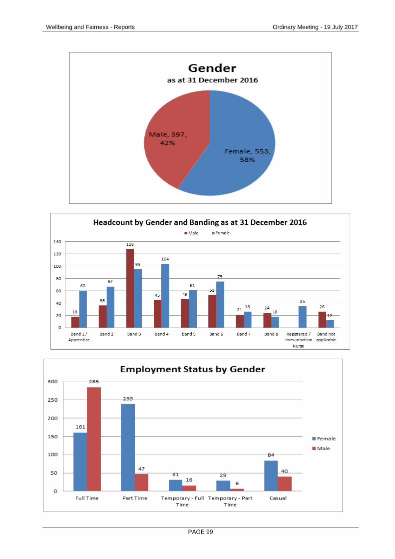
Wellbeing and Fairness - Reports Ordinary Meeting - 19 July 2017
PAGE 99

Wellbeing and Fairness - Reports Ordinary Meeting - 19 July 2017
PAGE 100
In relation to employment status, females have a higher representation in part-time, casual and temporary roles compared to males. This could be by choice; alternately it may be due to external gender bias where females are expected to take up carer duties. A scan of the organisation also indicates that the spread of male and female jobs mirrors general stereotypes in the community with the work and waste areas dominated by males and the home care and childcare areas dominated by females. Research shows that organisations with the high levels of gender equity outperform those with low levels. Increasing the proportion of women in leadership roles is associated with better financial performance and gender equity promotes an environment where innovation can flourish. It also can reduce staff turnover and attract the best employees. Research has also found that a focus on gender equity in workplaces is vital, as workplaces are a setting that influences our attitudes, beliefs and behaviours in both personal and professional life.
Initially the City approached this work through its efforts to prevent violence against women. In 2010 Councillors signed the Position Statement ‘Greater Bendigo City Council says “NO” to violence against women’. Work then began on developing the City’s first Violence Prevention Plan. The Plan included two objectives:
Increase community knowledge and capacity to prevent violence; and
Increase the competency of City staff to prevent, recognise and manage violence against others appropriately.
After the election of a new Council in 2012 a new Position Statement was signed “Achieving respect and gender equality in Greater Bendigo”.
Since 2010 the City has achieved the following:
Endorsed the Victorian Local Government Women’s Charter
Undertaken a Pay Equity Gap Analysis
Introduced flexible work options
Take a Stand bystander training
Participated in the Preventing Violence Against Women Cluster Project with Macedon
Ranges and Mount Alexander Councils
Participated in the Rural Challenge Project with Macedon Ranges Shire, local CFA
branches and local football/netball clubs
The City of Greater Bendigo is a large organisation which employs over 900 people. It is important that as a lead employer in the community that we ‘get our house in order’ and have a strong commitment before we can influence gender equity into the whole community. As the arm of government closest to the community, local government has the capacity to influence many of the determinants of health and wellbeing, including gender equity.

Wellbeing and Fairness - Reports Ordinary Meeting - 19 July 2017
PAGE 101
Local government is extremely well placed to promote gender equity through its role in planning, providing community facilities and public spaces, service delivery and partnerships which cut across the social, economic, environmental and cultural domains of civic life. Research shows that actions to prevent violence against women are most effective when multiple messages and strategies which promote gender equity and respectful relationships occur across different levels in communities and reinforce each other. Local government has a critical role in creating and supporting environments that enable everyone in our community to achieve optimal health and wellbeing. This role is legislated under the Public Health and Wellbeing Act (2008) and the Local Government Act 1999, which mandates councils to act as representative, informed and responsible decision makers in the interests of their communities. Councils are also bound by legislation such as the Victorian Equal Opportunity Act 2010 and Sex Discrimination Act 1984, which aim to eliminate discrimination and sexual harassment and promote greater equity in our community. The Victorian Charter of Human Rights and Responsibilities Act 2006 require councils to uphold human rights, including the rights of women, as an essential component of a democratic, equitable and inclusive society. In its 2017-2021 Community Plan, the City of Greater Bendigo has adopted the vision ‘Greater Bendigo – creating the world’s most liveable community’. Liveability is about the way that a place enables and assists people to achieve the quality of life they desire to be healthy and fulfilled. Gender equity is an important contributor to liveability and achieving this vision. The Community Plan includes Strategic Objective 2: Wellbeing and fairness – inclusive policies, partnerships and projects that improve learning opportunities and health, increase access and build better connections and quality of life for all. Improving gender equity aligns with the goals of the City’s Culture Plan and will assist the organisation to move towards its preferred culture. Gender equity across the Greater Bendigo community The following data for Greater Bendigo is taken from the Victorian Women’s Health Atlas.
Female Male
Population (2011) 51,841 48,776
Indigenous (2011) 1.4% 1.5%
Year 12 or equivalent (2011) 33.3% 28%
Employed full-time (2011) 42.6% 75%
Employed part-time (2011) 51.7% 19.6%
Unemployed (2011) 5.7% 5.4%
% Below minimum weekly wage ($0-599) (2011) 49.9% 33.6%
% Above minimum weekly wage ($600+) (2011) 25.8% 39.5%
% of CEOs, GMs & Legislators (2011) 22.4% 77.6%
Lone parents (2011) 4056 816
Family violence incidents (2014) 1310 388

Wellbeing and Fairness - Reports Ordinary Meeting - 19 July 2017
PAGE 102
Female Male
Perceptions of safety (2011) 57.1% 95.1%
Sexual offences – reported incidents (2014) 129 34
Stalking, Harassment and Threatening behaviours – reported incidents (2014)
98 26
Psychological Distress (2014) 12.6% 5.4%
Anxiety & Depression – Lifetime Prevalence (2011) 38.9% 16.1%
As can be seen, significant disparities exist for men and women living within the Greater Bendigo community. Research suggests that challenging stereotypes and social norms, reviewing policies and programs and modelling good practice can change these outcomes for both men and women. Relevant Commonwealth, State and Regional Policy Acknowledgement of the prevalence of violence against women and its determinants has led to the development of new legislation, policy and programs at the Commonwealth, State and Local Level. Key policy documents released in the last few years include:
National Plan to Reduce Violence against Women and their Children 2010-2022.
Free from violence: Victoria’s strategy to prevent family violence and all forms of violence against women. 2016
Safe and strong: A Victorian gender equality strategy. 2016.
The Loddon Mallee Action Plan for the primary prevention of violence against women. 2016-2019
PROJECT SCOPE This strategy will aim to identify initiatives that will increase gender equity across the whole Greater Bendigo community. It will take a primary prevention approach to:
Prevent gender inequality before it occurs
Focus on the whole population and the range of settings in which inequalities are shaped, to address factors that lead to inequality
Build social structures, norms and practices that prevent gender inequality happening or reduce the likelihood of it.
In developing the strategy the City will identify and work with partners who have a shared commitment to increasing gender equity across the community. OBJECTIVES 1. Identify key partners with a shared commitment to building gender equity across the
community 2. Engage with the community to identify local case studies of gender equality 3. Develop a common understanding of the drivers of gender inequality 4. Establish baseline data on current levels of gender inequality across the community
Wellbeing and Fairness - Reports Ordinary Meeting - 19 July 2017
PAGE 103
5. Identify evidence informed interventions relevant to the Greater Bendigo context 6. Identify priority settings for intervention 7. Build an evaluation framework 8. Develop an agreed action plan for implementation. PROJECT PLAN 1. Draft Project Brief 2. Seek EMT and Councillor endorsement of brief 3. Establish Internal Working Group 4. Scope and undertake gendered data analysis 5. Undertake policy and evidence desk top review 6. Develop community engagement plan including:
a. Community communications plan b. Community awareness and engagement forum c. Staff consultation process
7. Deliver Community engagement and awareness forum a. Range of speakers with expertise in this work b. Invite general community, agencies, networks c. Seek Expressions of Interest for External Reference Group
8. Undertake benchmarking with other communities 9. Map current activities and initiatives underway 10. Develop an issues and opportunities paper for community consultation outlining:
a. Data b. Evidence c. Potential settings d. Potential partners e. Potential policy and program interventions f. Draft evaluation framework
11. Brief Council on progress / findings 12. Undertake community engagement process 13. Advertise for community partnerships 14. Draft strategy 15. Seek final input from key stakeholders 16. Finalise on-going governance structures 17. Seek Council endorsement It is anticipated that this process may take up to twelve months. No budget has been allocated so this strategy will need to be implemented within existing resources. POTENTIAL PARTNERS
Women’s Health Loddon Mallee
Centre for Non Violence
Communities for Children
Municipal Association of Victoria
Our Watch
Loddon Campaspe Councils
Early Years’ service providers
Schools

Wellbeing and Fairness - Reports Ordinary Meeting - 19 July 2017
PAGE 104
Sports Clubs
Be Bendigo
Major employers
Emergency Service Providers
Bendigo Loddon Primary Care Partnership
Sport and Recreation Victoria
Department of Health and Human Services
Department of Education and Training
GOVERNANCE Internal Working Group 50% men / 50% women with representation including:
Councillor
Director Health and Wellbeing
Male Director
All Directorates
Community Partnerships
Active & Healthy Lifestyles
Community Wellbeing
People and Culture
Staff consultative committee representative Plus
Loddon Mallee Women’s Health External Reference Group 50% men / 50% women with representation potentially including:
Councillor
Chief Executive Officer
Health and Wellbeing Director
Social Planner
Manager Active & Healthy Lifestyles
Manager Community Partnerships
Manager People and Culture
Loddon Mallee Women’s Health
Centre for Non-violence
Sports Focus
Be Bendigo
Communities for Children
Department of Health and Human Services
Department of Sport and Recreation
Department of Education
Other as identified

Strengthening the Economy - Reports Ordinary Meeting - 19 July 2017 Environmental Sustainability Embracing Our Culture and Heritage
PAGE 105
4. STRENTHENING THE ECONOMY
Nil.
5. ENVIRONMENTAL SUSTAINABILITY
Nil.
6. EMBRACING OUR CULTURE AND HERITAGE
Nil.
Lead and Govern for All - Reports Ordinary Meeting - 19 July 2017
PAGE 106
7. LEAD AND GOVERN FOR ALL
7.1 RECORD OF ASSEMBLIES
Document Information
Author Peter Davies, Manager Executive Services Responsible Kerryn Ellis, Director Corporate Performance Director
Purpose
The purpose of this report is to provide the record of any assembly of Councillors, which has been held since the last Council Meeting, so that it can be recorded in the Minutes of the formal Council Meeting.
RECOMMENDATION
That Council endorse the record of assemblies of Councillors as outlined in this report.
~~~~~~~~~~~~~~~~~~~~~~~~~
Policy Context
Effective community engagement will guide well informed, responsive decision-making and financially responsible resource allocations, which are transparent and accountable.
Background Information
The Local Government Act provides a definition of an assembly of Councillors where conflicts of interest must be disclosed. A meeting will be an assembly of Councillors if it considers matters that are likely to be the subject of a Council decision, or, the exercise of a Council delegation and the meeting is: 1. A planned or scheduled meeting that includes at least half the Councillors (5) and a
member of Council staff; or 2. an advisory committee of the Council where one or more Councillors are present. The requirement for reporting provides increased transparency and the opportunity for Councillors to check the record, particularly the declarations of conflict of interest.

Lead and Govern for All - Reports Ordinary Meeting - 19 July 2017
PAGE 107
Report
Meeting Information
Meeting Name/Type
Farming Advisory Committee
Meeting Date 2 May 2017
Matters discussed 1. Presentation on Draft Greater Bendigo Road Management Plan 2. Introduction of Committee members 3. Key opportunities for regional agribusiness 4. Role of Farming Advisory Committee in Rural Communities Strategy implementation 5. Broadband/NBN
Attendees/Apologies
Councillors Cr Margaret O'Rourke Cr Matt Emond Apology: Cr Andrea Metcalf
Staff/ Community Representatives
Mr Trevor Budge Ms Deb Simpson Ms Jenny Pendlebury Mr Paul Nicholson/ Mr Darren Heritage Mr Jim Long Mr Michael Crapper Mr Geoff Kroker Mr Ken Laing Mr Warren Smith Mr Rod Luke Mr Ross McKinstry Mr Martin Szakal Apology: Ms Fiona Cannon
Conflict of Interest disclosures
Matter No.
Councillor/officer making disclosure Councillor/officer left meeting
Nil

Lead and Govern for All - Reports Ordinary Meeting - 19 July 2017
PAGE 108
Meeting Information
Meeting Name/Type
Councillors' Briefing
Meeting Date 5 June 2017
Matters discussed 1. Planning matters and review of draft Ordinary Meeting Agenda 2. Chauncey Street footbridge, Heathcote 3. Plan Greater Bendigo 4. Budget 2017/2018 5. New pool naming process 6. Community Plan 2017-2021 7. Monash Rural Health 8. Richmond Football Club 9. Sustainable Building Policy 10. Retail Doctor 11. Community Survey results 12. Fundraising for new Chinese Dragon
Attendees/Apologies
Councillors Cr Margaret O'Rourke Cr Jennifer Alden Cr George Flack Cr Rod Fyffe Cr Julie Hoskin Cr Andrea Metcalf Cr James Williams Cr Yvonne Wrigglesworth Apology: Cr Matt Emond
Staff/ Community Representatives
Mr Craig Niemann Mr Bernie O'Sullivan Mr Craig Lloyd Ms Kerryn Ellis Ms Vicky Mason Mr Richard Morrison
Conflict of Interest disclosures
Matter No.
Councillor/officer making disclosure Councillor/officer left meeting
Nil

Lead and Govern for All - Reports Ordinary Meeting - 19 July 2017
PAGE 109
Meeting Information
Meeting Name/Type
Sustainability and Environment Advisory Committee
Meeting Date 6 June 2017
Matters discussed 1. Wanyarram Dhelk Project 2. CoGB Public Health and Wellbeing Plan 3. Greater Bendigo Environment Strategy - Draft Action Plan
Attendees/Apologies
Councillors Cr Rod Fyffe Cr Andrew Metcalf Cr Jennifer Alden
Staff/ Community Representatives
Ms Robyn Major Mr Bernie O'Sullivan Mr Anthony Sheean Ms Lindy Wilson/ Ms Jess Milroy Mr Chris Weir Ms Pamela Beattie Mr Colin Smith Ms Terri Williams Ms Kelly Button Mr Rohan Hogan Ms Nicole Bullen Apologies: Mr Greg Butler Mr Geoff Caine Ms Kathryn Stanislawski Mr James Shaddick
Conflict of Interest disclosures
Matter No.
Councillor/officer making disclosure Councillor/officer left meeting
Nil
Lead and Govern for All - Reports Ordinary Meeting - 19 July 2017
PAGE 110
Meeting Information
Meeting Name/Type
Councillors' Briefing
Meeting Date 14 June 2017
Matters discussed 1. Community Plan 2. Finance Committee and draft Budget review 3. Flying foxes in Rosalind Park 4. Lake Weeroona Master Plan 5. Social and Economic Impact - Wellington Hotel 6. Organisation Health Check
Attendees/Apologies
Councillors Cr Margaret O'Rourke Cr Jennifer Alden Cr Matt Emond Cr Rod Fyffe Cr Julie Hoskin Cr Andrea Metcalf Cr Yvonne Wrigglesworth Apologies: Cr George Flack Cr James Williams
Staff/ Community Representatives
Mr Craig Niemann Mr Bernie O'Sullivan Mr Craig Lloyd Ms Kerryn Ellis Ms Vicky Mason Mr Richard Morrison
Conflict of Interest disclosures
Matter No.
Councillor/officer making disclosure Councillor/officer left meeting
Nil

Lead and Govern for All - Reports Ordinary Meeting - 19 July 2017
PAGE 111
Meeting Information
Meeting Name/Type
Councillors' Briefing
Meeting Date 19 June 2017
Matters discussed 1. Bendigo Heritage Attractions Funding Agreement 2. Bendigo Freight Study 3. Smart Cities Update 4. Eaglehawk Playsapce 5. Women's Health Loddon Mallee 6. Access to Community Plan documents 7. Customer Support 8. Council recognition 9. Alexandra Fountain 10. Works at Heathcote
Attendees/Apologies
Councillors Cr Rod Fyffe Cr Jennifer Alden Cr Matt Emond Cr Julie Hoskin Cr Andrea Metcalf Cr Yvonne Wrigglesworth Apologies: Cr Margaret O'Rourke Cr George Flack Cr James Williams
Staff/ Community Representatives
Mr Bernie O'Sullivan Mr Craig Lloyd Ms Kerryn Ellis Ms Vicky Mason Mr Peter Davies Apology: Mr Craig Niemann
Conflict of Interest disclosures
Matter No.
Councillor/officer making disclosure Councillor/officer left meeting
1. Cr Hoskin Yes
Attachments
Nil

Ordinary Meeting - 19 July 2017
PAGE 112
8. URGENT BUSINESS
Nil.
9. NOTICES OF MOTION
Nil.
10. COUNCILLORS' REPORTS
11. MAYOR'S REPORT
12. CHIEF EXECUTIVE OFFICER'S REPORT
13. CONFIDENTIAL (SECTION 89) REPORTS
Nil.