Oracle10g Database: A Spatial VLDB Case Study Xavier R. Lopez Director, Server Technologies Oracle...
55
-
date post
19-Dec-2015 -
Category
Documents
-
view
218 -
download
2
Transcript of Oracle10g Database: A Spatial VLDB Case Study Xavier R. Lopez Director, Server Technologies Oracle...


Oracle10g Database:A Spatial VLDB Case Study
Xavier R. Lopez Director, Server Technologies
Oracle Corporation
Session id: 40125

Overview Role of Spatial Database Technology Oracle Spatial & Locator Benefits of Oracle 10g in large systems What’s Coming in 10g VLDB Case Study – UK Ordnance Survey

Why Use a Spatial Database? Every Oracle DBMS is a Spatial database Integrate location & Business data in RDBMS Open Access - no proprietary types High Performance – 64 bit Integrity managed by DBMS Scaleable: Supports Terabytes of Data Scaleable: Supports 1000s of Users Easy to Program – SQL, Java, XML Security and Reliability Short & Long Transaction Management You already license it !!

5
Early Spatial Systems: Hybrids
Attributes in database Geometries in
proprietary data files Poor integration No access to spatial data
from IT
AttributesGeometriesGeometriesGeometries
GIS
IT
SQL
blobs
• Attributes in database• Geometries in database - but
in proprietary binary format• IT can access geometries via
proprietaty interfaces only• Poor integration

6
Open Spatial Databases
GIS
eBusiness
GeometriesAttributes
SQL
• Spatial is native DBMS type • Attributes and geometries
integrated in database• Supported by all GIS • Supported by eBusiness
applications• Spatial data queried using
SQL, Java
SQL
GISGIS
eBusinesseBusiness

DesignTools
XML Database
Business Intelligence
Mobile &Wireless
JDeveloperTools
3rd party GIS
Tools
ERP
Applications
Oracle Stack is Spatially Enabled
CRM
Applications
SpatialSpatial

8
Differentiating Oracle eBusiness Suite with Location Capability
Competition (SAP, Siebel, SAS)
No native location capability
Location requires 3rd party tool and integration cost
Multiple data models 3rd party proprietary
BLOBs or Long Raws Complex technical support
Oracle eBusiness Suite Integrated Location
capability No additional mapping
tools or integration needed Single data model Native Spatial format Out-of-the box feature &
support
9
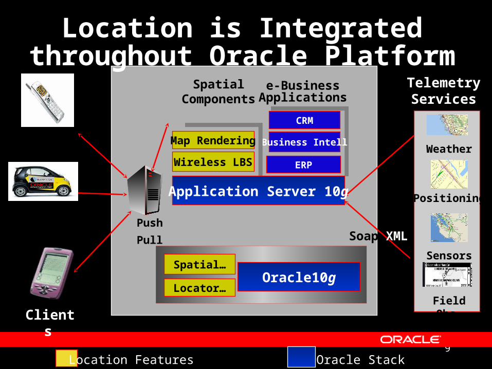
Location is Integrated throughout Oracle Platform
Weather
Positioning
Sensors
Field Obs.
CRM
Business Intell
Push
Pull
TelemetryServices
Map Rendering
Wireless LBS
SpatialComponents
Clients
Application Server 10g
Oracle10g
e-BusinessApplications
Soap XML
Location Features Oracle Stack
Locator…
Spatial…
ERP

10
Location Components
Location-enabled Enterprise:Complementary Roles
CRM/ERP Business Intelligence
SQLSQL XML/SOAP
Oracle Spatial 10g
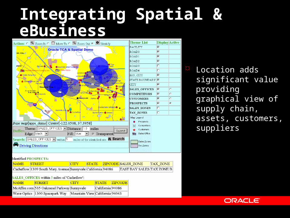
Integrating Spatial & eBusiness
Location adds significant value providing graphical view of supply chain, assets, customers, suppliers

12
A Spatially-enabled Database

Generating Map Data from Oracle Spatial Tables
Fisher Circle
85th St.
Coop Court
Road
ROAD_ID
1
2
3
SURFACE
Asphalt
Asphalt
Asphalt
NAME
Pine Cir.
2nd St.
3rd St.
LANES
4
2
2
LOCATION

14
How Spatial Data Is Stored in 10g?
Data type
Geographiccoordinates

15
Performing Location Query on Oracle 10g
Find post offices within 3km to my office?
Mai
n S
tree
t
163 Island Park Dr.
K1Y 2C3
+ Station B K1Y 2C43 km
+ Station P K1Y 2C3
SQL> SELECT P.Post_Office_Name, P.Address 2> FROM Post_Offices P, 3> Address_Master A 4> WHERE 5> A.St_Address =‘163 Island Park Dr.’ 6> and A.City = ‘Ottawa’ 7> AND MDSYS.SDO_WITHIN_DISTANCE( 8> A.Location, P.Location, 9> ‘distance=3’) = ‘TRUE’;

16
Oracle10g Spatial Capabilities
R-tree index Native Spatial Type Spatial Operators Spatial Reference System Long Transactions Parallel Index & Query Geodetic Support

Oracle10g Location Features
Locator Points, lines, polys 2D, 3D, 4D data Spatial Operators
– Within-distance– Spatial Relations
Coordinate Systems Long Transactions
Table Partitioning* Object Replication* Oracle10g Standard &
Enterprise
Spatial All Locator features Linear Referencing Spatial Aggregates Coordinate Transforms Network Data Model Topology Data Model GeoRaster Geocoder Spatial Analytic
Functions Oracle10g Enterprise Option Only
* Available on Enterprise Edition Only

Extensible Database Framework
Optimizer
Query Engine
Index Engine
Type Manager
Exten
sibility

19
Securing Spatial Information
Accesscontrol
Privacy &integrity of
data
Comprehensiveauditing
Boundary a
Infrastructure
Building a
Point c
Boundary c
Infrastructure D
Point b
Boundary b Point a
Building bInfra B
Build D Infra C
Building C
Network Security
Privacy &integrity of
communications
Authenticate
User Security
Data Security
Points of Interest
Buildings
Infrastructure
Boundaries

20
9i R1 Performance Enhancements
R-tree index creation up to 20% faster than 8i Partitioned local indexes provide additional performance
gains for queries on large datasets, and concurrent queries and updates
Spatial aggregate functions speed retrieval of large sets of SDO_GEOMETRY objects
WITHIN_DISTANCE queries run up to 40% faster with R-tree indexes
VALIDATE_GEOMETRY function runs 200% faster depending on the complexity of the geometries

21
9i R2 Performance Enhancements
R-tree indexes are created 50% faster than 9i R-tree update performance increased significantly Parallel index builds dramatically reduce R-tree
index creation for large non-point spatial datasets Spatial queries using secondary filters on geodetic
data run up to 40% faster Applications that execute WITHIN_DISTANCE
queries on linear features perform 30% faster.

22
Ten Spatial “Tips of the Trade”
1. Use R-Tree Spatial Indexes for your GIS applications!2. Ensure USER_SDO_GEOM_METADATA extents are correct (for longitude/latitude, must be (-180,180) (-
90,90)
3. Ensure tolerance is set correctly in USER_SDO_GEOM_METADATA.
4. Always Validate geometries using either: SDO_GEOM.VALIDATE_GEOMETRY_WITH_CONTEXT or SDO_GEOM.VALIDATE_LAYER_WITH_CONTEXT functionS
5. Spatial objects must use 4-digit notation for types
6. You can load spatial data through your GIS tool, Oracle SQL*Loader, or other 3rd party tools (eg. Safe FME)
7. Consider binary access only when single geometry exceeds 1M ordinates
8. Use Realistic Generalized Layers
9. Spatial objects must use 4-digit notation for types
10. Use DBMS tracing to identify performance bottlenecks

Oracle Spatial 10g Enables Critical Grid Capabilities
Integrated Data Management
Seamless Datasets Supports Complex
Workflows Easy to Manage & Program High Performance Supports Terabytes of
Data Supports 1000s of Users Fast Transactions Parallelism Bulk Load Utilities
Open/Standards-based Reliable Scalability Distributed/Replication Partitioning Version Management History Management Security Multi-platform Support

24
What the Analysts are Saying about Oracle
Spatial… “In repeated surveys, IDC has found that
Oracle is used in an 80%-90% share of Spatial Information Management oriented database installations.”
IDC, December 2002

25
The Dominant Spatial Database
National Mapping, Cadasters & Hydrographic Agencies– NIMA, USGS, US Army, Ordnance Survey (UK, IR, NI), Denmark, Sweden, The
Netherlands, Poland, Australia Transportation Management
– California, Iowa, Florida, Maine, Maryland, Minnesota, New York, Oklahoma, Pennsylvania, Alabama, Alberta, London Rail, Netherlands Transport, Australia, Austrian Rail, German Rail
Telco & Wireless LBS– AT&T, Bell South, Cingular, DoCoMo, KDDI, Intrado, JPhone, Nextel, Sprint, T-
Mobile, Telkom, Telenor, Telstra, Telus, Telia, Cellcom, Verizon, VIAG, Vodaphone, Wind
Utilities– Omaha Public Power, Reliant, US DoE, Western Power Corp, Severn Trent, Bejing
Power, Czech Telem, Copenhagen Energy, Electrable, Gaz de France, Hydro-Quebec, Equitable Resources, Nova Naturgas, Sao Paulo Electric,
Local Authorities– New York City, Chicago, Los Angeles, San Jose, San Mateo, Washington DC,
Cleveland, Detroit, Phoenix, Winnipeg, Vancouver, Edmonton, Stockholm…

26
What’s coming?

Upcoming Spatial 10g Features
Network Data Model Topology Data Model GeoRaster Geocoder Spatial Analytic Functions MapViewer

28
10g: Network Data Model Network Data Model
– A data model to store network (graph) structure in the database
– Explicitly stores and maintains connectivity of the network– Attributes at link and node level
Routing Engine– Street navigation for single or multiple destinations– Provide network analysis functionality in the database
Supports network solutions (Tracing & Routing)– Transportation and Transit Solutions– Field Service, Logistics– Location based Services and Telematics
VP: Bio-Info Pathways (Life Sciences)

29
10g: Topology Data Model New data model to store persistent topology
– Easier to do data consistency checks in this model
– Example: when the road moves, the property boundary automatically moves with it
Topology Data Model and Schema– Describes how different spatial features are
related to each other– A land parcel shares the boundary with a road
10g continues to support transient topology– Topology computed on demand
Conference Center
Oracle Pkwy

30
10g: GeoRaster What is GeoRaster
– A new data type to store raster data Satellite images, remote sensing data
– An XML schema to store Metadata Data source, layer information
– Geo Referencing information How to relate a pixel in the image to a
longitude/latitude on Earth’s surface Functionality
– Open, general purpose raster data model– storage and indexing of raster data
No size limit for each raster object– querying and analyzing raster data – delivering GeoRaster to external consumers
Publish as JPEG, GIFF images

31
10g Geocoder
Generates latitude/longitude (points) from address International addressing standardization Formatted and unformatted addresses Tolerance parameters support fuzzy matching 100% Java, open and scalable Record-level and batch processes Data provided by leading data vendors

32
10g: Spatial Analytic Functions Discovery based on Spatial Patterns
– Explicitly materialize spatial relationships
Usage– Insurance risk analysis, crime analysis– Demographic analysis, customer profiling– Epidemiology, Facility placement– Insurance Risk analysis:
cluster house-holds based on high risk neighborhoods
– Indentify business prospects across a region: examine the average incomes across different
regions of the space

MapViewer in Application Server 10gIntelligent Map Rendering & Analysis Component of Oracle Application Server Customized for the CRM/ERP Apps Vector and Raster visualization XML and Java Interfaces
New Features: Improved labeling and legend support Java map client lib and JSP custom tags Image theme & Customizable Image Renderer PNG and Macromedia Flash mapping support Multi-threaded geometry loading of themes Low Memory Requirements, increased performance New Security Features (admin login; password encryption)

Complying to Open Standards
OGC (GML,OpenLS ISO TC211 W3C Consortium (XML/Web Services) J2EE
SQL/MM

Berik Davies
Principal Consultant
Oracle Spatial at UK Ordnance Survey

36
Overview
Setting the scene – who are Ordnance Survey ?
Why build a new database ? Business Requirements Business Case High level Architecture Sizing and Hardware Summary

37
The early days …
The Tower of London 1841

38
Ordnance Survey in 2003 The National
Mapping agency of Great Britain
Turnover of £100m (US$160m)
1800 staff UK Government
Agency with ‘Trading Fund’ status

39
What does Ordnance Survey do ?
We capture data – surveying !
We store and manage data

40
… and we make products and sell them
What does Ordnance Survey do ?
OS MasterMap™ Strategi®Land-Line®

41
Current Environment
Existing systems lack agility
Difficult to integrate/interoperate
Very costly to maintain
Complex bespoke developments
DDMS DCS
Editors
HSM CMS
DCQTCSAPSFEP
DMS LMS
MOSAIC
GMSDef Reg
GRACE
CFS
eDCSCSAMGDW/S
Mercury(GOS)
ROADS
FTP
RAMS
GMS2
Sls & Mktng Stats
Prod Sched Systems

42
Why build new databases? (1)
‘Old World’ Land-Line®
‘New World’ OS MasterMap™(query on same area)
(complete tile)

43
Why build new databases? (2)

44
Business Requirements
Reduce deployment costs Reduce maintenance costs Improve data integration Improve systems integration Facilitate new product opportunities Increase business agility Store and maintain once, use many
times Standards and COTS based

45
Business Case for Oracle Spatial An open repository for our geospatial data Industry standard for spatial data in
RDBMS Robustness, reliability, scalability,
availability Part of the whole Oracle product family /
stack Strategic enterprise software within
Ordnance Survey

46
High-level overview – Maia & Mercury
Maia(maintenance)
Mercury(publication)
Custom
erD
ata
Col
lect
ion
Oracle 10G Spatial

47
DDMS
A-P CMS
DAOS/SDIT
DCS
OSCAR
DCQTCSComment
IN93 CT93 CTSU INSU
GEOSPATIAL SYSTEMS 1 (SSADM Contex t), READ ONLYSA/2001
Tue Apr 25, 2000 16:14Comment
Orig ina l Des ign Conc eiv ed and Drawn by Bry an L ingAmended fo l lowing R&A: 27-29 Marc h 1996 Vers ion 1.0
Updated by B Todd 19/05/97 v ers ion 2.0aUpdated by J Durnford 5/8/97
Is s ued Oc t 97 V2.0Updated by K Grims haw J une 1998
Is s ued J uly 1998 v 3.0Updated by K Grims haw Feb 1999
Is s ued Apri l 1999Updated by M Hodges Marc h 2000
Is s ued Apri l 2000 v.5.0
DCQC Quarantine Area
DC Server
(Pilot)
OS96 Fast Track
NSG concession
DFRSMQCSampling
HSM
PRISM
OCE plotter
HP plotter
DC Server FEP
Archive
Royal Mail DDMS WIP
BP A-P Team
A-PImprovement
Cell
Marketing Contractor
Sales &Marketing
Stats
TSF
50K RAMS
A-P ProjectsOffice
NLIS
OS96 PCS
Landplan
PS
MID
ELS
StatutoryUndertakers
HighwaysAuthority
GI Solutions
GRACE
Sales &Marketing
Stats
(AAP/EDIT)(BUS)
BoundariesAAP Edit
CountyStreet Atlas
MIDSCALES
DMS
PS Systems
SSMI
CountyStreet Atlas
CCD
OSCARWorkflow
DCS
Geospatial Data Systems Part 1
fo r clarity, the fo llowing data flows may no t shown on th is d iag ram:(1 ) Success/Failu re files(2 ) Request files3 ) Acknowledgemen t filesThey are shown in the app ropriate lower levels o f Data Flow Diag ram
NOTE:
repaired f ailures
repaired databanks
holdings liston request
inval. A-P sect .f ile ( f ailure)
I nvalid dmu +A-P update
InvalidA-P sect or I nvalid A-P
sect or f ile (f ixed)
repaired PRISMdmu AP updat e
holdings liston request
I nval. A-P sect .f ile ( f ailure)
invalid dmu +A-P update
invalidA-P sect or
I nvalid A-Psector f ile ( f ixed)
repaired PRISM dmu+ AP update
set quarant ineor rework f lag
init iat e sweep request
Defec t fi lesAc c es s databas e output
OS96 Defec t fi le
CI TF Def ect f ile
DCQTCS Error log
CI TF updat e f ile
Paper report to Produc tion
databas e update
50K TI FF
50K TI FF & T30 data
updated 50K TIFF/T30 data
ReworkOS96DMU
AP ex trac t
FSF
book ing res pons e refbook ing fi le
uncorrectedaccess +val f ails
R/O frozen AP datafor address range c reation
Traffic Managerfor address range c reation
Traffic Managerwi th addres s range data (NTF)
NSG c s v
+ as s . s treet data(app. E)
NSG c s v
+ as s . s treet data(app. E)
NSG c s v
+ as s . s treet data(app. E)
DMU s tatus updates
DMU s tatus queries
DMU s tatus queries
OSCAR av ai lab i l i ty
inst ruct ions
progressupdates
ta i lored OSCAR data(IFF)
OSCAR information
Route Manager data(IFF&NTF)
As s et Manager data
Traffic Manager+ DRI data
Network Manager data
Route Manager data
TOPODMU
Ac c es s read only query
AP-Q2 fi le
fi lm +paperp lots
c olourpaperp lots
metadata
ras ter data
ac c es s &v al idationfa i lures
Unfin is hedOS96DMU
Metadata
Conv ertedOS96DMU
OS93 DMU
UOS96(fin is hed)
c olourpaperp lots
fi lm +paperp lots
read only forms access
Interac tive forms access
DC week ly s tats
1:10Kras ter(TIFF)
new1:10Kras terdata
(TIFF)
metadata
databas emetadata
landplanras ter
landplan c i tfdata for
SPS agents
in terac tiv e forms ac c es s
address data(asc ii )
address data(asc ii )
wri te permis s ion in fo
RMupdates tats
A-P update & FSF
metadata
MQCs ampl ing
data(read only )
holdings list
pos s ib lec orrec tiv e
ac tion
PAF + Changes ;Pos tzonKeychain
c orrupt media,data for inv es tigation
reques ts to DDMS:
(1) databank(2) quarantine ex trac t(3) quarantine databank(4) quarantine reques t
read-only dmufor c hec k ing
(quarantine c opy )
ras terimages
address data(asc ii )
OSCARupdate
inf o
hold ingsl is ts onreques t
repai red databank s
c orrec tedac c es s + v a l fai ls
A-Ps ec tor
fi le
in terac tiv eforms
ac c es s
airphotographs
reques tfor
data
repai red dmu
interac tiveforms access repai red fa i lures
uni t pos tc odec o-ord inates
address data(asc ii )
A-P datato databank
A-P ex trac ted data
new/s upers ededdmu detai ls
dmu & us erin formation
Landl ine dataCITF
LandformProfi le
(c ontour)data
+ DTM
dmus (CITF)fi l tered for OSCAR
fai led dmu (CITF)
IDS fi ledmu, A-P
& defec t update
OS96Val idation
fa i lures
dmu ,A-P &
defec t ex trac t
ex -c ontrac tor(RRUC) dmu (CITF)
(updated)
orig ina l(RRUC)
dmu(CITF)
Map header in fo
fa i led A-Pex trac ts &databank s
As s et Managerfor DoT
(Highway s Agenc y )ta i lored v ers ion
update offroz en A-P datas et
updated(RRUC)dmus (RRUC) dmus
for update
dmu
DDMS
GEOSPATIAL SYSTEMS 2 (SSADM Co n tex t), READ ONLYSA/2 0 0 1
Wed Ap r 1 9 , 2 0 00 1 4 :5 3Co mme n t
Orig in al Desig n Co n ceiv ed an d Drawn b y Bryan Lin gAmen d ed fo llo wing R&A: 27 -2 9 March 1 9 9 6 Versio n 1 .0
Up d ated by B To d d 1 9 /0 5 /9 7 v ersio n 2 .0 aUp d ated by J Du rn fo rd 5 /8 /9 7
Issu ed Oct 9 7 V2 .0Up d ated by K Grimsh aw Ju ne 1 9 9 8
Issu ed Ju ly 1 9 9 8 v 3 .0Up d ated by K Grimsh aw Feb 1 9 9 9
Issu ed Ap ril 1 9 9 9 v 4 .0Up d ated by M Hod g es March 2 0 0 0
Issu ed Ap ril 2 0 0 0 v 5 .0
Boundaries AAP EditCo mme n t
(AAP/EDIT)
DCS
APS
TPDCo mme n t
Ag e n ts FEP
PS Systems
Boundary Commiss ion
GI SolutionsData Hub
SERAD
LandplanCo mme n t
DMS
Ag e n ts FEP
Customer
SERAD
DC BoundarySec tion
Mid-Scales
GRDS
DE
GRACE
GISOLUTIONS
BoundariesViewer
Sales &Marketing Stats
SurveyComps
10KREPMAT
CUSTOMER
Sales andMarketing Stats
GI SolutionsSurveyComps
DMS
Fly ing Unit
DCS
DCS
AIS
OSCAR
AAA
DAOS/SDIT
Mid-Scales
MID
Geospatial Data Systems Part 2
Ag e n ts FEP
for clarity, the follow ing data flow s may not be show n on this diagram:(1) S uccess/Failure files(2) R equest files3) A cknow ledgement filesThey are show n in the appropriate low er levels of D ata Flow D iagram
N OT E :
Su p e rp l a n i n d e x e s
L a n d l i n e o n CD
Bo u n d a ry l i n e d a ta (NT F)(a n n u a l fro z e n s e t)
Co mp l e te AAP d a ta b a s e
Cu s to mi s e d d a ta
R/O d a ta
fo rmsa c c e s s
me ta d a ta
IDS F i l e
1 0 K ra s te r (T IF )
p o l y g o n s
ra s te rd a ta
Re a dDMUIF F
1 :1 0 Kra s te r(T IF F )
n e w1 :1 0 Kra s te rd a ta(T IF F )
d e v e l o p e dl a n d u s e
c o a s tb o u n d a ri e sn a me s (IF F )
Ra i l wa y s(n e wl y
c a p tu re d b yDE) (IF F )
b o u n d a ri e sd a ta (IF F)
IF F f i l e s
tra n s fe r fa i l u re l i s t
IF F
DMUs fo r a g e n ts
l a n d p l a nra s te r
l a n d p l a n c i t fd a ta fo r
SPS a g e n ts
NH ma i n t. d a taNH ma i n t. d a ta
me ta d a ta
SPS i n fo rma t i o n
c o n fi rma ti o n
re q u e s t v a l i d a t i o na d mi n a re a
h o l d i n g s l i s t
d mu f i l te re d fo rb o u n d a ri e s
u n i t p o s tc o d ec o -o rd i n a te s
fa rm i n fo rma t i o n
re q u e s tfro m a g e n t
fo r d a ta
re q u e s tfo r
d a ta
u p d a te d e n c l a v e s
e n c l a v e s
L a n d l i n ed a taCIT F
L a n d fo rmPro f i l e
(c o n to u r)d a ta
+ DT M
L a n d p l a nT i l e (CIT F)
g ro u n d c o n tro li n fo
d mu (CIT F )
fa i l e d d mu (CIT F)
b o u n d a ryo rd e r
d mu(CIT F )
d mu(CIT F )
1 0 k ra s te rf i l e (T IF )
Ma p h e a d e r i n fo
Bo u n d a ry -L i n e d a ta
(NT F )(a n n u a l fro z e n s e t)
IF F a n d NT F f i l e s
L a n d p l a n T i l e(CIT F )
p l o t s ta ts
As s e t Ma n a g e r fo r Do T(Hi g h wa y s Ag e n c y )
ta i l o re d v e rs i o n
L a n d p l a n T i l e(CIT F )
OS9 3d mu (CIT F )
NHDM T i l e(CIT F )
OSCARAs s e t Ma n a g e r
d a ta
Cu s to mi s e d L a n d fo rm(CIT F )
DT M
a e ri a lp h o to g ra p h
Pl o t F i l e
L a n d l i n ed mu (CIT F )

48
Type of Data Size (GB)
Raw Data
Spatial Indexes
Transient Tables required during Spatial Index Creation / Re-Build
Non-Spatial Indexes
History (10% change per year for 5 years)
History Spatial Indexes
Database Structures (system, undo, etc.)
History Non-Spatial Indexes
Transient Tables required during Spatial Index Creation / Re-Build
Contingency at 25%
Total 995 GB
175
20
40
70
350
100
10
10
20
200
Sizing
450 million features

49
Hardware
2 x Sun Fire F6800, 12 x UltraSPARC-III 1050 MHz, 24 GB RAM
2 x Sun StorEdgeT3 disk arrays, 2 TB raw storage, RAID 5 Sun StorEdge L700 Tape system – 135 TB storage
50
Summary
The Maia database, together with Oracle® Spatial and ESRI®’s ArcGIS™ will bring Ordnance Survey’s own internal processes into the MasterMap™ era.
Expect financial and strategic gains from the move to Commercial Off-The-Shelf software.
The close relationship between Oracle and Ordnance Survey has brought significant benefit to both organsiations.
51
Contact for further information
Berik DaviesOrdnance SurveyRomsey RoadSOUTHAMPTONUnited KingdomSO16 4GU
Phone: +44 (0)23 8030 5488Fax: +44 (0)23 8079 2078E-mail: [email protected] site: www.ordnancesurvey.co.uk

52
Next Steps…. Recommended sessions
– #40340 - Leveraging Location-Based Services for Everyday Government and Emergency Management (Mon Sept 9, 4:00pm, Marriott Golden Gate A3)
– Keynote: Craig R. Barrett, Chief Executive Officer, Intel (Tuesday, September. 9, 1:00 -1:45 PM)
– # 40058 - Oracle Mobile and Wireless Technology Overview (Thu Sept 11 8:30 AM, Moscone Room 202)
– #40340 - Leveraging Location-Based Services for Everyday Government and Emergency Management (Mon Sept 9, 4:00pm, Marriott Golden Gate A3)
– # 40081 - Using Oracle Workspace Manager to Cut Costs: Case Studies (Thur. 3:15 PM, Moscone Room 131)
Oracle Spatial 10g demos – Oracle10g Location Services, Oracle DEMOgrounds

53
Next Steps (cont.) Partner Exhibition
– #725 Autodesk– #1736 eSpatial– #2126 ESRI– #2408 Intergraph– # Plangraphics– # Skyline
Oracle Security Command Center Pavilion eSpatial PCI Geomatics PlanGraphics TARGUSInfo
For more information– http:// technet.oracle.com/products/spatial

54
Reminder – please complete the OracleWorld online session survey
Thank you.

AQ&Q U E S T I O N SQ U E S T I O N SA N S W E R SA N S W E R S