
OPNAVINST 3140.24F OPNAV INSTRUCTION 3140.24F Subj ...navybmr.com/study material/OPNAVINST...
13
DEPARTMENT OF THE NAVY OFFICE OF THE CHIEF OF NAVAL OPERATIONS 2000 NAVY PENTAGON WASHINGTON, D.C. 20350-2000 IN REPLY REFER TO OPNAVINST 3140.24F N84 27 Aug 08 OPNAV INSTRUCTION 3140.24F From: Chief of Naval Operations Subj: ADVERSE AND SEVERE WEATHER WARNINGS AND CONDITIONS OF READINESS Encl: (1) Common Weather Warning Terminology and Criteria (2) DoD Conditions of Readiness 1. Purpose. To promulgate information on Department of Defense (DoD) and the National Weather Service (NWS) terminology and severe weather criteria, used for determining and setting conditions of readiness for United States Navy (USN) and United States Marine Corps (USMC) activities and commands in advance of adverse or severe weather. 2. Cancellation. OPNAVINST 3140.24E. 3. Scope and Applicability. Adverse or severe weather poses a significant threat to military personnel, ships, aircraft and installations. Adequate and timely weather warnings, combined with prompt and effective action by commanders, will minimize loss, damage, and help ensure the safety of personnel. The weather warning criteria and terminology defined in this instruction are applicable at all Navy and Marine Corps activities and commands. 4. Action Required. Commanders and commanding officers shall: a. Use all available weather information to minimize potential loss of life and damage to property associated with hazardous weather. b. Include precautionary measures and planned rapid responses in local directives to ensure safety of personnel and property when warnings of destructive weather are received. c. Commander, Naval Meteorology and Oceanography Command (CNMOC), and USMC weather activities are responsible for the
Transcript of OPNAVINST 3140.24F OPNAV INSTRUCTION 3140.24F Subj ...navybmr.com/study material/OPNAVINST...

DEPARTMENT OF THE NAVYOFFICE OF THE CHIEF OF NAVAL OPERATIONS
2000 NAVY PENTAGONWASHINGTON, D.C. 20350-2000
IN REPLY REFER TO
OPNAVINST 3140.24FN8427 Aug 08
OPNAV INSTRUCTION 3140.24F
From: Chief of Naval Operations
Subj: ADVERSE AND SEVERE WEATHER WARNINGS AND CONDITIONS OFREADINESS
Encl: (1) Common Weather Warning Terminology and Criteria(2) DoD Conditions of Readiness
1. Purpose. To promulgate information on Department of Defense(DoD) and the National Weather Service (NWS) terminology andsevere weather criteria, used for determining and settingconditions of readiness for United States Navy (USN) and UnitedStates Marine Corps (USMC) activities and commands in advance ofadverse or severe weather.
2. Cancellation. OPNAVINST 3140.24E.
3. Scope and Applicability. Adverse or severe weather poses asignificant threat to military personnel, ships, aircraft andinstallations. Adequate and timely weather warnings, combinedwith prompt and effective action by commanders, will minimizeloss, damage, and help ensure the safety of personnel. Theweather warning criteria and terminology defined in thisinstruction are applicable at all Navy and Marine Corpsactivities and commands.
4. Action Required. Commanders and commanding officers shall:
a. Use all available weather information to minimizepotential loss of life and damage to property associated withhazardous weather.
b. Include precautionary measures and planned rapidresponses in local directives to ensure safety of personnel andproperty when warnings of destructive weather are received.
c. Commander, Naval Meteorology and Oceanography Command(CNMOC), and USMC weather activities are responsible for the

OPNAVINST 3140.24F27 Aug 08
timely dissemination of hazardous or destructive weatherwarnings to naval airfields and fleet concentration areas. IfCNMOC or Marine Corps weather activities warnings are notavailable, commanders and commanding officers should use warninginformation disseminated by other agencies to include the NWS,United States Air Force, National Oceanic and AtmosphericAdministration (NOAA) and local media. Enclosure (l) contains alist of the DoD and NWS/NOAA weather warning terminology andcriteria.
5. Conditions and Criteria. Conditions of readiness criteriaprescribed in enclosure (2) shall be used at all Navy and MarineCorps activities and commands, and may be modified to reflectlocal readiness criteria. Local area commanders, at theirdiscretion, may set a higher condition of readiness for theiractivities but may not lower any condition of readiness belowthat established by the regional disaster preparedness officer,emergency manager or regional planning agent for naturaldisasters, or their delegated representative.
D. A. GOVERear Admiral, U.S. NavyOceanographer of the Navy
Distribution:Electronic only, via Department of the Navy Issuances Web sitehttp://doni.daps.dla.mil
2

Common Weather Warning Terminology and Criteria
OPNAVINST 3140.24F27 Aug 08
USN/USMC I NWSWind Warnings
.. . ":'::
Sustained wind of 25-33 knots(Varies slightly bygeographical region) areforecast for harbors andinland waters, as well asadjacent coastal areas within24 hours. Can also be issued
Sustained wind of 18-33 knots based on local sea conditionsare forecast for harbors and (varies by geographical
Small Craft warning inland waters. region) •Sustained wind of 25-39 Milesper Hour (mph) (22-34 knots)for at least 1 hour and/or any
Sustained wind of 18-33 knots gusts to 57 mph (40-49 knots)or frequent gusts to 25 knots are forecast over land.
Airfield Wind or greater are forecast for Issuance is normally siteAdvisory . airfields and installations. specific .
A warning of sustained surfacewinds, or frequent gusts, inthe range of 34 knots (39 mph)to 47 knots (54 mph)
Sustained wind of 34-47 knots inclusive, either predicted orare forecast for harbors, occurring, and not directlyinland waters, ocean areas, associated with a tropical
Gale Warning airfields and installations. cyclone.
Enclosure (1')

OPNAVINST 3140.24F27 Aug 08
USN/USMC NWSStorm Warning Sustained wind of 48 knots or A warning of sustained surface
greater are forecasted for winds, or frequent gusts, in theharbor, inland waters, ocean range of 48 knots (55 mph) to 63areas, airfields and knots (73 mph) inclusive, eitherinstallations. predicted or occurring, and not
directly associated with atropical cyclone .
Tropical'Qyqlone Warnings " .. , ' , .' ',.
. "
Warning for land, harbor,inland water, and ocean areasfor sustained wind of 33knots or less / no specified
Tropical Depression timeframe. N/AWarning for land, harbor,inland waters, and oceanareas for sustained wind of34-63 knots / no specified
Tropical Storm timeframe. N/AWarning for land, harbor,inland waters, and oceanareas for sustained wind of64 knots or greater / no
Hurricane/ Typhoon specified timeframe. N/AAn announcement for specificcoastal areas that tropicalstorm conditions are possible
Tropical Storm Watch N/A within 36 hours.,
2 Enclosure (1)
OPNAVINST 3140.24F27 Aug 08
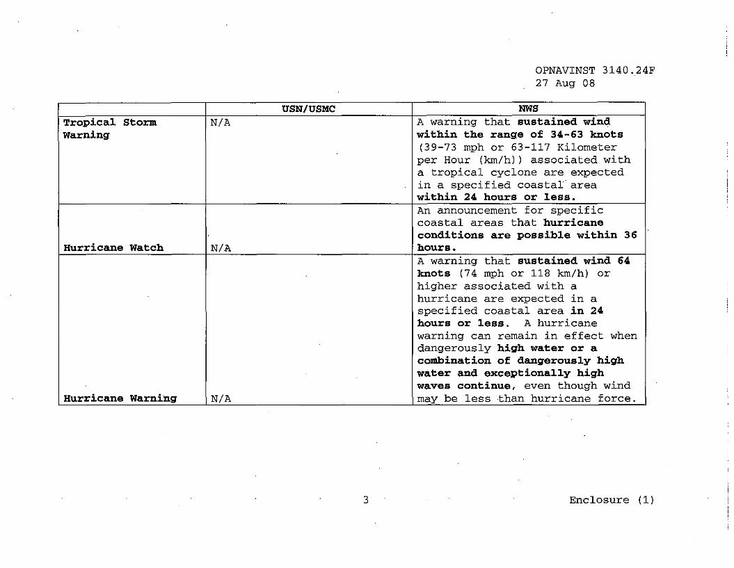
USN/USMC NWSTropical Storm N/A A warning that sustained windWarning within the range of 34-63 knots
(39-73 mph or 63-117 Kilometerper Hour (kIn/h) ) associated witha tropical cyclone are expectedin a specified coastal areawithin 24 hours or less.An announcement for specificcoastal areas that hurricaneconditions are possible within 36
Hurricane Watch N/A hours.A warning that sustained wind 64knots (74 mph or 118 kIn/h) orhigher associated with ahurricane are expected in aspecified coastal area in 24hours or less. A hurricanewarning can remain in effect whendangerously high water or acombination of dangerously highwater and exceptionally highwaves continue, even though wind
Hurricane Warning N/A may be less than hurricane force.
3 Enclosure (1)

OPNAVINST 3140.24F27 Aug 08
USN/USMC NWSThunderstorm and Tornado Warnings ..... .. . . .
Destructive wind andaccompanying thunderstorms arewithin 25 Nautical Miles (NM) ,or expected within 6 hours.Associated lightning/thunder,torrential rain, hail, severedownbursts, and sudden windshifts are possible. Takeprecautions that will permitestablishment of an
Thunderstorm Watch appropriate state of readiness(T2) on short notice. N/AThunderstorm Warning Destructive wind and N/A(T1) accompanying thunderstorms are
within 10 NM, or expectedwithin 1 hour. Associatedlightning/thunder, torrentialrain, hail, severe downbursts,and sudden wind shifts arepossible. Take immediatesafety precautions andshelter .
.
4 Enclosure (1)
Severe ThunderstormWatch
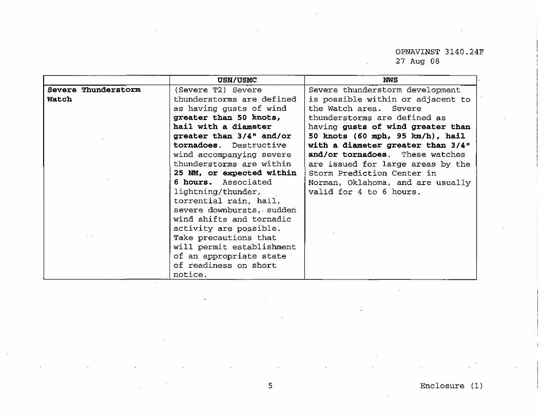
USN/USMC(Severe T2) Severethunderstorms are definedas having gusts of windgreater than 50 knots,hail with a diametergreater than 3/4" and/ortornadoes. Destructivewind accompanying severethunderstorms are within25 NM, or expected within6 hours. Associatedlightning/thunder,torrential rain, hail,severe downbursts,. suddenwind shifts and tornadicactivity are possible.Take precautions thatwill permit establishmentof an appropriate stateof readiness on shortnotice.
5
OPNAVINST 3140.24F27 Aug 08
NWSSevere thunderstorm developmentis possible within or adjacent tothe Watch area. Severethunderstorms are defined ashaving gusts of wind greater than50 knots (60 mph, 95 km/h), hailwith a diameter greater than 3/4"and/or tornadoes. These watchesare issued for large areas by theStorm Prediction Center inNorman, Oklahoma, and are usuallyvalid for 4 to 6 hours.
Enclosure (1)

USN/USMCSevere Thunderstorm Warning I (Severe TIl Severe
thunderstorms are definedas having gusts of windgreater than 50 knots,hail with a diametergreater than 3/4" and/ortornadoes. Destructivewind accompanying severethunderstorms are within10 NM, or expected within1 hour. Associatedlightning/thunder,torrential rain, hail,severe downbursts, suddenwind shifts and tornadicactivity are possible.Take immediate safetyprecautions and shelter.
Tornado Watch IN/A
6
OPNAVINST 3140.24F27 Aug 08
NWSSevere thunderstorm isindicated by Doppler radar orsighted by skywarn spotters.Severe thunderstorms aredefined as having gusts of windgreater than 50 knots (GO mph,95 km/h), hail with a diametergreater than 3/4" and/ortornadoes. These warnings areissued by local NWS fieldoffices for counties and/orportions of counties.
Conditions are favorable forthe development of severethunderstorms and tornadoes inand close to the watch area.These watches are issued forlarge areas by the StormPrediction Center in Norman,Oklahoma, and are usually validfor 4 to 6 hours.
Enclosure (1)

OPNAVINST 3140.24F27 Aug 08
USN/USMC NWS .
Tornado Warning N/AConditions are likely that atornado exists. Strongrotation in a thunderstorm isindicated by Doppler radar or atornado is sighted by sky~arn
spotters.Special WeatherAdvisories/Watches/Warnings
Up to 1" of snow in 12hours; or up to 2" in 24
winter Snow Advisory hours. N/AModerate to heavy snowwith freezingprecipitation within 6
Winter Snow Warning hours. N/ASpecific advisories used todescribe conditions which maypose a threat to specifiedusers, but are not seriousenough to warrant a warning ofthe general public. Conditionsinclude snow (less than 4"),blowing snow, wind chill,
Winter Storm Advisory N/A freezing rain, dense fog, etc.
7 Enclosure (1l

OPNAVINST 3140.24F27 Aug 08
USN/USMC NWSWhen the risk of a hazardousweather event has increasedsignificantly, but itsoccur.rence, location, and/ortiming is still uncertain.Such weather events includeblizzards, heavy snow, freezing
Winter Storm Watch N/A rain or drizzle, and sleet.When the risk of a hazardousweather event is imminent oroccurring. The winter stormwarning covers the sameconditions included under
Winter Storm Warning N/A winter storm watch.
Freezing PrecipitationAdvisory Up to 1/4" accumulation. Any accretion on road surfaces.
6" or more accumulation in 12hours for sleet or 1/2"
Freezing precipitation Greater than 1/4" accumulation or more forWarning accumulation. freezing rain.
8 Enclosure (1)

OPNAVINST 3l40.24F27 Aug 08
USN/USMC NWSAn abnormal rise in sea level
Warning issued for accompanying a hurricane orcoastal areas, harbor, other intense storm, whosebays, and inland waters height is the differencewhen abnormally high between the observed level oftides are forecast to the sea surface and the levelimpact operations. The that would have occurred.in thespecific warning height absence of the cyclone. Stormabove normal mean high surge is usually estimated bytide will be determined subtracting the normal tide
Storm Surge warning by local area commanders. from the observed storm tide.Heavy rainfall may result in,or has produced, flash
Flash Flood Watch/Warning N/A flooding.. Strong on-shore wind,
potentially combined with heavyrainfall, may result in, or hasproduced, coastal flooding.Special statements may beissued for astronomically high-tides which.produce minor
Coastal Flood Watch/warning N/A flooding.Tsu.J:J.alllis/Siedhe·
. . ' .' .. . ".
.'.. . .;,',
Tsunamis warning N/A Pacific Tsunami Warning CenterNaval Maritime ForecastCenter, Pearl Harbor,issues Seiche warnings asrequired or as requested
Seiche Warning by the user. N/A
9 Enclosu::-e (l)

OPNAVINST 3140.24F27 Aug 08
DoD Conditions of Readiness
1. Conditions of readiness are set using the applicable termindicating wind force, such as setting Gale Condition. Unlessspecifically stated otherwise, conditions of readiness are basedon sustained wind. Tropical cyclone conditions are set only forcyclonic systems of tropical or subtropical origin. Gale andstorm condit{ons are used for wind storms other than tropicalcyclones, or for wind outside a tropical cyclone'S generalcirculation.
TROPICAL CYCLONE, SUB-TROPICAL, EXTRA-TROPICAL WIND STORMS(Issue using gale, storm, tropical storm, or hurricane/typhoon
to indicate force of destructive wind.)Condition V Destructive winds are possible within 96
hours.
Condition IV Trend indicates a possible threat ofdestructive wind of the force indicatedwithin 72 hours. Review hazardous anddestructive weather implementation plans, asestablished by local regulations.
Condition III Destructive wind of the force indicated arepossibly within 48 hours. Take preliminaryprecautions.
Condition II Destructive wind of the force indicated areanticipated within 24 hours. Takeprecautions that will permit establishment of·an appropriate state of readiness on shortnotice.
Condition I Destructive wind of the force indicated areoccurring or anticipated within 12 hours.Take final precautions as prescribed.
2. Further amplification of the basic conditions prescribedabove is authorized to facilitate conditions of readiness withinlocal commands. The previous setting of a lower condition ofreadiness is not a prerequisite for setting any of theconditions. 'l'he forecast wind values may be different than thethreshold values in enclosure (ll to reflect best possibleforecast information. Examples:
Enclosure (2)

OPNAVINST 3140.24F27 Aug 08
a. "Set Gale Condition II. Destructive wind of 35 to 40knots are anticipated within 24 hours."
b. "Set Tropical Storm Condition III. Destructive wind of50 knots or greater are possible within 48 hours."
c. "Set Hurricane Condition I. Destructive wind of 80knots or greater are anticipated within 12 hours."
2 Enclosure (2)


![OPNAVINST 3710[1].7U IC 39](https://static.fdocuments.in/doc/165x107/553d1a7c4a7959f87e8b4bca/opnavinst-371017u-ic-39.jpg)


