OPERATION & INSTALLATION MANUAL AIS RX YACHT · AIS (Automatic Identification System) is the name...
28
OPERATION & INSTALLATION MANUAL AIS RX YACHT Version 1.4E © True Heading 2005 The manual may not in any aspect be copied without the prior authorization from True Heading AB.
Transcript of OPERATION & INSTALLATION MANUAL AIS RX YACHT · AIS (Automatic Identification System) is the name...
OPERATION & INSTALLATION
MANUAL
AIS RX YACHT
Version 1.4E
© True Heading 2005 The manual may not in any aspect be copied without the prior authorization from True Heading AB.

1 REVISSION................................................................................................................ 3 2 INTRODUCTION ...................................................................................................... 4 3 GLOSSARY ............................................................................................................... 5 4 CONDITIONS ............................................................................................................ 6 5 WARRANTY.............................................................................................................. 7
5.1 General................................................................................................................ 7 5.2 Warranty conditions ............................................................................................ 7 5.3 Warranty procedures........................................................................................... 7 5.4 Other issues......................................................................................................... 7
6 SUPPORT ................................................................................................................... 8 7 INFORMATION ABOUT AIS .................................................................................. 9
7.1 General................................................................................................................ 9 7.2 Short technical description of AIS .................................................................... 10 7.3 Limitations with AIS ......................................................................................... 11
8 AIS RX YACHT....................................................................................................... 12 8.1 General description ........................................................................................... 12 8.2 Technical specification..................................................................................... 12
8.2.1 Electrical data ............................................................................................ 12 8.2.2 Data output ................................................................................................ 12 8.2.3 Receiver .................................................................................................... 12 8.2.4 Physical data ............................................................................................. 12 8.2.5 GPS ........................................................................................................... 13
9 HOW TO INSTALL AIS RX YACHT .................................................................... 13 9.1 Introduction....................................................................................................... 13 9.2 Installation......................................................................................................... 13
9.2.1 Checking your material............................................................................. 14 9.2.2 Installing your receiver ............................................................................. 14 9.2.3 Antenna installation .................................................................................. 14 9.2.4 GPS antenna .............................................................................................. 15 9.2.5 VHF antenna ............................................................................................. 16 9.2.6 Power ........................................................................................................ 18 9.2.7 Connection to PC ...................................................................................... 19 9.2.8 Data cables ................................................................................................ 21
10 OPERATIONAL GUIDELINES FOR AIS RX YACHT.................................... 22 11 FAQ....................................................................................................................... 26 12 NOTES .................................................................................................................. 28

1 REVISSION Version Date Responsible Approved Changes 1.0E 2005-05-09 Anders Bergström Nils Willart First translation 1.1E 2005-05-10 Anders Bergström Nils Willart External GPS 1.2E 2005-05-17 Anders Bergström Nils Willart NMEA output 1.3E 2005-05-23 Anders Bergström Nils Willart External GPS 1.4E 2005-06-21 Anders Bergström Nils Willart External GPS
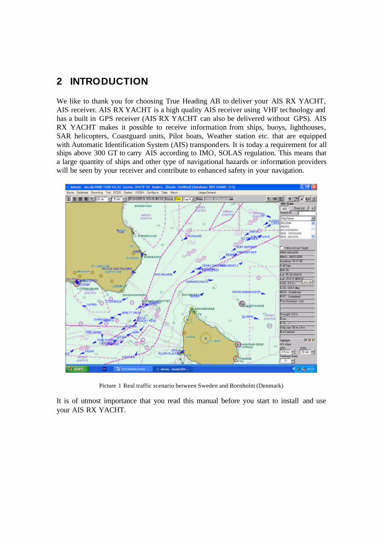
2 INTRODUCTION We like to thank you for choosing True Heading AB to deliver your AIS RX YACHT, AIS receiver. AIS RX YACHT is a high quality AIS receiver using VHF technology and has a built in GPS receiver (AIS RX YACHT can also be delivered without GPS). AIS RX YACHT makes it possible to receive information from ships, buoys, lighthouses, SAR helicopters, Coastguard units, Pilot boats, Weather station etc. that are equipped with Automatic Identification System (AIS) transponders. It is today a requirement for all ships above 300 GT to carry AIS according to IMO, SOLAS regulation. This means that a large quantity of ships and other type of navigational hazards or information providers will be seen by your receiver and contribute to enhanced safety in your navigation.
Picture 1 Real traffic scenario between Sweden and Bornholm (Denmark) It is of utmost importance that you read this manual before you start to install and use your AIS RX YACHT.

3 GLOSSARY To make the reading of the manual easier we like to start up with introducing the used abbreviations and glossary: AIS Automatic Identification System ATC Air Traffic Control DGPS Differential Global Positioning System ETA Estimated Time of Arrival GPS Global Positioning System GALILEO European equivalent to GPS GNSS Global Navigation Satellite System IMO International Maritime Organization NM Nautical Mile = 1852 m RX Receive/Receiver SMA Swedish Maritime Administration SOLAS Safety Of Life At Sea SOTDMA/STDMA Self Organized Time Division Multiple Access. VHF Very High Frequency VTS Vessel Traffic Services (Like ATC but for ships)
4 CONDITIONS Before you start using the AIS RX YACHT product from True Heading AB it is important that you read and fully understand the installation manual and its instructions. You should only proceed with the installation if you are confident that you will be able to do so. True Heading AB cannot be held liable for any injury or damage caused by, during or because of the installation of AIS RX YACHT or SeaClear . The AIS RX YACHT is used at your own risk and it shall be remembered that AIS and GPS data depends on the full co-operation of other users and systems. AIS RX YACHT is a navigat ion aid and works in co-operation with other similar systems like e.g. radar, optical lookout etc. The AIS RX YACHT installation should be inspected from time to time and checked on its operational quality frequently by the user. Remember that navigation and life at sea always requires proper seamanship and that the AIS RX YACHT is not a replacement for such qualities. SeaClear is only a navigational aid. It collects, calculates and displays data for you, but there is no guarantee it is correct, there are many sources for errors. SeaClear is not a replacement for navigational knowledge, nor can it navigate by it self. Use it with care. Always have the original charts available when SeaClear is in use. True Heading does not take any responsibility for functionality of SeaClear, neither are we responsible for any charts used in conjunction with SeaClear. NOT ALL VESSELS CARRY AIS. IT IS THEREFORE IMPORTANT TO KEEP PROPER LOOKOUT AT ALL TIMES AND TO USE ALL AVAILABLE MEANS TO AVOID COLLISIONS AND ACCIDENTS. GPS MAY FROM TIME TO TIME INCLUDE ERRORS: THEREFORE, THE POSITION RECEIVED FROM THE GPS BUILT IN TO AIS RX YACHT SHALL ALWAYS BE VERIFED WITH OTHER AVAILABLE MEANS.

5 WARRANTY
5.1 General AIS RX YACHT is developed and manufactured to meet high technical requirements and user demands. If installed correctly and with regular maintenance your AIS RX YACHT should provide you with several years of operation and a very useful product. For further information provided in the manual and in this information sheet please consult the place where you purchased the AIS RX YACHT or direct to our support.
5.2 Warranty conditions - The warranty belongs to the person that purchased the product and cannot be handed over to a third party or person. - The warranty is not valid if serial number is missing, seals broken or if the AIS RX YACHT has been incorrect installed. Neither is the warranty valid if instructions for connection have not been followed, faults caused by wrong usage, own made modifications or service made from none authorized service stations. - True Heading AB acknowledges that AIS RX YACHT at delivery has been controlled and found operational. - True Heading AB agrees to repair or replace any faulty unit without any cost according to the conditions set forth during a period of two (2) years from day of purchase. - The warranty includes replacement or repair of faulty unit due to error in components or errors in relation to the production of the product. - The warranty covers costs for spares, labor, and return shipment. It does not include shipment from to the repair facility. - True Heading AB will never be liable under the warranty conditions for incorrect use, misuse, and incidental, indirect or consequential damages of the AIS RX YACHT. - Proof of purchase is required for any warranty claim of the AIS RX YACHT.
5.3 Warranty procedures True Heading AB repairs and replaces faulty parts or units. The customer is responsible for transport of the defect part or unit to True Heading or its retailer. Warranty claims shall be made to the place where AIS RX YACHT was purchased or direct to True Heading AB through mail, fax or e-mail to our support department.
5.4 Other issues Proper seamanship and common sense is applicable when using AIS RX YACHT and the products shall only be seen as a navaid. True Heading AB keeps the right to change the specification of the product without prior notice. IF YOU ARE NOT ABLE TO ACCEPT THE TERMS ABOVE, PLEASE RETURN THE AIS RX YACHT TO YOUR RETAILER FOR FULL CREDIT BEFORE OPENED AND USED.

6 SUPPORT If you need support, please contact the closest reseller or the location where you acquired the product.
The manufacturer can also give support direct: Email: [email protected] or Fax: +46 8 6618020. Please register your purchase of AIS RX YACHT with True Heading AB by sending an e-mail to [email protected] stating the serial number, date of purchase, your name, address and your dealer’s name.

7 INFORMATION ABOUT AIS
7.1 General AIS (Automatic Identification System) is the name of a system that makes it possible for ships to identify other ships and to monitor ship movements. The reason for implementing the AIS system is for the mariner to obtain more information about ships in the vicinity than what radar is able to provide. AIS gives e.g. information about a ships identity (name, call sign, IMO number and MMSI), size this even for ships behind Island or bends that radar cannot detect. AIS is used to enhance safety for life at sea, improve safety and efficiency in navigation and protect the marine environment. AIS- information transmitted from a ship contains of three (3) different main types: - Static data that was programmed into the AIS equipment at installation and it only needs to be changed if the ship changes its name, flag or undergoes a major refit where size or ship type is changed; - Dynamic data contains information that automatically is updated from ship sensors like the heading from the Gyro, Position and speed from GNSS equipment. Also navigational status belongs to the group of dynamic data but is updated manually by the crew; and - Voyage related data that manually is updated by the crew along the voyage. From the start AIS some times also was refereed to as UAIS or as the 4S transponder system that meant Ship to Ship and Ship to Shore. IMO adopted 1998 a performance standard for AIS within the SOLAS requirement that described in general how AIS should work. Below follows a brief description of the main requirements for AIS from the performance standard:
• Automatically provide information to AIS land stations, other ships and airborne units e.g. SAR helicopters about the ships identity, Type of ship, Position, Course, Speed, Navigational status (e.g. under way using engine, at anchor) and other safety related information of importance.
• Be able to receive the same type of information from other ships. • Be able to monitor and track other ships. • Exchange information with land based AIS systems.
AIS is an automatic system that continuously and simultaneously transmits on two channels in the maritime VHF frequency band. AIS can handle several reports in a rapid consecutive flow. To accomplish these AIS uses a technique called Self Organized Time Division Multiple Access (SOTDMA) that guarantees high transmission safety and operational robustness.
AIS also allows for other types of information from e.g. sensors like Gyro, GPS and echo sounders etc. to be transmitted automatically . Important areas where AIS is used are:
• Information exchange between ships within VHF range (normally 20-30 NM) to enhance safety at sea and to improve situation awareness.
• Information exchange between ships and AIS land stations as e.g. a VTS that
controls and monitors maritime traffic in an area.
• Automatic reporting in areas with mandatory reporting of different kinds.
• Exchange of safety related information between ships and between ships and land stations.
• Services like e.g. meteorological information in real-time from areas of
importance, identity and position of floating and fixed aids to navigation to improve identification and navigation.
7.2 Short technical description of AIS AIS operates primarily on two dedica ted VHF-frequencies (AIS1 – 161,975 MHz and AIS2 – 162,025 MHz). In areas where these two channels are not available, AIS can automatically change to other alternatively available frequencies. AIS uses two VHF radio channels, where the information is transmitted in short data packages or slots in predefined and synchronized time frames. The dynamic information (position, speed, heading etc) is transmitted in intervals from 2 s up to 10 s, depending on the speed and maneuvers of the transmitting ship were the AIS is mounted. Static and voyage related information (type of ship, size, cargo, destination etc.) is transmitted every sixth minute or upon request from other units. Position, course and speed normally are collected from the same sensor systems that provides the same information used in the navigation e.g. in radars or ECDIS and this is normally based on GPS or DGPS. All ships within VHF coverage will be able to receive AIS data and competent authorities that have installed networks with coastal AIS coverage can receive the information. The capacity for the ships to report is defined by the IMO performance standard to a minimum of 2000 data packages or slots per minute (see picture 2). ITU (Technical Standard for the Universal AIS) has been kind to double this and has provided AIS with 4500 data packages or slots per minute. The transmission is based on the (SO)TDMA (Self-organized Time Division Multiple Access) technique, that allows the system to overload with 400 till 500 % and still give almost a 100 % message throughput between ships that are closer to each other than 8 to 20 nautical miles. In such case the system overloads targets far away will be discriminated in favor of targets close to your own ship. In reality, the system capacity is unlimited and allows for a large number of ships to communicate simultaneously.

Picture 2 The principle of AIS technology on the two radio channels.
7.3 Limitations with AIS You should always be aware that all ship others ships and in particular pleasurecrafts, fishing boats, warships and some coastal stations and VTS centers not will be equipped with AIS. Ships that have been mandated to carry AIS can also under certain conditions turn of there AIS equipment at the master’s disgrace. Therefore it is important to be aware that the information that AIS provides might not be the full and complete picture of the situation around your ship. Users of AIS must also be aware that transmission of false data can occur and that this will be hazardous not only to your own ship but to other as well. The user is responsible for all data that is entered into the system and for information provided by external sensors. The accuracy of received AIS data is only as good as the information transmitted from the source of information. You should always be aware that wrong configured or calibrated ship sensors (positions-, speed- or heading sensors) could lead to that wrong information will be transmitted. Dangerous situations can occur if fauly information is shown on another ship.

8 AIS RX YACHT
8.1 General description With your AIS RX YACHT you will be able to ”see” other ships that has been equipped with AIS and comes within your VHF coverage area. Information transmitted is e.g. name on the ship, call sign, Heading, Speed, Course, Destination and Type of ship. AIS RX YACHT complies to the NMEA0183 and IEC 61162-1 standards and can be connected to all kind of ECS or radar system that supports these formats and has the capacity to display AIS targets and data. The installation is quick and easy since it only requires power connection, a VHF antenna and GPS antenna and then a data cable to your display system and proper setup of the same. AIS RX YACHT is a very good complement to radar, since ships carrying AIS will be easy to identify on the radar screen.
8.2 Technical specification AIS RX YACHT is a compact, two-channel receiver with a synthesized VHF receiver that operates in the maritime VHF frequency band. It has been designed to receive and decode transmissions from other AIS transceivers.
8.2.1 Electrical data Power: 9 - 15 Volt DC Powerconsumption: 1.5 W
8.2.2 Data output Data Speed: 38400 b/s (default) Format : NMEA 0183 ver. 3 Out data NMEA messages: VDM, RMC
8.2.3 Receiver Frequency: AIS1 161.975 MHz AIS2 162.025 MHz Sensitivity: -112dBm Antenna impedans: 50 ohm
8.2.4 Physical data L x W x H: 136 x 98 x 38 (mm) Weight: 400g Connectors: Antenna BNC VHF Antenna TNC GPS Data output port: 9 pin D-sub connector
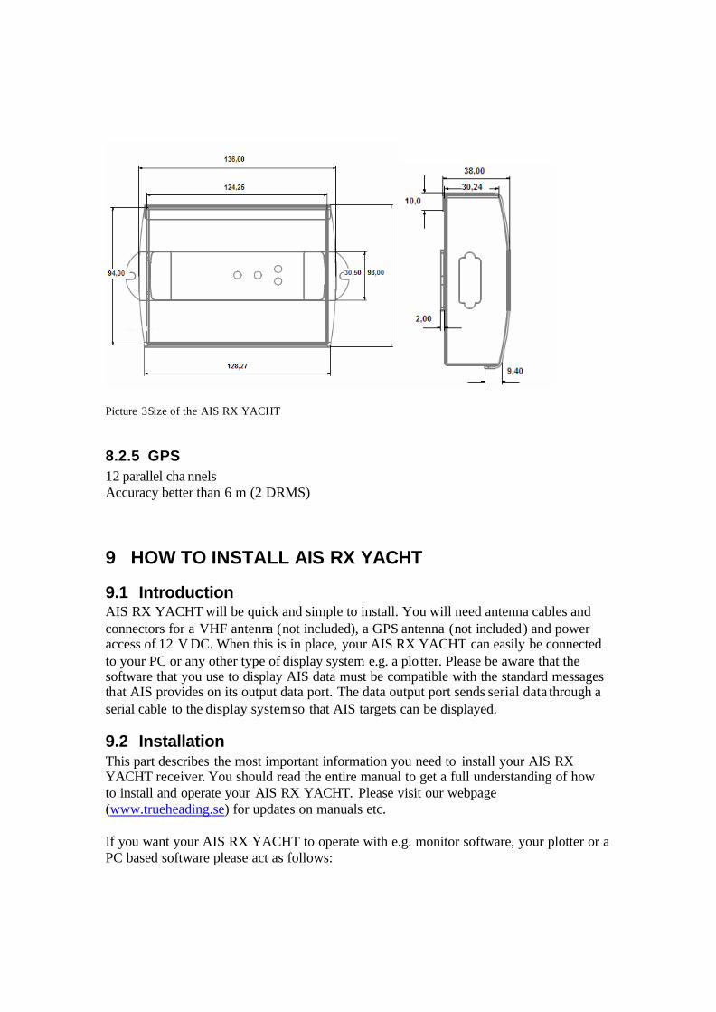
Picture 3Size of the AIS RX YACHT
8.2.5 GPS 12 parallel cha nnels Accuracy better than 6 m (2 DRMS)
9 HOW TO INSTALL AIS RX YACHT
9.1 Introduction AIS RX YACHT will be quick and simple to install. You will need antenna cables and connectors for a VHF antenna (not included), a GPS antenna (not included) and power access of 12 V DC. When this is in place, your AIS RX YACHT can easily be connected to your PC or any other type of display system e.g. a plo tter. Please be aware that the software that you use to display AIS data must be compatible with the standard messages that AIS provides on its output data port. The data output port sends serial data through a serial cable to the display system so that AIS targets can be displayed.
9.2 Installation This part describes the most important information you need to install your AIS RX YACHT receiver. You should read the entire manual to get a full understanding of how to install and operate your AIS RX YACHT. Please visit our webpage (www.trueheading.se) for updates on manuals etc. If you want your AIS RX YACHT to operate with e.g. monitor software, your plotter or a PC based software please act as follows:

9.2.1 Checking your material Check that you have received all the equipment with your AIS RX YACHT and that the delivered equipment has not been damaged during delivery. If the equipment has been damaged, please contact your reseller or our support.
9.2.2 Installing your receiver AIS RX YACHT is made to be installed in a protected environment (in door) and shall therefore be placed where it is well protected from humidity and water. AIS RX YACHT shall not either be placed close to generators or compressors from e.g. refrigerators since they can interfere with the reception. Normally a suitable placement of the AIS RX YACHT is together with other types of navigation equipment and the PC or plotter that will be used to display the AIS data, also a position close to a location where power is easy available is a good idea. AIS RX YACHT also contains led indicators for power, GPS reception and AIS reception on both channels, therefore it is a good idea to have these indicators viewable to ensure performance and functionality. AIS RX YACHT is easy to mount on the bulkhead or panels with included screws.
Picture 4 Measurements for the installation of the AIS RX YACHT.
9.2.3 Antenna installation Install the GPS and VHF antenna at a suitable position onboard (see further below) The antenna cabling should be installed the shortest possible way and cable type selected depending on cable length to avoid losses. All connectors should be properly connected to avoid losses and thoroughly sealed with self- amalgamating rubber tape to avoid humidity in the connectors and thereby reduced functionality. Quick quide for cable selection Length Cable types < 10 m cables RG58C/U > 10 m cables RG213/U

9.2.4 GPS antenna GPS antennas shall be of active types with built in amplifier (LNA). AIS RX YACHT provides the built in antenna amplifier with power through the antenna cable. The power supply to the antenna is 3V DC. The GPS antenna needs to have the following minimum performance: Antenna type: RHCP, patch or quadrifilar type. Power supply: 3V DC LNA amplifier: 10 - +32 dB Impedance: 50 ohm Connector: TNC male True Heading can also provide cost efficient and product adapted GPS antennas, ask for True Heading package solutions. It shall be noted that the GPS antenna shall be placed with free line of sight towards the sky. Do not place the antenna close to metal objects that can cause reflections or disturb the reception of the satellite signals. The GPS antenna shall be placed close to Inmarsat satellite antennas or radar antennas at the S- frequency band. The table below shows suitable safety distances to other equipment that could cause interference with the AIS receiver.
Object Safety distance Radar antenna, X-band 1, 5 m (5 ft) High efficiency engines 1 m (3 ft) HF or VHF antennas 3 m (10 ft) AC power cables with high currency 1 m (3 ft ) Satelitcommunication antennas 4 m (13 ft)
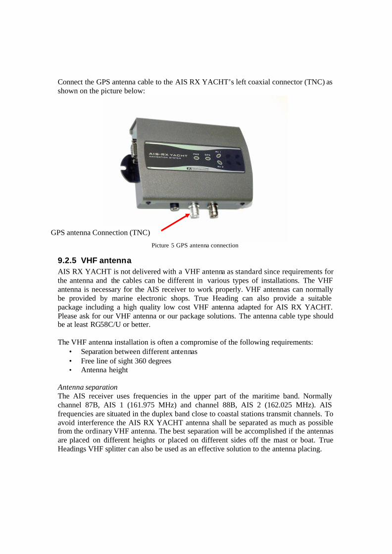
Connect the GPS antenna cable to the AIS RX YACHT’s left coaxial connector (TNC) as shown on the picture below:
Picture 5 GPS antenna connection
9.2.5 VHF antenna AIS RX YACHT is not delivered with a VHF antenna as standard since requirements for the antenna and the cables can be different in various types of installations. The VHF antenna is necessary for the AIS receiver to work properly. VHF antennas can normally be provided by marine electronic shops. True Heading can also provide a suitable package including a high quality low cost VHF antenna adapted for AIS RX YACHT. Please ask for our VHF antenna or our package solutions. The antenna cable type should be at least RG58C/U or better. The VHF antenna installation is often a compromise of the following requirements:
• Separation between different antennas • Free line of sight 360 degrees • Antenna height
Antenna separation The AIS receiver uses frequencies in the upper part of the maritime band. Normally channel 87B, AIS 1 (161.975 MHz) and channel 88B, AIS 2 (162.025 MHz). AIS frequencies are situated in the duplex band close to coastal stations transmit channels. To avoid interference the AIS RX YACHT antenna shall be separated as much as possible from the ordinary VHF antenna. The best separation will be accomplished if the antennas are placed on different heights or placed on different sides off the mast or boat. True Headings VHF splitter can also be used as an effective solution to the antenna placing.
GPS antenna Connection (TNC)
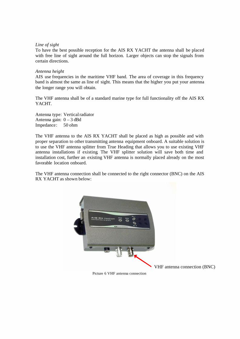
Line of sight To have the best possible reception for the AIS RX YACHT the antenna shall be placed with free line of sight around the full horizon. Larger objects can stop the signals from certain directions. Antenna height AIS use frequencies in the maritime VHF band. The area of coverage in this frequency band is almost the same as line of sight. This means that the higher you put your antenna the longer range you will obtain. The VHF antenna shall be of a standard marine type for full functionality off the AIS RX YACHT. Antenna type: Vertical radiator Antenna gain: 0 – 3 dBd Impedance: 50 ohm The VHF antenna to the AIS RX YACHT shall be placed as high as possible and with proper separation to other transmitting antenna equipment onboard. A suitable solution is to use the VHF antenna splitter from True Heading that allows you to use existing VHF antenna installations if existing. The VHF splitter solution will save both time and installation cost, further an existing VHF antenna is normally placed already on the most favorable location onboard. The VHF antenna connection shall be connected to the right connector (BNC) on the AIS RX YACHT as shown below:
Picture 6 VHF antenna connection
VHF antenna connection (BNC)

9.2.6 Power Connect the AIS RX YACHT to 12 V DC via a 0,5A fuse. The AIS RX YACHT comes with a power cable already fitted with a fuse and with a 2-pole DC connector that locks automatically when fitted. Red cable is positive Black cable is negative When AIS RX YACHT is connected to 12 VDC the PWR (POWER) led indicator shall be green.
Picture 7 Power and antenna cables connected
Picture 8 Data and power connection
Connection for data (9 pole Dsub)
Connection for power, 12V DC

9.2.7 Connection to external GPS The AIS RX YACHT can be connected to an external GPS sensor to provide position data through the AIS RX YACHT AIS Receiver. The internal GPS will then be automatically disconnected and remain passive until you disconnect power and restart the AIS receiver. This means that you will have a back up GPS from the AIS RX YACHT. If you like to connect to an external GPS this functionality is also very useful since it means that you will save one port on your display system as well as solve a the problem with having different data speeds from the GPS (normally 4800 bit/s) and AIS (38400 bit/s) something that normally not will be possible into a PC. Now the AIS RX YACHT automatically mixes the GPS and the AIS data and you will have a seamless throughput of data into your display system presenting own from the external GPS´s received position and AIS information from the AIS RX YACHT. The AIS RX YACHT will not filter any data from the external GPS hence provide you with full throughput of all transmitted data from the GPS. The connection is made in the following way.
Picture 5 Numbering of a female DB9 socket connector
Picture 5 displays the numbering scheme for an extension cable’s DB9 socket connectors (female). The associated numbering for the plug connector (male) is a mirror reflection of scheme showed in picture 5. The connection is made with a splitter that takes data from the GPS into the AIS RX YACHT AIS Receiver on port 3 and transmits data from the AIS RX YACHT AIS receiver to the display system on port 2 as shown in picture 6 and 7. True Heading can provide the serial cable splitter upon request. Please consult.
Picture 6 The serial NMEA data from the GPS commes into the AIS on port 3 and the AIS receivers
transmits AIS and GPS data to the application on port 2.
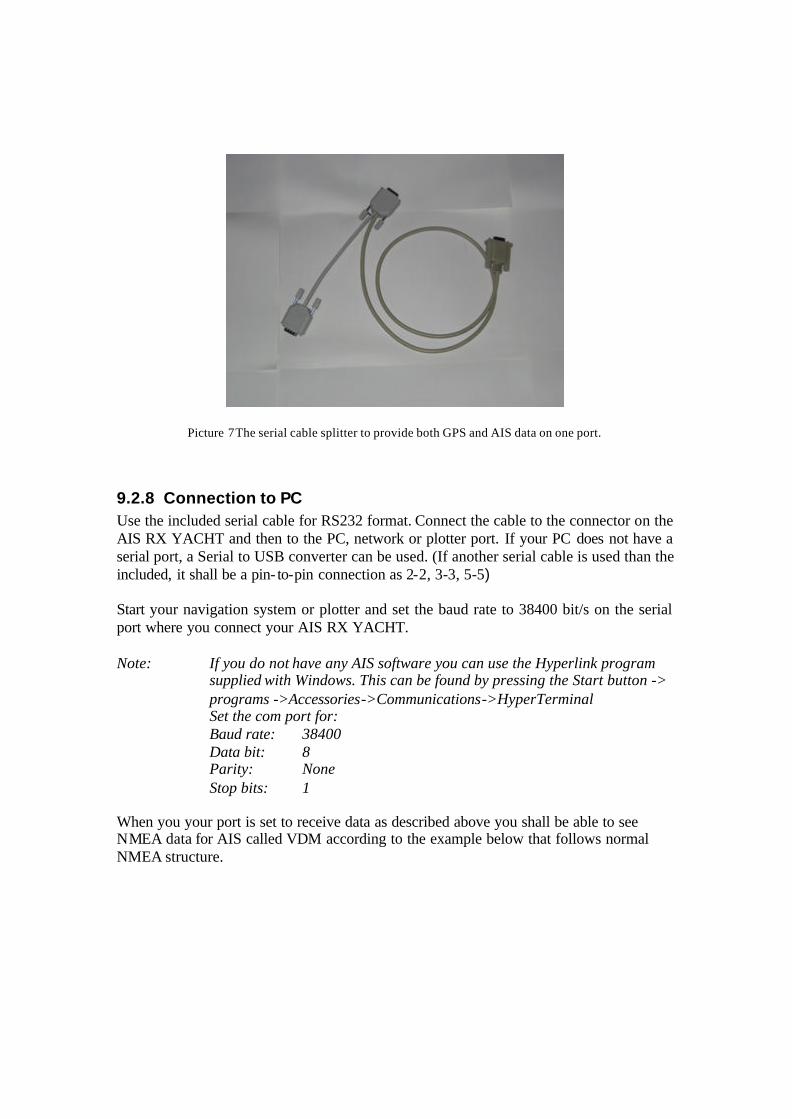
Picture 7 The serial cable splitter to provide both GPS and AIS data on one port.
9.2.8 Connection to PC Use the included serial cable for RS232 format. Connect the cable to the connector on the AIS RX YACHT and then to the PC, network or plotter port. If your PC does not have a serial port, a Serial to USB converter can be used. (If another serial cable is used than the included, it shall be a pin- to-pin connection as 2-2, 3-3, 5-5) Start your navigation system or plotter and set the baud rate to 38400 bit/s on the serial port where you connect your AIS RX YACHT. Note: If you do not have any AIS software you can use the Hyperlink program
supplied with Windows. This can be found by pressing the Start button -> programs ->Accessories->Communications->HyperTerminal Set the com port for: Baud rate: 38400 Data bit: 8 Parity: None Stop bits: 1
When you your port is set to receive data as described above you shall be able to see NMEA data for AIS called VDM according to the example below that follows normal NMEA structure.
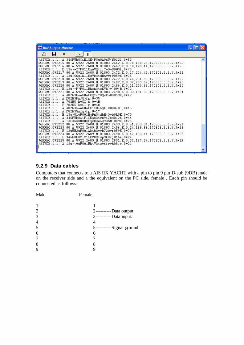
9.2.9 Data cables Computers that connects to a AIS RX YACHT with a pin to pin 9 pin D-sub (9DB) male on the receiver side and a the equivalent on the PC side, female . Each pin should be connected as follows: Male Female 1 1 2 2----------Data output 3 3----------Data input. 4 4 5 5----------Signal ground 6 6 7 7 8 8 9 9
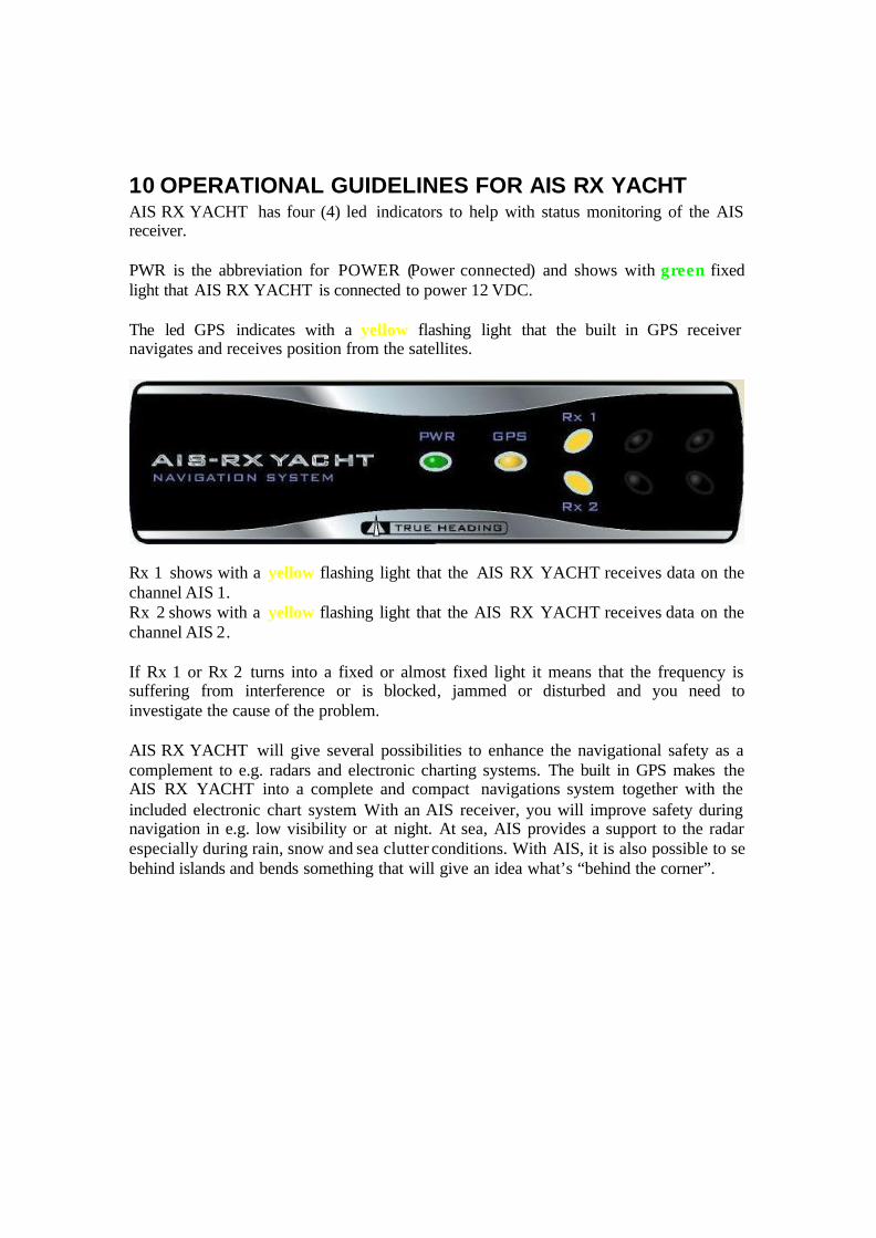
10 OPERATIONAL GUIDELINES FOR AIS RX YACHT AIS RX YACHT has four (4) led indicators to help with status monitoring of the AIS receiver. PWR is the abbreviation for POWER (Power connected) and shows with green fixed light that AIS RX YACHT is connected to power 12 VDC. The led GPS indicates with a yellow flashing light that the built in GPS receiver navigates and receives position from the satellites.
Rx 1 shows with a yellow flashing light that the AIS RX YACHT receives data on the channel AIS 1. Rx 2 shows with a yellow flashing light that the AIS RX YACHT receives data on the channel AIS 2. If Rx 1 or Rx 2 turns into a fixed or almost fixed light it means that the frequency is suffering from interference or is blocked, jammed or disturbed and you need to investigate the cause of the problem. AIS RX YACHT will give several possibilities to enhance the navigational safety as a complement to e.g. radars and electronic charting systems. The built in GPS makes the AIS RX YACHT into a complete and compact navigations system together with the included electronic chart system. With an AIS receiver, you will improve safety during navigation in e.g. low visibility or at night. At sea, AIS provides a support to the radar especially during rain, snow and sea clutter conditions. With AIS, it is also possible to se behind islands and bends something that will give an idea what’s “behind the corner”.
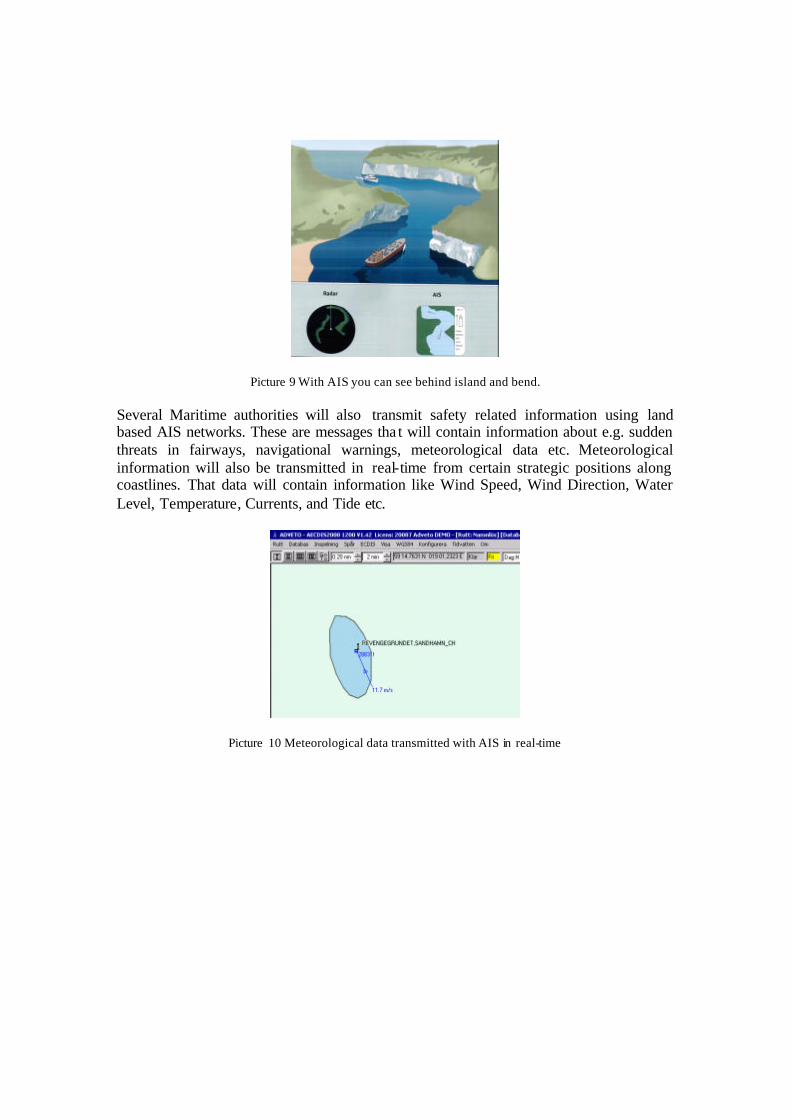
Picture 9 With AIS you can see behind island and bend. Several Maritime authorities will also transmit safety related information using land based AIS networks. These are messages tha t will contain information about e.g. sudden threats in fairways, navigational warnings, meteorological data etc. Meteorological information will also be transmitted in real-time from certain strategic positions along coastlines. That data will contain information like Wind Speed, Wind Direction, Water Level, Temperature, Currents, and Tide etc.
Picture 10 Meteorological data transmitted with AIS in real-time

AIS transponders will transmit the following data that can be received from your AIS RX YACHT: Static Information Dynamic Information Voyage related Information ? ?Name ? ?Position ? ?Destination ? ?Type of ship ? ?Speed Over Ground ? ?Depth ? ?Call sign ? ?Course Over Ground ? ?ETA ? ?MMSI number ? ?Rate Of Turn ? ?Navigational Status ? ?IMO number ? ?Heading ? ?Size Note: Sometimes ships have not properly programmed their AIS transponders and parts of above-mentioned information can then be missing. AIS RX YACHT can without charge be provided with the electronic chart system SeaClear. SeaClear is presented separately with its own user manual. Below some examples of how AIS can be presented in various types of electronic chart systems or plotters. At present, several manufacturers can provide systems that can display AIS. A list of the once known to us can be found in the chapter FAQ.
Picture 11 Examp le how AIS is presented in the software AECDIS from ADVETO.

Picture 12 Example how AIS is presented in the software HORIZON from ICAN.
Picture 13 Example how AIS is presented in SeaClear.
Picture 14 Example how AIS is presented in AIS Yacht.

11 FAQ Q: Is it possible to use an existing VHF antenna? A: Yes, you can use an existing VHF antenna by adding the True Heading VHF antenna splitter to the installation. Then the same antenna used for VHF/DSC can be used also for the AIS RX YACHT. Q: Can I use an existing GPS antenna? A: Like the VHF antenna installation, a GPS signal can be divided with a splitter as well. GPS splitters are available through True Heading as well. Q: What type of GPS and VHF antenna do I need for my AIS RX YACHT? A: The GPS antenna should at least fulfill the following requirements: Antenna type: RHCP, patch or quadrifilar type. Power supply: 3V DC LNA gain: 10 ±32 dB Impedance: 50 ohm Connector: TNC male The VHF antenna should at least fulfill the following requirements: Antenna type: Vertical radiator Antenna gain: 0 – 3 dBd Impedance: 50 ohm Q: Is it possible to connect my AIS RX YACHT to a plotter? A: Today only a few plotters are prepared to connect AIS and to display AIS targets. Some of the manufacturer that supports this today is Furuno, Seiwa and Interphase. Garmin and some others are working on the issue and will be able to do so in coming models. For further information contact your supplier and ask about AIS interface to their product. Q: What electronic chart programs can handle AIS today AIS? A: Today several software are prepared for AIS, the once known to us are Adveto AECDIS series, Fugawi, Fugro, ICAN Aldebaran, Nobeltech, SeaClear, Transas Navisailor. All software that can handle the NMEA message VDM and display the data will be able to present AIS. Ask your provider for further information. In addition, stand-alone display software is available like e.g. the AIS YACHT from Y-tronic.

Q: Will AIS RX YACHT work with my network solution onboard? A: All networks that can handle NMEA VDM data at the speed 38400 b/s will be able to handle AIS data. Silva and Navnet from Furuno has been told to us to be able to do so. Raymarine’s Seatalk will most likely not be able to handle AIS. Ask your network provider for further information. Q: I do not have a serial port on my computer, how can I then get the data from my AIS RX YACHT into the PC? A: Today serial to USB format converters can be found in most computer shops. True Heading can also provide such converters upon request. Please ask for a serial to USB converter.
Picture 15 Example of a serial to USB converter.

12 NOTES

![AIS Functional Manual - Alltek · AIS Functional Manual. How AIS Works 1.Press [MENU] key to open the main menu. Automatic Identification System (AIS) is a reporting system used in](https://static.fdocuments.in/doc/165x107/5e781e19de54365c4d7713f0/ais-functional-manual-ais-functional-manual-how-ais-works-1press-menu-key.jpg)