Open Space Strategy - City of Casey · influence the quantum, functionality, ... reserves, shops...
48
Open Space Strategy Version: 1.1 Date updated: Adopted 7 April 2015 Responsible Department: Sport & Leisure CASEY.VIC.GOV.AU Contents Executive Summary 2 Purpose 6 Definitions 6 Context 6 Strategy 9 Implementation 17 Administrative Updates 17 Review 17 Attachment 1 - Core Service Level Standards 18 Attachment 2 - Open Space Planning Framework 38 Attachment 3 - Land Acquisitions and Disposals 45 Attachment 4 - Open Space Map 48 Council policy documents change from time to time and it is recommended that you consult the electronic reference copy at www.casey.vic.gov.au/policiesstrategies to ensure that you have the current version. Alternatively you may contact Customer Service on 9705 5200.
Transcript of Open Space Strategy - City of Casey · influence the quantum, functionality, ... reserves, shops...

Open Space Strategy Version: 1.1 Date updated: Adopted 7 April 2015 Responsible Department: Sport & Leisure
CASEY.VIC.GOV.AU
Contents
Executive Summary 2
Purpose 6
Definitions 6
Context 6
Strategy 9
Implementation 17
Administrative Updates 17
Review 17
Attachment 1 - Core Service Level Standards 18
Attachment 2 - Open Space Planning Framework 38
Attachment 3 - Land Acquisitions and Disposals 45
Attachment 4 - Open Space Map 48
Council policy documents change from time to time and it is recommended that you consult the electronic reference copy at www.casey.vic.gov.au/policiesstrategies to ensure that you have the current version. Alternatively you may contact Customer Service on 9705 5200.
Open Space Strategy (Version 1.1) Page 2 of 48
1. Executive Summary
Objective
The Open Space Strategy (‘the Strategy’) provides a framework to guide the planning, design, development and management of open space in the City of Casey.
Vision
To deliver a connected network of quality and diverse open spaces now and into the future to improve the liveability of the City for residents and visitors.
Context
Council recognises the benefits that a quality open space network has for the health and liveability of the City’s residents and as such has a strong commitment to ensuring that a diverse range of quality connected open spaces is provided within the City.
There is considerable research demonstrating the myriad of social, mental, physical, environmental and economic benefits that open space can provide, including:
• Providing children with an opportunity to play and learn.
• Providing opportunities for physical exercise.
• Providing affordable places for social gatherings.
• Conserving biodiversity.
• Connecting us with the natural world.
• Offering restorative qualities and thereby reduce stress and improve a sense of wellbeing.
• Providing pleasant places to be outdoors.
• Enhancing neighbourhood character.
• Contributing significantly to a sense of civic pride in a place.
• Offering economic benefits (e.g. increased property values, employment opportunities, tourism development and the support of major industries such as sport, personal fitness, and landscape products and services).
The Strategy complements the objectives of Council’s key strategic plans including C21 – Building a Great City Strategy, Council Plan, and the Health and Wellbeing Plan and has linkages with a number of State and Federal Government strategies and policies.
The Strategy and its Implementation Plan is an overarching document for a number of other sport, leisure, environmental and landscape strategies and policies (i.e. Leisure Facilities and Development Plan, Revegetation Strategy, Landscape Policy etc.).
Open Space Strategy (Version 1.1) Page 3 of 48
The Strategy provides key directions that support the objectives of these documents by providing direction on advocacy, a planning framework, infrastructure and maintenance service level standards, design considerations and various project initiatives.
Through the research and consultation phase of the Strategy several key challenges were identified as impacting on Casey’s open space network, including:
• Urbanisation of the City and an increasing population places pressure on individual open space parcels to accommodate higher numbers of users.
• The rise in land values which impacts on the costs to set aside land for open space.
• The increasing residential densities resulting in shrinking private spaces impacts on people’s need to access public open space for incidental exercise, social gathering and relaxation (especially if they own pets).
• The ability to provide for a diverse range of sports across the City as land for many sports is not provided for within new developments.
• The increase in community expectations for what open space can and should provide.
• Desire for spaces for families of all ages to recreate.
• Global warming.
• Reliance on vehicle for transportation.
This context led to the development of four key pillars which underpin the direction for open space planning in the City of Casey into the future.
Key Pillars
The four key pillars of the Strategy are supported by a number of strategic directions as described below. These will assist Council in its advocacy and planning to meet the current and future open space needs of its residents and visitors. They will also influence the quantum, functionality, planning, development, management and promotion of open space for the City.
• Planned City
To enhance the planning of Casey’s open space to deliver a connected network of quality open spaces that meet the diverse needs of the community. The creation of a planned City will be underpinned by:
o Core service level standards (see Attachment 1) that influence the land development process, open space network and infrastructure provision.
o A Planning Framework (see Attachment 2) that provides key considerations for practitioners seeking to deliver a connected and diverse open space network.
Open Space Strategy (Version 1.1) Page 4 of 48
o A Land Acquisition and Disposal framework (see Attachment 3) which provides guidance on key considerations regarding strategic land purchases and disposals to assist in the delivery of a quality connected open space network.
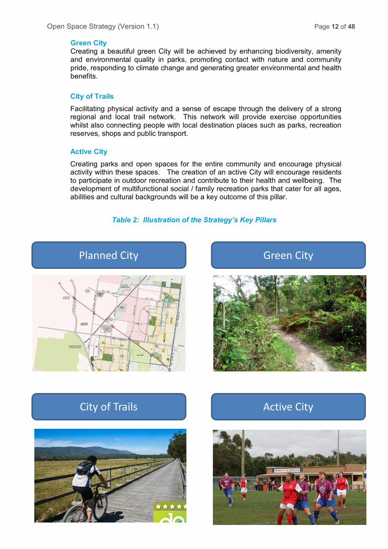
• Green City
Creating a beautiful green City will be achieved by enhancing biodiversity, amenity and environmental quality in parks, promoting contact with nature and community pride, responding to climate change and generating greater environmental and health benefits.
• City of Trails
Facilitating physical activity and a sense of escape through the delivery of a strong regional and local trail network. This network will provide exercise opportunities whilst also connecting people with local destination places such as parks, recreation reserves, shops and public transport.
• Active City
Creating parks and open spaces for the entire community and encouraging physical activity within these spaces. The creation of an active City will encourage residents to participate in outdoor recreation and contribute to their health and wellbeing. The development of multifunctional social / family recreation parks that cater for all ages, abilities and cultural backgrounds is a key outcome of this pillar.
Outcomes
Successful implementation of the Strategy is anticipated to result in the following key outcomes:
1. A connected network of quality and diverse open spaces within new development areas to cater for community demands.
2. Implementation of core service level standards to ensure open spaces across the City are engaging and fit for purpose.
3. Development of strong connections with the City’s heritage and natural features through the protection of built and natural assets.
4. Improved partnerships with statutory authorities and Government to secure opportunities for an expanded open space network to meet the service needs of the City’s large population.
5. Protection of significant environmental areas to support local habitat.
6. Establishment of diverse landscape settings across the open space network to connect people with nature.
7. Development of a regional trail network to promote extended forms of physical activity and sense of escape, supported by a local trail network to connect people to destination places and reduce reliance on vehicle transport.

Open Space Strategy (Version 1.1) Page 5 of 48
8. Development of new open spaces for sport to meet the needs of a growing community across a range of sports.
9. Advocacy for new regional open spaces for sport and informal recreation use to complement the existing open space network and provide broader opportunities for the community.
10. Development of social / family recreation spaces that provide a range of facilities and engage a broader range of ages, abilities and cultural backgrounds and act as community hubs.
Implementation
The implementation of the Strategy will be driven by a Council Working Group, consisting of key internal departments. The Working Group will develop an annual implementation plan of strategic initiatives that will influence Council’s Capital Works Program, Land Acquisition Register, strategies, policies and master plans and also report on the achievements and outcomes of the Strategy. Considerations will include reviews of existing plans, audits of existing open spaces and utilising the Strategy to guide and influence future planning and advocacy for open space development.
Strategy User Reference Guide
The following table illustrates an overall view of the structure of the Strategy, its key directions and its implementation.
Context Research / Background / Consultation
Key Pillars Planned City / Green City / City of Trails / Active City
Key Directions Various aligned with each key pillar
Guides for Practitioners Core Service Level Standards
Functions – Nature / Trails / Social-Family Rec / Sport Hierarchy (catchments) – Local / District / Regional
Planning Framework – Quality / Equity / Accessibility / Diversity Land Acquisitions and Disposals
IMPLEMENTATION Working Group - Annual Implementation Plan
Reviews and Audits / Advocacy Apply Standards / Establish Priorities Capital Works Projects / Promotion
Open Space Strategy (Version 1.1) Page 6 of 48
2. Purpose
The Open Space Strategy (‘the Strategy’) provides a framework to guide the planning, design, development and management of open space in the City of Casey.
Vision: To deliver a connected network of quality and diverse open spaces now and into the future to improve the liveability of the City for residents and visitors.
3. Definitions
Council means Casey City Council, being a body corporate constituted as a municipal Council under the Local Government Act 1989
Councillors means the individuals holding the office of a member of Casey City Council
Council officer means the Chief Executive Officer and staff of Council appointed by the Chief Executive Officer.
Open Space Public land that has a leisure function or is reserved as a public park or conservation use. Also includes public land that does not have a core function of open space such as land that is primarily required for drainage or utility purposes but that may still be used for leisure purposes and valued by the community.
4. Context
Council is committed to providing a quality open space network across the City. Council recognises the benefits open space has for the health of its residents and liveability of the City. The Strategy provides a strategic approach to planning and managing the existing and future open spaces in Casey to ensure Council meets the needs of Casey’s current and future population in addition to encouraging visitors to the City.
The Strategy supports Council’s C21 vision – Building a Great City and aligns with its key goals:
• The creation of a ‘Sense of Place’ is a key goal of the C21 Strategy to strengthen Casey’s communities. Ensuring the community has adequate and accessible open space to meet its needs is one of the objectives listed to achieve this broader goal.
• ‘Building Community Capacity’ to help sustain healthy communities in terms of physical activity, access to open space, community safety, the environment, income security, housing, transport, education and connectedness.
Open Space Strategy (Version 1.1) Page 7 of 48
The Strategy also links with the key directions within Council’s corporate and strategic documents including the Council Plan, Municipal Health and Wellbeing Plan and Sustainability Plan. These linkages recognise that high quality open space networks contribute to:
• Services for the community, enhancing health and wellbeing.
• Economic benefits by making the City attractive for businesses to establish within the City.
• Responsible planning for the current and future growth of Casey’s diverse community and recognition of the importance of heritage.
• The built environment through development of parks, trails, sports grounds and nature reserves.
• Increased physical activity levels of the City’s residents through provision of environments and facilities that support exercise and socialisation to deliver enhanced health and wellbeing outcomes.
Whilst Casey’s Planning Scheme provides the statutory requirements for open space for subdivisions in the City’s existing areas, the State Government’s Precinct Structure Planning Guidelines provide the broader framework for provision of open space in Casey’s growth areas. Council continues to work within the context of this broader planning framework in its efforts to provide a quality open space network that will meet the diverse range of needs of its community.
The Victorian Government’s Plan Melbourne recognises the importance of open space and the greening of the City. The Plan recommends the need for a Metropolitan Open Space Strategy to improve the provision of open space in areas that are expected to grow substantially. The Metropolitan Open Space Strategy will be informed by the Victorian Environmental Assessment Council (VEAC 2011) report which provided some key recommendations to meet the open space needs for Melbourne’s growing population. The VEAC report noted that current planning needs to continue in the growth municipalities to ensure an adequate provision of open space is provided. The report recommends for the Government to review open space contributions through the Subdivision Act (1998) and to encourage multiple uses of public authority land as a means of providing additional open space for the community. Also, it recommends that local councils to give close consideration to the cost and benefit impact of any loss of public open space before considering proposals.
Table 1 (next page) illustrates how these documents have influenced the development of Casey’s Open Space Strategy. The table also demonstrates how the Strategy’s key directions connect with a broad range of Council’s strategies.
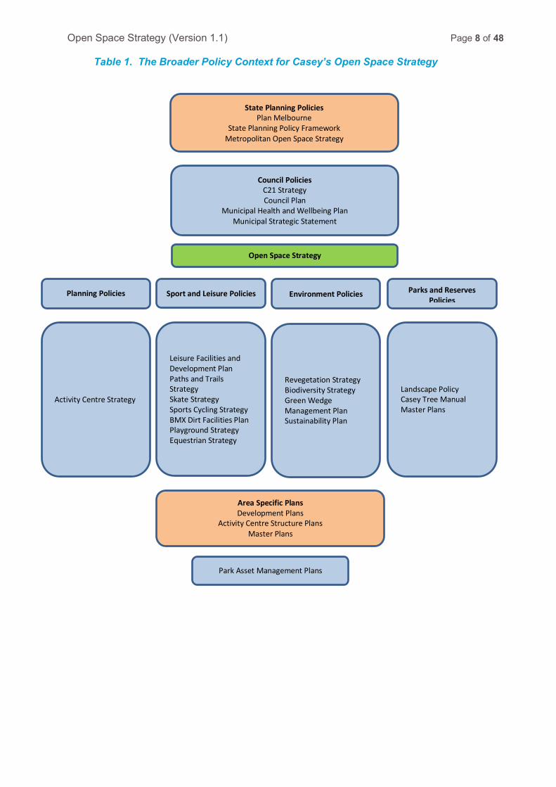
Open Space Strategy (Version 1.1) Page 8 of 48
Table 1. The Broader Policy Context for Casey’s Open Space Strategy
State Planning Policies Plan Melbourne
State Planning Policy Framework Metropolitan Open Space Strategy
Council Policies C21 Strategy Council Plan
Municipal Health and Wellbeing Plan Municipal Strategic Statement
Park Asset Management Plans
Open Space Strategy
Activity Centre Strategy
Planning Policies
Leisure Facilities and Development Plan Paths and Trails Strategy Skate Strategy Sports Cycling Strategy BMX Dirt Facilities Plan Playground Strategy Equestrian Strategy
Sport and Leisure Policies
Revegetation Strategy Biodiversity Strategy Green Wedge Management Plan Sustainability Plan
Environment Policies
Landscape Policy Casey Tree Manual Master Plans
Parks and Reserves Policies
Area Specific Plans Development Plans
Activity Centre Structure Plans Master Plans
Open Space Strategy (Version 1.1) Page 9 of 48
5. Strategy
5.1 Background and Research
The Strategy has been informed by considerable research and analysis undertaken by @leisure consultants.
The City of Casey currently has approximately 3,482 hectares of public open space or approximately 14 hectares per 1,000 population. This includes:
• State owned land or land managed by other government agencies including national and regional parks, metropolitan parks and nature conservations reserves.
• Open space reserved for drainage and utility purposes.
• Regional and national parks.
Approximately half of the public open space in the City of Casey is not owned by Council.
A considerable proportion of Casey’s open space serves a primary purpose of drainage, utility and conservation. This leaves approximately 800 hectares servicing a primary purpose of sport, recreation or play or approximately 3 hectares per 1,000 population.
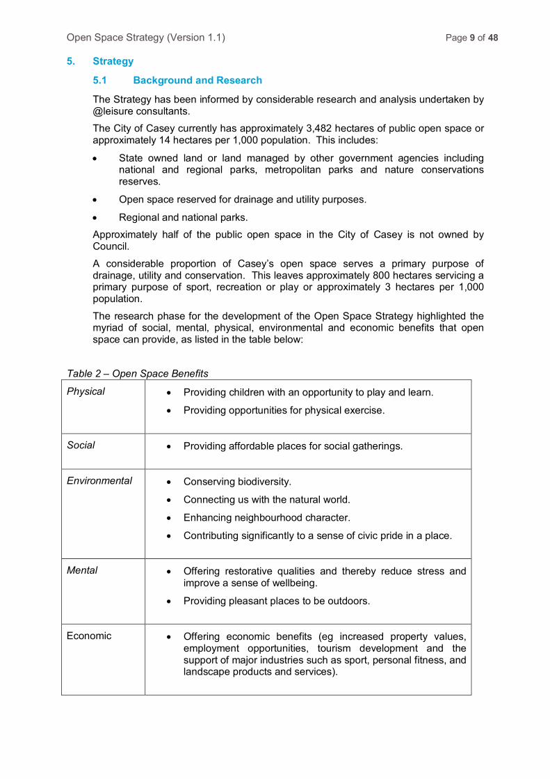
The research phase for the development of the Open Space Strategy highlighted the myriad of social, mental, physical, environmental and economic benefits that open space can provide, as listed in the table below:
Table 2 – Open Space Benefits
Physical
• Providing children with an opportunity to play and learn.
• Providing opportunities for physical exercise.
Social
• Providing affordable places for social gatherings.
Environmental
• Conserving biodiversity.
• Connecting us with the natural world.
• Enhancing neighbourhood character.
• Contributing significantly to a sense of civic pride in a place.
Mental
• Offering restorative qualities and thereby reduce stress and
improve a sense of wellbeing.
• Providing pleasant places to be outdoors.
Economic
• Offering economic benefits (eg increased property values,
employment opportunities, tourism development and the support of major industries such as sport, personal fitness, and landscape products and services).
Open Space Strategy (Version 1.1) Page 10 of 48
Considerable research and consultation occurred as part of the development of the Strategy, including:
• Community and stakeholder consultation (telephone and mail out surveys and workshops with community and key stakeholders).
• Assessment of the impact of population growth projections and residential settlement patterns.
• A locality analysis of open space distribution and condition.
• An open space demand assessment across the City and by local area.
• Community and stakeholder feedback on the issues paper.
This research highlighted, despite the well documented benefits of open space, there are a number of significant challenges to be considered in the development of Casey’s open space network, as outlined below:
Table 3 – Open Space Challenges
Environmental
• Climate change and impacts such as sea level rises, particularly in the coastal townships.
• Continued urban development impacting on the perception of available open space and the urban heat island effect on the City.
• Challenges in providing appropriate natural environments for Casey’s habitat particularly within the growth areas.
• Challenges in meeting biodiversity objectives such as tree canopy coverage across the City to mitigate the heat island effect.
Urban Development
• Growth and development of Casey’s population impacting on the demand for open space and specific interests.
• Urbanisation of the City and shrinking of private household space raising the importance of public spaces for improved health and liveability (ie. incidental exercise, social gathering, relaxation and exercising pets).
• Increasing residential densities and less access to nature placing greater emphasis on the importance of open space.
• Increasing residential densities in the growth areas which are not being matched with commensurate increases in open space.
• The preference of many property developers to provide more smaller sized open space parcels within the residential development area rather than large parcels. Larger parks are considered to provide more functional benefit to local communities and can accommodate a broader range of infrastructure which promotes longer usage periods.
Open Space Strategy (Version 1.1) Page 11 of 48
Public Open Space Provision
• Increasing cost of land to set aside for parks and sporting reserves.
• The continued increase in demand for community sport and physical activity driving demand for additional sports facilities to be provided.
• Significant challenges in providing a diversity of sporting facilities for the community as land provided through the growth area development process is limited to a small number of sports.
• The increasing demand for a broader range of community services and activities (ie. Men’s Sheds, scout halls, community gardens, community facilities etc.) and the desire to locate these on open space land.
• Increasing value placed on open space by residents contributing numerous social, economic and environmental benefits to the City.
Planning • The contested environment that is in place for the planning of open space in new growth areas.
• A need for strategic direction on the appropriate infrastructure provision within various open space types.
• Need for a fair and equitable distribution of open space through the City to service all residents.
These elements were considered in the formulation of the Strategy’s key pillars which underpin the directions and actions of the Strategy.
5.2 Key Pillars
The four key pillars of the Strategy will assist Council in its advocacy and planning to meet the current and future open space needs of its residents and visitors. These key pillars influence the quantum, functionality, planning, development, management and promotion of open space for the City. Planned City Enhance the planning of Casey’s open space to deliver a connected network of quality open spaces that meet the diverse needs of the community. The creation of a planned City will be underpinned by:
o Core service level standards (see Attachment 1) that influence the land development process, open space network and infrastructure provision.
o A Planning Framework (see Attachment 2) that provides key considerations for practitioners seeking to deliver a connected and diverse open space network.
o A Land Acquisition and Disposal framework (see Attachment 3) which provides guidance on key considerations regarding strategic land purchases and disposals to assist in the delivery of a quality connected open space network.
Open Space Strategy (Version 1.1) Page 12 of 48
Green City Creating a beautiful green City will be achieved by enhancing biodiversity, amenity and environmental quality in parks, promoting contact with nature and community pride, responding to climate change and generating greater environmental and health benefits.
City of Trails Facilitating physical activity and a sense of escape through the delivery of a strong regional and local trail network. This network will provide exercise opportunities whilst also connecting people with local destination places such as parks, recreation reserves, shops and public transport.
Active City Creating parks and open spaces for the entire community and encourage physical activity within these spaces. The creation of an active City will encourage residents to participate in outdoor recreation and contribute to their health and wellbeing. The development of multifunctional social / family recreation parks that cater for all ages, abilities and cultural backgrounds will be a key outcome of this pillar.
Table 2: Illustration of the Strategy’s Key Pillars
Planned City Green City
City of Trails Active City
Open Space Strategy (Version 1.1) Page 13 of 48
Key Pillar 1 – A Planned City
The Planned City key pillar will provide direction and support on planning, design and decision making for open space in the City. In new residential areas the land development process does not always deliver the quality and quantity of open space that Council believes is required to deliver the range of community benefits desired and is economical to maintain. There is also increased pressure on public open space in established residential areas of the City due to further infill residential development.
This pillar, seeks to guide Council in in key issues such as identifying the appropriate amount, effectively utilising encumbered land for recreation, providing for all open space catchment levels (particularly district and regional), preserving heritage and providing open space in non-residential areas.
A key aspect of this approach is a planning framework (see Attachment 2) which has been developed to inform the open space decision making process. The planning framework outlines the process in which Council can respond to the growth and infill development as well as influence master planning and infrastructure provision within individual open space sites.
The planning framework is a four step process that assesses the adequacy of the proposed open space provision to meet the demands for various open space functions. The framework gives consideration to the environmental context where the open space is being considered such as its settlement context as well as site specific contextual considerations. These processes are used to inform the appropriate size and distribution of spaces to meet the intended vision of ensuring a connected network of quality and diverse open spaces are delivered.
In the context of changing residential densities, land development issues and other pressures on open space the planning framework is a key aspect of the Strategy to ensure fairness, equity and appropriate provision of open space for residents.
The planning framework is supported by the Strategy’s core service level standards (see Attachment 1) which provide strategic guidance on infrastructure and maintenance standards for each of the open space functions respective to their various sizes (ie. local, district and regional). These standards will ensure a coordinated approach is taken to the planning and development of open space, ensuring open space parcels are sized appropriately and include infrastructure which is fit for its intended purpose. These standards will be used to inform developers and Council staff in the master planning and development of open spaces.
The Strategy also includes a Land Acquisitions and Disposals framework (see Attachment 3) which provides strategic guidance on the process for considering future land purchases or disposals for open space. This framework will seek to assist Council in delivering a quality network of open space across the City.
Key Directions
1. Strengthen the open space policy provisions within the Local Planning Policy Framework of the Casey Planning Scheme (including the Municipal Strategic Statement and local policies) to support the key recommendations and policy directions of this Strategy.
2. Utilise the planning framework in structure planning and subdivisions to provide a connected and diverse open space network.
3. Utilise the core service level standards to inform the planning, infrastructure provision and maintenance standards for open spaces ensuring they are fit for purpose
Open Space Strategy (Version 1.1) Page 14 of 48
4. Advocate for quality open space outcomes in the planning of new development areas, including ensuring adequate open space is provided and that views onto local parks are maximised.
5. Address gaps in the open space network through identifying opportunities with schools, and other statutory authorities (subject to land manager approval).
6. Co-locate public open space with adjacent encumbered land where the encumbered land is usable and can add value to the overall site for recreation.
7. Seek to protect unique characteristics of a site or area such as heritage and cultural significance where appropriate and recognise/promote these through signage.
8. Minimise any loss of public open space and protect existing open spaces from encroachment by community buildings or other public functions.
9. Utilise open space contributions from developers to embellish open spaces and purchase land to meet the needs of the community.
10. Advocate for cash contributions in excess of the standard open space contribution rate where open space is not provided for within the development and/or where higher density housing is proposed. Cash contributions from developers should be taken in lieu of provision of land, under the following circumstances:
a. Where the size of the subdivision does not allow sufficient land to be taken as open space.
b. Where a good range of open space functions are already available (that meet the specified distance thresholds from the development).
c. Where specific embellishments or enhanced quality open spaces are a priority.
d. Where resources are required to contribute to a regional recreational resource that serves the new residential development.
e. Where cash contributions are in excess of the standard sub-division rate.
Key Pillar 2 – A Green City
The Green City key pillar supports the provision of a greater diversity of experiences and environmental elements in parks and across the open space network. This will contribute to a number of environmental objectives, including providing residents with better access to nature and environmental stimuli in open space, enhancing civic pride, neighbourhood character and recreation amenity.
Council’s existing environmental plans support the natural environment. There are numerous Council and developer initiatives which contribute to enhanced environmental amenity for the City through the provision of street trees to promote visual amenity, establishment of an urban forest to reduce the heat-island effect of urbanisation, provision of shade from the sun, provision of natural areas to promote environmental awareness and connection to nature.
The Strategy supports a focus on enhancing people’s connection to nature through local, district and regional open spaces, maintaining and enhancing views onto open space and vegetation, supporting greater community engagement with open space and enhancing the landscape settings of open spaces by providing for natural settings (such as treed parkland and bushland areas).
Open Space Strategy (Version 1.1) Page 15 of 48
Key Directions
1. Continue to recognise and protect significant environmental open space areas in the City from urban development.
2. Continue to implement Council’s Biodiversity Strategy supporting habitat corridors.
3. Increase the proportion of parks that have treed parkland or bushland settings to connect residents with nature.
4. Enhance the tree canopy coverage across the City to respond to risks posed by climate change and to reduce the heat island effect.
5. Support the retention of mature treed landscapes including Casey’s significant trees (as per Council’s significant tree register).
6. Implement a programmed maintenance schedule to enhance the quality of nature reserves throughout the City.
7. Provide interpretative signage at nature reserves and along selected waterways to educate the community about aboriginal, environmental values and threatened species.
8. Diversify landscape settings across Casey’s open space network.
Key Pillar 3 - A City of Trails
The City of Trails key pillar seeks to provide a network of regional trails across the City connecting to neighbouring municipalities. By visiting Casey’s waterways regional off-road trails provide opportunities for extended forms of physical activity, a sense of escape and promote sustainable transportation in a City which is largely car dependent. These regional trails will be linked with localised trail connections which connect people with local destinations such as schools, shops, recreation reserves, parks and public transport. The Strategy’s core service level standards also promote the creation of perimeter park trails and off-road exercise circuits particularly around waterways to encourage physical activity.
Research and consultation of Casey’s residents identified a significant demand for informal physical activity including walking, running, cycling, horse riding, skating and dog exercise. These activities can be accommodated through the provision of trails (including shared off-road trails and equestrian trails). Recreational trails are provided through Council’s Capital Works Program and from developer contributions. The Strategy recognises the importance of creating permeable residential areas through the planning process to ensure people can easily move around and connect to open space and other desired destinations. This influences the likely participation of residents in active transportation and level of activity in open spaces and contributes to the health of local communities. The delivery of A City of Trails will be supported by Council’s Paths and Trails and Equestrian strategies.

Open Space Strategy (Version 1.1) Page 16 of 48
Key Directions
1. Develop a regional trail network across the City linking with neighbouring municipalities.
2. Ensure consideration is given to potential sea level rises and environmental impacts in the planning of any coastal trails.
3. Utilise closed roads, transport corridors, waterways and easements to create trail connections.
4. Ensure off-road trails, trail circuits and perimeter paths around recreation reserves and parks are provided for (in addition to on-road bike routes) in structure and subdivision planning and existing recreation reserves.
5. Promote the opportunities and benefits of Casey’s open space network.
Key Pillar 4 - An Active City
An Active City key pillar recognises the importance of open spaces to facilitate physical activity which is critical to the health and wellbeing of the community. Limited functional open space being provided through the land development process continues to present challenges to cater for the range of open space requirements to meet a large and growing population. This challenge is heightened as residents now have a greater recognition of the importance of public open space as private backyard sizes continue to reduce in size.
This pillar seeks to maximise the benefits of open spaces to enhance levels of physical activity through a strategic and coordinated approach to planning, designing and management. A key component is the development of spaces to fulfil the role of ‘social / family recreation’ (‘SFR’). The Strategy’s core service level standards provide specific guidance on the appropriate size, distribution and infrastructure provision for sport, social / family recreation spaces and local parks. These standards seek to ensure open spaces are fit for purpose.
A key outcome of the Strategy will be the development of multifunctional social / family recreation parks that cater for all ages, abilities and cultural backgrounds. These parks will seek to engage and get the community active to improve their health and wellbeing.
The delivery of the Active City key directions will be further guided and supported by key Council strategies including the Municipal Health and Wellbeing Plan (Active Living Pillar), Leisure Facilities and Development Plan, Sports Cycling Strategy, Playground Strategy and Equestrian Strategy.
An Active City requires open spaces to be activated with programming and promotional initiatives in addition to support infrastructure provision. These initiatives will raise the community’s awareness of available recreational opportunities and engage them in spaces through their design and range of facilities provided.
Key Directions
1. Continue to develop and/or enhance open spaces in line with Council’s Leisure Facilities and Development Plan, Sports Cycling, Equestrian and other relevant sport and recreation strategies to meet the demand for sport in the City.
2. Investigate the potential to purchase a regional open space south of the urban growth boundary to meet the demand for a diversity of sports in the City.

Open Space Strategy (Version 1.1) Page 17 of 48
3. Advocate for regional park/s and funding to be provided in the City to complement the existing open space network.
4. Partner with the Department of Education and Early Childhood Development to provide additional sports facilities to meet demand.
5. Facilitate informal physical activity through the development and/or enhancement of parks as social / family recreation spaces and ensure that these spaces cater for all ages, abilities and cultural backgrounds.
6. Investigate the potential to create social / family recreation hubs in the vicinity of the Westernport coast to serve local residents and visitors.
7. Develop new and enhance existing parks in line with the Strategy’s core service level standards to ensure they cater for different age groups and abilities.
8. Develop a number of dedicated dog exercise spaces within parks across the City.
9. Introduce programmed activities in selected parks to increase activation of these spaces.
6. Implementation
The implementation of the Strategy will be driven by a Council Working Group, consisting of key internal departments. The Working Group will develop an annual implementation plan of strategic initiatives that will influence Council’s Capital Works Program, Land Acquisition Register, strategies, policies and master plans and more. The annual implementation plan will be informed by several pieces of work:
• Review of existing documentation such as precinct structure plans, local area plans and master plans against the Open Space Strategy’s core service level standards.
• Audit the existing open space network to consider its adequacy in providing for the various open space functions and in delivering upon the Strategy’s key pillars and core service level standards.
• Review the existing capital works program to consider prioritisation of projects
and initiatives and over time develop new capital works submissions for Council’s consideration.
The Working Group will report annually to Council on the achievements and outcomes of the Strategy.
7. Administrative Updates
It is recognised that, from time to time, circumstances may change leading to the need for minor administrative changes to this document. Where an update does not materially alter this document, such a change may be made administratively. Examples include a change to the name of a Council department, a change to the name of a Federal or State Government department, and a minor update to legislation which does not have a material impact. However, any change or update which materially alters this document must be by resolution of Council.
8. Review
The next biennial review of this document is scheduled for completion by 30 April 2017.
Open Space Strategy (Version 1.1) Page 18 of 48
Attachment 1 – Core Service Level Standards
The core service level standards provide strategic guidance to influence the quantum, size, location, distribution and design of open spaces for the City. The standards provide a framework based on the (a) function and (b) hierarchy of the open space.
(a) Function Categorising open spaces by function helps to determine how each particular space is intended to be used and in turn the infrastructure that would help fulfil that particular function. The function of individual open spaces can be determined by considering the various function types and the benefits that people seek from open space particularly in the context of the settlement type (i.e. where the open space is to be situated and the people it seeks to cater for). The Strategy proposes that the open space be considered in the context of four functions (see below). Open spaces can be made up of a single function or fulfil a range of functions within the one space. Nature:
Areas dedicated for environmental values promoting flora and fauna sustainability and connecting residents with nature. These include nature reserves which consist of remnant or newly created vegetation sites.
Trails and Waterways:
Land which is set aside or has a secondary function to accommodate trail linkages or open space corridors / walkways. These include walkways between streets and neighbourhoods, open space corridors, waterways, drainage corridors, floodplains, tree reserves, wetland areas and gas and transmission line easements which accommodate service infrastructure. Melbourne Water acknowledges that it is committed to supporting multiple use of its waterways to contribute to liveability outcomes. However, restrictions may be in place to allow for flooding, drainage and transfer of water supply and sewerage.
Social / family recreation or local parks:
Social family recreation parks provide opportunities for a range of age groups typically catering for play, picnics, casual ball games, trail activities and environmental qualities. These parks will be created at district and regional level open spaces. Local parks will be smaller informal open spaces catering for the local neighbourhood area.
Sport:
Land set aside to provide for organised sport. These open spaces should also provide for non-organised recreational uses and at the district and regional level act as community hubs.
(b) Hierarchy A three tiered hierarchy of public open space based on its catchment has been developed where the catchment is the distance in which people may travel to access that particular space. The hierarchy influences the level of infrastructure provision and maintenance standards applied for local, district and regional open space parcels.
Open Space Strategy (Version 1.1) Page 19 of 48 Table 4 – Open Space Hierarchy Classifications
Hierarchy Description Local open space Predominantly provided to serve an immediate local catchment ie
relatively small in size, servicing daily and weekly neighbourhood, generally accessed by bicycle or foot from the surrounding catchment.
District open space Generally larger areas of a greater complexity (perhaps with support facilities) that serve a group of suburbs or a precinct, with significance for the precinct as a whole or a substantial part of it (due to the size, function or diversity in the space), where there may also be local significance (conservation, cultural value, or for large social gatherings) and where residents might be expected to drive for access.
Regional open space Areas that serve regional catchments (whole of, or broader than, the municipality) that may host significant sites, including of flora and fauna species, or, by virtue of their size, that offer diversity of opportunities or levels of development that would not necessarily be available for all primary functions and in every municipality, and that may attract high numbers of people, including tourists.
Table 5 outlines the core service level standards for each of the four open space functions. The table is a reference guide for the development industry, Government and Council to inform the quantum, size, location, distribution and design of open spaces for the City of Casey.

Version: Draft as at 13 November 2014
Date updated: Adopted Day Month Year
Responsible Department: Sport & Leisure
FUNCTION 1: NATURE
Table 5 - Core service levels for suburban areas, by open space function type and open space catchment
CATCHMENT LOCAL DISTRICT REGIONAL FUNCTION 1: NATURE Areas dedicated for environmental values promoting flora and fauna sustainability and connecting residents with nature. These include stand-alone sites of significant vegetation as well as nodes of vegetation incorporated into parks and reserves, consisting of remnant and newly created vegetation. These sites will promote environmental sustainability, provide habitat corridors, reduce the heat effect across the City and connect people with nature. Where appropriate these sites will be accessible to the community through dedicated formed pathways which will seek to restrict damage to vegetation and fauna.
Description
Council owned and managed sites that provide interaction with local environmental values. These sites are identified for their protection of remnant and newly created vegetation and contain native vegetation in a nature state. These sites are accessed through local street network. Examples include Colley street and Yanathan Street Nature reserves.
Council owned and managed sites offering higher levels of service than at the local level. These sites are destination spaces, include ancillary infrastructure such as car parking as well as native vegetation connecting people to nature. Access to the sites may be through dedicated paths and the local road network. Examples Brookland Greens Nature Reserve and Kurll Park.
These sites are larger in size, owned and managed by state agencies or statutory authorities. Whilst Council doesn’t maintain these sites it does advocate for the appropriate use and protection of these sites.
State agency managed sites may include other recreational opportunities where they are consistent with the reservation purpose and approved management plans.
These sites may include other recreational and sporting opportunities. Examples include Royal Botanic Gardens Cranbourne and Cardinia Creek Parklands. Service standards for state owned or managed sites are based on use recommendations
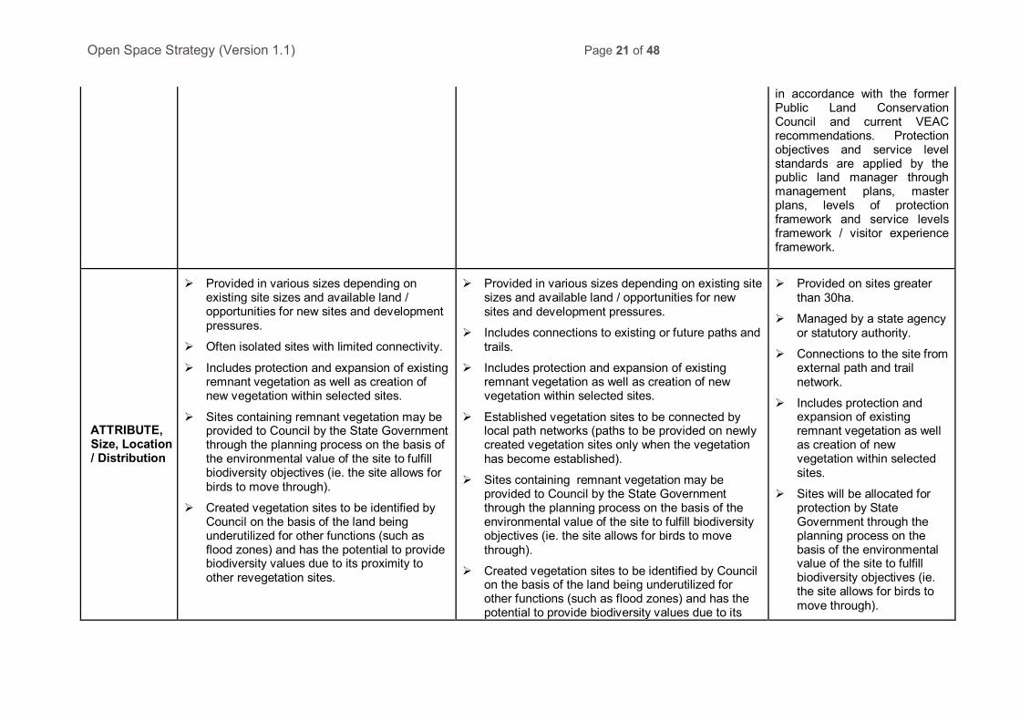
Open Space Strategy (Version 1.1) Page 21 of 48
in accordance with the former Public Land Conservation Council and current VEAC recommendations. Protection objectives and service level standards are applied by the public land manager through management plans, master plans, levels of protection framework and service levels framework / visitor experience framework.
ATTRIBUTE, Size, Location / Distribution
Provided in various sizes depending on existing site sizes and available land / opportunities for new sites and development pressures.
Often isolated sites with limited connectivity.
Includes protection and expansion of existing remnant vegetation as well as creation of new vegetation within selected sites.
Sites containing remnant vegetation may be provided to Council by the State Government through the planning process on the basis of the environmental value of the site to fulfill biodiversity objectives (ie. the site allows for birds to move through).
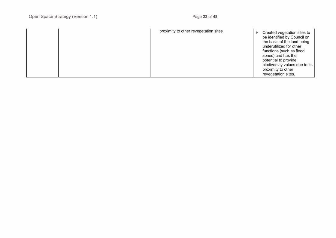
Created vegetation sites to be identified by Council on the basis of the land being underutilized for other functions (such as flood zones) and has the potential to provide biodiversity values due to its proximity to other revegetation sites.
Provided in various sizes depending on existing site sizes and available land / opportunities for new sites and development pressures.
Includes connections to existing or future paths and trails.
Includes protection and expansion of existing remnant vegetation as well as creation of new vegetation within selected sites.
Established vegetation sites to be connected by local path networks (paths to be provided on newly created vegetation sites only when the vegetation has become established).
Sites containing remnant vegetation may be provided to Council by the State Government through the planning process on the basis of the environmental value of the site to fulfill biodiversity objectives (ie. the site allows for birds to move through).
Created vegetation sites to be identified by Council on the basis of the land being underutilized for other functions (such as flood zones) and has the potential to provide biodiversity values due to its
Provided on sites greater than 30ha.
Managed by a state agency or statutory authority.
Connections to the site from external path and trail network.
Includes protection and expansion of existing remnant vegetation as well as creation of new vegetation within selected sites.
Sites will be allocated for protection by State Government through the planning process on the basis of the environmental value of the site to fulfill biodiversity objectives (ie. the site allows for birds to move through).
Open Space Strategy (Version 1.1) Page 22 of 48
proximity to other revegetation sites. Created vegetation sites to be identified by Council on the basis of the land being underutilized for other functions (such as flood zones) and has the potential to provide biodiversity values due to its proximity to other revegetation sites.
Open Space Strategy (Version 1.1) Page 23 of 48
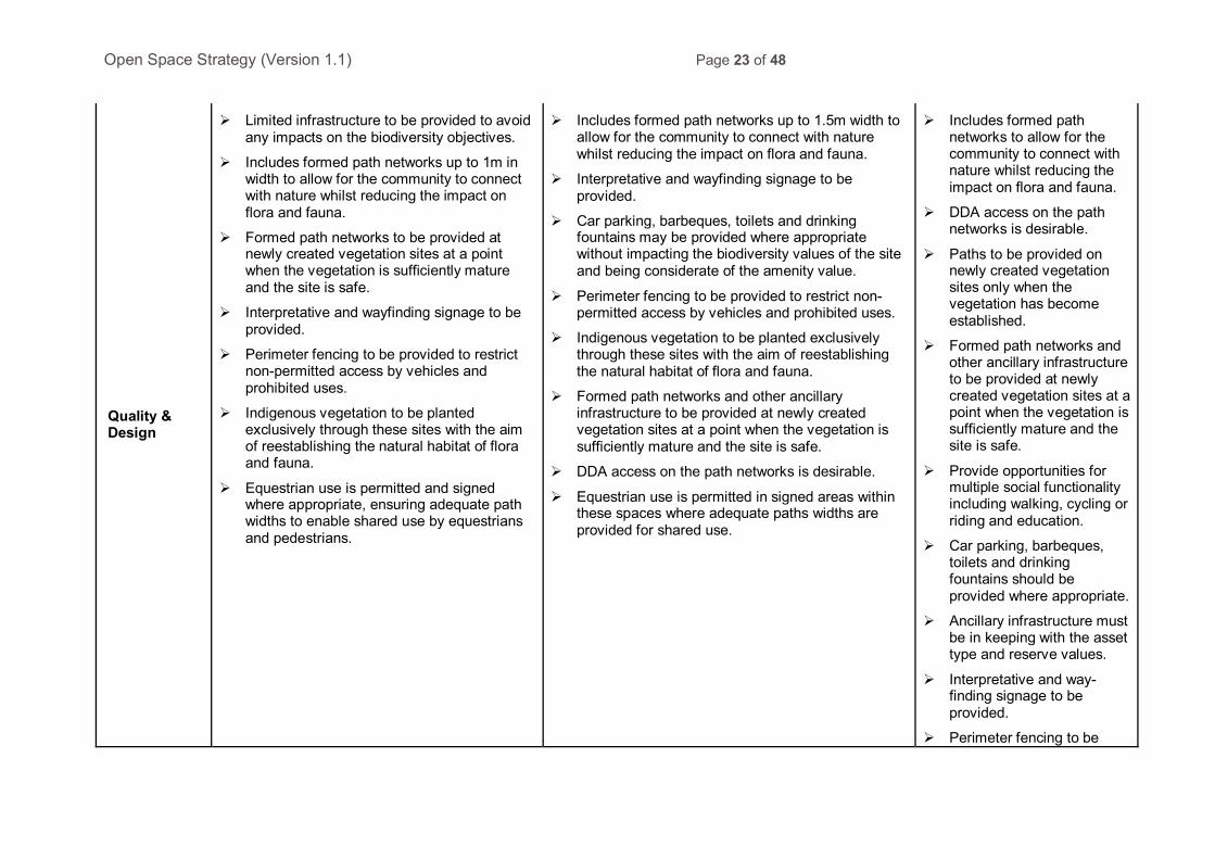
Quality & Design
Limited infrastructure to be provided to avoid any impacts on the biodiversity objectives.
Includes formed path networks up to 1m in width to allow for the community to connect with nature whilst reducing the impact on flora and fauna.
Formed path networks to be provided at newly created vegetation sites at a point when the vegetation is sufficiently mature and the site is safe.
Interpretative and wayfinding signage to be provided.
Perimeter fencing to be provided to restrict non-permitted access by vehicles and prohibited uses.
Indigenous vegetation to be planted exclusively through these sites with the aim of reestablishing the natural habitat of flora and fauna.
Equestrian use is permitted and signed where appropriate, ensuring adequate path widths to enable shared use by equestrians and pedestrians.
Includes formed path networks up to 1.5m width to allow for the community to connect with nature whilst reducing the impact on flora and fauna.
Interpretative and wayfinding signage to be provided.
Car parking, barbeques, toilets and drinking fountains may be provided where appropriate without impacting the biodiversity values of the site and being considerate of the amenity value.
Perimeter fencing to be provided to restrict non-permitted access by vehicles and prohibited uses.
Indigenous vegetation to be planted exclusively through these sites with the aim of reestablishing the natural habitat of flora and fauna.
Formed path networks and other ancillary infrastructure to be provided at newly created vegetation sites at a point when the vegetation is sufficiently mature and the site is safe.
DDA access on the path networks is desirable.
Equestrian use is permitted in signed areas within these spaces where adequate paths widths are provided for shared use.
Includes formed path networks to allow for the community to connect with nature whilst reducing the impact on flora and fauna.
DDA access on the path networks is desirable.
Paths to be provided on newly created vegetation sites only when the vegetation has become established.
Formed path networks and other ancillary infrastructure to be provided at newly created vegetation sites at a point when the vegetation is sufficiently mature and the site is safe.
Provide opportunities for multiple social functionality including walking, cycling or riding and education.
Car parking, barbeques, toilets and drinking fountains should be provided where appropriate.
Ancillary infrastructure must be in keeping with the asset type and reserve values.
Interpretative and way-finding signage to be provided.
Perimeter fencing to be
Open Space Strategy (Version 1.1) Page 24 of 48
provided to restrict non-permitted access by vehicles and prohibited uses.
Indigenous vegetation to be planted exclusively through these sites with the aim of reestablishing the natural habitat of flora and fauna.
Equestrian use is permitted in signed areas within these spaces where adequate paths widths are provided for shared use. This is subject to the activity being consistent with the reserve purpose of the land and consistent with approved management plans.
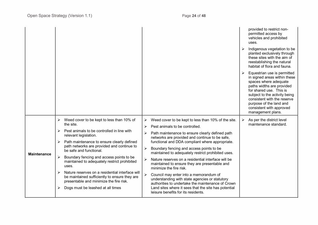
Maintenance
Weed cover to be kept to less than 10% of the site.
Pest animals to be controlled in line with relevant legislation.
Path maintenance to ensure clearly defined path networks are provided and continue to be safe and functional.
Boundary fencing and access points to be maintained to adequately restrict prohibited uses.
Nature reserves on a residential interface will be maintained sufficiently to ensure they are presentable and minimize the fire risk.
Dogs must be leashed at all times
Weed cover to be kept to less than 10% of the site.
Pest animals to be controlled.
Path maintenance to ensure clearly defined path networks are provided and continue to be safe, functional and DDA compliant where appropriate.
Boundary fencing and access points to be maintained to adequately restrict prohibited uses.
Nature reserves on a residential interface will be maintained to ensure they are presentable and minimize the fire risk.
Council may enter into a memorandum of understanding with state agencies or statutory authorities to undertake the maintenance of Crown Land sites where it sees that the site has potential leisure benefits for its residents.
As per the district level maintenance standard.

Open Space Strategy (Version 1.1) Page 25 of 48
Dogs must be leashed at all times
Open Space Strategy (Version 1.1) Page 26 of 48
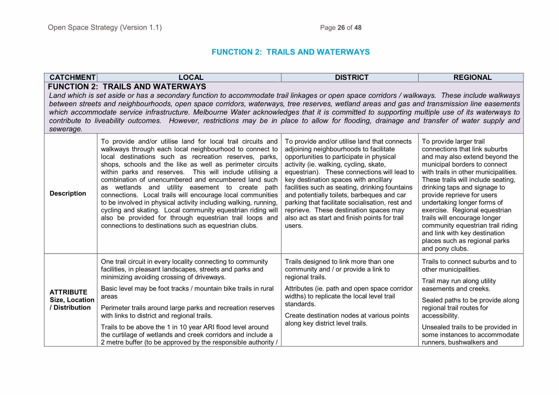
FUNCTION 2: TRAILS AND WATERWAYS
CATCHMENT LOCAL DISTRICT REGIONAL FUNCTION 2: TRAILS AND WATERWAYS Land which is set aside or has a secondary function to accommodate trail linkages or open space corridors / walkways. These include walkways between streets and neighbourhoods, open space corridors, waterways, tree reserves, wetland areas and gas and transmission line easements which accommodate service infrastructure. Melbourne Water acknowledges that it is committed to supporting multiple use of its waterways to contribute to liveability outcomes. However, restrictions may be in place to allow for flooding, drainage and transfer of water supply and sewerage.
Description
To provide and/or utilise land for local trail circuits and walkways through each local neighbourhood to connect to local destinations such as recreation reserves, parks, shops, schools and the like as well as perimeter circuits within parks and reserves. This will include utilising a combination of unencumbered and encumbered land such as wetlands and utility easement to create path connections. Local trails will encourage local communities to be involved in physical activity including walking, running, cycling and skating. Local community equestrian riding will also be provided for through equestrian trail loops and connections to destinations such as equestrian clubs.
To provide and/or utilise land that connects adjoining neighbourhoods to facilitate opportunities to participate in physical activity (ie. walking, cycling, skate, equestrian). These connections will lead to key destination spaces with ancillary facilities such as seating, drinking fountains and potentially toilets, barbeques and car parking that facilitate socialisation, rest and reprieve. These destination spaces may also act as start and finish points for trail users.
To provide larger trail connections that link suburbs and may also extend beyond the municipal borders to connect with trails in other municipalities. These trails will include seating, drinking taps and signage to provide reprieve for users undertaking longer forms of exercise. Regional equestrian trails will encourage longer community equestrian trail riding and link with key destination places such as regional parks and pony clubs.
ATTRIBUTE Size, Location / Distribution
One trail circuit in every locality connecting to community facilities, in pleasant landscapes, streets and parks and minimizing avoiding crossing of driveways.
Basic level may be foot tracks / mountain bike trails in rural areas
Perimeter trails around large parks and recreation reserves with links to district and regional trails.
Trails to be above the 1 in 10 year ARI flood level around the curtilage of wetlands and creek corridors and include a 2 metre buffer (to be approved by the responsible authority /
Trails designed to link more than one community and / or provide a link to regional trails.
Attributes (ie. path and open space corridor widths) to replicate the local level trail standards.
Create destination nodes at various points along key district level trails.
Trails to connect suburbs and to other municipalities.
Trail may run along utility easements and creeks.
Sealed paths to be provide along regional trail routes for accessibility.
Unsealed trails to be provided in some instances to accommodate runners, bushwalkers and
Open Space Strategy (Version 1.1) Page 27 of 48
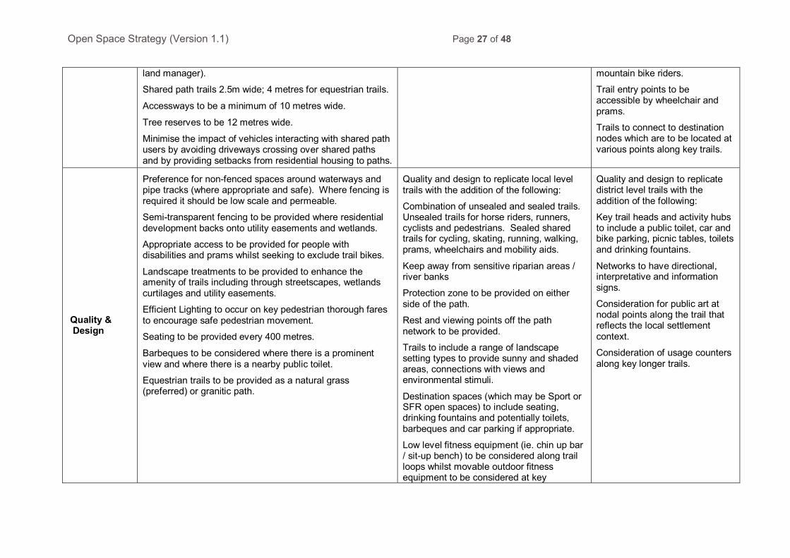
land manager).
Shared path trails 2.5m wide; 4 metres for equestrian trails.
Accessways to be a minimum of 10 metres wide.
Tree reserves to be 12 metres wide.
Minimise the impact of vehicles interacting with shared path users by avoiding driveways crossing over shared paths and by providing setbacks from residential housing to paths.
mountain bike riders.
Trail entry points to be accessible by wheelchair and prams.
Trails to connect to destination nodes which are to be located at various points along key trails.
Quality & Design
Preference for non-fenced spaces around waterways and pipe tracks (where appropriate and safe). Where fencing is required it should be low scale and permeable.
Semi-transparent fencing to be provided where residential development backs onto utility easements and wetlands.
Appropriate access to be provided for people with disabilities and prams whilst seeking to exclude trail bikes.
Landscape treatments to be provided to enhance the amenity of trails including through streetscapes, wetlands curtilages and utility easements.
Efficient Lighting to occur on key pedestrian thorough fares to encourage safe pedestrian movement.
Seating to be provided every 400 metres.
Barbeques to be considered where there is a prominent view and where there is a nearby public toilet.
Equestrian trails to be provided as a natural grass (preferred) or granitic path.
Quality and design to replicate local level trails with the addition of the following:
Combination of unsealed and sealed trails. Unsealed trails for horse riders, runners, cyclists and pedestrians. Sealed shared trails for cycling, skating, running, walking, prams, wheelchairs and mobility aids.
Keep away from sensitive riparian areas / river banks
Protection zone to be provided on either side of the path.
Rest and viewing points off the path network to be provided.
Trails to include a range of landscape setting types to provide sunny and shaded areas, connections with views and environmental stimuli.
Destination spaces (which may be Sport or SFR open spaces) to include seating, drinking fountains and potentially toilets, barbeques and car parking if appropriate.
Low level fitness equipment (ie. chin up bar / sit-up bench) to be considered along trail loops whilst movable outdoor fitness equipment to be considered at key
Quality and design to replicate district level trails with the addition of the following:
Key trail heads and activity hubs to include a public toilet, car and bike parking, picnic tables, toilets and drinking fountains.
Networks to have directional, interpretative and information signs.
Consideration for public art at nodal points along the trail that reflects the local settlement context.
Consideration of usage counters along key longer trails.

Open Space Strategy (Version 1.1) Page 28 of 48
destination sites.
Open Space Strategy (Version 1.1) Page 29 of 48
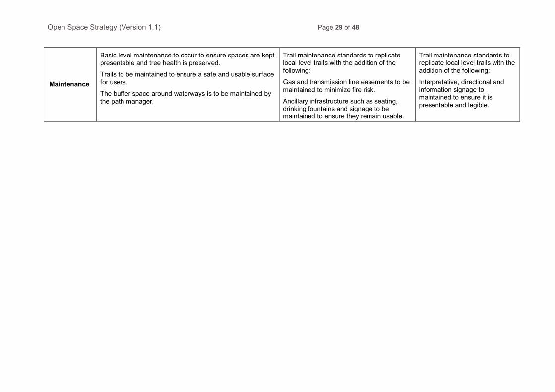
Maintenance
Basic level maintenance to occur to ensure spaces are kept presentable and tree health is preserved.
Trails to be maintained to ensure a safe and usable surface for users.
The buffer space around waterways is to be maintained by the path manager.
Trail maintenance standards to replicate local level trails with the addition of the following:
Gas and transmission line easements to be maintained to minimize fire risk.
Ancillary infrastructure such as seating, drinking fountains and signage to be maintained to ensure they remain usable.
Trail maintenance standards to replicate local level trails with the addition of the following:
Interpretative, directional and information signage to maintained to ensure it is presentable and legible.
Open Space Strategy (Version 1.1) Page 30 of 48
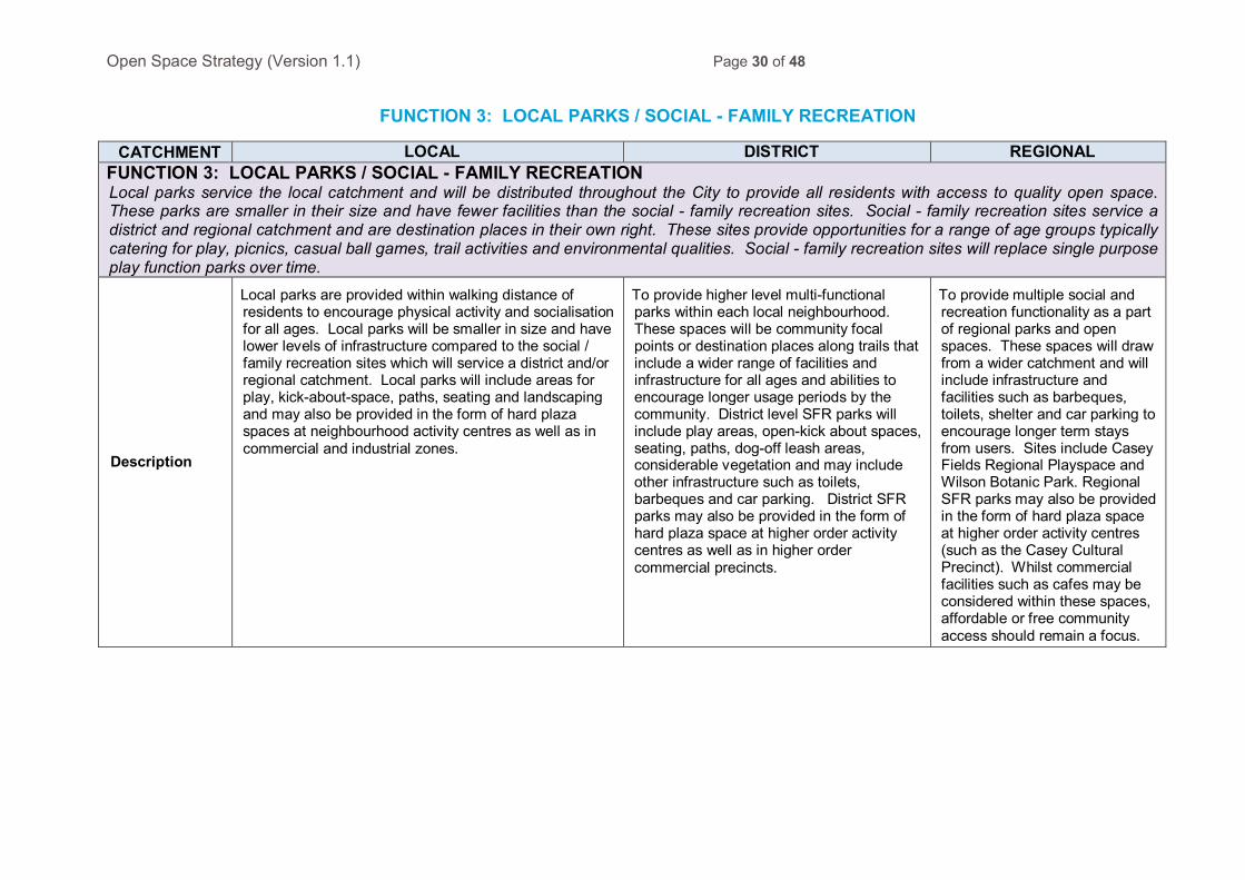
FUNCTION 3: LOCAL PARKS / SOCIAL - FAMILY RECREATION
CATCHMENT LOCAL DISTRICT REGIONAL FUNCTION 3: LOCAL PARKS / SOCIAL - FAMILY RECREATION Local parks service the local catchment and will be distributed throughout the City to provide all residents with access to quality open space. These parks are smaller in their size and have fewer facilities than the social - family recreation sites. Social - family recreation sites service a district and regional catchment and are destination places in their own right. These sites provide opportunities for a range of age groups typically catering for play, picnics, casual ball games, trail activities and environmental qualities. Social - family recreation sites will replace single purpose play function parks over time.
Description
Local parks are provided within walking distance of residents to encourage physical activity and socialisation for all ages. Local parks will be smaller in size and have lower levels of infrastructure compared to the social / family recreation sites which will service a district and/or regional catchment. Local parks will include areas for play, kick-about-space, paths, seating and landscaping and may also be provided in the form of hard plaza spaces at neighbourhood activity centres as well as in commercial and industrial zones.
To provide higher level multi-functional parks within each local neighbourhood. These spaces will be community focal points or destination places along trails that include a wider range of facilities and infrastructure for all ages and abilities to encourage longer usage periods by the community. District level SFR parks will include play areas, open-kick about spaces, seating, paths, dog-off leash areas, considerable vegetation and may include other infrastructure such as toilets, barbeques and car parking. District SFR parks may also be provided in the form of hard plaza space at higher order activity centres as well as in higher order commercial precincts.
To provide multiple social and recreation functionality as a part of regional parks and open spaces. These spaces will draw from a wider catchment and will include infrastructure and facilities such as barbeques, toilets, shelter and car parking to encourage longer term stays from users. Sites include Casey Fields Regional Playspace and Wilson Botanic Park. Regional SFR parks may also be provided in the form of hard plaza space at higher order activity centres (such as the Casey Cultural Precinct). Whilst commercial facilities such as cafes may be considered within these spaces, affordable or free community access should remain a focus.
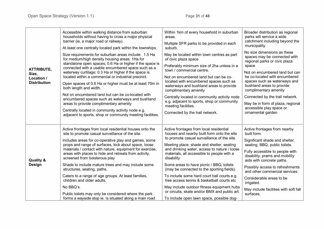
Open Space Strategy (Version 1.1) Page 31 of 48
ATTRIBUTE, Size, Location / Distribution
Accessible within walking distance from suburban households without having to cross a major physical barrier (ie. a major road or railway).
At least one centrally located park within the townships.
Size requirements for suburban areas include: 1.5 Ha for medium/high density housing areas; 1Ha for standalone open spaces; 0.6 Ha or higher if the space is connected with a usable encumbered space such as a waterway curtilage; 0.3 Ha or higher if the space is located within a commercial or industrial precinct.
Open spaces of 0.6 Ha or higher must be at least 70m in both length and width.
Not on encumbered land but can be co-located with encumbered spaces such as waterways and bushland areas to provide complimentary amenity
Centrally located in community activity node e.g. adjacent to sports, shop or community meeting facilities.
Within 1km of every household in suburban areas.
Multiple SFR parks to be provided in each suburb.
May be located within town centres as part of civic plaza space
Preferably minimum size of 2ha unless in a town / commercial centre.
Not on encumbered land but can be co-located with encumbered spaces such as waterways and bushland areas to provide complimentary amenity
Centrally located in community activity node e.g. adjacent to sports, shop or community meeting facilities.
Connected by the trail network.
Broader distribution as regional parks will service a wide catchment including beyond the municipality.
No size dimensions as these spaces may be connected with regional parks or civic plaza space
Not on encumbered land but can be co-located with encumbered spaces such as waterways and bushland areas to provide complimentary amenity
Connected by the trail network.
May be in form of plaza, regional accessible play space or ornamental garden
Quality & Design
Active frontages from local residential houses onto the site to promote casual surveillance of the site.
Includes areas for co-operative play and games, some props and range of surfaces, kick about space, loose materials / contact with nature, equipment for exercise, areas with places to hide and retreats from activity, screened from boisterous play
Shade to include mature trees and may include some structures, seating, paths.
Caters to a range of age groups. At least families, children and older adults.
No BBQ’s.
Public toilets may only be considered where the park forms a wayside stop ie. is situated along a main road
Active frontages from local residential houses and nearby built form onto the site to promote casual surveillance of the site.
Meeting place; shade and shelter, seating and drinking water, access to nature / loose materials, all accessible to people with a disability
Some areas to have picnic / BBQ, toilets (may be connected to the sporting fields).
To include some hard court ball courts e.g. free access tennis & basketball courts etc
May include outdoor fitness equipment hubs or circuits, skate and/or BMX and public art.
To include open lawn space, possible dog-
Active frontages from nearby built form.
Significant shade and shelter, seating, BBQ, public toilets.
Fully accessible to people with disability, prams and mobility aids with concrete paths.
Possibly access to refreshments and other commercial services.
Considerable areas to be irrigated.
May include facilities with soft fall surfaces.
Open Space Strategy (Version 1.1) Page 32 of 48
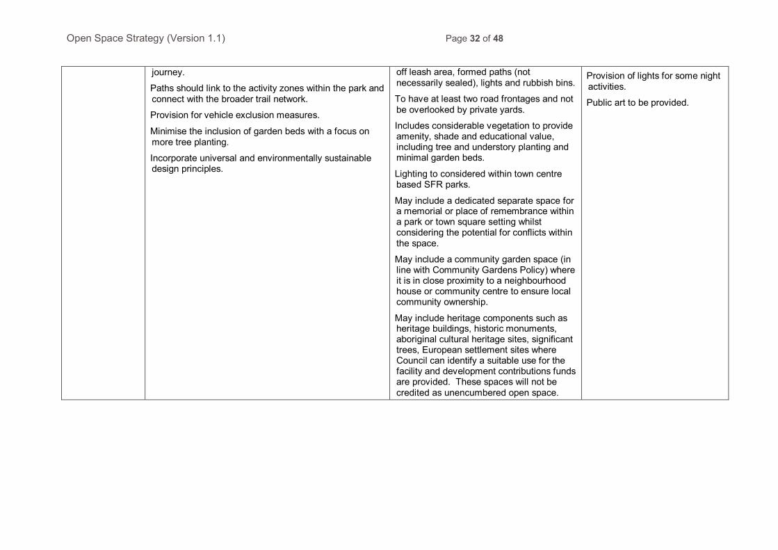
journey.
Paths should link to the activity zones within the park and connect with the broader trail network.
Provision for vehicle exclusion measures.
Minimise the inclusion of garden beds with a focus on more tree planting.
Incorporate universal and environmentally sustainable design principles.
off leash area, formed paths (not necessarily sealed), lights and rubbish bins.
To have at least two road frontages and not be overlooked by private yards.
Includes considerable vegetation to provide amenity, shade and educational value, including tree and understory planting and minimal garden beds.
Lighting to considered within town centre based SFR parks.
May include a dedicated separate space for a memorial or place of remembrance within a park or town square setting whilst considering the potential for conflicts within the space.
May include a community garden space (in line with Community Gardens Policy) where it is in close proximity to a neighbourhood house or community centre to ensure local community ownership.
May include heritage components such as heritage buildings, historic monuments, aboriginal cultural heritage sites, significant trees, European settlement sites where Council can identify a suitable use for the facility and development contributions funds are provided. These spaces will not be credited as unencumbered open space.
Provision of lights for some night activities.
Public art to be provided.
Open Space Strategy (Version 1.1) Page 33 of 48
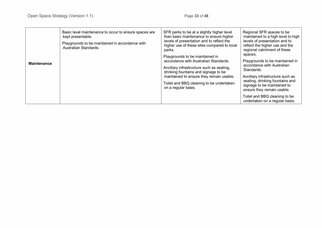
Maintenance
Basic level maintenance to occur to ensure spaces are kept presentable.
Playgrounds to be maintained in accordance with Australian Standards.
SFR parks to be at a slightly higher level than basic maintenance to ensure higher levels of presentation and to reflect the higher use of these sites compared to local parks.
Playgrounds to be maintained in accordance with Australian Standards.
Ancillary infrastructure such as seating, drinking fountains and signage to be maintained to ensure they remain usable.
Toilet and BBQ cleaning to be undertaken on a regular basis.
Regional SFR spaces to be maintained to a high level to high levels of presentation and to reflect the higher use and the regional catchment of these spaces.
Playgrounds to be maintained in accordance with Australian Standards.
Ancillary infrastructure such as seating, drinking fountains and signage to be maintained to ensure they remain usable.
Toilet and BBQ cleaning to be undertaken on a regular basis.
Open Space Strategy (Version 1.1) Page 34 of 48
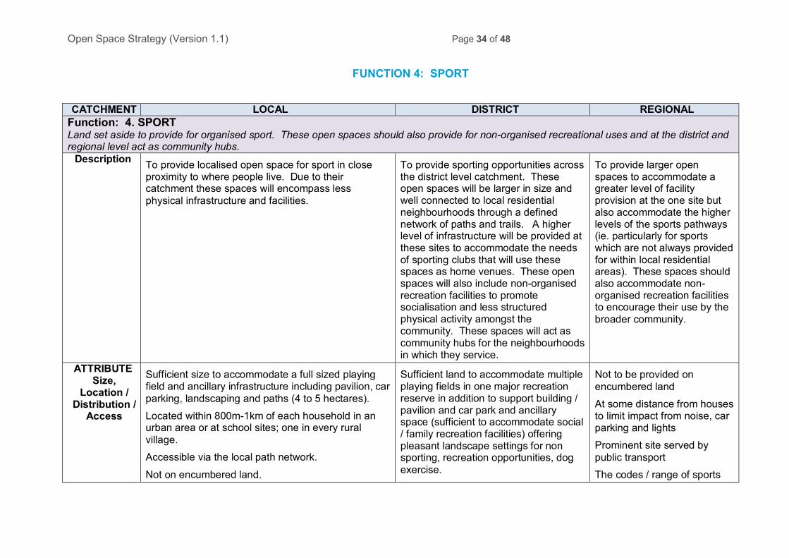
FUNCTION 4: SPORT
CATCHMENT LOCAL DISTRICT REGIONAL
Function: 4. SPORT Land set aside to provide for organised sport. These open spaces should also provide for non-organised recreational uses and at the district and regional level act as community hubs.
Description To provide localised open space for sport in close proximity to where people live. Due to their catchment these spaces will encompass less physical infrastructure and facilities.
To provide sporting opportunities across the district level catchment. These open spaces will be larger in size and well connected to local residential neighbourhoods through a defined network of paths and trails. A higher level of infrastructure will be provided at these sites to accommodate the needs of sporting clubs that will use these spaces as home venues. These open spaces will also include non-organised recreation facilities to promote socialisation and less structured physical activity amongst the community. These spaces will act as community hubs for the neighbourhoods in which they service.
To provide larger open spaces to accommodate a greater level of facility provision at the one site but also accommodate the higher levels of the sports pathways (ie. particularly for sports which are not always provided for within local residential areas). These spaces should also accommodate non-organised recreation facilities to encourage their use by the broader community.
ATTRIBUTE Size,
Location / Distribution /
Access
Sufficient size to accommodate a full sized playing field and ancillary infrastructure including pavilion, car parking, landscaping and paths (4 to 5 hectares).
Located within 800m-1km of each household in an urban area or at school sites; one in every rural village.
Accessible via the local path network.
Not on encumbered land.
Sufficient land to accommodate multiple playing fields in one major recreation reserve in addition to support building / pavilion and car park and ancillary space (sufficient to accommodate social / family recreation facilities) offering pleasant landscape settings for non sporting, recreation opportunities, dog exercise.
Not to be provided on encumbered land
At some distance from houses to limit impact from noise, car parking and lights
Prominent site served by public transport
The codes / range of sports

Open Space Strategy (Version 1.1) Page 35 of 48
Not to be provided on encumbered land
A minimum of 10ha in size and located within 1km of all dwellings.
Council owned indoor facilities should ideally be located within a community hub (ie. either in a town centre or co-located with a school or community facility).
Perimeter trails and circuits within the site that link to surrounding off-road trail networks.
Located off a collector road and on a public transport route.
provided should be based on the LFDP and sports pathways.
The full range of sports including equestrian should be considered for these spaces.
Perimeter trails and circuits within the site that link to surrounding off-road trail networks.
Accessed by a main road (at least a collector road and preferably an arterial).
Quality & design Active frontages from local residential houses onto
the site to promote casual surveillance of the site.
Civil and building infrastructure to be provided in accordance with Council’s Leisure Facilities and Development Plan facility standards.
Ancillary space offering pleasant landscape setting, seating and shade and paths.
Spaces and facilities incorporate universal and environmentally sustainable design principles.
Minimise the visual impact of service requirements such as water tanks, power and gas meters.
As per local level sports facilities with the addition of the following:
Oval fencing to be avoided in some instances to increase flexibility of the site (where it doesn’t conflict with the requirements of the sport).
Seating and shade, play and contact with nature, environmental qualities to be provided.
Social / family recreation infrastructure / facilities to be included on the site with public access to toilets to be considered where the SFR space is a sufficient attractor.
Schools and community facilities should not encroach on the open space site.
Public art to be considered and
As per district level sports facilities with the addition of the following:
Support facilities for the individual sports to be provided in accordance with LFDP standards and commensurate with the level of sporting competition.
Fencing to be provided where it is a requirement of the sport or to accommodate higher level competitions and events.
Consistent design in the site’s features including buildings and shelters.
High quality, prominent public
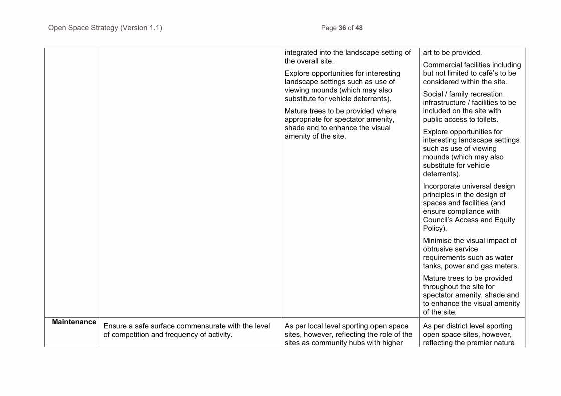
Open Space Strategy (Version 1.1) Page 36 of 48
integrated into the landscape setting of the overall site.
Explore opportunities for interesting landscape settings such as use of viewing mounds (which may also substitute for vehicle deterrents).
Mature trees to be provided where appropriate for spectator amenity, shade and to enhance the visual amenity of the site.
art to be provided.
Commercial facilities including but not limited to café’s to be considered within the site.
Social / family recreation infrastructure / facilities to be included on the site with public access to toilets.
Explore opportunities for interesting landscape settings such as use of viewing mounds (which may also substitute for vehicle deterrents).
Incorporate universal design principles in the design of spaces and facilities (and ensure compliance with Council’s Access and Equity Policy).
Minimise the visual impact of obtrusive service requirements such as water tanks, power and gas meters.
Mature trees to be provided throughout the site for spectator amenity, shade and to enhance the visual amenity of the site.
Maintenance Ensure a safe surface commensurate with the level of competition and frequency of activity.
As per local level sporting open space sites, however, reflecting the role of the sites as community hubs with higher
As per district level sporting open space sites, however, reflecting the premier nature

Open Space Strategy (Version 1.1) Page 37 of 48
Pavilions maintained to a safe and functional level.
Ancillary spaces to be maintained to ensure they remain tidy and presentable.
and broader levels of use. of the site/facilities and subsequent player and spectator visitation to the site.
Version: Draft as at 13 November 2014
Date updated: Adopted Day Month Year
Responsible Department: Sport & Leisure
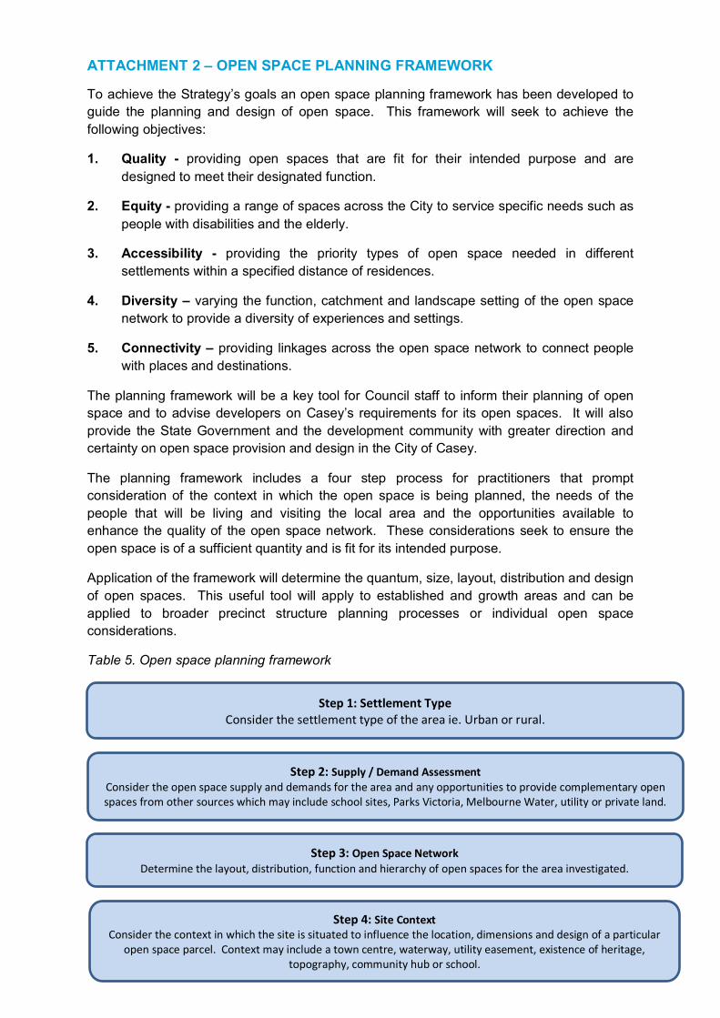
ATTACHMENT 2 – OPEN SPACE PLANNING FRAMEWORK
To achieve the Strategy’s goals an open space planning framework has been developed to guide the planning and design of open space. This framework will seek to achieve the following objectives:
1. Quality - providing open spaces that are fit for their intended purpose and are designed to meet their designated function.
2. Equity - providing a range of spaces across the City to service specific needs such as people with disabilities and the elderly.
3. Accessibility - providing the priority types of open space needed in different settlements within a specified distance of residences.
4. Diversity – varying the function, catchment and landscape setting of the open space network to provide a diversity of experiences and settings.
5. Connectivity – providing linkages across the open space network to connect people with places and destinations.
The planning framework will be a key tool for Council staff to inform their planning of open space and to advise developers on Casey’s requirements for its open spaces. It will also provide the State Government and the development community with greater direction and certainty on open space provision and design in the City of Casey.
The planning framework includes a four step process for practitioners that prompt consideration of the context in which the open space is being planned, the needs of the people that will be living and visiting the local area and the opportunities available to enhance the quality of the open space network. These considerations seek to ensure the open space is of a sufficient quantity and is fit for its intended purpose.
Application of the framework will determine the quantum, size, layout, distribution and design of open spaces. This useful tool will apply to established and growth areas and can be applied to broader precinct structure planning processes or individual open space considerations.
Table 5. Open space planning framework
Step 1: Settlement Type Consider the settlement type of the area ie. Urban or rural.
Step 2: Supply / Demand Assessment Consider the open space supply and demands for the area and any opportunities to provide complementary open spaces from other sources which may include school sites, Parks Victoria, Melbourne Water, utility or private land.
Step 3: Open Space Network Determine the layout, distribution, function and hierarchy of open spaces for the area investigated.
Step 4: Site Context Consider the context in which the site is situated to influence the location, dimensions and design of a particular
open space parcel. Context may include a town centre, waterway, utility easement, existence of heritage, topography, community hub or school.
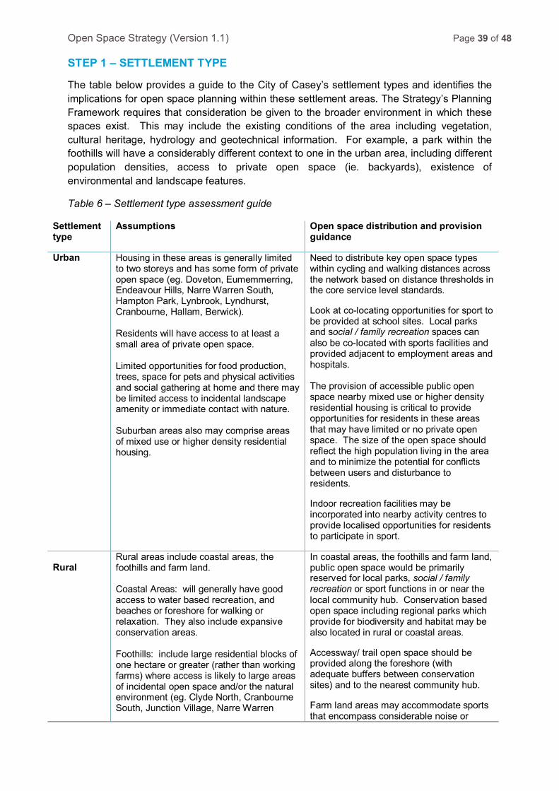
Open Space Strategy (Version 1.1) Page 39 of 48 STEP 1 – SETTLEMENT TYPE
The table below provides a guide to the City of Casey’s settlement types and identifies the implications for open space planning within these settlement areas. The Strategy’s Planning Framework requires that consideration be given to the broader environment in which these spaces exist. This may include the existing conditions of the area including vegetation, cultural heritage, hydrology and geotechnical information. For example, a park within the foothills will have a considerably different context to one in the urban area, including different population densities, access to private open space (ie. backyards), existence of environmental and landscape features.
Table 6 – Settlement type assessment guide
Settlement type
Assumptions Open space distribution and provision guidance
Urban Housing in these areas is generally limited to two storeys and has some form of private open space (eg. Doveton, Eumemmerring, Endeavour Hills, Narre Warren South, Hampton Park, Lynbrook, Lyndhurst, Cranbourne, Hallam, Berwick). Residents will have access to at least a small area of private open space. Limited opportunities for food production, trees, space for pets and physical activities and social gathering at home and there may be limited access to incidental landscape amenity or immediate contact with nature. Suburban areas also may comprise areas of mixed use or higher density residential housing.
Need to distribute key open space types within cycling and walking distances across the network based on distance thresholds in the core service level standards.
Look at co-locating opportunities for sport to be provided at school sites. Local parks and social / family recreation spaces can also be co-located with sports facilities and provided adjacent to employment areas and hospitals. The provision of accessible public open space nearby mixed use or higher density residential housing is critical to provide opportunities for residents in these areas that may have limited or no private open space. The size of the open space should reflect the high population living in the area and to minimize the potential for conflicts between users and disturbance to residents.
Indoor recreation facilities may be incorporated into nearby activity centres to provide localised opportunities for residents to participate in sport.
Rural
Rural areas include coastal areas, the foothills and farm land. Coastal Areas: will generally have good access to water based recreation, and beaches or foreshore for walking or relaxation. They also include expansive conservation areas. Foothills: include large residential blocks of one hectare or greater (rather than working farms) where access is likely to large areas of incidental open space and/or the natural environment (eg. Clyde North, Cranbourne South, Junction Village, Narre Warren
In coastal areas, the foothills and farm land, public open space would be primarily reserved for local parks, social / family recreation or sport functions in or near the local community hub. Conservation based open space including regional parks which provide for biodiversity and habitat may be also located in rural or coastal areas.
Accessway/ trail open space should be provided along the foreshore (with adequate buffers between conservation sites) and to the nearest community hub.
Farm land areas may accommodate sports that encompass considerable noise or
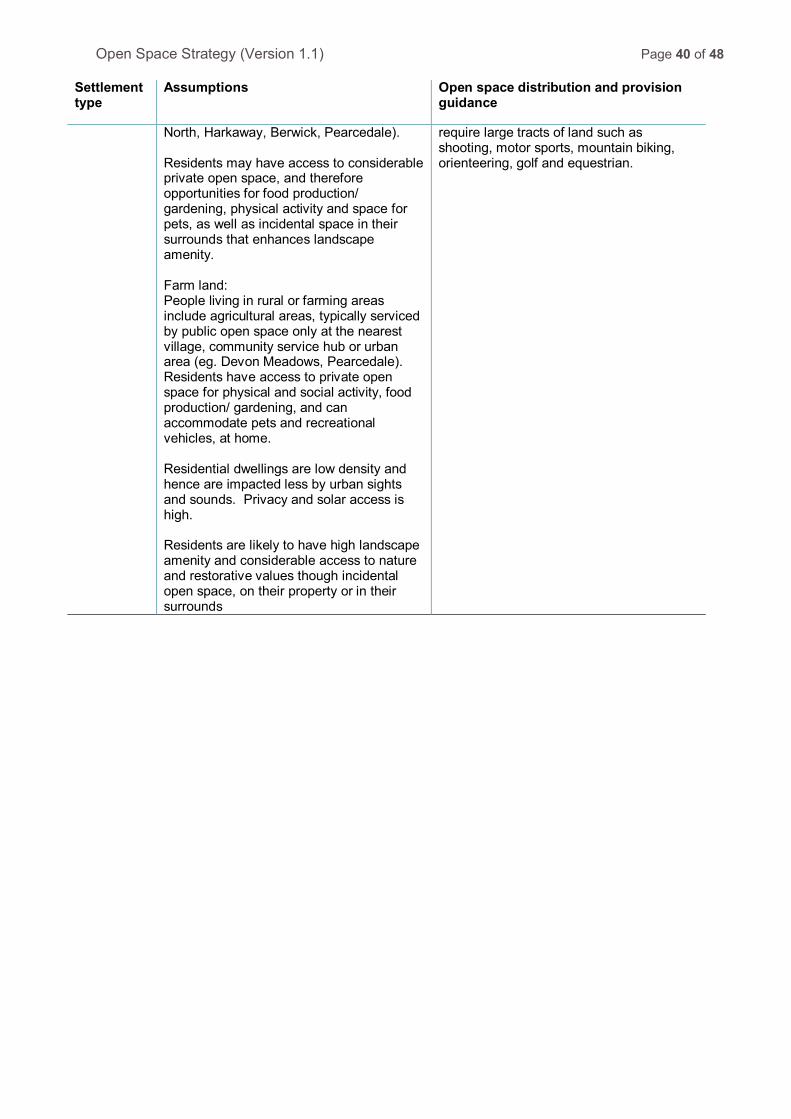
Open Space Strategy (Version 1.1) Page 40 of 48
Settlement type
Assumptions Open space distribution and provision guidance
North, Harkaway, Berwick, Pearcedale). Residents may have access to considerable private open space, and therefore opportunities for food production/ gardening, physical activity and space for pets, as well as incidental space in their surrounds that enhances landscape amenity. Farm land: People living in rural or farming areas include agricultural areas, typically serviced by public open space only at the nearest village, community service hub or urban area (eg. Devon Meadows, Pearcedale). Residents have access to private open space for physical and social activity, food production/ gardening, and can accommodate pets and recreational vehicles, at home. Residential dwellings are low density and hence are impacted less by urban sights and sounds. Privacy and solar access is high. Residents are likely to have high landscape amenity and considerable access to nature and restorative values though incidental open space, on their property or in their surrounds
require large tracts of land such as shooting, motor sports, mountain biking, orienteering, golf and equestrian.

Open Space Strategy (Version 1.1) Page 41 of 48 STEP 2 – SUPPLY / DEMAND ASSESSMENT
Determining the appropriate quantum of open space from a development proposal requires an assessment of the proposed supply and analysing this against the demands of the area to meet the needs of the population for each of the open space functions. Council’s technical strategies (such as the Leisure Facilities Development Plan, Paths and Trails Strategy, Playground Strategy, Biodiversity Strategy and more) may be used as a guide to determine the demand.
An analysis of other opportunities should also to be undertaken to consider available land for open space at school sites or land owned or managed by Parks Victoria, Melbourne Water, other public authorities (ie. power/gas) and / or private land. These spaces may complement Council’s provision and add value to the overall network of open space. Where these opportunities exist, Council may seek agreement or partner with these organisations / agencies to ensure access, provide infrastructure or determine appropriate maintenance arrangements.
Council may also consider the broader context of open space provision such as larger open space land parcels located in adjacent municipalities to determine its impact on open space provision within Casey.
The State Government’s Metropolitan Open Space Strategy has an objective to identify opportunities for new open space and connections as well as making better use of the existing network. The supply of open space in the City of Casey is also guided by the Growth Area Authority Precinct Structure Plan Guidelines (for growth areas), local development plans or through the Subdivision Act 1988. These documents will also contribute to the future provision of open space within the City.

Open Space Strategy (Version 1.1) Page 42 of 48 STEP 3 – OPEN SPACE NETWORK
Open space planning requires consideration of the City’s overall network of open spaces, including linkages, gaps and the distribution of open space functions to ensure an equitable distribution. This broader network planning can then be used to inform localised open space network planning which may occur during structure plan and subdivision processes. Considerations for local open space network planning include:
• The distribution of spaces within the development area.
• Proposed linkages in the network and how access can be facilitated / enhanced through the location or trails.
• Linkages to the broader open space network and the complementary elements / destination places.
• The size and catchment of open spaces as well as where particular functions of open space should be located.
The Strategy’s core service level standards define a hierarchy of open spaces across each of the four functions. This hierarchy is based on the catchment of the spaces (ie. local, district or regional) and the appropriate infrastructure and maintenance levels for each catchment. The catchment is based on the sphere of influence of the open space as defined by where the users will originate from and how long they may utilise / stay at the open space. The size, scale and proximity of the open space to nearby populations will influence the catchment.
The Strategy proposes four functions for public open space in the City, including:
• Nature.
• Trails and Waterways.
• Social / Family Recreation.
• Sport.
The selection of functions for the Council owned individual open spaces will be determined by Council’s Recreation Planning team.
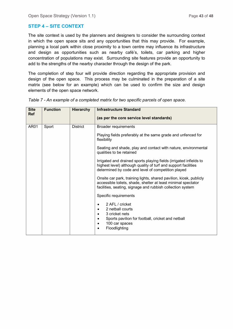
Open Space Strategy (Version 1.1) Page 43 of 48 STEP 4 – SITE CONTEXT
The site context is used by the planners and designers to consider the surrounding context in which the open space sits and any opportunities that this may provide. For example, planning a local park within close proximity to a town centre may influence its infrastructure and design as opportunities such as nearby café’s, toilets, car parking and higher concentration of populations may exist. Surrounding site features provide an opportunity to add to the strengths of the nearby character through the design of the park.
The completion of step four will provide direction regarding the appropriate provision and design of the open space. This process may be culminated in the preparation of a site matrix (see below for an example) which can be used to confirm the size and design elements of the open space network.
Table 7 - An example of a completed matrix for two specific parcels of open space.
Site Ref
Function Hierarchy Infrastructure Standard
(as per the core service level standards)
AR01 Sport District Broader requirements
Playing fields preferably at the same grade and unfenced for flexibility
Seating and shade, play and contact with nature, environmental qualities to be retained
Irrigated and drained sports playing fields (irrigated infields to highest level) although quality of turf and support facilities determined by code and level of competition played
Onsite car park, training lights, shared pavilion, kiosk, publicly accessible toilets, shade, shelter at least minimal spectator facilities, seating, signage and rubbish collection system
Specific requirements
• 2 AFL / cricket • 2 netball courts • 3 cricket nets • Sports pavilion for football, cricket and netball • 100 car spaces • Floodlighting
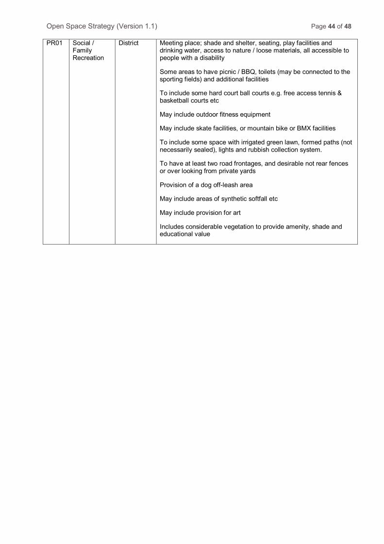
Open Space Strategy (Version 1.1) Page 44 of 48 PR01 Social /
Family Recreation
District Meeting place; shade and shelter, seating, play facilities and drinking water, access to nature / loose materials, all accessible to people with a disability
Some areas to have picnic / BBQ, toilets (may be connected to the sporting fields) and additional facilities
To include some hard court ball courts e.g. free access tennis & basketball courts etc
May include outdoor fitness equipment
May include skate facilities, or mountain bike or BMX facilities
To include some space with irrigated green lawn, formed paths (not necessarily sealed), lights and rubbish collection system.
To have at least two road frontages, and desirable not rear fences or over looking from private yards
Provision of a dog off-leash area
May include areas of synthetic softfall etc
May include provision for art
Includes considerable vegetation to provide amenity, shade and educational value

Open Space Strategy (Version 1.1) Page 45 of 48 ATTACHMENT 3 - LAND ACQUISITIONS AND DISPOSALS
To assist in the delivery of an appropriate distribution of quality open space throughout the City, Council may consider acquiring and disposing of selected land parcels.
Open Space Land Acquisitions
Council can acquire land to add to or fill gaps in the open space network to create additional recreation opportunities for the community. Land purchases may be identified through technical strategies or master plans or determined by Council to meet a specific need in the community.
Land purchases follow a statutory process as defined in the Land Acquisition and Compensation Act 1986. Land can be purchased through a negotiation process with the property owner or through compulsory acquisition.
Council’s process for purchasing land includes the following steps:
1. Strategic identification of land required to meet a need in the community.
2. Preliminary determination of the cost of land acquisition.
3. Report to Council’s Executive Management Group to gain support for the proposal.
4. Inclusion of the land parcel in Council’s Strategic Land Acquisition Register and subsequent listing in Council’s capital works program for the endorsement of Council.
5. Purchase of land parcel through either negotiated or compulsory acquisition process.
Open Space Land Disposals
Council may elect to dispose of open space land parcels where they are deemed to have limited benefit to the community. Factors that influence the consideration of benefit of an open space parcel may include:
• The location and proximity to populations.
• Ease of access.
• Size.
• Site characteristics and constraints (topography).
• Suitability for use.
The disposal of land is an important consideration as there is a limited supply of existing open space to fulfil the needs of the community. Clause 11 of the Casey Planning Scheme states for the overall network of open space within the City to be protected and that where there is a reduction in open space, it should be offset through the replacement of parkland of equal or greater size and quality (ie. no net loss).
Open Space Strategy (Version 1.1) Page 46 of 48 Section 20(2) of the Subdivision Act 1988 states that Council must use any proceeds from the sale of public open space to:
(a) Buy land for use for public recreation or public resort, as parklands or for similar purposes; or
(b) Improve land already set aside, zoned or reserved (by the Council, the Crown, a planning scheme or otherwise) for use for public recreation or public resort, as parklands or for similar purposes; or
(c) With the approval of the Minister administering the Local Government Act 1989, improve land (whether set aside on a plan or not) used for public recreation or public resort, as parklands or for similar purposes.
(d) Public open space can be used for municipal purposes in accordance with the planning scheme, or sold only if the Council has provided for replacement public open space.
Case Study
Council has previously attempted to dispose of the land at 78-92I Heatherton Road Endeavour Hills. The land sale was contested at the Victorian Civil and Administrative Tribunal (VCAT). VCAT advised that the sale of land could not proceed at that point as the sale had not been identified in an endorsed Council Strategy.
The Property in question is considered to have limited recreation value and is considered appropriate for sale on the basis of the following factors:
• The location and proximity to populations.
o The site is located adjacent to Heatherton Road in Endeavour Hills and is not central to the local population which it is intended to service.
• Ease of access.
o N/A.
• Size.
o N/A.
• Site characteristics and constraints (topography).
o The land has a considerable slope which makes it difficult to utilise for numerous recreation functions.
o The slope of land provides considerable access challenges for people with disabilities, the elderly and young children.
• Suitability for use.
o The site has very limited existing infrastructure at present to accommodate any recreational / social activity.

Open Space Strategy (Version 1.1) Page 47 of 48 • Other
o There are nearby parks and reserves which provide considerably greater recreational benefit to the local community, such as Singleton Reserve, James Alexander Reserve and Sydney Parkinson Reserve. These spaces are generally linked by a local recreational path network.
o Council has prepared a master plan for the Endeavour Hills Town Centre which proposes staged upgrades to the town centre including upgrades to the recreation infrastructure and establishment of new community facilities. The proposed upgrades to the Town Centre will enhance the precinct as a focal point for the local community and complement existing recreation and community facilities (such as the Leisure Centre and Library). Funds generated from the sale of the property could be utilised to contribute to the implementation of the Town Centre Master Plan.
These factors demonstrate that the topography of the site makes it difficult to utilise and provide easy access to any proposed facilities. There are a number of alternative open space options which better serve the needs of the community. Any funds derived from a sale of land could be utilised to provide recreational benefits for the Endeavour Hills area through investment in the implementation of the Endeavour Hills Town Centre project.

Open Space Strategy (Version 1.1) Page 48 of 48 ATTACHMENT 4 - OPEN SPACE MAP
This map outlines the City of Casey’s current open space network by its defined catchment.