Open Map Open Figure 6 Open Figure - Connecticut · The Surficial Geology of the New Haven and...
49
Open Map Open Figure 6 Open Figure 7
-
Upload
nguyenduong -
Category
Documents
-
view
219 -
download
0
Transcript of Open Map Open Figure 6 Open Figure - Connecticut · The Surficial Geology of the New Haven and...

Open MapOpen Figure 6 Open Figure 7

STATE GEOLOGICAL AND NATURAL HISTORY SURVEY OF CONNECTICUT
A DIVISION OF THE DEPARTMENT OF AGRICULTURE
AND NATURAL RESOURCES
The Surficial Geology
of the
New Haven and Woodmont
Quadrangles WITH MAP
BY RICHARD FOSTER FLINT Yale University
1965
QUADRANGLE REPORT NO. 18

STATE GEOLOGICAL AND NATURAL HISTORY SURVEY OF CONNECTICUT
A DIVISION OF THE DEPARTMENT OF AGRICULTURE AND NATURAL RESOURCES
HONORABLE JoHN N. DEMPSEY, Governor of Connecticut
JosEPH N. GILL, Commissioner of the Department of Agriculture and Natural Resources
COMMISSIONERS HoN. JoHN N. DEMPSEY, Governor of Connecticut
DR. J. WENDELL BuRGER, Department of Biology, Trinity College
DB. RICHARD H. GOODWIN, Department of Botany, Connecticut College
DR. JoE WEBB PEOPLES, Department of Geology, Wesleyan University
DR. JoHN RODGERS, Department of Geology, Yale University
DR. JAMES A. SLATER, Department of Zoology and Entomology, University of Connecticut
DIRECTOR JoE WEBB PEOPLES, Ph.D.
Wesleyan University, Middletown, Connecticut
EDITOR MAP EDITOR Lou WILLIAMS PAGE, Ph.D. HENRY R. ALDRICH, Ph.D.
DISTRIBUTION AND EXCHANGE AGENT WALTER BRAHM, State Librarian
State Library, Hartford
ii

TABLE OF CONTENTS
Page
Abstract. . . . . . . . . . . . . . . . . . . . . . . . . . . . . . . . . . . . . . . . . . . . . . . . . . . . . . . . . . . . . . . . . 1
Introduction . . . . . . . . . . . . . . . . . . . . . . . . . . . . . . . . . . . . . . . . . . . . . . . . . . . . . . . . . . . . . ]
Bedrock geology. . . . . . . . . . . . . . . . . . . . . . . . . . . . . . . . . . . . . . . . . . . . . . . . . . . . . . . . . . 3
Topography and drainage. . . . . . . . . . . . . . . . . . . . . . . . . . . . . . . . . . • . . . . . . . • . . . . . . . 4
Glacial geology. • . . . . . . . . . . . . . . . . . . . . . . . . . . . . . . . . . . . . . . . . . . . . . . . . . . . . . . . . . 7 Glacial-eroeional features. . . . . . . . . . . . . . . . . . . . . . . . . . . . . . . . . . . . . . . . . . . . . . . . . 7 Stream-abraded rock surfaces... . . . . . . . . . . . . . . . . . . . . . . . . . . . . . . . . . . . . . . . . . . JO
Glacial sediments . . . . . . . . . . . . . . . . . . . . . . . . . . . . . . . . . . . . . . . . . . . . . . . . . . . . . . . 11 Till................................................................. 11
General charact.er. . . . . . . . . . . . . . . . . . . . . . . . . . . . . . . . . . . . . . . . . . . . . . . . . . . 11 Stratigraphy and correlation. . . . . . . . . . . . . . . . . . . . . . . . . . . . . . . . . . . . . . . . . . 14
Erratic boulders . . . . . . . . . . . . . . . . . . . . . . . . . . . . . . . . . . . . . . . . . . . . . . . . . . . . . . 14 Stratified drift. . . . . . . . . . . . . . . . . . . . . . . . . . . . . . . . . . . . . . . . . . . . . . . . . . . . . . . . 16
Kinds or stratified drift . . . . . . . . . . . . . . . . . . . . . . . . . . . . . . . . . . . . . . . . . . . . . . 16 New Haven valley train: ictK:ontact Cacies. . . . . . . . . . . . . . . . . . . . . . . . . . . . 17 New Haven valley train: outwash facies.............................. 19 Farm River valley outwash sediments . . . . . . . . . . . . . . . . . . . . . . . . . . . . . . . . . 21 Oyster River valley train . . . . . . . . . . . . . . . . . . . . . . . . . . . . . . . . . . . . . . . . . . . . 22 Lake-bottom sediments. . . . . . . . . . . . . . . . . . . . . . . . . . . . . . . . . . . . . . . . • . . . . . 22 Quinnipiac Valley outwash sedimen,ts.................................. 24 Unnamed bodies of ictK:ontact stratified drift. . . . . . . . . . . . . . . . . . . . . . . . . . 25 Sand and gravel, undifferentiated . . . . . . . . . . . . . . . . . . . . . . . . . . . . . . . . . . . . . 26
Poetglacial sediments. . . . . . . . . . . . . . . . . . . . . . . . . . . . . . . . . . . . . . . . . . . . . . . . . . • . . . 27
Terrace alluviU:m.. . . . . . . . . . . . . . . . . . . . . . . . . . . . . . . . . . . . . . . . . . . . . • . . . . . . . . . 27 Alluvium and colluvium. . . . . . . . . . . . . . . . . . . . . . . . . . . . . . . . . . . . . . . • . . . . . . . . . 28 Wind-blown sediments; ventifacts. . . . . . . . . . . . . . . . . . . . . . . . . . . . . . . • . . . . . . . • . 29 Swamp and marsh deposits. . . . . . . . . . . . . . . . . . . . . . . . . . . . . . . . . . . . . . . . . . . . . . . 30
Sliderock. • • • . . . . . . . . . . . . . . . . . . . . . . . . . . . . . . . . . . . . . . . . . . . . . . . . • . . . . . . . . . 32
Beach sand and gravel. . . . . . . . . . . . . . . . . . . . . . . . . . . . . . . . . . . . . . . . . • . . . • . • . . . 32 Fstuarine sediments. . . . . . . . . . . . . . . . . . . . . . . . . . . . . . . . . . . . . . . . . . . . . . . . . . . . . 33 Artificial fill . . . . . . . . . . . . . . . . . . . . . . . . . . . . . . . . . . . . . . . . . . . . . . . . . . . . . . . . . . . . 33
Weathering and soils. . . . . . . . . . . . . . . . . . . . . . . . . . . . . . . . . . . . . . . . . . . . . . . . . . . . 34
Glacial and postglacial history. . . . . . . . . . . . . . . . • . . . . . . . . . . . . . . . . . . . . . . . . . . . • . 34
Economic gieology......................................................... 39 Sand and gravel. . . . . . . . . . . . . . . . . . . . . . . . . . . . . . . . . . . . . . . . . . . . . . . . . . . . . . . . 39 Brick clay.... . . . . . . . . . . . . . . . . . . . . . . . . . . . . . . . . . . . . . . . . . . . . . . . . . . . . . . . . . . 39 Swamp deposits . . . • . . . . . . . . . . . . . . . . . . . . . . . . . . . . . . . . . . . . . . . . . . . . . . . . • . . . 39 Gro11Dd water. . . . . . . . . . . . . . . . . . . . . . . . . . . . . . . . . . . . . . . . . . . . . . . . . . . . . . . . . . 40
References. • • • . . . . . . . . . . . . . . . . . . . . . . . . . . . . . . . . . . . . . . . . . . . . . . . . . . . . . . . . . . . 41
iii

ILLUSTRATIONS Page
Plate l, Map of the surficial geology of the New Haven and Woodm-0nt quadrangles ............................................... (in pocket)
Figure I. Map of Connecticut showing location of the New Haven and Woodmont quadrangles and of other published quadrangles ............... , . . . 2
2. The three natural regions of Connecticut. . . . . . . . . . . . . . . . . . . . . . . . . . . 5
3. Locations and trends of streamline hills, striations, grooves, till-fabric measurements, and larger erratic boulders .................. , . . . . . 8
4, Section showing that exposed thickness of till on a hill slope can exceed true thickness. . . . . . . . . . . . . . . . . . . . . . . . . . . . . . . . . . . . . . . . . . . . . . . . . 12
5. Principal bodies of stratified drift ................................ , . 17
6. Profile of Mill River and New Haven valley train .............. (in pocket)
7. Profiles in Quinnipiac Valley ................................ (in pocket)
TABLES Page
Table 1. Genetic classification of swamps and marshes in the map area . . . . . . . . 31
2. Principal soils of the New Haven and Woodmont quadrangles..... . . . . 35
3. Characteristics of selected soils in the New Haven and Woodmont
quadrangles . . . . . . . . . . . . . . . . . . . . . . . . . . . . . . . . . . . . . . . . . . . . . . . . . . 36
iv

The Surficial Geology of the New Haven
and Woodmont Quadrangles by
Richard Foibter Flint
ABSTRACT
The New Haven and Woodmont quadrangles include parts of the Western Highland, Central Lowland, and Eastern Highland of Connecticut, as well as part of Long Island Sound. The surficial geology of the area expresses principally the effects of glaciation. Features made by glacial erosion include striations arid grooves, streamline hills, and crag-and-tail features. Till covers much of the area, although over man'y ridges and hills it is thin or absent. The glacial features are believed to have resulted from two successive glaciations, one with movement toward the south and the other (probably the later of the two) with SW movement. During the latest deglaciation stratified drift was deposited in many of the lower parts of the area. Much of this drift is represented by four extensive and distinct bodies. These are the New Haven and Farm River valley trains, the New Haven Clay (deposited in a glacial lake), and the muchdissected, fragmentary Quinnipiac valley train.
During dissection of the glacial drift, streams deposited alluvium, some of which caps low stream terraces. Related to the building and dissection of valley trains are wind-blown sand and silt, occurring as thin patches along major valleys. Swamp and marsh deposits, mostly thin, have yielded a postglacial record in the form of fossil pollen. Most of the marshes along the shore are tidal marshes, a product of the most recent part of the postglacial rise of sea level against the land.
The soils of the area, ten in number, are shown in two tables. Substances of potential or possible economic value include ground water, sand and gravel, humus, and clay.
In places the natural terrain has been conspicuously altered by artificial filling. This is the case especially in New Haven, notably around the harbor, where, during the last century, the shoreline has been displaced seaward through substantial distances.
INTRODUCTION
The New Haven quadrangle and the Woodmont quadrangle maps (fig. 1) together represent a tract of country in the central part of southern Connecticut. They are published by the U. S. Geological Survey as two separate topographic maps. The Woodmont quadrangle is largely covered
1

M A s s 13• A c H u s E T T 72° s do' ¢ ,_ClorJ .t"'<>c "~ ct iv~ Q~
& <$" rP jl0 ~ ,:; ~<i?"Q ~ v -J:'V.;; Q.::04"' """' ~t.v~~ ,_Clo g_Q ,p 0' ,.CJ '<Q"x~- -~x~- -G3Q-- ~~~---,{-- ,::, -~L- _.f __ .>;~ ""' !v<Q o°"' # ..,07 &-- ~-- ---.__
42° <; <; 42°
& o~ s~.t 0' If' If' # '"" .f' ..,o ::u ;j. ~ <f'~" 0' '<o '<c
""' ;, ..#' ..,~ 0" ~~ t;. ,:;. q;:, o,
.>;" t,J ""' I :::c
I I I &' I->.
~I I ~"I <; ~"" Io ~t,; I <v" t.v"f:? .->· ~I " I "' Q -<' I 0 a:: I Q I IT1 f:<.!i7 c,O,
OI I ~ """'' " o I I
q" I
I ¢ I
>-I I i" ~~
<:} ,__o ~v I l ,)~I
q" I r! _,o I CJ) ' I
N I I ' ~~ I.._ <$" .>;"
\: "' .t' rt" I ~"· Q <; -,g' I & " I ' --
I.¢' ~I I s Iv" !>:Q ~""I ~"-YT@ I _Q:? I ~~ I ... ·'t\." .... ~ 11,~ ! ll~v~ lr{ltl'.~.J.'n.I .»".:-JZ ,_<" '<o
d'o <Q'v ""' """' rJ' ' .,o .J I .,.
-···~ J (j- ~:_ I .. ; •• ,,,,iU. '1.--'l ' \£ _/ ,.,lf-'...7 \ \_,,.,,, IO
ILi I q \
00 &r . I ~ ~ ,"' ~~<- I ,_, I ~~1fv - - Quadrangle z "-· ~ 8'8' tJ l'(j ~v ~ / ~'5 -<'-<" -i' of This Report
~ «0' l ~".,:...~ I ,,f~ I Published Published
41
frAMA~i OYSTERt
Surficial Maps Bedrock Maps -14••
ONECK /BAY
-NE 13·w y 0 R K 72•
Fig. l. Index map or Connecticut showing the location or the New Haven and Woodmont quadrangles, and or other published quadrangle maps. See Appendix for list or published maps.

by water, having only two small areas of land, in its northeastern and northwestern corners, respectively. Therefore, in the study of their surficial geology the two quadrangles have been treated as a unit and are published as a single geologic map (pl. 1, in pocket). The land area represented on the combined map (excluding New Haven Harbor) aggregates about 55 sq. mi. The area lies wholly within New Haven County and includes the towns of New Haven and West Haven, as well as parts of Woodbridge, Orange, Milford, Hamden, East Haven, and North Haven. Its chief center of population is New Haven.
Mapping of the surficial geology, on the scale of 1: 24,000, was done at various times in 1960, 1961, 1962, and 1963. Data for the map were obtained chiefly from observations in natural and artificial exposures, test holes made with hand tools, and analysis of land forms. Subsurface information was obtained from files of the State Highway Department, the U. S. Geological Survey, the State Water Resources Commission, and the offices of Town engineers and the New Haven City Engineer.
Acknowledgment is due to A. L. Bloom and J. H. Hartshorn for their critical reading of the manuscript of this report, and to Mr. Hartshorn for reviewing the geology in the field.
By special arrangement the northeastern corner of the quadrangle, the area bounded by 72°52'30" and 72°55' W Long. and by 41°20' and 41°22'30" N Lat., was mapped independently by A. M. LaSala of the U. S. Geological Survey and by R. F. Flint. The northeastern corner of the final map (pl. 1) embodies elements of the two resulting field maps.
The fact that southern Connecticut had been glaciated was firmly established by J. D. Dana (1870, 1871). General discussion of the glacial features of Connecticut, although without special reference to the New Haven area, can be found in Rice and Gregory (1906, p. 227-259) and in Flint (1930, 1934). Ward (1920) made a more detailed study of the greater New Haven area. J. S. Brown (1928) published maps, including the area of the New Haven and Woodmont quadrangles, in which the distribution of till and stratified drift was shown on the scale of 1: 62,500.
BEDROCK GEOLOGY
Three very different groups of rocks underlie these quadrangles: preTriassic metamorphic rocks, Triassic sedimentary and volcanic rocks, and pre-Triassic granitic rocks. They are shown on a small-scale map by C. E. Fritts (1962). The Triassic rocks overlie unconformably the preTriassic metamorphics and are separated from the granitic rocks by a fault.
The pre-Triassic metamorphic rocks are confined to a narrow northsouth belt along the western edge of the quadrangles. They consist of two units, on the north the W epawaug Schist of Fritts, and on the south a group of metavolcanic and metasedimentary rocks cut, near the New Haven-Woodbridge boundary, by a conspicuous diabase dike of Triassic age.
The Triassic rocks underlie the remainder of the land area of the quadrangles except for the extreme southeastern corner. The principal unit
3

is the New Haven Arkose, consisting of pinkish, gray, brown, and reddish arkosic sandstone and conglomerate, with interbedded layers of reddish siltstone. These rocks are variably and irregularly stratified. They strike NE in the central part of the New Haven quadrangle and SE in the northern part, at angles between 10° and 30°. Associated with the arkose are bodies of diabase and basalt of similar age, constituting igneous intrusions in the sedimentary rocks. The intrusive rocks, greenish black to bluish black, are massive and generally have well-developed columnar jointing. The most massive body is the West Rock Ridge diabase sheet. Other conspicuous bodies are East Rock, a dike-sill combination, and Pine Rock, an irregular dike. Dikes of smaller size are numerous, particularly in the eastern part of the New Haven quadrangle.
Pre-Triassic granitic rocks, which underlie a large area in the Branford quadrangle adjacent on the east, crop out only in the extreme southeastern corner of the land area of the New Haven and Woodmont quadrangles. They underlie all the area south of the general latitude of Morris Cove, and include granite and gneiss, believed to be the product of metamorphism of older sedimentary rocks. They have whitish, grayish, and pinkish hues, and are generally massive and conspicuously jointed.
The identities and outcrop patterns of all these types of bedrock are important in the study of the surficial geology of the New HavenWoodmont area. The presence in the glacial drift of rock fragments with identifiable areas of origin makes possible the determination of the direction of movement of the former glacier ice.
Exposures of bedrock, most of them small, are shown individually on the map in areas that are covered nearly continuously with glacial drift. In many areas of diabase and basalt, however, where slopes are steep, the blanket of drift is so thin and discontinuous that exposures of bedrock are numerous and closely spaced. Hence areas of West Rock, Pine Rock, Mill Rock, and East Rock are mapped with a distinctive color as bedrock, and the thin overlying regolith is not shown separately.
TOPOGRAPHY AND DRAINAGE
Most of the map area, underlain by Triassic rocks, is within the Central Lowland of Connecticut (fig. 2). Only the western part, west of a line connecting Lake Dawson on the north with Savin Rock on the south, lies within the Western Highland. The southern edge of the mapped area is the shoreline of Long Island Sound. Close offshore are a few very small jslands, which are the tops of hills not quite submerged.
Altitudes range from sea level at the shoreline to 570 ft on the summit of West Rock Ridge at the northern margin of the area. The highest and most conspicuous topographic features in the area are the long, curving West Rock Ridge, the group of steep hills together known as East Rock, and the smaller Mill Rock and Pine Rock (the latter, not labeled on the map, standing east of the southern end of West Rock Ridge). All these high areas are underlain by diabase and basalt. Also high, but less conspicuous because of its relative breadth, is the terrain underlain by metamorphic rocks in the western part of the map area. The most conspicuous
4

feature of that terrain is the scarp, as much as 200 ft high, by which it rises from the valley of West River.
\ \
,,./
I
'
, \
'
·---------------- "/! ·-------·-------------- ..... ,._J I I
I I I I I I I I I I ; f Cl I 1 WESTERN' z r EASTERN I ...J I
I - <I: I I ....., I
(o::-1 / I 3: f I (- I
l z 0 : I W _J I
:HIGHLAND HIGHLAND
• I
' I
\ ' ' ,,,,,.
I I I I
I () / I I I I I I
/ _,,. ,/
I ~
Fig. 2. Map of Connecticut showing boundaries of its three natural regions, and location oC the New Haven and Woodmont quadrangles.
Most of the topographic features of the area tend to be elongate, reflecting general S to SW trends in the structures of both the Triassic and the metamorphic rocks. Mill Rock and Pine Rock, with their more nearly E-W trends, are exceptions, reflecting the strike of the diabase dike or dikes that are responsible for their relative height above their surroundings.
Agreement between altitude and lithology within the area is strong. The highest hills and ridges are underlain by diabase and basalt, the hills underlain by the various metamorphic rocks are generally intermediate in altitude, and most of the areas underlain by sedimentary rocks are still lower, although some are as high as hills in the intermediate group. This agreement is best explained by the assumption that the sedimentary rocks are relatively erodible, the metamorphic rocks less so, and the igneous rocks least erodible of all.
Agreement between altitude and rock structures is almost equally good. Trends of hills and ridges generally parallel the strike of the rocks that underlie them. The impression given is that erosional processes have shaped the bedrock features of the area under the very close guidance of local rock composition and local rock structure. Nearly all this sculpture antedates glaciation, for the deposits and other features characteristic of
5

glacial activity occur at all altitudes, from below sea level up to the highest point in the area.
This morphology is all part of a coastal belt of dissected hilly country that extends from end to end of Connecticut (Flint, 1963a). Within this belt hilltop altitudes decline southward at about 50 ft per mi., and the whole surface passes beneath Long Island Sound. Where intersected by the sea this surface forms an irregular shoreline, with broad rocky points separated by coves. The single great indentation of the shoreline is represented by New Haven Harbor, the submerged valley of the Quinnipiac River and its chief tributaries. These and other, smaller streams enter the sea through areas fringed with tidal marshes. The very irregular shoreline and the abundant islands both east and west of the New Haven-Woodmont area suggest that this part of the Connecticut coast has been submerged beneath the sea since the valleys and ridges were developed by erosion. It is apparent also that the submergence, or at least the most recent submergence, postdates glaciation, for terrestrial sediments, including freshwater swamp deposits, occur beneath tidal-marsh peat at positions well below low-tide level in the valley of the Quinnipiac River opposite New Haven.
Except in the larger valleys, the covering of glacial drift that overlies the bedrock is generally so thin that it does not mask the forms of the bedrock hills. In most places it masks only the small details of relief, and in the areas of igneous and metamorphic rocks some hills have almost no drift cover. Locally, where the glacial drift is thicker than usual, individua] hills have been heightened by thick accumulations of drift. Marsh Hill, on the boundary between West Haven and Orange, is an example. In other areas, such as the Quinnipiac Valley and the southern part of New Haven, the bedrock relief has been sharply reduced by the filling of valleys with thick accumulations of glacial drift. With these exceptions the relief of the area is attributable mainly to the irregular surface of the bedrock.
Most of the mapped area is drained by the Quinnipiac River and its tributaries, among which are included here Mill River and West River. Other drainage basins are small. Those west of the Quinnipiac include Cove River, Oyster River, and Silver Brook. East of the Quinnipiac is Morris Creek.
The drainage pattern as a whole is closely related to composition and structure of the bedrock. The predominating trend of streams is southerly, parallel with the structural trends of both the Triassic and the metamorphic rocks. Streams avoid the igneous rocks completely. This general relation between stream positions and bedrock characteristics is much like that which would be expected had the region not been glaciated. The similarity leads to the inference that glaciation had little effect on the positions and forms of valleys and hills, which evidently were already present before the glacial invasion occurred. On the other hand, the weathered regolith that must have been developed on the bedrock surface in preglacial time is not present, and must have been removed by glacial erosion. Regolith on similar rocks in the nonglaciated region of eastern United States is at least 5 to 10 ft thick. Hence it can be inferred that glacial erosion stripped off a surface layer at least a few feet thick but did
6

not remove enough rock to alter the positions of streams or to destroy the close relationship between altitude and lithology that had developed during a very long period of preglacial time.
The rather small depth of glacial erosion in the New Haven-Woodmont area is shown in another way. At no place is glacial diversion of drainage, a not uncommon feature of glaciated regions, clearly evident. Nevertheless, glaciation has influenced some stream valleys. The Quinnipiac, Mill, and West Rivers are now flowing, in places at least, on thick deposits of glacial drift, and hence may now he at positions different from those occupied before glaciation. In a few places, also, streams are interrupted by swamps or ponds, some of them occupying shallow basins created by the irregular deposition of glacial drift. The presence of such basins is one result of the recency of glaciation; since that event time has been too short to permit the re-establishment of uninterrupted stream flow.
None of the lakes within the area are known to occupy wholly natural basins. Whitney Lake, Lake Wintergreen, Lake Dawson, and the three Maltby Lakes are reservoirs created by dams. Lake Phipps, Lily Pond, Bishops Pond, and the ponds on the Yale Golf Course are likewise held in by dams. Konolds Pond, which is very shallow, has no obvious dam but appears to occupy a low area of the valley floor of West River, which has been partly blocked by artificial fill downstream. Beaver Ponds occupy swamp areas that have been deepened artificially. Polliwog Pond was created by railroad fills, and the unnamed pond west of Pine Rock occupies an abandoned sand pit excavated in outwash sediments.
GLACIAL GEOLOGY
Glacial-erosional features Striations and grooves, etched into the bedrock surface by rock particles
imhedded in the base of flowing glacier ice, are exposed at a few places within the map area. In most localities individual striations are rarely traceable through ~istances of more than 10 ft. However, striations as long as 30 ft are visible on the surface of diabase exposed immediately north of Judges Cave, on the summit of West Rock Ridge.
The areal distribution of these marks is very irregular, a result in part of the varied degrees to which the several kinds of bedrock yield to glacial abrasion. More commonly, this distribution reflects the ease with which weathering destroys the markings, especially the smaller ones, after they have been exposed at the surface. Where recent erosion, natural or artificial, has stripped away the mantle of glacial drift, striations and grooves in the rock are commonly visible. But hills and smaller bosses of bare bedrock, whose general form indicates that they were shaped by glacial erosion, show striations only rarely. The bedrock surfaces, roughened and granulated by weathering, suggest that any striations they formerly bore have been destroyed during long exposure to the atmosphere. Because some joints in diabase are curveil, care must he taken to distinguish between weathered grooves and weathered joint interfaces on exposures of diabase.
For these reasons, striations were seen and recorded at only 19 localities, embracing 21 directional measurements. At those places, shown on plate 1
7

~ ~.~
~ I ~ o~\ or J
) +I '---... -f+ I ;fj\
Pond
~~ -f ~ \ ti- #" © \
..f.! \ ~ (f\ Round l VJ \l) Hill I
\ \ \
I
New Haven 8
m\"R \
©Marsh Hill \ \ \ \
/ Striation or groove
ff Till -fabric trend
"R ---x -g
+ Erratic boulder (D-diabase and basalt; H-Hartland Formation; M- Milford chlorite schist; S- Sandstone; no symbol - unidentified.)
/ Approximate contact between major bedrock groups / {m: metamorphicsi A: Triassics; g: granitics.)
Rose diagram (lower L) shows trends of striations and grooves (blank areas) and of till fabric (black area.)
f
Fig. 3. Sketch map of the New Haven and Woodmont quadrangles showing locations and trends of streamline hills (including drumlins), glacial striations and grooves, tillfabric measllrements, and observed erratic boulders 10 ft or more in diameter.
8

and figure 3, the bearings range from S 5° E to S 64° W, with an average of S 20° W. The markings are on all the principal sorts of rock exposed within the area. Their present distribution seems to he controlled more by the accidents of exposure than by rock type.
The rose diagram in figure 3 summarizes the trends of the 21 striations measured within the map area. The trends fall into two groups, one averaging S 3° E, the other S 40° W. The distinct contrast between the two groups suggests that they record two distinct movements of glacier ice over the area, separated in time. At the single locality (southeastern side of Uriah Street, East Haven, opposite the southeastern end of the New Haven Airport) where both trends were observed at the same place, it was not possible to determine which set of striations is the younger. Nor was any means found, within the area, of approximating the time interval that seems to have separated the two movements. However, data from a locality a little more than a mile north of the northern boundary of the New Haven quadrangle suggest that the SW trend may he the younger and that the interval may have been considerable (Flint, 1961, p. 1691).
At several places within the area, chiefly on the summit of West Rock Ridge, low hills of rock are smoothed at their northerly ends to whalehack form, whereas their southerly ends are steep cliffiets controlled by joints in the rock. Such stoss-and-lee features are indicators of sustained direction of flow of glacier ice. Their usefulness is enhanced by the fact that they remain long after striations have been destroyed by weathering. Where they occur in the New Haven-Woodmont area their orientations agree well with those of striations in their vicinity.
In many parts of the area the surface has been molded by glacial action into streamline hills (fig. 3). These are ovate in plan and range in length from about 700 to about 3,500 ft. The hills occur on Triassic sedimentary and on pre-Triassic metamorphic rocks, hut not on the granitic rocks in the southeastern part of the area. Evidently most of the hills consist mainly of bedrock, because bedrock is exposed frequently in them. The long axes of the majority of the hills parallel the trends of structures in the rocks, such as the strike of dipping beds and of foliation. The average trend of hill axes is slightly west of south. It is close to hut not parallel with one of the two dominant trends of striations, and diverges widely from the other dominant trend (fig. 3).
On a basis of the facts stated, the long axes of the hills known or inferred to consist mainly of bedrock are considered not to record a direction of glacier flow. They are believed to have existed as hills before glaciation, and to have been shaped and smoothed, perhaps repeatedly, by flowdirection components that paralleled the pre-existing long axes of the hills. Possibly flow directions were locally altered and guided by the presence of the hills. The absence of any trend parallel with the strongly marked SW direction of one of the groups of striations suggests that the glacial movement responsible for those striations was too weak or of too short duration to have played any part in shaping the hills.
In addition to streamline hills known or believed to consist mainly of bedrock, at least two such hills in the New Haven-Woodmont area are
9

thought to consist mainly of till. One of these is Round Hill in West Haven, not named on the map (pl. 1), hut centered 37i mi. west of Allingtown (incorrectly labeled Allington on the map). This hill, just over 300 ft in altitude, is about 150 ft high. No bedrock is exposed in its slopes above an altitude of 175 ft. A boring at the summit penetrated 107 ft of compact till and ended without reaching bedrock (Dana, 1883-84, p. 357). The entire hill therefore probably consists of till. If it does, the hill is a streamline hill of glacial drift and is by definition a drumlin. According to Brown (1928, pl. llA), Marsh Hill in Orange also is a drumlin. The long axes of both hills trend nearly exactly N-S, in contrast to SW trends of other streamline hills nearby. This trend suggests that the two drumlins were shaped, at least in part, by the glacial movement defined by the striations that average S 3°E. Whether other hills in the vicinity, lacking bedrock exposures, are true drumlins is not known because subsurface information is inadequate to show whether or not bedrock is present in them, beneath a comparatively thin coating of till.
Stream-abraded rock surf aces Evidence of abrasion of bedrock by streams no longer active at the
locality is known from three places within the map area. The first is at the southwestern tip of Crow Hill, a high bedrock hill (not labeled on the map), 0.9 mi. northeast of the Clinton Avenue School in Fair Haven. Along the southeastern base of the hill, at altitude about 30 ft, massive arkosic sandstone is exposed, with its surface, including all irregularities, smoothly abraded. The abraded surface implies a turbulent stream, carrying a load of fine rock particles. Undoubtedly the stream consisted of glacial meltwater, but the exposure is too limited to permit either its dating or its closer identification.
The other two localities mark former occurrences of potholes drilled into sandstone by high-energy eddies in turbulent streams. One is at the former Tucker Brothers stone quarry, at altitude 80 ft on the high ground between Russell Street and the swamp that includes Polliwog Pond. According to James H. Tucker, a local resident, a block of rock containing a pothole 2.5 ft wide and 4 ft deep was removed in about 1900 and taken to Yale University. It is now exhibited on Sachem Street, New Haven, near the west facade of the Peabody Museum. As the original position of this pothole, near the top of a ridge, does not conform with any stream valley now existing, the feature is thought to belong to a very temporary stream that flowed during the deglaciation of the locality. Such a stream could be explained by the assumption that the site of the present swamp was filled or partly filled with glacier ice and that meltwater flowed between that ice and the rock hill northwest of it.
As late as 1884 a group of potholes, the largest 4.5 ft wide by 7 ft deep, existed at the east end of Mill Rock, at altitude about 60 ft, just southeast of the intersection of Whitney A venue and Deepwood Drive. These features were destroyed by regrading along Whitney A venue (Dana, 1883-84, p. ll 7). They can reasonably he ascribed to the meltwater stream that built the Mill River portion of the New Haven valley train, described in a subsequent section. Probably many other bedrock surfaces, abraded by turbulent glacial meltwater, underlie areas now covered with glacial drift.
10
Glacial sediments Sediments of glacial origin, collectively known as glacial drift, are
of two general kinds. those deposited directly by glacier ice and those deposited in streams and lakes consisting of water derived from the melting of glacier ice. Both kinds are present in the New Haven and Woodmont quadrangles.
TILL
General character. Till, a glacial sediment consisting of nonsorted, nonstratified rock particles of all sizes, forms a general though discontinuous mantle over nearly all the higher land in the area. It covers much of the bedrock surface, hills and smaller valleys alike, and thereby shows that the bedrock had been sculptured essentially to its present surface form, with only rather minor modifications, before glaciation. Because the major valleys are partly filled with sediments of post-till age, till is not exposed on their lower slopes, but it passes downward beneath the younger sediments and probably underlies them, at least in places, on the bedrock floors of the major valleys.
Within the outcrop area of the larger bodies of diabase and basalt bedrock, the till mantle is extremely thin or is lacking altogether. These rock types are peculiarly resistant to glacial erosion and evidently supplied little material from which till could be made. Also, they form hills with steeper average slopes than the hill slopes on other rocks; hence till can be eroded from them with comparative ease. Probably substantial volumes of till were removed from such slopes during the time immediately following the disappearance of the latest covering of glacier ice from the district.
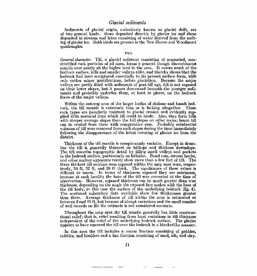
Thickness of the till mantle is conspicuously variable. Except in drumlins the till is generally thinnest on hilltops and thickens downslope. The till smooths topographic detail by filling small valleys and pockets in the bedrock surface, particularly on hillsides. Road cuts, stream banks, and other surface exposures rarely show more than a few feet of till. The three thickest till sections seen exposed within the map area were, respectively, 34 ft, 32 ft, and 20 ft thick. The significance of these values is difficult to assess. In terms of thickness exposed they are minimum, because at each locality the base of the till was concealed at the time of observation. However, exposed thickness can be much greater than true thickness, depending on the angle the exposed face makes with the base of the till body, in this case the surface of the underlying bedrock (fig. 4). The scattered subsurface data available show few thicknesses greater than these. Average thickness of till within the area is estimated at between 8 and 15 ft, but because of abrupt variations and the small number of well records on file the estimate is not considered accurate.
Throughout the map area the till mantle generally has little constructional relief; that is, relief resulting from local variations in till thickness independent of the relief of the underlying bedrock surface. The glacier appears to have smeared the till over the bedrock in a blanketlike manner.
In this area the till includes a coarse fraction consisting of pebbles, cobbles, and boulders and a fine fraction consisting of sand, silt, and clay.
11
-------------------

As is general throughout much of Connecticut, the coarse fraction is conspicuous in surface exposures, but when measured is found in most samples not to exceed 20 percent of the total. In some samples it hardly exceeds 10 percent. Within the fine fraction sand and silt are abundant; hence the till is commonly rather friable.
thickness
True thickness
Fig. 4. Ideal section showing that exposed thickness of till on a hill slope can greatly exceed true thickness.
Although in places strongly cemented, the Triassic sandstones exposed within the map area are rather commonly poorly cemented and crumbly, tending to yield to weathering by disaggregation of their component grains. Apparently they can yield to glacial abrasion in a similar manner, as shown by a crumbly surface of sandstone, overlain by fresh, unweathered till, in a temporary power-line trench dug in July 1959 at the northwestern corner of the Hamden Plaza shopping center, about 1,500 ft north of the Hamden High School.
The pebbles, cobbles, and boulders are generally somewhat subangular in shape, reflecting the positions of joints and stratification surfaces in the bedrock from which they were derived. Most of them show some degree of smoothing by abrasion during glacial transport. Corners and edges between facets are rounded, and the surfaces of a few (generally not more than 5 percent) are marked with glacial striations. A very few are well rounded; probably these had been transported in water before being last picked up by the glacier. The sand-sized particles are mainly very angular, implying crushing during glacial transport.
In some exposures the shapt>s of many particles in the coarse fraction (nearly 50 percent in one extreme case) are ragged fracture surfaces with little or no evidence of modification by glacial abrasion. These fragments may have been torn from bedrock by the glacier and transported without coming into frequent contact with other pieces of rock, or may have resulted from crushing while in glacial transport.
12

In composition the till resembles the bedrock that immediately underlies it or that occurs within a short distance upstream. The Triassic sandstones in the New Haven district generally range in color from moderate reddish brown to pale reddish brown (lOR 4/6 to lOR 5/4)1. In some exposures till immediately above exposed bedrock approximates the color of the bedrock itself. Upward and away from the bedrock it grades from reddish brown to brown, most commonly moderate brown (5YR 3/4), or to a paler and lighter color value (5YR 5/6). Close to the large bodies of diabase and basalt the color of till becomes more dusky, approximating grayish brown (5YR 3/2), because there the reddish sedimentary rocks in the till are diluted with a larger proportion of dark-colored igneous rocks. In the western area of metamorphic rocks, which are predominantly chloritic, the till has a greenish or yellowish hue, generally light olive gray (5Y 5/2) or dusky yellow (5Y 6/4), weathering to dark yellowish orange (lOYR 6/6). In the southeastern area of granitic rocks the till approaches yellowish gray (5Y 7 /2), closely reflecting the hue of the bedrock.
Because of these differences the character of the till changes with change in the bedrock, although with some lag. Thus, with increasing distance westward from the contact between Triassic sandstone and metamorphics, metamorphic elements in the till increase at the expense of Triassic elements. At the western edge of the quadrangle, 0.3 mi. west of Marsh Hill, analysis of the coarse fraction of a till exposure 150 ft long showed that local metamorphic rocks constitute nearly 70 percent of the coarse fraction, whereas Triassic rocks comprise only 23 percent. If it is assumed that the till was deposited by the glacier movement represented by the SWtrending group of striations, then the locality is 2. 7 mi. southwest of the western limit of Triassic rocks in the upstream direction during that movement.
Although in the Triassic rock area some of the cobbles and boulders in the till consist of sandstone, the large fragments are more commonly diabase or basalt, despite the fact that rocks of the latter sorts occupy a far smaller aggregate area within the map limits than do sandstones. The anomaly results from the fact that the diabase and basalt bodies are cut by joints that transect them in various directions, and in some places these joints are widely spaced. This permitted the invading glacier to tear away large chunks of these rocks, which resisted crushing in transport and were incorporated almost intact into the till. In contrast, the sandstones, being more friable, were more readily crushed and disaggregated, despite the presence of well-developed joints in some of them.
Although till is not stratified, in a number of places within the area it possesses a distinct fissility consisting of closely spaced, subparallel partings that also are approximately parallel with the ground surface. The origin of this structure is not understood; it may have originated in two or more quite different ways.
1 Colors are described according to the Munsell rock-color system (Goddard, 1948). All colors given are those of dry material.
13

In general, till is likely to possess a distinct fabric created by nearparallelism of the long axes of the component cobbles and pebbles. A statistically significant proportion of the stones lie with their long axes paralleling the direction of flow of the glacier inferred from striations and other directional indicators. Three fabric measurements were made during study of the till in the New Haven and Woodmont quadrangles; their locations are shown on plate 1 and in figure 3. All three show SW orientations, in general agreement with the group of striations whose average trend is S 40° W. A reasonable inference is that at the three localities measured the till was deposited by the SW-moving ice recorded by those striations, rather than by the S-flowing ice recorded by the other set of striations.
Stratigraphy and correlation. In the Mount Carmel quadrangle, adjacent to the New Haven quadrangle on the north, two distinct till sheets (Lake Chamberlain Till and Hamden Till) have been identified (Flint, 1962, p. 9). These tills, and striations related to them, record glacial flow in a direction nearly_ due S, followed later by flow toward the SW. In the New Haven and Woodmont quadrangles the measured fabrics indicate SW movement and the composition of the till at various points is compatible with glacier flow toward the SW. At no place was a basis found for relating the till exposed to more than a single body. That body is believed to be equivalent to the Hamden Till described in the Mount Carmel quadrangle. A similar situation exists in the Branford quadrangle, adjacent on the east to the New Haven and Woodmont quadrangles, where all the till examined is believed to correlate with the Hamden Till (Flint, 1963b, p. 13). If, as seems likely, the Lake Chamberlain Till is present in the New Haven and Woodmont quadrangles, probably it is buried in one or more of the deeper valleys and has not yet been uncovered by natural erosion or artificial excavation.
If the S-flowing ice, to which the Lake Chamberlain Till is related, was responsible for the drumlins, as suggested in a foregoing section, then it is likely that the Hamden till is younger than the drumlins. If a deep cut in one of the drumlins existed, this possibility could be tested by measuring the fabric of the till there; unfortunately, however, no such exposure exists at present.
ERRATIC BOULDERS
Erratic boulders, consisting of rock that differs from the bedrock underlying them, are abundant in the area. Some lie free on the surface whereas others are partly imbedded in till. Many of these boulders reach 4 to 6 ft in longest diameter, but only those with diameters of 10 ft or more were recorded (pl. l; fig. 3). Those recorded number 26, of which 18 are diabase or basalt, 4 are Prospect Gneiss, one is Milford Chlorite Schist, one is Triassic sandstone and two were not identified. The largest boulder, nearly 50 ft in diameter, is beside the Naugatuck Trail 0.3 mi. north of the Wilbur Cross Parkway overpass at Fountain Street, New Haven.
The chief factor determining the maximum diameter of a boulder is the spacing of joints and stratification surfaces in the parent bedrock. It is noteworthy that of the 26 large boulders recorded, 24 (more than 90 percent) consist of diabase (or basalt) or Prospect Gneiss. These rocks
14

are massive, and their joints commonly are widely spaced. The Triassic sandstone and the Milford Chlorite Schist are generally more closely jointed, and also possess surfaces of either stratification or foliation along which the rock can break.
The Prospect Gneiss is not exposed within the New Haven and Woodmont quadrangles, but crops out to the north, extending no farther east than the longitude of New Haven. The four large boulders (plus many smaller ones) observed in the New Haven-Woodmont area are confined to the part of the area due south of the Prospect Gneiss outcrop. Therefore the Prospect Gneiss erratics are attributed to the north-south glacial movement shown on the rose diagram in figure 3.
Fourteen of the 18 large diabase/basalt boulders are concentrated within a small area west of West River and north of the Townships of West Haven and Orange. These boulders are very similar to the rocks that constitute the West Rock Ridge diabase sheet, the East Rock body of diabase and basalt, and the rock body that constitutes the Hanging Hills in Meriden, 18 mi. northeast of New Haven. Probably most or all of the 26 large boulders came from those sources. No rocks like these (apart from much-jointed dikes unlikely to have yielded large boulders) crop out north of the area of concentration of the boulders. Therefore it is unlikely that any of the 14 boulders is attributable to the north-to-south glacial movement. On the other hand, the positions of the boulders are compatible with the hypothesis that the erratics were carried from West Rock Ridge to their present locations by the SW movement shown by striations (fig. 3). Indeed the absence of such boulders from the zone between the Maltby Lakes and the shore at West Haven is expectable on this hypothesis, inasmuch as the southern termination of West Rock Ridge is in a direction N 30° E from the southern end of the area of boulder concentration. Of the four boulders outside the area of concentration, one is at Judges Cave on the top of West Rock Ridge, and could have been derived from the ridge itself. Two are on the beach near Merwin Point and West Shore, respectively, and could have been carried from West Rock Ridge by the N-S movement or, more likely, from East Rock by the SW movement. The fourth, lying on the east side of New Haven Harbor, also could have been carried from East Rock by the N-S movement.
The one sandstone boulder, lying west of Konolds Pond, could only have come from east or northeast and is attributed to the SW movement. The single boulder of Milford Chlorite Schist is probably of local origin and therefore not significant.
The concentration of erratic boulders in the area west of West River is significant in another way. Those boulders lie along the eastern edge of the plateaulike Western Highland and along the scarp, sloping Eat about 1,400 ft per mi., that leads from the highland to the valley floor of West River. They appear to have been cleated out of the flowing glacier as it moved SW obliquely across the scarp, as was recognized long ago by Dana (1883-84, p. 348). Similar cleating, by the eastern slope of West Rock Ridge, is evident in the Mount Carmel quadrangle adjacent to the north (Flint, 1962, p. 12). The significance of the boulder concentration is enhanced by the fact that the number of similar boulders less than 10 ft in diameter, occurring within the area of concentration, is much greater than the number of individuals more than 10 ft across. .
15

STRATIFJ1ED DRijFT
Kinds of stratified drift. The sorted sediments, mostly stratified, deposited in streams of water derived from melting glaciers and in other water bodies as well, are collectively known as stratified drift. This material is merely reworked and redeposited till. In the New Haven and Woodmont quadrangles stratified drift is of three kinds. One consists of lake-bottom sediments, mostly fine grained, deposited during deglaciation on the floor of a temporary glacial lake in the Quinnipiac Valley.
The two other types of stratified drift in the area constitute two facies, each an end member of a gradational series. One facies is the drift deposited in contact with melting ice near the glacier margin. The other end member is the drift deposited by streams flowing away from the glacier, miles or tens of miles from the glacier in which it originated. The sediments of both facies are much the same, although, like all stream-deposited sediments, they become finer grained and otherwise better sorted in the downstream direction. But as long as ice, residual from the glacier, is present beside or beneath the accumulating stratified drift, that drift will have characteristics that betray its peculiar place of deposition, and constitutes a facies labeled ice-contact stratified drift. Downstream from the point where the meltwater stream has passed over the last identifiable remnant of buried ice, the sediment will have different characteristics and constitutes a facies labeled outwash, although it is essentially the same body of sediment.
We define ice-contact stratified drift, then, as sediments deposited in streams and other bodies of water against, upon, beneath, or otherwise in immediate contact with melting glacier ice. Such sediments include sand, gravel, silt, and clay, and commonly possess one or more of these characteristics: great internal variability; poor sorting; large and abrupt changes in grain size both vertically and horizontally; inclusion of small bodies of till, erratic boulders, or flowtill (a till-like sediment deposited by landsliding off adjacent ice); deformation of sedimentary laminae by subsidence or other displacement activated by melting of underlying or adjacent glacier ice.
Rounding of individual particles, although highly variable, is commonly slight or only partial. In addition, ice-contact stratified drift has, in places at least, constructional topography that inclucles basins (known as kettles), partial basins, and knoll-like mounds. These features reflect the presence of irregular bodies of melting ice during accumulation of the drift.
In contrast, outwash is defined as stratified drift deposited by streams beyond the glacier and free of any influence of buried ice. It is characterized by lenticular beds each consisting of parallel laminae dipping downstream. Range of grain size is relatively small (most outwash consists of sand and pebble sizes), and stratification is more regular and systematic than in ice-contact sediments.
In the New Haven and Woodmont quadrangles are bodies of stratified drift that consist of one or more of the kinds described. They are discussed, as physical units, in the following sections. Figure 5 shows the extent of each unit and figure 6 the long profiles of the principal one. Two of the
16

drift bodies, being elongate and confined to specific valleys, are referred to as valley trains, notwithstanding the fact that the literature commonly applies this term to bodies of drift said to consist exclusively of outwash.
(Ice-contact facies)
New Haven valley train
(Outwash facies)
Oyster River valley train
\ t"····-·
.'
........ /·····
.......
..... /
JSLAND SOUND
.... i :;,'. .... {"•' '\ ..... , .. , ~ ........ / ....... · ................ .
I mile
Fig. 5. Sketch map of the New Haven and Woodmont quadrangles showing the principal bodies of stratified drift, restored to their inferred approximate extent before dissection or burial. Thick arrows indicate generalized directions of flow of former meltwater streams. (Quinnipiac Valley outwash body, which is of later date, is omitted for clarity.)
New Haven valley train: ice-contact facies. The New Haven valley train is a body of stratified sand and gravel, of variable width and thickness, that occupies the valleys of West River and Mill River and slopes continuously southward through the city of New Haven and along both
17

sides of New Haven Harbor. Most of its upper surface, with average slope through the New Haven quadrangle of 9.4 ft per mi., is original; that is, it has been neither truncated by river activity nor buried beneath a thick sedimentary cover. In this respect it differs from the principal sediments in the adjacent Quinnipiac Valley.
The New Haven valley train was built by streams of meltwater that flowed S, away from the wasting glacier, into a large valley that is today submerged to form Long Island Sound. As shown in figure 5, the valley train consists of an ice-contact facies (mapped in pl. 1 as ice-contact straiified drift) and an outwash facies (mapped as New Haven outwash sediments). In figure 5 the two facies are separated by a broken line, interrupted by two "islands" of till-covered bedrock. Although the facies grade into each other, the position of the line that separates them on the map was drawn at the southern limit of topographic and/or internal evidence of the immediate presence of residual glacier ice during deposition of the valley train.
As seen on a map, the ice-contact facies has two prongs of unequal size. The shorter and narrower prong extends N up the valley of West River as far as the Lake Dawson Reservoir, where it ends. From the reservoir N, glacier ice was evidently continuous throughout the time of accumulation of the valley train. Southward the ice was so thin and discontinuous that it was buried, partly or wholly, beneath the gravel and sand of the valley train. Its subsequent melting resulted in subsidence and collapse of the sediments along the axis of West River valley, leaving irregular terracelike masses of sediment along the valley sides.
A large gravel pit immediately northeast of Konolds Pond exposes a 20-ft section typical of this prong of the ice-contact facies. Sand constitutes about 75 percent of the sediment, pebbles and cobbles about 18 percent, and boulders about 7 percent. About half of the pebbles, cobbles, and boulders consist of Triassic sandstone and diabase; the other half are metamorphic and igneous rocks mainly or wholly from the Western Highland. This dual composition reflects the fact that the West River approximates the contact between Triassic and pre-Triassic rocks (fig. 3), with the result that contributions of sediment could be received from botli sources. The color of the sediment as a whole is moderate brown to light brown, closely approaching the color of sediments derived wholly from Triassic rocks. This reflects the strong influence of dispersed, finely divided particles of hematite, responsible for the brown color of the Triassic sediments. In the pit exposure, changes in grain size are abrupt, local deformation of layers and angular unconformities are present, and style of stratification lacks uniformity. The upper surface of the terracelike form into which the pit is cut is undulatory, with relief of 15 ft or more. Southward down the valley, grain size decreases but the proportion of gravel to sand remains about the same. In many exposures, the sediment is cross stratified, with foreset layers dipping generally S, recording S flow of the streams that deposited the stratified drift.
The longer and wider prong of the ice-contact facies of the New Haven valley train extends N up the valley of Mill River and continues N, as the higher of two terraces (Flint, 1962, fig. 3), as far as Mount Carmel 3 mi. north of the northern limit of the New Haven quadrangle. Th~
18

proportion of gravel to sand and the average diameter of the pebbles, cobbles, and boulders are less than in the West River prong, the degree of rounding of stones is greater, and the proportion of materials derived from Triassic rocks is far greater, exceeding 90 percent. These differences reflect the fact that the Mill River watershed is considerably larger than that of West River, has gentler average slopes, and drains Triassic rocks exclusively.
Ice-contact features are developed more widely than in West River valley. The two arms of Lake Whitney occupy chains of kettles. The western chain extends southward beyond the Winchester School, although a number of kettles that were present as recently as about 1880 (Dana, 1883-84, pl. 2) have been destroyed by filling, notably in large areas mapped as artificial fill. Farther west, Beaver Ponds Park occupies a large kettle, and smaller ones, some of which have been recently destroyed, occur between Beaver Ponds Park and Pine Rock. Collapse structures and other features indicating the presence of residual ice are common in exposures, and have been ohs()rved as far south as the vicinity of the Beecher School. ·
In the Mill River prong as in the West River prong many exposures show cross stratification, with foreset laminae dipping generally S. The arrows in figure 5 are based chiefly on these observed dips. An exception is the exposure in the Farnham sand-and-gravel pit immediately northwest of Pine Rock. There foreset laminae dip NE and grain sizes diminish in the same direction. The percentage of non-Triassic rocks is higher than elsewhere in the Mill River prong, and increases SW around the southern end of West Rock. Here the West River prong merges with the Mill River prong. Streams of meltwater from West River valley flowed around the end of West Rock and deposited sediment, chiefly sand, in a low area northwest of Pine Rock. At the same time the northeastern part of the low area was being filled with sediments brought by the meltwater stream in Mill River valley. The same waters built sediments NW into the two re-entrants that lie, respectively, south and southwest of the Dunbar Hill School in Hamden, as shown by the arrows in figure 5.
New Haven valley train: outwash f acies. The outwash facies of the New Haven· valley train lies immediately south of the ice-contact facies, and is continuous with it. The boundary between the two facies is drawn at the southern limit of evidence of the presence of residual ice during deposition. The restored valley train is shown in figures 5 and 6. In the outwash facies sand predominates even more strongly over gravel, and within the gravel, particles larger than pebbles are rare. Pebbles are not scattered through the sand but are commonly concentrated in distinct layers, overlain and underlain by layers of sand. The gravel layers are believed to represent deposits made in restricted channels during times of greater discharge than usual. The sediment includes extremely little silt and clay, indicating that these fines remained in suspension and were thus carried past the New Haven area.
Stratification is rather systematically of the cut-and-fill type, consisting of lenticular courses, a few inches to more than 1 ft thick, of foreset laminae. Although, in one exposure or another, foreset dips in all directions, including N, have been observed, the predominant direction is S, consistent both
19

with the slope of the upper surface of the valley train and with a general decrease in avera0e 0rain size toward the south. This S direction of flow (fig. 5), reconstructed from predominant directions of foresets and surface slope, shows a deviation immediately south of Snake Rock. Here the meltwater streams, at least at times, flowed E and locally even NE, around the end of Snake Rock into the Quinnipiac Valley, much as they did around the south end of West Rock. The local surface of the outwash body, however, does not reflect this stream flow in that it does not slope uniformly E and NE, but is gently irregular. The reason for the irregularity is not known with certainty. In the southeastern sector of the Fair Haven "peninsula" of outwash, extending more than 1 mi. S from Snake Rock, bedrock lies immediately beneath the surface, and continues beneath Quinnipiac River between the Grand A venue and Ferry Street bridges. Thinly covered with till, it also underlies the hills east of the river. Beneath the central and western parts of the peninsula, however, the bedrock surface lies more than 100 ft, and may lie more than 250 ft, below sea level. The peninsula is thought to mask a former bedrock valley of the Quinnipiac River, trending SW in continuation of the river's course northeast of Snake Rock. Deposition of the outwash sediments apparently pushed the Quinnipiac drainage out of the valley that is now buried, and forced it to detour in a wide arc around the periphery of the outwash mass, rejoining its former valley farther south. The relation of these events to deposits in the Quinnipiac Valley proper is discussed in the section on Quinnipiac Valley outwash sediments.
In the few localities where excavations or bore holes have encountered the base of the outwash facies, the sediments generally overlie bedrock without an intervening layer of till. Thickness of the outwash sediments is extremely variable. Inasmuch as the upper surface of the sedimentary body is rather uniform, the implication is that the sediment overlies a bedrock surface that is quite irregular. In many places the outwashbedrock contact is more than 100 ft below sea level, and at a point about 1,000 ft east of the Dante School in New Haven, the contact lies more than 280 ft below sea level. The occurrence of stream-deposited sediments down to so great a depth is the result, entirely or in large part, of deposition during a glacial age. At such times the sea level was much lower than it is today because of the wholesale transfer of water substance to the lands to build the great ice sheets.
Along the western side of Mill River from the southern end of Lake Whitney nearly to the Yale Medical School, an indistinct, E-facing scarp follows a line between Whitney A venue and Orange Street and continues through the center of the New Haven Green. The scarp, 15 to 20 ft high but inconspicuous owing to grading of streets and building lots, separates the high surface of the New Haven valley train (labeled High terrace in fig. 6) from a low terrace also underlain by valley-train sand and gravel and cut by a few faint, shallow channels. An eastern counterpart, a SWfacing scarp with a maximum height of about 12 ft, crosses the Fair Haven peninsula between the Mill and Quinnipiac Rivers, separating counterpart terraces.
The terrace between the two scarps and Mill River is labeled Low terrace in figure 6. It is believed to continue N nearly to the head of Mill River
20

near the northern end of the Mount Carmel quadrangle (Flint, 1962, pl. 1, fig. 3, p. 15). North of the south end of Lake Whitney the sediment underlying the low terrace is the ice-contact facies, much collapsed and pitted with kettles. Furthermore the low terrace south of Lake Whitney lacks the veneer of terrace alluvium and the meander channels that indicate the work of postglacial streams in other valleys. Hence we conclude that the low terrace and its limiting scarps represent a broad shallow cut made by the glacier-fed Mill River while buried ice was still abundant beneath the surface of the valley train immediately to the north. As no comparable cut exists between Mill River ancl West River, it is evident that at this late period meltwater from the north discharged exclusively along the present route of Mill River, and had ceased to deposit sand and gravel over the broad area farther west. The load of secliment in transit must have diminished to permit the meltwater to erode its former deposits. This change could have resulted in part from deposition of sediment farther upstream, in pockets continually created by the melting out of extensive bodies of buried ice.
Farm River valley outwash sediments. In the extreme southeastern part of the map (pl. 1) is the lower end of a valley train, about 13 mi. in overall length, extending back through the Branford quadrangle into the Wallingford quadrangle (Flint, 1963b, p. 15). It occupies the valley of Farm River as far downstream as East Haven center, where it widens to a fanlike form and enters the New Haven quadrangle. There it trends SW through the airport area, its principal part entering Long Island Sound at Morris Cove. The Farm River valley train consists of an ice-contact facies from its head to as far downstream as Foxon, beyond which point it consists of an outwash facies, the only facies represented in the New HavenWoodmont area.
The sediment is almost entirely sand, with rare small, well-rounded pebbles in some exposures. Its color is moderate brown (5YR 4/4), and like that of the Mill River prong of the New Haven valley train, its composition resembles closely that of the Triassic rocks. This is expectable, as the Farm River watershed lies wholly within the area of Triassic outcrop. Stratification consists of thin beds of cut-and-fill type, each with foreset laminae dipping generally SW and S.
The thickness of the outwash body is unknown but is probably considerable. The upper surface is a plain with local relief of less than 10 ft, sloping SW from about 20 ft near the East Haven High School to about 14 ft at Morris Cove. Its only distinctive features are two discontinuous parallel depressions, broad and no more than 5 ft deep, trending SW, parallel with the long axis of the valley train. Probably these are ancient channels of the Farm River meltwater stream, dating from the end of the period of upbuilding of the outwash sediments. Today the plain proper remains undissected by postglacial streams. However, the areas of swamp west, south, and east of the airport represent postglacial valleys cut int0 the outwash body and subsequently converted to swamps as the rising sea level approached its present position. The swamp north of East Haven, around Turnpike Interchange 51, was created when the upgrowing sand body of the vallE>y train permanently blocked small, S-draining valleys.
21

The Farm River valley train was tributary to and merged with the New Haven valley train west of Morris Cove. The downstream ends of the two bodies that remain above sea level are alike in grain size, stratification, surface form, and altitude (if the New Haven body is projected S to Morris Cove). Also the sea floor off Morris Cove is underlain, beneath a thin veneer of estuarine mud, by similar outwash sand. Furthermore, the change from outwash to ice-contact facies is at the same latitude in each of the two valley trains, as one would expect if the two bodies are approximately contemporaneous. Oyster River valley train. A small body of outwash sediment occupies part of the valley of Oyster River (fig. 5) in West Haven, Orange, and Milford. Although the larger part of it lies west of the New HavenWoodmont map area, the body can be conveniently referred to as the Oyster River valley train, because that river drains its eastern periphery. This valley train consists only of sand and pebbles with indistinct stratification, in part cross stratified. It possesses no ice-contact characteristics and is interpreted as outwash sediment. In color the sand is dusky yellow (SY 6/4) and contains particles of the local chlorite-schist bedrock. Where exposed it is less than 10 ft thick, overlying an irregular surface of bedrock. The valley train constitutes a pair of terraces 15 to 20 ft above Oyster River. It has been dissected extensively. Apparently it was built by meltwater draining away from glacier ice that lay about 1 mi. northwest of Oyster River, outside the limits of the quadrangles. Lake-bottom sediments. A considerable area of the Quinnipiac Valley floor in the northeastern corner of the map area and in adjacent parts of the Branford, Mount Carmel, and Wallingford quadrangles, is underlain by a distinctive body of silt and clay, the New Haven Clay (Flint, 1933, p. 968). In the map area, however, these sediments are covered extensively by overlying deposits and are exposed in only two small areas of artificial excavation. One is the abandoned pit of the Shares Brick Company, 1,700 ft north of the State Street School in Hamden. The other is the south pit of the Stiles Corporation 0.7 mi. south of the intersection of Sackett Point Road with State Street in North Haven.
The New Haven Clay consists, in order of decreasing abundance, of silt, clay, and fine sand; in general its color is moderate brown (5YR 3/4), indicative of derivation from Triassic rocks. The sediment is stratified in parallel layers a fraction of an inch to 2 in. in thickness. Many of the layers are couplets consisting of a silt layer grading up into a thinner clay layer. The couplet is then abruptly overlain by the silt layer of the next couplet. A sequence of such couplets implies deposition by a rhythmic or at least frequently repeated natural process. It has been inferred (Antevs, 1922, p. 1) that the couplets are rhythmic and that the period of the rhythm is one year. The sediments are held to have been deposited in a glacial lake by meltwater flowing from a glacier at the northern end of the lake. The silt fraction was deposited during the spring and summer thaw; the clay fraction was kept in suspension until the lake froze over in the autumn and wave agitation ceased; then it settled out on to the bottom, ready to be covered by silt during the ensuing spring thaw. The New Haven Clay shows little evidence of deformation by ice, either as glaciers or as bergs, but a few erratic pebbles and cobbles found imbedded in it were probably dumped from floating ice.
22

There is no question that the sediments accumulated in a lake fed in part by meltwater, but whether glacier ice was in contact with the lake throughout its existence is not known. More likely, during the later history of the lake, meltwater entered the lake via proglacial streams. At any rate, the presence of the bulky Muddy River delta shows that a sizeable side stream helped to feed the lake after glacier ice had melted away from the immediate vicinity.
The thickness of the New Haven Clay within the New Haven quadrangle is not known, for its base has never been reported. Thicknesses as great as 17 ft have been observed in the past (Antevs, 1928, p. 184) but the total thickness is probably much greater. A minimum thickness of 15 ft was measured in 1960 at the Stiles pit. Borings made in the adjacent Branford quadrangle showed thickness varying between 80 and 100 ft, with increasing proportion of silt and fine sand toward the base, which directly overlies bedrock.
In the Branford quadrangle the New Haven Clay grades laterally E through a facies of silt and fine sand into the coarEer sand of a bulky delta, the Muddy River delta (Flint, 1963b, p. 19), and probably grades N into similar sediments farther up the Quinnipiac Valley in the Wallingford quadrangle. In the Stiles pit exposure existing in 1960, the New Haven Clay was observed to grade upward into silt and sand in rhythmically layered beds several inches thick, at an altitude of at least 10 ft below sea level. A comparable gradation, at about the same altitude, was seen in 1960 at the abandoned Shares pit mentioned previously. Probably these gradational sediments are not far below the local position of the former final lake bottom.
If the sedimentary couplets are truly varves, then the lake must have endured at least 364 years, as can be inferred by counting exposed couplets (Antevs, 1928, p. 184), plus an unknown and probably much greater time represented in the thickness of underlying clay that has never been either exposed or core sampled.
Fossil leaves of tundra plants have been found in the upper part of the New Haven Clay at the Stiles pit (Christopher Durden, unpublished), indicating that an arctic climate prevailed in the area at the time the lake existed.
The extent of the New Haven Clay, determined from exposures and borings, is shown in figure 5 as lake-bottom sediments. The clay body ends southward a few hundred feet north of the southernmost railroad bridge across the Quinnipiac River. South of its end, borings show only reddish sand and pebbles similar to the sediment of the New Haven valley train exposed south of Snake Rock. The sand and pebbles are probably a part of that valley train.
Although the origin of the lake basin in which the New Haven Clay was deposited is not established with certainty, it is likely that the building of the New Haven outwash body into and across the deep bedrock valley of the Quinnipiac River, mentioned earlier, created a dam which converted that valley into a basin. The basin would have held a lake, whose level would have risen with the rising surface of the accumulating outwash body, the overflow from the lake following around the eastern periphery
23

of the outwash to join the outwash-building streams over the site of New Haven Harbor.
Quinnipiac Valley outwash sediments. In at least eight localities within the map area there has been ~een exposed a distinctive, yellowish, micarich sand, in some places with small pebbles or with silt, here referred to as the Quinnipiac Valley outwash sediments. Although this material may be in part secondary, in the main it consists of remnants of a onceextensive body of outwash sediments, the Quinnipiac valley train, that subsequently was nearly destroyed by erosion. It occurs more widely in the Branford quadrangle and very extensively in the Wallingford quadrangle. It overlies, always with erosional unconformity, till, icecontact stratified drift, sediments of the Muddy River delta, and New Haven Clay; it underlies terrace alluvium. These sediments lack the hematite that is chiefly responsible for giving the other surficial sediments in the valley a reddish color; they are characteristically yellowish gray (5Y 7 /2). In places, where mixed with reworked local reddish sediments, they are reddish gray (lOYR 5/4 to 7R 4/2), or are interstratified with red sediments of almost purely Triassic origin. These sediments contain a mineral assemblage different from that of the Triassic rocks but characteristic of the rocks exposed in the drainage basins of the Pequabuck and Farmington Rivers in the Western Highland (P. D. Krynine, 1937). The sedimentary body is nearly continuous up the Quinnipiac Valley to about 30 mi. north of the New Haven quadrangle, where the Farmington River enters the Central Lowland.
The Quinnipiac Valley outwash sediments have cut-and-fill stratification and other fluvial cross lamination. They were built up by a braided proglacial stream, as a valley train resembling the outwash facies of the New Haven valley train, but much longer. In places near the valley margin its sediments are unusually fine grained and nearly parallel laminated, suggesting local shallow ponds along the margins of the accumulating stream-laid sediment. Apart from these places there is no evidence in the stratification of the outwash that the sediment was built into a lake. On the contrary, remnants of the Muddy River delta formerly exposed along Sackett Point Road are trenched by stream channels filled with the outwash. On this evidence it is concluded that the lake now represented by the New Haven Clay had ceased to exist before deposition of the outwash sediments began.
The base of the outwash body has been seen exposed (on Sackett Point Road) at altitudes as low as 8 ft below mean sea level, implying that at the time of deposition the sea here stood lower with respect to the land than it does today. At points on the Branford quadrangle, also on Sackett Point Road, the outwash base is at around 20 ft above mean sea level. Hence we can say that the outwash overlies an irregular surface. The original top of the body has not been identified with certainty in the New Haven and Woodmont quadrangles, but exposures have been seen at altitudes as high as 30 ft, both along the railroad south of Snake Rock and in the Kenny Drive-Emily Road vicinity at the eastern edge of the map area due east of BM 12 on a Quinnipiac River bridge. An exposed thickness of 32 ft was measured at one place in the Wallingford quadrangle (Porter, 1960, p. 20). The original thickness in the New Haven quadrangle was probably not much greater than that.
24

An attempt to reconstruct the original surface profile of the outwash body, at the time when deposition had built it up to its maximum thickness and before dissection had begun to remove it, is represented in figure 7. In that figure the profile labeled Quinnipiac valley train was constrncted by connecting approximately the points marked by circles and by projecting the line thus obtained S to the Farm River valley train at Morris Cove. At that place the Quinnipiac Valley outwash body must have been no higher than the Farm River body, which it postdates, because had it been higher, yellowish sand should appear today overlying the reddish Farm River sediments. The symbols representing broad surfaces of the Quinnipiac valley train were plotted from the report on the Wallingford quadrangle (Porter, 1960, fig. 14). They are believed not to represent the maximum profile of the valley train, which is probably represented with greater accuracy by the small, thin remnants, in places protected by bedrock spurs, along the sides of the body. The profile shown in figure 7 does not, of course, depict the actual former profile, but only an approximation to it from the data gathered during the field study. The average slope of the profile through the segment plotted is 5.7 ft per mi.
At seven localities along the Quinnipiac Valley, at altitudes well above the reconstructed profile of the valley train shown in figure 7, were seen exposures of yellowish sand, microscopically and mineralogically similar to the outwash sediment, and that must have been derived from it. Four of the seven localities are in the Branford quadrangle and two of these are mentioned in a published report (Flint, 1963b, p. 25). The third lies on the New Haven-North Haven Town Line immediately north of 136 Glen Haven Road. The fourth is on the southeastern slope of Crow Hill, at the 120-ft contour, just 200 ft east of the western edge of the quadrangle.
The three remaining localities are in the New Haven quadrangle. One lies immediately east of Barnes Avenue and 1,600 ft east southeast of the New Haven incinerator plant. The sand here is secondary, in the form of small alluvial fans that postdate the opening of a sand pit prior to 1932. The body from which the fans were built has been cut away. The second locality is 200 ft due south of the preceding one, at the western end of a quarry reopened in 1963, at altitude 50 ft. The sand is well sorted, and cross laminated subparallel with the surface, which here slopes SW at 20°. The third locality is at the north side of Skiff Street, North Haven, opposite its intersection with Vineyard Road. At these seven localities the precise relation of the sediments to the valley train is not known; probably some of the occurrences represent sediments blown from the valley-train surface and redeposited by the wind. Possibly valley trains of more than one age are involvecl. The data at hand are too few to support a firm solution to the problem.
Unnamed bodies of ice-contact stratified drift. In addition to the ice-contact facies of the New Haven valley train described above, four bodies of icecontact stratified drift have been recognized within the map area. Two of these are small, much-eroded masses of sand and gravel, of primarily TriaMic lithology, which accumulated apparently as poorly developed kame terraces against steep hillsides. One body lies at the locality in Orange where the northwestern inlet of the most westerly of the Maltby
25

Lakes is intersected by a power line. The other is centered about 500 ft south of the southern end of Lake Wintergreen in Hamden.
The third body is at the intersection of the Old Hartford Turnpike in North Haven with the northern edge of the map area; most of it lies within the Mount Carmel quadrangle. It is a mass of sand and pebble gravel of Triassic lithology, built upon or against thin, decaying ice; it collapsed irregularly as the ice melted. Its maximum altitude, about 65 ft, is slightly higher than that of the present top of the Muddy River delta directly across the Quinnipiac Valley in the Branford quadrangle. Probably it accumulated during the deglaciation phase that immediste1y preceded the building of the delta.
The fourth body lies just south of the intersection of the Boston Post Road with the western edge of the map. It is a very small part of a much larger body that occupies the valley of Silver Brook on the adjacent Ansonia quadrangle.
Sand and gravel, undifferentiated. Several bodies of sand with or without gravel, all of them of Triassic lithology, are designated on the map (pl. 1) as "sand and gravel, undifferentiated," because the conditions under which they accumulated are not clearly evident. One of them straddles the boundary between the New Haven quadrangle and the northeastern part of the Woodmont quadrangle. Its nearly flat surface, 2,000 ft long and reaching about 25 ft in altitude, is underlain by sand and pebbles at least 8 ft thick. The sediment was exposed in 1962 through a north-south distance of 700 ft in excavation for houses along Maturo Drive, north of South End Road, East Haven. As neither the morphology nor the internal character of this body possesses obvious ice-contact characteristics, probably the sediment is local outwash of early date, possibly as early as the Oyster River valley train. A much smaller mass of similar sediments and probably of similar origin, at altitude about 35 ft is crossed by Silver Sands Road in East Haven.
A small mass of sand and gravel is poorly exposed at altitude 30 to 35 ft on the western side of State Street, New Haven, at the base of Snake Rock opposite Lyman Street. The mass, in which stratification is not now apparent, is a thin remnant of a larger body. It could represent an early kame terrace or an extension of the New Haven valley train around Snake Rock.
On the western slope of Crow Hill, the unlabeled high rock mass immediately southeast of Middletown Avenue, New Haven, and north of Route 80, sand occurs at an altitude of more than 100 ft. Where exposed in the adjacent Branford quadrangle it is at least 12 ft thick and appears to be water laid. It seems best explained as a deposit made in a local pond or stream along the lateral margin of a glacier lobe in the Quinnipiac Valley, at a time somewhat earlier than that represented by the New Haven valley train. South and west of Crow Hill a broad terracelike form reaching about 35 ft in altitude is underlain by sand, locally with pebble layers, identified mainly from borings. However, in 1932, 1935, and 1947 extensive exposures in what is now the site of Kenny Drive and Emily Road showed thick sand-and-gravel foreset beds of a delta with dips W and SW, the foresets truncated and overlain by Quinnipiac Valley outwash sediments.
26

The delta could represent an early deposit in the lake created when the Quinnipiac Valley was blocked by the New Haven valley train. Source of the sand and gravel could have been the drainage of Muddy River, on the Branford quadrangle, diverted southward along the eastern margin of a lobe of glacier ice still occupying the Quinnipiac Valley as far south as Crow Hill. These possibilities are conjectural only, because the data gathered are insufficient to establish a firm interpretation.
Southeast of this deltaic body, on the eastern bank of the Quinnipiac River channel opposite the foot of Lombard Street in Fair Haven, is Grannis "Island," a low, tree-covered mound standing a few feet above the tidal marsh that nearly surrounds it. Its western side, facing the river, exposes sediments which show that the "island" consists of a gently sloping mound of fairly well-rounded cobble gravel abruptly overlain by well-sorted sand that thickens downslope. The sand layer in turn is overlain abruptly by tidal-marsh peat. The gravel is unlike the New Haven valley train exposed across the river, and is interpreted as a remnant of an ice-contact accumulation constructed during deglaciation of the locality, shortly before the lake was formed in the area to the north. The overlying sand is similar to that which underlies the broad area south of Crow Hill, and is probably a part of that body. Subsequently the "island" was probably covered with New Haven outwash; then was eroded and later covered with Quinnipiac Valley outwash, which in turn was eroded, leaving the "island" to become gradually isolated by the building of peat around it.2
POSTGLACIAL SEDIMENTS
Terrace alluvium Alluvium, chiefly pebbly sand, lies as a thin veneer on the surface of a
stream terrace along the Quinnipiac River. It is therefore designated terrace alluvium. It overlies, at various places, ice-contact stratified drift, New Haven Clay, sediments of the Muddy River delta, and Quinnipiac Valley outwash sediments. Its maximum thickness rarely extends to 5 ft, although in 1932 a thickness of 9 ft was measured at North Haven, just north of the New Haven quadrangle. Where terrace alluvium overlies the New Haven Clay the surface of contact is sharply defined, but its contact with underlying sand or gravel is vague, especially in places where the alluvium is less than 3 ft thick. In this area and in adjacent quadrangles exposures of Quinnipiac Valley outwash sediments commonly show an unstratified surface zone, 2 to 4 ft thick, which grades down into stratified outwash. Very likely this surface zone is in part terrace alluvium derived from the outwash and in part wind-blown sand. The vagueness of its base can be attributed to growth of roots, burrowing organisms, freezing and thawing, wind-throwing of trees, and agricultural activity.
1 The "island" is a1so an archeologic site. At the peat-sand contact are a pre-pottery "workshop" layer or artifacts and oyster shel1s, and an overlying layer belonging to the Woodland culture, which elsewhere dates to around 3,000 years before the present (Sargent, 1952). In Woodland time, therefore, the se,a was lower relative to the land than it is today and the peat had not yet formed.
27

In all exposures seen, the texture is loose, and color normally ranges between moderate brown (5YR 4/4) and dark yellowish orange (lOYR 6/6), according to the character of the underlying sediments from which much of the terrace alluvium was derived.
The stream terrace or terraces on which the alluvium occurs is cut from the Quinnipiac Valley outwash sediments and older sediments. Along the Quinnipiac River in the Wallingford quadrangle the inner margin of the terrace alluvium follows a series of meander scarps. This implies that the erosion which formed the upper surface of the terrace and the accompanying deposition of terrace alluvium occurred after the Quinnipiac valley train had been built, and also after the regimen of the Quinnipiac River had changed from one of braiding to its present meandering habit. Probably the change marks the transition from glacial to postglacial in a broad sense; it took place when glacial meltwater ceased to enter the head of the Quinnipiac River, leaving the river dependent on local rainfall for its water supply.
A shallow channel, probably belonging to an abandoned meander, occurs in the surface of the terrace where it is traversed by Sackett Point Road.
The contact of terrace alluvium with till along the west side of the Quinnipiac Valley is difficult to trace because it is covered extensively with colluvium and alluvium and has been greatly disturbed by artificial cutting and filling related to industrial activity. The terrace alluvium shown on the map (pl. 1) may he related either to a single terrace or to two or more terraces at small vertical intervals.
If terraces exist along Mill River, West River, and sma Her streams within the map area, they lie only a few feet above valley floors and have not been distinguished from them. Hence the map shows alluvium, but not terrace alluvium, along those streams.
Alluvium and colluvium Alluvium, ranging in grain size from cobble gravel to silty sand, occurs
on valley floors and in stream channels. The coarsest alluvium is found along small streams having steep gradients; the finest along streams of gentle slope. Although most of the sediment mapped as alluvium lies at the surfaces of floodplains, which are inundated at times of high water, some may overlie very low terraces, not inundated under existing regimens.
The lithologic character of the alluvium varies with that of the local bedrock. As the sediment is very poorly exposed its thickness is not known; in most places it is probably less than 5 ft thick. At some points along the bases of steep slopes alluvium is overlain by or is interbedded with colluvium that has crept or washed down the slopes.
Alluvium in the Quinnipiac Valley presents a special problem. Although abundantly present at the surface in the Wallingford quadrangle, in the
28
- -------------------------

New Haven quadrangle it has been seen exposed only in clay pits and other artificial excavations, and at present is exposed only in the south pit of the Stiles Corporation, in Hamden, 1,700 ft south of the intersection of the Quinnipiac River and the Hamden-North Haven Town Line. All exposures seen have been at positions below mean sea level. Submergence of ·the river's mouth beneath tidewater has drowned whatever alluvium was formerly at the surface and has resulted in the building of swamp deposits over the floor of the valley. Although these deposits include alluvial silt brought to them by the river and trapped by the swamp vegetation, all such material is mapped as swamp deposits.
Like the terrace alluvium, probably not all the alluvium in the Quinnipiac Valley is related to a single profile of the river. In figure 7 the alluvium at positions below sea level does not form a profile smoothly related to that profiled on the Wallingford quadrangle, and may be somewhat younger. Sandy, pebbly alluvium underlying tidal-marsh peat has been seen by the writer at three localities along the western side of the valley and has also been reported by Davis (1913), R. W. Brown (in Flint, 1930, p. 263), and Bloom and Ellis (1963, p. 3). From all three localities logs or stumps are reported, and from one, layers of twigs, leaves, and nuts as well. Probably this debriE was brought to its present position mainly by the caving of wooded stream banks. As all this wood and plant trash is from the kinds of trees that grow in the area today, the alluvium must be postglacial rather than glacial. This age is confirmed by the radiocarbon dates of two pieces of wood from alluvium exposed in the south pit of the Stiles Corporation, at positions 15 to 18 ft below the surface of the marsh. One (Stuiver and Deevey, 1961, p. 127; no. Y-843), at the top of the alluvium, dates 3560 ± 80 years B.P. The other (Stuiver and others, 1963, p. 318;no. Y-1077), nearly 3 ft below it, dates 6810 ± 170 years B. P. At each of these times, sea level was considerably lower relative to the land than it is today.
In the layer of alluvium from which the older wood in the Stiles pit came, a piece of wood showing tooth marks of a beaver was collected (by J. P. Schafer of the U.S. Geological Survey in November 1963), showing that beavers were at work in the Quinnipiac Valley nearly 7,000 years ago.
It is not unlikely that alluvium underlies the central part of the marsh at even lower altitudes, and possibly overlies other, lower terraces now concealed beneath the marsh.
As it is very discontinuous and mostly very thin, colluvium is included on the map with alluvium, till, and bedrock, except for conspicuous bodies of sliderock, described in a separate section.
Wind-blown sediments; ventifacts A thin cover of sediment believed to have been deposited by wind is
present discontinuously over parts of the map area, mainly in the vicinity of the Quinnipiac and Mill Rivers and behind beaches along the shore. In most places it is less than 20 in. thick, and rarely exceeds 30 in. It was seen sufficiently thick to map at only one locality, in a small dune about 5 ft high, between the southeastern bank of the Quinnipiac River and the railroad yard close to the eastern edge of the map area. Larger dunes lie to the northeast, in the Branford quadrangle.
29

The wind-blown sediment is generally sand or silty sand without stratification. Its color in Mill River valle-y exposures is light brown (5YR 5/6) and in the Quinnipiac Valley dark yellowish orange (lOYR 6/6) to grayish orange (lOYR 7/4). In most exposures it is included within the modern soil profile. In valleys it overlies terrace alluvium and older sediments, but has not been seen on alluvium. Therefore it is believed to antedate the alluvium. Along and immediately shoreward of beaches, notably the Silver Sands beaches and the beach between New Haven Harbor and Cove River, nonstratified wind-blown sand is present, overlying beach sand with a vague contact. It is too thin to be shown on the map, and is no older than the beaches. Hence it is younger than the wind-blown sand in the major valleys.
The wind-blown sand in both dunes and thin mantle is believed to have accumulated mainly during the building and the beginning of dissection of the outwash valley trains. Possibly it has been added to later, at unusually dry times. The shapes and orientations of the dunes in the Branford quadrangle tell nothing significant about wind directions at the time they were built. ·
At several localities in the Quinnipiac Valley ventifacts (pebbles, cobbles, or boulders faceted or polished by the abrasive action of wind-blown sand and silt) are imbedded in the eolian sediments. Probably the abrasion took place during the general period of deposition of wind-blown sediments. Wind directions cannot be learned from the orientations of facets on the stones because the ventifacts have been moved and in some instances completely overturned, possibly by wind-throwing of trees, freezing and thawing, and similar activities.
Swamp and marsh deposits
Swamps (wooded) and marshes (p.onwooded) occur in various parts o the New Haven and Woodmont quadrangles, and have an aggregate area of more than 2 sq. mi. The deposits in them, which underlie the living vegetation, consist mainly of muck, an olive-gray to dink-gray or brownish mixture of silt, clay, and fine sand with a high percentage of comminuted decayed plant matter, and also of peat, which is nearly pure organic matter. Such deposits in the smaller swamps and marshes are seldom more than 10 to 12 ft thick; beneath the larger ones thicknesses are possibly greater. Swamps and marshes in this area are classified as to origin in table 1.
The thicker swamp deposits preserve a fossil record of changes in vegetation and climate since the time when the glacier melted away from the area. Before it was drained and partly covered with fill, the swamp in Beaver Ponds Park, occupying a kettle in the New Haven valley train, was about 1 mi. long, and the organic sediment that filled the kettle was as much as 52 ft thick near its northern end (Dana, 1883-84, p. 119; pl. 2). A core 28 ft long, bored from the peaty sediments, yielded fossil pollen from top to bottom. Analysis of the pollen from various segments of the core revealed the kinds of trees and other plants that lived in the vicinity during the period of sedimentation (Deevey, 1943, p. 726). That period probably began soon after building of the New Haven valley train ended and is believed, on evidence outside the map area, to have embraced at
30

least the last 15,000 years (Barendsen and others, 1957, p. 913). At the beginning the vegetation was undoubtedly tundra, hut the Beaver Ponds boring did not reach the base of the organic sediments and so did not record that phase. It showed, however, a general change from spruce, fir, and pine to the deciduous forest of today, with intermediate fluctuations.
Table I. Genetic classification of swamps and marshes in the map area.
Genetic origin Example Type
Large unit drained by Cove River, Basins in till between Derby Avenue and marsh
Boston Post Road
Basins created by darns of Unit at Interchange 51, marsh stratified drift Connecticut Turnpike
Kettles; basins in collapsed surfaces Unit in Beaver Ponds Park marsh
Valley floors Unit traversed by Silver Brook marsh, without definite at western margin of map swamp basins 1 area
Unit occupying much of Tidal rnarshes2 floor of Quinnipiac marsh
Valley
1 Such units reflect conditions in which drainage is impeded by variations in permeability of the floor material, including plant matter.
' Detailed in accompanying text.
Tidal marshes constitute a special category among the swamps within the New Haven area. They do not occupy basins hut lie at and upstream from the mouths of streams, and hence are open to the sea. They have resulted from submergence or "drowning" of the lower parts of valleys. The tides move in and out, creating an environment for the growth of specialized plants, mostly grasses. Within the area every valley or lowland that extends to the coast is floored wholly or partly with tidal marsh. Stream channels within the marshes normally have an intricate pattern of meanders. In some marshes, however, the natural channels have been replaced by straight artificial drainage ditches and are filling with vegetation.
The vegetation of the marshes grades upstream, from grasses specialized to salt water into reeds, cattails, and bulrushes characteristic of water with low salinity. As the gradation is irregular, it is not feasible to separate true tidal marsh from freshwater marsh hy a line on the map. Conse quently all swamps and marshes within the quadrangle are indicated by a single map convention. In the Quinnipiac Valley the salt-water grasses do not occur significantly north of the latitude of East Rock (Bloom and Ellis, 1963, p. 5).
The deposits of the tidal marshes consist of muddy peat and peaty mud, and form crudely wedge-shaped bodies that thicken seaward to a maximum of as much as 17 ft. Their seaward parts are underlain generally by gray, shell-hearing estuarine mud, their landward parts generally by alluvium. In the Quinnipiac Valley extreme high tides reach as far upstream as the
31

northern edge of the New Haven quadrangle. The relations described indicate that the Connecticut coast has been unclergoing gradual submergence by rise of sea level, subsidence of the land, or both.
Sliderock
V cry locally within the area, thin bodies of sliderock form taluses. These are aprons composed of angular blocks of diabase or basalt that mantle parts of cliffs. Sliderock is mapped in two positions, along the clifflike western faces of East Rock and West Rock respectively. The individual clasts have faces that were determined by joints and fractures, and range generally up to about 10 in. in diameter. However, boulders up to more than 15 ft in length occur locally. Although a few fragments of sandstone occur, the bulk of the sliderock consists of dark-colored igneous rock.
The taluses are not uniformly smooth aprons; they form fanlike protuberances and broad re-entrants. Some parts of them appear to be stable and are developing covers of vegetation. Others are raw, nearly bare, and obviously active. The taluses along the face of East Rock have been quarried in many places; the depths of excavations suggest talus thicknesses of 6 to 8 ft.
Sliderock forms mainly by seasonal freeze and thaw of water substance in joints in the bedrock. As glaciation can be expected to have removed any pre-existing sliderock, that which is present now must have formed within postglacial time. New clasts, mostly large ones, occasionally slide or roll to the bases of taluses at the present time.
Beach sand and gravel
About 70 percent of the New Haven-Woodmont coast (exclusive of New Haven Harbor) is fringed with modern beaches consisting of sand, gravel, or both. The beaches are discontinuous, and range in individual length from less than 200 ft to 1.5 mi. Beach development is related closely to erodibility of the local materials. Where the coast consists primarily of bedrock, as in the vicinity of Lighthouse Point, the beaches are narrow, crescent-shaped bands fringing coves between pairs of rocky points. Where the coast consists of till the beaches are longer, and where stratified drift is exposed along the coast, as in the southeastern part of West Haven, beach sand is virtually continuous.
The grain size of beach sediments likewise reflects the character of the materials locally exposed to the surf. Thus Rocky Beach, which fronts a bluff of till, consists mainly of pebbles, cobbles, and boulders, whereas the beach at Morris Cove, which fronts a low bluff of sandy outwash, consists largely of sand.
East and West Silver Sands Beaches in East Haven and the beaches between Bradley Point and Sea Bluff in West Haven front only tidal marshes. Probably these beaches formed first as bars connecting small promontories, when the areas shoreward of them were shallow lagoons, before the marshes were created. A similar development is occurring today at Sandy Point, a spit being built eastward across New Haven Harbor in prolongation of the beach southwest of it.
32

The beach sediments rarely exceed a very few feet in thickne!!s. They are maintained by a Jlrecarious balance between local erosion and deposition by surf and longshore currents, and are easily altered by the building of structures on the beaches themselves or on the points between them. This fact is being taken into account increasingly in the planning of construction programs, so as to protect what has become a valuable recreational asset. Efforts to counteract local erosion of beaches and to widen them for recreational use have included importation of sand for dumping on the beaches, for example in Woodmont and in the eastern part of West Haven. The rapidity with which beaches form is illustrated by the narrow beach that fronts East Shore Park in New Haven. The beach consists entirely of reworked artificial fill, brought to the area very recently.
Although the surf has cut cliffs in both stratified drift and till, no cliffs have been cut in the bedrock exposed along the shore. Indeed, smooth glaciated surfaces of bedrock at the shoreline testify to the almost total lack of erosion of bedrock by surf. Although Forbes Bluff north of Morris Cove, an impressive cliff of dolerite, was formerly considered a surf-cut cliff (Wentworth, 1922, p. 76), it was later shown to be the work chiefly of mechanical weathering by freeze and thaw (Sharp, 1929, p. 52), limited abruptly downward by sea level.
Estuarine sediments
New Haven Harbor is floored with a layer of gray clayey silt containing marine shells and fine-grained, dark-colored organic matter. This material, characteristic generally of open estuaries along the Connecticut coast, is known from borings to reach thicknesses of at least 40 ft. The borings show also that in New Haven Harbor the estuarine mud overlies with sharp contact reddish or brown sand of the New Haven and Farm River valley trains. The mud has been deposited during the time when the sea level, rising relatively against the land, has been encroaching through the harbor area, a period inferred, from radiocarbon dates, to have embraced the last 7,000 years or more.
Artificial fill Artificial fill consists of deposits made by human activity; these include
railroad, road, and building-construction fills and large accumulations of trash. Much of the fill material mapped was obtained from areas close to the fill bodies, but some of it was brought from distant sources. The largest bodies of fill within the map area are those related to the Connecticut Turnpike, the Cedar Hill Freight Yard of the New Haven Railroad in the Quinnipiac Valley, the airport, and the fringes of the city of New Haven along the Harbor and its tributary rivers. The las~named fill body, really a series of contiguous fills made at many different times throughout a long period, was reconstructed from observations in excavations mostly related to city redevelopment activity, from records of borings, and from an 1872 map of New Haven Harbor (Bache, 1872), reproduced in part by J. D. Dana (1883-84, pl. 2). The map shows accurately the harbor shoreline and the tidal marshes as they were about 1872. The lilhoreline and marshes were plotted on a modern map; the differences between the two configurations were assumed to represent additions to dry land by
33
--------------------

filling. At a number of points the fringe area of fill could be checked by observation. Checks were furnished also by local descriptions such as the excellent one by D. P. Krynine (1948).
In densely populated areas much of the surface material underlying streets, driveways, and lawns is fill. However, fill is mapped only where it is known or judged to be at least 5 ft thick and where it is large enough in area to be shown at the scale of the map. Areas of conspicuous artificial cutting that are continuous with areas of fill are mapped as fill.
Weathering and soils
Where the contact between bedrock and overlying till is exposed, the surface of the bedrock is fresh and unweathered, just as it was left after glacial abrasion. But in places where no till was deposited or where overlying till has been stripped away by erosion, the surface of the bedrock is slightly but noticeably weathered. On rocks of all kinds it is slightly roughened. On sandstones it is slightly bleached, on granitic rocks it is oxidized yellowish, and basaltic rocks invariably are covered with a thin rind, a small fraction of an inch in thickness, of brown limonite. Along joints these weathering changes extend downward well below the surface. This is the extent of local postglacial weathering in rocks.
In glacial drift, wind-blown sediments, and terrace alluvium the most obvious effect of weathering is oxidation, which in most places is limited to a depth of 2 or 3 ft. Oxidation gives a yellowish or brownish hue to the fine-grained particles in the clrift and also forms rinds of limonite on basaltic stones. At greater depths the surfaces of basaltic stones are fresh. Within this thin zone of weathering, soils are developecl.
The New Haven-Woodmont area lies within the region of Brown Podzolic soils of northeastern United States. Brown Podzolic soils are imperfectly developed Podzols characterized, in forested areas, by a thin gray leached zone beneath a thin mat of partly decomposed organic matter. These soils, having weakly developed profiles, are normally less than 30 in. thick. Within the map area there are ten chief soil types, which, with others, are named and described in tables 2 and 3. As the quadrangle lies within a single zone of climate and vegetation, differences among its soils must result mainly from differences in parent material, relief, and drainage. Of these factors parent material is believed to be the most important.
GLACIAL AND POSTGLACIAL HISTORY
Before glaciation of the region began, the principal valleys, ridges, and hills had already been shaped by long-continued erosion and were broadly similar to those of today. Probably the surface was mantled with a thick regolith developed by weathering of the underlying rocks.
Evidence from outside the area indicates that Connecticut was overrun by a sheet of glacier ice at least twice and probably several times, during the last million years or more. The glacial features of the New Haven area, in conjunction with those of the Mount Carmel quadrangle, imply two glacial invasions rather closely related in time. In the earlier one
34

.Sl l j 0 ... 'ti .,,-t"C
.;;i ~'ti ~ :!~ .l/l 0 • "; s Ill "Cl.::: 0
.::I §::: ~ . :Si~ ~ "2.S~ae r:c: -a.$ ~-~
~ c.;i .... rlJ
..... ,..$ "' ~ ~ < il till .s ... CA U .8 i:l.E!::
..:. I - <' • ,..c1.$".S ~ .!!P "' 0 :-= l>:;i::..So!::~ ~ till ..c: -s e .s l ~ .s 'ti ... "Cl
.e~&~§ lll~,!2~!9
:::i ~ ...... ~
~ 1 ~-~ ~ • {! .... ~El§~:a
Q)-.f:l~
Table 2. Principal soils of the New Haven and Woodmont quadrangfes1
Parent material
Compact gravelly loam or fine sandy loam on till derived principally from siltstone, sandstone, and shale .
Friable to firm gravelly sandy loam or loamy sand, on till derived principally from sandstone and conglomerate •
Shallow soil over thin till and diabase or basalt residuum.
Sandy and gravelly stratified drift derived principally
Excessively Very well Well Moderately drained drained drained wel' drained
Wethersfield Ludlow
Cheshire Watchaug
Holyoke 2 Holyoke2
from Triassic rocks. ManchesterB Hartford3 Hartford3 Ellington
Poorly drained
Very poorly drained
Wilbraham Menlo
Meriden Scarboro
Compact gravelly fine sandy loam, or loam, on till derived principally from schist, gneiss, and phyllite. Paxton Woodbridge Ridgebury Whitman
Very friable to firm gravelly fine sandy loam or loamy sand, on till derived principally from schist, gneiss, and phyllite.
Shallow soils in till on schist, gneiss, and phyllite.
Stratified sandy and gravelly glacial drift derived principally from schist and gneiss. Hinckley
Hollis'
Merrimacs
1 Compiled by Arthur E. Shearin, U.S. Soil Conservation Service, Windsor, Conn. ' Placed in two drainage classes because depth to bedrock is variable. • Placed in two drainage classes because of range in texture.
Charlton Sutton Leicester
Hollis 2
Merrimacs Sudbury Walpole Scarboro

Table 3. Characteristics of selected soils in the New Haven and Woodmont quadrangles 1
Soil name Wethersfield Cheshire Holyoke Manchester
Thickness of solum (in.) 22 to 30 24 to 30 A few to 6to18 (A and B horizons) about 20
Loam to Fine Silt Gravelly silt loam sandy loam to sandy loam
sol um loam loam to loamy sand
Dominant texture Gravelly Gravelly Bedrock Sand and loam sandy loam gravel
substratum or loamy sand
Reddish Reddish Daik Yellowish brown to brown to brown to red to
solum dark red yellowish reddish reddish red brown brown
Color (dry) Yellowish Reddish Bedrock Reddish red to brown to brown
substratum red dark red-dish brown
Upland: UNiand: ua,iand: Terraces Topographic position streamline ti ri ges of
hills plains diabase and basalt
Slopes Gentle to Undulat- Gentle Undulating steep in to to toslobing;
hifiy steep local asins
Drainage Well Well Well to Excessively drained drained very well drained
drained
1 Compiled by Arthur E. Shearin, U.S. Soil Conservation Service, Windsor, Conn.
movement was almost directly S, creating a set of striations and probably shaping the drumlins in the southwestern part of the New Haven quadrangle. The ice of the later invasion flowed across the area in a SW direction, creating a second set of striations and a new layer of till. When the glacier reached its maximum extent, it is evident that the area was completely buried beneath ice, because evidence of glaciation is present on the highest hills as well as in the valleys. Because the buried bedrock floor of the Quinnipiac Valley lies more than 200 ft below sea level in the Wallingford quadrangle and more than 280 ft in the New Haven quadrangle, the glacier must have had a minimum thickness of 750 ft in this area. It may have exceeded that thickness by a wide margin. The cumulative effect of this and earlier glaciers was to smooth, round off, and generally streamline the hills and ridges and to smooth and widen some of the valleys.
In the Great Lakes region the combined evidence of layers of till and of radiocarbon dates indicates that a number of related glaciations occurred within the last 70,000 years or so and that the last major invasion cul-
36

Hartford Paxton Charlton Hollis Hinckley Merrimac
18 to 30 20 to 30 24 to 36 A few to 6 to 18 18 to 30 about 20
Sandy loam Fine Fine Fine Gravelly Sandy loam to to fine sandy sandy sandy fine sandy fine sandy sandy loam loam loam loam loam to loam
loamy sand
Sand and Gravelly Gravelly Bedrock Sand and Sand and gravel fine sandy fine sandy gravel gravel
loam loam or loamy sand
Reddish Dark Brown to Brown to Stron~ brown Stronf brown brown to yellowish yellowish yellowish to ye! owish to ye! owish yellowish brown to brown brown brown brown red olive brown
Reddish Olive brown Grayish Bedrock Yellowish Yellowish brown brown to brown brown
light olive brown
Terraces Upland: uri1and: streamline ti 1
Upland Terraces Terraces
hills plains
Nearly Gentle to Undulating Gentle Undulating Neaily level to steep to to steep to sloping; level to undulating hilly local basins undulating
Well to Well Well Well to Excessively Well to very well drained drained very well drained veqr well drained drained dramed
minated around 18,000 years ago. How the invasions of southern Connecticut are related in time to those of the Great Lakes region is not known with certainty, but it seems likely that hills began to reappear from beneath the melting ice of the last invasion somewhat before 15,000 years ago. At least throughout a wide belt near the southern margin of the glacier, melting occurred to a large extent by general thinning of the ice body.
Thickness within this belt was so reduced that the ice ceased to flow and became inert. Thinning exposed the highest hills and then progressively the lower hills, while tongues and detached masses of ice remained in the valleys. Streams of meltwater flowed between the margins of such ice bodies and the adjacent valley sides and built up high embankments of sand and gravel. In many places coverings of stratified drift completely buried residual ice masses. In this way were built up the New Haven and other valley trains, the downstream ends of which were accumulating in a zone that had become entirely ice free. The distribution of ice-contact
37
------------------------

features in the Mill River Valley suggests that the zone of separated bodies of residual ice was at least 6 mi. wide.
One wing or lobe of the New Haven valley train was built around the south end of Snake Rock, into and across the Quinnipiac Valley, creating a long narrow lake. In this the New Haven Clay accumulated, and sand likewise was built into it from the Muddy River and from the melting Quinnipiac Valley glacier, then north of the New Haven quadrangle. At that time the vegetation of the area consisted largely of dwarf willow, dwarf birch, and other tundra plants. The climate was colder and probably cloudier than that of today.
As the glacier shrank northward out of the Mill River watershed the New Haven valley train ceased to be built up. The stream that drained the Quinnipiac Valley lake could then gradually dissect the valley train to some depth below present sea level and drain the lake away, exposing the higher, sandy parts of the lake sediments to extensive erosion. A sudden change then occurred. When deglaciation of the country farther north opened a path from the Pequabuck and Farmington Rivers to the mouth of the Quinnipiac River, a stream of meltwater with braided pattern built up the large body of diEtinctive yellowish outwash sand that now remains only as remnants in the New Haven quadrangle. This Quinnipiac Valley outwash body covered a very irregular channeled surface of the underlying sediments. The altitude of the upper surface of the outwash at the close of upbuilding was higher than that of the broadest remnant now remaining within the area.
During the period of activity of meltwater streams in all parts of the New Haven-Woodmont area, sand was blown from valley floors and was spread as a very thin, discontinuous blanket over adjacent slopes. Probably this activity was brought to an end by the establishment of a continuous cover of vegetation over valley floors, first in the smaller valleys and last of all in the Quinnipiac Valley, where deposition of outwash continued long after it had ceased elsewhere. The vegetation changed from tundra to spruce forest, and was thus still quite different from that of today.
When deglaciation had progressed far enough to open a low-level path from Farmington to Tariffville in northern Connecticut, the FarmingtonPequabuck drainage was diverted to its present route via Tariffville to the Connecticut River, and the present shortened Quinnipiac River, confmed to the area of Triassic rocks, came into existence.
With the disappearance of its extraordinary glacial source of abundant sediment, the Quinnipiac River became relatively underloaded, assumed the single-channel, meandering habit it has today, and dissected its valley train. This resulted in stream terraces and a valley floor cut into icecontact stratified drift, outwash, and delta sediments, and covered with thin veneers of sandy alluvium deposited from the bed load of the river. The vegetation evolved from predominantly coniferous forest to the mixed deciduous forest characteristic of the region at present. The climate became warmer, but with fluctuations.
From its very low position at the time of maximum extent of the glacier, sea level gradually rose as meltwater returned through streams to the sea. By about 5,900 years ago the sea had risen, relative to the land, to a
38

position about 26 ft below present mean sea level, as shown by a series of radiocarbon dates on wood and peat from beneath estuarine mud at several places along the Connecticut coast (Bloom and Stuiver, 1963).
Throughout postglacial time the existing soils were forming and developing beneath the surface, under a cover of largely forest vegetation. The youngest soils are those on postglacial terraces and on alluvium bordering the streams. The accumulation of peat in swamps and the postglacial return of forests have altered the landscape appreciably, but the deforestation, cultivation, and construction of various kinds brought about by man constitute changes that are even more conspicuous.
When settlement of the New Haven Colony by European people began in the 17th Century, the entire land area of the quadrangle, with the exception of tidal marshes, some of the other swamps, and some patches of bare rock, was forest. Today about one-third of the area consists of woodland. The Podzolic character of the local soils reflects the influence of the forest cover.
ECONOMIC GEOLOGY
Sand and gravel
Although much of New Haven is underlain by sand and gravel of the New Haven valley train, there is little production of this much-needed resource because most of the area is densely settled. No large sand and gravel pits remain, although a few of medium and small size, notably in the area northeast of Konolds Pond, and of Spring Glen in Hamden, are operating at least intermittently. Most of the remainder of the sand and gravel used in the area is imported from outside the New Haven and Woodmont quadrangles.
Brick clay
The past has witnessed extensive production of silt and clay from the New Haven Clay unit for the making of brick, as is evident from a series of large, abandoned, water-filled excavations along the western side of the Quinnipiac Valley floor. In 1964 only one operation was active, that of the Stiles Corporation, 1.7 mi. northeast of Whitneyville. The New Haven Clay generally consists of more silt than clay, and the brick must be burned very thoroughly in order to be durable. Possibly the product has been competitive with imported brick of better quality only because of the high cost of transportation of the imported product.
Swamp deposits
Organic swamp deposits within the map area are potential sources of garden humus. However, as most of the swamps are small in area and probably also in thickness, it is doubtful that economic development would be feasible.
39

Ground water
Various bodies of stratified drift within the New Haven area constitute potential sources of ground water for domestic use or for small industrial plants. However, as the sand and gravel of which they consist are very permeable, the water table is generally low (25 to 40 ft below the surface in central and northern New Haven), being rather closely adjusted to tidewater or to the nearest surface streams. In consequence, the development of a reliable water supply from such material depends on thickness of the sediment in the zone below the water table. This is a matter for local investigation in each case.
Till is generally too thin and in some places too impermeable to be a source of water other than for shallow wells of low yield. Most users of water within the quadrangle prefer to derive their supplies either from surface reservoirs or from wells drilled into bedrock.
A discussion of ground water in the New Haven area will be found in a report by J. S. Brown (1928).
40

REFERENCES
Antevs, Ernst, 1922, The recession of the last ice sheet in New England: Am. Geog. Soc. Research Ser., no. 11, 120 p.
----, 1928, The last glaciation, with special reference to the ice retreat in northeastern North America: Am. Geog. Soc. Research Ser., no. 17, 292 p.
Bache, R. M., 1872, New Haven Harbor, 1872 [map] Sheet 1 in Atlas of the city and region of New Haven, Conn.: U. S. Coast Survey, New York, Julius Bien, 1879, 12 sheets.
Barendsen, G. W., Deevey, E. S., and Gralenski, L. J., 1957, Yale natural radiocarbon measurements Ill: Science, vol. 126, p. 908-919.
Bloom, A. L. and Ellis, C. W., 1963, Postglacial stratigraphy and morphology of coastal Connecticut: Guidebook, Field Trip no. 5, Geol. Soc. America, 1963 Meetings. [Manuscript].
Bloom, A. L., and Stuiver, Minze, 1963, Submergence of the Connecticut coast: Science, v., 139, p. 332-334.
Brown, J. S., 1928, Ground water in the New Haven area, Connecticut: U.S. Geol. Survey Water-Supply Paper 540, 206 p.
Dana, J. D., 1870, On the e-eology of the New Haven region, with special reference to the origin of some of its topographic features: Connecticut Acad. Arts and Sciences Trans., v. 2, p. 45-112.
----., 1871, On the Quaternary, or post-Tertiary of the New Haven region: Am. Jour. Sci., v. l, p. 1-5, 125-126.
----, 1883-84, Phenomena of the glacial and Champlain periods about the mouth of the Connecticut Valley, in the New Haven region: Am. Jour. Sci., v. 26, p. 341-361; v. 27, p. 113-130.
Davis, C. A., 1913, Peat deposit of geological interest near New Haven, Connecticut (Abs.): Geol. Soc. America Bull., v. 24, p. 700.
Deevey, E. S., 1943, Additional pollen analyses from southern New England: Am. Jour. Sci., v. 241, p. 717-752.
Flint, R. F., 1930, The glacial geology of Connecticut: Connecticut Geo!. Nat. History Survey Bull. 47, 294 p.
----, 1933, Late-Pleistocene sequence in the Connecticut Valley: Geo!. Soc. America Bull., v. 44, p. 965-988.
----., 1934, Late-glacial features of the Quinnipiac-Farmington lowland in Connecticut: Am. Jour. Sci., v. 227, p. 81-91.
----, 1961, Two tills in southern Connecticut: Geo!. Soc. America Bull., v. 72, p. 1687-1692.
----, 1962, The surficial geology of the Mount Carmel quadrangle: Connecticut Geo!. Nat. History Survey Quad. Rept. 12, 23 p.
----, 1963a, Altitude, lithology, and the Fall Zone in Connecticut: Jour. Geology, v. 71, p. 683-697.
----., 1963b, The surficial geology of the Branford quadrangle: Connecticut Geol. Nat. History Survey Quad. Rept. 14, 47 p.
41

Fritts, C. E., 1962, Age and sequence of metasedimentary and metavolcanic formations northwest of New Haven, Connecticut: U. S. Geol. Survey Prof. Paper 450, p. D32-D36.
Goddard, E. N., chairman, 1948, Rock color chart: National Research Council, Washington, D. C., 6 p. [Reprinted, 1961, Geol. Soc. America].
Krynine, D. P., 1948, History of an old New Haven landmark: Connecticut Soc. Civil Engineers Proc., v. 64, p. 73-98.
Krynine, P. D., 1937, Glacial sedimentology of the Quinnipiac-Pequahuck lowland in southern Connecticut: Am. Jour. Sci., v. 233, p. 111-139.
Porter, S. C., 1960, The surficial geology of the Wallingford quadrangle: Conneeticut Geol. Nat. History Survey Quad. Rept. 10, 42 p.
Rice, W. N ., and Gr·egory, H. E., 1906, Manual of the geology of Connecticut: Connecticut Geo!. Nat. History Survey Bull. 6, 273 p.
Sargent, H. R., 1952, Preliminary report on the excavations at Grannis Island: Archeol. Soc. Conn. Bull., no. 26, p. 30-50.
Sharp, H. S., 1929, The physical history of the Connecticut shoreline: Connecticut Geol. Nat. History Survey Bull. 46, 97 p.
Stuiver, Minze, and Deevey, E. S., 1961, Yale natural radiocarbon measurements VI: Radiocarbon, v. 3, p. 126-140.
Stuiver, Minze, Deevey, E. S., and Rouse, Irving, 1963, Yale natural radiocarbon meMurement.s VIII: Radiocarbon, v. 5, p. 318.
Ward, Freeman, 1920, The Quaternary geology of the New Haven region: Connecticut Geol. Nat. History Survey Bull. 29, 78 p.
Wentworth, C. K., 1922, The shapes of beach pebbles: U.S. Geol. Survey Prof. Paper 131, p. 75-83.
42

APPENDIX
A complete list of the publications of the State Geological and Natural History Survey of Connecticut is available from its Distribution and Exchange Agent, State Librarian, State Library, Hartford, Connecticut, 06115.
Quadrangle Report Series The quadrangle reports listed below will be sent postpaid at $1.00
each, the quadrangle map alone for 25 cents postpaid. Residents of Connecticut shall add 3,%' percent sales tax. Payment must accompany order. Make checks or money orders payable to Connecticut State Library. Quadrangle reports, and all other publications of the State Geological and Natural History Survey of Connecticut, are available wthout charge to public officials, exchange libraries, scientists, and teachers, who indicate, under their official letterhead, that these publications are required in their professional work. Established book dealers shall receive a 20 percent discount.
Orders should be sent to the Survey's Distribution and Exchange Agent, State Librarian, State Library, Hartford, Connecticut, 06115.
1. The Bedrock Geology of the Litchfield Quadrangle, by Robert M. Gates; 13 p., with quadrangle map in color (Misc. Ser. l), 1951.
2. The Geology of the New Preston Quadrangle: Part I. The Bedrock Geology, by Robert M. Gates; Part II. The Glacial Geology, by William C. Bradley; 46 p., 14 pis., with charts and quadrangle map in color (Misc. Ser. 5), 1952.
3. The Bedrock Geology of the Woodbury Quadrangle, by Robert M. Gates; 32 p., 8 plS., 1 fig., with quadrangle map in color, 1954.
4. The Bedrock Geology of the Ellington Quadrangle, by Glendon E. Collins; 44 p., 1 fig., with qiw.drangle map in color, 1954.
5. The Bedrock Geology of the Glastonbury Quadrangle, by Norman Herz; 22 p., 2 pis., 1 fig., with quadrangle map in color, 1955.
6. The Bedrock Geology of the Rockville Quadrangle, by Janet M. Aitken; 55 p., 20 pis., 1 fig., with quadrangle map in color, 1955.
7. The Bedrock Geology of the Danbury Quadrangle, by James W. Clarke; 47 p., with quadrangle map in color, 1958.
8. The Bedrock Geology of the Middletown Quadrangle, by Elroy P. Lehmann; 40 p., 7 figs., with quadrangle map in color, 1959.
9. The Bedrock Geology of the Naugatuck Quadrangle, by Michael H. Carr; 25 p., 5 figs., with quadrangle map in color, 1960.
10. The Surficial Geology of the Wallingford Quadrangle, by Stephen C. Porter; 42 p., 18 figs., with quadrangle map in color, 1960.
11. The Bedrock Geology of the Cornwall Quadrangle, by Robert M. Gates; 35 p., 5 figs., with quadrangle map in color, 1961.
12. The Surficial Geology of the Mount Carmel Quadrangle, by Richard F. Flint; 25 p., 3 figs., with quadrangle map in color, 1962.
13. The Bedrock Geology of the Deep River Quadrangle, by Lawrence Lundgren, Jr.; 40 p., 6 figs., with quadrangle map in color, 1963.
14. The Surficial Geology er the Branford Quadrangle, by Richard F. Flint; 45 p., 4 pis., 7 figs., with quadrangle map in color, 1964.
15. The Bedrock Geology of the Essex Quadrangle, by Lawrence Lunijgren, Jr.; 44 p., 9 figs., with quadrangle map in color, 1964.
16. The Bedrock Geology of the Col.lin6ville Quadrangle, by Rolfe S. Stanley; 99 p., 2 pis., 22 figs., with quadranile map in color, 1964.
17. The Bedrock Geology of the West Torrington Quad,-angle, by Robert M. Gates and Nikolas I. Christensen; 38 p., 5 figs., with quadrangle map in color, 1965.
18. The Surfici.al Geology of the New Haven and Woodmont Quadrangles, by Richard F. F1int; 42 p., 7 figs., with quadrangle map in color. ,

Quadrangle Maps of Cooperative Program with U. S. Geological Survey
These maps are pubished by the U. S. Geological Survey. The Connecticut State Library carries a stock for sale; the Geologic Quadrangle Maps are $1.00 each, the Miscellaneous Geological Investigations Maps are 50 cents each, both postpaid. Payment must accompany order. Make checks or money orders payable to Connecticut State Library. Connecticut residents must add 3 75 percent sales tax. No free copies can be distributed.
QUADRANGLE GEOLOGIC MAPS
Geologic Quadrangle No. 119. Surficial Geology of the New Britain Quadrangle, by Howard E. Simpson, 1959.
Geologic Quadrangle No. 121. Bedrock Geology of the Roxbury Quadrangle, by Robert M. Gates, 1959.
Geologic Quadrangle No. 134. Bedrock Geology of the Avon Quadrangle, by Robert Schn~bel, 1960.
Geologic Quadrangle No. 137. Surficial Geology of the Windsor Locks Quadrangle, by Roger Colton, 1960.
Geologic Qundrangle No. 138. Surficial Geology of the Uncasville Quadrangle, by Richard Go1dsmith, 1960.
Geologic Quadrangle No. 144. Bedrock Geology of the Norwich Quadrangle, by George Snyder, 1961.
Geologic Quadran_gle No. 145. Surficial Geology of the Bristol Quadrangle, by Howard E. Simpson, 1961.
Geologic Quadrangle No. 146. Surficial Geology of the Southington Quadrangle, by Albert La Sala, 1961.
Geologic Quadrangle No. 147. Surficial Geology of the Avon Quadrangle, by Robert W. Schnhliel, 1962.
Geologic Quadrang1e No. 148. Surficial Geology of the Montville Quadrangle, by Richard Goldsmith, 1962.
Geologic Quadrangle No. 150. Surficial Geology of the Meriden Quadrangle, by Pe®lope M. Hanshaw, 1962.
Geologic Quadrangle No. 165. Surficial Geology of the Norwich Quadrangle, by Penelope M. Hanshaw and GeoFge L. Snyder, 1962.
Geologic Quadrangle No. 176. Surficial Geology of the New London Quadrangle, by Richard Goldsmith, 1962.
Geologic Quadrangle No. 199. Bedrock Geology of the Mount Carmel Quadrangle, by Crawford E. Fritts, 1963.
Geologic Quadrangle No. 200. Bedrock Geology of the Southington Quadrangle, by Crawford E. Fritts, 1963.
Geologic Quadrangle No. 223. Geology of the Hartford North Quadrangle, by Robert V. Cushman, 1963.
Geologic Quadrangle No. 329. Surficial Geology of the Niantic Quadrangle, by Richard Goldsmith, 1964.
Geologic Quadrangle No. 335. Bedrock Geology of the Willimantic Quadrangle, by George L. Snyder, 1964.
MISCELLANEOUS GEOLOGICAL INVESTIGATIONS
Miscellaneous Geological Investigation~ Map l-401. Contour Map of the Bedrock Surface of the Broad Brook Quadrangle, by R. V. Cushman and R. B. Colton, 1963.
Miscellaneous Geological Investigations Map I-402. Contour Map of the Manchester Quadrangle, by Roger B. Colton and Robert V. Cushman, 1963.
BULLETINS
Bulletin 1161-1. Petrochemistry and Bedrock Geology of the Fitchville Quadrangle, by George L. Snyder, 1964, $1.00.