Ontario Winter Lake-effect Systems (OWLeS) Projectgeerts/bart/owles_whitepaper.pdf · Ontario...
19
OWLeS White Paper 7/30/09 Ontario Winter Lake-effect Systems (OWLeS) Project Science Overview and Experimental Design November – December 2010 Richard Clark, Millersville University Bart Geerts, University of Wyoming David Kristovich, Illinois State Water Survey George Young, Pennsylvania State University Neil Laird, Hobart and William Smith Colleges Todd Sikora, Millersville University Abstract The overarching objectives of the OWLeS project are (a) to describe the detailed structure of lake-effect systems as they form over an open water surface and as they evolve over land; (b) to understand the development of and interactions between internal layers within the PBL as lake- effect systems move over one or more relatively warm bodies of water and intervening land surfaces; and (c) to examine how surface fluxes, lake-scale circulations, cloud microphysics and radiative processes affect the formation, structure, and downstream evolution of lake-effect systems. An additional objective of OWLES is the in situ validation of operational dual- polarization hydrometeor type classification of lake-effect snowfall. The proposed experimental facilities include the University of Wyoming King Air aircraft with cloud radar and lidar systems, five sounding systems (three NCAR Integrated Sounding Systems, the Millersville University Profiling System, and SUNY Oswego mobile Sounding System), and four NCAR Integrated Surface Flux Systems. The field deployment budget fits into the Small Field Project category. 1. Background The object of study of OWLeS is lake-effect systems (LeS), including the evolution of the convective boundary layer prior to snow development. The term LeS is used rather than the more common expression “lake-effect snow bands”, because LeS are not always banded (they can be cellular), and because far inland they may not produce precipitation on the ground, although they often produce radar-detectable precipitation. Over the last three decades, several field experiments have focused on understanding processes involved in the development of lake-effect snow storms. For example, the Lake- Induced Convection Experiment (Kristovich et al. 2000) was conducted over Lake Michigan in the winter of 1997/98 and the Lake Ontario Winter Storms project (Reinking et al. 1993) occurred in early 1990. Observational and associated numerical modeling studies have revealed much about the complex evolution of lake-effect storms and examined the broader issues of atmospheric convective planetary boundary layer (PBL) responses, mesoscale circulations, and cloud-microphysical processes which are associated with variations in surface properties. This extensive work has raised a number of important scientific questions. These include: how do multiple internal boundary layers develop and interact as an air mass progresses over multiple stretches of open water and intervening land; what role does the variation in multiple internal 1
Transcript of Ontario Winter Lake-effect Systems (OWLeS) Projectgeerts/bart/owles_whitepaper.pdf · Ontario...

OWLeS White Paper 7/30/09
Ontario Winter Lake-effect Systems (OWLeS) Project Science Overview and Experimental Design
November – December 2010
Richard Clark, Millersville University Bart Geerts, University of Wyoming
David Kristovich, Illinois State Water Survey George Young, Pennsylvania State University
Neil Laird, Hobart and William Smith Colleges Todd Sikora, Millersville University
Abstract The overarching objectives of the OWLeS project are (a) to describe the detailed structure of lake-effect systems as they form over an open water surface and as they evolve over land; (b) to understand the development of and interactions between internal layers within the PBL as lake-effect systems move over one or more relatively warm bodies of water and intervening land surfaces; and (c) to examine how surface fluxes, lake-scale circulations, cloud microphysics and radiative processes affect the formation, structure, and downstream evolution of lake-effect systems. An additional objective of OWLES is the in situ validation of operational dual-polarization hydrometeor type classification of lake-effect snowfall. The proposed experimental facilities include the University of Wyoming King Air aircraft with cloud radar and lidar systems, five sounding systems (three NCAR Integrated Sounding Systems, the Millersville University Profiling System, and SUNY Oswego mobile Sounding System), and four NCAR Integrated Surface Flux Systems. The field deployment budget fits into the Small Field Project category. 1. Background
The object of study of OWLeS is lake-effect systems (LeS), including the evolution of the convective boundary layer prior to snow development. The term LeS is used rather than the more common expression “lake-effect snow bands”, because LeS are not always banded (they can be cellular), and because far inland they may not produce precipitation on the ground, although they often produce radar-detectable precipitation.
Over the last three decades, several field experiments have focused on understanding processes involved in the development of lake-effect snow storms. For example, the Lake-Induced Convection Experiment (Kristovich et al. 2000) was conducted over Lake Michigan in the winter of 1997/98 and the Lake Ontario Winter Storms project (Reinking et al. 1993) occurred in early 1990. Observational and associated numerical modeling studies have revealed much about the complex evolution of lake-effect storms and examined the broader issues of atmospheric convective planetary boundary layer (PBL) responses, mesoscale circulations, and cloud-microphysical processes which are associated with variations in surface properties. This extensive work has raised a number of important scientific questions. These include: how do multiple internal boundary layers develop and interact as an air mass progresses over multiple stretches of open water and intervening land; what role does the variation in multiple internal
1

OWLeS White Paper 7/30/09
boundary layers have on the morphology of mesoscale precipitation; and how does the interplay between dynamics and mixed-phase cloud processes produce long-lived LeS persisting far downstream of open water?
These questions are fundamental to understanding the influence of complex surface conditions on both local boundary layer processes and those far downwind. To develop a better understanding of these processes, the proposed OWLeS (Ontario Winter Lake-effect Systems) project will collect measurements during a one-month period early in the winter season (November-December) in the vicinity of Lake Ontario. While NWP models now resolve lake-effect snow processes, the predictability of the amount and inland extent of lake-effect snow remains poor, in part because of the sensitivity of lake-effect snowfall to the parameterization of boundary-layer processes and the influences of unresolved variations in both upwind boundary layer structure and downwind mesoscale circulations.
Improved understanding of processes in lake-effect storms are expected to become more important in a warming global climate. In particular, boreal lakes and the Arctic coastal waters at high latitudes are expected to remain ice-free for longer periods in the cold season (IPCC AR4, 2007), possibly resulting in substantial increases in atmospheric modification and snowfall potential (e.g., Walsh 2008).
1.a Boundary-layer circulations over a complex of open lakes and land
The evolution of the PBL in response to variations in the surface properties is complex and has complex influences on low-level atmospheric processes, such as dispersion and precipitation, and may affect societal activities, such as wind power production. The Great Lakes region is ideal for investigations of these processes, since most cold-air outbreaks result in flow over multiple mesoscale regions of land and open water surfaces. A rather extreme example of these processes, pre-modification of the atmosphere by upwind lakes has been shown to increase lake-effect snow storm intensity and influence snow band locations over downwind lakes (Agee and Gilbert 1989; Schroeder et al. 2006; Niziol et al. 1995; Rose 2000; Mann et al. 2002; Rodriguez et al. 2007). Using numerical modeling techniques, Rose (2000) argued that the development of a convergence zone downwind of the southern shore of Lake Michigan in lake-effect cases with west or northwest winds, enhanced the development of snowbands over Lake Erie. Variations in lake-generated buoyancy or placement of the relative positions of the lakes led to decreases in PBL vertical motions over Lake Erie. However, the relative roles of radiative processes, mesoscale circulations, and alterations in the PBL stability profile have not been determined for lake-effect systems (e.g., Byrd et al. 1991, Kristovich and Laird 1998).
While upwind lakes have large influences on lake-effect convection over downwind lakes, more subtle variability in upwind land and lake surface conditions are also thought to affect the downwind evolution of the lake-effect PBL. Meso-β variations in the cross-wind depth of the PBL have been observed in a number of detailed case studies. Kristovich and Laird (1998) found that such changes in cross-wind boundary layer depth could be due to subtle variations in lake-surface temperatures and upwind stability. However, these influences were found to be most prominent when lake-effect storms weakened and surface forcing decreased. Important cross-wind variations in boundary layer structure have been reported for several strong lake-effect storms (Schroeder et al. 2006, Barthold 2008). Barthold (2008) found clear correlations between these variations and snowfall intensity. The reasons for these Meso-β variations in PBL depth and structure were not clear. On a smaller scale, Tripoli (2005) argued that meso-γ-scale roll-
2

OWLeS White Paper 7/30/09
like structures could be generated by slight variations in the upwind coast in lake-effect cases. The influence of the roll-like structures were seen entirely across the lake in his simulations.
The proposed OWLeS measurements will take place in a region with multiple mesoscale water bodies and intervening land areas with varying topographic features along the direction of the prevailing wind. OWLeS observations will allow for an unprecedented opportunity to address fundamental aspects of lake-to-lake mesoscale and boundary layer interactions, a topic recently examined for the Great Lakes (Rodriguez et al. 2007) and identified as important to New York State Finger Lakes snow bands (Laird et al. 2009).
1.b Downwind persistence of lake-effect circulations
In some conditions lake-effect circulations and their associated snow bands persist for hundreds of kilometers downwind of their original surface buoyancy source (e.g., Young and Sikora 2003; McFarlane et al. 2005) and may ultimately result in snowfall well removed from the lakes (i.e., Keighton et al. 2009). It is well understood that LeS developing during cold-air outbreaks over relatively warm water consist of convective cells driven by surface heat fluxes (e.g., Yang and Geerts 2006). Furthermore it is widely believed that the circulations supporting long-lived LeS over land decouple rapidly from the land surface once the air mass crosses the shore.
But it is not clear whether long-lived LeS over land remain solenoidal circulations driven by residual buoyancy release in a decoupled internal boundary layer. In particular, it is not clear how a conditionally unstable lapse rate can be maintained under turbulent mixing and radiative flux divergence, nor how moist convection can be sustained in a non-replenishing water vapor reservoir. Slow isentropic ascent of the moist layer above an increasingly deep stable boundary layer over land, especially at night or over snow cover, may explain sustained condensation/deposition and very light snowfall. However, the strongest overland snowfall is often observed during the afternoon in conjunction with towering cumulus, suggesting a surface-forced convective component related to solar heating. Cellular convection aligned in bands occurs as far downstream of the eastern Great Lakes as central Pennsylvania. If convective forcing does cease rapidly upon landfall, one wonders whether frictional dissipation can be slow enough to allow such circulations to continue for hours. Alternatively, long-lived LeS may result from gravity waves triggered in the capping layer above the BL by linear convection over the upstream lake and ducted under a suitable wind shear and stratification profile (e.g., Wang and Lin 1999). Yet in several cases singular (not wave-like) persistent snow bands have been observed.
Thus, the existing observations suggest the existence of one or more mechanisms for continued destabilization (such as differential temperature advection) in support of convection in the overland regions downstream of the lakes. Observations taken during OWLeS will allow quantification of these potential processes to develop a better understanding of the downwind longevity of lake-effect mesoscale circulations. We believe highly resolved thermodynamic, kinematic, and flux profiles using surface observations, profiling capabilities and aircraft will help to improve our understanding of the connection between the boundary layer forcing and the downwind evolution of these circulations.
3

OWLeS White Paper 7/30/09
1.c Lake-effect circulations induced or modified by small lakes
Much of the current understanding of lake-effect systems and the conditions that lead to their development is related to large lakes, such as the Great Lakes. Investigations of lake-effect systems over smaller lakes, such as the Great Salt Lake (Steenburgh et al. 2000, Steenburgh and Onton 2001) and Lake Champlain (Laird et al. 2009a), have resulted in an increased understanding of lake-effect processes and the differences between large and smaller lake systems; however, limited observations are available to examine the influence of a large lake on convective development over smaller downwind lakes. The Finger Lakes region within central New York State (NYS) includes 11 lakes of varying sizes and orientations approximately 50 km south of Lake Ontario making the region ideal for investigating the influence of Lake Ontario boundary layers on the development and evolution of mesoscale circulations and precipitation that develop in association with smaller lakes.
Laird et al. (2009b) found three main types of lake-effect precipitation events occurred in the Finger Lakes region during the winters (October-March) of 1995/96 through 2005/06: (a) isolated Finger Lakes lake-effect, (b) the enhancement of Lake Ontario lake-effect by the Finger Lakes, and (c) the enhancement of synoptic-scale precipitation by the Finger Lakes. Observations taken during the OWLeS project, particularly downwind of Lake Ontario in the Finger Lakes region, will provide critical information to examine the interaction of convective boundary layers, specifically the influence of large-lake boundary layers on the evolution of convection over smaller lakes. In addition, the proposed OWLeS measurements will be used to address fundamental scientific issues, such as the limitation of surface heat source dimensions (defined by wind-normal lake width and lake fetch) and topographic variation on the development of coherent solenoidal circulations.
1.d Dual-polarization radar hydrometeor type classification and quantitative precipitation estimation (QPE) of lake-effect snowfall
Dual-polarization (dual-pol for short) radar variables, in particular differential reflectivity (ZDR) and differential propagation phase (KDP), together with equivalent reflectivity (Z), have been shown to enable the classification of hydrometeor particle type (Vivekanandan et al. 1999) and improve estimates of precipitation (Zrnic and Ryzhkov 1996; Chandrasekar et al. 2008), compared to estimates based on Z alone. Therefore the National Weather Service has embarked on an ambitious program to upgrade the United States network of S-band WSR-88D (Weather Surveillance Radar – 88 Doppler) radars to enable dual-pol measurements (Istok et al. 2009). While much research has focused on algorithms of dual-pol hydrometeor classification in convective systems (e.g. Park et al. 2009) and on dual-pol quantitative precipitation estimation (QPE) validation in convective and stratiform rainfall (e.g. Ryhzkov et al. 2005), the advantages of dual-pol measurements for QPE in lake-effect snowfall remain unexplored. In addition, there is very little validation of particle classification using flight-level data in any type of precipitating system. The proposed OWLeS measurements and the anticipated timely dual-pol upgrade of the WSR-88D radars around Lake Ontario represent a unique, cost-effective opportunity to pursue the topic of dual-pol hydrometeor type classification and QPE assessment in lake-effect snowfall.
4
OWLeS White Paper 7/30/09
2. OWLeS objectives and hypotheses
2.a. Objectives
The overarching objectives of the OWLeS project are (a) to describe the detailed structure of lake-effect systems as they form over an open water surface and as they evolve over land; (b) to understand the development of and interactions between internal layers within the PBL as lake-effect systems move over one or more relatively warm bodies of water and intervening land surfaces; and (c) to examine how surface fluxes, lake-scale circulations, cloud microphysics and radiative processes affect the formation, structure, and downstream evolution of lake-effect systems. An additional objective of OWLES is the in situ validation of dual-pol hydrometeor type classification and QPE of lake-effect snowfall.
2.b. Hypotheses
Measurements collected during the OWLeS project will be used to test the following hypotheses: I. Effect of Upwind Lakes: Modification of the thermodynamic structure of the PBL and
mesoscale circulations generated by an upwind lake or significant upwind land surface variations play a major role in determining the convective structure and snowfall distribution over the downwind lake.
II. Downwind Persistence: Long-lived LeS over downstream land are sustained by one of three mechanisms: solenoidal circulations driven by weak convection in a decoupled mixed layer, ducted gravity waves, or the ability of lake-initiated convection to efficiently tap the overland instability created by differential temperature advection and surface heat fluxes.
III. Small Downwind Lakes: Characteristics of the boundary layer structure and pre-existing mesoscale circulations developed over a large upstream lake control the mesoscale variability in lake-effect precipitation morphology over downwind small lakes.
IV. Hydrometeor Particle Types and QPE: Lake-effect precipitation bands contain a variety of particles (dry snow, rimed snow, graupel, wet snow …), which can be correctly identified using operational dual-pol radar measurements. The dual-pol snow rate estimation is superior to reflectivity-based snow rate estimation.
3. Experimental design
3.a Location of fixed facilities and UWKA flight tracks
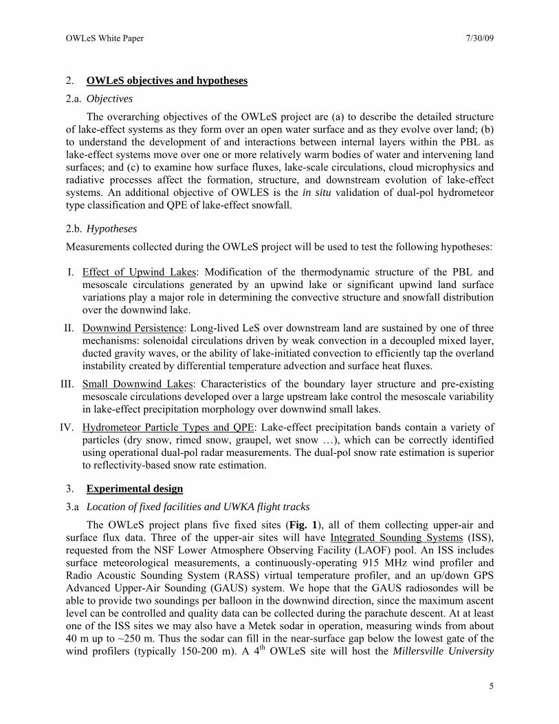
The OWLeS project plans five fixed sites (Fig. 1), all of them collecting upper-air and surface flux data. Three of the upper-air sites will have Integrated Sounding Systems (ISS), requested from the NSF Lower Atmosphere Observing Facility (LAOF) pool. An ISS includes surface meteorological measurements, a continuously-operating 915 MHz wind profiler and Radio Acoustic Sounding System (RASS) virtual temperature profiler, and an up/down GPS Advanced Upper-Air Sounding (GAUS) system. We hope that the GAUS radiosondes will be able to provide two soundings per balloon in the downwind direction, since the maximum ascent level can be controlled and quality data can be collected during the parachute descent. At at least one of the ISS sites we may also have a Metek sodar in operation, measuring winds from about 40 m up to ~250 m. Thus the sodar can fill in the near-surface gap below the lowest gate of the wind profilers (typically 150-200 m). A 4th OWLeS site will host the Millersville University
5

OWLeS White Paper 7/30/09
Profiling System (MUPS), which includes surface meteorological measurements, surface fluxes (not flux divergence), a GPS radiosonde system, a tethered balloon with a ceiling of 500-1000 m AGL, and a continuously-operating acoustic sodar with RASS. The MUPS can be used as a mobile system, and can be moved during the campaign if required.
In addition, OWLeS project operations intend to collaborate with the field project effort proposed by the Meteorology Program at the State University of New York (SUNY) at Oswego. Their mobile upper-air sounding system will be used as a 5th supplementary facility, if it is available during OWLeS operations. The OWLeS project will request M-GAUS sondes to be operated by the MUPS and Oswego crews. The Oswego project has requested a DOW X-band radar through the LAOF pool. This radar, if available, will be deployed at the 3rd site, where it will fill a gap between three WSR-88 radars. The collaboration with the Oswego project is discussed further in Section 3c.
The OWLeS project will also require four Integrated Surface Flux Systems (ISFS), requested from the NSF LOAF pool. All of the ISFS units will have a 10-m tower with flux sensors at (at least) two levels. At three sites the ISFS units are collocated with ISS units. The approximate proposed location of the five fixed sites is shown on Fig. 1. The five sites are as follows:
Site # location facilities
1 Lake Ontario north shore, ISS + ISFS near Toronto, Ontario
2 Lake Ontario south shore, ISS + ISFS between Rochester & Oswego
3 between #2 and #4 ISFS + DOW + Oswego radiosondes
4 Cayuga Lake north shore MUPS (surface fluxes, radiosondes, tethered balloon, and sodar with RASS)
5 Cayuga Lake south shore ISS + ISFS
The University of Wyoming King Air (UWKA) will also be requested from the NSF LAOF pool. Schematic flight patterns are shown on Fig. 1. A vertical transect aligned with the mean wind and snow bands is shown on Fig. 2. The UWKA contains a state-of-the-art suite of flux measurements, basic meteorology and wind, and cloud microphysical probes. It also carries a 3-mm (95 GHz) multi-antenna Doppler radar, the 2nd generation Wyoming Cloud Radar (WCR). The key antennas are those pointing up and down from the aircraft, enabling the interpretation of in situ measurements in the context of a vertical profile of fine-scale (~30 m resolution) radar data. A third antenna points some 30 degrees forward from nadir. The combination of the nadir and slant nadir antennas allows the synthesis of the along-track 2D flow below the aircraft (Damiani and Haimov 2006). We also plan to collect single and dual-Doppler WCR data to the right of the aircraft, using the up-looking antenna (which can point sideways, depending on the position of a mirror) and a 4th antenna, pointing sideways slant-forward. Finally, The UWKA carries an incoherent elastic polarization backscatter lidar, the Wyoming Cloud Lidar, also to be used in profiling mode (above and below the aircraft). The WCL detects aerosol layers and liquid water clouds, and the depolarization ratio can be used to discriminate between scatter by droplets and by snow crystals. Cloud top can be determined by both WCR (looking up or down, depending on flight level) and WCL (looking down only). Because of snowfall, the cloud base of
6
OWLeS White Paper 7/30/09
lake-effect clouds cannot be determined from the WCR, but it can using WCL data on flight legs below cloud base. Also, the WCL is expected to be able to capture the very first, very shallow streamers of lake-effect clouds near the upwind shore (e.g., Mayor and Eloranta 2001).
Fig. 1a: Map showing schematic location of UWKA flight patterns, the five sites with OWLeS facilities, and relevant operational facilities.
7
OWLeS White Paper 7/30/09
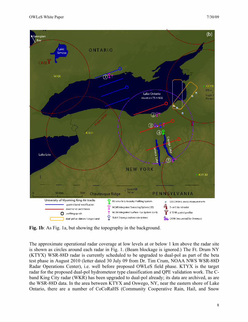
Fig. 1b: As Fig. 1a, but showing the topography in the background.
The approximate operational radar coverage at low levels at or below 1 km above the radar site is shown as circles around each radar in Fig. 1. (Beam blockage is ignored.) The Ft. Drum NY (KTYX) WSR-88D radar is currently scheduled to be upgraded to dual-pol as part of the beta test phase in August 2010 (letter dated 30 July 09 from Dr. Tim Crum, NOAA NWS WSR-88D Radar Operations Center), i.e. well before proposed OWLeS field phase. KTYX is the target radar for the proposed dual-pol hydrometeor type classification and QPE validation work. The C-band King City radar (WKR) has been upgraded to dual-pol already; its data are archived, as are the WSR-88D data. In the area between KTYX and Oswego, NY, near the eastern shore of Lake Ontario, there are a number of CoCoRaHS (Community Cooperative Rain, Hail, and Snow
8

OWLeS White Paper 7/30/09
Network) precipitation measurement sites (www.cocorahs.org), and students from SUNY Oswego and Millersville University will be deployed to measure snow depth and characterize hydrometeor type. Finally, there are two 915 MHz profiler in the region: one, located near the Syracuse NY airport, is part of the NOAA demonstration network. It is not functional at this time but we will work with NOAA to make it operational for the OWLeS field phase. The second wind profiler, located near Egbert, Ontario, is part of the Environment Canada Centre for Atmospheric Research Experiments (CARE). This profiler will be in British Columbia during the 2010 Winter Olympics but is planned to be back at CARE before November 2010.We hope that the UWKA can maintain a flight level of ~160 m (500 ft) AGL over the lake, and lower where the visibility is good (Fig. 2). The lowest level for the across-wind legs over land probably needs to be slightly higher. The highest flight level for the across-wind legs typically will be 4,000 ft (1,219 m) MSL, but it may be as high as 10,000 ft (3,048 m) MSL. The vertical extent of the UWKA soundings will be from as close as possible to the surface (over land possibly through a missed airport approach), typically up to 5,000 ft (1,524 m) MSL, but possibly as high as 10,000 ft (3,048 m) MSL. The flight patterns shown in Figs. 1 and 2 are schematic and may need to be changed based on airspace considerations, safety, and weather.
Fig. 2: Schematic vertical transect aligned with the mean low-level wind from the left (northwesterly to northerly flow).
The UWKA will likely be based at the Rochester NY Int’l airport, which suffers little from lake effect snow, even under northwesterly flow. The OWLeS field office will likely be at the Hobart and William Smith Colleges in Geneva NY, on the north shore of Seneca Lake, and within 1.5 hours drive to the Rochester airport and sites 2-5. The field office will house the P/Is, the
9

OWLeS White Paper 7/30/09
students, the seminar room for weather briefings, for IOP nowcasting, and for the OWLeS seminar (see Section 5, Educational Activities). The weather briefings will be conducted in consultation with the National Weather Service (NWS) Forecast Offices in Binghamton (KBGM, Fig. 1) and Buffalo (KBUF). Letters of support from these Forecast Offices are available.
3.b Measurement strategies
I. Effect of Upwind Lakes: Testing this hypothesis requires the ability to quantitatively observe the upstream evolution of the vertical boundary layer structure and mesoscale circulations upstream of and over the target lake (i.e., Lake Ontario). The UWKA provides the primary means of achieving this goal, both via in situ measurements of boundary layer thermodynamic properties and via remote sensing using the onboard profiling radar and lidar. Stacks of horizontal crosswind flight legs will be used to document the structure of the mesoscale circulations both near the upwind (northern) shore and as they evolve over Lake Ontario. These legs need to be long enough (50-60 km) to capture both the mesoscale variations and the mean flux profile. They will be flown within the complex PBL, to obtain in situ thermodynamic measurements in the context of the vertical profile of radar and lidar data above and below the aircraft, depicting the horizontal and vertical structure of snow band transects and of isentropic (aerosol) layers between the clouds above the PBL. Flight legs will also be flown above the clouds, to obtain WCR dual-Doppler cross sections of PBL circulations in LeS, and to depict undulations in isentropic layers above cloud. UWKA observations of the PBL spatial variations will be combined with vertical structure information (wind profiler, RASS, and GAUS) obtained from the ISS at site #1 to develop a comprehensive view of upwind atmospheric conditions. M-GAUS ascent and descent soundings, UWKA spiral soundings, and UWKA missed approaches over airports will be used to profile the PBL approaching the upwind shore of Lake Ontario. These will be combined with over-lake observations to understand lake-effect responses to upwind variations.
II. Downwind Persistence: This hypothesis poses similar requirements for observations of both boundary layer vertical structure and convective band horizontal structure. However, emphasis will be placed on observations of snow band thermodynamic and vertical velocity measurements at several locations along the bands to quantify the contribution of surface-forced convection and latent heat release in the overland persistence of convective bands. The UWKA will provide the primary means of measuring mesoscale structures as well as making in situ measurements of convective forcing or wave activity. Pressure perturbations will be estimated by measuring in situ static air pressure and the exact altitude of the aircraft (within ~0.1 m) using differential GPS (Parish et al. 2007). The UWKA will provide measurements of PBL vertical structure via soundings in strategic locations relative to the band. Both in situ gust probe measurements and remotely-sensed flow and cloud measurements from the cloud radar and cloud lidar will be required to fully document the dynamically significant aspects of the convective bands. The UWKA will fly cross-wind legs across LeS at multiple levels ranging from ~300 m AGL to above cloud top, but mainly at cloud level.
The possible decoupling of circulations from the surface as they move over land will be addressed through a coordinated set of surface flux and surface-based profiling measurements. A water-side or pier-mounted ISFS on the south shore of Lake Ontario (site
10

OWLeS White Paper 7/30/09
#2, see Fig. 1) will provide a time series of fluxes from Lake Ontario. Surface fluxes over land will be measured by a second ISFS unit at site #3, located ~30 km from the shore. The Millersville University flux system will be located at approximately 60 km from the shore, just upwind from Cayuga Lake in the Finger Lakes region. Finally, surface fluxes will be measured at site #5, located on the downwind shore of Cayuga Lake. By comparing the over-land to the over-lake flux measurements it will be possible to determine how the band’s surface buoyancy forcing evolves as it moves inland. Likewise, the evolving boundary layer vertical structure will be captured by transects of four units from the south shore of Lake Ontario to the south shore of Cayuga Lake. This transect includes two ISS units (sites #2 and #5), the Oswego radiosonde unit (site #3), and MUPS (site #4). The continuous RASS virtual temperature profiles at the ISS sites and from the Millersville University facility will provide continuity of lower boundary layer profiling between sounding times, allowing us to study the relationship between time-evolving surface fluxes and the corresponding boundary layer response.
III. Small Downwind Lakes: Testing this hypothesis requires the ability to observe (a) the spatial and temporal evolution of the vertical boundary layer structure south of Lake Ontario extending to south of Cayuga Lake, and (b) the resulting morphology of lake-effect precipitation associated with the Finger Lakes. This investigation requires continuous observations by the ISS 915-MHz wind profiler and Radio Acoustic Sounding System (RASS) virtual temperature profiler and multiple soundings (at roughly a 3-hour interval) during lake-effect and marginal lake-effect time periods to appropriately capture the entire range of conditions responsible for Finger Lakes lake-effect events and transitional periods (both during transitions of event type and at the initiation and dissipation stages). Measurements of the kinematic and thermodynamic structure of the Lake Ontario lake-effect boundary layer upstream of the Finger Lakes will be obtained from the ISS unit at the Lake Ontario south shore (site #2) and the two university-supported profiling sites (#3 and #4). The ISS at site #5 in the southern Finger Lakes region (e.g., south of Cayuga Lake) will provide observations necessary to determine the modification to the PBL by the Finger Lakes. The ISFS at sites #2 and #5 will also allow for an examination of the surface fluxes from Lake Ontario and Cayuga Lake. The mesoscale precipitation morphological response in the Finger Lakes region will be determined from the KBGM radar (Fig. 1), the Oswego-supported X-band mobile radar (if available), and satellite observations. Laird et al. (2009b) used KBGM WSR-88D radar measurements to effectively distinguish lake-effect morphology and conduct a climatological study of lake-effect precipitation events in the Finger Lakes region. The proposed OWLeS measurements will build on this previous work by examining the influence of large-lake boundary layers on the evolution of convection over smaller lakes.
IV. Hydrometeor particle types: Testing this hypothesis requires a flight track within 70-80 km from the KTYX radar, near the eastern shore of Lake Ontario. The target snow bands generally form in westerly flow, and tend to be deeper than those targeted for hypotheses I-III. The proposed flight track is a racetrack with offshore and on-shore long legs (Fig. 1). In case of a single, deep, lake-parallel snow band (the target of the Oswego project), the race track will most likely be oriented normal to the band to obtain cross sections of the reflectivity structure and circulation across the band. All legs are at least partly within the precipitation, at flight levels no lower than 300 m AGL. The WCR will operate in profiling mode to document the vertical structure of the snow band. Vertical structure information
11

OWLeS White Paper 7/30/09
will be obtained from the ISS unit at site #2, and from soundings released by the Oswego team on the west shore of Lake Ontario as part of their project, if it is funded. Trained observers on the ground, both undergraduate students from SUNY Oswego and CoCoRaHS volunteers, will be deployed to measure snow depth and basic snow characteristics, in an effort to validate the WSR-88D dual-pol hydrometeor type classification and QPE. This OWLeS objective takes advantage of the unique combination of airborne and ground-based measurements proposed for the project at a time when the KTYX radar will have just been upgraded to dual-pol.
3.c Relationship with the SUNY Oswego campaign
Dr. Scott Steiger and colleagues at SUNY Oswego are planning to conduct a related campaign in the same region during an overlapping period. Their focus is on LeS aligned with Lakes Ontario and Erie, forming under WSW flow and capable of producing heavy snowfall near the downwind shore. Their objectives are (a) to determine and understand the microphysics and flow fields and to evaluate and improve mesoscale model simulations (e.g., WRF) of these LeS, and (b) to document the electrical and lightning characteristics of these LeS. They plan to deploy a mobile X-band Doppler radar (Section 3a), release GPS radiosondes from their mobile sounding system, and deploy a large number of undergraduate students in the field to measure snowfall rate and to characterize precipitation/crystal type.
The Oswego and OWLeS projects are complementary in that the former focuses on deeper LeS under WSW flow, while the latter focuses on shallower LeS under NW flow. Thus facilities of the respective projects can be used in a cost-efficient, mutually beneficial way. If both projects are funded, OWLeS will benefit from limited low-level radar coverage between the KBUF and KTYX radars (Fig. 1). The X-band radar would provide better coverage near the Finger Lakes in support of the relatively shallow LeS targeted for the downwind persistence and small downwind lake studies. OWLeS will also benefit from the additional sounding site (#3) manned by the Oswego crew, who will be launching GAUS sondes provided by the OWLeS project.
On the other hand, the Oswego project benefits from the airborne dual-Doppler and vertical-profile radar coverage and flight-level microphysical data collected in westerly-flow LeS as part of the dual-pol hydrometeor type classification flights, which will target a wide array of lake-effect systems, including the deeper ones of interest to the Oswego project. The KTYX coverage over deeper LeS extends beyond the 70 km range shown in Fig. 1, and the dual-pol UWKA racetrack can be flown normal to the snow bands as shown in Fig. 1, making the WCR dual-Doppler data more relevant to the Oswego project. In addition, OWLeS-provided sondes will be released from site #1 during single-band lake-parallel events of interest to the Oswego project. In such westerly (WSW) flow events site #1 is on the upwind side of Lake Ontario, and a GAUS sonde can provide two soundings, one upwind of (ascent) and one over (descent) the lake, to complement the soundings released by the Oswego team on the eastern side of the lake.
While the OWLeS and Oswego projects will strengthen each other, they are mutually independent and the success of OWLeS depends neither on the availability of facilities requested by the Oswego project, nor on the participation of their faculty and students. In the event that the OWLeS project is funded and the Oswego project is not, there will be no X-band radar but Dr. Steiger’s group will still be available to release radiosondes from site #3, and to deploy students in the field to measure snowfall rate and to characterize precipitation/crystal type.
12

OWLeS White Paper 7/30/09
3.d Instrument priorities
A summary of the relative importance of the facilities (both LAOF and non-LAOF) for the four OWLeS science objectives is given in Table 1. In general, the full array of OWLeS facilities will be at least useful for each of the four objectives. The overlap is even more apparent in the four proposals to be submitted to NSF-ATM (Section 6). For instance, Geerts’s group has most experience with the use of WCR and WLR data; they plan to use the radar and lidar data in a collaborative way to explore the dynamics of LeS generated upwind of Lake Ontario, as well as LeS advecting over land south of Lake Ontario.
Table 1: Relative importance of the facilities for OWLeS science objectives, rated as follows: 1=essential, 2=important, 3=useful, 4=not needed. The NSF LAOF rows are shaded.
Effect of
Upwind Lakes Downwind Persistence
Small Downwind
Lakes Hydrometeor Particle Types
UWKA in situ probes 1 1 3 1 UWKA cloud radar 2 1 3 1 UWKA cloud lidar 2 2 3 1 site 1: ISS + ISFS 1 1 2 2 site 2: ISS + ISFS 2 1 1 2 site 3: ISFS 3 1 1 4 site 3: X-band radar + Oswego radiosondes 3 2 2 4 site 4: MUPS surface flux tower 3 1 1 4 site 4: MUPS radiosondes 3 1 1 3 site 4: MUPS tethersonde 3 1 1 4 site 4: MUPS acoustic sodar & RASS 3 1 1 4 site 5: ISS + ISFS 3 3 1 4
3.e OWLeS timing and duration
The field phase is scheduled for a time of the year when the larger bodies of water in the Eastern Great Lakes region are still ice-free, yet deep enough in the cold season for significant cold-air outbreaks to occur. Climatological studies based on visible satellite imagery suggest that LeS in northwesterly flow are most likely in the months of November through January (Table 2) (Kristovich and Steve 1995; Rodriguez et al. 2008). The deeper lake-parallel LeS that are the subject of the Oswego project, and the primary target for the dual-pol validation work, occur most frequently slightly earlier in the season, October-December (Steiger et al. 2009).
The duration of the field campaign should be sufficient to capture several good cases. A four-week period in Nov-Dec typically yields 1-4 cases of multiple bands under northwesterly flow, and 3-4 cases of snow bands cross the land bridge between Lakes Huron and Ontario (Table 2). Weaker cases of PBL development which do not produce significant visible clouds over Lake Ontario, useful for studying the influence of upwind lake and land variations, are thought to occur more frequently (Rodriguez et al. 2008). The deeper lake-parallel cases are less common, although they tend to last longer (Table 3). In short, in the proposed one-month period we should get 2-4 good cases under northwesterly flow, and 1-2 lake-parallel cases. At least one third of the cases should last longer than a day (Table 3). These cases can be sampled at least twice by the UWKA, on consecutive days.
13

OWLeS White Paper 7/30/09
Table 2. Climatic frequency (in number of days) of LeS over Lake Ontario in a four-week period in November or December, based on visible satellite imagery. Number of days with Kristovich & Steve (1995) Rodriguez et al. (2008) Lake-effect snow 3-8 7-8 Widespread snow or multiple bands (rolls, usually oriented NW to SE)
1-4 3-4
Snow bands parallel to the long axis of the lake (SW-NE)
< 1-2 1-2
Table 3. Duration (in number of days) of lake-effect snows over Lake Ontario. The Kristovich et al. (2009) percentages are preliminary, based on surface snowfall observations. The NWS Buffalo percentages are calculated from their ongoing list of significant lake-effect snows, which are more likely under westerly flow conditions (used with permission of T. Niziol, NWS Buffalo). Percentage of Kristovich et al. (2009) NWS Buffalo website 1-day events 66% 18% 2-day events 23% 46% Both 1- and 2-day events 89% 64%
In short, we propose to conduct OWLeS between 20 Nov – 20 Dec 2010 (31 days). Depending on the availability of the LAOF platforms requested, OWLeS could start as early as 1 November, and end as late as 15 January. 4. Personnel
Utilizing this mutually supporting suite of observing systems to test the interrelated OWLeS hypotheses requires observational expertise with each of the sensor systems and extensive overlapping experience in boundary layer meteorology, mesoscale convective systems, lake-effect systems, and cloud microphysics. The OWLeS investigators cover these fields in depth as well as bring to the project extensive experience in field program management and collaborative field operations and data analysis. Drs. Kristovich, Young and Geerts together have half a century of experience in boundary layer and observational meteorology, including numerous studies of mesoscale convection and lake-effect systems, often using the UWKA or other NSF aircraft. Thus, they will take the lead with the UWKA and its cloud radar and cloud lidar. Dr. Clark has decades of experience in surface-based flux measurements which he will apply to supervising the ISFS and profiling observations and their subsequent analysis. Dr. Laird has extensive experience on lake effect systems, first over the Great Lakes and more recently over the Finger Lakes. He is thus perfectly poised to study the interaction of these two phenomena. And Dr. Sikora brings extensive experience with remote sensing of lake-effect convection in non-traditional locations including Chesapeake Bay and Gulf Stream meanders. 5. Educational efforts
A critical need identified at the NSF LAOF Users Workshop held at NCAR in September 2007 is the education of future observational scientists (Serafin et al. 2008). We intend to bring
14

OWLeS White Paper 7/30/09
several graduate students and a larger number of undergraduates into the field, in particular from Millersville University (~12 undergraduates), the University of Illinois (2-4 graduate students), Penn State University (2 graduate students), and the University of Wyoming (1-2 graduate students). One or two student positions will be assigned officially to the operations of each of the three ISS units, reducing the number of NCAR personnel required. Also, we plan to closely work with Dr. Scott Steiger and colleagues at SUNY Oswego to coordinate use of the Oswego mobile rawinsonde system and arrange for SUNY Oswego undergraduate students to participate in the field measurements of snowfall rates and the characterization of snow crystals (Section 3.c).
Students will be involved in all aspects of the project. This includes logistics, deployment, real-time running of WRF, with an inner domain centered over Lake Ontario, daily weather briefing presentations, nowcasting during IOPs, data collection, quality assurance and post-field-phase data analysis. Students will have the opportunity to give seminars to the project team and attendees invited from local colleges (e.g. Oswego), AMS chapters, NWS WFOs and CoCoRAHS contributors describing their participation and responsibilities to the project, and preliminary project results.
In addition, we plan to turn an OWLeS weakness, the fact that there will be many non-IOP days between cold-air outbreaks, into a strength. On non-IOP days, the P/Is will bring together all students in the field and offer a for-credit OWLeS seminar on both the science of lake-effect snowfall and on field instrumentation, which will include visits to the facilities. One seminar will be dedicated to the planning of an IOP, whereby the students decide on the UWKA flight plan, the schedule of GAUS sonde releases, and the deployment of participants in the field. This seminar, aimed at participating graduate and undergraduate students, will be modeled after the seminar held as part of RICO (Rauber et al. 2007). The richness and breadth of instrumentation deployed in OWLeS will ensure that students participating in the seminar will be exposed to in-situ ground-based and airborne platforms and remote observing facilities, with sensors operating at several different frequencies, capturing multiple spatial scales, with each sensor dedicated to a specific measurement while serving as a component of a coordinated project-scale observing system. This seminar will be open to others, including students from any of the several Departments of Meteorology / Atmospheric Science in the vicinity (SUNY Oswego, SUNY Brockport, Cornell University,…), NWS forecasters, and the general public, including the CoCoRAHS volunteers.
“Most scientists today began their careers as children, chasing bugs, collecting spiders, [observing weather], and feeling awe in the presence of nature. Since such untidy activities are fast disappearing, how, then, will our future scientists learn about nature? (Richard Louv, Last Child in the Woods: Saving our children from nature deficit disorder. Algonquin Books of Chapel Hill, 2008 p.144.) OWLeS activities are replete with opportunities for young students to learn about winter weather, meet the scientists that endeavor to understand the phenomenon, and visit the facilities. To engage these students, we will develop a web-based OWLeS Outreach Program similar to the program at Millersville University where teachers can submit requests to arrange on-site visits or to have undergraduate students visit their classroom to give presentations on winter weather and the OWLeS project. We also hope to arrange events for students to see the aircraft and talk with project students and scientists.
15

OWLeS White Paper 7/30/09
6. Budget Estimate Based on information provided by NCAR EOL (Brigitte Baeuerle) and the University of
Wyoming (Alfred Rodi), we estimate the cost for the LAOF deployment pool to be about $808K, for a 31 day project in Nov-Dec 2010. Note that the estimate from NCAR EOL is rather approximate, because it did not consider the exact number of ISS and ISFS units requested. We will strive to reduce the cost of operating the ISS units by employing graduate and undergraduate students trained for the launch of GAUS balloons, as already discussed with EOL. The cost estimate for the UWKA is more specific. It assumes that the WCL is not (yet) part of the UWKA Cooperative Agreement. A summary is given in Table 4.
Table 4. Estimated cost of deployment of NSF facilities in OWLeS (20 Nov- 20 Dec 2010), in 1000s of dollars.
facility specifics approx. costUWKA with WCR and WCL 50 research flight hours $285Kthree ISS units with wind profiler and RASS 30 GAUS radiosondes per ISS $391Kfour ISFS units with bi-level flux sensors 10-m tower $112Kadditional GAUS sondes (sites #1 and #3) 40 GAUS sondes $21K
total: $808K
The OWLeS investigators are planning to submit four proposals to NSF ATM by the end of
July 2009. A summary of these proposals is given in Table 4.
Table 5. List of OWLeS proposals in preparation, for submission to NSF ATM, with a very preliminary budget estimate.
PI tentative title approx. costYoung, Clark and Sikora Downwind persistence of lake-effect snowbands $512K
Geerts Airborne profiling remote sensing measurements of the kinematics, microphysics and dynamics of lake-effect snow bands in OWLeS $400K
Laird Mesoscale & climatic variability of lake-effect precipitation events and conditions $300K
Kristovich Examination of the influence of upwind lakes and land conditions on lake-effect PBL development and evolution $300K
total: $1,512K
16

OWLeS White Paper 7/30/09
References
Agee, E.M., and S.R. Gilbert, 1989: An aircraft investigation of mesoscale convection over Lake Michigan during the 10 January 1984 cold air outbreak. J. Atmos. Sci., 46, 1877–1897.
Chandrasekar, V., A. Hou, E. Smith, V.N. Bringi, S.A. Rutledge, E. Gorgucci, W.A. Petersen, and G.S. Jackson, 2008: Potential role of dual- polarization radar in the validation of satellite precipitation measurements: rationale and opportunities. Bull. Amer. Meteor. Soc., 89, 1127–1145.
Byrd, G.P., R.A. Anstett, J.E. Heim, and D.M. Usinski, 1991: Mobile sounding observations of lake-effect snowbands in Western and Central New York. Mon. Wea. Rev., 119, 2323–2332.
Cooper, K.A., M.R. Hjelmfelt, R.G. Derickson, D.A.R. Kristovich, and N.F. Laird, 2000: Numerical simulation of transitions in boundary layer convective structures in a lake-effect snow event. Mon. Wea. Rev., 128, 3283–3295.
IPCC AR4, 2007: Climate Change 2007, The Physical Science Basis. Contribution of Working Group 1 to the Fourth Assessment Report of the Intergovernmental Panel on Climate Change. Solomon, S., D. Qin, M. Manning, Z. Chen, M. Marquis, K.B. Averyt, M.Tignor and H.L. Miller, Z. Chen (eds.). Cambridge University Press, New York.
Damiani R., and S. Haimov, 2006: A high-resolution dual-Doppler technique for fixed multi-antenna airborne radar. IEEE Trans. Geosci. Remote Sens., 42, 3475–3489.
Istok, M.J., M. A. Fresch, S. D. Smith, Z. Jing, R. Murnan, A. V. Ryzhkov, J. Krause, M. H. Jain, J. T. Ferree, P. T. Schlatter, B. Klein, D. J. Stein, G. S. Cate, and R. E. Saffle, 2009: WSR-88D dual polarization initial operational capabilities. 25th Conf. on International Interactive Information and Processing Systems (IIPS) for Meteorology, Oceanography, and Hydrology, AMS, Phoenix AZ, Jan 2009 (Extended Abstract available at http://ams.confex.com/ams/pdfpapers/148927.pdf)
Keighton S, Lee L, Holloway B, Hotz D, Zubrick S, et al. (2009) A Collaborative Approach to Study Northwest Flow Snow in the Southern Appalachians. Bull. Amer. Meteor. Soc: In Press
Kelly, R.D., 1984: Horizontal roll and boundary-layer interrelationships observed over Lake Michigan. J. Atmos. Sci., 41, 1816–1826.
Kristovich, D.A.R., 1993: Mean circulations of boundary-layer rolls in lake-effect snow storms. Bound.-Lay. Meteor., 63, 293-315.
Kristovich, D.A.R., and R. Steve, 1995: A satellite study of cloud-band frequencies over the Great Lakes. J. Appl. Meteor., 34, 2083-2090.
Kristovich, D. A. R., and R. R. Braham, Jr., 1998: Profiles of moisture fluxes in snow-filled boundary layers. Bound.-Lay. Meteor., 87, 195-215.
Kristovich, D.A.R., and N.F. Laird, 1998: Observations of Widespread Lake-Effect Cloudiness: Influences of Lake Surface Temperature and Upwind Conditions. Wea. Forecasting, 13, 811–821.
Kristovich, D.A.R., N.F. Laird, M.R. Hjelmfelt, R.G. Derickson, and K.A. Cooper, 1999: Transitions in boundary layer meso-γ convective structures: an observational case study. Mon. Wea. Rev., 127, 2895–2909.
Kristovich, D.A.R., G.S. Young, J. Verlinde, P.J. Sousounis, P. Mourad, D. Lenschow, R.M. Rauber, M.K. Ramamurthy, B.F. Jewett, K. Beard, E. Cutrim, P.J. DeMott, E.W. Eloranta, M.R. Hjelmfelt, S.M. Kreidenweis, J. Martin, J. Moore, H.T. Ochs, D.C. Rogers, J. Scala, G.
17

OWLeS White Paper 7/30/09
Tripoli, and J. Young, 2000: The Lake—Induced Convection Experiment and the Snowband Dynamics Project. Bull. Amer. Meteor. Soc., 81, 519–542.
Kristovich, D.A.R., N.F. Laird, and M.R. Hjelmfelt, 2003: Convective evolution across Lake Michigan during a widespread lake-effect snow event. Mon. Wea. Rev., 131, 643–655.
Kristovich, D.A.R., et al., 2009: Duration of Lake Ontario lake-effect snowstorms. J. Appl. Meteor. Climatol., in preparation.
Kuettner, J.P., P.A. Hildebrand and T.L. Clark, 1987: Convection waves: observations of gravity wave systems over convectively active boundary layers. Quart. J. Royal Meteor. Soc.,113, 445-467.
Laird, N. F., J. Desrochers, and M. Payer, 2009a: Climatology of lake-effect precipitation events over Lake Champlain. J. Appl. Meteor. Climatol., 48, 232-250.
Laird, N. F., R. Sobash, and N. Hodas, 2009b: The frequency and characteristics of lake-effect precipitation events associated with the New York State Finger Lakes. J. Appl. Meteor. Climatol., 48, 873-886.
Mann, G.E., R.B. Wagenmaker, and P.J. Sousounis, 2002: The influence of multiple lake interactions upon lake-effect storms. Mon. Wea. Rev., 130, 1510–1530.
Mayor, S.D., and E.W. Eloranta, 2001: Two-dimensional vector wind fields from volume imaging lidar data. J. Appl. Meteor., 40, 1331–1346.
Niziol, T.A., W.R. Snyder, and J.S. Waldstreicher, 1995: Winter weather forecasting throughout the Eastern United States. Part IV: Lake-effect snow. Wea. Forecasting, 10, 61–77.
Parish, T.R., M.D. Burkhart, and A.R. Rodi, 2007: Determination of the Horizontal Pressure Gradient Force Using Global Positioning System on board an Instrumented Aircraft. J. Atmos. Oceanic Technol., 24, 521–528.
Park, H.S., A. Ryzhkov, D. Zrnic, and K.E. Kim, 2009: The hydrometeor classification algorithm for the polarimetric WSR-88D: Description and application to an MCS. Wea. Forecasting, in press.
Rauber, R.M., and co-authors, 2007: In the driver's seat: RICO and education. Bull. Amer. Meteor. Soc., 88, 1929–1937.
Reinking, R. F., and Coauthors, 1993: The Lake Ontario Winter Storms (LOWS) project. Bull. Amer. Meteor. Soc., 74, 1828–1849
Rodriguez, Y., D.A.R. Kristovich, and M.R. Hjelmfelt, 2007: Lake-to-lake cloud bands: frequencies and locations. Mon. Wea. Rev., 135, 4202–4213.
Rose B. L., 2000: The role of upstream lakes in determining downstream severe lake-effect snowstorms. Ph.D. dissertation, University of Illinois, 183 pp. [Available from ProQuest Information and Learning, P. O. Box 1346, Ann Arbor, MI 48106.].
Ryzhkov, A.V., S.E. Giangrande, and T.J. Schuur, 2005: Rainfall estimation with a polarimetric prototype of the WSR-88D radar. J. Appl. Meteor., 44, 502 – 515
Schroeder, J.J., D.A.R. Kristovich, and M.R. Hjelmfelt, 2006: Boundary layer and microphysical influences of natural cloud seeding on a lake-effect snow storm. Mon. Wea. Rev., 134, 1842-1858.
Serafin, R., et al., 2008: An Assessment of Observational Research Facilities and Future Needs. 94 pp [available at http://www.eol.ucar.edu/fai/NSF%20Facilities%20Assessment%20Final%20Report.pdf]
Steiger, S.M., R. Hamilton, J. Keeler, and R.E. Orville, 2009: Lake-effect thunderstorms in the Lower Great Lakes, J. Appl. Meteor. Climatol., 48, 889-902.
18

OWLeS White Paper 7/30/09
19
Tripoli, G.J., 2005: Numerical study of the 10 January 1998 lake-effect bands observed during Lake-ICE. J. Atmos. Sci., 62, 3232–3249.
Vivekanandan, J., S.M. Ellis, R. Oye, D.S. Zrnic, A.V. Ryzhkov, and J. Straka, 1999: Cloud microphysics retrieval using S-band dual-polarization radar measurements. Bull. Amer. Meteor. Soc., 80, 381–388.
Walsh, J.E., 2008: Climate of the arctic marine environment. Ecol. Appl., 18, S3-S22. doi: 10.1890/06-0503.1
Wang, T.A., and Y.L. Lin, 1999: Wave ducting in a stratified shear flow over a two-dimensional mountain. Part I: General linear criteria. J. Atmos. Sci., 56, 412–436.
Yang, Q., and B. Geerts, 2006: Horizontal convective rolls in cold air over water: buoyancy characteristics of coherent plumes detected by an airborne radar. Mon. Wea. Rev., 134, 2373–2396.
Young, G.S., D.A.R. Kristovich, M.R. Hjelmfelt, and R.C. Foster, 2002: Rolls, streets, waves, and more: a review of quasi-two-dimensional structures in the atmospheric boundary layer. Bull. Amer. Meteor. Soc., 83, 997–1001.
Young, G.S., and T.D. Sikora, 2003: Mesoscale stratocumulus bands caused by Gulf Stream Meanders. Mon. Wea. Rev., 131, 2177–2191.
Zrnic, D. S., and A. Ryzhkov, 1996: Advantages of rain measurements using specific differential phase. J. Atmos. Oceanic Technol., 13, 454–464.