
Ontario Integrated Hydrology Data and OFAT III · Ontario Integrated Hydrology Data and OFAT III...
22
Latornell, November 15, 2012 Ontario Integrated Hydrology Data and OFAT III Bryce Matthews, Kent Todd, Elizabeth Philip, Steve Damaia, John Gaiot, Taylor Wilkinson [email protected] [email protected]
Transcript of Ontario Integrated Hydrology Data and OFAT III · Ontario Integrated Hydrology Data and OFAT III...

Latornell, November 15, 2012
Ontario Integrated Hydrology Data and OFAT III
Bryce Matthews, Kent Todd, Elizabeth Philip, Steve Damaia, John Gaiot, Taylor Wilkinson

1. Ontario Integrated Hydrology (LCC) a. Integrated Hydrology Packages
2. Ontario Flow Assessment Tools III a. A Session b. Data c. Performance d. Models e. Typical Usage f. Future and Demo
Presentation Overview Overview

• A new series of data packages, known as Ontario Integrated Hydrology Data, have been developed to provide a collection of related elevation and mapped water features that are used in combination for Provincial, medium-scale hydrology applications, such as watershed generation and hydrologic modelling.
• Surficial data only
• As there are inter-layer dependencies in the Integrated Hydrology Data, data maintenance and the release of updates can be streamlined by packaging all the datasets into one common package.
Ontario Integrated Hydrology Overview
OIH, WISH, SWISH?

Ontario Integrated Hydrology Overview
OIH, WISH, SWISH?

Ontario Integrated Hydrology Packages include integrated spatial data
StreamGRID
EnhancedFlow Direction
HydroDEM
Watercourse
Overview
OIH, WISH, SWISH?

Enhanced Watercourse
The Enhanced Watercourse dataset is a hydrologic network based on a time-stamped version of LIO’s OHN Watercourse data class which was developed in accordance with the Provincial medium-scale data capture specifications for hydrographic features.
Specific attributes include: primary, secondary, and tertiary watershed codes;
Strahler and Shreve stream ordering values
Overview
OIH, WISH, SWISH? EWC

Stream Enforced DEM
Specifics:
• 30 metre resolution
• Lambert Conformal Conic
• Variety of input data sources
Overview
OIH, WISH, SWISH? EWC
DEM

Stream Enforced DEM Overview
OIH, WISH, SWISH? EWC
DEM

Enhanced Flow Direction
A typical flow direction raster represents the direction of water flow across the surface of the landscape.
The Enhanced Flow Direction is based on this principle, but also incorporates and honours directionality sourced from mapped hydrology features (Kenny and Matthews, 2005).
Flow direction can be assigned using more accurate directionality (from mapped streams/lakes) as opposed to just relying on elevation.
Using the Enhanced Flow Direction ensures mapped features are incorporated into any derived watershed boundaries.
Overview
OIH, WISH, SWISH? EWC
DEM EFDirG

Seamless Integration User’s can work on study areas that span over two or more packages.
No issues with different resolutions, alignments etc.
All data is ‘hydro-analysis’ ready and can easily be mosaiced together
Overview
OIH, WISH, SWISH? EWC
DEM EFDirG
Seamless Integration

Integration in Practice Specific Uses:
Allows for a number of legislative, regulatory and operational requirements to be addressed within the Province of Ontario.
• Water Resources Act – assist practitioners who are assessing permits, transfers within and between Great Lakes watersheds
• Lake Simcoe Protection Act – to protect and restore the Lake Simcoe watersheds health
• Land Use Planning Boundaries – Far North Planning act – 65% of the ecological system is comprised by lakes, rivers or wetlands
• Support MNR’s Surface Water Monitoring Centre and Water Budget Program
General Uses:
• Agriculture (nutrient modeling), geology (3D subsurface, terrain mapping), integrated watershed management, forest management, mining and aggregate studies, hydologic and hydraulic modeling (hydro-power potential), landcover mapping,
….and
Overview
OIH, WISH, SWISH? EWC
DEM EFDirG
Seamless Integration
Integration in Practice

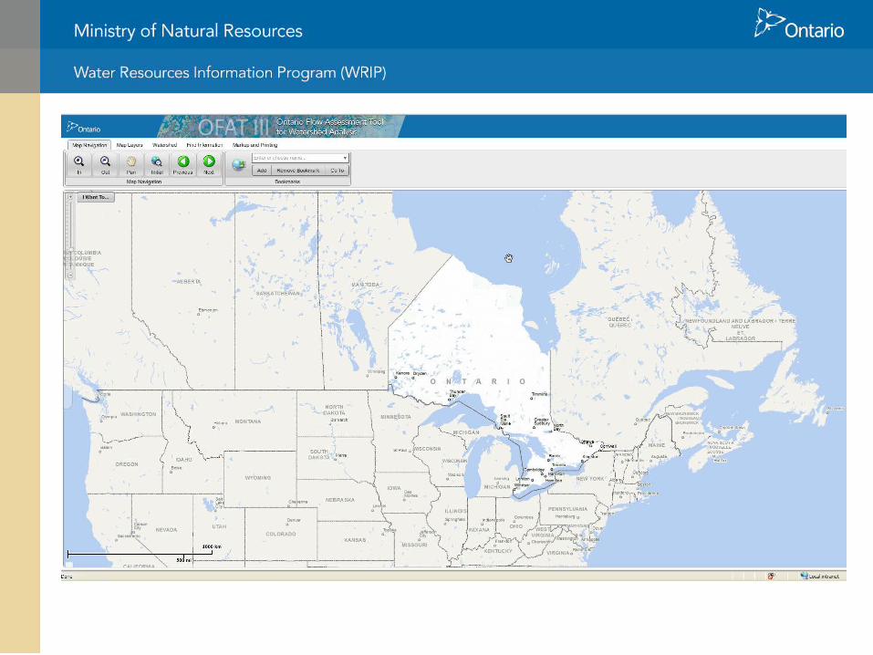
Ontario Flow Assessment Tools (OFAT) III is an online spatial application to automate a series of labour intensive hydrology tasks.
With stream flow quantity estimation being the conclusion of a sequence, intermediate outputs such as watershed delineation and characterization provide a wide variety of users with useful spatial derivatives that can be applied to many water related applications.
Overview
OIH, WISH, SWISH? EWC
DEM EFDirG
Seamless Integration
Integration in Practice
OFATIII Project

Multi- year project co-ordinated with new spatially integrated hydrology data
User Community Input • Institute for Watershed Science – Evaluation of
Hydrological Models in the OFAT Software Tool: Assessment of Model Suitability for Ontario’s Far North
• User Community Survey – experiences from previous
version, and future improvements
• Steering Committee: MNR, MOE, EC, CA’s, Academic Community
OFAT III Project development Overview
OIH, WISH, SWISH? EWC
DEM EFDirG
Seamless Integration
Integration in Practice
OFATIII Project

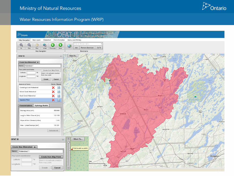
An OFAT III Session
Watershed Delineation
Watershed Characterization
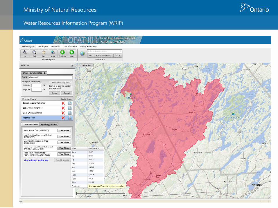
Regional Hydrology Models
Export/Print Results
• OFAT III provides an automated implementation of commonly used hydrology functions.
Overview
OIH, WISH, SWISH? EWC
DEM EFDirG
Seamless Integration
Integration in Practice
A Session
OFATIII Project

OFAT Data 1. Updated Stream Network
2. Updated Digital Elevation Model (30m)
3. Updated Enhanced Flow Direction Grid
4. Updated Tertiary Watersheds
5. Pre-defined Contributing Watersheds
6. Upstream Flow Length/Downstream Flow Length
7. Raster Water Body
Integrated Hydrology
Package
Additional
OFAT Data
Overview
OIH, WISH, SWISH? EWC
DEM EFDirG
Seamless Integration
Integration in Practice
A Session OFAT Data
OFATIII Project

• Programs are custom built and optimized for speed and accuracy by taking advantage of specialized data sets produced by WRIP.
• Performance goal – 5 – 120 sec. depending on watershed size
• Where possible, the data and programs are coordinated to
take advantage of pre-computed watersheds and characterizations
• Confidence of Data – best seamless provincial data set available
• Border Limitations
OFAT III Performance Overview
OIH, WISH, SWISH? EWC
DEM EFDirG
Seamless Integration
Integration in Practice
A Session OFAT Data Performance
OFATIII Project

• Flood Flows – Moin & Shaw 1985 Index Flood with EPA – Moin & Shaw 1985 Primary Multiple Regression
• Low Flows – MOEE 1995 Graphical Index Method – MOEE 1995 Regression Method
• Mean Annual Flow (MNR 2003 grid)
OFAT III Regional Hydrology Overview
OIH, WISH, SWISH? EWC
DEM EFDirG
Seamless Integration
Integration in Practice
A Session OFAT Data Performance Models
OFATIII Project

Create and characterize watersheds for watershed based planning
Create baseline flow information needed to: • design hydraulic structures such as culverts, bridges, dams,
etc • plan for existing and future hydroelectric facilities • protect or enhance fish habitat • support a watershed/ecosystem based approach to land
and water management • identify water supply for water use and wastewater
permitting • support various academic studies
OFAT III Typical Use Overview
OIH, WISH, SWISH? EWC
DEM EFDirG
Seamless Integration
Integration in Practice
A Session OFAT Data Performance Models Typical Usage
OFATIII Project

OFAT III Future Development • Funding dependent
• 2012/13 – additions may include
• Watershed Land Cover summary, Land Cover viewing
• Water flow monitoring station frequency analysis of low flows/flood flows
• KML export, session XML metadata generation
• Look at future partnerships
• Demo
Overview
OIH, WISH, SWISH? EWC
DEM EFDirG
Seamless Integration
Integration in Practice
A Session OFAT Data Performance Models Typical Usage
Future and Demo
OFATIII Project


![[Hydrology] Groundwater Hydrology - David K. Todd (2005)](https://static.fdocuments.in/doc/165x107/548ce7beb47959e2288b45f9/hydrology-groundwater-hydrology-david-k-todd-2005.jpg)


![[hydrology] groundwater hydrology - david k. todd (2005).pdf](https://static.fdocuments.in/doc/165x107/577c77961a28abe0548cb0b1/hydrology-groundwater-hydrology-david-k-todd-2005pdf.jpg)

