Onshore and Nearshore Explorations along the Maharashtra Coast ...
11
Onshore and Nearshore Explorations along the Maharashtra Coast: with a View to Locating Ancient Ports and Submerged Sites Sila Tripati and A.S. Gaur Marine Archaeology Centre National Institute of Oceanography Dona Paula Goa 403 004 Abstract Coastal explorations were carried out along the west coast of India at Elephanta Island, Malvan, Vijaydurg, Sopara and Chaul. A number of lead and copper coins as well as pottery of different cultural periods were found. Onshore explorations at Malvan and Vijaydurg yielded stone anchors of the Historical period, the first of their kind to be found in this region. The purpose of the submerged stone structure off Vijaydurg appears to have been damage to enemy ships or protect the fort from wave and current action. Other discoveries as well as offshore explorations arc of importance in the reconstruction of the maritime history of India Introduction Marine archaeological research seeks to reconstruct the history of shipping, maritime trade and cultural migrations by exploring and excavating defunct and submerged ports as well as sunken ships. A systematic attempt has been made by the National Institute of Oceanography (NIO) to explore and study the ancient ports and their locations all along the coast of India. The present paper discusses the results of coastal explorations at Elephanta Island, Malvan, Vijaydurg, Sopara and Chaul (Fig. I). These sites were important ports located on the west coast of India. Offshore explorations were only carried out around Vijaydurg. Data on ship- wrecks were also collected from local sources. Remains of ancient port installations and other coastal structures were also surveyed. Elephanta Island Elephanta Island, 7 km in circumference, is situated about 10 km off the coast of Mumbai. It is locally known as Gharapuri and comprises the three villages of Rajbandar, Morabandar and Shetbandar. Elephanta Island was also a port between the 1st century B.C. and the 16th century A.D. The earliest port during the Satavahana period was Morabandar. Rajbandar served as a port during the Roman period and Shetbandar during the Portuguese period. The Aihole inscription states that Pulakesin II, the Early Chalukya ruler invaded the island, vanquished the Konkan Mauryas and reduced Puri (Gharapuri) after attacking it with hundreds of ships (Kielhorn 1900-01). This Gharapuri might have been the capital of the Mauryas. After the Chalukyas, the island passed into the hands of the Rashtrakutas (8th century A.D.) and subsequently to the Chalukyas of Kalyana (10th century A.D.), the Yadavas, the Muslim invaders, the Portuguese, the Marathas and the British (Sastri 1934). Rajbandar Previous Work While quarrying earth at Rajbandar to construct a water reservoir in 1973 the Public Health Department, Govern- ment of Maharashtra, exposed a brick structure which was later identified by the Archaeological Survey of India as a jetty-cum-wharf. The wharf (4 m in height and 15 m in length) has an outer face sloping inward (Rao 1983). Silver Kashalrapa and Roman coins dating from the lst-4th century A.D. as well as small copper coins known as Kakinis and Karshapanas of the 1st century B.C. to 1st century A.D. were also found at the site. Amphorae fragments, Red Polished Ware (RPW), copper coins (Kakinis), etc. recovered from the earliest level suggest that
Transcript of Onshore and Nearshore Explorations along the Maharashtra Coast ...

Onshore and Nearshore Explorations along the Maharashtra Coast: with a View to Locating Ancient Ports and Submerged Sites
Sila Tripati and A.S. Gaur
Marine Archaeology Centre National Institute of Oceanography Dona Paula Goa 403 004
Abstract
Coastal explorations were carried out along the west coast of India at Elephanta Island, Malvan, Vijaydurg, Sopara and Chaul. A number of lead and copper coins as well as pottery of different cultural periods were found. Onshore explorations at Malvan and Vijaydurg yielded stone anchors of the Historical period, the first of their kind to be found in this region. The purpose of the submerged stone structure off Vijaydurg appears to have been damage to enemy ships or protect the fort from wave and current action. Other discoveries as well as offshore explorations arc of importance in the reconstruction of the maritime history of India
Introduction
Marine archaeological research seeks to reconstruct the history of shipping, maritime trade and cultural migrations by exploring and excavating defunct and submerged ports as well as sunken ships. A systematic attempt has been made by the National Institute of Oceanography (NIO) to explore and study the ancient ports and their locations all along the coast of India.
The present paper discusses the results of coastal explorations at Elephanta Island, Malvan, Vijaydurg, Sopara and Chaul (Fig. I). These sites were important ports located on the west coast of India. Offshore explorations were only carried out around Vijaydurg. Data on shipwrecks were also collected from local sources. Remains of ancient port installations and other coastal structures were also surveyed.
Elephanta Island
Elephanta Island, 7 km in circumference, is situated about 10 km off the coast of Mumbai. It is locally known as Gharapuri and comprises the three villages of Rajbandar, Morabandar and Shetbandar. Elephanta Island was also a port between the 1st century B.C. and the 16th century A.D. The earliest port during the Satavahana period was Morabandar. Rajbandar served as a port during the Roman
period and Shetbandar during the Portuguese period. The Aihole inscription states that Pulakesin II, the Early Chalukya ruler invaded the island, vanquished the Konkan Mauryas and reduced Puri (Gharapuri) after attacking it with hundreds of ships (Kielhorn 1900-01). This Gharapuri might have been the capital of the Mauryas. After the Chalukyas, the island passed into the hands of the Rashtrakutas (8th century A.D.) and subsequently to the Chalukyas of Kalyana (10th century A.D.), the Yadavas, the Muslim invaders, the Portuguese, the Marathas and the British (Sastri 1934).
Rajbandar
Previous Work
While quarrying earth at Rajbandar to construct a water reservoir in 1973 the Public Health Department, Government of Maharashtra, exposed a brick structure which was later identified by the Archaeological Survey of India as a jetty-cum-wharf. The wharf (4 m in height and 15 m in length) has an outer face sloping inward (Rao 1983). Silver Kashalrapa and Roman coins dating from the lst-4th century A.D. as well as small copper coins known as Kakinis and Karshapanas of the 1st century B.C. to 1st century A.D. were also found at the site. Amphorae fragments, Red Polished Ware (RPW), copper coins (Kakinis), etc. recovered from the earliest level suggest that

Man and Environment XXII (2) - 1997
Rajbandar was a port with trade contacts with the Roman world (Rao 1987). It is believed that the wharf was in use from the 1st century B.C. to the 7th century A.D. (Visweswariah 1985).
Present Explorations
The newly constructed jetty opposite Rajbandar has destroyed the ancient remains and the whole area is covered with stone chips making it difficult to trace the pottery and other antiquities of the historical period. A few Chinese sherds, a carnelian bead and copper coins were collected from the vicinity. Rolled and unrolled pottery was noticed respectively within the nearshorc area and in the sections.
Morabandar
Morabandar, which name probably derives from port of the Mauryas of Konkan, is a small hamlet on the northeastern side of Elephanta Island. A number of circular and square copper coins were collected from Morabandar. On two lead coins on the obverse a three peaked hill is visible and a wheel is seen on the reverse. On one of the copper coins a Brahmi character read as Ya is also visible. The section facing the sea is hardly 5 m above the high water line. Section scrapings yielded pottery which included a bowl, dish, jar, and plates of Red Ware and coins of different periods. In the intertidal zone rolled pottery and fragments of carnelian nodules were found. While crossing over the
74
Fig. 1: Map showing the sites explored on the coast of Maharashtra

Onshore and Nearshore Explorations along the Maharashtra Coast
Fig. 2: Copper and lead coins from Elephanta Island
75

Man and Environment XX11 (2) - 1997
hillock between Morabandar and Shetbandar some brick and stone structures were also noticed on the surface. The brick structure extends towards the sea and is more than 15 m in length. A stone pestle was found in the vicinity (Rao et al. in press). Since a large quantity of coins and numerous structural remains as well as pottery were found at Morabandar it is presumed that this site might have been a habitational area during the Roman period while Rajbandar certainly was a port.
Shetbandar
During the Portuguese period Shetbandar served as a port. Large sized bricks are seen scattered in the intertidal zone along with potsherds of RPW. On the way to Morabandar from Shetbandar, a rock-cut well 2.5 m in diameter was also noticed. In a rain gully at Shetbandar a brick wall was seen (approximately 15-20 m in length, 1 m high) made with bricks (30x20x7 cm). Below the wall was a I m thick deposit of loose clay underlain by another thick deposit consisting of miniature bowls, spouts and jars. They are
thin in section, unpainted and ill-fired. The brick wall appears to be of the Gupta period while the pottery may belong to the pre-Gupta period.
The presence of a large number of bricks of the Early Historical period in the intertidal zone suggest that the township once extended further towards the sea.
Coins from Elephanta Island
At Elephanta Island 24 coins were collected: 15 arc of copper and the remaining 9 are of lead. The earliest coins may be dated to the 2nd century A.D. on the basis of the Brahmi Ya found on a coin perhaps issued by the Satavahanas. Two of the copper coins are of Sri Krishnaraja of the Kalachuri dynasty (A.D. 550-575). Similar coins had earlier been reported from Morabandar by Gokhale (1976) and others (Rajgor and Lad 1992). A description of four coins (Fig. 2) of which the first three are of copper and the fourth one of lead arc given below:
Fig. 3: Location of stone anchors on the platform of Sindhudurg Fort
76

Onshore and Nearshore Explorations along the Maharashtra Coast
1. Obverse: four Brahmi words are visible but only one character can be read as Ya
Reverse: heavily encrusted
2. Obverse: Sri Krishnaraja within dotted border, below an altar-like hollow symbol
Reverse: Couchant Nandi facing left
3. Obverse: Sri Krishnaraja within dotted border
Reverse: Couchant Nandi facing left
4. Obverse: a three peaked hill
Reverse: wheel with ten spokes within dotted circle
Malvan
Malvan is in Sindhudurg District (previously Ratnagiri). Malvan (Aurannoboas) and Vijaydurg (Byzantine) were minor ports in ancient times. Schoff (1974) refers to Aurannoboas which McCrindle (1879) identified with modern Malvan. These minor ports had direct contact with Sopara and Kalyan. Shivaji, the great Maratha king constructed several coastal forts including the one at Sindhudurg to protect his vessels and as a stronghold in adversity. Sindhudurg Fort is constructed on a low island called Kurte, about 1.6 km offshore from Malvan. The western side of the outer wall has been damaged as a result of wave action. Another small ruined fort called Padamgad, opposite Sindhudurg, was built on a smaller island and served as a shipyard for Shivaji (Apte 1973). Padamgad Fort is now connected with the mainland by the development of a neck of sand.
Present Explorations
Exploration of the forts of Sindhudurg and Padamgad revealed a number of triangular and grapnel-type stone anchors: 3 of the former and 5 of the latter type were noticed at Sindhudurg Fort (Fig. 3). These triangular anchors and three of the grapnel-type anchors have been used in the construction of the platform of the jetty of the Sindhudurg Fort while the other two grapnel-type anchors arc used as mooring bits (Fig. 4). Another grapnel type stone anchor was noticed at the entrance of the Padamgad Fort (Fig. 5). All these weathered anchors are made of locally available laterite and sandstone and provide information on the maritime history of the region. They arc the first of their type to be found around Malvan.
Similar types of anchors have been found in the waters around Dwarka and Prabhas-Patan-Somnath (Rao et al. 1992). The size, age, shape and material of these anchors differ from region to region. It seems that they had been in use prior to Shivaji's construction of the fort. During the 17th century iron anchors were used extensively and stone anchors rarely. Thus, it is very likely that stone anchors were used for paving, mooring and various other purposes.
The archaeological excavations at Brahmapuri, on the banks of the river Panchaganga near Kolhapur yielded Satavahana coins and a statuette of Poseidon, the Roman sea god along with a number of bronze vessels of Roman origin thus providing evidence of commercial contact with the Mediterranean world from 200 B.C. to 200 A.D. It is very likely that the trading community of Brahmapuri contributed to the spread of Buddhism on this part of the west coast (Ghosh 1989). Satavahana coins were also found at locations closer to Malvan, however, sites near Sindhudurg Fort have not yielded pre-Satavahana antiquities. It appears that after the decline of the Satavahanas, Malvan and Vijaydurg lost their glory until they were absorbed into the kingdom of Shivaji.
Vijaydurg
The Early Historic port of Vijaydurg is situated on the southern bank of the river Vaghotan in the Devgad taluka of Sindhudurg District and was referred to as Byzantcion and Byzantine by Ptolemy (McCrindle 1885) and Pcriplus (Schoff 1974) in the 1st and 2nd century A.D. Vijaydurg again came into the limelight during the rule of Shivaji,
Fig. 4: Grapnel-type stone anchor used as a mooring bit at the entrance of Sindhudurg Fort
77

Man and Environment XXII (2) - 1997
Fig. 5: Grapnel-type stone anchor used as a lintel at the entrance of Padamgad Fort
who made Vijaydurg the naval base of the Maratha kingdom. There were frequent naval battles between Europeans and Maratha kings and a number of ships were burnt and sunk in the Vijaydurg waters due to exchange of fire(Apte 1973).
Present Exporations
Explorations and excavations were carried out in the nearshore area of Vijaydurg in December 1995 (National Institute of Oceanography 1996). Diving as well as airlift operations with the help of metal detectors and the Global Positioning System (GPS) were carrried out in Vaghotan creek and on the western side of Vijaydurg Fort at a depth of 8 to 10 m. Underwater explorations (Fig. 6) on the western side of the fort (about 100 m seaward) revealed a huge linear stone structure built of irregular stone blocks. trending EW and with the offshore end veering to the south. This structure is 122 m long, 7 m wide and 3 m high. It is believed that it belongs to the Maratha period
78
and was probably constructed to cause damage to enemy ships as well as to protect the fort from wave and current action. The underwater probe and metal detector survey were carried out at various locations inside the creek followed by airlifting which revealed coal, shale, slag and medieval pottery at a depth of 2.5 m on the sea bed. Other finds include the two iron sling balls, indigenous pottery, a few sherds of Chinese ceramic, chalcedony nodules and the wooden logs of wrecked ships.
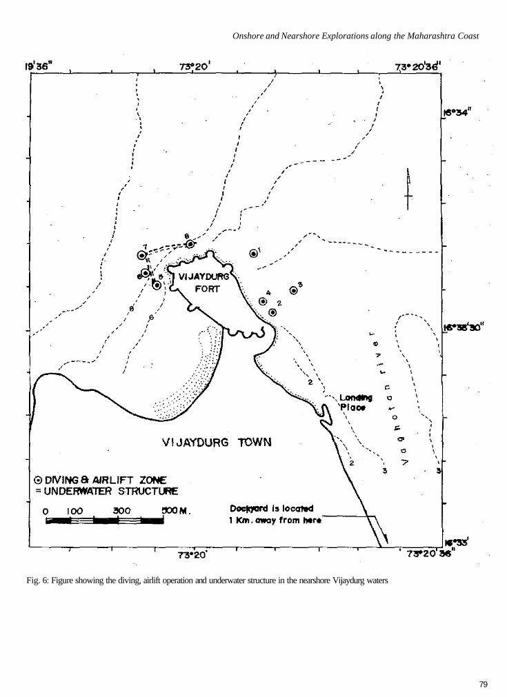
Onshore explorations in the area about 3 km from Vijaydurg revealed a tidal dockyard (godi) on the bank of the river Vaghotan (Fig. 7). This dockyard was built by the Maratha admiral Kanhoji Angre in the 17th century A.D. This dock was renovated by Anand Rao Dhulup who also increased the landing capacity. The dimnensions of the dock are 110 x 75 m and it had a capacity to hold ships of 500 tonnes. The entrance of the dock is 7 m wide at the base and 12 m at the top. The southern and eastern sides are cut out of natural rock while the third side is a dry masonary construction.
In addition, a number of stone anchors were also located in the adjoining area of the dockyard (Fig. 8). It appears that these anchors were used as mooring bits when the dock was in use. Eight grapnel-type stone anchors were also discovered to have been used as a lintel in the parapet wall of the second fortification of Vijaydurg Fort. The anchors are generally in good condition, made out of locally available sandstone. A cannon stand was also noticed near the third fortification wall of the fort.
Sopara
Sopara, presently known as Nala Sopara (Vasai taluka, Thane District) is about 58 km north of Mumbai. Nala Sopara is accepted by scholars as the Suparaka or Supparak of ancient India and was a busy trade centre and an important seal of Buddhism. It was also one of the administrative units under the Satavahanas and is mentioned in the inscriptions of Karle, Nashik, Naneghat and Kanheri(Ray 1994).
Previous Work
The stupa site of Sopara locally known as Baruda Rajacha Killa was excavated by Bhagwanlal Indraji in 1882 and yielded a fragment of the VIII Rock Edict of Asoka along with a large stone coffer, jewellery, a copper casket and seven Buddha images and a Maitreya image (Inderji 1882). The site was re-excavated by M.M.Qureshi of the Archaeological Survey of India in 1939-40, when several stone lintels and two small stupas were found on the south side of the main stupa in addition to a few sherds of plain glazed ware of the Muslim period (Desai 1981-84). Anwar Munshi (1972) found a number of Satavahana lead coins at Sopara.
Onshore and Nearshore Explorations along the Maharashtra Coast
Fig. 6: Figure showing the diving, airlift operation and underwater structure in the nearshore Vijaydurg waters
79
Man and Environment XXII (2) - 1997
Fig. 7: Vijaydurg: (a) general view of the dockyard, (b) artistic view of the dockyard
80

Onshore and Nearshore Explorations along the Maharashtra Coast
Fig. 8: Vijaydurg: srone anchors found in the adjoining area of the dockyard
81

Man and Environment XXII (2) - 1997
Present Exploration
The ancient habitation site lies 2 km away from the stupa which overlooks the dry creek on the south and on the east opens to Thane creek. A large quantity of Islamic Glazed Ware, Black and Red Ware (BRW) and RPW were found at the site. It seems that during the Early Historical period Sopara was located on the mainland facing Agashi island on the north and Bassein to the south. The backwaters between the mainland and the island were suitable for the movement and anchorage of ships. Gas and Nirmal villages were once part of the creek. A number of tanks and architectural remains arc noticed in the areas adjoining these villages. All the ancient relics were found in the area between the stupa and the creek. Up to the 19th century this creek was navigable and ships of 20 tonnes used to ply here. The significance of the architectural pieces becomes more important when the surface findings arc taken into account. The area around Bhatela pond is a landing place or bunder, where even remains of a Portuguese jetty and customs house are seen. Exploration (1994) in the adjoining area has yielded RPW and Glazed Ware. The evidence is further corroborated by a joint excavation in 1993 carried out by the Archaeological Survey of India and the British Academy, Hyderabad where antiquities of the Early Historical period (Satavahana and Kashatrapa period) — lead and copper coins, semi-precious stone beads, small fragments of Northern Black Polished Ware (NBPW), amphorae pieces and Islamic Blue Glazed ware were discovered. An earthen wall and a fourteen coarse stone wall with varying sizes of stone blocks were also encountered during this excavation (Howell 1994).
It is clearly evident from the archaeological and literary sources that Sopara was the main entrepot dating from the pre-Asokan period up to the 3rd century A.D. and again from 9th to 13th century A.D. There is no evidence of cultural remains from 4th to 9th century and it seems that during this period Sopara had lost its importance (Dhavalikar 1988). Ghate (1996) shows that the main cause for the decline of the ancient port of Sopara was due to the effect of siltation caused by a rise in sea level. Further nearshore and offshore marine archaeological exploration and excavation would be helpful to ascertain the extent of the ancient port city.
Chaul
Chaul, also known as Ceul is situated on the right bank of the Kundalika river (Alibagh taluka, Raigarh District). In Early Historical times Chaul was an important port on the west coast of India. The trade and commerce of Chaul is known from archaeological evidence, accounts of travellers and records of the foreign rulers. Chaul also had hinterland contacts with Nashik and Junnar. The economy of ancient Maharashtra was sound and stable in the Early Historical period because of the maritime trade from Kalyan, Sopara,
Chaul and Dabhol. Chaul also had trade contacts with Alexandria for the export of rice and cloth as well as sugar to Egypt. Merchants also used to collect spices and textiles from Chaul (Kenny 1994).
Present Explorations
Structural remains of the ancient period were not traceable in the Chaul region. Presently, shrines of the god Hinglaj and a number of Buddhist caves can be seen on a hillock which is very close to Chaul village. These caves are now in a dilapidated condition. Some hero-stones of the later medieval period were also noticed in the foothill area. The ancient channel and other relics of the old port town of Chaul can be seen from the top of the hill. It seems that this hillock served as a lighthouse in ancient times (Tripathi 1992). The ancient approach road to the old Chaul port town passed near hamam khana, which is now covered with bushes. A large quantity of Chinese pottery which can be dated between 1400 and 1700 A.D., along with indigenous glazed ware were also noticed along the road. The pottery is decorated in blue and grey with floral and faunal designs and the main types are dishes, platters and cups.
The dilapidated Portuguese fort of Revdanda near Chaul is known as Agar Fort. In the recent past a sea wall has been constructed to check further damage to the fort. Chinese and indigenous pottery and a few glass bangles were also noticed in the debris of the fort wall.
Conclusions
Recent onshore and offshore explorations show that during the Early Historical period Elephanta Island, Sopara and Chaul were important ports of Maharashtra. The underwater explorations off Morabandar, Shetbandar and Sopara should reveal antiquities of the historical period. Rapid siltation accounted for the decline of Sopara, while erosion and anarchy might have been the reasons for abandoning the ports on Elephanta Island. Archaeological finds, e.g. Satavanhana coins from the Malvan region together with the description in the Periplus of Malvan (Aurannoboas), suggests that these stone anchors belong to the Early Historic period (3rd century B.C. to 2nd century A.D.). The subsequent reuse of these stone anchors for various purposes at Sindhudurg and Vijaydurg forts, when combined with the results of underwater exploration indicate that these places were important naval centres of the Maralha period. An intensive nearshorc and offshore exploration at strategic locations will prove to be of value for the reconstruction of the maritime history of India.
Acknowledgements
The authors are grateful to the Director, National Institute of Oceanography, Goa for providing the necessary facilities during exploration, to Shri. K.H. Vora, Scientist-in-
82

Onshore and Nearshore Explorations along the Maharashtra Coast
Charge and Dr. S.R. Rao, Advisor, Marine Archaeology Centre (NIO) for various suggestions. We thank Cmdr. A.V. Gupchup, Master Mariner of Mumbai Port Trust for providing information on Vijaydurg. Our special thanks to Shri. V. Gowthaman for preparing the drawing of the dockyard. We arc indebted to our colleagues including Shri. M.K. Saxcna for their continuing support and encouragement throughout field trips, to Shri. S.B. Chitari for preparing the figures and to Shri. S.N. Bandodkar and Shri. Sheikh Ali Karim for the photographs.
References
Apte, B.K. 1973. A History of Maratha Navy and Merchantships. Bombay: Government Central Press.
Desai, D. 1981-84. Sopara — Pandit Bhagvanlal Inderji and After, Journal of the Asiatic Society of Bombay 56-59: 7-16.
Dhavalikar, M.K. 1988. The Decline of Sopara, Marine Archaeology of Indian Ocean Countries. (S.R. Rao Ed), pp. 104-106. Dona Paula: National Institute of Oceanography.
Ghosh, A. 1989. An Encyclopedia of Indian Archaeology, Vol. II. New Delhi: Munshiram Manoharlal.
Gokhalc, S. 1976. Elephanla Hoard of Copper Coins of Krishnaraja, Journal of Numismatic Society of India 38: 89-91.
Howell, J. 1994. Recent Archaeological Evidence on Maritime Contacts, NISTADS Conference, New Delhi.
McCrindle, J.W. 1885 (reprinted in 1985). Ancient India as Described by Ptolemy, Delhi: Today and Tomorrow's Printers and Publishers.
Munshi, A. 1972. Some Satavahana Coins from Sopara. Journal of the Numismatic Society of India XXXIV(l): 67-70.
National Institute of Oceanography, Goa 1996. Exploration and Excavation of Shipwrecks in Vijaydurg Waters, Maharashtra — 1995, Technical Report No.NIO-SP-7/96:l-26.
Rajgor, D. and R. Lad 1992. A Treasure from Elephanta, Indian Coin Society Newsletter 15.
Ghate, S. 1990. Palaeogcography of Chaul: a Coastal Town of North Konkan Coast, Bulletin of the Deccan College Post-graduate and Research Institute 49: 145-152.
Rao, S.R. 1983. Sunken Ships and Submerged Port, Science Today 18.
Rao, S.R. 1987. Progress and Prospects of Marine Archaeology in India. Dona Paula: National Institute of Oceanography.
Rao, S.R., Sila Tripati and A.S. Gaur 1992. A Preliminary Exploration of Prabhasa-Somnath, Journal of Marine Archaeology 3: 13-16.
Rao, S.R., A.S. Gaur and Sila Tripati (in prcss).Exploration of an Ancient Port: Elephanta Island (Bombay), C.T.M. Kotraiah Felicitation Volume.
Ray, H.P. 1994. The Winds of Change.New Delhi: Oxford University Press.
Sastri, H. 1934. A Guide to Elephanta. New Delhi: Manager of Publication.
Schoff, W.H. 1974. The Periplus of the Erythraean Sea (2nd edition). New Delhi: Munshiram Manoharlal.
Tripati, Sila 1992. Chaul: a Declining Port of Konkan, Journal of Marine Archaeology 3: 54-56.
Visweswariah, S. 1985. Some Important Excavations in India — a Reappraisal, Manjusha, Recent Archaeological Researches in India, (S. Shastri Ed.), pp. 99-127. Bangalore: Gnanajyothi Kala-mandir.
Inderji, B. 1881 -82. Antiquarian Remains at Sopara and Padana. Journal of the Bombay Branch of the Royal Asiatic Society XV: 273-328.
Kenny, L.B. 1994. Antiquity of Chaul as a Commercial Port of Konkan (Prc-Portuguese). Role of Universities and Research Institutions in Marine Archaeology (S.R. Rao Ed.), pp. 91-95. Dona Paula: National Institute of Oceanography.
Kielhorn, F. 1900-01. Aihole Inscription of Pulakesin-II Saka Samvat 556, Epigraphia Indica II: 1-12.
McCrindle, J.W. 1879. Ancient India as Described by Ptolemy, The Commerce and Navigation of the Erythraean Sea, (reprint 1987). Patna: Eastern Book House.