On - Haringey Council satisfaction on highways and transport issues with ... 1.1 This document sets...
53
1
Transcript of On - Haringey Council satisfaction on highways and transport issues with ... 1.1 This document sets...

1

2
Cabinet On 24 March 2009
Report Title. Highways Works Plan 2009/10
Report of : Niall Bolger, Director of Urban Environment
Signed : (see scanned first page inserted above)
Contact Officer :
Joan Hancox, Head of Sustainable Transport 020 8489 1777
Malcolm Smith, Transport Policy & Projects 020 8489 5574
Wards(s) affected: All
Report for: Key decision
1. State link(s) with Council Plan Priorities and actions and other Strategies
1.1. The strategy supports Council’s Priority 1 (making Haringey one of London’s greenest boroughs); and Priority 2 (creating a Better Haringey; cleaner, greener and safer.
1.2. The strategy also supports the Greenest Borough Strategy.
2. Recommendations
That Cabinet: 2.1. Agrees to the Highway Works Plan for 2009/10 2.2. Notes the proposed changes to future Local Implementation Plan funding for 2010/11 and
onwards
3
3. Reason for recommendation(s) 3.1. The Plan represents an investment by the Council of £9,925,000 in the borough’s highways
and transport infrastructure. It needs to be approved by Cabinet as this provides the authorisation to commence our programme for 2009/10. Cabinet needs to be made aware of the significant proposed changes to the LIP funding process.
4. Other options considered 4.1. None
5. Summary 5.1. The Highways Works Plan sets out the yearly investment programme in the borough’s
highway and transport infrastructure, as well as its initiatives to encourage greater use of sustainable transport. In 2009/10 the total proposed investment is £10,150,000. The Council is providing an additional £1 million for investment in the borough’s highways bringing the total to £2.8 million and an additional £1m for street lighting up to a total of £2 million. There will also be investment in structures such as bridges and retaining walls. The key investments using Transport for London funding are
• road safety measures in Wightman Road, Westbury Avenue, Tottenham Lane
• a 20mph zone proposed for the Downhills Park area
• Northumberland Park bus stand
• School travel planning
• Developing proposals to improve station access to Wood Green Full details of all the proposed works, including a ward by ward breakdown, is attached as Appendix A.
5.2. From 2009/10 onwards the Highways Works Plan is based on the type of investment, rather
than the source of funding to provide a more cohesive view of how the investment will contribute towards improving highways conditions and transport infrastructure. It is also mainstreaming some of the Greenest Borough actions into the Highways Works Plan e.g. provision of car club bays or electric vehicle charging points. This is part of the work to ensure greater synergy between highways and transport, which was envisaged as part of the creation of the Sustainable Transport Department.
5.3. Investment in Haringey’s streets and transport has been a major priority for the last 5 years
and this sustained investment is resulting in improvements to both the Council’s performance and resident’s perceptions. Resident’s have been consulted on their priorities through the Road to Improvement consultation and the results of this led to the introduction of the pothole blitz in 2008/9 which has successfully seen over 2000 potholes mended. A follow up to the Road to Improvement is planned for 2009/10 as well as benchmarking the Council’s customer satisfaction on highways and transport issues with other local authorities.
5.4. Each year we fund projects from a number of sources, primarily through Local
Implementation Plan funded by TfL but also from the Council’s own resources. The highway projects are in line with the previous Mayor’s Transport Strategy. Transport policy changes and different objectives can be expected to emerge from the new Mayor’s Transport Strategy, a draft of which is expected in April/May for Functional and London Assembly bodies. This in turn would be expected to lead to a refocusing of resources to different types of transport projects for 2010/11 and onwards.

4
5.5. TfL are planning changes to the methodology for allocating LIP funding to the boroughs. There are currently 23 different transport areas for which we can apply for funding. The proposal is to reduce these to 5. The changes are planned to take effect from 2010/11 and would result in the borough being allocated funding over 3 years without going through a bidding process. This will give boroughs much more freedom to determine their transport spending priorities and development of these will be a major work area for Sustainable Transport in 2009/10.
6. Chief Financial Officer Comments
8.1 The currently approved highways investment programme for 2009/10 is £10.15m funded as follows:
Funding Source £m TfL Grant 4.093
Council Investment 5.740 Section 106 0.337 Total 10.150 8.2 Further potential capital investment has been identified from various sources. The schemes
in respect of this funding will be included in the 2009/10 Urban Environment capital budget once final confirmation/approval has been obtained from the appropriate funding source/body.
8.3 The Highways Work programme for 2008/09 is mainly on target to spend at its revised
budget allocation £10.985m by 31 March 2009. 8.4 The Highways Works Plan includes the 2009/10 capital budget allocation to be funded from
council investment. 8.5 LIP funding currently amounts to more than £138m per year across London boroughs. A
review of the LIPs process is being undertaken with the aim of making the system of funding allocations by TfL to the boroughs more flexible and less bureaucratic, and more stable and predictable. The potential implications for Haringey are not known at this stage.
7. Head of Legal Services Comments
9.1 The Head of Legal Services comments that the Highways Act 1980 imposes on a highway authority the duty to maintain highways maintainable at public expense. The standard of maintenance is the standard necessary to accommodate the ordinary traffic which passes, or may reasonably be expected to pass along the highway.
9.2 The new Mayor of London is proposing changes to the LIP funding process and a further
report will be required when the details are known.
8. Head of Procurement Comments
10.1 N/A
9. Equalities & Community Cohesion Comments

5
9.1. Part of our works programme supports better access to the public transport and highway networks and footway enhancements which particularly benefit people with mobility handicaps and disabled people.
10. Consultation
12.1 A revised process for consulting on our highways schemes was agreed by Cabinet in March 2008. Under this process three levels of consultation are undertaken:
• Notification of works [all works]
• Statutory notification [all schemes that require statutory notification]
• Full consultation [any high profile scheme – agreed as part of this highways works programme and any other scheme that is deemed to require it by the agreement of the Lead Member]
12.2 Appendix 7 of the works plan details the type of consultation planned for the various
schemes.
11. Service Financial Comments
11.1. The overall highways investment programme for 2009/10 is £10,150,000. A significant proportion of the funding is from external sources, primarily TfL through the LIP process. LIP funding amounts to £3.848m subject to confirmation we are expecting additional funding for A406 works from TfL. An estimated £337,000 investment would be achieved via S106 and S278 agreements through the planning process.
11.2. Our own investment totals £5,740,000. This is split as follows:
• Footways £2,000,000
• Non-principal roads £800,000
• Street lighting £2,000,000
• Road safety improvements £100,000
• Parking Plan £600,000
• Bridges and Highway Structures £240,000
12. Use of appendices /Tables and photographs
12.1. Appendix: Highways Works Plan 2009/10
13. Local Government (Access to Information) Act 1985
15.1. Local Implementation Plan APR 2009/10, June 2008 Highways Asset Management Plan LIP funding allocation letter from TfL, 20 November 2008
6
APPENDIX
LONDON BOROUGH OF HARINGEY
HIGHWAYS WORKS PLAN 2009-10
(with provisional plan for 2010-11)

7
Contents
1 Introduction 7
2 Background 7
3 Policy and Performance 8
4 Consultation 12
5 Details of Schemes 13
6 Achievements of 2008/09 Highways Work Plan 24
7 Conclusions 24
8 Use of Appendices / Tables 25
9 Appendix 1 – Location Plan of Planned Resurfacing Schemes 26
10 Appendix 2 – Location Plan of LCN+ routes 28
11 Appendix 3 – Transport investment by Ward 33
12 Appendix 4 – Type of Consultation for schemes 38
13 Appendix 5 - Highways Work Plan achievements 2008/09
14 Appendix 6 - Programme of Works delivered in 2008/9 40
15 Appendix 7 – Progress against Mayoral Targets 45

8
1. Introduction
1.1 This document sets out Haringey’s Highways Works Plan for 2009-10, giving the list of highway and transport schemes that will be carried out on the Borough’s roads in 2009/10 as well as those proposed for 2010/11.
1.2 This plan is an integral part of the move towards a Sustainable Transport system for the Council. The maintenance of the Council’s highways infrastructure is key to ensuring that public transport as well as pedestrians, cyclists and powered two wheelers are able to use the roads as well as cars and freight.
2. Background
2.1 For the last five years, the Sustainable Transport Service has produced an annual Highways Works Plan for agreement by the Cabinet. This report shows what has been achieved in 2008/09 and outlines the programme of investment for the Highways Works Plan for 2009/10. It also includes:
§§§§ The draft programme for 2010/11 (based on same financial provision)
§§§§ The proposals for detailed scheme consultation on a scheme by scheme basis.
2.2 Each year the Council funds improvements to the borough’s highways infrastructure from a number of sources. These improvements are in line with the objectives of the previous Mayor’s Transport Strategy, which are reflected within the Council’s final Local Implementation Plan (LIP). The strategic context which prioritises the key areas of work contained within this plan is set out below.

9
3. Policy and Performance
3.1 The Council works within a wide range of National and London targets as well as key Council priorities. Last year’s achievements in terms of the works delivered are set out in Appendix 5.
3.2 Section 16 of the Traffic Management Act 2004 (“the Act”) introduced a new network management duty for local traffic authorities, including Haringey Council. We are required to manage our road network to secure the expeditious movement of traffic on that network and to facilitate the same on the networks of others. This duty has to be taken into account when developing and implementing our highway and transport schemes.
Targets
3.3 The Government has set each London Borough challenging targets, including the reduction in the level of accidents across the capital. Generally, Haringey is meeting or exceeding these targets. Progress against Mayoral targets is detailed in Appendix 7.
3.4 In terms of road safety, the baseline from which the reduction is judged is determined by the average number of accidents which occurred during the period from 1994 to 1998. The levels of reduction to be achieved by 2010 are as follows:
§§§§ 40% reduction in all road users killed and seriously injured.
§§§§ 50% reduction in children killed and seriously injured.
§§§§ 10% reduction in the overall casualty rate (slightly injured).
§§§§ 40% reduction in pedestrian, cyclist and powered two wheeler rider killed and seriously injured.
3.5 In addition the Mayor for London has set targets for Boroughs in the London Road Safety Plan. These targets also to be achieved by 2010 are as follows:
§§§§ 50% reduction in pedestrians killed and seriously injured
§§§§ 40% reduction in cyclist killed and seriously injured
§§§§ 40% reduction in powered two wheeler casualties
§§§§ 60% reduction in children killed and seriously injured
§§§§ 25% reduction in slight casualty rate
3.6 Additional Mayoral targets are:
• Improving bus journey time and reliability – reduce excess wait time; reduce average bus journey time

10
• Relief traffic congestion and improve journey time – reduce traffic volume growth; zero traffic growth in Wood Green; maintain or increase the proportion of personal travel by means other than the car; to review all school travel plans
• Accessibility and social inclusion on the transport network – improvements in the proportion of trips made by equality and inclusion target groups
• Encourage walking by improving the street environment – achieve an increase of at least 10% in journeys made on foot
• Encourage cycling by improving the street environment – achieve an increase of at least 80% in cycling trips
• Bringing transport infrastructure to a state of good repair – bring all A roads and busy bus routes to a serviceable standard [UKPMS score <70]
3.7 Under the Local Area Agreement, the Council will be monitoring progress under NI175 [access to services and facilities by public transport, cycling and walking] and NI198 [children travelling to school – mode of travel normally used] and NI186 [per capita reduction in CO2 emissions]. The latter can be used a proxy indicator for measuring changes in traffic volumes and its associated congestion.
Other Issues
3.8 The results of the annual road condition indicators will be used to plan road resurfacing and footway re-paving schemes within the network. The latest condition surveys were not available when this plan was being drafted but they will be used to review it if there are any unexpected results.
3.9 The works will be based on the Council’s Streetscape Design Manual. Therefore
footway improvements will in general convert paved footways to black-top except where this in town centres or Conservation areas, as this leads to less trips and easier protection against vehicular damage. In particular any footways where vehicles are allowed to park with two wheels on the footway will be constructed with a hidden concrete strengthening below a black-top surfacing wherever possible.
3.10 As part of the Greenest Borough Strategy, we will be looking at a “durable
Pavements” trial to look at different treatments to roads and pavements which may extend their “life”. This is part of the work looking at what adaptations to our service delivery are needed to take account of climate change.

11
4. Consultation
4.1 Consultation on Schemes
The various schemes developed through this works plan will now be the subject of further consultation. The level of consultation will be dependant upon impact of the scheme on the local community. In line with good practice the Council will always endeavour to provide feedback following consultation.
4.2 Cabinet agreed to a consultation strategy in March 2008. Under the system there are different levels of consultation based on the following 3 levels of notification and consultation:
§§§§ Notification of works (All works)
§§§§ Statutory notification (All schemes that require statutory notification)
§§§§ Full consultation (Any high profile schemes – agreed as part of this Highways works programme and any other schemes that later seem to require it by the agreement of the Lead Member)
4.3 The Council has a commitment to engage all stakeholders when developing proposals to address traffic and transport issues. Schemes developed for the Works Plan will be the subject of consultation as summarised above.
4.4 The proposed consultation process is shown for each scheme type in the table in Appendix 4.

12
5. Details of Schemes
5.1 The capital allocation for 2009/10 has been financed by the following three funding streams:
§§§§ TfL’s Local Implementation Plan Funding (LIP), including additional funding for car clubs and Greenways - £4.093m
§§§§ The Council’s capital investment of - £5.740m
§§§§ Schemes funded from other funding sources - £337k
5.2 This report will set out, in turn, the details of the proposed projects. For the first time this year these will be by the types of works, rather than by funding source. The report does not detail revenue works generally as these are of a routine maintenance nature and are more responsive in nature. A breakdown of investment by ward is included as appendix 3.
Borough Roads
5.3 An additional £1m has been made available for Borough Roads in 2009/10, making a total of £2.8m. A plan showing the carriageway and footway investment programme is included as Appendix 1. The total for investment in Borough roads and footways, bridges and highways structures is set out below.
Table 1: Planned investment in Borough Roads
Description 2009/10 (£k)
Planned
Principal Road reconstruction 435
Classified and Unclassified roads resurfacing 800
Footway relaying 2,000
Walking 145
Local Area Accessibility (dropped kerbs etc) 70
Bridges and Highway Structures 240
Total 3,690

13
Principal, Classified and Unclassified Roads Resurfacing
5.4 Principal Road reconstruction: Funding for this element is provided by TfL. The Mayor set a target for all ‘A’ roads and busy bus routes to be serviceable standard by 2010 i.e. none needing planned maintenance. Although there has been a decrease in the percentage of ‘A’ roads needing maintenance (from 10.25% in 2003/4 to 5.5% in 2007/8) this will not be sufficient to meet the target. The 5.5% figure is comparable with other London boroughs.
Table 2 : Principal Roads – Funded projects - 2009/10
Road Name Ward Estimated Cost (£k)
West Green Road (High Road to Spur Road)
Tottenham Green 375
Fortis Green between Eastern Road and Western Road
Fortis Green 60
SUB-TOTAL 435
5.5 Classified and Unclassified Roads: The proposed investment of £800k for 2009/10 will maintain in the short term current levels of performance. The future needs will need to be reviewed as part of the wider implications of the Sustainable Transport Asset Management Plan. A new feature in 2008/9 was the introduction of the pothole blitz as part of the reactive maintenance service. This has resulted in targeted action on potholes and over 2000 potholes were mended in the first 10 months of the year. Table b provides information on our provisional programme for 2010/11.
Table 3: Classified Non-principal roads – Network Treatment Priority List 2009/10
Road Name Ward Estimated Cost (£k)
Brantwood Road, N17 Northumberland Park 102
Highgate High Street N6 Highgate 55
Colney Hatch Lane Alexandra/Fortis Green 93
SUB-TOTAL 250
Note: This list includes all roads with a score over 70% on the 2007 CI rating.
14
Table 4: Unclassified Non-principal roads Network Treatment Priority List 2009/10
Road Name Ward Estimated Cost (£k)
Croxford Gardens, N22 Woodside 12
Eleanor Road, N11 Bounds Green 20
Ferndale Road, N15 Seven Sisters 26
Southwood Lawn Road Highgate 22
Summersby Road Highgate 37
Chandos Road, N17 Bruce Grove 24
Suffield Road Tottenham Green 24
Crescent Rise Alexandra 55
Gladstone Avenue, N22 Noel Park 53
Somerset Gardens, N6 Highgate 12
Jarrow Road, N17 Tottenham Hale 54
Talbot Road, N6 Highgate 31
Denton Road, N8 Stroud Green 58
The Avenue, N10 Alexandra 35
Church Road, N6 Highgate 23
Moira Close, N17 West Green 24
Manor Road, N17 Tottenham Hale 40
SUB-TOTAL 550
Note: This list is provisional and will be confirmed upon receipt of results of road condition surveys and road condition indicators generated as a result.
Table 5: Unclassified Non-principal roads Network Treatment Priority List 2010/11
Road Name Ward Estimated Cost (£k)
Adams Road, N17 West Green 8
Higham Road, N15 West Green 41
Mount Pleasant Crescent, N4 Stroud Green 7
Gladstone Mews, N22 Noel Park 15
Stanhope Gardens, N4 Crouch End 27
Vallance Road, N22 Alexandra 58
Perth Road, N22 Woodside 84
15
Road Name Ward Estimated Cost (£k)
Hornsey Lane Gardens, N6 Highgate 7
Hampden Road, N8 Harringay 57
Oak Avenue, N17 White Hart Lane 24
Gedeney Road, N17 White Hart Lane 25
Waldegrave Road, N8 Noel Park 29
Vernon Road, N8 Noel Park 18
In vicinity of Coppetts Road – highway improvements funded from s106/s278
138
SUB-TOTAL 538
This list is provisional and will be confirmed upon receipt of results of road condition surveys and road condition indicators generated as a result
5.6 Footways : Footway works were a key priority for the public who responded to the On the Road to Improvement Consultation undertaken by the Council in 2007. Our condition surveys show that there are a greater percentage of footways (25%) needing maintenance than the borough roads. This investment also contributes to improving the walking environment. It is therefore proposed to allocate the majority of the planned investment to deal with those footways in need of urgent repair and so increase the level of investment in footways to £2,000k (2009/10). In addition, there is funding from TfL for two walking routes and local accessibility improvements such as dropped kerbs which will also contribute to these objectives.
Table 6: Footway Network – Provisional Treatment Priority List for 2009/10
Road Name Ward Estimated Cost (£k)
Park View Road, N17 Tottenham Hale 70
Footpath linking Trinity Road to Commerce Road N22
Bounds Green 17
Poynton Road N17 Tottenham Hale 81
Wolves Lane, N22 Bounds Green 56
Siddons Road, N17 Tottenham Hale 21
Lawrence Road, N15 Tottenham Green 52
Green Lanes, N8 Harringay 34
Grovelands Road, N15 Seven Sisters 22
Church Vale, N2 Fortis Green 50
Crowland Road N15 Seven Sisters 29
16
Road Name Ward Estimated Cost (£k)
Glendish Road, N17 Tottenham Hale 40
St Loy’s Road N17 Bruce Grove 35
Keynes Close, N2 Fortis Green 17
Gladesmore Road, N15 Seven Sisters 37
Effingham Road N8 Harringay 84
Janson’s Road N15 Tottenham Green 22
Halefield Road N17 Tottenham Hale 38
Finsbury Road, N22 Bounds Green 20
Asplins Road, N17 Northumberland Park 78
The Avenue, N17 Bruce Grove 102
Great North Road Fortis Green 18
Stirling Road N17 Tottenham Hale 11
Footway works in vicinity of 725-733 Lordship Lane s106
funding Woodside/Noel Park 25
Bedwell Road. N17 White Hart Lane Estimate not yet available
Markfield Tottenham Green Estimate not yet available
Beech Drive, N2 Fortis Green Estimate not yet available
Tregaron Avenue, N8 Crouch End Estimate not yet available
Wrightman Road,N4 Harringay Estimate not yet available
The Crossway, N22 Woodside Estimate not yet available
Buckingham Road, N22 Bounds Green Estimate not yet available
Croxford Gardens, N22 Woodside Estimate not yet available
Park Avenue South, N8 Muswell Hill Estimate not yet available
Weir Hall Road, N17 White Hart Lane Estimate not yet available
Paisley Road, N22 Woodside Estimate not yet available
Kirkton Road, N22 Tottenham Green Estimate not yet available
Wood Vale N10 Muswell Hill Estimate not yet available
Inderwick Road, N8 Hornsey Estimate not yet available
Cholmeley Park, N6 Highgate Estimate not yet available
South Close, N6 Highgate Estimate not yet available
Burgoyne Road, N8 Harringay Estimate not yet available
Princes Avenue, N22 Alexandra Estimate not yet available
Woodstock Road, N4 Stroud Green Estimate not yet available

17
Road Name Ward Estimated Cost (£k)
Woodside Avenue, N10 Muswell Hill/Fortis Grn Estimate not yet available
Albert Road, N22 Alexandra Estimate not yet available
Rectory Gardens, N8 Hornsey Estimate not yet available
Moorfield Road, N17 Bruce Grove Estimate not yet available
Trinity Road, N22 Woodside/Bounds Grn Estimate not yet available
Shelborne Road, N17 Tottenham Hale Estimate not yet available
Waltheof Avenue, N17 White Hart Lane Estimate not yet available
The Avenue, N10 Alexandra Estimate not yet available
Walden Road, N17 White Hart Lane Estimate not yet available
North View Road, N8 Hornsey Estimate not yet available
Queens Wood Road, N6 Highgate Estimate not yet available
Hawthorn Road, N8 Hornsey Estimate not yet available
St James’s Lane N10 Muswell Hill Estimate not yet available
Vallance Road N22 Alexandra Estimate not yet available
Tilson Road, N17 Tottenham Hale Estimate not yet available
White Hart Lane White Hart Lane Estimate not yet available
Wycombe Road N17 Tottenham Hale Estimate not yet available
Park Avenue North, N8 Muswell Hill Estimate not yet available
Gedeney Road, N17 White Hart Lane Estimate not yet available
Tower Gardens Road, N17 White Hart Lane Estimate not yet available
Durnsford Road, N11 Alexandra Estimate not yet available
Beechwood Road, N8 Hornsey Estimate not yet available
Risley Avenue, N17 White Hart Lane Estimate not yet available
Muswell Road, N10 Alexandra Estimate not yet available
Smithson Road White Hart Lane Estimate not yet available
Oak Avenue, N17 White Hart Lane Estimate not yet available
South View Road, N8 Hornsey Estimate not yet available
Priory Road, N8 Muswell Hill Estimate not yet available
Bounds Green Road, N22 Woodside Estimate not yet available
Awlfield Avenue, N17 White Hart Lane Estimate not yet available
Priory Gardens, N6 Crouch End Estimate not yet available
Cholmeley Crescent, N6 Highgate Estimate not yet available

18
Road Name Ward Estimated Cost (£k)
Cranley Gardens, N10 Muswell Hill Estimate not yet available
Clovelly Road, N10 Muswell Hill Estimate not yet available
All Hallows Road, N17 White Hart Lane Estimate not yet available
Walking route from Wood Green to Seven Sisters
Various 50
Walking route from Tottenham to Lee Valley
Various 20
Pedestrian accessibility improvements
Borough wide 75
Local area Accessibility Programme
Various 40
Total to date 1,119
Table Notes
1. This list is provisional and will be confirmed upon receipt of results of road condition surveys and road condition indicators generated as a result. These roads are subject to high levels of complaints and accident claims. 2. Although cost estimates are not yet available for some of the proposed schemes, estimates for footway resurfacing schemes prepared to date amount to £934,000. The budget allocation for footway treatment is £2m and the value of works for the remainder of the schemes will be estimated up to this amount.
5.7 Highway Bridges and Structures: In recent years the Council has not been able to carry out essential planned maintenance of the bridge and structures stock through a lack of funding. For 2009/10 £240,000 has been allocated towards highway bridges and structures. The funding will be used for planned maintenance with the aim of arresting further deterioration which in the long term can increase the risk of accidents.
Table 7: Bridges and Structures Investment for 2009/10
Bridge/structure Name Ward
Watermead Way Bridge, N15 Tottenham Hale
Springfield Avenue retaining wall, N10 Muswell Hill
St James’s Lane retaining wall, N10 Muswell Hill
Wood Green City Bridge over High Road, N22
Noel Park
Westbury Avenue Bridge N22 Noel Park
Highgate Hill retaining wall N6 Highgate
Height Restriction Signs Borough Wide
Allocated Budget - £240k

19
Street lighting
5.8 The Council is seven years into a major lighting column replacement programme. This makes a major contribution to the improved night time environment, makes residents feel safer and helps reduce crime and the fear of crime. Street lighting is also implemented to improve road safety. To date 35% of our streetlights have been renewed and 25% was already in a good condition. This leaves 40% still to be replaced or 6440 columns.
Table 8: Street Lighting proposed renewal areas 2009/10
AREA WARD/ROAD VALUE (£k)
Ferry Lane and Jarrow Road
Tottenham Hale Ward
150
Southwood Lane, Stormont Road, Sheldon Avenue
Highgate Ward 200
To the west of Bruce Grove
Bruce Grove Ward 150
Roads to the south of West Green Road
St Ann’s Ward 130
Join up the works begun with steel replacement scheme
Fortis Green Ward 200
From High Road, N22 to A10
White Hart Lane 220
Residential roads off Bounds Green Road
Bounds Green Ward 175
Roundway to Bruce Grove
Lordship Lane [part] 200
Residential roads off Alexandra Park Road
Alexandra Ward 175
Wolves Lane Woodside Ward 50
Tottenham Lane, Church Lane and some side roads
Crouch End Ward 175
Residential roads off Alexandra Park Road
Muswell Hill Ward 175
Contribution from s106 103-149 Cornwall Road
St Ann’s Ward 5
TOTAL 2,005

20
Parking Programme
5.9 There are three major priorities for the Parking Plan in 2009/10. The first one is to continue with the extension or creation of Controlled Parking Areas, subject to resident demand, the second is to introduce additional pay and display to promote more short term parking to support shops and other services. The third area is to continue the lines and signs compliance work started in 2008/9. The Council has allocated £600k for its Parking Programme. In addition, the Parking Team within Sustainable Transport will be responsible for the implementation of Car Club bays, on street electric charging points and car parking improvements around Milton Road. Environmental Resources will also be requesting further parking restrictions during 2009/10 although funding and locations have yet to be identified.
Table 9: Parking Programme 2009/10
SCHEME NAME / LOCATION Allocation
2009/10 (£k)
Controlled Parking Zones (CPZ) New schemes
St Ann’s area
Bruce Grove
100
200
Controlled Parking Zones (CPZ) Extensions
Fortis Green
Bounds Green extension
Highgate west extension
15
20
60
Pay and Display
Additional pay and display schemes to be identified and review of existing schemes e.g. Muswell Hill stop and shop
90
Lines, signs and TMO compliance
Borough –wide double yellow lines Tottenham Hale CPZ
40
75
Additional parking proposals
Car club bays 50

21
On street electric charging points 30
Car parking improvements in vicinity of Milton Road 5
School Travel Plan implementation – signs and lines 20
Parking restrictions to improve access of waste vehicles To be estimated
Total 705
Road Safety
5.10 The combined funding for road safety in 2009/10 comes to £1.35m from TfL and the Council. This covers a range of initiatives ranging from homes zones and specific local safety schemes to reactive safety measures. The Road Safety Partnership of the Fire Brigade, Police, Transport for London as well as the Council including Children Services and Urban Environment will decide on road safety initiatives to further reduce road casualties in the borough. This funding will also be targeted at reactive safety measures throughout the year.
5.11 In addition, money has also been made available from TfL for schemes for parts of the borough affected by the A406 works. A fund totalling £4m has been allocated between Haringey, Enfield and Barnet over a number of years and bids are subject to TfL approval. Working in partnership with lead borough Enfield, detailed programmes have been developed and approved by TfL. To date we have introduced traffic management measures in the Dukes Avenue, Woodside Avenue, Creighton Avenue and Palmerston Road areas as well as preliminary design for Palace Gates area and Bidwell Gardens.
Table 10: Road Accident Reduction Improvement List for 2009/10
SCHEME NAME / LOCATION Allocation
2009/10 (£k)
Road safety initiatives identified through Road Safety
Strategy Group 50
Additional Road Safety Initiatives 50
Wightman Road - Local Safety Scheme 100
Westbury Avenue – Local Safety Scheme 150
Upper Tollington Park and Endymion Road – Local Safety Scheme
80

22
SCHEME NAME / LOCATION Allocation
2009/10 (£k)
Watermead Way junctions with Burdock Road and marigold Road – Local Safety Scheme
60
Tottenham Lane between Park Road and Priory Road/High Street – Local Safety Scheme
130
Downhills Park Area – 20mph 300
Tottenham Hale 20 mph area Phase 2A – 20 mph 75
A406 Complementary traffic calming works Palace Gates and Bidwell Gdns
To be determined and subject to TfL approval
Future Scheme Development 40
TOTAL AMOUNT OF FUNDING 1,035
Cycling schemes
5.12 Work will continue to develop the London Cycle Network, other cycling routes and facilities for cyclists. TfL fund the Greenways cycle and walking route corridor programme. There are three links within the Borough: Link 01 Parkland Walk south between Highgate and Finsbury Park; Link 02 Parkland Walk north between Muswell Hill and Muswell Hill Road and Link 03 between Finsbury Park and the Lee Valley. Good progress has been made on both the Parkland Walk schemes. The location plan of LCN+ routes is shown as Appendix 2.
Table 11: Cycling schemes
Revised allocation
(£k)
Commitment (£k)
Commitment (£k) Scheme Name / Location.
2009/10 2010/11 2011/12
Cycling – Non LCN+
Greenways cycle and pedestrian corridors 175 75 25
Advance stop lines at signalised junctions 20 20 20
Secure cycle parking at Wood Green 3 - -
Cycle Training Programme 80 - -
Cycle Parking borough wide 30 - -

23
Total Amount of Funding Committed £k 173 20 20
Cycling – LCN+
Link 81 A1 Archway Road to Alexandra Palace station 164 - -
Link 79 Bounds Green Road junction with Truro Road 37 - -
Link 83 Green Lanes 100 - -
Sector fees to oversee the North East Sector Boroughs 15 - -
Total Amount of Funding Committed £k 316 - -
Improving bus facilities and services
5.13 There will also be continuing investment in bus priority measures and improving accessibility to bus services by making bus stops fully accessible.
Table 12: Bus stop accessibility and bus priority schemes
Revised allocation
(£k)
Commitment (£k)
Commitment (£k) Scheme Name / Location.
2009/10 2010/11 2011/12
Bus Stop Accessibility
Station Road, N22 34 - -
Westbury Avenue/Lordship Lane/Bruce Grove 45 - -
Contribution from s106, Grovelands Road, South Tottenham
40
Total Amount of Funding Committed £k 119 - -
Bus Priority
The Roundway 55 20 -
Ferme Park Road 5 - -
Philip Lane 5 - -
Middle Lane/Rokesly Avenue/Elmfield Avenue 5 - -
Crouch End Broadway to Church Lane 70 - -
Bounds Green Rd/Durnsford Rd/Brownlow Rd jn 10 100 -
Highgate High Street 5 - -
Turnpike Lane 5 - -
Highgate West Hill/North Road jn 5 - -

24
North Road/North Hill 15 - -
Northumberland Park bus stand 200 - -
Denton Road 35 - -
Dowsett Road 15 - -
Downhills Way/Belmont Road 15 - -
Rokesly Avenue 35 - -
Hampstead Lane 20 - -
Bounds Green Road/Park Avenue jn 20 - -
Wood Green High Road 20 - -
Contribution from s106 – Lynx Depot, Coppetts Road 50
Borough Admin 15 - -
Total Amount of Funding Committed £k 605 120 -
Town Centres and Transport Hubs
5.14 The projects in this area meet a wide range of objectives through a single project. These can be to improve accessibility to major transport hubs such as Wood Green, or support the vitality and viability of town centres as well as bringing about public realm improvements or reducing accidents.
5.15 The main project being developed at the moment is around Wood Green tube station and the possibility of introducing a diagonal crossing. We are looking to combine this with s106 funding and other capital to dramatically improve the appearance of this part of the borough.
Table 13: Town Centre and Transport Hub schemes
Revised allocation
(£k)
Commitment (£k)
Commitment (£k) Scheme Name / Location.
2009/10 2010/11 2011/12
Town Centres
Wood Green – Provisional Allocation 100 - -
S106 Wood Green Shopping City 150
Shopmobility 30 25
Total Amount of Funding available £k 280 25 -
Station Access
Wood Green station subject to approval 400 - -

25
Other station access schemes subject to approval - 275 275
Total Amount of Funding Committed £k 400 275 275
Smarter Choices
5.16 Smarter Choices is the term used to describe the range of activities which encourage reduced car use through behaviour change. In this area, the Council has been most active on School Travel Plans, Road Safety Education and its own Staff Travel Plan. However, it includes general awareness, education and promotion such as car free day, air monitoring and bike week.
Table 14: Smarter Choices projects
Revised allocation
(£k)
Commitment (£k)
Commitment (£k) Scheme Name / Location.
2009/10 2010/11 2011/12
School Travel Plans
Borough wide development: promotion & marketing of STP's, including, banners and newsletters
20 25 -
STA Co-ordinator Post and engineering support 45 55 -
Monitoring & evaluation 30 35 -
STP Implementation – small grants 60 60 -
STP Implementation - Moselle School 5 18 -
Walk to School and Walk on Wednesdays (WOW) 65 70 -
Schools Transition Pack 70 70 -
National Bike Week in Schools 10 15 -
Theatre, music and poetry projects in education 21 20 -
Total Amount of Funding Committed £k 346 388 -
Education, Training and Publicity Schemes
Junior Citizen Scheme 13 - -
Senior Citizen Scheme 9 - -
In Car Safety Awareness 3 - -
Total Amount of Funding Committed £k 25 - -
Travel Awareness
Car free day, Smarter driving event, National Bike Week and Walking works events
24 - -

26
Total Amount of Funding Committed £k 24 - -
Environment
Purchase and maintenance of mobile air quality monitoring equipment
30 10 -
Greening the environment [tree planting] 10 10 -
Total Amount of Funding Committed £k 70 35 -
Workplace travel plans
Promotion of travel plans at employers 10 - -
Total Amount of Funding Committed £k 10 - -
6. Achievements of 2008/09 Highways Work Plan
6.1 The details of the projects with the associated spend in 2008/09 is set out in Tables 3.1 - 3.7 in Appendix 6. The projected total spend on the Highways Work Plan for 2008/09 is shown in Table 15.
Table 15 : Overall investment for 2008/9
Funding Stream 2008/9
Original Allocation (£k)
2008/9 Revised
Allocation (£k)
2008/9 Projected
Spend (£k)
LIP and other TfL funding 5,360 6,653 6,653
Council Investment 3,600 3,790 3,790
Other Funding 115 542 542
Total 9,075 10,985 10,985
7. Conclusions
7.1 This document sets out a detailed and heavy work programme for the Sustainable Transport service for the coming year clearly linking investment to Council priorities on the basis of need and performance. A major focus of the work will be street lighting and pavement renewal. The proposed investment also prioritises the improvements to road safety and improvements to the condition of classified/unclassified roads.

27
8. Use of Appendices / Tables
8.1 Appendix 1 - Location Plan of Planned Resurfacing Schemes
8.2 Appendix 2 – Location Plan of LCN+ routes through the borough
8.3 Appendix 3 – Transport investment by Ward
8.4 Appendix 4 – Type of Consultation for schemes
8.5 Appendix 5 – Highways Work Plan 2008/09 achievements
8.6 Appendix 6 - Programme of Works delivered in 2008/9
§§§§ Table 3.1 – Summary of LIP Programme 2008/09
§§§§ Table 3.2 – Summary of Highways Investment Programme 2008/09
§§§§ Table 3.3 – Additional sources of funded schemes delivered in 2008/09
§§§§ Table 3.4 – Classified and unclassified roads resurfaced in 2008/09
§§§§ Table 3.5 – Footway maintenance schemes completed in 2008/09
§ Table 3.6 – Flooding alleviated and gully replacement locations completed in 2008/9
8.7 Appendix 7 – Progress against Mayoral Targets

28
9. Appendix 1: Location Plan of Planned Resurfacing Schemes
ENFIELD
WALTHAM FOREST
HACKNEY
ISLINGTONCAMDEN
BARNET
Location Plan of Planned Resurfacing Schemes
Carriageway Resurfacing
Footway Resurfacing
Based upon the Ordinance Survey map with the permission of the controller of her Majesty's Stationary Office. Crown copyright reserved. Licence No. 100019199 2007 1:34000

29
10. Appendix 2 : Location Plan of LCN+ routes through the Borough

30
11. Appendix 3 : Transport Investment by Ward
WARD TRANSPORT AREA PROJECT
Street Lighting Roads off Alexandra Road
Carriageway resurfacing Colney Hatch Lane; Crescent Rise; The Avenue
Footway resurfacing Princes Avenue; Albert Road; The Avenue; Vallance Road; Durnsford Road; Muswell Road
Alexandra
Cycling LCN plus Link 81 Archway to Alexandra Palace
Street Lighting Roads off Bounds Green Road
Carriageway resurfacing Eleanor Road
Footway resurfacing
Footpath linking Trinity Road and Commerce Road; Wolves Lane, Finsbury Road, Buckingham Road, Trinity Road
Bounds Green
Bus priority Bounds Green Rd/Brownlow Road junction; Bounds Green Road/Park Avenue junction
Street Lighting Area to the west of Bruce Grove; Lordship Lane [Roundway to Bruce Grove]
Carriageway resurfacing Chandos Road
Footway resurfacing St Loys Road; The Avenue; Moorefield Road
Bus stop accessibility Bruce Grove
Bruce Grove
Bus priority Philip Lane
Street Lighting Tottenham Lane; Church Lane and some side roads
Footway resurfacing Tregaron Avenue; Priory Gardens
Bus priority Ferme Park Road; Crouch End Broadway to Church Lane
Crouch End
Greenways Parkland Walk
Street Lighting General enhancements
Carriageway resurfacing Colney Hatch Lane; Fortis Green
Fortis Green
Footway resurfacing
Church Vale; Keynes Close; Gt North Road; Beech Drive; Woodside Avenue, Coppetts Road [S 106]
31
WARD TRANSPORT AREA PROJECT
Footway resurfacing Green Lanes; Effingham Road; Burgoyne Road
Local safety scheme Wightman Road, Upper Tollington Park/Endymion Road
Cycling LCN plus Link 83 Green Lanes
Harringay
Bus priority Turnpike Lane
Street Lighting Southwood Lane, Stormont Road, Sheldon Avenue
Carriageway resurfacing
Highgate High St, Southwood Lawn Road, Summersby Road, Somerset Gardens, Talbot Road, Church Road
Footway resurfacing Cholmeley Park, South Close, Queens Wood Road, Cholmeley Crescent
Bridges and structures Highgate Hill retaining wall
Greenways Parkland Walk
Bus priority
Highgate High St, West Hill/North Road jn; North Road/North Hill jn; Hampstead Lane
Highgate
Cycling LCN plus Link 81 Archway to Alexandra Palace
Footway resurfacing
Inderwick Road, Rectory Gardens; North View Road; Hawthorn Road; Beechwood Road, South View Road
Local safety schemes Tottenham Lane Hornsey
Bus priority Middle Lane/Rokesly Ave/Elmfield Ave; Crouch End Broadway to Church Lane
Street Lighting Roads off Alexandra Park Road
Footway resurfacing
Park Avenue South, Wood Vale, Woodside Avenue, St James’s Lane, Park Avenue North, Priory Road, Cranley Gardens, Clovelly Road
Bridges and structures Springfield Avenue retaining wall
Greenways Parkland Walk
Muswell Hill
Cycling LCN plus Link 81 Archway Road to Alexandra Palace

32
WARD TRANSPORT AREA PROJECT
Carriageway resurfacing Gladstone Avenue
Bridges and structures Wood Green City Bridge over High Road; Westbury Avenue bridge
Environmental enhancements [S 106]
Wood Green Shopping City
Local safety schemes Westbury Avenue
Walking Walking route Wood Green to Seven Sisters, footway enhancements [S 106]
Cycling Cycle parking at Wood Green
Bus stop accessibility Station Road, Westbury Avenue/Lordship Lane
Bus priority Turnpike Lane, Wood Green High Road
Town Centre Wood Green
Local area accessibility Wood Green Shopmobility
Noel Park
Station access Wood Green station
Carriageway resurfacing Brantwood Road
Local safety schemes Watermead Way/Marigold Road jn Northumberland Park
Bus priority Northumberland Park bus stand
Street Lighting Roads to the south of West Green Road
Carriageway resurfacing West Green Road
Cycling LCN plus Link 83 Green Lanes St Ann’s
Environmental enhancements [S 106]
Cornwall Road
Carriageway resurfacing Ferndale Road
Footway resurfacing Grovelands Road, Crowland Road, Gladesmore Road
Seven Sisters
Bus priority [S106] Grovelands Road
Carriageway resurfacing Denton Road
Footway resurfacing Woodstock Road
Local safety schemes Upper Tollington Park/Endymion Road
Greenways Parkland Walk
Stroud Green
Bus priority Ferme Park Road, Denton Road

33
WARD TRANSPORT AREA PROJECT
Carriageway resurfacing Suffield Road, West Green Road
Footway resurfacing Lawrence Road, Jansons Road, Kirkton Road
20mph zones Tottenham Hale area Phase 2A
Walking Walking routes Wood Green to Seven Sisters and Tottenham to Lee Valley
Tottenham Green
Bus priority Philip Lane
Street Lighting Ferry Lane, Jarrow Road
Carriageway resurfacing Jarrow Road, Manor Road
Footway resurfacing
Park View Road, Poynton Road, Siddons Road, Glendish Road, Halefield Road, Asplins Road, Stirling Road, Shelbourne Road, Tilson Road, Wycombe Road
Bridges and structures Watermead Way bridge
Local safety schemes Watermead Way/Burdock Road junction
Walking Walking route Tottenham to Lee Valley
Tottenham Hale
Bus priority Dowsett Road
Carriageway resurfacing Moira Close
Local safety schemes Westbury Avenue
20mph zone Downhills Park area
Walking Walking route Wood Green to Seven Sisters
Bus stop accessibility Westbury Avenue/Lordship Lane
Bus priority Philip Lane, Downhills Way/Belmont Road junction
West Green
Parking enhancements [S 106]
Milton Road]
Street Lighting White Hart Lane, Lordship Lane [Roundway to Bruce Grove]
White Hart Lane
Footway resurfacing Bedwell Road, Weir Hall Road, Waltheof Ave, Walden Road, White Hart Lane, Gedeney Road, Tower Gardens Road, Risley Avenue, Smithson

34
WARD TRANSPORT AREA PROJECT
Road, Oak Avenue, Awlfield Ave, All Hallows Road
Bus stop accessibility Lordship Lane
Bus priority The Roundway
Street Lighting White Hart Lane, Wolves Lane
Carriageway resurfacing Croxford Gardens
Footway resurfacing The Crossway, Croxford Gdns, Paisley Road, Trinity Road, Bounds Green Road
Cycling Cycle parking at Wood Green
Bus stop accessibility Station Road, Westbury Avenue/Lordship Lane
Bus priority The Roundway, Bounds Green Road/Park Avenue junction
Woodside
Station access Wood Green station
BOROUGH WIDE PROJECTS
Bridges and Structures Height restriction signs
Road safety initiatives Schemes to be identified
Road safety Education, Training and Publicity Junior Citizen, Senior Citizen, In Car safety awareness
Walking Pedestrian accessibility improvements
Cycling
Advance stop lines at signalised junctions, cycle training programme, cycle parking programme
School travel plans Wide range of projects as detailed in Appendix 2
Travel awareness Car free day, smarter driving event, National Bike Week, Walking Works events
Environment
On-street recharging facilities for electric vehicles, mobile air quality monitoring equipment, tree planting
Workplace Travel Plans Promotion of workplace travel plans with employers
Local Area Accessibility Pedestrian accessibility measures
Non-specific allocation Proposals to be developed

35
12. Appendix 4: Type of Consultation for schemes
Revised Allocation
(£k) Consultation Type
Scheme Name / Location.
2009/10 Notification Statutory Notification
Full Consultation
Principal Road Renewal
West Green Road, N22 (High Road – Spur Road) 375 ü ü
Fortis Green between Eastern Road and Western Road 60 ü ü
Local Safety Schemes
Wightman Road between Turnpike Lane and Endymion Road
100 ü ü
Westbury Avenue between Turnpike Lane and Lordship Lane
150 ü ü
Upper Tollington Park and Endymion Road 80 ü ü
Watermead Way junctions with Burdock Road and Marigold Road
60 ü ü
Tottenham Lane between Park Road and Priory Road/High St
130 ü ü
Future Scheme Development 40 N/A N/A N/A
20mph zones
Downhills Park area 300 ü ü
Tottenham Hale area Phase 2A 75 ü ü
Education, Training and Publicity Schemes
Junior Citizen Scheme 13 N/A N/A N/A
Senior Citizen Scheme 9 N/A N/A N/A
In Car Safety Awareness 3 N/A N/A N/A
Walking
Walking route from Wood Green to Seven Sisters 50 ü
Walking route from Tottenham to Lee Valley 20 ü
Pedestrian accessibility improvements 75 ü
Cycling – Non LCN+
Greenways cycle and pedestrian corridors 40 ü ü
Cycle Training Programme 80 N/A N/A N/A
Cycle Parking borough wide 30 N/A N/A N/A

36
ASLs at signalised junctions 20 ü
Secure cycle parking at Wood Green 3 N/A N/A N/A
Cycling – LCN+
Link 81 A1 Archway Road to Alexandra Palace station 164 ü ü
Link 79 Bounds Green Road junction with Truro Road and pedestrian crossing
37 ü ü
Link 83 Green Lanes 100 ü
Sector fees to oversee the North East Sector Boroughs 15 N/A N/A N/A
Bus Stop Accessibility
Station Road, N22 34 ü
Westbury Avenue/Lordship Lane/Bruce Grove 45 ü
Bus Priority
The Roundway 55 ü
Bounds Green Road/Durnsford Road/Brownlow Road 10 ü
Ferme Park Road 5 ü
Philip Lane 5 ü
Middle Lane/Rokesly Avenue/Elmfield Avenue 5 ü
Highgate High Street 5 ü
Crouch End Broadway to Church Lane 70 ü
Turnpike Lane 5 ü
Highgate West Hill/North Road junction 5 ü
North Road/North Hill 15 ü
Northumberland Park bus stand 200 ü
Denton Road 35 ü
Dowsett Road 15 ü
Downhills Way/Belmont Road 15 ü
Rokesly Avenue 35 ü
Hampstead Lane 20 ü
Bounds Green Road/Park Avenue jn 20 ü
Wood Green High Road 20 ü
Borough Admin 15 N/A N/A N/A
Town Centres
Wood Green – nominal allocation 100

37
School Travel Plans
Borough wide development: promotion & marketing of STP's
10 N/A N/A N/A
STP Co-ordinator Post 25 N/A N/A N/A
Monitoring & evaluation 30 N/A N/A N/A
STP development. Engineering resource to implement & develop physical / structural requirements of STP's
20 N/A N/A N/A
STP newsletter once a term 10 N/A N/A N/A
STP Implementation - Small Grants 60 N/A N/A N/A
STP implementation - lineage and signage 20 ü ü
STP Implementation - Moselle School 5 ü ü
Walk to school 5 N/A N/A N/A
Schools Transition Pack 70 N/A N/A N/A
Walk on Wednesdays WOW 60 N/A N/A N/A
National Bike Week in Schools 10 N/A N/A N/A
Poetry competition 1 N/A N/A N/A
Theatre in Education 15 N/A N/A N/A
Music project in secondary schools 5 N/A N/A N/A
Travel Awareness
Car free day 9 ü
National bike week 7 N/A N/A N/A
Walking Works events 3 N/A N/A N/A
Smarter driving event 5 N/A N/A N/A
Environment
Installation of on-street recharging facilities for electric vehicles
30 ü ü
Purchasing and maintenance of mobile air quality monitoring equipment
30 N/A N/A N/A
Greening the environment 10 ü
Local Area Accessibility
Local area schemes 40 ü
Shopmobility 30 N/A N/A N/A
Workplace travel plans
Promotion of travel plans with employers 10 N/A N/A N/A
Station access

38
Wood Green subject to approval 400 ü
Non-specific allocation 100 N/A N/A N/A
Core Funding Admin Support NLTF 65 N/A N/A N/A
Council Capital Investment
Street lighting new columns 2000 ü ü
Classified and Unclassified roads resurfacing 800 ü ü
Footway relaying 2000 ü ü
Bridges and highway structures 240 ü ü
Parking Plan
Controlled Parking Zones (CPZ)
New schemes and Extensions to existing zones 395
ü ü ü
Pay and Display
Schemes to be identified 90
ü ü ü
Lines, signs and TMO compliance 115
ü ü ü
Road Safety update
Additional Road Safety Initiatives 100
ü ü
Other sources of funding
Planning S 106/S 278 337 ü ü

39
13. Appendix 5 – Highways Work Plan achievements 2008/09
9.1 Local Safety Schemes – projects delivered comprised upgraded zebra crossing on Lordship Lane by Waltheof Avenue and kerb buildouts on side roads between The Roundway east and west; anti skid surfacing on Philip Lane; upgrade belisha beacons on West Green Road; new pedestrian crossing of The Roundway west by Gospatrick Road as well as development work for the White Hart Lane/High Road junction and investigative work for future safety schemes.
9.2 School Travel Plan - delivered engineering schemes at Stroud Green, Bruce Grove and St Gildas and St Peters primary schools and at Coleridge primary school. In addition a wide range of soft measures have been put in at a number of schools.
9.3 20mph Zones – completed Tottenham Hale phase 1.
9.4 Walking – pedestrian accessibility enhancements in various locations; enhancement to footway on Hornsey High Street near to St Mary’s school.
9.5 Principal Road Maintenance – scheme completed on Wood Green High Road between Truro Road and borough boundary with Enfield.
9.6 Cycling – 80 additional cycle stands have been installed; cycle training has been delivered at schools and for individuals living or working in Haringey; the LCN plus cycle route programme delivered Improvements to Links 78, 79 and link 82 in Crouch End Broadway and carried out further studies for Links 80, 81, 82 & 83. Three Greenways cycle and pedestrian corridors are being progressed including Parkland Walk.
9.7 Town Centres – a major refurbishment of Tottenham Town Centre has been completed including better street lighting, footway works, bus stop improvements, entry treatments, cycle facilities and pedestrian crossing improvements.
9.8 Travel awareness – we organised a number of events through out the year including organising the very successful car free day, participating in Haringey Green Fair, walk to work campaign and Dr Bike sessions.
9.9 Environment – we have obtained a third electric vehicles which will be used by Council officers as part of the staff travel plan. We have installed charging facilities for electric vehicles in Council car parks for use by the community.
9.10 Bridges – interim measures completed for Burgoyne Road, Duckett Road, Mattison Road, Stapleton Hall Road and Buckingham Road bridges and repairs to retaining wall on Highgate Hill.
9.11 Bus Priority – engineering measures in Lansdowne Road and Brownlow Road completed with studies of The Roundway, Turnpike Lane and Highgate.
9.12 Bus stop accessibility – bus stop accessibility completed in St Ann’s Road, Philip Lane, Black Boy Lane and North Hill.
9.13 North Circular Road – traffic management schemes completed in Creighton Avenue, and Woodside Avenue.

40
9.14 Car Clubs – provision of 41 car club bays throughout the borough.
9.15 Council Investment – Highways Planned Maintenance – delivered £1.6m resurfacing programme including improvement of the network. This equated to 2.3km of predominantly non principal classified roads. In addition 21 footway locations amounting to 9.7km has been relaid.
9.16 Council Investment – Street Lighting renewals – delivered £940,000 renewal programme for replacement of street lighting. This equated to approximately 640 columns.
9.17 CPZ’s – schemes implemented in Highgate, Crouch End, Finsbury Park, Fortis Green, Wood Green and Green Lanes and pay and display parking on Hornsey High Street.
9.18 Spine Road – construction of the spine road linking Western Road and Clarendon Road and providing essential road access to pump prime development in Haringey Heartlands has been completed and opened for traffic.

41
14. APPENDIX 6 – Programme of Works delivered in 2008/9
TABLE 3.1 – SUMMARY OF LIP PROGRAMME AND OTHER TFL FUNDING 2008/09
HARINGEY
LIP PROGRAMME
Original 2008/9
Allocation (£k)
2008/9 Projected Outturn
(£k)
Principal Road Maintenance 400 400
Bridge Assessment & Strengthening 995 131
Local Safety Schemes 545 595
20mph zones 180 180
ETP (Education, Training and Publicity) 23 23
Walking 135 200
Cycling LCN+ 802 902
Cycling Non-LCN+ schemes inc Greenways 130 355
Bus Stop Accessibility 208 209
Bus Priority 205 444
Town Centres 1,000 1,602
School travel plans 612 682
Environment 55 64
Travel Awareness 30 30
Local area accessibility 40 40
Sub Total 5,360 5,857
A406 0 766
Car Clubs 0 30
TOTAL 5,360 6,653
All schemes are on target to spend at Revised LIP Allocation levels by 31st March 2009.

42
TABLE 3.2 – SUMMARY OF HIGHWAYS INVESTMENT PROGRAMME 2008/09
HARINGEY
PROGRAMME
Original 2008/9 Budget
(£k)
Revised 2008/9 Budget
(£k)
Road Resurfacing 700 650
Parking Plan 300 600
Footway Resurfacing 1,000 1,000
Road Safety 300 300
Street Lighting 1,000 940
Flood relief including gullies and gully pots 300 300
Haringey Heartlands Spine Road 400 400
TOTAL 4,000 4,190
* Projected spend on all schemes is currently on target.
TABLE 3.3: ADDITIONAL SOURCES OF FUNDING IN 2008/09
SCHEME 2008/9 Budget
(£k)
2008/9 Projected
Spend (£k)
Church Road 7 7
Lordship Lane 25 25
Williamson Road, Green Lanes 97 97
Former Middlesex University, Bounds Green Road 176 176
136 Wood Green High Road 50 50
Penstock footpath Grovelands Road College Road
36 40 19
36 40 19
Total Section 106 450 450
Former Hornsey waterworks 22 22
Homebase, Green Lanes 33 33
Lordship Lane Health Centre 2 2
Queen Street 5 5
Former Middlesex University 20 20
Tiverton Road 10 10
43
SCHEME 2008/9 Budget
(£k)
2008/9 Projected
Spend (£k)
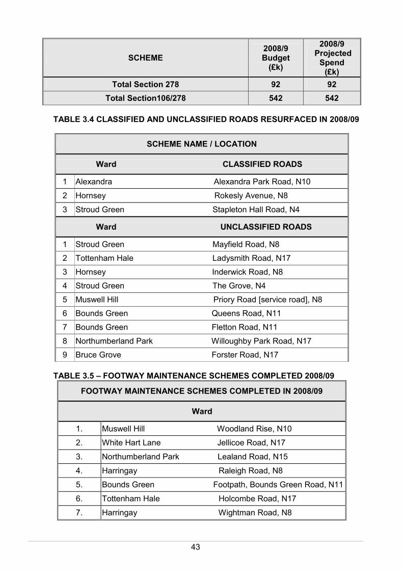
Total Section 278 92 92
Total Section106/278 542 542
TABLE 3.4 CLASSIFIED AND UNCLASSIFIED ROADS RESURFACED IN 2008/09
SCHEME NAME / LOCATION
Ward CLASSIFIED ROADS
1 Alexandra Alexandra Park Road, N10
2 Hornsey Rokesly Avenue, N8
3 Stroud Green Stapleton Hall Road, N4
Ward UNCLASSIFIED ROADS
1 Stroud Green Mayfield Road, N8
2 Tottenham Hale Ladysmith Road, N17
3 Hornsey Inderwick Road, N8
4 Stroud Green The Grove, N4
5 Muswell Hill Priory Road [service road], N8
6 Bounds Green Queens Road, N11
7 Bounds Green Fletton Road, N11
8 Northumberland Park Willoughby Park Road, N17
9 Bruce Grove Forster Road, N17
TABLE 3.5 – FOOTWAY MAINTENANCE SCHEMES COMPLETED 2008/09
FOOTWAY MAINTENANCE SCHEMES COMPLETED IN 2008/09
Ward
1. Muswell Hill Woodland Rise, N10
2. White Hart Lane Jellicoe Road, N17
3. Northumberland Park Lealand Road, N15
4. Harringay Raleigh Road, N8
5. Bounds Green Footpath, Bounds Green Road, N11
6. Tottenham Hale Holcombe Road, N17
7. Harringay Wightman Road, N8

44
8. Northumberland Road Park Lane, N17
9. St. Ann’s Etherley Road, N15
10. Highgate Highgate Avenue, N6
11. Seven Sisters Crowland Road, N15
12. Seven Sisters Wargrave Road, N15
13. Hornsey/Stroud Green Inderwick Road, N8
14. Bounds Green Nightingale Road, N22
15. Seven Sisters Ferndale Road, N15
16. Hornsey Hillfield Avenue, N8
17. Fortis Green Bancroft Avenue, N2
18. Northumberland Park Northumberland Park, N17
19. Bounds Green Palmerston Road, N22
20. Tottenham Hale Rycroft Way, N17
TABLE 3.6– FLOODING ALLEVIATED AND GULLY REPLACEMENT LOCATIONS DURING 2008/09
Road Name Ward
Moselle Brook, N17 White Hart Lane
High Road, N22 Noel Park & Woodside
Ferry Lane, N15 Tottenham Hale
High Road, N17 Northumberland Park
Lancaster Road, N15 Stroud Green
Mark Road, N22 Noel Park
Crawley Road, N15 West Green
Nightingale Lane N8 Hornsey
Rangemoor Road N15 Tottenham Green
Fortis Green Road, N10 Fortis Green
TABLE 3.7– DETAILS OF POTHOLES REPAIRED IN INDIVIDUAL WARDS DURING 2008/09 (update as at January 2009)
Ward Number of potholes identified and
repaired
Highgate 265
Muswell Hill 100
Crouch End 130
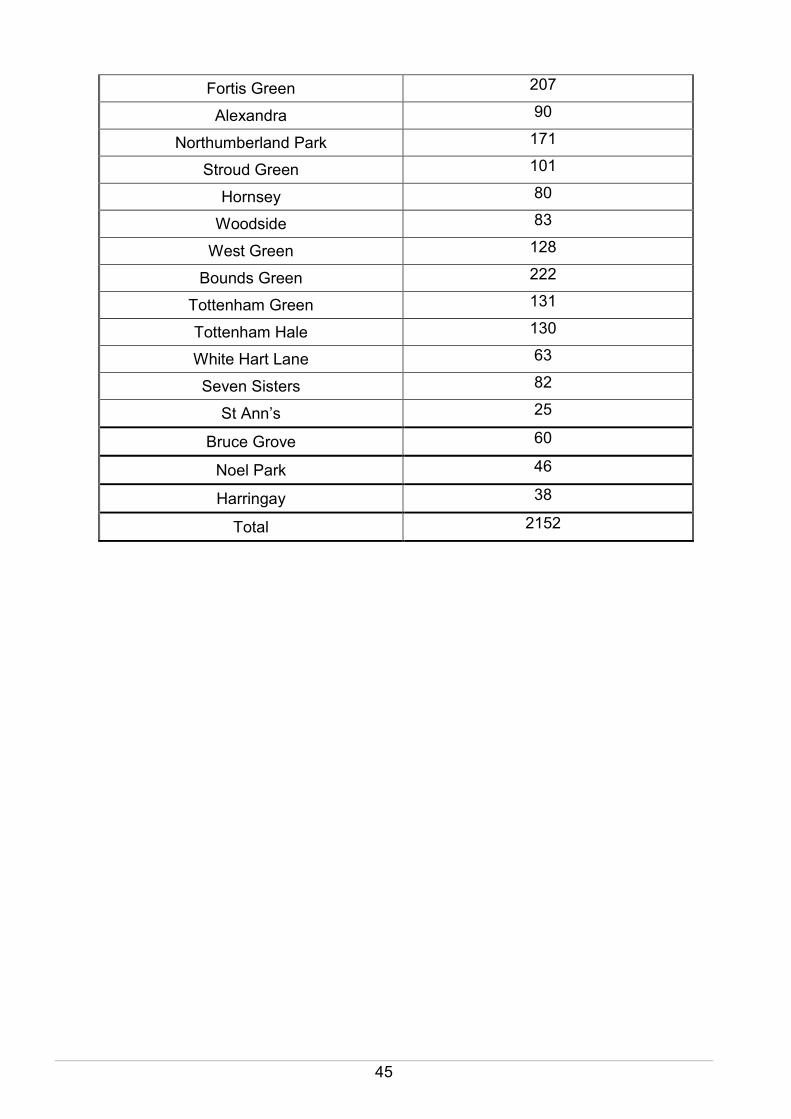
45
Fortis Green 207
Alexandra 90
Northumberland Park 171
Stroud Green 101
Hornsey 80
Woodside 83
West Green 128
Bounds Green 222
Tottenham Green 131
Tottenham Hale 130
White Hart Lane 63
Seven Sisters 82
St Ann’s 25
Bruce Grove 60
Noel Park 46
Harringay 38
Total 2152

46
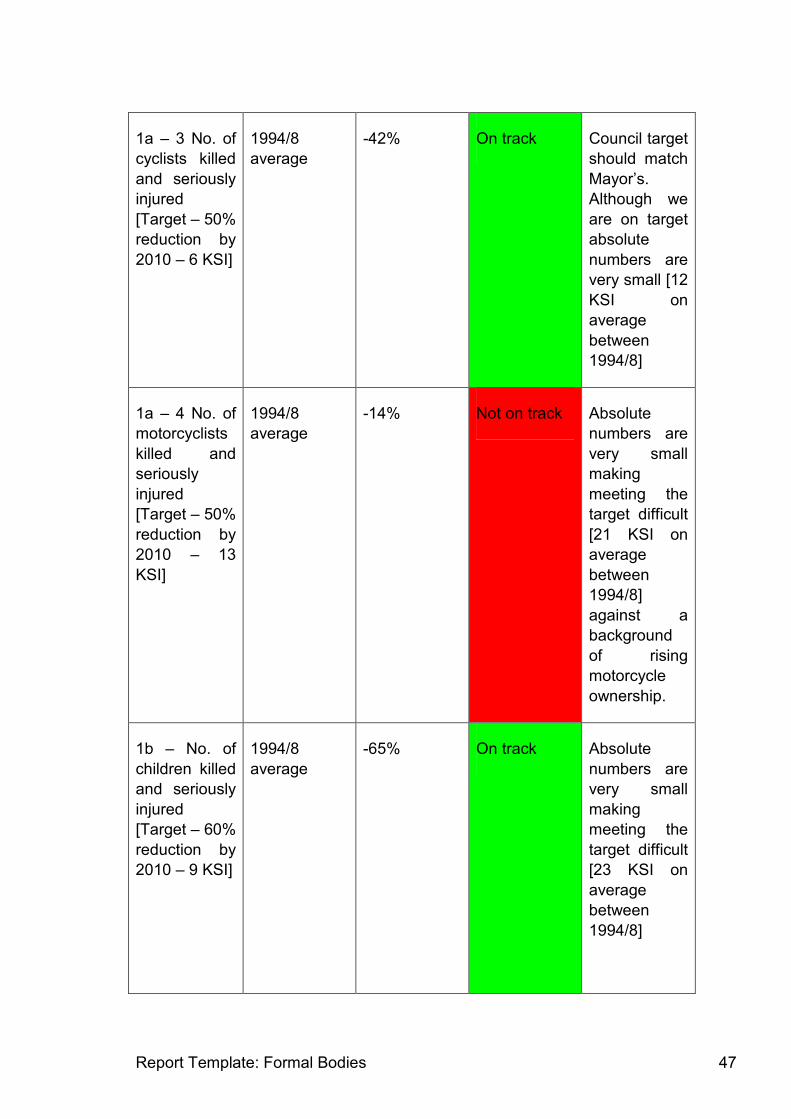
15 Appendix 7: Progress against Mayoral Targets
TfL report Borough progress against MTS performance indicators. The report covers 2007 or 2007/8 as appropriate and relates to 14 performance indicators as detailed below. In summary, we are on track or have met 11 of the 14 PIs. Of those that are not on track, the number of motorcyclists killed and seriously injured are small in absolute number [18 in 2007], making meeting the target a challenge in the context on rising motorcycle usage in inner London. The shortfall in funding for principal road network has meant that schemes for Wood Green High Road, Westbury Avenue and Watermead Way will not be progressed in 2009/10 nor West Green Road in 2008/9.
1. Improving road safety
Base year Change since
baseline
Progress
against linear
trajectory and
Mayor’s
target
Comments
1a – 1 No. of
people killed
and seriously
injured
[Target – 50%
reduction by
2010 – 80
KSI]
1994/8
average
-51% On track Council target
should match
Mayor’s
1a – 2 No. of
pedestrians
killed and
seriously
injured
[Target – 50%
reduction by
2010 – 33
KSI]
1994/8
average
-49% On track Council target
should match
Mayor’s
Report Template: Formal Bodies 47
1a – 3 No. of
cyclists killed
and seriously
injured
[Target – 50%
reduction by
2010 – 6 KSI]
1994/8
average
-42% On track Council target
should match
Mayor’s.
Although we
are on target
absolute
numbers are
very small [12
KSI on
average
between
1994/8]
1a – 4 No. of
motorcyclists
killed and
seriously
injured
[Target – 50%
reduction by
2010 – 13
KSI]
1994/8
average
-14% Not on track Absolute
numbers are
very small
making
meeting the
target difficult
[21 KSI on
average
between
1994/8]
against a
background
of rising
motorcycle
ownership.
1b – No. of
children killed
and seriously
injured
[Target – 60%
reduction by
2010 – 9 KSI]
1994/8
average
-65% On track Absolute
numbers are
very small
making
meeting the
target difficult
[23 KSI on
average
between
1994/8]

Report Template: Formal Bodies 48
1c – No. of
slight
casualties
[Target – 25%
reduction by
2010 – 758
slight]
1994/8
average
-30% On track Council target
should match
Mayor’s.
2 No. of
primary and
secondary
schools with
travel plans in
place [ Target
– 100% of
schools by
2008]
2004/5 94 Met Previous
years
assessment
has been
based on no.
of travel
plans in place
as well as no.
of plans
reviewed.
2. Improving bus journey time and reliability
3. Bus excess
wait time on
high
frequency
routes [Target
– 1.3 minutes
by 2009/10]
2000/1 1.1 On track London-wide
target.
Boroughs not
required to
report
borough
specific data.
4.1 Average
bus journey
time on LBI
routes within
the Borough –
AM peak
[Target –
reduce of
maintain at
2005 levels,
bus journey
times on LBI
2005 On track Only data for
one route [5
routes in LBI];
issue that
performance
is not directly
influenced by
an individual
borough – eg
delays to a
route may
occur in

Report Template: Formal Bodies 49
routes] adjoining
boroughs;
utility road
works can
delay buses
but is largely
outside our
control.
4.2 Average
bus journey
time on LBI
routes within
the Borough –
Interpeak
[Target –
reduce of
maintain at
2005 levels,
bus journey
times on LBI
routes]
2005 On track Comment as
above.
4.3 Average
bus journey
time on LBI
routes within
the Borough –
PM peak
[Target –
reduce of
maintain at
2005 levels,
bus journey
times on LBI
routes]
2005 Not on track Comment as
above
3. Relieve traffic congestion and improve journey time
5.1 Traffic
volume
[million veh-
2001 3% On track TfL
considered
Haringey an

Report Template: Formal Bodies 50
kms] in
Borough
[Target –
reduction in
growth in
outer London
of a third ie
5% growth
between 2001
and 2011]
Inner London
borough in
our
preparation of
the LIP and
hence were
required to
achieve zero
traffic growth;
TfL are now
stating we
are an Outer
London
borough and
therefore
have a target
of 5% growth.
5.2 Traffic
volume
[million veh
kms] in
Metropolitan
town centres
[Target – zero
growth in
veh/kms
between 2001
and 2011
2001 See
comment;
traffic volume
increased
between
2004 and
2005.
See comment Data not
available on
veh/kms for
town centres.
TfL provided
data on
absolute
traffic
volumes for
Wood Green
based on
counts for our
interpretation
7. Proportion
of personal
travel made
by mode
[Target to
maintain or
increase the
proportion of
personal
travel made
by means
2008 [73%] See comment N/A 2008 is the
first year for
which data is
available.
London
Travel
Demand
Survey
[LTDS] being
used.

Report Template: Formal Bodies 51
other than the
car]
8. No. of
schools
where review
of travel has
been
completed
[Target – to
review all
schools by
March 2008]
2004/5 94 Met Performance
should be
amended to
95 as there is
an additional
school
5. Accessibility and social inclusion on the transport network
2008; trip
rate per
person for
trips on
public
transport by
disabled
people – 0.45
See comment N/A Date based
on LTDS.
The data
collected is
absolute
numbers and
trip rate and
not the
proportion.
Absolute
survey
numbers are
very low.
10. Trips
made by
equality and
inclusion
target groups
under
represented
in the public
transport
market
[Target – TfL
and boroughs
are to achieve
year-on year
improvements
in the
proportion of
trips made by
equality and
inclusion
target groups
particularly
disabled
2008; trip
rate per
person for
trips on
public
transport by
older people
– 0.79
See comment N/A As above

Report Template: Formal Bodies 52
people and
women
travelling at
night]
2008; trip
rate per
person for
trips on
public
transport by
women
between
19.00 and
07.00 – 0.09
See comment N/A As above;
data should
relate to
women
travelling
alone to be of
use but this is
not stated
6. Encourage walking by improving the street environment
12. TfL and
boroughs are
to achieve an
increase of at
least 10% in
journeys
made on foot
per person in
London
between
2001 and
2015 [Target
of 280 trips
per person on
foot by 2015]
2008; 267
trips
N/A N/A Target based
on linear
trajectory of
5% increase
between
2008 and
2015 due to
lack of earlier
data. Data
from LTDS.
7. Encourage cycling by improving the street environment
13. TfL and
boroughs are
to achieve an
increase of at
least 80% in
cycling in
London
between
2001 and
2015 [Target
2008; 2.7
million cycle
trips per
annum
N/A N/A Target based
on linear
trajectory of
40% increase
between
2008 and
2015 due to
lack of earlier
data. Data
from LTDS

Report Template: Formal Bodies 53
of 3.8 million
trips per
annum]
8. Bringing transport infrastructure to a state of good repair
14. TfL and
boroughs are
to bring all A
roads and
Busy Bus
Routes up to
serviceable
standard
[Target -
UKPMS
score of <70
by 2010 for
all A roads
and Busy Bus
Routes]
2003/4 based
on Coarse
Visual
Inspection
[CVI] –
10.25%
- 4.75% Not on track Data based
on A roads
only. We are
heavily reliant
on TfL
funding
through the
LIP funding
submission.
Allocations
against bids
over the last
3 years have
been on
average 38%
leading to an
increasing
backlog to
resurfacing of
principal
roads.