On folds and thrusts affecting the Coppermine River Group ...
9
On folds and thrusts affecting the Coppermine River Group, northwestern Canadian Shield1 i R. S. HILDEBRAND AND W. R. A. BARAGAR Continental Geoscience Division, Geological Survey of Canada, 588 Booth Street, Ottawa, Ont., Canada KIA 0E4 Received August 5, 1990 Revision accepted December 17, 1990 Examination of existing geological and aeromagnetic maps of the Coppermine homocline reveals two periods of deformation which affect rocks of the Coppermine River Group but predate rocks of the Rae Group. The oldest event generated easterly- trending folds and southerly-vergentthrust faults and is probably related to events along the northern margin of Laurentia. The younger event caused northerly-trendingfolds, possibly correlates with an east-west compressional event seen in the subsurface of the Interior Plains, and was likely a result of plate interactions along the western margin of Laurentia. Both deformational events that affect the Coppermine homocline are younger than 1267 Ma and are not correlative with the pre-1268 Ma Racklan orogeny of the northern Cordillera. L'examen des cartes gCologiques et aCromagnttiques existentes de l'homoclinal de Coppermine rCvble deux ptriodes de &formation qui affecerent les roches du Groupe de Coppermine River, mais -tent les roches du Group de Rae. L'CvCnement le plus ancien a cr& des plis de direction est, et des failles de chevauchement de vergence sud, et il est probablement reliC aux Cvtnements survenus le long de la marge nord du Laurentia. L'CvCnement le plus jeune a engendre des plis de direction nord, qui peuvent Ctre corrtlCs avec un tvCnement en rCgime de compression est-ouest, observe en subsurface dans les Plaines de I'IntCrieur; lequel rCsulte vraisemblablement d'interactions de plaques le long de la marge occidentale du Laurentia. Ces deux CvCnements de dtformation qui ont perturb6 l'homoclinal de Coppermine sont plus jeunes que 1267 Ma, et ils ne sont pas corrtlables avec l'orogbne de Racklan de la Cordillbre septentrionale. [Traduit par la rkdaction] Can. J. Earth Sci. 28, 523-531 (1991) Introduction The 1.7-0.7 Ga Proterozoic successions of the northwestern Canadian Shield and northern Cordillera are important to our understanding of the development of North America because they provide one of the few records of sedimentation, vol- canism, and deformation which postdate the main amalgamation of the Laurentian supercontinent (Hoffman 1989) but predate, or are synchronous with, its breakup. Middle to Late Proterozoic successions of northwestern Canada are exposed mainly within the Coppennine homocline, the Brock inlier, the Minto inlier on Victoria Island, the Bathurst Inlet area, and in the northern Cordillera (Fig. 1). Young et al. (1979) correlated and divided the successions into three sequences: A, B, and C. The oldest sequence (A) includes rocks of the Wernecke Supergroup within the Cordil- lera and the Hornby Bay, Dismal Lakes, and Coppermine River groups of the Coppermine homocline. In the Cordillera, rocks of the Wernecke Supergroup were metamorphosed to greens- chist facies and deformed during the RacMan orogeny (Gabri- else 1967; Young et al. 1979). Rocks of sequence B, which in the Cordillera sit unconformably upon the deformed rocks of sequence A, include the Pinguicula Group and the Mackenzie Mountains supergroup of the Cordillera, the Shaler Group of Victoria Island, and the Rae Group of the Coppermine homo- cline. Rocks of unit C include rocks of the Windermere Supergroup within the Cordillera (Jefferson and Parrish 1989), the Coronation sills of the Coppermine homocline, and the Natkusiak flows and related sills on Victoria Island. Examination of seismic reflection data from the Interior Plains, located between the Coppermine homocline and the northern Cordillera, suggests the presence of a thin-skinned, easterly-vergent, thrust-fold belt in the subsurface that affects rocks of sequence A but predates those of sequence B (Cook 1988a, 1988b). Accordingly, Cook tentatively correlated the '~eolo~ical Survey of Canada Contribution 15190. east-west compressional event with the Racklan orogeny of the Cordillera. More recently, Cook and Mayers (1990) examined additional seismic data through the same area, but did not recognize thrust faults of the magnitude proposed by F. A. Cook. However, they also found evidence for an east-west compressional event that deforms strata of sequence A. Compilation of a new 1 : 500 000 scale map of northern Wopmay orogen and the Coppermine homocline focused our attention on compressional structures within the homocline that, like those beneath the Interior Plains, postdate rocks of the Coppermine River Group (upper sequence A) but predate those of the Rae Group (sequence B). Thus, Middle to Late Proterozoic deformational events are possibly more widespread than previously thought. In this paper we discuss the evidence for compressional deformation affecting rocks of the Copper- mine River Group and explore the possibility that they are related to events of the Interior Plains and northern Cordillera. General geology Rocks of the Coppermine homocline unconformably overlie Archean rocks of the Slave Province and 2.2-1.8 Ga. rocks of Wopmay orogen (Fig. 1). They comprise four distinct packages of supracrustal rocks separated by unconformities: the Hornby Bay Group, the Dismal Lakes Group, the Coppermine River Group, and the Rae Group, in ascending order (Baragar and Donaldson 1973). The Hornby Bay and Dismal Lakes groups (Fig. 2) are both clastic to carbonate sequences. The Hornby Bay Group com- prises coarse-grained siliciclastic sedimentary rocks deposited in fault-bounded graben, overlain by westward-thickening fluvial-peritidal deposits (Ross 1983). Volcanic and associated hypabyssal intrusive rocks in the upper part of the group have a U-Pb zircon age of 1663 f 8 Ma (Bowring and Ross 1985). The overlying Dismal Lakes Group passes upwards from siliciclastic rocks at its base to carbonates, all of which were deposited upon a northwesterly-facing fluviomarine shelf
Transcript of On folds and thrusts affecting the Coppermine River Group ...
On folds and thrusts affecting the Coppermine River Group, northwestern Canadian Shield1
i R. S. HILDEBRAND AND W. R. A. BARAGAR
Continental Geoscience Division, Geological Survey of Canada, 588 Booth Street, Ottawa, Ont., Canada KIA 0E4 Received August 5, 1990
Revision accepted December 17, 1990
Examination of existing geological and aeromagnetic maps of the Coppermine homocline reveals two periods of deformation which affect rocks of the Coppermine River Group but predate rocks of the Rae Group. The oldest event generated easterly- trending folds and southerly-vergent thrust faults and is probably related to events along the northern margin of Laurentia. The younger event caused northerly-trending folds, possibly correlates with an east-west compressional event seen in the subsurface of the Interior Plains, and was likely a result of plate interactions along the western margin of Laurentia. Both deformational events that affect the Coppermine homocline are younger than 1267 Ma and are not correlative with the pre-1268 Ma Racklan orogeny of the northern Cordillera.
L'examen des cartes gCologiques et aCromagnttiques existentes de l'homoclinal de Coppermine rCvble deux ptriodes de &formation qui affecerent les roches du Groupe de Coppermine River, mais -tent les roches du Group de Rae. L'CvCnement le plus ancien a cr& des plis de direction est, et des failles de chevauchement de vergence sud, et il est probablement reliC aux Cvtnements survenus le long de la marge nord du Laurentia. L'CvCnement le plus jeune a engendre des plis de direction nord, qui peuvent Ctre corrtlCs avec un tvCnement en rCgime de compression est-ouest, observe en subsurface dans les Plaines de I'IntCrieur; lequel rCsulte vraisemblablement d'interactions de plaques le long de la marge occidentale du Laurentia. Ces deux CvCnements de dtformation qui ont perturb6 l'homoclinal de Coppermine sont plus jeunes que 1267 Ma, et ils ne sont pas corrtlables avec l'orogbne de Racklan de la Cordillbre septentrionale.
[Traduit par la rkdaction] Can. J. Earth Sci. 28, 523-531 (1991)
Introduction The 1.7-0.7 Ga Proterozoic successions of the northwestern
Canadian Shield and northern Cordillera are important to our understanding of the development of North America because they provide one of the few records of sedimentation, vol- canism, and deformation which postdate the main amalgamation of the Laurentian supercontinent (Hoffman 1989) but predate, or are synchronous with, its breakup. Middle to Late Proterozoic successions of northwestern Canada are exposed mainly within the Coppennine homocline, the Brock inlier, the Minto inlier on Victoria Island, the Bathurst Inlet area, and in the northern Cordillera (Fig. 1).
Young et al. (1979) correlated and divided the successions into three sequences: A, B, and C. The oldest sequence (A) includes rocks of the Wernecke Supergroup within the Cordil- lera and the Hornby Bay, Dismal Lakes, and Coppermine River groups of the Coppermine homocline. In the Cordillera, rocks of the Wernecke Supergroup were metamorphosed to greens- chist facies and deformed during the RacMan orogeny (Gabri- else 1967; Young et al. 1979). Rocks of sequence B, which in the Cordillera sit unconformably upon the deformed rocks of sequence A, include the Pinguicula Group and the Mackenzie Mountains supergroup of the Cordillera, the Shaler Group of Victoria Island, and the Rae Group of the Coppermine homo- cline. Rocks of unit C include rocks of the Windermere Supergroup within the Cordillera (Jefferson and Parrish 1989), the Coronation sills of the Coppermine homocline, and the Natkusiak flows and related sills on Victoria Island.
Examination of seismic reflection data from the Interior Plains, located between the Coppermine homocline and the northern Cordillera, suggests the presence of a thin-skinned, easterly-vergent, thrust-fold belt in the subsurface that affects rocks of sequence A but predates those of sequence B (Cook 1988a, 1988b). Accordingly, Cook tentatively correlated the
'~eolo~ical Survey of Canada Contribution 15190.
east-west compressional event with the Racklan orogeny of the Cordillera. More recently, Cook and Mayers (1990) examined additional seismic data through the same area, but did not recognize thrust faults of the magnitude proposed by F. A. Cook. However, they also found evidence for an east-west compressional event that deforms strata of sequence A.
Compilation of a new 1 : 500 000 scale map of northern Wopmay orogen and the Coppermine homocline focused our attention on compressional structures within the homocline that, like those beneath the Interior Plains, postdate rocks of the Coppermine River Group (upper sequence A) but predate those of the Rae Group (sequence B). Thus, Middle to Late Proterozoic deformational events are possibly more widespread than previously thought. In this paper we discuss the evidence for compressional deformation affecting rocks of the Copper- mine River Group and explore the possibility that they are related to events of the Interior Plains and northern Cordillera.
General geology Rocks of the Coppermine homocline unconformably overlie
Archean rocks of the Slave Province and 2.2-1.8 Ga. rocks of Wopmay orogen (Fig. 1). They comprise four distinct packages of supracrustal rocks separated by unconformities: the Hornby Bay Group, the Dismal Lakes Group, the Coppermine River Group, and the Rae Group, in ascending order (Baragar and Donaldson 1973).
The Hornby Bay and Dismal Lakes groups (Fig. 2) are both clastic to carbonate sequences. The Hornby Bay Group com- prises coarse-grained siliciclastic sedimentary rocks deposited in fault-bounded graben, overlain by westward-thickening fluvial-peritidal deposits (Ross 1983). Volcanic and associated hypabyssal intrusive rocks in the upper part of the group have a U-Pb zircon age of 1663 f 8 Ma (Bowring and Ross 1985). The overlying Dismal Lakes Group passes upwards from siliciclastic rocks at its base to carbonates, all of which were deposited upon a northwesterly-facing fluviomarine shelf

524 CAN. J. EARTH SCI. VOL. 28. 1991
FIG. 1. Map of the northwestern Canadian Shield and northern Cordillera after Young et al. (1979) and Hoffman (1989), showing the distribution of the Middle-Late Proterozoic sequences. The location of Fig. 2 is outlined. B, Bathurst Inlet.
(Kerans et al. 1981; Kerans 1983). Well-developed karst in the upper part of the group was argued by Kerans (1983) to have developed during regional uplift consequent to emplacement of the Muskox intrusion because the karst is approximately centred over the intrusion.
Rocks of the Coppermine River Group are divided into two formations: a thick sequence of flood basalts termed the Copper Creek Formation, overlain by a mixed sequence of sandstone, siltstone, and basaltic lava flows collectively named the Husky Creek Formation (Baragar and Donaldson 1973). Lavas of the Coppernine River Group and their intrusive equivalents, the Muskox intrusion and the Mackenzie dyke swarm, constitute one of the most voluminous and widespread episodes of continental basaltic magmatism of any age (Fahrig and Jones 1969; Fahng 1987; LeCheminant and Hearnan 1989). Magmatism spanned only a few million years with the Muskox intrusion being emplaced at 1270 2 4 Ma and the Mackenzie dyke swarm at 1267 2 2 Ma (LeCheminant and Heaman 1989). Basaltic lavas of the group are not precisely dated but are compositionally similar to the intrusions and were obviously fed by them (Baragar 1969).
The Rae Group, comprising sandstones, shales, and car- bonates, caps the sequence and is profusely intruded by
gabbroic sheets known as the Coronation Sills (Baragar and Donaldson 1973; Campbell 1983). One of the Coronation Sills and three of their presumed correlatives, which cut the Shaler Group on Victoria Island, were recently dated as 723 k 3 Ma (Heaman et al. 1990).
The uppermost units of the Coppermine homocline are Paleozoic sedimentary rocks. They were originally considered to be part of the Rae Group but were found to be fossiliferous by Dixon (1979) and Campbell (1983).
Coppermine River Group The Coppermine River Group comprises 2-3.5 krn of ,
tholeiitic plateau basalts, collectively termed the Copper Creek Formation, and an overlying succession of red-coloured sandstones with intercalated basaltic lava flows, termed the 1 Husky Creek Formation (Baragar and Donaldson 1973). The Copper Creek Formation is mostly a monotonous succession of up to 150 basalt flows which ranging in thickness from 4 to 300 m. Individual flows were traced for at least 16 krn along strike, but they may be more extensive. Rare pillowed flows and pyroclastic rocks occur in the lower part of the formation.
The chemistry of the basalts was documented by Baragar (1969) and Dostal et al. (1983). Overall, the basalts are typical

HILDEBRAND AND BARAGAR 525

526 CAN. J. EARTH SCI. VOL. 28. 1991
continental tholeiites with low Ni, Cr, and Mg/Fe, suggesting that they were fractionated prior to eruption. They contain relatively high abundances of incompatible elements and have geochemical signatures indicative of contamination by con- tinental crust. Furthermore, the lavas show regular mineralogical and chemical variations with stratigraphic level. For example, SiO,, Cr, Ni, and MgO decrease and FeO, TiO,, Fe-Ti oxides, and K20 increase upwards through the section. This relation- ship, the overall compositional similarity, and the spatial and temporal proximity of lavas to the Muskox intrusion were used to suggest that the intrusion was a crustal reservoir in which the magmas were stored prior to eruption (Dostal et al. 1983).
The Husky Creek Formation comprises about 1 km of cross-bedded sandstone, siltstone, basaltic lavas, and minor mud-chip conglomerate. The basaltic lavas occur mainly in the upper part of the exposed sequence and are compositionally similar to those of the lower Copper Creek Formation. The sedimentary rocks are compositionally and texturally immature, with 10-30% hematite grains. Desiccation features are common (Campbell 1983). Limited paleocurrent data (Campbell 1983) suggest that rocks of the formation were deposited in a south- westerly-trending valley.
Structure The Coppermine homocline is generally considered to be a
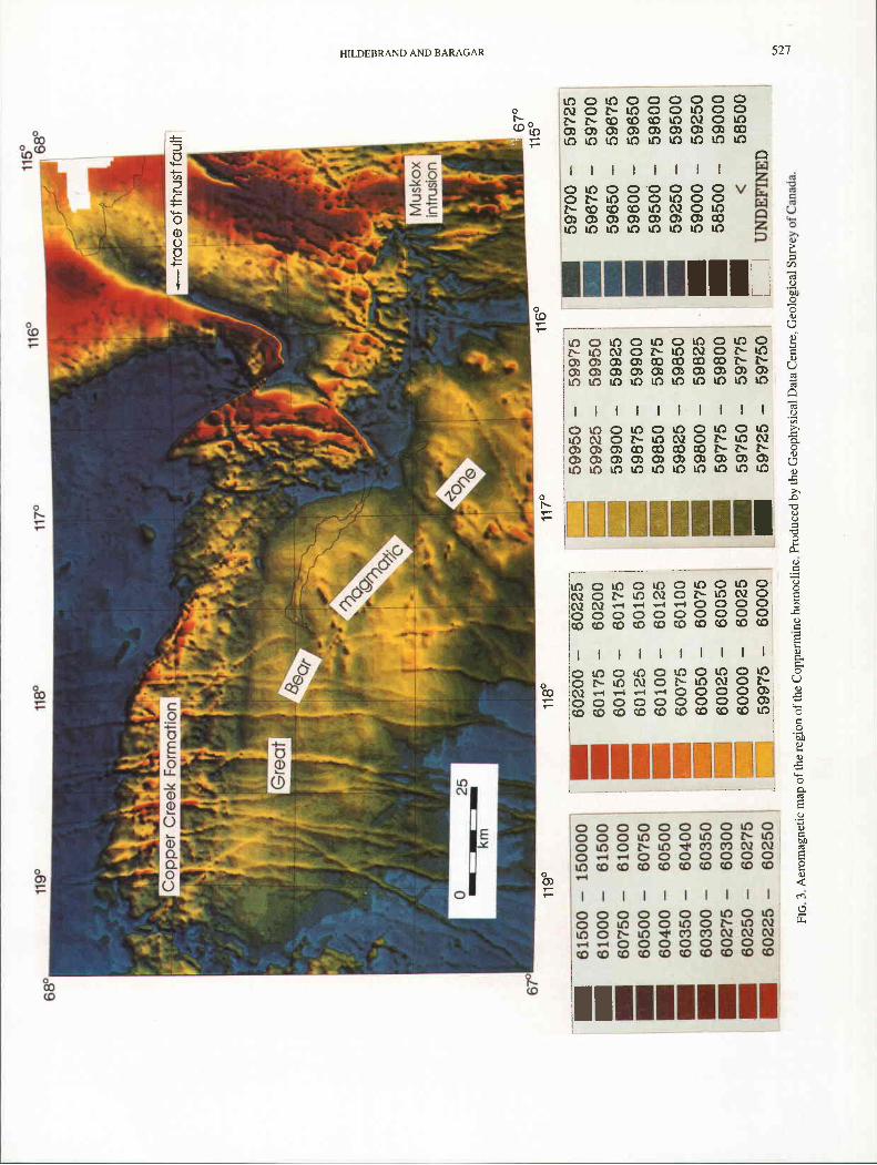
simple tilted block, as its name implies. However, this is not the case, as there are faults and folds of many ages (Baragar and Donaldson 1973; Ross and Kerans 1990). In this paper we consider only structures that postdate rocks of the Coppermine River Group and predate rocks of the Rae Group. Our discus- sion relies on recompilation of existing geological maps, reexamination of field notes, and analysis of aeromagnetic maps of the region. Aeromagnetic maps (Fig. 3) are particularly useful because lavas of the Copper Creek Formation, except for the stratigraphically lowest flows, which contain lesser amounts of Fe-Ti oxides relative to those at higher stratigraphic levels (Baragar 1969; Baragar and Robertson 1973; Dostal et al. 1983), have a high magnetic intensity, whereas rocks of the Husky Creek Formation and Hornby Bay and Dismal Lakes groups have relatively low magnetic intensities. At first glance it might appear that rocks of the Hornby Bay and Dismal Lakes groups have a reasonably high magnetic intensity; however, the broad northwesterly-trending high in that area is a continuation of the aeromagnetic high related to the Great Bear magmatic zone of Wopmay orogen, rocks of which peek through the Hornby Bay Group. Furthermore, the thin magnetically low strip between the magnetic highs of the Great Bear magmatic zone and the Copper Creek Formation is known to coincide with outcrops of the Dismal Lakes Group. North of the Copper- mine River Group, younger cover rocks appear to have little effect on the aeromagnetic signatures, except to diffuse gradi- ents slightly. Thus, we are able to extrapolate for some distance beneath the younger cover.
Although it has long been recognized that rocks of the Coppermine homocline are broadly folded, little regional significance was given to the deformation (Baragar and Donald- son 1973; Dostal et al. 1983;). Our reexamination of the existing maps prompted us to reevaluate two sets of folds and one group of faults that are temporally bounded by the Copper- mine River and Rae groups. The two sets of folds that affect rocks of the Coppermine River Group are orthogonal to one another: the older is easterly trending and the younger northerly
trending. The faults appear to postdate the earlier folds but predate the younger folds.
Easterly -trending folds The easterly-trending folds are broad open structures with
wavelengths of about 80 km and little, if any, plunge. The most northerly of the older easterly-trending fold set is an open syncline with limb dips generally between 5" and 10". It is difficult to discern, as its axis and northern limb are, for the most part, covered by rocks of the Rae Group. However, the axial trace and the lower contact of the lavas on the northern limb are exposed in one fault block (Fig. 2). Although only a short portion of the northern contact is exposed, it can be inferred beneath the younger cover west of the fault block because the inflection point between the aeromagnetic high, characteristic of the lavas, and the aeromagnetic low, charac- teristic of the older sedimentary units, closely approximates the position of the contact between them. The syncline is strongly asymmetrical, with about 1-1.5 km of section on the northern limb and about 3 km present on the southern. The disparity in thicknesses might be explained by (1) southward-directed thrusting of rocks of the Dismal Lakes Group over rocks of the Copper Creek Group, (2) southward tilting and erosion after deposition, (3) the filling of an already existing basin that deepened to the south, or (4) eruption into a basin that was actively subsiding.
The thrust model is unlikely because the contacts between lavas of the Copper Creek Formation and sedimentary rocks of the Dismal Lakes Group are exposed on both limbs of the fold and there is no evidence that they are anything but depositional. If lavas stratigraphically above the contact on the north limb of the fold are lower lavas, as they seemed to be on visual inspec- tion in the field, then progressive northward onlap, which should place stratigraphically higher lavas at the contact, is unlikely. Consequently, model 2, in which the thickness variations were generated by uplift and erosion in the north with consequent erosion of the upper part of the lava plateau, appears to be the most likely alternative. In fact, the abundant hematite grains of the Husky Creek Formation may have been derived from the underlying lavas. However, we cannot rule out the possibility that at least some of the thickness variation is due to nondeposition at some time during the formation of the lava plateau. A useful test would be to collect and analyze samples of the lavas on the north limb of the syncline, because in all other sections examined there are systematic compositional variations with time.
North of the syncline there is no evidence on available aeromagnetic maps for any rocks with the high magnetic intensities of the lavas (Fig. 3). This suggests that there are no lavas preserved north of the syncline. The magnetic data are compatible with that area being underlain by rocks such as occur within either the Dismal Lakes or Hornby Bay groups. Whether this is due to complete erosion of the lavas in that area prior to folding or the result of folding and later faulting is unclear.
Thrust faults Several faults cut rocks of the Coppermine River Group but
do not appear to displace rocks of the Rae Group. The most interesting of these is a large U-shaped fault located about 60 km northwest of the Muskox intrusion (Fig. 2). The fault has a pronounced magnetic signature and can therefore be traced for considerable distances beneath the overlying Rae Group (Fig.

CAN 1. EARTH SCI VOL 28, 1991
FIG. 4. Detailed geological map of the area surrounding the proposed thrust fault. Modified from Baragar and Donaldson (1973).
3). It places lavas of the Copper Creek Formation on top of rocks of the younger Husky Creek Formation. On the basis of paleomagnetic evidence, Baragar and Robertson (1973) demon- strated that lavas north of the fault were rotated about 28" counterclockwise relative to those south of the fault and interpreted the fault to be the result of buckling due to magma withdrawal. However, on recently published aeromagnetic maps the fault can be traced well to the north beneath rocks of the Rae Group, which makes a reinterpretation necessary. Because the fault trace is concave northward, as is bedding south of the fault, and because it places older rocks upon younger rocks, we interpret it as a thrust fault.
Rucks 111 Ihr lower platc generally dip genlly nc)rth\h:ard except just beneath the fault itself whurc they fnml an ea\~urly- trcnding f(wtwall syncline (Fig. 1) with boutherly dips rrn thc nc~rthcrn limb up to 4O". Baaalts in the upper plaie dip gent]! snulh to sourht'ahterly. 111 the wcsr. the fault cleiirly cut\ downsection ilorlhwcstward, as drinonatrii~rJ b! ~ h c truncalrd strikes and thc cutol'js o C bedding within rock\ of thc Husky Creek I;ortnalion. I111 i l k .;ourhem and eastern li~nbh i t appeara to be concordant with the strike of bedding in the H u A y Creek Formation. 'This suggests a snutherly to ea~lerly dirrciion o f movement.
As stated above. the thruar Riult is iriterprctcd to correspond to an ohvioux steep gradient in the ileromagne~ic pattern of the rcgion (Fig. 3) and can he traced nonhwrvd ~ ' C I I . many kilornrlrrs beneath the younger cover. Within the buried portion of the thrusl sheet there i s mother aero~nagnetic gradient. low lo rtir north and west. high 10 thc south and curt. Ths high cr~rrrhponds to middle and upper lavas of the Copper Crurk Fornlation. The low could represent rocks of the Huaky Creek Fomintic~n, Rae. Dismal 1,akes. and Hornby Ray groups, as well as the lower-
most flows of the Copper Creek Formation, which are all typified by relatively low magnetic intensities. Because dips in the thrust plate are southward, the region of low magnetic intensity probably represents rocks of the lower Copper Creek Formation and the stratigraphically subjacent Dismal Lakes and Hornby Bay groups.
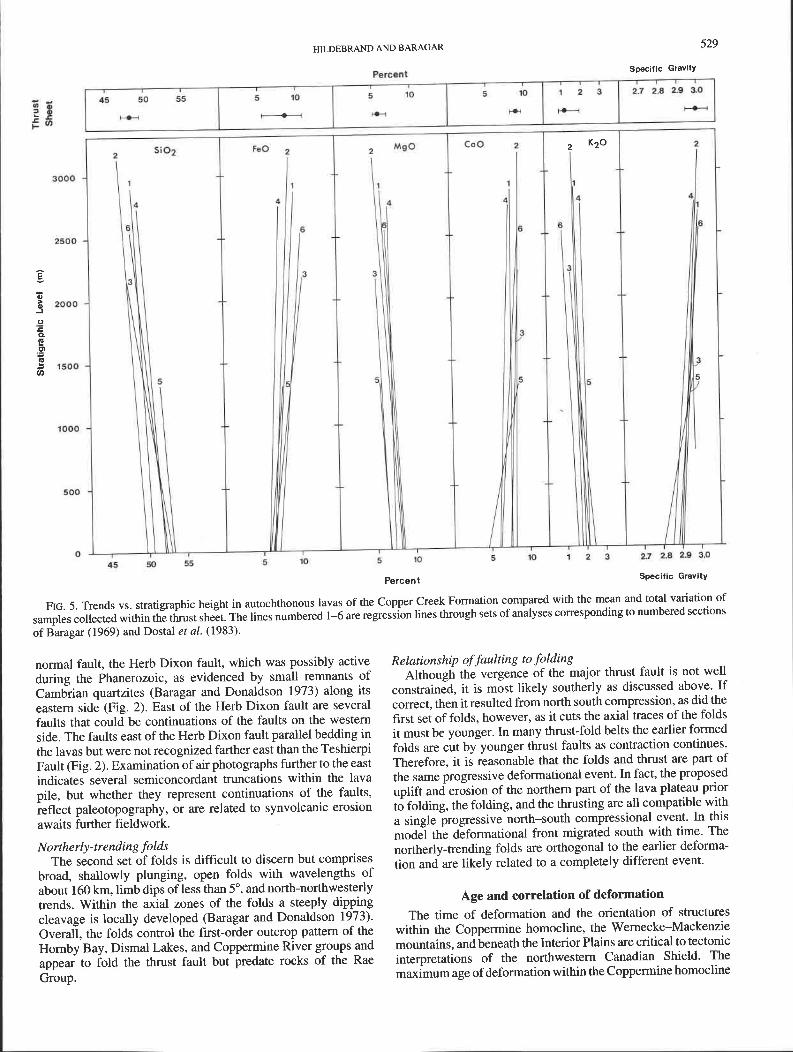
The minimum stratigraphic displacement on the fault can be estimated by using the systematic chemical variations within the lavas. Figure 5 shows trends measured in samples collected from six sections of the basalts. It also shows the total variation and mean for samples collected from the thrust sheet. The lavas of the thrust sheet most closely resemble those from the upper third of the main lava plateau. Thus, there could be a kilometre of vertical movement on the fault.
If we assume southerly vergence, that the lavas came from the upper third of the pile, and that the inflection in the magnet- ic pattern within the thrust sheet represents the basal contact of the lavas as to the west, then by projecting this contact eastward there is a minimum of 45 km of horizontal movement on the fault, based on the distance between the contact within the thrust sheet and the projected contact. If the vergence on the fault is easterly, then the minimum amount of horizontal movement is in excess of 160 km, for to the west there is continuous expo- sure of the lavas for that distance and no evidence of a footwall cutoff. Because 160 krn is a large amount of movement for a thrust fault in subgreenschist-facies rocks, we favour a generally southward vergence for the fault. Thus, 45 km is probably a more realistic estimate of the horizontal displacement.
Several other possible thrust faults occur to the west of the one described above. They are northwesterly trending, cut the easterly-trending fold discussed above, and predate deposition of rocks of the Rae Group. They are cut by a northerly-trending
HILDEBRAND AND BARAGAR 529
Percent Specific Gravity
FIG. 5. Trends vs. stratigraphic height in autochthonous lavas of the Copper Creek Formation compared with the mean and total variation of samples collected within the thrust sheet. The lines numbered 1-6 are regression lines through sets of analyses corresponding to numbered sections of Baragar (1969) and Dostal et al. (1983).
normal fault, the Herb Dixon fault, which was possibly active during the Phanerozoic, as evidenced by small remnants of Cambrian quartzites (Baragar and Donaldson 1973) along its eastern side (Fig. 2). East of the Herb Dixon fault are several faults that could be continuations of the faults on the western side. The faults east of the Herb Dixon fault parallel bedding in the lavas but were not recognized farther east than the Teshierpi Fault (Fig. 2). Examination of air photographs further to the east indicates several semiconcordant truncations within the lava pile, but whether they represent continuations of the faults, reflect paleotopography, or are related to synvolcanic erosion awaits further fieldwork.
Northerly-trending folds The second set of folds is difficult to discern but comprises
broad, shallowly plunging, open folds with wavelengths of about 160 km, limb dips of less than 5", and north-northwesterly trends. Within the axial zones of the folds a steeply dipping cleavage is locally developed (Baragar and Donaldson 1973). Overall, the folds control the first-order outcrop pattern of the Hornby Bay, Dismal Lakes, and Coppermine River groups and appear to fold the thrust fault but predate rocks of the Rae Group.
Relationship of faulting to folding Although the vergence of the major thrust fault is not well
constrained, it is most likely southerly as discussed above. If correct, then it resulted from north south compression, as did the first set of folds, however, as it cuts the axial traces of the folds it must be younger. In many thrust-fold belts the earlier formed folds are cut by younger thrust faults as contraction continues. Therefore, it is reasonable that the folds and thrust are part of the same progressive deformational event. In fact, the proposed uplift and erosion of the northern part of the lava plateau prior to folding, the folding, and the thrusting are all compatible with a single progressive north-south compressional event. In this model the deformational front migrated south with time. The northerly-trending folds are orthogonal to the earlier deforma- tion and are likely related to a completely different event.
Age and correlation of deformation The time of deformation and the orientation of structures
within the Copperrnine homocline, the Wernecke-Mackenzie mountains, and beneath the Interior Plains are critical to tectonic interpretations of the northwestern Canadian Shield. The maximum age of deformation within the Coppermine homocline

530 CAN. J. EARTH SCI. VOL. 28, 1991
is constrained by the age of the Mackenzie dyke swarm, dated at 1267 + 2 Ma (LeCheminant and Heaman 1989), and the upper limit by the Coronation Sills, dated at 723 + 3 Ma (Heaman et al. 1990). Within the Wernecke-Mackenzie mountains the minimum age of deformation is determined by a 2"Pb/nSU monazite age of 1268 Ma (Parrish and Bell 1987) from breccia that msscut cleavage in rocks of the Wernecke Supergroup (Thompson and Roots 1982). Furthermore, the breccias cut another goup of rocks, known informally as the "Fifteenmile group," that have no cleavage and sit uncon- formably upon rocks of the Wernecke Supergroup (C. Roots, personal communication, 1990). Thus, as pointed out by Hoffman (19891, there is a problem relating the deformation within the Coppermhe homocline to the -~acklan orogeny because the orogeny is apparently older than mapmatism associated with the Coppermine River Group. One could appeal to uncertainties in the U-Pb interpretations or diachronous deformation and argue that as such-the data are inconclusive, but the simplest interpretation of the data is that the Racklan orogeny is older than events in the Coppermine homocline. Furthermore, because the breccias and the lavas are approxi- mately the same age it is possible that they are part of the same magmatic event. as hypothesized by Peterson and LeCherninant (1989).
McMechan and Price (1982) suggested that the Racklan orogeny was the same event as the East Kootenay orogeny. which affects rocks of the Belt-Purcell Supergroup in the southern Cordillera. If their correlation is right, then the age of the Racklan orogeny must be older than 1365-1370 Ma, based on U-Pb zircon ages of the Hellroaring Creek stock (J. K. Mortensen, personal communication, 1989). which cuts de- formed and metarnorposed racks of the Belt-Purcell Super- group. In this model, the deformation that affects the Copper- mine homocline cannot be related to the Racklan orogeny, and because structures beneath the Interior Plains are also inter- preted to postdate rocks of the Coppennine River Group (Cook 1988a, 1988b), the deformation there would also be younger than the Racklan orogeny. Whatever the relationship of the Racklan to the East Kootenay, when taken at face value the radiometric ages indicate that the deformational events of the Interior Plains and Coppennine homocline postdate the Racklan orogeny.
Although it is likely that the deformation beneath the Interior Plains - Coppemine homocline areas is significantly younger than the RacWan orogeny of the Cordillera, it is probable that at Ieast one of the deformations in the Coppermine homocline is correlative with that which produced the compressional struc- tures beneath the Interior Plains, because the deformation in both areas postdates deposition of the Coppermine River Gmup and predates the deposition of the Rae Group. Whereas struc- tures beneath the ~nterior Plains are northerly trending (Cook 1988a, 1988b), it is unlikely that the early deformational event that affected rocks of the Coppermine River Group is of the same age and origin. It was probably generated by an event to the north. perhaps along the northern margin of Laurentia. However, trends of the second set of folds in the Coppermine homocline are northerly, as are the trends of structures beneath the Interior Plains (Cook 1988a, 1988b; Cook and Mayers 1990) and coutd have been generated by the same event. Since the deformation appears less intense in the Coppemine homocIine than to the west, and since it indicates east-west contraction, it seems reasonable to link the deformation in both areas to an event that occurred along the western margin of Laurentia.
Conclusions
(1) Within the Coppermine homocline two discrete sets of compressional structures that affect rocks of the Coppermine River Group but predate m k s of the Rae Cnoup are recognized.
(2) The older set of sbuctures includes easterly-trending folds and southerly-vergent thrust faults, The younger set comprises broad, open northerly-trending folds.
(3) Both deformational events probably postdate the Racklan orogeny of the northern Cordillera.
(4) The older easterly-trending structures were probably generated by events to the north, perhaps at the northern margin of Laurentia. Deformation may have progressed southward with early uplift and erosion of the lava plateau, followed by folding and finally, thrusting.
(5) The younger northerly-trending structures of the Copper- mine homocline and those beneath the Interior Plains are likely , correlative. They were probably generated by an event along the I
western margin of Laurentia. 1 I
Acknowledgments
We would like to thank G. Lernieux and R. Kelly for photography, J. Janveau and P. McGrath for obtaining the shaded relief aeromagnetic data, and Dianne Paul for cheerfully drafting the figures. Discussions with D. Cook, A. N. LeChe- minant, P. F. Hoffman, J. Mortensen, R. Parrish, R. Rainbird, and C. Roots were beneficial. F. A. Cook, D. G. Cook, P. F. Hoffman, and A. N. LeCheminant critically reviewed the manuscript.
BARAGAR, W. R. A. 1969. The geochemistry of the Coppermine River basalts. Geological Survey of Canada, Paper 6 9 4 .
BARAGAR, W. R. A., and DONALDSON, J. A. 1973. Coppermine and Dismal Lakes map-areas. Geological Survey of Canada, Paper 71-39.
BARAGAR, W. R. A., and ROBERTSON, W. A. 1973. Fault rotation of paleomagnetic directions in Coppennine River lavas and their revised pole. Canadian Journal of Earth Sciences, 10: 1519-1532.
BOWRING, S. A., and Ross, G. M. 1985. Geochronology of the Narakay Volcanic Complex: Implications for the age of the Coppermine homocline and Mackenzie igneous events. Canadian Joumal of Earth Sciences, 22: 774-780.
CAMPBELL, F. H. A. 1983. Stratigraphy of the Rae Group, Coronation Gulf area, Districts of Mackenzie and Franklin. In Current research, part A. Geological Survey of Canada, Paper 83-lA, pp. 43-52.
COOK, D. G., and MAYERS, I. R. 1990. Precambrian structure and stratigraphy based on seismic interpretation, Colville Hills region, Northwest Territories. In Current research, part C. Geological Survey of Canada, Paper 90-lC, pp. 339-348.
COOK, F. A. 1988a. Proterozoic thin-skinned thrust and fold belt beneath the Interior Platform in northwest Canada. Geological Society of America Bulletin, 100: 877-890.
19886. Middle Proterozoic compressional orogen in north- western Canada. Journal of Geophysical Research, 93: 8985-9005.
DMON, J. 1979. Comments on the Proterozoic stratigraphy of Victoria Island and the Coppermine area, Northwest Territories. In Current research, part B. Geological Survey of Canada, Paper 79-lB, pp. 263-267.
DOSTAL, J., BARAGAR, W. R. A., and DUPUY, C. 1983. Geochemistry and petrogenesis of basaltic rocks from Coppennine River area, Northwest Territories. Canadian Joumal of Earth Sciences, 20: 684-698.
FAHRIG, W. F. 1987. The tectonic settings of continental mafic dyke swarms: failed arm and early passive margin. In Mafic dyke swarms. Edited by H. C. Halls and W. F. Fahrig. Geological Association of Canada, Special Paper 34, pp. 33 1-348.
FAHRIG, W. F., and JONES, D. L. 1969. Paleomagnetic evidence for the

HILDEBFUND AND BARAGAR 53 1
extent of Mackenzie igneous events. Canadian Journal of Earth Sciences, 6: 679-688.
GABRIELSE, H. 1967. Tectonic evolution of the northern Canadian Cordillera. Canadian Journal of Earth Sciences, 4: 271-298.
HEAMAN, L. M, LECHEMINANT, A. N., and RAINBIRD, R. H. 1990. A U-Pb baddeleyite study of Franklin igneous events, Canada. Geological Association of Canada, Abstracts with Programs, 15: A55.
HOFFMAN, P. F. 1989. Precambrian geology and tectonic history of North America. In The geology of North America-An overview. Edited by A. W Bally and A. R. Palmer. Geological Society of America, The Geology of North America, Vol. A, pp. 447-510.
JEFFERSON, C. W., and PARRISH, R. R. 1989. Late Proterozoic strati- graphy, U-Pb zircon ages, and rift tectonics, Mackenzie Mountains, northwestern Canada. Canadian Journal of Earth Sciences, 26: 1784-1801.
KERANS, C. 1983. Timing of emplacement of the Muskox intrusion: constraints from Coppermine homocline cover strata. Canadian Journal of Earth Sciences, 20: 673-683.
KERANS, C., ROSS, G. M., Donaldson, J. A., and Geldsetzer, H. J. 1981. Tectonism and depositional history of the Helikian Hornby Bay and Dismal Lakes groups, District of Mackenzie. In Proterozoic basins of Canada. Edited by F. H. A. Campbell. Geological Survey of Canada, Paper 81-10, pp. 157-182.
LECHEMINANT, A. N., and HEAMAN, L. M. 1989. Mackenzie igneous events, Canada: Middle Proterozoic hotspot magmatism associated with ocean opening. Earth and Planetary Science Letters, 96: 3848.
MCMECHAN, M. E., and PRICE, R. A. 1982. Superimposed low-grade metamorphism in the Mount Fisher area, southeastern British Columbia-implications for the East Kootenay orogeny. Canadian Journal of Earth Sciences, 19: 476489.
PARRISH, R. R., and BELL, R. T. 1987. Age of the NOR breccia pipe, Wernecke Supergroup, Yukon Territory. In Radiogenic age and isotopic studies: Report 1. Geological Survey of Canada, Paper 87-2, pp. 3942.
PETERSON, T. D., and LECHEMINANT A. N. 1989. Dynamics and tectonics of the Mackenzie igneous events. Geological Survey of Canada, Current Activities Forum, Program with Abstracts, pp. 19-20.
Ross, G. M. 1983. Geology and depositional history of the Hornby Bay Group, Proterozoic, Northwest Territories, Canada. Ph.D. dissertation, Carleton University, Ottawa, Ont.
Ross, G. M., and KERANS, C. 1990. Geology, Hornby and Dismal Lakes groups, Coppermine homocline, District of Mackenzie, Northwest Territories. Geological Survey of Canada, Map 1663A, scale 1 : 250 000.
THOMPSON, R. I., and ROOTS, C. F. 1982. Ogilvie Mountains Project, Yukon; Part A: A new regional mapping program. In Current research, part A. Geological Survey of Canada, Paper 82-lA, pp. 403-41 1.
YOUNG, G. M., JEFFERSON, C. W., DELANEY, G. D., and YEO, G. M. 1979. Middle and late Proterozoic evolution of the northern Canadian Cordillera and shield. Geology, 7: 125-128.