on Farmer-Managed Irrigation Systems and Support Services...
68
FIiNAL REPORT Program on Farmer-Managed Irrigation Systems and Support Services PHASE II VOLUME 3 IRRIGATION RESOURCE INVENTORY: A METHODOLOGY AND DECISION SUPPORT TOOL FOR ASSISTING FARMER-MANAGED IRRIGATION SYSTEMS October 1994 SiJbmitted to the International Fund 'for Agricultural Development and the Bundesministerium filr Wirtschaftliche Zusammenarbeit und Entwicklung (BMZ) Government of the Federal Republic of Germany by the International Irrigation Management Institute PO BOX 2075, Colombo, Sri Lanka
Transcript of on Farmer-Managed Irrigation Systems and Support Services...

FIiNAL REPORT
Program on Farmer-Managed Irrigation Systems and Support Services
PHASE II
VOLUME 3
IRRIGATION RESOURCE INVENTORY: A METHODOLOGY AND DECISION SUPPORT TOOL
FOR ASSISTING FARMER-MANAGED IRRIGATION SYSTEMS
October 1994
SiJbmitted to the
International Fund 'for Agricultural Development and the Bundesministerium filr Wirtschaftliche Zusammenarbeit und Entwicklung (BMZ)
Government of the Federal Republic of Germany
by the
International Irrigation Management Institute PO BOX 2075, Colombo, Sri Lanka
Contents
Figures . . . . . . . . . . . . . . . . . . . . . . . . . . . . . . . . . . . . . . . . . . . . . . . . . . . . . . . . . . . . . . . . . . . ix Tables . . . . . . . . . . . . . . . . . . . . . . . . . . . . . . . . . . . . . . . . . . . . . . . . . . . . . . . . . . . . . . . . . . . . xi Abbreviations . . . . . . . . . . . . . . . . . . . . . . . . . . . . . . . . . . . . . . . . . . . . . . . . . . . . . . . . . . . . . xi11
Acknowledgements . . . . . . . . . . . . . . . . . . . . . . . . . . . . . . . . . . . . . . . . . . . . . . . . . . . . . . . . xv
...
Chapter 1 The Methods and Its Uses . . . . . . . . . . . . . . . . . . . . . . . . . . . . . . . . . . . . . . . . . 1 INTRODUCTION . . . . . . . . . . . . . . . . . . . . . . . . . . . . . . . . . . . . . . . . . . . . . . . . . 1 METHODOLOGY DEVELOPMENT . . . . . . . . . . . . . . . . . . . . . . . . . . . . . . . . . . . 3 TESTING OF METHODOLOGY . . . . . . . . . . . . . . . . . . . . . . . . . . . . . . . . . . . . . . 5
Background . . . . . . . . . . . . . . . . . . . . . . . . . . . . . . . . . . . . . . . . . . . . . . 5 IMSSGllAAS lnver. tory at Tanahu District . . . . . . . . . . . . . . . . . . . . . . . . . 5 Process . . . . . . . . . . . . . . . . . . . . . . . . . . . . . . . . . . . . . . . . . . . . . . . . . . 6 Results . . . . . . . . . . . . . . . . . . . . . . . . . . . . . . . . . . . . . . . . . . . . . . . . . . 6 Hydro-Engineering ServiceslNepalConsult Inventories at
Lamjung and Dang Districts . . . . . . . . . . . . . . . . . . . . . . . . . . . . . . . . 9 Process . . . . . . . . . . . . . . . . . . . . . . . . . . . . . . . . . . . . . . . . . . . . . . . . . . 9 Results . . . . . . . . . . . . . . . . . . . . . . . . . . . . . . . . . . . . . . . . . . . . . . . . . 10 Assessment of the Methodology . . . . . . . . . . . . . . . . . . . . . . . . . . . . . . . 13
CONCLUSIONS AND RECOMMENDATIONS . . . . . . . . . . . . . . . . . . . . . . . . . . 15
Chapter 2 Inventory and Needs Asriessment of Irrigation Systems in Northeast Tanahuin District . . . . . . . . . . . . . . . . . . . . . . . . . . . . . . . . . 17
INTRODUCTION . . . . . . . . . . . . . . . . . . . . . . . . . . . . . . . . . . . . . . . . . . . . . . . 17 Background . . . . . . . . . . . . . . . . . . . . . . . . . . . . . . . . . . . . . . . . . . . . . 17 Report Outline . . . . . . . . . . . . . . . . . . . . . . . . . . . . . . . . . . . . . . . . . . . 18 The Study . . . . . . . . . . . . . . . . . . . . . . . . . . . . . . . . . . . . . . . . . . . . . . 18
METHODOLOGY . . . . . . . . . . . . . . . . . . . . . . . . . . . . . . . . . . . . . . . . . . . . . . 25 The Study Area . . . . . . . . . . . . . . . . . . . . . . . . . . . . . . . . . . . . . . . . . . 25 Rural Support Syslems . . . . . . . . . . . . . . . . . . . . . . . . . . . . . . . . . . . . . 30
Institution and Personnel . . . . . . . . . . . . . . . . . . . . . . . . . . . . . . . . . . . . 34 Process of Study . . . . . . . . . . . . . . . . . . . . . . . . . . . . . . . . . . . . . . . . . 34 Phase I . . . . . . . . . . . . . . . . . . . . . . . . . . . . . . . . . . . . . . . . . . . . . . . . 34 Collection of Secorldaty Information . . . . . . . . . . . . . . . . . . . . . ~ . . . . . . 35 Experience Sharing and Its Implications on Methodology . . . . . . . . . . . . . 37 Application of Geo!2raphic Information System (GIS) in
Irrigation Resource Inventoty: . . . . . . . . . . . . . . . . . . . . . . . . . . . . . . 37
Selection of Irrigation Systems for External Assistance . . . . . . . . . . . . . . 39
Preparation of Invmtory Checklist . . . . . . . . . . . . . . . . . . . . . . . . . . . . . 39
Duration of Study . . . . . . . . . . . . . . . . . . . . . . . . . . . . . . . . . . . . . . . . . 34
Data Analysis . . . . . . . . . . . . . . . . . . . . . . . . . . . . . . . . . . . . . . . . . . . 39
Phase I1 . . . . . . . . . . . . . . . . . . . . . . . . . . . . . . . . . . . . . . . . . . . . . . . 39
iii

Training of Research Assistants for Phase II Study . . . . . . . . . . . . . . . . . 39 Data Collection . . . . . . . . . . . . . . . . . . . . . . . . . . . . . . . . . . . . . . . . . . . 40 Needs Assessment for External Assistance . . . . . . . . . . . . . . . . . . . . . . 40 Report Presentation in Workshop . . . . . . . . . . . . . . . . . . . . . . . . . . . . . . 41 Preparation of the Final Report . . . . . . . . . . . . . . . . . . . . . . . . . . . . . . . . 41
RESULTS AND DISCUSSION . . . . . . . . . . . . . . . . . . . . . . . . . . . . . . . . . . . . . . 42 Age of the Irrigation Systems . . . . . . . . . . . . . . . . . . . . . . . . . . . . . . . . . 42 Hydrology of Water Resources . . . . . . . . . . . . . . . . . . . . . . . . . . . . . . . . 42 Types of Irrigation Systems . . . . . . . . . . . . . . . . . . . . . . . . . . . . . . . . . . 44 Location and Accessibility of Irrigation Systems . . . . . . . . . . . . . . . . . . . . 44 Size of irrigation Systems . . . . . . . . . . . . . . . . . . . . . . . . . . . . . . . . . . . . 45
. . . . . . . . . . . . . . 45 Physical Characteristics of Irrigation Systems . . . . . . . . . . . . . . . . . . . . . 48 Environmental Stress on Irrigation Systems . . . . . . . . . . . . . . . . . . . . . . 51 Socioeconomic Characteristics . . . . . . . . . . . . . . . . . . . . . . . . . . . . . . . . 52 Institutional characteristics . . . . . . . . . . . . . . . . . . . . . . . . . . . . . . . . . . 56 Operation and Management . . . . . . . . . . . . . . . . . . . . . . . . . . . . . . . . . . 58 Repair and Maintenance . . . . . . . . . . . . . . . . . . . . . . . . . . . . . . . . . . . . 64 Rules and Regulations for System Operation . . . . . . . . . . . . . . . . . . . . . 65 Conflict Management . . . . . . . . . . . . . . . . . . . . . . . . . . . . . . . . . . . . . . . 66 Decision Making . . . . . . . . . . . . . . . . . . . . . . . . . . . . . . . . . . . . . . . . . . 67 Issues on Water Rlghts and Land Acquisition . . . . . . . . . . . . . . . . . . . . . 68 Conflicts over Watc!r Rights . . . . . . . . . . . . . . . . . . . . . . . . . . . . . . . . . . 69 Characteristics and Performance of Agricultural Systems . . . . . . . . . . . . . 70
EVALUATION OF IRRIGATION SYSTEMS FOR EXTERNAL ASSISTANCE . . . . 77 Potentials and Constraints for System Expansion and Improvement . . . . . 77 External Assistancci . . . . . . . . . . . . . . . . . . . . . . . . . . . . . . . . . . . . . . . . 81 External Assistance . . . . . . . . . . . . . . . . . . . . . . . . . . . . . . . . . . . . . . . . 81
SUMMARY. IMPLICATIONS AND SUGGESTIONS . . . . . . . . . . . . . . . . . . . . . . 89 Summary . . . . . . . . . . . . . . . . . . . . . . . . . . . . . . . . . . . . . . . . . . . . . . . 89 Institutional and Orjanizational Characteristics . . . . . . . . . . . . . . . . . . . . 89 Utility ofIRI . . . . . . . . . . . . . . . . . . . . . . . . . . . . . . . . . . . . . . . . . . . . . . 95 Suggestions . . . . . . . . . . . . . . . . . . . . . . . . . . . . . . . . . . . . . . . . . . . . . 95
LESSONS LEARNED FRC'M THE STUDY . . . . . . . . . . . . . . . . . . . . . . . . . . . . . 95 GUIDELINES FOR IMPLEIAENTING IRRIGATION RESOURCE INVENTORY . . . 96
Resource Mobilizaiion for Operation and Management
Chapter 3 Inventory Study of Irrigation Systems in Marsyangdi River Catchment. Lamjung District . . . . . . . . . . . . . . . . 101
INTRODUCTION . . . . . . . . . . . . . . . . . . . . . . . . . . . . . . . . . . . . . . . . . . . . . . . 101 RATIONALE OFTHE STUDY . . . . . . . . . . . . . . . . . . . . . . . . . . . . . . . . . . . . . 102 OBJECTIVE OF THE STUIIY . . . . . . . . . . . . . . . . . . . . . . . . . . . . . . . . . . . . . 103 THE STUDY AREA . . . . . . . . . . . . . . . . . . . . . . . . . . . . . . . . . . . . . . . . . . . . . 104
Location . . . . . . . . . . . . . . . . . . . . . . . . . . . . . . . . . . . . . . . . . . . . . . . 104
iv
Accessibility . . . . . . . . . . . . . . . . . . . . . . . . . . . . . . . . . . . . . . . . . . . . . 104 Topography . . . . . . . . . . . . . . . . . . . . . . . . . . . . . . . . . . . . . . . . . . . . . 104 Climate . . . . . . . . . . . . . . . . . . . . . . . . . . . . . . . . . . . . . . . . . . . . . . . . 104
METHODOLOGY . . . . . . . . . . . . . . . . . . . . . . . . . . . . . . . . . . . . . . . . . . . . . . i06 Reconnaissancelln ilentory Study (Stage I) . . . . . . . . . . . . . . . . . . . . . . 106 Rapid Appraisal Study (Stage II) . . . . . . . . . . . . . . . . . . . . . . . . . . . . . . 108
FINDINGS OF THE STUDY . . . . . . . . . . . . . . . . . . . . . . . . . . . . . . . . . . . . . . . 110 Identification . . . . . . . . . . . . . . . . . . . . . . . . . . . . . . . . . . . . . . . . . . . 110 Land Resources . . . . . . . . . . . . . . . . . . . . . . . . . . . . . . . . . . . . . . . . 113 Water Resources . . . . . . . . . . . . . . . . . . . . . . . . . . . . . . . . . . . . . . . . 114 System Managemmt . . . . . . . . . . . . . . . . . . . . . . . . . . . . . . . . . . . . . . 114 Physical System . . . . . . . . . . . . . . . . . . . . . . . . . . . . . . . . . . . . . . . . 117 Agricultural Systeni . . . . . . . . . . . . . . . . . . . . . . . . . . . . . . . . . . . . . . . 117 System Repair ancl Maintenance . . . . . . . . . . . . . . . . . . . . . . . . . . . . . 120 Resource Mobilization . . . . . . . . . . . . . . . . . . . . . . . . . . . . . . . . . . . . . 120 Constraints . . . . . . . . . . . . . . . . . . . . . . . . . . . . . . . . . . . . . . . . . . . . 122 Environmental I S S L ~ S . . . . . . . . . . . . . . . . . . . . . . . . . . . . . . . . . . . . . . 123 Genderlssues . . . . . . . . . . . . . . . . . . . . . . . . . . . . . . . . . . . . . . . . . . 123 Water Rights, Wati?r Allocation and Distribution . . . . . . . . . . . . . . . . . . . 125
RANKING OF POTENTIAL . IRRIGATION SYSTEMS . . . . . . . . . . . . . . . . . . . . . 126 Irrigation Systems Selected for the Stage II Study . . . . . . . . . . . . . . . . . 126 Ranking of Irrigation Systems for Intervention . . . . . . . . . . . . . . . . . . . . 127 Demand for Intervention . . . . . . . . . . . . . . . . . . . . . . . . . . . . . . . . . . . . 129 Water Rights and Conflicts . . . . . . . . . . . . . . . . . . . . . . . . . . . . . . . . . . 129 Resource (Water and Land) Potential . . . . . . . . . . . . . . . . . . . . . . . . . . 129 Physical Characteristics . . . . . . . . . . . . . . . . . . . . . . . . . . . . . . . . . . . . 129 Lessons Learnt ancj Suggestions . . . . . . . . . . . . . . . . . . . . . . . . . . . . . 131
Chapter 4 Inventory Study of lrrigalion Systems in Babai River Catchment. Dang District . . . . . . . . . . . . . . . . . . . . . . . . . . . . . . . . . . . . . . . . . . . . . 137
THE STUDY AREA . . . . . . . . . . . . . . . . . . . . . . . . . . . . . . . . . . . . . . . . . . . . 137 LOCATION . . . . . . . . . . . . . . . . . . . . . . . . . . . . . . . . . . . . . . . . . . . . . . . . . . . 137 ACCESS . . . . . . . . . . . . . . . . . . . . . . . . . . . . . . . . . . . . . . . . . . . . . . . . . . . . . 137 TOPOGRAPHY . . . . . . . . . . . . . . . . . . . . . . . . . . . . . . . . . . . . . . . . . . . . . . . . 139 CLIMATE . . . . . . . . . . . . . . . . . . . . . . . . . . . . . . . . . . . . . . . . . . . . . . . . . . . . 139 METHODOLOGY . . . . . . . . . . . . . . . . . . . . . . . . . . . . . . . . . . . . . . . . . . . . . . 139 RECONNAISSANCEllNVENTORY STUDY (STAGE I) . . . . . . . . . . . . . . . . . . . 139
Collection of Information . . . . . . . . . . . . . . . . . . . . . . . . . . . . . . . . . . . . 140 Questionnaire and Write-up Format . . . . . . . . . . . . . . . . . . . . . . . . . . . 140 Field Study Program . . . . . . . . . . . . . . . . . . . . . . . . . . . . . . . . . . . . . . 140 Inception Report . . . . . . . . . . . . . . . . . . . . . . . . . . . . . . . . . . . . . . . . . 140 Inventory Field Works . . . . . . . . . . . . . . . . . . . . . . . . . . . . . . . . . . . . . 140 Visit to DIO . . . . . . . . . . . . . . . . . . . . . . . . . . . . . . . . . . . . . . . . . . . . 140 Data Verification . . . . . . . . . . . . . . . . . . . . . ; . . . . . . . . . . . . . . . . . . . 141
V
Mobilization of Local Farmers . . . . . . . . . . . . . . . . . . . . . . . . . . . . . . . . 141 System Walk-Throligh . . . . . . . . . . . . . . . . . . . . . . . . . . . . . . . . . . . . . 141 Interview . . . . . . . . . . . . . . . . . . . . . . . . . . . . . . . . . . . . . . . . . . . . . . . 141 Discharge Measurcment . . . . . . . . . . . . . . . . . . . . . . . . . . . . . . . . . . . 141 System Location . . . . . . . . . . . . . . . . . . . . . . . . . . . . . . . . . . . . . . . . 142 Selection of Poteniial Irrigation Systems . . . . . . . . . . . . . . . . . . . . . . . . 142
. . . . . . . . . . . . . . . . . . . . . . . . . . . . . 143 Reference Map . . . . . . . . . . . . . . . . . . . . . . . . . . . . . . . . . . . . . . . . . 143 Question Guide and Write-up Format . . . . . . . . . . . . . . . . . . . . . . . . . . 143 Fieldwork . . . . . . . . . . . . . . . . . . . . . . . . . . . . . . . . . . . . . . . . . . . . . . 143
RAPID APPRAISAL STUDY (DRAFT) REPORT . . . . . . . . . . . . . . . . . . . . . . . . 144 FINDINGS OF THE STUDY . . . . . . . . . . . . . . . . . . . . . . . . . . . . . . . . . . . . . . . 144
Identification . . . . . . . . . . . . . . . . . . . . . . . . . . . . . . . . . . . . . . . . . . . . . 144 Land Resources . . . . . . . . . . . . . . . . . . . . . . . . . . . . . . . . . . . . . . . . . 145 Water Resources . . . . . . . . . . . . . . . . . . . . . . . . . . . . . . . . . . . . . . . . . 148 System Management . . . . . . . . . . . . . . . . . . . . . . . . . . . . . . . . . . . . . 148 Physical System . . . . . . . . . . . . . . . . . . . . . . . . . . . . . . . . . . . . . . . . . 152 Agricultural System . . . . . . . . . . . . . . . . . . . . . . . . . . . . . . . . . . . . . . . 152 System Repair and Maintenance . . . . . . . . . . . . . . . . . . . . . . . . . . . . . 154 Resource Mobilization . . . . . . . . . . . . . . . . . . . . . . . . . . . . . . . . . . . . . 154 Constraints . . . . . . . . . . . . . . . . . . . . . . . . . . . . . . . . . . . . . . . . . . . . . 154 Environmental Issues . . . . . . . . . . . . . . . . . . . . . . . . . . . . . . . . . . . . . . 155 Genderlssues . . . . . . . . . . . . . . . . . . . . . . . . . . . . . . . . . . . . . . . . . . . 155 Water Rights. Allocation and Distribution . . . . . . . . . . . . . . . . . . . . . . . . 155
RANKING OF THE POTENTIAL IRRIGATION SYSTEMS . . . . . . . . . . . . . . . . . 159 Irrigation Systems !Selected for the Stage I I Study . . . . . . . . . . . . . . . . . 159 Prioritization of Irrigation Systems for Intervention . . . . . . . . . . . . . . . . . 160 Institutional and Management Status . . . . . . . . . . . . . . . . . . . . . . . . . . 163
LESSONS LEARNT AND WGGESTIONS . . . . . . . . . . . . . . . . . . . . . . . . . . . . 164 New Beneficiaries . . . . . . . . . . . . . . . . . . . . . . . . . . . . . . . . . . . . . . . . 164 Management Training . . . . . . . . . . . . . . . . . . . . . . . . . . . . . . . . . . . . . 164 Improving Distributriries . . . . . . . . . . . . . . . . . . . . . . . . . . . . . . . . . . ; . 164 semipermanent Headworks . . . . . . . . . . . . . . . . . . . . . . . . . . . . . . . . . 164 Land Size . . . . . . . . . . . . . . . . . . . . . . . . . . . . . . . . . . . . . . . . . . . . . . 166 Hydrological Data . . . . . . . . . . . . . . . . . . . . . . . . . . . . . . . . . . . . . . . . 166 Questionnaire . . . . . . . . . . . . . . . . . . . . . . . . . . . . . . . . . . . . . . . . . . . 166 Suitable Field Inverttory Time . . . . . . . . . . . . . . . . . . . . . . . . . . . . . . . . 166 Site Location and Verification . . . . . . . . . . . . . . . . . . . . . . . . . . . . . . . . 166 Farmers' Cooperation . . . . . . . . . . . . . . . . . . . . . . . . . . . . . . . . . . . . . 167 Orientation Prograni . . . . . . . . . . . . . . . . . . . . . . . . . . . . . . . . . . . . . . . 167 Withholding of Information . . . . . . . . . . . . . . . . . . . . . . . . . . . . . . . . . . 167
Implementation Stages . . . . . . . . . . . . . . . . . . . . . . . . . . . . . . . . . . . . . 167 Farmer-to-Farmer Training . . . . . . . . . . . . . . . . . . . . . . . . . . . . . . . . . . 168
RAPID APPRAISAL STUDY (STAGE II)
. . . . . . . . . . . . . . . . . . . . . . . . . . . . . . . Systems Worthy of Assistance 167
vi

References . . . . . . . . . . . . . . . . . . . . . . . . . . . . . . . . . . . . . . . . . . . . . . . . . . . . . . . . . . . . . 169 Annex I Inventory Checklist for Phase I Study . . . . . . . . . . . . . . . . . . . . . . . . . . . . . . . . 173 Annex II Questionnaire for Reconnaissancellnventory Study of Irrigation Systems . . . . 177 Annex 111 Irrigation System Inventory Checklist for Phase II Study . . . . . . . . . . . . . . . . . 183
vii
FINAL REPORT
Program on Farmer-Managed Irrigation Systems avd Support Services
PHASE II
Volume 1
Volume 2
Overview of the Program
Comparison of Support Services for Farmer-Managed Irrigation Systems in Sri Lanka and Nepal
lrrigation Resource Inventory: A Methodology and Decision Support Tool for Assisting Farmer-Managed Irrigation Systenis
Volume 3
Volume 4 Farmer-Managed Irrigation Systems in Chitral, Pakistan: Technology, Management Performance and Needs for Suppi>rt
Self-Assessment of Performance of Farmer-Managed Irrigation in Bicol, Philippines
Farmer-Managed Groundwater Irrigation within the Eastern Gandak Irrigation System in Bihar, India
Lift Irrigation in West Africa: Challenges for Sustainable Local Management
Volume 5
Volume 6
Volume 7
viii

Figures
Figure 2.1 Map of Nepal showing Tariahun District . . . . . . . . . . . . . . . . . . . . . . . . . . . . . . . 26 Figure 2.2 Tanahun District. Nepal . . . . . . . . . . . . . . . . . . . . . . . . . . . . . . . . . . . . . . . . . . 27 Figure 3.1 Study area location map. Fllarsyangdi River Catchment . . . . . . . . . . . . . . . . . . . 105 Figure 4.1 Study area. Babai River Catchment. Dang District . . . . . . . . . . . . . . . . . . . . . . 138
ix

Tables
Table 1.1 Table 1.2 Table 1.3 Table 1.4
Table 1.5 Table 2.1 Table 2.2 Table 2.3 Table 2.4 Table 2.5
Table 2.6 Table 2.7 Table 2.8 Table 2.9 Table 2.10
Table 2.11
Table 2.12 Table 2.13 Table 2.14 Table 2.15 Table 2.16 Table 2.17 Table 2.18 Table 2.19 Table 2.20
Table 2.21 Table 2.22 Table 2.23 Table 2.24
Table 2.25 Table 2.25 Table 2.26 Table 2.27 Table 2.28 Table 2.29
Basis of ranking the 35 FhllS in northeastern Tanahu District . . . . . . . . . . . . . . . . 8 Characteristics of systems inventoried for Lamjung and Dang districts . . . . . . . . . 10 Land tenure characteristics in the Lamjung and Dang districts . . . . . . . . . . . . . . . 11 Male and female ratio on participation in agriculture- and
imgation-related activities in Lamjung and Dang districts . . . . . . . . . . . . . . . . 12 Summary of the irrigation i'esource inventory as used in Nepal . . . . . . . . . . . . . . 14 Names of the irrigation systems and their codes . . . . . . . . . . . . . . . . . . . . . . . . . 19 Distribution of irrigation systems by Village Development Committee . . . . . . . . . . 28 General land use pattern c f Tanahun District . . . . . . . . . . . . . . . . . . . . . . . . . . . 29 Natural vegetation of Tanahun District . . . . . . . . . . . . . . . . . . . . . . . . . . . . . . . . 29 Area and productivity of m9jor crops in Tanahun District
(1980/81 and 1989/90) . . . . . . . . . . . . . . . . . . . . . . . . . . . . . . . . . . . . . . . . . 31 Terms used in local dialect for irrigation activities . . . . . . . . . . . . . . . . . . . . . . . . 38 Number of irrigation systems by their age and major sources . . . . . . . . . . . . . . . 40 Distribution of irrigation systems and accessibility . . . . . . . . . . . . . . . . . . . . . . . . 44 Size of irrigation systems i i the study area . . . . . . . . . . . . . . . . . . . . . . . . . . . . . 45 Distribution of irrigation sy:. terns by the basis for internal resource
mobilization in repair and maintenance . . . . . . . . . . . . . . . . . . . . . . . . . . . . . 47 Relationship between systom size classes and labor used for
system operation and management . . . . . . . . . . . . . . . . . . . . . . . . . . . . . . . 47 Distribution of irrigation systems by types of headworks . . . . . . . . . . . . . . . . . . . 48 Distribution of irrigation systems by the length of main canal . . . . . . . . . . . . . . . . 49 Number of water users' ho.mholds by ethnicity and source . . . . . . . . . . . . . . . . 53 Number of irrigation systenis by dominant ethnic groups Landholding size in the irrigation systems by source . . . . . . . . . . . . . . . . . . . . . . 55 Number of households under off-farm employment by source . . . . . . . . . . . . . . . 56 Distribution of the irrigation systems by types of water users organizations . . . . . 57 Structure of functionaries iii formal water users organizations . . . . . . . . . . . . . . . 59
and distribution of water within the system . . . . . . . . . . . . . . . . . . . . . . . . . . 61 Relative participation in irrigation and agricultural activities by gender . . . . . . . . . 63 Variation in women's participation in repair and maintenance activities . . . . . . . . . 65 Status of recordkeeping by nature of organization . . . . . . . . . . . . . . . . . . . . . . . . 66
defaulters. and nature i f organization . . . . . . . . . . . . . . . . . . . . . . . . . . . . . . 67
Areas of conflict over watei' rights . . . . . . . . . . . . . . . . . . . . . . . . . . . . . . . . . . . 69 Cropping systems of irrigated and nonirrigated areas . . . . . . . . . . . . . . . . . . . . . 70 Major crops and their productivity . . . . . . . . . . . . . . . . . . . . . . . . . . . . . . . . . . . . 71 Types of crop and commorl cultivar prevalent in the study area . . . . . . . . . . . . . . 72 Crop calendar in the study area . . . . . . . . . . . . . . . . . . . . . . . . . . . . . . . . . . . . . 72
. . . . . . . . . . . . . . . :
Variation in irrigation systems by water adequacy for allocatiori
Distribution of irrigation systems by nature of fines imposed on
Areas of conflict over watei' rights
xi
Table 2.30 Table 2.31 Table 2.32 Table 2.33 Table 2.34 Table 2.35 Table 2.36 Table 2.37 Table 3.1 Table 3.2 Table 3.3 Table 3.4 Table 3.5 Table 3.6 Table 3.7 Table 3.8 Table 3.9 Table 3.10 Table 3.11 Table 3.12 Table 4.1
Table 4.2 Table 4.3 Table 4.4 Table 4.5 Table 4.6 Table 4.7 Table 4.8 Table 4.9 Table 4.10 Table 4.11 Table 4.12 Table 4.13
Variation in soil type and fertility . . . . . . . . . . . . . . . . . . . . . . . . . . . . . . . . . . . . . 73 Agricultural inputs used and their sources . . . . . . . . . . . . . . . . . . . . . . . . . . . . . . 75 Rate of application of agricultural inputs (based on 33 irrigation systems) . . . . . . 76 Irrigated area (ha) by seasons . . . . . . . . . . . . . . . . . . . . . . . . . . . . . . . . . . . . . . 76 Land use pattern and productivity . . . . . . . . . . . . . . . . . . . . . . . . . . . . . . . . . . . . 77 Irrigation systems selected for the Phase I1 study . . . . . . . . . . . . . . . . . . . . . . . . 82 Ranking of irrigation systems according to their existing performance . . . . . . . . . 85 Ranking of irrigation systems for exIernal assistance needs . . . . . . . . . . . . . . . . 86 List of village development committees (VDCs) included in the study area . . . . . 109 Irrigation systems by Village Development Committee . . . . . . . . . . . . . . . . . . . . 111 Selected irrigation systems . . . . . . . . . . . . . . . . . . . . . . . . . . . . . . . . . . . . . . . 112 Landholding and land and water resources . . . . . . . . . . . . . . . . . . . . . . . . . . . . 115 River-wise distribution of mnal systems . . . . . . . . . . . . . . . . . . . . . . . . . . . . . . 116 Management . physical and agricultural systems . . . . . . . . . . . . . . . . . . . . . . . . 118 Distribution of irrigation systems by main canal lengths . . . . . . . . . . . . . . . . . . . 119 Crops in different seasons . . . . . . . . . . . . . . . . . . . . . . . . . . . . . . . . . . . . . . . . 119 Maintenance. mobilization. constraints and farmers' interest . . . . . . . . . . . . . . . 121 Male and female participatim in irrigation and agricultural activities . . . . . . . . . . 124 Canal systems recommended for rapid appraisal study along with their ranking . 128 Ranking for intervention of irrigation systems . . . . . . . . . . . . . . . . . . . . . . . . . . 132 List of Village Development Committees (VDCs) and municipalities
included in the study ai'ea . . . . . . . . . . . . . . . . . . . . . . . . . . . . . . . . . . . . . 142 Irrigation systems by VDClinunicipality . . . . . . . . . . . . . . . . . . . . . . . . . . . . . . . 145 Selected irrigation systems . . . . . . . . . . . . . . . . . . . . . . . . . . . . . . . . . . . . . . . 146 Landholding and land and water resources . . . . . . . . . . . . . . . . . . . . . . . . . . . . 147 Nature of tenancy (in percentages) . . . . . . . . . . . . . . . . . . . . . . . . . . . . . . . . . . 149 Distribution of canal systems according to river sources . . . . . . . . . . . . . . . . . . 150 Management. physical and agricultural systems . . . . . . . . . . . . . . . . . . . . . . . . 151 Distribution of irrigation syslems by the main canal lengths . . . . . . . . . . . . . . . . 153 Crops cultivated in different seasons . . . . . . . . . . . . . . . . . . . . . . . . . . . . . . . . 153 Maintenance. mobilization. constraints and farmers' interest . . . . . . . . . . . . . . . 156 Involvement of males and females in irrigation and agricultural activities . . . . . . 158 Canal systems recommend. ?d for rapid appraisal study along with their ranking . 161 Ranking for intervention of irrigation systems . . . . . . . . . . . . . . . . . . . . . . . . . . 165
xii

Abbreviations
ADBN AMSL B.S.
BMZ CCA
CDO Cumew DDC DIO DO1 DDDPIGTZ FMlS
IAAS lFAD IlMl ILC IMSSG ISSP km IPS mm M O W NGO P PRA Prop. RRA RTB S Se. No. SNV Sys. No. UNDP USAID VDC
ha
WECS WUA
Agricultural Development Bank of Nepal Above mean sea level Eikrarn Sarnbat. Thi:; calendar, which is 57 years older than the Gregorian
Bundesministerium fur WirtschaRliche Zusammenarbeit Culturable Command Area. It is the land that can be brought under irrigation
Chief District Officer Cubic meters per second District Development Committee District Irrigation Office Department of Irrigation Dhading District Development ProjectlGTZ Farmer-Managed lrrigition System(s) Hectare@) Institute of Agriculture and Animal Science International Fund for Agricultural Development International Irrigation Management Institute Irrigation Line of Credit Irrigation Management Systems Studies Group Irrigation Sector Support Program Kilometer(s) Liters per second Millimeter@.) Ministry of Water Resources Nongovernmental Organization(s) Perennial Participatory Rural Apktraisal Proposed Rapid Rural Appraisal Research and Training Branch Seasonal Serial Number Netherlands Developm?nt Agency System Number United Nations Development Programme United States Agency .:or International Development Village Development Committee. This is the political boundary of the area at the
Water and Energy Commission Secretariat Water Users Associaticin
Calendar, is used in Nepal.
provided water is available.
village level
xiii

Acknowledgements
IlMl W~SHES TO thank Dr. Alfredo Valera who wrote the first chapter of this study, and provided technical guidance for the production of the three studies in Tanahun, Lamjung and Dang districts in Nepal. The pilot irrigation resource inventories in Tanahun District were conducted by the Irrigation Management Systems Study Group of the Institute for Agriculture and Animal Science in Rampur. The pilot irrigation resource inventories in Lamjung and Dang cistricts were conducted jointly by Hydro-Engineering Services and NepalConsult (P) Ltd. IlMl wishes to thank the district engineers in Lamjung and Dang districts; the district development committee members at Tanahun, Lamjung and Dang districts; the staff of the Decentralization ProjecWUnled Nations Development Programme (UNDP), other concerned staff of the Department of Irrigation and, last but not least, the farmers of northeastern Tanahun, Lamjung and Dang districts, without whom this methodology could not have been developed.
xv
Irrigation Resource Inventory: A Methodology and Decision Support Tool for Assisting Farmer-Managed Irrigation Systems
Collaboriattvely prepared by the irrigation Managlement Systems Study Group,
Hydro-Eingtneering Services, NepalConsult (P) Ltd., and
IIMI-Nepal'
CHAPTER 1
The Methods and Its Uses
INTRODUCTION
RESOURCE BASE INVENTORY techniques have been improving in recent years, Comprehensive data collection methods covering biophysical antl socioeconomic dimensions have been developed. The use of Geographic Information Systems (GI:;) and rapid rural appraisal/participatory rapid appraisal ( R W P R A ) are the more recent innovations in collecting data sets relevant to resource base development.
In the case of water resources developrnent, combining biophysical and socioeconomic dimensions in collecting data has been a significant component of development efforts in many developing countries. Particularly in irrigation resource inventory, the socioeconomic dimensions are very important without taking for granted the physical resource bsise. This becomes more prominent when farmer-managed irrigation systems (FMIS) are involved.
The large number of these systems dug? to the scattered and limited land resource being cultivated makes FMlS a formidable developmental c'lallenge to donors as well as governments. Assisting"tt?ese FMlS is also not an attractive proposition and most often taken for granted vis-a-vis the large irrigation schemes in the plains. However, given the increase in population and depletion of resources where these FMlS are located, attention has b w n focussed towards their sustainable development. In countries where FMlS is of significance, like Nepal, the first step is to determine their location and status. An irrigation resource inventory is necess;iry to find out what is out there and where it is (they are), before rational planning and development activities can be undertaken. Similarly at the local level, resource allocation and mobilization for new construction and rehabilitation of irrigation systems even for minor schemes need basic information antl data before rational decisions can be made.
The use of inventory ranges from the generation of preliminary information for the existing plan for water resource development for irrigation ir an area or region, to project identification for development.
'The Irrigation Management Systems Study Grou, IS a group of faculty members of the Institute of Agriculture and Anlmal Science. Tribhuvan University, Rampur, Nepal Hydro Engineering Services and NepalConsult (P) Ltd are pnvate consulting flrms located in Kathmandu, Nepal
1
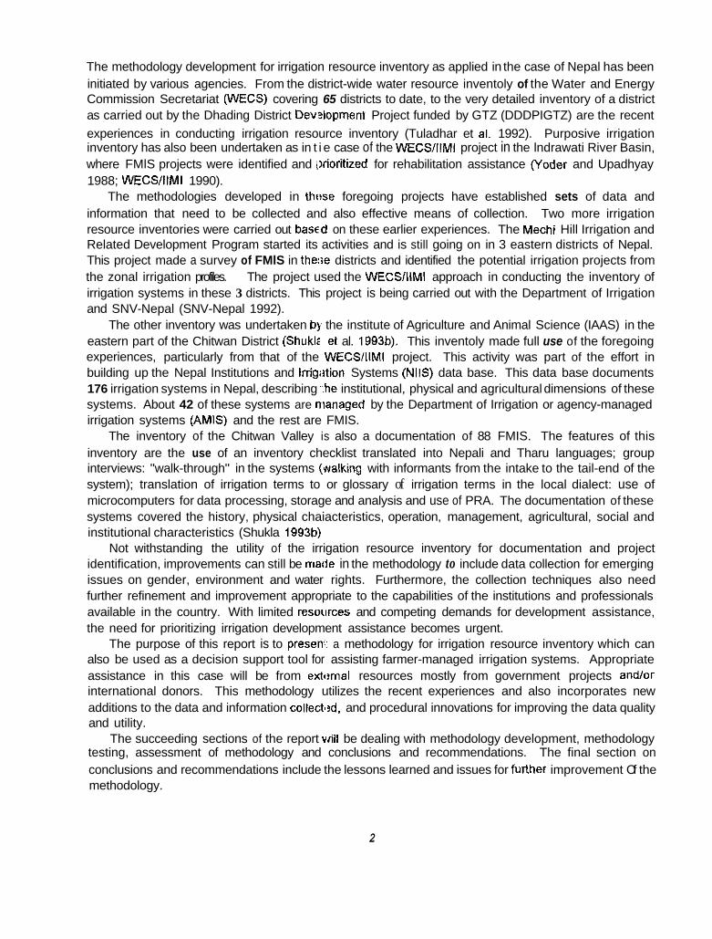
The methodology development for irrigation resource inventory as applied in the case of Nepal has been initiated by various agencies. From the district-wide water resource inventoly of the Water and Energy Commission Secretariat (WECS) covering 65 districts to date, to the very detailed inventory of a district as carried out by the Dhading District Dev2lopment Project funded by GTZ (DDDPIGTZ) are the recent experiences in conducting irrigation resource inventory (Tuladhar et al. 1992). Purposive irrigation inventory has also been undertaken as in t i e case of the WECS/IIMi project in the lndrawati River Basin, where FMlS projects were identified and iirioriiized for rehabilitation assistance (Yoder and Upadhyay 1988; WECS/IIMI 1990).
The methodologies developed in thtrse foregoing projects have established sets of data and information that need to be collected and also effective means of collection. Two more irrigation resource inventories were carried out based on these earlier experiences. The Mechi Hill Irrigation and Related Development Program started its activities and is still going on in 3 eastern districts of Nepal. This project made a survey of FMlS in these districts and identified the potential irrigation projects from the zonal irrigation profiles. The project used the WECSIllMl approach in conducting the inventory of irrigation systems in these 3 districts. This project is being carried out with the Department of Irrigation and SNV-Nepal (SNV-Nepal 1992).
The other inventory was undertaken by the institute of Agriculture and Animal Science (IAAS) in the eastern part of the Chitwan District (Shukls et al. 1993b). This inventoly made full use of the foregoing experiences, particularly from that of the WECS/IIMI project. This activity was part of the effort in building up the Nepal Institutions and Irrigiition Systems (NIIS) data base. This data base documents 176 irrigation systems in Nepal, describing ,..he institutional, physical and agricultural dimensions of these systems. About 42 of these systems are managed by the Department of Irrigation or agency-managed irrigation systems (AMIS) and the rest are FMIS.
The inventory of the Chitwan Valley is also a documentation of 88 FMIS. The features of this inventory are the use of an inventory checklist translated into Nepali and Tharu languages; group interviews: "walk-through" in the systems ("alking with informants from the intake to the tail-end of the system); translation of irrigation terms to or glossary of irrigation terms in the local dialect: use of microcomputers for data processing, storage and analysis and use of PRA. The documentation of these systems covered the history, physical chaiacteristics, operation, management, agricultural, social and institutional characteristics (Shukla 1993b),
Not withstanding the utility of the irrigation resource inventory for documentation and project identification, improvements can still be made in the methodology to include data collection for emerging issues on gender, environment and water rights. Furthermore, the collection techniques also need further refinement and improvement appropriate to the capabilities of the institutions and professionals available in the country. With limited resotirces and competing demands for development assistance, the need for prioritizing irrigation development assistance becomes urgent.
The purpose of this report is to preseni a methodology for irrigation resource inventory which can also be used as a decision support tool for assisting farmer-managed irrigation systems. Appropriate assistance in this case will be from exti?rnal resources mostly from government projects andlor international donors. This methodology utilizes the recent experiences and also incorporates new additions to the data and information collecti?d, and procedural innovations for improving the data quality and utility.
The succeeding sections of the report will be dealing with methodology development, methodology testing, assessment of methodology and conclusions and recommendations. The final section on conclusions and recommendations include the lessons learned and issues for furlher improvement Of the methodology.
2

METHODOLOGY DEVELOPMENT
In developing the irrigation resource inventory, the underlying objective was to arrive at a methodology that will provide the necessary data and irformation to enable informed or rational decision making to occur in assisting FMIS. The data to be collected should be instrumental in identifying and prioritizing appropriate assistance to FMIS.
The checklist used in the WECSlllMl Project was the starting documentation in developing this methodology (WECSIIIMI 1990). The chectlist used in the inventory of east Chitwan Valley by the IAAS group was not used, since it did not directly address the need for identifying and prioritizing for assisting FMlS (Shukla 1993). The areas of concern that were in the WECS/IIMI checklist are as follows:
1. 2. 3. 4. 5 . 6. 7.
Water Resources. Land Resources. Water Rights. Water Allocation. Physical System. Management System. Agricultural System.
Among the foregoing topics in the checklist. the water rights topic was not covered thoroughly by the inventory undertaken in the WECSlllMl Project. This checklist was further examined in terms of the questions asked and the manner in which they were asked. In surveys or inventories, the questions and how they are asked are as important as the data or information being collected.
The methodology can be divided into three stages or phases, two of which were field work surveys. The first one is the reconnaissance survey. This involved the use of a checklist covering the foregoing topics. These topics were reviewed and streamline,q, Redundant questions were deleted although selected cross-checking questions were retained 'to determine consistency of answers from the respondents. The data variables were furlher screened to only about 100. The rationale behind the limiting of the number of variables was to expedite data collection and analysis without jeopardizing the necessary amount and quality of data bein3 gathered.
The existing areas of concern were retained but improved and additional topics were added to address the issues of environment and gentler. The water rights questions were modified to have better indications of inter-and intra-systems water use conditions. These additional topics and questions were then added to the reconnaissance checklist for inventory. This checklist was msant to provide initial ,.
evaluation of all systems in a demarcated area of a river basin. This evaluation will lead to a shorter list of systems where a PRA will be applied thsreafter.
The basis for short-listing the target systems for PRA are the water resource, land resource and institutional capability potential. These three' major criteria are the main points in evaluating the surveyed systems in the target area.
To determine the effectiveness of this checklist, pre-testing of this checklist was undeltaken. With the pre-testing of the checklist, improvemenls were made on the terms used and on the manner in which the questions were asked. The improved checklist was then ready for use in the target area. A copy of this checklist can be found in Annex 1.
The procedural improvement made in this methodology was the inclusion or participation of a farmer, from a water user association (WUA) based nongovernmental organization (NGO), who was knowledgeable about FMIS irrigation management and development. The inclusion of this farmer/NGO in the survey was a learning experience for both the university-trained surveyors and the farmer. The
. .,
3
objective in including the farmer/NGO in th,? inventory team was to improve the quality of data gathered. This quality improvement is based on the fiimiliarity of the farmedNG0 regarding the idiosyncracies and proclivities of his fellow farmers, particulariy in terms of irrigation-related activities.
With a farmerING0 as a member of the inventory team, credibility is also enhanced in terms of farmers' willingness to respond candidly to the questions asked of them regarding irrigation and their agricultural activities. Subtle nuances and sttitudinal responses are most often missed in straight-forward questions asked by university-trained intewiewers. On the other hand, the farmer/NGO also learns how to interview farmers and in the process learns to become member(s) of a professional team in undertaking a survey.
With the inclusion of gender issues, it is difficult to raise questions about female activities in connection with irrigation activities, particularly in a highly patriarchal society. Female members of farming villages are reluctant to answer questions asked by male outsiders. Females interviewers were included in the team composition of the invf?ntory team. However, their participation was only limited to the PRA portion of the inventory.
The second stage of the methodology i:; the PRA of the short-listed or potential FMlS for assist.ance. The main concern in this PRA is to asses:. the most promising system in order of priority, for greater productivity with the improvement of the irrigation system. This improvement can be brought about either through physical assistance or institutional and organizational improvements among the fewer number of potential systems.
A set of questionnaires was prepared u:>ing the checklist, but adding more detailed questions under each of the topics. Additional questions rfjgarding external assistance for improving FMlS were also asked. In particular, questions about specific: irrigation practices on operation and maintenance, resource mobilization, organizational aspects of the irrigation systems and interlintra-water use conflicts, if any, and reasons behind the conflicts were asked.
The participation of farmer/NGO as a m,?mber of the inventory team for the PRA was still necessary at this stage of methodology development. Furthermore, the participation of farmer informants becomes more important at this stage of the PRA. Walk-through with farmer informant from both head and tail portions of the system was carried out. l'he involvement of female interviewers also proved to be effective, particularly in the collection of the gender-related issues in irrigation activities.
The last stage of the methodology was the reporting or reconciliation of results to the users Of
information for decision support. The inventi~ry results only become useful if the users of the information are able to have access to the data and info,mation generated by the inventory. This inventory In effect becomes a decision support tool. With this information, decisions regarding which irrigation System needs to be assisted with the highest possitile potential for increased productivity can be made both at the local as well as the national level with donor support. Informed decision making is one outcome of this methodology when it comes to choosincl alternatives for irrigation development. The prioritized list as provided by this inventory facilitates the effort in identifying which system needs to be investigated for a formal feasibility study for improvement or rehabilitation assistance.
The final step in this methodology devel3pment was the establishment of a data base whereby the data and information collected in this inventory will be formatted and stored in a "user-friendly" computer program that can be accessed and updated by concerned and interested users.
This methodology becomes only effective if its results lead to the fulfillment of the objective in that, effective assistance to FMlS will be undertaken.
A
TESTING OF METHODOLOGY
Background
The methodology was tested in two project!; implemented in Nepal. In one project, the decentralization project of the United Nations Development Programme (UNDP) and the National Planning Commission (NPC), and IAAS tested this methodology, The decentralization project was basically premised on devolution of powers, particularly in the development sector. This project was piloted in 5 districts. Each district had a district development comniittee, whose function was to coordinate and decide on development activities to be carried out in each district.
IIMI-Nepal with a grant from the BMi!-IFAD awarded a contract to the Irrigation Management Systems Study Group (IMSSG) of the IAAS to use the foregoing methodology in carrying out complementary activities with the decentrallzation project. With the experience of iAAS in carrying out the inventory in east Chitwan Valley, they were qualified to undertake this methodology testing. The district selected for methodology testing was Tanahu which is about 150 kilometers (km) west of Kathmandu.
The other project was "District Strengttiening," whose the objective was to enhance the capability of district irrigation agency (Department of Irrigation [Doll) staff in assisting FMIS. This project is a joint Research and'Technology Branch (RTB/D(3I) and IlMl activity. There were 2 districts piloted for this project-Lamjung and Dang districts-represanting one hill and one plain (terai) district. The DO1 'District staff was involved in drafling the terms of reference, and selecting and supervising the local consultants who carried out the irrigation resource inventory in these districts. The selected consultants were Hydro- Engineering Services for Lamjung District m d NepalConsuit for Dang District. IIMI-Nepal with a grant from Ford Foundation and partly from BMZ-IFAD, provided the funds for these two consulting firms to undertake the irrigation resource inventory.
IMSSGllAAS Inventory at Tanahu District
The IMSSGllAAS group consisted of faculty members, students and a farmer/NGO. The faculty members had an interdisciplinary background in agriculture engineering, agronomy and sociology. Tanahu District was selected upon the recommendation of the Decentralization Project UNDP project staff. The district development committee (DDC) chairman at Tanahu was very active in soliciting new ideas as well as funds to support the develorment efforts in this district. The decentralization project was conducting surveys in other aspects of dcvelopment except irrigation. This provided a very good opportunity to test the methodology.
The only other inventory made covering the entire Tanahu District was made by WECS as part of the nationwide inventory for water resources development (WECS/SILT 1991). The major shortfall of this inventory was that it only looked into the water aspects for irrigation and hydro power utilizations. Irrigation operation, maintenance, and agricuttural aspects were not included in this inventory. Moreover, systems with a command area of 5 hectart?s (ha) or less was not included in the inventory. Thus, a mwe thorough inventory that can be used for development activities was really needed in this district.
5

Process
The IMSSG/IAAS group undertook the (preparatory activities effectively. The development of the checklist for the reconnaissance survey was undertaken in consultation with the IIMI-Nepal staff. Collection of secondary materials pertinerit to the Tanahu District was also conducted by visiting the different offices in the district capital. Thf! DDC chairman was briefed and he also visited IIMI-Nepal office to discuss the inventory study.
With limited resources in terms oftime ,dnd funds, only the northeastern portion ofthe Tanahu District was covered by the IMSSGIIAAS inventor/--approximately 400 square kilometers (km’) (IMSSGAAAS 1994). Out of the 160 systems surveyed in the first stage, only 35 systems were targeted for PhaselStage 2 inventory. The criteria for selecting these 35 systems were:
* Potential area for irrigation. * * *
* Feasibility of canal extension. * Overall potential system productivi:~.
A report on the completion of the recoiinaissance survey was prepared by the IMSSGllAAS group and submitted to IIMI-Nepal. This report was discussed regarding the results and also the forthcoming Stage 2 PRA. A summary version translatr!d into Nepali was also prepared by the IMSSGIIAAS. which was submitted to the DOC chairman.
These 35 systems were then visited aJain by the IMSSGllAAS group for PRA. In the 2nd stage, female enumerators (students) participated in the data collection, mainly in obtaining responses to questions on gender issues in irrigation.
The use of geographic information system (GIS) to generate a more accurate map indicating the location of these FMlS was attempted. Hcrmver, due to the delay in the availability of GIS equipment, particularly the global positioning device, or ly a couple of FMlS sites were documented. The use of GIS would have improved the accuracy and ah,^ updated the location of these FMlS in conjunction with the other data and information that were incliided as part of the decentralization project to indicate the baseline information for district developmelit.
Adequacy of water at the source ciuring the winter and spring seasons. Potential for crop intensification arid diversification. Willingness of water users to mobilize resources for system improvement. Severiiy of environmental threats lo the system.
Results
Only the highlights of the inventory at Tznahu will be discussed in this section. In particular, the additional sections on gender, water rights and environment will be presented.
In the role of women in irrigation activitios, about 15 to 43 percent of these activities were conducted by women. Only in 2 systems were there women members in the executive committee and only in 6 systems were the women attending the geni’ral assembly meetings of the water users organization. The minimal participation of women in irrigation ;activities was attributed to male dominance in Nepali society.
Customary water rights prevailed amon${ the systems inventoried. In particular, inter- and intra-water conflicts were limited to 12 systems. Wattw use conflicts were used as an indication of water rights status in these 35 systems. In 2 systems alone, there were intra-system conflicts reported along the canal, while in 10 systems, the conflicts wert? inter-system at the source and between canals. It appears
6

that with the proliferation of irrigation systeins in the river basin, more and more conflicts are observed due to the absence of clear-cut policies on water rights.
On the environmental issues, mostly orily physical deterioration was observed as brought about by landslides, floods, seepage, breaching of canals and deforestation. No data on chemical, sociallcultural, health, and environmental impacts by and upon the irrigation systems were collected.
The significance of these emerging issues in natural resource management is not very obvious at the moment. But these additional informalion does provide us with some sense or indication of the situation regarding these important areas csf natural resource management.
The IMSSGllAAS group made use of a scoring system to rank the 35 systems in accordance with their priority for assistance. This system of scoring enabled them to prioritize these systems accordingly. The criteria was based on 3 major group: of factors, namely, positive factors, negative factors and potential factors for external assistance ne?ds Fable 1.1). In cases where ties occur in the resulting rank, other variables were considered calkd passive variables. These variables consist more of the qualitative characteristics ofthe systems under consideration in terms of potential for crop diversification, irrigation management capability, soil and service or command area characteristics and other related factors like market accessibility (IMSSG/IAAS 1994:87-88).
Upon completion of the drafl report, providing the ranked FMlS for assistance, a workshop or meeting was convened to present these results. The participants in this meeting were the chairmen of the 12 village development committees (JDCs), the executive officers of the district development committee and the representatives of the ccncerned agencies for development like the District Irrigation Office, District Branch of the Agricultural Development Bank, District Officer for the Department of Agriculture and Development, and the Disti'ict Development Officer.
The draft report was summarized and translated into Nepali language for presentation. The presentation disappointed some participant:;, since the FMlS in their respective VDCs were not on the priority list. This is one drawback of the invi?ntory. Interviewing and discussing irrigation-related issues with farmers in these FMlS inevitably raises the expectations of farmers. No matter how much explanation is provided regarding the purpose of the inventory. farmers will tend to expect assistance in terms of a project in their FMIS.
Moreover, the inventory covered only a quarter ofthe entire district. The chairman of the DDC raised the issue of covering the entire district. FLrthermore, the assistance to the prioritized FMlS was also raised by the DDC chairman. This again is another level of expectation from the users of the inventory. It was explained that the main purpose 01 the inventory was only to provide information, to enable rational and informed decision making in assisting FMIS. At least in the northeastern part of the district, assistance to FMlS will be based more oil physical and economic rationale rather than on political considerations. These inventory results will also provide the justification for not supporting inappropriate assistance to less deserving FMIS.
The other participants from the district cevelopment offices were more understanding of the results and were appreciative of the prioritized list of FMlS for assistance. In particular, the District Irrigation Office, welcomed the results. This will facilitate the implementation of their ongoing assistance to FMIS, financed.by the World Bank under the Irrigation Line of Credit (ILC). This project assists FMlS through rehabilitation of existing systems and also construction of new ones. The procedure for obtaining assistance is on "demand" basis. The water users groups or associations have to be formally organized and registered with the Chief District Officer (CDO).
, .
I ,
7
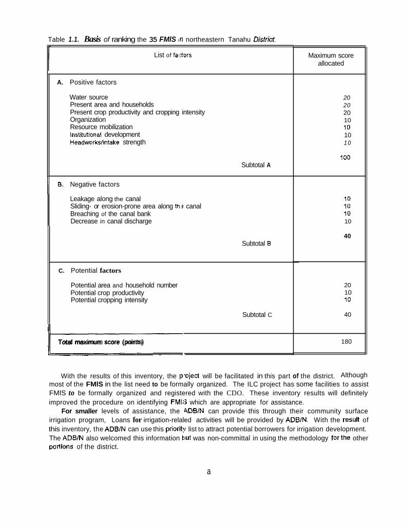
Table 1.1. Basis of ranking the 35 FMlS In northeastern Tanahu Districf.
List of fa8;tors
A. Positive factors
Water source Present area and households Present crop productivity and cropping intensity Organization Resource mobilization Institutional development Headworkshntake strength
Subtotal A
B. Negative factors I/ Leakage along the canal Sliding- or erosion-prone area along thi? canal Breaching of the canal bank Decrease in canal discharge
Subtotal B
C. Potential factors
Potential area and household number Potential crop productivity Potential cropping intensity
Subtotal C
Total maximum score (points) I
~ ~~~
Maximum score allocated
20 20 20 10 10 10 10
100
10 10 10 10
40
20 10 10
40
180
With the results of this inventory, the p-oject will be facilitated in this part of the district. Although most of the FMlS in the list need to be formally organized. The ILC project has some facilities to assist FMlS to be formally organized and registered with the CDO. These inventory results will definitely improved the procedure on identifying FMIS which are appropriate for assistance.
For smaller levels of assistance, the 4DWN can provide this through their community surface irrigation program, Loans for irrigation-relaled activities will be provided by ADB/N. With the result of this inventory, the ADBlN can use this prioritif list to attract potential borrowers for irrigation development. The ADB/N also welcomed this information tiut was non-committal in using the methodology forthe other DortionS of the district.
a

In this instance, the methodology for irrigation resource inventory was considered effective. This effectiveness was in terms of providing infclrmation for decision making regarding assistance to FMIS. Although there was unanimity among the u!iers of the information generated by the inventory regarding the utility of the results, there was no explicit endorsement of adopting the methodology for further use in the other parts of the district.
Hydro-Engineering ServiceslNepalConsu It Inventories at Lamjung and Dang Districts
The project on District Strengthening provid8d another opportunity to test the methodology on irrigation resource inventory. DO1 required that the implementing consultants go through a tendering process. There were about 20 tenderdproposals for the inventory for each district. The Hydro-Engineering Services (Hydro) group was awarded the contract for the Lamjung District while the NepalConsull group won the contract for the Dang District. Actually, Hydro and NepalConsult submitted joint proposals and only differentiated on the lead contractor. Thus for Lamjung District the lead was Hydro, and for Dang the lead was NepalConsult. The instruments (procedures and questionnaires) used were the same except the inventory team members: one sf?t of inventory team members for Lamjung, and another set for Dang, but using the same questionnaire (Annex 2).
Hydro-Engineering Services has a very good track record when it comes to inventory. This was the group that undertook the WECSlllMl Project in Sindhupalchok (Yoder and Upadhyay 1988) and also the inventory of other districts in Nepal. The inventory team for each district consisted of an engineer, agronomist, sociologist, farmer/NGO and an environmentalist. The environmentalist was only present during the reconnaissance survey. During the RRAIPRA. this team member was not available anymore.
Process
The inventory at Lamjung District covered more than a third of the district (540 km'), representing the densely settled portions of the Marsyangdi River Catchment. A total of 239 FMlS were visited in the Stage I of the inventory. Out of these, only 30 were found suitable for RRA based on:
1. 2. 3. 4. 5. 6. Length of main canal. 7. Size of command area.
Potential of expansion of irrigati?d area. Potential of increasing cropping intensity. Availability of water in the source. Number and degree of risk factws. Water users' interest in the sys.em.
With these criteria the list of FMlS was narrowed down to 30 (HydrolNepalConsuk 1994). For Dang District, about 4/5 of the district was covered by the inventory (900 km'). A total of 162
FMlS were visited by the inventory team. This district being in the plains, the systems were more accessible compared to the hill districts like -amjung. Out of these, only 24 were found suitable for RRA or Stage II of the inventory. In addition to the above criteria, two more were added in the case of Dang. These were the presence of organized watw users and inclusion of a system to represent as much as possible all of the villages in the catchment .area of the inventory. In this district, two major donors have been operating forthe past decade in terms of providing development assistance. These are the U'nited'
9

States Agency for International Development (USAID) and CAREINepal. In terms of irrigation, only CAREINepal has been actively involved, particularly in assisting FMIS.
Lamjung
Results
Dang
Organizational status management
Informal 17 with informal (led by local leader, Aguwa) 6 with formal WUA
Physical systems Fair-Good
Cropping intensity of irrigated 11 9.270%
Fair-Good (w/a system not good)
167-300%
Sources: Hydro-Engineering SeNices/NepalCon~.uIt, OraR Report on Inventory Study of Irrigation Systems In Marsyangdi River Catchment of Lamjung District, May 1994 [pp. 25-28].
Nepal ConsUiVHydro-Engineering Sew ces, DraR Report on Inuentoiy Study of Irrigation Systems in Babai Khola, Dang District, May 1994 [pp. 25-29].
In Lamjung Dishict, a total of 30 irrigation systems were studied while in Dang District, a total of 23 irrigation systems were inventoried.
Cropping-
Notes:
The major crop irrigated is rice during monsoon while a few portions are irrigated during spring. Other crops such as wht!at, lentil and legume are aiso irrigated but on a very limited scale. These other orops are pianted in the Same field as that of rice, during winter but very seldom irrigated.
The cropping intensity is much higher in Dang District compared with that of Lamjung. The land tenure pattern also, to a large extent, cortributes to the institutional differences between these two districts (Table 1.3). In Lamjung, tenancy i!; rare and landowners usually operate or cultivate their own land, In Dang, there are 5 categories of lald tenure. This is also the case in the other districts in the plains or the terai area of Nepal.
10

Land tenure
11 Land owner/operator
Lamjung Dang
100%
Land owners not cultivating
61%
11%
Absentee land owner
Share croppers
Landless Iaborers/Kamafya
4%
12%
12%
Sources: Hydro-Engineering ServiceslNepalConsuR, Dran Report on inventory Study of Irrigation Systems in the Catchment of Marsyangdi River, Lamjung District, pp 18.2'1, May 1994.
NepalConsulUHydro-Engineering Babai River, Dang District, pp. 17-21, May 1994
The percentages are based on the number of respondents aggregated for 30 systems in Lamjung and 23 systems in Dang.
Services. DraR Report on Inventory Study of Irrigation Systems in the Catchment of
Notes:
The issue of water rights is more acute in Dang District. Conflict over prior use of water led to the statutory legalization of water riihts for 2 systems. In addition to this, another system was legalized in terms of water rights during the previous Rana regime. The rest of the FMlS in Dang. still have customary water rights as handed down to them from the generations of water users.
In the case of Lamjung, conflicts arise but are settled amicably by the water users themselves. No formally legalized water rights have been established in this part of Lamjung yet. However, competing usage among systems have been reported. Several cases have been cited by water users where conflicts have risen but were settled. In ternis of water rights, the information generated by the inventory does reflect significant emerging issues that need to be addressed both locally and nationally given the dwindling water resources and increasing demand.
In terms of male and female participation in irrigated agriculture, the hill district appears to be more participatory compared to the Dang District in the terai (Table 1.4). Although Nepal ,is .predominantly a patriarchal society, the responses from Dan!) District reflects a very traditional pattern. However, for both districts, decision making is still a prerogative of the male member of the farming household. Yet female participation, particularly in the agricultural (other than irrigation) activities, is very much evident. This additional insight into the characteristics of FMlS is helpful in defining developmental plans for effective assistance.
The environmental information obtainrid was very general and mostly confined to the physical observations affecting the physical features of the FMIS. The concerns raised in Lamjung District were landslides, embankment erosion, seepage from canals, and floods. Similarly, in Dang District, siltation of the command area was raised in several systems as well as seepage, embankment erosion and also floods. Although these physical effects on tt e system were noted, significant yield reductions attributable to these has not yet been determined.
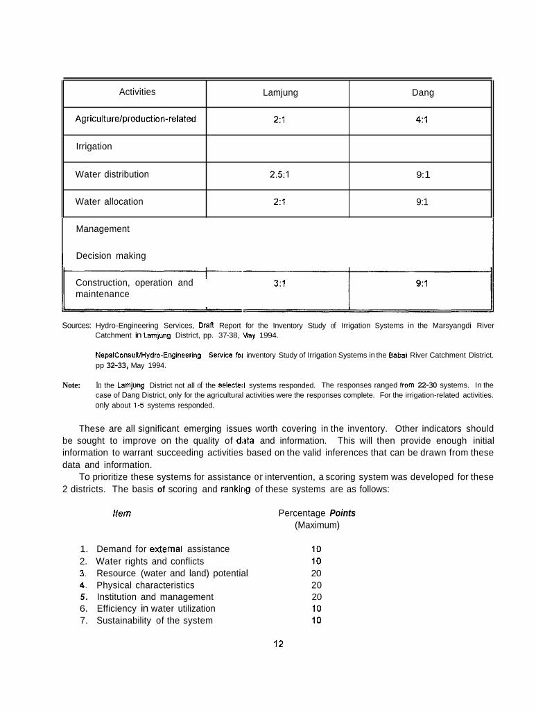
Activities
Agriculturelproduction-related
Irrigation
Water distribution
Water allocation
Management
Decision making
Lamjung Dang
2:l 4 : l
2 .51 9: 1
2 : l 9:1
Construction, operation and maintenance
3 : l 9:l
Sources: Hydro-Engineering Services, Drafl Report for the Inventory Study of Irrigation Systems in the Marsyangdi River Catchment in Lamjung District, pp. 37-38, Vlay 1994.
NepaiConsulVHydro-Engineering SeNice foi inventory Study of Irrigation Systems in the Eabai River Catchment District. pp 32-33, May 1994.
In the Lamjung District not all of the selectell systems responded. The responses ranged from 22-30 systems. In the case of Dang District, only for the agricultural activities were the responses complete. For the irrigation-related activities. only about 1-5 systems responded.
Note:
These are all significant emerging issues worth covering in the inventory. Other indicators should be sought to improve on the quality of d8ta and information. This will then provide enough initial information to warrant succeeding activities based on the valid inferences that can be drawn from these data and information.
To prioritize these systems for assistance or intervention, a scoring system was developed for these 2 districts. The basis of scoring and ranking of these systems are as follows:
Item Percentage Points (Maximum)
1. Demand for external assistance 10 2. Water rights and conflicts 10 3. Resource (water and land) potential 20 4. Physical characteristics 20 5 . Institution and management 20 6. Efficiency in water utilization 10 7. Sustainability of the system 10
12

For each item, another scoring systeni was done to evaluate the specific concerns of the criteria listed above. For example, the score for demand ranges from 0 to 10, with poor demand getting the minimum score and high demand with potential improvement on the system getting 10 points maximum (HydrolNepalConsult 1994: 45-48 and NellalConsult/Hydro, 1994: 39-42).
With this scoring system, the FMlS in Lamjung and Dang were ranked. There were ties (systems with the same rank) and these were not resolved unlike in the IMSSGllAAS inventory of northeast Tanahu. Additional qualitative measures were not taken to avoid ties. However, since the recommendation for a follow-up feasibilit)' stage was proposed, the occurrence of ties is not that important, particularly since they are in the bottom part of the list (i.e., for Lamjung starting only in rank 17 and for Dang in rank 13).
The results of this inventory were presented at an informal seminar. The participants in this seminar were the Director-General, and Deputy-Director Generals; Chiefs of RTB, SMB, HRDTB; Coordinator of the Irrigation Sector Support Program: Consultants for ISP and IMP; DEs from Dang and Lamjung; ILC in-charge of mid-western and western regions, DDC chairmen from Dang and Lamjung and; representatives from ADBIN and CARE/NI:pal and IIMI-Nepal. (The actual outcome of this seminar should be provided by Ujjwal Pradhan.
With an ongoing program to assist FMIS within the DOI, the Director-General was very interested in this activity. The seminar was held in the conference room of DOI. Interest was expressed to extend the inventory beyond the 2 districts and also to try it out in other districts as well where assistance to FMlS by DO1 is being provided. This is a clear indication of the effectiveness of the methodology for its adoption by DO1 in improving assistance ti] FMlS in other districts of Nepal.
Assessment of the Methodology
The testing of the methodology provided the opportunity for evaluating the methodology using two different sets of inventory teams (IMSSGIIPAS and HydrolNepaiConsult), Both teams utilized the core topics to be included and also added the is6ues on gender, water rights and environment. Procedurally, a farmerlNG0 was included in the inventory teams. However, only in the IMSSGllAAS team was a female team member was included. This enabled the effective collection of gender-related data and information in northeastern Tanahu District. Table 1.5 summarizes the features of this methodology as comparing the WECSIllMl inventory and ttie two teams.
In terms of methodological improvements, the additional contents, membership of the inventory teams and sharing the inventoty results with the users (both local and national) were the main features of the methodology as validated by both IMSSG/IAAS and HydrolNepalConsuH. The IMSSGllAAS inventory team had the complete membership and also provided a female interviewer which is an innovation in itself.
In terms of outcome, the iMSSGllAAS rcport provided more detailed information and data particularly on the agricultural and management/insti:utional aspects of the FMIS. However, data on water resources, particularly on the available flowti from the sources/rivers were not collected completely. The report is a reflection of the academic bias ttiat is expected from this team, and there were shortcomings with regard to water flow data.
The Hydro/NepalConsult report on the ,other hand provided a standard consultants report, with 1855
detail but direct to the point of prioritizing t i e systems according to the data and information gathered as specified by the criteria for ranking. Although the inventory team did not have the full complement of "expertise" in its membership, the presenl capability of national consultants in caving out an irrigation resource inventory was shown, Furthermore, this team demonstrated the replicable practicality of the
13
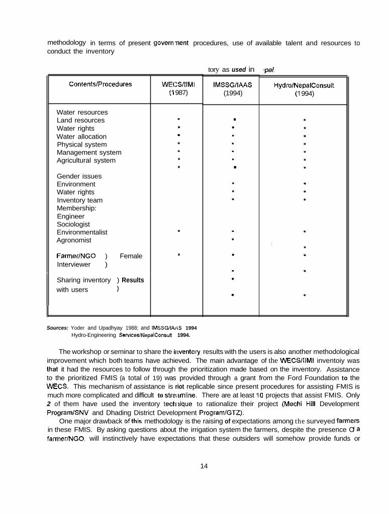
methodology in terms of present government procedures, use of available talent and resources to conduct the inventory
ContentslProcedures
Water resources Land resources Water rights Water allocation Physical system Management system Agricultural system
Gender issues Environment Water rights Inventory team Membership: Engineer Sociologist Environmentalist Agronomist
FarmerlNGO ) Female Interviewer )
WECSIIIMI (1 987)
* *
* * * *
I
I
Sharing inventory ) Results with users )
tory as used in
IMSSGllAAS (1994)
. t
L.
* I . * * I
I
"
f
pal.
HydrolNepalConsult (1 994)
Sources: Yoder and Upadhyay 1988; and IMSSGIIAI6 1994 Hydro-Engineering SeNices/NepalConsult 1994.
The workshop or seminar to share the iiiventory results with the users is also another methodological improvement which both teams have achieved. The main advantage of the WECS/I\MI inventoiy was that it had the resources to follow through the prioritization made based on the inventory. Assistance to the prioritized FMIS (a total of 19) was provided through a grant from the Ford Foundation to the WECS. This mechanism of assistance is riot replicable since present procedures for assisting FMIS is much more complicated and difficult to streiimline. There are at least 10 projects that assist FMIS. Only 2 of them have used the inventory techiiique to rationalize their project (Mechi Hill Development PrograrnlSNV and Dhading District Development PrograrnlGTZ).
One major drawback ofthis methodology is the raising of expectations among the surveyed famWS in these FMIS. By asking questions about the irrigation system the farmers, despite the presence Of a farmer/NGO, will instinctively have expectations that these outsiders will somehow provide funds or
14

materials for improving their system. In all of the 3 districts studied, the majority of farmers had expectations that their system will somehow receive assistance in one form or another.
Wdh a validated methodology, it is erivisaged that more projects will adapt this methodology in improving the assistance to FMIS. The IM:;SG/IAAS effort is not easy or not practical to replicate. This is due to the unavailability of the full complement of expertise for the inventory team. However, their attempts to improve on the methodology, Farticularly on the use of female interviewen and application of GIs, are noteworthy for future improvenlents of the methodology.
The information generated was appreciated by the users and the skills which are needed to undertake the inventory were found to be available. The final arbiter of ts effectiveness will be when the methodology will be used in other parts of Nepal or even in other countries where irrigation resource inventory will be a useful tool for decision making for assisting FMIS.
Overall, the methodology as tested and validated was found to be effective.
CONCLUSIONS AND RECOMMENDATIONS
The methodology developed had improvements relative to previous inventory methodology in terms of content and procedural innovations. Specifically, the methodology:
1. Provided additional information on gender, water rights and environmental issues that are significant to the assistance of FMIS.
2. Showed that the contents of the existing inventory methodology can be improved, in terms of collecting only directly relevant information for making prioritization of assistance based on water and land resources, institutional capability, potential for increased productivity and need for external assistance.
3. Led to the development of a decision support tool for informed decision making through the prioritized listing of FMIS.
4. Provided the opportunity for the iisers of data and information generated by the inventory activities to discuss and decide on development assistance for FMIS at the local and national levels.
5. Demonstrated actual feasibility for the inclusion of female members in inventory team to improve on the quality of data and information collected for the gender-related issues in irrigation development, in a highly patriarchal society.
6. Showed that involving farmer/NGO in the inventory activities improved the overall quality of data gathered from the water users through better rapport with fellow farmers and credibility of the inventory teams.
7. Led to the examination of other areas of improvement such as the use of GIS right at the reconnaissance stage and to the integration of these data and information in the data base generated for the district.
15

8. Showed that there is capability on the part of the national consultants to carry out inventory and still conform to the government procedures.
9. Contributed to a limited extent to ihe institutional development of research institutions such as IAAS, farrner/NGOs, national consultants and DOI, for carrying out inventory of irrigation systems in the catchment areas of selected rivers in the districts.
Notwithstanding the overall positive results and improvements made in the inventory methodology, the following recommendations are forwarded to s e w as the next starting stage for further improving the methodology and thus, assist FMIS more effectively:
1. The use of the 3 stages in the inventory methodology should be retained. Reconnaissance, RRAlPRA for short-listed systems and finally, the reporting of results to the users of data and information locally and nationally.
2. The use of GIs, particularly the use of the global-positioning device should be incorporated in the reconnaissance stage of the mothodology. This will significantly improve the accuracy of the information on the location of these FMIS. Inclusion of this information to the data base will complement the other data sets thE8t will be useful for effective development assistance to FMIS.
3. In a patriarchal society, the use of female members in the inventory team should be considered in order to improve on the quality i f data collected, particularly on gender issues.
4. Indicators for environmental interactions with irrigation development should be included or even established. This will facilitate the icollection of environment-related data and information for the inventory. Training of inventory team members to ask the appropriate questions in varying environment should also be part of this improvement effort. Besides physical environmental impacts, other areas of concern should be included such as chemical (ia, fertilizer and pesticide use, salinity), economic, social, cuitural and health aspects.
5. To reduce or minimize the negative side-effects of inventory in terms of unwarranted expectations of external assistance, respondents or water users should be thoroughly informed of the purpose of the inventory. Iiiformation explicitly indicating the purpose of the inventory activity should be relayed to all of the respondents. This entails a more careful approach, to respect the sensitivities of farmers regarding assistance from the government.
6 . The incorporation of this methodology in the planning stage of 'assistance to the FMIS development program will improve the effectiveness of assistance. There are costs attributable to the inclusion ofthis methodology. However, the long-term benefits will outweigh the costs that will be incurred in incorporating this methodology in assistance programs for FMIS.
There are other specific details for recommendations that can be made. Some of them can be found in the reports submitted by IAAS and Hydro/NepalConsult. These are worth considering to comprehensively improve the methodOlOQy as presented in this report.
16
CHAPTER 2
Inventory and Needs Assessment of Irrigation Systems in Northetast Tanahun District
Irrigation Manaclernent Systems Study Group, Institute of Agriculture and Animal Science, Rarnpur
INTRODUCTION
Background
THE POOR SOCIOECONOMIC status of the farmers in conjunction with the fast deteriorating environment caused by landslides, soil erosion, deforesjation, flash flood and fragility of hilly terrain have intensified agricultural problems. Several agencies have emerged or have been forced to assist farmers to face these challenges in different capacities. Among them, the District Irrigation Office (DIO), under the Department of Irrigation (DOI), is the principal government agency for such rehabiliation and improvement of irrigation schemes. Now, t k major activities of DO1 are carried out through the Irrigation Line of Credit (ILC) Program of the World Elank. Other agencies involved in irrigation development are ADBIN, Hill Food Production Project (HFPP), District Soil Conservation and Watershed Management Office and the District Development Committee (DDC). But the magnitude ofthe problems is enormous and hardly any single governmental or nong~~vernmental agency can fulfill all the assistance requirements at once. After all, Nepal is one of the poc'rest countries in the world and, maximum utilization of the scarce resources for prioritized or need-based programs has always been its concern. In the context of irrigation, it is always better to asses the need(s) of each system before any assistance program is launched. Systematic study of irrigation systems comes under the domain of the irrigation researchers, study groups andlor institutions.
One of the various tools for irrigation stiidies is the irrigation resource inventory (IRI) technique. To date, several institutions in Nepal have undertaken irrigation resource inventories (Tuladhar et al. 1992). The WECS is one of the leading institutions to prepare nationwide irrigation inventories. IIMllNepal, Irrigation Management Systems Study Group (IMSSG) ofthe IAAS, Dhading District Development Project (DDDP) and the Workshop in Political lheory and Policy Analysis, Indiana University, are other institutions to undertake IRI within Nepal.
IMSSG ofthe IAAS, Rampur had carried out an "Irrigation Resource Inventory of Northeast Tanahun District." Funding support for this study was made available by IIMIlNepal. The study was accomplished in two phases. Phase I of the study was bssically limited to conducting a brief overview of the irrigation systems from within the northeastern part of Tanahun District. Phase II of the study was carried out in more detail in a very limited number of irrigation systems having possibilities of expanding the irrigated area, having adequate water at the source during scarce periods, and potentialities of crop intensification and/or diversification and considerable environmental threats. This report has been prepared to present the findings of the study. The methodology for IRI carried out by different institutions may differ due to
17

the set objectives of the study. The major objective of this study was to develop an appropriate methodology for IRI in the hills of Nepal.
No AMlS exist in the study area, though few systems have received external assistance for initial construction and rehabilitation. Major concentration of the irrigation systems in the study area fall in the river basin of streams like Chundi Khola, Kalesti Khola. Risti Khola, Phaundi Khola, Chitti Khola, Buldi Khola and Naudi Khola. The Water Use Inventory Study of Tanahun District (WECSlSlLT 1991) reported a total of 149 FMIS and 8 agency-assisted/sponsored irrigation systems in northeastern Tanahun.
Major findings presented in this report ,and the implications derived herein are based on an analysis of 160 FMIS in the study area.
Report Outline
The irrigation systems of the study area included in this report have been coded according to their sub- watershed regions or river basins in alphanumeric characters. For instance, a system tapping water from a tributary of'the Risti River will have a code of "Rn" where n = 1,2.3,4 ... etc., depending upon the location of a particular system starting from upstream side of the major river or the tributaries (Table 2.1).
This chapter has seven sections. Section one discusses background information, report outline, rationale and objectives of the study. Scction two presents the methodology. It also includes an overview of the study area with more emphasis on agricultural and irrigation development. Section two also describes the methodology used in the study. Section three presents the results and discussion about the inventory of irrigation resources of northeast Tanahun which includes: hydrology of water resources; types, location, accessibility anNl size of the irrigation systems; physical characteristics and environmental issues of the irrigation sysiems; organization for operation and management; gender issues; water rights as well as the characieristics and performance of the agricultural systems in the study area. Application of the Geographc Information System (GIS) for spatial inventory of water resources and other infrastructures is also discussed in this section. Section four presents the evaluation of irrigation systems for external assessment. It includes the analysis of the irrigation systems inventoried during the second phase of the study to evaluate them for seeking external assistance. Section five deals with the summary, implications and suggestions about the study. The lessons learned from this study are presented in Section si>:. The last or the seventh section offers some guidelines for implementing irrigation resource inventories.
The Study
Rationale
Irrigation development has always been an area of high priority for His Majesty's Government of Nepal (HMG/N). Despite continuing efforts in the past the cultivated area with some form of irrigation is only 943 thousand ha out of 2,641 thousand ha of arable land in Nepal (FA0 1991). There is undue population pressure on agricultural land to meet the increasing demand for food crops. It is therefore mandatory that irrigation development be intensified to bring changes in cropping pattern to attain potentially anticipated productivity of arable land and water resources. Realizing the food situation and the importance of irrigation as an importent production input for agriculture, the government's new irrigation policy emphasizes better management of irrigation resources in association with farmers, to
18
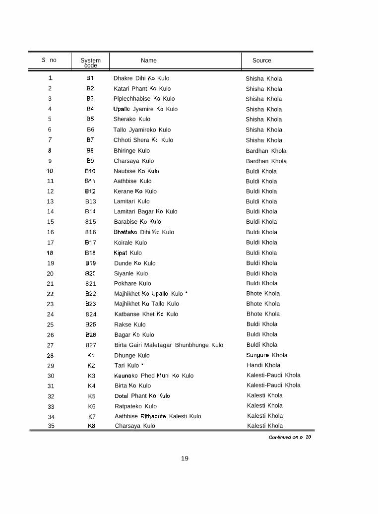
s no
1
2
3
4
5
6
7
8
9
10
11
12
13
14
15
16
17
18
19
20
21
22 23
24
25
26
27
28
29
30
31
32
33
34
System Name Source code
B1
82
B3
84
B5
B6
87
BE
89
B10
B11
BIZ
B13
814
815
816
81 7
BIB
B19
820
821
B22
823
824
825
826
827
K1
K2
K3
K4
K5
K6
K7
Dhakre Dihi KO Kulo
Katari Phant KO Kulo
Piplechhabise K O Kulo
Upallo Jyamire <o Kulo
Sherako Kulo
Tallo Jyamireko Kulo
Chhoti Shera KO Kulo
Bhiringe Kulo
Charsaya Kulo
Naubise KO Kulo
Aathbise Kulo
Kerane KO Kulo
Lamitari Kulo
Lamitari Bagar Ko Kulo
Barabise KO Kulo
Bhattako Dihi KO Kulo
Koirale Kulo
Kipat Kulo
Dunde KO Kulo
Siyanle Kulo
Pokhare Kulo
Majhikhet KO Upallo Kulo *
Majhikhet KO Tallo Kulo
Katbanse Khet KO Kulo
Rakse Kulo
Bagar KO Kulo
Birta Gairi Maletagar Bhunbhunge Kulo
Dhunge Kulo
Tari Kulo *
Kaunako Phed Muni KO Kulo
Birta KO Kulo
Dotel Phant KO I(ulo
Ratpateko Kulo
Aathbise Rithabcite Kalesti Kulo
Shisha Khola
Shisha Khola
Shisha Khola
Shisha Khola
Shisha Khola
Shisha Khola
Shisha Khola
Bardhan Khola
Bardhan Khola
Buldi Khola
Buldi Khola
Buldi Khola
Buldi Khola
Buldi Khola
Buldi Khola
Buldi Khola
Buldi Khola
Buldi Khola
Buldi Khola
Buldi Khola
Buldi Khola
Bhote Khola
Bhote Khola
Bhote Khola
Buldi Khola
Buldi Khola
Buldi Khola
Sungure Khola
Handi Khola
Kalesti-Paudi Khola
Kalesti-Paudi Khola
Kalesti Khola
Kalesti Khola
Kalesti Khola
35 K8 Charsaya Kulo Kalesti Khola
CO"t,""ed on D 20
19
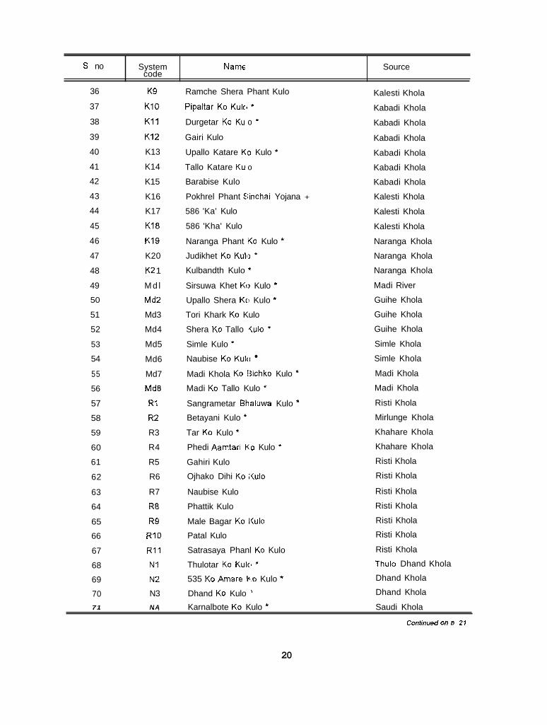
S no
36
37
38
39
40
41
42
43
44
45
46
47
48
49
50
51
52
53
54
55
56
57
58
59
60
61
62
63
64
65
66
67
68
69
70 71
System Name Source code
K9
K10
K11
K12
K13
K14
K15
K16
K17
K18
K19
K20
K2 1
Md l
Md2
Md3
Md4
Md5
Md6
Md7
MdB
R1
R2
R3
R4
R5
R6
R7
RE
R9
R10
R11
N1
N2
N3 N A
Ramche Shera Phant Kulo
Pipaltar KO Kulc, *
Durgetar KO Ku o *
Gairi Kulo
Upallo Katare K O Kulo *
Tallo Katare Ku o
Barabise Kulo
Pokhrel Phant Iiinchai Yojana +
586 'Ka' Kulo
586 'Kha' Kulo
Naranga Phant KO Kulo *
Judikhet KO Kuh ' Kulbandth Kulo *
Sirsuwa Khet KI) Kulo *
Upallo Shera Kri Kulo *
Tori Khark KO Kulo
Shera KO Tallo iu lo *
Simle Kulo *
Naubise KO Kulu
Madi Khola KO tjichko Kulo *
Madi KO Tallo Kulo *
Sangrametar Bhaluwa Kulo *
Betayani Kulo
Tar KO Kulo *
Phedi Aamtari K O Kulo *
Gahiri Kulo
Ojhako Dihi KO Kulo
Naubise Kulo
Phattik Kulo
Male Bagar KO ltulo Patal Kulo
Satrasaya Phanl KO Kulo
Thulotar KO Kulc ' 535 KO Amare V.0 Kulo *
Dhand KO Kulo '
Kalesti Khola
Kabadi Khola
Kabadi Khola
Kabadi Khola
Kabadi Khola
Kabadi Khola
Kabadi Khola
Kalesti Khola
Kalesti Khola
Kalesti Khola
Naranga Khola
Naranga Khola
Naranga Khola
Madi River
Guihe Khola
Guihe Khola
Guihe Khola
Simle Khola
Simle Khola
Madi Khola
Madi Khola
Risti Khola
Mirlunge Khola
Khahare Khola
Khahare Khola
Risti Khola
Risti Khola
Risti Khola
Risti Khola
Risti Khola
Risti Khola
Risti Khola
Thulo Dhand Khola
Dhand Khola
Dhand Khola
. , ,. , Karnalbote KO Kulo * Saudi Khola
Contmued On I) 21
20

S. no
72
73
74
75
76
77
78
79
80
81
a2
83
84
85
86
87
aa 89
90
91
92
93
94
95
96
97
98
99
100
101
102
103
104
105
106
System Name Source code
N5
N6
N7
N8
N9
N10
N11
N12
N13
N14
N15
N16
M I
M2
M3
M4
M5
M6
M7
MB M9
M10
M11
M I 2
M I 3
M I 4
M15
M I 6
M17
M I 8
M19
M20
M21
M22
M23
Mohariya KO Kulo
Male Bagar KO Kulo
Banayatar Sabadi KO Kulo
Thulotar Sinchai Yojana *
Ghartiswara KO Kulo
Birta KO Kulo
Rumati Banayatar KO Kulo *
Pangre Khola K3 Kulo *
Aambote Phant KO Kulo ' Dhand KO Kulo ' Pandheru Phant KO Kulo *
Sarange Jholunge Phant *
Kalleri 800 KO Kulo *
Shera Phant KO Kulo * Bhatta Phant Kc Kulo
Sangrale Phant KO Kulo
Bagar KO Kulo
Sangrale Sota K O Kulo
Dunde Kulo *
Atthaise KO Kulc, *
Barabise Kulo
Junge Phant KO Upallo Kulo *
Junge Phant KO Tallo Kulo *
Bagale Phant Kii Thulo Kulo *
Bagale Phant Kii Sano Kulo
Dhand Kulo *
Dinuwa Kulo
Jhinuwa Phant KO Upallo Kulo
Balai Phant *
Judi Kulo * Chhabise KO Ku o *
Bagaincha Muni KO Kulo *
Barkatar KO Kul(i *
Barabise Khet K3 Kulo *
Biruwa KO Kulo '
Naudi Khola
Naudi Khola
Sabadi Khola
Sabadi Khola
Sabadi Khola
Rurnati Khola
Rurnati Khola
Pangre Khola
Tirali Khola
Tirali Khola
Thulo Pahare Khola
Spring
Chitti Khola
Chitti Khola
Chitti Khola
Chftti Khola
Chitti Khola
Chitti Khola
Chisapani Khola
Kolainche Khola
Bais Jangar Khola
Bais Jangar Khola
Bais Jangar Khola
Bais Jangar Khola
Bais Jangar Khola
Bais Jangar Khola
Bais Jangar Khola
Bais Jangar Khola
Spring+Drainage water
Siusar Khola
Siusar Khola
Siusar Khola
Kape Khola
Kape Khola
Chipleti Khola
M24 Bhartari KO Upallo Kulo * Nirsinge Khola 107
Continued on p. 22
21

S no
108
109
110
111
112
113
114
115
116
117
I 1 8
19
120
121
122
123
124
125
126
127
128
129
130
131
132
133
134
135
136
137
138
139
140
141
142
System Name Source code
M25
M26
M27
M28
M29
M30
M31
M32
M33
M34
M35
M36
M37
M38
M39
M40
M41
M42
c 1
c 2
c 3
c 4
c 5
C6
c 7
C8 c 9
c10
c11
c12
C13
C14
C15
C16
C17
Aathunne KO K81lo *
Khorane KO Ku o
lndretari KO Up;illo Kulo *
lndretari KO Tal o Kulo *
Barai KO Kulo
Bastakote Phant KO Kulo * Dhukurdi Phant KO Kulo *
Kalleri Phant Kc, Kulo
Chapachaur KO Kulo *
Shera Kulo
Muhane KO Kulo *
Thulo Kulo *
Bhatta Phant KCI Kulo *
Aambote Kulo ' Dunde KO Kulo *
Kamalkote Kulo *
Thati Kulo
Andheri Khola b.0 Kulo *
Chuhine Raha kko Kulo *
Shera Phant KO Kulo
Baguwa Khetmz Lagne Dhakal Kunako Kulo
Dhakal Kuna Kc Mainphale Kulo
Dhakal Kuna Kc Kulo *
Chirkatta (Ghimire Phant) Kulo
Naubise (Ghimire Phant) Kulo
Thada Khet KO <ulo
Dhakal Kulo
Gomane KO Kul.)
Lamitari Aambote Kulo *
Gopaltari Dhungekol Bandh KO Kulo
Dhanubanse KO Kulo
Maran Ghat Baraha Kulo
Charsaya KO Kulo
Bhanu Baraha Kulo
Badahare KO Bsndh KO Kulo
Dharapani Khola
Dharapani Khola
Sunkuwa Khola
Sunkuwa Khola
Phaudi Khola
Khatre Khola
Dhukurdi Khola
Ridi Khola
Dhawadi Khola
Dhawadi Khola
Dhawadi Khola
Paudure Khola
Paudure Khola
Paudure Khola
Paudure Khola
Paudure Khola
Thati Khola
Andheri Khola
Kasaudi Khola
Chundi Khola
Chundi Khola
Chundi Khola
Chundi Khola
Chundi Khola
Chundi Khala
Chundi Khola
Chundi Khola
Chundi Khola
Ladi Khola
Ladi Khola
Chundi Khola
Chundi Khola
Chundi Khola
Chundi Khola
Chundi Khola
143 C18 Tuntari Pahare Kulo * Baguwa Khola
Conhnmd on D 23
22
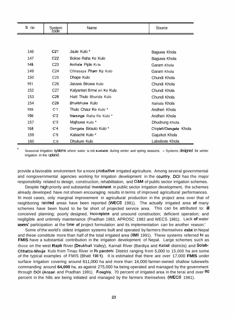
S no
146 c21 Jaule Kulo *
147 c22 Bokse Raha KO Kulo 148 C23 Archale Piple K~i lo
149 C24 Chhasaya Phanl KO Kulo
150 C25 Dhape Kulo
151 C26 Jaruwa Biruwa Kulo
System Name Source code
Baguwa Khola
Baguwa Khola
Garam Khola
Garam Khola
Chundi Khola Chundi Khola
152 C27 Kalyantari Simal ari KO Kulo Chundi Khola 153 C28 Hatt Thulo Bhurida Kulo Chundi Khola 154 C29 Bhukbhuke Kulo 155 C 1 Thulo Chaur KO Kulo *
156 C 2 Narringe Raha KO Kulo *
157 c 3 Majhuwa Kulo *
158 C'4 Gangate Birauto Kulo * 159 C'5 Kabachit Kulo *
Nahala Khola Andheri Khola Andheri Khola Dhudrung Khola
ChipletilGangate Khola Gajurkot Khola
160 C 6 Dhukure Kulo Labsibote Khola
* Seasonal irrigation systems where water is not adailable during winter and spring seasons. + Systems designed for winter irrigation in the upland.
provide a favorable environment for a more Fmroductive irrigated agriculture. Among several governmental and nongovernmental agencies working for irrigation development in the countty, DO1 has the major responsibility related to design, construction, rehabilitation, and OBM of public sector irrigation schemes.
Despite high priority and substantial invt!stment in public sector irrigation development, the schemes already developed have not shown encouraging results in terms of improved agricultural performances. In most cases, only marginal improvement in agricultural production in the project area over that of neighboring rainfed areas have been reported (WECS 1981). The actually irrigated area of many schemes have been found to be far short of projected service area. This can be attributed to: ill conceived planning; poorly designed, incoinplete and unsound construction; deficient operation; and negligible and untimely maintenance (Pradhan 1983, APROSC 1982 and WECS 1981). Lack of water users' participation at the time of project formulation and its implementation can be another reason;'
Some of the world's oldest irrigation systems built and operated by farmers themselves exist in Nepal and these constitute more than half of the total irrigated area (IIMI 1991). These systems referred to as FMlS have a substantial contribution in the irrigation development of Nepal. Large schemes such as those on the west Rapti River (Deukhuri Valley), Karnali River (Bardiya and Kailali districts) and Solah- Chhattis-Mauja Kulo from Tinau River in Rtipandehi District ranging from 5,000 to 15,000 ha are some of the typical examples of FMlS (Bhatt 19Ell). It is estimated that there are over 17,000 FMlS under surface irrigation covering around 611,000 ha and more than 16,000 farmer-owned shallow tubewells commanding around 64,000 ha, as against 275,000 ha being operated and managed by the government through DO1 (Ansari and Pradhan 1991). Foughly, 70 percent of irrigated area in the terai and over 90 percent in the hills are being initiated and managed by the farmers themselves (WECS 1981).
23

The role played by FMlS to meet the basic needs of the farming community in Nepal while sustaining the peasant economy and its impact on the national economy, is extremely important (Ansari and Pradhan 1991; Ansari 1989; Yoder and Upadhyay 1988 and WECS 1981). Due to this fact, FMlS have been recognized as a potential and cost-lrffective alternative to expanding and intensifying irrigation development in the country, and thus improving the performance of irrigated agriculture.
The Water Use Inventory Study of Tariahun District conducted by Water and Energy Commission Secretariat (WECS 1991) provides an ovcwiew of water resources and their exploitation in Tanahun District in a general manner. However, the report does not adequately present the agricultural, economic, social and organizational aspe<:ts apart from physical and hydrologic aspects of irrigation systems and, hence, fails to evaluate the ir’igation potentials, constraints, strengths and weaknesses of individual systems,
Thus, this study intends to gain a brief knowledge of the physical, sociallorganizational and agricultural aspects of irrigation systems in :he northeastern part of Tanahun District in collaboration with IIMIlNepai. Such information is valuable ti) evaluate the potentiality of the irrigation systems and help assess the need for external assistance. However, the potentiality of the systems cannot be judged without knowing the present status of systN?m performance. Keeping this in view, a detailed inventory on sociallorganizational, physical and agricultural aspects was undertaken in all the irrigation systems within the study area.
Information related to physical and social factors such as the production, distribution and appropriation of resources of the irrigation systems and the agricultural status within the service areas is of vital importance. This also covers the information on: source characteristics; canal systems; distribution and allocation of structures; physical problems along the canal; organization of institutions for system management; service area and the number of households: crop production, intensification and diversification; soil characteristics within the system; local agriculture and market facilities, and so on. Such studies help us find out the nature an3 magnitude of potentialities and constraints of the irrigation systems. It generates ideas for assessing the needs of the systems for external assistance. The study also explores possibilities of acceptancelnoriacceptance of farmers of new water users in their respective water users organizations when there is a possibility of expansion of irrigable area.
The evaluation of a limited number of.irrigation systems in the study area which have the scope for expansion of irrigable area and potentialities for crop intensification or diversification was also undertaken in this study with a view to assessing the needs for external assistance, and prioritization of the irrigation systems for the same. Finally,.this study intents to develop a methodology to be adopted for assessing the needs of the irrigation systems so thal it could be used as a guideline for maximum utilization Of scarce resources with maximum output.
Objectives
General
To develop and test a methodology for i’rigation resource inventory that will assess the needs of irrigation systems for external assistance.
Specific
i To prepare inventory of existing irrigation systems in respects of physical, hydrologic, agricultural, socioeconomic and environmental aspects. :. , . . .
24

ii To evaluate the characteristics of ir'igation organizations, organizational development, women's participation and role(s) in operatiori. maintenance, resource mobilization and conflict resolution.
iii To examine the nature and magnitude of potentials and constraints in the area of water allocation, distribution, provision to area expansion, crop intensification/diversification and characteristics of water sources.
iv To develop the criteria to select th': irrigation systems for external assistance
Phase II
i To determine the positive and ne'lative factors influencing the performance of irrigation systems.
ii
iii
To evaluate the present performance status of the selected irrigation systems
To determine the potential factors for external assistance
iv To develop and test the methodDlogy to prioritize the irrigation systems for external assistance needs.
To rank the selected irrigation systems based on their needs assessment for external assistance.
v
METHODOLOGY
The Study Area
Location and Accessibility
The Tanahun District is located in the Gandaki Zone of the western development region, between longitudes 83" 57' to 84" 34' east and the laiitudes 27" 36' to 28" 05' north, covering a geographical area of 1,568.4 km2 (see Figure 2.1). The Tanaliun District's boundaries are Kaski and Lamjung districts to the north, Syanja and Kaski districts to the west, Kaligandaki River and Palpa District to the south and Gorkha and Chitwan districts marked by Maisyangdi-Narayani River to the east (Figure 2.2). Byas Nagar is the district headquarters situated almost in the middle part of the district along the Prithvi Rajmarga (highway).
The study was carried out in the northeastern part of the Tanahun District separated by Marsyangdi River in the east, Madi River in the wesi, Prithvi highway in the south, and the district boundary separated by Naudi and Risti river system:; in the north. The study area comprises of twelve Village Development Committees (VDCs) and one Municipality. Distribution of irrigation systems by different VDCs presented in Table 2.2 indicated a maximum of 23 systems in Bhanu VDC, followed by Purkot and Kyamin VDCs and Vyas Municipality with .22 systems each. A minimum of 4 systems were found in Tanahunsur VDC.
The study area is connected by major fa:r-weather motorable roads such as Dumre-Beshisahar road, Dumre-Chandrawali road (Bhanu Marga) and Byas Nagar-Sotipasal road (Vyas Marga). The majority of the irrigation systems are accessible froin these roads.
25
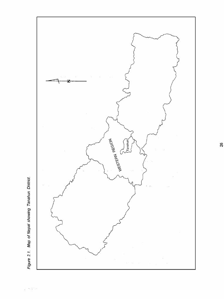

LZ

Climate
Due to the significant variation in topograpt y within the district, mainly two types of climate--suD-tropical in the lower river valleys and warm temperate steadily changing to cool temperate in the middle hills--are seen. The provision of rainfall recording facilities at four stations, viz., Khairenitar, Byas Nagar Bandipur and Kunchha Bhanjyang represent the amaunt and distribution of annual rainfall for both sub-tropical and temperate zones of Tanahun. Although climatic parameters fluctuate significantly within a short stretch of vertical zonation, the annual average raiifall IS around 2,000 millimeters (mm). more than 76 percent of which occurs during monsoon months starting from June to September (WECS 1991). The Mahabharat range has a cool and pleasan! climate, whereas the Tars and river basins have a hot and humid summer and a cool, dry winter. The, average minimum and maximum temperatures recorded at Khairenitar for each month over nine years (1978-1 986) is 7.8 ' C during December and 33.2 ' C during June (FAONNDP 1990)
able 2.2. DistriL
S . no.
8
9
10
11
12
13
ion of irrigation systems by I/;//:
Name of VDC ~~ ~~~~
Bhanu
Purkot
Basantpur
Barbhanjyang
Tanahunsur
Mirlung
Chowk- Chisapani
Rupakot
Risti
Kyamin
Ghansikuwa
Satiswara
V as Na ar dnicipailty
I Development Commiffet
Number of systems
23
22
7
10
4
6
7
12
5
22
9
11
22
160
Note: VDC = Village Development Committee
Soils
The soils of the study area have been forned primarily by the flowing of rivers (i.e., Marsyangdi and Madl), streams (Risti, Chundi, Kalesti) and their tributaries, through the dissected valleys. According to Land Resource Mapping Project (LRMP) ('986). these soils are categorized as the land form of alluvial plains and fans (depositional) and relativell old and dissected gently sloping terraces (Tars). Shallow profiles with weakly expressed horizons can be observed in alluvial plains and fans probably due to frequenffoccasional floods. By contrast, old river terraces (Tars) can be characterized by well-developed deep and red soils that indicated more weathered, oxidized and stabilized land systems.
28

Topographical region
Middle mountains
Siwalik
Total
Agriculture Grazing Forest (ha) Oher (ha) Total (ha) (ha)
Cultivated (ha) Non-
Gross Net (ha) cultivated
w482 33.185 25.583 2.544 84.294 2,534 154,437
827 754 208 42 1,068 295 2,440
40,309 33,939 25,791 2,586 @a362 2,829 158,077
I 83.880.2 I Hardwood (01%) all other combinations I of tree wecies (1%) and shrubs 18%) Middle mountains I
Region Cwer type
Siwalik Hardwood (97%) and shrub (3%)
Hectares (ha)
4,481.9
Population pressure, forest dynamics arid stream-bank erosion are some of the salient features that account for land use changes.
Total
29
85,362.1

Physiography and Water Resources
Tanahun District falls within the river basin ofthe Sapta Gandaki River. The majority of the geographical area falls within the sloping lands (84.3%) and valley floors (13.9%) of the middle mountains, and the rest (1.8%) falls within the Siwalik range (WECS 1991).
Most of the irrigated lands in the study area are river valleys formed by major riverslstreamsltributaries such as Chundi, Kalesti, Buldi, Phaundi, Chitti, Naudi-Paundi and Risti Khola. Many streams flow into the river valleys oricinating from the Mahabharat hills which are either perennial or seasonallephemeral in nature, and the volume of water declines significantly during the dry season. All the major streams from the study area either join the Madi River in the west or the Marsyangdi River in the east, and ultimately the Narayani Rivw System in the south. Approximately half of the study area falls within the sub-watershed of Madi River, while the remaining half falls within the sub-watershed of Marsyangdi River.
Demography
Tanahun District is one of the hilly districts of Nepal comprising of mainly hills, sloping lands and river valleys. Earlier, the people of Tanahun used to live on the hill top, but with the introduction of the Malaria Eradication Program of HMGlN and due to the existence of potential agricultural land in the river valleys, they gradually started shifting their homestead down to the valley floor. In 1981, the total population of Tanahun District was estimatc,d to be 223,438, with an annual growth rate of 4.12 percent for the period between 1971 to 1981 (CBS 1981). In 1991, the total population had risen to 268,073
The population of Tanahun is multiethric in character. Brahmin, Chhetri, Gurung, Magar, Newar, the occupational castes (Damai, Karni, Sharki, Sunar), Kumal and Darai are the major ethnic groups in the study area. Nepali is the dominant language spoken (63.0%) followed by the Magar (17.3%) and Gurung (9.6%) languages (CBS 1991).
(CBS 1993).
Rural Support Systems
Agricultural Development
The study area of the Tanahun District repi'esents the typical mid-hill area of the country with levelled, nearly levelled flat lands and land with viirious level of slopes. Climate and soils vary over short distances because of topography and this has resulted in numerous micro-climatic pockets.
The economy of Tanahun is dominated by agriculture which provides employment to more than 80 percent of the working population. Crop prc'duction contributes about 60 percent of the total agricultural output, livestock 30 percent and forestry 10 percent (CBS 1991). Fisheries is limited to river valleys and streams, but at the same time, micro-levei fish farming was also observed in places like Chambas. Bhanu VDC and Deurali in Ghashikuwa VDC.
The river terraces, alluvial plains and fails together occupy only 13.9 percent ofthe land area (LRMP 1986). The area and productivity of major crops in Tanahum District (1980/81 and 1989/90) have been presented in the Table 2.5. It shows that tlie total area under major crops during 1989/90 was 46,060 ha, out of which maize, rice, millet, wheat and oilseed occupied 44, 29, 16, 8 and one percent area, respectively. Area under potato, barley ard sugarcane was less than one percent. During the same year, productivity of major crops such as r ice maize, millet, wheat, and oilseed was estimated to be 2.29, 1.77, 1.23, 1.48 and 0.72 metric tonnes/ht!ctare (mtlha). respectively: while it was 7.1 1, 0.85 and 17 mt/ha in the case of potato, barley and su(larcane, respectively.
30
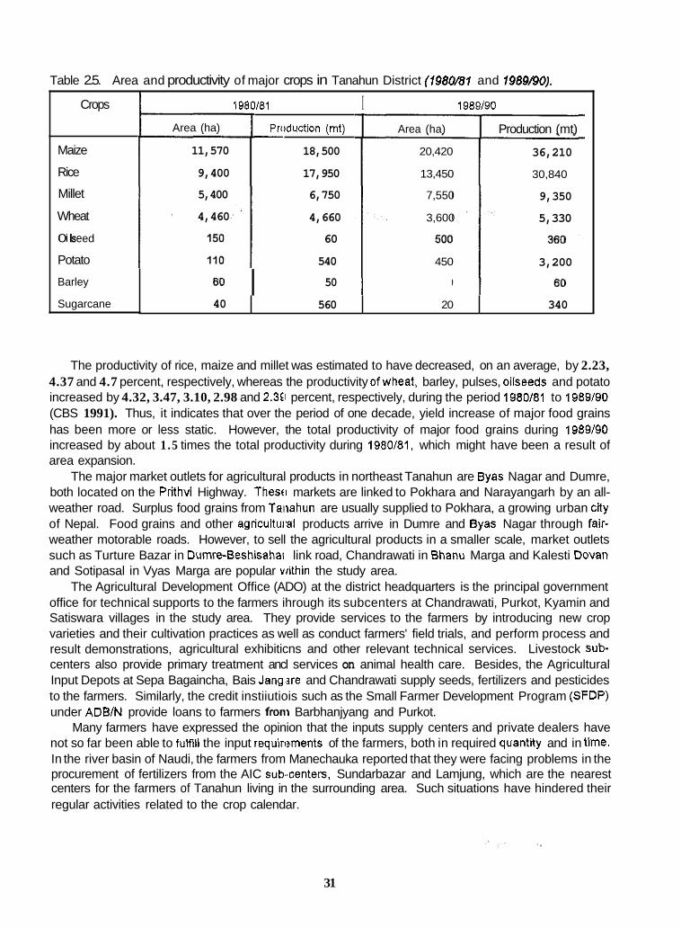
Table 2.5. Area and productivity of major crops in Tanahun District (198OB1 and 1989190). I
40
Crops
560 20 340
Maize
Rice
Millet
Wheat
0 i I s e e d
Potato
Barley
Sugarcane
1980/81 I 1989/90
Area (ha)
11,570
9,400
5,400
4,460
6o I
Produdion (mt) - 18,500
17,950
6,750
4,660
60
540
50
Area (ha)
20,420
13,450
7,550
3,600
450
Production (mt)
36,210
30,840
9,350
5,330
3,200
The productivity of rice, maize and millet was estimated to have decreased, on an average, by 2.23, 4.37 and 4.7 percent, respectively, whereas the productivity ofwheat, barley, pulses, oilseeds and potato increased by 4.32, 3.47, 3.10, 2.98 and 2.3Ei percent, respectively, during the period 1980/81 to 1989/90 (CBS 1991). Thus, it indicates that over the period of one decade, yield increase of major food grains has been more or less static. However, the total productivity of major food grains during 1989/90 increased by about 1 .5 times the total productivity during 1980/81, which might have been a result of area expansion.
The major market outlets for agricultural products in northeast Tanahun are Byas Nagar and Dumre, both located on the Prithvi Highway. Thesfi markets are linked to Pokhara and Narayangarh by an all- weather road. Surplus food grains from Taiiahun are usually supplied to Pokhara, a growing urban city of Nepal. Food grains and other agricultuial products arrive in Dumre and Byas Nagar through fair- weather motorable roads. However, to sell the agricultural products in a smaller scale, market outlets such as Turture Bazar in Dumre-Beshisahai' link road, Chandrawati in Bhanu Marga and Kalesti Dovan and Sotipasal in Vyas Marga are popular within the study area.
The Agricultural Development Office (ADO) at the district headquarters is the principal government office for technical supports to the farmers ihrough its subcenters at Chandrawati, Purkot, Kyamin and Satiswara villages in the study area. They provide services to the farmers by introducing new crop varieties and their cultivation practices as well as conduct farmers' field trials, and perform process and result demonstrations, agricultural exhibiticns and other relevant technical services. Livestock sub- centers also provide primary treatment ancl services on animal health care. Besides, the Agricultural Input Depots at Sepa Bagaincha, Bais Jang,are and Chandrawati supply seeds, fertilizers and pesticides to the farmers. Similarly, the credit instiiutiois such as the Small Farmer Development Program (SFDP) under ADWN provide loans to farmers from Barbhanjyang and Purkot.
Many farmers have expressed the opinion that the inputs supply centers and private dealers have not so far been able to fuMII the input requiri?ments of the farmers, both in required quantity and in time. In the river basin of Naudi, the farmers from Manechauka reported that they were facing problems in the procurement of fertilizers from the AIC sub..centers, Sundarbazar and Lamjung, which are the nearest centers for the farmers of Tanahun living in the surrounding area. Such situations have hindered their regular activities related to the crop calendar.
31

Rural Support Services
Support services for rural development in the study area are also directly or indirectly geared up by the development of infrastructures such as niassive construction of motorable tracks that link different villages to the district headquarters. This has enabled the farmers to transport agricultural produce and other inputs even to or from the very interior points. This has also facilitated the farmers with timely communication with the concerned agricultural agencies in the district headquarters. Numerous schools, particularly comprising of lower grades, have been concentrated in this area. In some places there are primary health centers and post oftices although they are not yet provided with the facility of electrification.
On top of the involvement of several go'rernment and semi-government agencies, the UNDP Project for Supporting Decentralization in Nepal (UhDPlNPClNepaIl88/009) is also underway in Tanahun District. This project is working in close collaboratiori with the District Development Council (DDC). Tanahun, for various development activities in the district. Furthermore, the DDC also fixes the priorities of the development projects and coordinates various developmental activities taking place in the district.
The major aims and objectives of this xoject are:
* To strengthen local governance by providing necessaly information on local resources, viz., road network, settlement, population cenius data, water resources, forest resources, etc., and thereby preparing development plans
To reduce the dependency of the citizens on external resources by providing required information from within the district itself.
-
Support Services to FMlS
in Tanahun District, both FMlS and agency-built or -assisted systems exist. However, the majority of them have come down several generations at the initiative of the farmers themselves. When these two categories of systems are compared, FMlS come out to be strong examples of local governance, as the local resources are mobilized by the farmers themselves in an effective manner.
At present, the agencieslprojects involved in the irrigation development of Tanahun District include:
* District Irrigation Office (DIO) through the Irrigation Line of Credit (ILC) Program of the World Bank under the Department of Irrigation.
* District Development Council (DDC). * District Watershed Management O%ce (DWMO). * Small Farmers Development Project (SFDP) OfAgricultural Development Branch/Nepal (ADBIN). - Hill Food Production Project (HFPF'). * Department of Roads.
The above-mentioned offices have beer contributing in various ways to the development of irrigation systems in Tanahun District.
District Irrigation Office
The principal agency for irrigation developrient in Tanahun is the DIO which was established in 2026 B.S. (1969 A.D.) with the then name as "Canal Subdivision Office" (Mishra 1988). Numerous demands such as requests for canal extension, new construction, and rehabilitation and system improvement, from different corners of the study area have reached the DIO through the farmers. DiO provides Some assistance to those irrigation systems which have approached it either on an individual or group basis
32
I
byproviding gabion wires for rehabilitation and system improvement under the recommendation of DDC office. The group should represent the water users organization (WUO), the members of which, ,are nominated or elected from among the water users. A delegation of one or two persons can also approach DIO to file'their demands or proposals in favor of the water users organization WUO). However, the delegation should have the evidence to prove that it is representative of the WUO. Once the application from the farmers is filed, DIO arranges for a detailed survey of the proposed plans and estimates fhe costs. Once the proposed plan is found feasible, it is forwarded along with all the documents and recommendations to the Rclgional Directorate of Irrigation (RDI) for final approval. it is the RDI that decides whether to approve oi'disapprove of the plan.
Dlstrict Development Council
DDC is mostly involved in distributing construction material such as gabion and cement, and food grains for the workers under the Drought Relief anll Food for Work programs. DDC is the number one among several district-level agencies concerned with local development within the district, after the multi-party democracy was revitalized in Nepal in 1990, DDC has the provision of a local development ofticei and a planning officer to support the District Development Coordination Committee (DDCC).
DDCC is the most responsible unit for m'aintaining and improying coor'dination among the concerned agencies required for all district-level development works. It is ch,aired.Qy the DDC Chairman. Other members of DDCC are DDC Vice Chairman and heads of all line agencies related to local development in the district. In addition to other committec:s, DDC itself has a Development Committee composed of DDC members. Irrigation development activities are matters of direct concem of the Development Committee. Before finalizing any district-l-lt!vel project, it is thoroughly discussed in the village-level Advisory Council.
Each VDC has its own Advisory Council. Every developmental plan is, first, discussed in the village- level Advisory Council. Then, it is passed through the concerned VDC. Afler approval by VDC, the proposal is tiled to DDC. Primarily, the Development Committee of DDC discusses the proposal. Then it is forwarded to DDCC which, in tum, fomfar'ds it to the concerned line agency for implementation.
This process applies to all types of district-level projects including irrigation. But small grants in the form of cash or material (cement, gabion boxes or wire, etc.) are approved and supplied by the DDC itself.
District Watershed Management Office
The District Watershed Management Office (DWMO) also has provision to support irrigation development by providing construction material and technical help. It provides 60 percent of the project cost to the registered water users committee, whereas the fanners have to contribute their labor equival@flt,to 40 percent of the total cost. However, the DWhlO poky does not allow for the support of new construction of the system and thus, confines itself only lo the repair and maintenance of the canal.. , .
Agriculture Development BanWNepal
Contribution of ADB/N is mostly through its Small Farmer Development Program (SFDP) in the form Of
grants/subsidies and loans for irrigation. ACIB/N supports only those projects where the demand comes from at least five households having 100 ropani (five ha) of land. The proposed program should also have a perennial source of water. It provides 60 percent of the total cost in the form of a granUsubsidy which should be reimbursed by the government through some development project or through the government budget. Out of the remaining 40 percent, a 10 percent equivalent cost is to be borne by farmers in the form of labor contribution, w?ile 30 percent is given by ADB/N as a loan to the farmers at 18 percent interest per annum to be paid back in 3 to 7 years. ADBlN sanctions cash in favor of the
33

construction committee formed by the benef'ciaries themselves. Dhakre Dihi KO Kulo (BI) is an example of an ADEIN-SFDP-assisted irrigation sy:;tem within the study area. ADBIN, however, is mainly interested to invest in sprinkler irrigation. However presently, ADBIN has stopped subsidizing irrigation loans.
Other Agencies
At present, HFPP is not working in Tanahuii. Therefore, it cannot be listed as an irrigation assistance agency any more. The Department of F!oads has never had any direct involvement in irrigation development, both for construction and rehabilitation. It only improves the parts of canals that are damaged at the time of road construction Find makes culverts at the road passes.
Duration of Study
This study commenced in June 1993. The field data collection was completed in November 1993.
Institution and Personnel
The study was carried out by the members ,,f IMSSG at the IAAS, Rampur. Chitwan, Nepal, The study team included the faculties of IAAS from the following disciplines: socialscience, agriculture engineering, soil science and plant science. Representatives from the irrigation Study Center, a farmer-based nongovernmental organization of Chherlung, Palpa; two graduate students of IAAS representing social science and agriculture economics; and two senior students (female) of IAAS representing social science and agriculture economics were also involed in data collection and tabulation activities. 'The' IAAS graduates and the IAAS female students w m appointed as research assistants (RAs), mainly to assist in the primary data collection.
..: ; .,,!
Process of Study
The irrigation resource inventory and needs assessment was completed in two phases. The Phase \was mainly concerned with system identification, preparation of the irrigation inventory and selection of some systems for the Phase II study. ,The needs. assessment and ranking of irrigation systems for external assistance were carried out in detail in the selected systems during'the Phase II study.
Phase I
Training of Research Assistants
Before assigning jobs, the research assistaiits were briefed about their jobs and were given a few days training by the concerned faculty members. They were also informed about the objectives and courses of action to be followed in the project. Prolessional training was also given for data collection. Major emphasis was placed on identification ofthe key informants, interaction with the farmers and noting down of necessary data.
34

Collection of Secondary Information
Wih a view to finding out the total numbti. of irngation systems, their location, type, size, number of beneficiaries, level of assistance and other relevant information, the following district-level offices were consulted at the district headquarters, Bya!; Nagar:
* District Development Committee Office - District lrrigatron Office * Agricultural Development Bank.
* District Agricultural Development Oftice.
Maps, previous reports and other relevant information about irrigation development such as funding policy, formal petitions requesting external assistance for priority areas were availed from district- and central-level agencies. Information was also obtained through informal meetings with field workers, engineers and the officers in charge of the iibove-mentioned agencies. Information obtained from such meetings have been found to be very C N C I ~ to validate and cross-check the same during field visits.
Reconnaissance of the Study Area
A reconnaissance of the study area was conducted to update the list of irrigation systems along with their preliminary information. A large number of imgation systems with their size varying from 0.3 to 40 ha were identified during the reconnaissance. Therefore, keeping in view the existence of an unlimited number of very small-sized systems, a general criteria was made to include only those systems into the inventory study which have at least 1 ha of service area and 5 households. Accordingly, the final list of irrigation Systems existing in the study area was worked out along with their location, size, households and other relevant information Thus, a total of 160 irrigation systems were selected for the Phase I study. The systems with less than 1 ha of service area and 5 households were not inventoried using the checklists, but a bnef information profilo of and a total of 104 such systems were prepared
Preparation and Testing of Inventory Checklists for Primary Data Collection
The proposed study was planned to be carried out in two different phases. A brief inventory checklist I (Annex II) and a more detailed inventory checklist Ii (Annex Ill) to be used separately for the first and second phases of the study, respectively, were developed. The checklist I was primarily designed to identify the total number of those systems which have a potentiality of area expansion, have adequacy of water at the source, are in genuine need of external assistance for physical impmwment, reflect willingness of allowing new comers to their water users organization and indicate possiblliiy of Crop intensification/diversification, on top of other general attnbutes of the system
These two checklists were pre-tested wih the joint effort of IIMi-Nepal and IMSSG, Rampur, in five irrigation systems in Nuwakot District separately assuming that the terrain type, nature of water resources and agricultural practices in Nuwakot and the proposed study area in Tanahun are more or less the same Upon fieid testing, few amendments were made in the initial checklists.
In checklist I, based on the field experieirce, it was found essential to incorporate the information On peak-flood flow and lean-season flow in the riverdstreams based on farmers' judgement; present Canal discharge and its relative variation over seasons; amount, time and gender mies in repair and maintenance work; and farmers' perceptions of external assistance needs
In checklist II, many topics were restNdured with a view to capture information more effectively. Issues pertaining to environment, water rights, gender, and evaluation of the systems for the provision of external assistance needs were given due consideration while restructuring the checklist.
District Soil and Watershed Conservation Office.
35

Organization of Study Team
The total number of team members for prinlary data collection was eight consisting of faculty members, RA and the representative from farmers' NGO. The team was divided into two groups. Each group had faculties representing social science and plant science and was accompanied by a RA. Since the team has only one agriculture engineer, both R.4s were trained on the techniques of measuring the water discharge in the canal and at the source.
Identifying Key informants
The first job of inventory groups was to idsntify and call on the key informants in each system. The secondary data collected in the district headquarters helped a lot in accomplishing this step. Both groups gave priority to seeing the members of the \VUO wherever possible. The local leaders among the water users were consulted in many systems where there were no formal WUOs. Depending upon the situation(s) and time available, four-to-sewn key farmers were consulted in each irrigation system.
System Walk-Through
The team members walked from the head to the tail of the system along with the respondents before conducting .group interviews. The observalions during the system walk-through included:
. .
i The nature of the source and iitake point; diversion structure; adjacent upstream and downstream systems; characteristic:; of canal including length, landslide zones, seepagelleakage zones, stream bank cutting zones, etc.; network of canal systems; and shape ofthe service area.
ii Cropping System. agricultural actibities, soil types and water availability at different section$ within the service area.
iii Structures for water allocation, dist'ibution, cross drainage, head control and erosion control.
iv Conditions of natural forestry and trees grown in and around the system area.
The team members had enough time to record valuable information during the system walk-through.
, . , ,
. , , ~ . .
It also helped in validating some of the information obtained during the group interview.
Preparation of system Map
For each irrigation system, a map showing the network of canals, system boundary and distinct land marks within the command area was prepai'ed with the help of key informants. Information on cropped and fallow land, different soil types, uplalid and lowland, present irrigated area, possible area for expansion, distance between upstream and downstream systems, etc.. could be gathered more effectively using the system map.
Group Dfscussion and Iteration
Before initiating any discussion, the respondents and team members were introduced to each other in order to develop mutual respect for each other. The importance and the objectives i of the i,Quentory study were also clearly explained. Group discussi~~ns were conducted in each irrigation system using,checklist I and checklist II during Phase I and Phaie II studies, respectively. The respondents included key informants among the water users, functionaries of the Water Users Organization and local leaders.
36
Elderly persons from the system were (consulted to correct and validate data on the history of development. Attempts were also made to make the interview as participatory and iterative as possible. One of the team members led the discussion, focussed on the checklist and moderated/facilitated the respondents if they happened to deviate from the main topic, and other members recorded the information.
Capturing Local Dialect
Some of the agricultural and irrigation activties are instantly understood by the respondents if asked in their local dialect. Many such terms were noted and used during the discussion. A list of such terms in local dialect obtained from the study area is presented in Table 2.6.
Experience Sharing and Its Implications on Methodology
One representative from a farmer NGO basically involved in irrigation management and improvement activities was invited to participate during t 'le field data collection through the inventoly technique.
One of the objectives of such a joint enort of inventorying of the irrigation systems was to tacilltate discussion between the team and the frirmers by narrowing down the gap between the way of understanding of farmers' problems by academicians and the farmers. Apart from learning and sharing each others' experiences, lt also created a congenial atmosphere for the farmers to gain a substantial level of information regarding physical, organizational, agricultural and managerial issues of irrigation systems. It was also felt from such a joint pagram that, discussion and interaction between the farmers and a representative of farmer NGO who ha E several years of experience in resource mobilization, water allocation, and recordkeeping, is a better tocl than providing farmers with training and lectures. However, with regard to physical. environmental arid agricultural characteristics of the irrigation systems, a technical back stopping is a must to make them aware of the consequences and record the information on relevant issues.
Application of Geographic Information System (GIs) in Irrigation Resource Inventory:
As farmers are both the targeted beneficiariits as well as the agents of development, location- and time- specific information on their resource base is of paramount importance for sound planning. GIS being a participatory approach to resource informa tion systems, synthesizes all information about farmers, their fields and various development-conservatioii interfaces (K.C. 1993)
To facilitate the study, a digital map of l'anahun District based on aerial photographs was prepared using PC ARCANFO 3.4 D version of GIS soflware The facility was made available from the UNDP Project for supporting decentralizatlon in Nepal. The map was carned to the field to locate the most appropriate point of consideration of the irrigation systems inventoried as well as validate the boundaries of the VDCs with the help of local people. F!ivers/streams not appearing on the map were also inserted as per their occurrence on the ground.
37
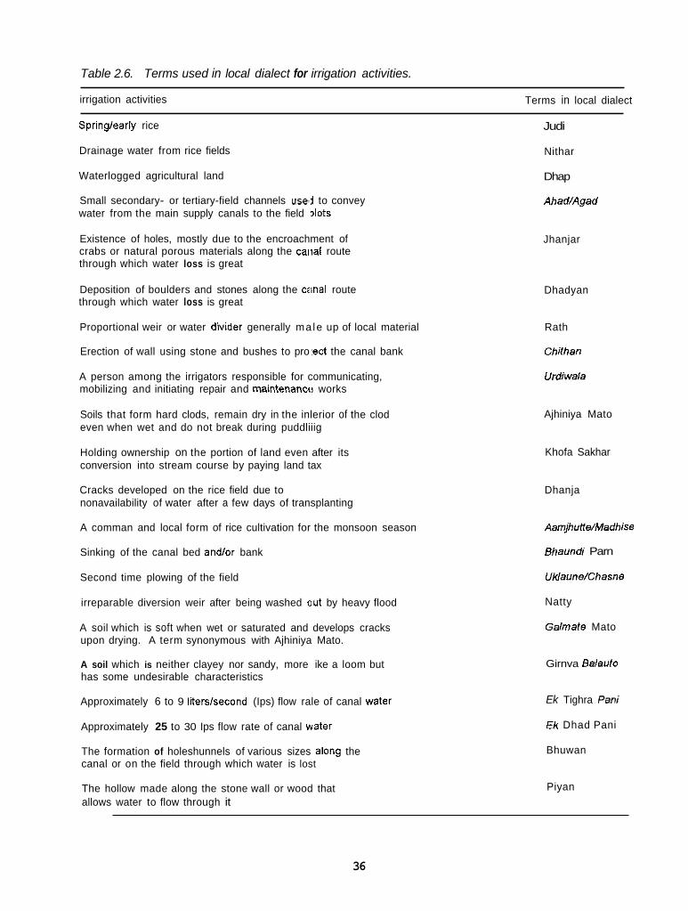
Table 2.6. Terms used in local dialect for irrigation activities.
irrigation activities Terms in local dialect
Spring/early rice
Drainage water from rice fields
Waterlogged agricultural land
Small secondary- or tertiary-field channels use,i to convey water from the main supply canals to the field dots
Existence of holes, mostly due to the encroachment of crabs or natural porous materials along the caiial route through which water loss is great
Deposition of boulders and stones along the canal route through which water loss is great
Proportional weir or water divider generally ma le up of local material
Erection of wall using stone and bushes to pro :ect the canal bank
A person among the irrigators responsible for communicating, mobilizing and initiating repair and maintenanw works
Soils that form hard clods, remain dry in the inlerior of the clod even when wet and do not break during puddliiig
Holding ownership on the portion of land even after its conversion into stream course by paying land tax
Cracks developed on the rice field due to nonavailability of water after a few days of transplanting
A comman and local form of rice cultivation for the monsoon season
Sinking of the canal bed andlor bank
Second time plowing of the field
irreparable diversion weir after being washed out by heavy flood
A soil which is soft when wet or saturated and develops cracks upon drying. A term synonymous with Ajhiniya Mato.
A soil which is neither clayey nor sandy, more ike a loom but has some undesirable characteristics
Approximately 6 to 9 iiterskecond (Ips) flow rale of canal water
Approximately 25 to 30 Ips flow rate of canal water
The formation of holeshunnels of various sizes along the canal or on the field through which water is lost
The hollow made along the stone wall or wood that allows water to flow through it
Judi
Nithar
Dhap
Ahad/Agad
Jhanjar
Dhadyan
Rath
Chithan
Urdiwala
Ajhiniya Mato
Khofa Sakhar
Dhanja
AamjhutWMadhise
Bhaundi Parn
UWaune/Chasne
Natty
Galmate Mato
Girnva Balauto
Ek Tighra Pan;
Ek Dhad Pani
Bhuwan
Piyan
36

It was succeeded by a joint effort of the JNDP Project for Supporting Decentralization in Nepal, IIMI- Nepal and IMSSG, Rampur, in which a field work project was undertaken to relocate on the map some crucial features such as the points of water rights dispute intakes within the study area, using a Global Positioning System (GPS) Receiver. The GPS Receiver is a tool with the principle that it receives signals from a number of satellites (Rusziian-constellation of GLONASS, American-constellation of NAVSTAR) to determine any point on earth by providing the latitude, longitude and altitude above mean sea level. In the field, the receiver was takc!n to points where the earth coordinates were desired. This way, any point, line or arealpolygon feature could be surveyed very quickly as compared to conventional survey techniques. The recorded coordinal,es in the receiver were later on downloaded to a computer to post-process and transfer to a GIS sofiware. Other associated attributes of the system recorded in the field are automatically linked with the GIs by means of unique identifiers.
The attributes-physical or social-under consideration were incorporated in to the digital file through digitization and annotation processes of GIs. The final map that was prepared through the GIS technique will be of greater use for policy maken, researchers, fiefd workers, project implementing agencies and ultimately to farmer users for irrigation development.
Data Analysis
Dummy tables were prepared fo compile the datalinformation obtained from the field work. Information was synthesized to compute the frequency of variables. To evaluate the performance and assess the need for external assistance to irrigation sy!items, scores were assigned to different variables based on the subjective judgement of the study team after thorough discussion.
Selection of Irrigation Systems for Exteinal Assistance
Based on the information collected from 160 irrigation systems, certain criteria were fixed for selection of the Irrigation systems for the Phase II study (Table 2.7). As a resun, only 35 systems fulfilled the criteria. The detailed procedures for system selection IS dealt with under a separate tile, "Evaluation of Irrigation Systems for External Assistance" in this chapter.
Phase II
Preparation of Inventory Checklist
A detailed semi-structured inventory checklizt was prepared to prioritize the selected systems for external assistance (Annex Ill), based on their diffeiences in terms of performance and potentialities.
Training of Research Assistants for Phase II Study
Since the objective and the model of inventory checklist were separate for Phase I and Phase II studies, RAs were trained again to prepare for the '=base II study.
39

Table 2.7. Number of irriioafion 2
No. of recent systems s. no. Total Name of major
sources
Tributaries of Marsyangdi River
Naudi- Paudi Khola
Risti Khola
Madi River
Kalesti Khola
Buldi Khola
Chundi Khola
Total
I
No. of very old systems (>ZOO yr)
36
14
6
3
17
22
21
119
'ems t 'v f -- No cf
old systems (100 l o 200 y.) --
4
1
5
3
1
1
6
__.-
21 --
(50-75 (25-50 (0-25 -1
1
2
42
16
11
8
21
27
1 35
Data Collection
As in Phase I, the study team split into two groups and moved to study the selected 35 systems in more detail as per fixed plan. This time, the group visited the key informants who were identified in the Phase I study. System walk-through was done tci some of the selected systems again depending upon the need felt by the study groups and the interest of the respondents. A detailed system map was also prepared in this phase in order to avoid any confusion about the physiography, landmarks and land use of each system. Other procedures for infoimation collection were same as in Phase I. , .
Needs Assessment for External Assistance
The Need for external assistance mainly depends on the: present performance status and future potentiality of each irrigation system. Thus the study team evaluated the performance and judged the potentiality of each system, the details of which are presented later. On the basis of this information, the irrigation systems have been ranked in the order of priority for external assistance (Table 2.37).
Evaluation of System Performance
Each ofthe irrigation systems has positive and negative factors affecting the performance of the System. In this study, bath factors were identified and scores were assigned to evaluate those factors individually. The score assignment and scoring were done according to the consensus of the study team based on the available data regarding each system aiid the subjective judgement of the members based on their field observation and experiences, To find ihe present status of performance of each irrigation System,
40

the negative score hindering system performance was suMracted from the positive score. Out of the 35 irrigation systems selected for the Phase I1 study, the study team decided to combine MD7 and MD8, and M3 and M5 as a single system (Table 2.36). Improvement in MD7 and M3 systems can serve all the present as well as potential sewice area and farmers equally in MD8 and M5, respectively. Thus, the total number of irrigation systems selected for needs assessment comes out to be only 33.
Scoring Potential Factors Affecting Need for External Assistance
The major factors influencing external assisi ance for irrigation system improvement considered were the potential service area, crop productivity ard cropping intensity. Relative scoring of the systems was done based on the projected data on these variables. The present status of the systems in respect of these factors were taken into account while scoring for their potentialities.
Needs Assessment and Prioritizing Irrigation Systems for External Assistance
Undoubtedly, the system potentialities are ttNe major factors determining the need for assistance to FMIS. But, at the same time, factors contributing negatively to system performance should also be considered and need to be corrected, thus enhancing the performance of the systems still further. Hence, the summation score of potential factors as wifll as positive and negative factors to system performance determines the magnitude of the external a:ssistance needs. Keeping this in view, 33 selected systems have been ranked in order of priority for erternal assistance (Table 2.37).
Report Presentation in Workshop
After preparing a drafl report of the study, the report was presented in a workshop arranged at the district headquarters, Byas Nagar, on 18 January 1993. The workshop was jointly sponsored by IIMlINepal. Tanahun District Development Council and IMSSG in the Institute of Agriculture and Animal Science, Rampur. The participants in the workshop were the VDC Chairmen from all 12 VDCS, Mayor of Byas Nagar Municipality, DDC Chairman, DDC Vice Chairman and all DDC members, Local Development Officer and Planning Officer, Chief Commiisioner of the Service Commission of National Agriculture Research Center (NARC), Vice Chairman of the National Cooperative Association, Heads of all concerned line agencies in Tanahun District (DIO, ADO, ADBlN and Watershed Management Office), all members of the study team, Head of IIMIINepal and other scientists, representatives from UNDPlN, and several other distinguished personalities of the district. The objective of the workshop was to present the findings, collect the comments, suggestions and reactions of the participants about the report and to incorporate them, wherever possible, in the preparation of the final report.
Preparation of the Final Report
The suggestions from DDC Chairman and other members, VDC Chairmen and representatives from IIMIIN and UNDPlN were very helpful in preparing the final report of the study. Their valuable suggestionskomments were well taken by the study team and incorporated in the final report.
41
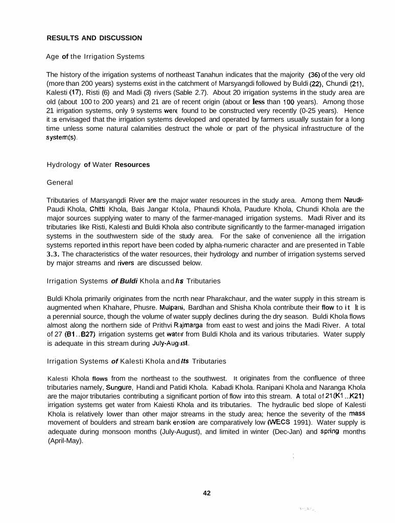
RESULTS AND DISCUSSION
Age of the Irrigation Systems
The history of the irrigation systems of northeast Tanahun indicates that the majority (36) of the very old (more than 200 years) systems exist in the catchment of Marsyangdi followed by Buldi (22), Chundi (21), Kalesti (17), Risti (6) and Madi (3) rivers (Sable 2.7). About 20 irrigation systems in the study area are old (about 100 to 200 years) and 21 are of recent origin (about or less than 100 years). Among those 21 irrigation systems, only 9 systems were found to be constructed very recently (0-25 years). Hence it IS envisaged that the irrigation systems developed and operated by farmers usually sustain for a long time unless some natural calamities destruct the whole or part of the physical infrastructure of the system(s).
Hydrology of Water Resources
General
Tributaries of Marsyangdi River are the major water resources in the study area. Among them Naudi- Paudi Khola, Chitti Khola, Bais Jangar Ktola, Phaundi Khola, Paudure Khola, Chundi Khola are the major sources supplying water to many of the farmer-managed irrigation systems. Madi River and its tributaries like Risti, Kalesti and Buldi Khola also contribute significantly to the farmer-managed irrigation systems in the southwestern side of the study area. For the sake of convenience all the irrigation systems reported in this report have been coded by alpha-numeric character and are presented in Table 3.3. The characteristics of the water resources, their hydrology and number of irrigation systems served by major streams and rives are discussed below.
Irrigation Systems of Buldi Khola and Irr Tributaries
Buldi Khola primarily originates from the ncrth near Pharakchaur, and the water supply in this stream is augmented when Khahare, Phusre. Mulpaiii, Bardhan and Shisha Khola contribute their flow to i t It is a perennial source, though the volume of water supply declines during the dry season. Buldi Khola flows almost along the northern side of Prithvi R.2jmarga from east to west and joins the Madi River. A total of 27 (81 ... 627) irrigation systems get watf!r from Buldi Khola and its various tributaries. Water supply is adequate in this stream during July-Augiist.
Irrigation Systems of Kalesti Khola and Its Tributaries
Kalesti Khola flows from the northeast to the southwest. It originates from the confluence of three tributaries namely, Sungure, Handi and Patidi Khola. Kabadi Khola. Ranipani Khola and Naranga Khola are the major tributaries contributing a significant portion of flow into this stream. A total of 21(K1 ... K21) irrigation systems get water from Kaiesti Khola and its tributaries. The hydraulic bed slope of Kalesti Khola is relatively lower than other major streams in the study area; hence the severity of the mass movement of boulders and stream bank erision are comparatively low (WECS 1991). Water supply is adequate during monsoon months (July-August), and limited in winter (Dec-Jan) and spring months (April-May).
42

Irrigation Systems of Madi River and Its Tributaries
Madi River, which originates from the Himalayas, flows from the north to the south before it joins the Seti River So, it is a perennial river with a relatibely deep bed level but does not possess any big river valley along its banks. Only 3 irrigation systems (Mdl, Md7 and Md8) get water from this river and the other five irrigation systems (Md2, Md3, Md4, Mt15 and Md6) receive water from the tributaries of the Madl River.
lrrlgation Systems of Risti Khola and Its Tributaries
Risti Khola originates from a narrow pass-Kiinchha Bhanjyang-and flows to the southwest before joining the Madi River. A total of 11 (RI, R2, .... R11) irrigation systems get water from Risti and its tributaries. The majority (7) of the irrigation systems in the river valley of Risti Khola located in the Tanahun side are perennial. A significant number of perennial irrigation systems also exist in the Lamjung side of the Risti Valley.
lrrlgation Systems of Naudi Khola and Its Tributarles
Naudi Khola originates from Kunchha Bhmjyang in Lamjung District and flows in the west-to-east direction. Paundi Khola (larger than the IUaudi Khola) that originates from Thansing Bhanjyang of Lamjung, joins the Naudi Khola near Maiiechauka and flows to the southeast Paundi Khola and ultimately joins Manyangdi River at Paunditlhik. The majority of the tributaries of Naudi-Paundi Khola. mostly originating from the hills of Mirlung Danda (ridge system), flow from the south to north and contribute significantly in supplying water to many irrigation systems. These streams are mostly seasonal in nature and have a very high hydi,aulic bed slope. Irrigation systems getting water from Naudl khola and Sabadi khola are perennial in natwe. A total of 16 (NI, N2. ... NIB) irrigation systems get water from Naudi-Paundi Khola and its tributaries.
. .
IrrigaUon Systems of the Tributaries of Marsyangdi River
Major tributaries of Marsyangdi River supplying water for irrigation include Chiti Khola (6 systems), Bais Jangar Khola (11 systems), the tributaries; of Phaundi Khola (10 systems) and Paudure Khola (4 systems). Most of these streams flow in the west-to-east or southeast direction and join Marsyandi River. The majority of the irrigation systems (26) getting water from these streams are seasonal in nature, while only 16 irrigation systems ale perennial in nature. A total of 42 (MI, M2 _...... M42) irrigation systems receiving water from various tributaries of Marsyangdi River are accessible from the Dumre-Beshishahar link mad.
1m.gation Systems of Chundi Khola and Its Tributaries
Chundi Khola originates from the confluence of the Kasaundi and Naspati Khola at Chandrawati. It flows in the north-to-southeast direction and joins Marsyandi River near Bimalnagar, a marketing center in the Mungling-Pokhara section of the Prithvi Highway. Chundi Khola is one of the potential sources of irrigation, not only within the study area but also in Tanahun District as a whole. The majority of the irrigation systems (24) receiving water fron Chundi Khola and its various tributaries are perennial in nature as Chundi Khola is a perennial soiirce of water. The destruction of headworks of irrigation systems and thereby the changing of river courses due to heavy floods during the monsoon is a common feature of this stream. Water quality of C'lundi Khola has been reported to be good for agricultural usage as it brings a lot of fertile silt and humus. A total of 35 (CI. C2 ... C29. C1. C'2, ... '2'6) irrigation systems get their irrigation water supply frc'm Chundi and its tributaries.
43

Types of Irrigation Systenls
The classification of irrigation Systems intcs seasonal or perennial type indicated a total of 86 irrigation systems to be perennial and 74 irrigation systems to be seasonal in nature. The classification of the irrigation systems into perennial and seasoiial types is based on whether or not a system obtains a water supply during spring (March-May) and monsoon (June-Sep) seasons. A system is considered perennial if irrigation water is available both in spririg and monsoon and considered seasonal if available only during monsoon. Another basis for this claissification has been the number of rice crops grown per year. In perennial irrigation systems, it is possible to grow two rice crops due to the availability of irrigation water during spring season as well as, while only one rice crop (monsoon rice) can be grown in seasonal irrigation systems. Winter irrigation is not extensively practiced in the study area as the farmers grow wheat, potato and vegetables in a smaller scale
System accessible from
Prithvi Highway
Vyas marga
Bhanu marga
Dumre-Besisahar secondary road
Grand total
Location and Accessibility of Irrigation Systems
All the irrigation systems within the study a'ea are ac
Range of time Total
0-X hr W-I hr 1-2 hr 2-3 hr
20 7 1 0 28
17 9 9 5 40
20 8 6 0 34
31 4 11 12 58
88 28 27 17 160
ssible from fou Aifferent roads within a rz .
a few minutes to 2.5 hours. The majority (58) of the irrigation systems are accessible from the Dumre- Besisahar road--a fair-weather road linking Besisahar, the district headquarters of Lamjung District, and Dumre, a small marketing center on Prithvi Highway. Out of these, more than 50 percent (31) of the systems are very close to or along the side of the road (0 to 30 minutes). A total of 40 systems are accessible from Vyas marga-a fair-weather road joining Byas Nagar. the district headquarters of Tanahun--to Sotipasal--a marketing center in Lamjung along the right side of the Risti River. A total of 34 systems are accessible from Bhanu rnarga, a fair-weather road linking Dumre to Chandrawati. Twenty out of the 34 systems accessible to rn Bhanu marga are very close to or along the left or right side of the road. About 75 percent (21 out of 28) of the systems ,accessible from Prithvi Rajmarga--a highway linking Pokhara and Kathmandu--,are very close to it.,,
The majority of the systems (88) are siich that it takes up to 30 mlnutes to reach the nearest road from the systems. Likewise, the systems requiring 0.5 to 1 hour, 1 to 2 hours and 2.to 3 +lot& are 28, 27 and 17 in number, respectively (Table 2.8).
Table 2.8. Distribution of irrioation svstems and accessibilitv. , ,
44

Size of Irrigation Systems
The size of the irrigation systems in the study area varied from 1.25 ha to 60 ha. Out of 160 systems inventoried, 88 systems (55%) fall in the clliss interval of 1 to 5 ha and only 2 systems (1.25%) fall in the class interval of 40 to 60 ha (Table 2.91. Thulo Tar KO Kulo (NI) and Aathbise Rihabote Kalesti Kulo (K7) are the largest irrigation systems having 60 ha of servioe area each, while Dhunge Kulo (KI), Tari KUlo (K2) end lnar Kuwa KO Kblo (ClCl) are the smallest systems having 1.25 ha of service area each.
Table 2
S. no. - -
1 2 3 4 5 6
I. Size of imgation systems in the study area.
Service area/siZe -7 Number systems of
1-5 5.1-10 10.1-20 20.1-40 40.1-60 More than 60
I Total I 160
Percent
55.00 23.13 13.12
0.00
100.00
Resource Mobilization for Operation and Management
Inhlal Construction
The information on the amount and basis of resource mobilization at the initial construction stage could not be obtained in almost all the irrigation :iystems as the history of these systems dates back to the unknown past. Even the elderly persons colikl not estimate nor do they have any information about the amount of resources used at that time. However, the nature and type of resources used and the occumnce of important events during the initial construction as reported by the farmers of the few systems are summarized below.
Barai KO Kulo (M28) was originally constructed in 2015 B.S. (1958 A.D.) at a cost of about NRs 1,500.00 (present exchange rate is US$1= NRs 50.00). Chirkatta Kulo (C6) was initially constructed by skilled people from outside the community. Tuntari Pahare KO Kulo (C18) was initially constructed by Harka Bahadur Kumal under a contract agrctement for NRs 1,100.00 in 2021 B.S.(1964 A.D.). Jaiuwa Biruwa Kulo (C26), guessed to be more than 100 years old, was constructed by employing labors @ NRs 0.02/person/day (present wage rate within that locality is NRs 50,00/personlday). Prior to 1951 during the Rana regime in Nepal, the first poet to tiave written in the Nepali language, BhanubhaMa Acharya. was sentenced to imprisonment for initiating the construction of Bhanu Baraha Kulo (C16) as ail developmental works in the villages wew restrlcted. The Pokhrel Phant Sinchai Yojana (K16) was started in 1978 at an approximate cost of NI% 200 thousand, afler getting external assistance from the Hill Food Production Project (HFPP).
Rehabilltation and System Improvement
The rehabilitation and system improvement works carried out in the irrigation systems of northeast Tanahun revealed that in 72 (45%) systems no record of rehabiliationlsystem improvement was found; 40 (25%) systems had mobilized their own iiternal resources and the rest of the 48 (30%) had received some external assistance and mobilized th sir own resources too, In such activities, the beneficiaries
45
contribute their labor significantly, and only in a few cases do they hire paid labor for such work, The labor contribution is based on the housohold in a majority of irrigation systems. The nature of rehabilitationlsystem improvement works .nclude further extension of the canal, lining of the canal, headworks improvement by placing gabion boxes filled with stones across the flowing stream to channelize the water into the canal, construction of spurs to protect the canal as well as the service area from stream-bank erosion, construction of iiermanent headworks, erection of dry stone walls across the erosion-prone zones to stabilize the bank of the canal, shifling of the diversion weir upstream, provision of pipe culverts for cross-drainage work and water allocation and distribution structures, etc.
A number of agencies providing assistalice for improvement and rehabilitation work identified during the field visit includes DIO (specially under the ILC Program of World Bank), SFDP of ADB/N, HFPP, Watershed Management Office, DDC, and the Department of Roads. The District Irrigation Office was found to be the major agency providing assistance for rehabilitation and improvement of the irrigation systems.
Regular and Emergency Repair and Maintenance
The amount of labor mobilized for annual cr emergency repair and maintenance of the systems by the internal sources are analyzed and presenkd in more detail under a separate section discussing repair and maintenance. The types of works tcs be performed in annual repair and maintenance include desilting of canal, repair of diversion weir ard strengthening of canal banks at vulnerable zones. In case of emergency repair and maintenance, major works to be performed are repair of damaged headworks, protection of canal bank by making spurs across the stream, and strengthening of canal banks. The desilting of canal was found to be done twice a year, once before the spring rice season during Feb- March and the next before the monsoon rico season during May-June, in most of the perennial irrigation systems. In seasonal irrigation systems, however, cleaning of canal network is done only before the start of monsoon season during ApriCMay.
Resource mobilization for repair and niaintenance includes cash and labor resources to carry out repair of diversion weir, cleaning of canal, strengthening of canal bank and cross-drainage works. The labor resource mobilization for regular repair and maintenance is based on the size of landholding and the number of households 74 (46%) irrigation systems while, 12 (8%) irrigation systems have another basis for resource mobilization. In the cimse of emergency repair and maintenance, only 37 (23%) systems follow the size of landholding as the basis, while 102 (64%) systems follow the number of households as the basis, and the rest of ttie 21 systems (13%) follow some other basis (Table 2.10). The other basis for resource mobilization fctr regular and emergency repair and maintenance includes:
Contribution of labor by winter wheat and spring rice growers. Contribution of more labor by larger landowners during emergency repairs. Mutual understanding among the users. Amount of water share. Users residing near the system intitke contributing more labor. Those who want to transplant rice earlier having to acquire water. Male member@) of the househod being preferred for contributing labor for repair and maintenance, etc. Some systems not cleaning canal -egularly.
Among the irrigation systems where the size of landholding is the basis for resource mobilization during repair and maintenance, variation was observed with regard to labor contribution per unit area. The size of landhoMiog that a laborer should serve varied from 0.021 to 0.1875 ha, depending upon the specific rules and regulations of the systenis.
46

Nature of repair and maintenance
Basis for resource mobiluation
Landholdin,~ Household Others
Regular 74 12
Emergency 102 21
Total
160
160
system per year (AMHS)
Numbers classes I System
size Systems Average man-days Average cropping
intensity (CI) (%) per household per
47
::6 I 'g I ;i 16-32 32-60
a 3 200 7 4 207 5 7 170 4 9 166
x'= 6 6 x'= 186

Physical Characteristics of Irrigation Systems
Types of Headworks
The major types of headworks in the irrigation systems of the study area include temporary brushwood check dams, gabion boxes treated as se mipermanent diversion structures and permanent cement concrete diversion weirs. The brushwood (check dams are constructed for temporary purposes using a variety of local materials such as bushes, wooden stakes, stones, gravel, earth slices. mud, etc., whereas the semipermanent diversion weix contain the whole or part of the diversion to be of gabion boxes filled with stones while the rest of th,? portion is made of other locally available materials. As far as permanent headworks are concerned, the intakes of such systems are made of cement concrete with or without the provision of a head regulato-.
The distribution of irrigation systems by type of headworks presented in Table 2.12 indicates that three irrigation systems (i.e., B I , N8 and M4) have permanent intake structures. Among them B1 had received extemal.assistance from ADBIN, N8 from DOlIDlO and M4 from HFPP for making the intake permanent. The irrigation systems having ijemipermanent types of headworks were mostly assisted by DIO or DDC. The majority of the irrigatioii systems (130 or 81%) in the study area have temporary brushwood check dams designed and mainlained by the farmers themselves. In three irrigation systems there is no headworks as'such but they get the water supply from springs o r other means (Table 2.12).
Table 2.12. Distribution of irrigation systems by types of headworks.
Total
Type of headworks Number of irrigation systems
Temporary brushwood Semipermanent (gabion box or
Permanent (cement concrete) Non-existent
brushwood + gabion box)
160
Main and Secondary Canals
The main and secondary canals in almost ;3ll the irrigation systems reported are unlined. A total of 12 systems out of 160 have partial lining in theii. main and secondary canals. The magnitude of lining varies from a minimum of 10 m in Sinuwa Khet KO Kulo (MD1) to as high as 1,700 m in the main canal and 400 m in the branch canal of Thulotar Sinchai Yojana (N8).
An assessment of the distribution of the irrigation system by main canal length shows'that out of 158 systems, the main canal length is more than 3 km in three systems, 2.6 to 3 km in five systems, 2.1 to 2.5 km in eight systems, 1.6 to 2 km in '15 systems, 1.1 to 1.5 km in 28 systems, 0.5 to 1 km in 70 systems (44.3 percent) and less than 0.5 km in 29 systems (Table 2.13). The irrigation systems with the largest main canal length of 3.5 km each are Birta Gairi Malebagar Bhunbhunge Kulo (827). Gairi Kulo (R5) and KaRari Simaltari KO Kulo (C2r). The smallest main canal length of 20 m is only observed in Dhaka1 Kulo (C9).
In the majority of the irrigation system:;, the length of secondary canal is found to be very small, ranging from a few meters to as high as 400 m in a single case. The distributionldelivery of water from the main canal Is usually performed througn direct outlets.
48

Table 2.13. Distribution of irh
Length of main canal (m)
C 500
500-1,000
1,100-1,500
1,600-2,000
2,100-2,500
2,600-3,000
3,100-3,500
'on sysrems by the length of main canal.
Numbw of systems
29
70
28
15
8
5
3
I I 158
Structures for Cross-Drainage Works
Percentage
18 35
44.30
17.73
9.50
5 06
3.16
1.90
100.00
Piped culverts, flumes, aqueducts are the major types of cross-drainage structures provided in many of the irrigation systems. The irrigation systems which cross major roads such as Dumre-Beshisahar road, Vyas Marga, Bhanu Marga or Prithvi Rajmatga have a provision of either piped culverts, inverted siphon or slab culverts and the Department of Roads is responsible for such works. However, in case of systems getting external assistance, the CrDSS-drainage works are mostly of the permanent type. On the other hand, systems operated by the fermers generally consist of wooden flumes/aqueducts, or in a few cases, they have designed and consttucted dry stone-earth walls similar to piped culverts (fjyan) to cross natural streams, depressions and village trails, using indigenous knowledge and resources.
Structures for Water Allocation and Dislribution
Provision of wooden proportional weirs for water allocation in secondary canals are found only in three irrigation systems, namely, Patal Kulo (R'IO), Shera Kulo (M34) and Muhane KO Kulo (M35). An interesting example of water allocation through direct outlets using wooden stakes, bushes and stones is found in Gairi Kulo (R5). Users of that system have established a set rule that afler transplantation of rice in the fieldAand, each outlet is entiled to receive a specific width of water flow through the outlet (i.e., one ha of land is entitled to receive a :'hare of 16 inches of water flow irrespective of depth of flow in the supply canal) using wooden stakes. I I Thulotar Sinchai Yojana (N8) and Sangrale Phant KO Kulo (M4), permanent outlets of a specific size are found receiving a specific share of water. In the majority of the systems, temporary outlets and secoridary canals are the structures for allocation and distribution of irrigation water. The general practice of the farmers to ensure near proportional allocation of water is through erection of temporary structures of wooden stakes, bushes, stones and earthen materials across the main canal.
Tunneling and Rock Cliffs
Tunnels and rock cliffs along and across ttle canal network are some of the distinguishing features of hill irrigation systems, Tunnels. rock cliffs and large boulders along the route of the canals sometimes create difficulties in constructing new canals and bring hinderance to the smooth operation and maintenance of irrigation systems necessitating skilled manpower and technology.
49
In 91 irrigation systems, there is no rocky terrain along the canal route. However, in 67 irrigation systems, the length of the rocky terrain along the canal varies from a minimum of 5 m to a maximum of 300 to 400 m. The indigenous, technology to break rocks for making canals or tunnels are of two types. The most common technology is the use 8,f a boiled solution of horsegram on the rock surface and the heating of the same surface on a wooden fire. Finally, the heated surface is broken by hammering on it. The second method is to only hammer son the rocky surface. The first method is used in cases where the rock is very hard to break. The types of rocks encountered along the canal route are sedimentary, conglomerate, hard limestone and other lock outcrops.
Users have made provisions for openiigs along tunnel sections at definite intervals for cleaning the tunnel when foreign materials get depositell. In some cases, these tunnels have served as leakage proof zones along the canals. However, the users have experienced difficulties while cleaning the canal through such sections.
Other Structures
In order to control and regulate the flow oi'water in the canal, especially during high floods, permanent head regulators have been provided at the intake in a few irrigation systems. The systems with permanent head regulators are Thulotar Sinchai Yojana (N8) and Sangrale Phant KO Kulo (M4).
Provision of spurs made up of gabion boxes filled with stones to protect the canal and service area from stream bank erosion and landslides have been observed in a substantial number of irrigation systems. Lining of canals on both or either side of the canal at several sections, super-passage structures to safely dispose surface runolf water over the canal, and escape structures to safeguard canals during high floods are some of the permanent structures observed in a few irrigation systems. In the absence of permanent structures u6;ers have erected dry stone walls to raise the bed level of the canal at required places and strengthened the canal bed by making retaining walls. Users have also employed the technology of Bio Engineering through the plantation oftrees along the side of Tune Khola to stabilize the slope of the canal in Sangrametar Bhaluwa Kulo (Rl).
Characteristics of the Service Area
Most of the land under rice cultivation in 1 he hills are terraced. The width of the terraces vary from a minimum of one meter to as high as ten meters depending upon the existing slope/topography of the area. The smallest terraces where it is v?ry difficult to operate bullocks for plowing are locally called Sufka. A significant portion of land in sleep sloped terraces is taken by rise- and bonds, thereby reducing the effective area for cultivation. However, in the case of river-valley irrigation systems where the service area is more or less flat, the: width and length of terraces are relatively larger in size. Generally, two major types of land systems. viz., lower terrace system (alluvial flood plain) and upper terrace systemflars (Older terraces orolder flood plains) are found in Tanahun. Such terraces are made only where water is available and it can take upto 5-to-10 years to complete the terracing for rice cultivation in an irrigation system (Pradhaii 1989).
An interesting feature of terraced cultivation is that the lower terraces (which are at a lower elevation) are always more benefitted with regard to water allocation and distribution, as the contribution through sub-surface flow is more significant, thus rt!sulting in nonequitable distribution of water within the service area. Some of the lowlying areas, genei'ally encountered within the service area of the river-valley irrigation systems, also suffer from waterlogging problem and remain fallow during winter (October- February).
50

c Discharge Measurement in the Main Cam/
r I L_
r
-.
.-. L
c I
L
i
The discharge of the canal was measured with respect to maximum anticipated supply, employing the velocity-area method. To estimate the velocity of the water flow, the float method was used. The discharge so measured could not show an'/ logical comparison with the size of the service area as in many systems, the maximum anticipated discharge could not be measured due to one reason or another. All discharge measurement was done during July 1993.
Environmental Stress on Irrigation Systirms
General
The irrigation systems in the study area of Tanahun exist over a wide range of environmental conditions. The systems have water sources originating from small creeks to big ephemeral streams. In many cases, earthen channels pass through long porous rocky and loose soil materials. The fragile nature of the hills, lack of incentives with the local resource users and erratic rainfall pattern are some of the major factors stressing the performance of irrigation systems. Although the majority of the irrigation systems face similar types of environmental problems, the magnitude of problems vary a lot. These irrigation systems spreading over about 1,400 ha acr'3ss two agro-climatic zones (valley floor and hills) are prone to multidimensional problems as described later.
Landslide and Erosion
It is apparent that the ravages caused by heavy monsoon rainfall are the most serious type of soil erosion in Tanahun. It is very much influenc:ed by the land topography such as slopes and vegetation. The canal sections across the slopes which lie in shady and moist condition are easily affected by landslide, thus causing occasional blockade to water supply and resulting in the huge conveyance loss of water.
Seepage and Leakage
Seepage and leakage have also posed conskierable environmental threats to several systems. It is quite common for hill irrigation systems to use marginal lands wherever convenient for making canals. The shallow and loose soil profile with an abundant occurrence of gravel and stones at sub-surface level is found contributing to the seepage and leakiige of water. Soil animals such as crabs and snakes along the anal, rats and field crickets (locally ternied as Birale Kira) in the field, as well as frequent movement of livestock and humans in the canal are not less important factors to add to this problem. There is a heavy burden on the farmers of plugging the holes, especially during the transplanting of rice.
There are instances where the sub-surface flow of water passes through cavities and tunnels, probably formed by soil animals from, the head to the tail reach of the same system and thus becomes a problem in water distribution among the irrigators. Cement-lined canals, although few in'number; put farmers in a dilemma once there is the formation of holes and water starts' leaking out. The farmers express that it is beyond their capacity to tilug the holes.
Flood and RiverBtream Characteristics
The latest and the most devastating flood occurred 21 years ago in 1973. As a result, Chundi. Kalesti, Buldi, Risti and Naudi streams changed their courses. This compelled the farmers to shifl the Site of the headworks and to dig out tunnels in the canals, Since then, occasional flash floods in these Streams
51

were also noted by the farmers that destrc'yed out-diversion and canal structures, claiming the bulk of resources for the repair and maintenance of the systems. Similarly, a large number of tributaries of seasonal streams crossed the canals vatically. Depending upon the slope and the area of the watersheds of these streams, they destroy canals and off-load various quantities of sediments both in the canals and the cultivated lands. The systems with relatively longer conveyance lengths suffer more and the situation becomes worse if a small number of households are to manage such canals. Unprecedented floods and the changing nature of the stream course have not been helpful for the farmers in sticking to their set crop calendar. On the contrary. this has created problems related to water rights.
During heavy floods these streams pose serious problems such as the bank cutting of productive land. However, the land systems away from the streams and upper terraces are relatively safe. The systems surrounding the district headquart'm have easy access to acquire gabion wires from the DIO for making spurs. However, this is not the case with other systems. Hence, measures such as riverlstream training works are of great concern to the water users in the study area. At the same time, efforts should be directed towards controlling landslides and soil erosion through different practices of soil and water conservation.
Canal Breaching
Canal breaching has also been considerecl as important as other problems. Several factors such as coarse soil type, high frequency of livestock and human movement, activities of soil animals, heavy flood influx, road construction either along or across the canal, close alignment of two or more canals running across the slope, are some of the noticeable causes of the breaching of canals. Furthermore, the irrigators cannot avoid the movement of wallowing buffalos along the canal route because this has served farmers for generations in taking tieir animals for watering and grazing. Another similar old tradition is that the farmers use canal routos to go to the forest, streams and croplands as well.
Deforestation
The middle mountain range of Nepal represents one of the most intensively utilized landscapes in the Himalayas. There is virtually no detailed quantitative information available on land use dynamics and resource degradation. processes in this part of Nepal (Shah and Screwier 1991). However, from the interactive resource inventory approach wilh the farmers of Tanahun District, some qualitative data on forest and grass land status have been gathered. The farmers have reported that although population pressure has led to the rapid crop intensilication and conversion of several public sloppy lands into terraces, forest firing by unidentified persons and forest clearing by human or animal encroachment have been reduced significantly because of the reinforcement of the government's ComrnunIty Forest Act. There have been some official reforestation efforts in the area as well. The farmers also seem to have been equally aware and planted various species of trees in their areas through the initiative of the respective village development committees. The dominant species planted are pines and sissoo on the up hill and down hill, respectively. Tree plaitation is also observed in the banks of irrigation canals and on terrace rises to reinforce stone walls, t'lereby helping in the stabilizing of the soil.
Socioeconomic Characteristics
This section describes the ethnicity, the number of households of the water users, their landholding pattern, common trends of tenurial status within the study area, off-farm employment and the nature Of water users organizations.
52

fthnicity
Brahman-Chheffy (66%), Gurung-Magar (15%) and the tribal castes (9%) are the major categories of ethnic groups prevalent in the study area (Table 2.14). The remaining 10 percent of the ethnic groups comprises of Newar, occupational castes and Muslims. The tribal castes include Kumal, Darai and Dura. Kumals are the majority within the study area. Sarki (shoe makers), Kami (blacksmiths), Damai (tailors) and Sunar (goldsmiths) fall under the occupational castes
16
18
27
31
able 2.14. A
Source
27
35
21
16
Buldi and its tributaries
Chundi and its tributaries
Kalesti and its tributaries
Naudi and its tributaries
Risti and its tributaries
Madi and its tributaries
Tributaries of Marsyanydi
Total
nber of water users' housvholds by ethnicity and source.
BC'
293
330
357
358
279
36
51 9
2 l'? -
15 15
137 38
Household by ethnicitv
oc'
6
28
18
42
5
1
53
153 -
Tribes (majority)
84 (Darai)
70 (Kumal)
81 (Kumal)
9 (Kumal)
24 (Kumal)
13 (Kurnal)
25 (Kumal)
306
- Total
428
615
557
488
350
60
771
3,290 -
I No. of
'Average1 household I
;I :: 160
' Brahman and Chhetn.
' Newar. Gumng and Magar.
occupational castes.
The majority of the water users are Brahman-Chhetry in 90 percent of the irrigation systems (Table 2.15). Kumals are the dominant group in :;even irrigation systems. A few systems are also dominated by Darai, Gurung-Magar, Dura and M u s h communities. There is no majority of the Newam and the occupational castes in any of the irrigatior systems
Brahman-Chhetry is a dominant comnunity at the national level too. In Tanahun too most of the farmers come from these families. Gandaki Zone, as a whole, is recognized as a Gurung-dominated region in Nepal. Kumals are the hill tribes who usually like to live in the old river terraces (Tars). The Newar community is mainly interested in ,Dukan (shopkeeping). Occupational castes are the artisans and are scattered throughout the hills to giet work for subsistence, and in a few cases, for earning.
53
Table 2.15. Number of irriaai
Source Brahmin- 1 Chhetrv
Buidi and its tributaries
Chundi and its tributaries
Kalesti and its tributaries
Naudi and its tributaries
Risti and its tributaries
Madi and its tributaries
Tributaries of Marsyangdi
Total
21
31
19
16
10
7
40
144
7 systems r5y domin -----l-
l 2 3 1 7
t ethnic !
Darai
4
4
Dura
1
1
Muslim
1
I
Total
27
35
21
16
11
8
42
160
Landholding Patterns and Tenurial Statirs
There is a wide variation in landholding sizes of the individual households within the study area. It ranges from as small as 0.01 ha to as high eis 15 ha (Table 2.16). A perusal of Table 2.16 also indicates a larger difference between the average farm size of the majority of farmers (mode of the farm size) and the average farm size of individual farm households in the irrigation systems of Chundi Phant and along the terraces of Marsyangdi River.
Except in Chundi Phant, none of the systems have an average farm size of even half a hectare. It indicates that most of the water users in the study area are poor or middle class farmers.
With regard to tenurial status of the farmers, not much variation, with some exception, is seen in the study area. Most of them cultivate their f a r m themselves. Small farmers, in addition to their own, also take land on lease for share cropping from the farmers with larger landholdings. There are a few cases on lease and contract. Shera Kulo (M34) of Dhawadi Khola in Bhanu VDC has exceptionally 13 Zamindafs (landlords). They were the businessmen of Bharatpur. Damauli and other towns of Nepal. Originally, they were the inhabitants of neighboring Bandipur, a trade center and ex-capital of Tanahun District. Mostly, they come from the Newar community and constitute more than 50 percent of the total water users in Shera Kulo. Since 13 of them are absentee landlords, they do not have any contribution in system management.
54
Table 2. j6. Landholding size in the inigafion systems by source.
Source
Buldi and its tributaries
Chundi and its tributaries
Kalesti and its tributaries
Naudi and its tributaries
Risti and its tributaries
Madi and its tributaries
Tributaries of Marsyangdi
Farm size
Range Average
0.025-2
0.025-1 5
0.025-2.6
0.01-3
0.025-2
0.18.4
0.025-3.2
0.28
0.51
0.328
0.346
0.32
0.38
0.32
la)
Average of majorii of
tarmen
0.276
0.623
0.358
0.446
0.31
0.36
0.516
OiT-Fann Employment
Family members of about 45 percent of the total water users' household are involved in off-farm employment (Table 2.17). All of them have farming as the main occupation. In addition to farming, some members of the household am alSO involved in nonfarm activities such as government or nongovemment services, business and teaching. It is mainly because of their smaller landholding size that farming alone cannot support their livelihood.
More than 90 percent of the water users' household along Chundi Phant am involved in off-farm employment. This area is the birth place of lhe late poet Bhanu Bhakta Aacharya, the first poet of Nepal. He came from a Brahmin family. More than 50 percent of the water users of this locality fall under the ethnic category of Brahman-Chhetry (Table 2.14). During the period of the late poet Acharya. the Brahmins of this area were mostly invoked in civil services and this is true even today. They are also relatively more educated than the other famiers of the study area. On the other hand, in spite of the fact that about 80 percent of the total water useis in Risti Khola are Bfahmin-Chhetry (Table 2.14), they are less than in Chundi Phant, and most of them are still involved in agriculture as a main occupation (Table 2.17). The involvement of a relatively hlgh percentage of households in off-farm employment in Naudl sMe could be due to the pmsence of the highest percentage (8.6%) of occupational castes. By tradition, they are involved in specific occupations such as tool making, shoe making, tailoring and jewelry making. These occupations have better prospects clue to better economic incentives than in agriculture.
55
Table 2.17. Number of households under off-farm em
Source
Buldi and its tributaries
Chundi and Rs tributaries
Kalesti and Rs tributaries
Naudi and its tributaries
Risti and its tributaries
Madi and its tributaries
Tributaries of Marsyangdi
Number c f households
182
555
256
266
102
38
306
ivment bv source.
Percentage of total households
42.52
90.24
45 47
54.51
29.14
47.5
40.96
Institutional Characteristics
Water Users Organizations
More than 80 percent of the irrigation systems have either loose or ad hoc institutions or are informally organized (Table 2.18). Irrigation systems with formal water users organizations also do not abide by their norms. The constraints behind these reasons will be dealt with later.
Nature of Organizations
Almost one-fifth (21%) of the total systems do not have any organization (Table 2.18). Fifteen percent of them have loose or ad hoc institutions. About half (46.88%) of the systems are informally organized. Only 26 systems (16%) are formally organized.
General criteria have been adopted for the classification of irrigation organizations into various categories. The formal organizations are those which are registered under the District Administrative Olfice (Office of the Chief District Orricer) with all formalities. They have set norms and a number of functionaries that make the executive body of the water users organization. Those organizations which do have written norms but are not registerell officially are also categorized under formal organizations.
Informal organizations, on the other hand, do not have any distinctly organized group of water users. One or a few water users take care of water management activities in the system. In most of the cases, such farmers are either opinion leaders or among those who have the largest farms or, reside near the service area, or have contributed much to system construction, or are progressive in nature. They generally call meetings, coordinate activities associated with water management and resource mobilization but do not keep any written dcicuments about their system management. Although such institutions do not have sanctioned rules, regulations and rights the duties assigned to such leader farmers are such that they can exercise thtt social norms as per situation(s) encountered.
56
vperera
Next >>