Ogre North Face Expedition 2015
19
Ogre North Face Expedition 2015 Greater Karakoram, Pakistan, June-July 2015 Mount Everest Foundation Expedition (Expedition Reference 15/13) Final Report Author: Bruce Normand The compiler of this report and the members of the expedition agree that any or all of this report may be copied for the purposes of private research.
Transcript of Ogre North Face Expedition 2015

Ogre North Face
Expedition 2015 Greater Karakoram, Pakistan, June-July 2015
Mount Everest Foundation Expedition
(Expedition Reference 15/13)
Final Report
Author: Bruce Normand The compiler of this report and the members of the expedition agree that any or all of this
report may be copied for the purposes of private research.

Ogre North Face Expedition 2015 Report
Contents 1 Aim 3 2 Summary 3 3 Introduction 3
3.1 Purpose 3 3.2 Geography 3 3.3 Access 4
4 Team 4 5 Preparation 5 5.1 Conception 5 5.2 Objective 5 5.3 Permission 5 5.4 Logistics 6 5.5 Medical 7 5.6 Travel 7
5.7 Finances 7 6 Expedition Log 8 7 Conclusion 18 8 Acknowledgements 18 Appendix A Bibliography 18 Appendix B Contact Information 18 Appendix C Map and Route Diagram 19
1 Aim
The goal of the expedition was to summit the Ogre (7284m) by its unclimbed North Face.
2 Summary
The expedition was led by Bruce Normand (Scotland), climbing with Marcos Costa
(Brazil). The other two members of the Ogre team were Jesse Mease and Billy Pearson
(both USA). They shared logistics with Scott Adamson and Kyle Dempster (both USA),
who were aiming to climb the North Face of the Ogre II (6960m) and the North Ridge of
Latok I (7145m). The expedition spent one month on the upper Choktoi, largely in
scorching weather which caused a significant increase in the usually nontrivial objective
dangers of the Karakoram. The only summit reached was the acclimatisation peak of
Baintha Ahrta (c. 6350m); routes without summits were climbed on Porter Peak,
Biacherahi Central Tower, the Ogre to 6600m and the Ogre II to 6700m.
3 Introduction
3.1 Purpose
The Ogre is a contender for the most imposing mountain on the planet. Its first ascent, by
Chris Bonington and Doug Scott in 1977, stands as one of the epics of climbing history.
The British team climbed from the West and Southwest, and the Ogre has seen only two
further ascents, by the imposing South Buttress in 2001 and from the East and Southeast
in 2011. Thus the Eiger Nordwand of the Karakoram remains not only unclimbed, but
also untouched by any recorded effort. The aim of the expedition was to climb this face.
3.2 Geography
A granitic spine cuts through the Karakoram range. From its southeastern end in the
Kondus Valley, it rises through the peaks of the Charakusa Valley, including K6 and K7,
and continues through Masherbrum to the famous walls of the Baltoro, Lobsang,
Cathedral, Trango and Paiju. Beyond this it continues northwest to the peaks of the upper
Panmah and on to the Choktoi, where it forms the Latok peaks (I-IV) and the Ogre I and
II. Its western continuation includes the Solu peaks, Tahu Rutum and Pumari Chhish,
while its southeastern continuation, if any, is unknown to climbers as it runs into the Line
of Control contested between Pakistan and India. Of all these famous peaks, perhaps
none are as impregnable as the Latoks and Ogres, particularly their northern aspects.
Indeed, the North Ridge of Latok I is believed to have repelled some 40 expeditions since
the first attempt in 1978, and no Choktoi expedition has ever reached a Latok or an Ogre
summit, with the exception of the 2011 route (which avoided anything North-facing).
Global climate change is generally thought to be a bad thing. However, places with
permanently terrible weather may rightfully see it as an opportunity, and this certainly
seems to be the story of climbing in Patagonia in recent seasons. The Karakoram is not
renowned for long and stable periods of summer weather, and certainly not for stable
snow and serac conditions. It is possible that climbers viewing the North Face of the Ogre
in previous decades were completely repelled by the serac bands in its lower, snowier

half. However, in the second decade of the 21st century they are no longer a definite
show-stopper. Further, previous efforts to view the face seem to have been made from the
upper arms of Snow Lake, which is a long and expensive trek up the Biafo Glacier to a
glaciated base camp (BC). The increased traffic in the Choktoi has by now pioneered a
3.5-day trekking approach to a pleasant BC on terra firma, from which it is (for an
acclimatised team) a 3-hour, technically trivial hike over the Sim La (5300m) to the base
of the Ogre North Face.
Left: Latok III, I and II seen from ABC (c. 5500m) for Baintha Ahrta. Right: Sim La
from the South, with Baintha Kabata (c. 6250m) and Baintha Ahrta (c. 6350m) behind.
The Sim La crossing comes from the right and follows the inclined bench (max. 300)
below the S Face of Baintha Kabata.
3.3 Access
The logistics of climbing in the Pakistani Karakoram have not changed for some decades.
One approaches via Islamabad or across the Khunjerab Pass from China. Islamabad has
not been unduly dangerous for the last 3 years, but the Karakoram Highway around
Besham is to be avoided if at all possible. For the Choktoi, the road-head is Askole,
which means a significant amount of paperwork in Skardu. Foreigners are (as a reaction
to the Nanga Parbat shooting) supposed to be accompanied by an armed policeman at all
times while in Skardu. The Askole road is in the usual poor condition, exacerbated in
2015 by mudslides and uncontrollable river flows from many side-valleys due to the
unusually high temperatures. The last bridge over the Braldu was out of commission for
vehicles after a partial collapse of the cables and hence the roadway; repairs were due for
completion late this summer. Jeep drivers fortunate enough to have vehicles on the
Askole side were charging 50% again of the usual fee (i.e. $50) for the final 30 minutes
of the journey. The trek from Askole branches North up the Panmah River from Jola (on
the Baltoro trek), follows the Panmah Glacier for a day to its junction with the Choktoi,
and finishes with a 5-7-hour day along the Choktoi to the “Ghafoor Camp.” The highest
of the BC locations on the Choktoi, Ghafoor Camp is located on the North bank of the
glacier, on solid ground at the foot of a spur and directly opposite the North Face of
Latok I.
4 Team
Due to the expensive permit and liaison officer (LO) situation, the team preserved its
alpine-style ethos by having three autonomous climbing pairs on one permit. The MEF-
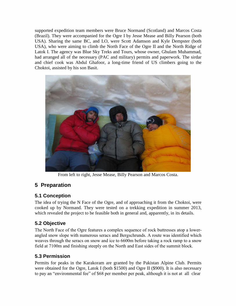
supported expedition team members were Bruce Normand (Scotland) and Marcos Costa
(Brazil). They were accompanied for the Ogre I by Jesse Mease and Billy Pearson (both
USA). Sharing the same BC, and LO, were Scott Adamson and Kyle Dempster (both
USA), who were aiming to climb the North Face of the Ogre II and the North Ridge of
Latok I. The agency was Blue Sky Treks and Tours, whose owner, Ghulam Muhammad,
had arranged all of the necessary (PAC and military) permits and paperwork. The sirdar
and chief cook was Abdul Ghafoor, a long-time friend of US climbers going to the
Choktoi, assisted by his son Basit.
From left to right, Jesse Mease, Billy Pearson and Marcos Costa.
5 Preparation
5.1 Conception
The idea of trying the N Face of the Ogre, and of approaching it from the Choktoi, were
cooked up by Normand. They were tested on a trekking expedition in summer 2013,
which revealed the project to be feasible both in general and, apparently, in its details.
5.2 Objective
The North Face of the Ogre features a complex sequence of rock buttresses atop a lower-
angled snow slope with numerous seracs and Bergschrunds. A route was identified which
weaves through the seracs on snow and ice to 6600m before taking a rock ramp to a snow
field at 7100m and finishing steeply on the North and East sides of the summit block.
5.3 Permission
Permits for peaks in the Karakoram are granted by the Pakistan Alpine Club. Permits
were obtained for the Ogre, Latok I (both $1500) and Ogre II ($900). It is also necessary
to pay an “environmental fee” of $68 per member per peak, although it is not at all clear

Ogre North Face from beneath.
that this money is put to any environmental purpose. Additional paperwork is required
from the Pakistan Army to be allowed into the Baltoro region, and it is necessary to be
accompanied at all times by an LO. The LO fee has not changed – a flat fee of $1500,
ostensibly for equipment, plus $30 for every day in the city and $15 for every day in the
mountains. Rules for LOs introduced since the Nanga Parbat massacre include the
requirement to be with the members at all times below BC and to carry a weapon. LOs
remain, as ever, the least competent members of the armed services, to whom no other
and more useful jobs could apparently be given. All of the necessary administrative
services were performed by Blue Sky.
5.4 Logistics
Transport in Pakistan is slow but fees are largely fair and all are priced separately. Flights
between Islamabad and Skardu remain the biggest bottleneck in terms of delays. Jeeps
from Skardu to Askole are becoming generally less reliable due to road and bridge
conditions and ever more frequent wash-outs. In 2015 all roads in the Northern Areas
were subject to wash-outs caused by mudslides and melting ice dams.
Costa and Normand came overland from China and were able to bring most of their
mountain food with them. Flying from the US, Mease and Pearson were able to do so too.
Additional top-up items were all purchasable in Skardu. Canisters of quality gas are not
available in any quantity and should be pre-ordered through the agency, which provides
full BC equipment.
Climbing equipment consisted of standard half ropes (60m x 8mm), rock (nuts, cams,
pitons) and ice (mostly short screws) racks, cord and a V-threader. No fixed rope was
used. The two two-man teams each carried bivouac tents and Jetboil stoves, and one
satellite telephone (Iridium) was carried for emergencies, status updates and weather
forecasts.
5.5 Medical
No vaccinations are required for Northern Pakistan. Normand coordinated a BC first-aid
kit to avoid duplication and increase the range of treatments available to the members.
Individual teams prepared their own climbing kits, with key antibiotics and painkillers
sourced from the US. No members used any altitude medication.
5.6 Travel
Costa and Normand flew from Shanghai and Beijing to Kashgar, taking a vehicle in 1 day
to Tashkurgan and then the bus to Sost, where they had arranged private transport to and
from Attabad Lake, arriving in Karimabad the same evening. The US members flew to
Islamabad; Pearson continued by bus to Gilgit and Karimabad to meet with Costa and
Normand for some acclimatisation before proceeding overland to Skardu in one more day.
Mease, arriving later, flew directly to Skardu.
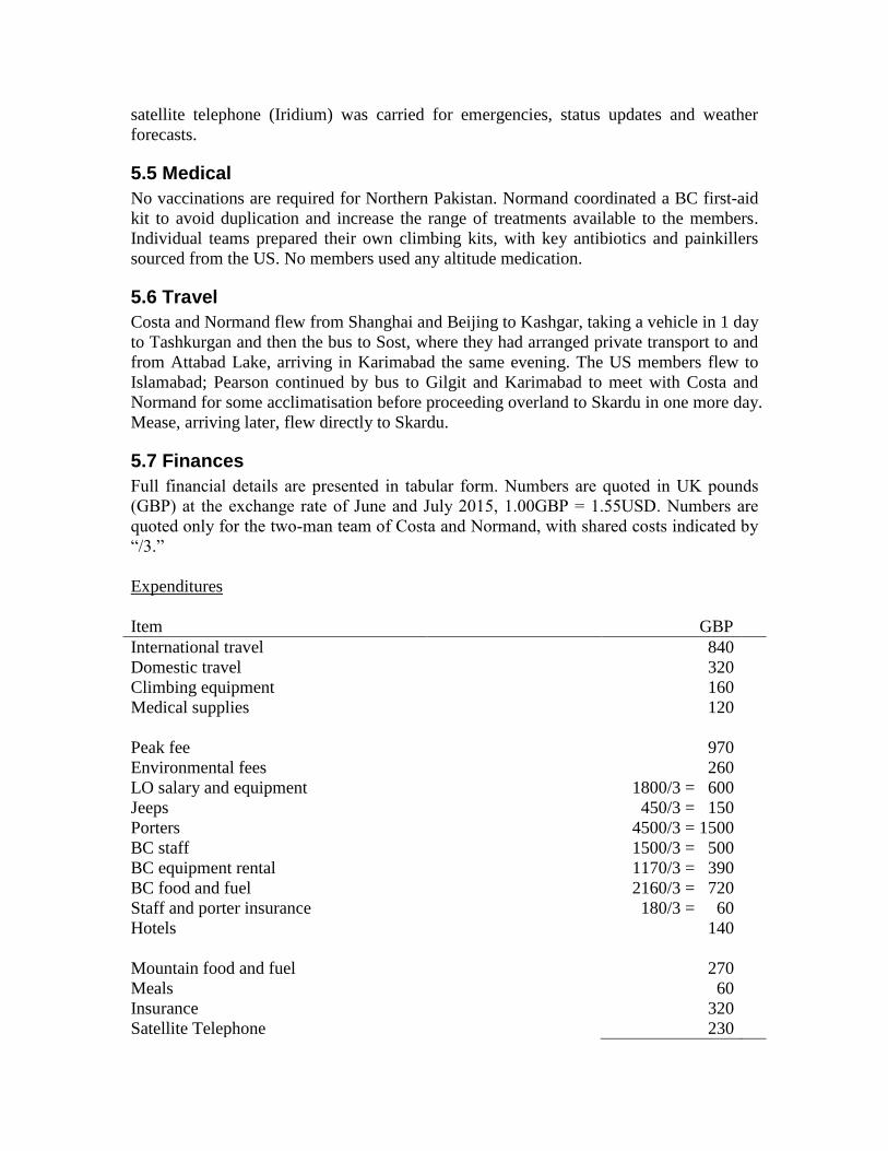
5.7 Finances
Full financial details are presented in tabular form. Numbers are quoted in UK pounds
(GBP) at the exchange rate of June and July 2015, 1.00GBP = 1.55USD. Numbers are
quoted only for the two-man team of Costa and Normand, with shared costs indicated by
“/3.”
Expenditures
Item GBP
International travel
Domestic travel
Climbing equipment
Medical supplies
Peak fee
Environmental fees
LO salary and equipment
Jeeps
Porters
BC staff
BC equipment rental
BC food and fuel
Staff and porter insurance
Hotels
Mountain food and fuel
Meals
Insurance
Satellite Telephone
840
320
160
120
970
260
1800/3 = 600
450/3 = 150
4500/3 = 1500
1500/3 = 500
1170/3 = 390
2160/3 = 720
180/3 = 60
140
270
60
320
230

₤7610
Income
Normand was the grateful recipient of additional grants from the BMC and AC.
Donor GBP
Mount Everest Foundation
Rothschild Trust
British Mountaineering Council
Alpine Club
₤1350
₤500
₤900
₤400
₤3150
The MEF and Rothschild Trust money was used against the two-man team’s peak-fee
and agency costs, while the BMC and AC money was restricted to Normand’s expenses.
Personal contributions from the two climbers were then ₤2880 from Costa and ₤1580
from Normand.
The author would like to thank all of the expedition’s sponsors for their generous support.
6 Expedition Log
9th June
Costa and Normand fly to Kashgar and pick up shipped gear.
10th June
The pair continue by road to Tashkurgan.
11th June
The bus to Pakistan is cancelled on this date.
12th June
Costa and Normand take the bus to Sost, are met by a driver for transfer to Attabad Lake,
take a regular passenger ferry and are transferred again to Karimabad, where they meet
with Pearson.
13th June
The three climbers rent a jeep to Minapin village and hike up to Rakaposhi North BC,
continuing across the Minapin Glacier and up south-facing slopes to make camp at dusk
at 4000m.
14th June
Leaving at first light, the climbers ascend snow slopes and avalanche debris, enjoying
excellent views of the North Face of Rakaposhi. Pearson begins to feel the altitude and
turns at 5000m. Costa and Normand continue to the summit of Mirshikhar, 5445m,
finding good conditions all the way. Views over the Hunza and up the Hispar are

shrouded by cumulus clouds over all the summits, but the weather is otherwise excellent.
All three are back in their high camp by 2pm and hike back to Minapin, meeting their
prearranged vehicle at 6pm and returning to Karimabad for dinner.
Left: Kongur (7719m) from the road between Kashgar and Tashkurgan. Right: Rakaposhi
(7788m) from the North, on the summit of Mirshikhar.
15th June
The three climbers take a private vehicle to Skardu. The news is that Mease and the LO
are stuck in Islamabad because all flights were cancelled.
16th June
Waiting begins in Skardu. Flights are cancelled again.
17th June
The three climbers rent a jeep from Skardu up the valley past Satpara Lake to the
northern edge of the Deosai plateau at 4000m. From here they hike southeastwards over
multiple rounded summits from 4000m to 4600m, enjoying excellent weather and
expansive vistas. On return to Skardu, there is still no sign of Mease and the LO.
Left: Marcos Costa on the summit of Mirshikhar (5445m), with Diran (7266m) behind.
Right: view over the Deosai Plateau.
18th June
Mease and the LO arrive around noon. The LO begins the administrative merry-go-round
of looking for hyper-important senior officers whose signatures are essential but who are
not in their offices at the hours when they undertake to be.
19th June
The same game continues. At 11am we supposedly have all the paperwork but a final
handshake (or something) takes until 4pm, at which point there is no point in leaving for
Askole. Our gear and BC equipment, however, leaves in the morning.
20th June
The jeep journey to Askole is uneventful. The porterage and jeep process at the broken
bridge is efficient. The LO does not like Askole and decides he will now return to Skardu
to wait there for Adamson and Dempster to arrive in 8 days. The compound in Askole is
filled with a Russell Brice team, shepherded by the man himself, with permits for K2 and
Broad Peak. Of the 29 members, presumably 18 are paying the fee of $55000 per head
for full service while the other 11 are Nepalese.
21st June
The weather turns warm and the team leaves early for the trek, passing Jola by noon and
arriving at the appointed riverbank camp with a trickle of clean water by 1pm. A long
afternoon is spent sheltering from the sun. The porters are ably assisted by 4 small but
strong Balti mountain horses.
22nd June
Another hot day of trekking takes the team to a pasture above the lower end of the
Panmah Glacier and another hot afternoon is spent sheltering from the sun.
Left: Skamri (6745m) viewed from the Panmah Glacier. Right: granite peaks east of the
Panmah.
23rd June
A very short day of trekking is required to reach the junction of the Panmah and Choktoi.
This is the appointed final camp, where the porters make their preparations for a long day
to BC and back the following day.
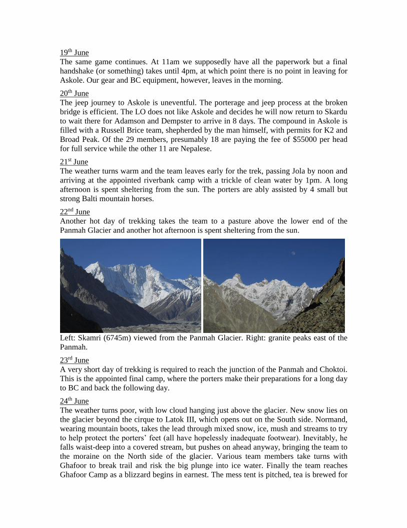
24th June
The weather turns poor, with low cloud hanging just above the glacier. New snow lies on
the glacier beyond the cirque to Latok III, which opens out on the South side. Normand,
wearing mountain boots, takes the lead through mixed snow, ice, mush and streams to try
to help protect the porters’ feet (all have hopelessly inadequate footwear). Inevitably, he
falls waist-deep into a covered stream, but pushes on ahead anyway, bringing the team to
the moraine on the North side of the glacier. Various team members take turns with
Ghafoor to break trail and risk the big plunge into ice water. Finally the team reaches
Ghafoor Camp as a blizzard begins in earnest. The mess tent is pitched, tea is brewed for

all the porters and their pay is handed out, while several of them disappear into the snow
and reappear with the loads off the horses. The team sets to with tent-pitching, including
the cook tent, and by late afternoon the camp is shipshape. Snow continues to drive in
from up-glacier.
25th June
Heavy snow overnight buries camp and keeps some members awake trying to prevent
tent collapse. An inactive day follows.
26th June
The snow continues intermittently. Members catch up with sleep and get ahead with
reading.
27th June
No change, other than a clearing towards evening, which causes some members to go for
a thrash on the glacier, where new snow is now waist-deep without snowshoes.
Views from Ghafoor Camp. Left: Latok I at sunset. Right: Ogre II at sunrise.
28th June
This break in the snow causes the members to succumb to an attack of irrationality.
Packing overnight gear, they snowshoe up low-angle slopes to the northwest of BC,
performing large amounts of work to reach a high point of approximately 5200m, just
below the col to the upper Nobande Sobande Glacier. The snow has by now resumed.
Smaller peaks of the upper Choktoi. Left: in the background, Baintha Kabata (c. 6250m)
and Baintha Ahrta (c. 6350m); in the foreground are the three Biacherahi towers. Ghafoor
Camp is located at the foot of the spur in line with Baintha Ahrta. Right: peaks North of
the Choktoi and downwards (East) from BC; at left is Porter Peak (c. 5700m).

29th June
Snow continues all night. Every slope ahead is now avalanche-threatened. The team
packs up and returns to BC. Later in the descent, more persistent sunshine emerges.
30th June
The weather finally looks more settled and the great transformation from winter to
summer begins. Avalanches are heard from all corners of the upper Choktoi.
1st July
The team saddles up and leaves for an acclimatisation climb. The easiest target is Baintha
Ahrta (c. 6350m), soloed by Normand in 2013 by a snow and ice couloir cutting through
its otherwise precipitous West Face. The approach involves hiking towards the Sim La
and then cutting up a serac and avalanche slope to gain a high basin between Baintha
Ahrta and Baintha Kabata (c. 6250m, climbed from the same place by Normand, Mease
and others in 2013). The climbers get off the steeper slopes before the sun is on them and
finish in baking heat to reach the 5500m high camp with excellent views of the Latoks.
Left: Ogre North Face from high on Baintha Ahrta. Right: final pitch on Baintha Ahrta.
2nd July
The four climbers solo the route. Costa leads the final ice pitch, which is in considerably
more difficult condition than on Normand’s solo. The snow on the crest is also deeper,
but with a belay he is able to go to the true high point (which Normand missed by about
1m due to cornice danger). Normand and Pearson follow, while Mease turns back due to
altitude. The trio enjoy excellent views and return to the high camp as the heat of the day
kicks in.
3rd July
The climbers wake early and descend the hazardous slope as the sun rises over the Ogres
and Latoks, making it back to camp before the day becomes too warm. With a view to the
Ogre North Face, they cache all technical gear, stoves and tents at 5000m where the
routes to Baintha Ahrta and the Ogre diverge. The weather forecast is for persistently
good, if warm, weather, which the team decides is more important than an extra day’s
rest.
4th July
The climbers rise early, return to their gear cache and continue over the Sim La before
the warmth of the day can turn the final (East-facing) slopes into an inclined swamp.

Arriving at the foot of the Ogre at 7am, they dig in to wait out another hot day. Pearson’s
lightweight tarp is the single most important item of team equipment.
5th July
A 3am start finds the snow around ABC incompletely frozen. The climbers find the
primary Bergschrunds on the lower face to be little trouble to cross, solo ice and neve
moves to 750, and traverse rightwards beneath a rock band to enter the main climbing line
at sunrise. Three roped pitches bring the two pairs (Costa/Normand and Mease/Pearson)
over a short section of thin, dirty ice into a long couloir, which pushes the climbers onto a
crest with potential seracs above. Mease moves right into the next gully, but suddenly
finds himself in a firing range of flying rocks. Normand moves in beside him as some
envisaged shelter turns out to be illusory, and Mease takes a number of hits. Pearson and
Costa scurry across the gully to the far side, where Pearson helps Mease dig in. Costa
continues to a natural hole, which he and Normand spend the next 2-3 hours turning into
a real snow cave. All four climbers then move to the cave for more comfortable shelter.
Rocks continue to fly down the main gully, and, astonishingly, a river is observed
flowing down it from mid- to late afternoon (this is a North Face at 5900m). The team
decision is unanimous: at midnight, when everything is hopefully frozen, they will
descend.
Left: glacier camping in the heat. Centre: climbing the lower slopes of the Ogre North
Face. Right: morning view of the Hispar Range.
6th July
The descent is inefficient but uneventful. Dawn finds the climbers soloing the lower
slopes back to the camp. They pack everything up and head back to BC to reassess. The
hike is stiflingly hot and soft, with extreme mush on the descent off the East side of the
Sim La. BC is also hot, with ice beginning to appear on the glaciers as the previous
week’s snow vanishes. Adamson and Dempster have arrived with the LO.
7th July
Rest day. Warm.
8th July
Costa and Normand go for a pre-dawn hike to investigate the approach to the col between
the two Ogres. They decide to stay away from the hazardous South-facing slopes on the
eastern toe of the Ogre I, but find themselves soloing serac blocks and cut off by large
crevasses invisible from below. The only route around the lower icefall is indeed on the
mountain itself. They return to BC with the snow turning to mush at 7am. The weather
forecast remains for more of the same, with daytime freezing levels soaring far above
6000m.

9th July
The climbers are anxious for more exercise. Costa and Mease go to Biacherahi Central
Tower and repeat the route climbed by Mease and Karnoup in 2013. Again they are
unable to see a logical continuation over the blank, red rock which makes up the final
100m to the summit. Normand and Pearson are attracted by the obvious couloirs on
Porter Peak (c. 5700m, first known ascent by Magro and Wharton, 2009), which curve up
its W Face and around to its northern side. The glaciated approach slopes are no problem
and neither is the climbing. However, the final 50m turn out to be highly hazardous, with
deep, soft snow over ice, and lead only to the underside of an unbroken cornice edge. The
climbers retreat from here, perhaps 5-10m short of the foresummit but with very limited
views. By now the air has become hazy in a way never before seen in the Karakoram, but
familiar to climbers used to observing industrial pollution from the peaks of the Alps.
The haze is thought to be coming from down-country Pakistan, where people are dying in
450 heat-waves, rather than from the (to date unpolluted) deserts of western China.
Left: haze over the Latoks and Ogres. Right: mixed gullies on Porter Peak.
10th July
Rest day in BC. Hot.
11th July
Rest day in BC. Hot. Adamson and Dempster return from an acclimatisation run to
Baintha Ahrta.
12th July
Hot. No break in the weather is visible anywhere in the forecast. The BC boulder,
laboriously shovelled out of the snow by Costa in late June, gets a lot of attention.
13th July
BC. Hot. By now it is clear that the climbers will have to choose a target and a strategy to
adapt to the heat, and go for one more roll of the dice. Normand and Pearson decide for
another round with the Ogre North Face, climbing at night and snow-caving by day.
Costa and Mease (understandably – he discovered on return home that one of the falling
rocks had chipped a vertebra) were not interested and decided to tackle the Ogre II, by its
NW Ridge from the col with the Ogre I. Adamson and Dempster declared themselves
ready to tackle the N Face of the Ogre II.
14th July
The teams set out. Normand and Pearson repeated the easy day over to the base of the
Ogre I and waited out the sunshine. The other two teams climbed past the lower icefall

and bivouacked again; Adamson and Dempster would take off from here but Dempster
had stomach trouble and returned to BC the following night. Costa and Mease would
have preferred to continue to the col but ran out of time as the morning sun caused
stonefall on the upper 8 ice pitches.
15th July
Normand and Pearson, better acclimatised and moving faster than on the first attempt,
left later to climb the lower slopes and arrived earlier at the snow cave, which required
little digging out. A lazy day was had watching the sun go round on all the mountains to
the West and North. Costa and Mease climbed to the Ogre I-II col and, finally free of
objective danger, traversed to the western side and then regained the Ogre II NW Ridge
by some highly enjoyable mixed climbing on excellent granite.
16th July
Leaving at 11pm, Normand and Pearson climbed across the main rockfall gully and
completed 3 simul-climbing pitches to its left (led by Normand), then 4 up its centre past
a rock band (led by Pearson). Normand retook the lead one pitch below the crux rock
band, which was passed on a narrow streak of very thin ice, which led to a poor belay on
execrable rock. At this point it was possible to cross the main couloir and continue up its
left side on firm neve leading to deep, soft snow. Pearson tried to continue on the edge of
the couloir but by this time the morning rockfall had started and he was stymied by soft
snow. Normand took a different snow slope and was able to wallow up to a point under a
serac at approximately 6400m where the climbers dug in for the day, sheltered from the
falling rocks which were coming down on both sides of and over them. Costa and Mease
continued up their route, finding more good but often delicate climbing, reaching a camp
on a very precarious cornice at approximately 6500m.
17th July
Leaving at 2am, Normand and Pearson skirted the remaining seracs on soft snow and left
a cache for the descent inside the last Bergschrund. They continued up and left on snow
and neve, reaching the very highest point of the snow (6600m) a little before first light.
Normand, leading and finding no protection in the rock, set a worthless anchor in the
snow and ice and passed the lead to Pearson. In 1.5 hours of dangerous prospecting to the
left and to the right, Pearson climbed up and down several body-lengths into the obvious
rock ramp but was unable to find a single useful piece of protection, or of ice, and did
find several axe- and footholds flying off down the snow slopes below. The black-orange
rock band from 6600-7100m on this part of the Ogre, the feeder for the steady rain of
rockfall down the lower slopes, is simply a slabby, friable, unprotectable choss of the
highest order, and not at all like the immaculate granite of the south side. Perhaps it can
be climbed on snow and ice in a different season, such as September (after the August
rains and once the sun is no longer in the face) but under the circumstances, with 10
pitches of the same ahead of them, the climbers had to conclude that it was hopeless.
They retreated to their cache and then to their serac shelter, arriving just on time to avoid
the first major rock volleys of the day. The weather was by now featuring high clouds
and ice-spicule rainbow rings around the sun, but even these later came to nothing.

Ogre North Face. Left: slabby choss at 6600m. Centre: Pearson prospecting for
something climbable. Right: view out over Baintha Kabata, Baintha Ahrta and Bobisghir.
Costa and Mease pushed on above their camp, but found themselves facing a band of
genuine rock climbing in the E1-2 range at 6700m, for which they were not at all
equipped in terms of footwear or rock protection. They also decided on a retreat and
returned to their cornice high camp.
18th July
Moving off at 11pm, Normand and Pearson downclimbed 2 pitches into the main rockfall
gully and abseiled the whole thing on V-threads, arriving at dawn on a snow slope below
a double-Bergschrund beneath the thin, dirty ice section. Traversing this slope was much
easier than the icier, steeper ones above and the pair were soon back at the base of the
face again. The morning clouds cleared obligingly to make the hike back to BC once
again suffocatingly hot. By this time, rivers were flowing down North-facing slopes
above 5000m, where avalanches were clearing gullies down to the ground.
Costa and Mease descended their route to the Ogre I-II col. A young Slovenian team had
also arrived in BC and one pair was setting out on skis through the mush for some
acclimatisation, ostensibly to climb a rock wall near the Nobande-Sobande col.
19th July
Costa and Mease finished their descent of the col and of the lower icefall, being forced to
leave stuck ropes on the last abseil, and returned to BC by mid-morning. The Slovenians
also returned, unsettled by the combination of the heat and the thickening clouds.
20th July
In persisting cloudier but warm weather, the team spent the day in BC wondering about
Adamson and Dempster’s progress. Alex Huber visited from down-glacier to report that
his team had had a lucky escape on the Northeast Face of Latok III when the blast wave
from a collapsing serac had nearly blown their tents off their platforms and into the abyss.
21st July
Adamson and Dempster were spotted returning to BC in mid-morning. Adamson was
limping as a result of a suspected broken ankle sustained in taking a fall estimated at 30m
when a piece of ice in which his axe was planted gave way. The pair had reached
approximately 6400m after 2 nights of extreme mixed climbing and were entering what
appeared to be an ice couloir of lower angle and leading out of the face. Adamson fell
past Dempster and, it was later discovered, had chipped his elbow as well as fracturing
his lower tibia. To add insult to this injury, the very last V-thread had given way as the
two climbers were trying to cross the Bergschrund below their route, this then being

achieved very rapidly by the toboggan technique. Apart from a lost camera and bloody
nose for Dempster, further damage was surprisingly limited. Mease and the LO lost no
time with the satphone in accelerating the arrival of the porters to finish the expedition.
22nd July
Rest and packing day.
23rd July
The high-speed porters arrived in BC around noon. Gear was loaded, Adamson limped
his way as far as a horse and the homeward journey commenced. The team reached the
camp at the Choktoi/Panmah junction around nightfall.
24th July
An early start on a hot day was not enough to avoid some significant difficulties with
river-crossings, but in the end these passed uneventfully. By mid-afternoon the group had
reached the riverside camp above Jola. The LO began behaving irrationally, probably due
to dehydration, and among other things tried to continue to Korophon, leaving his loaded
weapon with Costa and Mease.
25th July
Another early start had the team back in Askole by 9am for a quick transfer to waiting
jeeps. However, the bridge transfer was slow, and slowed further by a local festival
blocking the road. By the time the jeeps had reached upper Shegar in mid-afteroon, the
road was sliced by a raging torrent of mud and black water from a melting glacial dam
high above. All traffic was cut for hours as the flow raged, but it began to dissipate
towards nightfall. At this point some enterprising locals with planks were able to get
pedestrian traffic, and loads, across for a fee. Blue Sky had by now sent another jeep and
the journey finished in Skardu around 9pm.
26th July
As this was the only day in the coming week when PIA was flying to Islamabad with a
large jet, the three Americans took their chance and disappeared immediately. Costa and
Normand found themselves trapped in Skardu by more road-closing mudslides just to the
West of town.
27th July
The promised open road took until 4pm to materialise. The advice of the locals was to
take off immediately, in case another closure occurred. The promised vehicle was
substituted for an old and uncomfortable jeep with failing headlights. After a long wait at
the only bridge over the Indus, which allows only single-file traffic, one vehicle at a time,
and had to clear a backlog of 3 days’ traffic, the driver was able to crawl all the way to
Karimabad by 8am the following day.
28th July
After breakfast and lunch at the Al Barakat hotel, Costa and Normand were transferred to
Attabad Lake, did the scenic cruise one more time (the Chinese-built tunnel by-pass is
now open) and ended the day in Sost. The news was that the Chinese-built road had been
washed out above town and one could expect a delay of weeks until it could be repaired.
29th July
The bus company planned nonetheless to have a two-way shipment on this day, and all

the prospective passengers went through the motions of tickets, customs and passport
checks. The break in the road was indeed only 30 minutes up from Sost, and involved the
entire roadway plus foundations being washed away for approximately 100m. However,
foot passage was easy and baggage was duly dragged across the break. The location
meant a wait of 5 hours for the bus in the opposite direction, which then had to swap
passengers and return to Tashkurgan. Night fell during the painstaking baggage searches
by the Chinese military at the actual border and it was past midnight before the
passengers escaped from the equally tedious checks by Chinese customs in Tashkurgan.
30th July
Costa and Normand got a morning vehicle transfer to Kashgar, arriving there around 3pm
Xinjiang time, and apparently just before another road-closing landslide.
31st July
Both climbers flew out of Kashgar to end the expedition.
7 Conclusion
The expedition was unable to execute its declared aim of climbing the North Face of the
Ogre. It encountered poor rock and extremely warm temperatures resulting in dangerous
rockfall and climbing conditions. The new normal for alpinism in the Karakoram may be
moving away from the summer months.
8 Acknowledgements
The expedition acknowledges with gratitude the generous assistance of the Mount
Everest Foundation, the Rothschild Trust, the British Mountaineering Council and the
Alpine Club.
Appendix A: Bibliography
The Choktoi Glacier has by now been chronicled in extensive accounts of failed attempts
on its many target routes. The AAJ contains the most complete source of information.
Appendix B: Contact Information
Pakistan Alpine Club
The PAC (www.alpineclub.org.pk) may be contacted at [email protected]
Agents for Expeditions in Pakistan
The author continues to recommend Adventure Tours Pakistan (www.atp.com.pk), who
may be contacted at [email protected]
Expedition members’ contact information
Bruce Normand: [email protected]
Marcos Costa: [email protected]
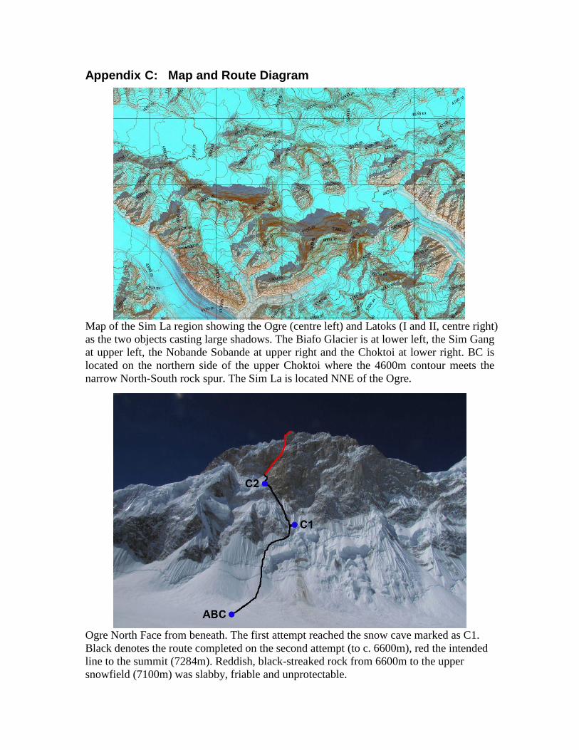
Appendix C: Map and Route Diagram
Map of the Sim La region showing the Ogre (centre left) and Latoks (I and II, centre right)
as the two objects casting large shadows. The Biafo Glacier is at lower left, the Sim Gang
at upper left, the Nobande Sobande at upper right and the Choktoi at lower right. BC is
located on the northern side of the upper Choktoi where the 4600m contour meets the
narrow North-South rock spur. The Sim La is located NNE of the Ogre.
Ogre North Face from beneath. The first attempt reached the snow cave marked as C1.
Black denotes the route completed on the second attempt (to c. 6600m), red the intended
line to the summit (7284m). Reddish, black-streaked rock from 6600m to the upper
snowfield (7100m) was slabby, friable and unprotectable.


![11 Lecture 4 Introducing Physics to Ogre References: [1] Gregory Junker, Pro OGRE 3D Programming, Apress, 2006 [2] Ogre Tutorials – Ogre Wiki .](https://static.fdocuments.in/doc/165x107/56649d8b5503460f94a71c77/11-lecture-4-introducing-physics-to-ogre-references-1-gregory-junker-pro.jpg)