OGC’s Underground Information Activities -...
47
® OGC’s Underground Information Activities Dr. Ingo Simonis representing Bart de Lathouwer Director Innovation Program & Science, OGC December 2017 Copyright © 2017 Open Geospatial Consortium
Transcript of OGC’s Underground Information Activities -...

®
OGC’s Underground Information
Activities
Dr. Ingo Simonis representing Bart de Lathouwer
Director Innovation Program & Science, OGC
December 2017
Copyright © 2017 Open Geospatial Consortium

OGC®
The OGC Mission
Global forum for collaboration of developers and users of spatial data products and services
Advance development of international standards for geospatial interoperability.
Copyright © 2017 Open Geospatial Consortium 2

OGC®
The Open Geospatial Consortium
Copyright © 2017 Open Geospatial Consortium
Not-for-profit, international voluntary consensus standards
organization; leading open innovation for geospatial data
• Founded in 1994
• 525+ member organizations
• 100 innovation initiatives
• 48 Open Standards
• 230 OGC certified products
• Thousands of implementations
•Enabling access to 100K+ datasets
3

OGC®
Value of OGC Participation
• Achieve technical agreement on interoperability challenges
• Networking, partnership development
• Insight into emerging technologies and markets
• Unique ability to share cost / resources in solving interoperability challenges
Copyright © 2017 Open Geospatial Consortium 4

OGC®
Example Government Members
– IGN (France) - BRGM (France) - City of Helsinki, Finland
– DHS (US) - NASA (US) - NOAA (US) - NGA (US)
– USGS (US) - USACE (US) - DSTL (UK) - DLR (Germany)
– EU Satellite Center (Europe) - NR Canada - DIGO (Australia)
– United Nations - Norwegian Building Authority - Ordnance Survey (UK)
– Ministry of Land, Infrastructure and Transport (Korea) - Vienna, Austria
– Dubai Municipality (UAE) - Charlotte, NC
– San Francisco City & County - Others…
Over 100 Universities, Research institutes, NGOs; e.g., TU Berlin, FCNY
http://www.opengeospatial.org/ogc/members
Copyright © 2016 Open Geospatial Consortium

OGC®
Example OGC Commercial Members
Copyright © 2016 Open Geospatial Consortium

OGC®
OGC Partners for Geospatial
ISO/TC 204
JTC 1/SC 24 Computer GraphicsJTC 1/SC 41 Internet of Things
JTC 1/WG 9 Big Data
JTC 1/WG 11 Smart Cities

OGC®
What is a Standard?
• “An agreed way of doing something”
• Standards are distilled wisdom of people with expertise in their subject matter and who know the needs of the organizations they represent – people such as manufacturers, sellers, buyers, customers, trade associations, users or regulators.
• Standards are knowledge. They are powerful tools that can help drive innovation and increase productivity. They can make organizations more successful and people’s everyday lives easier, safer and healthier.
Copyright © 2017 Open Geospatial Consortium
EC: Practical standards guide for researchers - en

OGC®
STANDARDS TO BUILD UNDERGROUND INFO
Underground Information Projecta:
© 2017 Open Geospatial Consortium

OGC®
OGC Web Services
Web Map Servers (WMS)
Web Feature Servers (WFS)
Web Coverage Servers (WCS)
Basic Geospatial Interoperability Challenge Solved
Copyright © 2017 Open Geospatial Consortium
http://www.opengeospatial.org/standards
Hundreds of thousands of maps and datasets accessible through 10,000 servers running OGC Web Services
NSDI - India GeoPortal Map Viewer Skyview2, Eurocontrol
OpenIOOS.Org
GEOSS Portal geoportal.org
OneGeology.Org

OGC®
Merging of spatial domains
Geospatial,
Civil Engineering &
BIM
come together in the Urban environment and are destined to work together
Copyright © 2017 Open Geospatial Consortium

OGC®
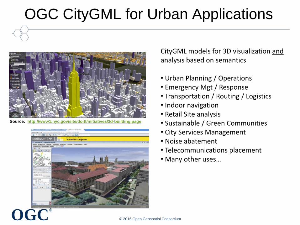
OGC CityGML for Urban Applications
Copyright © 2017 Open Geospatial Consortium

OGC®
CityGML - Berlin
>500,000 buildings;
• fully-automatically generated
from 2D cadastre footprints &
airborne laserscanning data.
• textures (automatically
extracted from aerial images)
• semantic information (includes
data from cadastre)
• 3D utility networks from the
energy providers
• modeled according to CityGML www.virtual-berlin.de
Source: Nagel, Kolbe, 2010Copyright © 2017 Open Geospatial Consortium
OGC®
OGC CityGML for Urban Applications
© 2016 Open Geospatial Consortium
Source: http://www1.nyc.gov/site/doitt/initiatives/3d-building.page
CityGML models for 3D visualization andanalysis based on semantics
• Urban Planning / Operations• Emergency Mgt / Response• Transportation / Routing / Logistics• Indoor navigation• Retail Site analysis• Sustainable / Green Communities• City Services Management• Noise abatement• Telecommunications placement• Many other uses…

OGC®
Software supporting CityGML
• Oracle 11g
• VirtualCitySystems
• Bentley: Bentley Map
• Autodesk: LandXplorer
• Safe Software FME
• University of Bonn: Aristoteles
• Snowflake software: Go Publisher
• Interactive Instruments: WFS
• HST Stuttgart: QS-City 3D
• MetGeoInfo: CityGRID
• ESRI: ArcGIS10
• CPA: SupportGIS3D
• GTA: Tridicon CityDiscoverer
• Ptolemy3D:
• RhinoTerrain:
• FH GK: CityGML-Toolchain
• FZ Karlsruhe: FZKViewer
• Revisitor: WI-MAP
• LibCitgyGML
• Bitmanagement: BS Contact Geo
3D
Copyright © 2017 Open Geospatial Consortium
Active community providing help, documentation, tips, example datasets, and tutorials, etc.
https://www.citygml.org

OGC®
Moving Underground
• CityGML is a mature standard for above ground– Data model standard defined
– Datasets widely available
– Software implementations of standard to exploit data model
– Maturity allows focus on data quality and efficiency
• Underground Infrastructure is the place to be now– The New Frontier of modeling the entire urban manmade and natural
environment.
– Add to CityGML to model the complete urban environment
– Huge cost efficiencies will be achievable
Copyright © 2017 Open Geospatial Consortium

OGC®
Underground Infrastructure Information (UGII) –Current State of Affairs –
• Present UGII data quality is poor
– Different data models
– Stored in different ways
– Different geometry and semantics
• Inability to exchange UGI data
– Maintainers have different purposes
– Ownership, governance challenges
– Interoperability issues
• Costs of UGII failures are recognized
– Routine excavations can be disastrous
– Inefficiencies in construction
– Unable to predict cascading failures
© 2017 Open Geospatial Consortium
OGC Underground Concept Development Study Report
http://docs.opengeospatial.org/per/17-048.html

OGC®
Catastrophes coming from underground
OGC underground workshop, NYC
Steam Pipe Explosion at Lexington Avenue and
East 41st Street, Manhattan, July 18, 2007
(https://www.flickr.com/photos/lorcanotway/848506700)
NYC steam pipe
explosion
Belgian natural gas
pipeline
July 30, 2004. High-pressure natural gas pipeline ruptured
following recent third party damage: 24 died and 150 hospitalised.
Damage to pipeline during the final stages of construction project.
https://en.wikipedia.org/wiki/Ghislenghien

Underground Environment:Soils, bedrock,
Water table
Foundation Layers:Imagery, structures,
roads, elevation
Interoperable Environment
Secure, Safe
Use Cases for Interoperable Underground Infrastructure Data
*Street Openings For Utility Work*Construction Design and Operations
*Emergency Preparedness and Response*Smart Cities
Source: Alan Leidner, FCNY
Simple Model of Infrastructure Data IntegrationCost of Data Creation Off-Set By Vast Uses of Combined Data
Gas
ElectricPower
GasWaterSewer
Telecom

OGC®
LEADERSHIP IN STANDARDS INNOVATION
Underground Information Project
© 2017 Open Geospatial Consortium

OGC®
OGC’s Approach for Advancing Innovation
© 2017 Open Geospatial Consortium
Rapid Interface
Development
Standards
Setting
Market
Adoption
Innovation
Program
Standards
Program
Compliance
Program
Communication &
Outreach Program
Testing &
Certification

OGC®
OGC Innovation Program Projects:
1999 to 2017Total 100
Pilots 30
Plugfests 4
Experiments 20
Testbeds 20
Concept Development 16
Support Services 8
Copyright © 2016 Open Geospatial Consortium
Increasing
Technology
Readiness

OGC®
Underground Information (UGI) Projects
1. Concept Study - complete
– Findings and Recommendations
2. Data Model – under development
– Necessary foundation for the Pilot
3. Pilot Implementation - planned
– Develop, Test and Demo technology advancements
– Provide basis for city procurements
© 2017 Open Geospatial Consortium
Source: Singapore Land Authority

OGC®
UNDERGROUND CONCEPT STUDY
© 2017 Open Geospatial Consortium

OGC®
OGC Concept Development Study
• To assess state-of-technologies available to support innovation initiatives and open standards development
• Process
1. Request for Information (RFI) posted to public
2. Workshop to review RFI results
3. Report as outcome and basis for Pilot
Thanks to Study Sponsors:
FCNY, Ordnance Survey, Singapore Land Auth.
© 2017 Open Geospatial Consortium

OGC®
Underground RFI Responses - March 2017
Copyright © 2016 Open Geospatial Consortium 26
Accenture Bentley BGS
Boston City BRGM Cesar Quiroga
CityGML Chair Dassault Systemes Delft University
Dubai Elec/Water EPRI Erik Stubkjaer
Geoweb 3D HERE HL Consulting
Informatie Vlaanderen LandInfra SWG Les Guest Assoc.
Luciad Robin Danton Rotterdam City
Sewer Network Spacetime Technology St Paul Minnesota
Swiss Water SJIB Technics Group Tech. Univ München
UMS Bernice
Reponses from gov, biz, research sectors - from around the globe

https://www.bloomberg.com/news/features/2017-08-10/nobody-knows-what-lies-beneath-new-york-city
“Nobody Knows What Lies Beneath New York City” Greg Milner Bloomberg Businessweek, 8.10.17

OGC®
Published Results from Concept Study
• Executive Summary
• Request for Information
• Workshop
• Discussion and knowledge synthesis
• Findings
• Recommendations
• Next steps
OGC Underground InfrastructureConcept Study Engineering Report
Publication Date: 2017-08-31
Approval Date: 2017-08-17
Reference number: OGC 17-048
Category: Public Engineering Report
Editor: Josh Lieberman, Andy Ryan
Underground
Infrastructure
Concept Study
Engineering Report
http://docs.opengeospatial.org/per/17-048.html

OGC®
Use cases and case studies
Through the input of RFI responders and Workshop participants, major categories of use case were identified:
• Routine street excavations
• Emergency response
• Utility maintenance programs
• Large scale construction projects
• Disaster planning and response
• Smart cities programs.

OGC®
Concept Study Recommendations
1. Develop interoperable common data models for underground infrastructure
2. Conduct research on legal, security, financial, and cultural challenges
3. Conduct collaborative pilot projects to validate UGI data models and architectures for handling the UGI data.
© 2017 Open Geospatial Consortium

OGC®
UNDERGROUND DATA MODEL
© 2017 Open Geospatial Consortium

OGC®
Underground Data Model
• Developed by review of multiple existing data models identified in the Concept Study
• Multiple interfaces to a common core model support multiple use cases and applications
• Data model focuses initially on priority use cases– Routine street excavations
– Large scale construction projects
– Disaster planning and response
• Primary structures to be modeled– Networks: water supply, sanitary sewer, storm drainage, natural gas,
steam, electric power and telecommunications lines.
– Subways, vaults, footings, foundations
– Underground environment of soil, water, rock
© 2017 Open Geospatial Consortium

OGC®
Data Integration Architecture
© 2017 Open Geospatial Consortium
Assets
Water
Power
A&E
Telecom
Standard Model Interfaces
Structures
Networks
Functions
• On-demand Query• Proxy / Cache• Authoritative Repository
Diverse Data Sources, Systems, Formats
Unified Model with Multiple Perspectives
Distinct Data-driven Applications
Planning,
Investment,
Lifecycle
Safe
Excavation
Large-scale
Constructio
n
Disaster
Planning
Unified / Harmonized Data Access

OGC®
Reference models for built / utility infrastructure
• CityGML Utility Network ADE (Application Domain Extension)
• INSPIRE Utility Networks
• IMKL (Information model for cable and pipes)
• Land and Infrastructure Conceptual Model (LandInfra)
• Underground Pipeline Information Management System
• Power Utilities
• Enterprise Systems for Utilities –
• Wastewater Pipeline & Manhole Condition Assessment Gas Distribution
• Water/Wastewater Modeling
• GEOfeature

OGC®
Reference underground environment models
• BGS National Geological Model
• BRGM SCUDD
• GeoSciML
• EarthResourceML
• INSPIRE
• GeoTOP
• GroundwaterML
Models are designed for different purposes (engineering, water management, hazard assessment). The model intents need to be understood to allow for meaningful translation and combination between them.

OGC®
UGIIIM Model Structure
© 2017 Open Geospatial Consortium
Core Structures
2D Geom
Core Model Elements
Network Structures
Environment Regions
Containers & Supports
Input / Output Interfaces
3D Geom
Surveys
Sensors
CityGML
BIM - IFC
Assets
Section
BoreholeEngineering Parameters
Data Quality
NetworkGraph
Specialized Structures
Supply Regions
Control Function
Inputs
Outputs

OGC®
Questions to Ask (of the Data)
© 2017 Open Geospatial Consortium
Queries Interfaces
3D image of all the UGI elements within 10m of planned excavation
2D geometry3D geometry
Minimum distance between 2 underground utility networks 3D geometryNetwork graph
Major transmission lines as distinguished from distribution elements
2D geometryNetwork control
Important control components in a neighborhood Network controlNetwork supply
Age, material composition, thickness of the UGI elements AssetSurveys
Likely composition, moisture, chemistry of soils surrounding particular UGI elements
2D geometrySection
Likely extent of corrosion of these elements, potential vulnerability to vibration and accidental strikes, spatial extent of network vulnerability
AssetSensorNetwork graph
OGC®
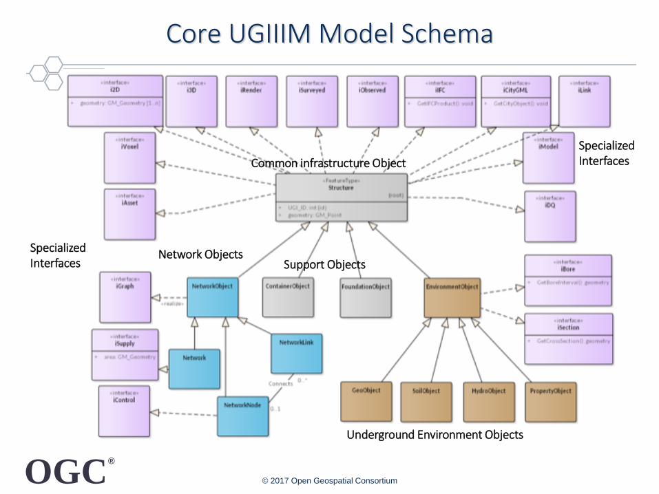
Core UGIIIM Model Schema
© 2017 Open Geospatial Consortium
Common infrastructure Object
SpecializedInterfaces
Network Objects
Underground Environment Objects
Support Objects
Specialized Interfaces

OGC®
PILOT
© 2017 Open Geospatial Consortium
OGC®
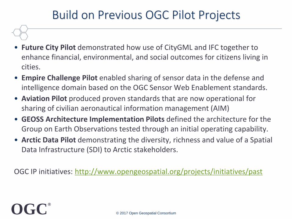
Build on Previous OGC Pilot Projects
• Future City Pilot demonstrated how use of CityGML and IFC together to enhance financial, environmental, and social outcomes for citizens living in cities.
• Empire Challenge Pilot enabled sharing of sensor data in the defense and intelligence domain based on the OGC Sensor Web Enablement standards.
• Aviation Pilot produced proven standards that are now operational for sharing of civilian aeronautical information management (AIM)
• GEOSS Architecture Implementation Pilots defined the architecture for the Group on Earth Observations tested through an initial operating capability.
• Arctic Data Pilot demonstrating the diversity, richness and value of a Spatial Data Infrastructure (SDI) to Arctic stakeholders.
OGC IP initiatives: http://www.opengeospatial.org/projects/initiatives/past
© 2017 Open Geospatial Consortium

OGC®
Underground Pilot
• Deploy, Test and Demonstrate Interoperability of underground information based on open standards– Use Cases: Excavations; Construction design; Disaster planning
– Examine alternatives for exchange of underground information from multiple independent organizations
– Produce basis for future procurements by cities
Copyright © 2017 Open Geospatial Consortium
8 Becker, T., Nagel, C., Kolbe, T. H. - Semantic 3D modeling of multi-utility networks in cities
Department of Geoinformation Science
Simplifying complex network structures
Every utility network consist of 3 main functions:
1. distribution objects (pipes, canals, cables etc.)
− Needed for transport and distribution of commodity
citygml:Track
citygml:Road
citygml:Track
Pipe - FreshWater Pipe - WasteWater
Pipe - Gas
Pipe -
coolingEnergy
Pipe
Long-Distance Heat
Existing
Municipal
Data Sets
Online Access
Underground Data Model

OGC®
OGC Pilot Process – DRAFT
Kickoff
Workshop
Demo in NYC
Demo in Singapore
Demo in UK
Technology &
Architecture
Development
Develop & Release
Call for Participation
CFP
Industry
ProposalsSelect,
Negotiate
Participants
Demo Scenario
Testing
Mid-Term
Workshop
Participant
Contracts
Duration from start to demo: 15 months
Sponsors actively
direct decision
processes at each step

OGC®
Pilot Outcomes will support Procurements
• Technical Deliverables usable in procurements
– Data model
– Architecture
• Validation that industry is ready to respond to procurement
– Technology maturity advanced by pilot deployment and testing
• Guides available for municipalities
– Guidance for adapting architecture to specifics of city data holders
– Apply architecture to production environment
– ROI models to develop cost rationale
© 2017 Open Geospatial Consortium

OGC®
OGC Pilot Outcomes
• Reduce technology risk through accelerating development, testing and acceptance of interoperability standards with the refinement of standards and best practices
• Expand the market and improve choice by encouraging industry adoption of new standards and best practices, ensuring market availability of interoperable solutions
• Mobilize new technologies through providing participants with real world experience and a platform to innovate while driving early adoption of standards
• Provide cost effective method for sponsors and participants to share expertise and development while gaining early marketplace insight and advantage
© 2017 Open Geospatial Consortium

OGC®
Estimating costs of the pilot
• Estimate for pilot implementation is based on this scope:
– 3 urban locations for scenario definitions and demonstrations
– 22 work items total; subcontracted to participants receiving cost-share funding matched by their funds
– OGC staff provides program management and systems engineering
– Duration: 62 weeks starting late 2017/early 2018
© 2017 Open Geospatial Consortium

OGC®
Benefits to Sponsors of Underground Pilot
• Affect market direction to sponsor’s needs
• Amplification of funding with multiple sponsors
• Leveraging 3.5x based on participant in-kind effort
• Accelerated process for innovation
• Procurements use proven standards-based results
• Leading to safer and more efficient cities.
• Visibility as global leader
© 2017 Open Geospatial Consortium