Official PDF , 418 pages
418
Government of The People’s Republic of Bangladesh Ministry of Water Resources Bangladesh Water Development Board Environmental Impact Assessment (EIA) (Draft Final) Volume I (Main Text) River Bank Improvement Program (RBIP) February 2015 Public Disclosure Authorized Public Disclosure Authorized Public Disclosure Authorized Public Disclosure Authorized Public Disclosure Authorized Public Disclosure Authorized Public Disclosure Authorized Public Disclosure Authorized
-
Upload
phungtuyen -
Category
Documents
-
view
335 -
download
16
Transcript of Official PDF , 418 pages
Government of The People’s Republic of Bangladesh
Ministry of Water Resources
Bangladesh Water Development Board
Environmental Impact Assessment (EIA)
(Draft Final)
Volume I (Main Text)
River Bank Improvement Program (RBIP)
February 2015
Pub
lic D
iscl
osur
e A
utho
rized
Pub
lic D
iscl
osur
e A
utho
rized
Pub
lic D
iscl
osur
e A
utho
rized
Pub
lic D
iscl
osur
e A
utho
rized
Pub
lic D
iscl
osur
e A
utho
rized
Pub
lic D
iscl
osur
e A
utho
rized
Pub
lic D
iscl
osur
e A
utho
rized
Pub
lic D
iscl
osur
e A
utho
rized
wb371432
Typewritten Text
E4751
wb371432
Typewritten Text
wb371432
Typewritten Text
Environmental Impact Assessment (EIA) of River Bank Improvement Program (RBIP)
Bangladesh Water Development Board ii
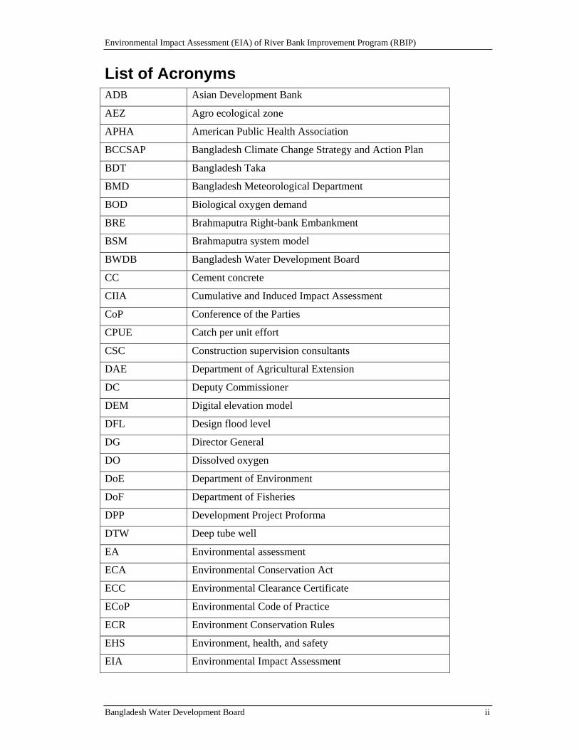
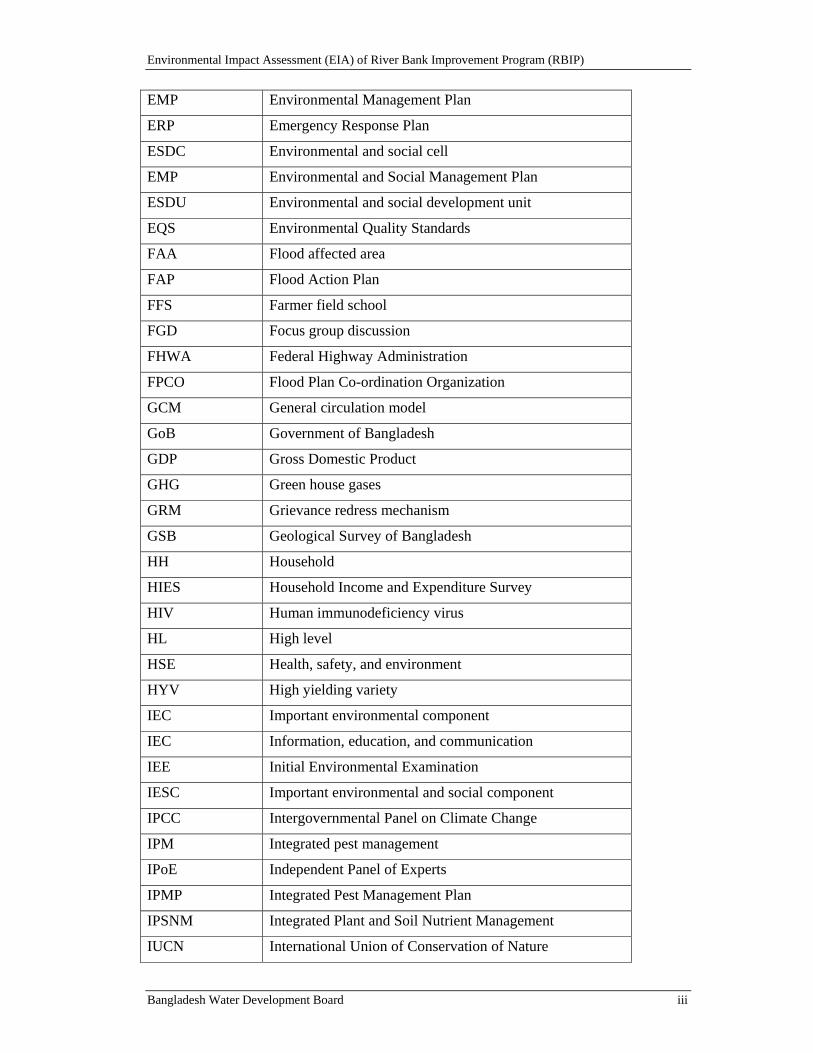
List of Acronyms ADB Asian Development Bank
AEZ Agro ecological zone
APHA American Public Health Association
BCCSAP Bangladesh Climate Change Strategy and Action Plan
BDT Bangladesh Taka
BMD Bangladesh Meteorological Department
BOD Biological oxygen demand
BRE Brahmaputra Right-bank Embankment
BSM Brahmaputra system model
BWDB Bangladesh Water Development Board
CC Cement concrete
CIIA Cumulative and Induced Impact Assessment
CoP Conference of the Parties
CPUE Catch per unit effort
CSC Construction supervision consultants
DAE Department of Agricultural Extension
DC Deputy Commissioner
DEM Digital elevation model
DFL Design flood level
DG Director General
DO Dissolved oxygen
DoE Department of Environment
DoF Department of Fisheries
DPP Development Project Proforma
DTW Deep tube well
EA Environmental assessment
ECA Environmental Conservation Act
ECC Environmental Clearance Certificate
ECoP Environmental Code of Practice
ECR Environment Conservation Rules
EHS Environment, health, and safety
EIA Environmental Impact Assessment
Environmental Impact Assessment (EIA) of River Bank Improvement Program (RBIP)
Bangladesh Water Development Board iii
EMP Environmental Management Plan
ERP Emergency Response Plan
ESDC Environmental and social cell
EMP Environmental and Social Management Plan
ESDU Environmental and social development unit
EQS Environmental Quality Standards
FAA Flood affected area
FAP Flood Action Plan
FFS Farmer field school
FGD Focus group discussion
FHWA Federal Highway Administration
FPCO Flood Plan Co-ordination Organization
GCM General circulation model
GoB Government of Bangladesh
GDP Gross Domestic Product
GHG Green house gases
GRM Grievance redress mechanism
GSB Geological Survey of Bangladesh
HH Household
HIES Household Income and Expenditure Survey
HIV Human immunodeficiency virus
HL High level
HSE Health, safety, and environment
HYV High yielding variety
IEC Important environmental component
IEC Information, education, and communication
IEE Initial Environmental Examination
IESC Important environmental and social component
IPCC Intergovernmental Panel on Climate Change
IPM Integrated pest management
IPoE Independent Panel of Experts
IPMP Integrated Pest Management Plan
IPSNM Integrated Plant and Soil Nutrient Management
IUCN International Union of Conservation of Nature
Environmental Impact Assessment (EIA) of River Bank Improvement Program (RBIP)
Bangladesh Water Development Board iv
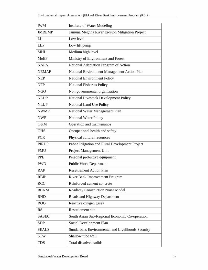
IWM Institute of Water Modeling
JMREMP Jamuna Meghna River Erosion Mitigation Project
LL Low level
LLP Low lift pump
MHL Medium high level
MoEF Ministry of Environment and Forest
NAPA National Adaptation Program of Action
NEMAP National Environment Management Action Plan
NEP National Environment Policy
NFP National Fisheries Policy
NGO Non governmental organization
NLDP National Livestock Development Policy
NLUP National Land Use Policy
NWMP National Water Management Plan
NWP National Water Policy
O&M Operation and maintenance
OHS Occupational health and safety
PCR Physical cultural resources
PIRDP Pabna Irrigation and Rural Development Project
PMU Project Management Unit
PPE Personal protective equipment
PWD Public Work Department
RAP Resettlement Action Plan
RBIP River Bank Improvement Program
RCC Reinforced cement concrete
RCNM Roadway Construction Noise Model
RHD Roads and Highway Department
ROG Reactive oxygen gases
RS Resettlement site
SASEC South Asian Sub-Regional Economic Co-operation
SDP Social Development Plan
SEALS Sundarbans Environmental and Livelihoods Security
STW Shallow tube well
TDS Total dissolved solids
Environmental Impact Assessment (EIA) of River Bank Improvement Program (RBIP)
Bangladesh Water Development Board v
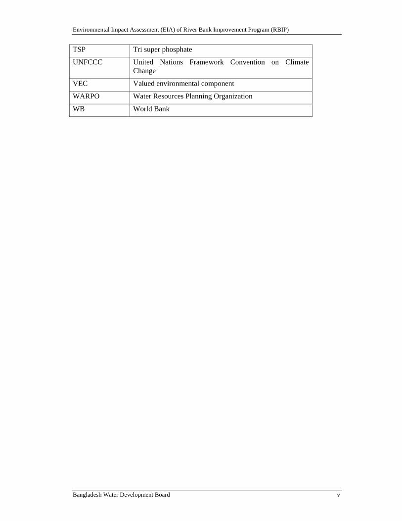
TSP Tri super phosphate
UNFCCC United Nations Framework Convention on Climate Change
VEC Valued environmental component
WARPO Water Resources Planning Organization
WB World Bank
Environmental Impact Assessment (EIA) of River Bank Improvement Program (RBIP)
Bangladesh Water Development Board vi
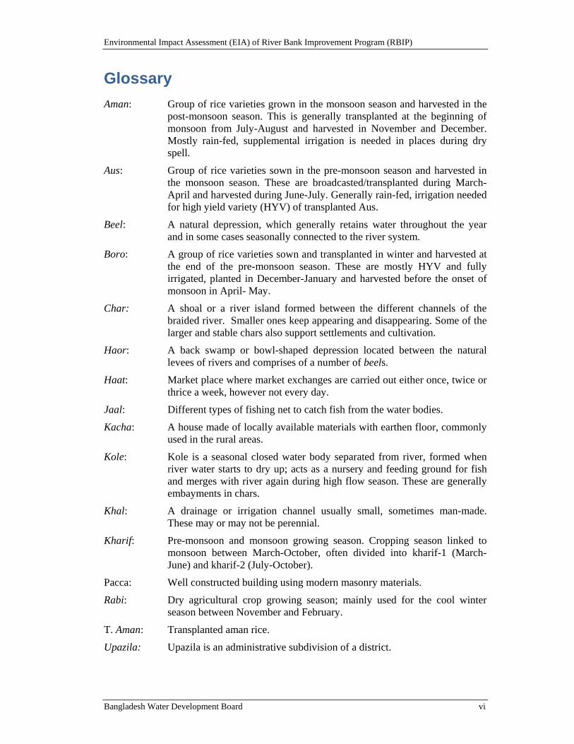
Glossary
Aman: Group of rice varieties grown in the monsoon season and harvested in the post-monsoon season. This is generally transplanted at the beginning of monsoon from July-August and harvested in November and December. Mostly rain-fed, supplemental irrigation is needed in places during dry spell.
Aus: Group of rice varieties sown in the pre-monsoon season and harvested in the monsoon season. These are broadcasted/transplanted during March-April and harvested during June-July. Generally rain-fed, irrigation needed for high yield variety (HYV) of transplanted Aus.
Beel: A natural depression, which generally retains water throughout the year and in some cases seasonally connected to the river system.
Boro: A group of rice varieties sown and transplanted in winter and harvested at the end of the pre-monsoon season. These are mostly HYV and fully irrigated, planted in December-January and harvested before the onset of monsoon in April- May.
Char: A shoal or a river island formed between the different channels of the braided river. Smaller ones keep appearing and disappearing. Some of the larger and stable chars also support settlements and cultivation.
Haor: A back swamp or bowl-shaped depression located between the natural levees of rivers and comprises of a number of beels.
Haat: Market place where market exchanges are carried out either once, twice or thrice a week, however not every day.
Jaal: Different types of fishing net to catch fish from the water bodies.
Kacha: A house made of locally available materials with earthen floor, commonly used in the rural areas.
Kole: Kole is a seasonal closed water body separated from river, formed when river water starts to dry up; acts as a nursery and feeding ground for fish and merges with river again during high flow season. These are generally embayments in chars.
Khal: A drainage or irrigation channel usually small, sometimes man-made. These may or may not be perennial.
Kharif: Pre-monsoon and monsoon growing season. Cropping season linked to monsoon between March-October, often divided into kharif-1 (March-June) and kharif-2 (July-October).
Pacca: Well constructed building using modern masonry materials.
Rabi: Dry agricultural crop growing season; mainly used for the cool winter season between November and February.
T. Aman: Transplanted aman rice.
Upazila: Upazila is an administrative subdivision of a district.
Environmental Impact Assessment (EIA) of River Bank Improvement Program (RBIP)
Bangladesh Water Development Board vii
Table of Contents Volume I
List of Acronyms ............................................................................................................... ii Glossary ............................................................................................................................ vi 1. Introduction ............................................................................................................ 1-1
1.1. Program Background ................................................................................................ 1-1
1.2. Overview of Proposed Program ................................................................................ 1-3
1.3. Study Scope .............................................................................................................. 1-5
1.4. Study Methodology ................................................................................................... 1-5
1.5. Program Influence Area ............................................................................................ 1-5
1.6. Study Team ............................................................................................................... 1-7
1.7. Document Structure .................................................................................................. 1-9
2. Policy and Regulatory Review ............................................................................... 2-1 2.1. National Environmental Laws .................................................................................. 2-1
2.1.1. Bangladesh Environment Conservation Act (ECA), 1995 ............................... 2-1
2.1.2. Bangladesh Environment Conservation Act (ECA), (Amendments) 2010 ...... 2-1
2.1.3. Bangladesh Environment Conservation Rules (ECR), 1997 ............................ 2-1
2.1.4. Bangladesh Environment Court Act, 2010 ....................................................... 2-2
2.2. Relevant National Policies, Strategies and Plans ...................................................... 2-2
2.2.1. National Environment Policy, 1992 .................................................................. 2-2
2.2.2. National Environment Management Action Plan, 1995 ................................... 2-3
2.2.3. National Water Policy, 1999 ............................................................................. 2-3
2.2.4. National Water Management Plan, 2001 (Approved in 2004) ......................... 2-4
2.2.5. National Land Use Policy (MoL, 2001) ........................................................... 2-4
2.2.6. National Agriculture Policy, 1999 .................................................................... 2-4
2.2.7. National Integrated Pest Management Policy ................................................... 2-5
2.2.8. National Fisheries Policy, 1996 ........................................................................ 2-5
2.2.9. National Livestock Development Policy, 2007 ................................................ 2-5
2.2.10. Privat Forest Policy 1994 .................................................................................. 2-5
2.2.11. National Policy for Safe Water Supply and Sanitation (1998) ......................... 2-6
2.2.12. National Policy for Arsenic Mitigation (2004) ................................................. 2-6
2.2.13. National Adaptation Programme of Action (NAPA)........................................ 2-6
2.2.14. Bangladesh Climate Change Strategy and Action Plan (BCCSAP) 2009 ........ 2-7
2.3. Other Relevant Acts, Laws and Rules ...................................................................... 2-7
2.3.1. Bangladesh Wildlife (Protection and Safety) Act 2012 .................................... 2-7
2.3.2. Bangladesh Wildlife (Preservation) Order (1973) and Act (1974) ................... 2-8
2.3.3. Protection and Conservation of Fish Act (1950) .............................................. 2-8
2.3.4. East-Bengal Protection and Fish Conservation Act (1950) and Amendments ..................................................................................................... 2-9
Environmental Impact Assessment (EIA) of River Bank Improvement Program (RBIP)
Bangladesh Water Development Board viii
2.3.5. Protection and Conservation of Fish Rules (1985) ........................................... 2-9
2.3.6. Forestry Acts ..................................................................................................... 2-9
2.3.7. Forest Act 1927 (Amendment 2000) .............................................................. 2-10
2.3.8. Private Forest Act (PFA), 1959 ...................................................................... 2-10
2.3.9. Embankment and Drainage Act, 1952 ............................................................ 2-10
2.3.10. Bangladesh Water Act, 2013 .......................................................................... 2-11
2.3.11. Bangladesh Labor Act, 2006 .......................................................................... 2-11
2.3.12. Bangladesh National Building Code, 2006 ..................................................... 2-12
2.3.13. Other Laws ..................................................................................................... 2-12
2.4. International Treaties Signed by GoB ..................................................................... 2-13
2.5. Implication of GoB Polices, Acts and Rules on RBIP ............................................ 2-14
2.6. World Bank's Environmental Safeguard Policies ................................................... 2-16
2.6.1. Environmental Assessment (OP 4.01) ............................................................ 2-16
2.6.2. Natural Habitats (OP 4.04) ............................................................................. 2-17
2.6.3. Pest Management (OP 4.09) ........................................................................... 2-17
2.6.4. Indigenous Peoples (OP 4.10) ........................................................................ 2-18
2.6.5. Physical Cultural Resources (OP 4.11) ........................................................... 2-18
2.6.6. Involuntary Resettlement (OP 4.12) ............................................................... 2-19
2.6.7. Forests (OP 4.36) ............................................................................................ 2-20
2.6.8. Safety of Dams (OP 4.37) ............................................................................... 2-20
2.6.9. Projects on International Waterways (OP 7.50) ............................................. 2-20
2.6.10. Projects in Disputed Areas (OP 7.60) ............................................................. 2-21
2.6.11. Access to Information ..................................................................................... 2-21
2.6.12. Environment, Health and Safety Guidelines ................................................... 2-21
2.6.13. Applicable World Bank Policies..................................................................... 2-21
3. Project Description ................................................................................................. 3-1 3.1. Background ............................................................................................................... 3-1
3.2. Proposed Interventions ............................................................................................. 3-2
3.2.1. Program Rationale ............................................................................................ 3-2
3.2.2. Program Objectives .......................................................................................... 3-3
3.2.3. Program Boundaries ......................................................................................... 3-4
3.3. Program Area, Work Sequencing, and Key Components ......................................... 3-7
3.3.1. RBIP Area and Selection of Priority Reach ...................................................... 3-7
3.3.2. The Phased Program ......................................................................................... 3-8
3.3.3. Flood Embankments ....................................................................................... 3-10
3.3.4. Service Road ................................................................................................... 3-14
3.3.5. Regulators and Fish Passes ............................................................................. 3-16
3.3.6. Riverbank Protection ...................................................................................... 3-18
3.4. Resources Requirements ......................................................................................... 3-23
Environmental Impact Assessment (EIA) of River Bank Improvement Program (RBIP)
Bangladesh Water Development Board ix
3.4.1. Material Requirements and their Sources ....................................................... 3-23
3.4.2. Manpower Requirements ................................................................................ 3-24
3.4.3. Construction Machinery ................................................................................. 3-25
3.4.4. Construction Camps ........................................................................................ 3-26
3.5. Operational and Maintenance Requirements .......................................................... 3-26
3.5.1. O&M Requirement of Bank protection structures .......................................... 3-27
3.5.2. O&M Requirements of Embankment cum Road ............................................ 3-27
3.5.3. O&M Requirements of Regulators ................................................................. 3-27
3.6. Project Costs ........................................................................................................... 3-27
4. Analysis of Alternatives.......................................................................................... 4-1 4.1. Overview ................................................................................................................... 4-1
4.2. No Project Alternative .............................................................................................. 4-2
4.2.1. Retirement of BRE and Failure of Bank Protection Structures ........................ 4-2
4.2.2. Damages from Jamuna Right Bank Erosion ..................................................... 4-2
4.2.3. Damages from Breach of BRE ......................................................................... 4-3
4.2.4. Current Approaches by BWDB to address Bank Erosion ................................ 4-4
4.3. Alternatives for River Bank Protection ..................................................................... 4-4
4.4. Embankment and Road Options ............................................................................. 4-16
4.4.1. Option 1: Widening of existing embankment with local road ........................ 4-16
4.4.2. Option 2: Reconstructed embankment on the floodplain with two-lane road at safe distance from the riverbank ......................................................... 4-16
4.4.3. Option 3: Embankment on the floodplain with separate four-lane highway as through road and adjacent local roads and bridges for crossing the highway ................................................................................. 4-17
4.4.4. Option 4: Embankment on filled land in the river with separate four lane highway ........................................................................................... 4-17
4.5. Alternatives for Embankment Materials ................................................................. 4-21
4.6. Alternatives for Regulators ..................................................................................... 4-21
4.7. Alternatives for Resettlement Sites ......................................................................... 4-22
5. Description of Physical Environment ................................................................... 5-1 5.1. Brahmaputra River Overview ................................................................................... 5-1
5.2. Climate ...................................................................................................................... 5-3
5.2.1. Temperature ...................................................................................................... 5-3
5.2.2. Precipitation ...................................................................................................... 5-4
5.2.3. Wind Speed ....................................................................................................... 5-5
5.2.4. Humidity ........................................................................................................... 5-5
5.3. Topography ............................................................................................................... 5-6
5.3.1. Floodplains ....................................................................................................... 5-7
5.3.2. Charland ............................................................................................................ 5-7
5.4. Hydrology and Floods .............................................................................................. 5-8
5.4.1. Surface Water Resources .................................................................................. 5-8
Environmental Impact Assessment (EIA) of River Bank Improvement Program (RBIP)
Bangladesh Water Development Board x
5.4.2. Jamuna Tributaries .......................................................................................... 5-10
5.4.3. Floods ............................................................................................................. 5-12
5.4.4. Navigation in River and Khals ....................................................................... 5-13
5.4.5. Erosion and Sediment Loading ....................................................................... 5-15
5.5. Geology and Hydrogeology .................................................................................... 5-16
5.5.1. Soils ................................................................................................................ 5-16
5.5.2. Geology .......................................................................................................... 5-17
5.5.3. Groundwater ................................................................................................... 5-17
5.5.4. Landuse and Land Cover Analysis ................................................................. 5-18
5.6. Quality of Environment .......................................................................................... 5-20
5.6.1. Ambient Air Quality in the Project Influence Area ........................................ 5-20
5.6.2. Ambient Noise Levels in Project Influence Area ........................................... 5-21
5.6.3. Surface Water Quality .................................................................................... 5-23
5.6.4. Groundwater Quality ...................................................................................... 5-26
5.6.5. Soil Quality ..................................................................................................... 5-26
6. Description of Ecological Environment ................................................................ 6-1 6.1. Overview: State of Biodiversity ................................................................................ 6-1
6.1.1. Ecosystem Diversity ......................................................................................... 6-3
6.1.2. Threatened Species ........................................................................................... 6-3
6.1.3. Critical Natural Habitats ................................................................................... 6-5
6.2. Project Influence Area Ecosystems .......................................................................... 6-7
6.2.1. Human Influence .............................................................................................. 6-8
6.2.2. Terrestrial Ecosystems ...................................................................................... 6-8
6.2.3. River-Charland-Wetland Ecosystems ............................................................... 6-9
6.3. Vegetation ............................................................................................................... 6-11
6.3.1. Terrestrial Vegetation ..................................................................................... 6-12
6.3.2. Aquatic Vegetation ......................................................................................... 6-12
6.3.3. Exotic Species ................................................................................................. 6-13
6.4. Wildlife ................................................................................................................... 6-13
6.4.1. Mammals ........................................................................................................ 6-14
6.4.2. Birds ................................................................................................................ 6-17
6.4.3. Reptiles ........................................................................................................... 6-18
6.4.4. Amphibians ..................................................................................................... 6-21
6.4.5. Terrestrial Invertebrates .................................................................................. 6-22
6.4.6. Ecosystem Services ........................................................................................ 6-22
6.4.7. Threats to Ecosystem ...................................................................................... 6-25
6.4.8. Use of Agrochemicals ..................................................................................... 6-26
6.4.9. Potential Vectors of Diseases ......................................................................... 6-26
6.4.10. Other Threats .................................................................................................. 6-26
Environmental Impact Assessment (EIA) of River Bank Improvement Program (RBIP)
Bangladesh Water Development Board xi
6.5. Fish and Fisheries ................................................................................................... 6-27
6.5.1. Summary of the fish and fisheries baseline .................................................... 6-27
6.5.2. Jamuna River - A suitable habitat of fresh water fishes ................................. 6-28
6.5.3. Fish habitat ..................................................................................................... 6-30
6.5.4. Fish Production ............................................................................................... 6-34
6.5.5. Fishing Effort .................................................................................................. 6-35
6.5.6. Fish Biodiversity ............................................................................................. 6-39
6.5.7. Species of Conservation Significance ............................................................. 6-40
6.5.8. Area of Conservation Significance ................................................................. 6-42
6.5.9. Fish Migration ................................................................................................ 6-45
6.5.10. Timing of Fish Migration ............................................................................... 6-49
6.5.11. Fish Catch Composition ................................................................................. 6-51
6.5.12. Aquatic Invertebrates ...................................................................................... 6-52
6.6. Supplementary Dry Season Primary Data .............................................................. 6-53
7. Description of Social Environment ....................................................................... 7-1 7.1. Overview of Erosion and Migration ......................................................................... 7-1
7.2. Socioeconomic Perspective ...................................................................................... 7-2
7.3. Administrative Units and Set Up .............................................................................. 7-4
7.4. Demography .............................................................................................................. 7-5
7.5. Income and Poverty .................................................................................................. 7-7
7.6. Education ................................................................................................................ 7-11
7.7. Public Health ........................................................................................................... 7-13
7.8. Water Supply and Sanitation .................................................................................. 7-15
7.9. Electricity ................................................................................................................ 7-16
7.10. Transport and Communication ............................................................................... 7-17
7.11. Chars ....................................................................................................................... 7-18
7.12. Gender ..................................................................................................................... 7-19
7.13. Agriculture .............................................................................................................. 7-19
7.13.1. Overview ........................................................................................................ 7-19
7.13.2. Soil and Agriculture Resources in the Influenced Area of RBIP ................... 7-21
7.13.3. Farm Size of Project Influence Area ............................................................... 7-23
7.13.4. Crops and Cropping Patterns of the Project Influence Area ........................... 7-23
7.13.5. Land Use Intensity and Cropping Intensity .................................................... 7-26
7.13.6. Crop Economics.............................................................................................. 7-26
7.13.7. Irrigation Coverage ......................................................................................... 7-27
7.13.8. Agricultural Inputs .......................................................................................... 7-28
8. Climate Change....................................................................................................... 8-1 8.1. Overview ................................................................................................................... 8-1
8.2. Global Context .......................................................................................................... 8-1
8.2.1. Warming of the Planet ...................................................................................... 8-1
Environmental Impact Assessment (EIA) of River Bank Improvement Program (RBIP)
Bangladesh Water Development Board xii
8.2.2. Ice, Snow, Permafrost, Rain, and Oceans ......................................................... 8-2
8.2.3. Hurricanes ......................................................................................................... 8-2
8.2.4. Model-based Projections for the Future ............................................................ 8-2
8.3. Climate Change in Bangladesh ................................................................................. 8-3
8.4. Observed changes in climate in Bangladesh ............................................................. 8-3
8.4.1. Temperature ...................................................................................................... 8-3
8.4.2. Rainfall ............................................................................................................. 8-4
8.4.3. Sea level rise ..................................................................................................... 8-5
8.5. Predicted changes in climate in Bangladesh ............................................................. 8-6
8.6. Predicted Climate Change Impacts and Adaptation Strategy for Project Influence Area ........................................................................................................................... 8-8
8.7. Climate change adaptation in RBIP design............................................................... 8-9
9. Impact Assessment ................................................................................................. 9-1 9.1. Potential Impacts - Overview.................................................................................... 9-1
9.2. Impact Assessment Methodology ............................................................................. 9-1
9.2.1. Impact Magnitude ............................................................................................. 9-2
9.2.2. Sensitivity of Receptor ..................................................................................... 9-2
9.3. Summary of Assessed Impacts ................................................................................. 9-3
9.4. Impact Assessment and Mitigation for Important Environmental and Social Components .............................................................................................................. 9-7
9.4.1. Significant Environmental Impacts from Project Siting ................................... 9-7
9.4.2. Significant Social Impacts from Project Siting ............................................... 9-26
9.4.3. Significant Environmental Impacts during Construction ............................... 9-36
9.4.4. Significant Social Impacts during Construction ............................................. 9-45
9.4.5. Environmental Impacts during Operation and Maintenance .......................... 9-48
9.4.6. Significant Social Impacts during Operation and Maintenance ..................... 9-51
10. Cumulative and Induced Impacts ....................................................................... 10-1 10.1. Overview ................................................................................................................. 10-1
10.2. CIIA in Context of RBIP ........................................................................................ 10-1
10.2.1. Study Boundaries ............................................................................................ 10-1
10.2.2. Identification of VECs for the CIIA ............................................................... 10-2
10.3. Morphology ............................................................................................................ 10-3
10.3.1. Background ..................................................................................................... 10-3
10.3.2. Future Trends .................................................................................................. 10-7
10.3.3. Cumulative Effects ......................................................................................... 10-7
10.4. Flood Affected Area ............................................................................................... 10-8
10.4.1. Background ..................................................................................................... 10-8
10.4.2. Future Trends .................................................................................................. 10-9
10.4.3. Cumulative Effects ....................................................................................... 10-12
10.5. Aquatic Biodiversity ............................................................................................. 10-15
Environmental Impact Assessment (EIA) of River Bank Improvement Program (RBIP)
Bangladesh Water Development Board xiii
10.6. Baseline and Trends .............................................................................................. 10-15
10.6.1. Cumulative Effects ....................................................................................... 10-15
10.7. Induced Environmental Impacts ........................................................................... 10-16
10.7.1. Road Network Development ........................................................................ 10-17
10.7.2. Roadside Development ................................................................................. 10-18
10.7.3. Industrialization ............................................................................................ 10-20
11. Environmental Management Plan ...................................................................... 11-1 11.1. EMP Objectives ...................................................................................................... 11-1
11.2. Inclusion of Relevant Components of EMP in Contract Documents ..................... 11-1
11.2.1. Payment Milestones ........................................................................................ 11-1
11.2.2. Guideline to Incorporate Environmental Management in Bid Document ...... 11-2
11.3. Institutional Arrangements...................................................................................... 11-2
11.3.1. Construction Phase ......................................................................................... 11-2
11.3.2. O&M Phase .................................................................................................... 11-5
11.3.3. Environment and Social Development Unit ................................................... 11-5
11.3.4. Construction Supervision Consultants (CSC) ................................................. 11-7
11.3.5. Contractors ...................................................................................................... 11-8
11.4. Environmental and Social Management ................................................................. 11-8
11.4.1. Environmental Codes of Practice ................................................................. 11-11
11.4.2. Mitigations and Compliance Monitoring Plans ............................................ 11-12
11.4.3. Site Specific Management Plans .................................................................. 11-12
11.5. Monitoring Program ............................................................................................. 11-78
11.5.1. Compliance Monitoring ................................................................................ 11-78
11.5.2. Effects Monitoring during Construction ....................................................... 11-78
11.5.3. External Monitoring ...................................................................................... 11-82
11.6. Performance Indicators ......................................................................................... 11-82
11.7. Grievance Redress Mechanism ............................................................................ 11-82
11.7.1. Local Grievance Redress Committee ........................................................... 11-83
11.7.2. Project Grievance Redress Committee ......................................................... 11-83
11.8. Capacity Building ................................................................................................. 11-83
11.9. Chance Find Procedure ......................................................................................... 11-85
11.10. Documentation ...................................................................................................... 11-85
11.11. EMP Implementation Cost .................................................................................... 11-85
12. Stakeholder Consultations ................................................................................... 12-1 12.1. Consultation Objectives .......................................................................................... 12-1
12.2. Approach and Methodology ................................................................................... 12-2
12.3. Community Consultations ...................................................................................... 12-2
12.4. Key Issues Discussed during Consultations ......................................................... 12-13
12.5. Institutional Consultations .................................................................................... 12-17
12.6. Consultations by Social Safeguard Team ............................................................. 12-19
Environmental Impact Assessment (EIA) of River Bank Improvement Program (RBIP)
Bangladesh Water Development Board xiv
12.7. Summary of Issues Discussed ............................................................................... 12-21
12.8. Disclosure Requirements ...................................................................................... 12-24
13. References.............................................................................................................. 13-1
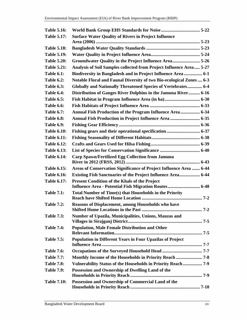
List of Tables Table 1.1: Program Phases ...................................................................................... 1-3
Table 2.1: Laws and Acts ...................................................................................... 2-13
Table 2.2: Treaty or Convention and Responsible Agency ................................ 2-13
Table 2.3: Triggering the World Bank Policies ................................................... 2-22
Table 3.1: Performance Indicators and Timeframes ............................................ 3-3
Table 3.2: Summary of physical interventions ...................................................... 3-8
Table 3.3: Key Parameters of the BRE ................................................................ 3-11
Table 3.4: Explanations of Map in Figure 3.4 ..................................................... 3-11
Table 3.5: Comparison of Design Water Levels and Embankment Crest Levels .......................................................................................... 3-14
Table 3.6: Comparison of cover layer alternatives above low water level ........ 3-22
Table 3.7: Construction Materials ........................................................................ 3-24
Table 3.8: Required Manpower during Construction ........................................ 3-25
Table 3.9: List of Construction Equipment and Machinery .............................. 3-25
Table 3.10: Initial Cost Estimates of RBIP Phase I (in USD) .............................. 3-28
Table 4.1: Criteria for evaluation of alternatives.................................................. 4-1
Table 4.2: Estimates of annual of loss of land and destruction of structures from bank erosion ................................................................ 4-3
Table 4.3: Analysis of River Bank Protection Alternatives ................................. 4-8
Table 4.4: Analysis of Embankment and Road Alternatives ............................. 4-18
Table 4.5: Analysis of Resettlement Site Alternatives ........................................ 4-22
Table 5.1: Seasonal Mean Discharge (1976 - 2011) of Jamuna ............................ 5-1
Table 5.2: Water levels of Jamuna (1945-2013) .................................................... 5-2
Table 5.3: Water level (m) frequency analysis at gauging stations ..................... 5-3
Table 5.4: Chars/ Shoals in the Project Influence Area ....................................... 5-8
Table 5.5: Rivers in the Project Influence Area .................................................. 5-10
Table 5.6: Khals of the Project Influence Area ................................................... 5-10
Table 5.7: Some Notable Flood Disasters of Bangladesh ................................... 5-13
Table 5.8: Comparison of Major Flood Impacts in the Jamuna ....................... 5-13
Table 5.9: General Land Use in Project Influence Area (Priority Reach) ....... 5-18
Table 5.10: Land Types in Project Influence Area Districts ................................ 5-18
Table 5.11: Ambient Air Quality Parameters in Project Influence Area ........... 5-20
Table 5.12: Bangladesh Standards for Ambient Air Quality............................... 5-21
Table 5.13: Ambient Air Quality (WBG EHS Standards) ................................... 5-21
Table 5.14: Noise Levels in Project Influence Area .............................................. 5-22
Table 5.15: Noise Quality Standards of Bangladesh ............................................. 5-22
Environmental Impact Assessment (EIA) of River Bank Improvement Program (RBIP)
Bangladesh Water Development Board xv
Table 5.16: World Bank Group EHS Standards for Noise .................................. 5-22
Table 5.17: Surface Water Quality of Rivers in Project Influence Area (2006) ........................................................................................... 5-23
Table 5.18: Bangladesh Water Quality Standards ............................................... 5-23
Table 5.19: Water Quality in Project Influence Area ........................................... 5-24
Table 5.20: Groundwater Quality in the Project Influence Area ........................ 5-26
Table 5.21: Analysis of Soil Samples collected from Project Influence Area ..... 5-27
Table 6.1: Biodiversity in Bangladesh and in Project Influence Area ................ 6-1
Table 6.2: Notable Floral and Faunal Diversity of two Bio-ecological Zones .... 6-3
Table 6.3: Globally and Nationally Threatened Species of Vertebrates ............. 6-4
Table 6.4: Distribution of Ganges River Dolphins in the Jamuna River .......... 6-16
Table 6.5: Fish Habitat in Program Influence Area (in ha) ............................... 6-30
Table 6.6: Fish Habitats of Project Influence Area ............................................ 6-33
Table 6.7: Annual Fish Production of the Program Influence Area ................. 6-34
Table 6.8: Annual Fish Production in Project Influence Area .......................... 6-35
Table 6.9: Fishing Gear Efficiency ....................................................................... 6-36
Table 6.10: Fishing gears and their operational specification ............................. 6-37
Table 6.11: Fishing Seasonality of Different Habitats .......................................... 6-38
Table 6.12: Crafts and Gears Used for Hilsa Fishing ........................................... 6-39
Table 6.13: List of Species for Conservation Significance ................................... 6-40
Table 6.14: Carp Spawn/Fertilized Egg Collection from Jamuna River in 2012 (FRSS, 2012) ................................................................. 6-43
Table 6.15: Areas of Conservation Significance of Project Influence Area ....... 6-44
Table 6.16: Existing Fish Sanctuaries of the Project Influence Area .................. 6-44
Table 6.17: Present Condition of the Khals of the Project Influence Area - Potential Fish Migration Routes ............................ 6-48
Table 7.1: Total Number of Time(s) that Households in the Priority Reach have Shifted Home Location ..................................................... 7-2
Table 7.2: Reasons of Displacement, among Households who have Shifted Home Locations in the Past ..................................................... 7-2
Table 7.3: Number of Upazila, Municipalities, Unions, Mauzas and Villages in Sirajganj District ................................................................. 7-5
Table 7.4: Population, Male Female Distribution and Other Relevant Information ............................................................................. 7-5
Table 7.5: Population in Different Years in Four Upazilas of Project Influence Area ........................................................................................ 7-7
Table 7.6: Occupations of the Surveyed Household Head ................................... 7-7
Table 7.7: Monthly Income of the Households in Priority Reach ....................... 7-8
Table 7.8: Vulnerability Status of the Households in Priority Reach ................. 7-9
Table 7.9: Possession and Ownership of Dwelling Land of the Households in Priority Reach ............................................................... 7-9
Table 7.10: Possession and Ownership of Commercial Land of the Households in Priority Reach ............................................................. 7-10
Environmental Impact Assessment (EIA) of River Bank Improvement Program (RBIP)
Bangladesh Water Development Board xvi
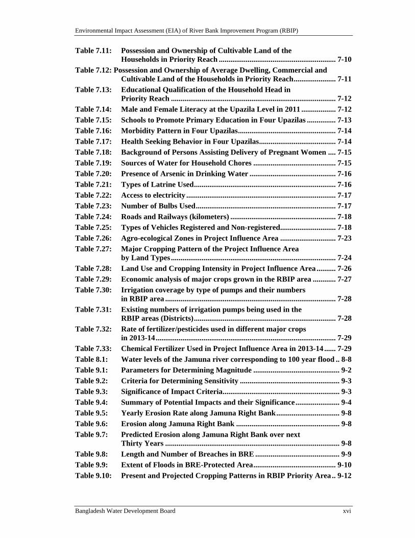
Table 7.11: Possession and Ownership of Cultivable Land of the Households in Priority Reach ............................................................. 7-10
Table 7.12: Possession and Ownership of Average Dwelling, Commercial and Cultivable Land of the Households in Priority Reach ...................... 7-11
Table 7.13: Educational Qualification of the Household Head in Priority Reach ...................................................................................... 7-12
Table 7.14: Male and Female Literacy at the Upazila Level in 2011 .................. 7-12
Table 7.15: Schools to Promote Primary Education in Four Upazilas ............... 7-13
Table 7.16: Morbidity Pattern in Four Upazilas ................................................... 7-14
Table 7.17: Health Seeking Behavior in Four Upazilas ........................................ 7-14
Table 7.18: Background of Persons Assisting Delivery of Pregnant Women .... 7-15
Table 7.19: Sources of Water for Household Chores ........................................... 7-15
Table 7.20: Presence of Arsenic in Drinking Water ............................................. 7-16
Table 7.21: Types of Latrine Used .......................................................................... 7-16
Table 7.22: Access to electricity .............................................................................. 7-17
Table 7.23: Number of Bulbs Used ......................................................................... 7-17
Table 7.24: Roads and Railways (kilometers) ....................................................... 7-18
Table 7.25: Types of Vehicles Registered and Non-registered ............................. 7-18
Table 7.26: Agro-ecological Zones in Project Influence Area ............................. 7-23
Table 7.27: Major Cropping Pattern of the Project Influence Area by Land Types ...................................................................................... 7-24
Table 7.28: Land Use and Cropping Intensity in Project Influence Area .......... 7-26
Table 7.29: Economic analysis of major crops grown in the RBIP area ............ 7-27
Table 7.30: Irrigation coverage by type of pumps and their numbers in RBIP area ......................................................................................... 7-28
Table 7.31: Existing numbers of irrigation pumps being used in the RBIP areas (Districts) .......................................................................... 7-28
Table 7.32: Rate of fertilizer/pesticides used in different major crops in 2013-14 .............................................................................................. 7-29
Table 7.33: Chemical Fertilizer Used in Project Influence Area in 2013-14 ...... 7-29
Table 8.1: Water levels of the Jamuna river corresponding to 100 year flood .. 8-8
Table 9.1: Parameters for Determining Magnitude ............................................. 9-2
Table 9.2: Criteria for Determining Sensitivity .................................................... 9-3
Table 9.3: Significance of Impact Criteria ............................................................. 9-3
Table 9.4: Summary of Potential Impacts and their Significance ....................... 9-4
Table 9.5: Yearly Erosion Rate along Jamuna Right Bank ................................. 9-8
Table 9.6: Erosion along Jamuna Right Bank ...................................................... 9-8
Table 9.7: Predicted Erosion along Jamuna Right Bank over next Thirty Years ........................................................................................... 9-8
Table 9.8: Length and Number of Breaches in BRE ............................................ 9-9
Table 9.9: Extent of Floods in BRE-Protected Area ........................................... 9-10
Table 9.10: Present and Projected Cropping Patterns in RBIP Priority Area .. 9-12
Environmental Impact Assessment (EIA) of River Bank Improvement Program (RBIP)
Bangladesh Water Development Board xvii
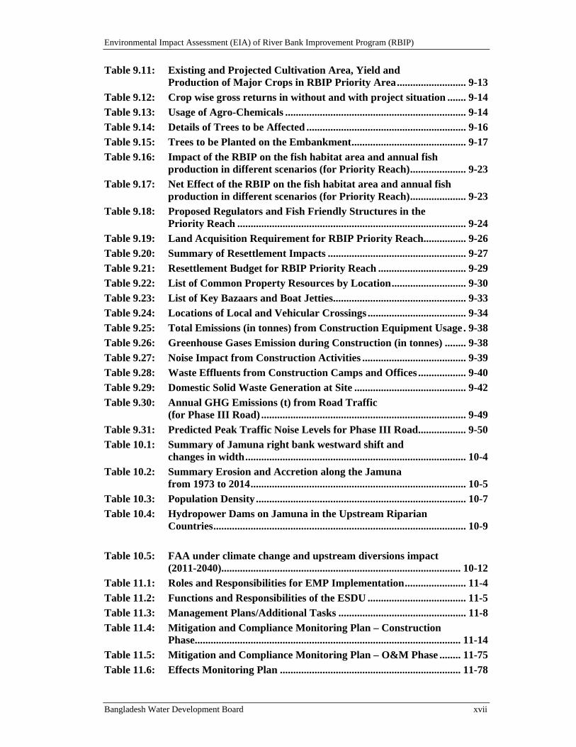
Table 9.11: Existing and Projected Cultivation Area, Yield and Production of Major Crops in RBIP Priority Area .......................... 9-13
Table 9.12: Crop wise gross returns in without and with project situation ....... 9-14
Table 9.13: Usage of Agro-Chemicals .................................................................... 9-14
Table 9.14: Details of Trees to be Affected ............................................................ 9-16
Table 9.15: Trees to be Planted on the Embankment ........................................... 9-17
Table 9.16: Impact of the RBIP on the fish habitat area and annual fish production in different scenarios (for Priority Reach) ..................... 9-23
Table 9.17: Net Effect of the RBIP on the fish habitat area and annual fish production in different scenarios (for Priority Reach) ..................... 9-23
Table 9.18: Proposed Regulators and Fish Friendly Structures in the Priority Reach ...................................................................................... 9-24
Table 9.19: Land Acquisition Requirement for RBIP Priority Reach ................ 9-26
Table 9.20: Summary of Resettlement Impacts .................................................... 9-27
Table 9.21: Resettlement Budget for RBIP Priority Reach ................................. 9-29
Table 9.22: List of Common Property Resources by Location ............................ 9-30
Table 9.23: List of Key Bazaars and Boat Jetties.................................................. 9-33
Table 9.24: Locations of Local and Vehicular Crossings ..................................... 9-34
Table 9.25: Total Emissions (in tonnes) from Construction Equipment Usage . 9-38
Table 9.26: Greenhouse Gases Emission during Construction (in tonnes) ........ 9-38
Table 9.27: Noise Impact from Construction Activities ....................................... 9-39
Table 9.28: Waste Effluents from Construction Camps and Offices .................. 9-40
Table 9.29: Domestic Solid Waste Generation at Site .......................................... 9-42
Table 9.30: Annual GHG Emissions (t) from Road Traffic (for Phase III Road) ............................................................................. 9-49
Table 9.31: Predicted Peak Traffic Noise Levels for Phase III Road .................. 9-50
Table 10.1: Summary of Jamuna right bank westward shift and changes in width ................................................................................... 10-4
Table 10.2: Summary Erosion and Accretion along the Jamuna from 1973 to 2014 ................................................................................. 10-5
Table 10.3: Population Density ............................................................................... 10-7
Table 10.4: Hydropower Dams on Jamuna in the Upstream Riparian Countries ............................................................................................... 10-9
Table 10.5: FAA under climate change and upstream diversions impact (2011-2040).......................................................................................... 10-12
Table 11.1: Roles and Responsibilities for EMP Implementation ....................... 11-4
Table 11.2: Functions and Responsibilities of the ESDU ..................................... 11-5
Table 11.3: Management Plans/Additional Tasks ................................................ 11-8
Table 11.4: Mitigation and Compliance Monitoring Plan – Construction Phase.................................................................................................... 11-14
Table 11.5: Mitigation and Compliance Monitoring Plan – O&M Phase ........ 11-75
Table 11.6: Effects Monitoring Plan .................................................................... 11-78
Environmental Impact Assessment (EIA) of River Bank Improvement Program (RBIP)
Bangladesh Water Development Board xviii
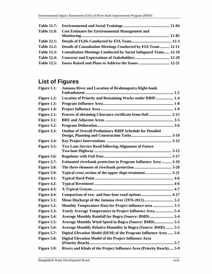
Table 11.7: Environmental and Social Trainings ............................................... 11-84
Table 11.8: Cost Estimates for Environmental Management and Monitoring .......................................................................................... 11-85
Table 12.1: Details of FGDs Conducted by EIA Team ......................................... 12-3
Table 12.2: Details of Consultation Meetings Conducted by EIA Team .......... 12-11
Table 12.3: Consultation Meetings Conducted by Social Safeguard Team...... 12-19
Table 12.4: Concerns and Expectations of Stakeholders ................................... 12-20
Table 12.5: Issues Raised and Plans to Address the Issues ................................ 12-21
List of Figures Figure 1.1: Jamuna River and Location of Brahmaputra Right-bank
Embankment .......................................................................................... 1-2
Figure 1.2: Location of Priority and Remaining Works under RBIP .................. 1-4
Figure 1.3: Program Influence Area ........................................................................ 1-8
Figure 1.4: Project Influence Area ........................................................................... 1-9
Figure 2.1: Process of obtaining Clearance certificate from DoE ....................... 2-15
Figure 3.1: BRE and Adjacent Areas ...................................................................... 3-5
Figure 3.2: Program Delineation .............................................................................. 3-6
Figure 3.3: Outline of Overall Preliminary RBIP Schedule for Detailed Design, Planning and Construction Tasks ......................................... 3-10
Figure 3.4: Key Project Interventions .................................................................. 3-12
Figure 3.5: Two Lane Service Road following Alignment of Future Two-lane Highway ............................................................................... 3-15
Figure 3.6: Regulator with Fish Pass ..................................................................... 3-17
Figure 3.7: Estimated riverbank protection in Program Influence Area .......... 3-19
Figure 3.8: The three elements of riverbank protection ...................................... 3-20
Figure 3.9: Typical cross section of the upper slope treatment ........................... 3-21
Figure 4.1: Typical Hard Point ................................................................................ 4-6
Figure 4.2: Typical Revetment ................................................................................. 4-6
Figure 4.3: A Typical Groyne ................................................................................... 4-7
Figure 4.4: Comparison of two- and four-lane road options ............................... 4-17
Figure 5.1: Mean Discharge of the Jamuna river (1976-2011) .............................. 5-2
Figure 5.2: Monthly Temperature Data for Project influence area ..................... 5-3
Figure 5.3: Yearly Average Temperature in Project Influence Area ................... 5-4
Figure 5.4: Average Monthly Rainfall for Bogra (Source: BMD) ........................ 5-4
Figure 5.5: Average Monthly Wind Speed in Bogra (Source: BMD) ................... 5-5
Figure 5.6: Average Monthly Relative Humidity in Bogra (Source: BMD) ........ 5-5
Figure 5.7: Digital Elevation Model (DEM) of the Program Influence Area ...... 5-6
Figure 5.8: Digital Elevation Model of the Project Influence Area (Priority Reach) ...................................................................................... 5-7
Figure 5.9: Rivers and Khals of the Project Influence Area (Priority Reach) ..... 5-9
Environmental Impact Assessment (EIA) of River Bank Improvement Program (RBIP)
Bangladesh Water Development Board xix
Figure 5.10: Average Monthly Discharge of the Teesta River .............................. 5-11
Figure 5.11: Average Monthly Discharge of the Teesta River .............................. 5-11
Figure 5.12: Average Monthly Discharge of the Bengali River ............................ 5-12
Figure 5.13: Average Monthly Discharge of the Hurasagar River ....................... 5-12
Figure 5.14: Draft Restriction of Inland Waterways of Bangladesh .................... 5-14
Figure 5.15: Pattern of bank erosion on Jamuna River, 1973 to 2013 ................. 5-16
Figure 5.16: Monthly Average Groundwater Level at Gaibandha, Bogra and Sirajganj ............................................................................................... 5-17
Figure 5.17: Land Use in the Project Influence Area (Priority Reach) ................ 5-19
Figure 6.1: Bio-ecological Zones in the Project Influence Area ............................ 6-2
Figure 6.2: High Density Areas for Ganges River Dolphin in Project Influence Area ........................................................................................ 6-6
Figure 6.3: Wintering/Staging Grounds for Migratory Winter Birds in the Project Influence Area ................................................................ 6-7
Figure 6.4: Homestead Vegetation in the Project Influence Area ........................ 6-8
Figure 6.5: Agricultural Land and Planted Exotic Eucalyptus Trees in the Project Influence Area ................................................................ 6-9
Figure 6.6: Strong Negative Linear Relationship between Canopy Cover and Crop cover across 12 Upazila of the Project Influence Area ............. 6-9
Figure 6.7: Char Ecosystem in the Project Influence Area ................................. 6-10
Figure 6.8: Relative Diversity of Major Plant Species across 12 Upazilas of the Project Influence Area .............................................................. 6-11
Figure 6.9: Principal Uses of Major Plants in Project Influence Area ............... 6-12
Figure 6.10: Aquatic Vegetation............................................................................... 6-13
Figure 6.11: Relative Diversity of Common Vertebrate Species across 12 Upazilas of the Project Influence Area ............................. 6-14
Figure 6.12: Ganges River Dolphin.......................................................................... 6-15
Figure 6.13: Relative abundance of Ganges River Dolphin in three transects .... 6-17
Figure 6.14: Flock of Water Birds ........................................................................... 6-17
Figure 6.15: Flock of Whiskered Tern - a Common Bird in the Project Influence Area ...................................................................................... 6-18
Figure 6.16: Binocellate Cobra - a Common Reptilian the Project Influence Area ...................................................................................... 6-19
Figure 6.17: Peacock Turtle ...................................................................................... 6-20
Figure 6.18: Crocodile at its natural Habitat ......................................................... 6-20
Figure 6.19: Distribution map of Crocodile in 2010 .............................................. 6-21
Figure 6.20: Cricket Frog - a Common Amphibian in the Project Influence Area ...................................................................................... 6-22
Figure 6.21: Ganges River Dolphin Accidentally Killed by Fishing Net in Project Influence Area .................................................................... 6-26
Figure 6.22: Dense shrubs along the banks of the Jamuna river chars–preferred feeding ground for fish offsprings ......................... 6-29
Figure 6.23: Location of Major Fish Habitats in Project Influence Area ............ 6-31
Environmental Impact Assessment (EIA) of River Bank Improvement Program (RBIP)
Bangladesh Water Development Board xx
Figure 6.24: Different Fish Sub-habitats of the Jamuna River in a Section of the Program Influence Area ............................................. 6-32
Figure 6.25: CPUE of the Different Fishing Gears................................................. 6-37
Figure 6.26: Different types of fishing gears and crafts of the study area ........... 6-37
Figure 6.27: Small Indigenous Species (SIS) of the Jamuna River ....................... 6-40
Figure 6.28: Carp Spawn Collection Points in Project Influence Area ................ 6-42
Figure 6.29: Carp spawn collection trend of the Jamuna river ............................ 6-43
Figure 6.30: Location of the Fish Sanctuaries of Project Influence Area ............ 6-45
Figure 6.31: Migration pattern of the floodplain fishes of the study area ........... 6-46
Figure 6.32: Potential Fish Migration Routes through Fishpass in Project Influence Area ...................................................................................... 6-47
Figure 6.33: Sariakandi fish pass (September 3, 2014) .......................................... 6-48
Figure 6.34: Depth and Velocity Preference for Fish (IWFM, 2011) ................... 6-50
Figure 6.35: Movement of Jatka (Hilsa juvenile) into the Jamuna River ............ 6-51
Figure 6.36: Fish catch composition (percent) of the Jamuna River .................... 6-52
Figure 6.37: Benthos indicator species for fresh water bodies in Bangladesh ..... 6-53
Figure 7.1: River Bank Erosion along Jamuna ...................................................... 7-1
Figure 7.2: Population Density of Four Upazilas in Project Influence Area ....... 7-6
Figure 7.3: Agro-ecological Zones .......................................................................... 7-22
Figure 7.4: Cropping Pattern in the Area ............................................................. 7-25
Figure 8.1: Observed trend in minimum temperature .......................................... 8-4
Figure 8.2: Observed trend in sea level rise as evident from different tidal stations along the coast ................................................... 8-5
Figure 8.3: Peak flood flow map for base condition, 1998 flood ............................. 8-7
Figure 8.4: Peak flood flow map for 2050 with climate change .............................. 8-7
Figure 9.1: Erosion along Jamuna Banks ................................................................. 9-7
Figure 9.2: Flood Extent due to BRE Breaches ...................................................... 9-11
Figure 9.3: Riverbank Erosion near Chandanbaissa ............................................ 9-16
Figure 9.4: Location of Regulators and Fish Pass Structures ............................... 9-25
Figure 10.1: Study Area of CIIA ............................................................................... 10-2
Figure 10.2: Bankline changes of the Jamuna River 1830 – 2010 .......................... 10-4
Figure 10.3: Erosion and Accretion of Jamuna from 1973 to 2014 ........................ 10-5
Figure 10.4: Changes of water, sand, floodplain and charland from 1973-2014 .. 10-6
Figure 10.5: Brahmaputra – Jamuna Catchment Area .......................................... 10-9
Figure 10.6: Schematic of the Brahmaputra System Model (BSM) ..................... 10-12
Figure 10.7: The five flood risk management measures ........................................ 10-14
Figure 10.8: Fish Production Trend of the Jamuna River .................................... 10-15
Figure 10.9: Network diagram for impact assessment of induced Development ......................................................................................... 10-17
Figure 11.1: Organogram for Environmental Management .................................. 11-3
Figure 12.1: An FGD Conducted at the Project Site ............................................... 12-2
Figure 12.2: An FGD Conducted at the Project Site ............................................... 12-3
Environmental Impact Assessment (EIA) of River Bank Improvement Program (RBIP)
Bangladesh Water Development Board xxi
Figure 12.3: A Meeting Conducted at the Project Site ............................................ 12-3
Figure 12.4: A Meeting with Institutional Stakeholders ....................................... 12-17
Figure 12.5: A Meeting with Institutional Stakeholders ....................................... 12-18
Volume II: Annexes
Environmental Impact Assessment (EIA) of River Bank Improvement Program (RBIP)
Bangladesh Water Development Board 1-1
1. Introduction
The Government of Bangladesh (GoB) through the Bangladesh Water Development Board (BWDB) is planning to initiate the River Bank Improvement Program (RBIP) primarily to rehabilitate and improve the existing right bank embankment of the Brahmaputra River, and also to undertake river bank protection and construction of a road over the embankment. The GoB is seeking assistance from the World Bank (WB) for this purpose.
The program will be implemented in phases and in the first phase, works will be carried out for the 50 km priority reach of the embankment and corresponding river bank; the remaining works will be implemented under subsequent phase(s). In line with the national regulatory as well as WB policy requirements, and in order to minimize the negative environmental and social impacts of the proposed interventions, the BWDB has conducted a detailed environmental impact assessment (EIA) for the priority reach of the program (described as the proposed project in rest of the document). This document presents the report of this assessment. An initial environmental examination (IEE) has earlier been prepared and submitted to the Department of Environment (DoE) for clearance.
An environmental management framework (EMF) has also been prepared to guide the detailed environmental assessments of the subsequent phases of the program to be carried out once the detailed design of the remaining works is underway. The EMF is presented under a separate cover.
1.1. ProgramBackground
Bangladesh is mainly comprised of the fertile alluvial floodplains and the delta of the Ganges-Brahmaputra-Meghna river system (Brahmaputra south through Bangladesh, named as the Jamuna). These three rivers combine within the country to form the world's third largest river, the Lower Meghna, which drains into the Bay of Bengal via a constantly changing network of estuaries and tidal creeks. Bangladesh is one of the most vulnerable countries to natural disasters, mainly by upstream river floods during monsoon season and coastal cyclones from the Bay of Bengal. Floods are of recurring phenomena in Bangladesh, and in each year about 22 percent of the country is inundated. Major floods occur when upland flood flows of the three rivers converging to Bangladesh coincide and combine with the heavy monsoon rainfall. It is also difficult to regulate these flood flows as over 90 percent of their river catchments areas are outside the Bangladesh.
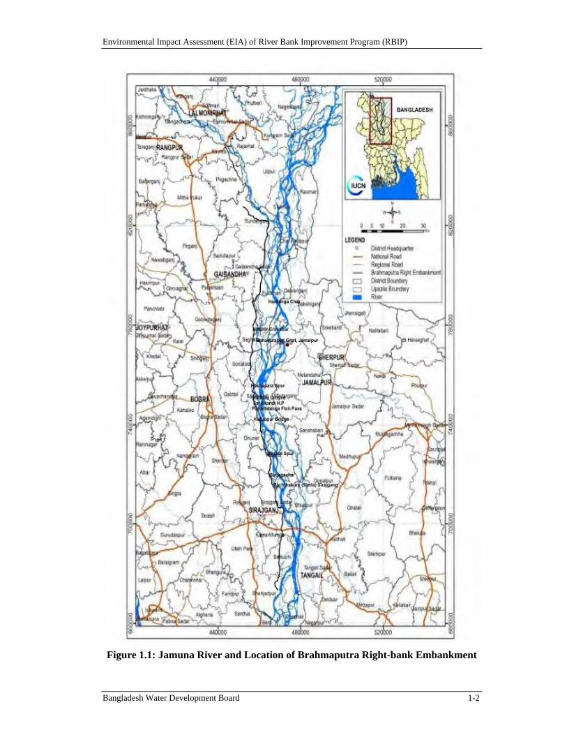
The Brahmaputra/Jamuna is the Country’s largest of the three rivers with highest erosion and bank movements. Prior to the construction of Brahmaputra Right-bank Embankment (BRE), over bank spills along the 220 km stretch of the right bank of the Brahmaputra River used to cause flooding on an area of about 240,000 ha. In early 1960s, the BRE was built to protect from this flooding problem and to foster agricultural growth in the protected area (see Figure 1.1).
Environmental Impact Assessment (EIA) of River Bank Improvement Program (RBIP)
Bangladesh Water Development Board 1-2
Figure 1.1: Jamuna River and Location of Brahmaputra Right-bank Embankment
Environmental Impact Assessment (EIA) of River Bank Improvement Program (RBIP)
Bangladesh Water Development Board 1-3
The original BRE had a setback of about 1.5 km from the Brahmaputra's right bank and it was assumed to have bank erosion life of 25-30 year span. In the 1970s the embankment started to fall under sporadic erosion attacks. During 1980s, the frequency of the BRE breaches by erosion increased rapidly as longer sections came within the range of rapidly eroding river bends which could cause bank-line erosion rates of several hundred meters per year in early stages of bend formation. To prevent flooding, these breaches were typically closed by local BRE retirements at about 200 meter set-backs. As a result of this minimal set-back distance the BRE has been retired several times in many places and at present perhaps only 50 km of the original BRE has remained in place. Currently, many long stretches of the BRE are very close to the river-bank line. Consequently, security of area protected by the BRE has been seriously threatened and large areas of land and cities with large population like Sirajganj are exposed to flooding.
1.2. OverviewofProposedProgram
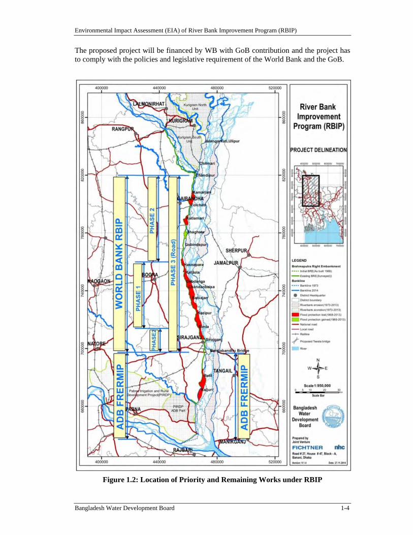
The main focus of the BRE rehabilitation and associated riverbank protection works under RBIP is on its length alongside the Brahmaputra/ Jamuna River from Bangabandhu (Jamuna) Bridge to the Teesta River (Figure 1.1). The priority works (ie, the proposed project) will cover the approximately 50-km long priority reach from Sailabari to Hasnapara (see Figure 1.2).
The RBIP’s physical works will include:
River bank protection (ie, revetment) on portions of the western (right) bank;
Embankment upgrading, reconstruction and realignment, including adding drainage/control;
structures (regulators and fish passes) to permit ecological connectivity and seasonal flow of river water for irrigation to the area behind the embankment); and
A new service road on the embankment. The RBIP in future phases may also include the option of a toll road (highway) along the flood embankment.
The RBIP will also provide livelihood and resettlement support to the displaced people. Based on the field reconnaissance and the preliminary morphological assessment, the RBIP works have been divided into three phases as shown in Table 1.1 below.
Table 1.1: Program Phases
Description Length (km)
Phase Tentative Schedule
Embankment, a service road over it, and riverbank protection from Jamuna Bridge to Sailabari
19 Phase II 2017 to 2022
Embankment, a service road over it, and riverbank protection from Sailabari to Hasnapara
50 Phase I (the proposed project)
2015 to 2020
Embankment, a service road over it, and riverbank protection from Hasnapara to Belka
77 Phase II 2017 to 2022
A 2-lane highway on embankment 146 Phase III 2018 to 2023
Environmental Impact Assessment (EIA) of River Bank Improvement Program (RBIP)
Bangladesh Water Development Board 1-4
The proposed project will be financed by WB with GoB contribution and the project has to comply with the policies and legislative requirement of the World Bank and the GoB.
Figure 1.2: Location of Priority and Remaining Works under RBIP
Environmental Impact Assessment (EIA) of River Bank Improvement Program (RBIP)
Bangladesh Water Development Board 1-5
1.3. StudyScope
The present EIA has been conducted for the first phase of the overall RBIP and covers river bank protection along the selected sections of the Jamuna right bank, rehabilitation and reconstruction of the embankment, and associated structures. The EIA studies for the remaining stages will be carried out later, in accordance with the project’s Environmental Management Framework (EMF).
1.4. StudyMethodology
The present EIA has been prepared following the standard methodology consisting of the steps listed below.
Review of the program details and meeting/discussions with the design team
Review of the policy and regulatory requirements
Reconnaissance field visit and initial scoping and screening
Collecting and analysis of baseline environmental and social data with the help of secondary literature review and field data collection
Consultations with the stakeholders including beneficiary/affected communities
Impact assessment
Preparing environmental management plan
Compilation of the present EIA.
The detailed methodology is included in Annex A whereas the terms of reference of the study are presented in Annex B.
1.5. ProgramInfluenceArea
The influence area of the overall program has been derived considering areas that are likely to be directly or indirectly affected by the RBIP construction and operation activities, including but not limited to the extent the project would have impacts on the floodplain areas, lateral fish migration, hydrological, road network, and the project footprints.1 The following criteria have been considered to define the influence area:
Project footprints: areas that directly fall under foot prints of the projects, ancillary facilities, temporary construction areas and worker camp sites, borrow areas, and access roads to the project facilities for transport of material; areas that will be affected by the emissions from construction and by operation of traffic.
Floodplain area: The extent of flood plain area that will be protected from the floods by the flood embankments (BRE) has primarily been considered as the program influence area. This area has been derived based on the latest satellite maps and GoB topographic maps through digital elevation model (DEM).
Flood Inundation: The extent of flood inundation caused by breaches of BRE. Satellite maps were analyzed for August-September, 2014 (i.e., the high flow season) to understand the extent of flooding from breaches and internal rivers like the Dharla, Dudhkumar, Teesta, Karotoya, Bangali, Ichamati, and Hurasagar.
1 The influence area for the cumulative impact assessment is defined later in the document.
Environmental Impact Assessment (EIA) of River Bank Improvement Program (RBIP)
Bangladesh Water Development Board 1-6
Connectivity: The area is crisscrossed with a network of khals (water channels) which carry flood waters from Jamuna to the internal rivers on the western part of the project influence area. All these rivers are interconnected by numerous khals, tributaries and distributaries forming a hydrological network in the entire northwest region of the Country. For example, Mahananda and Punorbhaba that are major rivers of the northwest region, are connected to the Atrai-Karatoya-Bangali river system which drains to the lower Jamuna through the Hurasagar/Baral in the south east corner of the region.
Lateral Fish Migration: Some fish species of Jamuna, such as major carps, undergo lateral migration from Jamuna to floodplains for spawning. The migratory routes have historically been affected by the BRE and the proposed interventions also have a potential to affect these lateral migratory routes (if appropriate features are not included in the proposed program to address it)2. Therefore the extent of lateral migration from Jamuna to floodplains, based on the known present-day fish migration and spawning behavior, has been included in the program influence area.
Longitudinal fish migration. The other type of fish migration in Jamuna is longitudinal migration between upstream and downstream (e.g. hilsa migration from sea to Jamuna). The RBIP will not have any impacts on the longitudinal migratory routes because: i) the proposed interventions in the river are limited to works either along the riverbank itself (revetment) or very close to it within the first channel of the river in shallow waters (sand extraction); ii) the river is sufficiently wide and has multiple channels thus providing suitable conditions for fish migration; and iii) the longitudinal fish migration takes place in deep channels that are far away from the location of the proposed interventions mentioned above. Hence the entire width of Jamuna river and river reaches downstream of the project area are not included in the program influence area (only the first active channel is included).
Significant Habitats (eco-dynamic area). There are many significant ecological habitats in the area especially in the chars. The proposed interventions under RBIP are not expected to have any impact on the chars, except one small char that is very close to the riverbank (shown on a map later in the document). Therefore the nearest chars have also been included in the program influence area.
River morphology. Jamuna is a braded river with water flowing through multiple channels. However at the Jamuna bridge at a short distance downstream of the project area the river morphology transforms dramatically from multi-braided to mostly single-channel river.
On the basis of the above criteria, the boundaries of program influence area have been determined as follows (see Figure 1.3):
On the northern side of the area, the Teesta river provides a natural boundary for the hydrological connectivity. However, some area north of this river experiences inundation because of floods in the Jamuna river hence the extent of this inundation
2 The blockage of fish migration was caused by the original BRE. However the frequent breaches in the
embankment have restored to some extent this lost connectivity. The proposed interventions will however reduce the frequency of / eliminate the breaches hence the RBIP has a potential to affect the fish migration/connectivity if appropriate features such as regulators and fish passes are not included in the program design.
Environmental Impact Assessment (EIA) of River Bank Improvement Program (RBIP)
Bangladesh Water Development Board 1-7
just north of the Teesta river has been taken as the northern boundary of the program influence area.
On the western side of the area, the Dhaka-Bogra-Rangpur highway acts as a barrier for the hydrological connectivity (and also flood inundation) hence this highway has been taken as the western boundary of the program influence area.
The Jamuna bridge - since at this point the river morphology changes significantly – and the road (and its corridor on the southern side) leading from this bridge to the above-mentioned highway have been taken as the southern boundary of the program influence area.
Finally, Jamuna river forms the eastern boundary of the hydrological connectivity and has therefore been taken as the eastern boundary of the program influence area. However because of the braided nature of the river, its entire width has not been included in the program area of influence; broadly the first active channel and associated chares are included in it.
The influence area for the proposed project (ie, RBIP Phase I) is the area within the program influence area defined above; it shares the eastern and western boundaries with the program influence area while the northern and southern boundaries have been determined to broadly cover a few kilometers upstream and downstream of the priority reach. See Figure 1.4 for the project influence area.
1.6. StudyTeam
The EIA study has been carried out by a multi-discipline team of international and national experts. The engineering team has contracted International Union of Conservation of Nature (IUCN) to prepare the EIA and EMF in accordance with the approved ToR. The firm commenced the work from August 2014. However, as World Bank policies require that EIA be carried out by an independent team from the engineering and project design team, two internationally recognized independent individual consultants hired by BWDB are therefore in place to review and provide guidance on the work of the IUCN team as they carry out their work, as well as to update and supplement the IUCN drafts as required to meet international standards and prepare the final EA/EMP/EMF in accordance with Bank requirements. These independent specialists provide two layers of independence, as they are contracted separately from one another and from the engineering team, with both reporting directly to BWDB. An Independent Panel of Expert for environmental study was also involved for ensuring the quality of the study.
The EIA team comprises Dr. Venkata Nukala as the independent EIA advisor and reviewer; Mr. Mohammad Omar Khalid, international team leader; Mr. Ishtiaq Uddin Ahmad, study advisor; Mr. Mohammad Shahad Mahabub Chowdhury, study coordinator and fisheries specialist; Mr. Sunil Baran Debroy, technical specialist-water resources; Ms. Bushra Nishat, technical specialist-climate change and environment; Prof. Dr. Monirul I. Khan, social scientist; Dr. Nowsher Ali Sarder, agriculture specialist; Prof. Dr. Monirul H. Khan, ecologist (wildlife); Mr. Junaid Kabir Choudhury, ecologist (vegetation); Mr. A B M Sarowar Alam, field investigator (ecology); Mr. Ashraful Haque, field investigator (ecology); Mr. Animesh Ghose, field investigator (ecology); Mr. Enamul Mazid Khan Siddique, field investigator (sociology); Mr. Sakib Mahmud, field investigator (water resources); Mr. Dibyendu Chattarjee, field investigator (agriculture); Mr. Md. Selim Reza, field investigator (fisheries); Mr. Emran Hassan, geographical information system
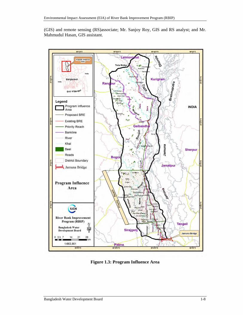
Environmental Impact Assessment (EIA) of River Bank Improvement Program (RBIP)
Bangladesh Water Development Board 1-8
(GIS) and remote sensing (RS)associate; Mr. Sanjoy Roy, GIS and RS analyst; and Mr. Mahmudul Hasan, GIS assistant.
Figure 1.3: Program Influence Area
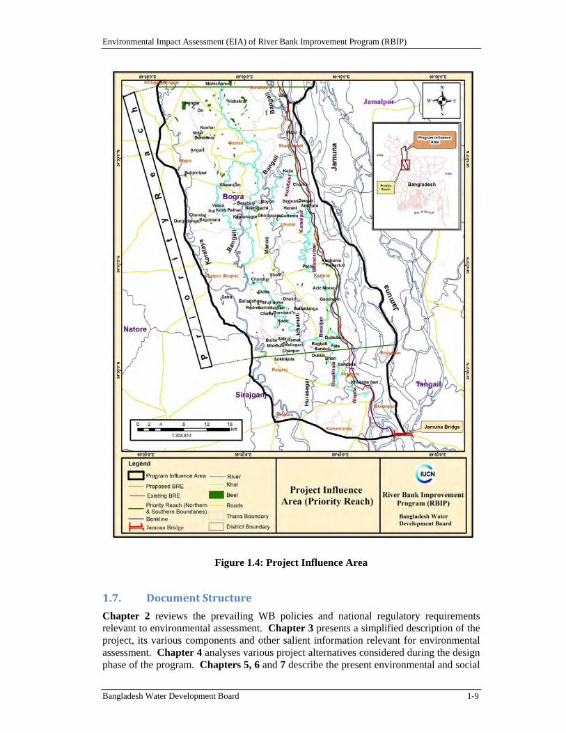
Environmental Impact Assessment (EIA) of River Bank Improvement Program (RBIP)
Bangladesh Water Development Board 1-9
Figure 1.4: Project Influence Area
1.7. DocumentStructure
Chapter 2 reviews the prevailing WB policies and national regulatory requirements relevant to environmental assessment. Chapter 3 presents a simplified description of the project, its various components and other salient information relevant for environmental assessment. Chapter 4 analyses various project alternatives considered during the design phase of the program. Chapters 5, 6 and 7 describe the present environmental and social
Environmental Impact Assessment (EIA) of River Bank Improvement Program (RBIP)
Bangladesh Water Development Board 1-10
conditions of the project influence area. Chapter 8 presents the climate change scenario and its implication for the project. Assessment of potentially negative environmental and social impacts as well as the appropriate mitigation measures to address these negative impacts has been discussed in Chapter 9. Cumulative and induced impacts of the RBIP and other possible projects in the area are assessed in Chapter 10. The environmental management plan (EMP) which defines the implementation and monitoring mechanism for the mitigation impacts is covered under Chapter 11. Chapter 12 outlines the stakeholder consultations carried out during the environmental assessment. Finally, Chapter 13 lists the references of the documents and reports that were reviewed and used to prepare the current EIA report.
Environmental Impact Assessment (EIA) of River Bank Improvement Program (RBIP)
Bangladesh Water Development Board 2-1
2. Policy and Regulatory Review
This Chapter presents a review of the national policy, legal, and regulatory framework relevant to the environmental and social aspects of the Project. Also reviewed in the Chapter are the WB environmental and social safeguard policies.
2.1. NationalEnvironmentalLaws
The key national policies, strategies, and plans relevant to environmental management are briefly discussed below.
2.1.1. BangladeshEnvironmentConservationAct(ECA),1995
The Environmental Conservation Act (ECA) of 1995 is the main legislative framework relating to environmental protection in Bangladesh. This umbrella Act includes laws for conservation of the environment, improvement of environmental standards, and control and mitigation of environmental pollution. This Act has established the Department of Environment (DoE), and empowers its Director General to take measures as he considers necessary which includes conducting inquiries, preventing probable accidents, advising the Government, coordinating with other authorities or agencies, and collecting and publishing information about environmental pollution. According to this act (Section 12), no industrial unit or project shall be established or undertaken without obtaining, in a manner prescribed by the accompanying Rules, an Environmental Clearance Certificate (ECC) from the Director General of DoE.
In accordance with this Act, the RBIP will need to be cleared by DoE before commencing the project following procedures given in the Environment Conservation Rules (ECR) 1997 (discussed below). Also the Ecologically Critical Areas, defined by DoE under this act, will be considered while planning and designing of the RBIP project interventions.
2.1.2. Bangladesh Environment Conservation Act (ECA), (Amendments)2010
The ECA 1995 was amended in 2010, which provided clarification of defining wetlands as well as Ecologically Critical Areas and included many important environmental concerns such as conservation of wetlands, hill cutting, ship breaking, and hazardous waste disposal. This amendment empowered the government to enforce more penalties than before. Moreover, affected persons were given provision for putting objections or taking legal actions against the polluters or any entity creating nuisance to affected person.
2.1.3. BangladeshEnvironmentConservationRules(ECR),1997
The Environment Conservation Rules, 1997 were issued by the Government of Bangladesh in exercise of the power conferred under the Environment Conservation Act (Section 20), 1995. Under these Rules, the following aspects, among others, are covered:
Declaration of ecologically critical areas
Classification of industries and projects into four categories
Procedures for issuing the Environmental Clearance Certificate (ECC)
Determination of environmental standards.
Environmental Impact Assessment (EIA) of River Bank Improvement Program (RBIP)
Bangladesh Water Development Board 2-2
The Rule 3 defines the factors to be considered in declaring an area 'ecologically critical area' (ECA) as per Section 5 of ECA 95. It empowers the Government to declare an area 'ECA', if it is satisfied that the ecosystem of the area has reached or is threatened to reach a critical state or condition due to environmental degradation. The Government is also empowered to specify which of the operations or processes shall not be carried out or shall not be initiated in the ecologically critical area.
The Rule 7 classifies industrial units and projects into four categories depending on environmental impact and location for the purpose of issuance of ECC. These categories are: Green, Orange A, Orange B, and Red.
All existing industrial units and projects and proposed industrial units and projects, that are considered to be low polluting are categorized under "Green" and shall be granted Environmental Clearance. For proposed industrial units and projects falling in the Orange-A, Orange-B and Red Categories, firstly a site clearance certificate and thereafter an environmental clearance certificate will be required. A detailed description of these four categories of industries has been given in Schedule-1 of ECR'97. Apart from general requirement, for every Red category proposed industrial unit or project, the application must be accompanied with feasibility report, Initial Environmental Examination (IEE), Environmental Impact Assessment (EIA) based on approved terms of reference (ToR) by DoE, Environmental Management Plan (EMP). As per ECR’97, water resources development projects fall under ‘Red’ category project. Therefore RBIP project is ‘Red’ category project which requires IEE, EIA and EMP for environmental clearance from DoE.
The ECR'97 describes the procedures for obtaining Environmental Clearance Certificates (ECC) from the Department of Environment for different types of proposed units or projects. Any person or organization wishing to establish an industrial unit or project must obtain ECC from the Director General. The application for such certificate must be in the prescribed form together with the prescribed fees laid down in Schedule 13, through the deposit of a Treasury Challan in favor of the Director General. The fees for clearance certificates have been revised in 2010. Rule 8 prescribes the duration of validity of such certificate (three years for green category and one year for other categories) and compulsory requirement for renewal of certificate at least 30 days before expiry of its validity.
2.1.4. BangladeshEnvironmentCourtAct,2010
Bangladesh Environment Court Act, 2010 has been enacted to resolve the disputes and establishing justice over environmental and social damage raised due to any development activities. This act allows government to take necessary legal action against any parties who creates environmental hazards/ damage to environmentally sensitive areas as well as human society. According to this act, government can take legal actions if any environmental problem occurs due to RBIP interventions.
2.2. RelevantNationalPolicies,StrategiesandPlans
2.2.1. NationalEnvironmentPolicy,1992
The National Environment Policy (NEP) is one of the key policy documents of the Government. The policy addresses 15 sectors in all, in addition to providing directives on the legal framework and institutional arrangements. Marine environment is one of the key
Environmental Impact Assessment (EIA) of River Bank Improvement Program (RBIP)
Bangladesh Water Development Board 2-3
sectors covered in this policy. Regarding water resource development, flood control and irrigation sector, the policy seeks to:
ensure environmentally-sound utilization of all water resources;
ensure that water development activities and irrigation networks do not create adverse environmental impact;
ensure that all steps are taken for flood control, including construction of embankments, dredging of rivers, digging of canals, etc, be environmentally sound at local, zonal and national levels;
ensure mitigation measures of adverse environmental impact of completed water resources development and flood control projects;
keep the rivers, canals, ponds, lakes, haors, baors and all other water bodies and water resources free from pollution;
ensure sustainable, long-term, environmentally sound and scientific exploitation and management of the underground and surface water resources; and
conduct environmental impact assessment before undertaking projects for water resources development and management.
The Policy is applicable to the RBIP and the proposed interventions are required to comply with all the policy directives emphasizing particularly on reducing adverse environmental impacts. The EIA studies of the proposed RBIP are required to clearly address the potential impacts and propose mitigation measures.
2.2.2. NationalEnvironmentManagementActionPlan,1995
The National Environment Management Action Plan (NEMAP, 1995) identifies the main national environmental issues, including those related to the water sector. The main water related national concerns include flood damage, riverbank erosion, environmental degradation of water bodies, increased water pollution, shortage of irrigation water and drainage congestion; various specific regional concerns are also identified.
2.2.3. NationalWaterPolicy,1999
Endorsed by the GoB in 1999, the National Water Policy (NWP) aims to provide guidance to the major players in water sector for ensuring optimal development and management of water. According to the policy, all agencies and departments entrusted with water resource management responsibilities (regulation, planning, construction, operation, and maintenance) are required to enhance environmental amenities and ensure that environmental resources are protected and restored in executing their tasks.
The policy has several clauses related to water resource development projects for ensuring environmental protection. Some of the relevant clauses are:
Clause 4.5b: Planning and feasibility studies of all projects will follow the Guidelines for Project Assessment, the Guidelines for People's Participation (GPP), the Guidelines for Environmental Impact Assessment, and all other instructions that may be issued from time to time by the Government.
Clause 4.9b: Measures will be taken to minimize disruption to the natural aquatic environment in streams and water channels.
Environmental Impact Assessment (EIA) of River Bank Improvement Program (RBIP)
Bangladesh Water Development Board 2-4
Clause 4.9e: Water development plans will not interrupt fish movement and will make adequate provisions in control structures for allowing fish migration and breeding.
Clause 4.10a: Water development projects should cause minimal disruption to navigation and, where necessary, adequate mitigation measures should be taken.
Clause 4.12a: Give full consideration to environmental protection, restoration and enhancement measures consistent with National Environmental Management Action Plan (NEMAP) and the National Water Management Plan (NWMP).
Clause 4.12b: Adhere to a formal environment impact assessment (EIA) process, as set out in EIA guidelines and manuals for water sector projects, in each water resources development project or rehabilitation program of size and scope specified by the Government from time to time.
Clause 4.13b: Only those water related projects will be taken up for execution that will not interfere with aquatic characteristics of those water bodies.
Most of the above clauses will be applicable to the RBIP.
2.2.4. NationalWaterManagementPlan,2001(Approvedin2004)
The National Water Management Plan (NWMP) 2001, approved by the National Water Resources Council in 2004, envisions to establish an integrated development, management and use of water resources in Bangladesh over a period of 25 years. Water Resources Planning Organization (WARPO) has been assigned to monitor the national water management plan. The major programs in the Plan have been organized under eight sub-sectoral clusters: i) Institutional Development, ii) Enabling Environment, iii) Main River, iv) Towns and Rural Areas, v) Major Cities; vi) Disaster Management; vii) Agriculture and Water Management, and viii) Environment and Aquatic Resources. Each cluster comprises of a number of individual programs, and a total of 84 sub-sectoral programs have been identified and presented in the investment portfolio.
2.2.5. NationalLandUsePolicy(MoL,2001)
The National Land Use Policy (NLUP), enacted in 2001, aims at managing land use effectively to support trends in accelerated urbanization, industrialization and diversification of development activities. The NLUP urges that increasing the land area of the country may be not possible through artificial land reclamation process, which is cost-effective only in the long run. Therefore, land use planning should be based on the existing and available land resources. The policy suggests establishing land data banks where, among others, information on accreted riverine and coastal chars will be maintained. Among the 28 policy statements of NLUP, the following are relevant to RBIP:
forests declared by the Ministry of Environment and Forests will remain as forest lands;
reclassification of forest lands will be prevented.
The RBIP will be designed in accordance with this Strategy and will comply with the above listed requirements.
2.2.6. NationalAgriculturePolicy,1999
The overall objective of the National Agriculture Policy is to make the nation self-sufficient in food through increasing production of all crops including cereals and ensure
Environmental Impact Assessment (EIA) of River Bank Improvement Program (RBIP)
Bangladesh Water Development Board 2-5
a dependable food security system for all. The policy particularly stresses on research on the development of improved varieties and technologies for cultivation in water-logged and salinity affected areas. The policy also recognizes that adequate measures should be taken to reduce water-logging, salinity and provide irrigation facilities for crop production.
The proposed RBIP is expected to contribute to achieve the objectives of the agriculture policy.
2.2.7. NationalIntegratedPestManagementPolicy
The objective of the integrated pest management (IPM) policy is to enable farmers to grow healthy crops in an increased manner and thereby increase their income on a sustainable basis while improving the environment and community health. To achieve these objectives, the IPM Policy aims to pursue the following strategies:
to expand IPM on a sustainable basis by establishing a national IPM program; and
to facilitate co-ordination of all IPM activities in Bangladesh.
2.2.8. NationalFisheriesPolicy,1996
The National Fisheries Policy (NFP), 1996 recognizes that fish production has declined due to environmental imbalances, adverse environmental impact and improper implementation of fish culture and management programs. The policy particularly focuses on aquaculture and marine fisheries development.
The policy suggests following actions:
Biodiversity will be maintained in all natural water bodies and in marine environment
Chemicals harmful to the environment will not be used in fish shrimp farms
Environment friendly fish shrimp culture technology will be used
Expand fisheries areas and integrate rice, fish and shrimp cultivation
Control measures will be taken against activities that have a negative impact on fisheries resources and vice-versa
Laws will be formulated to ban the disposal of any untreated industrial effluents into the water bodies.
2.2.9. NationalLivestockDevelopmentPolicy,2007
The National Livestock Development Policy (NLDP) has been prepared to address the key challenges and opportunity for a comprehensive sustainable development of the livestock sub-sector by creating an enabling policy framework. As livestock is one of the key assets in livelihoods of the project influence area, and protection of livestock from floods should be emphasized along with security of human life. The proposed RBIP interventions will contribute to the safety of livestock and thus increase livestock productivity in the project influence area.
2.2.10. PrivatForestPolicy1994
The policy suggested for extended effort to bring about 20 percent of the country's land under the afforestation programs of the government and private sector by year 2015 by accelerating the pace of the program through the coordinated efforts of the government and NGOs and active participation of the people in order to achieve self-reliance in forest
Environmental Impact Assessment (EIA) of River Bank Improvement Program (RBIP)
Bangladesh Water Development Board 2-6
products and maintenance of ecological balance. The policy viewed equitable distribution of benefits among the people, especially those whose livelihood depend on trees and forests; and people's participation in afforestation programs and incorporation of people's opinions and suggestions in the planning and decision-making process. The people-centered objectives of the policy are: creation of rural employment opportunities and expansion of forest-based rural development sectors; and prevention of illegal occupation of forest lands and other forest offences through people's participation. The policy statements envisage: massive afforestation on marginal public lands through partnerships with local people and NGOs; afforestation of denuded/encroached reserved forests with an agro-forestry model through participation of people and NGOs; giving ownership of a certain amount of land to the tribal people through forest settlement processes; strengthening of the Forest Department; strengthening of educational, training and research facilities; and amendment of laws, rules and regulations relating to the forestry sector and if necessary, promulgation of new laws and rules. Thus, over time the policy has shifted somewhat from total state control to a management regime involving local communities in specific categories of forests.
Because of limited amount of forestland, the policy underscores for effective measures for afforestation in rural areas, in the newly accreted chars, and in the denuded Unclassed State Forest areas of Chittagong Hill Tract and northern zone of the country including the Barind tract. The policy also encourages the private sector participation in afforestation.
2.2.11. NationalPolicyforSafeWaterSupplyandSanitation(1998)
The National Drinking Water Supply and Sanitation Policy (1998) goal is accessibility to all of water and sanitation services within the shortest possible time at a price that is affordable to all. The Policy will be achieved through strategies formulated at various levels in consultation with the Ministry of Planning. Policy objectives are (i) to improve the standard of public health and (ii) to ensure an improved environment. Policies for rural and urban areas are presented separately as they differ in institutional aspects, content, and magnitude.
2.2.12. NationalPolicyforArsenicMitigation(2004)
The National Policy for Arsenic Mitigation (2004) provides a guideline for mitigating the effect of arsenic on people and environment in a realistic and sustainable way. It supplements the National Water Policy (1998) and the National Policy for Safe Water Supply and Sanitation (1998) in fulfilling national goals related to poverty alleviation, public health, and food security.
The Policy states that access to safe water for drinking and cooking shall be ensured through implementation of alternative water supply options in all arsenic-affected areas. Arsenic mitigation activities under the Policy will focus on public awareness, alternative arsenic safe water supply, diagnoses and management of patients and capacity building. The national arsenic program is to encourage and promote research and development on the impact of arsenic on water supplies, health, food, and agriculture.
2.2.13. NationalAdaptationProgrammeofAction(NAPA)
In 2005, the Ministry of Environment and Forest (MoEF), Government of the People’s Republic of Bangladesh has prepared the National Adaptation Program of Action (NAPA) for Bangladesh, as a response to the decision of the Seventh Session of the Conference of the Parties (COP7) of the United Nations Framework Convention on Climate Change (UNFCCC). The basic approach to NAPA preparation was along with
Environmental Impact Assessment (EIA) of River Bank Improvement Program (RBIP)
Bangladesh Water Development Board 2-7
the sustainable development goals and objectives of the country where it has recognized the necessity of addressing climate change and environmental issue and natural resource management. The NAPA is the beginning of a long journey to address adverse impacts of climate change including variability and extreme events and to promote sustainable development of the country. There are 15 adaptation strategies suggested to address adverse effects of climate change. Among the 15 adaptation strategies the following strategies are relevant for reducing climate change induced vulnerability:
Construction of flood shelters, and information and assistance center to cope with enhanced recurrent floods in major floodplains
Promotion of research on drought, flood and saline tolerant varieties of crops to facilitate adaptation in future.
The RBIP broadly contributes toward achieving g the aims and objectives of the climate change adaptation strategies.
2.2.14. BangladeshClimateChangeStrategyandActionPlan(BCCSAP)2009
The Government of Bangladesh has prepared the Bangladesh Climate Change Strategy and Action Plan (BCCSAP), 2009. The BCCSAP is built on six pillars:
i. Food security, social protection and health to ensure that the poorest and most vulnerable in society, including women and children, are protected from climate change and that all programs focus on the needs of this group for food security, safe housing, employment and access to basic services, including health.
ii. Comprehensive disaster management to further strengthen the country’s already proven disaster management systems to deal with increasingly frequent and severe natural calamities.
iii. Infrastructure to ensure that existing assets (e.g., coastal and river embankments) are well maintained and fit for purpose and that urgently needed infrastructures (cyclone shelters and urban drainage) is put in place to deal with the likely impacts of climate change.
iv. Research and Knowledge management to predict that the likely scale and timing of climate change impacts on different sectors of economy and socioeconomic groups; to underpin future investment strategies; and to ensure that Bangladesh is networked into the latest global thinking on climate change.
v. Mitigation and low carbon development to evolve low carbon development options and implement these as the country’s economy grows over the coming decades.
vi. Capacity building and Institutional strengthening to enhance the capacity government ministries, civil society and private sector to meet the challenge of climate change.
RBIP will contribute towards achieving the objective of pillars such as (i), (ii), (iii), (iv), and (vi).
2.3. OtherRelevantActs,LawsandRules
2.3.1. BangladeshWildlife(ProtectionandSafety)Act2012
The Act protects 1,307 species of plants and animals, including 32 species of amphibian, 154 species of reptile, 113 species of mammal, 52 species of fish, 32 species of coral, 137
Environmental Impact Assessment (EIA) of River Bank Improvement Program (RBIP)
Bangladesh Water Development Board 2-8
species of mollusk, 22 species of crustacean, 24 species of insect, six species of rodent, 41 species of plant and 13 species of orchid. Of these, eight amphibian, 58 reptile, 41 bird, and 40 mammal species are listed as endangered in the IUCN Red Data Book (2000). The Act mandates:
one to three years imprisonment, a fine of BDT 50,000 to 200,000, or both, for wildlife poaching, capturing, trapping, and trading, and for the purchase of wild animals, parts of wild animals, trophies, meat or other products without license. The Act mandates two to seven years imprisonment and BDT 100,000 to 1 million fine or both, for killing an elephant or tiger; and 12 years plus BDT 1.5 million for repeat offenders.
five years imprisonment and BDT 200,000 fine for killing a cheetah, clouded cheetah, gibbon, sambar deer, crocodile, gavial, whale, and dolphin.
two years imprisonment and BDT 200,000 fine for killing a wild bird or migratory bird.
empowers the Government to create an eco-park, safari park, botanical garden, or breeding ground on any state-owned forest land, land or water-body.
two years imprisonment for farming, woodcutting, burning, and construction on such reserves.
2.3.2. BangladeshWildlife(Preservation)Order(1973)andAct(1974)
The Bangladesh Wildlife Preservation (Amendment) Act 1974 regulates the hunting, killing, capture, trade and export of wild life and wild life products. It designates a list of protected species and game animals. It empowers the Government to declare areas as game reserves, wildlife sanctuaries, and national parks to protect the country’s wildlife and provides the following legal definitions:
Game reserve is defined as an area declared by Government wherein the capture of wild animals is unlawful, to protect wildlife and increase the population of important species;
National park is defined as an area declared by Government comprising a comparatively large area of outstanding scenic and natural beauty with the primary objective of protection and preservation of scenery, flora, and fauna in their natural state, to which access for public recreation and education, and for scientific research, may be allowed;
Wildlife sanctuary is defined as an area declared by Government that is closed to hunting, shooting, or trapping of wild animals as an undisturbed breeding ground, primarily for the purpose of protecting all natural resources, including wildlife vegetation, soil, and water.
The Act allows Government to relax any or all specified prohibitions for scientific purposes, for aesthetic enjoyment, or betterment of scenery.
2.3.3. ProtectionandConservationofFishAct(1950)
This Act provides power to the government to: make and apply rules to protect fisheries; prohibit or regulate erection and use of fixed engines; and construction of temporary or permanent weirs, dams, bunds, embankments and other structures. The Act prohibits: destruction of fish by explosives, guns, and bows in inland or coastal areas; destruction of
Environmental Impact Assessment (EIA) of River Bank Improvement Program (RBIP)
Bangladesh Water Development Board 2-9
fish by poisoning, pollution, or effluents. The Act prescribes the seasons during which fishing is allowed, prohibits fishing during spawning periods, and specifies officials having authority to detect breaches of this Act.
2.3.4. East‐Bengal Protection and Fish Conservation Act (1950) andAmendments
The East-Bengal Protection and Fish Conservation Act (1950), as amended by the Protection and Conservation of Fish (Amendment) Ordinance (1982) and the Protection and Conservation of Fish (Amendment) Act (1995), provides for the protection and conservation of fish in inland waters of Bangladesh. These instruments define a relatively non-specific framework that simply provides a means for Government to introduce rules to protect inland waters not in private ownership. Among other things, they sanction rule-making regarding destruction of, or any attempt to destroy, fish by poisoning of water or depletion of fisheries by pollution, industrial effluent, or otherwise.
2.3.5. ProtectionandConservationofFishRules(1985)
These Rules are in line with the overall objectives of the Fisheries Act and its amendments. Section 5 of the Rules states that, “No person shall destroy or make any attempt to destroy any fish by explosives, gun, bow and arrow in inland waters or within coastal waters”. Section 6 states, “No person shall destroy or make any attempt to destroy any fish by poisoning of water or the depletion of fisheries by pollution, by trade effluents or otherwise in inland waters.”
2.3.6. ForestryActs
Systematic management of forests started in the 1860s after the establishment of a Forest Department in the Province of Bengal. To regulate activities within forests, rules and regulations have been formulated, amended, modified and improved upon over the years. These rules and regulations are formulated on the basis of long-existing acts and policies.
Forest legislation in Bangladesh dates back to 1865, when the first Indian Forest Act was enacted. It provided for protection of tree, prevention of fires, prohibition of cultivation, and grazing in forest areas. Until a comprehensive Indian Forest Act was formulated in 1927, several acts and amendments covering forest administration in British India were enacted and were as follows: (a) Government Forest Act, 1865; (b) Forest Act, 1890; (c) Amending Act, 1891; (d) Indian Forest (Amendment) Act, 1901; (e) Indian Forest (Amendment) Act, 1911; (f) Repealing and Amending Act, 1914; (g) Indian Forest Amendment Act, 1918; and (h) Devolution Act, 1920.
The Forest Act of 1927, as amended with its related rules and regulations, is still the basic law governing forests in Bangladesh. The emphasis of the Act is on the protection of reserved forest. Some important features of the Act are: (i) Under the purview of the Forest Act, all rights or claims over forestlands have been settled at the time of the reservation. The Act prohibits the grant of any new rights of any kind to individuals or communities; (ii) Any activity within the forest reserves is prohibited, unless permitted by the Forest Department; (iii) Most of the violations may result in court cases where the minimum fine is Taka 2,000 and/or two month's rigorous imprisonment; and (iv) The Act empowers the Forest Department to regulate the use of water-courses within Reserve Forests.
Environmental Impact Assessment (EIA) of River Bank Improvement Program (RBIP)
Bangladesh Water Development Board 2-10
2.3.7. ForestAct1927(Amendment2000)
The Forest Act of 1927 as amended in 1989 has its roots in Indian Forest Act, 1878. The Forest Act grants the government several basic powers, largely for conservation and protection of government forests, and limited powers for private forests. The 1927 version of the act was amended in 1989 for extending authority over "any [Government-owned] land suitable for afforestation".
Forest department is the main agency to implement the provisions of the Forest Act. The Act, however, does not specify any sort of institutional structure for the forest or other land holding agencies. It also does not set out any specific policy direction for managing the forests.
Most of the forest lands under the management of forest department are areas declared to be reserved and protected forests under this act. The act empowers the government to regulate the felling, extraction, and transport of forest produce in the country.
2.3.8. PrivateForestAct(PFA),1959
The Private Forest Act of 1959 allows the Government to take over management of improperly managed private forest lands, any private lands that can be afforested, and any land lying fallow for more than three years. The Private Forest Ordinance was originally enacted in 1945, as the Bengal Private Forest Act, and was re-enacted by the Bangladesh (then East Pakistan) in 1949 before being issued as an Act in 1959. These government managed lands under this act are called "vested forests". The Forest Department manages approximately 8,500 hectares in the country as "vested forests". This area is relatively small, but the area historically affected by this law is much larger.
PFA, 1959 empowers the government to require management plans for private forests and to assume control of private forests as vested forests. Government has broad powers to write rules regarding use and protection of vested forests, and apply rules to "controlled forests," which include all private forests subject to any requirement of the Act.
2.3.9. EmbankmentandDrainageAct,1952
The East Bengal Act No. 1, 1953 has been adapted by the People Republic of Bangladesh, by the Bangladesh Order (adaptation of Existing Laws), 1972 (President’s Order No. 48 of 1972). The Act consolidates the laws relating to embankments and drainage providing provision for the construction, maintenance, management, removal and control of embankments and water courses for the better drainage of lands and for their protection from floods, erosion or other damage by water. The specific Sections and Articles relevant to the Project are mentioned below.
Section 4 (1) of the Act states that the embankment, water-course, and tow-path, earth, pathways, gates, berms and hedges of the embankments shall vest in the Government of the Authority (BWDB).
Section 56 (1) states that, person will be subject to penalty (500 taka or imprisonment… if he erects, or causes of willfully permits to be erected, any new embankment, or any existing embankment, or obstructs of diverts, or causes or willfully permits to be obstructed or diverted, any water course.
Section 15 allows for the engineer (engineer in-charge of divisional level BWDB) for constructing new embankment or enlarging, lengthening or repairing existing embankments.

Environmental Impact Assessment (EIA) of River Bank Improvement Program (RBIP)
Bangladesh Water Development Board 2-11
The other sections of the Act give powers and access to the Government or Authority or Engineers to commence necessary Project activities, for land acquisition (through the Deputy Commissioner), and site clearing activities including removal of trees or houses (if necessary).
2.3.10. BangladeshWaterAct,2013
The recently published Water Act 2013 is based on the National Water Policy, and designed for integrated development, management, extraction, distribution, usage, protection and conservation of water resources in Bangladesh. In general, if one takes a critical look at the Act, the new law has provided the right framework for better management of water resources in the country.
As per this Act, all forms of water (e.g., surface water, ground water, sea water, rain water and atmospheric water) within the territory of Bangladesh belong to the government on behalf of the people. The private landowners will be able to use the surface water inside their property for all purposes in accordance with the Act. A worthwhile initiative is the requirement for permits/licenses for large scale water withdrawal by individuals and organizations beyond domestic use. Without prior permission issued by the Executive Committee, no individuals or organizations will be allowed to extract, distribute, use, develop, protect, and conserve water resources, nor they will be allowed to build any structure that impede the natural flow of rivers and creeks. However, the maximum amount of surface water or groundwater that can be withdrawn by individuals or organizations is not mentioned in the Act. Setting up a priority order for water usage in an area where the water resources is in critical condition is also a significant step.
2.3.11. BangladeshLaborAct,2006
The Bangladesh Labor Act, 2006 provides the guidance of employer’s extent of responsibility and workmen’s extent of right to get compensation in case of injury by accident while working. Some of the relevant Sections are:
Section 150. Employer’s Liability for Compensation: (1) If personal injury is caused to a workman by accident arising out of and in the course of his employment, his employer shall be liable to pay compensation in accordance with the provisions of this Act; and (2) Provided that the employer shall not be so liable - (a) in respect of any injury which does not result in the total or partial disablement of the workman for a period exceeding three days; (b) in respect of any injury, not resulting in death or permanent total disablement, caused by an accident which is directly attributable to - (i) the workman having been at the time thereof under the influence of drink or drugs, or (ii) the willful disobedience of the workman to an order expressly given, or to a rule expressly framed, for the purpose of securing the safety of workmen, or (iii) the willful removal or disregard by the workman of any safety guard or other device which he knew to have been provided for the purpose of securing the safety of workmen.
Section 151. (1) Amount of Compensation: Subject to the provisions of this Act, the amount of compensation shall be as follows, namely :- (a) where death results from the injury, an amount equal to fifty cent of the monthly wages of the deceased workman multiplied by the relevant factor; or an amount of fifty thousand taka, whichever is more; (b) where permanent disablement results from the injury an
Environmental Impact Assessment (EIA) of River Bank Improvement Program (RBIP)
Bangladesh Water Development Board 2-12
amount equal to sixty per cent of the monthly wages of the injured workman multiplied by the relevant factor.
2.3.12. BangladeshNationalBuildingCode,2006
The Bangladesh National Building Code (BNBC) clearly sets out the constructional responsibilities according to which the relevant authority of a particular construction site shall adopt some precautionary measures to ensure the safety of the workmen. According to section 1.2.1 of chapter 1 of part 7, “In a construction or demolition work, the terms of contract between the owner and the contractor and between a consultant and the owner shall be clearly defined and put in writing. These however will not absolve the owner from any of his responsibilities under the various provisions of this Code and other applicable regulations and bye-laws. The terms of contract between the owner and the contractor will determine the responsibilities and liabilities of either party in the concerned matters, within the provisions of the relevant Acts and Codes (e.g.) the Employers' Liability Act, 1938, the Factories Act 1965, the Fatal Accident Act, 1955 and Workmen's Compensation Act 1923”. (After the introduction of the Bangladesh Labor Act, 2006, these Acts have been repealed).
The BNBC also stipulates the general duties of the employer to the public as well as workers. According to this section, “All equipment and safeguards required for the construction work such as temporary stair, ladder, ramp, scaffold, hoist, run way, barricade, chute, lift shall be substantially constructed and erected so as not to create any unsafe situation for the workmen using them or the workmen and general public passing under, on or near them”.
The Code also clarifies the issue of safety of workmen during construction and with relation to this, set out the details about the different safety tools of specified standard. In relation with the health hazards of the workers during construction, this chapter describes the nature of the different health hazards that normally occur in the site during construction and at the same time specifies the specific measures to be taken to prevent such health hazards. According to this chapter, exhaust ventilation, use of protective devices, medical checkups etc. are the measures to be taken by the particular employer to ensure a healthy workplace for the workers.
To prevent workers falling from heights, the Code sets out the detailed requirements on the formation and use of scaffolding. According to section 3.9.2 of the same chapter, “every temporary floor openings shall either have railing of at least 900 mm height or shall be constantly attended. Every floor hole shall be guarded by either a railing with toe board or a hinged cover. Alternatively, the hole may be constantly attended or protected by a removable railing. Every stairway floor opening shall be guarded by railing at least 900 mm high on the exposed sides except at entrance to stairway. Every ladder way floor opening or platform shall be guarded by a guard railing with toe board except at entrance to opening. Every open sided floor or platform 1.2 meters or more above adjacent ground level shall be guarded by a railing on all open sides except where there is entrance to ramp, stairway or fixed ladder. The above precautions shall also be taken near the open edges of the floors and the roofs”.
2.3.13. OtherLaws
There are a number of other laws and regulations applicable which are relevant for the project. These are presented in the Table 2.1 below.
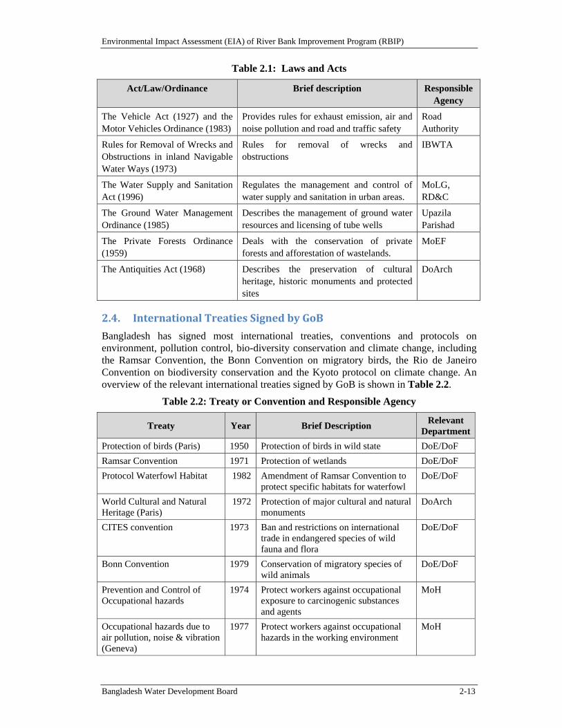
Environmental Impact Assessment (EIA) of River Bank Improvement Program (RBIP)
Bangladesh Water Development Board 2-13
Table 2.1: Laws and Acts
Act/Law/Ordinance Brief description Responsible Agency
The Vehicle Act (1927) and the Motor Vehicles Ordinance (1983)
Provides rules for exhaust emission, air and noise pollution and road and traffic safety
Road Authority
Rules for Removal of Wrecks and Obstructions in inland Navigable Water Ways (1973)
Rules for removal of wrecks and obstructions
IBWTA
The Water Supply and Sanitation Act (1996)
Regulates the management and control of water supply and sanitation in urban areas.
MoLG, RD&C
The Ground Water Management Ordinance (1985)
Describes the management of ground water resources and licensing of tube wells
Upazila Parishad
The Private Forests Ordinance (1959)
Deals with the conservation of private forests and afforestation of wastelands.
MoEF
The Antiquities Act (1968) Describes the preservation of cultural heritage, historic monuments and protected sites
DoArch
2.4. InternationalTreatiesSignedbyGoB
Bangladesh has signed most international treaties, conventions and protocols on environment, pollution control, bio-diversity conservation and climate change, including the Ramsar Convention, the Bonn Convention on migratory birds, the Rio de Janeiro Convention on biodiversity conservation and the Kyoto protocol on climate change. An overview of the relevant international treaties signed by GoB is shown in Table 2.2.
Table 2.2: Treaty or Convention and Responsible Agency
Treaty Year Brief Description Relevant
Department
Protection of birds (Paris) 1950 Protection of birds in wild state DoE/DoF
Ramsar Convention 1971 Protection of wetlands DoE/DoF
Protocol Waterfowl Habitat 1982 Amendment of Ramsar Convention to protect specific habitats for waterfowl
DoE/DoF
World Cultural and Natural Heritage (Paris)
1972 Protection of major cultural and natural monuments
DoArch
CITES convention 1973 Ban and restrictions on international trade in endangered species of wild fauna and flora
DoE/DoF
Bonn Convention 1979 Conservation of migratory species of wild animals
DoE/DoF
Prevention and Control of Occupational hazards
1974 Protect workers against occupational exposure to carcinogenic substances and agents
MoH
Occupational hazards due to air pollution, noise & vibration (Geneva)
1977 Protect workers against occupational hazards in the working environment
MoH
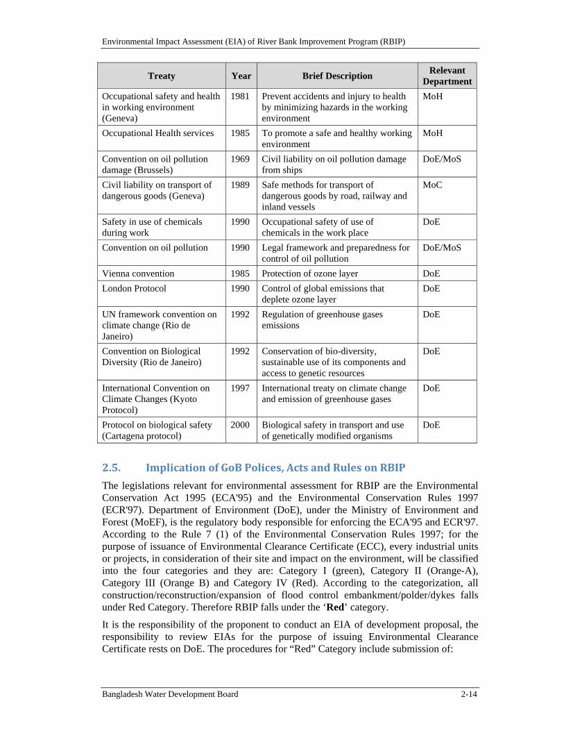
Environmental Impact Assessment (EIA) of River Bank Improvement Program (RBIP)
Bangladesh Water Development Board 2-14
Treaty Year Brief Description Relevant
Department
Occupational safety and health in working environment (Geneva)
1981 Prevent accidents and injury to health by minimizing hazards in the working environment
MoH
Occupational Health services 1985 To promote a safe and healthy working environment
MoH
Convention on oil pollution damage (Brussels)
1969 Civil liability on oil pollution damage from ships
DoE/MoS
Civil liability on transport of dangerous goods (Geneva)
1989 Safe methods for transport of dangerous goods by road, railway and inland vessels
MoC
Safety in use of chemicals during work
1990 Occupational safety of use of chemicals in the work place
DoE
Convention on oil pollution 1990 Legal framework and preparedness for control of oil pollution
DoE/MoS
Vienna convention 1985 Protection of ozone layer DoE
London Protocol 1990 Control of global emissions that deplete ozone layer
DoE
UN framework convention on climate change (Rio de Janeiro)
1992 Regulation of greenhouse gases emissions
DoE
Convention on Biological Diversity (Rio de Janeiro)
1992 Conservation of bio-diversity, sustainable use of its components and access to genetic resources
DoE
International Convention on Climate Changes (Kyoto Protocol)
1997 International treaty on climate change and emission of greenhouse gases
DoE
Protocol on biological safety (Cartagena protocol)
2000 Biological safety in transport and use of genetically modified organisms
DoE
2.5. ImplicationofGoBPolices,ActsandRulesonRBIP
The legislations relevant for environmental assessment for RBIP are the Environmental Conservation Act 1995 (ECA'95) and the Environmental Conservation Rules 1997 (ECR'97). Department of Environment (DoE), under the Ministry of Environment and Forest (MoEF), is the regulatory body responsible for enforcing the ECA'95 and ECR'97. According to the Rule 7 (1) of the Environmental Conservation Rules 1997; for the purpose of issuance of Environmental Clearance Certificate (ECC), every industrial units or projects, in consideration of their site and impact on the environment, will be classified into the four categories and they are: Category I (green), Category II (Orange-A), Category III (Orange B) and Category IV (Red). According to the categorization, all construction/reconstruction/expansion of flood control embankment/polder/dykes falls under Red Category. Therefore RBIP falls under the ‘Red’ category.
It is the responsibility of the proponent to conduct an EIA of development proposal, the responsibility to review EIAs for the purpose of issuing Environmental Clearance Certificate rests on DoE. The procedures for “Red” Category include submission of:
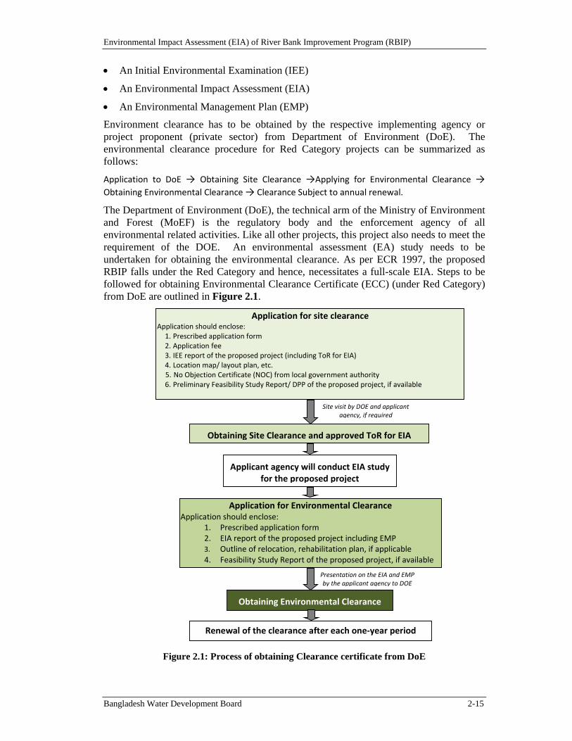
Environmental Impact Assessment (EIA) of River Bank Improvement Program (RBIP)
Bangladesh Water Development Board 2-15
An Initial Environmental Examination (IEE)
An Environmental Impact Assessment (EIA)
An Environmental Management Plan (EMP)
Environment clearance has to be obtained by the respective implementing agency or project proponent (private sector) from Department of Environment (DoE). The environmental clearance procedure for Red Category projects can be summarized as follows:
Application to DoE → Obtaining Site Clearance →Applying for Environmental Clearance → Obtaining Environmental Clearance → Clearance Subject to annual renewal.
The Department of Environment (DoE), the technical arm of the Ministry of Environment and Forest (MoEF) is the regulatory body and the enforcement agency of all environmental related activities. Like all other projects, this project also needs to meet the requirement of the DOE. An environmental assessment (EA) study needs to be undertaken for obtaining the environmental clearance. As per ECR 1997, the proposed RBIP falls under the Red Category and hence, necessitates a full-scale EIA. Steps to be followed for obtaining Environmental Clearance Certificate (ECC) (under Red Category) from DoE are outlined in Figure 2.1.
Figure 2.1: Process of obtaining Clearance certificate from DoE
Applicant agency will conduct EIA study for the proposed project
Obtaining Environmental Clearance
Renewal of the clearance after each one‐year period
Obtaining Site Clearance and approved ToR for EIA
Application for Environmental ClearanceApplication should enclose:
1. Prescribed application form 2. EIA report of the proposed project including EMP 3. Outline of relocation, rehabilitation plan, if applicable 4. Feasibility Study Report of the proposed project, if available
Application for site clearance Application should enclose: 1. Prescribed application form 2. Application fee 3. IEE report of the proposed project (including ToR for EIA) 4. Location map/ layout plan, etc. 5. No Objection Certificate (NOC) from local government authority 6. Preliminary Feasibility Study Report/ DPP of the proposed project, if available
Presentation on the EIA and EMP by the applicant agency to DOE
Site visit by DOE and applicant agency, if required
Environmental Impact Assessment (EIA) of River Bank Improvement Program (RBIP)
Bangladesh Water Development Board 2-16
Public participation or consultation is not a condition in the ECR 1997 and or EIA Guidelines, however, DOE prefers the proponent to engage in public participation and put conditions while providing site clearance or during the approval of the EIA TOR.
2.6. WorldBank'sEnvironmentalSafeguardPolicies
The World Bank has developed a number of Safeguard Policies to ensure that all possible impacts are considered and mitigation measures are spelled out prior to the implementation of any proposed project. These policies ensure that the quality of operations is uniform across different settings worldwide. If the decision is taken that a Safeguard Policy should be applied, mitigation measures and plans must be developed and in place before the implementation of a proposed project.
The Bank requires environmental screening and classification for all investment projects2 (including ones financed by Trust Funds, Project Preparation Facilities and Guarantees) proposed for Bank financing, to help ensure that they are environmentally and socially sound and sustainable. Screening and classification take into account the natural environment (air, water, and land); human health and safety; social aspects (involuntary resettlement, Indigenous Peoples); cultural property; and trans-boundary and global environmental aspects.
The objectives of environmental screening and classification are: to evaluate the environmental risks associated with a proposed operation; to determine the depth and breadth of Environmental Assessment (EA); and to recommend an appropriate choice of EA instrument(s) suitable for a given project. The Bank recognizes that environmental screening and classification is not absolute and involves professional judgment on a case by case basis. When screening, careful consideration needs to be given to potential environmental impacts and risks associated with the proposed project. Judgment is exercised with reference to the policy expectations and guidance; real impacts on the ground; and established regional and Bank-wide precedence and good practice.
2.6.1. EnvironmentalAssessment(OP4.01)
EA requirement. The World Bank requires environmental assessment (EA) of projects proposed for Bank support to ensure that they are environmentally sound and sustainable, and thus to improve decision making. The Bank Policy OP 4.01 considers that EA is a process whose breadth, depth, and type of analysis depend on the nature, scale, and potential environmental impact of the proposed project. EA evaluates a project's potential environmental risks and impacts in its area of influence; examines project alternatives; identifies ways of improving project selection, siting, planning, design, and implementation by preventing, minimizing, mitigating, or compensating for adverse environmental impacts and enhancing positive impacts; and includes the process of mitigating and managing adverse environmental impacts throughout project implementation. EA takes into account the natural environment (air, water and land); human health and safety; social aspects (involuntary resettlement, indigenous peoples and physical cultural resources); and trans-boundary and global environmental aspects. The Bank Policy also envisages that the borrower Government is responsible for carrying out the EA and the Bank advises the borrower on the Bank's EA requirements.
The present EIA (and social safeguard documents mentioned later in the Chapter) has been prepared in compliance with this OP.
Environmental Impact Assessment (EIA) of River Bank Improvement Program (RBIP)
Bangladesh Water Development Board 2-17
EA classification. The World Bank classifies the proposed project into one of the four categories, depending on the type, location, sensitivity, and scale of the project and the nature and magnitude of its potential environmental impacts. These categories are defined below.
Category A: A proposed project is classified as Category A if it is likely to have significant adverse environmental impacts that are sensitive, diverse, or unprecedented. These impacts may affect an area broader than the sites or facilities subject to physical works.
Category B: A proposed project is classified as Category B if its potential adverse environmental impacts on human populations or environmentally important areas--including wetlands, forests, grasslands, and other natural habitats--are less adverse than those of Category A projects.
Category C: A proposed project is classified as Category C if it is likely to have minimal or no adverse environmental impacts. Beyond screening, no further EA action is required for a Category C project.
Category FI: A proposed project is classified as Category FI if it involves investment of Bank funds through a financial intermediary (FI), in subprojects that may result in adverse environmental impacts.
The proposed RBIP has been classified as Category A, since some of the potential impacts are likely to be significant and diverse.
2.6.2. NaturalHabitats(OP4.04)
The Policy describes the conservation of natural habitats, like other measures that protect and enhance the environment, to be essential for long-term sustainable development. The Bank therefore supports the protection, maintenance, and rehabilitation of natural habitats and their functions in its economic and sector work, project financing, and policy dialogue. The Bank also supports, and expects borrowers to apply a precautionary approach to natural resource management to ensure opportunities for environmentally sustainable development. The Bank- promotes and supports natural habitat conservation and improved land use by financing projects designed to integrate into national and regional development the conservation of natural habitats and the maintenance of ecological functions. Furthermore, the Bank promotes the rehabilitation of degraded natural habitats. The Bank does not support projects that involve the significant conversion or degradation of critical natural habitats.
The activities under the proposed project could potentially alter the natural habitat hence this policy is triggered. Habitat restoration and enhancement measures will be included in the project design to mitigate and or compensate any adverse impacts on the natural habitat.
2.6.3. PestManagement(OP4.09)
Through this OP, the WB supports a strategy that promotes use of biological or environmental control methods and reduces reliance on synthetic chemical pesticides. Rural development and health sector projects have to avoid using harmful pesticides. Other pesticides can be used, but only as an element of an Integrated Pest Management Plan (IPMP) that emphasizes environmental and biological controls.
Though increase in agriculture production hence an increased usage of chemical pesticides and fertilizers is not included in the project objectives, such a consequence of
Environmental Impact Assessment (EIA) of River Bank Improvement Program (RBIP)
Bangladesh Water Development Board 2-18
the project cannot be ruled out since the enhanced flood protection to be provided by the proposed project may induce changes in agricultural pattern that may in turn cause increased usage of agro-chemicals. Hence this policy is triggered.
2.6.4. IndigenousPeoples(OP4.10)
For purposes of this Policy, the term ‘Indigenous Peoples’ is used in a generic sense to refer to a distinct, vulnerable, social and cultural group possessing the following characteristics in varying degrees:3
self-identification as members of a distinct indigenous cultural group and recognition of this identity by others;
collective attachment to geographically distinct habitats or ancestral territories in the project area and to the natural resources in these habitats and territories;
customary cultural, economic, social, or political institutions that are separate from those of the dominant society and culture; and
an indigenous language, often different from the official language of the country or region.
The OP defines the process to be followed if the project affects the indigenous people.
The social impact assessment of the RBIP indicates that there are no indigenous communities residing in the project influence area and therefore, no impacts on them are expected under the project. This has been confirmed in the priority reach where investments will be carried out under the proposed project. Therefore this OP is not triggered for the proiority reach.
2.6.5. PhysicalCulturalResources(OP4.11)
The World Bank’s general policy regarding cultural properties is to assist in their preservation, and to seek to avoid their elimination. The specific aspects of the Policy are given below. 4
The Bank normally declines to finance projects that will significantly damage non-replicable cultural property, and will assist only those projects that are sited or designed so as to prevent such damage.
The Bank will assist in the protection and enhancement of cultural properties encountered in Bank-financed projects, rather than leaving that protection to chance. In some cases, the project is best relocated in order that sites and structures can be preserved, studied, and restored intact in situ. In other cases, structures can be relocated, preserved, studied, and restored on alternate sites. Often, scientific study, selective salvage, and museum preservation before destruction is all that is necessary. Most such projects should include the training and strengthening of institutions entrusted with safeguarding a nation’s cultural patrimony. Such activities should be directly included in the scope of the project, rather than being postponed for some possible future action, and the costs are to be internalized in computing overall project costs.
3 Excerpts from the OP 4.10.WB Operational Manual. July 2005. 4 Excerpts from the OPN 11.03.WB Operational Manual. September 1986.
Environmental Impact Assessment (EIA) of River Bank Improvement Program (RBIP)
Bangladesh Water Development Board 2-19
Deviations from this policy may be justified only where expected project benefits are great, and the loss of or damage to cultural property is judged by competent authorities to be unavoidable, minor, or otherwise acceptable. Specific details of the justification should be discussed in project documents.
This policy pertains to any project in which the Bank is involved, irrespective of whether the Bank is itself financing the part of the project that may affect cultural property.
As part of the environmental and social assessment studies for the project, a full baseline assessment has been carried out, including consultations, to identify any physical cultural resources (PCR) in the project influence area. This assessment has revealed that the Project will need to relocate 20 mosques, four temples, one church, six Eid-gahs (place for offering Eid prayers) and two graveyards - however none of these resources require any special protections warranting a PCR management plan as per the policy. The mosques, templers and Eid-gahs will be reconstructed and graves relocated as an integral element of the resettlement action plan (RAP) and in full consultation with project-affected persons. In addition, the ‘chance find’ procedures are also included in the EMP.
2.6.6. InvoluntaryResettlement(OP4.12)
The WB’s experience indicates that involuntary resettlement under development projects, if unmitigated, often gives rise to severe economic, social, and environmental risks: production systems are dismantled; people face impoverishment when their productive assets or income sources are lost; people are relocated to environments where their productive skills may be less applicable and the competition for resources greater; community institutions and social networks are weakened; kin groups are dispersed; and cultural identity, traditional authority, and the potential for mutual help are diminished or lost. This policy includes safeguards to address and mitigate these impoverishment risks.5
The overall objectives of the Policy are given below.
Involuntary resettlement should be avoided where feasible, or minimized, exploring all viable alternative project designs.
Where it is not feasible to avoid resettlement, resettlement activities should be conceived and executed as sustainable development programs, providing sufficient investment resources to enable the persons displaced by the project to share in project benefits. Displaced persons should be meaningfully consulted and should have opportunities to participate in planning and implementing resettlement programs.
Displaced persons should be assisted in their efforts to improve their livelihoods and standards of living or at least to restore them, in real terms, to pre-displacement levels or to levels prevailing prior to the beginning of project implementation, whichever is higher.
Since the proposed Project will involve land acquisition as well as displacement of houses and other assets, a RAP has been prepared, under a separate cover, in accordance with this Policy.
5 Excerpts from WB OP 4.12.WB Operational Manual. December 2001.
Environmental Impact Assessment (EIA) of River Bank Improvement Program (RBIP)
Bangladesh Water Development Board 2-20
2.6.7. Forests(OP4.36)
This Policy recognizes the need to reduce deforestation and promote sustainable forest conservation and management in reducing poverty. The Bank believes that forests are very much essential for poverty reduction and sustainable development irrespective of their location in the world. The Bank assists borrowers with forest restoration activities that maintain or enhance biodiversity and ecosystem functionality. The Bank also assists borrowers with the establishment and sustainable management of environmentally appropriate, socially beneficial, and economically viable forest plantations to help meet growing demands for forest goods and services. The Bank does not finance projects that, in its opinion, would involve significant conversion or degradation of critical forest areas or related critical natural habitats. Furthermore, the Bank does not finance projects that contravene applicable international environmental agreements.
Though the proposed project will support some compensatory tree plantation on the re-constructed embankment, this OP is not triggered since the project is not located in any forested area and will therefore not have any direct or indirect impact on forests. The tree plantation on the embankment will nonetheless be carried out fully in compliance with the relevant paragraph of OP 4.36 on plantations (paragraph 7), which states: “The Bank does not finance plantations that involve any conversion or degradation of critical natural habitats, including adjacent or downstream critical natural habitats. When the Bank finances plantations, it gives preference to siting such projects on unforested sites or lands already converted (excluding any lands that have been converted in anticipation of the project). In view of the potential for plantation projects to introduce invasive species and threaten biodiversity, such projects must be designed to prevent and mitigate these potential threats to natural habitats.”
2.6.8. SafetyofDams(OP4.37)
The Policy seeks to ensure that appropriate measures are taken and sufficient resources provided for the safety of dams the WB finances. However this OP is not relevant since the proposed Project does not involve construction of dams. Nonetheless, while the embankments do not qualify as ‘dams’, many of the same risks and concerns associated with potential dam failure are also relevant in the context of the embankments. The project has therefore convened an International Panel of Experts (IPoE) to provide guidance on diverse project aspects including technical, environmental and social. The technical services provided by the panel include reviewing embankment safety aspects and providing guidance to BWDB on design aspects to minimize structural risks of breaching or failure of the embankments. Safety monitoring and emergency management plans will also be developed and implemented through the project.
2.6.9. ProjectsonInternationalWaterways(OP7.50)
Projects on international waterways may affect the relations between the World Bank and its borrowers, and between riparian states. Therefore, the Bank attaches great importance to the riparian making appropriate agreements or arrangements for the entire waterway, or parts thereof, and stands ready to assist in this regard. A borrower must notify other riparian of planned projects that could affect water quality or quantity, sufficiently far in advance to allow them to review the plans and raise any concerns or objections.
This Policy is triggered since Brahmaputra/Jamuna is an international waterway. However, as Bangladesh is the most downstream country of the Brahmaputra/ Jamuna
Environmental Impact Assessment (EIA) of River Bank Improvement Program (RBIP)
Bangladesh Water Development Board 2-21
River and the proposed project is not expected to adversely change the quality or quantity of water flow to the other riparians.
2.6.10. ProjectsinDisputedAreas(OP7.60)
Projects in disputed areas may raise a number of delicate problems affecting relations not only between the Bank and its member countries, but also between the borrower and one or more neighboring countries. In order not to prejudice the position of either the Bank or the countries concerned, any dispute over an area in which a proposed project is located is dealt with at the earliest possible stage.
The Bank may proceed with a project in a disputed area if the governments concerned agree that, pending the settlement of the dispute, the project proposed for country A should go forward without prejudice to the claims of country B. 6
This OP is not triggered since no part of the Project influence area is located in any disputed territory.
2.6.11. AccesstoInformation
This BP deals with the World Bank policy on disclosure of information. It is a mandatory procedure to be followed by the borrower and Bank and supports public access to information on environmental and social aspects of projects.
Once finalized, the EIA, EMF and both English version and Bengali translation of its executive summary will be disclosed to the public and will also be available on the official website of the BWDB. EIA and EMF will also be sent to the WB InfoShop.
2.6.12. Environment,HealthandSafetyGuidelines
The Environment, Health, and Safety (EHS) Guidelines7 contain the performance levels and measures that are generally considered to be achievable in new facilities or project by existing technology at reasonable costs. These Guidelines will be applicable to the Project.
2.6.13. ApplicableWorldBankPolicies
The project is classified as a Category A project, due to the complexity of environmental issues associated with project activities involving major civil works by reconstruction and rehabilitation of the embankment to protect against inundation. Since the area is of high economic value and ecological sensitivity, certain negative environmental impacts may occur during the implementation and operational phase of the project. There may be localized impacts on the natural habitats especially on the fish spawning areas during the implementation of the civil works.
The environment assessment (OP/BP 4.01), natural habitats (OP/BP 4.04), pest management (OP 4.09), involuntary resettlement (OP 4.12), and international waterways (OP 7.50) have been triggered for the proposed operation. The status of the environmental and social safeguard policies of the World Bank is summarized below in Table 2.3.
6 Excerpts from the OP 7.60.WB Operational Manual. November 1994. 7 EHS Guidelines available at:
http://www.gcgf.org/wps/wcm/connect/554e8d80488658e4b76af76a6515bb18/Final%2B-%2BGeneral%2BEHS%2BGuidelines.pdf?MOD=AJPERES
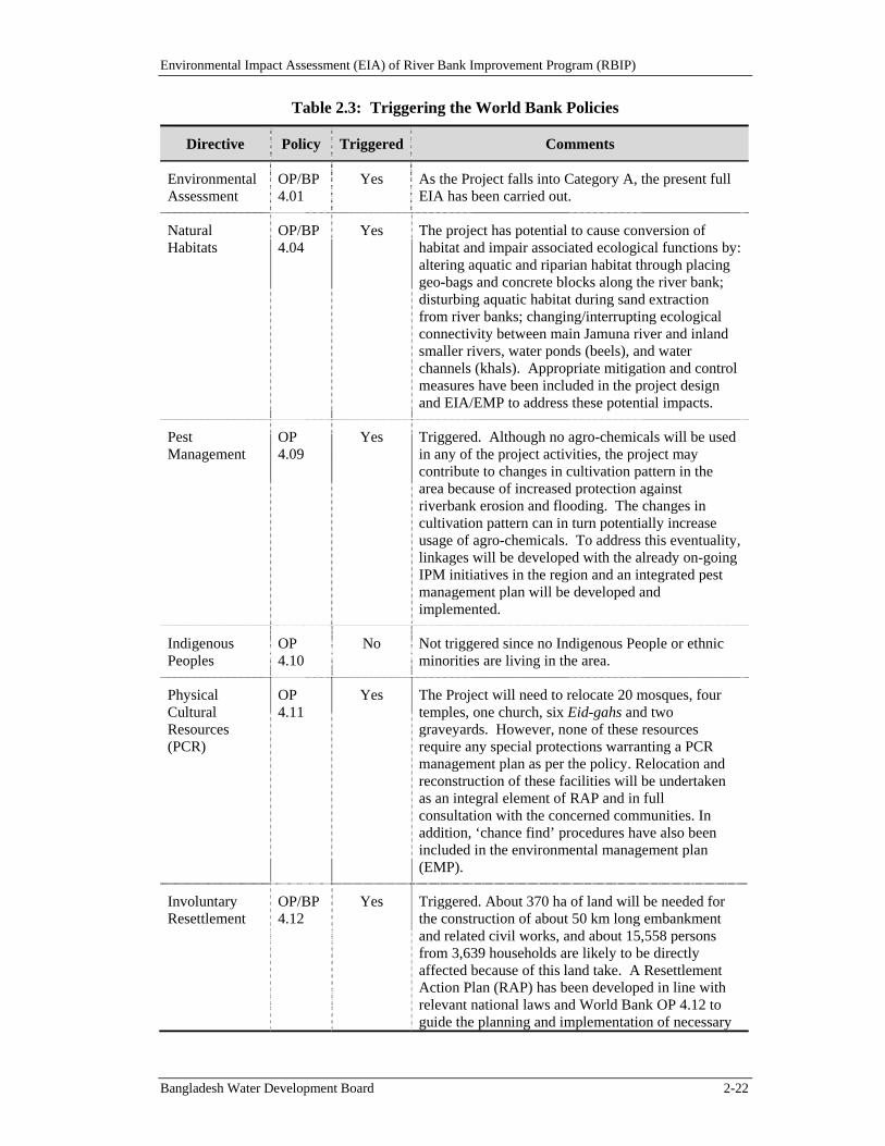
Environmental Impact Assessment (EIA) of River Bank Improvement Program (RBIP)
Bangladesh Water Development Board 2-22
Table 2.3: Triggering the World Bank Policies
Directive Policy Triggered Comments
Environmental Assessment
OP/BP 4.01
Yes As the Project falls into Category A, the present full EIA has been carried out.
Natural Habitats
OP/BP 4.04
Yes The project has potential to cause conversion of habitat and impair associated ecological functions by: altering aquatic and riparian habitat through placing geo-bags and concrete blocks along the river bank; disturbing aquatic habitat during sand extraction from river banks; changing/interrupting ecological connectivity between main Jamuna river and inland smaller rivers, water ponds (beels), and water channels (khals). Appropriate mitigation and control measures have been included in the project design and EIA/EMP to address these potential impacts.
Pest Management
OP 4.09
Yes Triggered. Although no agro-chemicals will be used in any of the project activities, the project may contribute to changes in cultivation pattern in the area because of increased protection against riverbank erosion and flooding. The changes in cultivation pattern can in turn potentially increase usage of agro-chemicals. To address this eventuality, linkages will be developed with the already on-going IPM initiatives in the region and an integrated pest management plan will be developed and implemented.
Indigenous Peoples
OP 4.10
No Not triggered since no Indigenous People or ethnic minorities are living in the area.
Physical Cultural Resources (PCR)
OP 4.11
Yes The Project will need to relocate 20 mosques, four temples, one church, six Eid-gahs and two graveyards. However, none of these resources require any special protections warranting a PCR management plan as per the policy. Relocation and reconstruction of these facilities will be undertaken as an integral element of RAP and in full consultation with the concerned communities. In addition, ‘chance find’ procedures have also been included in the environmental management plan (EMP).
Involuntary Resettlement
OP/BP 4.12
Yes Triggered. About 370 ha of land will be needed for the construction of about 50 km long embankment and related civil works, and about 15,558 persons from 3,639 households are likely to be directly affected because of this land take. A Resettlement Action Plan (RAP) has been developed in line with relevant national laws and World Bank OP 4.12 to guide the planning and implementation of necessary
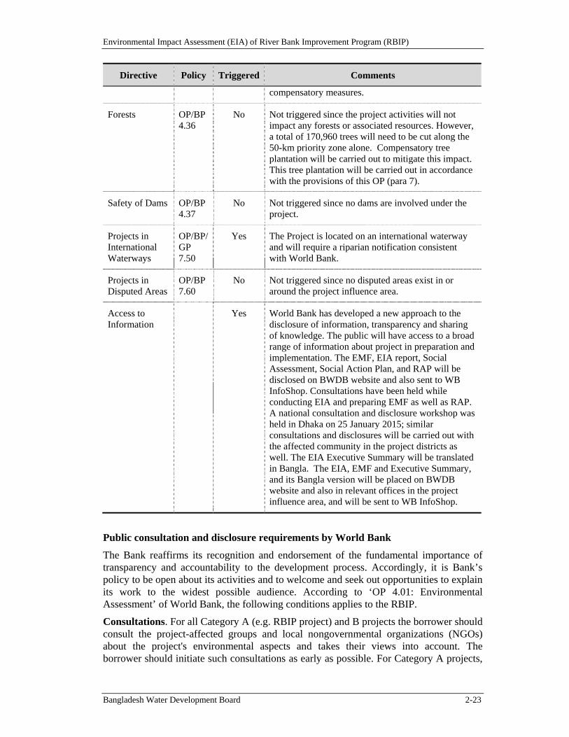
Environmental Impact Assessment (EIA) of River Bank Improvement Program (RBIP)
Bangladesh Water Development Board 2-23
Directive Policy Triggered Comments
compensatory measures.
Forests OP/BP 4.36
No Not triggered since the project activities will not impact any forests or associated resources. However, a total of 170,960 trees will need to be cut along the 50-km priority zone alone. Compensatory tree plantation will be carried out to mitigate this impact. This tree plantation will be carried out in accordance with the provisions of this OP (para 7).
Safety of Dams OP/BP 4.37
No Not triggered since no dams are involved under the project.
Projects in International Waterways
OP/BP/GP 7.50
Yes The Project is located on an international waterway and will require a riparian notification consistent with World Bank.
Projects in Disputed Areas
OP/BP 7.60
No Not triggered since no disputed areas exist in or around the project influence area.
Access to Information
Yes World Bank has developed a new approach to the disclosure of information, transparency and sharing of knowledge. The public will have access to a broad range of information about project in preparation and implementation. The EMF, EIA report, Social Assessment, Social Action Plan, and RAP will be disclosed on BWDB website and also sent to WB InfoShop. Consultations have been held while conducting EIA and preparing EMF as well as RAP. A national consultation and disclosure workshop was held in Dhaka on 25 January 2015; similar consultations and disclosures will be carried out with the affected community in the project districts as well. The EIA Executive Summary will be translated in Bangla. The EIA, EMF and Executive Summary, and its Bangla version will be placed on BWDB website and also in relevant offices in the project influence area, and will be sent to WB InfoShop.
Public consultation and disclosure requirements by World Bank
The Bank reaffirms its recognition and endorsement of the fundamental importance of transparency and accountability to the development process. Accordingly, it is Bank’s policy to be open about its activities and to welcome and seek out opportunities to explain its work to the widest possible audience. According to ‘OP 4.01: Environmental Assessment’ of World Bank, the following conditions applies to the RBIP.
Consultations. For all Category A (e.g. RBIP project) and B projects the borrower should consult the project-affected groups and local nongovernmental organizations (NGOs) about the project's environmental aspects and takes their views into account. The borrower should initiate such consultations as early as possible. For Category A projects,
Environmental Impact Assessment (EIA) of River Bank Improvement Program (RBIP)
Bangladesh Water Development Board 2-24
the borrower should consult these groups at least twice: (a) shortly after environmental screening and before the terms of reference for the EA are finalized; and (b) once a draft EA report is prepared. In addition, the borrower should consult with such groups throughout project implementation as necessary to address EA-related issues that affect them. In line with these requirements, extensive consultations have been carried out in the entire program influence area; details are presented in Chapter 12 of this document.
Disclosure. For a Category A project, the borrower should provide relevant information on project interventions in a timely manner prior to consultation and in a form and language that are understandable and accessible to the groups being consulted. The borrower should provide a summary of the proposed project's objectives, description, and potential impacts for the initial consultation. For consultation after the draft EA report is prepared, the borrower should provide a summary of the EA's conclusions. In addition, for a Category A project, the borrower makes the draft EA report available at a public place accessible to project-affected groups and local NGOs. The borrower also ensures that EA reports for Category A subprojects are made available in a public place accessible to affected groups and local NGOs. The document needs to be translated into Bengali. Public availability of the EA report for Category A project in the borrowing country and official receipt by the Bank are prerequisites to Bank appraisal of these projects.
Environmental Impact Assessment (EIA) of River Bank Improvement Program (RBIP)
Bangladesh Water Development Board 3-1
3. Project Description
This Chapter provides a simplified description of the proposed project on the basis of the information available at this stage. More details are available in the feasibility report.
3.1. Background
The Jamuna is one of the most important rivers of Bangladesh and dominates the hydrology and inundation cycles of the flood plains of Bangladesh. The river originates in the northern Himalayas in Tibet, flows through China as the Yarlung Tsangpo and India as the Brahmaputra and enters Bangladesh as the Jamuna. The Brahmaputra-Jamuna river system displays characteristics of a braided river and is highly susceptible to migration and avulsion. In plan form, the river typically shows two to three main channels per cross-section and has an average width of 12 km in Bangladesh.
In the 1960s, the 220 km Brahmaputra Right-bank Embankment (BRE) was constructed from Kaunia in Rangpur district to Bera in the Pabna district, to protect the surrounding area from flooding of the Jamuna (Brahmaputra) river and to improve agricultural production in the area (Figure 1.1). Around 180km of the embankment follow the Brahmaputra/Jamuna right bank, while 40km of embankment was built along the Teesta right bank. The Teesta is the main tributary of the Jamuna river in Bangladesh with its flow controlled by barrages in Bangladesh and India.
Prior to the BRE construction, overbank spills regularly caused flooding to some 240,000 ha of fertile floodplain land. Originally the BRE had a setback distance of about 1.50 km from the Jamuna river bankline. Over the years the embankment has been increasingly under attack from westward shifting of the river and consequent bank erosion, causing the embankment to breach at several locations. After such breaches, the embankment had to be retired from its original alignment and reconstructed. The retired embankments were typically constructed with around a 200 meter setback distance to prevent flooding. In many places, the embankment has been retired several times.
Under the Flood Action Plan (FAP 1), a Master Plan was prepared in 1994 to protect the BRE against ongoing riverbank erosion (Halcrow, 1994). The study included an assessment of river processes and physical and hydraulic modeling of various river training structures. The study proposed constructing a series of hard point structures along the existing bankline to limit future erosion. The structures were typically about 800 meters long and it was proposed that they be spaced 2.5 km apart along the right bank. It was recognized that erosion might continue between the structures, albeit at a slower rate, and where this occurred, the embankment could still need to be retired.
RecentHistory
After completion of the Master Plan hard points were constructed at Sirajganj, Sariakandi, and Mathurapara, and a groyne was installed at Kalitola from 1995 to 1998. The structures were heavily damaged, first in 1998 and 1999 and repeatedly later, and have required ongoing maintenance and re-construction. Due to the high cost of the “hard points”, the BWDB developed alternatives since the mid-1990s. While protruding spurs did not work satisfactorily, the BWDB has turned to guiding revetments since the mid-2000s, which have demonstrated a lower failure rate and protect the embankment better against steadily reducing overall setback distances to the river.
Environmental Impact Assessment (EIA) of River Bank Improvement Program (RBIP)
Bangladesh Water Development Board 3-2
Bank erosion has continued to attack the BRE, causing it to breach frequently and at different locations. Presently, only 41 kilometers of the original BRE remains intact upstream of Jamuna Bridge, and the overall setback distance is steadily reducing with more and more embankment length being within the reach of annual average erosion rates. Consequently, the integrity of the BRE is threatened and large areas of rural and urban areas are increasingly being exposed to the risk of flooding.
3.2. ProposedInterventions
3.2.1. ProgramRationale
Bangladesh, as the lowest riparian country of the Brahmaputra-Ganges river basin, lacks control over the basin and has to adapt to externally imposed basin changes. Natural processes associated with the continuing mountain-building process of the Himalaya and the annual monsoon rainfall on their southern mountain slopes, have built and continue building the delta that constitutes the major part of Bangladesh. This process is driven by some of the highest river flows and sediment loads in the world, mostly transported through Bangladesh into the Bay of Bengal during the four-month monsoon period from June through September. Besides being unable to control the physical environment, Bangladesh also lacks political influence over basin developments, including land-use changes and the construction of dams in India and China. Given the very high and growing population density, climate change poses additional future threats through projected increases in river flows, sediment loads, and sea levels.
Feeding the rapidly growing population of Bangladesh over the last half-century called for systematic reduction of flood risks to agricultural land, but until now this was constrained by large-scale river instability. Nevertheless, a quest for food self-sufficiency has resulted in some control and regulation to achieve multiple and increasingly high-yield crops. The key elements are: (i) flood risk reduction through the construction of embankments to control water levels during the monsoon season; and (ii) upgrading of irrigation infrastructure to enable a major second crop during the dry season. River instability and widening, however, has caused increasing destruction of flood embankments since the later 1970s and has also affected the irrigation schemes. At first, the reasons for this increased instability were not understood, but the Government also did not have sufficient resources or appropriate technologies to arrest large-scale riverbank erosion. A better understanding of river processes, together with low-cost technologies for riverbank protection, was developed only after 1990.
As of 2014, Bangladesh was in a transition from “fire-fighting” local riverbank erosion to developing a more comprehensive program for riverbank protection and river stabilization. The BWDB developed a promising bank protection technology from the early 1990s until 2010, based on experimentation with a number of technologies, often donor-supported. The method recommended in the Board’s Guideline for Riverbank Protection (2010), involves long guiding revetments along similar lines of those in high-energy reaches of the lower Mississippi River, USA. In support of larger-scale river stabilization, the BWDB experimented with capital dredging within the scope of a feasibility study,8 and the two main funders of water projects - the World Bank and the
8 Feasibility Study of Capital Dredging and Sustainable River Management in Bangladesh, draft final
report, April 2014. This study estimates that 311 km of long guiding revetments could protect both riverbanks along the 220-km long Brahmaputra/Jamuna course from the Indian border to the confluence with the Ganges. The riverbank protection would be supplemented by an annual dredging volume of
Environmental Impact Assessment (EIA) of River Bank Improvement Program (RBIP)
Bangladesh Water Development Board 3-3
Asian Development Bank - have launched major initiatives9. Given that the annual average cost of capital dredging amounts to 30 times the annual BWDB budget, the need is recognized for a phased river stabilization program and for riverbank protection and land reclamation to be viewed as a joint process.
One critical length is the 150-km BRE north of Jamuna Bridge, which protects around 200,000 ha of the grain-growing Northwestern Region against flooding. Riverbank erosion in this area has continuously displaced the floodplain population since 1973, so that by 2014 around 100,000 squatters were living on the embankment, of which about 40,000 were located in a 50-km priority reach. These people have lost their land and livelihood, some having had to relocate up to seven times. The fear of riverbank erosion and major flooding has a strong negative impact on riparian residents, who generally have high poverty levels, low health, and crowded low-quality dwellings with restricted access to civic amenities and roads. Their overwhelming demand is to stop riverbank erosion and forced retirement of embankments, which cuts ever more deeply into long-established communities.
3.2.2. ProgramObjectives
The overall objectives of the RBIP are to reconstruct the BRE and secure it against erosion. Arresting erosion is the primary interest of the local population living alongside the riverbank. Secondary objectives are to: (i) develop the local area to catch up with the rest of the country and reduce poverty; and (ii) strengthen BWDB’s capacity as a competent agency for mitigation of flooding and bank erosion within an overall strategy for Integrated Flood Risk Management.
While reduction of riverbank erosion and flooding risks will have positive impacts on development of the area in general, the rehabilitation of erosion victims presently squatting on more than 90 percent of the embankment length will directly benefit a large population that is neglected by current disaster response mechanisms.
The specific objectives of the Riverbank Improvement Program (RBIP) are: (i) to reduce riverbank erosion along 150 km of the right (western) bank of the Brahmaputra/Jamuna River from the Teesta River to the Jamuna Bridge; (ii) provide a reliable flood embankment with roadway; (iii) rehabilitate the population squatting on existing embankments; and (iv) initiate institutional change within BWDB to provide long-reach stabilization work and maintain it jointly with local communities. The performance indicators associated with these objectives and the associated timeframe are given below.
Table 3.1: Performance Indicators and Timeframes
Indicator Level Timeframe
Impact Overarching or higher order goals:
Millennium Development Goals, 6th Five-Year Plan, “a world free of poverty”
Five years after program end
146 million cubic meters - which amounts to roughly one third of the annual sediment load of the Brahmaputra River.
9 ADB: Flood and Riverbank Erosion Risk Management Investment Program (FRERMIP) covering the central Brahmaputra System from Jamuna Bridge to Chandpur, study from 2012 to 13, loan effective since mid-2014; and the World Bank’s current River Bank Improvement Program (RBIP), covering the northern part of the Brahmaputra system in Bangladesh between Jamuna Bridge and Indian border, study from 2012 until 2015, loan expected at the end of 2015.
Environmental Impact Assessment (EIA) of River Bank Improvement Program (RBIP)
Bangladesh Water Development Board 3-4
Indicator Level Timeframe
Outcome Dominant goals of water sector and people’s livelihoods, such as erosion and flood protection, irrigation expansion etc.
At program end
Output Detailed results from individual program components or activities, such as embankment construction, training, formation of stakeholder groups
During program implementation
3.2.3. ProgramBoundaries
The BRE protects central parts of Bangladesh’s north-western zone from Brahmaputra/Jamuna River flooding. It is delineated to the north by the Kurigram Irrigation Project, North and South Units, which provide around 36km of embankments along the Brahmaputra/Jamuna towards the Indian border, and in the south by the Pabna Irrigation and Rural Development Project (PIRDP), which provides around 30km of embankment line to the confluence with the Ganges. The BRE starts at the Teesta Bridge at Kaunia and follows the right bank of the Teesta River for 40km to its confluence with the Brahmaputra/Jamuna. The Teesta River forms the southern boundary of the Kurigram Irrigation Project. From the Teesta confluence the BRE follows the Jamuna River for around 180km to the south until it reaches the Hurasagar/Baral River, where it ends. The Hurasagar/Baral forms the northern boundary of the PIRDP. Figure 3.1 shows the BRE as the central part of the Brahmaputra/Jamuna right bank flood protection. The BRE influences around 297,000 ha of land. Since its establishment at the end of the 1960s, around 21,000 ha of flood-protected land were eroded along the BRE, and only 50km of the originally 178-km embankment along the Brahmaputra/Jamuna was still in place in 2014.
The RBIP covers the central and northern part of the BRE in the Sirajganj, Bogra, and Gaibandha Districts, and can be extended to the Kurigram Irrigation Project’s North and South Units over a new bridge across the Teesta River in future (Figure 3.2). The 40-km BRE section along the Teesta River has been omitted due to its low risk of flooding since construction of the Teesta Barrage in 1990. A 50-km priority reach (Phase I works) extends from Simla, about 8km upstream of Sirajganj, to Hasnapara approximately 10km upstream of Sariakandi, covering the central part of the BRE. The remaining 97km will be addressed in Phase II, while the embankment along the whole length will be provided with a highway standard road in Phase III. The short 20-km long southern reach between Simla and Jamuna Bridge was left out of Phase I, as the BWDB has undertaken some minor interventions there to reclaim a small piece of the lost floodplain land. It is planned to align the new embankment over the reclaimed land under Phase II.
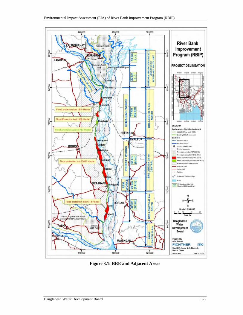
Environmental Impact Assessment (EIA) of River Bank Improvement Program (RBIP)
Bangladesh Water Development Board 3-5
Figure 3.1: BRE and Adjacent Areas

Environmental Impact Assessment (EIA) of River Bank Improvement Program (RBIP)
Bangladesh Water Development Board 3-6
Figure 3.2: Program Delineation
Environmental Impact Assessment (EIA) of River Bank Improvement Program (RBIP)
Bangladesh Water Development Board 3-7
3.3. ProgramArea,WorkSequencing,andKeyComponents
3.3.1. RBIPAreaandSelectionofPriorityReach
The RBIP starts with the rehabilitation of the existing around 150km long Brahmaputra Right Embankment (BRE) from the Teesta River to the Jamuna Bridge while the future ADB support under FRERMIP will cover the 140km length from Jamuna Bridge to Chandpur. The 70km BRE reach from Jamuna Bridge to Hasnapara is under heavy erosional attack with frequent embankment breaching and retirements. Out of this, the 50-km length between Hasnapara and Simla is designated as a priority reach for the following reasons:
Erosion rate: Over the 42-year period 1973 to 2014 the Brahmaputra/Jamuna eroded an average 3.3km wide strip into the floodplain with peak erosion exceeding 5 km. In comparison the average erosion rate along the whole BRE was 1.9km from 1973 to 2014.
Embankment breaching: The embankment setback distance has reduced from typically 1.5 km in 1973 to 390m in 2014. About 33 percent of the existing BRE in the priority reach is situated within 200m from the riverbank. With annual erosion rate of 150m in one year and 250m in two years in 10 percent of the cases the embankment is at a high risk of erosion. About 86 percent of the embankment retirements between 1995 and 2013 occurred in this reach, and the annual risk of a breach is 67 percent. The embankment has been retired typically five times and as much as nine times up to 3.5km to the west of the historic embankment line.
Risk of inundation: The floodplain slopes to the west towards a network of smaller streams draining the terrain behind a natural levee built by the river. A sequence of several breaches of the BRE would inundate substantial parts of the floodplain to levels not experienced since its completion. Numerical modeling indicates that the flooded area due to breaches within the 50 km priority reach would average nearly 50,000 ha annually, as opposed to 15,000 ha in the remaining (Phase II) areas upstream.
Risk of avulsion: The Bangali River flows closely to the Brahmaputra riverbank in the Sariakandi area. Over a length of some 15 km it is located as close as 350 m to the Brahmaputra bankline, a distance that could be eroded in one year. Avulsion of the Brahmaputra into the Bangali during a higher flood could cause widespread destruction.
Limited bank protection: The riverbank is insufficiently protected against embankment breaching with currently only 12km provided with riverbank protection work. Over the last four decades some 20,000 ha of the priority reach land has been lost due to erosion and breaches - corresponding in area to a large irrigation project.
Table 3.2 summarizes key project interventions in the priority and remaining reaches. Interventions in the priority reach will be designed in detail, whereas those in the remaining reaches will be tentative as based on the existing river morphology - their final design will depend on the amount of river change between the present feasibility study and the detailed design phase and the desired level of reclamation and river training identified during the first year of Phase I.
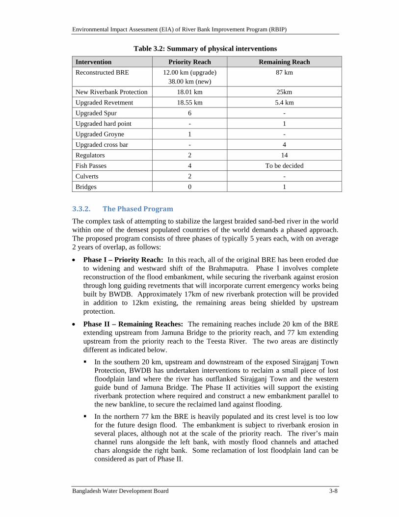
Environmental Impact Assessment (EIA) of River Bank Improvement Program (RBIP)
Bangladesh Water Development Board 3-8
Table 3.2: Summary of physical interventions
Intervention Priority Reach Remaining Reach
Reconstructed BRE 12.00 km (upgrade) 38.00 km (new)
87 km
New Riverbank Protection 18.01 km 25km
Upgraded Revetment 18.55 km 5.4 km
Upgraded Spur 6 -
Upgraded hard point - 1
Upgraded Groyne 1 -
Upgraded cross bar - 4
Regulators 2 14
Fish Passes 4 To be decided
Culverts 2 -
Bridges 0 1
3.3.2. ThePhasedProgram
The complex task of attempting to stabilize the largest braided sand-bed river in the world within one of the densest populated countries of the world demands a phased approach. The proposed program consists of three phases of typically 5 years each, with on average 2 years of overlap, as follows:
Phase I – Priority Reach: In this reach, all of the original BRE has been eroded due to widening and westward shift of the Brahmaputra. Phase I involves complete reconstruction of the flood embankment, while securing the riverbank against erosion through long guiding revetments that will incorporate current emergency works being built by BWDB. Approximately 17km of new riverbank protection will be provided in addition to 12km existing, the remaining areas being shielded by upstream protection.
Phase II – Remaining Reaches: The remaining reaches include 20 km of the BRE extending upstream from Jamuna Bridge to the priority reach, and 77 km extending upstream from the priority reach to the Teesta River. The two areas are distinctly different as indicated below.
In the southern 20 km, upstream and downstream of the exposed Sirajganj Town Protection, BWDB has undertaken interventions to reclaim a small piece of lost floodplain land where the river has outflanked Sirajganj Town and the western guide bund of Jamuna Bridge. The Phase II activities will support the existing riverbank protection where required and construct a new embankment parallel to the new bankline, to secure the reclaimed land against flooding.
In the northern 77 km the BRE is heavily populated and its crest level is too low for the future design flood. The embankment is subject to riverbank erosion in several places, although not at the scale of the priority reach. The river’s main channel runs alongside the left bank, with mostly flood channels and attached chars alongside the right bank. Some reclamation of lost floodplain land can be considered as part of Phase II.
Environmental Impact Assessment (EIA) of River Bank Improvement Program (RBIP)
Bangladesh Water Development Board 3-9
The Phase II also focuses on reconstruction of the BRE and securing it against riverbank erosion. While this preparatory study is based on riverbank protection along the present bankline, we recognize the need for a concept of comprehensive river stabilization, in line with the recommendation from the IPoE. The extent and type of riverbank erosion protection will be decided on the basis of a river training and reclamation study component encompassing the whole Brahmaputra River from the Indian border to the Jamuna Bridge. This river training study will precede the updated feasibility study component and detailed design of the remaining works and allow considering the option of reclaiming lost floodplain land and realigning the BRE over the reclaimed land.
Efforts should be made to understand flooding processes on the floodplain. The BRE provides flood protection to around 6 percent (220,000 ha) of the Northwestern Region (3,433,500 ha), a region that produces 34 percent of the country’s food grains. Growing road connections interfere with natural flooding and drainage paths and have led to noticeable changes since the time of BRE construction. Future sustainable development depends on a better understanding of residual flood risks, which requires two-dimensional flood modeling. In combination with depth-duration-damage curves, such modeling will enable the production of flood risk maps that identify areas and assets at risk during events of various frequencies, so providing input for land-use zoning and development of a Master Plan.
Phase III – Road: The new embankment will incorporate an emergency and maintenance road. Existing service or feeder roads on embankments often consist merely of crest pavement. For better market access by the local population, a higher category of road construction is warranted that would allow for future widening to four lanes. Also, subsoil conditions indicate that a wide embankment is needed to avoid geotechnical failure from seepage. The alignment of the reconstructed BRE will therefore allow for future road upgrading according to the Asian highway standard adopted in Bangladesh. Three development stages are envisaged as base case as described below, with alternative construction and operation models to be studied at the beginning of Phase I to identify the best way forward:
The 50-km length of embankment constructed in Phase I will be provided with a “service road” on the country-side berm.
After completion of the reconstructed embankment, a two-lane highway on the country side will provide local connectivity and also establish an interregional link from the Jamuna Bridge to the new Teesta Bridge near Chilmari, connecting the northern districts of Kurigram and Lalmonirhat. An initial traffic count indicates that this road would be economically feasible as it would shorten the travel distance between Jamuna Bridge and the northwestern districts10 from about 187 to 150 km. The new road would also cater to diverted traffic from Chilmari port. An origin and destination survey indicates that about 50 percent of the traffic on the existing route is through traffic that would be diverted. Non-through traffic will continue to use the existing route.
The highway would start construction shortly after completing the reconstruction of the priority reach and will be opened one year after completion of the Phase II BRE. Various toll road options will be considered, to cover both road and
10 Gaibandha, Lamonirhat, Thakargaon, Dinajpur, Panchagarh, Nilmaphar.
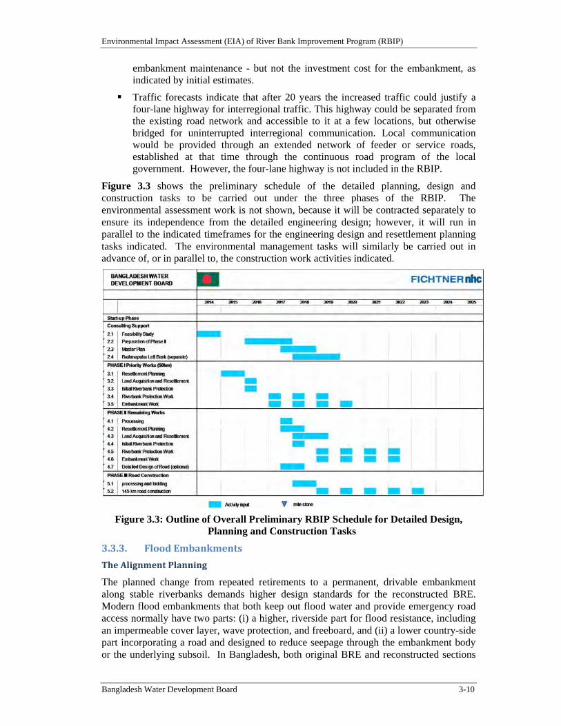
Environmental Impact Assessment (EIA) of River Bank Improvement Program (RBIP)
Bangladesh Water Development Board 3-10
embankment maintenance - but not the investment cost for the embankment, as indicated by initial estimates.
Traffic forecasts indicate that after 20 years the increased traffic could justify a four-lane highway for interregional traffic. This highway could be separated from the existing road network and accessible to it at a few locations, but otherwise bridged for uninterrupted interregional communication. Local communication would be provided through an extended network of feeder or service roads, established at that time through the continuous road program of the local government. However, the four-lane highway is not included in the RBIP.
Figure 3.3 shows the preliminary schedule of the detailed planning, design and construction tasks to be carried out under the three phases of the RBIP. The environmental assessment work is not shown, because it will be contracted separately to ensure its independence from the detailed engineering design; however, it will run in parallel to the indicated timeframes for the engineering design and resettlement planning tasks indicated. The environmental management tasks will similarly be carried out in advance of, or in parallel to, the construction work activities indicated.
Figure 3.3: Outline of Overall Preliminary RBIP Schedule for Detailed Design, Planning and Construction Tasks
3.3.3. FloodEmbankments
TheAlignmentPlanning
The planned change from repeated retirements to a permanent, drivable embankment along stable riverbanks demands higher design standards for the reconstructed BRE. Modern flood embankments that both keep out flood water and provide emergency road access normally have two parts: (i) a higher, riverside part for flood resistance, including an impermeable cover layer, wave protection, and freeboard, and (ii) a lower country-side part incorporating a road and designed to reduce seepage through the embankment body or the underlying subsoil. In Bangladesh, both original BRE and reconstructed sections
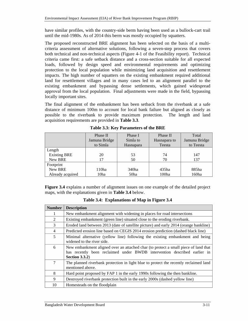
Environmental Impact Assessment (EIA) of River Bank Improvement Program (RBIP)
Bangladesh Water Development Board 3-11
have similar profiles, with the country-side berm having been used as a bullock-cart trail until the mid-1980s. As of 2014 this berm was mostly occupied by squatters.
The proposed reconstructed BRE alignment has been selected on the basis of a multi-criteria assessment of alternative solutions, following a seven-step process that covers both technical and non-technical aspects (Figure 4-1 of the Feasibility report). Technical criteria came first: a safe setback distance and a cross-section suitable for all expected loads, followed by design speed and environmental requirements and optimizing protection to the local population while minimizing land acquisition and resettlement impacts. The high number of squatters on the existing embankment required additional land for resettlement villages and in many cases led to an alignment parallel to the existing embankment and bypassing dense settlements, which gained widespread approval from the local population. Final adjustments were made in the field, bypassing locally important sites.
The final alignment of the embankment has been setback from the riverbank at a safe distance of minimum 100m to account for local bank failure but aligned as closely as possible to the riverbank to provide maximum protection. The length and land acquisition requirements are provided in Table 3.3.
Table 3.3: Key Parameters of the BRE
Phase II Jamuna Bridge
to Simla
Phase I Simla to
Hasnapara
Phase II Hasnapara to
Teesta
Total Jamuna Bridge
to TeestaLength Existing BRE New BRE
20 17
53 50
74 70
147 137
Footprint New BRE Already acquired
110ha 10ha
340ha 50ha
435ha 100ha
885ha 160ha
Figure 3.4 explains a number of alignment issues on one example of the detailed project maps, with the explanations given in Table 3.4 below.
Table 3.4: Explanations of Map in Figure 3.4
Number Description 1 New embankment alignment with widening in places for road intersections 2 Existing embankment (green line) situated close to the eroding riverbank. 3 Eroded land between 2013 (date of satellite picture) and early 2014 (orange bankline) 4 Predicted erosion line based on CEGIS 2014 erosion prediction (dashed black line) 5 Minimal alternative (yellow line) following the existing embankment and being
widened to the river side. 6 New embankment aligned over an attached char (to protect a small piece of land that
has recently been reclaimed under BWDB intervention described earlier in Section 3.3.2)
7 The planned riverbank protection in light blue to protect the recently reclaimed land mentioned above.
8 Hard point proposed by FAP 1 in the early 1990s following the then bankline. 9 Destroyed riverbank protection built in the early 2000s (dashed yellow line) 10 Homesteads on the floodplain
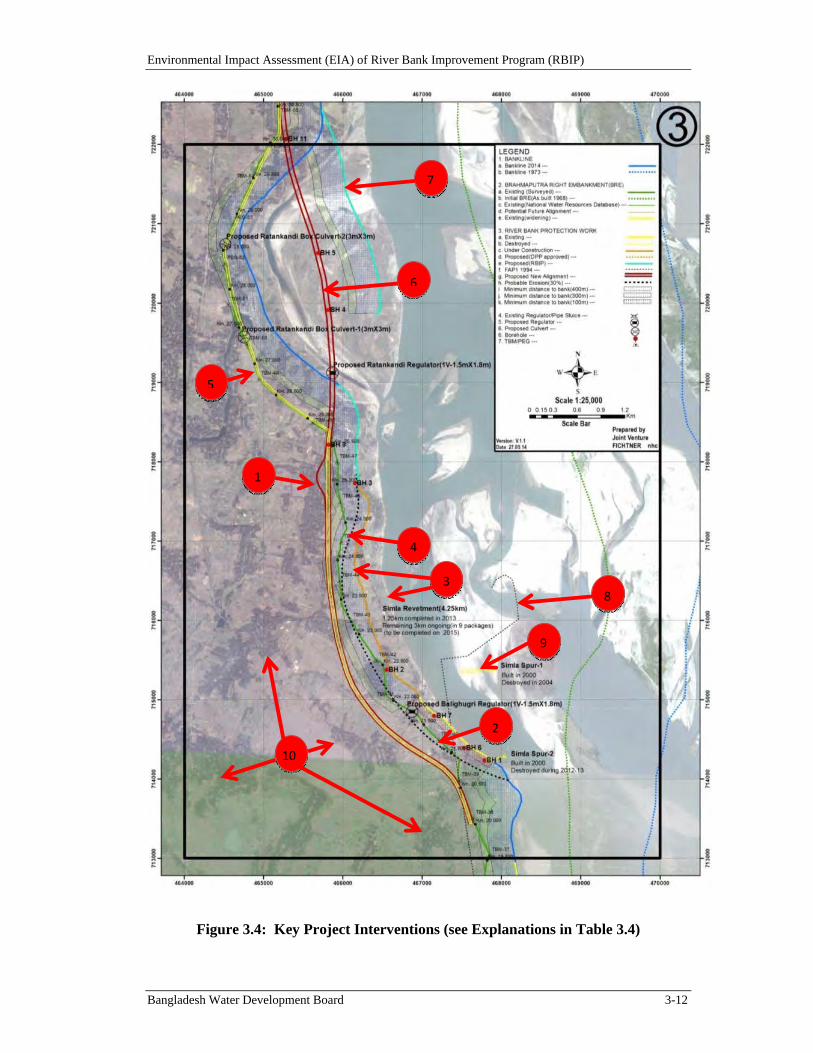
Environmental Impact Assessment (EIA) of River Bank Improvement Program (RBIP)
Bangladesh Water Development Board 3-12
Figure 3.4: Key Project Interventions (see Explanations in Table 3.4)
1
5
6
7
2
4
38
9
10
Environmental Impact Assessment (EIA) of River Bank Improvement Program (RBIP)
Bangladesh Water Development Board 3-13
EmbankmentDesign
The proposed new embankment incorporates the following design features (more details are provided in the Feasibility report):
The crest level will be raised to the 100-year flood level including climate change addition for 30 years plus 1.5 m freeboard.
Along around 40 percent of the length of the reconstructed BRE in the priority reach, an impermeable membrane will be placed to separate subsoil and embankment body (as the cohesive topsoil layer is insufficiently thick).
The new embankment is designed for load combinations including earthquake, rapid drawdown, and seepage. Seepage control requires a wide embankment body and two separate drainage systems to drain seepage and rainwater. The drainage system and outlet structure are designed to prevent entry of rodents and facilitate regular flushing.
The core of the embankment will consist of dredged sand, to avoid additional borrow pits on the densely populated floodplain. Surficial cladding will use selected cohesive soil from the toe excavation and the existing embankment line, which will be cut along about 40 percent of the length of the new alignment.
Both toe lines will be protected from encroachment by placing open cell pavers along the river side and planting trees on the country side, so that farmers cannot plough into the protective clay layer.
The crest of the embankment will be covered with open cell pavers to allow vegetation growth, fix the crest level, and discourage through traffic.
A countryside berm will initially accommodate a two-lane service road for emergency and local access, connected in eight places to the local road network. In other places crossings will allow the local population to access the river. The unoccupied part of the berm will have suitable vegetation coverage to discourage unauthorized settlement.
The standard design water level for the main rivers in Bangladesh has a 100-year return period. Climate change predictions indicate a slight increase in water levels such that 30 years into the future, the 100-year level will correspond to the present 200-year level. Morphological modeling, used to evaluate the water levels associated with a future 100-year discharge, indicate that water levels higher than indicated by statistical analysis should be used - specifically to account for a future protected riverbank. A comparison of water levels for key locations is provided in Table 3.5. Finally, a freeboard of 1.5 m will be added to the new design water level to account uncertainty in flood statistics, wave run-up, morphological changes, local settlements or subsidence etc. In terms of statistics, the 500-year flood level is estimated to be 0.5 m above the design flood level (DFL), which would still be below the crest of the embankment. The safety of the embankment against failure from overtopping, either from waves or extreme peak flows, is further increased by the wide paved road on the country side, which protects against retrogressive failure and sudden breach.
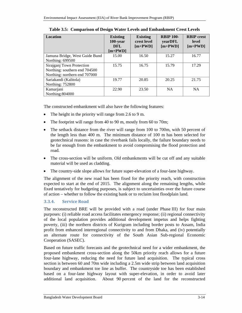
Environmental Impact Assessment (EIA) of River Bank Improvement Program (RBIP)
Bangladesh Water Development Board 3-14
Table 3.5: Comparison of Design Water Levels and Embankment Crest Levels
Location Existing 100-year
DFL [m+PWD]
Existing crest level [m+PWD]
RBIP 100-yearDFL
[m+PWD]
RBIP crest level
[m+PWD]
Jamuna Bridge, West Guide Bund Northing: 699500
15.00 16.50 15.27 16.77
Sirajganj Town Protection Northing: southern end 704500 Northing: northern end 707000
15.75 16.75 15.79 17.29
Sariakandi (Kalitola) Northing: 752800
19.77 20.85 20.25 21.75
Kamarjani Northing:804000
22.90 23.50 NA NA
The constructed embankment will also have the following features:
The height in the priority will range from 2.6 to 9 m.
The footprint will range from 40 to 90 m, mostly from 60 to 70m;
The setback distance from the river will range from 100 to 700m, with 50 percent of the length less than 400 m. The minimum distance of 100 m has been selected for geotechnical reasons: in case the riverbank fails locally, the failure boundary needs to be far enough from the embankment to avoid compromising the flood protection and road.
The cross-section will be uniform. Old embankments will be cut off and any suitable material will be used as cladding.
The country-side slope allows for future super-elevation of a four-lane highway.
The alignment of the new road has been fixed for the priority reach, with construction expected to start at the end of 2015. The alignment along the remaining lengths, while fixed tentatively for budgeting purposes, is subject to uncertainties over the future course of action – whether to follow the existing bank or to reclaim lost floodplain land.
3.3.4. ServiceRoad
The reconstructed BRE will be provided with a road (under Phase III) for four main purposes: (i) reliable road access facilitates emergency response; (ii) regional connectivity of the local population provides additional development impetus and helps fighting poverty, (iii) the northern districts of Kurigram including border posts to Assam, India profit from enhanced interregional connectivity to and from Dhaka, and (iv) potentially an alternate route for connectivity of the South Asian Sub-regional Economic Cooperation (SASEC).
Based on future traffic forecasts and the geotechnical need for a wider embankment, the proposed embankment cross-section along the 50km priority reach allows for a future four-lane highway, reducing the need for future land acquisition. The typical cross section is between 60 and 70m wide including a 2.5m wide strip between land acquisition boundary and embankment toe line as buffer. The countryside toe has been established based on a four-lane highway layout with super-elevation, in order to avoid later additional land acquisition. About 90 percent of the land for the reconstructed
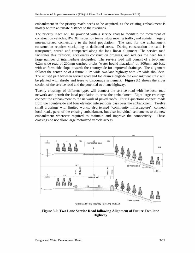
Environmental Impact Assessment (EIA) of River Bank Improvement Program (RBIP)
Bangladesh Water Development Board 3-15
embankment in the priority reach needs to be acquired, as the existing embankment is mostly within an unsafe distance to the riverbank.
The priority reach will be provided with a service road to facilitate the movement of construction vehicles, BWDB inspection teams, slow moving traffic, and maintain largely non-motorized connectivity to the local population. The sand for the embankment construction requires stockpiling at dedicated areas. During construction the sand is transported, spread and compacted along the long linear alignment. The service road facilitates this transport, accelerates construction progress, and reduces the need for a large number of intermediate stockpiles. The service road will consist of a two-lane, 6.2m wide road of 200mm crushed bricks (water-bound macadam) on 300mm sub-base with uniform side slope towards the countryside for improved drainage. The alignment follows the centerline of a future 7.3m wide two-lane highway with 2m wide shoulders. The unused part between service road and toe drain alongside the embankment crest will be planted with shrubs and trees to discourage settlement. Figure 3.5 shows the cross section of the service road and the potential two-lane highway.
Twenty crossings of different types will connect the service road with the local road network and permit the local population to cross the embankment. Eight large crossings connect the embankment to the network of paved roads. Four T-junctions connect roads from the countryside and four elevated intersections pass over the embankment. Twelve small crossings with limited works, also termed “community infrastructure”, connect local roads, parts of the existing embankment, but also individual settlements to the new embankment wherever required to maintain and improve the connectivity. These crossings do not allow large motorized vehicle access.
Figure 3.5: Two Lane Service Road following Alignment of Future Two-lane Highway

Environmental Impact Assessment (EIA) of River Bank Improvement Program (RBIP)
Bangladesh Water Development Board 3-16
3.3.5. RegulatorsandFishPasses
The reconstructed embankment will enhance the environment through a number of regulators and fish passes (see Figure 3.6). The existing embankment, especially in the priority reach hermetically seals the floodplain from the flood flows carrying fertile sediment and fish. Water passage is important for a number of reasons:
Recharging the groundwater: the passage of floodwater through dedicated khals contributes largely to groundwater recharge. As opposed to the impermeable floodplain, small rivulets, locally called khals contribute largely to the ground water recharge, as they penetrate through the surficial clay layer into the porous underlying sand strata. Closing passage ways through embankments leads to the degradation of the khals and reduced infiltration. This does not only negatively impact on wetlands but also the groundwater table used for local irrigation.
Supplementary irrigation: Regulators or fish passes allow substitution of low rainfall through flood flows and therefore provide supplementary irrigation. Regulators are commonly opened during normal flood seasons to provide additional water to the rice cultivation but also to entrain some of the fertile silt and clay. Regulators are effective for water levels above flood level in order to inundate the rice fields.
Fish migration: It is widely recognized that further enhanced agriculture and fish productivity depends on a mix of rice and fish culture. Fish also provides an important part of the protein intake of poor people. Increased fish production requires the passage of fish eggs, fingerlings, and fry from river to the floodplain during the period April to June and the return of adult fish after the monsoon in October. It is important to recognize that eggs and fingerlings drift with the flowing water and cannot swim, while fish fry can move on its own. Fish passes are designed to be effective for water levels typically 2m below flood plain level to allow fish migration through khals starting from May.
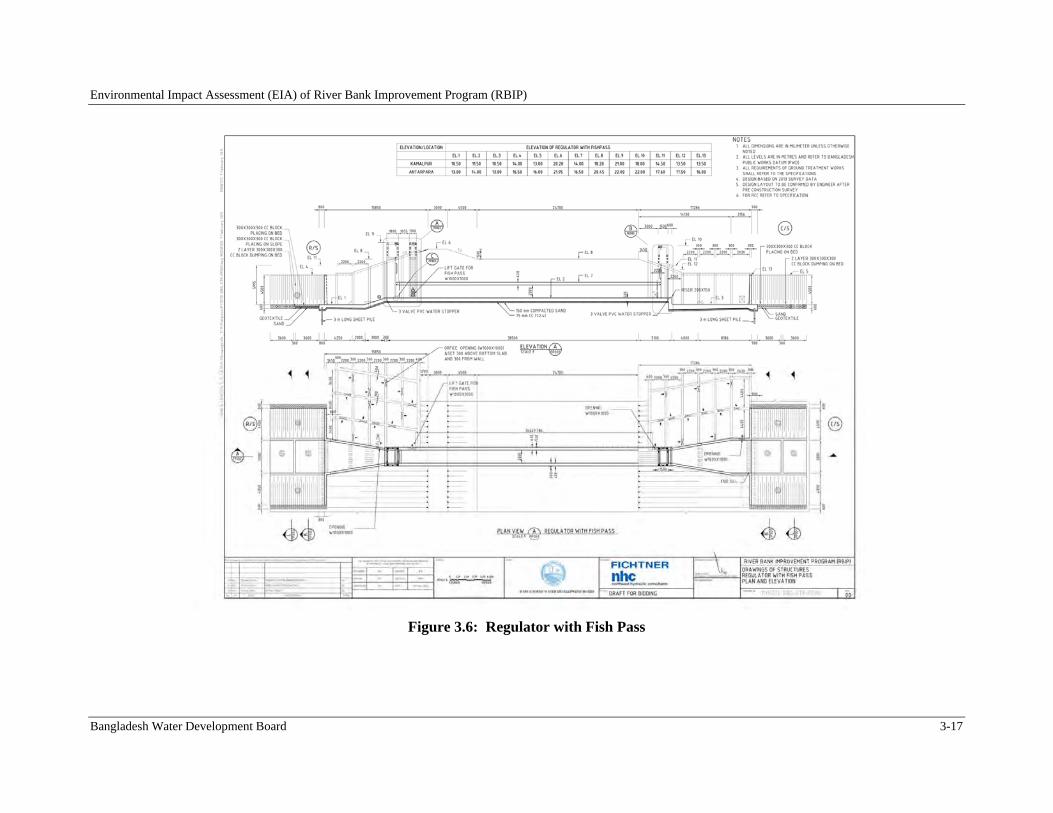
Environmental Impact Assessment (EIA) of River Bank Improvement Program (RBIP)
Bangladesh Water Development Board 3-17
Figure 3.6: Regulator with Fish Pass
Environmental Impact Assessment (EIA) of River Bank Improvement Program (RBIP)
Bangladesh Water Development Board 3-18
3.3.6. RiverbankProtection
Of a range of options for protecting the riverbank, guiding revetments incorporating sand-filled geo-textile bags (geo-bags) are the preferred solution for the high-energy main channel that is presently eroding the right bank in the priority reach and the downstream area to the Jamuna Bridge. The selection process, including designs for alternative solutions and cost estimates, is summarized in Annex A of the Feasibility report, River Engineering Feasibility Designs. The selection of revetments is based on three key considerations:
Protection of Infrastructure alongside the riverbank: A main purpose of riverbank protection is to assure the integrity of the BRE and other infrastructure alongside the riverbank. Consistent protection is best provided by continuous revetments. To provide equivalent protection, intermittent works such as “hard points” or spurs require greater embankment setback distances with additional riverbank erosion and more displacement of the local population.
Avoidance of erosion caused by the protection works themselves: Numerical modeling indicates that a frequent cause of failure is outflanking by the river at the curved upstream end of protection works. Short works such as hard points or spurs tend to cause rapid, deep scouring during initial river attack, which worsens over time due to increasing protrusion into the flow as outflanking proceeds. Long guiding revetments produce less severe flow disturbances and typically only about half the total scoured depth resulting from short protrusions.
Stability of Cover Layers: It is difficult to protect the upstream curvature of hard points or the head of spurs from failure under the high shear stresses of accelerating flow in these locations. Computational fluid dynamics with turbulence modeling of cover layers, in combination with recent turbulence theory, demonstrates that the common apron system of relying on single-layer rock or concrete block aprons must fail, and that in the absence of filters, many layers of rock are required to prevent wash-out of the underlying fine soil. Flexible geo-bags incorporate filter properties perform better as they leave much less gaps through which the subsoil can be eroded.
Guiding revetments have proven sustainable since their first use in 1998 at Sirajganj, especially after the upstream termination was strengthened with a wide apron of geo-textile bags. Subsequently the BWDB placed nearly 30 km of geo-textile bag revetments systematically on underwater slopes between 2004 and 2011. Another 40 km or so were placed using a simpler construction method. In the design of the river training works for Padma Bridge from 2009 to 2011, geo-bag revetment design was developed further: in the immediate vicinity of the bridge the geo-bags were to be covered with a multiple rock layer to increase longevity and robustness, while in upstream areas thicker geo-bag revetments without rock cover were proposed. In the present RBIP case, however, the largely agricultural areas to be protected do not warrant the high cost of rock cover, which would require rock to be imported and paid for in foreign currency. Therefore, as in the upstream areas of Sirajganj Town Protection and Padma Bridge, multiple layers of heavy, filter-tight geo-bags are proposed.
Along the 145 km length of the BRE approximately 55 km of riverbank protection will be required, of which approximately 25 km will be in the priority reach – the remaining part of the riverbank either does not need protection or has already been protected through earlier works. This includes rehabilitation of approximately 15 km of existing protection,
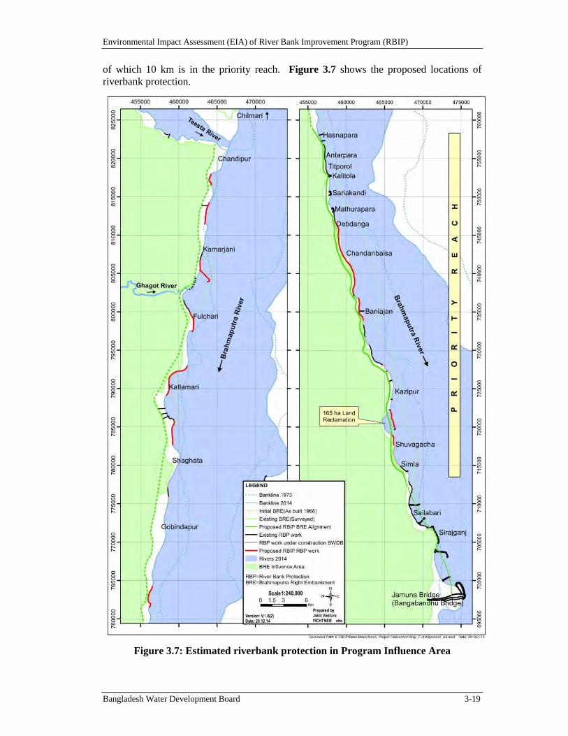
Environmental Impact Assessment (EIA) of River Bank Improvement Program (RBIP)
Bangladesh Water Development Board 3-19
of which 10 km is in the priority reach. Figure 3.7 shows the proposed locations of riverbank protection.
Figure 3.7: Estimated riverbank protection in Program Influence Area
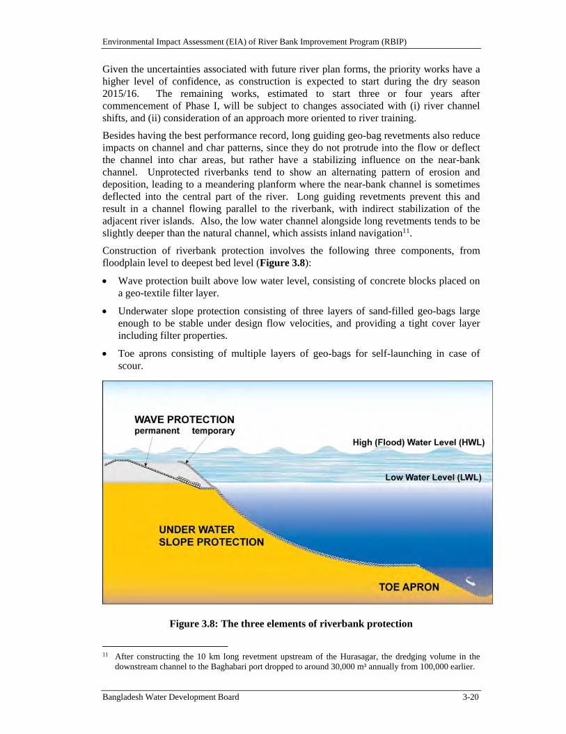
Environmental Impact Assessment (EIA) of River Bank Improvement Program (RBIP)
Bangladesh Water Development Board 3-20
Given the uncertainties associated with future river plan forms, the priority works have a higher level of confidence, as construction is expected to start during the dry season 2015/16. The remaining works, estimated to start three or four years after commencement of Phase I, will be subject to changes associated with (i) river channel shifts, and (ii) consideration of an approach more oriented to river training.
Besides having the best performance record, long guiding geo-bag revetments also reduce impacts on channel and char patterns, since they do not protrude into the flow or deflect the channel into char areas, but rather have a stabilizing influence on the near-bank channel. Unprotected riverbanks tend to show an alternating pattern of erosion and deposition, leading to a meandering planform where the near-bank channel is sometimes deflected into the central part of the river. Long guiding revetments prevent this and result in a channel flowing parallel to the riverbank, with indirect stabilization of the adjacent river islands. Also, the low water channel alongside long revetments tends to be slightly deeper than the natural channel, which assists inland navigation11.
Construction of riverbank protection involves the following three components, from floodplain level to deepest bed level (Figure 3.8):
Wave protection built above low water level, consisting of concrete blocks placed on a geo-textile filter layer.
Underwater slope protection consisting of three layers of sand-filled geo-bags large enough to be stable under design flow velocities, and providing a tight cover layer including filter properties.
Toe aprons consisting of multiple layers of geo-bags for self-launching in case of scour.
Figure 3.8: The three elements of riverbank protection
11 After constructing the 10 km long revetment upstream of the Hurasagar, the dredging volume in the
downstream channel to the Baghabari port dropped to around 30,000 m³ annually from 100,000 earlier.
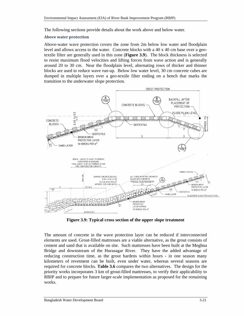
Environmental Impact Assessment (EIA) of River Bank Improvement Program (RBIP)
Bangladesh Water Development Board 3-21
The following sections provide details about the work above and below water.
Abovewaterprotection
Above-water wave protection covers the zone from 2m below low water and floodplain level and allows access to the water. Concrete blocks with a 40 x 40 cm base over a geo-textile filter are generally used in this zone (Figure 3.9). The block thickness is selected to resist maximum flood velocities and lifting forces from wave action and is generally around 20 to 30 cm. Near the floodplain level, alternating rows of thicker and thinner blocks are used to reduce wave run-up. Below low water level, 30 cm concrete cubes are dumped in multiple layers over a geo-textile filter ending on a bench that marks the transition to the underwater slope protection.
Figure 3.9: Typical cross section of the upper slope treatment
The amount of concrete in the wave protection layer can be reduced if interconnected elements are used. Grout-filled mattresses are a viable alternative, as the grout consists of cement and sand that is available on site. Such mattresses have been built at the Meghna Bridge and downstream of the Hurasagar River. They have the added advantage of reducing construction time, as the grout hardens within hours - in one season many kilometers of revetment can be built, even under water, whereas several seasons are required for concrete blocks. Table 3.6 compares the two alternatives. The design for the priority works incorporates 3 km of grout-filled mattresses, to verify their applicability to RBIP and to prepare for future larger-scale implementation as proposed for the remaining works.
Environmental Impact Assessment (EIA) of River Bank Improvement Program (RBIP)
Bangladesh Water Development Board 3-22
Table 3.6: Comparison of cover layer alternatives above low water level
Concrete blocks Grout filled mattress
Construction Large casting yards on the floodplain,
added traffic for supplying the materials from far distance,
preparation one year ahead of placement,
sensitive to water level rises depending on manual labor for
transport and placement
Very fast in one season and one construction sequence starting under water and moving up the slope,
Reduced transport of materials as mostly dependent on river sand
Batching plant and transport mixers reduce local labor force
Performance Robust, proven all over Bangladesh,
Low value and low risk of theft Risk of damages from anchors
Experience at two locations since the end of the 1990s and 2006 without major issues,
low value and low risk of theft some types are sensitive to
localized damages from anchors
UnderwaterSlopeProtection
Two problems with riverbank protection in Bangladesh are difficult to overcome:
The highly dynamic river morphology can result in large river changes between the low-flow dry season when construction is feasible and the flood season when it is inhibited by high discharges, velocities, and sediment transport rates.
Bangladesh has no rock quarries, except for one granite mine that can provide only limited quantities of smaller crushed rock largely unsuitable for riverbank protection.
Given the lack of rock and the good experience with initial geo-bag placements, the selected underwater slope protection design for RBIP consists of four layers of systematically dumped sand-filled geo-bags. Geo-bags of 250 kg weight will be used for standard revetment sections, with greater weights for strengthening of existing protruding structures such as spurs. The bags are placed by systematic dumping from barges precisely positioned in the river, to cover the underwater slope from the inner edge of the apron to the riverbank.
UnderwaterToeProtectionwithAprons
Riverbank protection in these highly mobile rivers depends on self-launching toe aprons that can respond flexibly to river-bed deepening by scour. The method was developed in the subcontinent in the late 19th century and was first applied to protect the piers of railway bridges against local scour. Due to lack of underwater observations, aprons were wrongly believed to produce multiple-layer coverage after launching, but when they were investigated in physical models after failure of a guide bund at Harding Bridge in the 1930s, it was found that only single-layer coverage resulted. This was confirmed after 2000 by diving observations and physical model tests in The Netherlands, Canada, and Bangladesh associated with the Jamuna Bridge, JMREMP, and Padma Bridge projects.
Recent experience demonstrates that flexible geo-bags incorporating filter properties perform better than hard materials for underwater bank protection in Bangladesh river conditions. Four main milestones in their development were as follows:

Environmental Impact Assessment (EIA) of River Bank Improvement Program (RBIP)
Bangladesh Water Development Board 3-23
After the 1988 flood, the World Bank-supported Flood Damage Restoration Project placed sand-filled geo-bags of around 900 kg weight as filter material under large concrete blocks for Chandpur Town Projection Works. This installation has performed well to date.
In 1996, the Flood Action Plan, Component 21, built a revetment test section incorporating sand-filled geo-bags as apron material. This protection still performs well.
After an upstream failure in 1998, the World Bank-financed Sirajganj Town Protection was repaired with a wide apron consisting of three sizes of sand-filled geo-bags, termed cushions (20 kg), pillows (250 kg), and mattresses (900 kg). Although Sirajganj Town Protection continues to fail along downstream areas protected solely by concrete block or rock aprons, the areas with geo-bag aprons have remained stable. This is one of the most turbulent areas in the Bangladesh rivers, due to prominent protrusion of the upstream corner of the Town Protection.
In the JMREMP project, falling aprons consisting of multiple layers of geo-bags were placed along 17 km of riverbanks in the lower Jamuna. The observed underwater slopes have inclinations of 1V:2H and are geo-technically stable.
Over the last decade, it has been found that three levels of safety can be achieved with increasingly larger footprints:
Emergency protection dumped from the riverbank: This is widely applied to provide protection for one flood season. After the first flood it is usually upgraded to the next level.
Above- and underwater slope protection: The methodology was developed under JMREMP in 2004 and later expanded under the Secondary Town Protection Project. Systematic coverage of the slope, secured by an apron, keeps deep toe scour far enough from the bankline and does not destabilize the slope. More recent studies for Padma Bridge showed that to cope with rare earthquake loading and associated flow slides, the apron needs to be widened to ensure that flat slopes following flow slides do not penetrate into the upper slope.
Dredged slopes to levels near design scour levels: The highest level of safety can be achieved through flat dredged slopes that are stable when subjected to design earthquakes. However, this expensive work has limited stability because the fine non-cohesive soils of Bangladesh liquefy easily at earthquake intensities corresponding to a 50- to 100-year return period. Nevertheless, these flat man-made slopes provide a higher level of safety than the usual natural slopes of the riverbanks. There seem to be no practical ways to improve the stability of riverbanks subject to increased earthquake loads.
Riverbank protection designs for the RBIP are made with a wide apron to account for larger earthquake and potential flow slides during the lifetime.
3.4. ResourcesRequirements
3.4.1. MaterialRequirementsandtheirSources
The construction materials required for embankment, road, river bank revetment, and other project components will include earth, geo-bags, hard rock, sand, geo-textile, stone-chips, brick chips, asphalt, cement, steel for concrete reinforcement, road furniture, and
Environmental Impact Assessment (EIA) of River Bank Improvement Program (RBIP)
Bangladesh Water Development Board 3-24
other accessories. Some of these materials will be obtained from within the project influence area: sand from the river bank and earth from the existing embankment. Other materials such as cement, steel, and brick chips will be procured from local/national markets, whereas some of the materials such as hard rock and asphalt may have to be imported. See Table 3.7 for the key construction materials and their approximate quantities needed for the first phase of RBIP (priority reach). The quantities of construction materials required for the subsequent phases will be determined during the detailed design of those works.
Table 3.7: Construction Materials
Description Approximate Quantity Source
Embankment
1 Sand 12 million m3 River
2 Clay 24,000 m3 Existing land of proposed alignment, old embankment
3 Brick chips 80,000 m3 Local supply
4 Concrete blocks 17,000 m3 Constructed at site
5 Stone Chips 180,000 m3 Local Supply
6 Geo-textile (3mm thick) 55,600 m2 Imported/Local Supply
New River bank Protection
1 CC blocks (Slope protection) 58,000 m3 Constructed at site
2 CC blocks (underwater) 1,064,700 m3 Constructed at site
3 Geo-bags (250kg and 800 kg) 3,285,336 Imported/Local Supply
4 Geo-textile 156,000 m2 Imported/Local Supply
5 Sand 5 million m3 River
Up grading existing protective work
1 CC block 960,000 m3 Constructed at site
2 Geo-textile (3mm thick) 402,000 m3 Imported/Local Supply
3 Sand 6 million m3 Local Supply
Structures
1 Cement 900 ton Local supply
2 Sand 1,440 m3 River
3 Stone chips 7500 m3 Local supply
Steel 500 ton Local supply
3.4.2. ManpowerRequirements
During the construction phase, technical and non-technical man power will be required in sizeable numbers. These will include engineers, technicians, supervisors, surveyors, mechanics, foremen, machinery operators, drivers and skilled and unskilled labor (see Table 3.8. Local community will be able to avail some employment opportunities during this phase.
Environmental Impact Assessment (EIA) of River Bank Improvement Program (RBIP)
Bangladesh Water Development Board 3-25
Table 3.8: Required Manpower during Construction
Category Persons (Approximate)
Engineer 15
Machinery Operators 40
Mechanics 4
Surveyors 8
Skilled Laborers 50
Un-skilled Laborers 150
During the O&M phase, the regular staff of the BWDB will carry out the monitoring, repair, and maintenance works.
3.4.3. ConstructionMachinery
A sizeable number of construction machinery and equipment would be needed for the construction activities of RBIP. A tentative list of these machinery and equipment is presented below (Table 3.9).
Table 3.9: List of Construction Equipment and Machinery
1 Bulldozers
2 Dump‐trucks
3 Pay loaders
4 Excavators
5 Barges
6 Engine Boats
7 Vibrators
8 Compactors
9 Mixture Machines
10 Mixing Plants
11 Trucks
12 Tractors
13 Generators
14 Total stations
15 De‐watering systems
16 Water‐pumps including suction pumps
Environmental Impact Assessment (EIA) of River Bank Improvement Program (RBIP)
Bangladesh Water Development Board 3-26
3.4.4. ConstructionCamps
Construction camps for each construction site are to be established by the contractor. The contractor will select the location of the camp through consultation with the local union parishad chairman and the local community. Moreover, they will have to obtain permission from the authorized BWDB representative. Tube wells may be installed in the labor camps premises for obtaining water for drinking and other purposes. For sanitation, latrines will be constructed along with septic tanks for safe disposal of sewage.
Location of these camps is not known at this stage however the key criteria to be used while selecting the sites are listed below.
Community consultations will be carried out to select the camp sites
Cultivation fields will be avoided as far as possible
Government-owned lands will be given priority while selecting the camp sites
If private land is used for camp sites, a fair rent will be paid to the land owner.
Camps will not be establishes near sensitive receptors such as schools
Camps will not be established near any sensitive habitat
Camps will not be established that could affect any khal, beel or river.
Camp sites will be approved by construction supervision consultants.
3.5. OperationalandMaintenanceRequirements
The BWDB receives fund from the government under the annual development program (ADP) for operation and maintenance of its infrastructure under different projects. Records indicate that the BWDB has been receiving on average about 17 percent of the total requirement for O&M, which reveals that the BWDB could not respond to all maintenance needs. For attaining sustainable maintenance of multipurpose project like proposed RBIP, the allocation for O&M in the ADP to be adequate as per actual need or there need to find a way to involve the beneficiaries directly in contributing to O&M. In RBIP, provision for toll collection from the highway can recover a good part of the maintenance cost of the project. It may be noted here that funds available for maintenance are often less than optimal, so it is important to make the best use of available funds and estimates of O&M components should be well supported by appropriate justification.
O&M works of proposed RBIP can be divided into three categories described below.
(a) Routine Maintenance: Routine maintenance includes preventative activities such as repair of small holes and rain cuts in embankments, removal of weeds and sediments from approach canal of regulators, repair of displaced blocks if any in the slope of the bank revetment work, petty repair of the pavement and a forestation of highway. The objective of routine maintenance is to keep overall flood protection system including all its elements in good functional order thereby reducing the need of periodic maintenance eventually avoiding high rehabilitation costs. The works are simple, generally inexpensive and cost effective and may need to be carried out round the year, almost continuously or as and when required.
(b) Periodic Maintenance: This is less frequent than routine maintenance and is likely to include re-sectioning of embankment, re-excavation of approach canal of regulators, rehabilitation of gates and gate lifting devices of regulators, repair of sliding of bank
Environmental Impact Assessment (EIA) of River Bank Improvement Program (RBIP)
Bangladesh Water Development Board 3-27
protection work, and maintenance of highway pavement after rainy season. BWDB engineering personnel will identify periodic maintenance works during surveys and inspections or on information from its field staffs.
(c) Emergency Maintenance: This type of maintenance is similar to periodic maintenance, but involves a potentially catastrophic situation that would likely cause significant damage to the infrastructure if not repaired immediately. Emergency maintenance may include breach closure in embankment, repair of major sliding of bank revetment work which if not taken care on emergency basis may cause further damage of the adjacent bank revetment work, arresting of unintentional erosion upstream and downstream of the existing bank revetment work, and repair of loose apron of the regulators. A component of the BWDB O&M budget should be set aside for natural or human caused calamities. Necessary funding and authorization to execute emergency maintenance should be readily available whenever required.
3.5.1. O&MRequirementofBankprotectionstructures
Bank revetment work is a major component of the project. The life and security of the project largely depend on the performance of the erosion protection works. It has been observed that inadequate monitoring of the completed work and lack of proper O&M activities due to limited funding provisions cause greater damage to the bank protection. Hence regular monitoring and proper O&M activities of bank protection work must be ensured to keep the project functional. O&M of new river bank protection as well as upgrading existing protection will be required to keep the work sustainable. Based on the Flood Plan Coordination Organization (FPCO) guidelines of May 1992, annual O&M cost for the proposed river bank protection should be around ten percent of the capital cost.
3.5.2. O&MRequirementsofEmbankmentcumRoad
Maintenance of embankment cum road is another most important item of activities of the project. It is necessary and cannot be avoided because it helps preserving the infrastructure in good and functional condition, protects investments and prevents high rehabilitation costs. BWDB O&M staffs will regularly visit the embankment cum road and detect the weak sections, gullies, slips, sign of squatter settlements, cultivation of perennial cash crops, cuts in the embankments to accommodate homesteads, embankment subsidence and erosion and requirement of repair maintenance work in the road pavement etc. Based on the above observations O&M estimate will be prepared for execution. As per FPCO guidelines the annual O&M cost of this component is five to six percent of the capital cost.
3.5.3. O&MRequirementsofRegulators
The proposed regulators would be subjected to variable flows, the most severe of which are likely to occur during high Jamuna stages. Therefore, it is essential that regular inspections take place, so that any damage or any irregularities will be noticed within reasonable time. Measures for rectification can then be taken, so that the damage will be contained. FPCO guidelines suggest to keep three percent of the capital cost as annual O&M cost for this component.
3.6. ProjectCosts
Initial cost estimates of the RBIP, Phase I are presented in Tables 3.10.
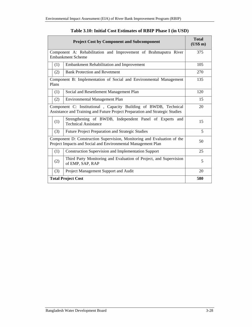
Environmental Impact Assessment (EIA) of River Bank Improvement Program (RBIP)
Bangladesh Water Development Board 3-28
Table 3.10: Initial Cost Estimates of RBIP Phase I (in USD)
Project Cost by Component and Subcomponent Total
(US$ m)
Component A: Rehabilitation and Improvement of Brahmaputra River Embankment Scheme
375
(1) Embankment Rehabilitation and Improvement 105
(2) Bank Protection and Revetment 270
Component B: Implementation of Social and Environmental Management Plans
135
(1) Social and Resettlement Management Plan 120
(2) Environmental Management Plan 15
Component C: Institutional , Capacity Building of BWDB, Technical Assistance and Training and Future Project Preparation and Strategic Studies
20
(1) Strengthening of BWDB, Independent Panel of Experts and Technical Assistance
15
(3) Future Project Preparation and Strategic Studies 5
Component D: Construction Supervision, Monitoring and Evaluation of the Project Impacts and Social and Environmental Management Plan
50
(1) Construction Supervision and Implementation Support 25
(2)
Third Party Monitoring and Evaluation of Project, and Supervision of EMP, SAP, RAP
5
(3) Project Management Support and Audit 20
Total Project Cost 580
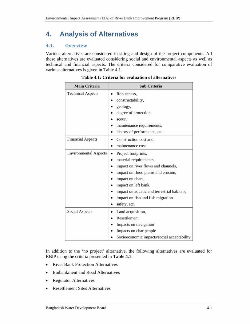
Environmental Impact Assessment (EIA) of River Bank Improvement Program (RBIP)
Bangladesh Water Development Board 4-1
4. Analysis of Alternatives
4.1. Overview
Various alternatives are considered in siting and design of the project components. All these alternatives are evaluated considering social and environmental aspects as well as technical and financial aspects. The criteria considered for comparative evaluation of various alternatives is given in Table 4.1.
Table 4.1: Criteria for evaluation of alternatives
Main Criteria Sub Criteria
Technical Aspects Robustness,
constructability,
geology,
degree of protection,
scour,
maintenance requirements,
history of performance, etc.
Financial Aspects Construction cost and
maintenance cost
Environmental Aspects Project footprints,
material requirements,
impact on river flows and channels,
impact on flood plains and erosion,
impact on chars,
impact on left bank,
impact on aquatic and terrestrial habitats,
impact on fish and fish migration
safety, etc.
Social Aspects Land acquisition,
Resettlement
Impacts on navigation
Impacts on char people
Socioeconomic impacts/social acceptability
In addition to the ‘no project’ alternative, the following alternatives are evaluated for RBIP using the criteria presented in Table 4.1:
River Bank Protection Alternatives
Embankment and Road Alternatives
Regulator Alternatives
Resettlement Sites Alternatives
Environmental Impact Assessment (EIA) of River Bank Improvement Program (RBIP)
Bangladesh Water Development Board 4-2
4.2. NoProjectAlternative
4.2.1. RetirementofBREandFailureofBankProtectionStructures
Prior to the construction of BRE, over bank spills along the 220 km stretch of the right bank of the Brahmaputra/Jamuna river used to cause flooding on an area of about 240,000 ha. In early 1960s, the BRE was built to protect from this flooding problem and to foster agricultural growth in the project influence area. The original BRE had a setback of about 1.50 km from the Brahmaputra's right bank. In the 1970s, the embankment started to fall under sporadic erosion attacks. During 1980s, the frequency of BRE breaches by erosion increased rapidly as longer sections came within the range of rapidly eroding river bends which would cause bank line erosion rates of several hundred meters per year in the early stage of bend formation. To prevent flooding, these breaches were typically closed by local retirements at about 200 m set-backs. As a result of this minimal set-back distance the BRE has been retired several times in many places.
Subsequently based on the studies carried out under Flood Action Plan (FAP), different types of structures like revetment, hard points, groynes and spurs etc. were constructed at different locations on Brahmaputra right bank for stabilizing the river bank in the critically eroding reaches. But it was observed that those structures experienced considerable damage due to repeated undermining by scour. The main problems were associated with the deep scour due to outflanking and geotechnical stability problems associated with the launched slopes. Ultimately the concept of hard point, groyne, and spur had to be abandoned by BWDB gradually due to a number of failures, not only in Jamuna river but also in Ganges and Teesta river. Latter on BWDB developed and implemented low cost revetments for longer reach (Kalitola to Mathurapara) and this has been observed the preferred approach until today. But this approach could not be implemented in all the erosion prone locations of BRE due to non availability of GOB fund or any approved donor project. At present perhaps only 41 km of the original BRE has remained in place upstream of Jamuna bridge. Currently, many long stretches of BRE are very close to the river bank line. Hence when embankment is breached at many places it is often left open as closing of such breach is becoming impossible. Consequently, security of the area protected by the BRE has been seriously threatened and large areas of land and Cities with large population like Sirajganj are exposed to flooding.
The priority reach is experiencing severe bank erosion on an annual basis threatening productive land and private and public physical assets on the river-side of the embankment. The dilapidated embankments breach occasionally, due to these bank erosion, causing severe floods in the floodplain. Damages from this phenomenon are explained in the following sections.
4.2.2. DamagesfromJamunaRightBankErosion
A morphological model has been developed by the design consultant to study the historical trends in morphological changes of Jamuna and its floodplain erosion, and to predict the future river bank erosion for next 30 years. The erosion of floodplains will in turn affect the agriculture land, residential and community structures. Detailed estimate on the projected annual damages is given in Table 4.2 and the annual cost of these losses are estimated to be about BDT 1.36 billion (US$ 18.3 million) in 2015 prices. This would be the value of damages in the no project scenario.
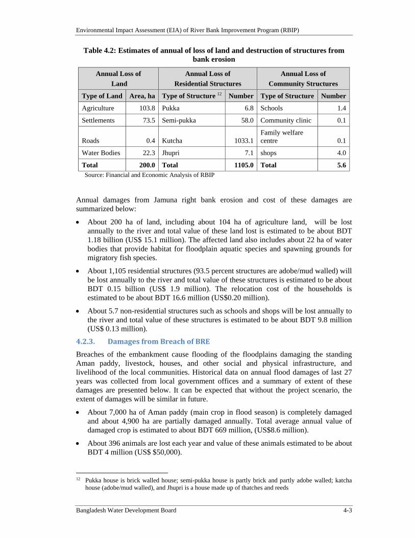
Environmental Impact Assessment (EIA) of River Bank Improvement Program (RBIP)
Bangladesh Water Development Board 4-3
Table 4.2: Estimates of annual of loss of land and destruction of structures from bank erosion
Annual Loss of
Land
Annual Loss of
Residential Structures
Annual Loss of
Community Structures
Type of Land Area, ha Type of Structure 12 Number Type of Structure Number
Agriculture 103.8 Pukka 6.8 Schools 1.4
Settlements 73.5 Semi-pukka 58.0 Community clinic 0.1
Roads 0.4 Kutcha 1033.1Family welfare centre 0.1
Water Bodies 22.3 Jhupri 7.1 shops 4.0
Total 200.0 Total 1105.0 Total 5.6Source: Financial and Economic Analysis of RBIP
Annual damages from Jamuna right bank erosion and cost of these damages are summarized below:
About 200 ha of land, including about 104 ha of agriculture land, will be lost annually to the river and total value of these land lost is estimated to be about BDT 1.18 billion (US$ 15.1 million). The affected land also includes about 22 ha of water bodies that provide habitat for floodplain aquatic species and spawning grounds for migratory fish species.
About 1,105 residential structures (93.5 percent structures are adobe/mud walled) will be lost annually to the river and total value of these structures is estimated to be about BDT 0.15 billion (US$ 1.9 million). The relocation cost of the households is estimated to be about BDT 16.6 million (US$0.20 million).
About 5.7 non-residential structures such as schools and shops will be lost annually to the river and total value of these structures is estimated to be about BDT 9.8 million (US$ 0.13 million).
4.2.3. DamagesfromBreachofBRE
Breaches of the embankment cause flooding of the floodplains damaging the standing Aman paddy, livestock, houses, and other social and physical infrastructure, and livelihood of the local communities. Historical data on annual flood damages of last 27 years was collected from local government offices and a summary of extent of these damages are presented below. It can be expected that without the project scenario, the extent of damages will be similar in future.
About 7,000 ha of Aman paddy (main crop in flood season) is completely damaged and about 4,900 ha are partially damaged annually. Total average annual value of damaged crop is estimated to about BDT 669 million, (US$8.6 million).
About 396 animals are lost each year and value of these animals estimated to be about BDT 4 million (US$ $50,000).
12 Pukka house is brick walled house; semi-pukka house is partly brick and partly adobe walled; katcha
house (adobe/mud walled), and Jhupri is a house made up of thatches and reeds
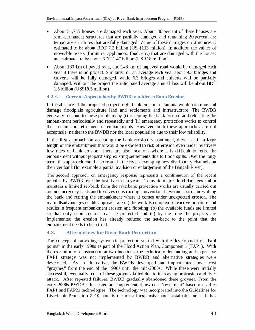
Environmental Impact Assessment (EIA) of River Bank Improvement Program (RBIP)
Bangladesh Water Development Board 4-4
About 51,735 houses are damaged each year. About 80 percent of these houses are semi-permanent structures that are partially damaged and remaining 20 percent are temporary structures that are fully damaged. Value of these damages on structures is estimated to be about BDT 7.2 billion (US $113 million). In addition the values of moveable assets (furniture, appliances, food, etc.) that are damaged with the houses are estimated to be about BDT 1.47 billion (US $18 million).
About 130 km of paved road, and 148 km of unpaved road would be damaged each year if there is no project. Similarly, on an average each year about 9.3 bridges and culverts will be fully damaged, while 6.3 bridges and culverts will be partially damaged. Without the project the anticipated average annual loss will be about BDT 1.5 billion (US$19.5 million).
4.2.4. CurrentApproachesbyBWDBtoaddressBankErosion
In the absence of the proposed project, right bank erosion of Jamuna would continue and damage floodplain agriculture land and settlements and infrastructure. The BWDB generally respond to these problems by (i) accepting the bank erosion and relocating the embankment periodically and repeatedly and (ii) emergency protection works to control the erosion and retirement of embankments. However, both these approaches are not acceptable, neither to the BWDB nor the local population due to their low reliability.
If the first approach on accepting the bank erosion is continued, there is still a large length of the embankment that would be exposed to risk of erosion even under relatively low rates of bank erosion. There are also locations where it is difficult to retire the embankment without jeopardizing existing settlements due to flood spills. Over the long-term, this approach could also result in the river developing new distributary channels on the river bank (for example a partial avulsion or enlargement of the Bangali River).
The second approach on emergency response represents a continuation of the recent practice by BWDB over the last five to ten years: To avoid major flood damages and to maintain a limited set-back from the riverbank protection works are usually carried out on an emergency basis and involves constructing conventional revetment structures along the bank and retiring the embankment where it comes under unexpected erosion. The main disadvantages of this approach are (a) the work is completely reactive in nature and results in frequent embankment erosion and flooding; (b) the available funds are limited so that only short sections can be protected and (c) by the time the projects are implemented the erosion has already reduced the set-back to the point that the embankment needs to be retired.
4.3. AlternativesforRiverBankProtection
The concept of providing systematic protection started with the development of “hard points” in the early 1990s as part of the Flood Action Plan, Component 1 (FAP1). With the exception of construction at two locations, the technically demanding and expensive FAP1 strategy was not implemented by BWDB and alternative strategies were developed. As an alternative, the BWDB developed and implemented lower cost “groynes” from the end of the 1990s until the mid-2000s. While these were initially successful, eventually most of these groynes failed due to increasing protrusion and river attack. After repeated failures, BWDB gradually abandoned these groynes. From the early 2000s BWDB pilot-tested and implemented low-cost “revetment” based on earlier FAP1 and FAP21 technologies. The technology was incorporated into the Guidelines for Riverbank Protection 2010, and is the most inexpensive and sustainable one. It has
Environmental Impact Assessment (EIA) of River Bank Improvement Program (RBIP)
Bangladesh Water Development Board 4-5
proven stable along 17km of riverbanks in the Brahmaputra/Jamuna. These long-guiding revetments are systematically replacing the other options when those fail. These three options are considered for analysis of alternatives. In addition, one more alternative of building revetments in to the river is also considered. A brief description of these alternatives is presented below and the comparative analysis is presented in Table 4.3.
Option 1: Hard Points. One of the alternatives for riverbank protection is constructing the hard points as recommended in the FAP-1. Hard-points only place erosion-resistant revetments at discrete locations spaced some distance between them. The hard points are generally located at the bankline following the original design concept, however a few need to protrude further from the bank to maintain reasonable flow lines along the bank. A layout of hard points is shown in Figure 4.1. The required length of hard points is 2.5 km for the priority reach.
Option 2: Long guiding revetments. Option 2 follows BWDB’s more recent approach to stabilizing the riverbanks by building long guiding revetments covering several kilometers of riverbank and as such stabilizing the bankline channel leading to parallel flow along the riverbank. BWDB has built around 30km of long guiding revetments during the last 10 years, which consist of sand-filled geo-textile bags, similar to the apron work built in Sirajganj in 1999, and which are constructed from the river through systematic placement. This construction method and a flexible response to riverbank erosion (“adaptive approach”) have made riverbank protection works sustainable to an extent not achieved before. A layout of revetments is shown in Figure 4.2. The proposed revetment builds on existing and BWDB approved works along the right bank, and will maintain a setback of generally 400 m to the embankment. The total length of new revetment is 15.6 km over the 50 km Priority Reach.
Option 3: Long guiding revetments built into the river. Option 3 was suggested by World Bank with the rationale to reduce the resettlement impact by building an additional strip of land in front of the existing riverbank where a newly constructed embankment would be located. This construction into the river does minimize the amount of resettlement. The technical approach would consist of the filling of an on average 280m wide strip of land along the existing riverbank and into the main channel, compaction of the loose fill, dredging and protection of the riverbank against riverbank erosion, and construction of the embankment on the fill with a safety margin of 50m from the riverbank. The result would be a perfectly shaped, man-made riverbank, protected against erosion. Despite the avoidance of resettlement, the land acquisition cost would be incurred as part of the program cost, as BWDB would have to pay the landowners for the whole swath of newly established land.
Option 4: Groynes and Spur. A spur may be defined as any solid projection from the river bank into running water. Figure 4.3 shows the layout of a groyne. The end of the groynes is generally located at the bankline, although a few will protrude further from the bank to maintain reasonable flow lines along the bank.
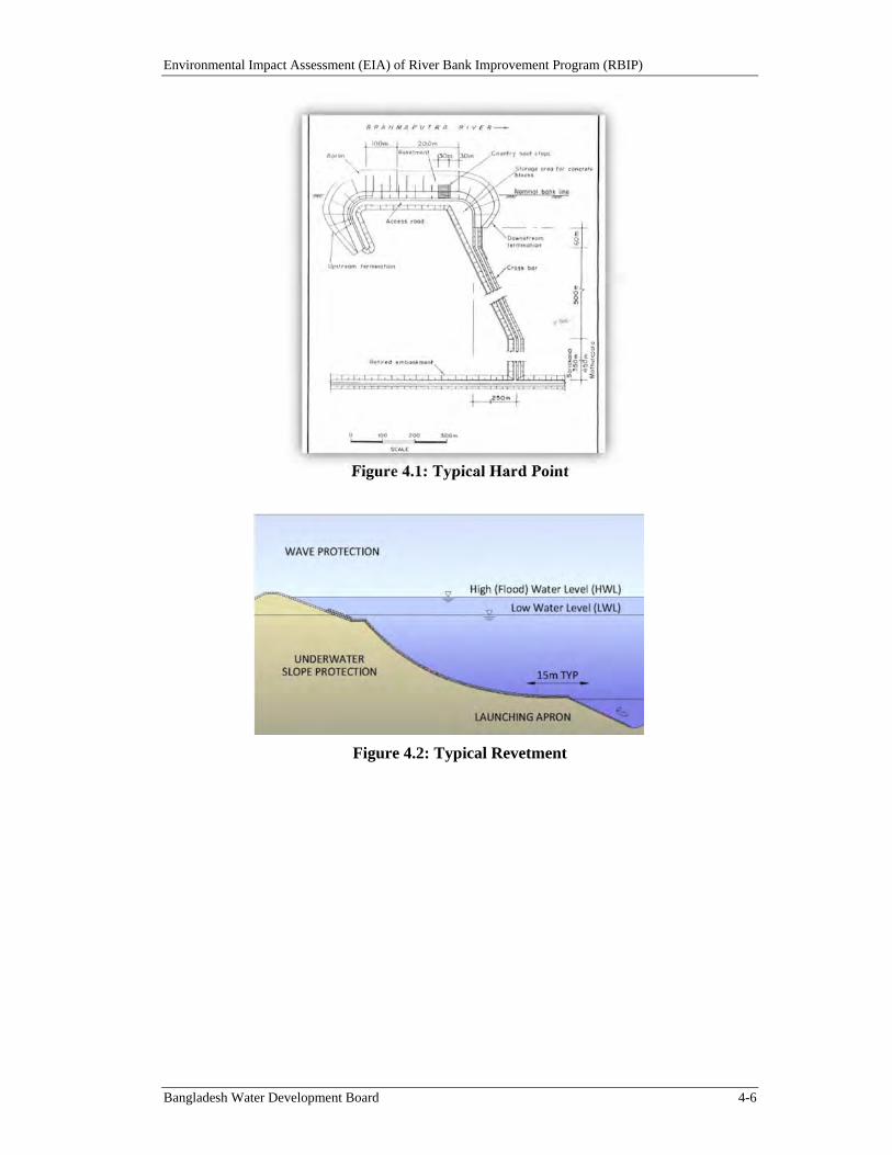
Environmental Impact Assessment (EIA) of River Bank Improvement Program (RBIP)
Bangladesh Water Development Board 4-6
Figure 4.1: Typical Hard Point
Figure 4.2: Typical Revetment
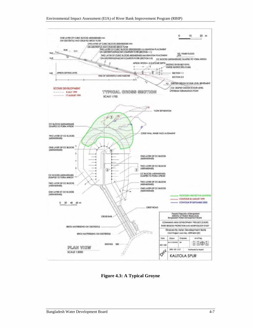
Environmental Impact Assessment (EIA) of River Bank Improvement Program (RBIP)
Bangladesh Water Development Board 4-7
Figure 4.3: A Typical Groyne
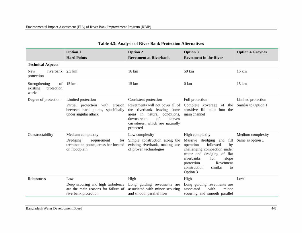
Environmental Impact Assessment (EIA) of River Bank Improvement Program (RBIP)
Bangladesh Water Development Board 4-8
Table 4.3: Analysis of River Bank Protection Alternatives
Option 1
Hard Points
Option 2
Revetment at Riverbank
Option 3
Revetment in the River
Option 4 Groynes
Technical Aspects
New riverbank protection
2.5 km 16 km
50 km
15 km
Strengthening of existing protection works
15 km 15 km 0 km 15 km
Degree of protection Limited protection
Partial protection with erosion between hard points, specifically under angular attack
Consistent protection
Revetments will not cover all of the riverbank leaving some areas in natural conditions, downstream of convex curvatures, which are naturally protected
Full protection
Complete coverage of the sensitive fill built into the main channel
Limited protection
Similar to Option 1
Constructability Medium complexity
Dredging requirement for termination points, cross bar located on floodplain
Low complexity
Simple construction along the existing riverbank, making use of proven technologies
High complexity
Massive dredging and fill operation followed by challenging compaction under water and dredging of flat riverbanks for slope protection. Revetment construction similar to Option 3
Medium complexity
Same as option 1
Robustness Low
Deep scouring and high turbulence are the main reasons for failure of riverbank protection
High
Long guiding revetments are associated with minor scouring and smooth parallel flow
High
Long guiding revetments are associated with minor scouring and smooth parallel
Low
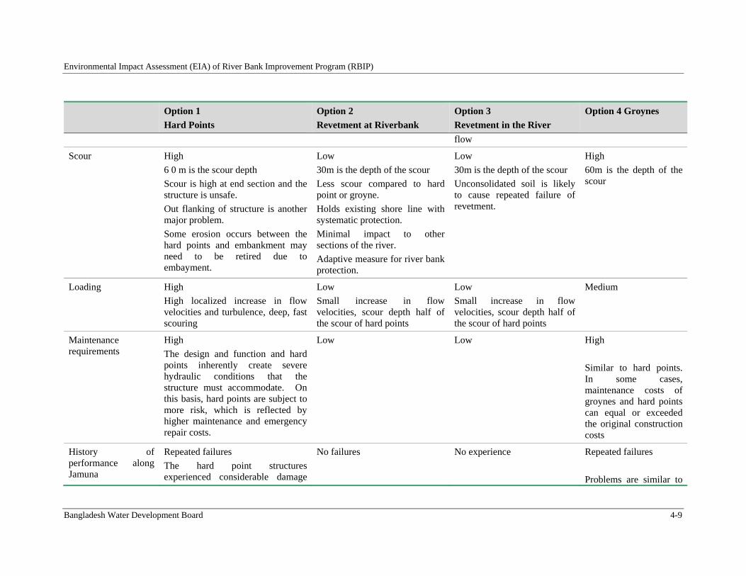
Environmental Impact Assessment (EIA) of River Bank Improvement Program (RBIP)
Bangladesh Water Development Board 4-9
Option 1
Hard Points
Option 2
Revetment at Riverbank
Option 3
Revetment in the River
Option 4 Groynes
flow
Scour High
6 0 m is the scour depth
Scour is high at end section and the structure is unsafe.
Out flanking of structure is another major problem.
Some erosion occurs between the hard points and embankment may need to be retired due to embayment.
Low
30m is the depth of the scour
Less scour compared to hard point or groyne.
Holds existing shore line with systematic protection.
Minimal impact to other sections of the river.
Adaptive measure for river bank protection.
Low
30m is the depth of the scour
Unconsolidated soil is likely to cause repeated failure of revetment.
High
60m is the depth of the scour
Loading High
High localized increase in flow velocities and turbulence, deep, fast scouring
Low
Small increase in flow velocities, scour depth half of the scour of hard points
Low
Small increase in flow velocities, scour depth half of the scour of hard points
Medium
Maintenance requirements
High
The design and function and hard points inherently create severe hydraulic conditions that the structure must accommodate. On this basis, hard points are subject to more risk, which is reflected by higher maintenance and emergency repair costs.
Low Low High
Similar to hard points. In some cases, maintenance costs of groynes and hard points can equal or exceeded the original construction costs
History of performance along Jamuna
Repeated failures
The hard point structures experienced considerable damage
No failures
No experience Repeated failures
Problems are similar to
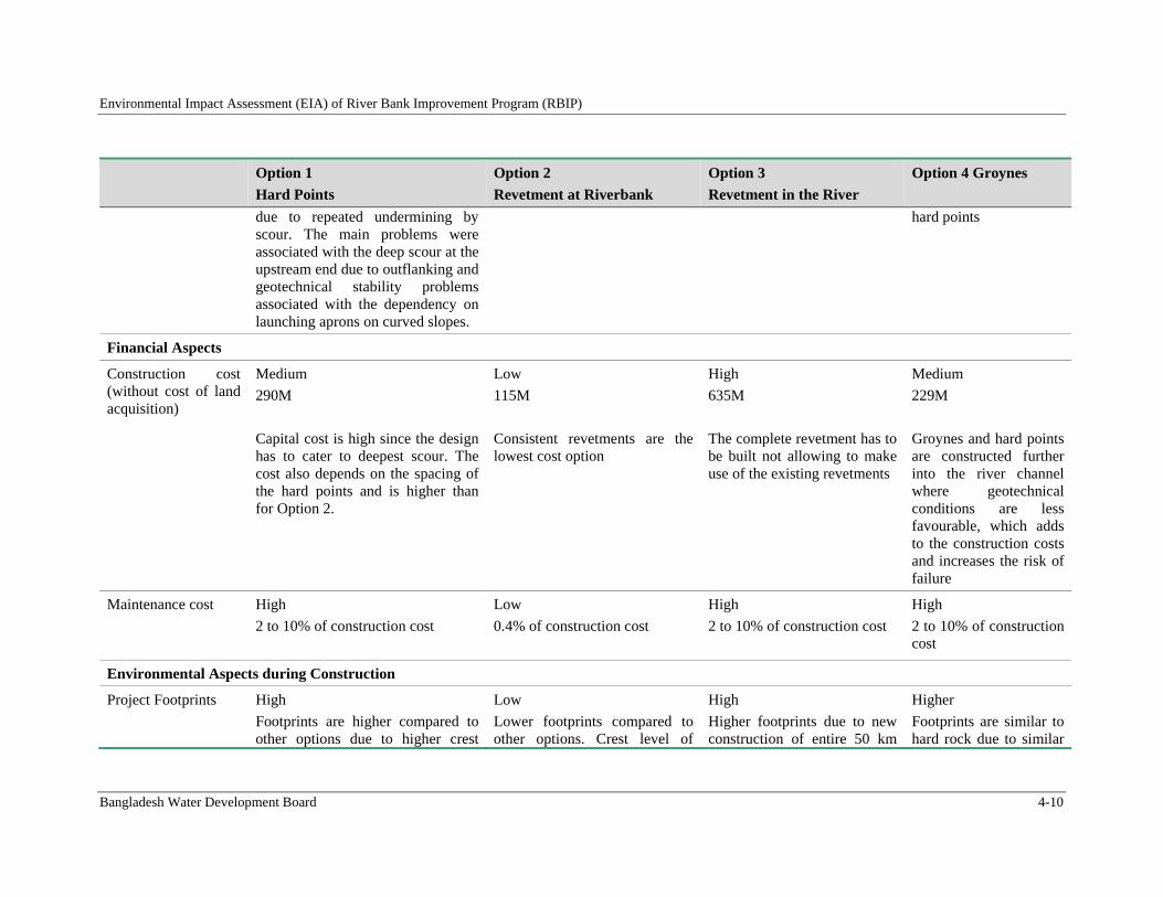
Environmental Impact Assessment (EIA) of River Bank Improvement Program (RBIP)
Bangladesh Water Development Board 4-10
Option 1
Hard Points
Option 2
Revetment at Riverbank
Option 3
Revetment in the River
Option 4 Groynes
due to repeated undermining by scour. The main problems were associated with the deep scour at the upstream end due to outflanking and geotechnical stability problems associated with the dependency on launching aprons on curved slopes.
hard points
Financial Aspects
Construction cost (without cost of land acquisition)
Medium
290M
Capital cost is high since the design has to cater to deepest scour. The cost also depends on the spacing of the hard points and is higher than for Option 2.
Low
115M
Consistent revetments are the lowest cost option
High
635M
The complete revetment has to be built not allowing to make use of the existing revetments
Medium
229M
Groynes and hard points are constructed further into the river channel where geotechnical conditions are less favourable, which adds to the construction costs and increases the risk of failure
Maintenance cost High
2 to 10% of construction cost
Low
0.4% of construction cost
High
2 to 10% of construction cost
High
2 to 10% of construction cost
Environmental Aspects during Construction
Project Footprints High
Footprints are higher compared to other options due to higher crest
Low
Lower footprints compared to other options. Crest level of
High
Higher footprints due to new construction of entire 50 km
Higher
Footprints are similar to hard rock due to similar
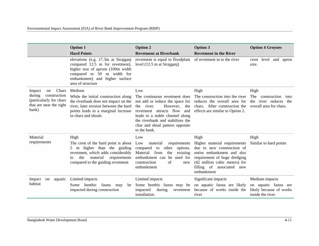
Environmental Impact Assessment (EIA) of River Bank Improvement Program (RBIP)
Bangladesh Water Development Board 4-11
Option 1
Hard Points
Option 2
Revetment at Riverbank
Option 3
Revetment in the River
Option 4 Groynes
elevations (e.g. 17.3m at Sirajganj compared 12.5 m for revetment), higher size of aprons (100m width compared to 50 m width for embankment) and higher surface area of structure
revetment is equal to floodplain level (12.5 m at Sirajganj)
of revetment in to the river crest level and apron size.
Impact on Chars during construction (particularly for chars that are near the right bank)
Medium
While the initial construction along the riverbank does not impact on the river, later erosion between the hard points leads to a marginal increase in chars and shoals
Low
The continuous revetment does not add or reduce the space for the river. However, the revetment attracts flow and leads to a stable channel along the riverbank and stabilizes the char and shoal pattern opposite to the bank.
High
The construction into the river reduces the overall area for chars. After construction the effects are similar to Option 2.
High
The construction into the river reduces the overall area for chars.
Material requirements
High
The crest of the hard point is about 5 m higher than the guiding revetment, which adds considerably to the material requirements compared to the guiding revetment
Low
Low material requirements compared to other options. Material from the existing embankment can be used for construction of new embankment
High
Higher material requirements due to new construction of entire embankment and also requirement of huge dredging (42 million cubic meters) for filling of associated new embankment
High
Similar to hard points
Impact on aquatic habitat
Limited impacts
Some benthic fauna may be impacted during construction
Limited impacts
Some benthic fauna may be impacted during revetment installation.
Significant impacts
on aquatic fauna are likely because of works inside the river
Medium impacts
on aquatic fauna are likely because of works inside the river
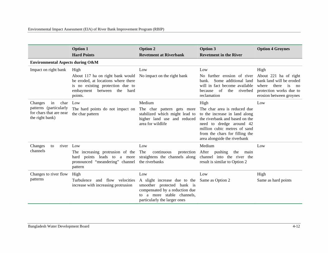
Environmental Impact Assessment (EIA) of River Bank Improvement Program (RBIP)
Bangladesh Water Development Board 4-12
Option 1
Hard Points
Option 2
Revetment at Riverbank
Option 3
Revetment in the River
Option 4 Groynes
Environmental Aspects during O&M
Impact on right bank High
About 117 ha on right bank would be eroded, at locations where there is no existing protection due to embayment between the hard points.
Low
No impact on the right bank
Low
No further erosion of river bank. Some additional land will in fact become available because of the riverbed reclamation
High
About 221 ha of right bank land will be eroded where there is no protection works due to erosion between groynes
Changes in char patterns (particularly for chars that are near the right bank)
Low
The hard points do not impact on the char pattern
Medium
The char pattern gets more stabilized which might lead to higher land use and reduced area for wildlife
High
The char area is reduced due to the increase in land along the riverbank and based on the need to dredge around 42 million cubic metres of sand from the chars for filling the area alongside the riverbank
Low
Changes to river channels
Low
The increasing protrusion of the hard points leads to a more pronounced “meandering” channel pattern
Low
The continuous protection straightens the channels along the riverbanks
Medium
After pushing the main channel into the river the result is similar to Option 2
Low
Changes to river flow patterns
High
Turbulence and flow velocities increase with increasing protrusion
Low
A slight increase due to the smoother protected bank is compensated by a reduction due to a more stable channels, particularly the larger ones
Low
Same as Option 2
High
Same as hard points
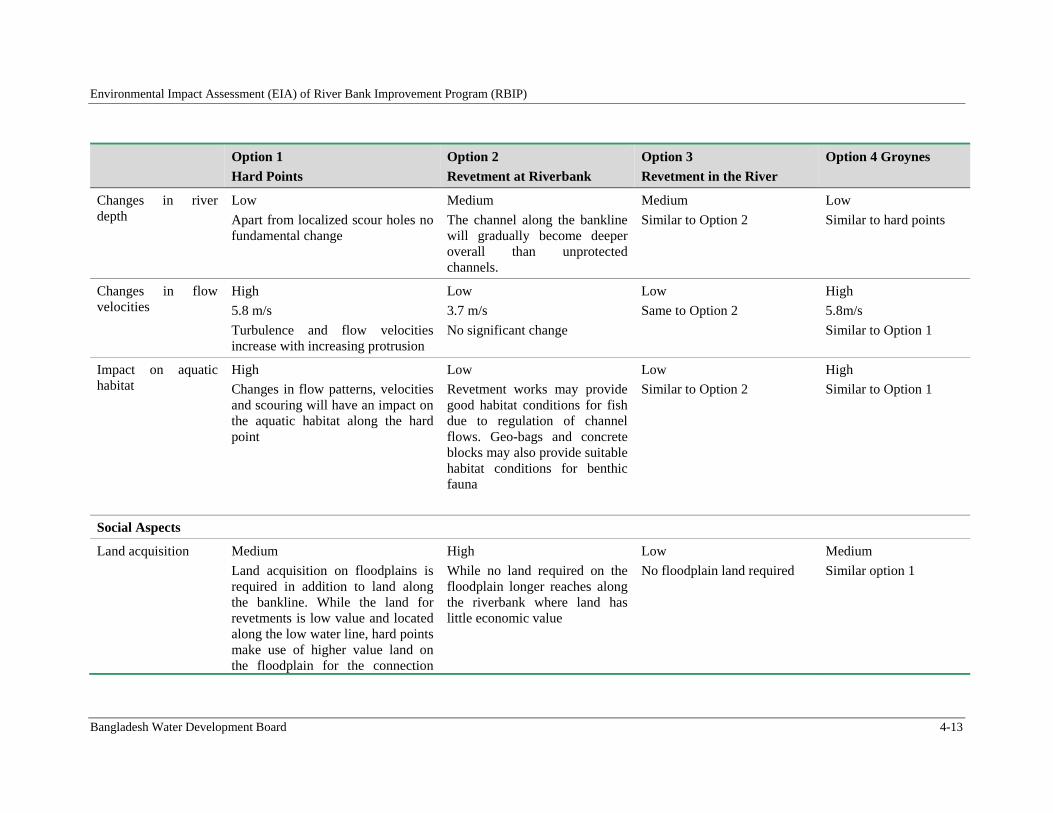
Environmental Impact Assessment (EIA) of River Bank Improvement Program (RBIP)
Bangladesh Water Development Board 4-13
Option 1
Hard Points
Option 2
Revetment at Riverbank
Option 3
Revetment in the River
Option 4 Groynes
Changes in river depth
Low
Apart from localized scour holes no fundamental change
Medium
The channel along the bankline will gradually become deeper overall than unprotected channels.
Medium
Similar to Option 2
Low
Similar to hard points
Changes in flow velocities
High
5.8 m/s
Turbulence and flow velocities increase with increasing protrusion
Low
3.7 m/s
No significant change
Low
Same to Option 2
High
5.8m/s
Similar to Option 1
Impact on aquatic habitat
High
Changes in flow patterns, velocities and scouring will have an impact on the aquatic habitat along the hard point
Low
Revetment works may provide good habitat conditions for fish due to regulation of channel flows. Geo-bags and concrete blocks may also provide suitable habitat conditions for benthic fauna
Low
Similar to Option 2
High
Similar to Option 1
Social Aspects
Land acquisition Medium
Land acquisition on floodplains is required in addition to land along the bankline. While the land for revetments is low value and located along the low water line, hard points make use of higher value land on the floodplain for the connection
High
While no land required on the floodplain longer reaches along the riverbank where land has little economic value
Low
No floodplain land required
Medium
Similar option 1
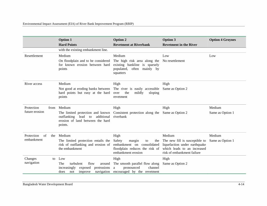
Environmental Impact Assessment (EIA) of River Bank Improvement Program (RBIP)
Bangladesh Water Development Board 4-14
Option 1
Hard Points
Option 2
Revetment at Riverbank
Option 3
Revetment in the River
Option 4 Groynes
with the existing embankment line.
Resettlement Medium
On floodplain and to be considered for known erosion between hard points
Medium
The high risk area along the existing bankline is sparsely populated, often mainly by squatters
Low
No resettlement
Low
River access Medium
Not good at eroding banks between hard points but easy at the hard points
High
The river is easily accessible over the mildly sloping revetment
High
Same as Option 2
Protection from future erosion
Medium
The limited protection and known outflanking lead to additional erosion of land between the hard points.
High
Consistent protection along the riverbank
High
Same as Option 2
Medium
Same as Option 1
Protection of the embankment
Medium
The limited protection entails the risk of outflanking and erosion of the embankment
High
Safety margin to the embankment on consolidated floodplain reduces the risk of embankment erosion
Medium
The new fill is susceptible to liquefaction under earthquake which leads to an increased risk of embankment failure
Medium
Same as Option 1
Changes to navigation
Low
The turbulent flow around increasingly exposed protrusions does not improve navigation
High
The smooth parallel flow along a pronounced channel encouraged by the revetment
High
Same as Option 2
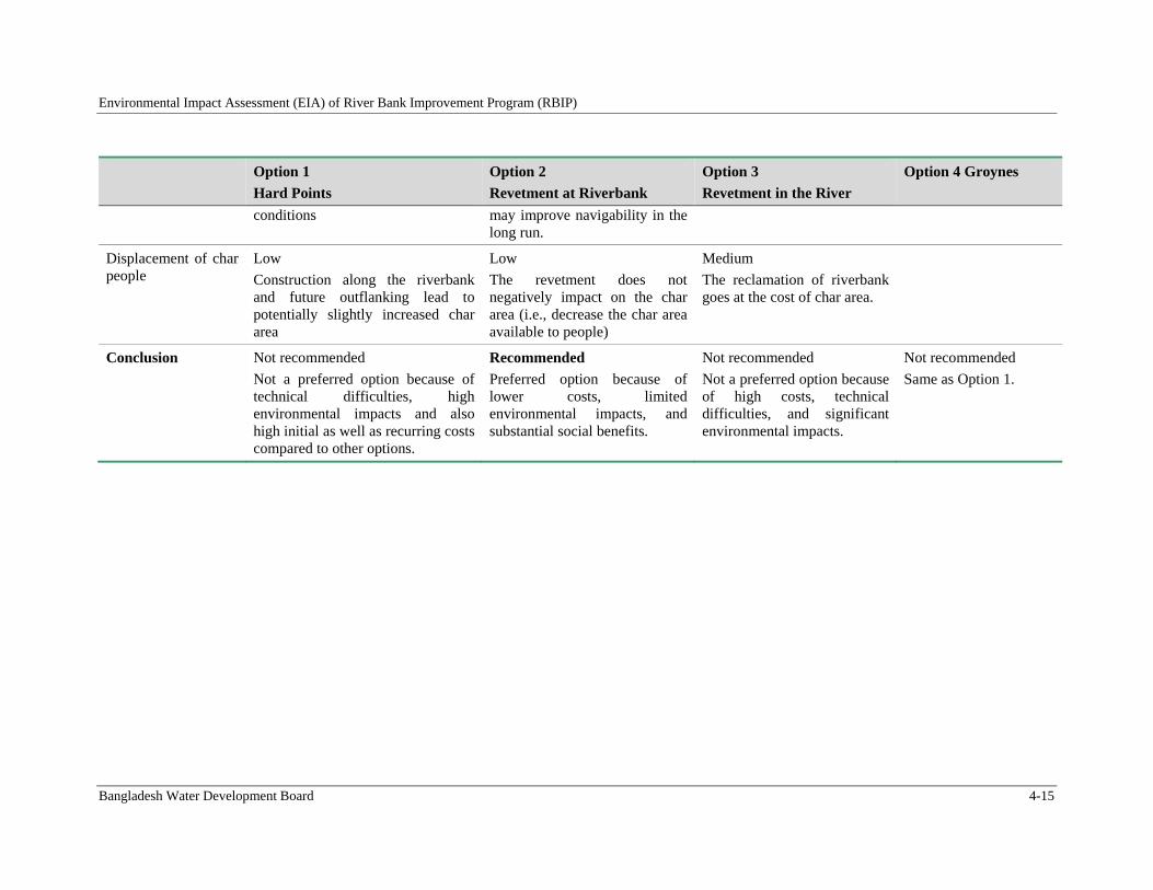
Environmental Impact Assessment (EIA) of River Bank Improvement Program (RBIP)
Bangladesh Water Development Board 4-15
Option 1
Hard Points
Option 2
Revetment at Riverbank
Option 3
Revetment in the River
Option 4 Groynes
conditions may improve navigability in the long run.
Displacement of char people
Low
Construction along the riverbank and future outflanking lead to potentially slightly increased char area
Low
The revetment does not negatively impact on the char area (i.e., decrease the char area available to people)
Medium
The reclamation of riverbank goes at the cost of char area.
Conclusion Not recommended
Not a preferred option because of technical difficulties, high environmental impacts and also high initial as well as recurring costs compared to other options.
Recommended
Preferred option because of lower costs, limited environmental impacts, and substantial social benefits.
Not recommended
Not a preferred option because of high costs, technical difficulties, and significant environmental impacts.
Not recommended
Same as Option 1.
Environmental Impact Assessment (EIA) of River Bank Improvement Program (RBIP)
Bangladesh Water Development Board 4-16
4.4. EmbankmentandRoadOptions
BWDB is mandated to build roads on flood embankments. It is common, world-wide practice to provide emergency access alongside flood embankments in order to provide better access to the area during emergencies. The embankment built under this program will have provision of a higher standard than the emergency roads alongside flood embankments due to its use for regional and inter-regional connectivity. Currently, annual repair maintenance allocation of the BRE is insufficient even to attend regular maintenance work. If the proposed road would be a toll road, then there will be a scope for revenue generation, which can be used for future maintenance of the project.
The following four embankment and road options have been compared against a set of the criteria presented in Table 4.1. Profile of the embankment and road for 2 lane and 4 lane options is shown in Figure 4.4 and comparison shown in Table 4.4.
Option 1: Widening of existing embankment with local road.
Option 2: Reconstructed embankment with improved alignment on the floodplain with two-lane road at safe distance from the riverbank with a provision for toll collection.
Option 3: Reconstructed embankment with improved alignment with separate four-lane highway as through road and adjacent local roads and bridges for crossing the highway. This option reflects the suggestion of World Bank to study a dedicated four lane highway.
Option 4: Embankment on filled land in the river with separate four lane highway and local road connections similar to Option 3. This option combines World Bank’s specific suggestion for a four-lane highway and construction into the river.
4.4.1. Option1:Wideningofexistingembankmentwithlocalroad
Option 1 comprises a simple upgrade of the existing embankment line to the design water levels and defined side slopes of 1V:3H. As such the embankment fulfills basic stability criteria, but is insufficient for seepage under design conditions and load combinations. The widening will be conducted towards the river so that the squatter households along the country side will not be affected. In places where the existing embankment is dangerously close to the unprotected riverbank the embankment will be retired.
4.4.2. Option 2: Reconstructed embankment on the floodplainwith two‐laneroadatsafedistancefromtheriverbank
Present BRE alignment is too much zigzag because of repeated retirement. Due to lack of proper maintenance, existing embankment section is not sufficient for seepage and vulnerable to damage during flood. Existing height of the embankment is below to the present design requirement and subjected to overtopped at different locations. Option 2 consists of the new standard embankment incorporating a two-lane road at the country side. The embankment is designed for a broad range of loads and load combinations, including earthquake, and failed drainage. This embankment is wider than the one from Option 1, as it is fully stable against seepage. The road serves the dual purpose of connecting the local population to the nearest growth centers while providing a through road from the Jamuna Bridge to the new Teesta Bridge near Chilmari. To this end the road is built to RHD highway standard and able to carry heavy traffic, and will be equipped with toll stations. The road is not meant to be a competition to the existing highway network as laid down in government’s highway master plan. The road
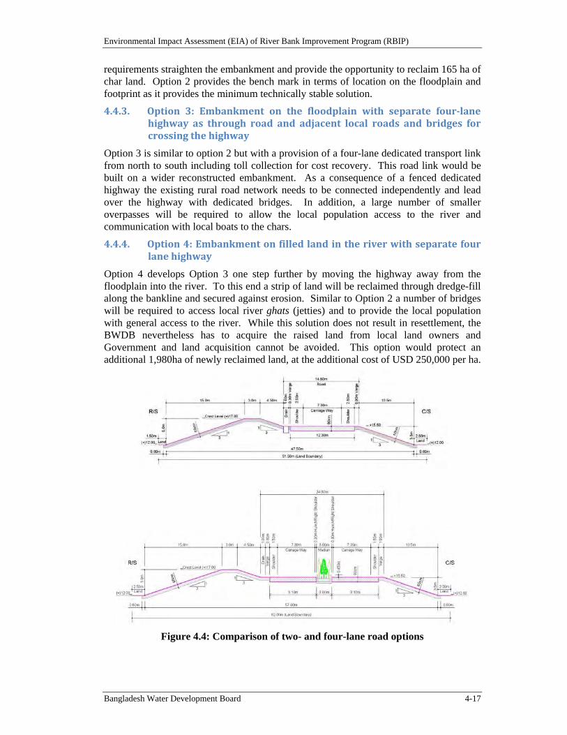
Environmental Impact Assessment (EIA) of River Bank Improvement Program (RBIP)
Bangladesh Water Development Board 4-17
requirements straighten the embankment and provide the opportunity to reclaim 165 ha of char land. Option 2 provides the bench mark in terms of location on the floodplain and footprint as it provides the minimum technically stable solution.
4.4.3. Option 3: Embankment on the floodplain with separate four‐lanehighway as through road and adjacent local roads and bridges forcrossingthehighway
Option 3 is similar to option 2 but with a provision of a four-lane dedicated transport link from north to south including toll collection for cost recovery. This road link would be built on a wider reconstructed embankment. As a consequence of a fenced dedicated highway the existing rural road network needs to be connected independently and lead over the highway with dedicated bridges. In addition, a large number of smaller overpasses will be required to allow the local population access to the river and communication with local boats to the chars.
4.4.4. Option4:Embankmentonfilledlandintheriverwithseparatefourlanehighway
Option 4 develops Option 3 one step further by moving the highway away from the floodplain into the river. To this end a strip of land will be reclaimed through dredge-fill along the bankline and secured against erosion. Similar to Option 2 a number of bridges will be required to access local river ghats (jetties) and to provide the local population with general access to the river. While this solution does not result in resettlement, the BWDB nevertheless has to acquire the raised land from local land owners and Government and land acquisition cannot be avoided. This option would protect an additional 1,980ha of newly reclaimed land, at the additional cost of USD 250,000 per ha.
Figure 4.4: Comparison of two- and four-lane road options
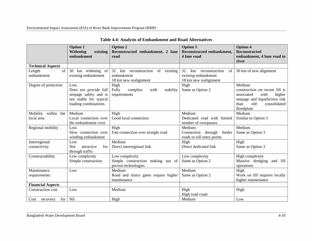
Environmental Impact Assessment (EIA) of River Bank Improvement Program (RBIP)
Bangladesh Water Development Board 4-18
Table 4.4: Analysis of Embankment and Road Alternatives
Option 1 Widening existing embankment
Option 2 Reconstructed embankment, 2 lane road
Option 3 Reconstructed embankment, 4 lane road
Option 4 Reconstructed embankment, 4 lane road in river
Technical Aspects Length of embankment
50 km widening of existing embankment
32 km reconstruction of existing embankment 18 km new realignment
32 km reconstruction of existing embankment 18 km new realignment
50 km of new alignment
Degree of protection Low Does not provide full seepage safety and is not stable for typical loading combinations
High Fully complies with stability requirements
High Same as Option 2
Medium construction on recent fill is associated with higher seepage and liquefaction risk than old consolidated floodplain
Mobility within the local area
Medium Local connection over the embankment crest
High Good local connection
Medium Dedicated road with limited number of overpasses
Medium Similar to Option 3
Regional mobility Low Slow connection over winding embankment
High Fast connection over straight road
Medium Connection through feeder roads to toll entry points
Medium Same as Option 3
Interregional connectivity
Low Not attractive for through traffic
Medium Direct interregional link
High Direct dedicated link
High Same as Option 3
Constructability Low complexity Simple construction
Low complexity Simple construction making use of proven technologies
Low complexity Same as Option 2
High complexity Massive dredging and fill operations
Maintenance requirements
Low
Medium Road and sluice gates require higher maintenance
Medium Same as Option 2
High Work on fill requires locally higher maintenance
Financial Aspects Construction cost Low
Medium High
High road coast High
Cost recovery for Nil High Medium Low
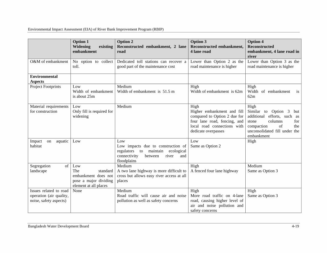
Environmental Impact Assessment (EIA) of River Bank Improvement Program (RBIP)
Bangladesh Water Development Board 4-19
Option 1 Widening existing embankment
Option 2 Reconstructed embankment, 2 lane road
Option 3 Reconstructed embankment, 4 lane road
Option 4 Reconstructed embankment, 4 lane road in river
O&M of embankment No option to collect toll.
Dedicated toll stations can recover a good part of the maintenance cost
Lower than Option 2 as the road maintenance is higher
Lower than Option 3 as the road maintenance is higher
Environmental Aspects
Project Footprints Low Width of embankment is about 25m
Medium Width of embankment is 51.5 m
High Width of embankment is 62m
High Width of embankment is 62m
Material requirements for construction
Low Only fill is required for widening
Medium
High Higher embankment and fill compared to Option 2 due for four lane road, fencing, and local road connections with dedicate overpasses
High Similar to Option 3 but additional efforts, such as stone columns for compaction of the unconsolidated fill under the embankment
Impact on aquatic habitat
Low Low Low impacts due to construction of regulators to maintain ecological connectivity between river and floodplains
Low Same as Option 2
High
Segregation of landscape
Low The standard embankment does not pose a major dividing element at all places
Medium A two lane highway is more difficult to cross but allows easy river access at all places
High A fenced four lane highway
Medium Same as Option 3
Issues related to road operation (air quality, noise, safety aspects)
None Medium Road traffic will cause air and noise pollution as well as safety concerns
High More road traffic on 4-lane road, causing higher level of air and noise pollution and safety concerns
High Same as Option 3
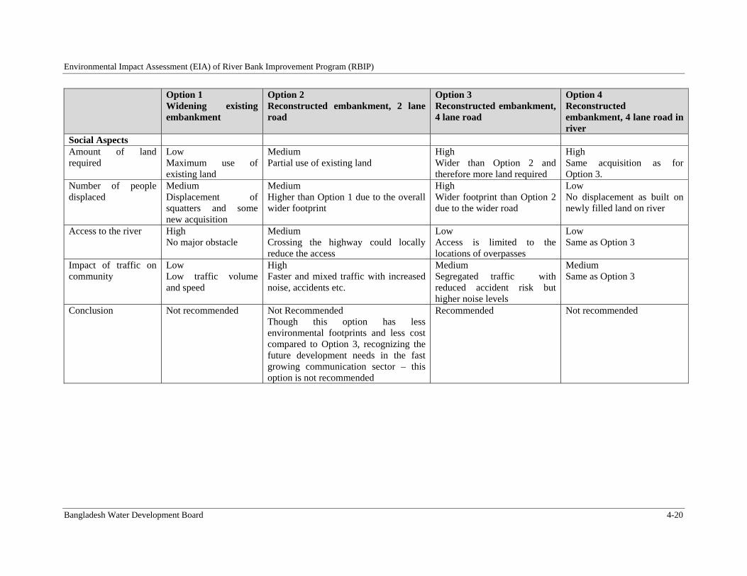
Environmental Impact Assessment (EIA) of River Bank Improvement Program (RBIP)
Bangladesh Water Development Board 4-20
Option 1 Widening existing embankment
Option 2 Reconstructed embankment, 2 lane road
Option 3 Reconstructed embankment, 4 lane road
Option 4 Reconstructed embankment, 4 lane road in river
Social Aspects Amount of land required
Low Maximum use of existing land
Medium Partial use of existing land
High Wider than Option 2 and therefore more land required
High Same acquisition as for Option 3.
Number of people displaced
Medium Displacement of squatters and some new acquisition
Medium Higher than Option 1 due to the overall wider footprint
High Wider footprint than Option 2 due to the wider road
Low No displacement as built on newly filled land on river
Access to the river High No major obstacle
Medium Crossing the highway could locally reduce the access
Low Access is limited to the locations of overpasses
Low Same as Option 3
Impact of traffic on community
Low Low traffic volume and speed
High Faster and mixed traffic with increased noise, accidents etc.
Medium Segregated traffic with reduced accident risk but higher noise levels
Medium Same as Option 3
Conclusion Not recommended Not Recommended Though this option has less environmental footprints and less cost compared to Option 3, recognizing the future development needs in the fast growing communication sector – this option is not recommended
Recommended
Not recommended
Environmental Impact Assessment (EIA) of River Bank Improvement Program (RBIP)
Bangladesh Water Development Board 4-21
4.5. AlternativesforEmbankmentMaterials
Construction of embankment and road requires huge amounts of earth fill. The following sources are considered as the sources of borrow material for earth fill:
Alternative 1: Entire embankment is constructed with soil excavated from the floodplains and agriculture land.
Alternative 2: Embankment to be constructed with dredged sand from the river bank and soil cladding.
Constructing the embankment with soil (Alternative 1) is a technically viable and perhaps the least cost option. However the soil will have to be either transported from long distances or obtained from the local areas thus significantly affecting the already scarce cultivation lands. Hence this option is not being considered for embankment construction.
The cost of Alternative 2 could be slightly higher than the other option discussed above. However the biggest advantage of this option is that it will avoid any adverse impacts on the cultivation lands of the area. There could be some localized and temporary impact on the aquatic habitat/fauna during the sand extraction from river bank and these impacts can be minimized with the improved sand extraction methodology and locating the extraction points away from the sensitive aquatic habitats. Alternative 2 is recommended for as source of earth fill primarily to avoid any impacts on the floodplain agriculture lands.
The source of cladding material of the embankment is usually extracted from the floodplain agriculture lands. In the RBIP, the material from the unused embankments will be used as cladding material.
4.6. AlternativesforRegulators
During Construction of BRE a good numbers of regulators were built on the embankment to provide lateral fish migration between the river and floodplains and also to provide drainage and supplementary Irrigation facilities. But most of them were engulfed into the Jamuna river due to erosion. During retirement or re-construction of BRE those engulfed regulators were not rebuilt and at those regulator points the natural channels were closed permanently. As a result the natural connectivity has been lost and there have been some problems with the natural drainage and supplementary irrigation. Following three alternatives were considered to address the problems:
Alternative 1: No new regulator and no rehabilitation of fish pass. This is the least cost option, avoiding any capital cost as well as any environmental and social impacts associated with the construction/rehabilitation activities. This option however is likely to have adverse impact on the ecological connectivity of the area with the main Jamuna river, resulting in reduced fish production and hence reduced livelihood for the local population
Alternative 2: rehabilitation and ongoing maintenance of existing regulators and fish pass. This option will result in capital cost associated with rehabilitation works, in addition to environmental and social impacts associated with the rehabilitation works. This option will eventually result in restoration of ecological connectivity that has been lost because of the dysfunctional regulators
Alternative 3: Rehabilitation and ongoing maintenance of existing regulators and fish pass, and construction and maintenance of additional regulators. This option will
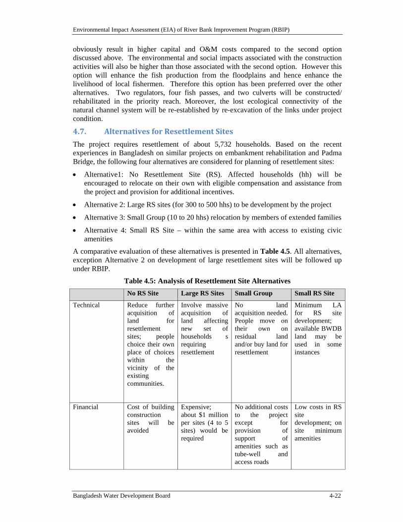
Environmental Impact Assessment (EIA) of River Bank Improvement Program (RBIP)
Bangladesh Water Development Board 4-22
obviously result in higher capital and O&M costs compared to the second option discussed above. The environmental and social impacts associated with the construction activities will also be higher than those associated with the second option. However this option will enhance the fish production from the floodplains and hence enhance the livelihood of local fishermen. Therefore this option has been preferred over the other alternatives. Two regulators, four fish passes, and two culverts will be constructed/ rehabilitated in the priority reach. Moreover, the lost ecological connectivity of the natural channel system will be re-established by re-excavation of the links under project condition.
4.7. AlternativesforResettlementSites
The project requires resettlement of about 5,732 households. Based on the recent experiences in Bangladesh on similar projects on embankment rehabilitation and Padma Bridge, the following four alternatives are considered for planning of resettlement sites:
Alternative1: No Resettlement Site (RS). Affected households (hh) will be encouraged to relocate on their own with eligible compensation and assistance from the project and provision for additional incentives.
Alternative 2: Large RS sites (for 300 to 500 hhs) to be development by the project
Alternative 3: Small Group (10 to 20 hhs) relocation by members of extended families
Alternative 4: Small RS Site – within the same area with access to existing civic amenities
A comparative evaluation of these alternatives is presented in Table 4.5. All alternatives, exception Alternative 2 on development of large resettlement sites will be followed up under RBIP.
Table 4.5: Analysis of Resettlement Site Alternatives
No RS Site Large RS Sites Small Group Small RS Site
Technical Reduce further acquisition of land for resettlement sites; people choice their own place of choices within the vicinity of the existing communities.
Involve massive acquisition of land affecting new set of households s requiring resettlement
No land acquisition needed. People move on their own on residual land and/or buy land for resettlement
Minimum LA for RS site development; available BWDB land may be used in some instances
Financial Cost of building construction sites will be avoided
Expensive; about $1 million per sites (4 to 5 sites) would be required
No additional costs to the project except for provision of support of amenities such as tube-well and access roads
Low costs in RS site development; on site minimum amenities
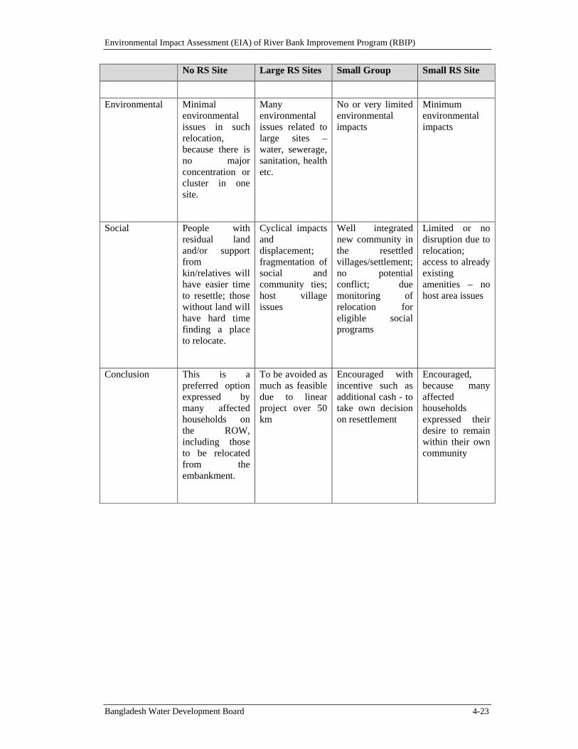
Environmental Impact Assessment (EIA) of River Bank Improvement Program (RBIP)
Bangladesh Water Development Board 4-23
No RS Site Large RS Sites Small Group Small RS Site
Environmental Minimal environmental issues in such relocation, because there is no major concentration or cluster in one site.
Many environmental issues related to large sites – water, sewerage, sanitation, health etc.
No or very limited environmental impacts
Minimum environmental impacts
Social People with residual land and/or support from kin/relatives will have easier time to resettle; those without land will have hard time finding a place to relocate.
Cyclical impacts and displacement; fragmentation of social and community ties; host village issues
Well integrated new community in the resettled villages/settlement; no potential conflict; due monitoring of relocation for eligible social programs
Limited or no disruption due to relocation; access to already existing amenities – no host area issues
Conclusion This is a preferred option expressed by many affected households on the ROW, including those to be relocated from the embankment.
To be avoided as much as feasible due to linear project over 50 km
Encouraged with incentive such as additional cash - to take own decision on resettlement
Encouraged, because many affected households expressed their desire to remain within their own community
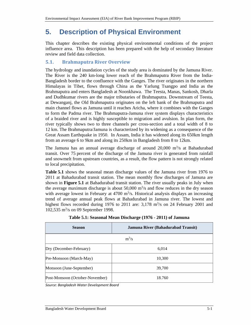
Environmental Impact Assessment (EIA) of River Bank Improvement Program (RBIP)
Bangladesh Water Development Board 5-1
5. Description of Physical Environment
This chapter describes the existing physical environmental conditions of the project influence area. This description has been prepared with the help of secondary literature review and field data collection.
5.1. BrahmaputraRiverOverview
The hydrology and inundation cycles of the study area is dominated by the Jamuna River. The River is the 240 km-long lower reach of the Brahmaputra River from the India-Bangladesh border to the confluence with the Ganges. The river originates in the northern Himalayas in Tibet, flows through China as the Yarlung Tsangpo and India as the Brahmaputra and enters Bangladesh at Noonkhawa. The Teesta, Manas, Sankosh, Dharla and Dudhkumar rivers are the major tributaries of Brahmaputra. Downstream of Teesta, at Dewanganj, the Old Brahmaputra originates on the left bank of the Brahmaputra and main channel flows as Jamuna until it reaches Aricha, where it combines with the Ganges to form the Padma river. The Brahmaputra-Jamuna river system displays characteristics of a braided river and is highly susceptible to migration and avulsion. In plan form, the river typically shows two to three channels per cross-section and a total width of 8 to 12 km. The Brahmaputra/Jamuna is characterized by its widening as a consequence of the Great Assam Earthquake in 1950. In Assam, India it has widened along its 650km length from an average 6 to 9km and along its 250km in Bangladesh from 8 to 12km.
The Jamuna has an annual average discharge of around 20,000 m3/s at Bahadurabad transit. Over 75 percent of the discharge of the Jamuna river is generated from rainfall and snowmelt from upstream countries, as a result, the flow pattern is not strongly related to local precipitation.
Table 5.1 shows the seasonal mean discharge values of the Jamuna river from 1976 to 2011 at Bahadurabad transit station. The mean monthly flow discharges of Jamuna are shown in Figure 5.1 at Bahadurabad transit station. The river usually peaks in July when the average maximum discharge is about 50,000 m3/s and flow reduces in the dry season with average lowest in February at 4700 m3/s. Historical analysis displays an increasing trend of average annual peak flows at Bahadurabad in Jamuna river. The lowest and highest flows recorded during 1976 to 2011 are: 3,178 m3/s on 24 February 2001 and 102,535 m3/s on 09 September 1998.
Table 5.1: Seasonal Mean Discharge (1976 - 2011) of Jamuna
Season Jamuna River (Bahadurabad Transit)
m3/s
Dry (December-February) 6,014
Pre-Monsoon (March-May) 10,300
Monsoon (June-September) 39,700
Post-Monsoon (October-November) 18.760
Source: Bangladesh Water Development Board
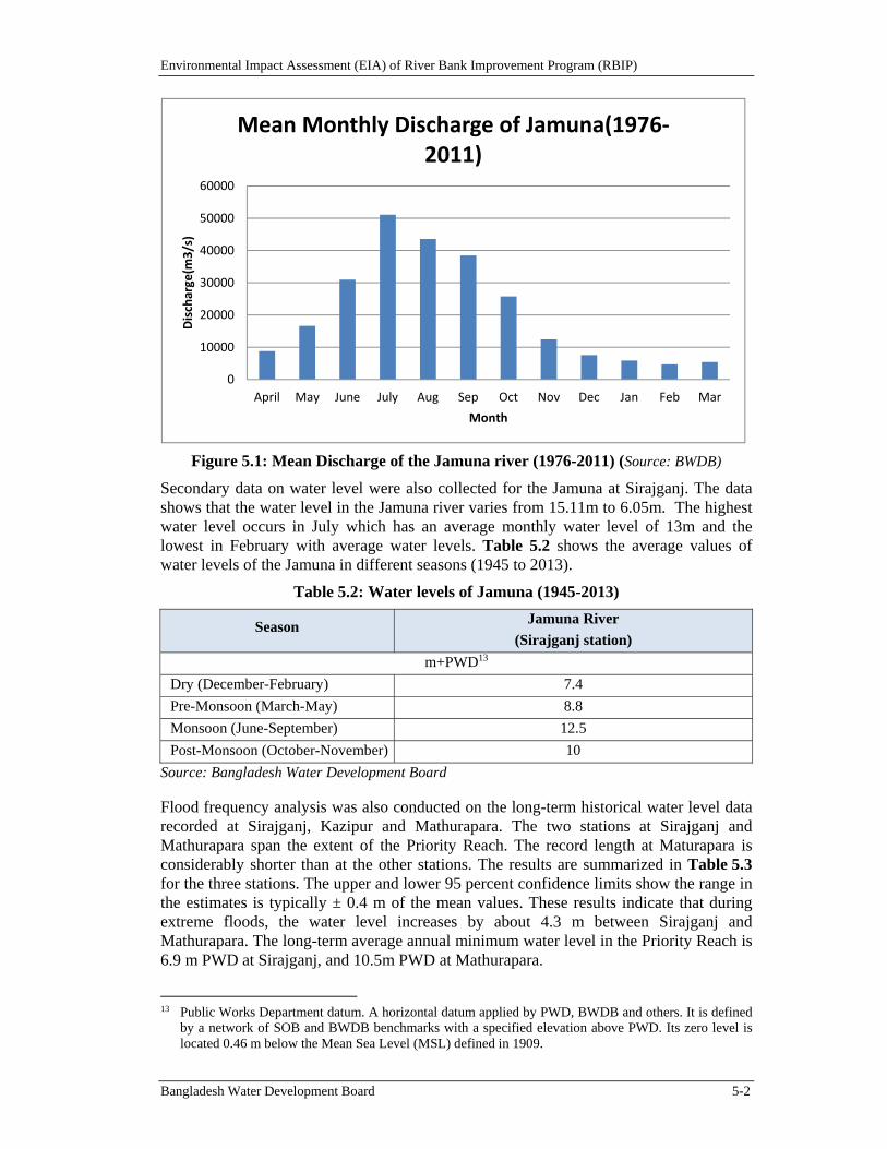
Environmental Impact Assessment (EIA) of River Bank Improvement Program (RBIP)
Bangladesh Water Development Board 5-2
Figure 5.1: Mean Discharge of the Jamuna river (1976-2011) (Source: BWDB)
Secondary data on water level were also collected for the Jamuna at Sirajganj. The data shows that the water level in the Jamuna river varies from 15.11m to 6.05m. The highest water level occurs in July which has an average monthly water level of 13m and the lowest in February with average water levels. Table 5.2 shows the average values of water levels of the Jamuna in different seasons (1945 to 2013).
Table 5.2: Water levels of Jamuna (1945-2013)
Season Jamuna River
(Sirajganj station)
m+PWD13
Dry (December-February) 7.4
Pre-Monsoon (March-May) 8.8
Monsoon (June-September) 12.5
Post-Monsoon (October-November) 10
Source: Bangladesh Water Development Board
Flood frequency analysis was also conducted on the long-term historical water level data recorded at Sirajganj, Kazipur and Mathurapara. The two stations at Sirajganj and Mathurapara span the extent of the Priority Reach. The record length at Maturapara is considerably shorter than at the other stations. The results are summarized in Table 5.3 for the three stations. The upper and lower 95 percent confidence limits show the range in the estimates is typically ± 0.4 m of the mean values. These results indicate that during extreme floods, the water level increases by about 4.3 m between Sirajganj and Mathurapara. The long-term average annual minimum water level in the Priority Reach is 6.9 m PWD at Sirajganj, and 10.5m PWD at Mathurapara.
13 Public Works Department datum. A horizontal datum applied by PWD, BWDB and others. It is defined
by a network of SOB and BWDB benchmarks with a specified elevation above PWD. Its zero level is located 0.46 m below the Mean Sea Level (MSL) defined in 1909.
0
10000
20000
30000
40000
50000
60000
April May June July Aug Sep Oct Nov Dec Jan Feb Mar
Discharge(m
3/s)
Month
Mean Monthly Discharge of Jamuna(1976‐2011)
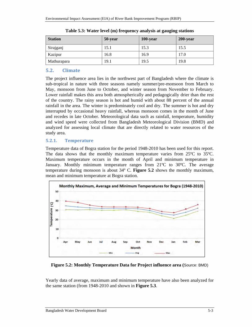
Environmental Impact Assessment (EIA) of River Bank Improvement Program (RBIP)
Bangladesh Water Development Board 5-3
Table 5.3: Water level (m) frequency analysis at gauging stations
Station 50-year 100-year 200-year
Sirajganj 15.1 15.3 15.5
Kazipur 16.8 16.9 17.0
Mathurapara 19.1 19.5 19.8
5.2. Climate
The project influence area lies in the northwest part of Bangladesh where the climate is sub-tropical in nature with three seasons namely summer/pre-monsoon from March to May, monsoon from June to October, and winter season from November to February. Lower rainfall makes this area both atmospherically and pedagogically drier than the rest of the country. The rainy season is hot and humid with about 88 percent of the annual rainfall in the area. The winter is predominately cool and dry. The summer is hot and dry interrupted by occasional heavy rainfall, whereas monsoon comes in the month of June and recedes in late October. Meteorological data such as rainfall, temperature, humidity and wind speed were collected from Bangladesh Meteorological Division (BMD) and analyzed for assessing local climate that are directly related to water resources of the study area.
5.2.1. Temperature
Temperature data of Bogra station for the period 1948-2010 has been used for this report. The data shows that the monthly maximum temperature varies from 25ºC to 35ºC. Maximum temperature occurs in the month of April and minimum temperature in January. Monthly minimum temperature ranges from 21ºC to 30ºC. The average temperature during monsoon is about 34º C. Figure 5.2 shows the monthly maximum, mean and minimum temperature at Bogra station.
Figure 5.2: Monthly Temperature Data for Project influence area (Source: BMD)
Yearly data of average, maximum and minimum temperature have also been analyzed for the same station (from 1948-2010 and shown in Figure 5.3.
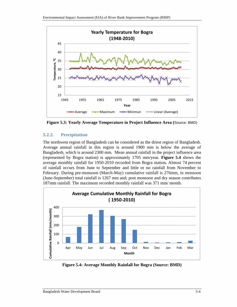
Environmental Impact Assessment (EIA) of River Bank Improvement Program (RBIP)
Bangladesh Water Development Board 5-4
Figure 5.3: Yearly Average Temperature in Project Influence Area (Source: BMD)
5.2.2. Precipitation
The northwest region of Bangladesh can be considered as the driest region of Bangladesh. Average annual rainfall in this region is around 1900 mm is below the average of Bangladesh, which is around 2300 mm. Mean annual rainfall in the project influence area (represented by Bogra station) is approximately 1705 mm/year. Figure 5.4 shows the average monthly rainfall for 1950-2010 recorded from Bogra station. Almost 74 percent of rainfall occurs from June to September and little or no rainfall from November to February. During pre-monsoon (March-May) cumulative rainfall is 276mm, in monsoon (June-September) total rainfall is 1267 mm and; post monsoon and dry season contributes 187mm rainfall. The maximum recorded monthly rainfall was 371 mm/ month.
Figure 5.4: Average Monthly Rainfall for Bogra (Source: BMD)
15
20
25
30
35
40
45
1945 1955 1965 1975 1985 1995 2005 2015
Temperature, 0C
Year
Yearly Temperature for Bogra (1948‐2010)
Average Maximum Minimun Linear (Average)
0
100
200
300
400
Apr May Jun Jul Aug Sep Oct Nov Dec Jan Feb Mar
Cumulative Rainfall (m
m/m
onth)
Month
Average Cumulative Monthly Rainfall for Bogra ( 1950‐2010)
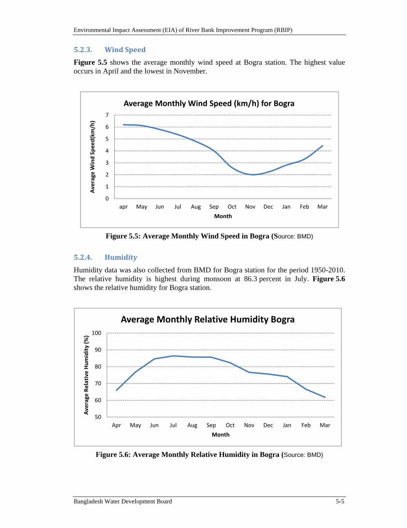
Environmental Impact Assessment (EIA) of River Bank Improvement Program (RBIP)
Bangladesh Water Development Board 5-5
5.2.3. WindSpeed
Figure 5.5 shows the average monthly wind speed at Bogra station. The highest value occurs in April and the lowest in November.
Figure 5.5: Average Monthly Wind Speed in Bogra (Source: BMD)
5.2.4. Humidity
Humidity data was also collected from BMD for Bogra station for the period 1950-2010. The relative humidity is highest during monsoon at 86.3 percent in July. Figure 5.6 shows the relative humidity for Bogra station.
Figure 5.6: Average Monthly Relative Humidity in Bogra (Source: BMD)
0
1
2
3
4
5
6
7
apr May Jun Jul Aug Sep Oct Nov Dec Jan Feb Mar
Average
Wind Speed(km/h)
Month
Average Monthly Wind Speed (km/h) for Bogra
50
60
70
80
90
100
Apr May Jun Jul Aug Sep Oct Nov Dec Jan Feb Mar
Average
Relative Humidity (%
)
Month
Average Monthly Relative Humidity Bogra
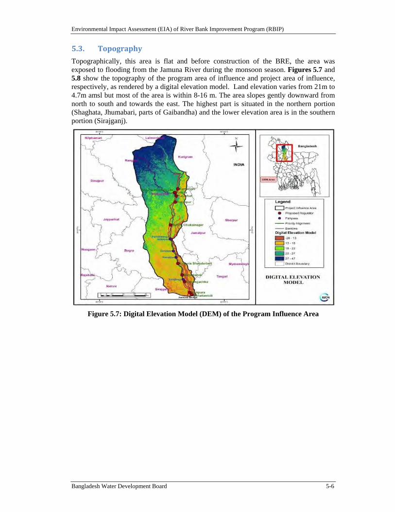
Environmental Impact Assessment (EIA) of River Bank Improvement Program (RBIP)
Bangladesh Water Development Board 5-6
5.3. Topography
Topographically, this area is flat and before construction of the BRE, the area was exposed to flooding from the Jamuna River during the monsoon season. Figures 5.7 and 5.8 show the topography of the program area of influence and project area of influence, respectively, as rendered by a digital elevation model. Land elevation varies from 21m to 4.7m amsl but most of the area is within 8-16 m. The area slopes gently downward from north to south and towards the east. The highest part is situated in the northern portion (Shaghata, Jhumabari, parts of Gaibandha) and the lower elevation area is in the southern portion (Sirajganj).
Figure 5.7: Digital Elevation Model (DEM) of the Program Influence Area
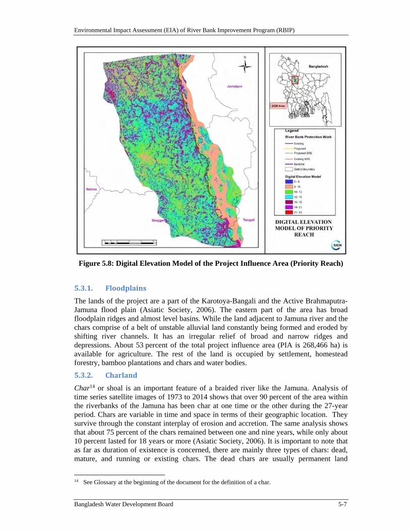
Environmental Impact Assessment (EIA) of River Bank Improvement Program (RBIP)
Bangladesh Water Development Board 5-7
Figure 5.8: Digital Elevation Model of the Project Influence Area (Priority Reach)
5.3.1. Floodplains
The lands of the project are a part of the Karotoya-Bangali and the Active Brahmaputra-Jamuna flood plain (Asiatic Society, 2006). The eastern part of the area has broad floodplain ridges and almost level basins. While the land adjacent to Jamuna river and the chars comprise of a belt of unstable alluvial land constantly being formed and eroded by shifting river channels. It has an irregular relief of broad and narrow ridges and depressions. About 53 percent of the total project influence area (PIA is 268,466 ha) is available for agriculture. The rest of the land is occupied by settlement, homestead forestry, bamboo plantations and chars and water bodies.
5.3.2. Charland
Char14 or shoal is an important feature of a braided river like the Jamuna. Analysis of time series satellite images of 1973 to 2014 shows that over 90 percent of the area within the riverbanks of the Jamuna has been char at one time or the other during the 27-year period. Chars are variable in time and space in terms of their geographic location. They survive through the constant interplay of erosion and accretion. The same analysis shows that about 75 percent of the chars remained between one and nine years, while only about 10 percent lasted for 18 years or more (Asiatic Society, 2006). It is important to note that as far as duration of existence is concerned, there are mainly three types of chars: dead, mature, and running or existing chars. The dead chars are usually permanent land
14 See Glossary at the beginning of the document for the definition of a char.
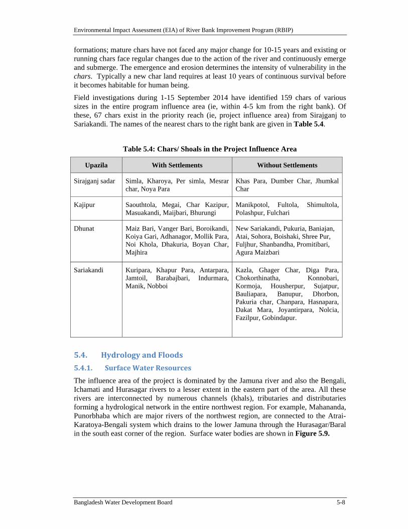
Environmental Impact Assessment (EIA) of River Bank Improvement Program (RBIP)
Bangladesh Water Development Board 5-8
formations; mature chars have not faced any major change for 10-15 years and existing or running chars face regular changes due to the action of the river and continuously emerge and submerge. The emergence and erosion determines the intensity of vulnerability in the chars. Typically a new char land requires at least 10 years of continuous survival before it becomes habitable for human being.
Field investigations during 1-15 September 2014 have identified 159 chars of various sizes in the entire program influence area (ie, within 4-5 km from the right bank). Of these, 67 chars exist in the priority reach (ie, project influence area) from Sirajganj to Sariakandi. The names of the nearest chars to the right bank are given in Table 5.4.
Table 5.4: Chars/ Shoals in the Project Influence Area
Upazila With Settlements Without Settlements
Sirajganj sadar Simla, Kharoya, Per simla, Mesrar char, Noya Para
Khas Para, Dumber Char, Jhumkal Char
Kajipur Saouthtola, Megai, Char Kazipur, Masuakandi, Maijbari, Bhurungi
Manikpotol, Fultola, Shimultola, Polashpur, Fulchari
Dhunat Maiz Bari, Vanger Bari, Boroikandi, Koiya Gari, Adhanagor, Mollik Para, Noi Khola, Dhakuria, Boyan Char, Majhira
New Sariakandi, Pukuria, Baniajan, Atai, Sohora, Boishaki, Shree Pur, Fuljhur, Shanbandha, Promitibari, Agura Maizbari
Sariakandi Kuripara, Khapur Para, Antarpara, Jamtoil, Barabajbari, Indurmara, Manik, Nobboi
Kazla, Ghager Char, Diga Para, Chokorthinatha, Konnobari, Kormoja, Housherpur, Sujatpur, Bauliapara, Banupur, Dhorbon, Pakuria char, Chanpara, Hasnapara, Dakat Mara, Joyantirpara, Nolcia, Fazilpur, Gobindapur.
5.4. HydrologyandFloods
5.4.1. SurfaceWaterResources
The influence area of the project is dominated by the Jamuna river and also the Bengali, Ichamati and Hurasagar rivers to a lesser extent in the eastern part of the area. All these rivers are interconnected by numerous channels (khals), tributaries and distributaries forming a hydrological network in the entire northwest region. For example, Mahananda, Punorbhaba which are major rivers of the northwest region, are connected to the Atrai-Karatoya-Bengali system which drains to the lower Jamuna through the Hurasagar/Baral in the south east corner of the region. Surface water bodies are shown in Figure 5.9.
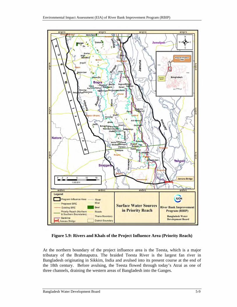
Environmental Impact Assessment (EIA) of River Bank Improvement Program (RBIP)
Bangladesh Water Development Board 5-9
Figure 5.9: Rivers and Khals of the Project Influence Area (Priority Reach)
At the northern boundary of the project influence area is the Teesta, which is a major tributary of the Brahmaputra. The braided Teesta River is the largest fan river in Bangladesh originating in Sikkim, India and avulsed into its present course at the end of the 18th century. Before avulsing, the Teesta flowed through today’s Atrai as one of three channels, draining the western areas of Bangladesh into the Ganges.
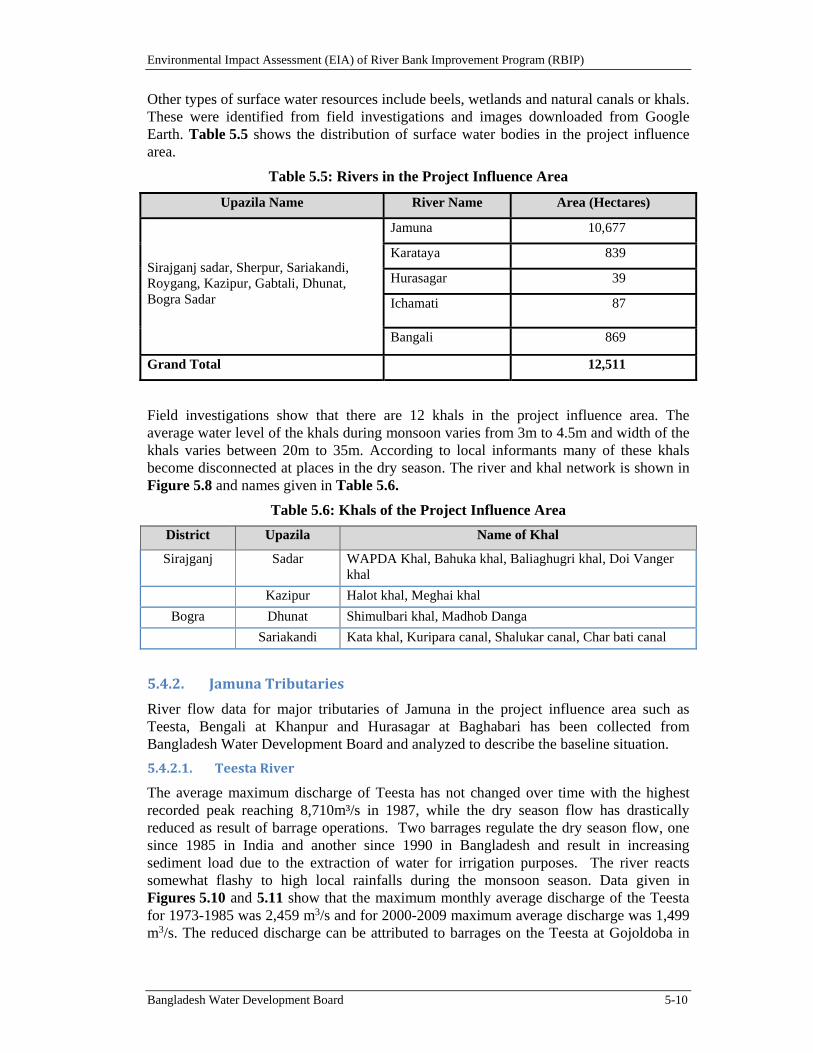
Environmental Impact Assessment (EIA) of River Bank Improvement Program (RBIP)
Bangladesh Water Development Board 5-10
Other types of surface water resources include beels, wetlands and natural canals or khals. These were identified from field investigations and images downloaded from Google Earth. Table 5.5 shows the distribution of surface water bodies in the project influence area.
Table 5.5: Rivers in the Project Influence Area
Upazila Name River Name Area (Hectares)
Sirajganj sadar, Sherpur, Sariakandi, Roygang, Kazipur, Gabtali, Dhunat, Bogra Sadar
Jamuna 10,677
Karataya 839
Hurasagar 39
Ichamati 87
Bangali 869
Grand Total 12,511
Field investigations show that there are 12 khals in the project influence area. The average water level of the khals during monsoon varies from 3m to 4.5m and width of the khals varies between 20m to 35m. According to local informants many of these khals become disconnected at places in the dry season. The river and khal network is shown in Figure 5.8 and names given in Table 5.6.
Table 5.6: Khals of the Project Influence Area
District Upazila Name of Khal
Sirajganj Sadar WAPDA Khal, Bahuka khal, Baliaghugri khal, Doi Vanger khal
Kazipur Halot khal, Meghai khal
Bogra Dhunat Shimulbari khal, Madhob Danga
Sariakandi Kata khal, Kuripara canal, Shalukar canal, Char bati canal
5.4.2. JamunaTributaries
River flow data for major tributaries of Jamuna in the project influence area such as Teesta, Bengali at Khanpur and Hurasagar at Baghabari has been collected from Bangladesh Water Development Board and analyzed to describe the baseline situation.
5.4.2.1. TeestaRiver
The average maximum discharge of Teesta has not changed over time with the highest recorded peak reaching 8,710m³/s in 1987, while the dry season flow has drastically reduced as result of barrage operations. Two barrages regulate the dry season flow, one since 1985 in India and another since 1990 in Bangladesh and result in increasing sediment load due to the extraction of water for irrigation purposes. The river reacts somewhat flashy to high local rainfalls during the monsoon season. Data given in Figures 5.10 and 5.11 show that the maximum monthly average discharge of the Teesta for 1973-1985 was 2,459 m3/s and for 2000-2009 maximum average discharge was 1,499 m3/s. The reduced discharge can be attributed to barrages on the Teesta at Gojoldoba in
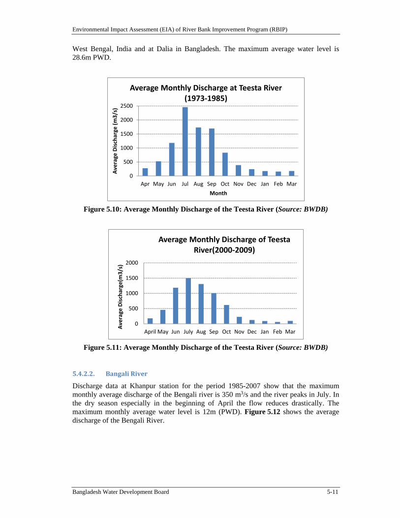
Environmental Impact Assessment (EIA) of River Bank Improvement Program (RBIP)
Bangladesh Water Development Board 5-11
West Bengal, India and at Dalia in Bangladesh. The maximum average water level is 28.6m PWD.
Figure 5.10: Average Monthly Discharge of the Teesta River (Source: BWDB)
Figure 5.11: Average Monthly Discharge of the Teesta River (Source: BWDB)
5.4.2.2. BangaliRiver
Discharge data at Khanpur station for the period 1985-2007 show that the maximum monthly average discharge of the Bengali river is 350 m3/s and the river peaks in July. In the dry season especially in the beginning of April the flow reduces drastically. The maximum monthly average water level is 12m (PWD). Figure 5.12 shows the average discharge of the Bengali River.
0
500
1000
1500
2000
2500
Apr May Jun Jul Aug Sep Oct Nov Dec Jan Feb Mar
Average
Discharge
(m3/s)
Month
Average Monthly Discharge at Teesta River (1973‐1985)
0
500
1000
1500
2000
April May Jun July Aug Sep Oct Nov Dec Jan Feb Mar
Average
Discharge(m
3/s)
Average Monthly Discharge of Teesta River(2000‐2009)
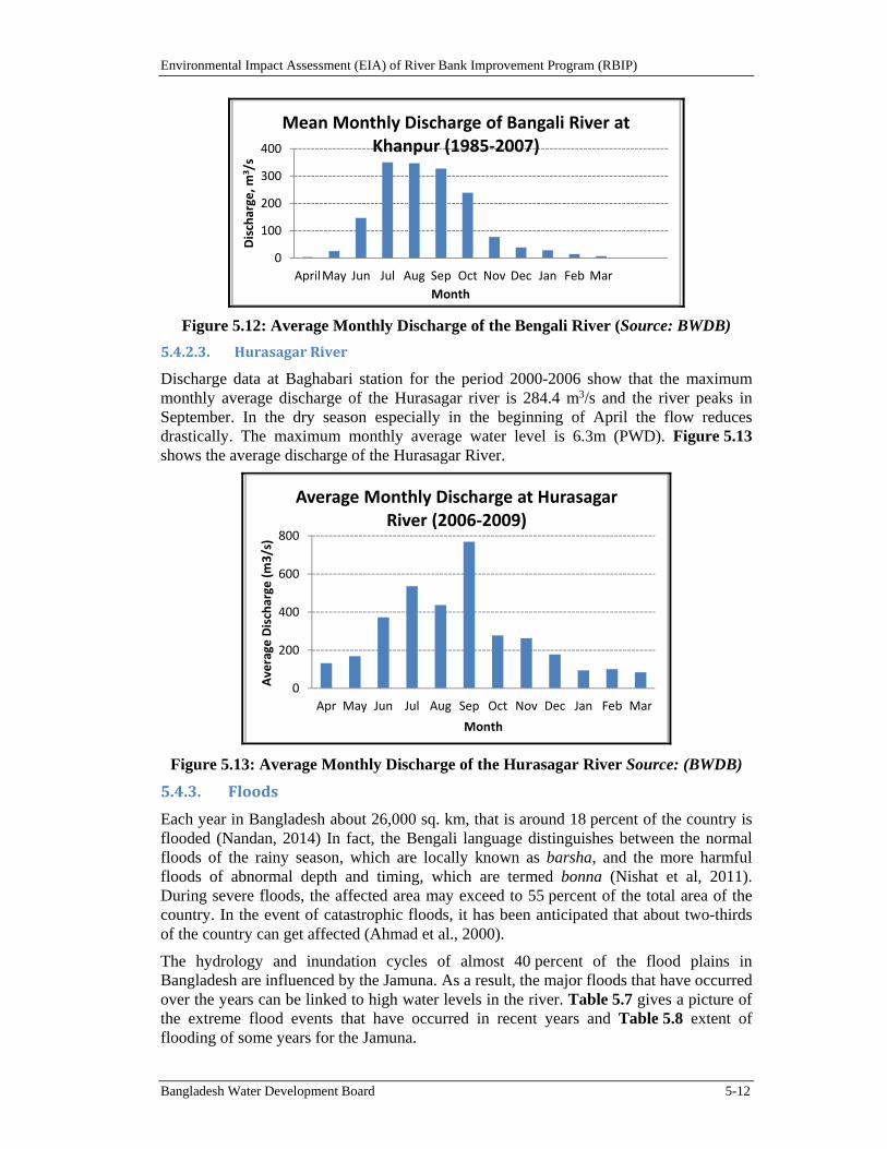
Environmental Impact Assessment (EIA) of River Bank Improvement Program (RBIP)
Bangladesh Water Development Board 5-12
Figure 5.12: Average Monthly Discharge of the Bengali River (Source: BWDB)
5.4.2.3. HurasagarRiver
Discharge data at Baghabari station for the period 2000-2006 show that the maximum monthly average discharge of the Hurasagar river is 284.4 m3/s and the river peaks in September. In the dry season especially in the beginning of April the flow reduces drastically. The maximum monthly average water level is 6.3m (PWD). Figure 5.13 shows the average discharge of the Hurasagar River.
Figure 5.13: Average Monthly Discharge of the Hurasagar River Source: (BWDB)
5.4.3. Floods
Each year in Bangladesh about 26,000 sq. km, that is around 18 percent of the country is flooded (Nandan, 2014) In fact, the Bengali language distinguishes between the normal floods of the rainy season, which are locally known as barsha, and the more harmful floods of abnormal depth and timing, which are termed bonna (Nishat et al, 2011). During severe floods, the affected area may exceed to 55 percent of the total area of the country. In the event of catastrophic floods, it has been anticipated that about two-thirds of the country can get affected (Ahmad et al., 2000).
The hydrology and inundation cycles of almost 40 percent of the flood plains in Bangladesh are influenced by the Jamuna. As a result, the major floods that have occurred over the years can be linked to high water levels in the river. Table 5.7 gives a picture of the extreme flood events that have occurred in recent years and Table 5.8 extent of flooding of some years for the Jamuna.
0
100
200
300
400
AprilMay Jun Jul Aug Sep Oct Nov Dec Jan Feb Mar
Discharge, m
3 /s
Month
Mean Monthly Discharge of Bangali River at Khanpur (1985‐2007)
0
200
400
600
800
Apr May Jun Jul Aug Sep Oct Nov Dec Jan Feb Mar
Average
Discharge
(m3/s)
Month
Average Monthly Discharge at Hurasagar River (2006‐2009)
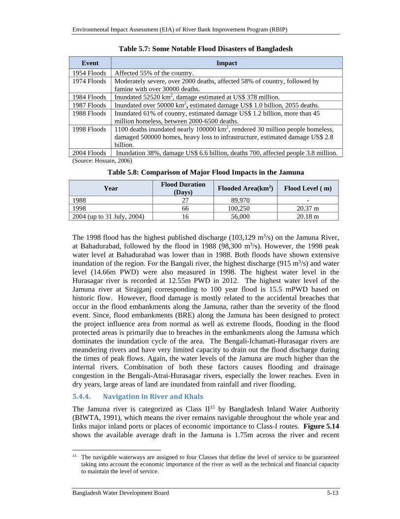
Environmental Impact Assessment (EIA) of River Bank Improvement Program (RBIP)
Bangladesh Water Development Board 5-13
Table 5.7: Some Notable Flood Disasters of Bangladesh
Event Impact
1954 Floods Affected 55% of the country. 1974 Floods Moderately severe, over 2000 deaths, affected 58% of country, followed by
famine with over 30000 deaths. 1984 Floods Inundated 52520 km2, damage estimated at US$ 378 million. 1987 Floods Inundated over 50000 km2, estimated damage US$ 1.0 billion, 2055 deaths. 1988 Floods Inundated 61% of country, estimated damage US$ 1.2 billion, more than 45
million homeless, between 2000-6500 deaths.1998 Floods 1100 deaths inundated nearly 100000 km2, rendered 30 million people homeless,
damaged 500000 homes, heavy loss to infrastructure, estimated damage US$ 2.8 billion.
2004 Floods Inundation 38%, damage US$ 6.6 billion, deaths 700, affected people 3.8 million. (Source: Hossain, 2006)
Table 5.8: Comparison of Major Flood Impacts in the Jamuna
Year Flood Duration
(Days) Flooded Area(km2) Flood Level ( m)
1988 27 89,970 - 1998 66 100,250 20.37 m 2004 (up to 31 July, 2004) 16 56,000 20.18 m
The 1998 flood has the highest published discharge (103,129 m3/s) on the Jamuna River, at Bahadurabad, followed by the flood in 1988 (98,300 m3/s). However, the 1998 peak water level at Bahadurabad was lower than in 1988. Both floods have shown extensive inundation of the region. For the Bangali river, the highest discharge (915 m3/s) and water level (14.66m PWD) were also measured in 1998. The highest water level in the Hurasagar river is recorded at 12.55m PWD in 2012. The highest water level of the Jamuna river at Sirajganj corresponding to 100 year flood is 15.5 mPWD based on historic flow. However, flood damage is mostly related to the accidental breaches that occur in the flood embankments along the Jamuna, rather than the severity of the flood event. Since, flood embankments (BRE) along the Jamuna has been designed to protect the project influence area from normal as well as extreme floods, flooding in the flood protected areas is primarily due to breaches in the embankments along the Jamuna which dominates the inundation cycle of the area. The Bengali-Ichamati-Hurasagar rivers are meandering rivers and have very limited capacity to drain out the flood discharge during the times of peak flows. Again, the water levels of the Jamuna are much higher than the internal rivers. Combination of both these factors causes flooding and drainage congestion in the Bengali-Atrai-Hurasagar rivers, especially the lower reaches. Even in dry years, large areas of land are inundated from rainfall and river flooding.
5.4.4. NavigationinRiverandKhals
The Jamuna river is categorized as Class II15 by Bangladesh Inland Water Authority (BIWTA, 1991), which means the river remains navigable throughout the whole year and links major inland ports or places of economic importance to Class-I routes. Figure 5.14 shows the available average draft in the Jamuna is 1.75m across the river and recent
15 The navigable waterways are assigned to four Classes that define the level of service to be guaranteed
taking into account the economic importance of the river as well as the technical and financial capacity to maintain the level of service.
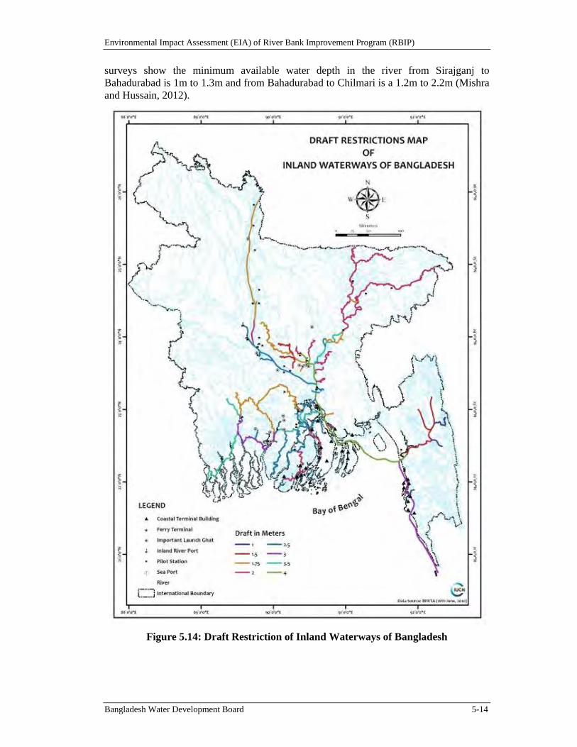
Environmental Impact Assessment (EIA) of River Bank Improvement Program (RBIP)
Bangladesh Water Development Board 5-14
surveys show the minimum available water depth in the river from Sirajganj to Bahadurabad is 1m to 1.3m and from Bahadurabad to Chilmari is a 1.2m to 2.2m (Mishra and Hussain, 2012).
Figure 5.14: Draft Restriction of Inland Waterways of Bangladesh
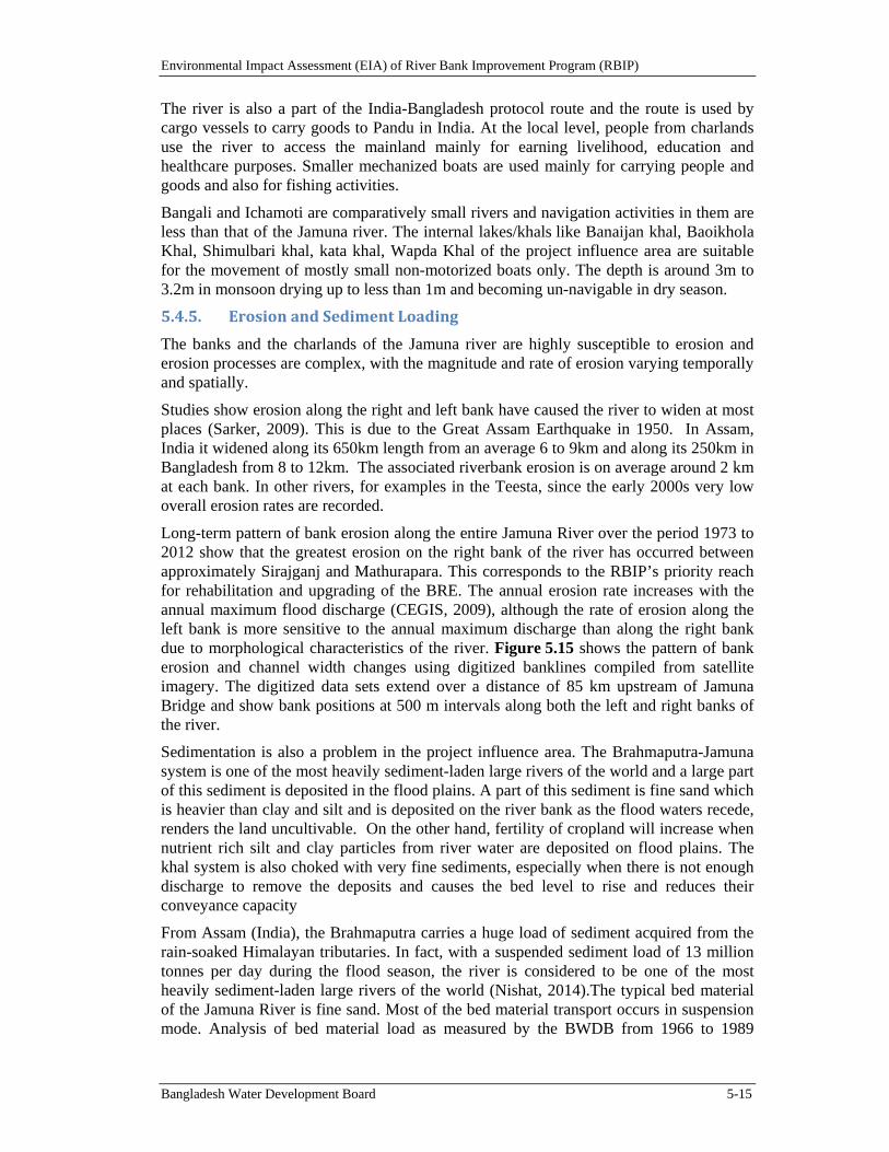
Environmental Impact Assessment (EIA) of River Bank Improvement Program (RBIP)
Bangladesh Water Development Board 5-15
The river is also a part of the India-Bangladesh protocol route and the route is used by cargo vessels to carry goods to Pandu in India. At the local level, people from charlands use the river to access the mainland mainly for earning livelihood, education and healthcare purposes. Smaller mechanized boats are used mainly for carrying people and goods and also for fishing activities.
Bangali and Ichamoti are comparatively small rivers and navigation activities in them are less than that of the Jamuna river. The internal lakes/khals like Banaijan khal, Baoikhola Khal, Shimulbari khal, kata khal, Wapda Khal of the project influence area are suitable for the movement of mostly small non-motorized boats only. The depth is around 3m to 3.2m in monsoon drying up to less than 1m and becoming un-navigable in dry season.
5.4.5. ErosionandSedimentLoading
The banks and the charlands of the Jamuna river are highly susceptible to erosion and erosion processes are complex, with the magnitude and rate of erosion varying temporally and spatially.
Studies show erosion along the right and left bank have caused the river to widen at most places (Sarker, 2009). This is due to the Great Assam Earthquake in 1950. In Assam, India it widened along its 650km length from an average 6 to 9km and along its 250km in Bangladesh from 8 to 12km. The associated riverbank erosion is on average around 2 km at each bank. In other rivers, for examples in the Teesta, since the early 2000s very low overall erosion rates are recorded.
Long-term pattern of bank erosion along the entire Jamuna River over the period 1973 to 2012 show that the greatest erosion on the right bank of the river has occurred between approximately Sirajganj and Mathurapara. This corresponds to the RBIP’s priority reach for rehabilitation and upgrading of the BRE. The annual erosion rate increases with the annual maximum flood discharge (CEGIS, 2009), although the rate of erosion along the left bank is more sensitive to the annual maximum discharge than along the right bank due to morphological characteristics of the river. Figure 5.15 shows the pattern of bank erosion and channel width changes using digitized banklines compiled from satellite imagery. The digitized data sets extend over a distance of 85 km upstream of Jamuna Bridge and show bank positions at 500 m intervals along both the left and right banks of the river.
Sedimentation is also a problem in the project influence area. The Brahmaputra-Jamuna system is one of the most heavily sediment-laden large rivers of the world and a large part of this sediment is deposited in the flood plains. A part of this sediment is fine sand which is heavier than clay and silt and is deposited on the river bank as the flood waters recede, renders the land uncultivable. On the other hand, fertility of cropland will increase when nutrient rich silt and clay particles from river water are deposited on flood plains. The khal system is also choked with very fine sediments, especially when there is not enough discharge to remove the deposits and causes the bed level to rise and reduces their conveyance capacity
From Assam (India), the Brahmaputra carries a huge load of sediment acquired from the rain-soaked Himalayan tributaries. In fact, with a suspended sediment load of 13 million tonnes per day during the flood season, the river is considered to be one of the most heavily sediment-laden large rivers of the world (Nishat, 2014).The typical bed material of the Jamuna River is fine sand. Most of the bed material transport occurs in suspension mode. Analysis of bed material load as measured by the BWDB from 1966 to 1989
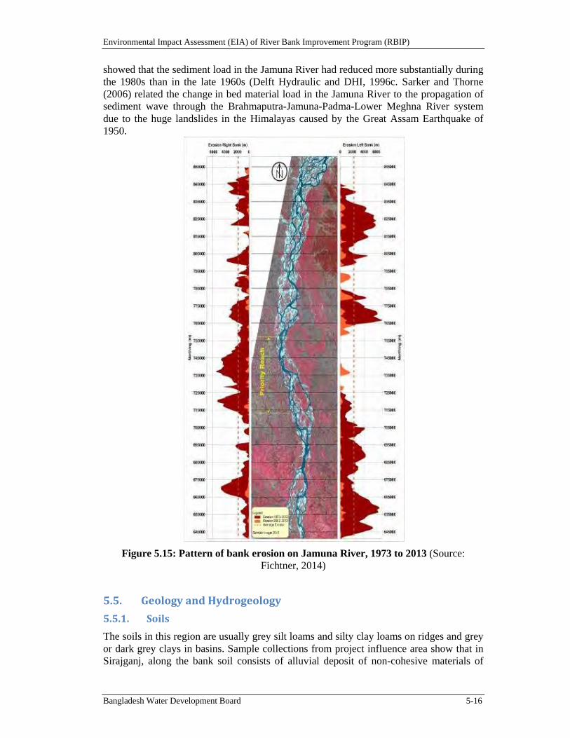
Environmental Impact Assessment (EIA) of River Bank Improvement Program (RBIP)
Bangladesh Water Development Board 5-16
showed that the sediment load in the Jamuna River had reduced more substantially during the 1980s than in the late 1960s (Delft Hydraulic and DHI, 1996c. Sarker and Thorne (2006) related the change in bed material load in the Jamuna River to the propagation of sediment wave through the Brahmaputra-Jamuna-Padma-Lower Meghna River system due to the huge landslides in the Himalayas caused by the Great Assam Earthquake of 1950.
Figure 5.15: Pattern of bank erosion on Jamuna River, 1973 to 2013 (Source: Fichtner, 2014)
5.5. GeologyandHydrogeology
5.5.1. Soils
The soils in this region are usually grey silt loams and silty clay loams on ridges and grey or dark grey clays in basins. Sample collections from project influence area show that in Sirajganj, along the bank soil consists of alluvial deposit of non-cohesive materials of
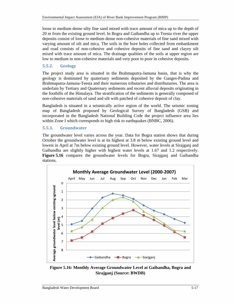
Environmental Impact Assessment (EIA) of River Bank Improvement Program (RBIP)
Bangladesh Water Development Board 5-17
loose to medium dense silty fine sand mixed with trace amount of mica up to the depth of 20 m from the existing ground level. In Bogra and Gaibandha up to Teesta river the upper deposits consist of loose to medium dense non-cohesive materials of fine sand mixed with varying amount of silt and mica. The soils in the bore holes collected from embankment and road consists of non-cohesive and cohesive deposits of fine sand and clayey silt mixed with trace amount of mica. The drainage qualities of the soils at upper region are low to medium in non-cohesive materials and very poor to poor in cohesive deposits.
5.5.2. Geology
The project study area is situated in the Brahmaputra-Jamuna basin, that is why the geology is dominated by quaternary sediments deposited by the Ganges-Padma and Brahmaputra-Jamuna-Teesta and their numerous tributaries and distributaries. The area is underlain by Tertiary and Quaternary sediments and recent alluvial deposits originating in the foothills of the Himalaya. The stratification of the sediments is generally composed of non-cohesive materials of sand and silt with patched of cohesive deposit of clay.
Bangladesh is situated in a seismically active region of the world. The seismic zoning map of Bangladesh proposed by Geological Survey of Bangladesh (GSB) and incorporated in the Bangladesh National Building Code the project influence area lies within Zone I which corresponds to high risk to earthquakes (BNBC, 2006).
5.5.3. Groundwater
The groundwater level varies across the year. Data for Bogra station shows that during October the groundwater level is at its highest at 3.8 m below existing ground level and lowest in April at 7m below existing ground level. However, water levels at Sirajganj and Gaibandha are slightly higher with highest water levels at 1.67 and 1.2 respectively. Figure 5.16 compares the groundwater levels for Bogra, Sirajganj and Gaibandha stations.
Figure 5.16: Monthly Average Groundwater Level at Gaibandha, Bogra and Sirajganj (Source: BWDB)
0
1
2
3
4
5
6
7
8
April May Jun Jul Aug Sep Oct Nov Dec Jan Feb Mar
Average
groundwater level below existing sground
level (m)
Monthly Average Groundwater Level (2000‐2007)
Gaibandha Bogra Siarjganj
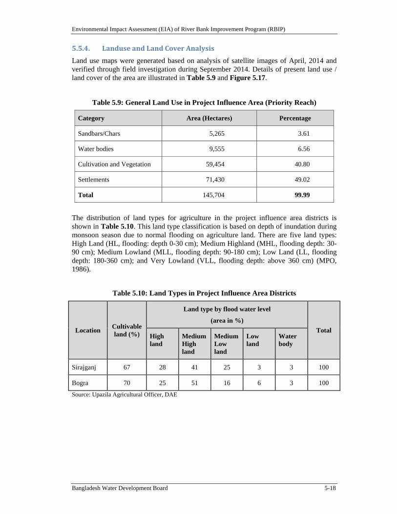
Environmental Impact Assessment (EIA) of River Bank Improvement Program (RBIP)
Bangladesh Water Development Board 5-18
5.5.4. LanduseandLandCoverAnalysis
Land use maps were generated based on analysis of satellite images of April, 2014 and verified through field investigation during September 2014. Details of present land use / land cover of the area are illustrated in Table 5.9 and Figure 5.17.
Table 5.9: General Land Use in Project Influence Area (Priority Reach)
Category Area (Hectares) Percentage
Sandbars/Chars 5,265 3.61
Water bodies 9,555 6.56
Cultivation and Vegetation 59,454 40.80
Settlements 71,430 49.02
Total 145,704 99.99
The distribution of land types for agriculture in the project influence area districts is shown in Table 5.10. This land type classification is based on depth of inundation during monsoon season due to normal flooding on agriculture land. There are five land types: High Land (HL, flooding: depth 0-30 cm); Medium Highland (MHL, flooding depth: 30-90 cm); Medium Lowland (MLL, flooding depth: 90-180 cm); Low Land (LL, flooding depth: 180-360 cm); and Very Lowland (VLL, flooding depth: above 360 cm) (MPO, 1986).
Table 5.10: Land Types in Project Influence Area Districts
Location Cultivable land (%)
Land type by flood water level
(area in %)
Total High land
Medium High land
Medium Low land
Low land
Water body
Sirajganj 67 28 41 25 3 3 100
Bogra 70 25 51 16 6 3 100
Source: Upazila Agricultural Officer, DAE
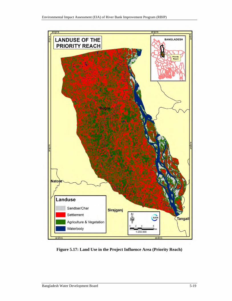
Environmental Impact Assessment (EIA) of River Bank Improvement Program (RBIP)
Bangladesh Water Development Board 5-19
Figure 5.17: Land Use in the Project Influence Area (Priority Reach)
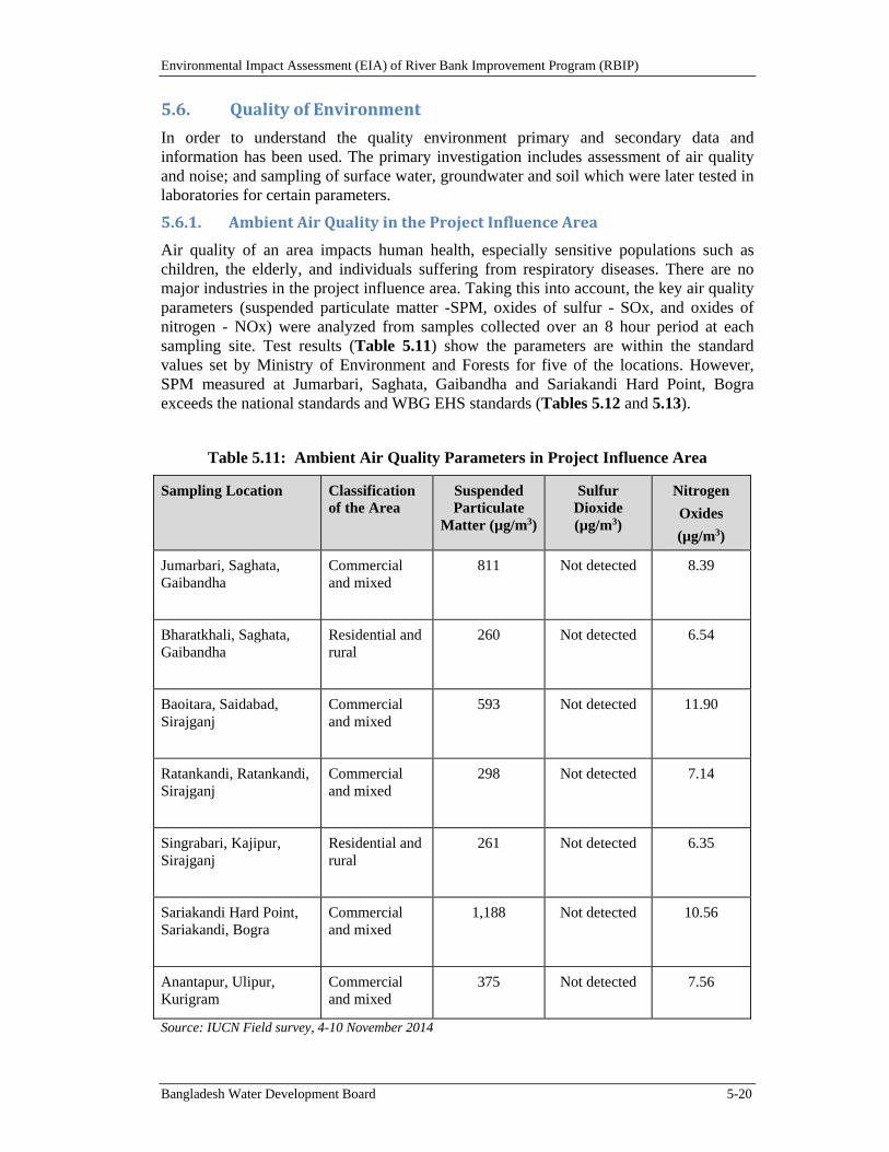
Environmental Impact Assessment (EIA) of River Bank Improvement Program (RBIP)
Bangladesh Water Development Board 5-20
5.6. QualityofEnvironment
In order to understand the quality environment primary and secondary data and information has been used. The primary investigation includes assessment of air quality and noise; and sampling of surface water, groundwater and soil which were later tested in laboratories for certain parameters.
5.6.1. AmbientAirQualityintheProjectInfluenceArea
Air quality of an area impacts human health, especially sensitive populations such as children, the elderly, and individuals suffering from respiratory diseases. There are no major industries in the project influence area. Taking this into account, the key air quality parameters (suspended particulate matter -SPM, oxides of sulfur - SOx, and oxides of nitrogen - NOx) were analyzed from samples collected over an 8 hour period at each sampling site. Test results (Table 5.11) show the parameters are within the standard values set by Ministry of Environment and Forests for five of the locations. However, SPM measured at Jumarbari, Saghata, Gaibandha and Sariakandi Hard Point, Bogra exceeds the national standards and WBG EHS standards (Tables 5.12 and 5.13).
Table 5.11: Ambient Air Quality Parameters in Project Influence Area
Sampling Location Classification of the Area
Suspended Particulate
Matter (µg/m3)
Sulfur Dioxide (µg/m3)
Nitrogen
Oxides
(µg/m3)
Jumarbari, Saghata, Gaibandha
Commercial and mixed
811 Not detected 8.39
Bharatkhali, Saghata, Gaibandha
Residential and rural
260 Not detected 6.54
Baoitara, Saidabad, Sirajganj
Commercial and mixed
593 Not detected 11.90
Ratankandi, Ratankandi, Sirajganj
Commercial and mixed
298 Not detected 7.14
Singrabari, Kajipur, Sirajganj
Residential and rural
261 Not detected 6.35
Sariakandi Hard Point, Sariakandi, Bogra
Commercial and mixed
1,188 Not detected 10.56
Anantapur, Ulipur, Kurigram
Commercial and mixed
375 Not detected 7.56
Source: IUCN Field survey, 4-10 November 2014
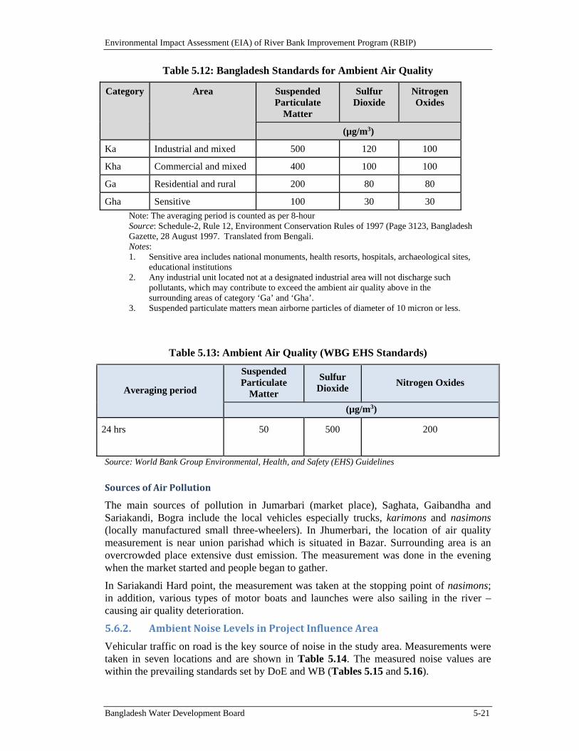
Environmental Impact Assessment (EIA) of River Bank Improvement Program (RBIP)
Bangladesh Water Development Board 5-21
Table 5.12: Bangladesh Standards for Ambient Air Quality
Category Area Suspended Particulate
Matter
Sulfur Dioxide
Nitrogen Oxides
(µg/m3)
Ka Industrial and mixed 500 120 100
Kha Commercial and mixed 400 100 100
Ga Residential and rural 200 80 80
Gha Sensitive 100 30 30
Note: The averaging period is counted as per 8-hour Source: Schedule-2, Rule 12, Environment Conservation Rules of 1997 (Page 3123, Bangladesh Gazette, 28 August 1997. Translated from Bengali. Notes: 1. Sensitive area includes national monuments, health resorts, hospitals, archaeological sites,
educational institutions 2. Any industrial unit located not at a designated industrial area will not discharge such
pollutants, which may contribute to exceed the ambient air quality above in the surrounding areas of category ‘Ga’ and ‘Gha’.
3. Suspended particulate matters mean airborne particles of diameter of 10 micron or less.
Table 5.13: Ambient Air Quality (WBG EHS Standards)
Averaging period
Suspended Particulate
Matter
Sulfur Dioxide
Nitrogen Oxides
(µg/m3)
24 hrs 50 500 200
Source: World Bank Group Environmental, Health, and Safety (EHS) Guidelines
SourcesofAirPollution
The main sources of pollution in Jumarbari (market place), Saghata, Gaibandha and Sariakandi, Bogra include the local vehicles especially trucks, karimons and nasimons (locally manufactured small three-wheelers). In Jhumerbari, the location of air quality measurement is near union parishad which is situated in Bazar. Surrounding area is an overcrowded place extensive dust emission. The measurement was done in the evening when the market started and people began to gather.
In Sariakandi Hard point, the measurement was taken at the stopping point of nasimons; in addition, various types of motor boats and launches were also sailing in the river – causing air quality deterioration.
5.6.2. AmbientNoiseLevelsinProjectInfluenceArea
Vehicular traffic on road is the key source of noise in the study area. Measurements were taken in seven locations and are shown in Table 5.14. The measured noise values are within the prevailing standards set by DoE and WB (Tables 5.15 and 5.16).
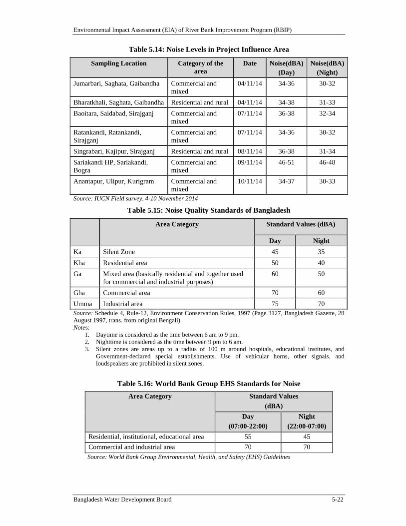
Environmental Impact Assessment (EIA) of River Bank Improvement Program (RBIP)
Bangladesh Water Development Board 5-22
Table 5.14: Noise Levels in Project Influence Area
Sampling Location Category of the area
Date Noise(dBA) (Day)
Noise(dBA)(Night)
Jumarbari, Saghata, Gaibandha Commercial and mixed
04/11/14 34-36 30-32
Bharatkhali, Saghata, Gaibandha Residential and rural 04/11/14 34-38 31-33
Baoitara, Saidabad, Sirajganj Commercial and mixed
07/11/14 36-38 32-34
Ratankandi, Ratankandi, Sirajganj
Commercial and mixed
07/11/14 34-36 30-32
Singrabari, Kajipur, Sirajganj Residential and rural 08/11/14 36-38 31-34
Sariakandi HP, Sariakandi, Bogra
Commercial and mixed
09/11/14 46-51 46-48
Anantapur, Ulipur, Kurigram Commercial and mixed
10/11/14 34-37 30-33
Source: IUCN Field survey, 4-10 November 2014
Table 5.15: Noise Quality Standards of Bangladesh
Area Category Standard Values (dBA)
Day Night
Ka Silent Zone 45 35
Kha Residential area 50 40
Ga Mixed area (basically residential and together used for commercial and industrial purposes)
60 50
Gha Commercial area 70 60
Umma Industrial area 75 70 Source: Schedule 4, Rule-12, Environment Conservation Rules, 1997 (Page 3127, Bangladesh Gazette, 28 August 1997, trans. from original Bengali). Notes:
1. Daytime is considered as the time between 6 am to 9 pm. 2. Nighttime is considered as the time between 9 pm to 6 am. 3. Silent zones are areas up to a radius of 100 m around hospitals, educational institutes, and
Government-declared special establishments. Use of vehicular horns, other signals, and loudspeakers are prohibited in silent zones.
Table 5.16: World Bank Group EHS Standards for Noise
Area Category Standard Values
(dBA)
Day
(07:00-22:00)
Night
(22:00-07:00)
Residential, institutional, educational area 55 45
Commercial and industrial area 70 70
Source: World Bank Group Environmental, Health, and Safety (EHS) Guidelines
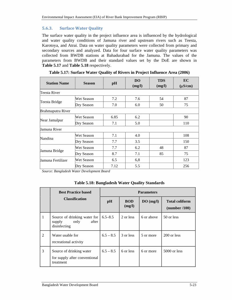
Environmental Impact Assessment (EIA) of River Bank Improvement Program (RBIP)
Bangladesh Water Development Board 5-23
5.6.3. SurfaceWaterQuality
The surface water quality in the project influence area is influenced by the hydrological and water quality conditions of Jamuna river and upstream rivers such as Teesta, Karotoya, and Atrai. Data on water quality parameters were collected from primary and secondary sources and analyzed. Data for four surface water quality parameters was collected from BWDB stations at Bahadurabad for the Jamuna. The values of the parameters from BWDB and their standard values set by the DoE are shown in Table 5.17 and Table 5.18 respectively.
Table 5.17: Surface Water Quality of Rivers in Project Influence Area (2006)
Station Name Season pH DO
(mg/l) TDS
(mg/l) EC
(S/cm)
Teesta River
Teesta Bridge Wet Season 7.2 7.6 54 87
Dry Season 7.0 6.0 50 75
Brahmaputra River
Near Jamalpur Wet Season 6.85 6.2 90
Dry Season 7.1 5.0 110
Jamuna River
Nandina Wet Season 7.1 4.0 108
Dry Season 7.7 3.5 150
Jamuna Bridge Wet Season 7.7 6.2 48 87
Dry Season 8.7 7.1 85 75
Jamuna Fertilizer
Wet Season 6.5 6,8 123
Dry Season 7.12 5.5 256 Source: Bangladesh Water Development Board
Table 5.18: Bangladesh Water Quality Standards
Best Practice based
Classification
Parameters
pH BOD (mg/l)
DO (mg/l) Total coliform
(number /100)
1 Source of drinking water for supply only after disinfecting
6.5–8.5 2 or less 6 or above 50 or less
2 Water usable for
recreational activity
6.5 – 8.5 3 or less 5 or more 200 or less
3 Source of drinking water
for supply after conventional treatment
6.5 – 8.5 6 or less 6 or more 5000 or less
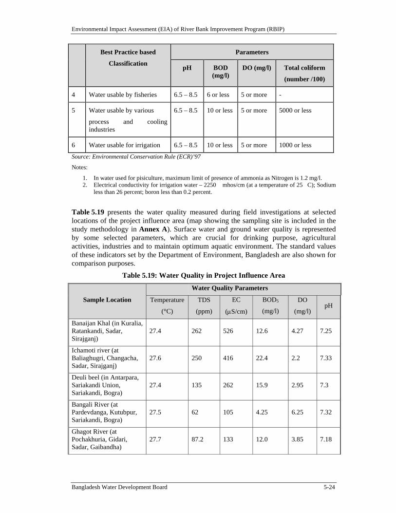
Environmental Impact Assessment (EIA) of River Bank Improvement Program (RBIP)
Bangladesh Water Development Board 5-24
Best Practice based
Classification
Parameters
pH BOD (mg/l)
DO (mg/l) Total coliform
(number /100)
4 Water usable by fisheries 6.5 – 8.5 6 or less 5 or more -
5 Water usable by various
process and cooling industries
6.5 – 8.5 10 or less 5 or more 5000 or less
6 Water usable for irrigation 6.5 – 8.5 10 or less 5 or more 1000 or less
Source: Environmental Conservation Rule (ECR)’97
Notes:
1. In water used for pisiculture, maximum limit of presence of ammonia as Nitrogen is 1.2 mg/l. 2. Electrical conductivity for irrigation water – 2250 �mhos/cm (at a temperature of 25�C); Sodium
less than 26 percent; boron less than 0.2 percent.
Table 5.19 presents the water quality measured during field investigations at selected locations of the project influence area (map showing the sampling site is included in the study methodology in Annex A). Surface water and ground water quality is represented by some selected parameters, which are crucial for drinking purpose, agricultural activities, industries and to maintain optimum aquatic environment. The standard values of these indicators set by the Department of Environment, Bangladesh are also shown for comparison purposes.
Table 5.19: Water Quality in Project Influence Area
Sample Location
Water Quality Parameters
Temperature
(°C)
TDS
(ppm)
EC
(S/cm)
BOD5
(mg/l)
DO
(mg/l) pH
Banaijan Khal (in Kuralia, Ratankandi, Sadar, Sirajganj)
27.4 262 526 12.6 4.27 7.25
Ichamoti river (at Baliaghugri, Changacha, Sadar, Sirajganj)
27.6 250 416 22.4 2.2 7.33
Deuli beel (in Antarpara, Sariakandi Union, Sariakandi, Bogra)
27.4 135 262 15.9 2.95 7.3
Bangali River (at Pardevdanga, Kutubpur, Sariakandi, Bogra)
27.5 62 105 4.25 6.25 7.32
Ghagot River (at Pochakhuria, Gidari, Sadar, Gaibandha)
27.7 87.2 133 12.0 3.85 7.18
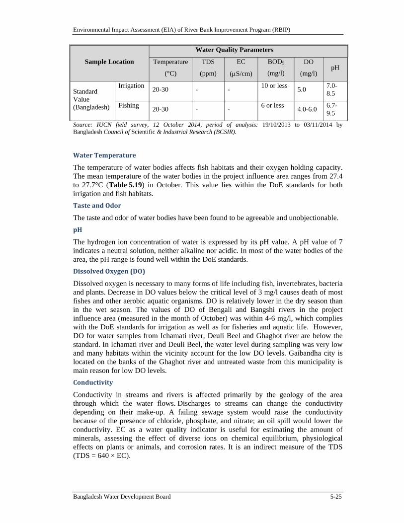
Environmental Impact Assessment (EIA) of River Bank Improvement Program (RBIP)
Bangladesh Water Development Board 5-25
Sample Location
Water Quality Parameters
Temperature
(°C)
TDS
(ppm)
EC
(S/cm)
BOD5
(mg/l)
DO
(mg/l) pH
Standard Value (Bangladesh)
Irrigation 20-30 - -
10 or less 5.0
7.0-8.5
Fishing 20-30 - -
6 or less 4.0-6.0
6.7-9.5
Source: IUCN field survey, 12 October 2014, period of analysis: 19/10/2013 to 03/11/2014 by Bangladesh Council of Scientific & Industrial Research (BCSIR).
WaterTemperature
The temperature of water bodies affects fish habitats and their oxygen holding capacity. The mean temperature of the water bodies in the project influence area ranges from 27.4 to 27.7°C (Table 5.19) in October. This value lies within the DoE standards for both irrigation and fish habitats.
TasteandOdor
The taste and odor of water bodies have been found to be agreeable and unobjectionable.
pH
The hydrogen ion concentration of water is expressed by its pH value. A pH value of 7 indicates a neutral solution, neither alkaline nor acidic. In most of the water bodies of the area, the pH range is found well within the DoE standards.
DissolvedOxygen(DO)
Dissolved oxygen is necessary to many forms of life including fish, invertebrates, bacteria and plants. Decrease in DO values below the critical level of 3 mg/l causes death of most fishes and other aerobic aquatic organisms. DO is relatively lower in the dry season than in the wet season. The values of DO of Bengali and Bangshi rivers in the project influence area (measured in the month of October) was within 4-6 mg/l, which complies with the DoE standards for irrigation as well as for fisheries and aquatic life. However, DO for water samples from Ichamati river, Deuli Beel and Ghaghot river are below the standard. In Ichamati river and Deuli Beel, the water level during sampling was very low and many habitats within the vicinity account for the low DO levels. Gaibandha city is located on the banks of the Ghaghot river and untreated waste from this municipality is main reason for low DO levels.
Conductivity
Conductivity in streams and rivers is affected primarily by the geology of the area through which the water flows. Discharges to streams can change the conductivity depending on their make-up. A failing sewage system would raise the conductivity because of the presence of chloride, phosphate, and nitrate; an oil spill would lower the conductivity. EC as a water quality indicator is useful for estimating the amount of minerals, assessing the effect of diverse ions on chemical equilibrium, physiological effects on plants or animals, and corrosion rates. It is an indirect measure of the TDS (TDS = 640 × EC).
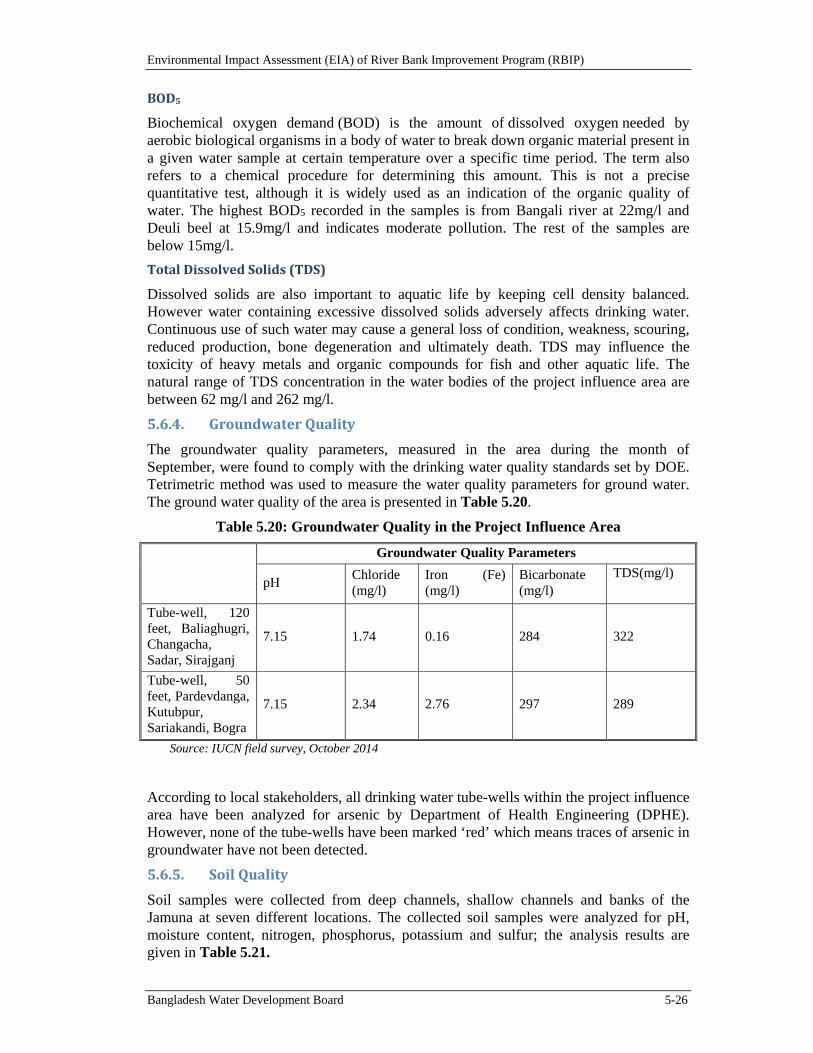
Environmental Impact Assessment (EIA) of River Bank Improvement Program (RBIP)
Bangladesh Water Development Board 5-26
BOD5
Biochemical oxygen demand (BOD) is the amount of dissolved oxygen needed by aerobic biological organisms in a body of water to break down organic material present in a given water sample at certain temperature over a specific time period. The term also refers to a chemical procedure for determining this amount. This is not a precise quantitative test, although it is widely used as an indication of the organic quality of water. The highest BOD5 recorded in the samples is from Bangali river at 22mg/l and Deuli beel at 15.9mg/l and indicates moderate pollution. The rest of the samples are below 15mg/l.
TotalDissolvedSolids(TDS)
Dissolved solids are also important to aquatic life by keeping cell density balanced. However water containing excessive dissolved solids adversely affects drinking water. Continuous use of such water may cause a general loss of condition, weakness, scouring, reduced production, bone degeneration and ultimately death. TDS may influence the toxicity of heavy metals and organic compounds for fish and other aquatic life. The natural range of TDS concentration in the water bodies of the project influence area are between 62 mg/l and 262 mg/l.
5.6.4. GroundwaterQuality
The groundwater quality parameters, measured in the area during the month of September, were found to comply with the drinking water quality standards set by DOE. Tetrimetric method was used to measure the water quality parameters for ground water. The ground water quality of the area is presented in Table 5.20.
Table 5.20: Groundwater Quality in the Project Influence Area
Groundwater Quality Parameters
pH Chloride (mg/l)
Iron (Fe) (mg/l)
Bicarbonate (mg/l)
TDS(mg/l)
Tube-well, 120 feet, Baliaghugri, Changacha, Sadar, Sirajganj
7.15 1.74 0.16 284 322
Tube-well, 50 feet, Pardevdanga, Kutubpur, Sariakandi, Bogra
7.15 2.34 2.76 297 289
Source: IUCN field survey, October 2014
According to local stakeholders, all drinking water tube-wells within the project influence area have been analyzed for arsenic by Department of Health Engineering (DPHE). However, none of the tube-wells have been marked ‘red’ which means traces of arsenic in groundwater have not been detected.
5.6.5. SoilQuality
Soil samples were collected from deep channels, shallow channels and banks of the Jamuna at seven different locations. The collected soil samples were analyzed for pH, moisture content, nitrogen, phosphorus, potassium and sulfur; the analysis results are given in Table 5.21.
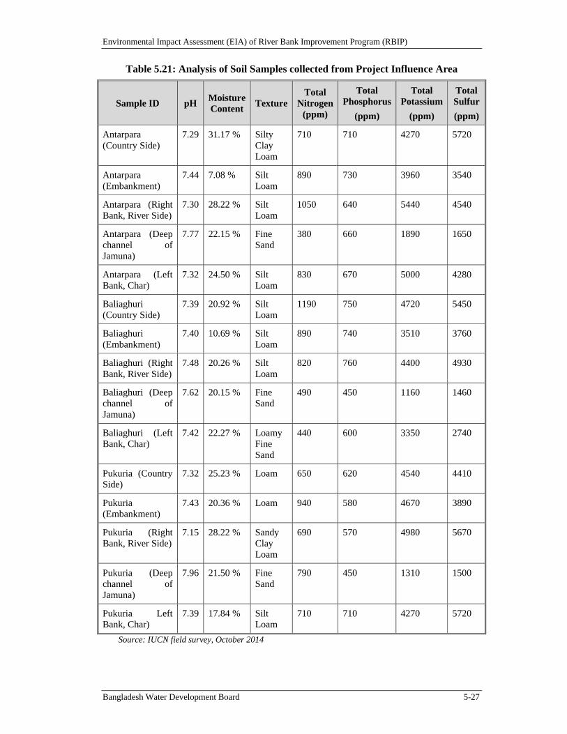
Environmental Impact Assessment (EIA) of River Bank Improvement Program (RBIP)
Bangladesh Water Development Board 5-27
Table 5.21: Analysis of Soil Samples collected from Project Influence Area
Sample ID pH Moisture Content
TextureTotal
Nitrogen (ppm)
Total Phosphorus
(ppm)
Total Potassium
(ppm)
Total Sulfur
(ppm)
Antarpara (Country Side)
7.29 31.17 % Silty Clay Loam
710 710 4270 5720
Antarpara (Embankment)
7.44 7.08 % Silt Loam
890 730 3960 3540
Antarpara (Right Bank, River Side)
7.30 28.22 % Silt Loam
1050 640 5440 4540
Antarpara (Deep channel of Jamuna)
7.77 22.15 % Fine Sand
380 660 1890 1650
Antarpara (Left Bank, Char)
7.32 24.50 % Silt Loam
830 670 5000 4280
Baliaghuri (Country Side)
7.39 20.92 % Silt Loam
1190 750 4720 5450
Baliaghuri (Embankment)
7.40 10.69 % Silt Loam
890 740 3510 3760
Baliaghuri (Right Bank, River Side)
7.48 20.26 % Silt Loam
820 760 4400 4930
Baliaghuri (Deep channel of Jamuna)
7.62 20.15 % Fine Sand
490 450 1160 1460
Baliaghuri (Left Bank, Char)
7.42 22.27 % Loamy Fine Sand
440 600 3350 2740
Pukuria (Country Side)
7.32 25.23 % Loam 650 620 4540 4410
Pukuria (Embankment)
7.43 20.36 % Loam 940 580 4670 3890
Pukuria (Right Bank, River Side)
7.15 28.22 % Sandy Clay Loam
690 570 4980 5670
Pukuria (Deep channel of Jamuna)
7.96 21.50 % Fine Sand
790 450 1310 1500
Pukuria Left Bank, Char)
7.39 17.84 % Silt Loam
710 710 4270 5720
Source: IUCN field survey, October 2014
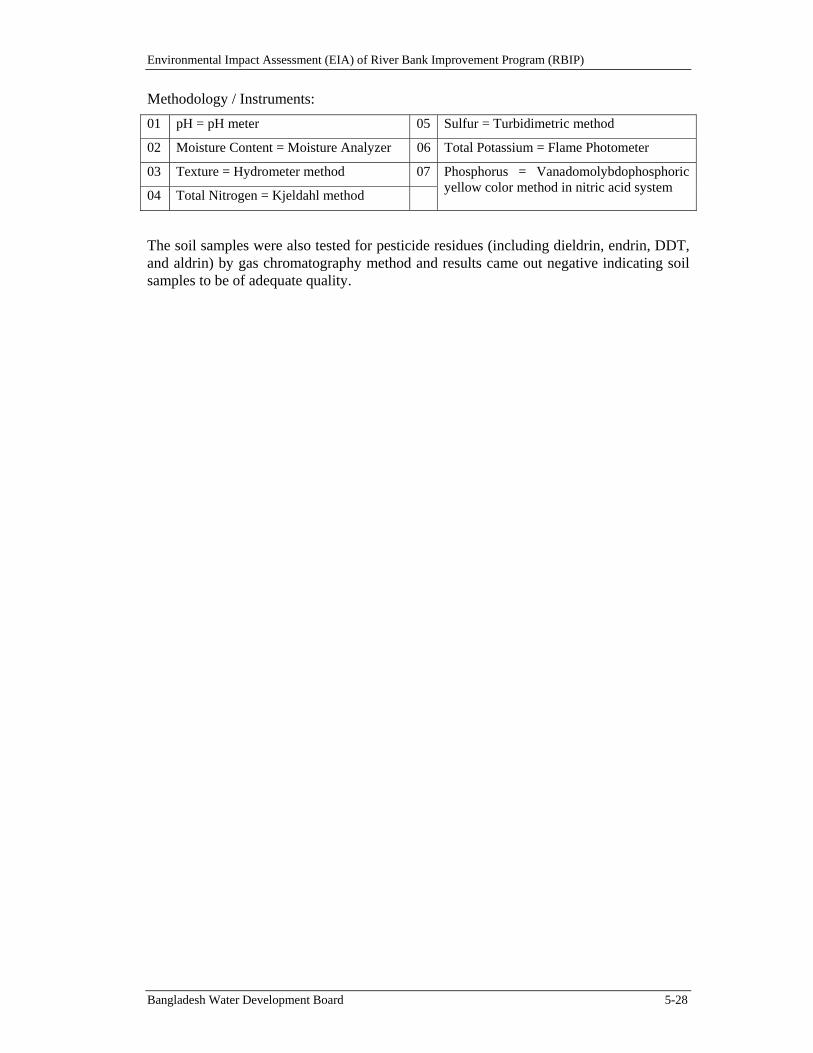
Environmental Impact Assessment (EIA) of River Bank Improvement Program (RBIP)
Bangladesh Water Development Board 5-28
Methodology / Instruments:
01 pH = pH meter 05 Sulfur = Turbidimetric method
02 Moisture Content = Moisture Analyzer 06 Total Potassium = Flame Photometer
03 Texture = Hydrometer method 07 Phosphorus = Vanadomolybdophosphoric yellow color method in nitric acid system
04 Total Nitrogen = Kjeldahl method
The soil samples were also tested for pesticide residues (including dieldrin, endrin, DDT, and aldrin) by gas chromatography method and results came out negative indicating soil samples to be of adequate quality.
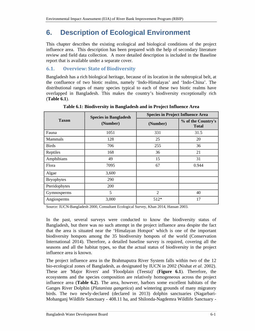
Environmental Impact Assessment (EIA) of River Bank Improvement Program (RBIP)
Bangladesh Water Development Board 6-1
6. Description of Ecological Environment
This chapter describes the existing ecological and biological conditions of the project influence area. This description has been prepared with the help of secondary literature review and field data collection. A more detailed description is included in the Baseline report that is available under a separate cover.
6.1. Overview:StateofBiodiversity
Bangladesh has a rich biological heritage, because of its location in the subtropical belt, at the confluence of two biotic realms, namely ‘Indo-Himalayas’ and ‘Indo-China’. The distributional ranges of many species typical to each of these two biotic realms have overlapped in Bangladesh. This makes the country’s biodiversity exceptionally rich (Table 6.1).
Table 6.1: Biodiversity in Bangladesh and in Project Influence Area
Taxon Species in Bangladesh
(Number)
Species in Project Influence Area
(Number) % of the Country's
Total
Fauna 1051 331 31.5
Mammals 128 25 20
Birds 706 255 36
Reptiles 168 36 21
Amphibians 49 15 31
Flora 7095 67 0.944
Algae 3,600
Bryophytes 290
Pteridophytes 200
Gymnosperms 5 2 40
Angiosperms 3,000 512* 17
Source: IUCN-Bangladesh 2000, Consultant Ecological Survey, Khan 2014, Hassan 2003.
In the past, several surveys were conducted to know the biodiversity status of Bangladesh, but there was no such attempt in the project influence area despite the fact that the area is situated near the ‘Himalayan Hotspot’ which is one of the important biodiversity hotspots among the 35 biodiversity hotspots of the world (Conservation International 2014). Therefore, a detailed baseline survey is required, covering all the seasons and all the habitat types, so that the actual status of biodiversity in the project influence area is known.
The project influence area in the Brahmaputra River System falls within two of the 12 bio-ecological zones of Bangladesh, as designated by IUCN in 2002 (Nishat et al. 2002). These are 'Major Rivers' and 'Floodplain (Teesta)' (Figure 6.1). Therefore, the ecosystems and the species composition are relatively homogeneous across the project influence area (Table 6.2). The area, however, harbors some excellent habitats of the Ganges River Dolphin (Platanista gangetica) and wintering grounds of many migratory birds. The two newly-declared (declared in 2013) dolphin sanctuaries (Nagarbari-Mohanganj Wildlife Sanctuary - 408.11 ha, and Shilonda-Nagdemra Wildlife Sanctuary -
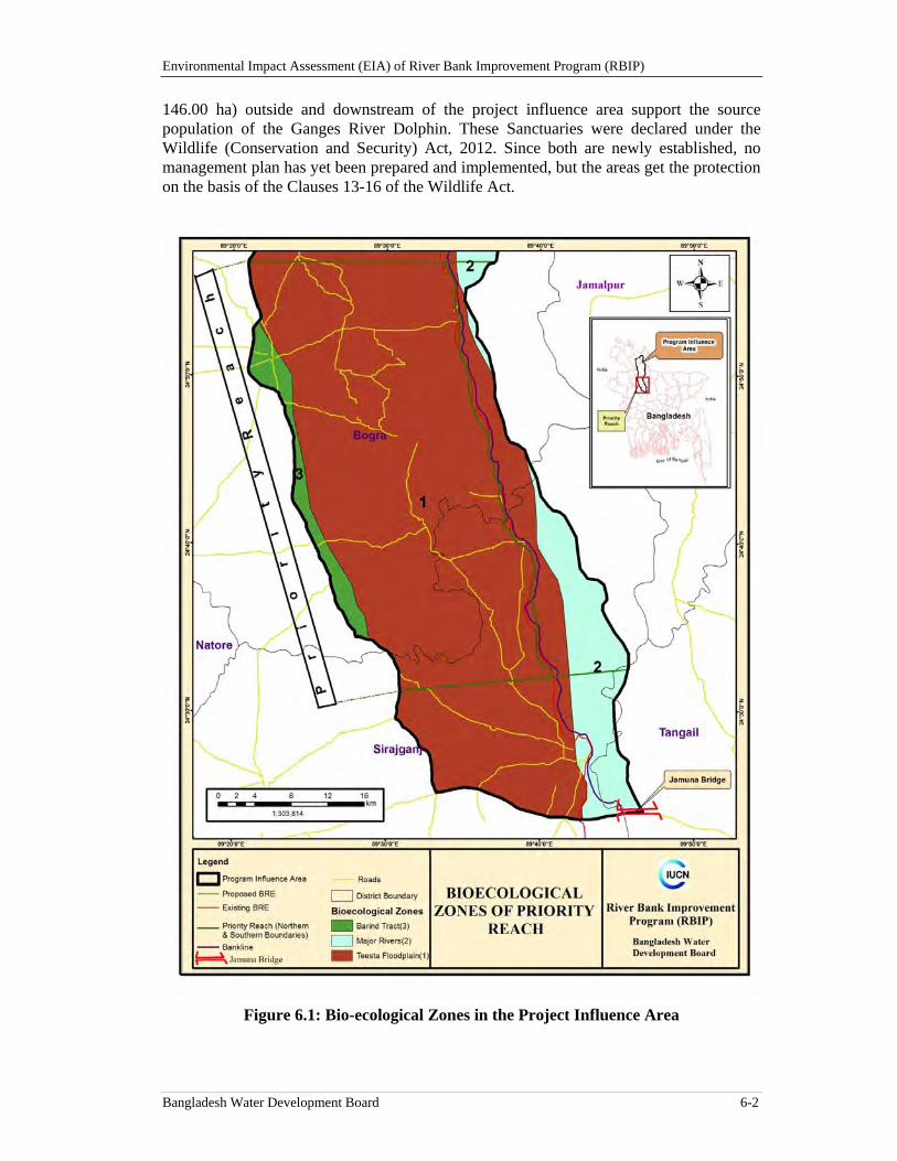
Environmental Impact Assessment (EIA) of River Bank Improvement Program (RBIP)
Bangladesh Water Development Board 6-2
146.00 ha) outside and downstream of the project influence area support the source population of the Ganges River Dolphin. These Sanctuaries were declared under the Wildlife (Conservation and Security) Act, 2012. Since both are newly established, no management plan has yet been prepared and implemented, but the areas get the protection on the basis of the Clauses 13-16 of the Wildlife Act.
Figure 6.1: Bio-ecological Zones in the Project Influence Area
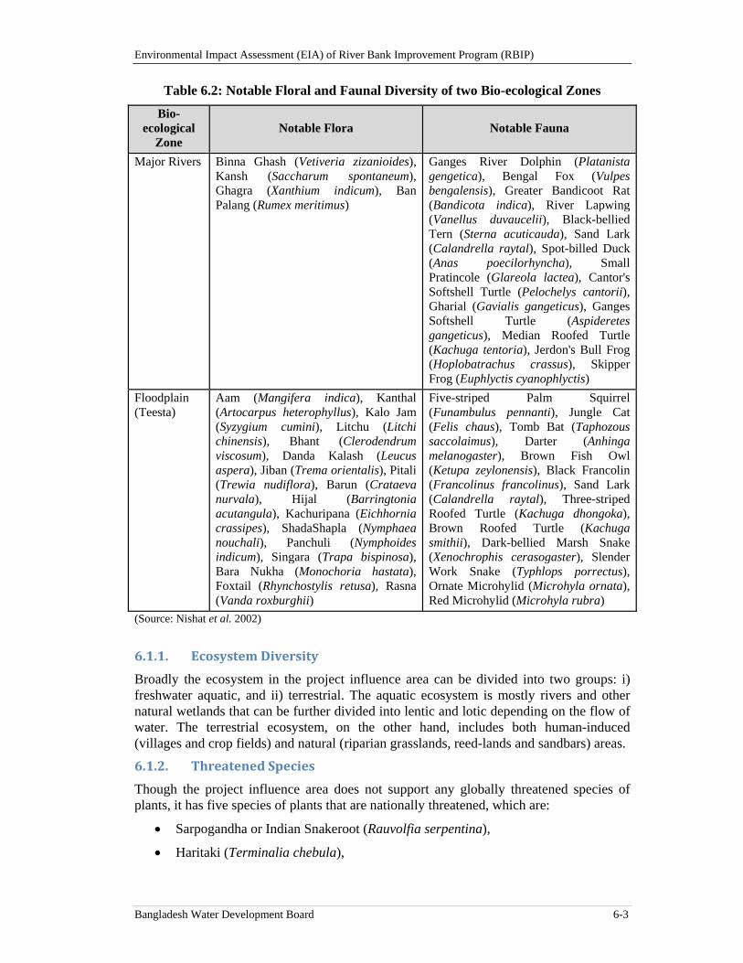
Environmental Impact Assessment (EIA) of River Bank Improvement Program (RBIP)
Bangladesh Water Development Board 6-3
Table 6.2: Notable Floral and Faunal Diversity of two Bio-ecological Zones
Bio-ecological
Zone Notable Flora Notable Fauna
Major Rivers Binna Ghash (Vetiveria zizanioides), Kansh (Saccharum spontaneum), Ghagra (Xanthium indicum), Ban Palang (Rumex meritimus)
Ganges River Dolphin (Platanista gengetica), Bengal Fox (Vulpes bengalensis), Greater Bandicoot Rat (Bandicota indica), River Lapwing (Vanellus duvaucelii), Black-bellied Tern (Sterna acuticauda), Sand Lark (Calandrella raytal), Spot-billed Duck (Anas poecilorhyncha), Small Pratincole (Glareola lactea), Cantor's Softshell Turtle (Pelochelys cantorii), Gharial (Gavialis gangeticus), Ganges Softshell Turtle (Aspideretes gangeticus), Median Roofed Turtle (Kachuga tentoria), Jerdon's Bull Frog (Hoplobatrachus crassus), Skipper Frog (Euphlyctis cyanophlyctis)
Floodplain (Teesta)
Aam (Mangifera indica), Kanthal (Artocarpus heterophyllus), Kalo Jam (Syzygium cumini), Litchu (Litchi chinensis), Bhant (Clerodendrum viscosum), Danda Kalash (Leucus aspera), Jiban (Trema orientalis), Pitali (Trewia nudiflora), Barun (Crataeva nurvala), Hijal (Barringtonia acutangula), Kachuripana (Eichhornia crassipes), ShadaShapla (Nymphaea nouchali), Panchuli (Nymphoides indicum), Singara (Trapa bispinosa), Bara Nukha (Monochoria hastata), Foxtail (Rhynchostylis retusa), Rasna (Vanda roxburghii)
Five-striped Palm Squirrel (Funambulus pennanti), Jungle Cat (Felis chaus), Tomb Bat (Taphozous saccolaimus), Darter (Anhinga melanogaster), Brown Fish Owl (Ketupa zeylonensis), Black Francolin (Francolinus francolinus), Sand Lark (Calandrella raytal), Three-striped Roofed Turtle (Kachuga dhongoka), Brown Roofed Turtle (Kachuga smithii), Dark-bellied Marsh Snake (Xenochrophis cerasogaster), Slender Work Snake (Typhlops porrectus), Ornate Microhylid (Microhyla ornata), Red Microhylid (Microhyla rubra)
(Source: Nishat et al. 2002)
6.1.1. EcosystemDiversity
Broadly the ecosystem in the project influence area can be divided into two groups: i) freshwater aquatic, and ii) terrestrial. The aquatic ecosystem is mostly rivers and other natural wetlands that can be further divided into lentic and lotic depending on the flow of water. The terrestrial ecosystem, on the other hand, includes both human-induced (villages and crop fields) and natural (riparian grasslands, reed-lands and sandbars) areas.
6.1.2. ThreatenedSpecies
Though the project influence area does not support any globally threatened species of plants, it has five species of plants that are nationally threatened, which are:
Sarpogandha or Indian Snakeroot (Rauvolfia serpentina),
Haritaki (Terminalia chebula),
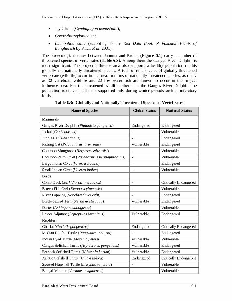
Environmental Impact Assessment (EIA) of River Bank Improvement Program (RBIP)
Bangladesh Water Development Board 6-4
Jay Ghash (Cymbopogon osmastonii),
Gastrodia zeylanica and
Limnophila cana (according to the Red Data Book of Vascular Plants of Bangladesh by Khan et al. 2001).
The bio-ecological zones between Jamuna and Padma (Figure 6.1) carry a number of threatened species of vertebrates (Table 6.3). Among them the Ganges River Dolphin is most significant. The project influence area also supports a healthy population of this globally and nationally threatened species. A total of nine species of globally threatened vertebrate (wildlife) occur in the area. In terms of nationally threatened species, as many as 32 vertebrate wildlife and 22 freshwater fish are known to occur in the project influence area. For the threatened wildlife other than the Ganges River Dolphin, the population is either small or is supported only during winter periods such as migratory birds.
Table 6.3: Globally and Nationally Threatened Species of Vertebrates
Name of Species Global Status National Status
Mammals
Ganges River Dolphin (Platanista gangetica) Endangered Endangered
Jackal (Canis aureus) - Vulnerable
Jungle Cat (Felis chaus) - Endangered
Fishing Cat (Prionailurus viverrinus) Vulnerable Endangered
Common Mongoose (Herpestes edwardsi) - Vulnerable
Common Palm Civet (Paradoxurus hermaphroditus) - Vulnerable
Large Indian Civet (Viverra zibetha) - Endangered
Small Indian Civet (Viverra indica) - Vulnerable
Birds
Comb Duck (Sarkidiornis melanotos) - Critically Endangered
Brown Fish Owl (Ketupa zeylonensis) - Vulnerable
River Lapwing (Vanellus duvaucelii) - Endangered
Black-bellied Tern (Sterna acuticauda) Vulnerable Endangered
Darter (Anhinga melanogaster) - Vulnerable
Lesser Adjutant (Leptoptilos javanicus) Vulnerable Endangered
Reptiles
Gharial (Gavialis gangeticus) Endangered Critically Endangered
Median Roofed Turtle (Pangshura tentoria) - Endangered
Indian Eyed Turtle (Morenia petersi) Vulnerable Vulnerable
Ganges Softshell Turtle (Aspideretes gangeticus) Vulnerable Endangered
Peacock Softshell Turtle (Nilssonia hurum) Vulnerable Endangered
Asiatic Softshell Turtle (Chitra indica) Endangered Critically Endangered
Spotted Flapshell Turtle (Lissymis punctata) - Vulnerable
Bengal Monitor (Varanus bengalensis) - Vulnerable
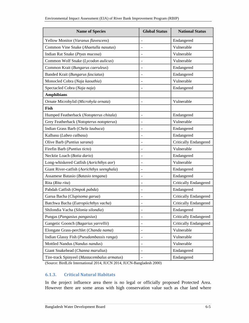
Environmental Impact Assessment (EIA) of River Bank Improvement Program (RBIP)
Bangladesh Water Development Board 6-5
Name of Species Global Status National Status
Yellow Monitor (Varanus flavescens) - Endangered
Common Vine Snake (Ahaetulla nasutus) - Vulnerable
Indian Rat Snake (Ptyas mucosa) - Vulnerable
Common Wolf Snake (Lycodon aulicus) - Vulnerable
Common Krait (Bungarus caeruleus) - Endangered
Banded Krait (Bungarus fasciatus) - Endangered
Monocled Cobra (Naja kaouthia) - Vulnerable
Spectacled Cobra (Naja naja) - Endangered
Amphibians
Ornate Microhylid (Microhyla ornata) - Vulnerable
Fish
Humped Featherback (Notopterus chitala) - Endangered
Grey Featherback (Notopterus notopterus) - Vulnerable
Indian Grass Barb (Chela laubuca) - Endangered
Kalbasu (Labeo calbasu) - Endangered
Olive Barb (Puntius sarana) - Critically Endangered
Firefin Barb (Puntius ticto) - Vulnerable
Necktie Loach (Botia dario) - Endangered
Long-whiskered Catfish (Aorichthys aor) - Vulnerable
Giant River-catfish (Aorichthys seenghala) - Endangered
Assamese Batasio (Batasio tengana) - Endangered
Rita (Rita rita) - Critically Endangered
Pabdah Catfish (Ompok pabda) - Endangered
Garua Bacha (Clupisoma garua) - Critically Endangered
Batchwa Bacha (Eutropiichthys vacha) - Critically Endangered
Shilondia Vacha (Silonia silondia) - Endangered
Pungas (Pangasius pangasius) - Critically Endangered
Gangetic Goonch (Bagarius yarrellii) - Critically Endangered
Elongate Grass-perchlet (Chanda nama) - Vulnerable
Indian Glassy Fish (Pseudambassis ranga) - Vulnerable
Mottled Nandus (Nandus nandus) - Vulnerable
Giant Snakehead (Channa marulius) - Endangered
Tire-track Spinyeel (Mastacembalus armatus) - Endangered (Source: BirdLife International 2014, IUCN 2014, IUCN-Bangladesh 2000)
6.1.3. CriticalNaturalHabitats
In the project influence area there is no legal or officially proposed Protected Area. However there are some areas with high conservation value such as char land where
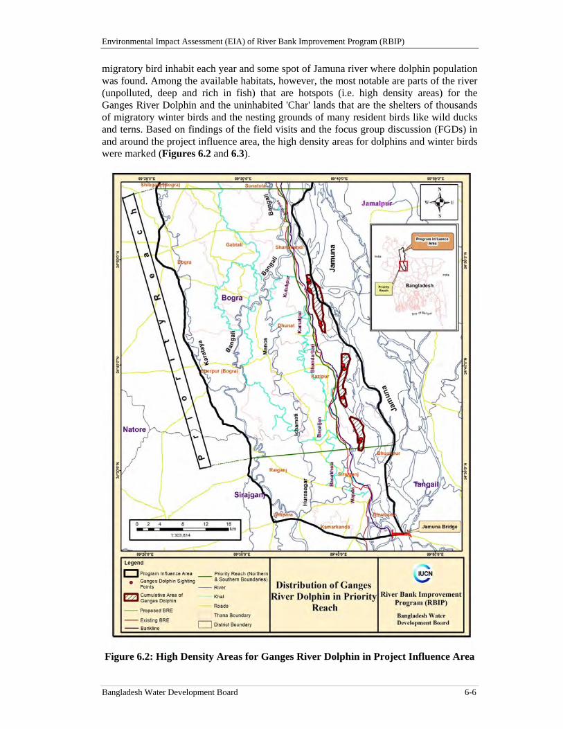
Environmental Impact Assessment (EIA) of River Bank Improvement Program (RBIP)
Bangladesh Water Development Board 6-6
migratory bird inhabit each year and some spot of Jamuna river where dolphin population was found. Among the available habitats, however, the most notable are parts of the river (unpolluted, deep and rich in fish) that are hotspots (i.e. high density areas) for the Ganges River Dolphin and the uninhabited 'Char' lands that are the shelters of thousands of migratory winter birds and the nesting grounds of many resident birds like wild ducks and terns. Based on findings of the field visits and the focus group discussion (FGDs) in and around the project influence area, the high density areas for dolphins and winter birds were marked (Figures 6.2 and 6.3).
Figure 6.2: High Density Areas for Ganges River Dolphin in Project Influence Area
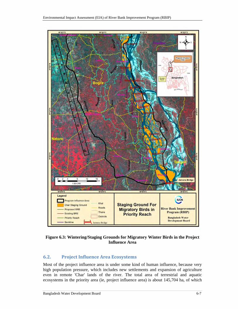
Environmental Impact Assessment (EIA) of River Bank Improvement Program (RBIP)
Bangladesh Water Development Board 6-7
Figure 6.3: Wintering/Staging Grounds for Migratory Winter Birds in the Project Influence Area
6.2. ProjectInfluenceAreaEcosystems
Most of the project influence area is under some kind of human influence, because very high population pressure, which includes new settlements and expansion of agriculture even in remote 'Char' lands of the river. The total area of terrestrial and aquatic ecosystems in the priority area (ie, project influence area) is about 145,704 ha, of which
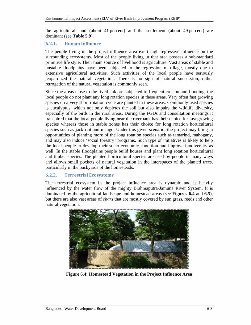
Environmental Impact Assessment (EIA) of River Bank Improvement Program (RBIP)
Bangladesh Water Development Board 6-8
the agricultural land (about 41 percent) and the settlement (about 49 percent) are dominant (see Table 5.9).
6.2.1. HumanInfluence
The people living in the project influence area exert high regressive influence on the surrounding ecosystems. Most of the people living in that area possess a sub-standard primitive life style. Their main source of livelihood is agriculture. Vast areas of stable and unstable floodplains have been subjected to the regression of tillage, mostly due to extensive agricultural activities. Such activities of the local people have seriously jeopardized the natural vegetation. There is no sign of natural succession, rather retrogation of the natural vegetation is commonly seen.
Since the areas close to the riverbank are subjected to frequent erosion and flooding, the local people do not plant any long rotation species in these areas. Very often fast growing species on a very short rotation cycle are planted in these areas. Commonly used species is eucalyptus, which not only depletes the soil but also impairs the wildlife diversity, especially of the birds in the rural areas. During the FGDs and consultation meetings it transpired that the local people living near the riverbank has their choice for fast growing species whereas those in stable zones has their choice for long rotation horticultural species such as jackfruit and mango. Under this given scenario, the project may bring in opportunities of planting more of the long rotation species such as tamarind, mahogany, and may also induce ‘social forestry’ programs. Such type of initiatives is likely to help the local people to develop their socio economic condition and improve biodiversity as well. In the stable floodplains people build houses and plant long rotation horticultural and timber species. The planted horticultural species are used by people in many ways and allows small pockets of natural vegetation in the interspaces of the planted trees, particularly in the backyards of the homesteads.
6.2.2. TerrestrialEcosystems
The terrestrial ecosystem in the project influence area is dynamic and is heavily influenced by the water flow of the mighty Brahmaputra-Jamuna River System. It is dominated by the agricultural landscape and homestead areas (see Figures 6.4 and 6.5), but there are also vast areas of chars that are mostly covered by sun grass, reeds and other natural vegetation.
Figure 6.4: Homestead Vegetation in the Project Influence Area
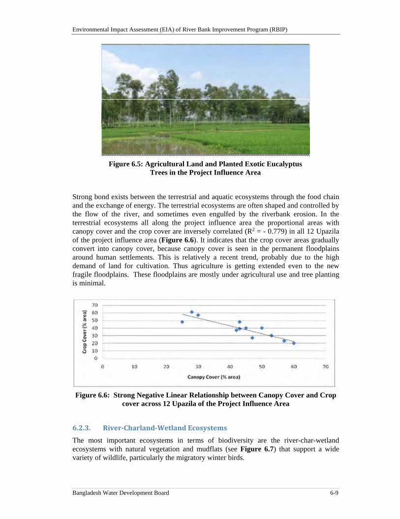
Environmental Impact Assessment (EIA) of River Bank Improvement Program (RBIP)
Bangladesh Water Development Board 6-9
Figure 6.5: Agricultural Land and Planted Exotic Eucalyptus Trees in the Project Influence Area
Strong bond exists between the terrestrial and aquatic ecosystems through the food chain and the exchange of energy. The terrestrial ecosystems are often shaped and controlled by the flow of the river, and sometimes even engulfed by the riverbank erosion. In the terrestrial ecosystems all along the project influence area the proportional areas with canopy cover and the crop cover are inversely correlated (R2 = - 0.779) in all 12 Upazila of the project influence area (Figure 6.6). It indicates that the crop cover areas gradually convert into canopy cover, because canopy cover is seen in the permanent floodplains around human settlements. This is relatively a recent trend, probably due to the high demand of land for cultivation. Thus agriculture is getting extended even to the new fragile floodplains. These floodplains are mostly under agricultural use and tree planting is minimal.
Figure 6.6: Strong Negative Linear Relationship between Canopy Cover and Crop cover across 12 Upazila of the Project Influence Area
6.2.3. River‐Charland‐WetlandEcosystems
The most important ecosystems in terms of biodiversity are the river-char-wetland ecosystems with natural vegetation and mudflats (see Figure 6.7) that support a wide variety of wildlife, particularly the migratory winter birds.
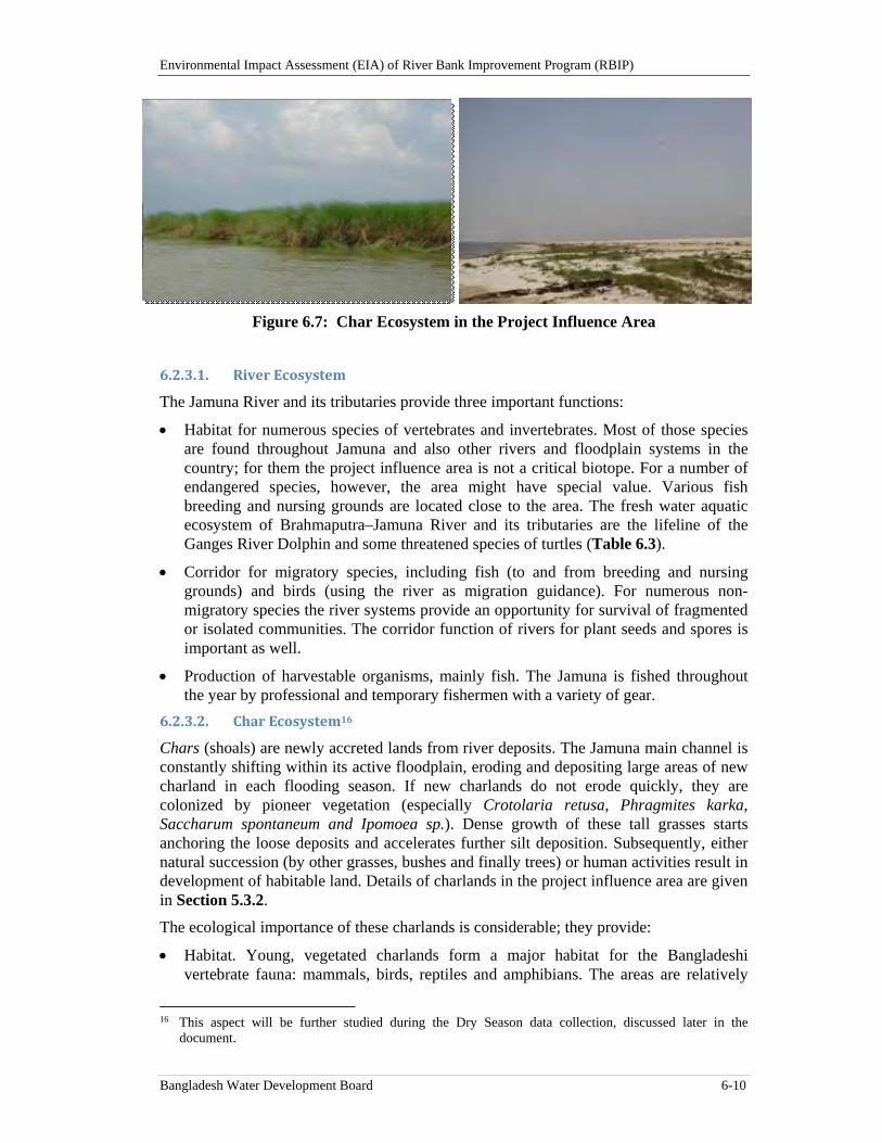
Environmental Impact Assessment (EIA) of River Bank Improvement Program (RBIP)
Bangladesh Water Development Board 6-10
Figure 6.7: Char Ecosystem in the Project Influence Area
6.2.3.1. RiverEcosystem
The Jamuna River and its tributaries provide three important functions:
Habitat for numerous species of vertebrates and invertebrates. Most of those species are found throughout Jamuna and also other rivers and floodplain systems in the country; for them the project influence area is not a critical biotope. For a number of endangered species, however, the area might have special value. Various fish breeding and nursing grounds are located close to the area. The fresh water aquatic ecosystem of Brahmaputra–Jamuna River and its tributaries are the lifeline of the Ganges River Dolphin and some threatened species of turtles (Table 6.3).
Corridor for migratory species, including fish (to and from breeding and nursing grounds) and birds (using the river as migration guidance). For numerous non-migratory species the river systems provide an opportunity for survival of fragmented or isolated communities. The corridor function of rivers for plant seeds and spores is important as well.
Production of harvestable organisms, mainly fish. The Jamuna is fished throughout the year by professional and temporary fishermen with a variety of gear.
6.2.3.2. CharEcosystem16
Chars (shoals) are newly accreted lands from river deposits. The Jamuna main channel is constantly shifting within its active floodplain, eroding and depositing large areas of new charland in each flooding season. If new charlands do not erode quickly, they are colonized by pioneer vegetation (especially Crotolaria retusa, Phragmites karka, Saccharum spontaneum and Ipomoea sp.). Dense growth of these tall grasses starts anchoring the loose deposits and accelerates further silt deposition. Subsequently, either natural succession (by other grasses, bushes and finally trees) or human activities result in development of habitable land. Details of charlands in the project influence area are given in Section 5.3.2.
The ecological importance of these charlands is considerable; they provide:
Habitat. Young, vegetated charlands form a major habitat for the Bangladeshi vertebrate fauna: mammals, birds, reptiles and amphibians. The areas are relatively
16 This aspect will be further studied during the Dry Season data collection, discussed later in the
document.
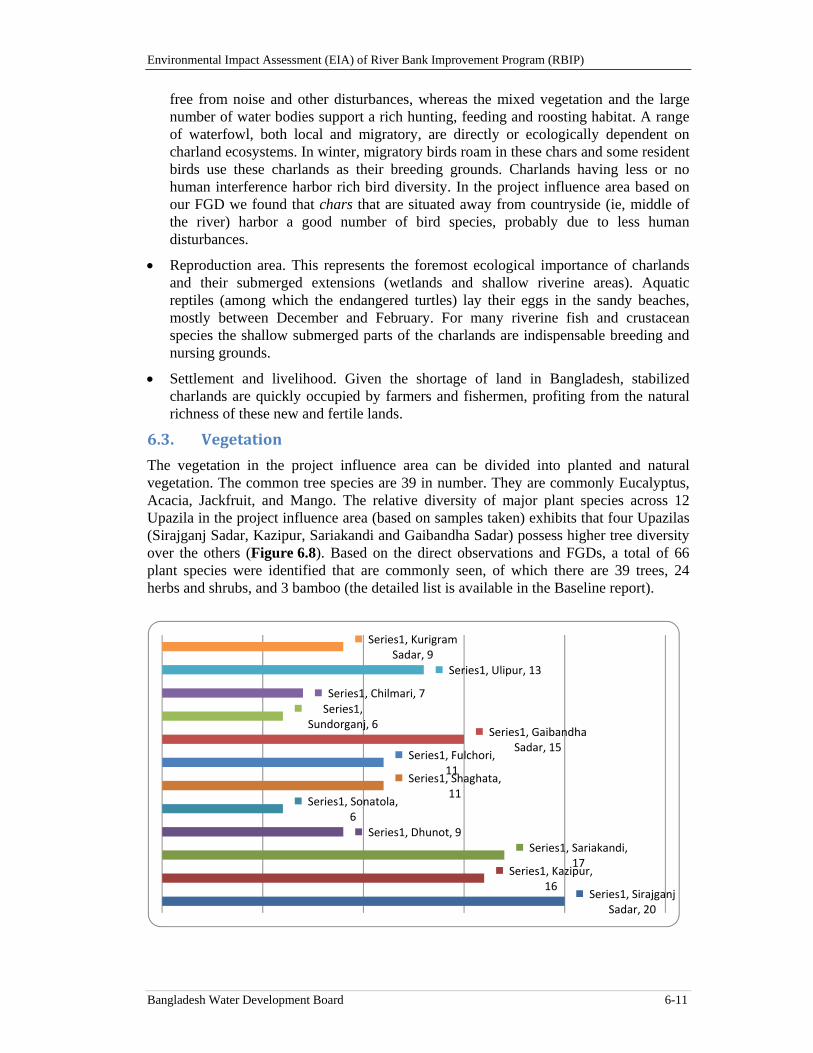
Environmental Impact Assessment (EIA) of River Bank Improvement Program (RBIP)
Bangladesh Water Development Board 6-11
free from noise and other disturbances, whereas the mixed vegetation and the large number of water bodies support a rich hunting, feeding and roosting habitat. A range of waterfowl, both local and migratory, are directly or ecologically dependent on charland ecosystems. In winter, migratory birds roam in these chars and some resident birds use these charlands as their breeding grounds. Charlands having less or no human interference harbor rich bird diversity. In the project influence area based on our FGD we found that chars that are situated away from countryside (ie, middle of the river) harbor a good number of bird species, probably due to less human disturbances.
Reproduction area. This represents the foremost ecological importance of charlands and their submerged extensions (wetlands and shallow riverine areas). Aquatic reptiles (among which the endangered turtles) lay their eggs in the sandy beaches, mostly between December and February. For many riverine fish and crustacean species the shallow submerged parts of the charlands are indispensable breeding and nursing grounds.
Settlement and livelihood. Given the shortage of land in Bangladesh, stabilized charlands are quickly occupied by farmers and fishermen, profiting from the natural richness of these new and fertile lands.
6.3. Vegetation
The vegetation in the project influence area can be divided into planted and natural vegetation. The common tree species are 39 in number. They are commonly Eucalyptus, Acacia, Jackfruit, and Mango. The relative diversity of major plant species across 12 Upazila in the project influence area (based on samples taken) exhibits that four Upazilas (Sirajganj Sadar, Kazipur, Sariakandi and Gaibandha Sadar) possess higher tree diversity over the others (Figure 6.8). Based on the direct observations and FGDs, a total of 66 plant species were identified that are commonly seen, of which there are 39 trees, 24 herbs and shrubs, and 3 bamboo (the detailed list is available in the Baseline report).
Series1, Sirajganj Sadar, 20
Series1, Kazipur, 16
Series1, Sariakandi, 17
Series1, Dhunot, 9
Series1, Sonatola, 6
Series1, Shaghata, 11
Series1, Fulchori, 11
Series1, Gaibandha Sadar, 15
Series1, Sundorganj, 6
Series1, Chilmari, 7
Series1, Ulipur, 13
Series1, Kurigram Sadar, 9
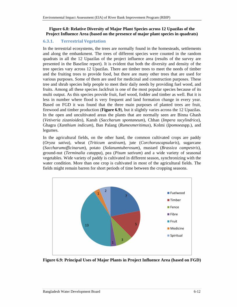
Environmental Impact Assessment (EIA) of River Bank Improvement Program (RBIP)
Bangladesh Water Development Board 6-12
Figure 6.8: Relative Diversity of Major Plant Species across 12 Upazilas of the Project Influence Area (based on the presence of major plant species in quadrats)
6.3.1. TerrestrialVegetation
In the terrestrial ecosystems, the trees are normally found in the homesteads, settlements and along the embankment. The trees of different species were counted in the random quadrats in all the 12 Upazilas of the project influence area (results of the survey are presented in the Baseline report). It is evident that both the diversity and density of the tree species vary across 12 Upazilas. There are timber trees to meet the needs of timber and the fruiting trees to provide food, but there are many other trees that are used for various purposes. Some of them are used for medicinal and construction purposes. These tree and shrub species help people to meet their daily needs by providing fuel wood, and fruits. Among all these species Jackfruit is one of the most popular species because of its multi output. As this species provide fruit, fuel wood, fodder and timber as well. But it is less in number where flood is very frequent and land formation change in every year. Based on FGD it was found that the three main purposes of planted trees are fruit, firewood and timber production (Figure 6.9), but it slightly varies across the 12 Upazilas. In the open and uncultivated areas the plants that are normally seen are Binna Ghash (Vetiveria zizanioides), Kansh (Saccharum spontaneum), Chhan (Impera tacylindrica), Ghagra (Xanthium indicum), Ban Palang (Rumexmeritimus), Kolmi (Ipomoeaspp.), and legumes.
In the agricultural fields, on the other hand, the common cultivated crops are paddy (Oryza sativa), wheat (Triticum aestivum), jute (Corchoruscapsularis), sugarcane (Saccharumofficinarum), potato (Solanumtuberosum), mustard (Brassica campestris), ground-nut (Terminalia catappa), pea (Pisum sativum) and a wide variety of seasonal vegetables. Wide variety of paddy is cultivated in different season, synchronizing with the water condition. More than one crop is cultivated in most of the agricultural fields. The fields might remain barren for short periods of time between the cropping seasons.
Figure 6.9: Principal Uses of Major Plants in Project Influence Area (based on FGD)
7
5
31
13
12
Fuelwood
Timber
Fence
Fibre
Fruit
Medicine
Spiritual
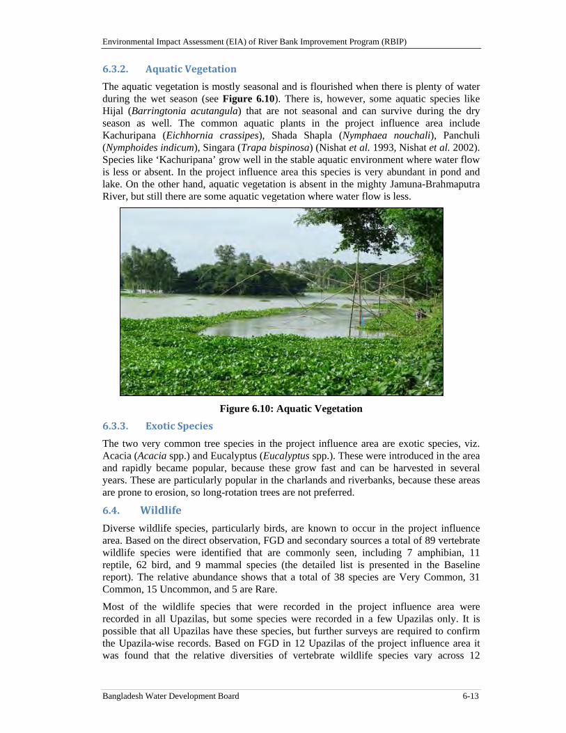
Environmental Impact Assessment (EIA) of River Bank Improvement Program (RBIP)
Bangladesh Water Development Board 6-13
6.3.2. AquaticVegetation
The aquatic vegetation is mostly seasonal and is flourished when there is plenty of water during the wet season (see Figure 6.10). There is, however, some aquatic species like Hijal (Barringtonia acutangula) that are not seasonal and can survive during the dry season as well. The common aquatic plants in the project influence area include Kachuripana (Eichhornia crassipes), Shada Shapla (Nymphaea nouchali), Panchuli (Nymphoides indicum), Singara (Trapa bispinosa) (Nishat et al. 1993, Nishat et al. 2002). Species like ‘Kachuripana’ grow well in the stable aquatic environment where water flow is less or absent. In the project influence area this species is very abundant in pond and lake. On the other hand, aquatic vegetation is absent in the mighty Jamuna-Brahmaputra River, but still there are some aquatic vegetation where water flow is less.
Figure 6.10: Aquatic Vegetation
6.3.3. ExoticSpecies
The two very common tree species in the project influence area are exotic species, viz. Acacia (Acacia spp.) and Eucalyptus (Eucalyptus spp.). These were introduced in the area and rapidly became popular, because these grow fast and can be harvested in several years. These are particularly popular in the charlands and riverbanks, because these areas are prone to erosion, so long-rotation trees are not preferred.
6.4. Wildlife
Diverse wildlife species, particularly birds, are known to occur in the project influence area. Based on the direct observation, FGD and secondary sources a total of 89 vertebrate wildlife species were identified that are commonly seen, including 7 amphibian, 11 reptile, 62 bird, and 9 mammal species (the detailed list is presented in the Baseline report). The relative abundance shows that a total of 38 species are Very Common, 31 Common, 15 Uncommon, and 5 are Rare.
Most of the wildlife species that were recorded in the project influence area were recorded in all Upazilas, but some species were recorded in a few Upazilas only. It is possible that all Upazilas have these species, but further surveys are required to confirm the Upazila-wise records. Based on FGD in 12 Upazilas of the project influence area it was found that the relative diversities of vertebrate wildlife species vary across 12
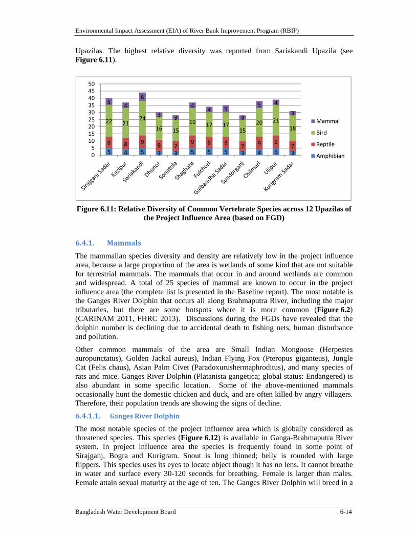
Environmental Impact Assessment (EIA) of River Bank Improvement Program (RBIP)
Bangladesh Water Development Board 6-14
Upazilas. The highest relative diversity was reported from Sariakandi Upazila (see Figure 6.11).
Figure 6.11: Relative Diversity of Common Vertebrate Species across 12 Upazilas of the Project Influence Area (based on FGD)
6.4.1. Mammals
The mammalian species diversity and density are relatively low in the project influence area, because a large proportion of the area is wetlands of some kind that are not suitable for terrestrial mammals. The mammals that occur in and around wetlands are common and widespread. A total of 25 species of mammal are known to occur in the project influence area (the complete list is presented in the Baseline report). The most notable is the Ganges River Dolphin that occurs all along Brahmaputra River, including the major tributaries, but there are some hotspots where it is more common (Figure 6.2) (CARINAM 2011, FHRC 2013). Discussions during the FGDs have revealed that the dolphin number is declining due to accidental death to fishing nets, human disturbance and pollution.
Other common mammals of the area are Small Indian Mongoose (Herpestes auropunctatus), Golden Jackal aureus), Indian Flying Fox (Pteropus giganteus), Jungle Cat (Felis chaus), Asian Palm Civet (Paradoxurushermaphroditus), and many species of rats and mice. Ganges River Dolphin (Platanista gangetica; global status: Endangered) is also abundant in some specific location. Some of the above-mentioned mammals occasionally hunt the domestic chicken and duck, and are often killed by angry villagers. Therefore, their population trends are showing the signs of decline.
6.4.1.1. GangesRiverDolphin
The most notable species of the project influence area which is globally considered as threatened species. This species (Figure 6.12) is available in Ganga-Brahmaputra River system. In project influence area the species is frequently found in some point of Sirajganj, Bogra and Kurigram. Snout is long thinned; belly is rounded with large flippers. This species uses its eyes to locate object though it has no lens. It cannot breathe in water and surface every 30-120 seconds for breathing. Female is larger than males. Female attain sexual maturity at the age of ten. The Ganges River Dolphin will breed in a
5 4 5 3 3 5 5 5 3 4 5 3
8 8 98 7
9 8 87 9 9
7
22 2124
16 15
19 17 1715
20 2118
54
6
3 3
44 5
3
5 4
3
05101520253035404550
Mammal
Bird
Reptile
Amphibian
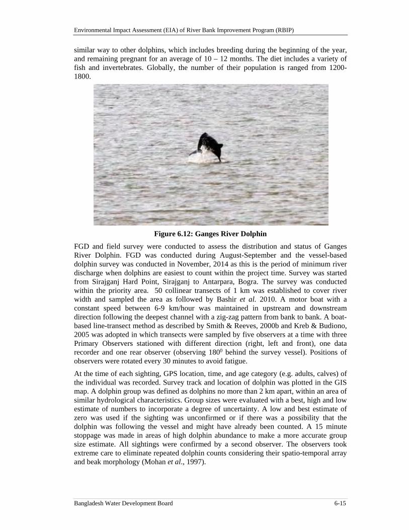
Environmental Impact Assessment (EIA) of River Bank Improvement Program (RBIP)
Bangladesh Water Development Board 6-15
similar way to other dolphins, which includes breeding during the beginning of the year, and remaining pregnant for an average of 10 – 12 months. The diet includes a variety of fish and invertebrates. Globally, the number of their population is ranged from 1200-1800.
Figure 6.12: Ganges River Dolphin
FGD and field survey were conducted to assess the distribution and status of Ganges River Dolphin. FGD was conducted during August-September and the vessel-based dolphin survey was conducted in November, 2014 as this is the period of minimum river discharge when dolphins are easiest to count within the project time. Survey was started from Sirajganj Hard Point, Sirajganj to Antarpara, Bogra. The survey was conducted within the priority area. 50 collinear transects of 1 km was established to cover river width and sampled the area as followed by Bashir et al. 2010. A motor boat with a constant speed between 6-9 km/hour was maintained in upstream and downstream direction following the deepest channel with a zig-zag pattern from bank to bank. A boat-based line-transect method as described by Smith & Reeves, 2000b and Kreb & Budiono, 2005 was adopted in which transects were sampled by five observers at a time with three Primary Observers stationed with different direction (right, left and front), one data recorder and one rear observer (observing 1800 behind the survey vessel). Positions of observers were rotated every 30 minutes to avoid fatigue.
At the time of each sighting, GPS location, time, and age category (e.g. adults, calves) of the individual was recorded. Survey track and location of dolphin was plotted in the GIS map. A dolphin group was defined as dolphins no more than 2 km apart, within an area of similar hydrological characteristics. Group sizes were evaluated with a best, high and low estimate of numbers to incorporate a degree of uncertainty. A low and best estimate of zero was used if the sighting was unconfirmed or if there was a possibility that the dolphin was following the vessel and might have already been counted. A 15 minute stoppage was made in areas of high dolphin abundance to make a more accurate group size estimate. All sightings were confirmed by a second observer. The observers took extreme care to eliminate repeated dolphin counts considering their spatio-temporal array and beak morphology (Mohan et al., 1997).
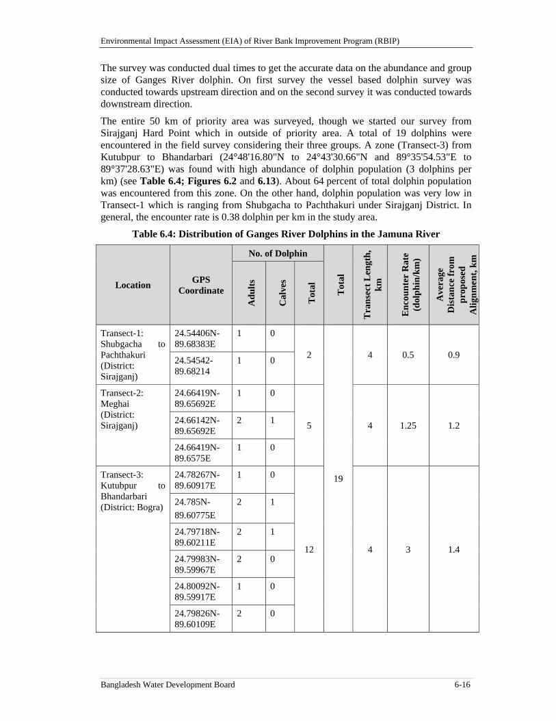
Environmental Impact Assessment (EIA) of River Bank Improvement Program (RBIP)
Bangladesh Water Development Board 6-16
The survey was conducted dual times to get the accurate data on the abundance and group size of Ganges River dolphin. On first survey the vessel based dolphin survey was conducted towards upstream direction and on the second survey it was conducted towards downstream direction.
The entire 50 km of priority area was surveyed, though we started our survey from Sirajganj Hard Point which in outside of priority area. A total of 19 dolphins were encountered in the field survey considering their three groups. A zone (Transect-3) from Kutubpur to Bhandarbari (24°48'16.80"N to 24°43'30.66"N and 89°35'54.53"E to 89°37'28.63"E) was found with high abundance of dolphin population (3 dolphins per km) (see Table 6.4; Figures 6.2 and 6.13). About 64 percent of total dolphin population was encountered from this zone. On the other hand, dolphin population was very low in Transect-1 which is ranging from Shubgacha to Pachthakuri under Sirajganj District. In general, the encounter rate is 0.38 dolphin per km in the study area.
Table 6.4: Distribution of Ganges River Dolphins in the Jamuna River
Location GPS
Coordinate
No. of Dolphin
Tot
al
Tra
nse
ct L
engt
h,
km
En
cou
nte
r R
ate
(dol
ph
in/k
m)
Ave
rage
D
ista
nce
fro
m
pro
pos
ed
Ali
gnm
ent,
km
Ad
ult
s
Cal
ves
Tot
al
Transect-1: Shubgacha to Pachthakuri (District: Sirajganj)
24.54406N-89.68383E
1 0
2
19
4 0.5 0.9 24.54542-89.68214
1 0
Transect-2: Meghai (District: Sirajganj)
24.66419N-89.65692E
1 0
5 4 1.25 1.2 24.66142N-89.65692E
2 1
24.66419N-89.6575E
1 0
Transect-3: Kutubpur to Bhandarbari (District: Bogra)
24.78267N-89.60917E
1 0
12 4 3 1.4
24.785N-
89.60775E
2 1
24.79718N-89.60211E
2 1
24.79983N-89.59967E
2 0
24.80092N-89.59917E
1 0
24.79826N-89.60109E
2 0
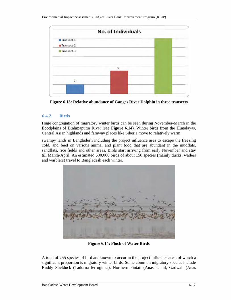
Environmental Impact Assessment (EIA) of River Bank Improvement Program (RBIP)
Bangladesh Water Development Board 6-17
Figure 6.13: Relative abundance of Ganges River Dolphin in three transects
6.4.2. Birds
Huge congregation of migratory winter birds can be seen during November-March in the floodplains of Brahmaputra River (see Figure 6.14). Winter birds from the Himalayas, Central Asian highlands and faraway places like Siberia move to relatively warm
swampy lands in Bangladesh including the project influence area to escape the freezing cold, and feed on various animal and plant food that are abundant in the mudflats, sandflats, rice fields and other areas. Birds start arriving from early November and stay till March-April. An estimated 500,000 birds of about 150 species (mainly ducks, waders and warblers) travel to Bangladesh each winter.
Figure 6.14: Flock of Water Birds
A total of 255 species of bird are known to occur in the project influence area, of which a significant proportion is migratory winter birds. Some common migratory species include Ruddy Shelduck (Tadorna ferruginea), Northern Pintail (Anas acuta), Gadwall (Anas
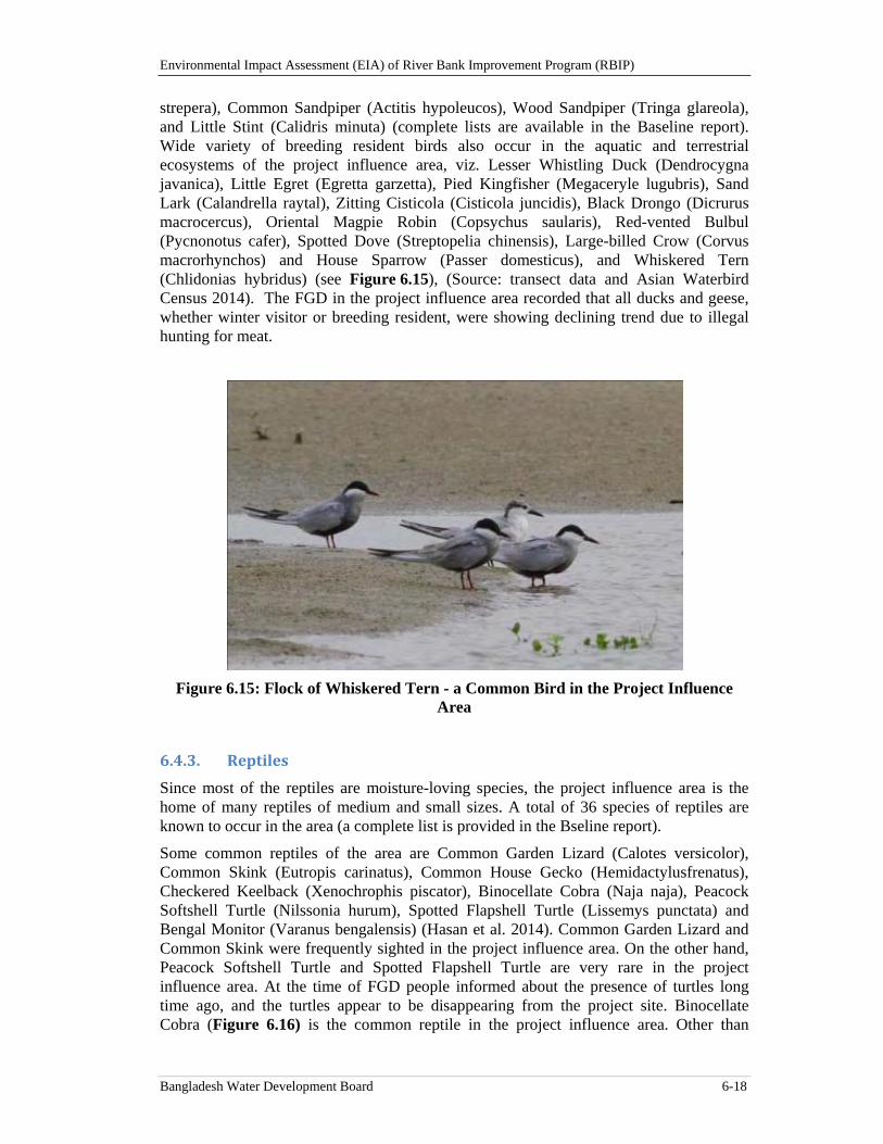
Environmental Impact Assessment (EIA) of River Bank Improvement Program (RBIP)
Bangladesh Water Development Board 6-18
strepera), Common Sandpiper (Actitis hypoleucos), Wood Sandpiper (Tringa glareola), and Little Stint (Calidris minuta) (complete lists are available in the Baseline report). Wide variety of breeding resident birds also occur in the aquatic and terrestrial ecosystems of the project influence area, viz. Lesser Whistling Duck (Dendrocygna javanica), Little Egret (Egretta garzetta), Pied Kingfisher (Megaceryle lugubris), Sand Lark (Calandrella raytal), Zitting Cisticola (Cisticola juncidis), Black Drongo (Dicrurus macrocercus), Oriental Magpie Robin (Copsychus saularis), Red-vented Bulbul (Pycnonotus cafer), Spotted Dove (Streptopelia chinensis), Large-billed Crow (Corvus macrorhynchos) and House Sparrow (Passer domesticus), and Whiskered Tern (Chlidonias hybridus) (see Figure 6.15), (Source: transect data and Asian Waterbird Census 2014). The FGD in the project influence area recorded that all ducks and geese, whether winter visitor or breeding resident, were showing declining trend due to illegal hunting for meat.
Figure 6.15: Flock of Whiskered Tern - a Common Bird in the Project Influence Area
6.4.3. Reptiles
Since most of the reptiles are moisture-loving species, the project influence area is the home of many reptiles of medium and small sizes. A total of 36 species of reptiles are known to occur in the area (a complete list is provided in the Bseline report).
Some common reptiles of the area are Common Garden Lizard (Calotes versicolor), Common Skink (Eutropis carinatus), Common House Gecko (Hemidactylusfrenatus), Checkered Keelback (Xenochrophis piscator), Binocellate Cobra (Naja naja), Peacock Softshell Turtle (Nilssonia hurum), Spotted Flapshell Turtle (Lissemys punctata) and Bengal Monitor (Varanus bengalensis) (Hasan et al. 2014). Common Garden Lizard and Common Skink were frequently sighted in the project influence area. On the other hand, Peacock Softshell Turtle and Spotted Flapshell Turtle are very rare in the project influence area. At the time of FGD people informed about the presence of turtles long time ago, and the turtles appear to be disappearing from the project site. Binocellate Cobra (Figure 6.16) is the common reptile in the project influence area. Other than
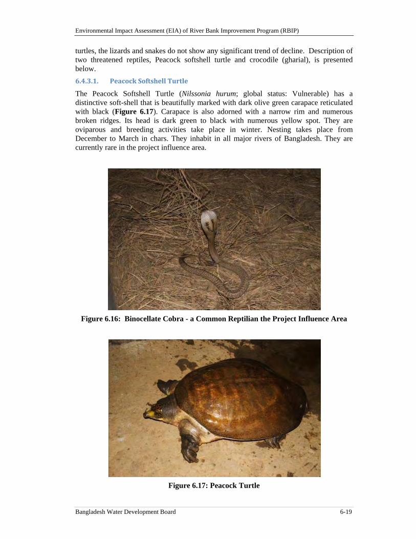
Environmental Impact Assessment (EIA) of River Bank Improvement Program (RBIP)
Bangladesh Water Development Board 6-19
turtles, the lizards and snakes do not show any significant trend of decline. Description of two threatened reptiles, Peacock softshell turtle and crocodile (gharial), is presented below.
6.4.3.1. PeacockSoftshellTurtle
The Peacock Softshell Turtle (Nilssonia hurum; global status: Vulnerable) has a distinctive soft-shell that is beautifully marked with dark olive green carapace reticulated with black (Figure 6.17). Carapace is also adorned with a narrow rim and numerous broken ridges. Its head is dark green to black with numerous yellow spot. They are oviparous and breeding activities take place in winter. Nesting takes place from December to March in chars. They inhabit in all major rivers of Bangladesh. They are currently rare in the project influence area.
Figure 6.16: Binocellate Cobra - a Common Reptilian the Project Influence Area
Figure 6.17: Peacock Turtle
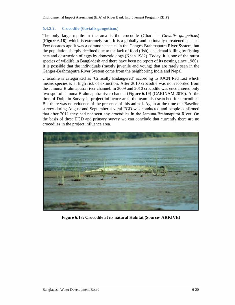
Environmental Impact Assessment (EIA) of River Bank Improvement Program (RBIP)
Bangladesh Water Development Board 6-20
6.4.3.2. Crocodile(Gavialisgangeticus)
The only large reptile in the area is the crocodile (Gharial - Gavialis gangeticus) (Figure 6.18), which is extremely rare. It is a globally and nationally threatened species. Few decades ago it was a common species in the Ganges-Brahmaputra River System, but the population sharply declined due to the lack of food (fish), accidental killing by fishing nets and destruction of eggs by domestic dogs (Khan 1982). Today, it is one of the rarest species of wildlife in Bangladesh and there have been no report of its nesting since 1980s. It is possible that the individuals (mostly juvenile and young) that are rarely seen in the Ganges-Brahmaputra River System come from the neighboring India and Nepal.
Crocodile is categorized as ‘Critically Endangered’ according to IUCN Red List which means species is at high risk of extinction. After 2010 crocodile was not recorded from the Jamuna-Brahmaputra river channel. In 2009 and 2010 crocodile was encountered only two spot of Jamuna-Brahmaputra river channel (Figure 6.19) (CARINAM 2010). At the time of Dolphin Survey in project influence area, the team also searched for crocodiles. But there was no evidence of the presence of this animal. Again at the time our Baseline survey during August and September several FGD was conducted and people confirmed that after 2011 they had not seen any crocodiles in the Jamuna-Brahmaputra River. On the basis of these FGD and primary survey we can conclude that currently there are no crocodiles in the project influence area.
Figure 6.18: Crocodile at its natural Habitat (Source- ARKIVE)
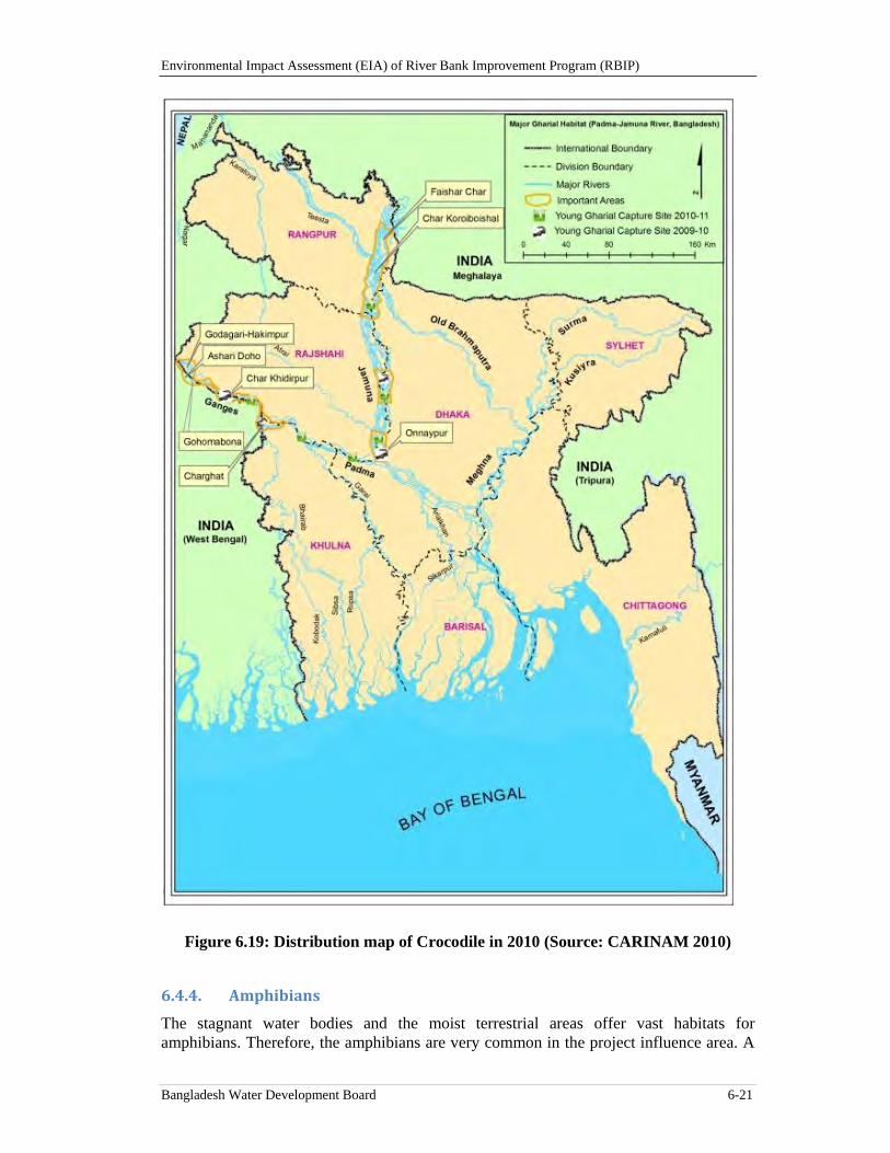
Environmental Impact Assessment (EIA) of River Bank Improvement Program (RBIP)
Bangladesh Water Development Board 6-21
Figure 6.19: Distribution map of Crocodile in 2010 (Source: CARINAM 2010)
6.4.4. Amphibians
The stagnant water bodies and the moist terrestrial areas offer vast habitats for amphibians. Therefore, the amphibians are very common in the project influence area. A
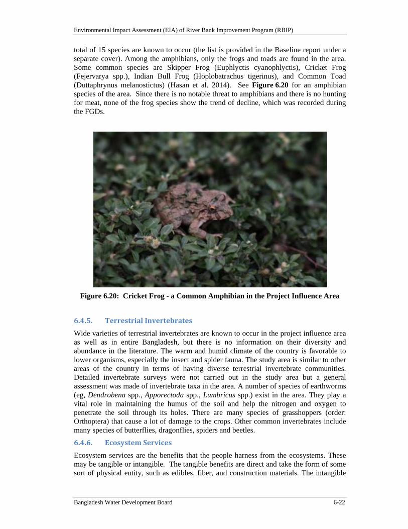
Environmental Impact Assessment (EIA) of River Bank Improvement Program (RBIP)
Bangladesh Water Development Board 6-22
total of 15 species are known to occur (the list is provided in the Baseline report under a separate cover). Among the amphibians, only the frogs and toads are found in the area. Some common species are Skipper Frog (Euphlyctis cyanophlyctis), Cricket Frog (Fejervarya spp.), Indian Bull Frog (Hoplobatrachus tigerinus), and Common Toad (Duttaphrynus melanostictus) (Hasan et al. 2014). See Figure 6.20 for an amphibian species of the area. Since there is no notable threat to amphibians and there is no hunting for meat, none of the frog species show the trend of decline, which was recorded during the FGDs.
Figure 6.20: Cricket Frog - a Common Amphibian in the Project Influence Area
6.4.5. TerrestrialInvertebrates
Wide varieties of terrestrial invertebrates are known to occur in the project influence area as well as in entire Bangladesh, but there is no information on their diversity and abundance in the literature. The warm and humid climate of the country is favorable to lower organisms, especially the insect and spider fauna. The study area is similar to other areas of the country in terms of having diverse terrestrial invertebrate communities. Detailed invertebrate surveys were not carried out in the study area but a general assessment was made of invertebrate taxa in the area. A number of species of earthworms (eg, Dendrobena spp., Apporectoda spp., Lumbricus spp.) exist in the area. They play a vital role in maintaining the humus of the soil and help the nitrogen and oxygen to penetrate the soil through its holes. There are many species of grasshoppers (order: Orthoptera) that cause a lot of damage to the crops. Other common invertebrates include many species of butterflies, dragonflies, spiders and beetles.
6.4.6. EcosystemServices
Ecosystem services are the benefits that the people harness from the ecosystems. These may be tangible or intangible. The tangible benefits are direct and take the form of some sort of physical entity, such as edibles, fiber, and construction materials. The intangible
Environmental Impact Assessment (EIA) of River Bank Improvement Program (RBIP)
Bangladesh Water Development Board 6-23
benefits are indirect and need a little thinking to perceive those, such as perennial stream flows, clean water, oxygen supply, climate regulations, microclimatic impacts, and aesthetic values of the landscapes. According to ‘The Economics of Ecosystems and Biodiversity’ (TEEB), ecosystem services can be divided into four categories, which are presented here under.
Provisioning services
These are mainly products obtained from ecosystems. These products will include:
food (including seafood and game), crops, wild foods, and spices
raw materials (including lumber, skins, fuel wood, organic matter, fodder, and fertilizer)
genetic resources (including crop improvement genes, and health care)
water
minerals (including diatomite)
medicinal resources (including pharmaceuticals, chemical models, and test and assay organisms)
energy (hydropower, biomass fuels)
ornamental resources (including fashion, handicraft, jewelry, pets, worship, decoration and souvenirs like furs, feathers, ivory, orchids, butterflies, aquarium fish, and shells)
Bangladesh context: Under the Bangladesh context, a few of the examples of such provisioning services rendered by the ecosystems are as under. The water bodies such as rivers, haors, baors, beels, wetlands etc. produce fishes, crabs, shrimps, etc. The agro-eco systems provide the cereals, spices, jute, cotton, vegetables, fruits, etc.. The forest ecosystems provide timber, fuel-wood, game animals, bamboos, canes, poles, etc. which is the provisioning services of these ecosystems.
Project Influence Area Context: The major provisioning services that are provided by the ecosystems in the Project Influence Area are:
The agro-ecosystems (agricultural areas) provide rice, wheat, oil seeds, spices, fruits, and jute.
The freshwater ecosystems provide clean ground water and surface water that are used for drinking and irrigation purposes. The water bodies such as the rivers, beels, ponds, wetland areas, etc. provide fishes, crabs, shrimps
Raw materials obtained from this ecosystem include bamboos, fruits, medicinal plants, timber and fuel-wood
Regulating services
Regulating services are the “benefits obtained from the regulation of ecosystem processes”. These include:
carbon sequestration and climate regulation
waste decomposition and detoxification
purification of water and air
Environmental Impact Assessment (EIA) of River Bank Improvement Program (RBIP)
Bangladesh Water Development Board 6-24
pest and disease control
Bangladesh context: The forest ecosystem in Bangladesh extended over 17 percent of the country transpires out huge quantities of water to the atmosphere. This water has a significant contribution in the rain fall at least on regional context. It is known that the North Western region of the country receive less rain fall than the South Eastern part of the country, which has some relation with the regional ecosystem variability, especially with respect to tree cover. The Barind tract of Bangladesh gets cooler during the winter months than the Chittagong area. In a small country like Bangladesh, this sort of climatic variability refers to the climate regulatory aspects of its ecosystem services.
Bangladesh in general is a tropical country and receives a reasonable quantity of rain fall. These features of the ecosystems of the country facilitate waste treatment as the regulating services of its ecosystems.
Bangladesh is endowed with the world largest contiguous mangrove forest, the Sundarban. The cyclone that lashed over Chittagong (non-Sundarban) area on 12 November 1970 had a speed of 224 km per hour and had a death toll of 0.5 million lives. Another cyclone ‘SIDR’, having a speed of 210 to 230 Km per hour, hit Sundarban first and then passed over the human habitations on November 15, 2007, had a death toll of 3363 numbers of human lives. The Sundarbans Environmental and Livelihood Security (SEALS) project (being implemented by the Forest Department) document has revealed that the intangible benefit of Sundarban, only with respect to the saving human lives, is about 8 billion euro. Sundarban as a “buffer zone” in the context of ‘regulating services’ of ecosystem is providing this intangible benefits from this given ecosystem.
Project Influence Area Context: In the project influence area the rural agricultural practices, in many locations have adopted agro-forestry, wherein tree species have been planted especially along the boundary of the agricultural plots. These trees through evapo-transpiration cause an impact on the climate regulation. Besides these the project influence area has large water bodies, which have some role on climate regulation at local level. The ecosystems in the project influence area have the biodegrading capability, which helps natural waste treatment. The flowing rivers in the project influence areas also help to remove the wastes downstream.
Support Services
Ecosystem services are necessary for the production of all other ecosystem services. These include services such as nutrient recycling, primary production and soil formation. These services make it possible for the ecosystems to provide services such as food supply, flood regulation and water purification.
Bangladesh context: The nutrient cycling is a universal phenomenon for almost all of the natural ecosystems in Bangladesh. This prevails not only in hill forest but also in fresh water wetland forest, and mangrove forest. Besides these most of the water bodies (except Buriganga) this sort of nutrient cycling is there. Biologically Mediated Habitats such as mangroves (Sundarban, coastal afforestation areas,) fresh water forests, such as Ratargul reserved forest (in Sylhet district), Tamguar haor in Sunamgonj district, etc. provide the support services by providing breeding and nursery grounds for large fish population of variety of species.
Project Influence Area Context: The project influence area includes many small rivers and khals that connect the Brahmaputra river with inland beels, depressions that retain water especially during the dry periods. These water bodies will act as spawning grounds
Environmental Impact Assessment (EIA) of River Bank Improvement Program (RBIP)
Bangladesh Water Development Board 6-25
for the fish and act as migratory routes for the fish from river to floodplains. The khals also allow for intake of water for irrigation along with nutrient rich silts and clays into the floodplain, and for drainage back into the river. The system of beels and khals are also important for recharge of groundwater resources throughout the floodplain.
Besides these the leaf chlorophyll in the project implementation area, through the process of photosynthesis continuously using the carbon dioxides from the air and releasing oxygen. This service of the existing ecosystems in the project influence area is maintaining the air quality. The organic matter in the upper layers of the soil is enhancing its water holding capacity of the existing ecosystems and thereby a better water regime. The roots of the aquatic plants of the existing ecosystems are holding the water pollutants and thereby enhancing and maintaining the quality of the surface water. In addition, the vegetation covers also somewhat regulate the natural hazards such as high wind speeds, erosion, etc. Some of beetles, especially ‘lady bird beetle’ commonly seen in the ecosystems of the project influence area, feed on many vegetable pests of which aphids are common.
Cultural services
Cultural services of ecosystems refer to nonmaterial benefits people obtain from ecosystems through spiritual enrichment, cognitive development, reflection, recreation, and aesthetic experiences. These include:
cultural (including use of nature as motif in books, film, painting, folklore, national symbols, architect, and advertising)
spiritual and historical (including use of nature for religious or heritage value or natural)
recreational experiences(including ecotourism, outdoor sports, and recreation)
science and education (including use of natural systems for school excursions, and scientific discovery).
Bangladesh context: The Dublar Char ecosystem, under the Sundarban (Khulna), provides the ecosystem services which are of the type of “cultural services”, by hosting a colorful Puja, which attracts a large number of tourists. Bangladesh has about 37 Protected Areas. Most of these attract tourists from the whole country, whereas Sundarban attract a sizable number of foreign tourists as well.
Project Influence Area: Jamuna and its charland ecosystem offer a lot of recreational value. Charland ecosystem of project influence area plays an important role by allowing thousands of migratory birds to visit the ecosystem. This phenomenon enhances the biodiversity values of the ecosystem and enhances its eco-tourism values, which may even generate revenues. The other attraction in the project influence area is presence of globally endangered ‘Ganges River Dolphin’.
6.4.7. ThreatstoEcosystem
Both the terrestrial and aquatic ecosystems of the project influence area face formidable anthropogenic threats. Excessive and uncontrolled use of various agrochemicals is the biggest threat to the local ecosystems. Moreover, there are reports of disease outbreaks, human-wildlife conflict and pollution.
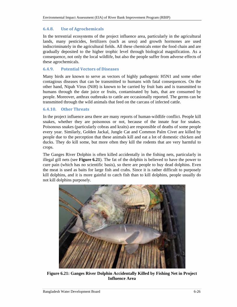
Environmental Impact Assessment (EIA) of River Bank Improvement Program (RBIP)
Bangladesh Water Development Board 6-26
6.4.8. UseofAgrochemicals
In the terrestrial ecosystems of the project influence area, particularly in the agricultural lands, many pesticides, fertilizers (such as urea) and growth hormones are used indiscriminately in the agricultural fields. All these chemicals enter the food chain and are gradually deposited to the higher trophic level through biological magnification. As a consequence, not only the local wildlife, but also the people suffer from adverse effects of these agrochemicals.
6.4.9. PotentialVectorsofDiseases
Many birds are known to serve as vectors of highly pathogenic H5N1 and some other contagious diseases that can be transmitted to humans with fatal consequences. On the other hand, Nipah Virus (NiH) is known to be carried by fruit bats and is transmitted to humans through the date juice or fruits, contaminated by bats, that are consumed by people. Moreover, anthrax outbreaks to cattle are occasionally reported. The germs can be transmitted through the wild animals that feed on the carcass of infected cattle.
6.4.10. OtherThreats
In the project influence area there are many reports of human-wildlife conflict. People kill snakes, whether they are poisonous or not, because of the innate fear for snakes. Poisonous snakes (particularly cobras and kraits) are responsible of deaths of some people every year. Similarly, Golden Jackal, Jungle Cat and Common Palm Civet are killed by people due to the perception that these animals kill and eat a lot of domestic chicken and ducks. They do kill some, but more often they kill the rodents that are very harmful to crops.
The Ganges River Dolphin is often killed accidentally in the fishing nets, particularly in illegal gill nets (see Figure 6.21). The fat of the dolphin is believed to have the power to cure pain (which has no scientific basis), so there are people to buy dead dolphins. Even the meat is used as baits for large fish and crabs. Since it is rather difficult to purposely kill dolphins, and it is more gainful to catch fish than to kill dolphins, people usually do not kill dolphins purposely.
Figure 6.21: Ganges River Dolphin Accidentally Killed by Fishing Net in Project Influence Area
Environmental Impact Assessment (EIA) of River Bank Improvement Program (RBIP)
Bangladesh Water Development Board 6-27
6.5. FishandFisheries
6.5.1. Summaryofthefishandfisheriesbaseline
The Jamuna is an important source of fresh water fish in Bangladesh. In a braided river like Jamuna, fish favorable environment generally exists around the river banks, braided channels, scour hole, deep clear water, and near shallow chars. The river has about 220 km long embankment along the right bank and other structures such as Bangabandhu Bridge, hard points, spurs and revetments (hard and soft) which play an important role in shaping the characteristics of different fish habitats dependent on the Jamuna river. Both capture and culture fisheries types exist in the project influence area. Among capture fisheries habitats main river channels, natural and manmade khals, connected seasonal wetlands (beel), associated flood plains, streams/creeks in riverine islands and embayments (koles)17 are important.
Total fish habitat area (in ha) of the program influence area is about 54,987 ha. Besides, about 56 ha culture ponds also exist in the project influence area. Wetlands and canals at the country side and embayments in the charlands play major role in sustaining the fish production of the Jamuna River. These habitats - most of which have been formed due to the complex hydro-morphological characteristics of the river - provide food and shelter for various species fishes. Others rivers that exist in the project influence area are Bangali river, Ichamati river, Hurasagar river, Ghagot river, Manosh river, Alai river, Dudhkumar river and Teesta river which are connected either directly or through different khals with the Jamuna river forming a fish movement network in the entire area. The eddy counter-current system at the junction of two rivers (tributary and main river) also provides an ideal place for fish assemblages. The confluences are also the passageways for upstream fish migration. The project influence area also has numerous seasonal and perennial beels/wetlands, some of which are connected with these rivers through the internal stream networks. Beels act as feeding and breeding grounds for many riverine species. However, beels do have a residential fish population as well. Besides, a considerable amount of seasonal floodplain area exists within the project influence area.
Annual total fish production of the project influence area (ie, priority reach) has been estimated at about 8500 metric tons. River contributes the largest share of this production followed by floodplain, beels and koles. Fish production from khals/streams is insignificant as most of those are either dried up during peak dry season or remain closed by flood control structures. Hilsa constitutes about 27 percent of Jamuna catch. Other major species of fish catch in Jamuna include major carps and cat fishes (about 1 percent each), and shrimps-prawns (4 percent). However, fish production of the Jamuna river has been declining continuously until recently, primarily because of increased fishing pressure and a decrease in the extent of floodplain habitats caused by the construction of flood control, drainage and irrigation systems, and the consequent obstruction of movement of fry and fingerlings from rivers.
More than 3500 fishermen have been identified during the catch assessment survey along the right bank. Fishing is one of the available livelihood opportunities for most of the landless people of the project influence area. The people that lose their lands because of the riverbank erosion generally resort to fishing as their livelihood means. A total of about 1800 fishing crafts have been found during catch assessment survey.
17 See Glossary at the beginning of the present document for the definition of a kole.
Environmental Impact Assessment (EIA) of River Bank Improvement Program (RBIP)
Bangladesh Water Development Board 6-28
Huge number of stagnant water bodies in chars and river channels support a habitat of rich fish biodiversity. Rahman and Akhter (2007) identified 156 fish species of which, 89 are commercially important and 53 are rare in the river. Jamuna river is renowned for its high diversity of the small indigenous fish species (SIS). Large hilsa is only available up to Sirajganj. Out of 54 threatened fishes of the country 29 were found in the project influence area during field investigation. Six principal carp spawn collecting sites have been established along the Brahmaputra-Jamuna mainly on its right bank. Carp spawn collection has been decreasing remarkably over the last three decades. Other areas of conservation significance in the Jamuna river found during the field survey are Simlar kole, Mothiar kole / Pachthakuri kole, Pukuria kole, Sariakandi kole, Boishakhi kole, Chunia para kole, Taltola kole and Kazlar kole. These areas are generally at a distance of 0.5 to 4 km from the embankment. Besides, Department of Fisheries (DoF) has notified several fish sanctuaries in the countryside.
The Brahmaputra stock of carp fishes is the largest stock in Bangladesh. The major migratory fish of the Jamuna is Carps, Cat fishes and Hilsa. Hilsa migrates into Jamuna during March-May from Bay of Bengal through the Meghna and the Padma rivers. Carp fishes migrate upstream and laterally to the inundated floodplains adjacent to the river channel during the late dry season or early rainy season in order to spawn in the nutrient-rich waters. The eggs and larvae of these species drift downstream and enter the floodplain with the floodwater, where they feed on the developed plankton. At the end of the rainy season, the adults and young migrate to the main river channel in order to avoid the harsh conditions of the floodplain during the dry season. Upstream migration of adult major carps in the Jamuna/Brahmaputra River starts in March, coinciding with the gradual rise of water level. Spawning starts in May, with the onset of the southwest monsoon, and continues until the end of July; juvenile fish migrate back to main river coinciding with the receding of water in October. Connecting khals between main rivers and other water bodies are vital for sustaining successful fish migration at different seasons.
The field survey has identified five migration routes of the priority area are as follows: i) Jamuna to Ichamoti river through Baliaghugri regulator; ii) Jamuna to Bangali river through Sariakandi fish pass; iii) Jamuna to Dauli beel to Bangali river through Antarpara regulator; iv) Jamuna to Manos river through proposed Kamalpur fish pass; and v) Jamuna to Bangali river via Kutubpur khal through proposed Kutubpur fish pass. Among these five, Sariakandi fish pass is now almost silted up. Other four fish migration routes are partially obstructed due to the existing regulators/BRE. The BRE acts as barrier and has disconnected large area of floodplain since 1965. This dis-connectivity has brought changes in the natural ecosystem dependent on the river hydrology resulting in great loss of biodiversity and natural resources, ultimately affecting the livelihood and wellbeing of the communities.
6.5.2. JamunaRiver‐Asuitablehabitatoffreshwaterfishes
The Jamuna is a large braided river having a length of 260km in Bangladesh with an average width of 11.8km. The annual average flow is 20,000 m3/sec with a maximum estimated discharge of 100,000 m3/sec. The average flood water slope of the river is 7.5 cm/km and the average median size bed material is 0.20mm (CEGIS, 2009).It is an important source of fresh water fish in Bangladesh. Braided nature of the river provides suitable fish habitat as the typical fish assemblage in a river requires a high variability of depth, flow velocity and substrates. The high species richness and diversity in braided rivers can be explained by small-scale habitat mosaics encompassing aquatic habitats as
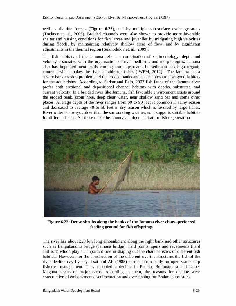
Environmental Impact Assessment (EIA) of River Bank Improvement Program (RBIP)
Bangladesh Water Development Board 6-29
well as riverine forests (Figure 6.22), and by multiple sub-surface exchange areas (Tockner et. al., 2006). Braided channels were also shown to provide more favorable shelter and nursing conditions for fish larvae and juveniles by mitigating high velocities during floods, by maintaining relatively shallow areas of flow, and by significant adjustments in the thermal region (Sukhodolov et. al., 2009).
The fish habitats of the Jamuna reflect a combination of sedimentology, depth and velocity associated with the organization of river bedforms and morphologies. Jamuna also has huge sediment loads coming from upstream. Its sediment has high organic contents which makes the river suitable for fishes (IWFM, 2012). The Jamuna has a severe bank erosion problem and the eroded banks and scour holes are also good habitats for the adult fishes. According to Sarkar and Bain, 2007 fish fauna of the Jamuna river prefer both erosional and depositional channel habitats with depths, substrates, and current velocity. In a braided river like Jamuna, fish favorable environment exists around the eroded bank, scour hole, deep clear water, near shallow sand bar and some other places. Average depth of the river ranges from 60 to 90 feet is common in rainy season and decreased to average 40 to 50 feet in dry season which is favored by large fishes. River water is always colder than the surrounding weather, so it supports suitable habitats for different fishes. All these make the Jamuna a unique habitat for fish regeneration.
Figure 6.22: Dense shrubs along the banks of the Jamuna river chars–preferred feeding ground for fish offsprings
The river has about 220 km long embankment along the right bank and other structures such as Bangabandhu bridge (Jamuna bridge), hard points, spurs and revetments (hard and soft) which play an important role in shaping out the characteristics of different fish habitats. However, for the construction of the different riverine structures the fish of the river decline day by day. Tsai and Ali (1985) carried out a study on open water carp fisheries management. They recorded a decline in Padma, Brahmaputra and Upper Meghna stocks of major carps. According to them, the reasons for decline were construction of embankments, sedimentation and over fishing for Brahmaputra stock.
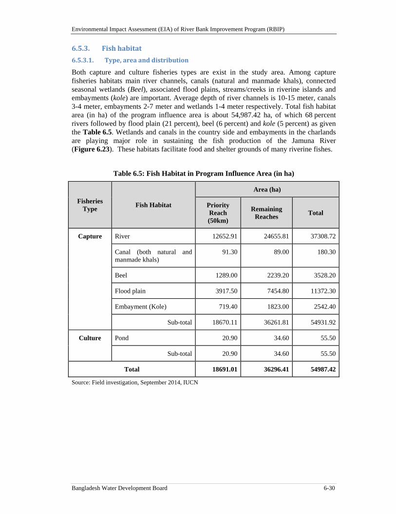
Environmental Impact Assessment (EIA) of River Bank Improvement Program (RBIP)
Bangladesh Water Development Board 6-30
6.5.3. Fishhabitat
6.5.3.1. Type,areaanddistribution
Both capture and culture fisheries types are exist in the study area. Among capture fisheries habitats main river channels, canals (natural and manmade khals), connected seasonal wetlands (Beel), associated flood plains, streams/creeks in riverine islands and embayments (kole) are important. Average depth of river channels is 10-15 meter, canals 3-4 meter, embayments 2-7 meter and wetlands 1-4 meter respectively. Total fish habitat area (in ha) of the program influence area is about 54,987.42 ha, of which 68 percent rivers followed by flood plain (21 percent), beel (6 percent) and kole (5 percent) as given the Table 6.5. Wetlands and canals in the country side and embayments in the charlands are playing major role in sustaining the fish production of the Jamuna River (Figure 6.23). These habitats facilitate food and shelter grounds of many riverine fishes.
Table 6.5: Fish Habitat in Program Influence Area (in ha)
Fisheries Type
Fish Habitat
Area (ha)
Priority Reach (50km)
Remaining Reaches
Total
Capture River 12652.91 24655.81 37308.72
Canal (both natural and manmade khals)
91.30 89.00 180.30
Beel 1289.00 2239.20 3528.20
Flood plain 3917.50 7454.80 11372.30
Embayment (Kole) 719.40 1823.00 2542.40
Sub-total 18670.11 36261.81 54931.92
Culture Pond 20.90 34.60 55.50
Sub-total 20.90 34.60 55.50
Total 18691.01 36296.41 54987.42
Source: Field investigation, September 2014, IUCN
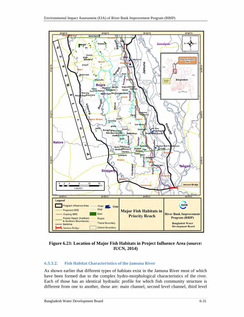
Environmental Impact Assessment (EIA) of River Bank Improvement Program (RBIP)
Bangladesh Water Development Board 6-31
Figure 6.23: Location of Major Fish Habitats in Project Influence Area (source: IUCN, 2014)
6.5.3.2. FishHabitatCharacteristicsoftheJamunaRiver
As shown earlier that different types of habitats exist in the Jamuna River most of which have been formed due to the complex hydro-morphological characteristics of the river. Each of those has an identical hydraulic profile for which fish community structure is different from one to another, those are: main channel, second level channel, third level
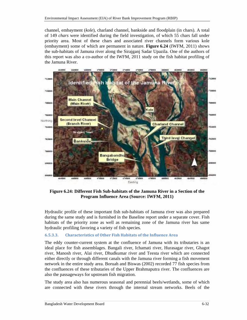
Environmental Impact Assessment (EIA) of River Bank Improvement Program (RBIP)
Bangladesh Water Development Board 6-32
channel, embayment (kole), charland channel, bankside and floodplain (in chars). A total of 149 chars were identified during the field investigation, of which 55 chars fall under priority area. Most of these chars and associated river channels form various kole (embayment) some of which are permanent in nature. Figure 6.24 (IWFM, 2011) shows the sub-habitats of Jamuna river along the Sirajganj Sadar Upazila. One of the authors of this report was also a co-author of the IWFM, 2011 study on the fish habitat profiling of the Jamuna River.
Figure 6.24: Different Fish Sub-habitats of the Jamuna River in a Section of the Program Influence Area (Source: IWFM, 2011)
Hydraulic profile of these important fish sub-habitats of Jamuna river was also prepared during the same study and is furnished in the Baseline report under a separate cover. Fish habitats of the priority zone as well as remaining zone of the Jamuna river has same hydraulic profiling favoring a variety of fish species.
6.5.3.3. CharacteristicsofOtherFishHabitatsoftheInfluenceArea
The eddy counter-current system at the confluence of Jamuna with its tributaries is an ideal place for fish assemblages. Bangali river, Ichamati river, Hurasagar river, Ghagot river, Manosh river, Alai river, Dhudkumar river and Teesta river which are connected either directly or through different canals with the Jamuna river forming a fish movement network in the entire study area. Boruah and Biswas (2002) recorded 77 fish species from the confluences of these tributaries of the Upper Brahmaputra river. The confluences are also the passageways for upstream fish migration.
The study area also has numerous seasonal and perennial beels/wetlands, some of which are connected with these rivers through the internal stream networks. Beels of the
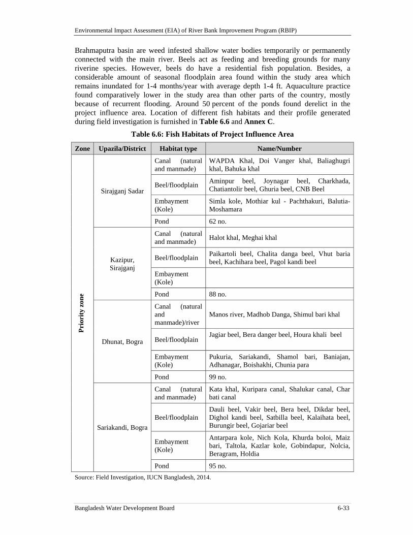
Environmental Impact Assessment (EIA) of River Bank Improvement Program (RBIP)
Bangladesh Water Development Board 6-33
Brahmaputra basin are weed infested shallow water bodies temporarily or permanently connected with the main river. Beels act as feeding and breeding grounds for many riverine species. However, beels do have a residential fish population. Besides, a considerable amount of seasonal floodplain area found within the study area which remains inundated for 1-4 months/year with average depth 1-4 ft. Aquaculture practice found comparatively lower in the study area than other parts of the country, mostly because of recurrent flooding. Around 50 percent of the ponds found derelict in the project influence area. Location of different fish habitats and their profile generated during field investigation is furnished in Table 6.6 and Annex C.
Table 6.6: Fish Habitats of Project Influence Area
Zone Upazila/District Habitat type Name/Number
Pri
orit
y zo
ne
Sirajganj Sadar
Canal (natural and manmade)
WAPDA Khal, Doi Vanger khal, Baliaghugri khal, Bahuka khal
Beel/floodplain Aminpur beel, Joynagar beel, Charkhada, Chatiantolir beel, Ghuria beel, CNB Beel
Embayment (Kole)
Simla kole, Mothiar kul - Pachthakuri, Balutia- Moshamara
Pond 62 no.
Kazipur, Sirajganj
Canal (natural and manmade)
Halot khal, Meghai khal
Beel/floodplain Paikartoli beel, Chalita danga beel, Vhut baria beel, Kachihara beel, Pagol kandi beel
Embayment (Kole)
Pond 88 no.
Dhunat, Bogra
Canal (natural and manmade)/river
Manos river, Madhob Danga, Shimul bari khal
Beel/floodplain Jagiar beel, Bera danger beel, Houra khali beel
Embayment (Kole)
Pukuria, Sariakandi, Shamol bari, Baniajan, Adhanagar, Boishakhi, Chunia para
Pond 99 no.
Sariakandi, Bogra
Canal (natural and manmade)
Kata khal, Kuripara canal, Shalukar canal, Char bati canal
Beel/floodplain Dauli beel, Vakir beel, Bera beel, Dikdar beel, Dighol kandi beel, Satbilla beel, Kalaihata beel, Burungir beel, Gojariar beel
Embayment (Kole)
Antarpara kole, Nich Kola, Khurda boloi, Maiz bari, Taltola, Kazlar kole, Gobindapur, Nolcia, Beragram, Holdia
Pond 95 no.
Source: Field Investigation, IUCN Bangladesh, 2014.
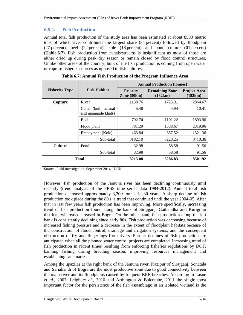
Environmental Impact Assessment (EIA) of River Bank Improvement Program (RBIP)
Bangladesh Water Development Board 6-34
6.5.4. FishProduction
Annual total fish production of the study area has been estimated at about 8500 metric tons of which river contributes the largest share (34 percent) followed by floodplain (27 percent), beel (22 percent), kole (16 percent) and pond culture (01 percent) (Table 6.7). Fish production from canals/streams is insignificant as most of those are either dried up during peak dry season or remain closed by flood control structures. Unlike other areas of the country, bulk of the fish production is coming from open water or capture fisheries sources as opposed to fish cultures.
Table 6.7: Annual Fish Production of the Program Influence Area
Fisheries Type Fish Habitat Annual Production (tonnes)
Priority Zone (50km)
Remaining Zone (132km)
Project Area (182km)
Capture River 1138.76 1725.91 2864.67
Canal (both natural and manmade khals)
5.48 4.94 10.41
Beel 792.74 1101.22 1893.96
Flood plain 781.29 1538.67 2319.96
Embayment (Kole) 463.84 857.52 1321.36
Sub-total 3182.10 5228.25 8410.36
Culture Pond 32.98 58.58 91.56
Sub-total 32.98 58.58 91.56
Total 3215.08 5286.83 8501.92
Source: Field investigation, September 2014, IUCN
However, fish production of the Jamuna river has been declining continuously until recently (trend analysis of the FRSS time series data 1984-2012). Annual total fish production decreased approximately 3,200 tonnes in 30 years. A sharp decline of fish production took place during the 80's, a trend that continued until the year 2004-05. After that in last few years fish production has been improving. More specifically, increasing trend of fish production found along the bank of Sirajganj, Gaibandha and Kurigram districts, whereas decreased in Bogra. On the other hand, fish production along the left bank is consistently declining since early 80s. Fish production was decreasing because of increased fishing pressure and a decrease in the extent of floodplain habitats because of the construction of flood control, drainage and irrigation systems, and the consequent obstruction of fry and fingerlings from rivers. Further declines of fish production are anticipated when all the planned water control projects are completed. Increasing trend of fish production in recent times resulting from enforcing fisheries regulations by DOF, banning fishing during breeding season, improving resources management and establishing sanctuaries.
Among the upazilas at the right bank of the Jamuna river, Kazipur of Sirajganj, Sonatala and Sariakandi of Bogra are the most productive zone due to good connectivity between the main river and its floodplains caused by frequent BRE breaches. According to Lasne et al., 2007; Leigh et al., 2010 and Arthington & Balcombe, 2011 the single most important factor for the persistence of the fish assemblage in an isolated wetland is the
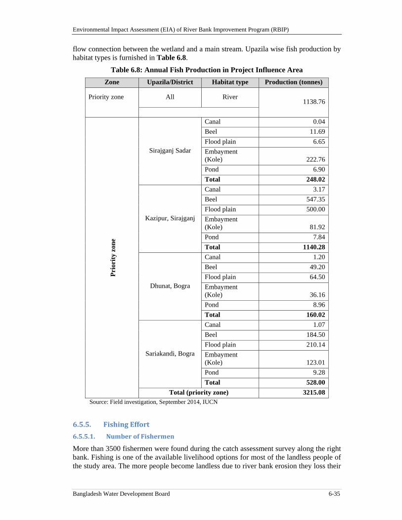
Environmental Impact Assessment (EIA) of River Bank Improvement Program (RBIP)
Bangladesh Water Development Board 6-35
flow connection between the wetland and a main stream. Upazila wise fish production by habitat types is furnished in Table 6.8.
Table 6.8: Annual Fish Production in Project Influence Area
Zone Upazila/District Habitat type Production (tonnes)
Priority zone All River 1138.76
P
rior
ity
zon
e
Sirajganj Sadar
Canal 0.04
Beel 11.69
Flood plain 6.65
Embayment (Kole) 222.76
Pond 6.90
Total 248.02
Kazipur, Sirajganj
Canal 3.17
Beel 547.35
Flood plain 500.00
Embayment (Kole) 81.92
Pond 7.84
Total 1140.28
Dhunat, Bogra
Canal 1.20
Beel 49.20
Flood plain 64.50
Embayment (Kole) 36.16
Pond 8.96
Total 160.02
Sariakandi, Bogra
Canal 1.07
Beel 184.50
Flood plain 210.14
Embayment (Kole) 123.01
Pond 9.28
Total 528.00
Total (priority zone) 3215.08Source: Field investigation, September 2014, IUCN
6.5.5. FishingEffort
6.5.5.1. NumberofFishermen
More than 3500 fishermen were found during the catch assessment survey along the right bank. Fishing is one of the available livelihood options for most of the landless people of the study area. The more people become landless due to river bank erosion they loss their
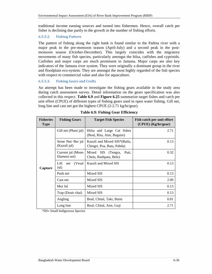
Environmental Impact Assessment (EIA) of River Bank Improvement Program (RBIP)
Bangladesh Water Development Board 6-36
traditional income earning sources and turned into fishermen. Hence, overall catch per fisher is declining due partly to the growth in the number of fishing efforts.
6.5.5.2. FishingPattern
The pattern of fishing along the right bank is found similar to the Padma river with a major peak in the pre-monsoon season (April-July) and a second peak in the post-monsoon season (October-December). This largely coincides with the migratory movements of many fish species, particularly amongst the hilsa, catfishes and cyprinids. Catfishes and major carps are much prominent in Jamuna. Major carps are also key indicators of the Jamuna river system. They were originally a dominant group in the river and floodplain eco-system. They are amongst the most highly regarded of the fish species with respect to commercial value and also for aquaculture.
6.5.5.3. FishingGearsandCrafts
An attempt has been made to investigate the fishing gears available in the study area during catch assessment survey. Detail information on the gears specification was also collected in this respect. Table 6.9 and Figure 6.25 summarize target fishes and catch per unit effort (CPUE) of different types of fishing gears used in open water fishing. Gill net, long line and cast net got the highest CPUE (2-2.71 kg/hr/gear).
Table 6.9: Fishing Gear Efficiency
Fisheries Type
Fishing Gears Target Fish Species Fish catch per unit effort (CPUE) (Kg/hr/gear)
Capture
Gill net (Phasi jal) Hilsa and Large Cat fishes (Boal, Rita, Aire, Bagaire)
2.71
Seine Net/ Ber jal (Kazoli jal)
Kazoli and Mixed SIS*(Baila, Chingri, Poa, Bata, Pabda)
0.13
Current jal (Mono filament net)
Mixed SIS (Tengra, Puti, Chela, Bashpata, Bele)
0.32
Lift net (Vesal Jal)
Kazoli and Mixed SIS 0.13
Push net Mixed SIS 0.13
Cast net Mixed SIS 2.00
Moi Jal Mixed SIS 0.13
Trap (Doair chai) Mixed SIS 0.13
Angling Boal, Chital, Taki, Baim 0.81
Long line Boal, Chital, Aire, Guji 2.71
*SIS=SmallIndigenousSpecies
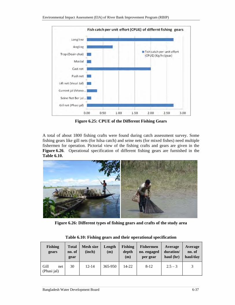
Environmental Impact Assessment (EIA) of River Bank Improvement Program (RBIP)
Bangladesh Water Development Board 6-37
Figure 6.25: CPUE of the Different Fishing Gears
A total of about 1800 fishing crafts were found during catch assessment survey. Some fishing gears like gill nets (for hilsa catch) and seine nets (for mixed fishes) need multiple fishermen for operation. Pictorial view of the fishing crafts and gears are given in the Figure 6.26. Operational specification of different fishing gears are furnished in the Table 6.10.
Figure 6.26: Different types of fishing gears and crafts of the study area
Table 6.10: Fishing gears and their operational specification
Fishing gears
Total no. of gear
Mesh size (inch)
Length (m)
Fishing depth (m)
Fishermen no. engaged
per gear
Average duration/ haul (hr)
Average no. of
haul/day
Gill net (Phasi jal)
30 12-14 365-950 14-22 8-12 2.5 – 3 3
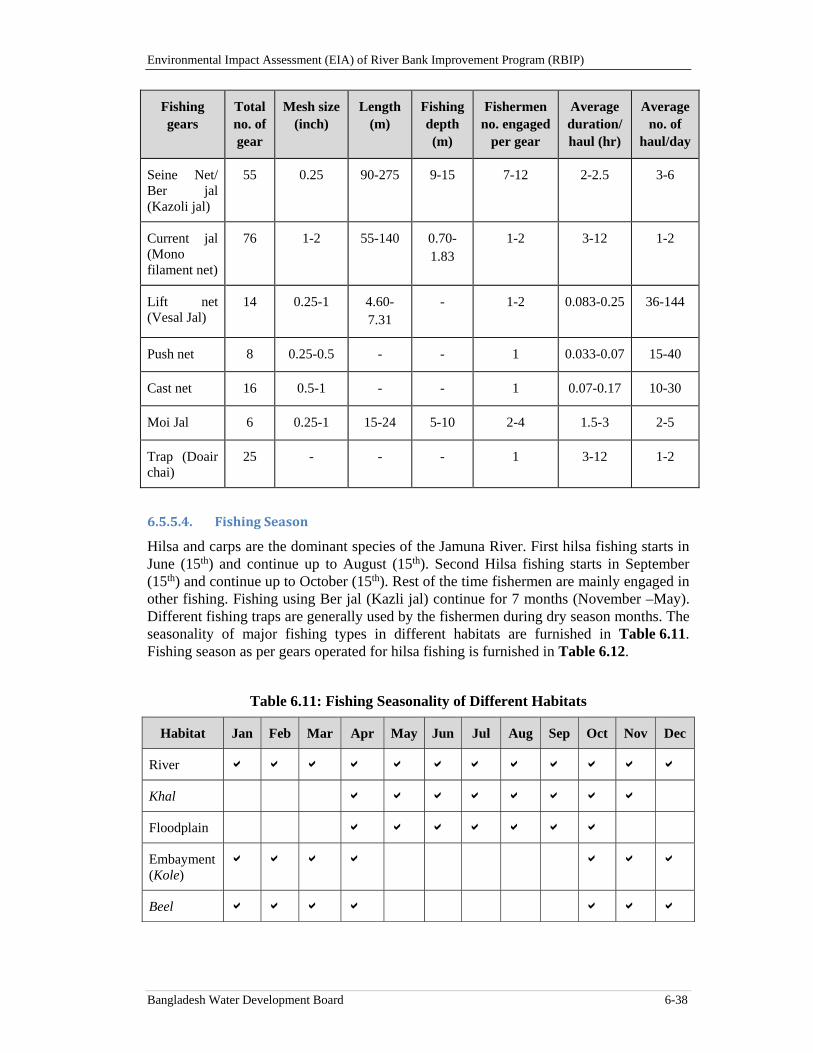
Environmental Impact Assessment (EIA) of River Bank Improvement Program (RBIP)
Bangladesh Water Development Board 6-38
Fishing gears
Total no. of gear
Mesh size (inch)
Length (m)
Fishing depth (m)
Fishermen no. engaged
per gear
Average duration/ haul (hr)
Average no. of
haul/day
Seine Net/ Ber jal (Kazoli jal)
55 0.25 90-275 9-15 7-12 2-2.5 3-6
Current jal (Mono filament net)
76 1-2 55-140 0.70-1.83
1-2 3-12 1-2
Lift net (Vesal Jal)
14 0.25-1 4.60-7.31
- 1-2 0.083-0.25 36-144
Push net 8 0.25-0.5 - - 1 0.033-0.07 15-40
Cast net 16 0.5-1 - - 1 0.07-0.17 10-30
Moi Jal 6 0.25-1 15-24 5-10 2-4 1.5-3 2-5
Trap (Doair chai)
25 - - - 1 3-12 1-2
6.5.5.4. FishingSeason
Hilsa and carps are the dominant species of the Jamuna River. First hilsa fishing starts in June (15th) and continue up to August (15th). Second Hilsa fishing starts in September (15th) and continue up to October (15th). Rest of the time fishermen are mainly engaged in other fishing. Fishing using Ber jal (Kazli jal) continue for 7 months (November –May). Different fishing traps are generally used by the fishermen during dry season months. The seasonality of major fishing types in different habitats are furnished in Table 6.11. Fishing season as per gears operated for hilsa fishing is furnished in Table 6.12.
Table 6.11: Fishing Seasonality of Different Habitats
Habitat Jan Feb Mar Apr May Jun Jul Aug Sep Oct Nov Dec
River
Khal
Floodplain
Embayment (Kole)
Beel
Environmental Impact Assessment (EIA) of River Bank Improvement Program (RBIP)
Bangladesh Water Development Board 6-39
Table 6.12: Crafts and Gears Used for Hilsa Fishing
Type of Net
Local Name Craft used Nos. crew
Operation Season
Fishing type
Set gill net
Gara jal
Dhara jal
Daba jal
Bundhi jal
Kosa
Kosha
Kosha
Dingi
6-8
4-6
4-6
10-15
Nov-Feb
May-Oct
May-Oct
Jan-May
Gilling & Selective
Gilling & Selective
Gilling & Selective
Gilling & Pocket Selective
Drift gill net
Current jal
Gulti jal
Kona jal
Dingi/kosha
Chandi
Chandi
2-4
8-10
8-10
Year round
May-Oct
May-Oct
Gilling & Selective
Pocketing
Gilling & Pocketing
Clap net Shangla jal
Kharki jal
Dingi/kosha
Kharki
2
2
Aug-Oct
Aug-Oct
Trapping
Trapping
Seine Jagat ber
Ber jal
Chandi
Chandi
40-50
30-40
Jan-May
Jan-May
Encircling
Encircling
Lift net Khara/Bhesal Dingi 1-2 Jan-May Lifting
6.5.6. FishBiodiversity
Huge number of stagnant water bodies in chars and river channels support a habitat of rich fish biodiversity. Rahman and Akhter (2007) identified 156 fish species of which, 89 are commercially important and 53 are rare in the river. Thousands of fishermen are also dependent on this river. FAP 17 (1995) carried out a catch assessment survey in Jamuna and Padma rivers during March 1993 - February 1994. The study classified the fish species according to their preference of habitat namely riverine, migratory and floodplain resident. The study identified 68 fish species for Jamuna, out of which 22 were riverine, 18 migratory, and 28 floodplain resident. Catches from Jamuna accounted 60 percent of riverine species, whereas migratory and floodplain resident fish species were equally abundant on the Jamuna comprising 13 percent. Hilsa was the dominant species occupied 31 percent of the catch. The study noted that the number of floodplain species found in the catch during winter highlights the importance of the extensive areas of these large rivers as shelter during a critical period in the hydrological cycle when the area of perennial water on the floodplain is at a minimum. Jamuna river is renowned for its high diversity of the small indigenous fish species (SIS). Some of the fishes like Piyali (Joya) are only now available in Jamuna and its adjacent floodplain (Figure 6.27). Large Hilsa is only available up to Sirajganj. A list of abundant species found during the catch assessment survey and determined through FGD in the study area is furnished in the Baseline report that is presented under a separate cover.
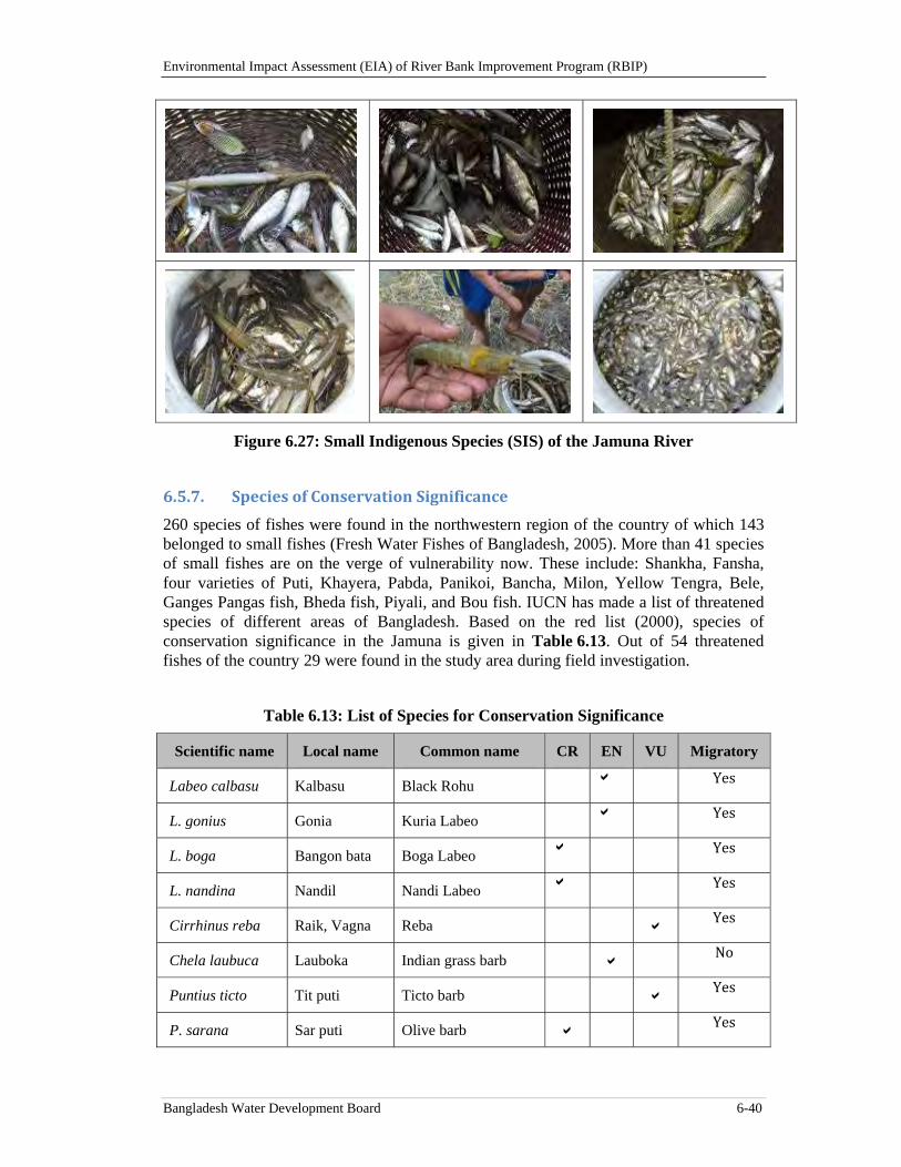
Environmental Impact Assessment (EIA) of River Bank Improvement Program (RBIP)
Bangladesh Water Development Board 6-40
Figure 6.27: Small Indigenous Species (SIS) of the Jamuna River
6.5.7. SpeciesofConservationSignificance
260 species of fishes were found in the northwestern region of the country of which 143 belonged to small fishes (Fresh Water Fishes of Bangladesh, 2005). More than 41 species of small fishes are on the verge of vulnerability now. These include: Shankha, Fansha, four varieties of Puti, Khayera, Pabda, Panikoi, Bancha, Milon, Yellow Tengra, Bele, Ganges Pangas fish, Bheda fish, Piyali, and Bou fish. IUCN has made a list of threatened species of different areas of Bangladesh. Based on the red list (2000), species of conservation significance in the Jamuna is given in Table 6.13. Out of 54 threatened fishes of the country 29 were found in the study area during field investigation.
Table 6.13: List of Species for Conservation Significance
Scientific name Local name Common name CR EN VU Migratory
Labeo calbasu Kalbasu Black Rohu Yes
L. gonius Gonia Kuria Labeo Yes
L. boga Bangon bata Boga Labeo
Yes
L. nandina Nandil Nandi Labeo
Yes
Cirrhinus reba Raik, Vagna Reba Yes
Chela laubuca Lauboka Indian grass barb No
Puntius ticto Tit puti Ticto barb Yes
P. sarana Sar puti Olive barb Yes
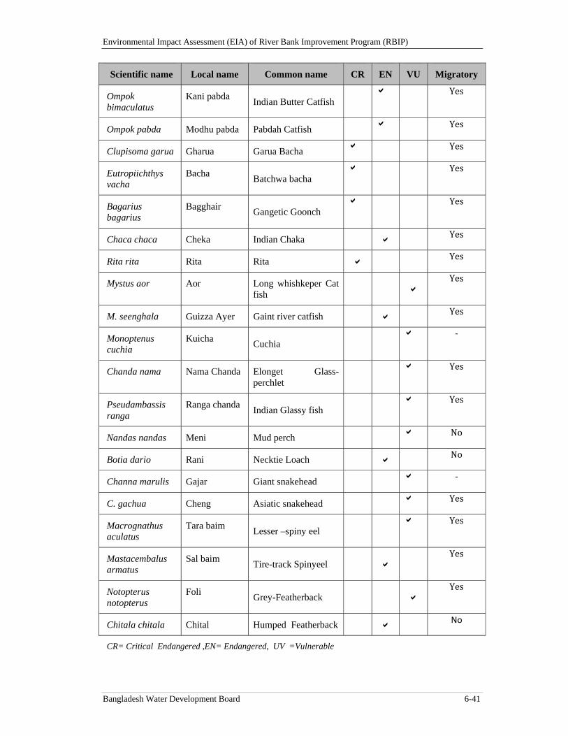
Environmental Impact Assessment (EIA) of River Bank Improvement Program (RBIP)
Bangladesh Water Development Board 6-41
Scientific name Local name Common name CR EN VU Migratory
Ompok bimaculatus
Kani pabda Indian Butter Catfish
Yes
Ompok pabda Modhu pabda Pabdah Catfish
Yes
Clupisoma garua Gharua Garua Bacha
Yes
Eutropiichthys vacha
Bacha Batchwa bacha
Yes
Bagarius bagarius
Bagghair Gangetic Goonch
Yes
Chaca chaca Cheka Indian Chaka Yes
Rita rita Rita Rita Yes
Mystus aor Aor Long whishkeper Cat fish
Yes
M. seenghala Guizza Ayer Gaint river catfish Yes
Monoptenus cuchia
Kuicha Cuchia
‐
Chanda nama Nama Chanda Elonget Glass-perchlet
Yes
Pseudambassis ranga
Ranga chanda Indian Glassy fish
Yes
Nandas nandas Meni Mud perch No
Botia dario Rani Necktie Loach No
Channa marulis Gajar Giant snakehead ‐
C. gachua Cheng Asiatic snakehead Yes
Macrognathus aculatus
Tara baim Lesser –spiny eel
Yes
Mastacembalus armatus
Sal baim Tire-track Spinyeel
Yes
Notopterus notopterus
Foli Grey-Featherback
Yes
Chitala chitala Chital Humped Featherback No
CR= Critical Endangered ,EN= Endangered, UV =Vulnerable
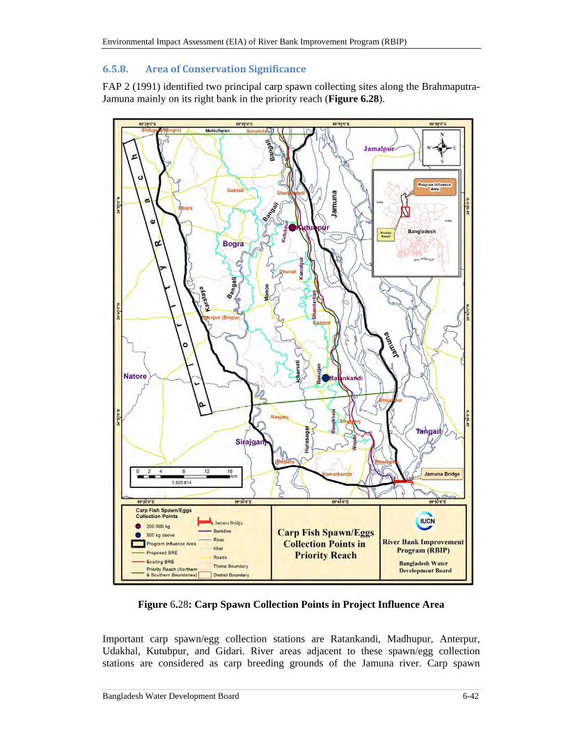
Environmental Impact Assessment (EIA) of River Bank Improvement Program (RBIP)
Bangladesh Water Development Board 6-42
6.5.8. AreaofConservationSignificance
FAP 2 (1991) identified two principal carp spawn collecting sites along the Brahmaputra-Jamuna mainly on its right bank in the priority reach (Figure 6.28).
Figure 6.28: Carp Spawn Collection Points in Project Influence Area
Important carp spawn/egg collection stations are Ratankandi, Madhupur, Anterpur, Udakhal, Kutubpur, and Gidari. River areas adjacent to these spawn/egg collection stations are considered as carp breeding grounds of the Jamuna river. Carp spawn
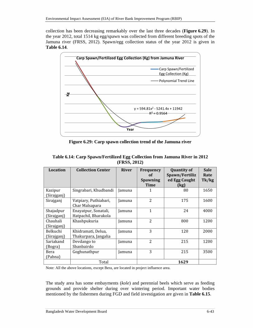
Environmental Impact Assessment (EIA) of River Bank Improvement Program (RBIP)
Bangladesh Water Development Board 6-43
collection has been decreasing remarkably over the last three decades (Figure 6.29). In the year 2012, total 1514 kg egg/spawn was collected from different breeding spots of the Jamuna river (FRSS, 2012). Spawn/egg collection status of the year 2012 is given in Table 6.14.
Figure 6.29: Carp spawn collection trend of the Jamuna river
Table 6.14: Carp Spawn/Fertilized Egg Collection from Jamuna River in 2012 (FRSS, 2012)
Location CollectionCenter River Frequencyof
SpawningTime
QuantityofSpawn/FertilizedEggCaught
(kg)
SaleRateTk/kg
Kazipur(Sirajganj)
Singrabari,Khudbandi Jamuna 1 80 1650
Sirajganj Vatpiary,Puthiabari,CharMalsapara
Jamuna 2 175 1600
Shajadpur(Sirajganj)
Enayatpur,Sonatali,Hatpachil,Bharakola
Jamuna 1 24 4000
Chauhali(Sirajganj)
Khashpukuria Jamuna 2 800 1200
Belkuchi(Sirajganj)
Khidramati,Delua,Thakurpara,Jangalia
Jamuna 3 120 2000
Sariakand(Bogra)
DevdangotoSbanbairdo
Jamuna 2 215 1200
Bera(Pabna)
Goghunathpur Jamuna 3 215 3500
Total 1629Note: All the above locations, except Bera, are located in project influence area.
The study area has some embayments (kole) and perennial beels which serve as feeding grounds and provide shelter during over wintering period. Important water bodies mentioned by the fishermen during FGD and field investigation are given in Table 6.15.
y = 594.81x2 ‐ 5241.4x + 11942R² = 0.9564
Kg
Year
Carp Spawn/Fertilized Egg Collection (Kg) from Jamuna River
Carp Spawn/FertilizedEgg Collection (Kg)
Polynomial Trend Line
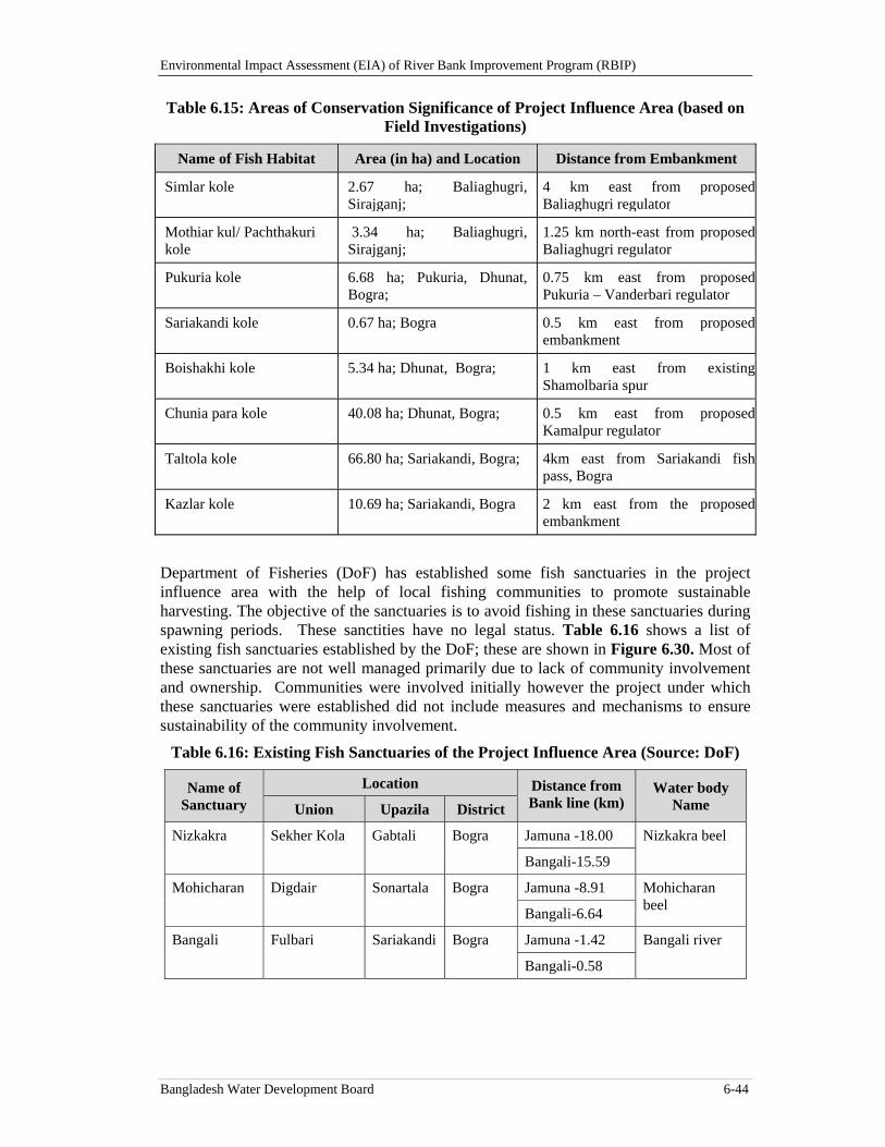
Environmental Impact Assessment (EIA) of River Bank Improvement Program (RBIP)
Bangladesh Water Development Board 6-44
Table 6.15: Areas of Conservation Significance of Project Influence Area (based on Field Investigations)
Name of Fish Habitat Area (in ha) and Location Distance from Embankment
Simlar kole 2.67 ha; Baliaghugri, Sirajganj;
4 km east from proposedBaliaghugri regulator
Mothiar kul/ Pachthakuri kole
3.34 ha; Baliaghugri, Sirajganj;
1.25 km north-east from proposedBaliaghugri regulator
Pukuria kole 6.68 ha; Pukuria, Dhunat, Bogra;
0.75 km east from proposedPukuria – Vanderbari regulator
Sariakandi kole 0.67 ha; Bogra 0.5 km east from proposedembankment
Boishakhi kole 5.34 ha; Dhunat, Bogra; 1 km east from existingShamolbaria spur
Chunia para kole 40.08 ha; Dhunat, Bogra; 0.5 km east from proposedKamalpur regulator
Taltola kole 66.80 ha; Sariakandi, Bogra; 4km east from Sariakandi fishpass, Bogra
Kazlar kole 10.69 ha; Sariakandi, Bogra 2 km east from the proposedembankment
Department of Fisheries (DoF) has established some fish sanctuaries in the project influence area with the help of local fishing communities to promote sustainable harvesting. The objective of the sanctuaries is to avoid fishing in these sanctuaries during spawning periods. These sanctities have no legal status. Table 6.16 shows a list of existing fish sanctuaries established by the DoF; these are shown in Figure 6.30. Most of these sanctuaries are not well managed primarily due to lack of community involvement and ownership. Communities were involved initially however the project under which these sanctuaries were established did not include measures and mechanisms to ensure sustainability of the community involvement.
Table 6.16: Existing Fish Sanctuaries of the Project Influence Area (Source: DoF)
Name of Sanctuary
Location Distance from Bank line (km)
Water body Name Union Upazila District
Nizkakra Sekher Kola Gabtali Bogra Jamuna -18.00 Nizkakra beel
Bangali-15.59
Mohicharan Digdair Sonartala Bogra Jamuna -8.91 Mohicharan beel
Bangali-6.64
Bangali Fulbari Sariakandi Bogra Jamuna -1.42 Bangali river
Bangali-0.58
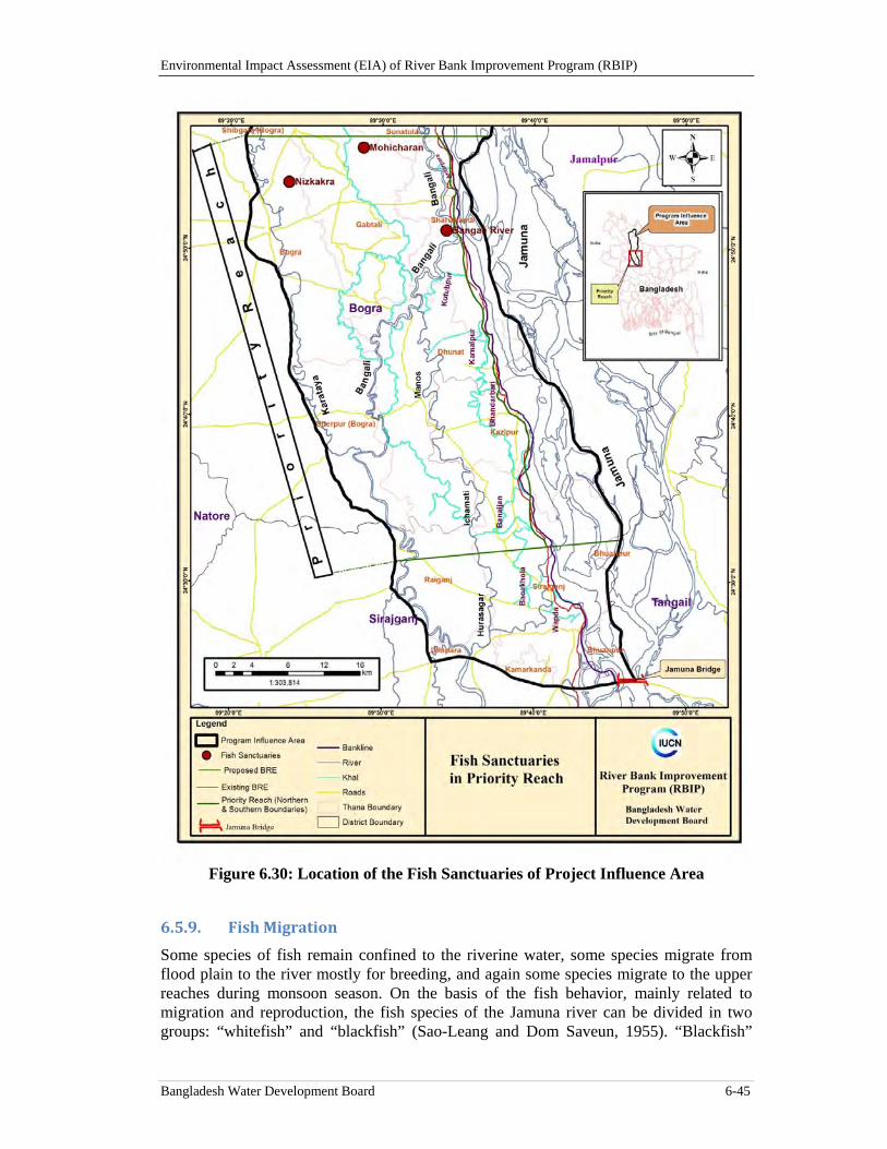
Environmental Impact Assessment (EIA) of River Bank Improvement Program (RBIP)
Bangladesh Water Development Board 6-45
Figure 6.30: Location of the Fish Sanctuaries of Project Influence Area
6.5.9. FishMigration
Some species of fish remain confined to the riverine water, some species migrate from flood plain to the river mostly for breeding, and again some species migrate to the upper reaches during monsoon season. On the basis of the fish behavior, mainly related to migration and reproduction, the fish species of the Jamuna river can be divided in two groups: “whitefish” and “blackfish” (Sao-Leang and Dom Saveun, 1955). “Blackfish”
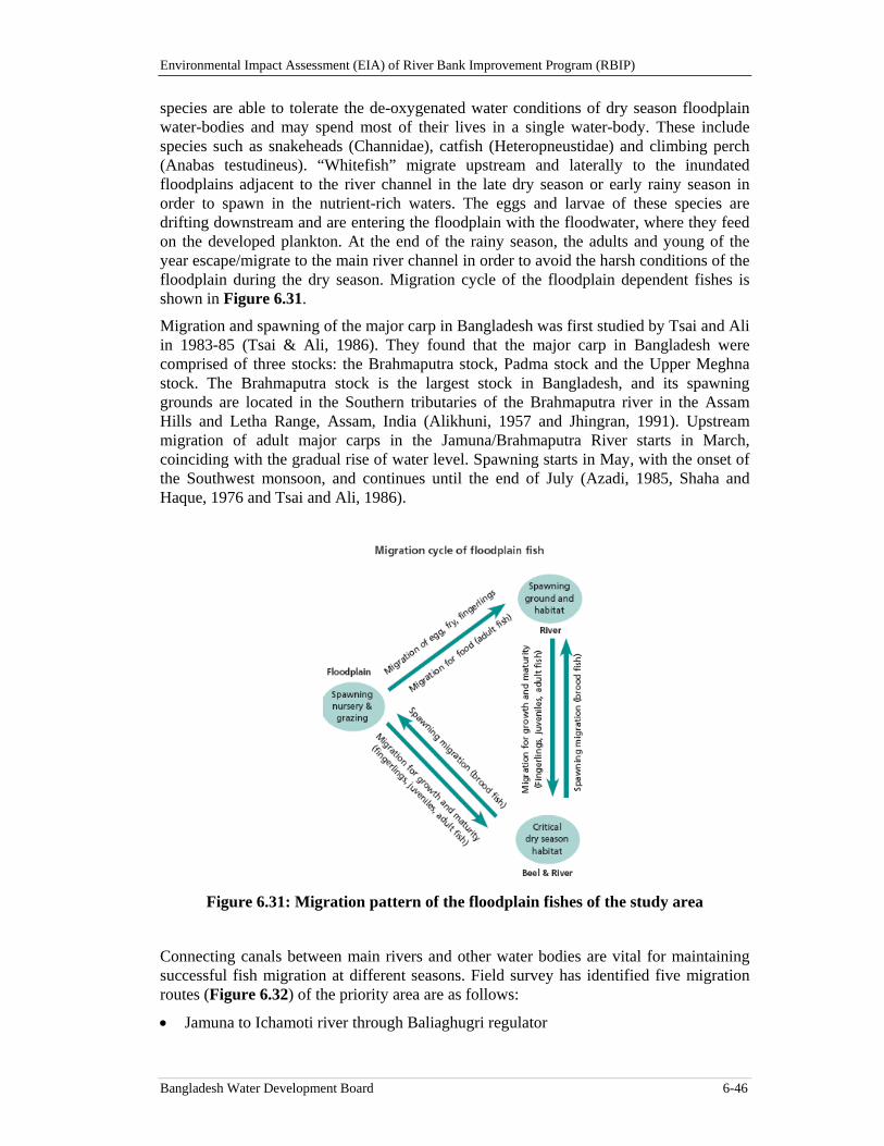
Environmental Impact Assessment (EIA) of River Bank Improvement Program (RBIP)
Bangladesh Water Development Board 6-46
species are able to tolerate the de-oxygenated water conditions of dry season floodplain water-bodies and may spend most of their lives in a single water-body. These include species such as snakeheads (Channidae), catfish (Heteropneustidae) and climbing perch (Anabas testudineus). “Whitefish” migrate upstream and laterally to the inundated floodplains adjacent to the river channel in the late dry season or early rainy season in order to spawn in the nutrient-rich waters. The eggs and larvae of these species are drifting downstream and are entering the floodplain with the floodwater, where they feed on the developed plankton. At the end of the rainy season, the adults and young of the year escape/migrate to the main river channel in order to avoid the harsh conditions of the floodplain during the dry season. Migration cycle of the floodplain dependent fishes is shown in Figure 6.31.
Migration and spawning of the major carp in Bangladesh was first studied by Tsai and Ali in 1983-85 (Tsai & Ali, 1986). They found that the major carp in Bangladesh were comprised of three stocks: the Brahmaputra stock, Padma stock and the Upper Meghna stock. The Brahmaputra stock is the largest stock in Bangladesh, and its spawning grounds are located in the Southern tributaries of the Brahmaputra river in the Assam Hills and Letha Range, Assam, India (Alikhuni, 1957 and Jhingran, 1991). Upstream migration of adult major carps in the Jamuna/Brahmaputra River starts in March, coinciding with the gradual rise of water level. Spawning starts in May, with the onset of the Southwest monsoon, and continues until the end of July (Azadi, 1985, Shaha and Haque, 1976 and Tsai and Ali, 1986).
Figure 6.31: Migration pattern of the floodplain fishes of the study area
Connecting canals between main rivers and other water bodies are vital for maintaining successful fish migration at different seasons. Field survey has identified five migration routes (Figure 6.32) of the priority area are as follows:
Jamuna to Ichamoti river through Baliaghugri regulator
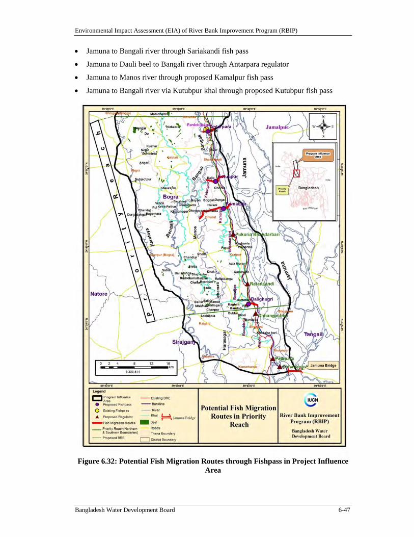
Environmental Impact Assessment (EIA) of River Bank Improvement Program (RBIP)
Bangladesh Water Development Board 6-47
Jamuna to Bangali river through Sariakandi fish pass
Jamuna to Dauli beel to Bangali river through Antarpara regulator
Jamuna to Manos river through proposed Kamalpur fish pass
Jamuna to Bangali river via Kutubpur khal through proposed Kutubpur fish pass
Figure 6.32: Potential Fish Migration Routes through Fishpass in Project Influence Area
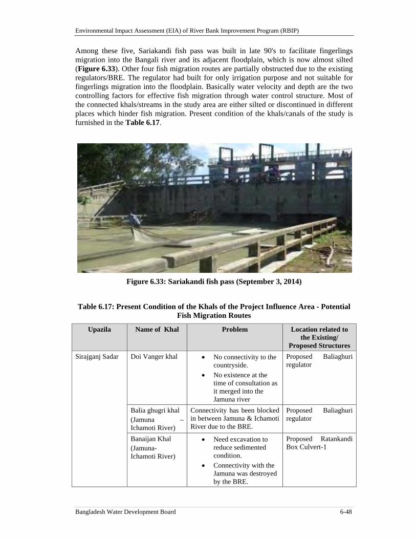
Environmental Impact Assessment (EIA) of River Bank Improvement Program (RBIP)
Bangladesh Water Development Board 6-48
Among these five, Sariakandi fish pass was built in late 90's to facilitate fingerlings migration into the Bangali river and its adjacent floodplain, which is now almost silted (Figure 6.33). Other four fish migration routes are partially obstructed due to the existing regulators/BRE. The regulator had built for only irrigation purpose and not suitable for fingerlings migration into the floodplain. Basically water velocity and depth are the two controlling factors for effective fish migration through water control structure. Most of the connected khals/streams in the study area are either silted or discontinued in different places which hinder fish migration. Present condition of the khals/canals of the study is furnished in the Table 6.17.
Figure 6.33: Sariakandi fish pass (September 3, 2014)
Table 6.17: Present Condition of the Khals of the Project Influence Area - Potential Fish Migration Routes
Upazila Name of Khal Problem Location related to the Existing/
Proposed Structures
Sirajganj Sadar Doi Vanger khal No connectivity to the countryside.
No existence at the time of consultation as it merged into the Jamuna river
Proposed Baliaghuri regulator
Balia ghugri khal (Jamuna –Ichamoti River)
Connectivity has been blocked in between Jamuna & Ichamoti River due to the BRE.
Proposed Baliaghuri regulator
Banaijan Khal (Jamuna- Ichamoti River)
Need excavation to reduce sedimented condition.
Connectivity with the Jamuna was destroyed by the BRE.
Proposed Ratankandi Box Culvert-1
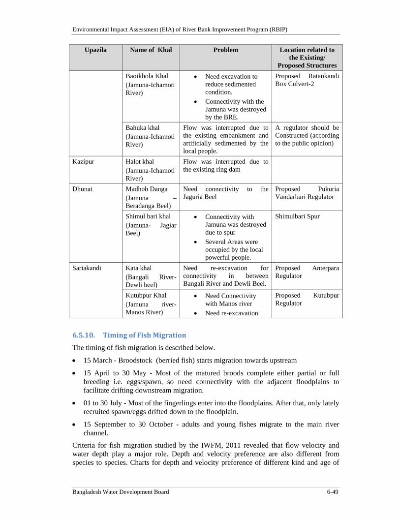
Environmental Impact Assessment (EIA) of River Bank Improvement Program (RBIP)
Bangladesh Water Development Board 6-49
Upazila Name of Khal Problem Location related to the Existing/
Proposed Structures
Baoikhola Khal (Jamuna-Ichamoti River)
Need excavation to reduce sedimented condition.
Connectivity with the Jamuna was destroyed by the BRE.
Proposed Ratankandi Box Culvert-2
Bahuka khal (Jamuna-Ichamoti River)
Flow was interrupted due to the existing embankment and artificially sedimented by the local people.
A regulator should be Constructed (according to the public opinion)
Kazipur Halot khal (Jamuna-Ichamoti River)
Flow was interrupted due to the existing ring dam
Dhunat Madhob Danga (Jamuna –Beradanga Beel)
Need connectivity to the Jaguria Beel
Proposed Pukuria Vandarbari Regulator
Shimul bari khal (Jamuna- Jagiar Beel)
Connectivity with Jamuna was destroyed due to spur
Several Areas were occupied by the local powerful people.
Shimulbari Spur
Sariakandi Kata khal (Bangali River- Dewli beel)
Need re-excavation for connectivity in between Bangali River and Dewli Beel.
Proposed Anterpara Regulator
Kutubpur Khal (Jamuna river- Manos River)
Need Connectivity with Manos river
Need re-excavation
Proposed Kutubpur Regulator
6.5.10. TimingofFishMigration
The timing of fish migration is described below.
15 March - Broodstock (berried fish) starts migration towards upstream
15 April to 30 May - Most of the matured broods complete either partial or full breeding i.e. eggs/spawn, so need connectivity with the adjacent floodplains to facilitate drifting downstream migration.
01 to 30 July - Most of the fingerlings enter into the floodplains. After that, only lately recruited spawn/eggs drifted down to the floodplain.
15 September to 30 October - adults and young fishes migrate to the main river channel.
Criteria for fish migration studied by the IWFM, 2011 revealed that flow velocity and water depth play a major role. Depth and velocity preference are also different from species to species. Charts for depth and velocity preference of different kind and age of
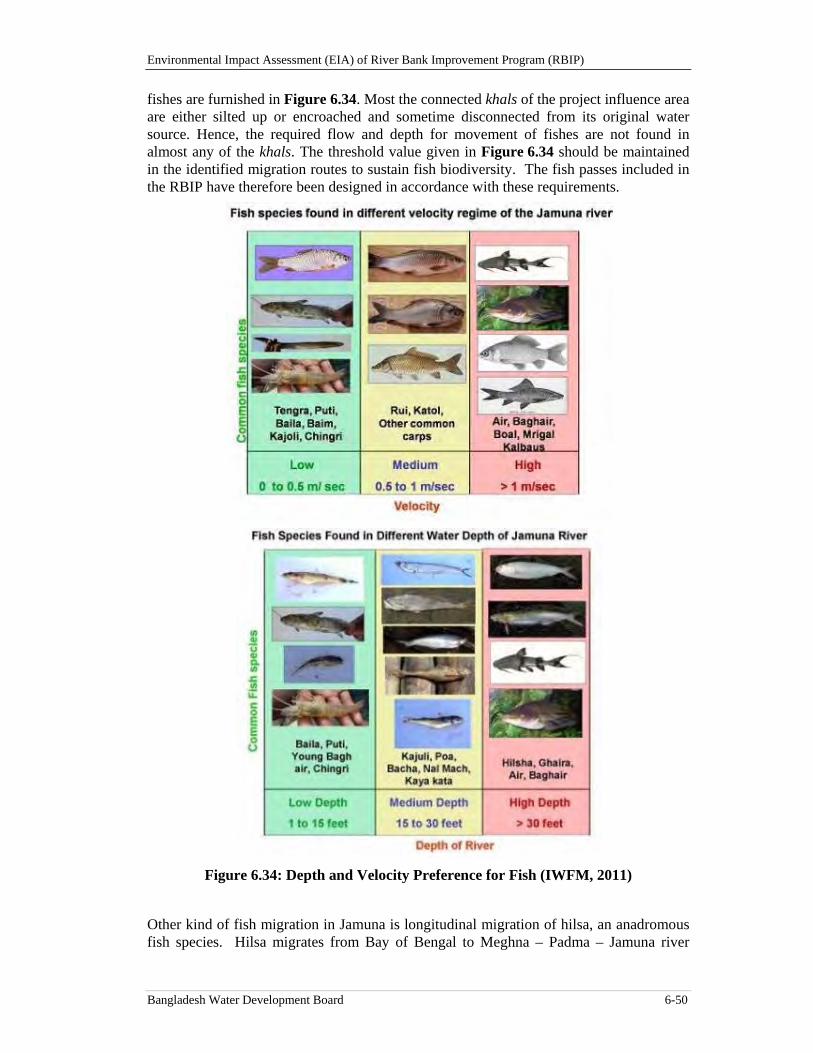
Environmental Impact Assessment (EIA) of River Bank Improvement Program (RBIP)
Bangladesh Water Development Board 6-50
fishes are furnished in Figure 6.34. Most the connected khals of the project influence area are either silted up or encroached and sometime disconnected from its original water source. Hence, the required flow and depth for movement of fishes are not found in almost any of the khals. The threshold value given in Figure 6.34 should be maintained in the identified migration routes to sustain fish biodiversity. The fish passes included in the RBIP have therefore been designed in accordance with these requirements.
Figure 6.34: Depth and Velocity Preference for Fish (IWFM, 2011)
Other kind of fish migration in Jamuna is longitudinal migration of hilsa, an anadromous fish species. Hilsa migrates from Bay of Bengal to Meghna – Padma – Jamuna river
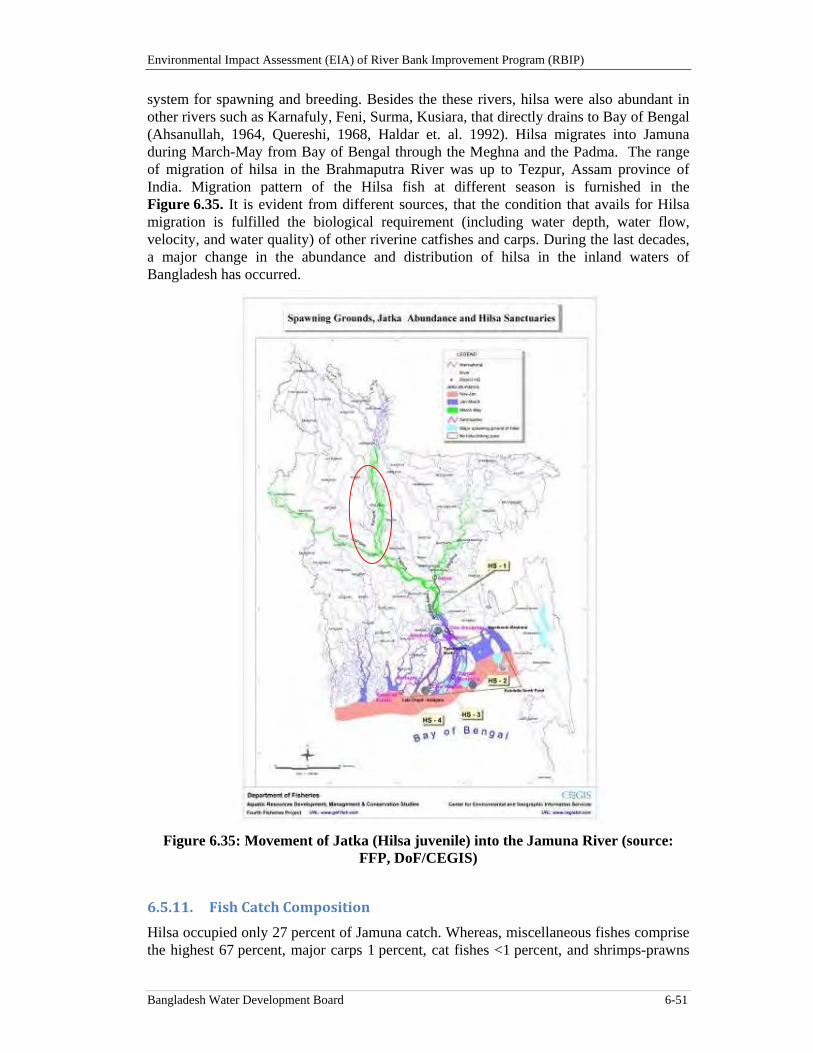
Environmental Impact Assessment (EIA) of River Bank Improvement Program (RBIP)
Bangladesh Water Development Board 6-51
system for spawning and breeding. Besides the these rivers, hilsa were also abundant in other rivers such as Karnafuly, Feni, Surma, Kusiara, that directly drains to Bay of Bengal (Ahsanullah, 1964, Quereshi, 1968, Haldar et. al. 1992). Hilsa migrates into Jamuna during March-May from Bay of Bengal through the Meghna and the Padma. The range of migration of hilsa in the Brahmaputra River was up to Tezpur, Assam province of India. Migration pattern of the Hilsa fish at different season is furnished in the Figure 6.35. It is evident from different sources, that the condition that avails for Hilsa migration is fulfilled the biological requirement (including water depth, water flow, velocity, and water quality) of other riverine catfishes and carps. During the last decades, a major change in the abundance and distribution of hilsa in the inland waters of Bangladesh has occurred.
Figure 6.35: Movement of Jatka (Hilsa juvenile) into the Jamuna River (source:
FFP, DoF/CEGIS)
6.5.11. FishCatchComposition
Hilsa occupied only 27 percent of Jamuna catch. Whereas, miscellaneous fishes comprise the highest 67 percent, major carps 1 percent, cat fishes <1 percent, and shrimps-prawns
Environmental Impact Assessment (EIA) of River Bank Improvement Program (RBIP)
Bangladesh Water Development Board 6-52
4 percent (Figure 6.36). Among the principal rivers, considerable amount of major carps (Rui, Catla, and Mrigal) production is coming from Jamuna. Other carps (Ghania, Kalbasu, and Kalia) production is the lowest in this river. Catfish (Rita, Boal, Pangas, Silon, Aor, and Bacha) production is also the highest in Jamuna. Small shrimps are available in almost all rivers, whereas big shrimp production is found comparatively higher than other rivers.
Figure 6.36: Fish catch composition (percent) of the Jamuna River (FRSS, 2012)
6.5.12. AquaticInvertebrates
In freshwater biology, benthos are referred to the organisms at the bottom of freshwater bodies of water, such as lakes, rivers, and streams. These are the organisms which live on, in, or near the benthic zone. Most organisms in the benthic zone are scavengers or detritivores. Different types of zoo-benthos and phyto-benthos exist in the aquatic part of the study area. Insect larvae constitute the most numerous and diverse zoo-benthos group. Daphnia, Cypris, Cyclops and several copepods are important zooplankton in freshwater and are food of many fish and other crustaceans.
According to a survey of the Department of Zoology, Rajshahi University, the rivers in Bangladesh once thrived with thousands of species of zooplankton and zoobenthos. The number of species has dwindled to 19 species of Rotifer, 12 species of Cladocera and 11 species of Copepoda. Many other indigenous species of plankton, beneficial insects and water worms have become extinct or on the way to extinction (Bhuiyan et. al. 2008). During an earlier study, 11 species of Crustacea (Arthropoda) and Gastropoda (Mollusca) were recorded in the Padma river. Crustaceans included four species: Macrobrachium rosenbergii, M. malcolmsonei and Cancer sp. which are present throughout the year and breed during December-February; and, M. lamarrei which also is present throughout the year and breeds during April-June. Two species of mollusks were collected (Pila globosa and Unio sp.); these species are present throughout the year and breed during April-June. Among non-fin fishes 36 percent were arthropods, 18 percent, mollusks and 45 percent chordates.
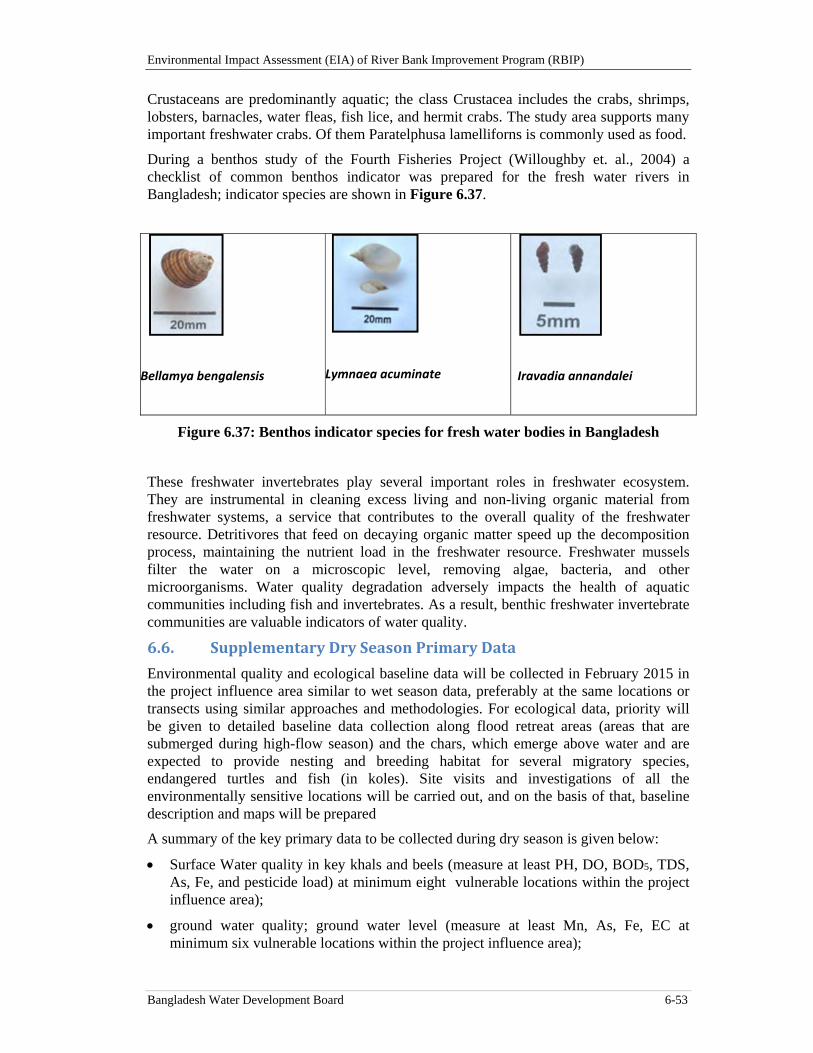
Environmental Impact Assessment (EIA) of River Bank Improvement Program (RBIP)
Bangladesh Water Development Board 6-53
Crustaceans are predominantly aquatic; the class Crustacea includes the crabs, shrimps, lobsters, barnacles, water fleas, fish lice, and hermit crabs. The study area supports many important freshwater crabs. Of them Paratelphusa lamelliforns is commonly used as food.
During a benthos study of the Fourth Fisheries Project (Willoughby et. al., 2004) a checklist of common benthos indicator was prepared for the fresh water rivers in Bangladesh; indicator species are shown in Figure 6.37.
Bellamya bengalensis
Lymnaea acuminate
Iravadia annandalei
Figure 6.37: Benthos indicator species for fresh water bodies in Bangladesh
These freshwater invertebrates play several important roles in freshwater ecosystem. They are instrumental in cleaning excess living and non-living organic material from freshwater systems, a service that contributes to the overall quality of the freshwater resource. Detritivores that feed on decaying organic matter speed up the decomposition process, maintaining the nutrient load in the freshwater resource. Freshwater mussels filter the water on a microscopic level, removing algae, bacteria, and other microorganisms. Water quality degradation adversely impacts the health of aquatic communities including fish and invertebrates. As a result, benthic freshwater invertebrate communities are valuable indicators of water quality.
6.6. SupplementaryDrySeasonPrimaryData
Environmental quality and ecological baseline data will be collected in February 2015 in the project influence area similar to wet season data, preferably at the same locations or transects using similar approaches and methodologies. For ecological data, priority will be given to detailed baseline data collection along flood retreat areas (areas that are submerged during high-flow season) and the chars, which emerge above water and are expected to provide nesting and breeding habitat for several migratory species, endangered turtles and fish (in koles). Site visits and investigations of all the environmentally sensitive locations will be carried out, and on the basis of that, baseline description and maps will be prepared
A summary of the key primary data to be collected during dry season is given below:
Surface Water quality in key khals and beels (measure at least PH, DO, BOD5, TDS, As, Fe, and pesticide load) at minimum eight vulnerable locations within the project influence area);
ground water quality; ground water level (measure at least Mn, As, Fe, EC at minimum six vulnerable locations within the project influence area);
Environmental Impact Assessment (EIA) of River Bank Improvement Program (RBIP)
Bangladesh Water Development Board 6-54
air and noise quality (measure at least PM10 PM2.5, SPM at minimum five locations for air and at least 10 locations for noise along the Embankment);
Landuse patterns in the flood plain above the dry-season A/D line and the embankment.
Description of aquatic and terrestrial habitats in charlands and flood plain particularly for areas that are submerged during the high-flow season, and with a special emphasis on the areas to be directly impacted by, or adjacent to, project interventions;
Description of floral and faunal species associated with above habitats;
Description of habitats for endangered species;
key migratory bird species, their nesting and feeding areas;
Environmental and ecological hot-spots particularly in those areas that are submerged during the high-flow season, and with a special emphasis on the areas to be directly impacted by, or adjacent to, project interventions;
description of habitat along the river bank where revetment will be carried out; and
description of habitat from where sand extraction is likely to be carried out.
The above data will be collected and the present EIA will be updated by end of March 2015.
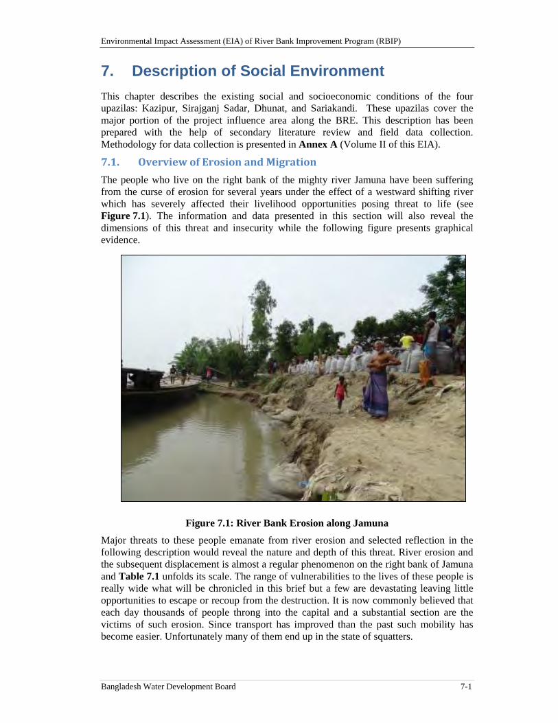
Environmental Impact Assessment (EIA) of River Bank Improvement Program (RBIP)
Bangladesh Water Development Board 7-1
7. Description of Social Environment
This chapter describes the existing social and socioeconomic conditions of the four upazilas: Kazipur, Sirajganj Sadar, Dhunat, and Sariakandi. These upazilas cover the major portion of the project influence area along the BRE. This description has been prepared with the help of secondary literature review and field data collection. Methodology for data collection is presented in Annex A (Volume II of this EIA).
7.1. OverviewofErosionandMigration
The people who live on the right bank of the mighty river Jamuna have been suffering from the curse of erosion for several years under the effect of a westward shifting river which has severely affected their livelihood opportunities posing threat to life (see Figure 7.1). The information and data presented in this section will also reveal the dimensions of this threat and insecurity while the following figure presents graphical evidence.
Figure 7.1: River Bank Erosion along Jamuna
Major threats to these people emanate from river erosion and selected reflection in the following description would reveal the nature and depth of this threat. River erosion and the subsequent displacement is almost a regular phenomenon on the right bank of Jamuna and Table 7.1 unfolds its scale. The range of vulnerabilities to the lives of these people is really wide what will be chronicled in this brief but a few are devastating leaving little opportunities to escape or recoup from the destruction. It is now commonly believed that each day thousands of people throng into the capital and a substantial section are the victims of such erosion. Since transport has improved than the past such mobility has become easier. Unfortunately many of them end up in the state of squatters.

Environmental Impact Assessment (EIA) of River Bank Improvement Program (RBIP)
Bangladesh Water Development Board 7-2
Table 7.1: Total Number of Time(s) Households in the Priority Reach have Shifted Home Location
Times (s) shifted Percent
N=3443
0 51.6
1-5 41.3
6-10 5.9
11-20 0.9
≥21 0.3
Total 100.0
Source: Priority Area Survey
Almost half of the surveyed households have experienced the lesson of shifting at some points of their life/household cycle. On the other hand, 51.6 percent never shifted who may be regarded as the old residents of this area. About 41.3 percent shifted in their life/household cycle 1 to 5 times. Similarly 5.9 percent shifted six to ten times. There are 0.3 percent households who experienced this bitterness for more than 21 times. River erosion and displacement have depleted their resources and infused extreme vulnerability contributing to the process of impoverishment.
The phenomenon of displacement and displacement is a part of the life for people who live on the right bank of Jamuna. Earlier table gave idea about its scale and the above table establishes the causes. River erosion is the prime factor behind displacement is no longer a hypothetical statement, if the above table is analyzed. About 97 percent affirms this cause that is erosion has led to their displacement where they used to live (Table 7.2).
Table 7.2: Reasons of Displacement, among Households who have Shifted Home Locations in the Past
Reasons Percent
N=1687
Displaced by River Erosion 96.91
Commercial Opportunity 0.36
Land Scarcity 2.43
Socio-Political Conflict 0.12
Family Problem 0.18
Total 100
Source: Priority Area Survey
7.2. SocioeconomicPerspective
Sirajganj is predominantly an agricultural area and Bogra has got slightly larger non-agricultural base. However, the scale of industrialization or urbanization cannot be compared with metropolitan areas. Thus villages and rural society constitute the core of
Environmental Impact Assessment (EIA) of River Bank Improvement Program (RBIP)
Bangladesh Water Development Board 7-3
its entity. Over the years its traditional agriculture has undergone changes with the introduction of Green Revolution technology. Changes in the agrarian society took place at the structural and technological levels. Although agriculture is the mainstay of its economy, Sirajganj earned fame for its handloom industry which produces saree, lungi and other clothes. In the late seventeenth and early eighteenth century it was commercially an important place. However, being faced with steep competition particularly from the clothes produced in the mill its business has been affected leading to shutdown of many handloom units. Many of them took loan from the banks but being unable to repay went bankrupt. Another commodity is popular of both districts is the cow milk and sweet food such as curd. Large milk manufacturers of the country gather milk from this district for retail sale in the large cities of the country. On the other hand Bogra has larger presence of banks and other financial institutions18. Bogra town is larger than Sirajganj and vegetable cultivation is also widespread in this district.
Sirajganj was a sub-division and elevated to a district in 1984 and Bogra was all along a full-fledged district. In both places, an average of 28 percent of the heads of household are day laborers engaged in agricultural and non-agricultural activities, which represents a plurality in reported occupations among the surveyed population.19. In non-agriculture sector the wholesale and retail business constitute more than half of the functional enterprises and still there is no textile, garments, steel and engineering industry in both districts, in Bogra district the presence of rice mill is noteworthy20. About 15 percent households are engaged in different services which are related to the enterprises carrying out different small and medium scale business. Some are also engaged in non-governmental organizations. Less than 1 percent of the enterprises are related to modern sector such as banking, insurance and financial institutions21. Roughly 11 percent households would be found in agriculture and about 15 percent households are engaged in business of different kinds. Transport sector comprising, rickshaw, van, and buses also absorb 8 percent of the households.
Nuclear family is the predominant form among different family types. With the decrease of the size of the agricultural holding and splitting of the households owing to the process of inheritance the nuclearization of families is taking place22. The proportion of joint family (where budget and kitchen are shared) is decreasing because of the fact landlessness has increased. The role of the extended family is present to some extent where the kinship interaction is noticeable, psychological attachment apparent with mutual support. Corporate spirit or neighborly relationship does not function intensely nowadays since individualization and market norms has intruded in a gradual manner, lineage relationship becomes relevant more at the time of election while political factionalism has emerged to a perceivable extent. The role of the union parishad in the rural power structure is visible more than the traditional samaj or salish. The effect of globalization on rural culture is becoming distinct in terms of dress code, language and others. The process of migration has also increased generating effect both on economy and culture. Sirajganj town is the victim of river erosion and the socioeconomic development of the area has been affected by this process.
18 Key Informant Interviews 19 Household Survey, 2014, RBIP 20 BBS (2013), District Statistics 2011, Sirajganj and Bogra, Ministry of Planning, GOB 21 BBS (2013), District Statistics 2011, Sirajganj and Bogra Ministry of Planning, GOB 22 Key Informant Interview.
Environmental Impact Assessment (EIA) of River Bank Improvement Program (RBIP)
Bangladesh Water Development Board 7-4
7.3. AdministrativeUnitsandSetUp
Two tiers administrative set up mark the district administration consisting of district and Upazila while union parishad function as local government at the grass root level. The District administration is headed by the Deputy Commissioner. District administration is a part of the central administration controlled from the capital Dhaka. The Deputy Commissioner at the district administration is supported by three Additional Deputy Commissioners assigned to general administration, revenue and education, besides an additional district magistrate. Police administration is headed by a Superintendent of Police directly controlled from the capital Dhaka. The Deputy Commissioner holds a very wide range of responsibility which would be as many as sixty plus. It includes revenue management, land administration, district and executive magistracy, public order and safety, law and order, government treasury, licensing and others.
At the district and sub-district level different governmental offices related to different ministries, directorate and department are functional. To ensure law and order there is a police department along with pera-military force. Related to agriculture and food a number of offices are present – agricultural extension, fishery, livestock and others. The responsibility of communication and engineering lies in the hand of roads and highways, tele-communication and others. For health and education there are specific offices. Schools and hospitals fall within the purview of these offices. Besides, there is the department of forestry, human resource development and others. Each office at the district level is headed by a district officer, while a coordination body is there headed by the Deputy Commissioner to integrate the activities. Similarly the Upazila Nirbahi Officer or the Sub-district Executive Officer coordinates the activities of different offices while each office headed by its respective officer. There are a number of NGOs functioning in this district engaged in health, education, environment, women’s empowerment and livelihood sectors. Micro-credit institutions are important segment of this part23.
Union Parishad consists of 14 persons who are entrusted with executing official responsibility including a chairman, nine councilors, three women councilors and a secretary. Structurally this local body consists of nine wards each is represented by an elected councilor irrespective of sex. However, for each three wards one woman councilor is elected. It is a coordinating and executive body. There are 13 standing committees with specific responsibility (e.g., infrastructure development, education or health). There is a coordination body comprising the chairman, councilors, government and non-government staff working at the union level. The activities of the government and non-government organizations are coordinated and facilitated at the union level through this entity and generally 10 to 15 villages constitutes a union (the following figure an Union Parishad viewed from outside).
NGO’s are expected to liaison with the Union Parishad while carrying out their respective jobs. Union Parishad is entitled to collect holding tax and spend for development. It receives annually development from the government for road maintenance and other infrastructure work, however, the budget allocation is limited. A large part of the Social Safety Network activities (e.g., old age pension, food for work, test relief work) are the responsibility of the Union Parishad.
23 BBS (2014), Statistical Pocketbook Bangladesh 2013, Ministry of Planning, GOB and the governmental
portal.
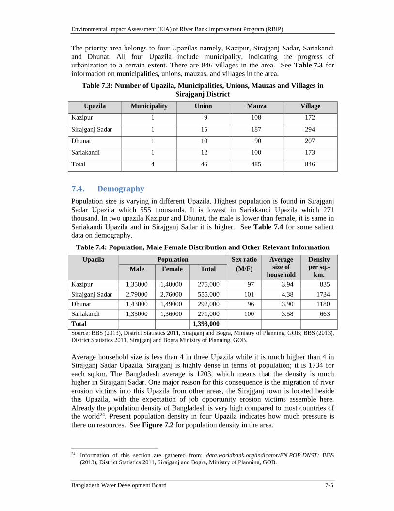
Environmental Impact Assessment (EIA) of River Bank Improvement Program (RBIP)
Bangladesh Water Development Board 7-5
The priority area belongs to four Upazilas namely, Kazipur, Sirajganj Sadar, Sariakandi and Dhunat. All four Upazila include municipality, indicating the progress of urbanization to a certain extent. There are 846 villages in the area. See Table 7.3 for information on municipalities, unions, mauzas, and villages in the area.
Table 7.3: Number of Upazila, Municipalities, Unions, Mauzas and Villages in Sirajganj District
Upazila Municipality Union Mauza Village
Kazipur 1 9 108 172
Sirajganj Sadar 1 15 187 294
Dhunat 1 10 90 207
Sariakandi 1 12 100 173
Total 4 46 485 846
7.4. Demography
Population size is varying in different Upazila. Highest population is found in Sirajganj Sadar Upazila which 555 thousands. It is lowest in Sariakandi Upazila which 271 thousand. In two upazila Kazipur and Dhunat, the male is lower than female, it is same in Sariakandi Upazila and in Sirajganj Sadar it is higher. See Table 7.4 for some salient data on demography.
Table 7.4: Population, Male Female Distribution and Other Relevant Information
Upazila Population Sex ratio
(M/F)
Average size of
household
Density per sq.-
km. Male Female Total
Kazipur 1,35000 1,40000 275,000 97 3.94 835
Sirajganj Sadar 2,79000 2,76000 555,000 101 4.38 1734
Dhunat 1,43000 1,49000 292,000 96 3.90 1180
Sariakandi 1,35000 1,36000 271,000 100 3.58 663
Total 1,393,000 Source: BBS (2013), District Statistics 2011, Sirajganj and Bogra, Ministry of Planning, GOB; BBS (2013), District Statistics 2011, Sirajganj and Bogra Ministry of Planning, GOB. Average household size is less than 4 in three Upazila while it is much higher than 4 in Sirajganj Sadar Upazila. Sirajganj is highly dense in terms of population; it is 1734 for each sq.km. The Bangladesh average is 1203, which means that the density is much higher in Sirajganj Sadar. One major reason for this consequence is the migration of river erosion victims into this Upazila from other areas, the Sirajganj town is located beside this Upazila, with the expectation of job opportunity erosion victims assemble here. Already the population density of Bangladesh is very high compared to most countries of the world24. Present population density in four Upazila indicates how much pressure is there on resources. See Figure 7.2 for population density in the area.
24 Information of this section are gathered from: data.worldbank.org/indicator/EN.POP.DNST; BBS
(2013), District Statistics 2011, Sirajganj and Bogra, Ministry of Planning, GOB.
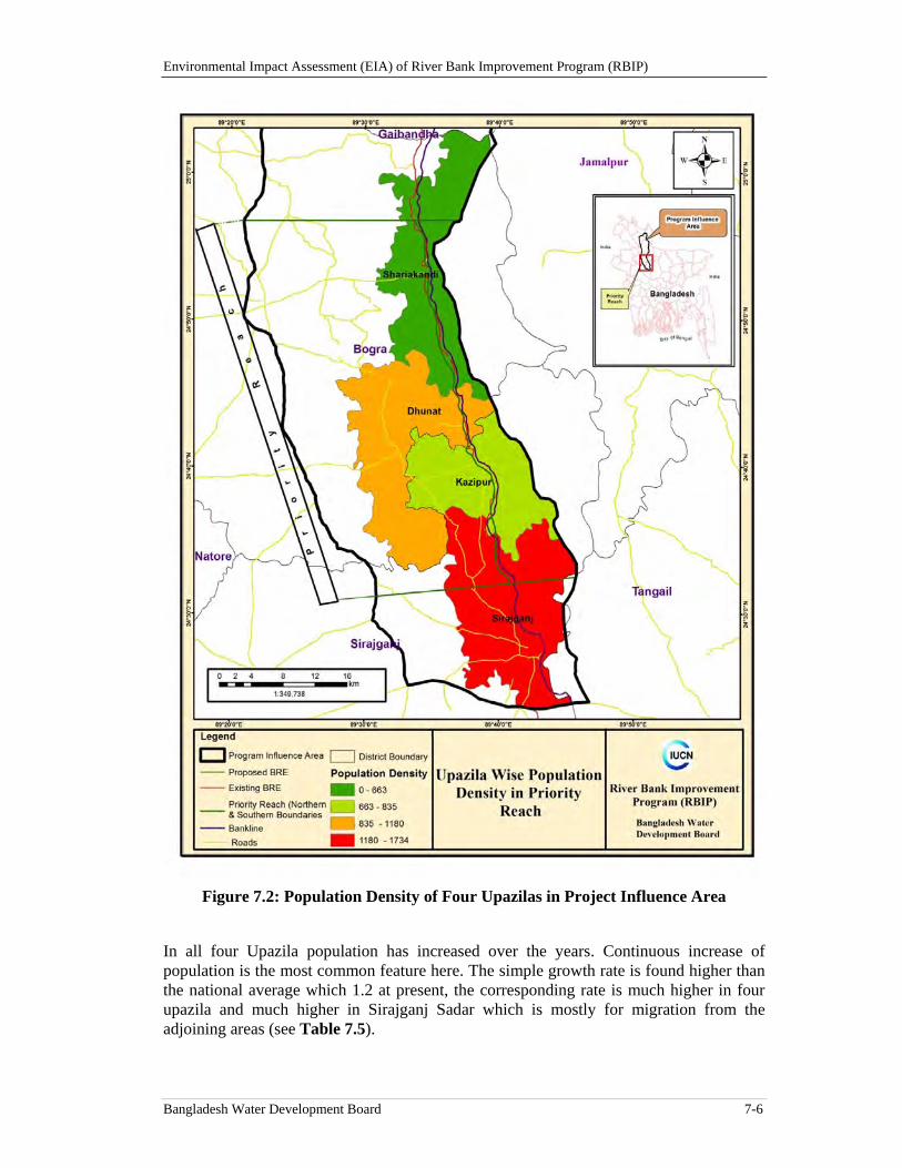
Environmental Impact Assessment (EIA) of River Bank Improvement Program (RBIP)
Bangladesh Water Development Board 7-6
Figure 7.2: Population Density of Four Upazilas in Project Influence Area
In all four Upazila population has increased over the years. Continuous increase of population is the most common feature here. The simple growth rate is found higher than the national average which 1.2 at present, the corresponding rate is much higher in four upazila and much higher in Sirajganj Sadar which is mostly for migration from the adjoining areas (see Table 7.5).
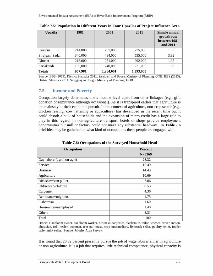
Environmental Impact Assessment (EIA) of River Bank Improvement Program (RBIP)
Bangladesh Water Development Board 7-7
Table 7.5: Population in Different Years in Four Upazilas of Project Influence Area
Upazila 1981 2001 2011 Simple annual growth rate
between 1981 and 2011
Kazipur 214,000 267,000 275,000 1.53
Sirajganj Sadar 340,000 484,000 555,000 3.32
Dhunat 213,000 271,000 292,000 1.95
Sariakandi 199,000 240,000 271,000 1.89
Totals 967,981 1,264,001 1,393,000 Source: BBS (2013), District Statistics 2011, Sirajganj and Bogra, Ministry of Planning, GOB; BBS (2013), District Statistics 2011, Sirajganj and Bogra Ministry of Planning, GOB.
7.5. IncomeandPoverty
Occupation largely determines one’s income level apart from other linkages (e.g., gift, donation or remittance although occasional). As it is transpired earlier that agriculture is the mainstay of their economic pursuit. In the context of agriculture, non-crop sector (e.g., chicken rearing, cow fattening or aquaculture) has developed in the recent time but it could absorb a bulk of households and the expansion of micro-credit has a large role to play in this regard. In non-agriculture transport, hotels or shops provide employment opportunities but mill or factory could not make any substantial headway. In Table 7.6 brief idea may be gathered on what kind of occupations these people are engaged with.
Table 7.6: Occupations of the Surveyed Household Head
Occupation Percent
N=3369
Day laborer(agri/non-agri) 28.32
Service 15.49
Business 14.49
Agriculture 10.69
Rickshaw/van puller 7.06
Old/retired/children 6.53
Carpenter 4.36
Remittance/migrants 1.75
Fisherman 1.60
Housewife/unemployed 1.40
Others 8.31
Total 100 Others: Handloom owner, handloom worker, business, carpenter, blacksmith, tailor, teacher, driver, mason, physician, folk healer, boatman, rent out house, crop intermediary, livestock seller, poultry seller, fodder seller, milk seller. Source: Priority Area Survey.
It is found that 28.32 percent presently pursue the job of wage laborer either in agriculture or non-agriculture. It is a job that requires little technical competence, physical capacity is
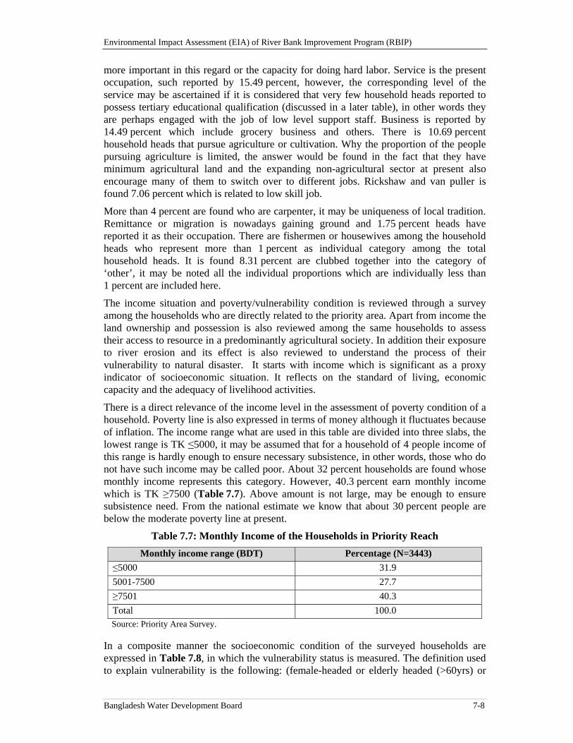
Environmental Impact Assessment (EIA) of River Bank Improvement Program (RBIP)
Bangladesh Water Development Board 7-8
more important in this regard or the capacity for doing hard labor. Service is the present occupation, such reported by 15.49 percent, however, the corresponding level of the service may be ascertained if it is considered that very few household heads reported to possess tertiary educational qualification (discussed in a later table), in other words they are perhaps engaged with the job of low level support staff. Business is reported by 14.49 percent which include grocery business and others. There is 10.69 percent household heads that pursue agriculture or cultivation. Why the proportion of the people pursuing agriculture is limited, the answer would be found in the fact that they have minimum agricultural land and the expanding non-agricultural sector at present also encourage many of them to switch over to different jobs. Rickshaw and van puller is found 7.06 percent which is related to low skill job.
More than 4 percent are found who are carpenter, it may be uniqueness of local tradition. Remittance or migration is nowadays gaining ground and 1.75 percent heads have reported it as their occupation. There are fishermen or housewives among the household heads who represent more than 1 percent as individual category among the total household heads. It is found 8.31 percent are clubbed together into the category of ‘other’, it may be noted all the individual proportions which are individually less than 1 percent are included here.
The income situation and poverty/vulnerability condition is reviewed through a survey among the households who are directly related to the priority area. Apart from income the land ownership and possession is also reviewed among the same households to assess their access to resource in a predominantly agricultural society. In addition their exposure to river erosion and its effect is also reviewed to understand the process of their vulnerability to natural disaster. It starts with income which is significant as a proxy indicator of socioeconomic situation. It reflects on the standard of living, economic capacity and the adequacy of livelihood activities.
There is a direct relevance of the income level in the assessment of poverty condition of a household. Poverty line is also expressed in terms of money although it fluctuates because of inflation. The income range what are used in this table are divided into three slabs, the lowest range is TK ≤5000, it may be assumed that for a household of 4 people income of this range is hardly enough to ensure necessary subsistence, in other words, those who do not have such income may be called poor. About 32 percent households are found whose monthly income represents this category. However, 40.3 percent earn monthly income which is TK ≥7500 (Table 7.7). Above amount is not large, may be enough to ensure subsistence need. From the national estimate we know that about 30 percent people are below the moderate poverty line at present.
Table 7.7: Monthly Income of the Households in Priority Reach
Monthly income range (BDT) Percentage (N=3443)
≤5000 31.9
5001-7500 27.7
≥7501 40.3
Total 100.0 Source: Priority Area Survey.
In a composite manner the socioeconomic condition of the surveyed households are expressed in Table 7.8, in which the vulnerability status is measured. The definition used to explain vulnerability is the following: (female-headed or elderly headed (>60yrs) or
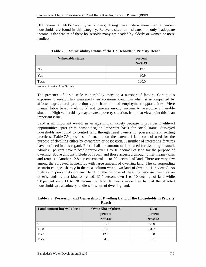
Environmental Impact Assessment (EIA) of River Bank Improvement Program (RBIP)
Bangladesh Water Development Board 7-9
HH income < Tk6367/monthly or landless). Using these criteria more than 80 percent households are found in this category. Relevant situation indicates not only inadequate income is the feature of these households many are headed by elderly or women or mere landless.
Table 7.8: Vulnerability Status of the Households in Priority Reach
Vulnerable status percent
N=3443
No 19.1
Yes 80.9
Total 100.0 Source: Priority Area Survey.
The presence of large scale vulnerability owes to a number of factors. Continuous exposure to erosion has weakened their economic condition which is accompanied by affected agricultural production apart from limited employment opportunities. Mere manual labor based work could not generate enough income to overcome vulnerable situation. High vulnerability may create a poverty situation, from that view point this is an important issue.
Land is an important wealth in an agricultural society because it provides livelihood opportunities apart from constituting an important basis for social status. Surveyed households are found to control land through legal ownership, possession and renting practices. Table 7.9 provides information on the extent of land control used for the purpose of dwelling either by ownership or possession. A number of interesting features have surfaced in this regard. First of all the amount of land used for dwelling is small. About 81 percent have placed control over 1 to 10 decimal of land for the purpose of dwelling, above amount include both own and those accessed through other means (khas and rented). Another 12.8 percent control 11 to 20 decimal of land. There are very few among the surveyed households with large amount of dwelling land. The corresponding scenario changes sharply in the next column when own land of dwelling is reviewed. As high as 55 percent do not own land for the purpose of dwelling because they live on other’s land - either khas or rented. 31.7 percent own 1 to 10 decimal of land while 9.8 percent own 11 to 20 decimal of land. It means more than half of the affected households are absolutely landless in terms of dwelling land.
Table 7.9: Possession and Ownership of Dwelling Land of the Households in Priority Reach
Land amount interval (dec.) Own+Khas+Others
percent
N=3440
Own
percent
N=3442
0 1.3 55.0
1-10 81.1 31.7
11-20 12.8 9.8
21-50 4.0 3.1
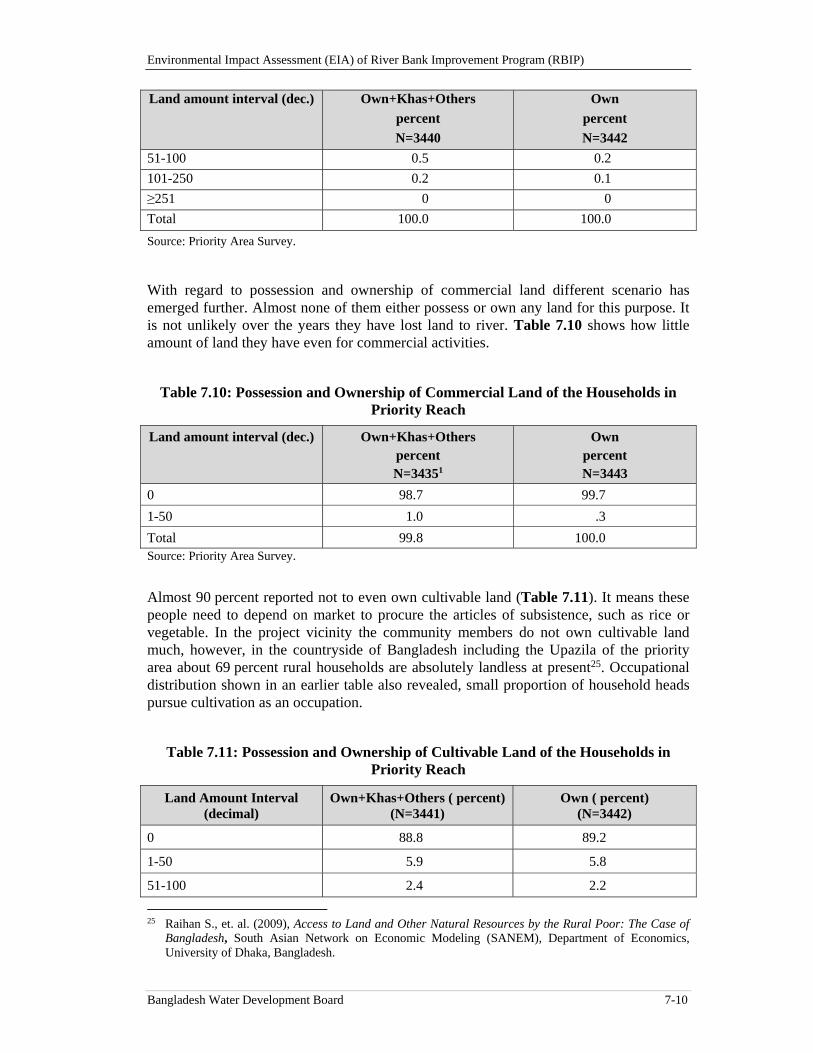
Environmental Impact Assessment (EIA) of River Bank Improvement Program (RBIP)
Bangladesh Water Development Board 7-10
Land amount interval (dec.) Own+Khas+Others
percent
N=3440
Own
percent
N=3442
51-100 0.5 0.2
101-250 0.2 0.1
≥251 0 0
Total 100.0 100.0
Source: Priority Area Survey.
With regard to possession and ownership of commercial land different scenario has emerged further. Almost none of them either possess or own any land for this purpose. It is not unlikely over the years they have lost land to river. Table 7.10 shows how little amount of land they have even for commercial activities.
Table 7.10: Possession and Ownership of Commercial Land of the Households in Priority Reach
Land amount interval (dec.) Own+Khas+Others percent N=34351
Own percent N=3443
0 98.7 99.7
1-50 1.0 .3
Total 99.8 100.0 Source: Priority Area Survey.
Almost 90 percent reported not to even own cultivable land (Table 7.11). It means these people need to depend on market to procure the articles of subsistence, such as rice or vegetable. In the project vicinity the community members do not own cultivable land much, however, in the countryside of Bangladesh including the Upazila of the priority area about 69 percent rural households are absolutely landless at present25. Occupational distribution shown in an earlier table also revealed, small proportion of household heads pursue cultivation as an occupation.
Table 7.11: Possession and Ownership of Cultivable Land of the Households in Priority Reach
Land Amount Interval (decimal)
Own+Khas+Others ( percent) (N=3441)
Own ( percent) (N=3442)
0 88.8 89.2
1-50 5.9 5.8
51-100 2.4 2.2
25 Raihan S., et. al. (2009), Access to Land and Other Natural Resources by the Rural Poor: The Case of
Bangladesh, South Asian Network on Economic Modeling (SANEM), Department of Economics, University of Dhaka, Bangladesh.
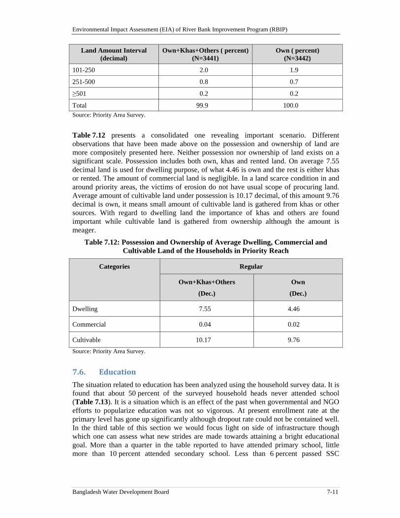
Environmental Impact Assessment (EIA) of River Bank Improvement Program (RBIP)
Bangladesh Water Development Board 7-11
Land Amount Interval (decimal)
Own+Khas+Others ( percent) (N=3441)
Own ( percent) (N=3442)
101-250 2.0 1.9
251-500 0.8 0.7
≥501 0.2 0.2
Total 99.9 100.0 Source: Priority Area Survey.
Table 7.12 presents a consolidated one revealing important scenario. Different observations that have been made above on the possession and ownership of land are more compositely presented here. Neither possession nor ownership of land exists on a significant scale. Possession includes both own, khas and rented land. On average 7.55 decimal land is used for dwelling purpose, of what 4.46 is own and the rest is either khas or rented. The amount of commercial land is negligible. In a land scarce condition in and around priority areas, the victims of erosion do not have usual scope of procuring land. Average amount of cultivable land under possession is 10.17 decimal, of this amount 9.76 decimal is own, it means small amount of cultivable land is gathered from khas or other sources. With regard to dwelling land the importance of khas and others are found important while cultivable land is gathered from ownership although the amount is meager.
Table 7.12: Possession and Ownership of Average Dwelling, Commercial and Cultivable Land of the Households in Priority Reach
Categories Regular
Own+Khas+Others
(Dec.)
Own
(Dec.)
Dwelling 7.55 4.46
Commercial 0.04 0.02
Cultivable 10.17 9.76
Source: Priority Area Survey.
7.6. Education
The situation related to education has been analyzed using the household survey data. It is found that about 50 percent of the surveyed household heads never attended school (Table 7.13). It is a situation which is an effect of the past when governmental and NGO efforts to popularize education was not so vigorous. At present enrollment rate at the primary level has gone up significantly although dropout rate could not be contained well. In the third table of this section we would focus light on side of infrastructure though which one can assess what new strides are made towards attaining a bright educational goal. More than a quarter in the table reported to have attended primary school, little more than 10 percent attended secondary school. Less than 6 percent passed SSC
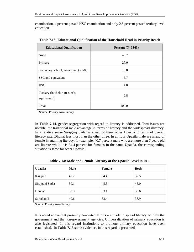
Environmental Impact Assessment (EIA) of River Bank Improvement Program (RBIP)
Bangladesh Water Development Board 7-12
examination, 4 percent passed HSC examination and only 2.8 percent passed tertiary level education.
Table 7.13: Educational Qualification of the Household Head in Priority Reach
Educational Qualification Percent (N=3363)
None 49.7
Primary 27.0
Secondary school, vocational (VI-X) 10.8
SSC and equivalent 5.7
HSC 4.0
Tertiary (bachelor, master’s,
equivalent ) 2.8
Total 100.0
Source: Priority Area Survey.
In Table 7.14, gender segregation with regard to literacy is addressed. Two issues are notable, the traditional male advantage in terms of literacy and the widespread illiteracy. In a relative sense Sirajganj Sadar is ahead of three other Upazila in terms of overall literacy rate, Dhunat lags most than the other three. In all four Upazila male are ahead of female in attaining literacy, for example, 40.7 percent male who are more than 7 years old are literate while it is 34.4 percent for females in the same Upazila, the corresponding situation is same for other Upazila.
Table 7.14: Male and Female Literacy at the Upazila Level in 2011
Upazila Male Female Both
Kazipur 40.7 34.4 37.5
Sirajganj Sadar 50.1 45.8 48.0
Dhunat 38.3 33.1 35.6
Sariakandi 40.6 33.4 36.9
Source: Priority Area Survey.
It is noted above that presently concerted efforts are made to spread literacy both by the government and the non-government agencies. Universalization of primary education is also legislated. In this regard institutions to promote primary education have been established. In Table 7.15 some evidences in this regard is presented.
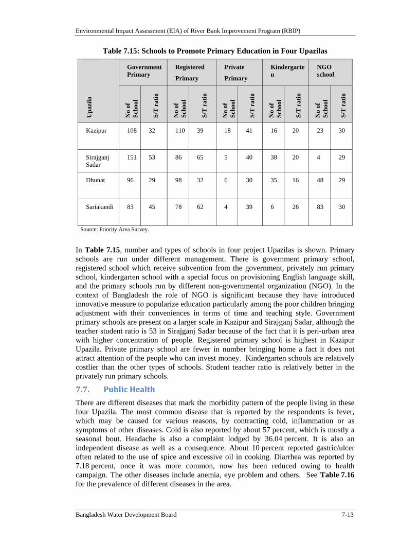
Environmental Impact Assessment (EIA) of River Bank Improvement Program (RBIP)
Bangladesh Water Development Board 7-13
Table 7.15: Schools to Promote Primary Education in Four Upazilas
Upa
zila
Government Primary
Registered
Primary
Private
Primary
Kindergarten
NGO school
No
of
Scho
ol
S/T
rat
io
No
of
Scho
ol
S/T
rat
io
No
of
Scho
ol
S/T
rat
io
No
of
Scho
ol
S/T
rat
io
No
of
Scho
ol
S/T
rat
io
Kazipur
108 32 110 39 18 41 16 20 23 30
Sirajganj Sadar
151 53 86 65 5 40 38 20 4 29
Dhunat
96 29 98 32 6 30 35 16 48 29
Sariakandi
83 45 78 62 4 39 6 26 83 30
Source: Priority Area Survey.
In Table 7.15, number and types of schools in four project Upazilas is shown. Primary schools are run under different management. There is government primary school, registered school which receive subvention from the government, privately run primary school, kindergarten school with a special focus on provisioning English language skill, and the primary schools run by different non-governmental organization (NGO). In the context of Bangladesh the role of NGO is significant because they have introduced innovative measure to popularize education particularly among the poor children bringing adjustment with their conveniences in terms of time and teaching style. Government primary schools are present on a larger scale in Kazipur and Sirajganj Sadar, although the teacher student ratio is 53 in Sirajganj Sadar because of the fact that it is peri-urban area with higher concentration of people. Registered primary school is highest in Kazipur Upazila. Private primary school are fewer in number bringing home a fact it does not attract attention of the people who can invest money. Kindergarten schools are relatively costlier than the other types of schools. Student teacher ratio is relatively better in the privately run primary schools.
7.7. PublicHealth
There are different diseases that mark the morbidity pattern of the people living in these four Upazila. The most common disease that is reported by the respondents is fever, which may be caused for various reasons, by contracting cold, inflammation or as symptoms of other diseases. Cold is also reported by about 57 percent, which is mostly a seasonal bout. Headache is also a complaint lodged by 36.04 percent. It is also an independent disease as well as a consequence. About 10 percent reported gastric/ulcer often related to the use of spice and excessive oil in cooking. Diarrhea was reported by 7.18 percent, once it was more common, now has been reduced owing to health campaign. The other diseases include anemia, eye problem and others. See Table 7.16 for the prevalence of different diseases in the area.
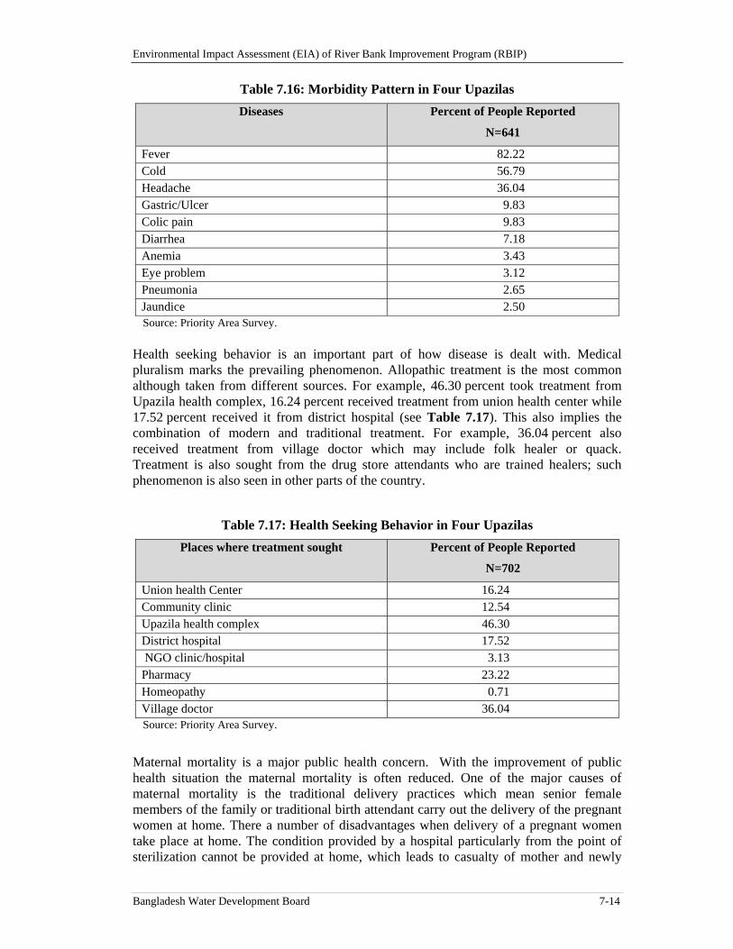
Environmental Impact Assessment (EIA) of River Bank Improvement Program (RBIP)
Bangladesh Water Development Board 7-14
Table 7.16: Morbidity Pattern in Four Upazilas
Diseases Percent of People Reported
N=641
Fever 82.22 Cold 56.79 Headache 36.04 Gastric/Ulcer 9.83 Colic pain 9.83 Diarrhea 7.18 Anemia 3.43 Eye problem 3.12 Pneumonia 2.65 Jaundice 2.50 Source: Priority Area Survey.
Health seeking behavior is an important part of how disease is dealt with. Medical pluralism marks the prevailing phenomenon. Allopathic treatment is the most common although taken from different sources. For example, 46.30 percent took treatment from Upazila health complex, 16.24 percent received treatment from union health center while 17.52 percent received it from district hospital (see Table 7.17). This also implies the combination of modern and traditional treatment. For example, 36.04 percent also received treatment from village doctor which may include folk healer or quack. Treatment is also sought from the drug store attendants who are trained healers; such phenomenon is also seen in other parts of the country.
Table 7.17: Health Seeking Behavior in Four Upazilas
Places where treatment sought Percent of People Reported
N=702
Union health Center 16.24 Community clinic 12.54 Upazila health complex 46.30 District hospital 17.52 NGO clinic/hospital 3.13 Pharmacy 23.22 Homeopathy 0.71 Village doctor 36.04 Source: Priority Area Survey.
Maternal mortality is a major public health concern. With the improvement of public health situation the maternal mortality is often reduced. One of the major causes of maternal mortality is the traditional delivery practices which mean senior female members of the family or traditional birth attendant carry out the delivery of the pregnant women at home. There a number of disadvantages when delivery of a pregnant women take place at home. The condition provided by a hospital particularly from the point of sterilization cannot be provided at home, which leads to casualty of mother and newly
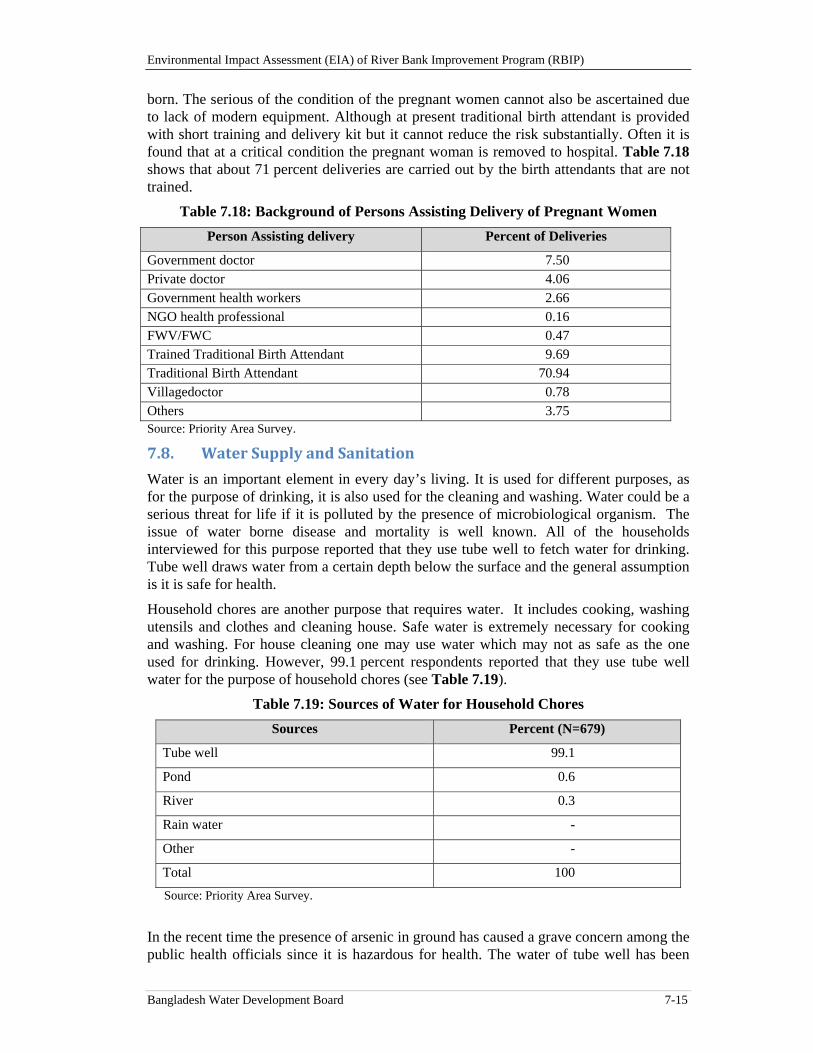
Environmental Impact Assessment (EIA) of River Bank Improvement Program (RBIP)
Bangladesh Water Development Board 7-15
born. The serious of the condition of the pregnant women cannot also be ascertained due to lack of modern equipment. Although at present traditional birth attendant is provided with short training and delivery kit but it cannot reduce the risk substantially. Often it is found that at a critical condition the pregnant woman is removed to hospital. Table 7.18 shows that about 71 percent deliveries are carried out by the birth attendants that are not trained.
Table 7.18: Background of Persons Assisting Delivery of Pregnant Women
Person Assisting delivery Percent of Deliveries
Government doctor 7.50 Private doctor 4.06 Government health workers 2.66 NGO health professional 0.16 FWV/FWC 0.47 Trained Traditional Birth Attendant 9.69 Traditional Birth Attendant 70.94 Villagedoctor 0.78 Others 3.75 Source: Priority Area Survey.
7.8. WaterSupplyandSanitation
Water is an important element in every day’s living. It is used for different purposes, as for the purpose of drinking, it is also used for the cleaning and washing. Water could be a serious threat for life if it is polluted by the presence of microbiological organism. The issue of water borne disease and mortality is well known. All of the households interviewed for this purpose reported that they use tube well to fetch water for drinking. Tube well draws water from a certain depth below the surface and the general assumption is it is safe for health.
Household chores are another purpose that requires water. It includes cooking, washing utensils and clothes and cleaning house. Safe water is extremely necessary for cooking and washing. For house cleaning one may use water which may not as safe as the one used for drinking. However, 99.1 percent respondents reported that they use tube well water for the purpose of household chores (see Table 7.19).
Table 7.19: Sources of Water for Household Chores
Sources Percent (N=679)
Tube well 99.1
Pond 0.6
River 0.3
Rain water -
Other -
Total 100
Source: Priority Area Survey.
In the recent time the presence of arsenic in ground has caused a grave concern among the public health officials since it is hazardous for health. The water of tube well has been
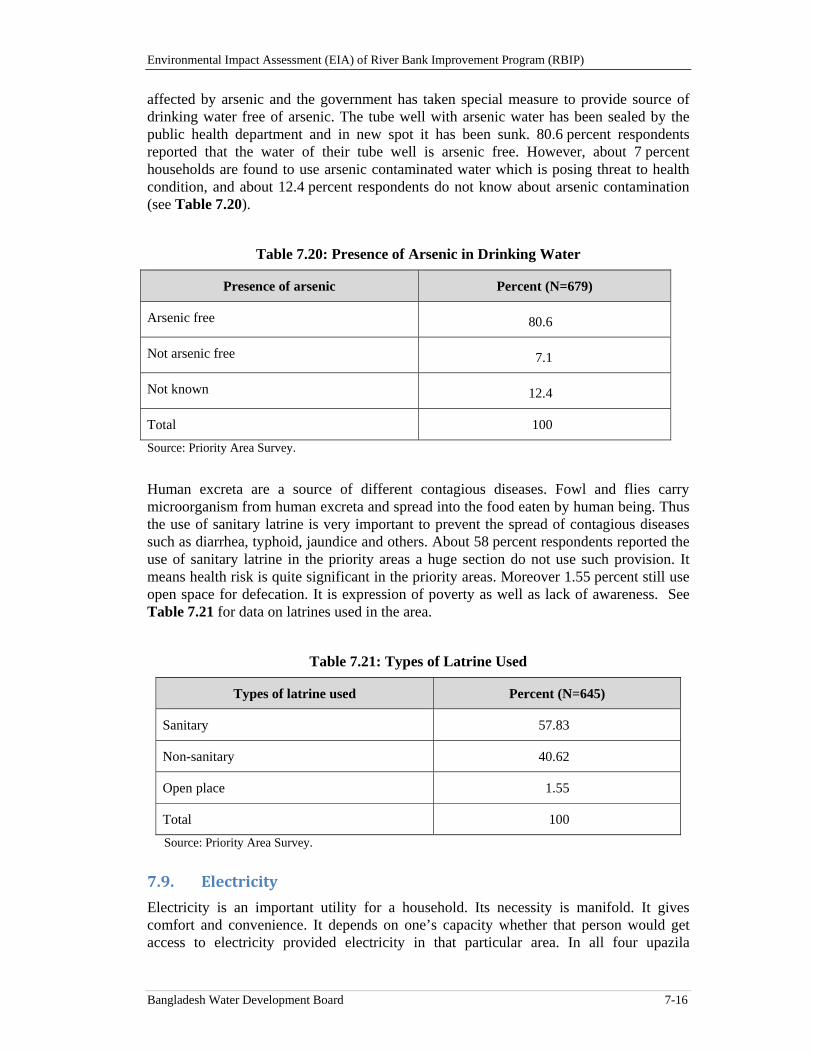
Environmental Impact Assessment (EIA) of River Bank Improvement Program (RBIP)
Bangladesh Water Development Board 7-16
affected by arsenic and the government has taken special measure to provide source of drinking water free of arsenic. The tube well with arsenic water has been sealed by the public health department and in new spot it has been sunk. 80.6 percent respondents reported that the water of their tube well is arsenic free. However, about 7 percent households are found to use arsenic contaminated water which is posing threat to health condition, and about 12.4 percent respondents do not know about arsenic contamination (see Table 7.20).
Table 7.20: Presence of Arsenic in Drinking Water
Presence of arsenic Percent (N=679)
Arsenic free 80.6
Not arsenic free 7.1
Not known 12.4
Total 100
Source: Priority Area Survey.
Human excreta are a source of different contagious diseases. Fowl and flies carry microorganism from human excreta and spread into the food eaten by human being. Thus the use of sanitary latrine is very important to prevent the spread of contagious diseases such as diarrhea, typhoid, jaundice and others. About 58 percent respondents reported the use of sanitary latrine in the priority areas a huge section do not use such provision. It means health risk is quite significant in the priority areas. Moreover 1.55 percent still use open space for defecation. It is expression of poverty as well as lack of awareness. See Table 7.21 for data on latrines used in the area.
Table 7.21: Types of Latrine Used
Types of latrine used Percent (N=645)
Sanitary 57.83
Non-sanitary 40.62
Open place 1.55
Total 100
Source: Priority Area Survey.
7.9. Electricity
Electricity is an important utility for a household. Its necessity is manifold. It gives comfort and convenience. It depends on one’s capacity whether that person would get access to electricity provided electricity in that particular area. In all four upazila
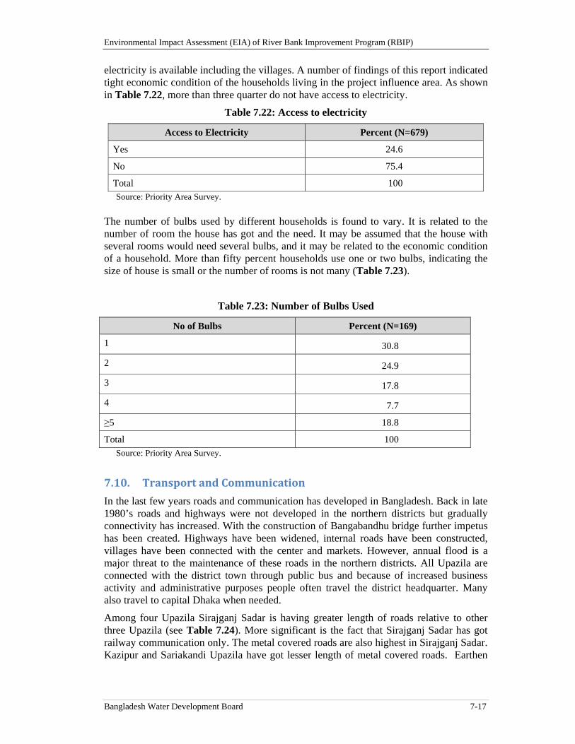
Environmental Impact Assessment (EIA) of River Bank Improvement Program (RBIP)
Bangladesh Water Development Board 7-17
electricity is available including the villages. A number of findings of this report indicated tight economic condition of the households living in the project influence area. As shown in Table 7.22, more than three quarter do not have access to electricity.
Table 7.22: Access to electricity
Access to Electricity Percent (N=679)
Yes 24.6
No 75.4
Total 100 Source: Priority Area Survey.
The number of bulbs used by different households is found to vary. It is related to the number of room the house has got and the need. It may be assumed that the house with several rooms would need several bulbs, and it may be related to the economic condition of a household. More than fifty percent households use one or two bulbs, indicating the size of house is small or the number of rooms is not many (Table 7.23).
Table 7.23: Number of Bulbs Used
No of Bulbs Percent (N=169)
1 30.8
2 24.9
3 17.8
4 7.7
≥5 18.8
Total 100 Source: Priority Area Survey.
7.10. TransportandCommunication
In the last few years roads and communication has developed in Bangladesh. Back in late 1980’s roads and highways were not developed in the northern districts but gradually connectivity has increased. With the construction of Bangabandhu bridge further impetus has been created. Highways have been widened, internal roads have been constructed, villages have been connected with the center and markets. However, annual flood is a major threat to the maintenance of these roads in the northern districts. All Upazila are connected with the district town through public bus and because of increased business activity and administrative purposes people often travel the district headquarter. Many also travel to capital Dhaka when needed.
Among four Upazila Sirajganj Sadar is having greater length of roads relative to other three Upazila (see Table 7.24). More significant is the fact that Sirajganj Sadar has got railway communication only. The metal covered roads are also highest in Sirajganj Sadar. Kazipur and Sariakandi Upazila have got lesser length of metal covered roads. Earthen
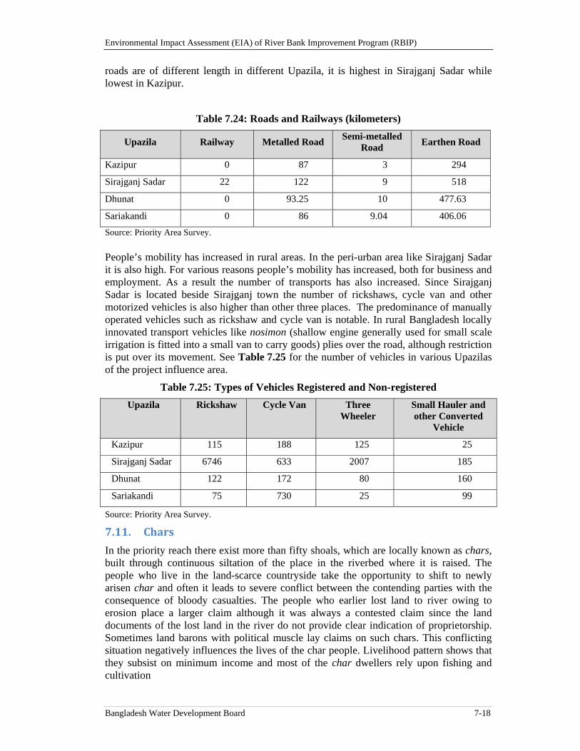
Environmental Impact Assessment (EIA) of River Bank Improvement Program (RBIP)
Bangladesh Water Development Board 7-18
roads are of different length in different Upazila, it is highest in Sirajganj Sadar while lowest in Kazipur.
Table 7.24: Roads and Railways (kilometers)
Upazila Railway Metalled Road Semi-metalled
Road Earthen Road
Kazipur 0 87 3 294
Sirajganj Sadar 22 122 9 518
Dhunat 0 93.25 10 477.63
Sariakandi 0 86 9.04 406.06
Source: Priority Area Survey. People’s mobility has increased in rural areas. In the peri-urban area like Sirajganj Sadar it is also high. For various reasons people’s mobility has increased, both for business and employment. As a result the number of transports has also increased. Since Sirajganj Sadar is located beside Sirajganj town the number of rickshaws, cycle van and other motorized vehicles is also higher than other three places. The predominance of manually operated vehicles such as rickshaw and cycle van is notable. In rural Bangladesh locally innovated transport vehicles like nosimon (shallow engine generally used for small scale irrigation is fitted into a small van to carry goods) plies over the road, although restriction is put over its movement. See Table 7.25 for the number of vehicles in various Upazilas of the project influence area.
Table 7.25: Types of Vehicles Registered and Non-registered
Upazila Rickshaw Cycle Van Three Wheeler
Small Hauler and other Converted
Vehicle
Kazipur 115 188 125 25
Sirajganj Sadar 6746 633 2007 185
Dhunat 122 172 80 160
Sariakandi 75 730 25 99
Source: Priority Area Survey.
7.11. Chars
In the priority reach there exist more than fifty shoals, which are locally known as chars, built through continuous siltation of the place in the riverbed where it is raised. The people who live in the land-scarce countryside take the opportunity to shift to newly arisen char and often it leads to severe conflict between the contending parties with the consequence of bloody casualties. The people who earlier lost land to river owing to erosion place a larger claim although it was always a contested claim since the land documents of the lost land in the river do not provide clear indication of proprietorship. Sometimes land barons with political muscle lay claims on such chars. This conflicting situation negatively influences the lives of the char people. Livelihood pattern shows that they subsist on minimum income and most of the char dwellers rely upon fishing and cultivation
Environmental Impact Assessment (EIA) of River Bank Improvement Program (RBIP)
Bangladesh Water Development Board 7-19
Commercial investment does not take place in the chars because the longevity of these chars is always uncertain. People live in different types of houses which include mostly thatched houses, tin sheds and semi-concrete ones. Literacy rate among the adults is very poor while among the children participation rate at the primary schools is increasing although limited number of primary schools has hindered the process. There is no community clinic because of very limited health investment and countryside is the last resort of receiving treatment. Drinking water is fetched from hand pumps while unsealed pit latrine is commonly used. Most people in these chars live around subsistence level poverty line though hunger is not reported. Agriculture has certain cropping pattern because of the presence of sand, facilitating the cultivation of groundnut and fodder for livestock. Paddy cultivation is noticeable in some chars particularly the ones existing for a longer period of time. The most common means of transport is bicycle though larger chars also have motorbikes. Electricity is almost absent and kerosene lamps provide light while the cooking fuel is mainly wood. Table 5.4 provides names of the key chars in the priority reach.
7.12. Gender
Traditionally patriarchy predominates over the gender relation in rural Bangladesh. As a result women’s position in family and society, role in division of labor, mobility or economic condition have been shaped in a particular manner. Compared to the male, the women enjoy lower status in family and society, engaged in household chores and their movement remains restricted to the home and around. However, in the last few decades the situation is gradually changing owing to macro-economic development (more than 2 million women in garment factories) and different development programs (micro-credit and self-employment of NGO, universal primary education, girls student stipend, gender awareness campaign among many). Women in the villages of these four Upazila are found to be engaged in different types of livelihood activities. Involvement with new activities led increased mobility of the women. More than 60 percent women interviewed in this respect reported that their mobility is not restricted to home. Homestead agriculture or livestock raising are some of the new activities. Involvement with livelihood activities has brought income and increased their control on cash, it has contributed to the consolidation of position in family and economic empowerment. In relation to mobility it is found that market related mobility has increased. However, more frequently they can visit to relative house and when necessary to the hospitals. Similarly women’s reproductive health rights are also better reflected and they can take pregnancy decision by themselves. However, there are certain social ills still affect them which include eve teasing, dowry and early marriage. It means complete emancipation of the women from the curse of patriarchal exploitation is still incomplete.
7.13. Agriculture
7.13.1. Overview
Bangladesh is situated in the north of the Bay of Bengal and is predominantly low lying. The alluvial plains of the delta are formed by the Ganges, the Brahmaputra and the Meghna rivers. The economy of the country is primarily dependent on agriculture. About 71 percent26 of the total population lived in rural areas and are directly or indirectly engaged in a wide range of agricultural activities. The contribution of agriculture to GDP
26 http://www.tradingeconomics.com/bangladesh/rural-population-percent-of-total-population-wb-
data.html
Environmental Impact Assessment (EIA) of River Bank Improvement Program (RBIP)
Bangladesh Water Development Board 7-20
growth was 33 percent in 1980-81, 25 percent in 2000-2001 and 21 percent in 2005-2006.27 The latest Household Income and Expenditure Survey (HIES), 2010 reported 17.6 percent of the country’s population currently lives in extreme poverty -- defined as those people whose total expenditure is equal to the food poverty line (the cost of a basket of goods amounting to the consumption of 2,100 Kcal per person day). More food production is needed to improve the livelihoods of people who are still lying below poverty level (25 million or more), which directly related with flood control measure in west bank of Brahmaputra/Jamuna river. No major townships except Sirajganj have been established in the project influence area due to its vulnerably to river erosion and as such the areas/populations are mostly rural, so around 70 percent population dependent upon agriculture farming. The share of agriculture in annual family income of rural households lived in west bank of Jamuna is 82 percent and small business only 8 percent28. So their livelihoods are practically agriculture based which is under threat of breaching of embankment almost in every year (flood damage of crops), river erosion, sand deposit and opening of new watershed that washed-away fertile crop lands.
The construction of river embankments to protect agricultural land from seasonal flooding/inundation is a common and continuous phenomenon of the country. Usually the silty alluvium deposit caused by flooding is brought under cultivation within 2-3 years. The floodplain areas are traditionally fertile land with alluvium deposit but generally less productive due to depth of flood water level during the monsoon. Before construction of embankment in 1960 the traditional crops grown in the area are broadcast aman rice29 (low yield potentials 1.0 – 10.5 t/ha during productive year), Aus rice also with low yield and local aman rice that was mostly vulnerable to flood damage. Some other crops like grass pea, corn, gram pulse, chili, and sugarcane were the crops in the dry season. The farmers were very poor and under threat of migration from their locality due to lack of livelihood support. After construction of embankment the scenario of crops and cropping and the livelihoods of people started to change. The flood plain areas became productive by started to produce good local aman rice reducing the areas of broadcasted deep-water aman rice. The dry land crops like vegetables and oilseeds started to occupy the areas of corn/gram pulse and sugarcane. In 80’s major crops were early aus rice, jute, deep-water aman rice, gram pulse, corn, mustard, rabi pulses, rabi groundnut and sugarcane. Transplanted aman rice is sometimes planted on silty alluvium or silty soils as the floodwater recedes, and boro paddy is grown locally in depressions, usually using traditional irrigation devices or hand pumps. There were ample surface water and groundwater resources, but they are difficult to exploit for irrigation except by small-scale traditional devices or hand pumps because of shifting river channels and changing land qualities. At present the farmers are mostly cultivating High Yielding Varieties (HYV) of Transplanted Aman and HYV Boro rice instead of local low yield potential varieties, Aus30 almost wiped out from the area. Among the popular crops now farmers have adopted boro rice, Aman rice, Maize, potato, mustard, chili, wheat, jute, and vegetables. 27 Updating Poverty Maps of Bangladesh, The World Bank, Bangladesh Bureau of Statistics, World Food
Program, 2009 28 Annual Report 2013-14, Second Crop Diversification Project, DAE, Khamarbari, Dhaka 29 Deepwater paddy cultivated in low land with more than 180 cm water depth during monsoon,
Transplanted aman rice cultivated in medium land during monsoon and aus rice either broadcast or transplant cultivated during pre-monsoon season (Mar-June)
30 Three types of rice is grown in the country: Aus rice either transplanted or broadcast cultivated in pre-monsoon period (Mar to June); Aman rice either transplanted or broadcast in monsoon period (July to Oct); and Boro rice cultivated in dry/winter season (Nov to Feb).
Environmental Impact Assessment (EIA) of River Bank Improvement Program (RBIP)
Bangladesh Water Development Board 7-21
The yield of rice has increased from 1.5 – 2.0 t/ha to 3.5 – 6.0 t/ha. Similarly the production per unit area of other popular crops potentially increased.
The area is still under threat of river breach the embankment during the monsoon that damages transplanted aman crop fully or partially. The breaching not only floods the crops, but also damages the fertility of the agriculture lands by depositing river sand. The proposed embankment would certainly restrict the occasional floods and sand cover of crop land and farmers would have good yield of transplanted man (T. Aman) rice regularly which is presently irregular and governed by flood. It is expected that the proposed construction of embankment would not only increase the area of T. Aman cultivation but also increase the yield levels of T. Aman by 10-15 percent as the farmers would invest more when they ensure about no flood damage.
7.13.2. SoilandAgricultureResourcesintheInfluencedAreaofRBIP
7.13.2.1. LandTypes
Land type is classified based on water depth of inundation during the monsoon season due to normal flooding. High land is classified as land which remains above flood level during the monsoon flood, medium high land flooded up to 90 cm, medium low land flooded up to 180 cm, low land flooded up to 300 cm and very low land flooded more than 300 cm during flood season. The majority of the cultivable land in the priority reach comprise medium high land (41 to 51 percent) followed by high land (25 to 28 percent), medium low land (16 to 25 percent), low land (3 to 6 percent) and very low land (4 percent) (see Table 5.10)31.
The area is characterized by presence of large numbers of chars with poor soils especially the new ones, however comparatively older chars are productive in respect of cultivating dry land crops (sweet potato, sesame, mustard, groundnut, rabi vegetables, melons and recently maize) and livestock raising/grazing.
7.13.2.2. SoilResources
The area included within the RBIP does not greatly vary in terms of agro-ecological characteristics. The west bank of Brahmaputra/Jamuna River starting from north (Kurigram district) to south (Sirajganj district) has wide range of environmental conditions. Soil diversity in the project influence area occurs not only at regions, but at Upazila and even at village levels. The diversity of crop production and yield level is greatly influenced by land types, seasonal flood water levels and soil textures.
The agro-ecological regions and sub-regions of the country are differentiated mainly on physiographic, soil and surface flooding characteristics and the crop suitability assessments for each unit take into account agro-climatic factors in only a generalized way. Thirty agro-ecological regions and 88 sub-regions have been identified for the country based on physiography, soils, land levels in relation to flooding and agro-climatology. The present RBIP area comprises of the following agro-ecological regions: i) Active Teesta Flood Plain (AEZ – 2); ii) Karatoya-Bangali Floodplain (AEZ – 4); and iii) Active Brahmaputra-Jamuna Flood plain (AEZ-7) (see Figure 7.3).
31 High Land: Land which is above normal flood level; Medium High Land: Land which normally is
flooded up to about 90 cm deep during the flood season; Medium Low Land: Land which normally is flooded up to between 90 cm and 180 cm deep during the flood season; Low Land: Land which normally is flooded up to between 180 cm and 300 cm deep during the flood season; Very Low Land: Land which normally is flooded deeper than 300 cm during the flood season
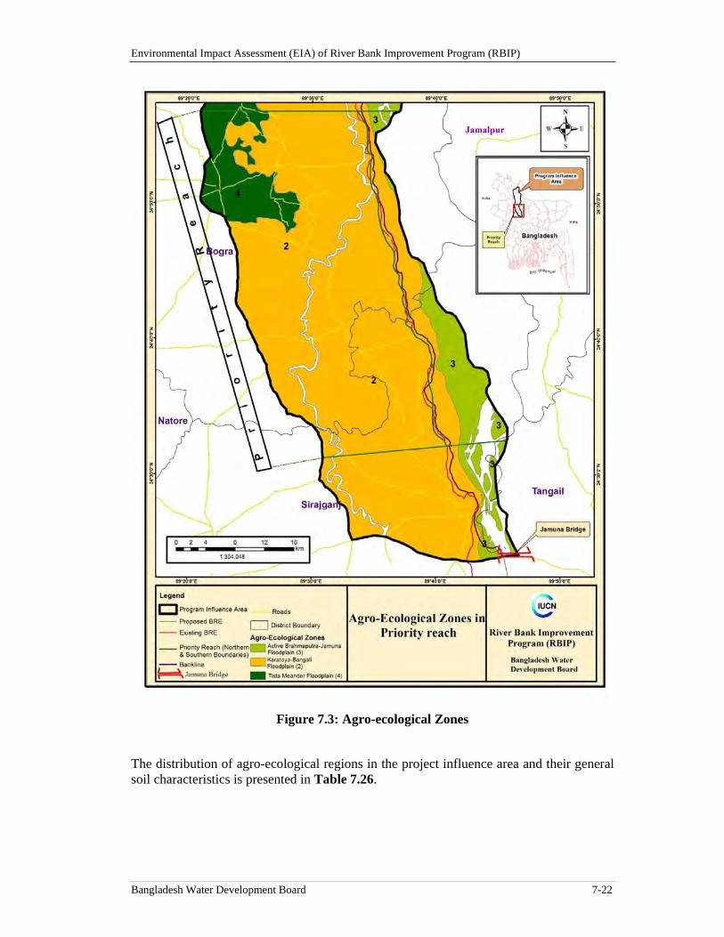
Environmental Impact Assessment (EIA) of River Bank Improvement Program (RBIP)
Bangladesh Water Development Board 7-22
Figure 7.3: Agro-ecological Zones
The distribution of agro-ecological regions in the project influence area and their general soil characteristics is presented in Table 7.26.
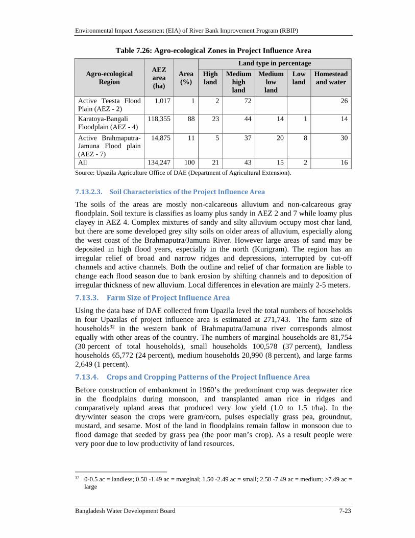
Environmental Impact Assessment (EIA) of River Bank Improvement Program (RBIP)
Bangladesh Water Development Board 7-23
Table 7.26: Agro-ecological Zones in Project Influence Area
Source: Upazila Agriculture Office of DAE (Department of Agricultural Extension).
7.13.2.3. SoilCharacteristicsoftheProjectInfluenceArea
The soils of the areas are mostly non-calcareous alluvium and non-calcareous gray floodplain. Soil texture is classifies as loamy plus sandy in AEZ 2 and 7 while loamy plus clayey in AEZ 4. Complex mixtures of sandy and silty alluvium occupy most char land, but there are some developed grey silty soils on older areas of alluvium, especially along the west coast of the Brahmaputra/Jamuna River. However large areas of sand may be deposited in high flood years, especially in the north (Kurigram). The region has an irregular relief of broad and narrow ridges and depressions, interrupted by cut-off channels and active channels. Both the outline and relief of char formation are liable to change each flood season due to bank erosion by shifting channels and to deposition of irregular thickness of new alluvium. Local differences in elevation are mainly 2-5 meters.
7.13.3. FarmSizeofProjectInfluenceArea
Using the data base of DAE collected from Upazila level the total numbers of households in four Upazilas of project influence area is estimated at 271,743. The farm size of households32 in the western bank of Brahmaputra/Jamuna river corresponds almost equally with other areas of the country. The numbers of marginal households are 81,754 (30 percent of total households), small households 100,578 (37 percent), landless households 65,772 (24 percent), medium households 20,990 (8 percent), and large farms 2,649 (1 percent).
7.13.4. CropsandCroppingPatternsoftheProjectInfluenceArea
Before construction of embankment in 1960’s the predominant crop was deepwater rice in the floodplains during monsoon, and transplanted aman rice in ridges and comparatively upland areas that produced very low yield (1.0 to 1.5 t/ha). In the dry/winter season the crops were gram/corn, pulses especially grass pea, groundnut, mustard, and sesame. Most of the land in floodplains remain fallow in monsoon due to flood damage that seeded by grass pea (the poor man’s crop). As a result people were very poor due to low productivity of land resources.
32 0-0.5 ac = landless; 0.50 -1.49 ac = marginal; 1.50 -2.49 ac = small; 2.50 -7.49 ac = medium; >7.49 ac =
large
Agro-ecological Region
AEZ area (ha)
Area (%)
Land type in percentage
High land
Medium high land
Medium low land
Low land
Homestead and water
Active Teesta Flood Plain (AEZ - 2)
1,017 1 2 72 26
Karatoya-Bangali Floodplain (AEZ - 4)
118,355 88 23 44 14 1 14
Active Brahmaputra-Jamuna Flood plain (AEZ - 7)
14,875 11 5 37 20 8 30
All 134,247 100 21 43 15 2 16
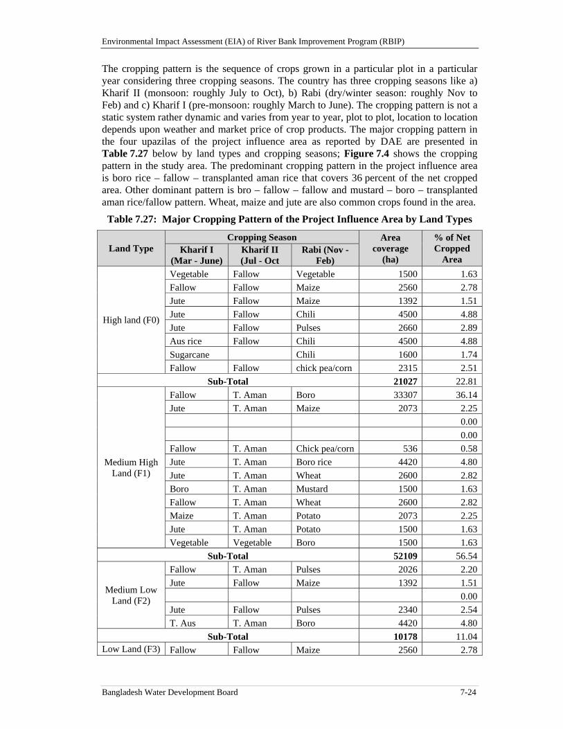
Environmental Impact Assessment (EIA) of River Bank Improvement Program (RBIP)
Bangladesh Water Development Board 7-24
The cropping pattern is the sequence of crops grown in a particular plot in a particular year considering three cropping seasons. The country has three cropping seasons like a) Kharif II (monsoon: roughly July to Oct), b) Rabi (dry/winter season: roughly Nov to Feb) and c) Kharif I (pre-monsoon: roughly March to June). The cropping pattern is not a static system rather dynamic and varies from year to year, plot to plot, location to location depends upon weather and market price of crop products. The major cropping pattern in the four upazilas of the project influence area as reported by DAE are presented in Table 7.27 below by land types and cropping seasons; Figure 7.4 shows the cropping pattern in the study area. The predominant cropping pattern in the project influence area is boro rice – fallow – transplanted aman rice that covers 36 percent of the net cropped area. Other dominant pattern is bro – fallow – fallow and mustard – boro – transplanted aman rice/fallow pattern. Wheat, maize and jute are also common crops found in the area.
Table 7.27: Major Cropping Pattern of the Project Influence Area by Land Types
Land Type Cropping Season Area
coverage (ha)
% of Net Cropped
Area Kharif I
(Mar - June) Kharif II (Jul - Oct
Rabi (Nov - Feb)
High land (F0)
Vegetable Fallow Vegetable 1500 1.63
Fallow Fallow Maize 2560 2.78
Jute Fallow Maize 1392 1.51
Jute Fallow Chili 4500 4.88
Jute Fallow Pulses 2660 2.89
Aus rice Fallow Chili 4500 4.88
Sugarcane Chili 1600 1.74
Fallow Fallow chick pea/corn 2315 2.51
Sub-Total 21027 22.81
Medium High Land (F1)
Fallow T. Aman Boro 33307 36.14
Jute T. Aman Maize 2073 2.25
0.00
0.00
Fallow T. Aman Chick pea/corn 536 0.58
Jute T. Aman Boro rice 4420 4.80
Jute T. Aman Wheat 2600 2.82
Boro T. Aman Mustard 1500 1.63
Fallow T. Aman Wheat 2600 2.82
Maize T. Aman Potato 2073 2.25
Jute T. Aman Potato 1500 1.63
Vegetable Vegetable Boro 1500 1.63
Sub-Total 52109 56.54
Medium Low Land (F2)
Fallow T. Aman Pulses 2026 2.20
Jute Fallow Maize 1392 1.51
0.00
Jute Fallow Pulses 2340 2.54
T. Aus T. Aman Boro 4420 4.80
Sub-Total 10178 11.04Low Land (F3) Fallow Fallow Maize 2560 2.78
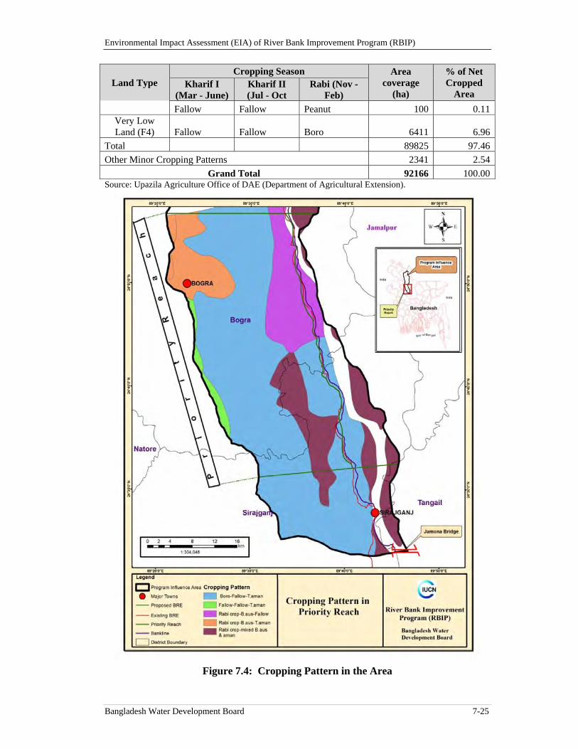
Environmental Impact Assessment (EIA) of River Bank Improvement Program (RBIP)
Bangladesh Water Development Board 7-25
Land Type Cropping Season Area
coverage (ha)
% of Net Cropped
Area Kharif I
(Mar - June) Kharif II (Jul - Oct
Rabi (Nov - Feb)
Fallow Fallow Peanut 100 0.11Very Low Land (F4) Fallow Fallow Boro 6411 6.96
Total 89825 97.46
Other Minor Cropping Patterns 2341 2.54
Grand Total 92166 100.00Source: Upazila Agriculture Office of DAE (Department of Agricultural Extension).
Figure 7.4: Cropping Pattern in the Area
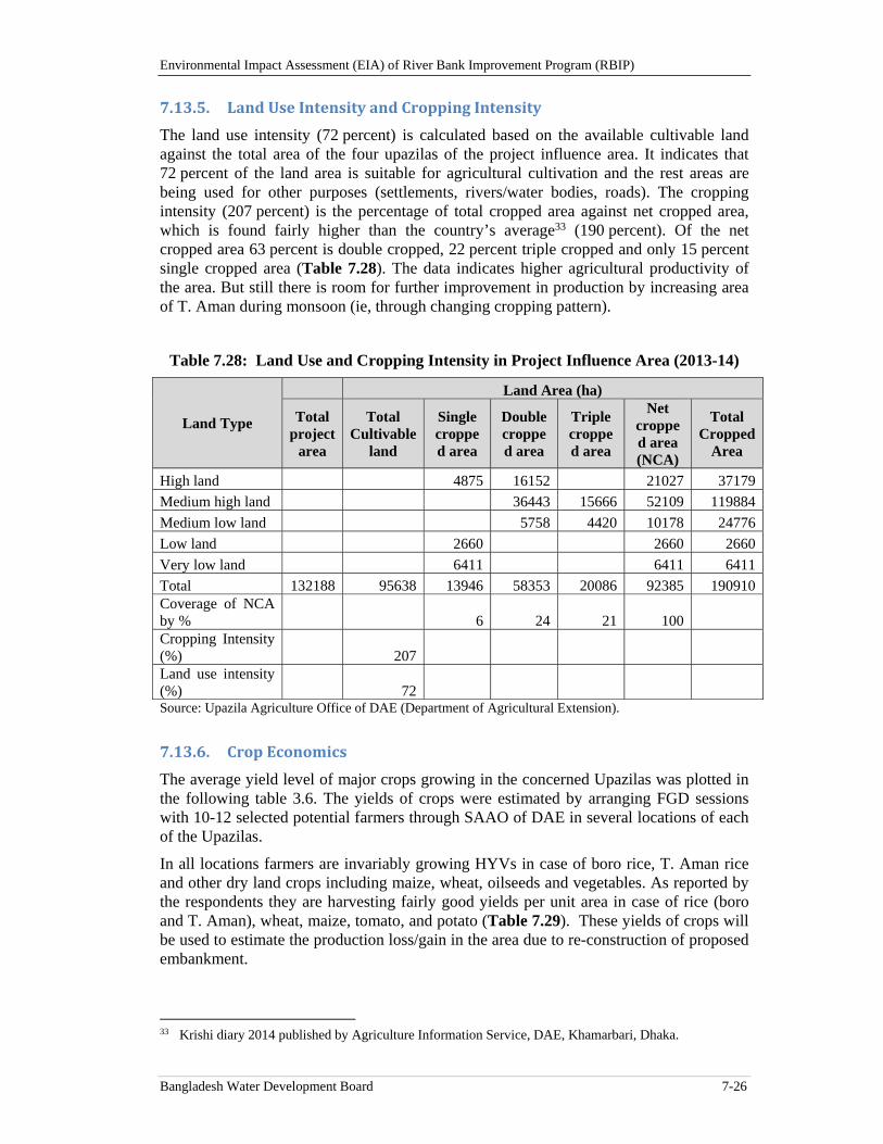
Environmental Impact Assessment (EIA) of River Bank Improvement Program (RBIP)
Bangladesh Water Development Board 7-26
7.13.5. LandUseIntensityandCroppingIntensity
The land use intensity (72 percent) is calculated based on the available cultivable land against the total area of the four upazilas of the project influence area. It indicates that 72 percent of the land area is suitable for agricultural cultivation and the rest areas are being used for other purposes (settlements, rivers/water bodies, roads). The cropping intensity (207 percent) is the percentage of total cropped area against net cropped area, which is found fairly higher than the country’s average33 (190 percent). Of the net cropped area 63 percent is double cropped, 22 percent triple cropped and only 15 percent single cropped area (Table 7.28). The data indicates higher agricultural productivity of the area. But still there is room for further improvement in production by increasing area of T. Aman during monsoon (ie, through changing cropping pattern).
Table 7.28: Land Use and Cropping Intensity in Project Influence Area (2013-14)
Land Type
Land Area (ha)
Total project
area
Total Cultivable
land
Single cropped area
Double cropped area
Triple cropped area
Net cropped area (NCA)
Total Cropped
Area
High land 4875 16152 21027 37179
Medium high land 36443 15666 52109 119884
Medium low land 5758 4420 10178 24776
Low land 2660 2660 2660
Very low land 6411 6411 6411
Total 132188 95638 13946 58353 20086 92385 190910Coverage of NCA by % 6 24 21 100 Cropping Intensity (%) 207 Land use intensity (%) 72 Source: Upazila Agriculture Office of DAE (Department of Agricultural Extension).
7.13.6. CropEconomics
The average yield level of major crops growing in the concerned Upazilas was plotted in the following table 3.6. The yields of crops were estimated by arranging FGD sessions with 10-12 selected potential farmers through SAAO of DAE in several locations of each of the Upazilas.
In all locations farmers are invariably growing HYVs in case of boro rice, T. Aman rice and other dry land crops including maize, wheat, oilseeds and vegetables. As reported by the respondents they are harvesting fairly good yields per unit area in case of rice (boro and T. Aman), wheat, maize, tomato, and potato (Table 7.29). These yields of crops will be used to estimate the production loss/gain in the area due to re-construction of proposed embankment.
33 Krishi diary 2014 published by Agriculture Information Service, DAE, Khamarbari, Dhaka.
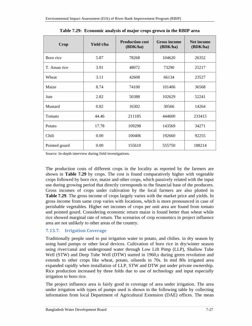
Environmental Impact Assessment (EIA) of River Bank Improvement Program (RBIP)
Bangladesh Water Development Board 7-27
Table 7.29: Economic analysis of major crops grown in the RBIP area
Crop Yield t/ha Production cost
(BDK/ha) Gross income
(BDK/ha) Net income (BDK/ha)
Boro rice 5.87 78268 104620 26352
T. Aman rice 3.91 48072 73290 25217
Wheat 3.11 42608 66134 23527
Maize 8.74 74100 101406 36568
Jute 2.82 50388 102629 52241
Mustard 0.82 16302 30566 14264
Tomato 44.46 211185 444600 233415
Potato 17.78 109298 143569 34271
Chili 0.00 100406 192660 92255
Pointed gourd 0.00 155610 555750 188214
Source: In-depth interview during field investigations.
The production costs of different crops in the locality as reported by the farmers are shown in Table 7.29 by crops. The cost is found comparatively higher with vegetable crops followed by boro rice, maize and other crops, which passively related with the input use during growing period that directly corresponds to the financial base of the producers. Gross incomes of crops under cultivation by the local farmers are also plotted in Table 7.29. The gross income of crops largely varies with the market price and yields. In gross income from same crop varies with locations, which is more pronounced in case of perishable vegetables. Higher net incomes of crops per unit area are found from tomato and pointed gourd. Considering economic return maize is found better than wheat while rice showed marginal rate of return. The scenarios of crop economics in project influence area are not unlikely to other areas of the country.
7.13.7. IrrigationCoverage
Traditionally people used to put irrigation water to potato, and chilies. in dry season by using hand pumps or other local devices. Cultivation of boro rice in dry/winter season using river/canal and underground water through Low Lift Pimp (LLP), Shallow Tube Well (STW) and Deep Tube Well (DTW) started in 1960,s during green revolution and extends to other crops like wheat, potato, oilseeds in 70s. In mid 80s irrigated area expanded rapidly when installation of LLP, STW and DTW put under private ownership. Rice production increased by three folds due to use of technology and input especially irrigation to boro rice.
The project influence area is fairly good in coverage of area under irrigation. The area under irrigation with types of pumps used is shown in the following table by collecting information from local Department of Agricultural Extension (DAE) offices. The mean
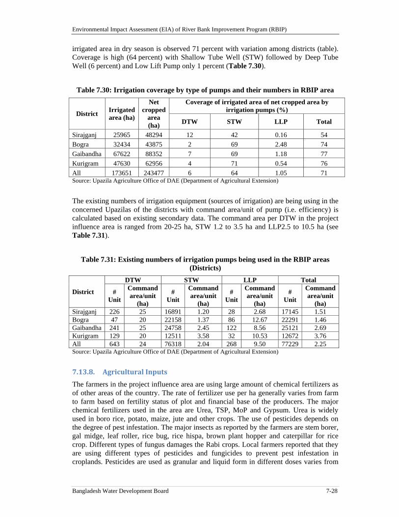
Environmental Impact Assessment (EIA) of River Bank Improvement Program (RBIP)
Bangladesh Water Development Board 7-28
irrigated area in dry season is observed 71 percent with variation among districts (table). Coverage is high (64 percent) with Shallow Tube Well (STW) followed by Deep Tube Well (6 percent) and Low Lift Pump only 1 percent (Table 7.30).
Table 7.30: Irrigation coverage by type of pumps and their numbers in RBIP area
District Irrigated area (ha)
Net cropped
area (ha)
Coverage of irrigated area of net cropped area by irrigation pumps (%)
DTW STW LLP Total
Sirajganj 25965 48294 12 42 0.16 54
Bogra 32434 43875 2 69 2.48 74
Gaibandha 67622 88352 7 69 1.18 77
Kurigram 47630 62956 4 71 0.54 76
All 173651 243477 6 64 1.05 71 Source: Upazila Agriculture Office of DAE (Department of Agricultural Extension)
The existing numbers of irrigation equipment (sources of irrigation) are being using in the concerned Upazilas of the districts with command area/unit of pump (i.e. efficiency) is calculated based on existing secondary data. The command area per DTW in the project influence area is ranged from 20-25 ha, STW 1.2 to 3.5 ha and LLP2.5 to 10.5 ha (see Table 7.31).
Table 7.31: Existing numbers of irrigation pumps being used in the RBIP areas (Districts)
District
DTW STW LLP Total
# Unit
Command area/unit
(ha)
# Unit
Command area/unit
(ha)
# Unit
Command area/unit
(ha)
# Unit
Command area/unit
(ha) Sirajganj 226 25 16891 1.20 28 2.68 17145 1.51 Bogra 47 20 22158 1.37 86 12.67 22291 1.46 Gaibandha 241 25 24758 2.45 122 8.56 25121 2.69 Kurigram 129 20 12511 3.58 32 10.53 12672 3.76 All 643 24 76318 2.04 268 9.50 77229 2.25 Source: Upazila Agriculture Office of DAE (Department of Agricultural Extension)
7.13.8. AgriculturalInputs
The farmers in the project influence area are using large amount of chemical fertilizers as of other areas of the country. The rate of fertilizer use per ha generally varies from farm to farm based on fertility status of plot and financial base of the producers. The major chemical fertilizers used in the area are Urea, TSP, MoP and Gypsum. Urea is widely used in boro rice, potato, maize, jute and other crops. The use of pesticides depends on the degree of pest infestation. The major insects as reported by the farmers are stem borer, gal midge, leaf roller, rice bug, rice hispa, brown plant hopper and caterpillar for rice crop. Different types of fungus damages the Rabi crops. Local farmers reported that they are using different types of pesticides and fungicides to prevent pest infestation in croplands. Pesticides are used as granular and liquid form in different doses varies from
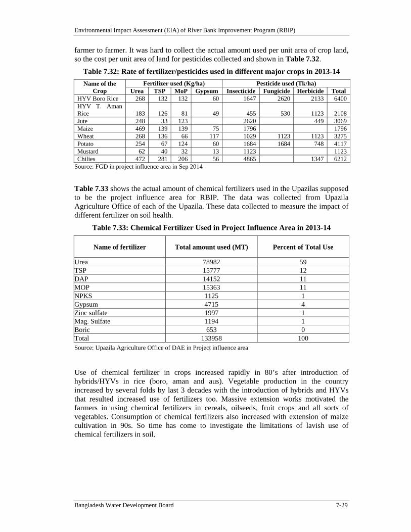
Environmental Impact Assessment (EIA) of River Bank Improvement Program (RBIP)
Bangladesh Water Development Board 7-29
farmer to farmer. It was hard to collect the actual amount used per unit area of crop land, so the cost per unit area of land for pesticides collected and shown in Table 7.32.
Table 7.32: Rate of fertilizer/pesticides used in different major crops in 2013-14
Name of the Crop
Fertilizer used (Kg/ha) Pesticide used (Tk/ha) Urea TSP MoP Gypsum Insecticide Fungicide Herbicide Total
HYV Boro Rice 268 132 132 60 1647 2620 2133 6400 HYV T. Aman Rice 183 126 81 49 455 530 1123 2108Jute 248 33 123 2620 449 3069Maize 469 139 139 75 1796 1796 Wheat 268 136 66 117 1029 1123 1123 3275 Potato 254 67 124 60 1684 1684 748 4117 Mustard 62 40 32 13 1123 1123 Chilies 472 281 206 56 4865 1347 6212
Source: FGD in project influence area in Sep 2014
Table 7.33 shows the actual amount of chemical fertilizers used in the Upazilas supposed to be the project influence area for RBIP. The data was collected from Upazila Agriculture Office of each of the Upazila. These data collected to measure the impact of different fertilizer on soil health.
Table 7.33: Chemical Fertilizer Used in Project Influence Area in 2013-14
Name of fertilizer Total amount used (MT) Percent of Total Use
Urea 78982 59 TSP 15777 12 DAP 14152 11 MOP 15363 11 NPKS 1125 1 Gypsum 4715 4 Zinc sulfate 1997 1 Mag. Sulfate 1194 1 Boric 653 0 Total 133958 100 Source: Upazila Agriculture Office of DAE in Project influence area
Use of chemical fertilizer in crops increased rapidly in 80’s after introduction of hybrids/HYVs in rice (boro, aman and aus). Vegetable production in the country increased by several folds by last 3 decades with the introduction of hybrids and HYVs that resulted increased use of fertilizers too. Massive extension works motivated the farmers in using chemical fertilizers in cereals, oilseeds, fruit crops and all sorts of vegetables. Consumption of chemical fertilizers also increased with extension of maize cultivation in 90s. So time has come to investigate the limitations of lavish use of chemical fertilizers in soil.

Environmental Impact Assessment (EIA) of River Bank Improvement Program (RBIP)
Bangladesh Water Development Board 30
Environmental Impact Assessment (EIA) of River Bank Improvement Program (RBIP)
Bangladesh Water Development Board 8-1
8. Climate Change
This chapter describes the predicted climate change scenarios for Bangladesh and also their implications for RBIP.
8.1. Overview
The Intergovernmental Panel on Climate Change (IPCC) defines climate change as ‘a change in the state of the climate that can be identified (e.g. using statistical tests) by changes in the mean and/or the variability of its properties, and that persists for an extended period, typically decades or longer’ (Glossary of words, IPCC Fifth Assessment Report 2014).
Climate change and climate variability is becoming an increasingly complex challenge worldwide but the solutions required and adaptations to be applied are mostly local. Appropriate anticipatory long-term strategies rather than short term reactionary responses are necessary to moderate the impacts of climate change. Since the hydrological cycle and hydrological systems are closely linked with climate and climatic parameters, it is important to address climate change concerns related to this project. This chapter gives an overview of observations of climate change at global and national level and briefly discusses the impacts on the project influence area and its surroundings.
8.2. GlobalContext
Recent trends in the Earth’s climate clearly indicate that global mean surface temperatures have been increasing and it is very likely this change is due to anthropogenic reasons. In order to understand the magnitude of these changes at the global level and thereby the severity of the problem the IPCC (IPCC, Fifth Assessment Report, 2013) scientific assessment on climate change and climate variability is given below.
8.2.1. WarmingofthePlanet
Eleven of the twelve years in the period (1995–2006) rank among the top 12 warmest years in the instrumental record (since 1880).
Warming in the last 100 years has caused about a 0.85°C increase in global average temperature. This is up from the 0.6°C increase in the 100 years prior to the Third Assessment Report.
Urban heat island effects were found to have negligible influence (less than 0.0006°C per decade over land and zero over oceans) on these measurements.(Forth IPCC synthesis report, 2007)
Observations since 1961 show that the ocean has been absorbing more than 80 percent of the heat added to the climate system, and that ocean temperatures have increased to depths of at least 3000 m (9800 ft).
Average Arctic temperatures increased at almost twice the global average rate in the past 100 years.
It is likely that greenhouse gases would have caused more warming than we have observed if not for the cooling effects of volcanic and human-caused aerosols.
Environmental Impact Assessment (EIA) of River Bank Improvement Program (RBIP)
Bangladesh Water Development Board 8-2
Average Northern Hemisphere temperatures during the second half of the 20th century were very likely higher than during any other 50-year period in the last 500 years and likely the highest in at least the past 1300 years (including both the Medieval Warm Period and the Little Ice age
8.2.2. Ice,Snow,Permafrost,Rain,andOceans
Mountain glaciers and snow cover have declined on average in both hemispheres.
Losses from the land-based ice sheets of Greenland and Antarctica have very likely (>90 percent) contributed to sea level rise between 1993 and 2003.
Ocean warming causes seawater to expand, which contributes to sea level rise.
Sea level rose at an average rate of about 1.7 mm/year during the years 1901-2010. The rise in sea level during 1993-2010 was at an average rate of 3.2 mm/year. It is not clear whether this is a long-term trend or just variability.
It is very likely that the annual Antarctic sea ice extent increased at a rate of between 1.2 and 1.8 percent per decade (0.13 to 0.20 million km2 per decade) between 1979 and 2012 (very high confidence).
8.2.3. Hurricanes
There has been an increase in hurricane intensity in the North Atlantic since the 1970s, and that increase correlates with increases in sea surface temperature.
The observed increase in hurricane intensity is larger than climate models prediction for the sea surface temperature changes we have experienced.
There is no clear trend in the number of hurricanes.
Other regions appear to have experienced increased hurricane intensity as well, but there are concerns about the quality of data in these other regions.
It is more likely than not (>50 percent) that there has been some human contribution to the increases in hurricane intensity.
It is likely (>66 percent) that we will see increases in hurricane intensity during the 21st century (Fourth IPCC synthesis report, 2007).
8.2.4. Model‐basedProjectionsfortheFuture
Climate Change Model global projections are made based on an analysis of various computer climate models running under different scenarios that were established in 2000 in the Special Report on Emissions Scenarios (SRES). As a result, predictions for the 21st century are shown below.
Best estimate for a "low scenario" is 1.8°C with a likely range of 1.1 to 2.9°C (3.2°F with a likely range of 2.0 to 5.2°F)
Best estimate for a "high scenario" is 4.0°C with a likely range of 2.4 to 6.4°C (7.2°F with a likely range of 4.3 to 11.5°F)
A temperature rise of about 0.1°C per decade would be expected for the next two decades, even if greenhouse gas and aerosol concentrations were kept at year 2000 levels.
A temperature rise of about 0.2°C per decade is projected for the next two decades for all SRES scenarios.
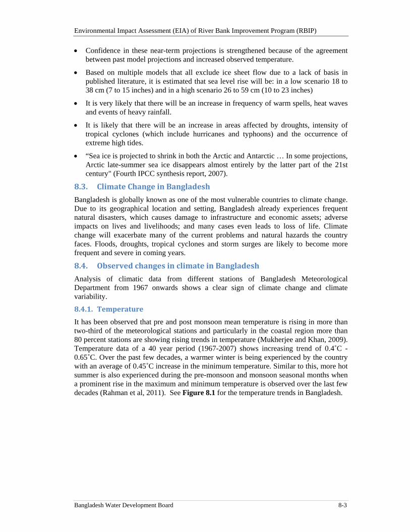
Environmental Impact Assessment (EIA) of River Bank Improvement Program (RBIP)
Bangladesh Water Development Board 8-3
Confidence in these near-term projections is strengthened because of the agreement between past model projections and increased observed temperature.
Based on multiple models that all exclude ice sheet flow due to a lack of basis in published literature, it is estimated that sea level rise will be: in a low scenario 18 to 38 cm (7 to 15 inches) and in a high scenario 26 to 59 cm (10 to 23 inches)
It is very likely that there will be an increase in frequency of warm spells, heat waves and events of heavy rainfall.
It is likely that there will be an increase in areas affected by droughts, intensity of tropical cyclones (which include hurricanes and typhoons) and the occurrence of extreme high tides.
“Sea ice is projected to shrink in both the Arctic and Antarctic … In some projections, Arctic late-summer sea ice disappears almost entirely by the latter part of the 21st century" (Fourth IPCC synthesis report, 2007).
8.3. ClimateChangeinBangladesh
Bangladesh is globally known as one of the most vulnerable countries to climate change. Due to its geographical location and setting, Bangladesh already experiences frequent natural disasters, which causes damage to infrastructure and economic assets; adverse impacts on lives and livelihoods; and many cases even leads to loss of life. Climate change will exacerbate many of the current problems and natural hazards the country faces. Floods, droughts, tropical cyclones and storm surges are likely to become more frequent and severe in coming years.
8.4. ObservedchangesinclimateinBangladesh
Analysis of climatic data from different stations of Bangladesh Meteorological Department from 1967 onwards shows a clear sign of climate change and climate variability.
8.4.1. Temperature
It has been observed that pre and post monsoon mean temperature is rising in more than two-third of the meteorological stations and particularly in the coastal region more than 80 percent stations are showing rising trends in temperature (Mukherjee and Khan, 2009). Temperature data of a 40 year period (1967-2007) shows increasing trend of 0.4˚C -0.65˚C. Over the past few decades, a warmer winter is being experienced by the country with an average of 0.45˚C increase in the minimum temperature. Similar to this, more hot summer is also experienced during the pre-monsoon and monsoon seasonal months when a prominent rise in the maximum and minimum temperature is observed over the last few decades (Rahman et al, 2011). See Figure 8.1 for the temperature trends in Bangladesh.
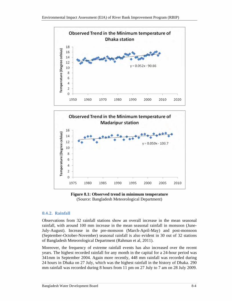
Environmental Impact Assessment (EIA) of River Bank Improvement Program (RBIP)
Bangladesh Water Development Board 8-4
Figure 8.1: Observed trend in minimum temperature (Source: Bangladesh Meteorological Department)
8.4.2. Rainfall
Observations from 32 rainfall stations show an overall increase in the mean seasonal rainfall, with around 100 mm increase in the mean seasonal rainfall in monsoon (June-July-August). Increase in the pre-monsoon (March-April-May) and post-monsoon (September-October-November) seasonal rainfall is also evident in 30 out of 32 stations of Bangladesh Meteorological Department (Rahman et al, 2011).
Moreover, the frequency of extreme rainfall events has also increased over the recent years. The highest recorded rainfall for any month in the capital for a 24-hour period was 341mm in September 2004. Again more recently, 448 mm rainfall was recorded during 24 hours in Dhaka on 27 July, which was the highest rainfall in the history of Dhaka. 290 mm rainfall was recorded during 8 hours from 11 pm on 27 July to 7 am on 28 July 2009.
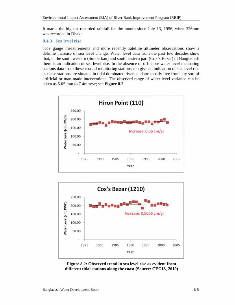
Environmental Impact Assessment (EIA) of River Bank Improvement Program (RBIP)
Bangladesh Water Development Board 8-5
It marks the highest recorded rainfall for the month since July 13, 1956, when 326mm was recorded in Dhaka.
8.4.3. Sealevelrise
Tide gauge measurements and more recently satellite altimeter observations show a definite increase of sea level change. Water level data from the past few decades show that, in the south western (Sunderban) and south eastern part (Cox’s Bazar) of Bangladesh there is an indication of sea level rise. In the absence of off-shore water level measuring stations data from these coastal monitoring stations can give an indication of sea level rise as these stations are situated in tidal dominated rivers and are mostly free from any sort of artificial or man-made interventions. The observed range of water level variance can be taken as 5.05 mm to 7.4mm/yr; see Figure 8.2.
Figure 8.2: Observed trend in sea level rise as evident from different tidal stations along the coast (Source: CEGIS, 2010)
Environmental Impact Assessment (EIA) of River Bank Improvement Program (RBIP)
Bangladesh Water Development Board 8-6
8.5. PredictedchangesinclimateinBangladesh
Climate change projections for Bangladesh available through studies carried out on regional scale by IPCC (2007), IWM (2008), CEGIS (2008) and CEGIS (2014) conclude that, climate change may result in the increased rainfall intensities, rise of future sea levels, and higher temperature and wind speeds. These changes may in turn result in to increased flood volumes, river water levels and velocities, which are all factors that may affect the design of the RBIP. Studies show that climate change induced alterations in precipitation in Bangladesh and upstream areas will alter the frequency, the magnitude and the areal extent of flooding in Bangladesh significantly due to:
Possible changes in temperature, precipitation and evapo-transpiration may result in the change in soil moisture, groundwater recharge and runoff and could severely impact the hydrograph and onset, intensity and recession of floods.
Increased rainfall intensity during pre-monsoon is especially critical for areas experiencing flash floods.
Change in the frequency and intensity in extreme rainfall event may subsequently increase flood affected area
Rise in the sea level may cause the backwater effect causing the rise in the river water level, or obstacle the upstream discharge to be drained off into the sea and increase duration of floods
The timing of peaking in the major rivers may also change, which may in turn change the likelihood of synchronization of flood peaks of major rivers
Statistical analysis of historical time series of flows in major rivers shows frequency of moderate flood has increased considerably from early eighties (IWM, 2008). A number of hydrological models (empirical and water balance modeling carried out by Mirza and Ahmed, 2005; Tanner et al., 2007; IWFM and CEGIS, 2008; IWM 2008, etc) have been used to assess the impact of climate change on the riverine flooding of Bangladesh. Most studies show, extreme peak river-discharges are likely to occur more frequently. IWM (2008) models predict that inundated area will increase by 12 to 16 percent in the Ganges and Jamuna basin for average or normal flood and peak flood level will increase by about 37cm in a moderate flood event the increase is 27cm in the Jamuna river (Figures 8.3 and 8.4). The same study predicts that the duration of flood level will also be prolonged.
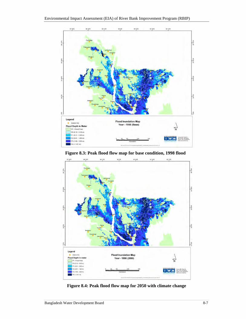
Environmental Impact Assessment (EIA) of River Bank Improvement Program (RBIP)
Bangladesh Water Development Board 8-7
Figure 8.3: Peak flood flow map for base condition, 1998 flood
Figure 8.4: Peak flood flow map for 2050 with climate change
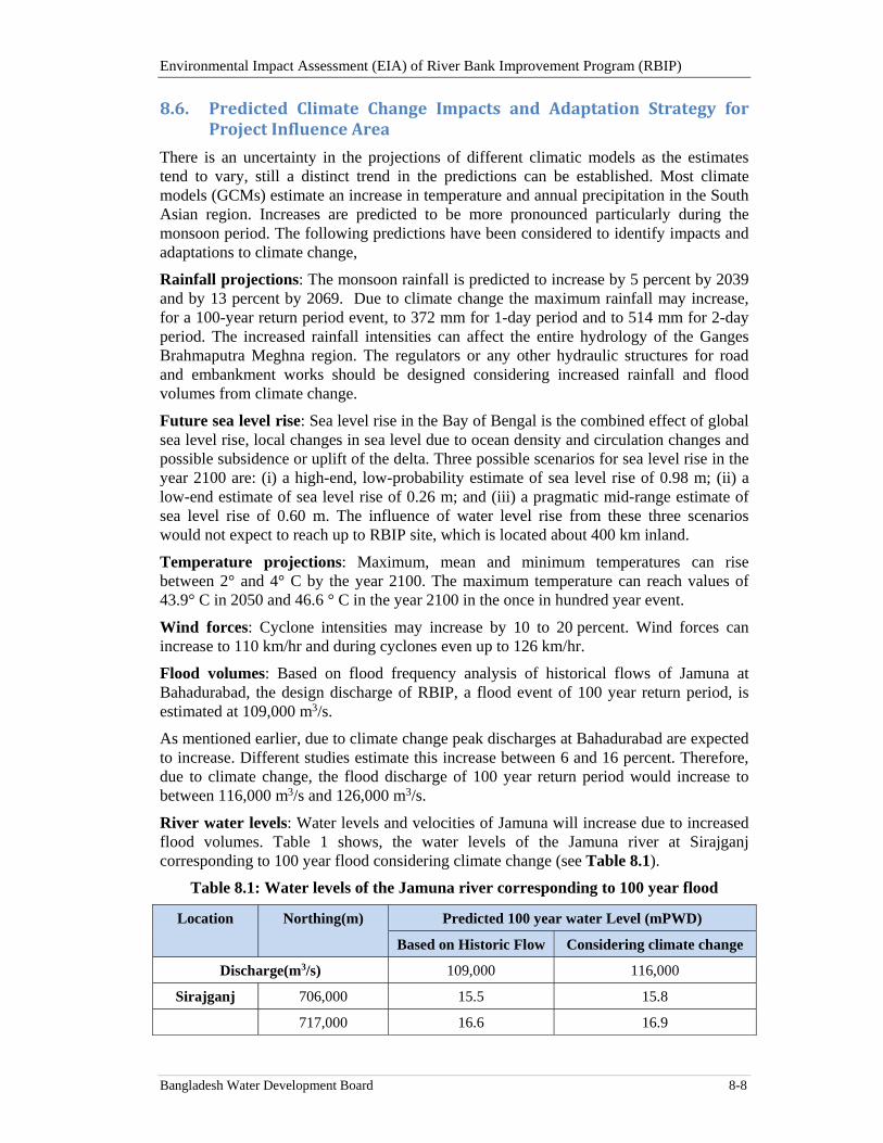
Environmental Impact Assessment (EIA) of River Bank Improvement Program (RBIP)
Bangladesh Water Development Board 8-8
8.6. Predicted Climate Change Impacts and Adaptation Strategy forProjectInfluenceArea
There is an uncertainty in the projections of different climatic models as the estimates tend to vary, still a distinct trend in the predictions can be established. Most climate models (GCMs) estimate an increase in temperature and annual precipitation in the South Asian region. Increases are predicted to be more pronounced particularly during the monsoon period. The following predictions have been considered to identify impacts and adaptations to climate change,
Rainfall projections: The monsoon rainfall is predicted to increase by 5 percent by 2039 and by 13 percent by 2069. Due to climate change the maximum rainfall may increase, for a 100-year return period event, to 372 mm for 1-day period and to 514 mm for 2-day period. The increased rainfall intensities can affect the entire hydrology of the Ganges Brahmaputra Meghna region. The regulators or any other hydraulic structures for road and embankment works should be designed considering increased rainfall and flood volumes from climate change.
Future sea level rise: Sea level rise in the Bay of Bengal is the combined effect of global sea level rise, local changes in sea level due to ocean density and circulation changes and possible subsidence or uplift of the delta. Three possible scenarios for sea level rise in the year 2100 are: (i) a high-end, low-probability estimate of sea level rise of 0.98 m; (ii) a low-end estimate of sea level rise of 0.26 m; and (iii) a pragmatic mid-range estimate of sea level rise of 0.60 m. The influence of water level rise from these three scenarios would not expect to reach up to RBIP site, which is located about 400 km inland.
Temperature projections: Maximum, mean and minimum temperatures can rise between 2° and 4° C by the year 2100. The maximum temperature can reach values of 43.9° C in 2050 and 46.6 ° C in the year 2100 in the once in hundred year event.
Wind forces: Cyclone intensities may increase by 10 to 20 percent. Wind forces can increase to 110 km/hr and during cyclones even up to 126 km/hr.
Flood volumes: Based on flood frequency analysis of historical flows of Jamuna at Bahadurabad, the design discharge of RBIP, a flood event of 100 year return period, is estimated at 109,000 m3/s.
As mentioned earlier, due to climate change peak discharges at Bahadurabad are expected to increase. Different studies estimate this increase between 6 and 16 percent. Therefore, due to climate change, the flood discharge of 100 year return period would increase to between 116,000 m3/s and 126,000 m3/s.
River water levels: Water levels and velocities of Jamuna will increase due to increased flood volumes. Table 1 shows, the water levels of the Jamuna river at Sirajganj corresponding to 100 year flood considering climate change (see Table 8.1).
Table 8.1: Water levels of the Jamuna river corresponding to 100 year flood
Location
Northing(m) Predicted 100 year water Level (mPWD)
Based on Historic Flow Considering climate change
Discharge(m3/s) 109,000 116,000
Sirajganj 706,000 15.5 15.8
717,000 16.6 16.9
Environmental Impact Assessment (EIA) of River Bank Improvement Program (RBIP)
Bangladesh Water Development Board 8-9
Due to climate change, the river water levels in the RBIP area will further increase between 0.2 to 0.3 m for a 6 percent increase flood volumes and between 0.3 to 0.4 m for a 16 percent increase in flood volumes.
Effects on riverbank erosion: Morphologists predict that the magnitude of riverbank erosion might be dependent on annual flood discharge. Increase in flood discharge by 20 percent within 100 years may increase the annual rate of riverbank erosion substantially. It has being predicted that if at present condition erosion rate of the Jamuna River is 2600 ha/yr after 50 years it will be 3100 ha/yr and after 100 years it will be 3600 ha/yr.
Effects on scour hole: Scouring of the river bed is a very important feature of a river. According to the Inglis model (1994), scour depth is the function of discharge and will increase as one-third power of discharge. Thus increase in discharge by 20 percent, would cause an increase of about 5 percent in the scour depth. It will certainly increase the cost of river training/bank protection works and also the maintenance of existing structures. With the changing of sediment regimes, scour depth may vary over time. The most critical condition would be when sediment load would be less.
8.7. ClimatechangeadaptationinRBIPdesign
Climate change considerations have ultimately led to new design height of the RBIP embankment and improved drainage system. A 100-year flood is generally adopted in Bangladesh for design of major flood embankments and river training works.
Future climate change will increase peak discharges although magnitude and time frame is uncertain; associated velocity is expected to increase.On the other hand, morphological adjustment related to climate change will take time and complex responses in the fluvial system means that changes in the rate of adjustment are likely to be highly non-linear. In this context, as monsoon flood discharges are likely to increase gradually over the coming decades, the Jamuna should be able to accommodate the change through morphological adjustments (such as bed level lowering) that are able to keep pace with changes in the discharge driver.
Assuming time frame for assessing embankments and river training works is 30 years, a six percent increase to this 100-year flood is considered for the design of RBIP to accommodate future flows from climate change.
The design water level for the embankments is proposed to increase to 0.5 m to accommodate increased water levels from climate change. Additional sensitivity analysis undertaken to confirm adequate freeboard is still available to account for more severe events over 50 to 100 years.
Thus a freeboard of 1.5 m is recommended to account for uncertainties in future hydrologic and morphological changes as well as wave run-up.
Environmental Impact Assessment (EIA) of River Bank Improvement Program (RBIP)
Bangladesh Water Development Board 9-1
9. Impact Assessment
This Chapter assesses the project for key environmental and social aspects, identifies significant potential impacts that may be caused by the project activities and proposes appropriate mitigation measures to address these impacts.
9.1. PotentialImpacts‐Overview
After its completion, the project is expected to have a multiple of very positive and beneficial effects on the people and economy of the area. First of all, the river bank protection will discontinue the recurring bank erosion and the associated loss of homesteads and cultivated land. Then, the improved embankment will also significantly reduce the flooding events and associated economic losses. Finally, the road constructed on the embankment will facilitate local mobility as well as long-distance transportation. All of these factors are likely to have very profound positive impacts on the local people and their economic condition. In addition, increased safety against river bank erosion and flooding as well as improved mobility and connectivity will bring in further development and investment in the area that is currently not possible because of the area vulnerability.
Most of the proposed interventions pertain to rehabilitation and improvement of the existing embankment and hence the potentially negative environmental impacts will primarily be limited to the construction activities.
The key potentially negative impacts and issues associated with the construction phase of the proposed project include changes in aquatic habitat because of riverbank protection works as well as from sand extraction from the river bank; changes in land form and land use because of rehabilitation of existing and construction of new embankment; land acquisition for construction of new embankment and resulting displacement of people; use of natural resources particularly river sand; health and safety risks associated with handling of hazardous materials and operation of construction machinery; air quality deterioration because of operation of construction vehicles and machinery as well as excavation activities; noise generation caused by the operation of construction machinery and vehicles; contamination of land and water caused by wastes generated from construction activities and camp operation; loss of trees that need to be removed for construction of embankment; risk of accidents associated with movement of construction vehicles and machinery; blockage of local routes caused by construction activities; and impacts on sensitive receptors such as schools along the embankment.
The potentially negative impacts associated with the O&M phase of the project include changes in river morphology caused by riverbank protection; changes in aquatic habitat caused by riverbank revetment; blockage of local routes caused by the embankment and road, effects on water bodies and associated habitats caused by disruption of hydrological and ecological connectivity between main river and internal rivers, beels and khals; noise generation and air quality deterioration caused by the vehicular traffic on the embankment road; risks of accidents associated with vehicular traffic on the embankment road; and increased usage of agro-chemicals caused by agricultural intensification due to enhanced protection against riverbank erosion and flooding.
9.2. ImpactAssessmentMethodology
The significance of potential impacts was assessed using the risk assessment methodology that considers impact magnitude and sensitivity of receptors, described below.
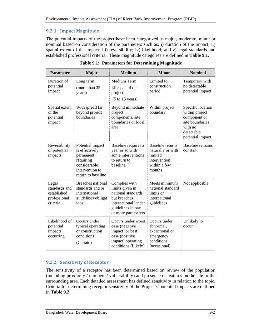
Environmental Impact Assessment (EIA) of River Bank Improvement Program (RBIP)
Bangladesh Water Development Board 9-2
9.2.1. ImpactMagnitude
The potential impacts of the project have been categorized as major, moderate, minor or nominal based on consideration of the parameters such as: i) duration of the impact; ii) spatial extent of the impact; iii) reversibility; iv) likelihood; and v) legal standards and established professional criteria. These magnitude categories are defined in Table 9.1.
Table 9.1: Parameters for Determining Magnitude
Parameter Major Medium Minor Nominal
Duration of potential impact
Long term
(more than 35 years)
Medium Term
Lifespan of the project
(5 to 15 years)
Limited to construction period
Temporary with no detectable potential impact
Spatial extent of the potential impact
Widespread far beyond project boundaries
Beyond immediate project components, site boundaries or local area
Within project boundary
Specific location within project component or site boundaries with no detectable potential impact
Reversibility of potential impacts
Potential impact is effectively permanent, requiring considerable intervention to return to baseline
Baseline requires a year or so with some interventions to return to baseline
Baseline returns naturally or with limited intervention within a few months
Baseline remains constant
Legal standards and established professional criteria
Breaches national standards and or international guidelines/obligations
Complies with limits given in national standards but breaches international lender guidelines in one or more parameters
Meets minimum national standard limits or international guidelines
Not applicable
Likelihood of potential impacts occurring
Occurs under typical operating or construction conditions
(Certain)
Occurs under worst case (negative impact) or best case (positive impact) operating conditions (Likely)
Occurs under abnormal, exceptional or emergency conditions (occasional)
Unlikely to occur
9.2.2. SensitivityofReceptor
The sensitivity of a receptor has been determined based on review of the population (including proximity / numbers / vulnerability) and presence of features on the site or the surrounding area. Each detailed assessment has defined sensitivity in relation to the topic. Criteria for determining receptor sensitivity of the Project’s potential impacts are outlined in Table 9.2.
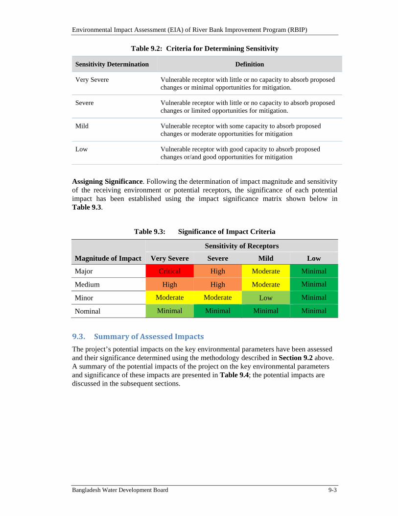
Environmental Impact Assessment (EIA) of River Bank Improvement Program (RBIP)
Bangladesh Water Development Board 9-3
Table 9.2: Criteria for Determining Sensitivity
Sensitivity Determination Definition
Very Severe Vulnerable receptor with little or no capacity to absorb proposed changes or minimal opportunities for mitigation.
Severe Vulnerable receptor with little or no capacity to absorb proposed changes or limited opportunities for mitigation.
Mild Vulnerable receptor with some capacity to absorb proposed changes or moderate opportunities for mitigation
Low Vulnerable receptor with good capacity to absorb proposed changes or/and good opportunities for mitigation
Assigning Significance. Following the determination of impact magnitude and sensitivity of the receiving environment or potential receptors, the significance of each potential impact has been established using the impact significance matrix shown below in Table 9.3.
Table 9.3: Significance of Impact Criteria
Magnitude of Impact
Sensitivity of Receptors
Very Severe Severe Mild Low
Major Critical High Moderate Minimal
Medium High High Moderate Minimal
Minor Moderate Moderate Low Minimal
Nominal Minimal Minimal Minimal Minimal
9.3. SummaryofAssessedImpacts
The project’s potential impacts on the key environmental parameters have been assessed and their significance determined using the methodology described in Section 9.2 above. A summary of the potential impacts of the project on the key environmental parameters and significance of these impacts are presented in Table 9.4; the potential impacts are discussed in the subsequent sections.

Environmental Impact Assessment (EIA) of River Bank Improvement Program (RBIP)
Bangladesh Water Development Board 9-4
Table 9.4: Summary of Potential Impacts and their Significance
Potential Impacts Duration of Impact
Spatial Extent
Reversible or not
Likelihood Magnitude Sensitivity Significance Prior
to Mitigation
Significance after
Mitigation
Control of Riverbank Erosion Long term Local Yes Certain Major - High positive High positive
Improved flood protection Long term Local Yes Certain Major - High positive High positive
Impacts related to Project siting
Land cover and land use changes Long term Local No Certain Major Mild Moderate negative Low negative
Loss of natural vegetation and trees Long term Local Yes Certain Major Mild Moderate negative Low negative
Loss of riverbank/aquatic habitat Long term Local No Likely Medium Mild Moderate negative Low negative
Loss of flood plain habitat Long term Local but beyond project foot print
No Certain Major Severe High negative Low negative
Drainage congestion and water logging
Long term Local but beyond project foot print
No Likely Medium Mild Moderate negative Low negative
Land acquisition and resettlement Long term Local No Certain Major Severe High negative Low to moderate negative
Loss of agriculture Long term Local No Certain Major Severe High negative Low to moderate negative
Impacts on Community Facilities and Places of Religious Significance
Long term Local No Certain Major Severe High negative Low to moderate negative
Blocked access because of road and embankment
Long term Local but beyond
No Certain Major Mild Moderate negative Low negative
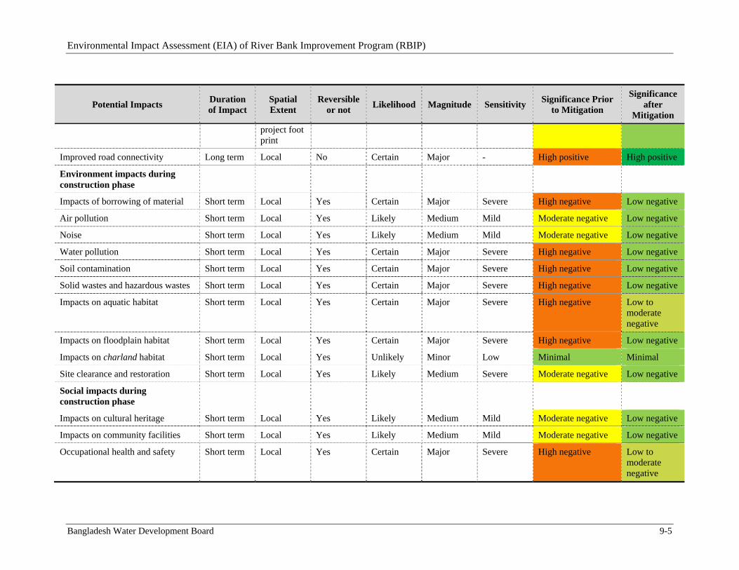
Environmental Impact Assessment (EIA) of River Bank Improvement Program (RBIP)
Bangladesh Water Development Board 9-5
Potential Impacts Duration of Impact
Spatial Extent
Reversible or not
Likelihood Magnitude Sensitivity Significance Prior
to Mitigation
Significance after
Mitigation
project foot print
Improved road connectivity Long term Local No Certain Major - High positive High positive
Environment impacts during construction phase
Impacts of borrowing of material Short term Local Yes Certain Major Severe High negative Low negative
Air pollution Short term Local Yes Likely Medium Mild Moderate negative Low negative
Noise Short term Local Yes Likely Medium Mild Moderate negative Low negative
Water pollution Short term Local Yes Certain Major Severe High negative Low negative
Soil contamination Short term Local Yes Certain Major Severe High negative Low negative
Solid wastes and hazardous wastes Short term Local Yes Certain Major Severe High negative Low negative
Impacts on aquatic habitat Short term Local Yes Certain Major Severe High negative Low to moderate negative
Impacts on floodplain habitat Short term Local Yes Certain Major Severe High negative Low negative
Impacts on charland habitat Short term Local Yes Unlikely Minor Low Minimal Minimal
Site clearance and restoration Short term Local Yes Likely Medium Severe Moderate negative Low negative
Social impacts during construction phase
Impacts on cultural heritage Short term Local Yes Likely Medium Mild Moderate negative Low negative
Impacts on community facilities Short term Local Yes Likely Medium Mild Moderate negative Low negative
Occupational health and safety Short term Local Yes Certain Major Severe High negative Low to moderate negative
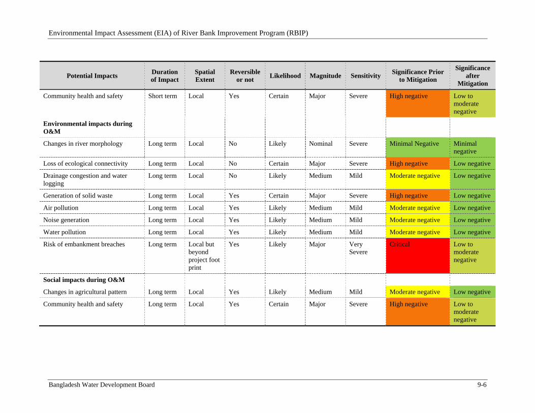
Environmental Impact Assessment (EIA) of River Bank Improvement Program (RBIP)
Bangladesh Water Development Board 9-6
Potential Impacts Duration of Impact
Spatial Extent
Reversible or not
Likelihood Magnitude Sensitivity Significance Prior
to Mitigation
Significance after
Mitigation
Community health and safety Short term Local Yes Certain Major Severe High negative Low to moderate negative
Environmental impacts during O&M
Changes in river morphology Long term Local No Likely Nominal Severe Minimal Negative Minimal negative
Loss of ecological connectivity Long term Local No Certain Major Severe High negative Low negative
Drainage congestion and water logging
Long term Local No Likely Medium Mild Moderate negative Low negative
Generation of solid waste Long term Local Yes Certain Major Severe High negative Low negative
Air pollution Long term Local Yes Likely Medium Mild Moderate negative Low negative
Noise generation Long term Local Yes Likely Medium Mild Moderate negative Low negative
Water pollution Long term Local Yes Likely Medium Mild Moderate negative Low negative
Risk of embankment breaches Long term Local but beyond project foot print
Yes Likely Major Very Severe
Critical Low to moderate negative
Social impacts during O&M
Changes in agricultural pattern Long term Local Yes Likely Medium Mild Moderate negative Low negative
Community health and safety Long term Local Yes Certain Major Severe High negative Low to moderate negative
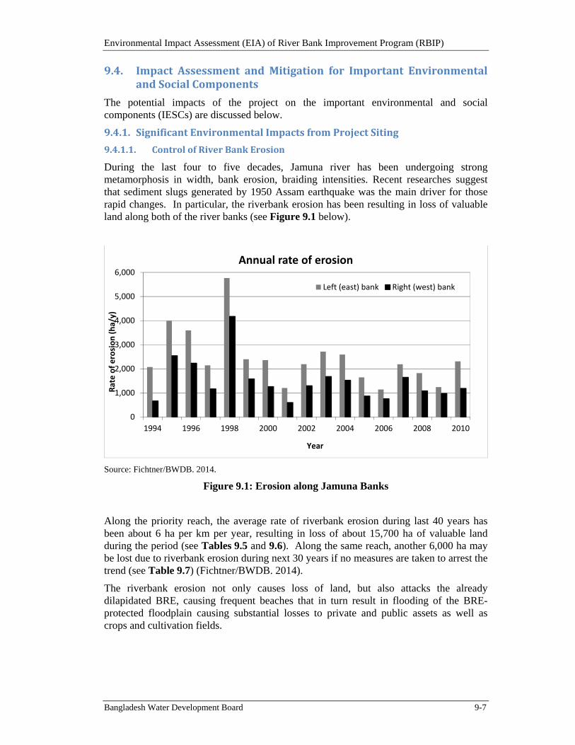
Environmental Impact Assessment (EIA) of River Bank Improvement Program (RBIP)
Bangladesh Water Development Board 9-7
9.4. ImpactAssessment andMitigation for Important EnvironmentalandSocialComponents
The potential impacts of the project on the important environmental and social components (IESCs) are discussed below.
9.4.1. SignificantEnvironmentalImpactsfromProjectSiting
9.4.1.1. ControlofRiverBankErosion
During the last four to five decades, Jamuna river has been undergoing strong metamorphosis in width, bank erosion, braiding intensities. Recent researches suggest that sediment slugs generated by 1950 Assam earthquake was the main driver for those rapid changes. In particular, the riverbank erosion has been resulting in loss of valuable land along both of the river banks (see Figure 9.1 below).
Source: Fichtner/BWDB. 2014.
Figure 9.1: Erosion along Jamuna Banks
Along the priority reach, the average rate of riverbank erosion during last 40 years has been about 6 ha per km per year, resulting in loss of about 15,700 ha of valuable land during the period (see Tables 9.5 and 9.6). Along the same reach, another 6,000 ha may be lost due to riverbank erosion during next 30 years if no measures are taken to arrest the trend (see Table 9.7) (Fichtner/BWDB. 2014).
The riverbank erosion not only causes loss of land, but also attacks the already dilapidated BRE, causing frequent beaches that in turn result in flooding of the BRE-protected floodplain causing substantial losses to private and public assets as well as crops and cultivation fields.
0
1,000
2,000
3,000
4,000
5,000
6,000
1994 1996 1998 2000 2002 2004 2006 2008 2010
Rate of erosion (ha/y)
Year
Annual rate of erosion
Left (east) bank Right (west) bank
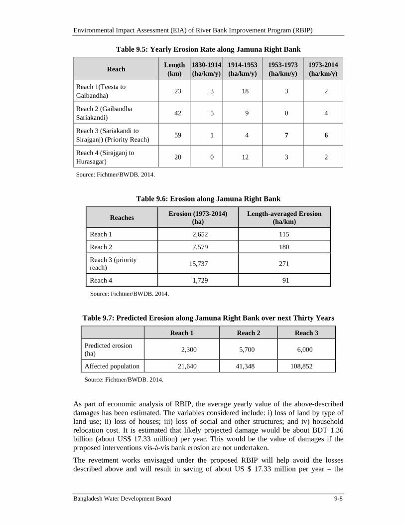
Environmental Impact Assessment (EIA) of River Bank Improvement Program (RBIP)
Bangladesh Water Development Board 9-8
Table 9.5: Yearly Erosion Rate along Jamuna Right Bank
Reach Length (km)
1830-1914 (ha/km/y)
1914-1953 (ha/km/y)
1953-1973 (ha/km/y)
1973-2014(ha/km/y)
Reach 1(Teesta to Gaibandha)
23 3 18 3 2
Reach 2 (Gaibandha Sariakandi)
42 5 9 0 4
Reach 3 (Sariakandi to Sirajganj) (Priority Reach)
59 1 4 7 6
Reach 4 (Sirajganj to Hurasagar)
20 0 12 3 2
Source: Fichtner/BWDB. 2014.
Table 9.6: Erosion along Jamuna Right Bank
Reaches Erosion (1973-2014)
(ha) Length-averaged Erosion
(ha/km)
Reach 1 2,652 115
Reach 2 7,579 180
Reach 3 (priority reach)
15,737 271
Reach 4 1,729 91
Source: Fichtner/BWDB. 2014.
Table 9.7: Predicted Erosion along Jamuna Right Bank over next Thirty Years
Reach 1 Reach 2 Reach 3
Predicted erosion (ha)
2,300 5,700 6,000
Affected population 21,640 41,348 108,852
Source: Fichtner/BWDB. 2014.
As part of economic analysis of RBIP, the average yearly value of the above-described damages has been estimated. The variables considered include: i) loss of land by type of land use; ii) loss of houses; iii) loss of social and other structures; and iv) household relocation cost. It is estimated that likely projected damage would be about BDT 1.36 billion (about US$ 17.33 million) per year. This would be the value of damages if the proposed interventions vis-à-vis bank erosion are not undertaken.
The revetment works envisaged under the proposed RBIP will help avoid the losses described above and will result in saving of about US $ 17.33 million per year – the
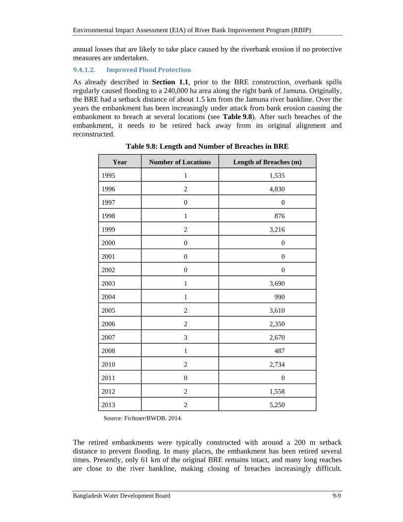
Environmental Impact Assessment (EIA) of River Bank Improvement Program (RBIP)
Bangladesh Water Development Board 9-9
annual losses that are likely to take place caused by the riverbank erosion if no protective measures are undertaken.
9.4.1.2. ImprovedFloodProtection
As already described in Section 1.1, prior to the BRE construction, overbank spills regularly caused flooding to a 240,000 ha area along the right bank of Jamuna. Originally, the BRE had a setback distance of about 1.5 km from the Jamuna river bankline. Over the years the embankment has been increasingly under attack from bank erosion causing the embankment to breach at several locations (see Table 9.8). After such breaches of the embankment, it needs to be retired back away from its original alignment and reconstructed.
Table 9.8: Length and Number of Breaches in BRE
Year Number of Locations Length of Breaches (m)
1995 1 1,535
1996 2 4,830
1997 0 0
1998 1 876
1999 2 3,216
2000 0 0
2001 0 0
2002 0 0
2003 1 3,690
2004 1 990
2005 2 3,610
2006 2 2,350
2007 3 2,670
2008 1 487
2010 2 2,734
2011 0 0
2012 2 1,558
2013 2 5,250
Source: Fichtner/BWDB. 2014.
The retired embankments were typically constructed with around a 200 m setback distance to prevent flooding. In many places, the embankment has been retired several times. Presently, only 61 km of the original BRE remains intact, and many long reaches are close to the river bankline, making closing of breaches increasingly difficult.
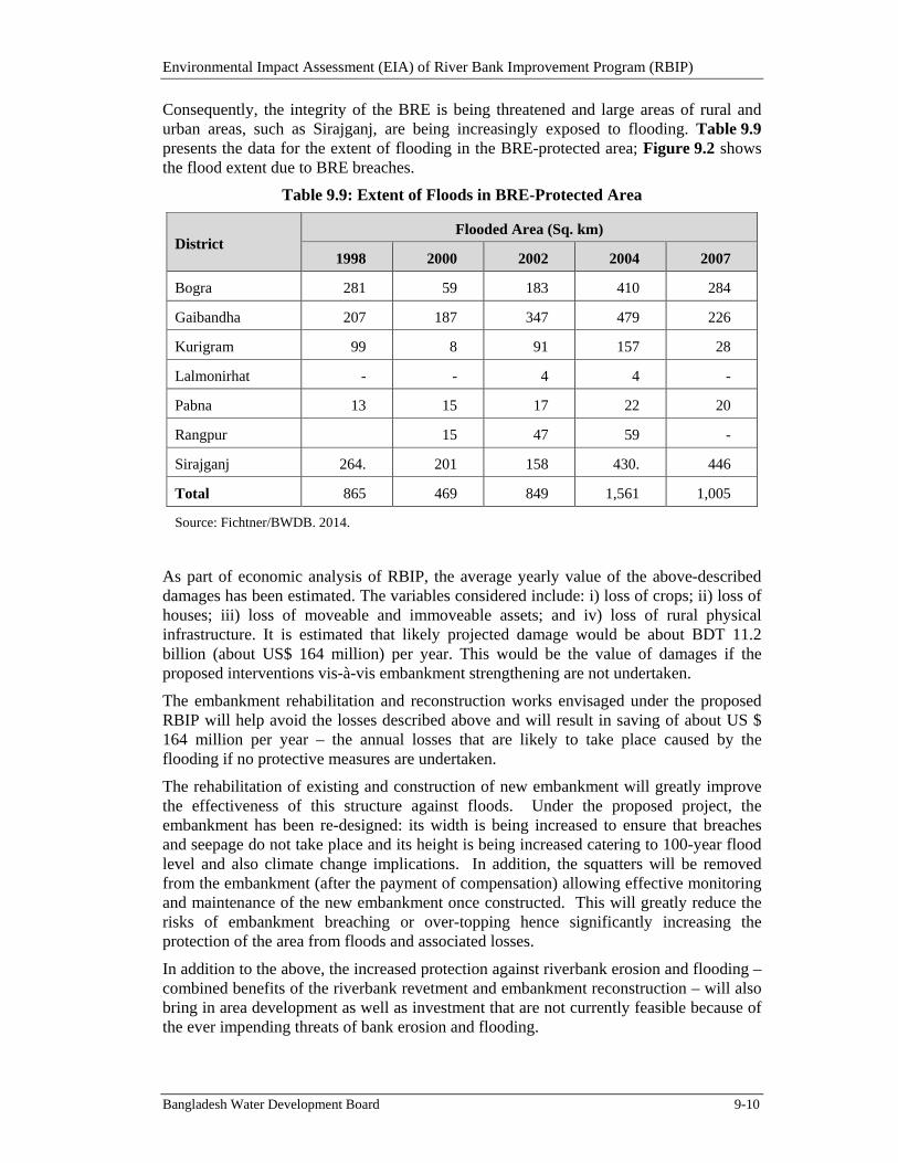
Environmental Impact Assessment (EIA) of River Bank Improvement Program (RBIP)
Bangladesh Water Development Board 9-10
Consequently, the integrity of the BRE is being threatened and large areas of rural and urban areas, such as Sirajganj, are being increasingly exposed to flooding. Table 9.9 presents the data for the extent of flooding in the BRE-protected area; Figure 9.2 shows the flood extent due to BRE breaches.
Table 9.9: Extent of Floods in BRE-Protected Area
District Flooded Area (Sq. km)
1998 2000 2002 2004 2007
Bogra 281 59 183 410 284
Gaibandha 207 187 347 479 226
Kurigram 99 8 91 157 28
Lalmonirhat - - 4 4 -
Pabna 13 15 17 22 20
Rangpur 15 47 59 -
Sirajganj 264. 201 158 430. 446
Total 865 469 849 1,561 1,005
Source: Fichtner/BWDB. 2014.
As part of economic analysis of RBIP, the average yearly value of the above-described damages has been estimated. The variables considered include: i) loss of crops; ii) loss of houses; iii) loss of moveable and immoveable assets; and iv) loss of rural physical infrastructure. It is estimated that likely projected damage would be about BDT 11.2 billion (about US$ 164 million) per year. This would be the value of damages if the proposed interventions vis-à-vis embankment strengthening are not undertaken.
The embankment rehabilitation and reconstruction works envisaged under the proposed RBIP will help avoid the losses described above and will result in saving of about US $ 164 million per year – the annual losses that are likely to take place caused by the flooding if no protective measures are undertaken.
The rehabilitation of existing and construction of new embankment will greatly improve the effectiveness of this structure against floods. Under the proposed project, the embankment has been re-designed: its width is being increased to ensure that breaches and seepage do not take place and its height is being increased catering to 100-year flood level and also climate change implications. In addition, the squatters will be removed from the embankment (after the payment of compensation) allowing effective monitoring and maintenance of the new embankment once constructed. This will greatly reduce the risks of embankment breaching or over-topping hence significantly increasing the protection of the area from floods and associated losses.
In addition to the above, the increased protection against riverbank erosion and flooding – combined benefits of the riverbank revetment and embankment reconstruction – will also bring in area development as well as investment that are not currently feasible because of the ever impending threats of bank erosion and flooding.
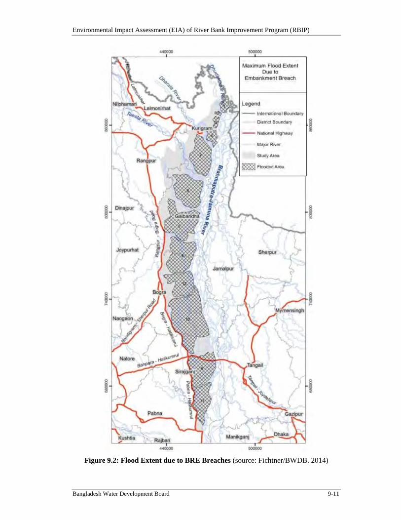
Environmental Impact Assessment (EIA) of River Bank Improvement Program (RBIP)
Bangladesh Water Development Board 9-11
Figure 9.2: Flood Extent due to BRE Breaches (source: Fichtner/BWDB. 2014)
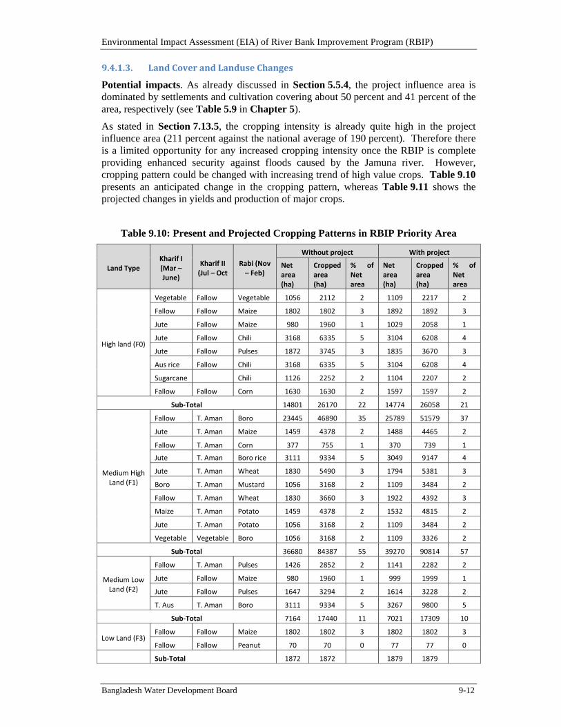
Environmental Impact Assessment (EIA) of River Bank Improvement Program (RBIP)
Bangladesh Water Development Board 9-12
9.4.1.3. LandCoverandLanduseChanges
Potential impacts. As already discussed in Section 5.5.4, the project influence area is dominated by settlements and cultivation covering about 50 percent and 41 percent of the area, respectively (see Table 5.9 in Chapter 5).
As stated in Section 7.13.5, the cropping intensity is already quite high in the project influence area (211 percent against the national average of 190 percent). Therefore there is a limited opportunity for any increased cropping intensity once the RBIP is complete providing enhanced security against floods caused by the Jamuna river. However, cropping pattern could be changed with increasing trend of high value crops. Table 9.10 presents an anticipated change in the cropping pattern, whereas Table 9.11 shows the projected changes in yields and production of major crops.
Table 9.10: Present and Projected Cropping Patterns in RBIP Priority Area
Land Type Kharif I (Mar – June)
Kharif II (Jul – Oct
Rabi (Nov – Feb)
Without project With project
Net area (ha)
Cropped area (ha)
% of Net area
Net area (ha)
Cropped area (ha)
% of Net area
High land (F0)
Vegetable Fallow Vegetable 1056 2112 2 1109 2217 2
Fallow Fallow Maize 1802 1802 3 1892 1892 3
Jute Fallow Maize 980 1960 1 1029 2058 1
Jute Fallow Chili 3168 6335 5 3104 6208 4
Jute Fallow Pulses 1872 3745 3 1835 3670 3
Aus rice Fallow Chili 3168 6335 5 3104 6208 4
Sugarcane Chili 1126 2252 2 1104 2207 2
Fallow Fallow Corn 1630 1630 2 1597 1597 2
Sub‐Total 14801 26170 22 14774 26058 21
Medium High Land (F1)
Fallow T. Aman Boro 23445 46890 35 25789 51579 37
Jute T. Aman Maize 1459 4378 2 1488 4465 2
Fallow T. Aman Corn 377 755 1 370 739 1
Jute T. Aman Boro rice 3111 9334 5 3049 9147 4
Jute T. Aman Wheat 1830 5490 3 1794 5381 3
Boro T. Aman Mustard 1056 3168 2 1109 3484 2
Fallow T. Aman Wheat 1830 3660 3 1922 4392 3
Maize T. Aman Potato 1459 4378 2 1532 4815 2
Jute T. Aman Potato 1056 3168 2 1109 3484 2
Vegetable Vegetable Boro 1056 3168 2 1109 3326 2
Sub‐Total 36680 84387 55 39270 90814 57
Medium Low Land (F2)
Fallow T. Aman Pulses 1426 2852 2 1141 2282 2
Jute Fallow Maize 980 1960 1 999 1999 1
Jute Fallow Pulses 1647 3294 2 1614 3228 2
T. Aus T. Aman Boro 3111 9334 5 3267 9800 5
Sub‐Total 7164 17440 11 7021 17309 10
Low Land (F3) Fallow Fallow Maize 1802 1802 3 1802 1802 3
Fallow Fallow Peanut 70 70 0 77 77 0
Sub‐Total 1872 1872 1879 1879
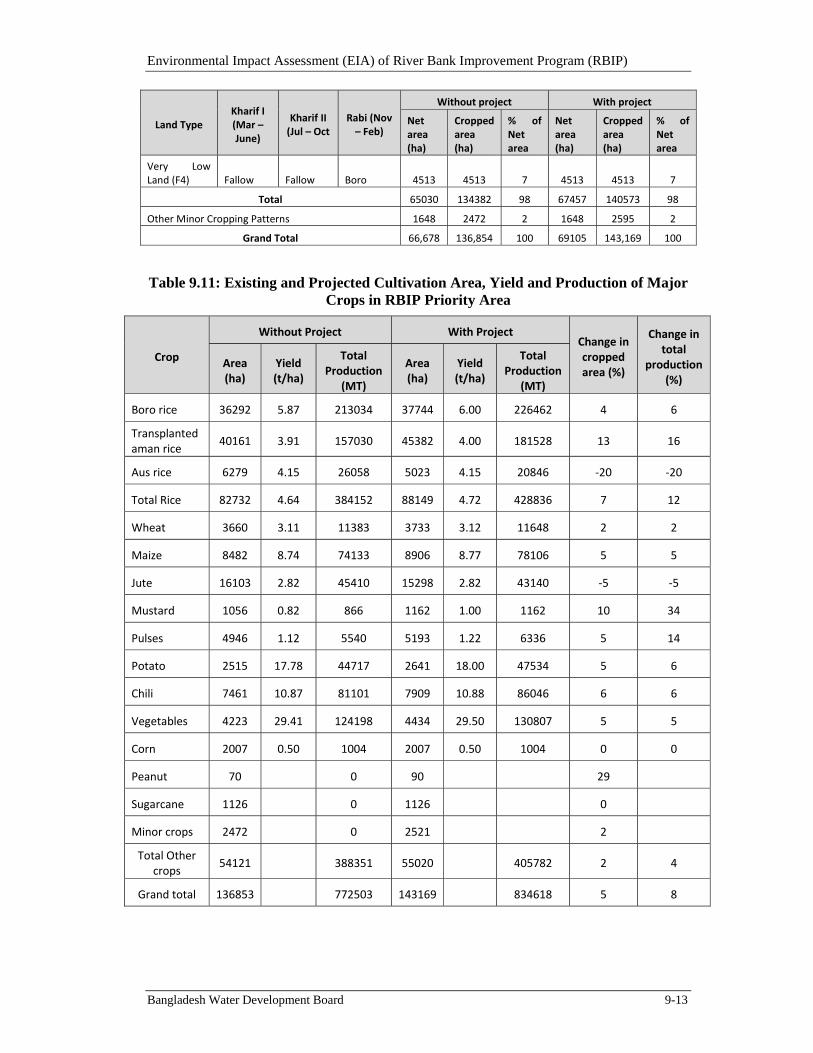
Environmental Impact Assessment (EIA) of River Bank Improvement Program (RBIP)
Bangladesh Water Development Board 9-13
Land Type Kharif I (Mar – June)
Kharif II (Jul – Oct
Rabi (Nov – Feb)
Without project With project
Net area (ha)
Cropped area (ha)
% of Net area
Net area (ha)
Cropped area (ha)
% of Net area
Very Low Land (F4) Fallow Fallow Boro 4513 4513 7 4513 4513 7
Total 65030 134382 98 67457 140573 98
Other Minor Cropping Patterns 1648 2472 2 1648 2595 2
Grand Total 66,678 136,854 100 69105 143,169 100
Table 9.11: Existing and Projected Cultivation Area, Yield and Production of Major Crops in RBIP Priority Area
Crop
Without Project With Project Change in cropped area (%)
Change in total
production (%)
Area (ha)
Yield (t/ha)
Total Production
(MT)
Area (ha)
Yield (t/ha)
Total Production
(MT)
Boro rice 36292 5.87 213034 37744 6.00 226462 4 6
Transplanted aman rice
40161 3.91 157030 45382 4.00 181528 13 16
Aus rice 6279 4.15 26058 5023 4.15 20846 ‐20 ‐20
Total Rice 82732 4.64 384152 88149 4.72 428836 7 12
Wheat 3660 3.11 11383 3733 3.12 11648 2 2
Maize 8482 8.74 74133 8906 8.77 78106 5 5
Jute 16103 2.82 45410 15298 2.82 43140 ‐5 ‐5
Mustard 1056 0.82 866 1162 1.00 1162 10 34
Pulses 4946 1.12 5540 5193 1.22 6336 5 14
Potato 2515 17.78 44717 2641 18.00 47534 5 6
Chili 7461 10.87 81101 7909 10.88 86046 6 6
Vegetables 4223 29.41 124198 4434 29.50 130807 5 5
Corn 2007 0.50 1004 2007 0.50 1004 0 0
Peanut 70 0 90 29
Sugarcane 1126 0 1126 0
Minor crops 2472 0 2521 2
Total Other crops
54121
388351 55020 405782 2 4
Grand total 136853 772503 143169 834618 5 8
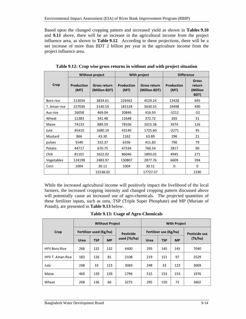
Environmental Impact Assessment (EIA) of River Bank Improvement Program (RBIP)
Bangladesh Water Development Board 9-14
Based upon the changed cropping pattern and increased yield as shown in Tables 9.10 and 9.11 above, there will be an increase in the agricultural income from the project influence area, as shown in Table 9.12. According to these projections, there will be a net increase of more than BDT 2 billion per year in the agriculture income from the project influence area.
Table 9.12: Crop wise gross returns in without and with project situation
Crop
Without project With project Difference
Production (MT)
Gross return (Million BDT)
Production (MT)
Gross return (Million BDT)
Production (MT)
Gross return (Million BDT)
Boro rice 213034 3834.61 226462 4529.24 13428 695
T. Aman rice 157030 3140.59 181528 3630.55 24498 490
Aus rice 26058 469.04 20846 416.93 ‐5212 ‐52
Wheat 11383 341.48 11648 372.72 265 31
Maize 74133 889.59 78106 1015.38 3974 126
Jute 45410 1680.19 43140 1725.60 ‐2271 45
Mustard 866 43.30 1162 63.89 296 21
pulses 5540 332.37 6336 411.83 796 79
Potato 44717 670.75 47534 760.54 2817 90
Chili 81101 1622.02 86046 1893.02 4945 271
Vegetables 124198 2483.97 130807 2877.76 6609 394
Corn 1004 30.11 1004 30.11 0 0
15538.02 17727.57 2190
While the increased agricultural income will positively impact the livelihood of the local farmers, the increased cropping intensity and changed cropping pattern discussed above will potentially cause an increased use of agro-chemicals. The projected quantities of these fertilizer inputs, such as urea, TSP (Triple Super Phosphate) and MP (Muriate of Potash), are presented in Table 9.13 below.
Table 9.13: Usage of Agro-Chemicals
Crop
Without Project With Project
Fertilizer used (Kg/ha) Pesticide used (Tk/ha)
Fertilizer use (Kg/ha) Pesticide use (Tk/ha) Urea TSP MP Urea TSP MP
HYV Boro Rice 268 132 132 6400 295 145 145 7040
HYV T. Aman Rice 183 126 81 2108 219 151 97 2529
Jute 248 33 123 3069 248 33 123 3069
Maize 469 139 139 1796 515 153 153 1976
Wheat 268 136 66 3275 295 150 72 3602
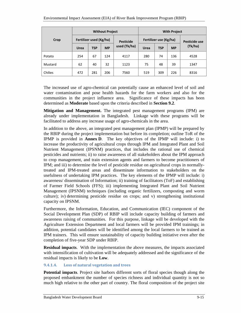
Environmental Impact Assessment (EIA) of River Bank Improvement Program (RBIP)
Bangladesh Water Development Board 9-15
Crop
Without Project With Project
Fertilizer used (Kg/ha) Pesticide used (Tk/ha)
Fertilizer use (Kg/ha) Pesticide use (Tk/ha) Urea TSP MP Urea TSP MP
Potato 254 67 124 4117 280 74 136 4528
Mustard 62 40 32 1123 75 48 39 1347
Chilies 472 281 206 7560 519 309 226 8316
The increased use of agro-chemical can potentially cause an enhanced level of soil and water contamination and pose health hazards for the farm workers and also for the communities in the project influence area. Significance of these impacts has been determined as Moderate based upon the criteria described in Section 9.2.
Mitigation and Management. The integrated pest management programs (IPM) are already under implementation in Bangladesh. Linkage with these programs will be facilitated to address any increase usage of agro-chemicals in the area.
In addition to the above, an integrated pest management plan (IPMP) will be prepared by the RBIP during the project implementation but before its completion; outline ToR of the IPMP is provided in Annex D. The key objectives of the IPMP will include: i) to increase the productivity of agricultural crops through IPM and Integrated Plant and Soil Nutrient Management (IPSNM) practices, that includes the rational use of chemical pesticides and nutrients; ii) to raise awareness of all stakeholders about the IPM approach to crop management, and train extension agents and farmers to become practitioners of IPM; and iii) to determine the level of pesticide residue on agricultural crops in normally-treated and IPM-treated areas and disseminate information to stakeholders on the usefulness of undertaking IPM practices. The key elements of the IPMP will include: i) awareness/ dissemination of Information; ii) training of facilitators (ToF) and establishing of Farmer Field Schools (FFS); iii) implementing Integrated Plant and Soil Nutrient Management (IPSNM) techniques (including organic fertilizers, composting and worm culture); iv) determining pesticide residue on crops; and v) strengthening institutional capacity on IPSNM.
Furthermore, the Information, Education, and Communication (IEC) component of the Social Development Plan (SDP) of RBIP will include capacity building of farmers and awareness raising of communities. For this purpose, linkage will be developed with the Agriculture Extension Department and local farmers will be provided IPM trainings; in addition, potential candidates will be identified among the local farmers to be trained as IPM trainers. This will ensure sustainability of capacity building initiative even after the completion of five-year SDP under RBIP.
Residual impacts. With the implementation the above measures, the impacts associated with intensification of cultivation will be adequately addressed and the significance of the residual impacts is likely to be Low.
9.4.1.4. Lossofnaturalvegetationandtrees
Potential impacts. Project site harbors different sorts of floral species though along the proposed embankment the number of species richness and individual quantity is not so much high relative to the other part of country. The floral composition of the project site
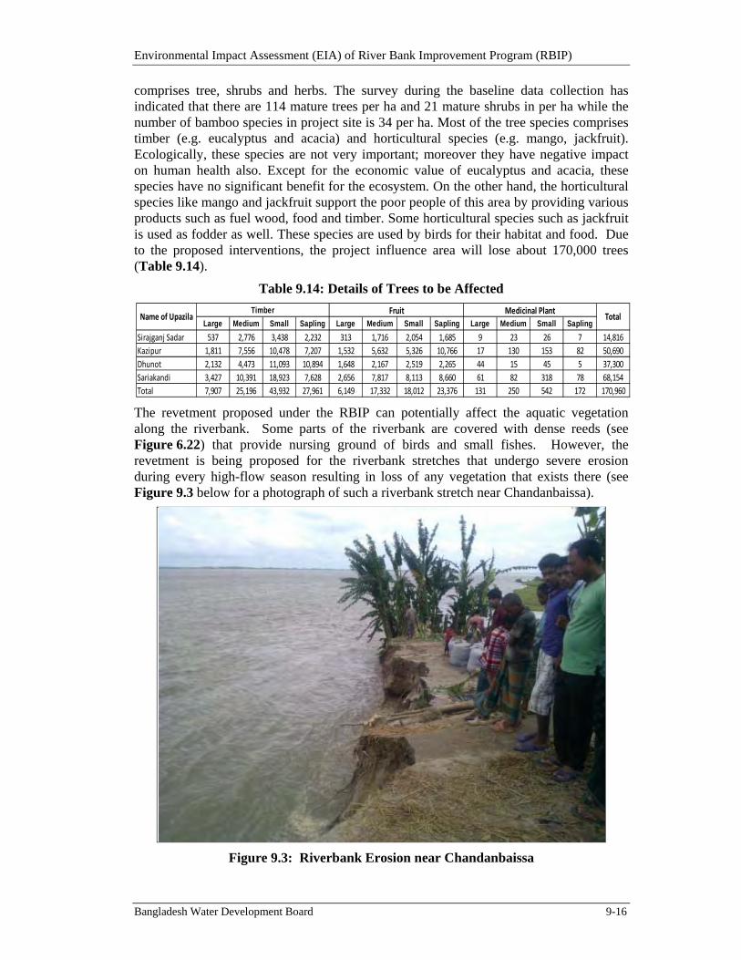
Environmental Impact Assessment (EIA) of River Bank Improvement Program (RBIP)
Bangladesh Water Development Board 9-16
comprises tree, shrubs and herbs. The survey during the baseline data collection has indicated that there are 114 mature trees per ha and 21 mature shrubs in per ha while the number of bamboo species in project site is 34 per ha. Most of the tree species comprises timber (e.g. eucalyptus and acacia) and horticultural species (e.g. mango, jackfruit). Ecologically, these species are not very important; moreover they have negative impact on human health also. Except for the economic value of eucalyptus and acacia, these species have no significant benefit for the ecosystem. On the other hand, the horticultural species like mango and jackfruit support the poor people of this area by providing various products such as fuel wood, food and timber. Some horticultural species such as jackfruit is used as fodder as well. These species are used by birds for their habitat and food. Due to the proposed interventions, the project influence area will lose about 170,000 trees (Table 9.14).
Table 9.14: Details of Trees to be Affected
The revetment proposed under the RBIP can potentially affect the aquatic vegetation along the riverbank. Some parts of the riverbank are covered with dense reeds (see Figure 6.22) that provide nursing ground of birds and small fishes. However, the revetment is being proposed for the riverbank stretches that undergo severe erosion during every high-flow season resulting in loss of any vegetation that exists there (see Figure 9.3 below for a photograph of such a riverbank stretch near Chandanbaissa).
Figure 9.3: Riverbank Erosion near Chandanbaissa
Large Medium Small Sapling Large Medium Small Sapling Large Medium Small Sapling
Sirajganj Sadar 537 2,776 3,438 2,232 313 1,716 2,054 1,685 9 23 26 7 14,816
Kazipur 1,811 7,556 10,478 7,207 1,532 5,632 5,326 10,766 17 130 153 82 50,690
Dhunot 2,132 4,473 11,093 10,894 1,648 2,167 2,519 2,265 44 15 45 5 37,300
Sariakandi 3,427 10,391 18,923 7,628 2,656 7,817 8,113 8,660 61 82 318 78 68,154
Total 7,907 25,196 43,932 27,961 6,149 17,332 18,012 23,376 131 250 542 172 170,960
Timber Fruit Medicinal PlantTotalName of Upazila
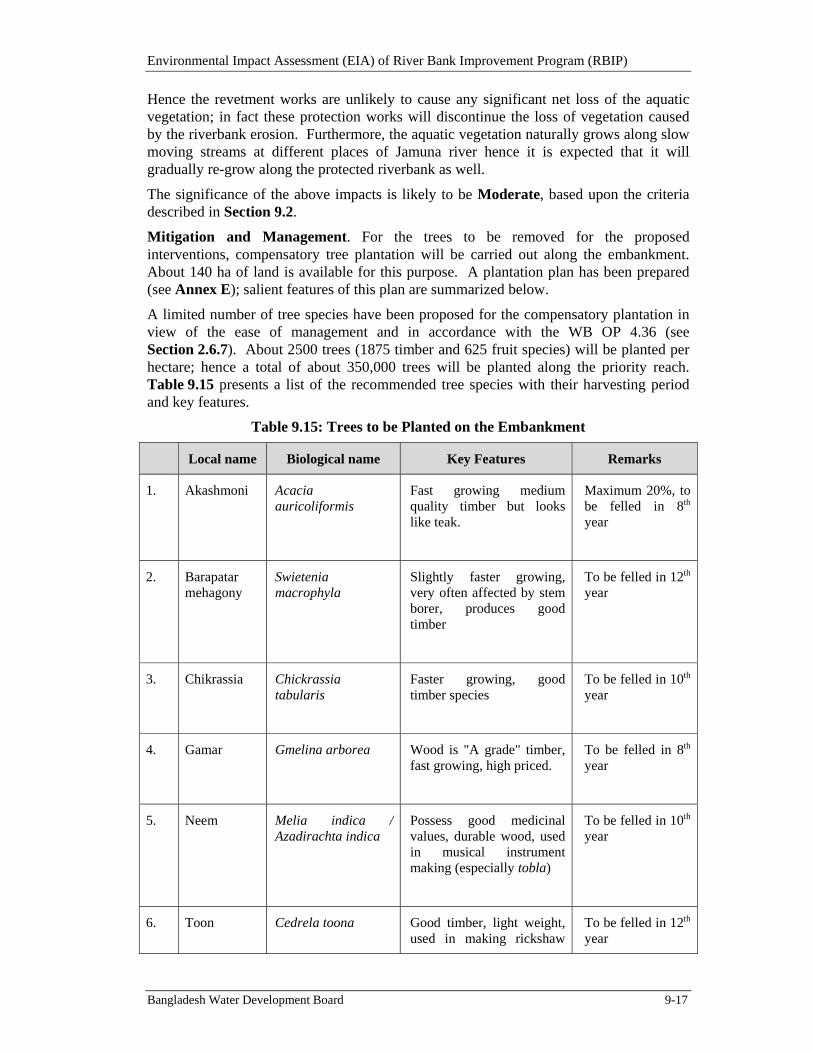
Environmental Impact Assessment (EIA) of River Bank Improvement Program (RBIP)
Bangladesh Water Development Board 9-17
Hence the revetment works are unlikely to cause any significant net loss of the aquatic vegetation; in fact these protection works will discontinue the loss of vegetation caused by the riverbank erosion. Furthermore, the aquatic vegetation naturally grows along slow moving streams at different places of Jamuna river hence it is expected that it will gradually re-grow along the protected riverbank as well.
The significance of the above impacts is likely to be Moderate, based upon the criteria described in Section 9.2.
Mitigation and Management. For the trees to be removed for the proposed interventions, compensatory tree plantation will be carried out along the embankment. About 140 ha of land is available for this purpose. A plantation plan has been prepared (see Annex E); salient features of this plan are summarized below.
A limited number of tree species have been proposed for the compensatory plantation in view of the ease of management and in accordance with the WB OP 4.36 (see Section 2.6.7). About 2500 trees (1875 timber and 625 fruit species) will be planted per hectare; hence a total of about 350,000 trees will be planted along the priority reach. Table 9.15 presents a list of the recommended tree species with their harvesting period and key features.
Table 9.15: Trees to be Planted on the Embankment
Local name Biological name Key Features Remarks
1. Akashmoni Acacia auricoliformis
Fast growing medium quality timber but looks like teak.
Maximum 20%, to be felled in 8th year
2. Barapatar mehagony
Swietenia macrophyla
Slightly faster growing, very often affected by stem borer, produces good timber
To be felled in 12th year
3. Chikrassia Chickrassia tabularis
Faster growing, good timber species
To be felled in 10th year
4. Gamar Gmelina arborea Wood is "A grade" timber, fast growing, high priced.
To be felled in 8th year
5. Neem Melia indica / Azadirachta indica
Possess good medicinal values, durable wood, used in musical instrument making (especially tobla)
To be felled in 10th year
6. Toon Cedrela toona Good timber, light weight, used in making rickshaw
To be felled in 12th year
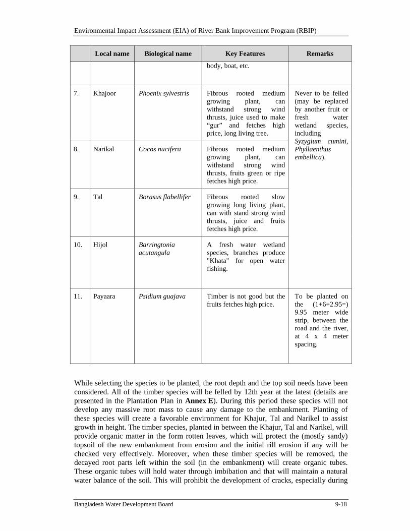
Environmental Impact Assessment (EIA) of River Bank Improvement Program (RBIP)
Bangladesh Water Development Board 9-18
Local name Biological name Key Features Remarks
body, boat, etc.
7. Khajoor Phoenix sylvestris Fibrous rooted medium growing plant, can withstand strong wind thrusts, juice used to make “gur” and fetches high price, long living tree.
Never to be felled (may be replaced by another fruit or fresh water wetland species, including Syzygium cumini, Phyllaenthus embellica).
8. Narikal Cocos nucifera Fibrous rooted medium growing plant, can withstand strong wind thrusts, fruits green or ripe fetches high price.
9. Tal Borasus flabellifer Fibrous rooted slow growing long living plant, can with stand strong wind thrusts, juice and fruits fetches high price.
10. Hijol Barringtonia acutangula
A fresh water wetland species, branches produce "Khata" for open water fishing.
11. Payaara Psidium guajava Timber is not good but the fruits fetches high price.
To be planted on the (1+6+2.95=) 9.95 meter wide strip, between the road and the river, at 4 x 4 meter spacing.
While selecting the species to be planted, the root depth and the top soil needs have been considered. All of the timber species will be felled by 12th year at the latest (details are presented in the Plantation Plan in Annex E). During this period these species will not develop any massive root mass to cause any damage to the embankment. Planting of these species will create a favorable environment for Khajur, Tal and Narikel to assist growth in height. The timber species, planted in between the Khajur, Tal and Narikel, will provide organic matter in the form rotten leaves, which will protect the (mostly sandy) topsoil of the new embankment from erosion and the initial rill erosion if any will be checked very effectively. Moreover, when these timber species will be removed, the decayed root parts left within the soil (in the embankment) will create organic tubes. These organic tubes will hold water through imbibation and that will maintain a natural water balance of the soil. This will prohibit the development of cracks, especially during
Environmental Impact Assessment (EIA) of River Bank Improvement Program (RBIP)
Bangladesh Water Development Board 9-19
sudden droughts. By 12th year the Khajur, Tal and Narikel species will grow to a reasonable height to provide the required shade and it is expected that grasses will grow underneath. The Khajur, Tal and Narikel will remain for all the time to come. These do not have any deep taproots. These are fibrous rooted plants and their roots do not travel deep and will not be able to create any problem for the embankment. These plants will provide benefits to the communities, throughout the future.
In addition to providing ecological service, embankment stabilization, and enhanced aesthetic value, this plantation will also prevent any encroachment over the embankment.
A monitoring program will be initiated for the re-growth of the aquatic vegetation along the riverbank revetment as well as for the plantation on the embankment. The ToR of this monitoring is presented in Annex F.
Residual impacts. With the help of the above-mentioned mitigation measures, the potential impacts associated with clearing of riparian as well as terrestrial vegetation/trees will be adequately addressed and hence the significance of the residual impacts in likely to be Low.
9.4.1.5. LossofRiverbank/AquaticHabitat
Potential impacts. Total length of the revetment will be about 17 km divided into four major sites at Balighuri, Ratankandi, Baniajan and Chandanbaissa. Average width of the revetment will be 100 meter of which the under-water portion will be 60 meter. Hence the estimated total potentially impacted aquatic area will be about 102 ha. However, this part of the aquatic habitat is regularly eroded because of the frequent riverbank erosion. Hence the revetment will not result in any additional loss of aquatic habitat.
The river bottom material like clay, silt, sand, cobbles, and boulders has different physical and chemical gesture and may support aquatic life differently. Geo-bags are helpful to stun sediment which will help to improve water transparency. On the other hand, geo-bag will cover part of the riverbed that may potentially have negative impacts on benthos. The benthic fauna at the substrates and phytoplankton at the water column will potentially be affected negatively at the revetment sites, which will in turn have effect on the food chain and may result in food shortage for faunal species such as fish, crab, and turtle. The covering of river bed with geo-bags in limnetic zone may potentially affect some fishes, such as Ayre (Aorichthys aor), boal (Wallago attu), Pangas (Pangasius pangasius), different types of baim, gutum (Lepidocephalus guntea), bala (Glossogobius giuris) and some small fish species by limiting their feeding opportunity. The associated fish production loss has been estimated at about 9 tonnes annually during the construction phase (considering that the annual fish production rate of the Jamuna river is 90kg/ha/year); however this loss will be more than compensated through increased fish production in the flood plains (discussed later in the Chapter).
Furthermore, it is now established that the geo-bags revetment creates fish habitat, as phytoplankton grow on their surface. Previous studies1 2 on impacts of geo-bags on the aquatic species have shown positive results. In general, there were more number of species and more population of fish and non fish aquatic organisms in areas protected
1 Geotextile Bags for River Erosion Control in Bangladesh, Under water behavior and environmental aspects. Hannes Zellweger; 2007. 2 Bank Protection and Fisheries at JMREMP; Jamuna-Meghna River Erosion Mitigation Project, Special Report; 2007.
Environmental Impact Assessment (EIA) of River Bank Improvement Program (RBIP)
Bangladesh Water Development Board 9-20
with geo-bags. The overall accumulation of species in number was better in geo-bag protected area than in the areas protected by cement concrete blocks. The quantity of fish availability was also better with geo-bags in many locations. In addition, the CC blocks used in the upper portion of the revetment are likely to provide habitat for certain fish species such as eels. The revetment is not likely to affect the dolphin or wintering bird habitats since the river protection works will not be carried out at or in the vicinity of those areas.
The aquatic habitat can also be potentially affected if sediments and pollutants from the construction sites and camp sites are released in the water bodies.
Potential impacts on key species. The revetment works are not likely to impact the key species of the area listed in Table 6.3 since the riverbank does not provide habitat for any of these species. Furthermore, the riverbank reaches where the revetment will be constructed undergo quite frequent erosion as stated earlier and hence whatever habitat exists there is subjected to repeated erosion, hence the revetment works are not likely to cause any additional damage to the natural habitat. Similarly, the important habitats identified in the area and shown in Figures 6.2 and 6.3 are also quite far away from the riverbank hence will remain unaffected by the proposed revetment works.
Based upon the above discussion, the potential impacts of the project on aquatic habitat have been characterized as Moderate, using the criteria described in Section 9.2.
Mitigation and Management. Since most of the potentially negative impacts of riverbank revetment on the aquatic habitat are expected to be temporary in nature, and since the revetment is likely to provide habitat for some aquatic species, as stated earlier, no mitigation measures are identified ex-ante for this activity. Habitat monitoring will however be initiated during the construction phase and will be continued thereafter to fully understand the impact of revetment on the aquatic habitat (see Annex E for the ToR of this monitoring). Appropriate mitigation measures may need to be designed and implemented on the basis of monitoring results. Similarly, long-term monitoring of river morphology will also be initiated to fully understand the changes in river morphology, and to inform subsequent phases of embankment and riverbank works under the RBIP program.
The monitoring program will be based on the assumption that different riverine fish species prefer different bankline conditions. The program will include year-round data collection on fish and non-fish organisms in control sites (i.e., areas without geo-bag revetment) as well as revetment sites. For each location, depth series data will be collected on fish habitat, availability of food, and abundance of key species. The monitoring will focus on adult or sub adult fish that will be available along bankline, however additional information will also be collected on breeding, nursing, and migration of the key species as well as on benthic species and riverbed ecology. The monitoring program will also cover potential impacts on other key aquatic species such as dolphins and turtles.
To protect the aquatic habitat from the sediments and pollutants from the construction sites and camp sites, contractors will be required to prepare and implement pollution prevention plan and waste management plan. Through these plans, it will be ensured that no untreated effluents or solid waste is released in the water bodies.
Environmental Impact Assessment (EIA) of River Bank Improvement Program (RBIP)
Bangladesh Water Development Board 9-21
Residual impacts. With the help of the above-mentioned mitigation measures, the potential impacts associated with aquatic habitat will be adequately addressed and hence the significance of the residual impacts is likely to be Low.
9.4.1.6. LossofFloodplainHabitat
Potential impacts. The embankment works will affect about 340 ha of terrestrial habitat however most parts of this area is completely modified and is currently either under cultivation or included in built-up area (homesteads, other physical infrastructure). The proposed works are not likely to impact the key species of the area listed in Table 6.3 since the project footprint does not provide habitat for any of these species.
Hence the project interventions are unlikely to cause any significant negative impacts on the natural habitat under its immediate footprint (loss of natural vegetation is already covered under Section 9.4.1.4). This potential impact is assessed as Low, based upon the criteria described in Section 9.2 and hence no mitigation is required for this.
In addition to the above impacts, the embankment construction can potentially disrupt the hydrological and ecological connectivity between the Jamuna River and smaller inland rivers, khals and beels – negatively affecting the floodplain habitat and potentially reducing the fish production in the area. This potential impact is characterized as High, based upon the criteria described in Section 9.2.
Since its construction in 1960s, the BRE has been acting as a barrier, disconnecting large area of floodplain from the river. This has brought changes in the natural ecosystems of floodplain dependent on the flood waters resulting in great loss of biodiversity and natural resources, as well as livelihood opportunities for the communities. The frequent embankment breaches while causing great economic loss to people in terms of lost lands and crops, restored to some extent the ecological connectivity of the floodplain with the main river. However, in the absence of mitigation measures, the proposed embankment reconstruction under RBIP would disrupt the ecological connectivity again. The potential negative impacts of the embankment will be mostly on the fish along with other aquatic species. Fish migration especially during pre-monsoon and monsoon season is likely to be greatly obstructed due to the connectivity loss. The impacts would also include reduction in water available for irrigation and groundwater replenishment on the floodplain behind the embankment.
Most significant impact is likely to be on the fish migration from the Jamuna river to the floodplain through linking rivers/khals. Internal rivers, khals and shallow floodplains provide breeding and feeding areas for a number of riverine fishes. These fishes migrate towards the shallow area of floodplain/beels that allow them to feed and shelter at the early stages of life cycle. Ichamati, Bangali and Manosh rivers are the three main migration routes of the study area. Besides, a number of khals listed in Annex G also facilitate fish migration to and from the internal floodplain and beels. The RBIP has a potential to obstruct this fish migration through these khals unless fish pass structures are included in the project scope.
Fish biodiversity is already declining in the project influence area because of the reduced ecological connectivity resulting into decline in the fish production whereas fish demand is increasing with the population growth. The project has a potential to exacerbate deterioration of fish habitat and also accelerate conversion of wetlands into cropland primarily because of the gradual drying up of internal khals and beels.
Environmental Impact Assessment (EIA) of River Bank Improvement Program (RBIP)
Bangladesh Water Development Board 9-22
It is estimated that total annual fish production will decline by about two tonnes in khals (water channels) and internal rivers, about 261 tonnes in beels (water ponds), and about 311 tonnes in floodplains. The associated annual economic loss has been estimated to be BDT 616,275 from khals and internal rivers, BDT 78,306,750 from beels and BDT 93,355,500 from floodplain – a total of about BDT 255 million on a yearly basis (see Table 9.16 for details).
Mitigation and Enhancement. To restore the ecological and hydrological connectivity, appropriate number of regulators and fish passes will be constructed at appropriate locations as part of the RBIP (fish passes for facilitating fish migration and regulators primarily for irrigation purposes though they will also be helpful to bring in sediments and nutrients). During the present study four potential areas within the priority reach have been identified where re-establishing of ecological connectivity will greatly help in restoring the biodiversity of the area particularly facilitating the fish migration, which in turn will enhance the fish production in the beels, khals, and other water bodies of the floodplain.
The fish passes have been designed on the basis of the fish migration requirements (see Figure 6.34 and Annex G) suitable for the key species that migrate between the main river and floodplain.
Operation and maintenance committees will be established for each regulator to appropriately operate and maintain these structures. These committees will be responsible for scheduled opening and closing of regulator gates, and removal of silt deposits in the khals. These committees will be provided with adequate training in O&M of the regulators. Furthermore, to achieve maximum benefit and also to ensure functionality of the fish passes, it is also necessary to undertake enhancement measures particularly excavation in the connecting khals, beels and other water bodies (the list of water bodies that need improvement works to ensure functionality of fish passes and enhance connectivity with the Jamuna river is furnished in Annex G). In addition, a fisheries development plan will be prepared as an ecological offset to compensate loss of fish production during the construction phase.
Construction of fish passes will facilitate fish migration that will ultimately enhance fish production of the area. It is estimated that the restoration of ecological connectivity achieved through fish pass structures and regulators will enhance the fish production from the floodplain of the priority reach by about 1,880 tonnes per year, resulting in a net economic benefit of about BDT 564 million annually (see Table 9.17 for details). Since the productivity enhancement is a gradual process, it is estimated that the above enhancements will be achieved after five years of project completion.
The regulators and fish pass structures proposed as part of RBIP are listed in Table 9.18 and shown in Figure 9.4.
Residual impacts. With the help of the above-described mitigation measures, the potential impacts on the floodplain habitat are likely to be adequately addressed and hence the residual impacts will be Low in significance particularly with reference to the fish species that would be able to use the fish passes (for other fish species for which fish passes are not suitable, the residual impact is likely to remain moderately negative). On the other hand, the project will result in net economic benefit of BDT 564 million on an annual basis, as described above.
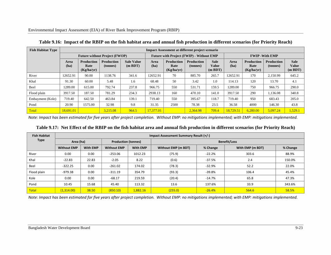
Environmental Impact Assessment (EIA) of River Bank Improvement Program (RBIP)
Bangladesh Water Development Board 9-23
Table 9.16: Impact of the RBIP on the fish habitat area and annual fish production in different scenarios (for Priority Reach)
Fish Habitat Type Impact Assessment at different project scenario
Future without Project (FWOP) Future with Project (FWIP) - Without EMP FWIP -With EMP
Area (ha)
Production Rate
(Kg/ha/yr)
Production (tonnes)
Sale Value (m BDT)
Area (ha)
Production Rate
(Kg/ha/yr)
Production (tonnes)
Sale Value
(m BDT)
Area (ha)
Production Rate
(Kg/ha/yr)
Production (tonnes)
Sale Value
(m BDT)
River 12652.91 90.00 1138.76 341.6 12652.91 70 885.70 265.7 12652.91 170 2,150.99 645.2
Khal 91.30 60.00 5.48 1.6 68.48 50 3.42 1.0 114.13 120 13.70 4.1
Beel 1289.00 615.00 792.74 237.8 966.75 550 531.71 159.5 1289.00 750 966.75 290.0
Flood plain 3917.50 187.50 781.29 234.3 2938.13 160 470.10 141.0 3917.50 290 1,136.08 340.8
Embayment (Kole) 719.40 642.50 463.84 139.1 719.40 550 395.67 118.7 719.40 950 683.43 205.0
Pond 20.90 1575.00 32.98 9.8 31.35 2500 78.38 23.5 36.58 4000 146.30 43.8
Total 18,691.01 3,215.08 964.5 17,377.01 2,364.98 709.4 18,729.51 6,280.00 5,097.24 1,529.1
Note: Impact has been estimated for five years after project completion. Without EMP: no mitigations implemented; with EMP: mitigations implemented.
Table 9.17: Net Effect of the RBIP on the fish habitat area and annual fish production in different scenarios (for Priority Reach)
Fish Habitat Type
Impact Assessment Summary Result (+/‐)
Area (ha) Production (tonnes) Benefit/Loss
Without EMP With EMP Without EMP With EMP Without EMP (m BDT) % Change With EMP (m BDT) % Change
River 0.00 0.00 ‐253.06 1012.23 (75.9) ‐22.2% 303.6 88.9%
Khal ‐22.83 22.83 ‐2.05 8.22 (0.6) ‐37.5% 2.4 150.0%
Beel ‐322.25 0.00 ‐261.02 174.02 (78.3) ‐32.9% 52.2 22.0%
Flood plain ‐979.38 0.00 ‐311.19 354.79 (93.3) ‐39.8% 106.4 45.4%
Kole 0.00 0.00 ‐68.17 219.59 (20.4) ‐14.7% 65.8 47.3%
Pond 10.45 15.68 45.40 113.32 13.6 137.6% 33.9 343.6%
Total (1,314.00) 38.50 (850.10) 1,882.16 (255.0) ‐26.4% 564.6 58.5%
Note: Impact has been estimated for five years after project completion. Without EMP: no mitigations implemented; with EMP: mitigations implemented.
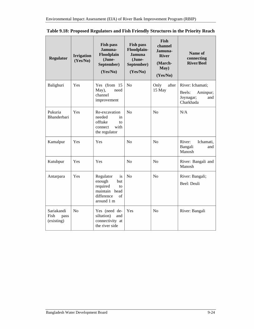
Environmental Impact Assessment (EIA) of River Bank Improvement Program (RBIP)
Bangladesh Water Development Board 9-24
Table 9.18: Proposed Regulators and Fish Friendly Structures in the Priority Reach
Regulator Irrigation (Yes/No)
Fish pass Jamuna-
Floodplain (June-
September)
(Yes/No)
Fish pass Floodplain-
Jamuna (June-
September)
(Yes/No)
Fish channel Jamuna-
River
(March-May)
(Yes/No)
Name of connecting River/Beel
Balighuri Yes Yes (from 15 May), need channel improvement
No Only after 15 May
River: Ichamati;
Beels: Aminpur; Joynagar; and Charkhada
Pukuria Bhanderbari
Yes Re-excavation needed in offtake to connect with the regulator
No No N/A
Kamalpur Yes Yes No No River: Ichamati, Bangali and Manosh
Kutubpur Yes Yes No No River: Bangali and Manosh
Antarpara Yes Regulator is enough but required to maintain head difference of around 1 m
No No River: Bangali;
Beel: Deuli
Sariakandi Fish pass (existing)
No Yes (need de-siltation) and connectivity at the river side
Yes No River: Bangali
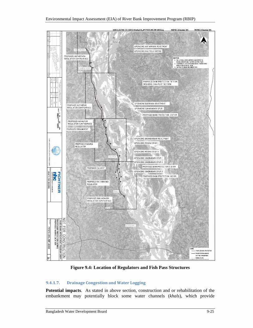
Environmental Impact Assessment (EIA) of River Bank Improvement Program (RBIP)
Bangladesh Water Development Board 9-25
Figure 9.4: Location of Regulators and Fish Pass Structures
9.4.1.7. DrainageCongestionandWaterLogging
Potential impacts. As stated in above section, construction and or rehabilitation of the embankment may potentially block some water channels (khals), which provide

Environmental Impact Assessment (EIA) of River Bank Improvement Program (RBIP)
Bangladesh Water Development Board 9-26
ecological connectivity in addition to facilitating irrigation/drainage. Some regulators were constructed across the original embankment constructed as part of the BRE however many of them have either been blocked or not functioning properly. As a result some cultivated lands particularly near Baliaghuri in Sirajganj are facing drainage congestion and water logging problems. In the absence of mitigation, similar impacts would be expected due to the proposed project works. Similarly, there is a possibility of water logging / drainage congestion between the old embankment and the new one to be constructed under RBIP. Significance of these impacts has been determined as Moderate based upon the criteria described in Section 9.2.
Mitigation and Management. Water regulators have been included in the project design, as stated earlier (see Table 9.18 and Figure 9.4). Appropriate operating procedures and a maintenance plan will be implemented to operate and maintain these structures to address the drainage congestion and water logging problems in the area. In addition, culverts will be constructed across the old embankment at appropriate places to ensure proper drainage of the area.
Residual impacts. With the help of the above mitigation measures, the potential impacts associated with water logging and drainage congestion are likely to be adequately addressed and hence the residual impact is likely to be Low in significance.
9.4.2. SignificantSocialImpactsfromProjectSiting
9.4.2.1. LandAcquisitionandResettlement
Potential impacts. Rehabilitation of existing and construction of new embankment will cause changes in land form and land use. For the priority reach, the total land requirement is about 370 ha. According to the full census of the priority reach carried out by the social safeguard team, a total of 5,751 households will be affected by the construction / rehabilitation of the embankment, of which 3,639 households need to be relocated. A summary of land acquisition requirement, affected households (AHs) and relocation requirements are tabulated in Tables 9.19 and 9.20; details are available in the Resettlement Action Plan (RAP) of the RBIP, prepared by the social safeguard team and presented under a separate cover.
Table 9.19: Land Acquisition Requirement for RBIP Priority Reach
Category of Land
Total Land (ha)
Sirajganj Sadar
Kazipur Dhunat Sariakandi Total %
1 Dwelling land/Vita/high land/Commercial land
8.34 13.76 15.32 27.57 65.00 17.57
2 Agricultural Land 24.54 69.14 28.55 104.34 226.57 61.24
3 Agricultural Land for resettlement site
5.20 6.04 8.79 29.99 50.02 13.52
4 Orchard 1.36 4.47 2.21 7.18 15.21 4.11
5 Bamboo groves 0.62 0.62 1.23 3.96 6.43 1.74
6 Pond 0.17 0.46 0.46 4.53 5.62 1.52
7 Wet land/ditch 0.00 0.17 0.47 0.35 0.99 0.27
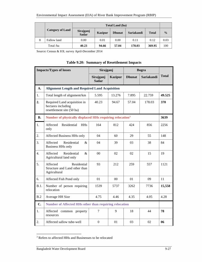
Environmental Impact Assessment (EIA) of River Bank Improvement Program (RBIP)
Bangladesh Water Development Board 9-27
Category of Land
Total Land (ha)
Sirajganj Sadar
Kazipur Dhunat Sariakandi Total %
8 Fallow land 0.00 0.01 0.00 0.11 0.12 0.03
Total /ha 40.23 94.66 57.04 178.03 369.95 100
Source: Census & IOL survey April-December 2014
Table 9.20: Summary of Resettlement Impacts
Impacts/Types of losses Sirajganj Bogra
Total Sirajganj Sadar
Kazipur Dhunat Sariakandi
A. Alignment Length and Required Land Acquisition
1. Total length of alignment/km 5.595 13.276 7.895 22.759 49.525
2. Required Land acquisition in hectares including resettlement site (50 ha)
40.23 94.67 57.04 178.03 370
B. Number of physically displaced HHs requiring relocation3 3639
1. Affected Residential HHs only
164 812 424 856 2256
2. Affected Business HHs only 04 60 29 55 148
3. Affected Residential & Business HHs only
04 39 03 38 84
4. Affected Residential & Agricultural land only
00 02 02 15 19
5. Affected Residential Structure and Land other than Agricultural
93 212 259 557 1121
6. Affected Fish Pond only 01 00 01 09 11
B.1. Number of person requiring relocation
1539 5737 3262 7736 15,558
B.2 Average HH Size 4.75 4.46 4.35 4.05 4.28
C. Number of Affected HHs other than requiring relocation
1. Affected common property resources
7 9 18 44 78
2. Affected sallow tube-well 0 01 03 02 06
3 Refers to affected HHs and Businesses to be relocated
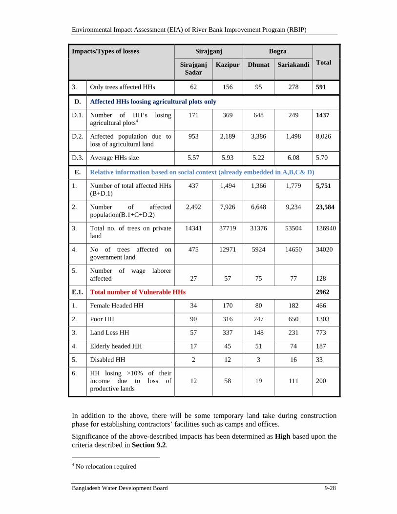
Environmental Impact Assessment (EIA) of River Bank Improvement Program (RBIP)
Bangladesh Water Development Board 9-28
Impacts/Types of losses Sirajganj Bogra
Total Sirajganj Sadar
Kazipur Dhunat Sariakandi
3. Only trees affected HHs 62 156 95 278 591
D. Affected HHs loosing agricultural plots only
D.1. Number of HH’s losing agricultural plots4
171 369 648 249 1437
D.2. Affected population due to loss of agricultural land
953 2,189 3,386 1,498 8,026
D.3. Average HHs size 5.57 5.93 5.22 6.08 5.70
E. Relative information based on social context (already embedded in A,B,C& D)
1. Number of total affected HHs (B+D.1)
437 1,494 1,366 1,779 5,751
2. Number of affected population(B.1+C+D.2)
2,492 7,926 6,648 9,234 23,584
3. Total no. of trees on private land
14341 37719 31376 53504 136940
4. No of trees affected on government land
475 12971 5924 14650 34020
5. Number of wage laborer affected 27 57 75 77 128
E.1. Total number of Vulnerable HHs 2962
1. Female Headed HH 34 170 80 182 466
2. Poor HH 90 316 247 650 1303
3. Land Less HH 57 337 148 231 773
4. Elderly headed HH 17 45 51 74 187
5. Disabled HH 2 12 3 16 33
6. HH losing >10% of their income due to loss of productive lands
12 58 19 111 200
In addition to the above, there will be some temporary land take during construction phase for establishing contractors’ facilities such as camps and offices.
Significance of the above-described impacts has been determined as High based upon the criteria described in Section 9.2.
4 No relocation required
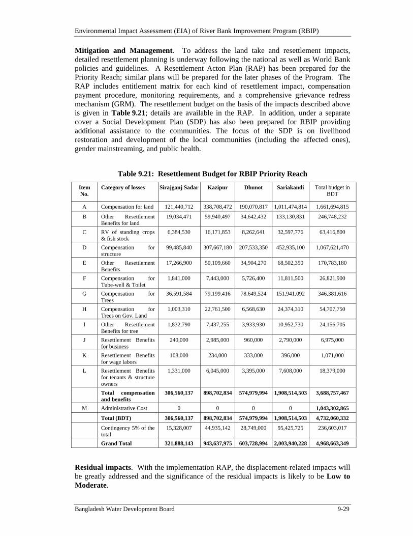
Environmental Impact Assessment (EIA) of River Bank Improvement Program (RBIP)
Bangladesh Water Development Board 9-29
Mitigation and Management. To address the land take and resettlement impacts, detailed resettlement planning is underway following the national as well as World Bank policies and guidelines. A Resettlement Acton Plan (RAP) has been prepared for the Priority Reach; similar plans will be prepared for the later phases of the Program. The RAP includes entitlement matrix for each kind of resettlement impact, compensation payment procedure, monitoring requirements, and a comprehensive grievance redress mechanism (GRM). The resettlement budget on the basis of the impacts described above is given in Table 9.21; details are available in the RAP. In addition, under a separate cover a Social Development Plan (SDP) has also been prepared for RBIP providing additional assistance to the communities. The focus of the SDP is on livelihood restoration and development of the local communities (including the affected ones), gender mainstreaming, and public health.
Table 9.21: Resettlement Budget for RBIP Priority Reach
Item No.
Category of losses Sirajganj Sadar Kazipur Dhunot Sariakandi Total budget in BDT
A Compensation for land 121,440,712 338,708,472 190,070,817 1,011,474,814 1,661,694,815
B Other Resettlement Benefits for land
19,034,471 59,940,497 34,642,432 133,130,831 246,748,232
C RV of standing crops & fish stock
6,384,530 16,171,853 8,262,641 32,597,776 63,416,800
D Compensation for structure
99,485,840 307,667,180 207,533,350 452,935,100 1,067,621,470
E Other Resettlement Benefits
17,266,900 50,109,660 34,904,270 68,502,350 170,783,180
F Compensation for Tube-well & Toilet
1,841,000 7,443,000 5,726,400 11,811,500 26,821,900
G Compensation for Trees
36,591,584 79,199,416 78,649,524 151,941,092 346,381,616
H Compensation for Trees on Gov. Land
1,003,310 22,761,500 6,568,630 24,374,310 54,707,750
I Other Resettlement Benefits for tree
1,832,790 7,437,255 3,933,930 10,952,730 24,156,705
J Resettlement Benefits for business
240,000 2,985,000 960,000 2,790,000 6,975,000
K Resettlement Benefits for wage labors
108,000 234,000 333,000 396,000 1,071,000
L Resettlement Benefits for tenants & structure owners
1,331,000 6,045,000 3,395,000 7,608,000 18,379,000
Total compensation and benefits
306,560,137 898,702,834 574,979,994 1,908,514,503 3,688,757,467
M Administrative Cost 0 0 0 0 1,043,302,865
Total (BDT) 306,560,137 898,702,834 574,979,994 1,908,514,503 4,732,060,332
Contingency 5% of the total
15,328,007 44,935,142 28,749,000 95,425,725 236,603,017
Grand Total 321,888,143 943,637,975 603,728,994 2,003,940,228 4,968,663,349
Residual impacts. With the implementation RAP, the displacement-related impacts will be greatly addressed and the significance of the residual impacts is likely to be Low to Moderate.
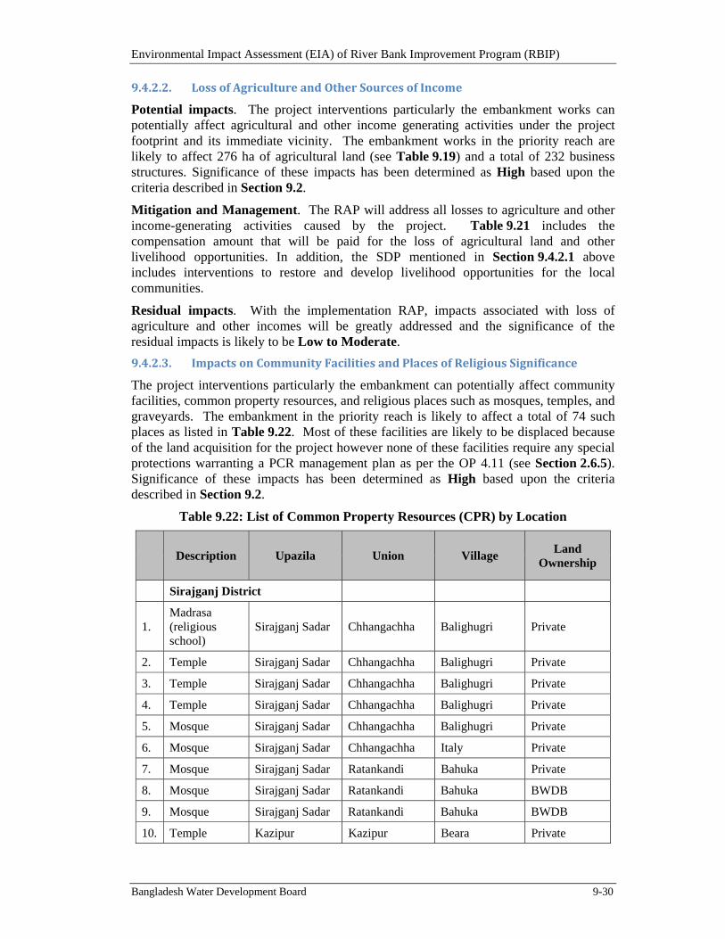
Environmental Impact Assessment (EIA) of River Bank Improvement Program (RBIP)
Bangladesh Water Development Board 9-30
9.4.2.2. LossofAgricultureandOtherSourcesofIncome
Potential impacts. The project interventions particularly the embankment works can potentially affect agricultural and other income generating activities under the project footprint and its immediate vicinity. The embankment works in the priority reach are likely to affect 276 ha of agricultural land (see Table 9.19) and a total of 232 business structures. Significance of these impacts has been determined as High based upon the criteria described in Section 9.2.
Mitigation and Management. The RAP will address all losses to agriculture and other income-generating activities caused by the project. Table 9.21 includes the compensation amount that will be paid for the loss of agricultural land and other livelihood opportunities. In addition, the SDP mentioned in Section 9.4.2.1 above includes interventions to restore and develop livelihood opportunities for the local communities.
Residual impacts. With the implementation RAP, impacts associated with loss of agriculture and other incomes will be greatly addressed and the significance of the residual impacts is likely to be Low to Moderate.
9.4.2.3. ImpactsonCommunityFacilitiesandPlacesofReligiousSignificance
The project interventions particularly the embankment can potentially affect community facilities, common property resources, and religious places such as mosques, temples, and graveyards. The embankment in the priority reach is likely to affect a total of 74 such places as listed in Table 9.22. Most of these facilities are likely to be displaced because of the land acquisition for the project however none of these facilities require any special protections warranting a PCR management plan as per the OP 4.11 (see Section 2.6.5). Significance of these impacts has been determined as High based upon the criteria described in Section 9.2.
Table 9.22: List of Common Property Resources (CPR) by Location
Description Upazila Union Village Land
Ownership
Sirajganj District
1. Madrasa (religious school)
Sirajganj Sadar Chhangachha Balighugri Private
2. Temple Sirajganj Sadar Chhangachha Balighugri Private
3. Temple Sirajganj Sadar Chhangachha Balighugri Private
4. Temple Sirajganj Sadar Chhangachha Balighugri Private
5. Mosque Sirajganj Sadar Chhangachha Balighugri Private
6. Mosque Sirajganj Sadar Chhangachha Italy Private
7. Mosque Sirajganj Sadar Ratankandi Bahuka Private
8. Mosque Sirajganj Sadar Ratankandi Bahuka BWDB
9. Mosque Sirajganj Sadar Ratankandi Bahuka BWDB
10. Temple Kazipur Kazipur Beara Private
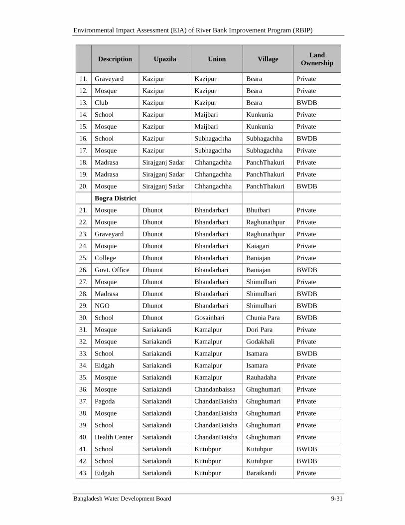
Environmental Impact Assessment (EIA) of River Bank Improvement Program (RBIP)
Bangladesh Water Development Board 9-31
Description Upazila Union Village Land
Ownership
11. Graveyard Kazipur Kazipur Beara Private
12. Mosque Kazipur Kazipur Beara Private
13. Club Kazipur Kazipur Beara BWDB
14. School Kazipur Maijbari Kunkunia Private
15. Mosque Kazipur Maijbari Kunkunia Private
16. School Kazipur Subhagachha Subhagachha BWDB
17. Mosque Kazipur Subhagachha Subhagachha Private
18. Madrasa Sirajganj Sadar Chhangachha PanchThakuri Private
19. Madrasa Sirajganj Sadar Chhangachha PanchThakuri Private
20. Mosque Sirajganj Sadar Chhangachha PanchThakuri BWDB
Bogra District
21. Mosque Dhunot Bhandarbari Bhutbari Private
22. Mosque Dhunot Bhandarbari Raghunathpur Private
23. Graveyard Dhunot Bhandarbari Raghunathpur Private
24. Mosque Dhunot Bhandarbari Kaiagari Private
25. College Dhunot Bhandarbari Baniajan Private
26. Govt. Office Dhunot Bhandarbari Baniajan BWDB
27. Mosque Dhunot Bhandarbari Shimulbari Private
28. Madrasa Dhunot Bhandarbari Shimulbari BWDB
29. NGO Dhunot Bhandarbari Shimulbari BWDB
30. School Dhunot Gosainbari Chunia Para BWDB
31. Mosque Sariakandi Kamalpur Dori Para Private
32. Mosque Sariakandi Kamalpur Godakhali Private
33. School Sariakandi Kamalpur Isamara BWDB
34. Eidgah Sariakandi Kamalpur Isamara Private
35. Mosque Sariakandi Kamalpur Rauhadaha Private
36. Mosque Sariakandi Chandanbaissa Ghughumari Private
37. Pagoda Sariakandi ChandanBaisha Ghughumari Private
38. Mosque Sariakandi ChandanBaisha Ghughumari Private
39. School Sariakandi ChandanBaisha Ghughumari Private
40. Health Center Sariakandi ChandanBaisha Ghughumari Private
41. School Sariakandi Kutubpur Kutubpur BWDB
42. School Sariakandi Kutubpur Kutubpur BWDB
43. Eidgah Sariakandi Kutubpur Baraikandi Private
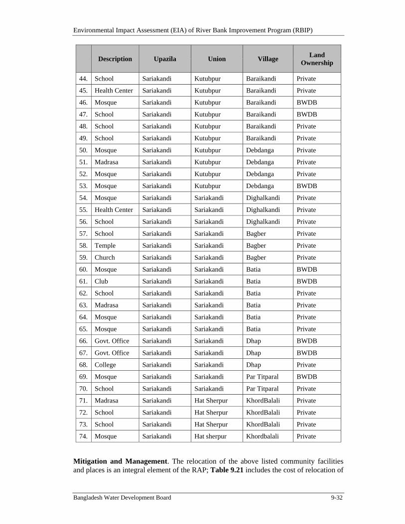
Environmental Impact Assessment (EIA) of River Bank Improvement Program (RBIP)
Bangladesh Water Development Board 9-32
Description Upazila Union Village Land
Ownership
44. School Sariakandi Kutubpur Baraikandi Private
45. Health Center Sariakandi Kutubpur Baraikandi Private
46. Mosque Sariakandi Kutubpur Baraikandi BWDB
47. School Sariakandi Kutubpur Baraikandi BWDB
48. School Sariakandi Kutubpur Baraikandi Private
49. School Sariakandi Kutubpur Baraikandi Private
50. Mosque Sariakandi Kutubpur Debdanga Private
51. Madrasa Sariakandi Kutubpur Debdanga Private
52. Mosque Sariakandi Kutubpur Debdanga Private
53. Mosque Sariakandi Kutubpur Debdanga BWDB
54. Mosque Sariakandi Sariakandi Dighalkandi Private
55. Health Center Sariakandi Sariakandi Dighalkandi Private
56. School Sariakandi Sariakandi Dighalkandi Private
57. School Sariakandi Sariakandi Bagber Private
58. Temple Sariakandi Sariakandi Bagber Private
59. Church Sariakandi Sariakandi Bagber Private
60. Mosque Sariakandi Sariakandi Batia BWDB
61. Club Sariakandi Sariakandi Batia BWDB
62. School Sariakandi Sariakandi Batia Private
63. Madrasa Sariakandi Sariakandi Batia Private
64. Mosque Sariakandi Sariakandi Batia Private
65. Mosque Sariakandi Sariakandi Batia Private
66. Govt. Office Sariakandi Sariakandi Dhap BWDB
67. Govt. Office Sariakandi Sariakandi Dhap BWDB
68. College Sariakandi Sariakandi Dhap Private
69. Mosque Sariakandi Sariakandi Par Titparal BWDB
70. School Sariakandi Sariakandi Par Titparal Private
71. Madrasa Sariakandi Hat Sherpur KhordBalali Private
72. School Sariakandi Hat Sherpur KhordBalali Private
73. School Sariakandi Hat Sherpur KhordBalali Private
74. Mosque Sariakandi Hat sherpur Khordbalali Private
Mitigation and Management. The relocation of the above listed community facilities and places is an integral element of the RAP; Table 9.21 includes the cost of relocation of
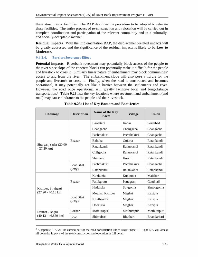
Environmental Impact Assessment (EIA) of River Bank Improvement Program (RBIP)
Bangladesh Water Development Board 9-33
these structures or facilities. The RAP describes the procedure to be adopted to relocate these facilities. The entire process of re-construction and relocation will be carried out in complete coordination and participation of the relevant community and in a culturally- and socially-acceptable manner.
Residual impacts. With the implementation RAP, the displacement-related impacts will be greatly addressed and the significance of the residual impacts is likely to be Low to Moderate.
9.4.2.4. Barrier/SeveranceEffect
Potential impacts. Riverbank revetment may potentially block access of the people to the river since slope of the concrete blocks can potentially make it difficult for the people and livestock to cross it. Similarly linear nature of embankment may block communities’ access to and from the river. The embankment slope will also pose a hurdle for the people and livestock to cross it. Finally, when the road is constructed and becomes operational, it may potentially act like a barrier between the settlements and river. However, the road once operational will greatly facilitate local and long-distance transportation.5 Table 9.23 lists the key locations where revetment and embankment (and road) may cause hindrance to the people and their livestock.
Table 9.23: List of Key Bazaars and Boat Jetties
Chainage Description Name of the Key
Places Village Union
Sirajganj sadar (20.00 - 27.20 km)
Bazaar
Baoaitara Kadai Soidabad
Changacha Changacha Changacha
Pachthakuri Pachthakuri Changacha
Bahuka Gojaria Ratankandi
Ratankandi Ratankandi Ratankandi
Chilgacha Ratankandi Ratankandi
Shimanto Kurali Ratankandi
Boat Ghat (jetty)
Pachthakuri Pachthakuri Changacha
Ratankandi Ratankandi Ratankandi
Kazipur, Sirajganj (27.20 - 40.13 km)
Bazaar
Kunkunia Kunkunia Maizbari
Patokgram Pattagram Gandhail
Hatkhola Suvgacha Shuvogacha
Boat Ghat (jetty)
Meghai, Kazipur Meghai Kazipur
Khutbandhi Meghai Kazipur
Dhekuria Meghai Kazipur
Dhunat , Bogra (40.13 - 46.850 km)
Bazaar Mothurapur Mothurapur Mothurapur
Boat Shimubari Bhutbari Bhandarbari
5 A separate EIA will be carried out for the road construction under RBIP Phase III. That EIA will assess all potential impacts of the road construction and operation in full detail.
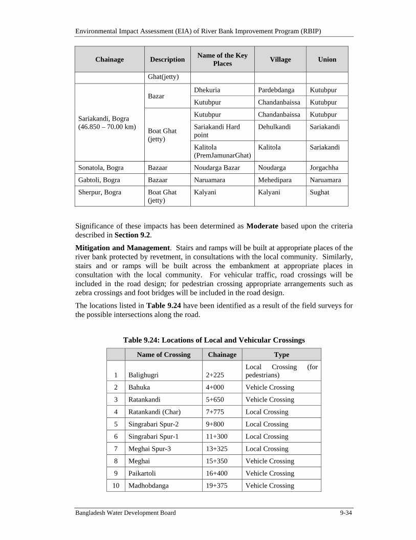
Environmental Impact Assessment (EIA) of River Bank Improvement Program (RBIP)
Bangladesh Water Development Board 9-34
Chainage Description Name of the Key
Places Village Union
Ghat(jetty)
Sariakandi, Bogra (46.850 – 70.00 km)
Bazar Dhekuria Pardebdanga Kutubpur
Kutubpur Chandanbaissa Kutubpur
Boat Ghat (jetty)
Kutubpur Chandanbaissa Kutubpur
Sariakandi Hard point
Dehulkandi Sariakandi
Kalitola (PremJamunarGhat)
Kalitola Sariakandi
Sonatola, Bogra Bazaar Noudarga Bazar Noudarga Jorgachha
Gabtoli, Bogra Bazaar Naruamara Mehedipara Naruamara
Sherpur, Bogra Boat Ghat (jetty)
Kalyani Kalyani Sughat
Significance of these impacts has been determined as Moderate based upon the criteria described in Section 9.2.
Mitigation and Management. Stairs and ramps will be built at appropriate places of the river bank protected by revetment, in consultations with the local community. Similarly, stairs and or ramps will be built across the embankment at appropriate places in consultation with the local community. For vehicular traffic, road crossings will be included in the road design; for pedestrian crossing appropriate arrangements such as zebra crossings and foot bridges will be included in the road design.
The locations listed in Table 9.24 have been identified as a result of the field surveys for the possible intersections along the road.
Table 9.24: Locations of Local and Vehicular Crossings
Name of Crossing Chainage Type
1 Balighugri 2+225 Local Crossing (for pedestrians)
2 Bahuka 4+000 Vehicle Crossing
3 Ratankandi 5+650 Vehicle Crossing
4 Ratankandi (Char) 7+775 Local Crossing
5 Singrabari Spur-2 9+800 Local Crossing
6 Singrabari Spur-1 11+300 Local Crossing
7 Meghai Spur-3 13+325 Local Crossing
8 Meghai 15+350 Vehicle Crossing
9 Paikartoli 16+400 Vehicle Crossing
10 Madhobdanga 19+375 Vehicle Crossing
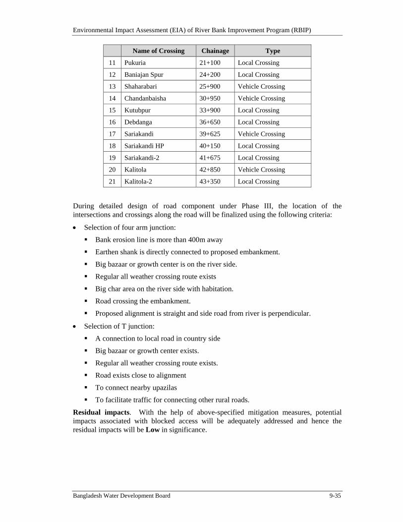
Environmental Impact Assessment (EIA) of River Bank Improvement Program (RBIP)
Bangladesh Water Development Board 9-35
Name of Crossing Chainage Type
11 Pukuria 21+100 Local Crossing
12 Baniajan Spur 24+200 Local Crossing
13 Shaharabari 25+900 Vehicle Crossing
14 Chandanbaisha 30+950 Vehicle Crossing
15 Kutubpur 33+900 Local Crossing
16 Debdanga 36+650 Local Crossing
17 Sariakandi 39+625 Vehicle Crossing
18 Sariakandi HP 40+150 Local Crossing
19 Sariakandi-2 41+675 Local Crossing
20 Kalitola 42+850 Vehicle Crossing
21 Kalitola-2 43+350 Local Crossing
During detailed design of road component under Phase III, the location of the intersections and crossings along the road will be finalized using the following criteria:
Selection of four arm junction:
Bank erosion line is more than 400m away
Earthen shank is directly connected to proposed embankment.
Big bazaar or growth center is on the river side.
Regular all weather crossing route exists
Big char area on the river side with habitation.
Road crossing the embankment.
Proposed alignment is straight and side road from river is perpendicular.
Selection of T junction:
A connection to local road in country side
Big bazaar or growth center exists.
Regular all weather crossing route exists.
Road exists close to alignment
To connect nearby upazilas
To facilitate traffic for connecting other rural roads.
Residual impacts. With the help of above-specified mitigation measures, potential impacts associated with blocked access will be adequately addressed and hence the residual impacts will be Low in significance.
Environmental Impact Assessment (EIA) of River Bank Improvement Program (RBIP)
Bangladesh Water Development Board 9-36
9.4.3. SignificantEnvironmentalImpactsduringConstruction
9.4.3.1. ImpactsfromBorrowAreasandWaterUse
Potential impacts. During the construction phase, RBIP will need sand for construction of embankment and filling of geo-bags for riverbank protection. Sand will be extracted from the river banks with the help of small pumps. For the entire works under the Phase I, about 23 million m3 of sand would be needed (see Table 3.7). Sand extraction can potentially cause negative impacts on the aquatic fauna although because of the high silt load in the river water, the sand extraction areas will rapidly be covered with fresh sediments hence minimizing any long lasting impacts. Earth if obtained from the cultivation fields can lead to significant impact on the already scarce cultivable land in the area.
Although, the sand extraction locations are not known at this stage, it can be assumed that the contractors will prefer to collect sand from the nearest shallow semi-permanent sand bars. It is estimated that about 500 ha of riverbed / riverbank would be affected by the sand extraction during each dry season (basis: about 23 million m3 sand needed; about 10 million m3 sand to be extracted each year along about 50 km river stretch with depth of about 2 m). Sand extraction may potentially decrease the quality of river habitat by increasing the water turbidity which may potentially affect the aquatic fauna including fish and dolphin. If this activity takes place during the breeding season (July to August) of fish and dolphin then it may negatively affect their population dynamics as well. The sand extraction if carried out during nighttime may potentially affect the wintering birds that are mostly found on chars. Similarly, the sand extraction can potentially affect turtles particularly if the activity is carried out near chars.
Several carp spawn collection area, some koles (embayment), and important charlands having waterfowl habitats were identified during the baseline survey. The sand extraction may potentially temporarily impact these areas by reducing feeding ground, creating noise, illumination, and increasing water turbidity. In addition, benthic fauna, phytoplankton and zooplankton may potentially be affected at the sand extraction sites ultimately disrupting the food chain, and as a result, tertiary level animals such as fish, birds, and dolphins that feed on these primary and secondary level fauna are likely to temporarily leave the area. The loss of fish production from the affected river area due to sand extraction is estimated to be about 45 tonnes during each year of sand extraction (considering that the annual fish production rate of the Jamuna river is 90kg/ha/year). The disturbed river productivity will be restored by next flooding season due to natural sedimentation process of the river. Furthermore, this temporary loss will be more than compensated with the expected increase in the fish production on a permanent basis.
A limited quantity of earth (about 24,000 m3; see Table 3.7) will also be needed for embankment cladding. Earth if obtained from the cultivation fields can lead to significant impact on the already scarce cultivable land in the area.
Water will be used in the construction process for various purposes including compaction, concreting, curing, concrete block making, and water sprinkling for dust suppression. In addition, water would also be needed in the camps and offices.
Significance of the above impacts has been determined as High based upon the criteria described in Section 9.2.
Mitigation and Management. The contractor will be required to prepare the Borrow Area Management Plan and obtain approval from the construction supervision consultants
Environmental Impact Assessment (EIA) of River Bank Improvement Program (RBIP)
Bangladesh Water Development Board 9-37
(CSC). Sand extraction from river bank will be carried out in an environmentally and ecologically safe manner. Only small quantities of sand will be collected from any single location and stretches of riverbank will be left undisturbed between the locations from where the sand is extracted – in order not to disturb long, unbroken stretches of river bank thus allowing the aquatic fauna to rejuvenate at the sand extraction locations. Sand extraction will not be permitted at or in the vicinity of sensitive habitats.
The contractor will obtain clearance from the CSC before sand extraction can be carried out at any particular location. The CSC will issue this clearance after surveying the area and ensuring that no critical habitat such as for turtles exists at/near such location.
The minor loss of fish production and the possible affect on the earnings of the local fishermen will be compensated through the implementation of livelihood restoration and development initiative to be implemented under the SDP described earlier as well.
BWDB through consultants will initiate monitoring during the construction phase and to be continued thereafter to determine any long lasting impacts of sand extraction and to identify any mitigation measures if so needed. The ToR of the monitoring is presented in Annex F.
No earth will be obtained from any cultivation fields; the existing embankments will be excavated to obtain the earth required for the embankment cladding.
Water will be obtained from the existing sources after reaching agreements with the relevant community and after paying the appropriate cost. Otherwise new tube-wells will be installed but maintaining safe distances from the existing ones thus ensuring no draw down of water in them. The grievance redress mechanism (GRM) will also be put in place to address community complaints.
Residual impacts. With the help of the mitigation measures described above, the potential impacts associated with sand and soil extraction and water procurement will be adequately addressed and hence the significance of the residual impacts is likely to be Low.
9.4.3.2. AirPollutionandGreenhouseGasesEmissionsfromConstructionWorks
Potential impacts. Construction of bank revetment, embankment and road works will generate emissions from excavation equipment, other machinery and construction traffic. The emissions will also include greenhouse gases (GHGs) from engine fuel combustion (exhaust emissions) and evaporation and leaks from vehicles (fugitive emissions) and emissions from asphalt works. Table 9.25 shows the total emissions of Reactive Organic Gases (ROG), carbon monoxide (CO), nitrogen oxides (NOx), sulfur oxides (SOx), particulate matter (PM), carbon dioxide (CO2), methane (CH4) and nitrous oxide (N2O) generated by construction of embankment and revetment (from 2015 to 2019) and road works (from 2019 to 2020). Total GHG emissions in terms of CO2 equivalent are shown in Table 9.26. It is estimated that about 0.019 million tonnes of CO2 will be emitted during the six years of construction period from all the construction activities. The emissions from construction activities will deteriorate the ambient air quality and affect the public health. The dense populated areas and crowded market places (bazaars) are particularly vulnerable to these impacts. In addition, dust generated from the above activities will also have impacts on crops and livestock. These impacts have been assessed as Moderate Adverse.
Environmental Impact Assessment (EIA) of River Bank Improvement Program (RBIP)
Bangladesh Water Development Board 9-38
Table 9.25: Total Emissions (in tonnes) from Construction Equipment Usage
Year ROG CO NOX SOX PM CO2 CH4 N2O
2015 4.8 22.3 34.4 0.043 2.0 3,797.9 0.4 0.2
2016 4.8 22.3 34.4 0.043 2.0 3,797.9 0.4 0.2
2017 4.8 22.3 34.4 0.043 2.0 3,797.9 0.4 0.2
2018 4.8 22.3 34.4 0.043 2.0 3,797.9 0.4 0.2
2019 5.2 23.3 35.4 0.037 2.1 3,894.4 0.5 0.2
2020 0.4 1.0 0.9 0.001 1.8 96.5 0.0 0.0
Total 24.8 113.6 174.1 0.2 10.4 19,182.3 2.2 1.0
Note: List of equipment used for construction works and emission factors are given in Annex H.
Table 9.26: Greenhouse Gases Emission during Construction (in tonnes)
Year CO2 CH4 (CO2e) N2O (CO2e) Total CO2e
2015 3,797.9 10.9 130.6 3,939
2016 3,797.9 10.9 130.6 3,939
2017 3,797.9 10.9 130.6 3,939
2018 3,797.9 10.9 130.6 3,939
2019 3,894.4 11.7 140.2 4,046
2020 96.5 0.8 9.7 107
Total Project 19,182 56 672 19,911
Note: Conversion factors are from IPCC 2007 Fourth Assessment Report (pg. 212)
Mitigation and management. To mitigate deterioration of air quality and generation of dust, following measures will be taken:
The equipment and vehicles used during the construction process will comply with the national standards as well as WBG EHS Guidelines on emission exhausts.
Concrete batching and asphalt plants will be located minimum 500 m away from residential areas and will have appropriate dust/emission suppression mechanisms such as wet scrubbers.
Contractor will implement dust prevention measures such as watering of roads near the residential areas and spraying of water on loose material where required and appropriate.
Continuous air monitoring will be carried out near the sensitive receptors (Table 9.22) to ensure ambient air quality remains within the limits defined by EQS and WBG EHS Guidelines.
Construction materials will be stored away from the residential areas and will be properly covered.
Measures will be taken to protect the workers from excessive dust (ie, usage of personal protective equipment).
Environmental Impact Assessment (EIA) of River Bank Improvement Program (RBIP)
Bangladesh Water Development Board 9-39
A GRM (discussed later in the document) will be put in place to receive complaints from public on various aspects of environmental issues, including air pollution. These grievances will be addressed by the contractor by adopting necessary pollution control measures. Continued consultations with the affected communities will be carried out during construction phase.
To reduce the greenhouse gases emissions, a series of vehicle exhaust emission controls will be implemented. These include regular maintenance of vehicles, plant and machinery in accordance with manufacturer’s specifications; monthly visual inspections on vehicle and plant exhausts to identify excessive emissions of smoke, and maintenance undertaken where required; switch off / throttle down all site vehicles and machinery when not in use; and avoid unnecessary idling of equipment.
In addition, the measures in Environmental Codes of Practice (ECoP) on air quality management will be implemented (ECoPs are discussed later in the document and presented in Annex I).
Residual impacts. With the help of the above mitigation measures, the potential impacts associated with air quality deterioration are likely to be adequately addressed and hence the residual impact is likely to be Low in significance.
9.4.3.3. NoisePollutionfromConstructionWorks
Potential impacts. Noise will be produced by vehicular movement, excavation machinery, concrete mixing, and other construction activities. Noise levels from construction activities will exceed the standards. The schools, religious places and crowded market areas are particularly vulnerable to the increased noise levels (see list of such facilities in Table 9.22). Noise levels resulting from construction works are estimated using US Federal Highway Administration's (FHWA) Roadway Construction Noise Model (RCNM) and presented in Table 9.27. These impacts have been assessed as Moderate Adverse.
Table 9.27: Noise Impact from Construction Activities
Source
Noise levels Leq [1h]
100 m from source
250 m from source
500 m from source
1000 m from source
Revetment Works 77 69 63 57
Embankment Works 75 67 61 55
Road Works 71 63 57 51
Mitigation and management. To mitigate impacts associated with noise generation, following measures will be taken:
The equipment and vehicles used during the construction process will comply with the national standards as well as WBG EHS Guidelines on noise.
Continuous monitoring of noise levels will be carried out to ensure they do not exceed national standards.
Contractors will adopt appropriate noise attenuation measures to reduce the noise generation from construction activities. The noise attenuation measures will include,
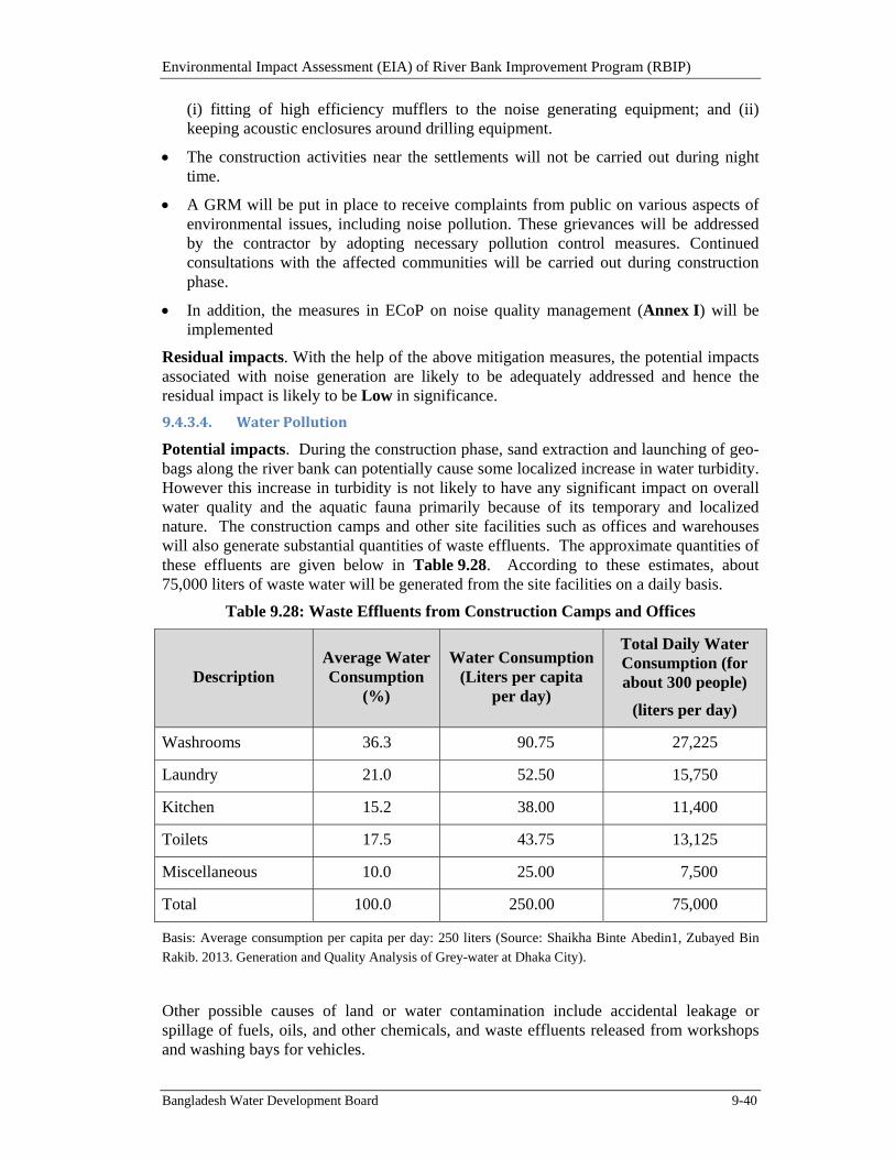
Environmental Impact Assessment (EIA) of River Bank Improvement Program (RBIP)
Bangladesh Water Development Board 9-40
(i) fitting of high efficiency mufflers to the noise generating equipment; and (ii) keeping acoustic enclosures around drilling equipment.
The construction activities near the settlements will not be carried out during night time.
A GRM will be put in place to receive complaints from public on various aspects of environmental issues, including noise pollution. These grievances will be addressed by the contractor by adopting necessary pollution control measures. Continued consultations with the affected communities will be carried out during construction phase.
In addition, the measures in ECoP on noise quality management (Annex I) will be implemented
Residual impacts. With the help of the above mitigation measures, the potential impacts associated with noise generation are likely to be adequately addressed and hence the residual impact is likely to be Low in significance.
9.4.3.4. WaterPollution
Potential impacts. During the construction phase, sand extraction and launching of geo-bags along the river bank can potentially cause some localized increase in water turbidity. However this increase in turbidity is not likely to have any significant impact on overall water quality and the aquatic fauna primarily because of its temporary and localized nature. The construction camps and other site facilities such as offices and warehouses will also generate substantial quantities of waste effluents. The approximate quantities of these effluents are given below in Table 9.28. According to these estimates, about 75,000 liters of waste water will be generated from the site facilities on a daily basis.
Table 9.28: Waste Effluents from Construction Camps and Offices
Description Average Water Consumption
(%)
Water Consumption (Liters per capita
per day)
Total Daily Water Consumption (for about 300 people)
(liters per day)
Washrooms 36.3 90.75 27,225
Laundry 21.0 52.50 15,750
Kitchen 15.2 38.00 11,400
Toilets 17.5 43.75 13,125
Miscellaneous 10.0 25.00 7,500
Total 100.0 250.00 75,000
Basis: Average consumption per capita per day: 250 liters (Source: Shaikha Binte Abedin1, Zubayed Bin
Rakib. 2013. Generation and Quality Analysis of Grey-water at Dhaka City).
Other possible causes of land or water contamination include accidental leakage or spillage of fuels, oils, and other chemicals, and waste effluents released from workshops and washing bays for vehicles.
Environmental Impact Assessment (EIA) of River Bank Improvement Program (RBIP)
Bangladesh Water Development Board 9-41
These effluents can potentially contaminate the drinking water sources of the area and can also be harmful for the natural vegetation, cultivation fields, water bodies, and aquatic flora and fauna. Figure 6.23 (and Annex C) includes the location of the water bodies (khals and beels) in the project influence area and their distance from the proposed embankment alignment; some of these water bodies are quite close to the alignment (eg, Kothir Pinjira khal, WAPDA khal, and Balia Ghugri khal).
Significance of the above-described impacts has been determined as High based upon the criteria described in Section 9.2.
Mitigation and Management. A methodology will be prepared for the river bank protection works in which the geo-bag launching will not be carried out in long stretches of the bank simultaneously. In this manner any increased water turbidity will remain limited and localized in nature hence avoiding any significant impact on overall water quality and aquatic fauna.
Similarly, sand extraction will not be carried out in long, contiguous stretches hence minimizing the extent of water pollution caused by this activity.
The contractors will be responsible to prepare and implement a waste and pollution management plan. The Plan will need to be cleared by the Construction Supervision Consultants (CSC) before it can be implemented. The Plan will include categorization and quantities, treatment mechanism (such as retention ponds and septic tanks), and final disposal of various waste streams; monitoring protocols; roles and responsibilities for the personnel assigned to implement the Plan; and documentation requirements.
For avoiding and managing any accidental leakages and spillages, standard operating procedures will be included in the Health, safety, and Environment (HSE) Plan. Monitoring of drinking water sources and other key water bodies in the area will also be carried out to ensure that these water resources are not affected by the project activities.
Residual impacts. With the help of the above mitigation measures, the potential impacts associated with water pollution are likely to be adequately addressed and hence the residual impact is likely to be Low in significance.
9.4.3.5. SoilContamination
Potential impacts. Much like water pollution discussed above, soils in the construction area and nearby lands that are used for agriculture will be prone to pollution from the construction activities, construction yards, workers camps and other construction areas. Fuel and hazardous material storage sites and their handling are also the potential sources for soil and water pollution. Improper siting, storage and handling of fuels, lubricants, chemicals and hazardous materials, and potential spills from these will severely impact the soil and water quality and also cause safety and health hazards. Significance of these impacts has been determined as High based upon the criteria described in Section 9.2.
Mitigation and Management. For avoiding and managing any accidental leakages and spillages, standard operating procedures (including the requirement of secondary containment for fuels, oils, and other hazardous substances) will be included in the HSE Plan. The contractors will also be responsible to prepare and implement a waste and pollution management plan. For the effluents to be released from workshops, camps, and offices, appropriate treatment arrangements such as retention ponds and septic tanks will be incorporated in the facility design.
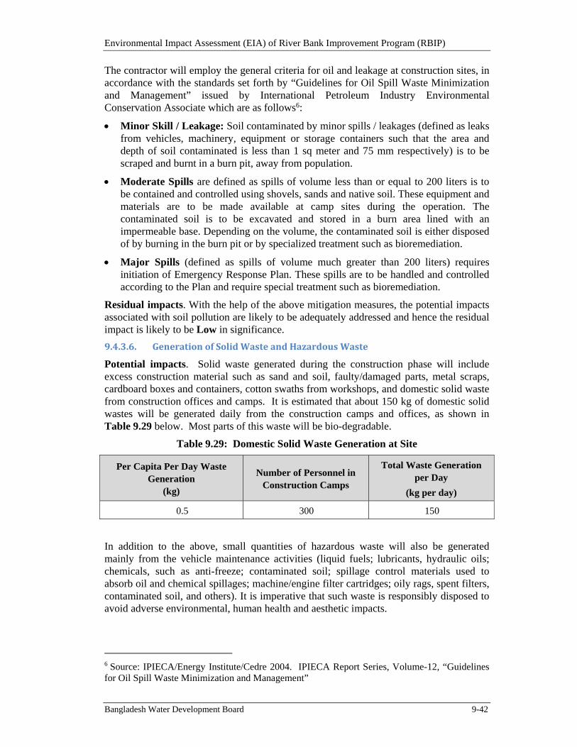
Environmental Impact Assessment (EIA) of River Bank Improvement Program (RBIP)
Bangladesh Water Development Board 9-42
The contractor will employ the general criteria for oil and leakage at construction sites, in accordance with the standards set forth by “Guidelines for Oil Spill Waste Minimization and Management” issued by International Petroleum Industry Environmental Conservation Associate which are as follows6:
Minor Skill / Leakage: Soil contaminated by minor spills / leakages (defined as leaks from vehicles, machinery, equipment or storage containers such that the area and depth of soil contaminated is less than 1 sq meter and 75 mm respectively) is to be scraped and burnt in a burn pit, away from population.
Moderate Spills are defined as spills of volume less than or equal to 200 liters is to be contained and controlled using shovels, sands and native soil. These equipment and materials are to be made available at camp sites during the operation. The contaminated soil is to be excavated and stored in a burn area lined with an impermeable base. Depending on the volume, the contaminated soil is either disposed of by burning in the burn pit or by specialized treatment such as bioremediation.
Major Spills (defined as spills of volume much greater than 200 liters) requires initiation of Emergency Response Plan. These spills are to be handled and controlled according to the Plan and require special treatment such as bioremediation.
Residual impacts. With the help of the above mitigation measures, the potential impacts associated with soil pollution are likely to be adequately addressed and hence the residual impact is likely to be Low in significance.
9.4.3.6. GenerationofSolidWasteandHazardousWaste
Potential impacts. Solid waste generated during the construction phase will include excess construction material such as sand and soil, faulty/damaged parts, metal scraps, cardboard boxes and containers, cotton swaths from workshops, and domestic solid waste from construction offices and camps. It is estimated that about 150 kg of domestic solid wastes will be generated daily from the construction camps and offices, as shown in Table 9.29 below. Most parts of this waste will be bio-degradable.
Table 9.29: Domestic Solid Waste Generation at Site
Per Capita Per Day Waste Generation
(kg)
Number of Personnel in Construction Camps
Total Waste Generation per Day
(kg per day)
0.5 300 150
In addition to the above, small quantities of hazardous waste will also be generated mainly from the vehicle maintenance activities (liquid fuels; lubricants, hydraulic oils; chemicals, such as anti-freeze; contaminated soil; spillage control materials used to absorb oil and chemical spillages; machine/engine filter cartridges; oily rags, spent filters, contaminated soil, and others). It is imperative that such waste is responsibly disposed to avoid adverse environmental, human health and aesthetic impacts.
6 Source: IPIECA/Energy Institute/Cedre 2004. IPIECA Report Series, Volume-12, “Guidelines for Oil Spill Waste Minimization and Management”
Environmental Impact Assessment (EIA) of River Bank Improvement Program (RBIP)
Bangladesh Water Development Board 9-43
Inappropriate disposal of these wastes can lead to soil and water contamination as well as health hazards for the local communities, livestock, and aquatic as well as terrestrial fauna. Significance of these impacts has been determined as High based upon the criteria described in Section 9.2.
Mitigation and management. Contractors will be required to prepare and implement a Waste and Pollution Management Plan in accordance with the WB EHS Guidelines and ECoP. The Plan will be prepared on the 3R principle (reduce, reuse, and recycle), and will specify appropriate disposal mechanism and place for each type of waste. Particular attention will be focused on hazardous waste and it will not be released to the environment in any circumstance. Appropriate procedure such as MSDS will be used to dispose hazardous wastes. Complete record will be maintained for waste disposal. The GRM will also capture any complaints related to inappropriate solid waste disposal.
As an environmental enhancement measure, the project will prepare a waste management plan for the communities along the embankment. The Plan will be prepared under the Social Development Plan of RBIP, during the construction phase of the project.
Residual impacts. With the help of the above mitigation measures, the potential impacts associated with solid waste generation are likely to be adequately addressed and hence the residual impact is likely to be Low in significance.
9.4.3.7. ImpactonAquaticandFloodplainHabitats
Potential impacts. Sand extraction from the riverbank, launching of geo-bags, and placement of concrete blocks for the river revetment may potentially disturb the aquatic habitat by increasing the water turbidity (siting impacts
of these activities have already been discussed in Section 9.4.1.5). Significance of these impacts has been determined as Moderate based upon the criteria described in Section 9.2.
Some sensitive and important habitats exist in the river chars (shoals) for wintering birds and some of the river channels for fish and dolphins (Figures 6.2 and 6.3). Similarly some of the beels (wetlands) in the floodplain provide important habitat for aquatic fauna. However embankment construction activities are not likely to have any direct impact on terrestrial or aquatic wildlife or their habitat since no sensitive ecological hot spots have been identified along the existing and proposed alignment (see Tables 6.6, 6.15, and 6.16 and also Annex C) for the key sensitive habitats in the area). However any accidental leakage, spillage of contaminants, or dumping of solid waste/debris on land or in water bodies can potentially affect these habitats. Significance of these impacts has been determined as High based upon the criteria described in Section 9.2.
During the project-related boat traffic, there is a potential risk of collisions with fish and dolphins. This can cause injuries and even fatalities to these species.
Mitigation and Management. The potential impacts on the aquatic fauna can be at least partially addressed by not carrying out sand extraction and revetments along long, contiguous sections of the river bank at a time, as already described earlier. This measure is likely to keep the increased water turbidity and any other impacts on aquatic habitat localized and minimized, in addition to help rejuvenate the benthic fauna. In addition, the geo-bags and concrete blocks are likely to provide habitat for aquatic fauna such as eels. However to further understand the impact of revetment on aquatic fauna and characteristics of the new habitat provided by geo-bags and concrete blocks a long term monitoring and data collection is needed. This will be initiated during the project
Environmental Impact Assessment (EIA) of River Bank Improvement Program (RBIP)
Bangladesh Water Development Board 9-44
construction phase and continued thereafter; attempts will be made to involve national and international research and educational organization for this purpose. See Annex E for the ToR of this monitoring program.
Construction-related boat movement (for sand extraction and revetment works) will be restricted to within 500 m of river bank, which should minimize their impact on river dolphins. Motor boat speed will be limited to 15 km/h in accordance with best international practices. Pingers will be used to chase away dolphins form the construction areas thus minimizing the chances of any collision.
Any negative impacts on terrestrial or aquatic flora and fauna through land and water contamination can be adequately addressed by adopting pollution control measures implementation of which will be a binding on the contractors (see Sections 9.4.3.4 to 9.4.3.6).
Residual impacts. With the help of the above mitigation measures, the potential impacts associated with aquatic habitat are likely to be somewhat addressed and hence the residual impact is likely to remain Low to Moderate in significance. On the other hand, environmental enhancement measures have been included in the project the form of conservation of dolphins and establishment of fish sanctuaries as an offset program in accordance with the provisions of OP 4.04 to deal with any residual impacts.
9.4.3.8. ImpactonCharlandHabitat
Potential impacts. The construction activities are not likely to affect the wintering birds that are mainly found in the chars (shoals) since these chars are across the river channels and quite away from the construction sites. If any sand extraction activities are located near chars, noise generated from these activities has a potential to affect the migratory birds. However, due to the vast habitat range of these birds along the chars in Jamuna, the project is not expected to have any impacts on the migratory birds. If any construction activities disturb their roosting, hunting and feeding grounds, they would move to another lesser or undisturbed areas without any difficulty. Significance of these impacts has been determined as Minimal based upon the criteria described in Section 9.2.
Mitigation and Management. The contractors will be required to reduce the noise levels generated from the construction activities by providing mufflers or acoustic enclosures for high noise generating equipment. The Contractor will also raise awareness about the protection of birds among the work force to reduce impacts such as disturbance and poaching.
In addition to the above, environmental enhancement measures in the form of sanctuaries and conservation areas have been included in the project as an offset program in accordance with the provisions of OP 4.04 to deal with any residual impacts.
Residual impacts. With the help of the above mitigation measures, the potential impacts associated with charland habitat are likely to be somewhat addressed and hence the residual impact is likely to remain Minimal in significance.
9.4.3.9. SiteclearanceandRestoration
Potential impacts. After the completion of the construction activities, the left over construction material, debris, spoils, scraps and other wastes from workshops, and camp sites can potentially create hindrance and encumbrance for the local communities in addition to blocking natural drainage and or irrigation channels. Significance of these impacts has been determined as High based upon the criteria described in Section 9.2.
Environmental Impact Assessment (EIA) of River Bank Improvement Program (RBIP)
Bangladesh Water Development Board 9-45
Mitigation and Management. The contractors will be required to remove all left over construction material, debris, spoils, and other wastes from the construction sites. The camps sites will be completely cleaned and restored in original condition to the extent possible. No waste disposal will be carried out in water channels (khals) or natural depressions and ponds (beels). The contractors will also obtain clearance from DoE in this respect.
Residual impacts. With the help of the above mitigation measures, the potential impacts associated with site clearance are likely to be adequately addressed and hence the residual impact is likely to be Low in significance.
9.4.4. SignificantSocialImpactsduringConstruction
9.4.4.1. ImpactonCulturalHeritage
Potential impacts. Table 9.22 includes sites and buildings of religious and cultural importance such as mosques, temples and graveyards. Many of these structures will have to be relocated because of the reconstruction and rehabilitation of the embankment. Significance of these impacts has been determined as Moderate to High based upon the criteria described in Section 9.2.
Mitigation and Management. The contractors will be required to prepare code of conduct to be followed by all site personnel - to respect religious beliefs and sites, and to conduct in a culturally appropriate manner. In addition, ‘chance find’ procedures will be followed in case of accidental discovery of any sites or artifacts of religious, historical, or cultural importance.
Relocation of places such as mosques and temples will be covered under the RAP and the project will cover the entire cost of such relocation or reconstruction.
Residual impacts. With the help of the above mitigation measures, the potential impacts associated with cultural resources are likely to be adequately addressed and hence the residual impact is likely to be Low in significance.
9.4.4.2. ImpactonCommunityFacilities
Potential impacts. A few schools and other community facilities exist along the embankment; a list of such facilities is included in Table 9.22. The potential impacts of the project on these schools could include relocation, air quality deterioration, noise, and safety hazards.
The construction activities can potentially damage the existing public and private infrastructures such as local roads, foot paths, and boat jetties. This can further aggravate the sufferings of the local communities because of river bank erosion and floods.
Significance of the above impacts has been determined as Moderate based upon the criteria described in Section 9.2.
Mitigation and Management. Any relocation needs of the schools and other community facilities will be adequately covered under the RAP that has been prepared for the Priority Reach. For noise, air quality, and safety hazard, the contractors will be required to ensure that activities in the vicinity of the sensitive receptors such as schools are carried out in a manner so as to minimize these risks (e.g., carrying out the construction activities after the school time). The construction site will be fenced near such places to minimize safety hazards. Safety signage will be placed and coordination will be maintained with the facility management as well as with the community to minimize the risks. Finally, any
Environmental Impact Assessment (EIA) of River Bank Improvement Program (RBIP)
Bangladesh Water Development Board 9-46
complaints of related to project impacts on the sensitive receptors will be addressed through the GRM described earlier.
The RAP covers the replacement and or relocation of the infrastructure that is affected by the direct land take for the project. Other damaged infrastructure affected by the construction activities will be repaired and or restored by the contractor.
Residual impacts. With the help of the above mitigation measures, the potential impacts associated with community facilities are likely to be adequately addressed and hence the residual impact is likely to be Low in significance.
9.4.4.3. BlockageofLocalRoads/Routes/JettiesandTrafficCongestion
Potential impacts. Construction activities for riverbank protection may potentially block/hinder access to boat jetties and also hinder the boat traffic. Similarly, construction works on the embankment may block local roads and routes and may prevent the local people to cross the construction area. Furthermore, the construction works and associated vehicular traffic may cause traffic congestion on local roads, particularly near local markets and boat jetties (see Table 9.23 for list of the key boat jetties and local bazaars in the area). Significance of these impacts has been determined as Moderate based upon the criteria described in Section 9.2.
Mitigation and Management. The contractor will prepare and implement a traffic management plan (for both vehicular as well as boat traffic). Consultations with the local communities will be carried out on an on-going basis and the construction schedule will be discussed with them to ensure that blockage of the local routes is minimized. The construction works particularly at/near the boat jetties and local bazaars will be carefully planned to minimize hindrance to the local communities. The GRM described earlier will address any community grievances related to blocked routes as well. The contractors will be required to prepare and implement a traffic management plan that will be prepared in consultation with the local community and relevant officials.
Residual impacts. With the help of the above mitigation measures, the potential impacts associated with blockage of local routes and roads are likely to be adequately addressed and hence the residual impact is likely to be Low in significance.
9.4.4.4. OccupationalHealthandSafety
Potential impacts. Generally the construction activities will involve large scale excavation, operations of heavy construction machinery and vehicular traffic. These activities may pose health and safety hazards to the workers at site during use of hazardous substances, lifting and handling of heavy equipment, operating machinery and electrical equipment, working near water or at height and more.
The project will need fuels, oils, and asphalt during the construction phase. Inappropriate handling or accidental spillage/leakage of these substances can potentially lead to safety and health hazards for the construction workers as well as the local community.
Significance of the above impacts has been determined as High based upon the criteria described in Section 9.2.
Mitigation and Management. Standard operating procedures will be used to handle, transport, and store hazardous materials during the construction phase. Contractors will be required to prepare and implement Health, Safety, and Environment (HSE) plan at the construction sites and in construction camps. The Plan will need to comply with the WB Environment, Health, and Safety (EHS) Guidelines and Environmental Code of Practice
Environmental Impact Assessment (EIA) of River Bank Improvement Program (RBIP)
Bangladesh Water Development Board 9-47
(ECoP). The Plan will include standard operating procedures for handling with emergencies, accidents, and incidents; roles and responsibilities, training and capacity building requirements; use of personal protective equipment (PPE); rules for handling of equipment and construction materials; and documentation and reporting protocols. The contractors will have qualified people at the site to implement the HSE Plan. The construction workers will use PPEs. Contractors will also prepare an Emergency Response Plan (ERP) to define procedures and actions in the event of any accidents such as fires. Contractors will also be responsible to provide HSE trainings to their staff and workers and awareness raising of nearby communities.
Residual impacts. With the help of the above mitigation measures, the potential impacts associated with health and safety issues are likely to be addressed to a considerable extent and hence the residual impact is likely to be Low to Moderate in significance.
9.4.4.5. CommunityHealthandSafety
Potential impacts. During the construction phase, the population living in close proximity of the construction area, people living in and around the potential resettlement sites, the construction workforce and individuals drawn to the area in search of income opportunities will be exposed to a number of temporary risks such as safety hazards associated with the construction activities and vehicular movement, exposure to dust, noise, pollution, infectious disease, and various hazards, including potential conflict with “outsiders” to the project influence area about employment and income. The influx and accommodation of a large work force will result in increased concerns for the health and safety of local population, including the spreading of sexually transmitted diseases such as HIV/AIDS. Significance of these impacts has been determined as High based upon the criteria described in Section 9.2.
Mitigation and Management. To address the safety risks for the construction workers, the contractors’ HSE plan will include detailed occupational health and safety (OHS) procedures and protocols. Similarly, the HSE plan will also include measures and protocols to protect the nearby community against the risk of accidents and mishaps. In addition, the ERP will also include procedures to be followed in case any accident does take place. Community awareness, warning signboards, and area fencing where possible will be some of the key elements of the safety protocols.
To address the health hazards caused by the project, the Public Health Action Plan (PHAP) has been prepared as part of the social safeguard documents. The key interventions proposed under PHAP include the following:
Safe drinking water: Testing of tube well water for households along old embankment and upgrading them if required, as well as safe tube wells in resettlement sites.
Hygienic latrines: water-sealed slab latrines for each household along old embankment and in new resettlement sites.
Clean cooking stoves: provision of clean cooking stoves for each household along the old embankment and in new resettlements
Information, Education, and Communication (IEC): Construction-related risks (for households along embankments), HIV/AIDS, TB, hand washing, maternal health, nutrition for households along the old embankment and in new resettlement.
Environmental Impact Assessment (EIA) of River Bank Improvement Program (RBIP)
Bangladesh Water Development Board 9-48
Capacity Building: Training of upazila and zila (district) public health staff on infectious diseases, emergency care, traumatology and referral; and Training of Skilled Birth Attendant and Community Health Workers.
Residual impacts. With the help of the above mitigation measures, the potential impacts associated with the community health and safety issues are likely to be addressed to a considerable extent and hence the residual impact is likely to be Low to Moderate in significance.
9.4.5. EnvironmentalImpactsduringOperationandMaintenance
9.4.5.1. PotentialChangesinRiverMorphologyandErosion
Potential impacts. The potential changes of the revetment on river morphology may include stabilization and deepening of the river channel. These changes are mostly positive in nature, likely to take place over a long period of time and need to be regularly monitored for better understanding of the phenomenon. Geomorphic studies (Annex J) have shown that river bank protection revetments are likely to induce only minor, localized effects on the river morphology. Morpho-dynamic modeling was also carried out to assess the effects of river bank protection structures on water levels, near-bank velocity, bank erosion, and riverbed level. These model investigations confirmed the geomorphic assessment that the planned river bank protection works will only induce localized bed changes (deepening and stabilization of channel – see details in the Annex J). Furthermore, the morphological changes that may be caused by the proposed revetment will not extend beyond the Jamuna bridge since at that location river morphology changes significantly and Jamuna flows mainly as a single channel river. This potential impact has also been assessed as Moderate, based upon the criteria described in Section 9.2.
Mitigation and Management. To better understand the cause and effect relationship of river bank revetment and morphological changes in the river, a long term monitoring program will be designed and initiated during the project implementation. The monitoring program will continue after the project completion and arrangements will be made for funds allocation for this program on a sustainable basis. Possibility of engaging national and international educational and research organizations will also be explored. This will in turn help provide resources and manpower for on-going efforts for data collection, monitoring, analyses, as well as planning for future interventions in and around the river.
9.4.5.2. GenerationofSolidWaste
Potential impacts. Solid waste will be generated from future toll plaza and also during regular operation and maintenance activities. Hazardous waste will also be generated from road maintenance from removal of asphalt. This waste if not appropriately disposed has a potential to contaminate soil and water resources, thus negatively affecting communities as well as natural habitat. Significance of these impacts has been determined as High based upon the criteria described in Section 9.2.
Mitigation and management. The BWDB will prepare an HSE Plan that will cover the appropriate disposal mechanism for various types of solid wastes.
In addition, a waste management plan will be prepared for the communities along the embankment, as stated earlier as well in Section 9.4.3.6.

Environmental Impact Assessment (EIA) of River Bank Improvement Program (RBIP)
Bangladesh Water Development Board 9-49
Residual impacts. With the help of the above mitigation measures, the potential impacts associated with waste generation are likely to be adequately addressed and hence the residual impact is likely to be Low in significance.
9.4.5.3. AirPollutionfromTraffic7
Potential impacts. Emissions from road traffic may affect the ambient air quality along the road embankment. Air quality modeling will be taken up during detailed design of road component to predict the air quality during O&M Phase. Annual GHG emissions from road traffic along 50 km of priority reach are estimated using the EBRD guidance note on ‘Methodology for Assessment of Greenhouse Gases’ and presented in Table 9.30. Annual GHG emissions from future traffic will vary from 0.02 to 0.16 million tonnes. These impacts have been assessed as Moderate based upon the criteria described in Section 9.2.
Table 9.30: Annual GHG Emissions (t) from Road Traffic (for Phase III Road)
Vehicle Type
Emission Factor (t/km)
Traffic in 2014*
Traffic in 2039
Annual Emissions in
2014
Annual Emissions in
2039
Cars 0.00027 161 1191 793 5869
Light Vehicles
0.000325 5013709 2971 21999
Medium Vehicles
0.000325 170812633 10130 74929
Heavy Vehicles
0.000535 8236088 8035 59442
Total 3,193 23,621 21,931 162,239
*Note: According to economic analysis of the project, the traffic in 2014 represents the current level of traffic if the road is already built
Mitigation and Management. The following measures will be implemented to address the air quality issues:
During design of road component (ie, RBIP, Phase III), various options to reduce the traffic congestion will be considered to reduce traffic emission. These measures could include: (i) minimizing grade changes, at-grade crossings, and sharp curves which can promote congestion and (ii) design of roadway to shed water to minimize rolling resistance, as well as to enhance safety
The road surface will be maintained regularly for smooth traffic flow and reduction of vehicular emissions
Tree plantation will be carried out along the road embankments to reduce the impacts on air quality.
Residual impacts. With the help of the above mitigation measures, the potential impacts associated with air quality are likely to be adequately addressed and hence the residual impact is likely to be Low in significance.
7 The impact assessment for air pollution caused by vehicular traffic will be carried out in detail during the EIA of the RBIP, Phase III. Here only initial impact assessment has been carried out.
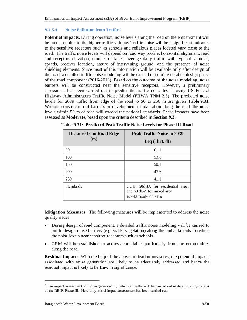
Environmental Impact Assessment (EIA) of River Bank Improvement Program (RBIP)
Bangladesh Water Development Board 9-50
9.4.5.4. NoisePollutionfromTraffic8
Potential impacts. During operation, noise levels along the road on the embankment will be increased due to the higher traffic volume. Traffic noise will be a significant nuisance to the sensitive receptors such as schools and religious places located vary close to the road. The traffic noise levels will depend on road way profile, horizontal alignment, road and receptors elevation, number of lanes, average daily traffic with type of vehicles, speeds, receiver location, nature of intervening ground, and the presence of noise shielding elements. Since most of this information will be available only after design of the road, a detailed traffic noise modeling will be carried out during detailed design phase of the road component (2016-2018). Based on the outcome of the noise modeling, noise barriers will be constructed near the sensitive receptors. However, a preliminary assessment has been carried out to predict the traffic noise levels using US Federal Highway Administrators Traffic Noise Model (FHWA TNM 2.5). The predicted noise levels for 2039 traffic from edge of the road to 50 to 250 m are given Table 9.31. Without construction of barriers or development of plantation along the road, the noise levels within 50 m of road will exceed the national standards. These impacts have been assessed as Moderate, based upon the criteria described in Section 9.2.
Table 9.31: Predicted Peak Traffic Noise Levels for Phase III Road
Distance from Road Edge (m)
Peak Traffic Noise in 2039
Leq (1hr), dB
50 61.1
100 53.6
150 50.1
200 47.6
250 41.1
Standards GOB: 50dBA for residential area, and 60 dBA for mixed area
World Bank: 55 dBA
Mitigation Measures. The following measures will be implemented to address the noise quality issues:
During design of road component, a detailed traffic noise modeling will be carried to out to design noise barriers (e.g. walls, vegetation) along the embankments to reduce the noise levels near sensitive receptors such as schools.
GRM will be established to address complaints particularly from the communities along the road.
Residual impacts. With the help of the above mitigation measures, the potential impacts associated with noise generation are likely to be adequately addressed and hence the residual impact is likely to be Low in significance.
8 The impact assessment for noise generated by vehicular traffic will be carried out in detail during the EIA of the RBIP, Phase III. Here only initial impact assessment has been carried out.
Environmental Impact Assessment (EIA) of River Bank Improvement Program (RBIP)
Bangladesh Water Development Board 9-51
9.4.5.5. WaterPollution
Potential impacts. Generally paved road increases the amount of impermeable surface area, which increases the rate of surface water runoff. Increased storm water flow rates can lead to stream erosion and flooding downstream; cause soil erosion, channel modification and siltation of streams.
During the O&M phase, some localized increase in turbidity may take place during any maintenance works on the bank revetment. Similarly, the maintenance works can also generate a limited quantity of waste effluents.
Significance of the above impacts has been determined as Moderate based upon the criteria described in Section 9.2.This aspect will be further assessed during the third phase of RBIP.
Mitigation and Management. Appropriate storm water drainage arrangements will be included in the road design. The runoff will be released in a manner that it does not cause soil erosion. To address the potential issues associated with waste effluents generated by O&M activities, the HSE Plan prepared by the BWDB also mentioned earlier will include disposal mechanism for waste effluents as well.
Residual impacts. With the help of the above mitigation measures, the potential impacts associated with storm water are likely to be adequately addressed and hence the residual impact is likely to be Low in significance.
9.4.6. SignificantSocialImpactsduringOperationandMaintenance
9.4.6.1. CommunityHealthandSafety9
Similar to construction activities, significant community health and safety issues associated with the maintenance activities will include pedestrian safety, traffic safety and emergency preparedness. Pedestrians will be at greatest risk of serious injury from collisions with moving vehicles. Collisions and accidents can involve a single or multiple vehicles, pedestrians or bicyclists, and animals.
Emergency situations most commonly associated during O&M phase will include accidents involving single or multiple vehicles, pedestrians, and/or the release of oil or hazardous materials.
Toll plaza (to be constructed under Phase III) and maintenance personnel at work will be subjected to physical and chemical hazards and noise. Maintenance personnel and landscaping workers working on right of way vegetation will be exposed to variety of physical hazards, particularly from operating machinery and moving vehicles and also working at elevations on bridges and overpasses.
Chemical hazards in operations and maintenance activities may be principally associated with exposures to dust during construction and paving activities; exhaust emissions from heavy equipment and motor vehicles during all maintenance activities; potentially hazardous dust generated during bridge paint removal; herbicide use during vegetation management; and diesel fuel used as a release and cleaning agent for paving equipment.
Significance of the above impacts has been determined as High based upon the criteria described in Section 9.2.
9 Aspects related to the road O&M will be covered in detail under the EIA of RBIP, Phase III.
Environmental Impact Assessment (EIA) of River Bank Improvement Program (RBIP)
Bangladesh Water Development Board 9-52
Mitigation and Management. During the O&M phase, the BWDB will be required to implement HSE procedures and prepare its own ERP. For the safety hazards associated with vehicular traffic on the embankment road, standard road signage and other safety measures such as zebra crossings and pedestrian walk-overs (bridges) are being included in the road design. Community awareness raising about these risks will be carried out during the construction phase and will also be included in the IEC component of the social development program.
Requirements for herbicide use to manage vegetation will be specified in IPMP (mentioned earlier in Section 9.4.1.3), and will ensure compliance with the provisions of World Bank OP 4.09 on Pest Management.
Residual impacts. With the help of the above mitigation measures, the potential impacts associated with safety hazards are likely to be addressed to a considerable extent and hence the residual impact is likely to be Low to Moderate in significance.
9.4.6.2. RiskofEmbankmentBreachesandEmergencyResponseMechanism
Potential impacts. Though the RBIP aims to strengthen the embankment, breaches can still take place because of a variety of reasons such as earthquakes and riverbank erosion. Such breaches in the post RBIP completion phase can potentially cause considerably higher losses than currently being incurred because of the intensified cultivation and increased area development that is likely to take place because of the enhanced protection against riverbank erosion and floods, as described earlier as well. Significance of the these impacts has been determined as High based upon the criteria described in Section 9.2
Mitigation and Management. The BWDB’s O&M procedures include regular monitoring of the embankment and its structural integrity, ensuring that the breaches can be prevented (see Section 3.5). The BWDB will explore the possibility of community involvement in this respect. The BWDB will also prepare an Emergency Response Plan (ERP) that will address among others embankment breaches. The ERP will include an alert system for local communities in the event of a catastrophic breach so that people can escape to higher land. It will be disclosed and regularly discussed with the local communities so that they are fully aware of the system and know what to do in the case of an emergency. Furthermore, BWDB will ensure adequate dissemination and enforcement of rules particularly regarding restrictions of certain activities on embankment (eg, construction over or excavation of embankment).
Residual impacts. With the help of the above mitigation measures, the potential impacts associated with embankment breaches are likely to be addressed to a considerable extent and hence the residual impact is likely to be Low to Moderate in significance.
Environmental Impact Assessment (EIA) of River Bank Improvement Program (RBIP)
Bangladesh Water Development Board 10-1
10. Cumulative and Induced Impacts
This Chapter discusses the cumulative and induced impacts (CIIA) of the entire RBIP.
10.1. Overview
The GoB is planning to rehabilitate existing river training works and flood embankments along both right and left banks of the Jamuna river, and also to construct new river training works and embankments. The objective of the current cumulative impact assessment is to evaluate the combined effects of proposed developments along the both banks of Jamuna River.
The most significant valued environmental components (VECs) related to the proposed developments are identified as morphology, flood affected areas and aquatic biodiversity; these VECs are considered for the current EIA study. Significance of these VECs is described later in the Chapter.
10.2. CIIAinContextofRBIP
10.2.1. StudyBoundaries
In the context of RBIP, the spatial boundaries of CIIA have been based on the extent of floodplain area of Jamuna in Bangladesh. The length of Jamuna from Indian border to the Ganges (the Padma River) confluence is about 220km. The spatial boundary of the CIIA is the floodplain of Jamuna from Bangladesh border with India to the confluence of Jamuna with the Ganges (Figure 10.1). According to GoB development plans, rehabilitation and construction of embankments and river training works along both banks of Jamuna, development of a road network along the right bank, and integrated river management program and inland water transport are considered as future major developments in next 20 years; and hence these projects are considered for CIIA study. Salient features of these developments along the both banks are presented below.
Project on Right Bank: The future development projects on right bank beyond the project, include (i) rehabilitation of 150 km BRE from the Teesta River to the Jamuna Bridge, and also a two lane highway along the embankment under RBIP Project, which would subsequently be expanded to 4 lanes, (ii) construction of about 32 km of additional new river bank protection works and rehabilitation of about 13 km of existing revetments, six spurs, one hard point and one groyne under RBIP project, (iii) rehabilitation of about 40km length of BRE from downstream of Jamuna Bridge to Chandpur under ADB funded FREMIP project, and (iv) about 100 m bridge over Ghagot and Teesta rivers along with necessary river training works.
Projects on Left Bank: The future development projects along left bank will include rehabilitation of existing bank protection works and embankments, and construction of new bank protections and embankments wherever required after carrying out detailed engineering studies.
Projects in the Jamuna: The GoB has an ambitious plan of undertaking about $100 billion ‘Capital Dredging Project’ in all major rivers including the Jamuna for sustainable river management. The objective of the project is control of river bed siltation and aggradation, land reclamation, and develop inland navigation through extensive dredging programs.
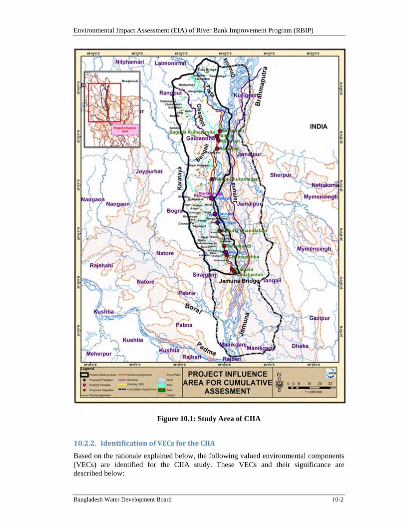
Environmental Impact Assessment (EIA) of River Bank Improvement Program (RBIP)
Bangladesh Water Development Board 10-2
Figure 10.1: Study Area of CIIA
10.2.2. IdentificationofVECsfortheCIIA
Based on the rationale explained below, the following valued environmental components (VECs) are identified for the CIIA study. These VECs and their significance are described below:
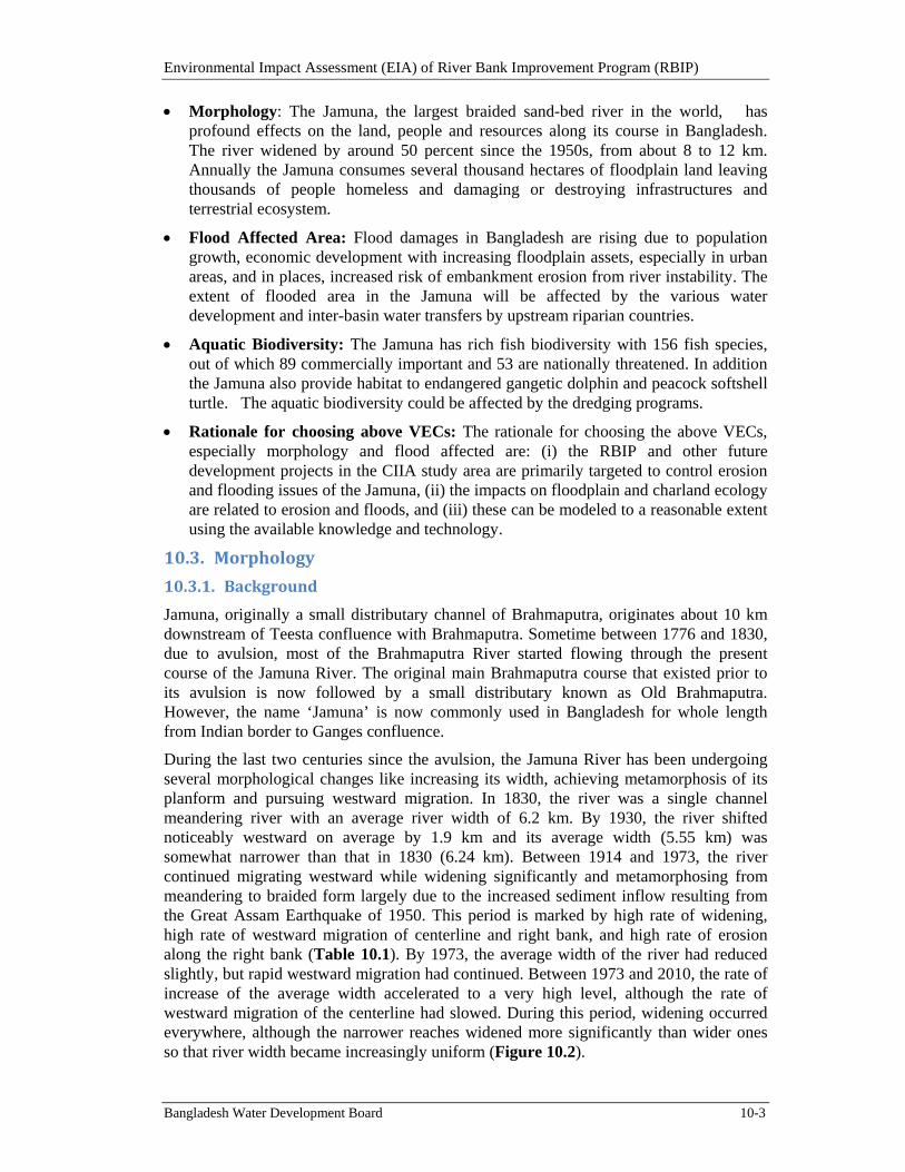
Environmental Impact Assessment (EIA) of River Bank Improvement Program (RBIP)
Bangladesh Water Development Board 10-3
Morphology: The Jamuna, the largest braided sand-bed river in the world, has profound effects on the land, people and resources along its course in Bangladesh. The river widened by around 50 percent since the 1950s, from about 8 to 12 km. Annually the Jamuna consumes several thousand hectares of floodplain land leaving thousands of people homeless and damaging or destroying infrastructures and terrestrial ecosystem.
Flood Affected Area: Flood damages in Bangladesh are rising due to population growth, economic development with increasing floodplain assets, especially in urban areas, and in places, increased risk of embankment erosion from river instability. The extent of flooded area in the Jamuna will be affected by the various water development and inter-basin water transfers by upstream riparian countries.
Aquatic Biodiversity: The Jamuna has rich fish biodiversity with 156 fish species, out of which 89 commercially important and 53 are nationally threatened. In addition the Jamuna also provide habitat to endangered gangetic dolphin and peacock softshell turtle. The aquatic biodiversity could be affected by the dredging programs.
Rationale for choosing above VECs: The rationale for choosing the above VECs, especially morphology and flood affected are: (i) the RBIP and other future development projects in the CIIA study area are primarily targeted to control erosion and flooding issues of the Jamuna, (ii) the impacts on floodplain and charland ecology are related to erosion and floods, and (iii) these can be modeled to a reasonable extent using the available knowledge and technology.
10.3. Morphology
10.3.1. Background
Jamuna, originally a small distributary channel of Brahmaputra, originates about 10 km downstream of Teesta confluence with Brahmaputra. Sometime between 1776 and 1830, due to avulsion, most of the Brahmaputra River started flowing through the present course of the Jamuna River. The original main Brahmaputra course that existed prior to its avulsion is now followed by a small distributary known as Old Brahmaputra. However, the name ‘Jamuna’ is now commonly used in Bangladesh for whole length from Indian border to Ganges confluence.
During the last two centuries since the avulsion, the Jamuna River has been undergoing several morphological changes like increasing its width, achieving metamorphosis of its planform and pursuing westward migration. In 1830, the river was a single channel meandering river with an average river width of 6.2 km. By 1930, the river shifted noticeably westward on average by 1.9 km and its average width (5.55 km) was somewhat narrower than that in 1830 (6.24 km). Between 1914 and 1973, the river continued migrating westward while widening significantly and metamorphosing from meandering to braided form largely due to the increased sediment inflow resulting from the Great Assam Earthquake of 1950. This period is marked by high rate of widening, high rate of westward migration of centerline and right bank, and high rate of erosion along the right bank (Table 10.1). By 1973, the average width of the river had reduced slightly, but rapid westward migration had continued. Between 1973 and 2010, the rate of increase of the average width accelerated to a very high level, although the rate of westward migration of the centerline had slowed. During this period, widening occurred everywhere, although the narrower reaches widened more significantly than wider ones so that river width became increasingly uniform (Figure 10.2).
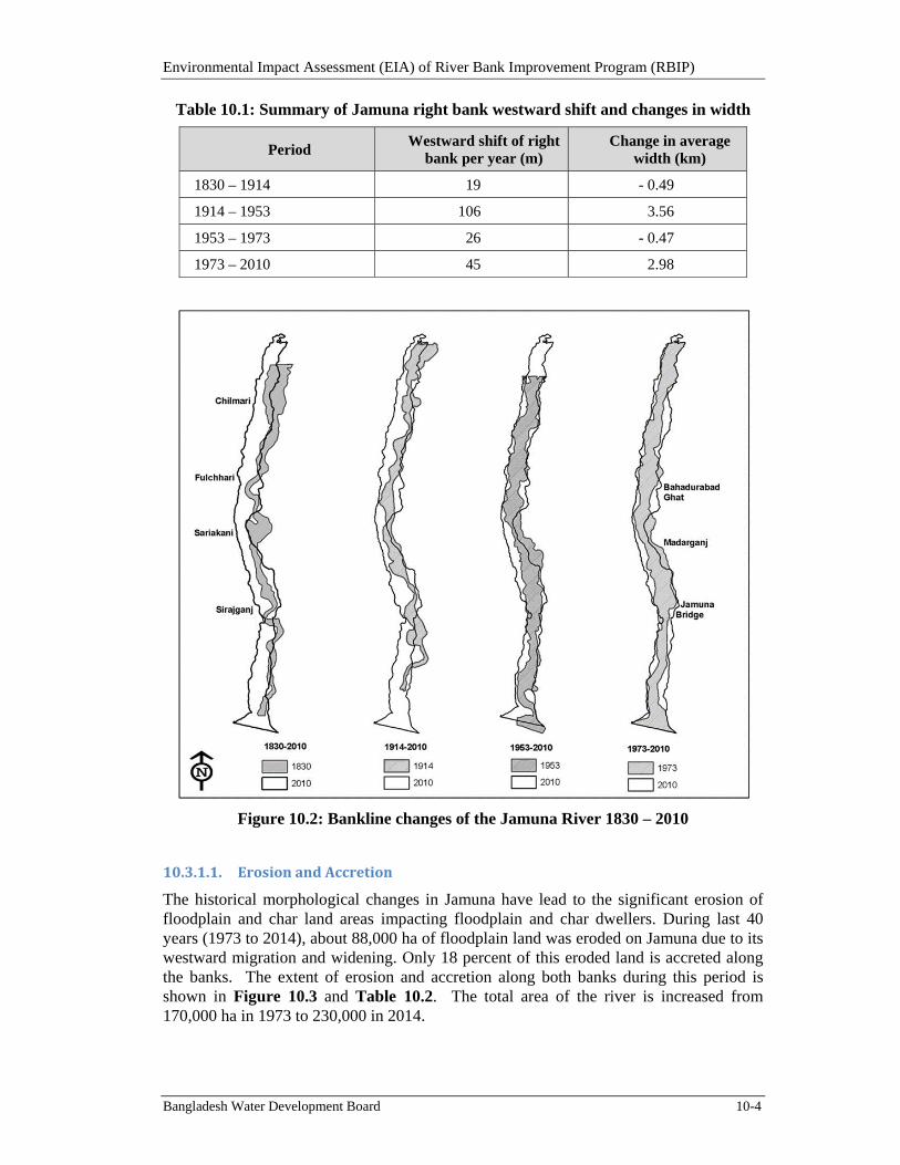
Environmental Impact Assessment (EIA) of River Bank Improvement Program (RBIP)
Bangladesh Water Development Board 10-4
Table 10.1: Summary of Jamuna right bank westward shift and changes in width
Period Westward shift of right
bank per year (m) Change in average
width (km)
1830 – 1914 19 - 0.49
1914 – 1953 106 3.56
1953 – 1973 26 - 0.47
1973 – 2010 45 2.98
Figure 10.2: Bankline changes of the Jamuna River 1830 – 2010
10.3.1.1. ErosionandAccretion
The historical morphological changes in Jamuna have lead to the significant erosion of floodplain and char land areas impacting floodplain and char dwellers. During last 40 years (1973 to 2014), about 88,000 ha of floodplain land was eroded on Jamuna due to its westward migration and widening. Only 18 percent of this eroded land is accreted along the banks. The extent of erosion and accretion along both banks during this period is shown in Figure 10.3 and Table 10.2. The total area of the river is increased from 170,000 ha in 1973 to 230,000 in 2014.
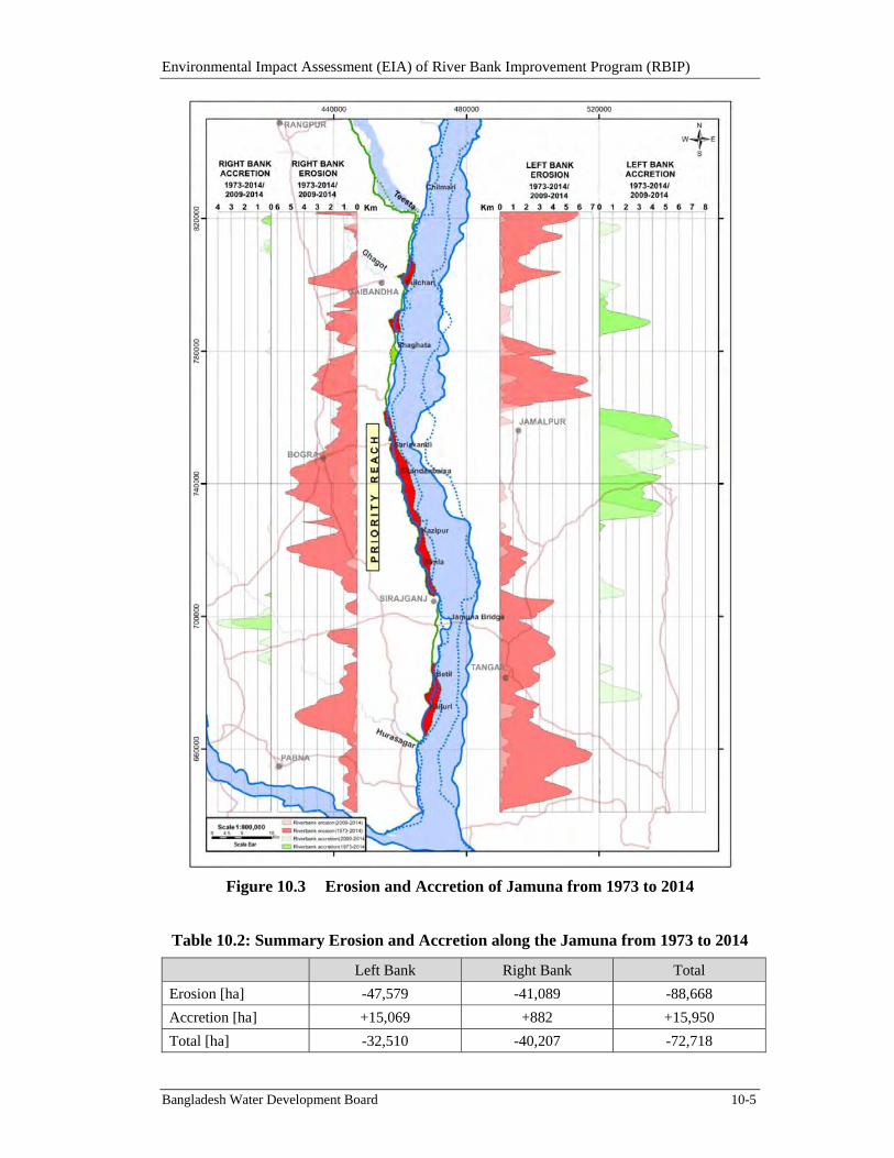
Environmental Impact Assessment (EIA) of River Bank Improvement Program (RBIP)
Bangladesh Water Development Board 10-5
Figure 10.3 Erosion and Accretion of Jamuna from 1973 to 2014
Table 10.2: Summary Erosion and Accretion along the Jamuna from 1973 to 2014
Left Bank Right Bank Total
Erosion [ha] -47,579 -41,089 -88,668
Accretion [ha] +15,069 +882 +15,950
Total [ha] -32,510 -40,207 -72,718
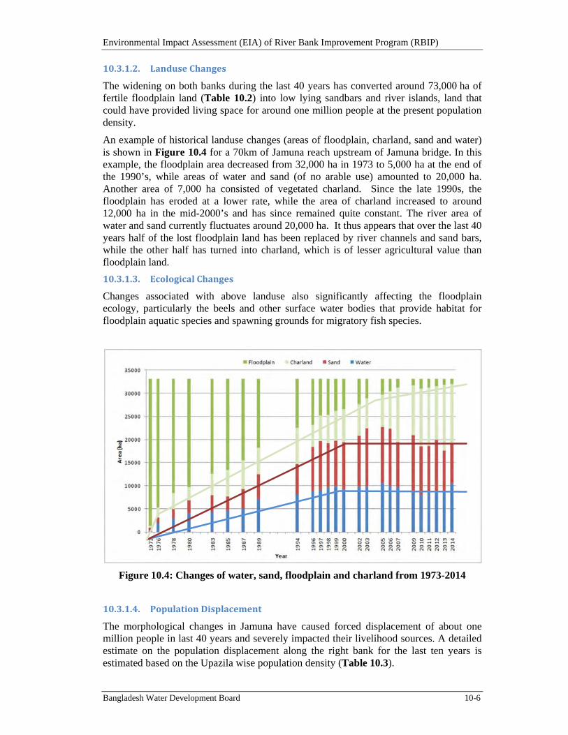
Environmental Impact Assessment (EIA) of River Bank Improvement Program (RBIP)
Bangladesh Water Development Board 10-6
10.3.1.2. LanduseChanges
The widening on both banks during the last 40 years has converted around 73,000 ha of fertile floodplain land (Table 10.2) into low lying sandbars and river islands, land that could have provided living space for around one million people at the present population density.
An example of historical landuse changes (areas of floodplain, charland, sand and water) is shown in Figure 10.4 for a 70km of Jamuna reach upstream of Jamuna bridge. In this example, the floodplain area decreased from 32,000 ha in 1973 to 5,000 ha at the end of the 1990’s, while areas of water and sand (of no arable use) amounted to 20,000 ha. Another area of 7,000 ha consisted of vegetated charland. Since the late 1990s, the floodplain has eroded at a lower rate, while the area of charland increased to around 12,000 ha in the mid-2000’s and has since remained quite constant. The river area of water and sand currently fluctuates around 20,000 ha. It thus appears that over the last 40 years half of the lost floodplain land has been replaced by river channels and sand bars, while the other half has turned into charland, which is of lesser agricultural value than floodplain land.
10.3.1.3. EcologicalChanges
Changes associated with above landuse also significantly affecting the floodplain ecology, particularly the beels and other surface water bodies that provide habitat for floodplain aquatic species and spawning grounds for migratory fish species.
Figure 10.4: Changes of water, sand, floodplain and charland from 1973-2014
10.3.1.4. PopulationDisplacement
The morphological changes in Jamuna have caused forced displacement of about one million people in last 40 years and severely impacted their livelihood sources. A detailed estimate on the population displacement along the right bank for the last ten years is estimated based on the Upazila wise population density (Table 10.3).
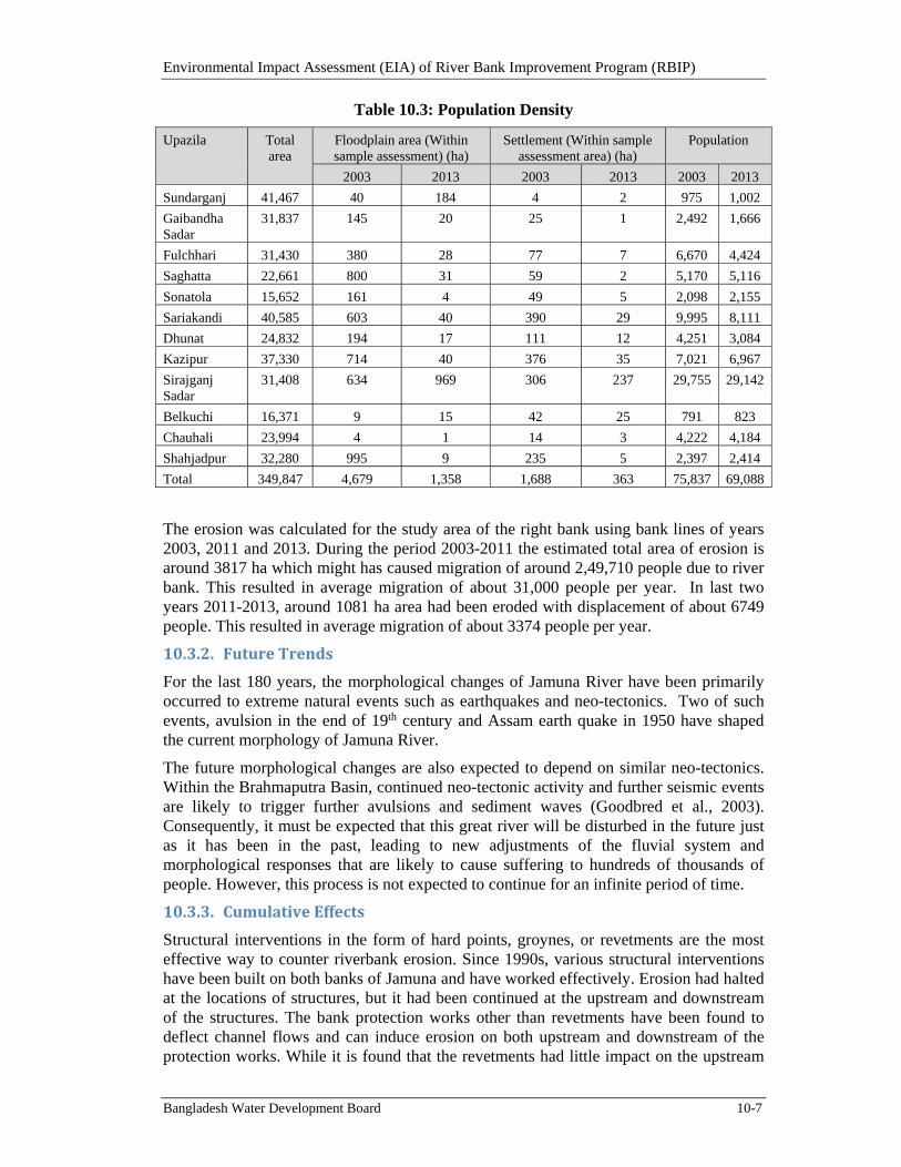
Environmental Impact Assessment (EIA) of River Bank Improvement Program (RBIP)
Bangladesh Water Development Board 10-7
Table 10.3: Population Density
Upazila Total area
Floodplain area (Within sample assessment) (ha)
Settlement (Within sample assessment area) (ha)
Population
2003 2013 2003 2013 2003 2013
Sundarganj 41,467 40 184 4 2 975 1,002
Gaibandha Sadar
31,837 145 20 25 1 2,492 1,666
Fulchhari 31,430 380 28 77 7 6,670 4,424
Saghatta 22,661 800 31 59 2 5,170 5,116
Sonatola 15,652 161 4 49 5 2,098 2,155
Sariakandi 40,585 603 40 390 29 9,995 8,111
Dhunat 24,832 194 17 111 12 4,251 3,084
Kazipur 37,330 714 40 376 35 7,021 6,967
Sirajganj Sadar
31,408 634 969 306 237 29,755 29,142
Belkuchi 16,371 9 15 42 25 791 823
Chauhali 23,994 4 1 14 3 4,222 4,184
Shahjadpur 32,280 995 9 235 5 2,397 2,414
Total 349,847 4,679 1,358 1,688 363 75,837 69,088
The erosion was calculated for the study area of the right bank using bank lines of years 2003, 2011 and 2013. During the period 2003-2011 the estimated total area of erosion is around 3817 ha which might has caused migration of around 2,49,710 people due to river bank. This resulted in average migration of about 31,000 people per year. In last two years 2011-2013, around 1081 ha area had been eroded with displacement of about 6749 people. This resulted in average migration of about 3374 people per year.
10.3.2. FutureTrends
For the last 180 years, the morphological changes of Jamuna River have been primarily occurred to extreme natural events such as earthquakes and neo-tectonics. Two of such events, avulsion in the end of 19th century and Assam earth quake in 1950 have shaped the current morphology of Jamuna River.
The future morphological changes are also expected to depend on similar neo-tectonics. Within the Brahmaputra Basin, continued neo-tectonic activity and further seismic events are likely to trigger further avulsions and sediment waves (Goodbred et al., 2003). Consequently, it must be expected that this great river will be disturbed in the future just as it has been in the past, leading to new adjustments of the fluvial system and morphological responses that are likely to cause suffering to hundreds of thousands of people. However, this process is not expected to continue for an infinite period of time.
10.3.3. CumulativeEffects
Structural interventions in the form of hard points, groynes, or revetments are the most effective way to counter riverbank erosion. Since 1990s, various structural interventions have been built on both banks of Jamuna and have worked effectively. Erosion had halted at the locations of structures, but it had been continued at the upstream and downstream of the structures. The bank protection works other than revetments have been found to deflect channel flows and can induce erosion on both upstream and downstream of the protection works. While it is found that the revetments had little impact on the upstream
Environmental Impact Assessment (EIA) of River Bank Improvement Program (RBIP)
Bangladesh Water Development Board 10-8
and downstream areas. Apart from protecting the riverbank, protection works have the potential of attracting the flow and maintain channels along the revetments.
The cumulative effects of the bank protection works will be very beneficial in controlling further erosion of thousands of Jamuna floodplains and displacement of hundreds of thousands of people. Based on the current trends of right bank erosion, it is expected that the projects would save about 14,000 ha of land from erosion and forced displacement of about 172,000 people. The channel flows will be controlled by the structures and it is likely that the channel will flow along the structure maintaining a higher depth. Further, stability of the channels and chars would be increased. Due to stabilized river banks, channels and chars, the cumulative effects on the ecological habitats of both river and charland would be very positive.
However, assessing the impact of structural interventions on a complex braided river like Jamuna is a serious challenge. Post-project monitoring can be very helpful in developing and gaining enhanced understanding of the river responses over time. BWDB, as part of its regular O&M, needs to carry out regular and comprehensive monitoring of bathymetry along the embankments and analysis of time-series of multi-spectral satellite images. From ecological point of view, a regular monitoring program on aquatic and charland biodiversity should be implemented and coordinated by BWDB to cover not just the RBIP influence area but also the ADB project’s influence area, as well as baseline data collection along the left bank and in any other areas of proposed future intervention, so that a better understanding can be developed of the relationship between the morphological and land use change effects and the region’s unique and important aquatic and charland biodiversity This in turn will enable better regional planning in consideration of these effects.
10.4. FloodAffectedArea
10.4.1. Background
The Brahmaputra river drains almost 0.57 million km2, nearly four times the area of Bangladesh. Its main stem and many tributaries flow through four countries: China, India, Bhutan and Bangladesh (see Figure 10.5). Water in the Brahmaputra River is the foundation for food production, hydropower generation and other ecosystem services for an estimated 130 million people living within the boundaries of its basin.
The flow of the Jamuna is mainly generated from northeast monsoon precipitation, which is concentrated from June to October. During the rest of the year the flow is generated from base flow and snow/glacier melt in the Himalayas.
Flooding occurs during the months from June to October commonly peaking between July and early September while the lowest water levels are experienced from January to March. The extent of flood affected area in Jamuna catchment area in Bangladesh is about 28,320 km2.
The mean monsoon flow of Jamuna at Bahadurabad station was around 40,000m3/s during the period from 1965 to 2006. During the dry season, the discharge is less than 10,000m3/s and as low as 5,000m³/s in early March. During the monsoon season, the monthly discharge varies from 30,000 to 50,000m3/s. The highest floods on the Jamuna River occurred in 1988, 1998, 2004 and 2007.
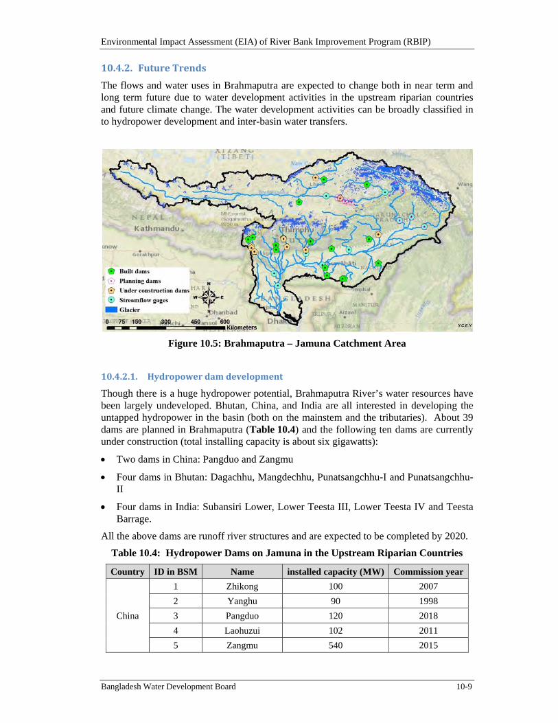
Environmental Impact Assessment (EIA) of River Bank Improvement Program (RBIP)
Bangladesh Water Development Board 10-9
10.4.2. FutureTrends
The flows and water uses in Brahmaputra are expected to change both in near term and long term future due to water development activities in the upstream riparian countries and future climate change. The water development activities can be broadly classified in to hydropower development and inter-basin water transfers.
Figure 10.5: Brahmaputra – Jamuna Catchment Area
10.4.2.1. Hydropowerdamdevelopment
Though there is a huge hydropower potential, Brahmaputra River’s water resources have been largely undeveloped. Bhutan, China, and India are all interested in developing the untapped hydropower in the basin (both on the mainstem and the tributaries). About 39 dams are planned in Brahmaputra (Table 10.4) and the following ten dams are currently under construction (total installing capacity is about six gigawatts):
Two dams in China: Pangduo and Zangmu
Four dams in Bhutan: Dagachhu, Mangdechhu, Punatsangchhu-I and Punatsangchhu-II
Four dams in India: Subansiri Lower, Lower Teesta III, Lower Teesta IV and Teesta Barrage.
All the above dams are runoff river structures and are expected to be completed by 2020.
Table 10.4: Hydropower Dams on Jamuna in the Upstream Riparian Countries
Country ID in BSM Name installed capacity (MW) Commission year
China
1 Zhikong 100 2007
2 Yanghu 90 1998
3 Pangduo 120 2018
4 Laohuzui 102 2011
5 Zangmu 540 2015
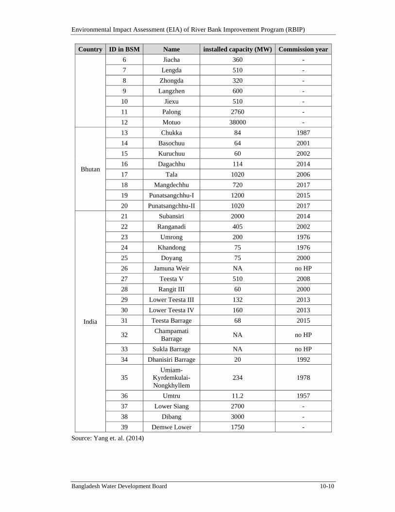
Environmental Impact Assessment (EIA) of River Bank Improvement Program (RBIP)
Bangladesh Water Development Board 10-10
Country ID in BSM Name installed capacity (MW) Commission year
6 Jiacha 360 -
7 Lengda 510 -
8 Zhongda 320 -
9 Langzhen 600 -
10 Jiexu 510 -
11 Palong 2760 -
12 Motuo 38000 -
Bhutan
13 Chukka 84 1987
14 Basochuu 64 2001
15 Kuruchuu 60 2002
16 Dagachhu 114 2014
17 Tala 1020 2006
18 Mangdechhu 720 2017
19 Punatsangchhu-I 1200 2015
20 Punatsangchhu-II 1020 2017
India
21 Subansiri 2000 2014
22 Ranganadi 405 2002
23 Umrong 200 1976
24 Khandong 75 1976
25 Doyang 75 2000
26 Jamuna Weir NA no HP
27 Teesta V 510 2008
28 Rangit III 60 2000
29 Lower Teesta III 132 2013
30 Lower Teesta IV 160 2013
31 Teesta Barrage 68 2015
32 Champamati
Barrage NA no HP
33 Sukla Barrage NA no HP
34 Dhanisiri Barrage 20 1992
35 Umiam-
Kyrdemkulai-Nongkhyllem
234 1978
36 Umtru 11.2 1957
37 Lower Siang 2700 -
38 Dibang 3000 -
39 Demwe Lower 1750 -
Source: Yang et. al. (2014)
Environmental Impact Assessment (EIA) of River Bank Improvement Program (RBIP)
Bangladesh Water Development Board 10-11
10.4.2.2. Waterdiversionscenarios
China and India are both considering trans-boundary water diversions to transfer water from the Brahmaputra Basin to water-scarce regions of their countries. Zuo et al. (2008) summarized a number of “Greater Western Route Water Diversion Project” proposals from Chinese government. The proposals include diversion of about 20 billion cubic meters (BCM) per year to 60 BCM per year. The tentative routes of these diversions are:
starting from Shuo-Ma-Tan (on the main stem of the Brahmaputra), water will be diverted through dams and tunnels to the Niyang River (one major tributary of the Brahmaputra River);
more dams and tunnels will be built on the Niyang River to divert water to the Yigon Tsangpo River (another major tributary of the Brahmaputra River); and
after Yigon Tsangpo, water will be sent further north to the Yangtze and Yellow Rivers.
Similar water transfer projects have been proposed in India to divert water from the Brahmaputra River basin to the Ganges River basin through linked canals as part of a national-level River Interlinking Project (Rahaman and Varis, 2009). The “Manas-Sankosh-Tista-Ganga” link is the primary route. Two dams have been proposed on the Manas River and the Sankosh River, and link canals with length more than 250 km would be built. The proposed annual water diversion capacity is 34.43 BCM. Figure 10.6 shows these two potential water diversion routes.
10.4.2.3. Climatechange
The historical hydrologic regime is dominated by two different mechanisms: snow/glacier melt in the upper basin (the mountainous area mostly in China and Bhutan), and monsoon rainfall in the lower basin (the floodplains mostly in India and Bangladesh). Temperature increase and changes in precipitation patterns due to climate change will have different influences on these two mechanisms. Long-term observations (over 40 years) of temperature, precipitation and stream flow in the upper Brahmaputra basin all show increasing trends. This may be partially attributable to melt water from retreating glaciers in the region. In the lower basin, most studies anticipated increases in stream flow as an effect of climate change, resulting from increases in monsoon rainfall.
Temperature increase and precipitation change due to climate change will have different influences on both snow/glacier melt dominated and monsoon dominated flow regime. Modeling results indicate that stream flow is more sensitive to changes in precipitation than changes in temperature, and future GCM projections suggest a warmer and wetter future, resulting in an increase in stream flow in the Brahmaputra Basin.
Environmental Impact Assessment (EIA) of River Bank Improvement Program (RBIP)
Bangladesh Water Development Board 10-12
Figure 10.6: Schematic of the Brahmaputra System Model (BSM)
10.4.3. CumulativeEffects
A Brahmaputra System Model (BSM) study was carried out by Yang et. al. (2014) to model the basin-wide water resources management under climatic and social uncertainties. The goal of this study is to address water resources management needs through a coupled modeling framework: integrating a physically-based distributed hydrologic model with a water resources system model to evaluate the impact of climatic and social uncertainties on the basin’s water uses, crop production and hydropower generation and the flood affected area (FAA).
The model results are given in Table 10.5. When no water diversion occurs, the expected values of FAA will increase by 23 percent, 33 percent and 54 percent for near, middle and far future compare to baseline. China’s largest diversion (60 bcm/year) will reduce FAA by 28 percent, 21 percent and 5 percent for near, middle and far future compare to baseline. India’s largest diversion (30 bcm/year), although cannot reduce the FAA, will mitigate the increasing trend and FAA will increase by 2 percent, 11 percent and 31 percent for near, middle and far future compare to baseline under India’s largest water diversions. The reduction in FAA will partially reduce the flood risk in Bangladesh. However, the reduction in FAA may not affect the agricultural productivity in Bangladesh since the irrigation in the country mostly met from rainfall and groundwater.
Table 10.5: FAA under climate change and upstream diversions impact (2011-2040)
GCM scenarios
Upstream diversions
% change from current FAA
back-calculated FAA using historical modeled value (km2)
RCP 2.6 China-10 bcm 8% 30950.22China-20 bcm 2% 29336.89
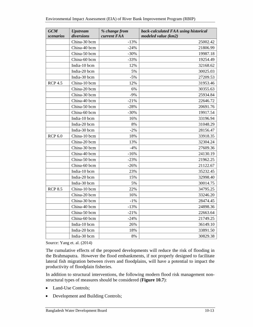
Environmental Impact Assessment (EIA) of River Bank Improvement Program (RBIP)
Bangladesh Water Development Board 10-13
GCM scenarios
Upstream diversions
% change from current FAA
back-calculated FAA using historical modeled value (km2)
China-30 bcm -13% 25002.42China-40 bcm -24% 21806.99China-50 bcm -30% 19987.18China-60 bcm -33% 19254.49India-10 bcm 12% 32168.62India-20 bcm 5% 30025.03
India-30 bcm -5% 27209.53RCP 4.5 China-10 bcm 12% 31953.46
China-20 bcm 6% 30355.63China-30 bcm -9% 25934.84China-40 bcm -21% 22646.72China-50 bcm -28% 20691.76China-60 bcm -30% 19917.54India-10 bcm 16% 33196.94India-20 bcm 8% 31048.29
India-30 bcm -2% 28156.47RCP 6.0 China-10 bcm 18% 33918.35
China-20 bcm 13% 32304.24China-30 bcm -4% 27609.36China-40 bcm -16% 24130.19China-50 bcm -23% 21962.25China-60 bcm -26% 21122.67India-10 bcm 23% 35232.45India-20 bcm 15% 32998.40
India-30 bcm 5% 30014.75RCP 8.5 China-10 bcm 22% 34795.25
China-20 bcm 16% 33246.20China-30 bcm -1% 28474.45China-40 bcm -13% 24898.36China-50 bcm -21% 22663.64China-60 bcm -24% 21749.25India-10 bcm 26% 36149.10India-20 bcm 18% 33891.50India-30 bcm 8% 30829.38
Source: Yang et. al. (2014)
The cumulative effects of the proposed developments will reduce the risk of flooding in the Brahmaputra. However the flood embankments, if not properly designed to facilitate lateral fish migration between rivers and floodplains, will have a potential to impact the productivity of floodplain fisheries.
In addition to structural interventions, the following modern flood risk management non-structural types of measures should be considered (Figure 10.7):
Land-Use Controls;
Development and Building Controls;
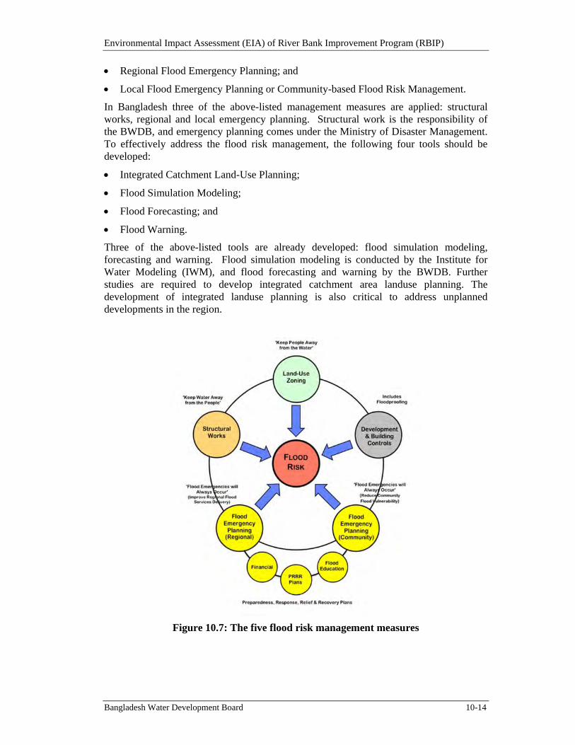
Environmental Impact Assessment (EIA) of River Bank Improvement Program (RBIP)
Bangladesh Water Development Board 10-14
Regional Flood Emergency Planning; and
Local Flood Emergency Planning or Community-based Flood Risk Management.
In Bangladesh three of the above-listed management measures are applied: structural works, regional and local emergency planning. Structural work is the responsibility of the BWDB, and emergency planning comes under the Ministry of Disaster Management. To effectively address the flood risk management, the following four tools should be developed:
Integrated Catchment Land-Use Planning;
Flood Simulation Modeling;
Flood Forecasting; and
Flood Warning.
Three of the above-listed tools are already developed: flood simulation modeling, forecasting and warning. Flood simulation modeling is conducted by the Institute for Water Modeling (IWM), and flood forecasting and warning by the BWDB. Further studies are required to develop integrated catchment area landuse planning. The development of integrated landuse planning is also critical to address unplanned developments in the region.
Figure 10.7: The five flood risk management measures
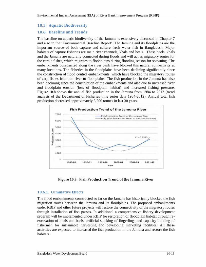
Environmental Impact Assessment (EIA) of River Bank Improvement Program (RBIP)
Bangladesh Water Development Board 10-15
10.5. AquaticBiodiversity
10.6. BaselineandTrends
The baseline on aquatic biodiversity of the Jamuna is extensively discussed in Chapter 7 and also in the ‘Environmental Baseline Report’. The Jamuna and its floodplains are the important source of both capture and culture fresh water fish in Bangladesh. Major habitats of capture fisheries are main river channels, khals and beels. These beels, khals and the Jamuna are naturally connected during floods and will act as migratory routes for the carp’s fishes, which migrates to floodplains during flooding season for spawning. The embankments constructed along the river bank have blocked this natural connectivity at many locations. The fisheries in the floodplains have been declining significantly since the construction of flood control embankments, which have blocked the migratory routes of carp fishes from the river to floodplains. The fish production in the Jamuna has also been declining since the construction of the embankments and also due to increased river and floodplain erosion (loss of floodplain habitat) and increased fishing pressure. Figure 10.8 shows the annual fish production in the Jamuna from 1984 to 2012 (trend analysis of the Department of Fisheries time series data 1984-2012). Annual total fish production decreased approximately 3,200 tonnes in last 30 years.
Figure 10.8:FishProductionTrendoftheJamunaRiver
10.6.1. CumulativeEffects
The flood embankments constructed so far on the Jamuna has historically blocked the fish migration routes between the Jamuna and its floodplains. The proposed embankments under RBIP and other future projects will restore the connectivity of the migratory routes through installation of fish passes. In additional a comprehensive fishery development program will be implemented under RBIP for restoration of floodplain habitat through re-excavation of khals and beels, artificial stocking of fingerlings and capacity building of fishermen for sustainable harvesting and developing marketing facilities. All these activities are expected to increased the fish production in the Jamuna and restore the fish habitats.
Environmental Impact Assessment (EIA) of River Bank Improvement Program (RBIP)
Bangladesh Water Development Board 10-16
Proposed dredging activities under the ‘Capital Dredging Project’ to improve and maintain navigation channels and land reclamation will have some impacts on the aquatic biodiversity of the Jamuna. Dredging activities will disturb the benthic habitat and the bottom fish feeders that depend on the benthic habitat. The sediments generated from the dredging activity will affect the water quality and in turn the quality of the entire river habitat. The water quality of the river will also be affected due to risk of oil spills from the barges and disposal of bilge water. There will be a risk of collision of dolphins with the barges and ships.
To address the cumulative impacts associated with the future dredging activities and also with induced environmental impacts (discussed in next section), fish and dolphin sanctuaries need to be established in the Jamuna. Detailed ecological baseline studies are recommended for the entire CIIA study area to be carried out in Phase 1 of RBIP to identify suitable areas of sanctuaries and establishment of these sanctuaries in the subsequent phases of the RBIP.
10.7. InducedEnvironmentalImpacts
The north western part of the country particularly the floodplains are is comparatively under developed due to continuous threats of erosion and floods from the Jamuna. Construction of bank protection works and flood embankments will lead improved investments and development in the region. Urbanization in Bangladesh is growing in rapid pace especially along the road and railway corridors. With the construction of the highway along the RBIP embankment a rapid uncontrolled and unplanned urbanization may take place around the Project influence area. Further, the construction of highway will further lead to road network development in the region. All these induced developments may trigger several environmental issues at local and regional level.
A network diagram showing the induced impacts from the construction of bank protection works and tolled highway is shown in Figure 10.9. It is expected that the connectivity of the north-western part of the region with the rest of country will provide increased accessibility to markets, ports and growth centers. This will lead to development of business (including agriculture and fisheries), industry, communication, tourism, urbanization, etc. The induced development has both negative and positive impacts. The positive impacts are increase in the socio-economic conditions of the region through employment generation and poverty reduction. The negative impacts are (i) air and noise pollution due to construction activities, increase in traffic levels and industrial development, (ii) generation of wastes due to increased living standards, (iii) consequent health impacts due to pollution and waste generation, (iv) loss of biodiversity, and (v) land acquisition and resettlement. The positive impacts and negative impacts are represented with +/- sign in the network diagram.
The anticipated induced developments in the region and their potential environmental impacts are discussed in the following sections. Most of these impacts could be avoided or managed through development of an integrated catchment landuse planning (Figure 10.7) by BWDB under the integrated flood risk management program. A master plan study is proposed in the RBIP program as a part of the engineering studies. Though the scope of the study is yet to be finalized, it broadly focuses on understanding the floodplain processes (protected through the BRE) and/or incorporating a river training component either focusing on the right bank or more holistically on both banks. It is recommended that the ‘master plan’ study also should cover the landuse planning aspects in the RBIP influence area.
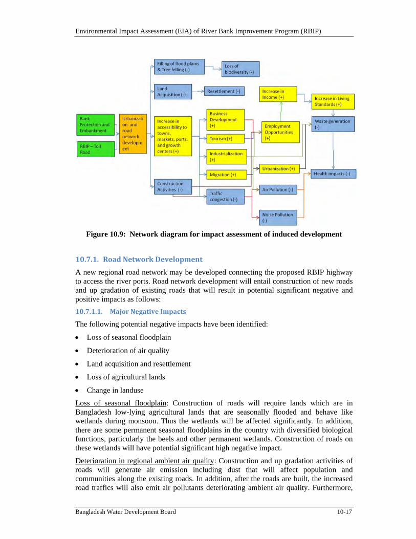
Environmental Impact Assessment (EIA) of River Bank Improvement Program (RBIP)
Bangladesh Water Development Board 10-17
Figure 10.9: Network diagram for impact assessment of induced development
10.7.1. RoadNetworkDevelopment
A new regional road network may be developed connecting the proposed RBIP highway to access the river ports. Road network development will entail construction of new roads and up gradation of existing roads that will result in potential significant negative and positive impacts as follows:
10.7.1.1. MajorNegativeImpacts
The following potential negative impacts have been identified:
Loss of seasonal floodplain
Deterioration of air quality
Land acquisition and resettlement
Loss of agricultural lands
Change in landuse
Loss of seasonal floodplain: Construction of roads will require lands which are in Bangladesh low-lying agricultural lands that are seasonally flooded and behave like wetlands during monsoon. Thus the wetlands will be affected significantly. In addition, there are some permanent seasonal floodplains in the country with diversified biological functions, particularly the beels and other permanent wetlands. Construction of roads on these wetlands will have potential significant high negative impact.
Deterioration in regional ambient air quality: Construction and up gradation activities of roads will generate air emission including dust that will affect population and communities along the existing roads. In addition, after the roads are built, the increased road traffics will also emit air pollutants deteriorating ambient air quality. Furthermore,
Environmental Impact Assessment (EIA) of River Bank Improvement Program (RBIP)
Bangladesh Water Development Board 10-18
the changes to land use induced by the presence of a major trade corridor / highway are likely to include not only densification of settlements but also potentially industrial development benefiting from improved access to markets.
Land acquisition and resettlement: Construction and up gradation of roads will require land acquisition which may trigger out involuntary resettlement for affected people therein.
Loss of agricultural lands: Majority of the flood plain lands are used for agriculture purpose and construction or up gradation of roads will result in loss of agriculture lands of a narrow strip over long distances, as well as potentially in a greater area, if the new toll road stimulates industrial development.
Change in landuse: Change in landuse will primarily be from loss of agricultural lands and secondly from roadside development induced after road development. The impact is perceived as potential significant negative as unplanned and haphazard development will have significant negative impact on landuse.
10.7.1.2. MajorPositiveImpacts
The following potential positive impacts have been identified:
Employment
Transport Communication
Employment: Employment generation will occur in the road construction/rehabilitation and in the increased commercial and business activities induced with road network development.
Transport Communication: With the road network development the commercial and business importance in the south western zone will rise significantly. Traffic will be generated locally due to the induced growth. For commercial and business purpose, goods will be carried by multimodal transport from various places within the regions including urban, semi-urban and rural areas. The impact will occur gradually at an increased trend over a long period of time.
10.7.2. RoadsideDevelopment
Because of commercial importance of the roads and easy access to regional road network via major roads, roadside developments are expected to get faster pace with the construction of the project. The expected roadside developments are industries, markets/growth centers/shops, housing areas, etc.
The potential significant negative and positive impacts from roadside development are as below.
10.7.2.1. MajorNegativeImpacts
The following potential negative impacts have been identified:
Loss of seasonal floodplain
Deterioration in surface water quality
Deterioration in groundwater quality
Waste generation
Land acquisition and resettlement
Environmental Impact Assessment (EIA) of River Bank Improvement Program (RBIP)
Bangladesh Water Development Board 10-19
Loss of agricultural lands
Change in landuse
Loss of seasonal floodplain: Loss of seasonal floodplain will result primarily from earth filling of roadside low-lying lands. These lands are seasonally flooded, habitats for fishes/aquatic life, birds during monsoon/wet season and used as agricultural lands during dry period.
Deterioration in surface water quality: Roadside developments will generate several types of wastes during their construction and O&M stages. Typical wastes are likely of solid and liquid which may further be classified as hazardous/toxic and non-hazardous/non-toxic. Disposal of these wastes without treatment will contaminate surface water surrounding the dumping sites. Contamination of surface water quality will have potential significant negative impact on biological functions of surface water as well as fish/aquatic life resources therein.
Water Supply and Sanitation: Roadside development will require safe drinking water supply and sanitation facilities in selected locations. Unplanned development will pose great risk of waterborne diseases to infants and young children and people who are debilitated or living in unsanitary conditions and elderly. BWDB needs to coordinate with other departments and regions especially Local Government and Engineering Department for identifying locations for water supply and sanitation facilities along the corridor. And expedite the development of these infrastructures along the corridor to cash in the full advantage of the Asian Highway.
Deterioration in groundwater quality: Deterioration in groundwater quality is likely to occur due to the dumping of untreated wastes. Leachate of wastes that contains hazardous elements will percolate soils reaching groundwater contaminating the natural resources.
Waste: Wastes will be generated during construction and O&M of roadside development, and unless they are properly managed they will cause severe impact on environment. Particularly industrial hazardous wastes would affect the health quality of the workers as well as will contaminate soil and water at their dumping locations.
Land acquisition and resettlement: Widening of the road along road side with the private/public initiative will trigger out land acquisition and resettlement issues and their associated impacts which needs to be properly handled before the start of such activity.
Loss of agricultural lands: Roadside areas are mostly agricultural lands and development along the corridor will have impact on the agricultural lands. The impact is cumulative and will be seen as key issue for all infrastructure development in Bangladesh.
Change in landuse: Change in landuse is from conversion of existing lands, mostly agricultural lands, into residential and commercial lands. Moreover, development works would induce further developments which also have the impact on landuse again.
10.7.2.2. MajorPositiveImpacts
Employment: Roadside developments including industries, commercial shops, fuel and CNG stations and similar others will generate a lot of employment for different professional categories of people. Employments will also be generated from other sectors, directly or indirectly linked with roadside developments.
Environmental Impact Assessment (EIA) of River Bank Improvement Program (RBIP)
Bangladesh Water Development Board 10-20
10.7.3. Industrialization
In addition, as it happened after Jamuna Bridge Project, private industries are expected to grow along the major roads having good access to the proposed bridge.
Industrialization in the regions will result in both potential significant negative and positive impacts as below.
10.7.3.1. MajorNegativeImpacts
The following potential negative impacts have been identified:
Loss of seasonal floodplain
Deterioration in water quality
Soil quality
Waste generation
Land acquisition and resettlement
Loss of agricultural lands
Change in landuse
Loss of seasonal floodplain: Loss of seasonal floodplain will result from construction of industries on roadside floodplain/wetlands, adjacent to major roads and in other areas in the regions
Deterioration in water quality: Industries are likely to produce hazardous and non-hazardous wastes which they may not handle/manage properly and dump elsewhere without treatment. This will deteriorate surface water quality. Surface water contamination during monsoon may spread over large area due to flooding. Unplanned disposal of hazardous/toxic waste may lead to the deterioration of groundwater quality, which may lead to several public health implications related to drinking groundwater. In Bangladesh groundwater is the main drinking water source.
Deterioration in Soil quality/soil contamination: Improper waste dumping will contaminate soil. Liquid wastes generated from industries may be accumulated contaminating surface water, groundwater and soil there. The effect may be widespread due to flooding effect.
Waste: Wastes will be generated at various stages of industrial development, both during construction and O/M. The wastes generated during construction may not be hazardous as maybe case during the operation of the industries. Various types of hazardous and non-hazardous wastes will be generated depending on the type of industries and their extent of operation.
Land acquisition and resettlement: Land acquisition and resettlement issues will arise due to the establishment of various industries including the export processing zone (EPZ).
Loss of agricultural lands: Loss of agricultural lands is associated with land-acquisition for industrial development.
Change in landuse: Change in landuse is primarily due to the transformation of agricultural and other lands to industrial development.
10.7.3.2. MajorPositiveImpacts
The following potential positive impacts have been identified:
Environmental Impact Assessment (EIA) of River Bank Improvement Program (RBIP)
Bangladesh Water Development Board 10-21
Employment
Gender
Employment: Industrial sector is a potential source of employments in Bangladesh. Industries will provide employments to many people directly and indirectly. Several types of industries are expected to be established in the regions such as, textile and dyeing, pharmaceuticals, sea fish/food processing industries, etc. These industries require professionals at various skills and levels and the technicians. Employment will also come from associated business and commercial activities linked with industries. Thus people who are associated with the transportation and export/import business will also be benefited from employments.
Gender: With industrialization, ample job opportunities will be generated for the local people and a part of these jobs are for women. In the textile and garments sector, a large part of the industrial jobs are offered to women because of the job nature and for their skills and efficient performance in this sector. It is anticipated that after the project, textile and garments sector will boost up in south-western part of the country and local women will be highly benefited from it.
Environmental Impact Assessment (EIA) of River Bank Improvement Program (RBIP)
Bangladesh Water Development Board 11-1
11. Environmental Management Plan
This Chapter presents the environmental management plan (EMP) of the RBIP, Phase I project.
11.1. EMPObjectives
The basic objective of the EMP is to manage adverse impacts of project interventions in a way that minimizes the adverse impact on the environment and people of the Project influence area. The specific objectives of the EMP are to:
Facilitate the implementation of the mitigation measures identified during the present EIA and discussed earlier in the document.
Maximize potential project benefits and control negative impacts;
Draw responsibilities for project proponent, contractors, consultants, and other members of the Project team for the environmental and social management of the Project;
Define a monitoring mechanism and identify monitoring parameters in order to:
Ensure the complete implementation of all mitigation measures,
Ensure the effectiveness of the mitigation measures;
Maintain essential ecological process, preserving biodiversity and where possible restoring degraded natural resources; and
Assess environmental training requirements for different stakeholders at various levels.
The EMP will be managed through a number of tasks and activities and site specific management plans. One purpose of the EMP is to record the procedure and methodology for management of mitigation identified for each negative impacts of the Project. The management will clearly delineate the responsibility of various participants and stakeholders involved in planning, implementation and operation of the Project.
11.2. InclusionofRelevantComponentsofEMPinContractDocuments
In order to make contractors fully aware and responsible of the implications of the EMP and to ensure compliance, it is essential that environmental and social management measures are included in the tender documentation. The various contractors must be made accountable to implement the plans and mitigation measures which pertain to them through contract documents and/or other agreements of the obligations and importance of the environmental and social components of the Project.
11.2.1. PaymentMilestones
Payments to contractors would be linked to environmental performance, measured by completion of the prescribed environmental and social mitigation measures. Contractors would be required to join forces with the executing agency, project management unit, supervising consultants and local population for the mitigation of adverse impacts of the project. For effective implementation of the proposed mitigation and monitoring measures they would attract trained and experienced environmental management staff.
Environmental Impact Assessment (EIA) of River Bank Improvement Program (RBIP)
Bangladesh Water Development Board 11-2
11.2.2. GuidelinetoIncorporateEnvironmentalManagementinBidDocument
The design consultants will be responsible to incorporate environmental management requirements in the bidding documents, with the assistance of the environmental consultants. The generic guidelines to incorporate environmental aspects in the bidding documents are listed below.
Prepare cost estimates, to be incorporated in Bid Documents.
Contractor version of the Environmental Management Plan along with the ECoPs to be incorporated in the bid document‘s work requirements.
Penalty clauses for not complying with EMP requirements to be incorporated. Indicative penalty clauses are presented below (Addendum to Clause 17.2 Contractor‘s Care of the Works of FIDIC).
The contractor has to follow all traffic safety measures as defined in the technical specification. Damage shall be levied at the rate Tk. 3000/- per day per location for non – conformity of traffic safety measures as per the decision of the engineer.
The contractor has to follow all environmental mitigation measures as defined in the technical specification read along with the Environmental Management Plan for the specific RBIP activities. Damage shall be levied at the rate Tk. 3000/- per day per location for nonconformity of Environmental Management Plan measures as per the decision of the BWDB Engineer.
The contractor has to ensure that prior to every monsoon season, during the construction period; all the temporary and permanent cross drainage structures are free from debris as defined in the Technical Specifications read along with the Environmental Management Plan. Damage shall be levied at the rate of Tk.3000/- per day per location for non-conformity as per the decision of the Engineer.
The contractor has to ensure that sufficient numbers and good quality Personnel Protective Equipment (PPE), should be provide to staff and labor all time as defined in the labor codes read along with the EMP. Damage shall be levied at the rate of Tk. 1000/- per day for non-conformity as per the decision of the Engineer. In addition, for any non-compliance causing damages or material harm to the natural environment, public or private property or resources, the contractor will be required to either remediate / rectify any such damages in a timeframe specified by and agreed with the engineer, or pay BWDB for the cost (as assessed by BWDB) of contracting a third party to carry out the remediation work.
Since many contractors do not have clear understanding the need of environmental management, some quote very low price for implementation of EMP and eventually cannot implement EMP as per design. To avoid this problem, fixed budget may be assigned for EMP implementation. The contractors may need orientation on the requirement of the EMP in the pre-bidding meeting.
11.3. InstitutionalArrangements
11.3.1. ConstructionPhase
The RBIP implementation will be led by the River Management Office (RMO) that will be established within BWDB. The RMO will be headed by the Chief Engineer River Management (CERM) acting as Project Management Unit (PMU) and Project Director (PD). The post CERM was approved in November 2014 as part of the planning wing

Environmental Impact Assessment (EIA) of River Bank Improvement Program (RBIP)
Bangladesh Water Development Board 11-3
under the Additional Director General Planning. Further details of the institutional arrangement for the overall RBIP management are available in Feasibility report under the Institutional Arrangement volume.
BWDB has agreed to set-up an Environment and Social Development Unit/Cell with qualified staff in their regular organogram. Since the establishment of the Unit/Cell would require several administrative clearances, as an interim measure, BWDB will set-up a project specific Environment and Social Development Unit (ESDU) in the PMU (i.e., RMO) of RBIP. This ESDU under the leadership of a Superintending Engineer will assist the PMU on issues related to environmental and social management. ESDU will provide trainings to the BWDB personnel responsible for monitoring of environmental compliance during the O&M phase of the program. Thus smooth transition to BWDB will happen to ensure environmental compliance during the O&M phase. The organogram for Environmental and Social Development Unit is shown in Figure 11.1.
Figure 11.1: Organogram for Environmental Management
Government of Bangladesh (GOB)Ministry of Water Resources (MOWR)
Bangladesh Water
Development Board (BWDB)
Project Management Unit (PMU)
Planning and Adaptation
Budget and Finance
Design and Construction Supervision Consultant
Contractor
Project Steering
Committee
Construction Super VisionEnvironmental SpecialistSocial SpecialistEcologistOHS SpecialistEnvironmental Inspectors
Environmental Health and Safety OfficersEcologist
Note:Existing Government Unit
Proposed Unit in PMU
Design of Phase 2 and 3Environmental SpecialistsSocial SpecialistsEcologists
Coordinating NGO
RAP Implementing
NGO
Public Health Action Plan
NGO
Livelihood Restoration
NGO
Gender NGO
Field Coordinator
Sirajganj
Field Coordinator
Bogra
Environmental Monitoring and Implementation
Consultants
Independent Environmental Consultants
Environmental and Social
Development Unit
Senior Environmental and Social SpecialistsJunior Environmental and Social SpecialistsEcologist
Panel of Experts
External Monitoring
Agency
Executive Engineer -
Bogra
Executive Engineer - Sirajganj
Asst. Engineer Land &
Revenue
Asst. Engineer Land &
Revenue
Project Affected Persons and Beneficiaries
Design and Supervision Consultants
Independent Consultants
Contractor
Engineering
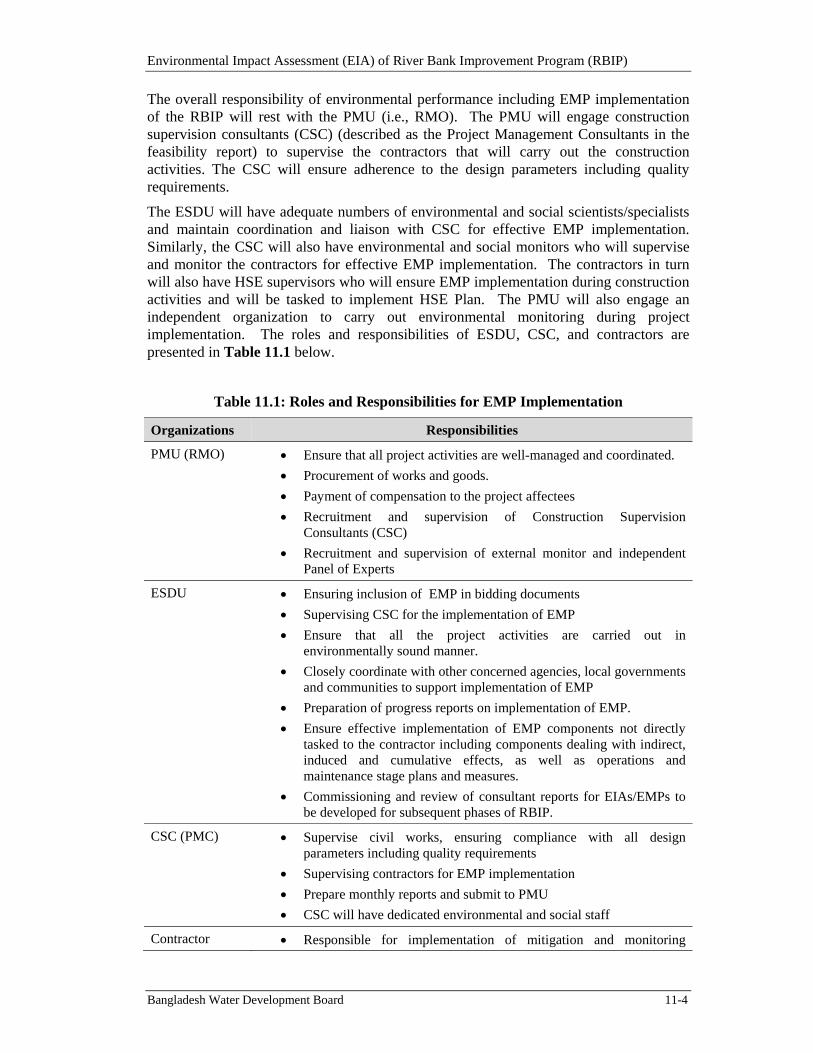
Environmental Impact Assessment (EIA) of River Bank Improvement Program (RBIP)
Bangladesh Water Development Board 11-4
The overall responsibility of environmental performance including EMP implementation of the RBIP will rest with the PMU (i.e., RMO). The PMU will engage construction supervision consultants (CSC) (described as the Project Management Consultants in the feasibility report) to supervise the contractors that will carry out the construction activities. The CSC will ensure adherence to the design parameters including quality requirements.
The ESDU will have adequate numbers of environmental and social scientists/specialists and maintain coordination and liaison with CSC for effective EMP implementation. Similarly, the CSC will also have environmental and social monitors who will supervise and monitor the contractors for effective EMP implementation. The contractors in turn will also have HSE supervisors who will ensure EMP implementation during construction activities and will be tasked to implement HSE Plan. The PMU will also engage an independent organization to carry out environmental monitoring during project implementation. The roles and responsibilities of ESDU, CSC, and contractors are presented in Table 11.1 below.
Table 11.1: Roles and Responsibilities for EMP Implementation
Organizations Responsibilities
PMU (RMO) Ensure that all project activities are well-managed and coordinated.
Procurement of works and goods.
Payment of compensation to the project affectees
Recruitment and supervision of Construction Supervision Consultants (CSC)
Recruitment and supervision of external monitor and independent Panel of Experts
ESDU Ensuring inclusion of EMP in bidding documents
Supervising CSC for the implementation of EMP
Ensure that all the project activities are carried out in environmentally sound manner.
Closely coordinate with other concerned agencies, local governments and communities to support implementation of EMP
Preparation of progress reports on implementation of EMP.
Ensure effective implementation of EMP components not directly tasked to the contractor including components dealing with indirect, induced and cumulative effects, as well as operations and maintenance stage plans and measures.
Commissioning and review of consultant reports for EIAs/EMPs to be developed for subsequent phases of RBIP.
CSC (PMC) Supervise civil works, ensuring compliance with all design parameters including quality requirements
Supervising contractors for EMP implementation
Prepare monthly reports and submit to PMU
CSC will have dedicated environmental and social staff
Contractor Responsible for implementation of mitigation and monitoring
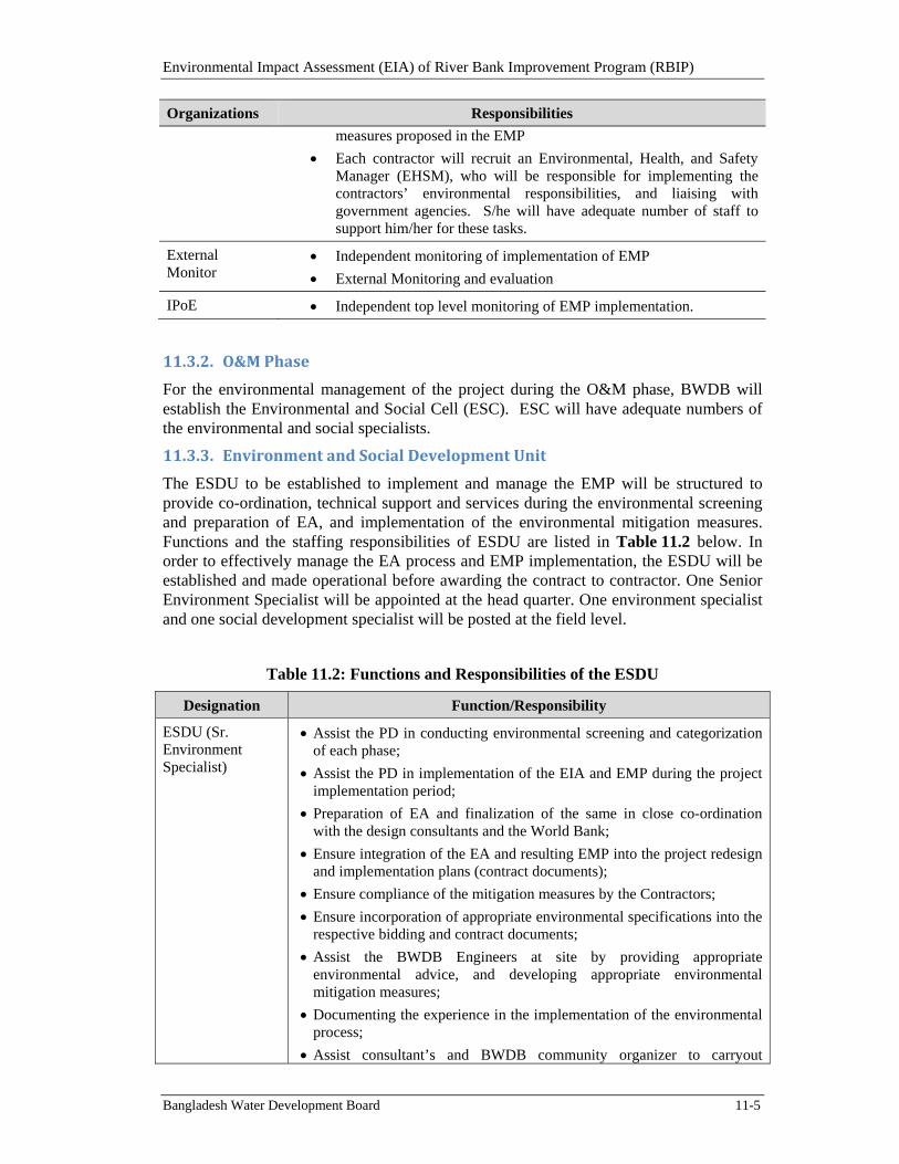
Environmental Impact Assessment (EIA) of River Bank Improvement Program (RBIP)
Bangladesh Water Development Board 11-5
Organizations Responsibilities
measures proposed in the EMP
Each contractor will recruit an Environmental, Health, and Safety Manager (EHSM), who will be responsible for implementing the contractors’ environmental responsibilities, and liaising with government agencies. S/he will have adequate number of staff to support him/her for these tasks.
External Monitor
Independent monitoring of implementation of EMP
External Monitoring and evaluation
IPoE Independent top level monitoring of EMP implementation.
11.3.2. O&MPhase
For the environmental management of the project during the O&M phase, BWDB will establish the Environmental and Social Cell (ESC). ESC will have adequate numbers of the environmental and social specialists.
11.3.3. EnvironmentandSocialDevelopmentUnit
The ESDU to be established to implement and manage the EMP will be structured to provide co-ordination, technical support and services during the environmental screening and preparation of EA, and implementation of the environmental mitigation measures. Functions and the staffing responsibilities of ESDU are listed in Table 11.2 below. In order to effectively manage the EA process and EMP implementation, the ESDU will be established and made operational before awarding the contract to contractor. One Senior Environment Specialist will be appointed at the head quarter. One environment specialist and one social development specialist will be posted at the field level.
Table 11.2: Functions and Responsibilities of the ESDU
Designation Function/Responsibility
ESDU (Sr. Environment Specialist)
Assist the PD in conducting environmental screening and categorization of each phase;
Assist the PD in implementation of the EIA and EMP during the project implementation period;
Preparation of EA and finalization of the same in close co-ordination with the design consultants and the World Bank;
Ensure integration of the EA and resulting EMP into the project redesign and implementation plans (contract documents);
Ensure compliance of the mitigation measures by the Contractors;
Ensure incorporation of appropriate environmental specifications into the respective bidding and contract documents;
Assist the BWDB Engineers at site by providing appropriate environmental advice, and developing appropriate environmental mitigation measures;
Documenting the experience in the implementation of the environmental process;
Assist consultant’s and BWDB community organizer to carryout
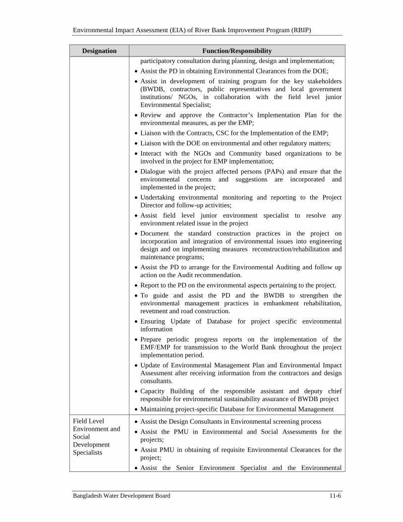
Environmental Impact Assessment (EIA) of River Bank Improvement Program (RBIP)
Bangladesh Water Development Board 11-6
Designation Function/Responsibility
participatory consultation during planning, design and implementation;
Assist the PD in obtaining Environmental Clearances from the DOE;
Assist in development of training program for the key stakeholders (BWDB, contractors, public representatives and local government institutions/ NGOs, in collaboration with the field level junior Environmental Specialist;
Review and approve the Contractor’s Implementation Plan for the environmental measures, as per the EMP;
Liaison with the Contracts, CSC for the Implementation of the EMP;
Liaison with the DOE on environmental and other regulatory matters;
Interact with the NGOs and Community based organizations to be involved in the project for EMP implementation;
Dialogue with the project affected persons (PAPs) and ensure that the environmental concerns and suggestions are incorporated and implemented in the project;
Undertaking environmental monitoring and reporting to the Project Director and follow-up activities;
Assist field level junior environment specialist to resolve any environment related issue in the project
Document the standard construction practices in the project on incorporation and integration of environmental issues into engineering design and on implementing measures reconstruction/rehabilitation and maintenance programs;
Assist the PD to arrange for the Environmental Auditing and follow up action on the Audit recommendation.
Report to the PD on the environmental aspects pertaining to the project.
To guide and assist the PD and the BWDB to strengthen the environmental management practices in embankment rehabilitation, revetment and road construction.
Ensuring Update of Database for project specific environmental information
Prepare periodic progress reports on the implementation of the EMF/EMP for transmission to the World Bank throughout the project implementation period.
Update of Environmental Management Plan and Environmental Impact Assessment after receiving information from the contractors and design consultants.
Capacity Building of the responsible assistant and deputy chief responsible for environmental sustainability assurance of BWDB project
Maintaining project-specific Database for Environmental Management
Field Level Environment and Social Development Specialists
Assist the Design Consultants in Environmental screening process
Assist the PMU in Environmental and Social Assessments for the projects;
Assist PMU in obtaining of requisite Environmental Clearances for the project;
Assist the Senior Environment Specialist and the Environmental
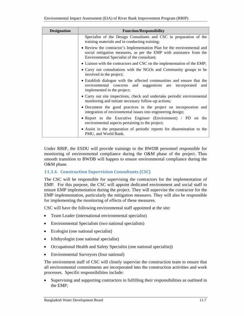
Environmental Impact Assessment (EIA) of River Bank Improvement Program (RBIP)
Bangladesh Water Development Board 11-7
Designation Function/Responsibility
Specialist of the Design Consultants and CSC in preparation of the training materials and in conducting training;
Review the contractor’s Implementation Plan for the environmental and social mitigation measures, as per the EMP with assistance from the Environmental Specialist of the consultant;
Liaison with the contractors and CSC on the implementation of the EMP;
Carry out consultations with the NGOs and Community groups to be involved in the project;
Establish dialogue with the affected communities and ensure that the environmental concerns and suggestions are incorporated and implemented in the project;
Carry out site inspections, check and undertake periodic environmental monitoring and initiate necessary follow-up actions;
Document the good practices in the project on incorporation and integration of environmental issues into engineering design;
Report to the Executive Engineer (Environment) / PD on the environmental aspects pertaining to the project;
Assist in the preparation of periodic reports for dissemination to the PMU, and World Bank.
Under RBIP, the ESDU will provide trainings to the BWDB personnel responsible for monitoring of environmental compliance during the O&M phase of the project. Thus smooth transition to BWDB will happen to ensure environmental compliance during the O&M phase.
11.3.4. ConstructionSupervisionConsultants(CSC)
The CSC will be responsible for supervising the contractors for the implementation of EMP. For this purpose, the CSC will appoint dedicated environment and social staff to ensure EMP implementation during the project. They will supervise the contractor for the EMP implementation, particularly the mitigation measures. They will also be responsible for implementing the monitoring of effects of these measures.
CSC will have the following environmental staff appointed at the site:
Team Leader (international environmental specialist)
Environmental Specialists (two national specialists)
Ecologist (one national specialist)
Ichthyologist (one national specialist)
Occupational Health and Safety Specialist (one national specialist))
Environmental Surveyors (four national)
The environment staff of CSC will closely supervise the construction team to ensure that all environmental commitments are incorporated into the construction activities and work processes. Specific responsibilities include:
Supervising and supporting contractors in fulfilling their responsibilities as outlined in the EMP;
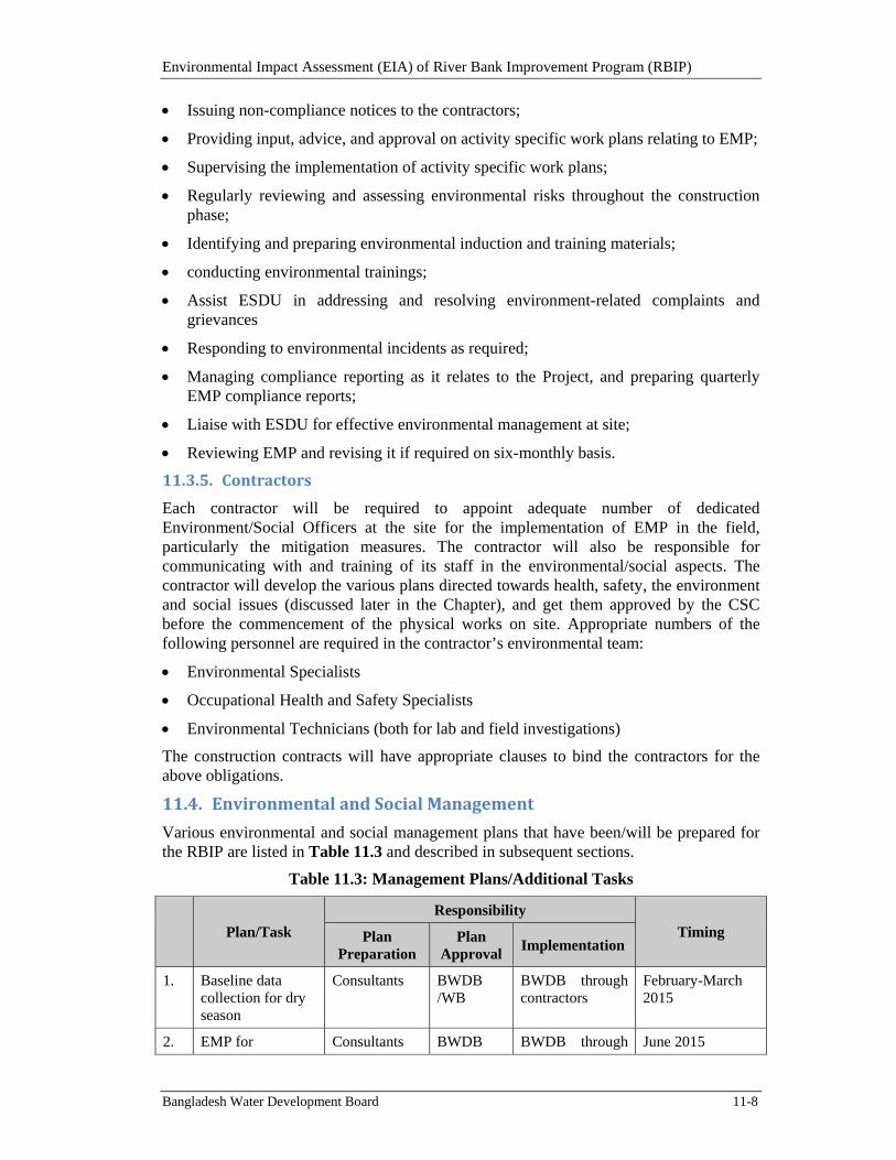
Environmental Impact Assessment (EIA) of River Bank Improvement Program (RBIP)
Bangladesh Water Development Board 11-8
Issuing non-compliance notices to the contractors;
Providing input, advice, and approval on activity specific work plans relating to EMP;
Supervising the implementation of activity specific work plans;
Regularly reviewing and assessing environmental risks throughout the construction phase;
Identifying and preparing environmental induction and training materials;
conducting environmental trainings;
Assist ESDU in addressing and resolving environment-related complaints and grievances
Responding to environmental incidents as required;
Managing compliance reporting as it relates to the Project, and preparing quarterly EMP compliance reports;
Liaise with ESDU for effective environmental management at site;
Reviewing EMP and revising it if required on six-monthly basis.
11.3.5. Contractors
Each contractor will be required to appoint adequate number of dedicated Environment/Social Officers at the site for the implementation of EMP in the field, particularly the mitigation measures. The contractor will also be responsible for communicating with and training of its staff in the environmental/social aspects. The contractor will develop the various plans directed towards health, safety, the environment and social issues (discussed later in the Chapter), and get them approved by the CSC before the commencement of the physical works on site. Appropriate numbers of the following personnel are required in the contractor’s environmental team:
Environmental Specialists
Occupational Health and Safety Specialists
Environmental Technicians (both for lab and field investigations)
The construction contracts will have appropriate clauses to bind the contractors for the above obligations.
11.4. EnvironmentalandSocialManagement
Various environmental and social management plans that have been/will be prepared for the RBIP are listed in Table 11.3 and described in subsequent sections.
Table 11.3: Management Plans/Additional Tasks
Plan/Task
Responsibility
Timing Plan Preparation
Plan Approval
Implementation
1. Baseline data collection for dry season
Consultants BWDB /WB
BWDB through contractors
February-March 2015
2. EMP for Consultants BWDB BWDB through June 2015
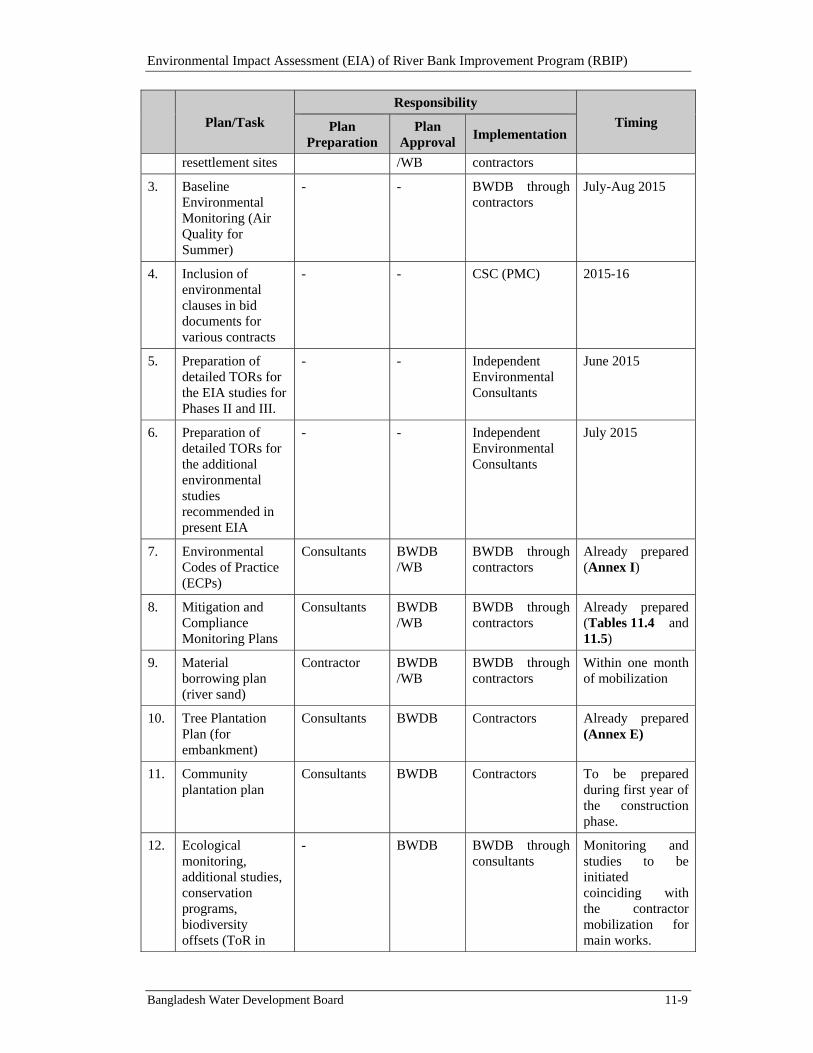
Environmental Impact Assessment (EIA) of River Bank Improvement Program (RBIP)
Bangladesh Water Development Board 11-9
Plan/Task
Responsibility
Timing Plan Preparation
Plan Approval
Implementation
resettlement sites /WB contractors
3. Baseline Environmental Monitoring (Air Quality for Summer)
- - BWDB through contractors
July-Aug 2015
4. Inclusion of environmental clauses in bid documents for various contracts
- - CSC (PMC) 2015-16
5. Preparation of detailed TORs for the EIA studies for Phases II and III.
- - Independent Environmental Consultants
June 2015
6. Preparation of detailed TORs for the additional environmental studies recommended in present EIA
- - Independent Environmental Consultants
July 2015
7. Environmental Codes of Practice (ECPs)
Consultants BWDB /WB
BWDB through contractors
Already prepared (Annex I)
8. Mitigation and Compliance Monitoring Plans
Consultants BWDB /WB
BWDB through contractors
Already prepared (Tables 11.4 and 11.5)
9. Material borrowing plan (river sand)
Contractor BWDB /WB
BWDB through contractors
Within one month of mobilization
10. Tree Plantation Plan (for embankment)
Consultants BWDB Contractors Already prepared (Annex E)
11. Community plantation plan
Consultants BWDB Contractors To be prepared during first year of the construction phase.
12. Ecological monitoring, additional studies, conservation programs, biodiversity offsets (ToR in
- BWDB BWDB through consultants
Monitoring and studies to be initiated coinciding with the contractor mobilization for main works.
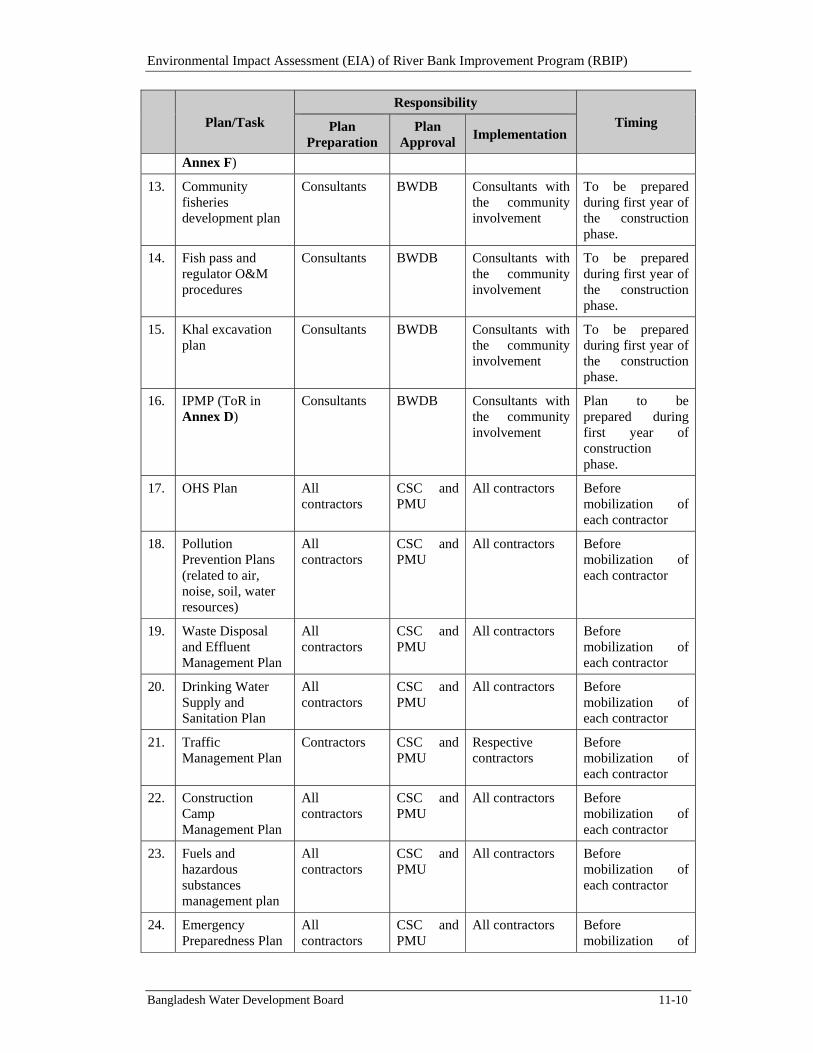
Environmental Impact Assessment (EIA) of River Bank Improvement Program (RBIP)
Bangladesh Water Development Board 11-10
Plan/Task
Responsibility
Timing Plan Preparation
Plan Approval
Implementation
Annex F)
13. Community fisheries development plan
Consultants BWDB Consultants with the community involvement
To be prepared during first year of the construction phase.
14. Fish pass and regulator O&M procedures
Consultants BWDB Consultants with the community involvement
To be prepared during first year of the construction phase.
15. Khal excavation plan
Consultants BWDB Consultants with the community involvement
To be prepared during first year of the construction phase.
16. IPMP (ToR in Annex D)
Consultants BWDB Consultants with the community involvement
Plan to be prepared during first year of construction phase.
17. OHS Plan All contractors
CSC and PMU
All contractors Before mobilization of each contractor
18. Pollution Prevention Plans (related to air, noise, soil, water resources)
All contractors
CSC and PMU
All contractors Before mobilization of each contractor
19. Waste Disposal and Effluent Management Plan
All contractors
CSC and PMU
All contractors Before mobilization of each contractor
20. Drinking Water Supply and Sanitation Plan
All contractors
CSC and PMU
All contractors Before mobilization of each contractor
21. Traffic Management Plan
Contractors CSC and PMU
Respective contractors
Before mobilization of each contractor
22. Construction Camp Management Plan
All contractors
CSC and PMU
All contractors Before mobilization of each contractor
23. Fuels and hazardous substances management plan
All contractors
CSC and PMU
All contractors Before mobilization of each contractor
24. Emergency Preparedness Plan
All contractors
CSC and PMU
All contractors Before mobilization of
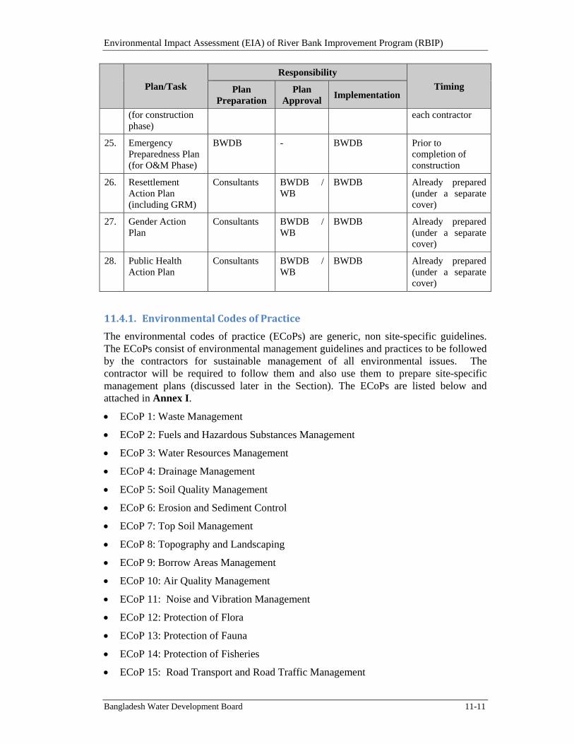
Environmental Impact Assessment (EIA) of River Bank Improvement Program (RBIP)
Bangladesh Water Development Board 11-11
Plan/Task
Responsibility
Timing Plan Preparation
Plan Approval
Implementation
(for construction phase)
each contractor
25. Emergency Preparedness Plan (for O&M Phase)
BWDB - BWDB Prior to completion of construction
26. Resettlement Action Plan (including GRM)
Consultants BWDB / WB
BWDB Already prepared (under a separate cover)
27. Gender Action Plan
Consultants BWDB / WB
BWDB Already prepared (under a separate cover)
28. Public Health Action Plan
Consultants BWDB / WB
BWDB Already prepared (under a separate cover)
11.4.1. EnvironmentalCodesofPractice
The environmental codes of practice (ECoPs) are generic, non site-specific guidelines. The ECoPs consist of environmental management guidelines and practices to be followed by the contractors for sustainable management of all environmental issues. The contractor will be required to follow them and also use them to prepare site-specific management plans (discussed later in the Section). The ECoPs are listed below and attached in Annex I.
ECoP 1: Waste Management
ECoP 2: Fuels and Hazardous Substances Management
ECoP 3: Water Resources Management
ECoP 4: Drainage Management
ECoP 5: Soil Quality Management
ECoP 6: Erosion and Sediment Control
ECoP 7: Top Soil Management
ECoP 8: Topography and Landscaping
ECoP 9: Borrow Areas Management
ECoP 10: Air Quality Management
ECoP 11: Noise and Vibration Management
ECoP 12: Protection of Flora
ECoP 13: Protection of Fauna
ECoP 14: Protection of Fisheries
ECoP 15: Road Transport and Road Traffic Management
Environmental Impact Assessment (EIA) of River Bank Improvement Program (RBIP)
Bangladesh Water Development Board 11-12
ECoP 16: River Transport management
ECoP 17: Construction Camp Management
ECoP 18: Cultural and Religious Issues
ECoP 19: Workers Health and Safety.
11.4.2. MitigationsandComplianceMonitoringPlans
The mitigation and compliance monitoring plans are the key element of EMP and have been prepared on the basis of impact assessment described in Chapter 9. The Plans describe the potentially negative impacts of each project activity, lists mitigation and control measures to address the negative impacts, and assigns responsibilities for implementation and monitoring of these measures. The Plans are presented in Tables 11.4 and 11.5.
11.4.3. SiteSpecificManagementPlans
Sand extraction plan will be prepared and implemented by the contractors on the basis of the ECoPs and the mitigation measures given in Chapter 9 and Table 11.4. The Plan will describe among others the methodology to be adopted, restrictions to be followed, prior survey to be conducted, and documentation to be maintained for the sand extraction. The Plan will be submitted to the CSC for their review and approval before initiating the sand extraction activity.
Pollution Prevention Plan will be prepared and implemented by the contractors on the basis of the ECoPs and WBG EHS Guidelines (2007) that will be part of the bidding documents. The Plan will be submitted to the CSC for their review and approval before contractor mobilization.
Waste Disposal and Effluent Management Plan will be prepared and implemented by the Contractor on the basis of the EMP, ECoP, and WBG EHS Guidelines (2007), which will be part of the bidding documents. The Plan will be submitted to the CSC for their review and approval before contractor mobilization.
Drinking Water Supply and Sanitation Plan: Separate water supply and sanitation provisions will be needed for the temporary facilities including offices, labor camps and workshops in order not to cause shortages and/or contamination of existing drinking water sources. A Plan will be prepared by the contractors on basis of the EMP and ECoPs, which are part of the bidding documents. The Plan will be submitted to the CSC for their review and approval before contractor mobilization.
Occupational Health and Safety (OHS) Plan will be prepared and implemented by each contractor on the basis of the WBG EHS Guidelines (2007), ECoPs, mitigation plan (Table 11.4), and other relevant standards. The Plan will be submitted to the CSC for their review and approval before contractor mobilization.
Traffic Management Plan will be prepared by each contractor after discussion with BWDB and authorities responsible for roads and traffic. The Plan will be submitted to the CSC for their review and approval before contractor mobilization. The Plan will identify the routes to be used by the contractors, procedures for the safety of the local community particularly pedestrians, and monitoring mechanism to avoid traffic congestion.
Construction Camp Management Plan will be prepared by each contractor. The Plan will include the camp layout, details of various facilities including supplies, storage, and
Environmental Impact Assessment (EIA) of River Bank Improvement Program (RBIP)
Bangladesh Water Development Board 11-13
disposal. The Plan will be submitted to the CSC for their review and approval before camp establishment.
Fuel and Hazardous Substances Management Plan will be prepared by each contractor in accordance with the standard operating procedures, relevant guidelines, and where applicable, material safety data sheets (MSDS). The Plan will include the procedures for handling the oils and chemical spills. The Plan will be submitted to the CSC for their review and approval before contractor mobilization.
An Emergency Preparedness Plan will be prepared by each contractor after assessing potential risks and hazards that could be encountered during construction. The Plan will be submitted to the CSC/BWDB for their review and approval before contractor mobilization.
Plantation Plan: A plantation plan has been prepared (discussed in Section 9.4.1.4) for the trees to be planted on the embankment. The Plan includes the species to be planted, the plantation methodology, and plantation layout.
Resettlement Action Plan (RAP): The Project will require about 340 ha of land and affect a total of 15,558 persons for the construction of embankment. The social impacts largely include loss of residential and agricultural land, residential, commercial and communal structures, as well as loss of income and livelihoods. To address and mitigate these relocation and resettlement impacts, the Resettlement Action Plan (RAP) has been prepared. The RAP is based on the findings of the inventory and census surveys as well as meetings and consultations with various project-affected persons. The RAP presents (a) type and extent of loss of assets including land, structures and trees; (b) principles and legal framework applicable for mitigation of these losses; (c) the entitlement matrix, (d) relocation strategies and plans, including provision for livelihoods; (e) resettlement and rehabilitation budget; and (f) institutional framework for the implementation of the plan, including monitoring and evaluation. It has been designed as a “development” plan, therefore the overall objective of the RAP is to restore and/or improve the living standards of the affected persons from pre-project level.
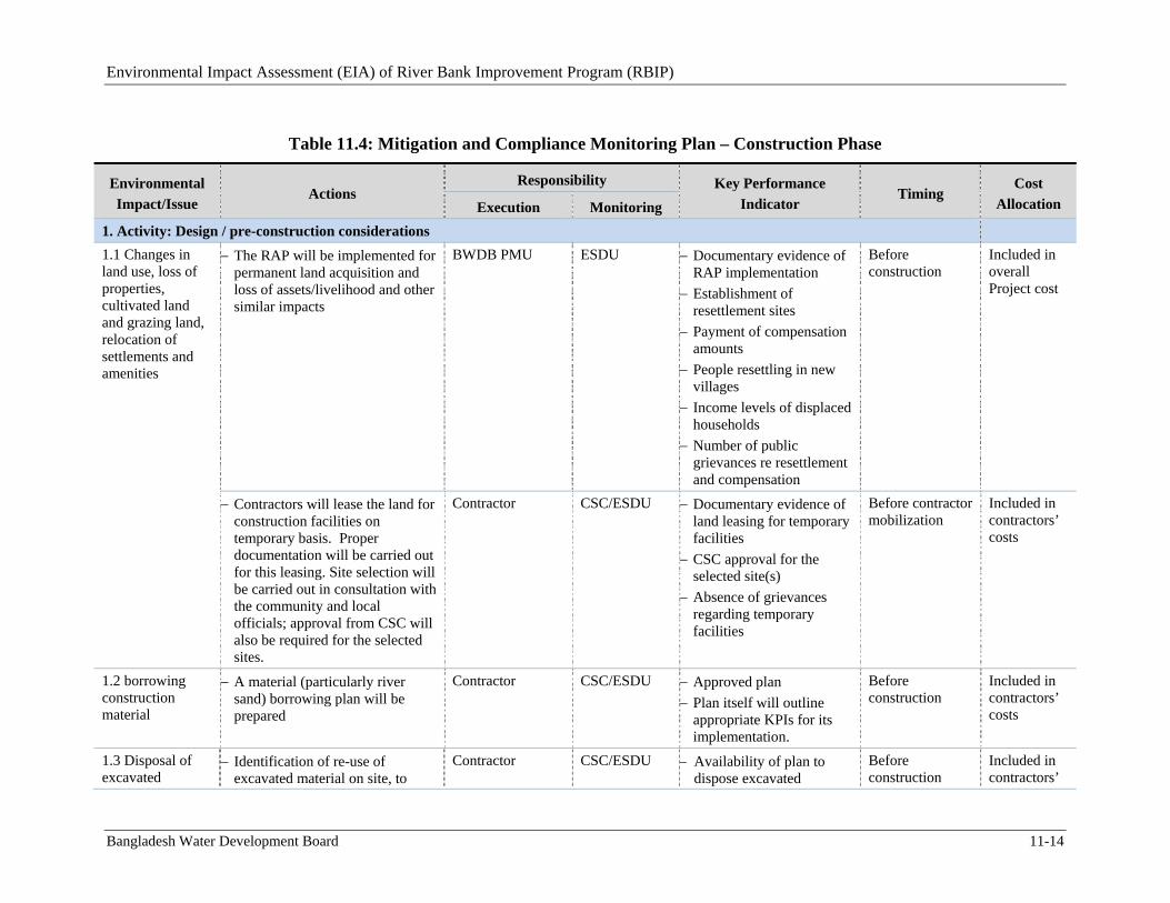
Environmental Impact Assessment (EIA) of River Bank Improvement Program (RBIP)
Bangladesh Water Development Board 11-14
Table 11.4: Mitigation and Compliance Monitoring Plan – Construction Phase
Environmental
Impact/Issue Actions
Responsibility Key Performance
Indicator Timing
Cost
Allocation Execution Monitoring
1. Activity: Design / pre-construction considerations
1.1 Changes in land use, loss of properties, cultivated land and grazing land, relocation of settlements and amenities
The RAP will be implemented for permanent land acquisition and loss of assets/livelihood and other similar impacts
BWDB PMU
ESDU
Documentary evidence of RAP implementation
Establishment of resettlement sites
Payment of compensation amounts
People resettling in new villages
Income levels of displaced households
Number of public grievances re resettlement and compensation
Before construction
Included in overall Project cost
Contractors will lease the land for construction facilities on temporary basis. Proper documentation will be carried out for this leasing. Site selection will be carried out in consultation with the community and local officials; approval from CSC will also be required for the selected sites.
Contractor
CSC/ESDU Documentary evidence of land leasing for temporary facilities
CSC approval for the selected site(s)
Absence of grievances regarding temporary facilities
Before contractor mobilization
Included in contractors’ costs
1.2 borrowing construction material
A material (particularly river sand) borrowing plan will be prepared
Contractor
CSC/ESDU Approved plan
Plan itself will outline appropriate KPIs for its implementation.
Before construction
Included in contractors’ costs
1.3 Disposal of excavated
Identification of re-use of excavated material on site, to
Contractor CSC/ESDU Availability of plan to dispose excavated
Before construction
Included in contractors’
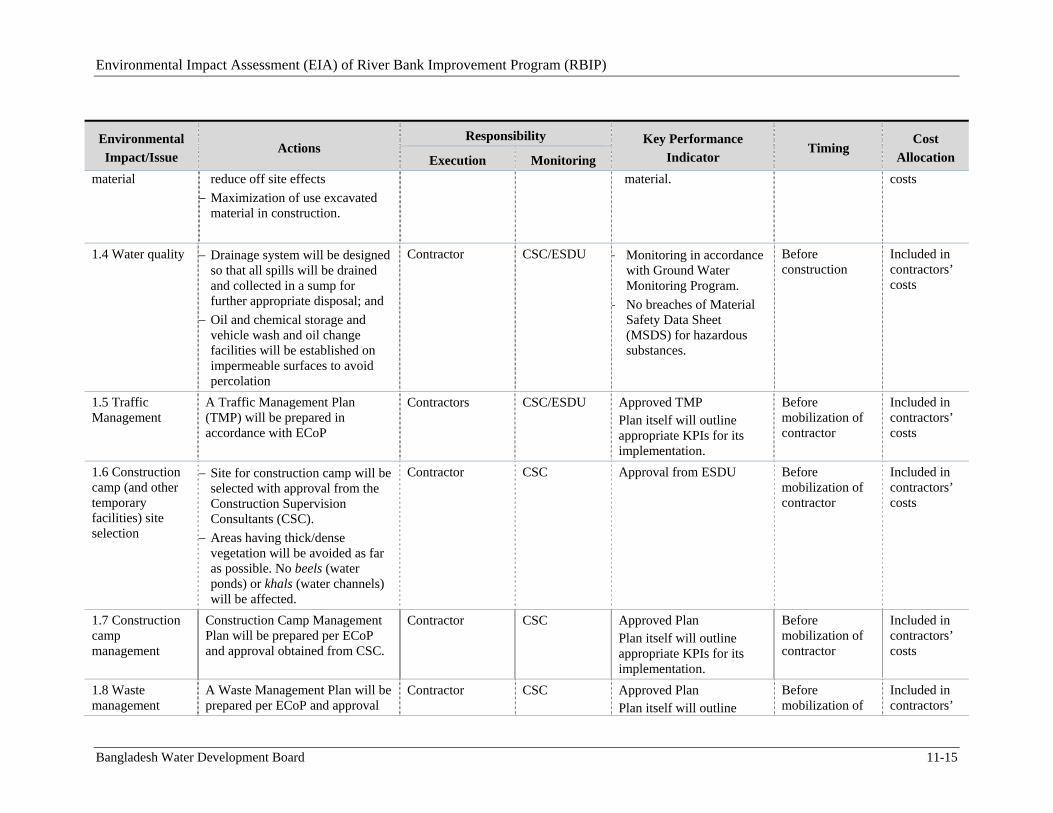
Environmental Impact Assessment (EIA) of River Bank Improvement Program (RBIP)
Bangladesh Water Development Board 11-15
Environmental
Impact/Issue Actions
Responsibility Key Performance
Indicator Timing
Cost
Allocation Execution Monitoring material
reduce off site effects
Maximization of use excavated material in construction.
material. costs
1.4 Water quality
Drainage system will be designed so that all spills will be drained and collected in a sump for further appropriate disposal; and
Oil and chemical storage and vehicle wash and oil change facilities will be established on impermeable surfaces to avoid percolation
Contractor CSC/ESDU Monitoring in accordance with Ground Water Monitoring Program.
No breaches of Material Safety Data Sheet (MSDS) for hazardous substances.
Before construction
Included in contractors’ costs
1.5 Traffic Management
A Traffic Management Plan (TMP) will be prepared in accordance with ECoP
Contractors CSC/ESDU Approved TMP Plan itself will outline appropriate KPIs for its implementation.
Before mobilization of contractor
Included in contractors’ costs
1.6 Construction camp (and other temporary facilities) site selection
Site for construction camp will be selected with approval from the Construction Supervision Consultants (CSC).
Areas having thick/dense vegetation will be avoided as far as possible. No beels (water ponds) or khals (water channels) will be affected.
Contractor CSC Approval from ESDU
Before mobilization of contractor
Included in contractors’ costs
1.7 Construction camp management
Construction Camp Management Plan will be prepared per ECoP and approval obtained from CSC.
Contractor CSC Approved Plan Plan itself will outline appropriate KPIs for its implementation.
Before mobilization of contractor
Included in contractors’ costs
1.8 Waste management
A Waste Management Plan will be prepared per ECoP and approval
Contractor CSC Approved Plan Plan itself will outline
Before mobilization of
Included in contractors’
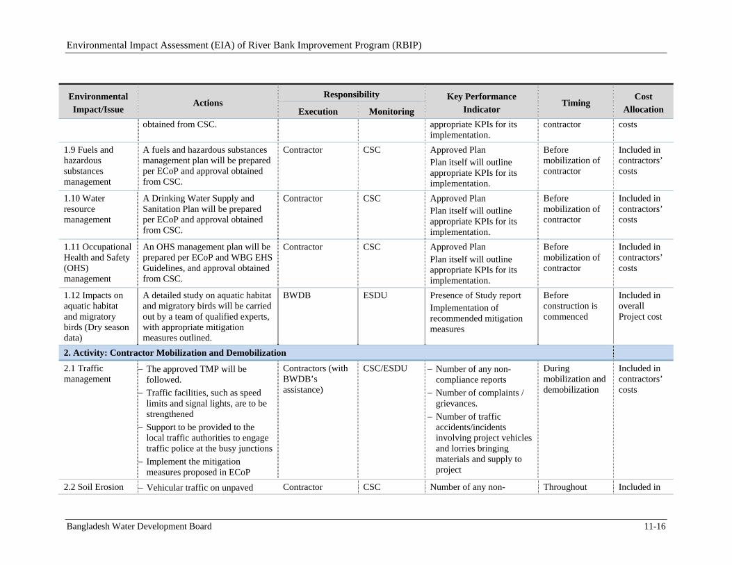
Environmental Impact Assessment (EIA) of River Bank Improvement Program (RBIP)
Bangladesh Water Development Board 11-16
Environmental
Impact/Issue Actions
Responsibility Key Performance
Indicator Timing
Cost
Allocation Execution Monitoring obtained from CSC. appropriate KPIs for its
implementation. contractor costs
1.9 Fuels and hazardous substances management
A fuels and hazardous substances management plan will be prepared per ECoP and approval obtained from CSC.
Contractor CSC Approved Plan Plan itself will outline appropriate KPIs for its implementation.
Before mobilization of contractor
Included in contractors’ costs
1.10 Water resource management
A Drinking Water Supply and Sanitation Plan will be prepared per ECoP and approval obtained from CSC.
Contractor CSC Approved Plan Plan itself will outline appropriate KPIs for its implementation.
Before mobilization of contractor
Included in contractors’ costs
1.11 Occupational Health and Safety (OHS) management
An OHS management plan will be prepared per ECoP and WBG EHS Guidelines, and approval obtained from CSC.
Contractor CSC Approved Plan Plan itself will outline appropriate KPIs for its implementation.
Before mobilization of contractor
Included in contractors’ costs
1.12 Impacts on aquatic habitat and migratory birds (Dry season data)
A detailed study on aquatic habitat and migratory birds will be carried out by a team of qualified experts, with appropriate mitigation measures outlined.
BWDB ESDU Presence of Study report Implementation of recommended mitigation measures
Before construction is commenced
Included in overall Project cost
2. Activity: Contractor Mobilization and Demobilization
2.1 Traffic management
The approved TMP will be followed.
Traffic facilities, such as speed limits and signal lights, are to be strengthened
Support to be provided to the local traffic authorities to engage traffic police at the busy junctions
Implement the mitigation measures proposed in ECoP
Contractors (with BWDB’s assistance)
CSC/ESDU Number of any non-compliance reports
Number of complaints / grievances.
Number of traffic accidents/incidents involving project vehicles and lorries bringing materials and supply to project
During mobilization and demobilization
Included in contractors’ costs
2.2 Soil Erosion Vehicular traffic on unpaved Contractor CSC Number of any non- Throughout Included in
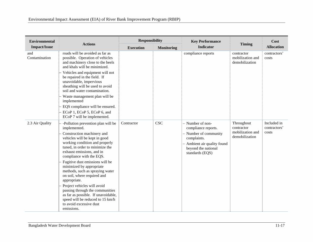
Environmental Impact Assessment (EIA) of River Bank Improvement Program (RBIP)
Bangladesh Water Development Board 11-17
Environmental
Impact/Issue Actions
Responsibility Key Performance
Indicator Timing
Cost
Allocation Execution Monitoring and Contamination
roads will be avoided as far as possible. Operation of vehicles and machinery close to the beels and khals will be minimized.
Vehicles and equipment will not be repaired in the field. If unavoidable, impervious sheathing will be used to avoid soil and water contamination.
Waste management plan will be implemented
EQS compliance will be ensured.
ECoP 1, ECoP 5, ECoP 6, and ECoP 7 will be implemented.
compliance reports contractor mobilization and demobilization
contractors’ costs
2.3 Air Quality -Pollution prevention plan will be implemented.
Construction machinery and vehicles will be kept in good working condition and properly tuned, in order to minimize the exhaust emissions, and in compliance with the EQS.
Fugitive dust emissions will be minimized by appropriate methods, such as spraying water on soil, where required and appropriate.
Project vehicles will avoid passing through the communities as far as possible. If unavoidable, speed will be reduced to 15 km/h to avoid excessive dust emissions.
Contractor CSC Number of non-compliance reports.
Number of community complaints.
Ambient air quality found beyond the national standards (EQS)
Throughout contractor mobilization and demobilization
Included in contractors’ costs
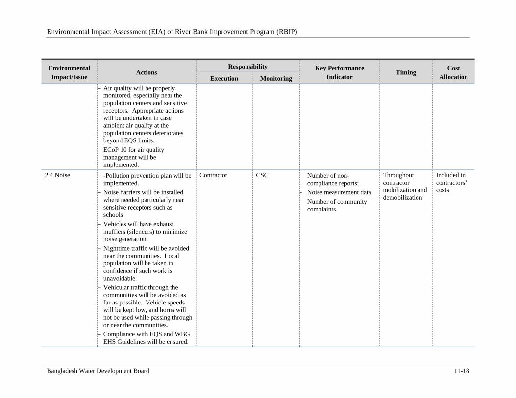
Environmental Impact Assessment (EIA) of River Bank Improvement Program (RBIP)
Bangladesh Water Development Board 11-18
Environmental
Impact/Issue Actions
Responsibility Key Performance
Indicator Timing
Cost
Allocation Execution Monitoring
Air quality will be properly monitored, especially near the population centers and sensitive receptors. Appropriate actions will be undertaken in case ambient air quality at the population centers deteriorates beyond EQS limits.
ECoP 10 for air quality management will be implemented.
2.4 Noise -Pollution prevention plan will be implemented.
Noise barriers will be installed where needed particularly near sensitive receptors such as schools
Vehicles will have exhaust mufflers (silencers) to minimize noise generation.
Nighttime traffic will be avoided near the communities. Local population will be taken in confidence if such work is unavoidable.
Vehicular traffic through the communities will be avoided as far as possible. Vehicle speeds will be kept low, and horns will not be used while passing through or near the communities.
Compliance with EQS and WBG EHS Guidelines will be ensured.
Contractor CSC Number of non-compliance reports;
Noise measurement data
Number of community complaints.
Throughout contractor mobilization and demobilization
Included in contractors’ costs
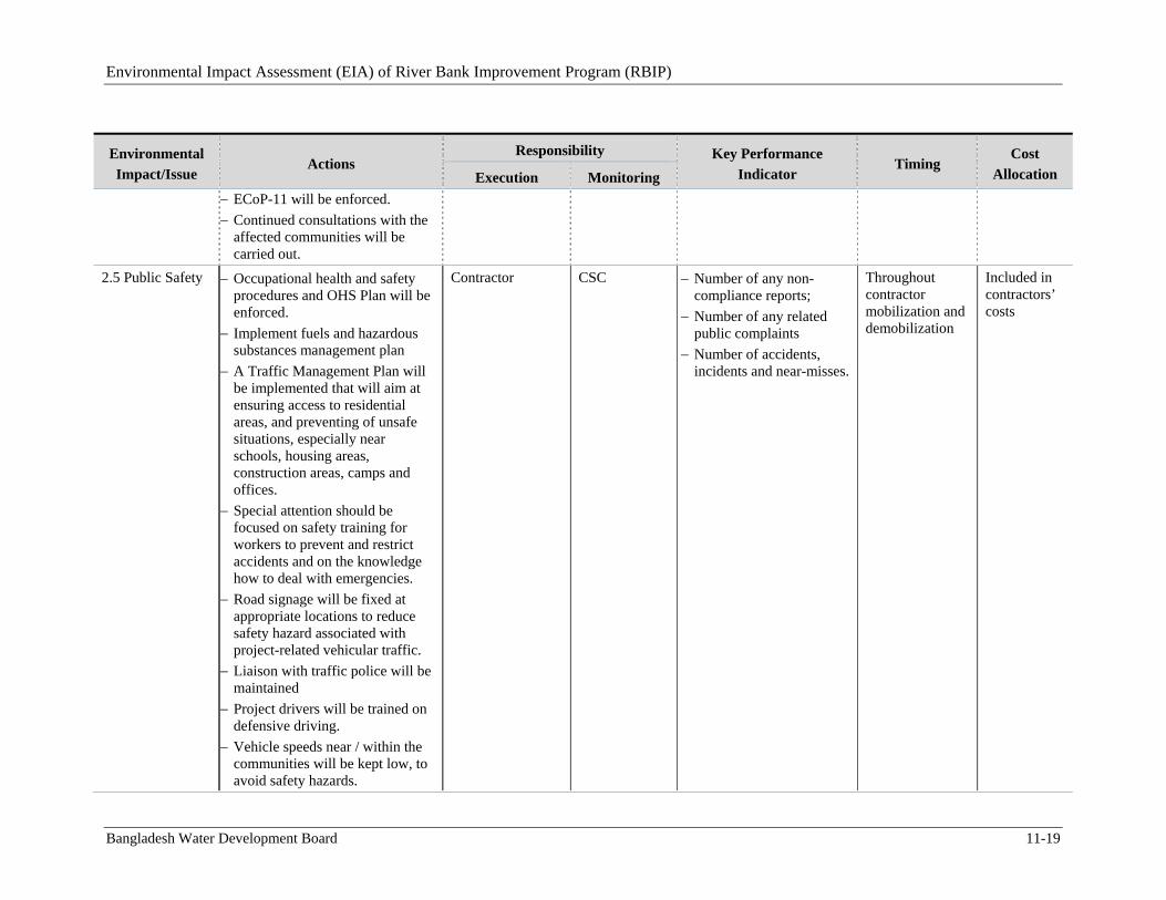
Environmental Impact Assessment (EIA) of River Bank Improvement Program (RBIP)
Bangladesh Water Development Board 11-19
Environmental
Impact/Issue Actions
Responsibility Key Performance
Indicator Timing
Cost
Allocation Execution Monitoring
ECoP-11 will be enforced.
Continued consultations with the affected communities will be carried out.
2.5 Public Safety Occupational health and safety procedures and OHS Plan will be enforced.
Implement fuels and hazardous substances management plan
A Traffic Management Plan will be implemented that will aim at ensuring access to residential areas, and preventing of unsafe situations, especially near schools, housing areas, construction areas, camps and offices.
Special attention should be focused on safety training for workers to prevent and restrict accidents and on the knowledge how to deal with emergencies.
Road signage will be fixed at appropriate locations to reduce safety hazard associated with project-related vehicular traffic.
Liaison with traffic police will be maintained
Project drivers will be trained on defensive driving.
Vehicle speeds near / within the communities will be kept low, to avoid safety hazards.
Contractor CSC Number of any non-compliance reports;
Number of any related public complaints
Number of accidents, incidents and near-misses.
Throughout contractor mobilization and demobilization
Included in contractors’ costs
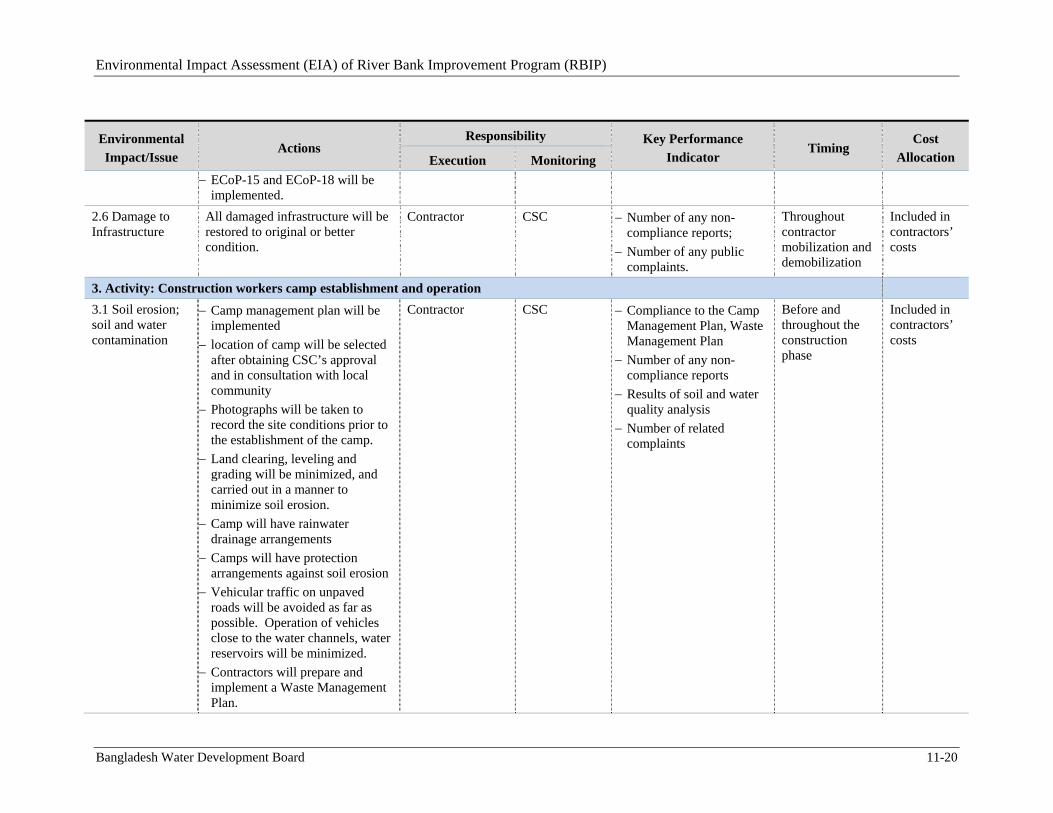
Environmental Impact Assessment (EIA) of River Bank Improvement Program (RBIP)
Bangladesh Water Development Board 11-20
Environmental
Impact/Issue Actions
Responsibility Key Performance
Indicator Timing
Cost
Allocation Execution Monitoring
ECoP-15 and ECoP-18 will be implemented.
2.6 Damage to Infrastructure
All damaged infrastructure will be restored to original or better condition.
Contractor CSC Number of any non-compliance reports;
Number of any public complaints.
Throughout contractor mobilization and demobilization
Included in contractors’ costs
3. Activity: Construction workers camp establishment and operation
3.1 Soil erosion; soil and water contamination
Camp management plan will be implemented
location of camp will be selected after obtaining CSC’s approval and in consultation with local community
Photographs will be taken to record the site conditions prior to the establishment of the camp.
Land clearing, leveling and grading will be minimized, and carried out in a manner to minimize soil erosion.
Camp will have rainwater drainage arrangements
Camps will have protection arrangements against soil erosion
Vehicular traffic on unpaved roads will be avoided as far as possible. Operation of vehicles close to the water channels, water reservoirs will be minimized.
Contractors will prepare and implement a Waste Management Plan.
Contractor CSC Compliance to the Camp Management Plan, Waste Management Plan
Number of any non-compliance reports
Results of soil and water quality analysis
Number of related complaints
Before and throughout the construction phase
Included in contractors’ costs
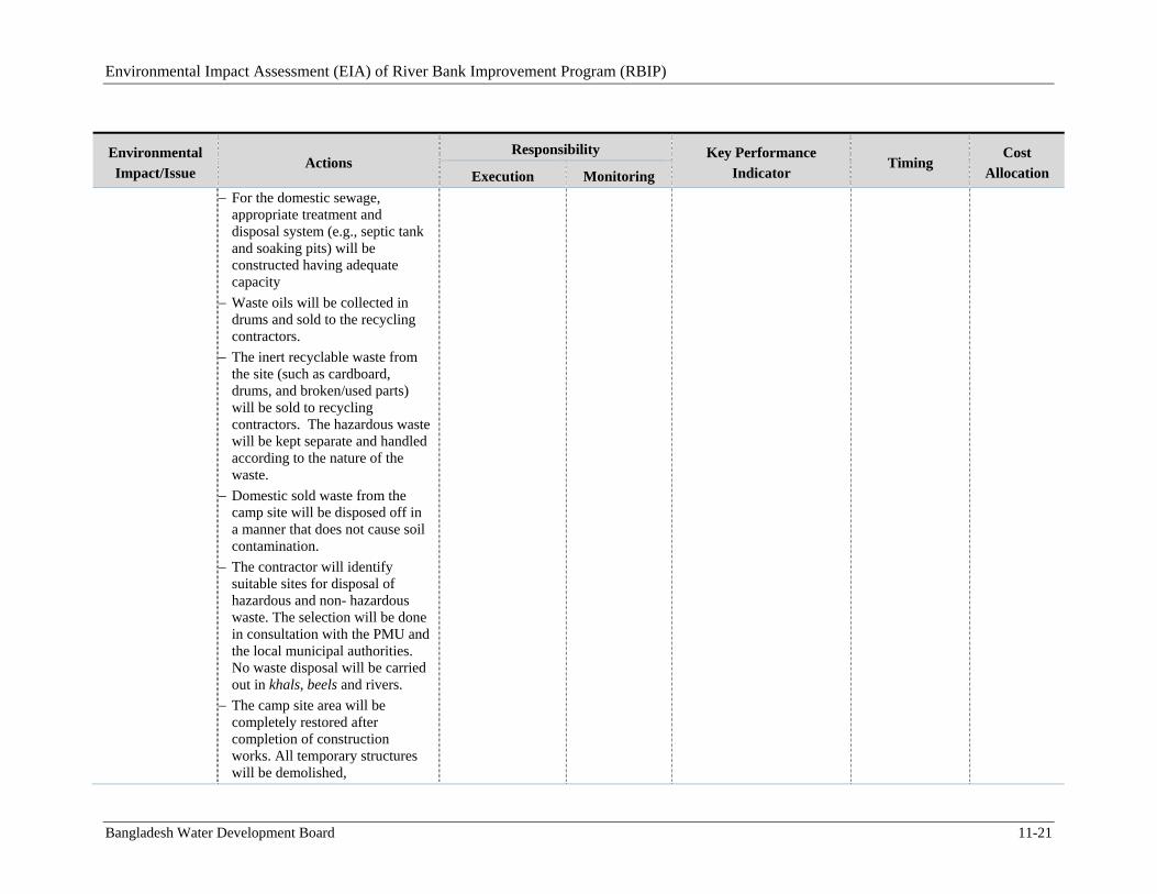
Environmental Impact Assessment (EIA) of River Bank Improvement Program (RBIP)
Bangladesh Water Development Board 11-21
Environmental
Impact/Issue Actions
Responsibility Key Performance
Indicator Timing
Cost
Allocation Execution Monitoring
For the domestic sewage, appropriate treatment and disposal system (e.g., septic tank and soaking pits) will be constructed having adequate capacity
Waste oils will be collected in drums and sold to the recycling contractors.
The inert recyclable waste from the site (such as cardboard, drums, and broken/used parts) will be sold to recycling contractors. The hazardous waste will be kept separate and handled according to the nature of the waste.
Domestic sold waste from the camp site will be disposed off in a manner that does not cause soil contamination.
The contractor will identify suitable sites for disposal of hazardous and non- hazardous waste. The selection will be done in consultation with the PMU and the local municipal authorities. No waste disposal will be carried out in khals, beels and rivers.
The camp site area will be completely restored after completion of construction works. All temporary structures will be demolished,
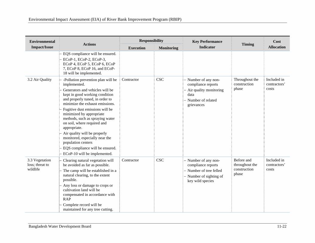
Environmental Impact Assessment (EIA) of River Bank Improvement Program (RBIP)
Bangladesh Water Development Board 11-22
Environmental
Impact/Issue Actions
Responsibility Key Performance
Indicator Timing
Cost
Allocation Execution Monitoring
EQS compliance will be ensured.
ECoP-1, ECoP-2, ECoP-3, ECoP 4, ECoP 5, ECoP 6, ECoP 7, ECoP 8, ECoP 16, and ECoP-18 will be implemented.
3.2 Air Quality -Pollution prevention plan will be implemented.
Generators and vehicles will be kept in good working condition and properly tuned, in order to minimize the exhaust emissions.
Fugitive dust emissions will be minimized by appropriate methods, such as spraying water on soil, where required and appropriate.
Air quality will be properly monitored, especially near the population centers
EQS compliance will be ensured.
ECoP-10 will be implemented.
Contractor CSC Number of any non-compliance reports
Air quality monitoring data
Number of related grievances
Throughout the construction phase
Included in contractors’ costs
3.3 Vegetation loss; threat to wildlife
Clearing natural vegetation will be avoided as far as possible.
The camp will be established in a natural clearing, to the extent possible.
Any loss or damage to crops or cultivation land will be compensated in accordance with RAP
Complete record will be maintained for any tree cutting.
Contractor CSC Number of any non-compliance reports
Number of tree felled
Number of sighting of key wild species
Before and throughout the construction phase
Included in contractors’ costs
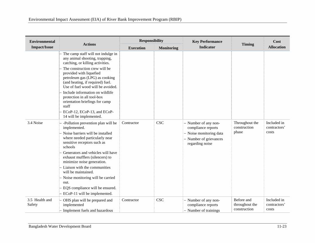
Environmental Impact Assessment (EIA) of River Bank Improvement Program (RBIP)
Bangladesh Water Development Board 11-23
Environmental
Impact/Issue Actions
Responsibility Key Performance
Indicator Timing
Cost
Allocation Execution Monitoring
The camp staff will not indulge in any animal shooting, trapping, catching, or killing activities.
The construction crew will be provided with liquefied petroleum gas (LPG) as cooking (and heating, if required) fuel. Use of fuel wood will be avoided.
Include information on wildlife protection in all tool-box orientation briefings for camp staff
ECoP-12, ECoP-13, and ECoP-14 will be implemented.
3.4 Noise -Pollution prevention plan will be implemented.
Noise barriers will be installed where needed particularly near sensitive receptors such as schools
Generators and vehicles will have exhaust mufflers (silencers) to minimize noise generation.
Liaison with the communities will be maintained.
Noise monitoring will be carried out.
EQS compliance will be ensured.
ECoP-11 will be implemented.
Contractor CSC Number of any non-compliance reports
Noise monitoring data
Number of grievances regarding noise
Throughout the construction phase
Included in contractors’ costs
3.5 Health and Safety
OHS plan will be prepared and implemented
Implement fuels and hazardous
Contractor CSC Number of any non-compliance reports
Number of trainings
Before and throughout the construction
Included in contractors’ costs
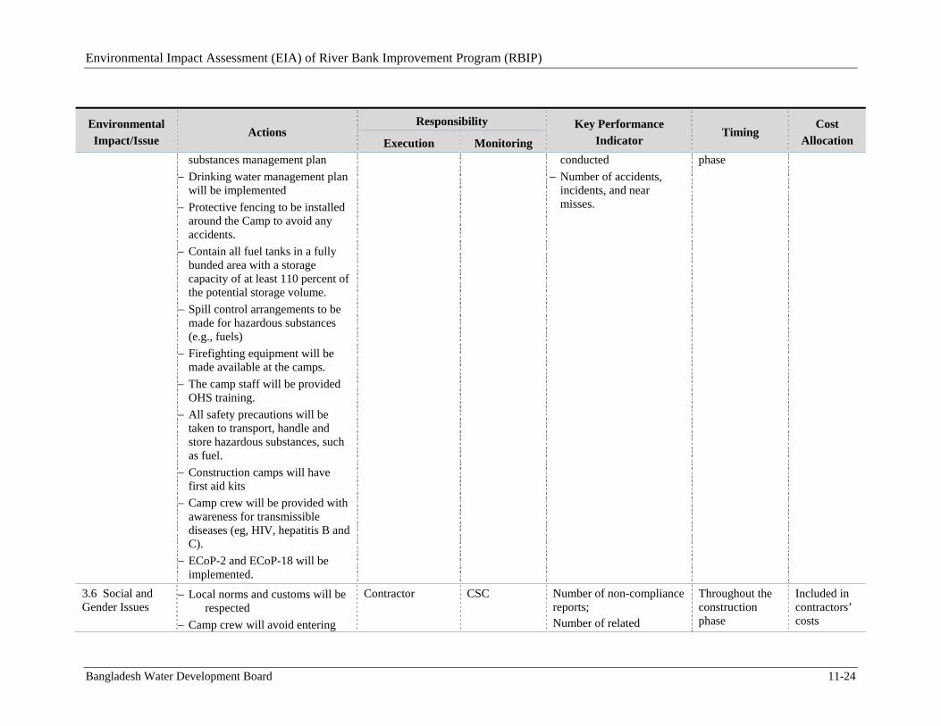
Environmental Impact Assessment (EIA) of River Bank Improvement Program (RBIP)
Bangladesh Water Development Board 11-24
Environmental
Impact/Issue Actions
Responsibility Key Performance
Indicator Timing
Cost
Allocation Execution Monitoring substances management plan
Drinking water management plan will be implemented
Protective fencing to be installed around the Camp to avoid any accidents.
Contain all fuel tanks in a fully bunded area with a storage capacity of at least 110 percent of the potential storage volume.
Spill control arrangements to be made for hazardous substances (e.g., fuels)
Firefighting equipment will be made available at the camps.
The camp staff will be provided OHS training.
All safety precautions will be taken to transport, handle and store hazardous substances, such as fuel.
Construction camps will have first aid kits
Camp crew will be provided with awareness for transmissible diseases (eg, HIV, hepatitis B and C).
ECoP-2 and ECoP-18 will be implemented.
conducted
Number of accidents, incidents, and near misses.
phase
3.6 Social and Gender Issues
Local norms and customs will be respected
Camp crew will avoid entering
Contractor CSC Number of non-compliance reports; Number of related
Throughout the construction phase
Included in contractors’ costs
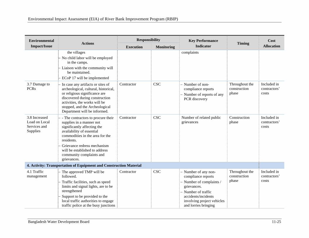
Environmental Impact Assessment (EIA) of River Bank Improvement Program (RBIP)
Bangladesh Water Development Board 11-25
Environmental
Impact/Issue Actions
Responsibility Key Performance
Indicator Timing
Cost
Allocation Execution Monitoring the villages
No child labor will be employed in the camps.
Liaison with the community will be maintained.
ECoP 17 will be implemented
complaints
3.7 Damage to PCRs
In case any artifacts or sites of archeological, cultural, historical, or religious significance are discovered during construction activities, the works will be stopped, and the Archeological Department will be informed.
Contractor CSC Number of non-compliance reports
Number of reports of any PCR discovery
Throughout the construction phase
Included in contractors’ costs
3.8 Increased Load on Local Services and Supplies
- The contractors to procure their supplies in a manner not significantly affecting the availability of essential commodities in the area for the residents.
Grievance redress mechanism will be established to address community complaints and grievances.
Contractor CSC Number of related public grievances
Construction phase
Included in contractors’ costs
4. Activity: Transportation of Equipment and Construction Material
4.1 Traffic management
The approved TMP will be followed.
Traffic facilities, such as speed limits and signal lights, are to be strengthened
Support to be provided to the local traffic authorities to engage traffic police at the busy junctions
Contractor CSC Number of any non-compliance reports
Number of complaints / grievances.
Number of traffic accidents/incidents involving project vehicles and lorries bringing
Throughout the construction phase
Included in contractors’ costs
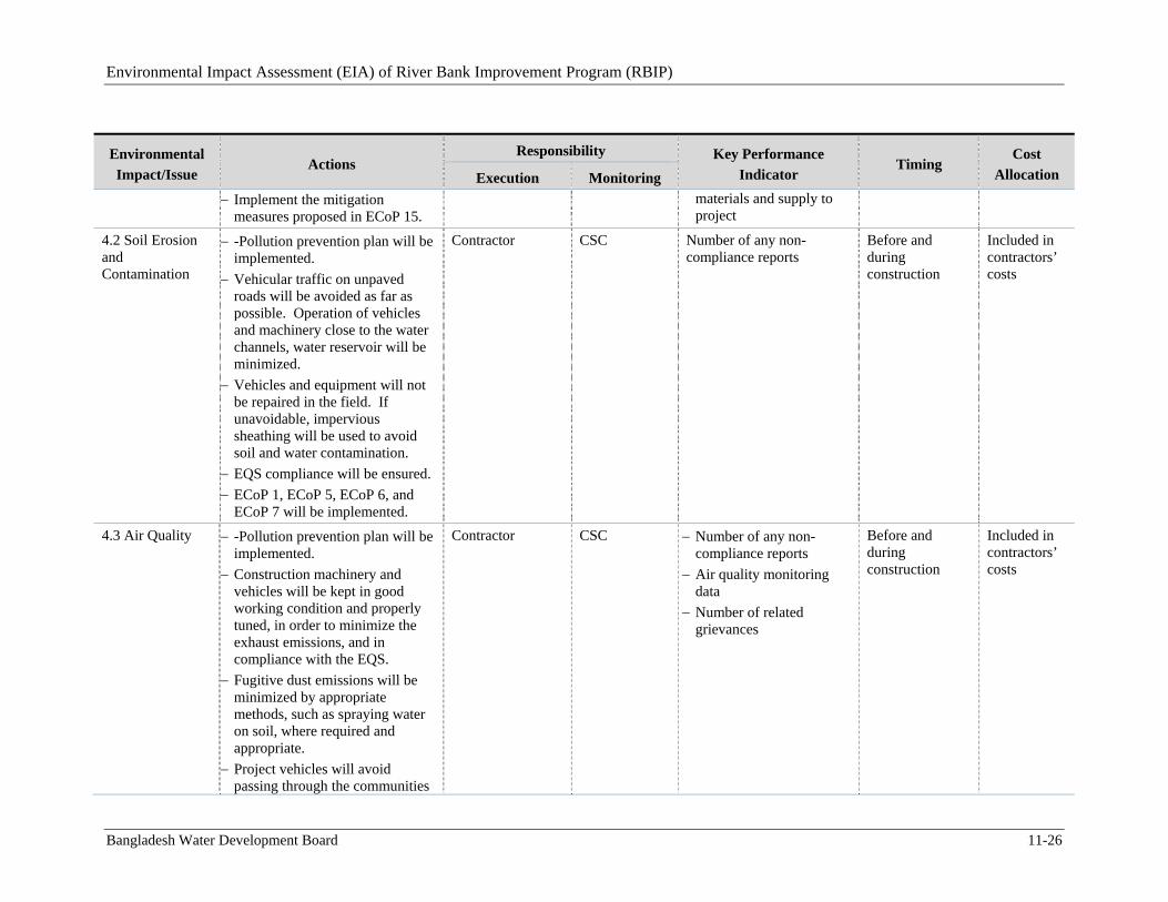
Environmental Impact Assessment (EIA) of River Bank Improvement Program (RBIP)
Bangladesh Water Development Board 11-26
Environmental
Impact/Issue Actions
Responsibility Key Performance
Indicator Timing
Cost
Allocation Execution Monitoring
Implement the mitigation measures proposed in ECoP 15.
materials and supply to project
4.2 Soil Erosion and Contamination
-Pollution prevention plan will be implemented.
Vehicular traffic on unpaved roads will be avoided as far as possible. Operation of vehicles and machinery close to the water channels, water reservoir will be minimized.
Vehicles and equipment will not be repaired in the field. If unavoidable, impervious sheathing will be used to avoid soil and water contamination.
EQS compliance will be ensured.
ECoP 1, ECoP 5, ECoP 6, and ECoP 7 will be implemented.
Contractor CSC Number of any non-compliance reports
Before and during construction
Included in contractors’ costs
4.3 Air Quality -Pollution prevention plan will be implemented.
Construction machinery and vehicles will be kept in good working condition and properly tuned, in order to minimize the exhaust emissions, and in compliance with the EQS.
Fugitive dust emissions will be minimized by appropriate methods, such as spraying water on soil, where required and appropriate.
Project vehicles will avoid passing through the communities
Contractor CSC Number of any non-compliance reports
Air quality monitoring data
Number of related grievances
Before and during construction
Included in contractors’ costs
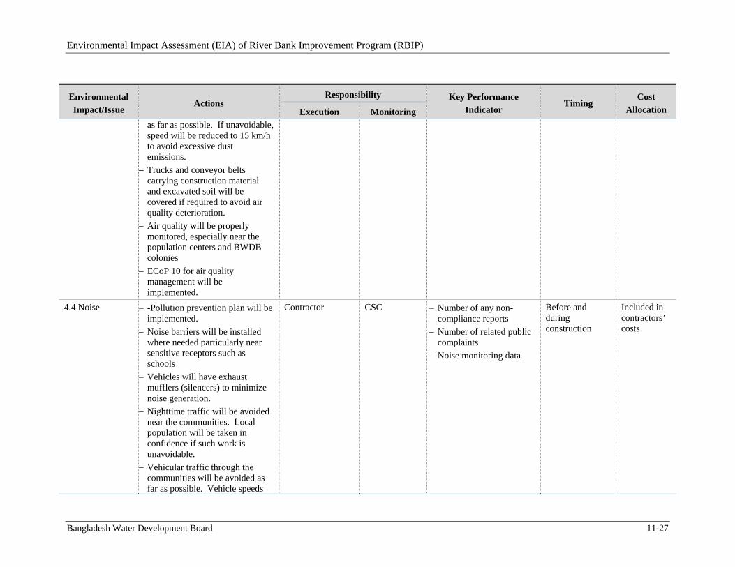
Environmental Impact Assessment (EIA) of River Bank Improvement Program (RBIP)
Bangladesh Water Development Board 11-27
Environmental
Impact/Issue Actions
Responsibility Key Performance
Indicator Timing
Cost
Allocation Execution Monitoring as far as possible. If unavoidable, speed will be reduced to 15 km/h to avoid excessive dust emissions.
Trucks and conveyor belts carrying construction material and excavated soil will be covered if required to avoid air quality deterioration.
Air quality will be properly monitored, especially near the population centers and BWDB colonies
ECoP 10 for air quality management will be implemented.
4.4 Noise -Pollution prevention plan will be implemented.
Noise barriers will be installed where needed particularly near sensitive receptors such as schools
Vehicles will have exhaust mufflers (silencers) to minimize noise generation.
Nighttime traffic will be avoided near the communities. Local population will be taken in confidence if such work is unavoidable.
Vehicular traffic through the communities will be avoided as far as possible. Vehicle speeds
Contractor CSC Number of any non-compliance reports
Number of related public complaints
Noise monitoring data
Before and during construction
Included in contractors’ costs
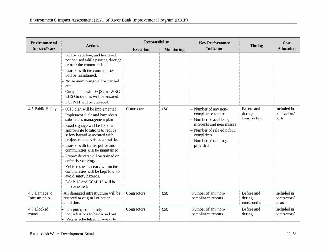
Environmental Impact Assessment (EIA) of River Bank Improvement Program (RBIP)
Bangladesh Water Development Board 11-28
Environmental
Impact/Issue Actions
Responsibility Key Performance
Indicator Timing
Cost
Allocation Execution Monitoring will be kept low, and horns will not be used while passing through or near the communities.
Liaison with the communities will be maintained.
Noise monitoring will be carried out
Compliance with EQS and WBG EHS Guidelines will be ensured.
ECoP-11 will be enforced.
4.5 Public Safety OHS plan will be implemented
Implement fuels and hazardous substances management plan
Road signage will be fixed at appropriate locations to reduce safety hazard associated with project-related vehicular traffic.
Liaison with traffic police and communities will be maintained
Project drivers will be trained on defensive driving.
Vehicle speeds near / within the communities will be kept low, to avoid safety hazards.
ECoP-15 and ECoP-18 will be implemented.
Contractor CSC Number of any non-compliance reports
Number of accidents, incidents and near misses
Number of related public complaints
Number of trainings provided
Before and during construction
Included in contractors’ costs
4.6 Damage to Infrastructure
All damaged infrastructure will be restored to original or better condition.
Contractors CSC Number of any non-compliance reports
Before and during construction
Included in contractors’ costs
4.7 Blocked routes
On-going community consultations to be carried out
Proper scheduling of works to
Contractors CSC Number of any non-compliance reports
Before and during
Included in contractors’
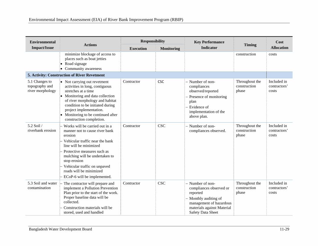
Environmental Impact Assessment (EIA) of River Bank Improvement Program (RBIP)
Bangladesh Water Development Board 11-29
Environmental
Impact/Issue Actions
Responsibility Key Performance
Indicator Timing
Cost
Allocation Execution Monitoring minimize blockage of access to places such as boat jetties
Road signage Community awareness
construction costs
5. Activity: Construction of River Revetment
5.1 Changes to topography and river morphology
Not carrying out revetment activities in long, contiguous stretches at a time
Monitoring and data collection of river morphology and habitat condition to be initiated during project implementation.
Monitoring to be continued after construction completion.
Contractor CSC Number of non-compliances observed/reported
Presence of monitoring plan
Evidence of implementation of the above plan.
Throughout the construction phase
Included in contractors’ costs
5.2 Soil / riverbank erosion
Works will be carried out in a manner not to cause river bank erosion
Vehicular traffic near the bank line will be minimized
Protective measures such as mulching will be undertaken to stop erosion
Vehicular traffic on unpaved roads will be minimized
ECoP-6 will be implemented.
Contractor CSC Number of non-compliances observed.
Throughout the construction phase
Included in contractors’ costs
5.3 Soil and water contamination
The contractor will prepare and implement a Pollution Prevention Plan prior to the start of the work. Proper baseline data will be collected.
Construction materials will be stored, used and handled
Contractor CSC Number of non-compliances observed or reported
Monthly auditing of management of hazardous materials against Material Safety Data Sheet
Throughout the construction phase
Included in contractors’ costs
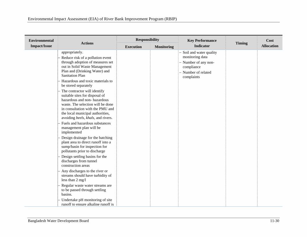
Environmental Impact Assessment (EIA) of River Bank Improvement Program (RBIP)
Bangladesh Water Development Board 11-30
Environmental
Impact/Issue Actions
Responsibility Key Performance
Indicator Timing
Cost
Allocation Execution Monitoring appropriately.
Reduce risk of a pollution event through adoption of measures set out in Solid Waste Management Plan and (Drinking Water) and Sanitation Plan
Hazardous and toxic materials to be stored separately
The contractor will identify suitable sites for disposal of hazardous and non- hazardous waste. The selection will be done in consultation with the PMU and the local municipal authorities, avoiding beels, khals, and rivers.
Fuels and hazardous substances management plan will be implemented
Design drainage for the batching plant area to direct runoff into a sump/basin for inspection for pollutants prior to discharge
Design settling basins for the discharges from tunnel construction areas
Any discharges to the river or streams should have turbidity of less than 2 mg/l
Regular waste water streams are to be passed through settling basins.
Undertake pH monitoring of site runoff to ensure alkaline runoff is
Soil and water quality monitoring data
Number of any non-compliance
Number of related complaints
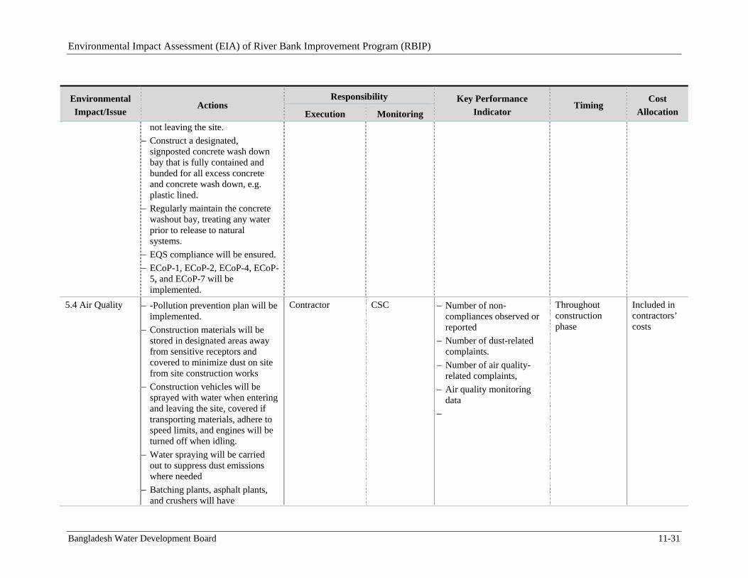
Environmental Impact Assessment (EIA) of River Bank Improvement Program (RBIP)
Bangladesh Water Development Board 11-31
Environmental
Impact/Issue Actions
Responsibility Key Performance
Indicator Timing
Cost
Allocation Execution Monitoring not leaving the site.
Construct a designated, signposted concrete wash down bay that is fully contained and bunded for all excess concrete and concrete wash down, e.g. plastic lined.
Regularly maintain the concrete washout bay, treating any water prior to release to natural systems.
EQS compliance will be ensured.
ECoP-1, ECoP-2, ECoP-4, ECoP-5, and ECoP-7 will be implemented.
5.4 Air Quality
-Pollution prevention plan will be implemented.
Construction materials will be stored in designated areas away from sensitive receptors and covered to minimize dust on site from site construction works
Construction vehicles will be sprayed with water when entering and leaving the site, covered if transporting materials, adhere to speed limits, and engines will be turned off when idling.
Water spraying will be carried out to suppress dust emissions where needed
Batching plants, asphalt plants, and crushers will have
Contractor CSC Number of non-compliances observed or reported
Number of dust-related complaints.
Number of air quality-related complaints,
Air quality monitoring data
Throughout construction phase
Included in contractors’ costs
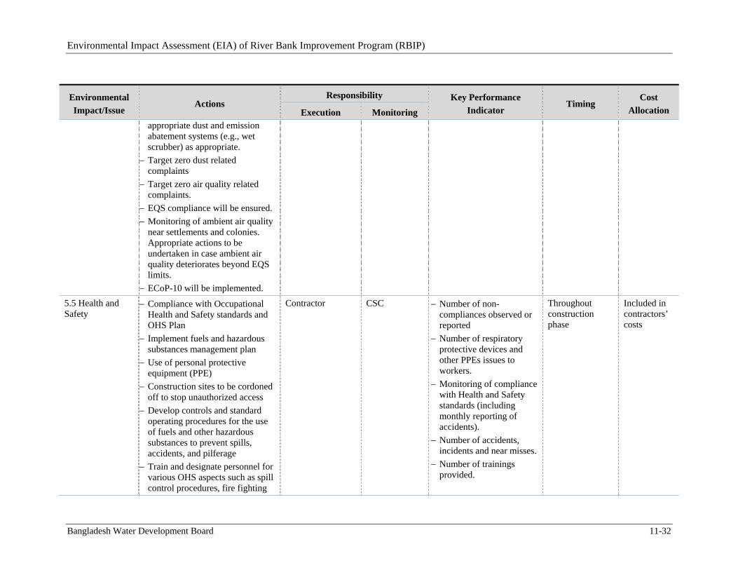
Environmental Impact Assessment (EIA) of River Bank Improvement Program (RBIP)
Bangladesh Water Development Board 11-32
Environmental
Impact/Issue Actions
Responsibility Key Performance
Indicator Timing
Cost
Allocation Execution Monitoring appropriate dust and emission abatement systems (e.g., wet scrubber) as appropriate.
Target zero dust related complaints
Target zero air quality related complaints.
EQS compliance will be ensured.
Monitoring of ambient air quality near settlements and colonies. Appropriate actions to be undertaken in case ambient air quality deteriorates beyond EQS limits.
ECoP-10 will be implemented.
5.5 Health and Safety
Compliance with Occupational Health and Safety standards and OHS Plan
Implement fuels and hazardous substances management plan
Use of personal protective equipment (PPE)
Construction sites to be cordoned off to stop unauthorized access
Develop controls and standard operating procedures for the use of fuels and other hazardous substances to prevent spills, accidents, and pilferage
Train and designate personnel for various OHS aspects such as spill control procedures, fire fighting
Contractor CSC Number of non-compliances observed or reported
Number of respiratory protective devices and other PPEs issues to workers.
Monitoring of compliance with Health and Safety standards (including monthly reporting of accidents).
Number of accidents, incidents and near misses.
Number of trainings provided.
Throughout construction phase
Included in contractors’ costs
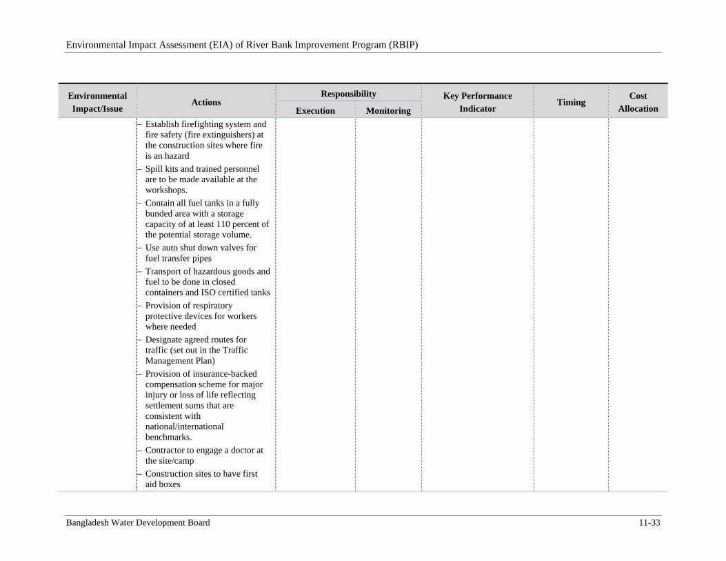
Environmental Impact Assessment (EIA) of River Bank Improvement Program (RBIP)
Bangladesh Water Development Board 11-33
Environmental
Impact/Issue Actions
Responsibility Key Performance
Indicator Timing
Cost
Allocation Execution Monitoring
Establish firefighting system and fire safety (fire extinguishers) at the construction sites where fire is an hazard
Spill kits and trained personnel are to be made available at the workshops.
Contain all fuel tanks in a fully bunded area with a storage capacity of at least 110 percent of the potential storage volume.
Use auto shut down valves for fuel transfer pipes
Transport of hazardous goods and fuel to be done in closed containers and ISO certified tanks
Provision of respiratory protective devices for workers where needed
Designate agreed routes for traffic (set out in the Traffic Management Plan)
Provision of insurance-backed compensation scheme for major injury or loss of life reflecting settlement sums that are consistent with national/international benchmarks.
Contractor to engage a doctor at the site/camp
Construction sites to have first aid boxes
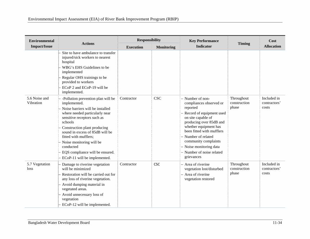
Environmental Impact Assessment (EIA) of River Bank Improvement Program (RBIP)
Bangladesh Water Development Board 11-34
Environmental
Impact/Issue Actions
Responsibility Key Performance
Indicator Timing
Cost
Allocation Execution Monitoring
Site to have ambulance to transfer injured/sick workers to nearest hospital
WBG’s EHS Guidelines to be implemented
Regular OHS trainings to be provided to workers
ECoP 2 and ECoP-19 will be implemented.
5.6 Noise and Vibration
-Pollution prevention plan will be implemented.
Noise barriers will be installed where needed particularly near sensitive receptors such as schools
Construction plant producing sound in excess of 85dB will be fitted with mufflers;
Noise monitoring will be conducted
EQS compliance will be ensured.
ECoP-11 will be implemented.
Contractor CSC Number of non-compliances observed or reported
Record of equipment used on site capable of producing over 85dB and whether equipment has been fitted with mufflers
Number of related community complaints
Noise monitoring data
Number of noise related grievances
Throughout construction phase
Included in contractors’ costs
5.7 Vegetation loss
Damage to riverine vegetation will be minimized
Restoration will be carried out for any loss of riverine vegetation.
Avoid dumping material in vegetated areas.
Avoid unnecessary loss of vegetation
ECoP-12 will be implemented.
Contractor CSC Area of riverine vegetation lost/disturbed
Area of riverine vegetation restored
Throughout construction phase
Included in contractors’ costs
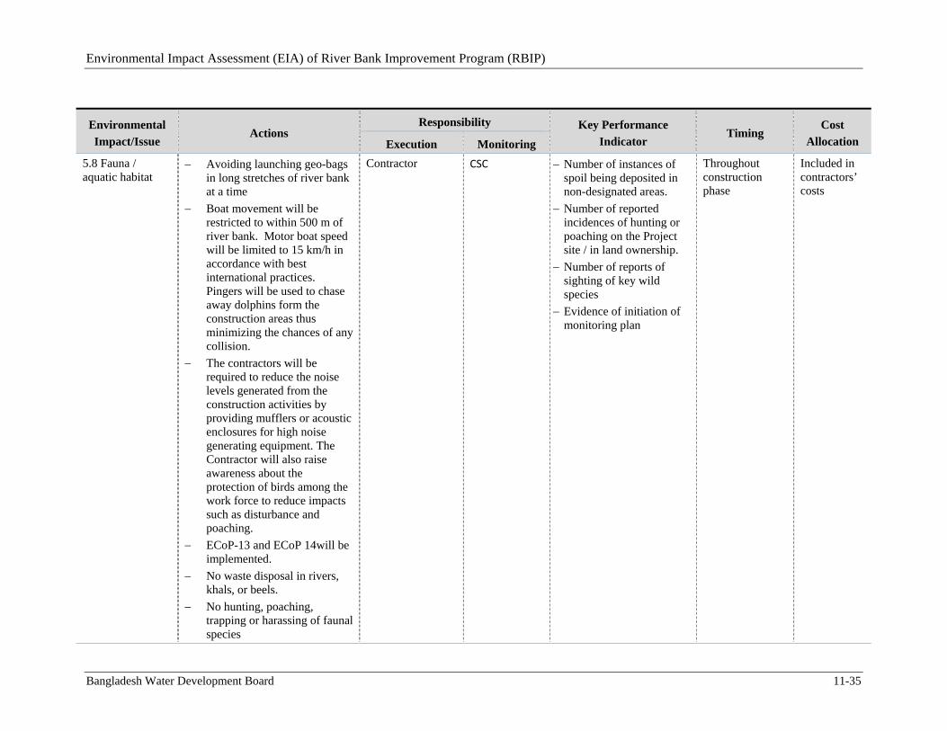
Environmental Impact Assessment (EIA) of River Bank Improvement Program (RBIP)
Bangladesh Water Development Board 11-35
Environmental
Impact/Issue Actions
Responsibility Key Performance
Indicator Timing
Cost
Allocation Execution Monitoring
5.8 Fauna / aquatic habitat
Avoiding launching geo-bags in long stretches of river bank at a time
Boat movement will be restricted to within 500 m of river bank. Motor boat speed will be limited to 15 km/h in accordance with best international practices. Pingers will be used to chase away dolphins form the construction areas thus minimizing the chances of any collision.
The contractors will be required to reduce the noise levels generated from the construction activities by providing mufflers or acoustic enclosures for high noise generating equipment. The Contractor will also raise awareness about the protection of birds among the work force to reduce impacts such as disturbance and poaching.
ECoP-13 and ECoP 14will be implemented.
No waste disposal in rivers, khals, or beels.
No hunting, poaching, trapping or harassing of faunal species
Contractor CSC Number of instances of spoil being deposited in non-designated areas.
Number of reported incidences of hunting or poaching on the Project site / in land ownership.
Number of reports of sighting of key wild species
Evidence of initiation of monitoring plan
Throughout construction phase
Included in contractors’ costs
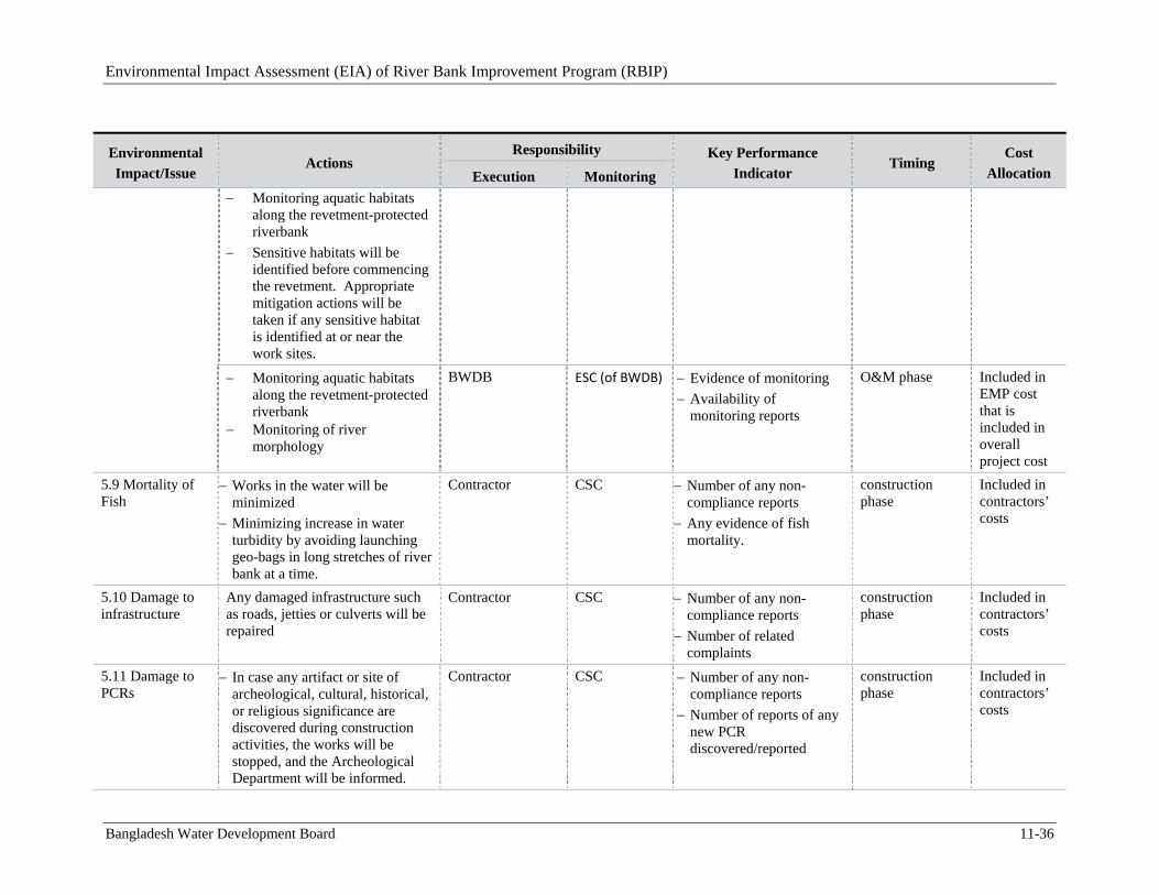
Environmental Impact Assessment (EIA) of River Bank Improvement Program (RBIP)
Bangladesh Water Development Board 11-36
Environmental
Impact/Issue Actions
Responsibility Key Performance
Indicator Timing
Cost
Allocation Execution Monitoring
Monitoring aquatic habitats along the revetment-protected riverbank
Sensitive habitats will be identified before commencing the revetment. Appropriate mitigation actions will be taken if any sensitive habitat is identified at or near the work sites.
Monitoring aquatic habitats along the revetment-protected riverbank
Monitoring of river morphology
BWDB ESC (of BWDB) Evidence of monitoring
Availability of monitoring reports
O&M phase Included in EMP cost that is included in overall project cost
5.9 Mortality of Fish
Works in the water will be minimized
Minimizing increase in water turbidity by avoiding launching geo-bags in long stretches of river bank at a time.
Contractor CSC Number of any non-compliance reports
Any evidence of fish mortality.
construction phase
Included in contractors’ costs
5.10 Damage to infrastructure
Any damaged infrastructure such as roads, jetties or culverts will be repaired
Contractor CSC Number of any non-compliance reports
Number of related complaints
construction phase
Included in contractors’ costs
5.11 Damage to PCRs
In case any artifact or site of archeological, cultural, historical, or religious significance are discovered during construction activities, the works will be stopped, and the Archeological Department will be informed.
Contractor CSC Number of any non-compliance reports
Number of reports of any new PCR discovered/reported
construction phase
Included in contractors’ costs
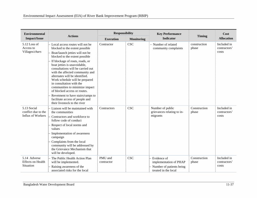
Environmental Impact Assessment (EIA) of River Bank Improvement Program (RBIP)
Bangladesh Water Development Board 11-37
Environmental
Impact/Issue Actions
Responsibility Key Performance
Indicator Timing
Cost
Allocation Execution Monitoring
5.12 Loss of Access to Villages/chars
Local access routes will not be blocked to the extent possible
Boat/launch jetties will not be blocked to the extent possible
If blockage of routs, roads, or boat jetties is unavoidable, consultations will be carried out with the affected community and alternates will be identified. Work schedule will be prepared in consultation with the communities to minimize impact of blocked access or routes.
Revetment to have stairs/ramps to facilitate access of people and their livestock to the river
Contractor CSC Number of related community complaints
construction phase
Included in contractors’ costs
5.13 Social conflict due to the Influx of Workers
Liaison will be maintained with the communities
Contractors and workforce to follow code of conduct
Respect of local norms and values
Implementation of awareness campaign
Complaints from the local community will be addressed by the Grievance Mechanism that will be developed.
Contractors CSC Number of public grievances relating to in-migrants
Construction phase
Included in contractors’ costs
5.14 Adverse Effects on Health Situation
The Public Health Action Plan will be implemented.
Raising awareness of the associated risks for the local
PMU and contractor
CSC Evidence of implementation of PHAP
Number of patients being treated in the local
Construction phase
Included in contractors’ costs
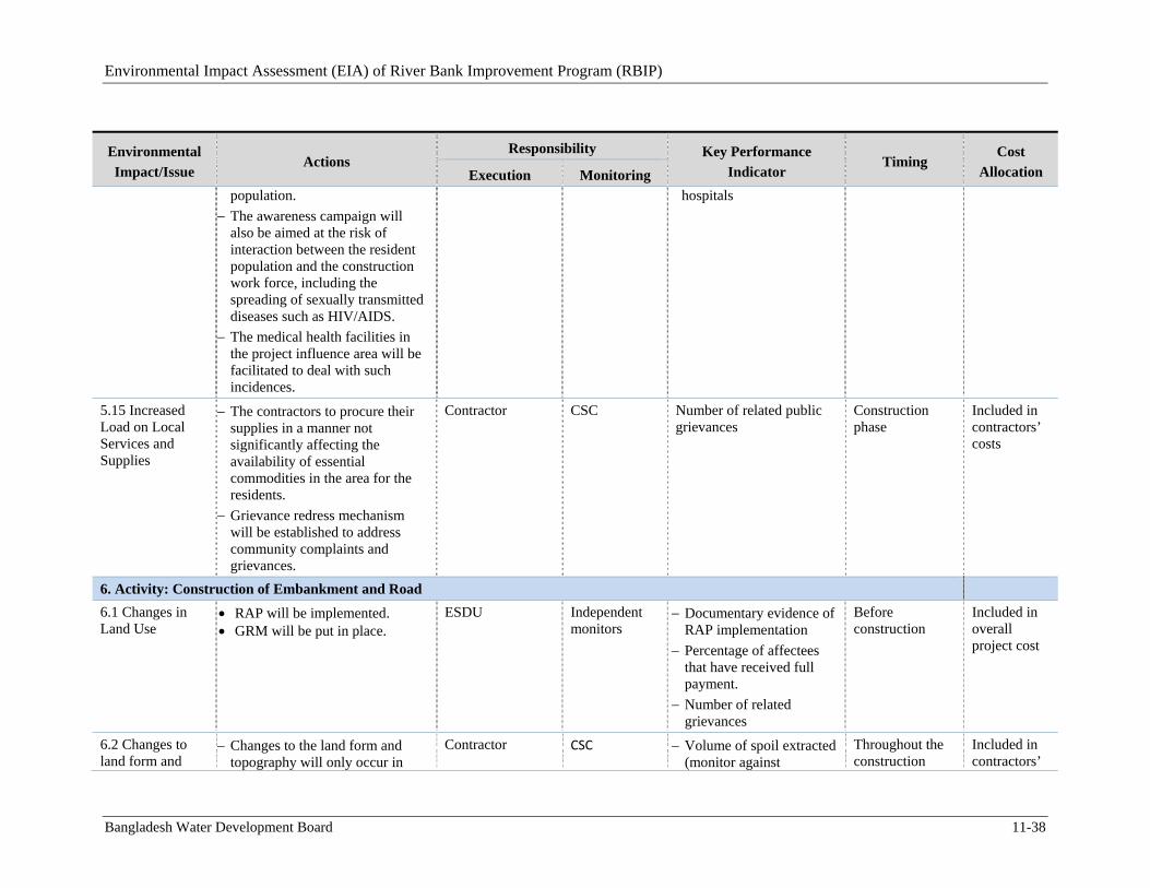
Environmental Impact Assessment (EIA) of River Bank Improvement Program (RBIP)
Bangladesh Water Development Board 11-38
Environmental
Impact/Issue Actions
Responsibility Key Performance
Indicator Timing
Cost
Allocation Execution Monitoring population.
The awareness campaign will also be aimed at the risk of interaction between the resident population and the construction work force, including the spreading of sexually transmitted diseases such as HIV/AIDS.
The medical health facilities in the project influence area will be facilitated to deal with such incidences.
hospitals
5.15 Increased Load on Local Services and Supplies
The contractors to procure their supplies in a manner not significantly affecting the availability of essential commodities in the area for the residents.
Grievance redress mechanism will be established to address community complaints and grievances.
Contractor CSC Number of related public grievances
Construction phase
Included in contractors’ costs
6. Activity: Construction of Embankment and Road
6.1 Changes in Land Use
RAP will be implemented. GRM will be put in place.
ESDU
Independent monitors
Documentary evidence of RAP implementation
Percentage of affectees that have received full payment.
Number of related grievances
Before construction
Included in overall project cost
6.2 Changes to land form and
Changes to the land form and topography will only occur in
Contractor CSC Volume of spoil extracted (monitor against
Throughout the construction
Included in contractors’
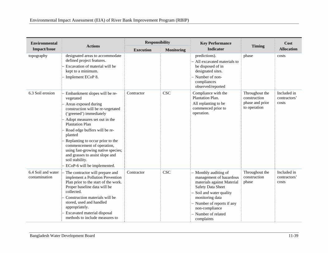
Environmental Impact Assessment (EIA) of River Bank Improvement Program (RBIP)
Bangladesh Water Development Board 11-39
Environmental
Impact/Issue Actions
Responsibility Key Performance
Indicator Timing
Cost
Allocation Execution Monitoring topography designated areas to accommodate
defined project features.
Excavation of material will be kept to a minimum.
Implement ECoP 8.
predictions).
All excavated materials to be disposed of in designated sites.
Number of non-compliances observed/reported
phase costs
6.3 Soil erosion
Embankment slopes will be re-vegetated
Areas exposed during construction will be re-vegetated (‘greened’) immediately
Adopt measures set out in the Plantation Plan
Road edge buffers will be re-planted
Replanting to occur prior to the commencement of operation, using fast-growing native species; and grasses to assist slope and soil stability.
ECoP-6 will be implemented.
Contractor CSC Compliance with the Plantation Plan. All replanting to be commenced prior to operation.
Throughout the construction phase and prior to operation
Included in contractors’ costs
6.4 Soil and water contamination
The contractor will prepare and implement a Pollution Prevention Plan prior to the start of the work. Proper baseline data will be collected.
Construction materials will be stored, used and handled appropriately.
Excavated material disposal methods to include measures to
Contractor CSC Monthly auditing of management of hazardous materials against Material Safety Data Sheet
Soil and water quality monitoring data
Number of reports if any non-compliance
Number of related complaints
Throughout the construction phase
Included in contractors’ costs
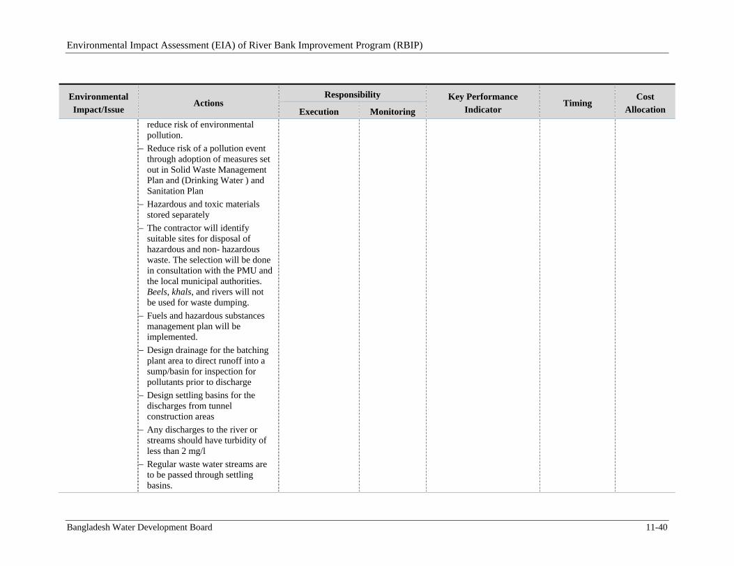
Environmental Impact Assessment (EIA) of River Bank Improvement Program (RBIP)
Bangladesh Water Development Board 11-40
Environmental
Impact/Issue Actions
Responsibility Key Performance
Indicator Timing
Cost
Allocation Execution Monitoring reduce risk of environmental pollution.
Reduce risk of a pollution event through adoption of measures set out in Solid Waste Management Plan and (Drinking Water ) and Sanitation Plan
Hazardous and toxic materials stored separately
The contractor will identify suitable sites for disposal of hazardous and non- hazardous waste. The selection will be done in consultation with the PMU and the local municipal authorities. Beels, khals, and rivers will not be used for waste dumping.
Fuels and hazardous substances management plan will be implemented.
Design drainage for the batching plant area to direct runoff into a sump/basin for inspection for pollutants prior to discharge
Design settling basins for the discharges from tunnel construction areas
Any discharges to the river or streams should have turbidity of less than 2 mg/l
Regular waste water streams are to be passed through settling basins.
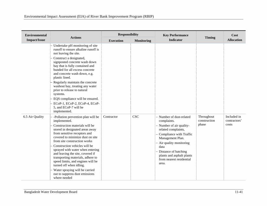
Environmental Impact Assessment (EIA) of River Bank Improvement Program (RBIP)
Bangladesh Water Development Board 11-41
Environmental
Impact/Issue Actions
Responsibility Key Performance
Indicator Timing
Cost
Allocation Execution Monitoring
Undertake pH monitoring of site runoff to ensure alkaline runoff is not leaving the site.
Construct a designated, signposted concrete wash down bay that is fully contained and bunded for all excess concrete and concrete wash down, e.g. plastic lined.
Regularly maintain the concrete washout bay, treating any water prior to release to natural systems.
EQS compliance will be ensured.
ECoP-1, ECoP-2, ECoP-4, ECoP-5, and ECoP-7 will be implemented.
6.5 Air Quality
-Pollution prevention plan will be implemented.
Construction materials will be stored in designated areas away from sensitive receptors and covered to minimize dust on site from site construction works
Construction vehicles will be sprayed with water when entering and leaving the site, covered if transporting materials, adhere to speed limits, and engines will be turned off when idling.
Water spraying will be carried out to suppress dust emissions where needed
Contractor CSC Number of dust-related complaints.
Number of air quality-related complaints,
Compliance with Traffic Management Plan.
Air quality monitoring data
Distance of batching plants and asphalt plants from nearest residential area.
Throughout construction phase
Included in contractors’ costs
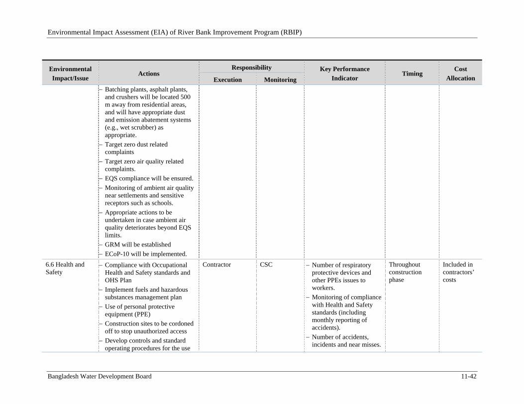
Environmental Impact Assessment (EIA) of River Bank Improvement Program (RBIP)
Bangladesh Water Development Board 11-42
Environmental
Impact/Issue Actions
Responsibility Key Performance
Indicator Timing
Cost
Allocation Execution Monitoring Batching plants, asphalt plants,
and crushers will be located 500 m away from residential areas, and will have appropriate dust and emission abatement systems (e.g., wet scrubber) as appropriate.
Target zero dust related complaints
Target zero air quality related complaints.
EQS compliance will be ensured.
Monitoring of ambient air quality near settlements and sensitive receptors such as schools.
Appropriate actions to be undertaken in case ambient air quality deteriorates beyond EQS limits.
GRM will be established
ECoP-10 will be implemented.
6.6 Health and Safety
Compliance with Occupational Health and Safety standards and OHS Plan
Implement fuels and hazardous substances management plan
Use of personal protective equipment (PPE)
Construction sites to be cordoned off to stop unauthorized access
Develop controls and standard operating procedures for the use
Contractor CSC Number of respiratory protective devices and other PPEs issues to workers.
Monitoring of compliance with Health and Safety standards (including monthly reporting of accidents).
Number of accidents, incidents and near misses.
Throughout construction phase
Included in contractors’ costs
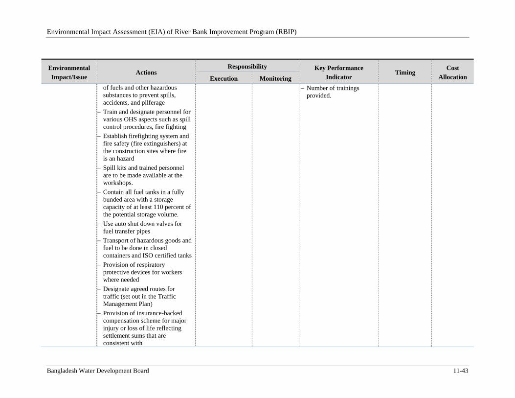
Environmental Impact Assessment (EIA) of River Bank Improvement Program (RBIP)
Bangladesh Water Development Board 11-43
Environmental
Impact/Issue Actions
Responsibility Key Performance
Indicator Timing
Cost
Allocation Execution Monitoring of fuels and other hazardous substances to prevent spills, accidents, and pilferage
Train and designate personnel for various OHS aspects such as spill control procedures, fire fighting
Establish firefighting system and fire safety (fire extinguishers) at the construction sites where fire is an hazard
Spill kits and trained personnel are to be made available at the workshops.
Contain all fuel tanks in a fully bunded area with a storage capacity of at least 110 percent of the potential storage volume.
Use auto shut down valves for fuel transfer pipes
Transport of hazardous goods and fuel to be done in closed containers and ISO certified tanks
Provision of respiratory protective devices for workers where needed
Designate agreed routes for traffic (set out in the Traffic Management Plan)
Provision of insurance-backed compensation scheme for major injury or loss of life reflecting settlement sums that are consistent with
Number of trainings provided.
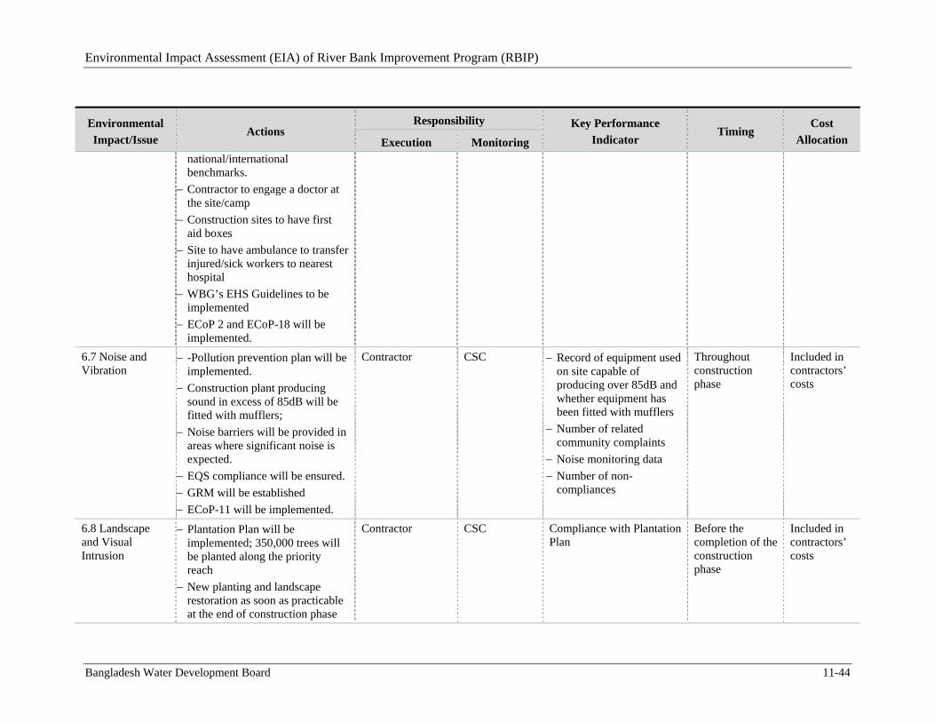
Environmental Impact Assessment (EIA) of River Bank Improvement Program (RBIP)
Bangladesh Water Development Board 11-44
Environmental
Impact/Issue Actions
Responsibility Key Performance
Indicator Timing
Cost
Allocation Execution Monitoring national/international benchmarks.
Contractor to engage a doctor at the site/camp
Construction sites to have first aid boxes
Site to have ambulance to transfer injured/sick workers to nearest hospital
WBG’s EHS Guidelines to be implemented
ECoP 2 and ECoP-18 will be implemented.
6.7 Noise and Vibration
-Pollution prevention plan will be implemented.
Construction plant producing sound in excess of 85dB will be fitted with mufflers;
Noise barriers will be provided in areas where significant noise is expected.
EQS compliance will be ensured.
GRM will be established
ECoP-11 will be implemented.
Contractor CSC Record of equipment used on site capable of producing over 85dB and whether equipment has been fitted with mufflers
Number of related community complaints
Noise monitoring data
Number of non-compliances
Throughout construction phase
Included in contractors’ costs
6.8 Landscape and Visual Intrusion
Plantation Plan will be implemented; 350,000 trees will be planted along the priority reach
New planting and landscape restoration as soon as practicable at the end of construction phase
Contractor CSC Compliance with Plantation Plan
Before the completion of the construction phase
Included in contractors’ costs
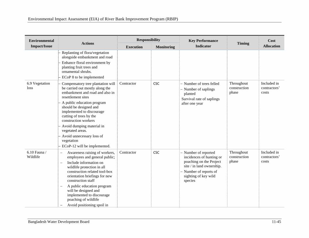
Environmental Impact Assessment (EIA) of River Bank Improvement Program (RBIP)
Bangladesh Water Development Board 11-45
Environmental
Impact/Issue Actions
Responsibility Key Performance
Indicator Timing
Cost
Allocation Execution Monitoring
Replanting of flora/vegetation alongside embankment and road
Enhance floral environment by planting fruit trees and ornamental shrubs.
ECoP 8 to be implemented
6.9 Vegetation loss
Compensatory tree plantation will be carried out mostly along the embankment and road and also in resettlement sites
A public education program should be designed and implemented to discourage cutting of trees by the construction workers
Avoid dumping material in vegetated areas.
Avoid unnecessary loss of vegetation
ECoP-12 will be implemented.
Contractor CSC Number of trees felled
Number of saplings planted
Survival rate of saplings after one year
Throughout construction phase
Included in contractors’ costs
6.10 Fauna / Wildlife
Awareness raising of workers, employees and general public;
Include information on wildlife protection in all construction related tool-box orientation briefings for new construction staff
A public education program will be designed and implemented to discourage poaching of wildlife
Avoid positioning spoil in
Contractor CSC Number of reported incidences of hunting or poaching on the Project site / in land ownership.
Number of reports of sighting of key wild species
Throughout construction phase
Included in contractors’ costs
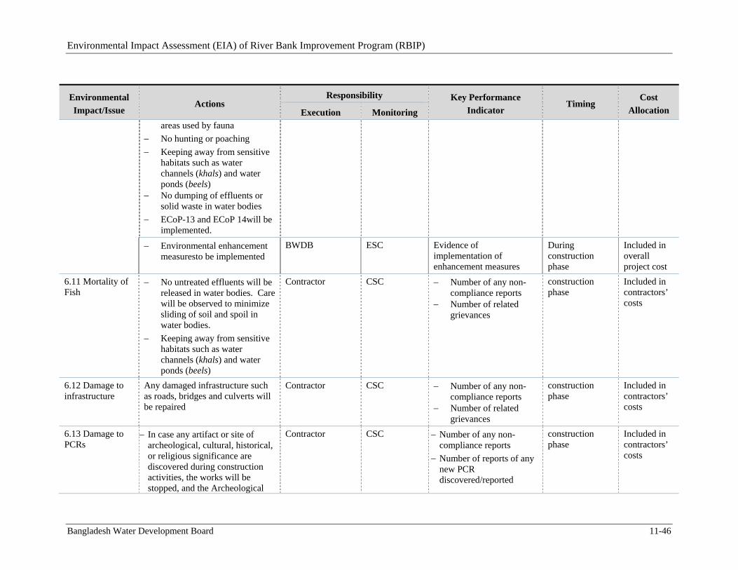
Environmental Impact Assessment (EIA) of River Bank Improvement Program (RBIP)
Bangladesh Water Development Board 11-46
Environmental
Impact/Issue Actions
Responsibility Key Performance
Indicator Timing
Cost
Allocation Execution Monitoring areas used by fauna
No hunting or poaching
Keeping away from sensitive habitats such as water channels (khals) and water ponds (beels)
No dumping of effluents or solid waste in water bodies
ECoP-13 and ECoP 14will be implemented.
Environmental enhancement measuresto be implemented
BWDB ESC Evidence of implementation of enhancement measures
During construction phase
Included in overall project cost
6.11 Mortality of Fish
No untreated effluents will be released in water bodies. Care will be observed to minimize sliding of soil and spoil in water bodies.
Keeping away from sensitive habitats such as water channels (khals) and water ponds (beels)
Contractor CSC Number of any non-compliance reports
Number of related grievances
construction phase
Included in contractors’ costs
6.12 Damage to infrastructure
Any damaged infrastructure such as roads, bridges and culverts will be repaired
Contractor CSC Number of any non-compliance reports
Number of related grievances
construction phase
Included in contractors’ costs
6.13 Damage to PCRs
In case any artifact or site of archeological, cultural, historical, or religious significance are discovered during construction activities, the works will be stopped, and the Archeological
Contractor CSC Number of any non-compliance reports
Number of reports of any new PCR discovered/reported
construction phase
Included in contractors’ costs
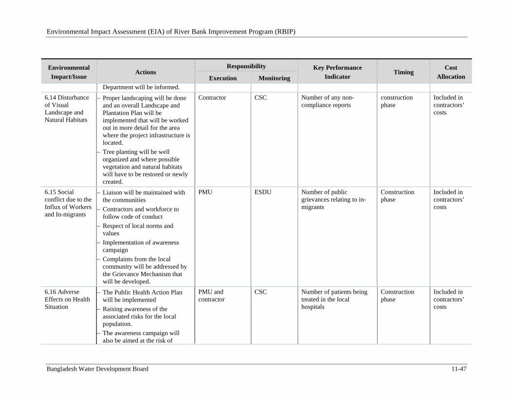
Environmental Impact Assessment (EIA) of River Bank Improvement Program (RBIP)
Bangladesh Water Development Board 11-47
Environmental
Impact/Issue Actions
Responsibility Key Performance
Indicator Timing
Cost
Allocation Execution Monitoring Department will be informed.
6.14 Disturbance of Visual Landscape and Natural Habitats
Proper landscaping will be done and an overall Landscape and Plantation Plan will be implemented that will be worked out in more detail for the area where the project infrastructure is located.
Tree planting will be well organized and where possible vegetation and natural habitats will have to be restored or newly created.
Contractor CSC Number of any non-compliance reports
construction phase
Included in contractors’ costs
6.15 Social conflict due to the Influx of Workers and In-migrants
Liaison will be maintained with the communities
Contractors and workforce to follow code of conduct
Respect of local norms and values
Implementation of awareness campaign
Complaints from the local community will be addressed by the Grievance Mechanism that will be developed.
PMU ESDU Number of public grievances relating to in-migrants
Construction phase
Included in contractors’ costs
6.16 Adverse Effects on Health Situation
The Public Health Action Plan will be implemented
Raising awareness of the associated risks for the local population.
The awareness campaign will also be aimed at the risk of
PMU and contractor
CSC Number of patients being treated in the local hospitals
Construction phase
Included in contractors’ costs
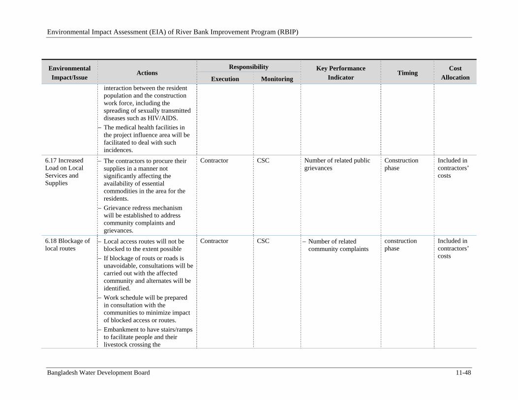
Environmental Impact Assessment (EIA) of River Bank Improvement Program (RBIP)
Bangladesh Water Development Board 11-48
Environmental
Impact/Issue Actions
Responsibility Key Performance
Indicator Timing
Cost
Allocation Execution Monitoring interaction between the resident population and the construction work force, including the spreading of sexually transmitted diseases such as HIV/AIDS.
The medical health facilities in the project influence area will be facilitated to deal with such incidences.
6.17 Increased Load on Local Services and Supplies
The contractors to procure their supplies in a manner not significantly affecting the availability of essential commodities in the area for the residents.
Grievance redress mechanism will be established to address community complaints and grievances.
Contractor CSC Number of related public grievances
Construction phase
Included in contractors’ costs
6.18 Blockage of local routes
Local access routes will not be blocked to the extent possible
If blockage of routs or roads is unavoidable, consultations will be carried out with the affected community and alternates will be identified.
Work schedule will be prepared in consultation with the communities to minimize impact of blocked access or routes.
Embankment to have stairs/ramps to facilitate people and their livestock crossing the
Contractor CSC Number of related community complaints
construction phase
Included in contractors’ costs
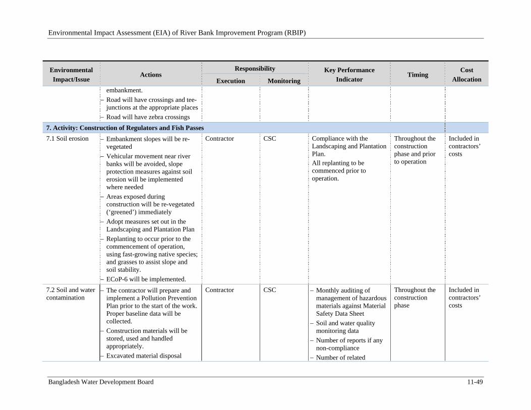
Environmental Impact Assessment (EIA) of River Bank Improvement Program (RBIP)
Bangladesh Water Development Board 11-49
Environmental
Impact/Issue Actions
Responsibility Key Performance
Indicator Timing
Cost
Allocation Execution Monitoring embankment.
Road will have crossings and tee-junctions at the appropriate places
Road will have zebra crossings
7. Activity: Construction of Regulators and Fish Passes
7.1 Soil erosion
Embankment slopes will be re-vegetated
Vehicular movement near river banks will be avoided, slope protection measures against soil erosion will be implemented where needed
Areas exposed during construction will be re-vegetated (‘greened’) immediately
Adopt measures set out in the Landscaping and Plantation Plan
Replanting to occur prior to the commencement of operation, using fast-growing native species; and grasses to assist slope and soil stability.
ECoP-6 will be implemented.
Contractor CSC Compliance with the Landscaping and Plantation Plan. All replanting to be commenced prior to operation.
Throughout the construction phase and prior to operation
Included in contractors’ costs
7.2 Soil and water contamination
The contractor will prepare and implement a Pollution Prevention Plan prior to the start of the work. Proper baseline data will be collected.
Construction materials will be stored, used and handled appropriately.
Excavated material disposal
Contractor CSC Monthly auditing of management of hazardous materials against Material Safety Data Sheet
Soil and water quality monitoring data
Number of reports if any non-compliance
Number of related
Throughout the construction phase
Included in contractors’ costs

Environmental Impact Assessment (EIA) of River Bank Improvement Program (RBIP)
Bangladesh Water Development Board 11-50
Environmental
Impact/Issue Actions
Responsibility Key Performance
Indicator Timing
Cost
Allocation Execution Monitoring methods to include measures to reduce risk of environmental pollution.
Reduce risk of a pollution event through adoption of measures set out in Solid Waste Management Plan and (Drinking Water ) and Sanitation Plan
Hazardous and toxic materials stored separately
The contractor will identify suitable sites for disposal of hazardous and non- hazardous waste. The selection will be done in consultation with the PMU and the local municipal authorities. Beels, khals, and rivers will not be used for waste dumping.
Fuels and hazardous substances management plan will be implemented.
Design drainage for the batching plant area to direct runoff into a sump/basin for inspection for pollutants prior to discharge
Design settling basins for the discharges from tunnel construction areas
Any discharges to the river or streams should have turbidity of less than 2 mg/l
Regular waste water streams are to be passed through settling
complaints
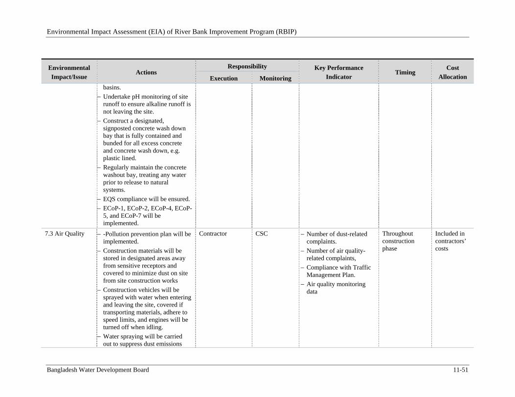
Environmental Impact Assessment (EIA) of River Bank Improvement Program (RBIP)
Bangladesh Water Development Board 11-51
Environmental
Impact/Issue Actions
Responsibility Key Performance
Indicator Timing
Cost
Allocation Execution Monitoring basins.
Undertake pH monitoring of site runoff to ensure alkaline runoff is not leaving the site.
Construct a designated, signposted concrete wash down bay that is fully contained and bunded for all excess concrete and concrete wash down, e.g. plastic lined.
Regularly maintain the concrete washout bay, treating any water prior to release to natural systems.
EQS compliance will be ensured.
ECoP-1, ECoP-2, ECoP-4, ECoP-5, and ECoP-7 will be implemented.
7.3 Air Quality
-Pollution prevention plan will be implemented.
Construction materials will be stored in designated areas away from sensitive receptors and covered to minimize dust on site from site construction works
Construction vehicles will be sprayed with water when entering and leaving the site, covered if transporting materials, adhere to speed limits, and engines will be turned off when idling.
Water spraying will be carried out to suppress dust emissions
Contractor CSC Number of dust-related complaints.
Number of air quality-related complaints,
Compliance with Traffic Management Plan.
Air quality monitoring data
Throughout construction phase
Included in contractors’ costs
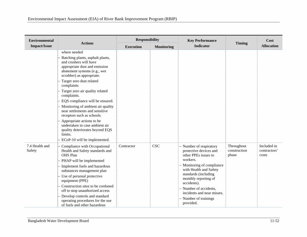
Environmental Impact Assessment (EIA) of River Bank Improvement Program (RBIP)
Bangladesh Water Development Board 11-52
Environmental
Impact/Issue Actions
Responsibility Key Performance
Indicator Timing
Cost
Allocation Execution Monitoring
where needed
Batching plants, asphalt plants, and crushers will have appropriate dust and emission abatement systems (e.g., wet scrubber) as appropriate.
Target zero dust related complaints
Target zero air quality related complaints.
EQS compliance will be ensured.
Monitoring of ambient air quality near settlements and sensitive receptors such as schools.
Appropriate actions to be undertaken in case ambient air quality deteriorates beyond EQS limits.
ECoP-10 will be implemented.
7.4 Health and Safety
Compliance with Occupational Health and Safety standards and OHS Plan
PHAP will be implemented
Implement fuels and hazardous substances management plan
Use of personal protective equipment (PPE)
Construction sites to be cordoned off to stop unauthorized access
Develop controls and standard operating procedures for the use of fuels and other hazardous
Contractor CSC Number of respiratory protective devices and other PPEs issues to workers.
Monitoring of compliance with Health and Safety standards (including monthly reporting of accidents).
Number of accidents, incidents and near misses.
Number of trainings provided.
Throughout construction phase
Included in contractors’ costs
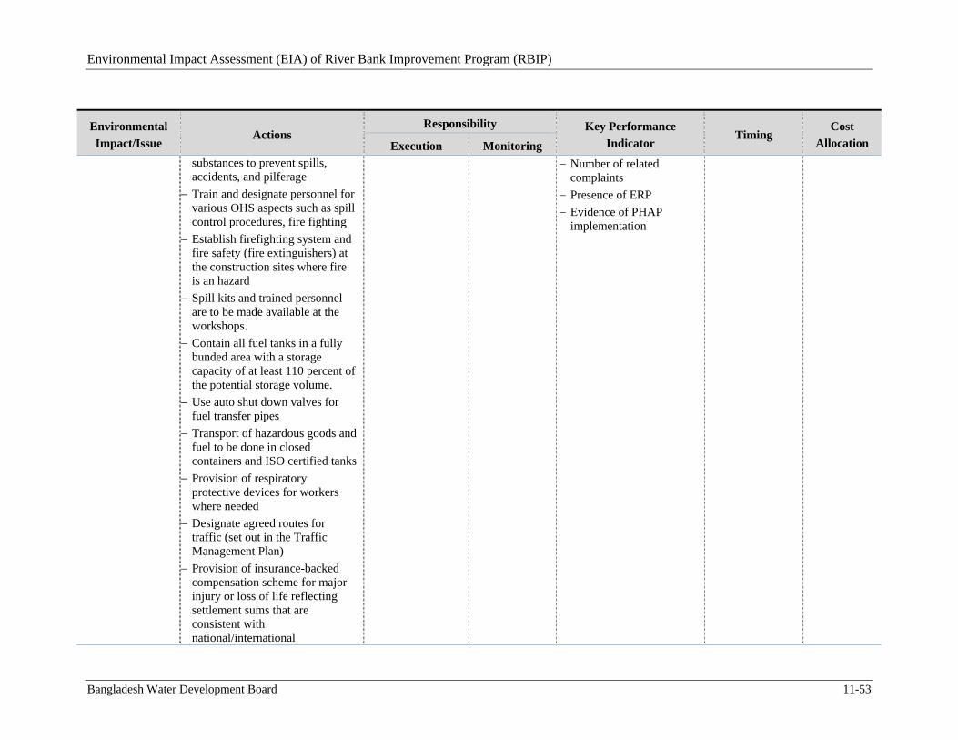
Environmental Impact Assessment (EIA) of River Bank Improvement Program (RBIP)
Bangladesh Water Development Board 11-53
Environmental
Impact/Issue Actions
Responsibility Key Performance
Indicator Timing
Cost
Allocation Execution Monitoring substances to prevent spills, accidents, and pilferage
Train and designate personnel for various OHS aspects such as spill control procedures, fire fighting
Establish firefighting system and fire safety (fire extinguishers) at the construction sites where fire is an hazard
Spill kits and trained personnel are to be made available at the workshops.
Contain all fuel tanks in a fully bunded area with a storage capacity of at least 110 percent of the potential storage volume.
Use auto shut down valves for fuel transfer pipes
Transport of hazardous goods and fuel to be done in closed containers and ISO certified tanks
Provision of respiratory protective devices for workers where needed
Designate agreed routes for traffic (set out in the Traffic Management Plan)
Provision of insurance-backed compensation scheme for major injury or loss of life reflecting settlement sums that are consistent with national/international
Number of related complaints
Presence of ERP
Evidence of PHAP implementation
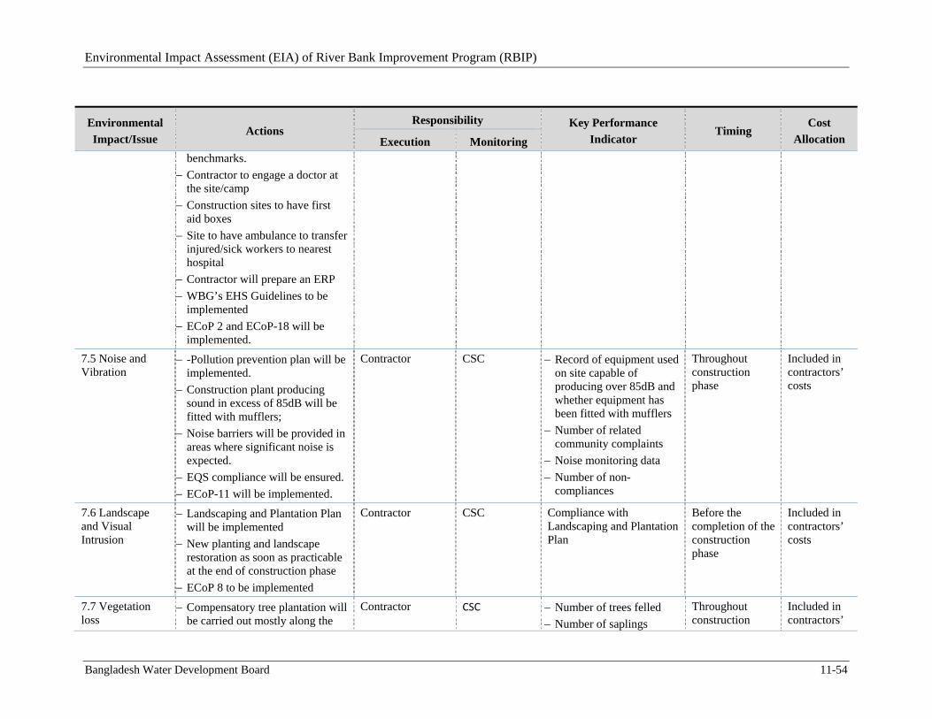
Environmental Impact Assessment (EIA) of River Bank Improvement Program (RBIP)
Bangladesh Water Development Board 11-54
Environmental
Impact/Issue Actions
Responsibility Key Performance
Indicator Timing
Cost
Allocation Execution Monitoring benchmarks.
Contractor to engage a doctor at the site/camp
Construction sites to have first aid boxes
Site to have ambulance to transfer injured/sick workers to nearest hospital
Contractor will prepare an ERP
WBG’s EHS Guidelines to be implemented
ECoP 2 and ECoP-18 will be implemented.
7.5 Noise and Vibration
-Pollution prevention plan will be implemented.
Construction plant producing sound in excess of 85dB will be fitted with mufflers;
Noise barriers will be provided in areas where significant noise is expected.
EQS compliance will be ensured.
ECoP-11 will be implemented.
Contractor CSC Record of equipment used on site capable of producing over 85dB and whether equipment has been fitted with mufflers
Number of related community complaints
Noise monitoring data
Number of non-compliances
Throughout construction phase
Included in contractors’ costs
7.6 Landscape and Visual Intrusion
Landscaping and Plantation Plan will be implemented
New planting and landscape restoration as soon as practicable at the end of construction phase
ECoP 8 to be implemented
Contractor CSC Compliance with Landscaping and Plantation Plan
Before the completion of the construction phase
Included in contractors’ costs
7.7 Vegetation loss
Compensatory tree plantation will be carried out mostly along the
Contractor CSC Number of trees felled
Number of saplings
Throughout construction
Included in contractors’
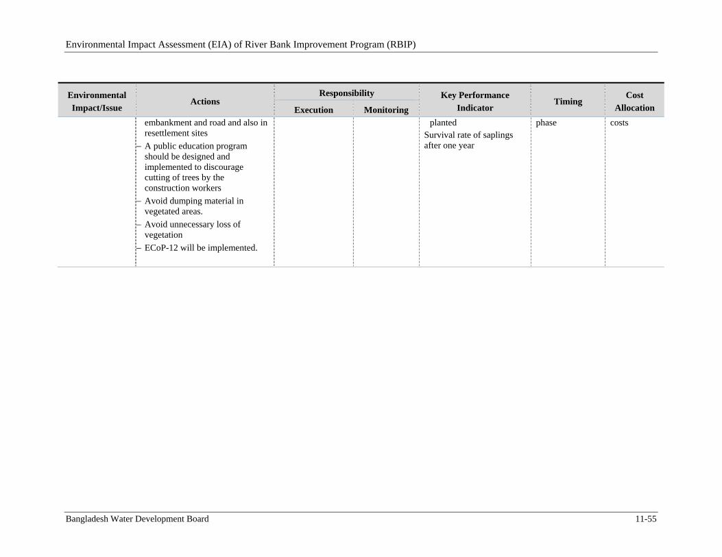
Environmental Impact Assessment (EIA) of River Bank Improvement Program (RBIP)
Bangladesh Water Development Board 11-55
Environmental
Impact/Issue Actions
Responsibility Key Performance
Indicator Timing
Cost
Allocation Execution Monitoring
embankment and road and also in resettlement sites
A public education program should be designed and implemented to discourage cutting of trees by the construction workers
Avoid dumping material in vegetated areas.
Avoid unnecessary loss of vegetation
ECoP-12 will be implemented.
planted Survival rate of saplings after one year
phase costs
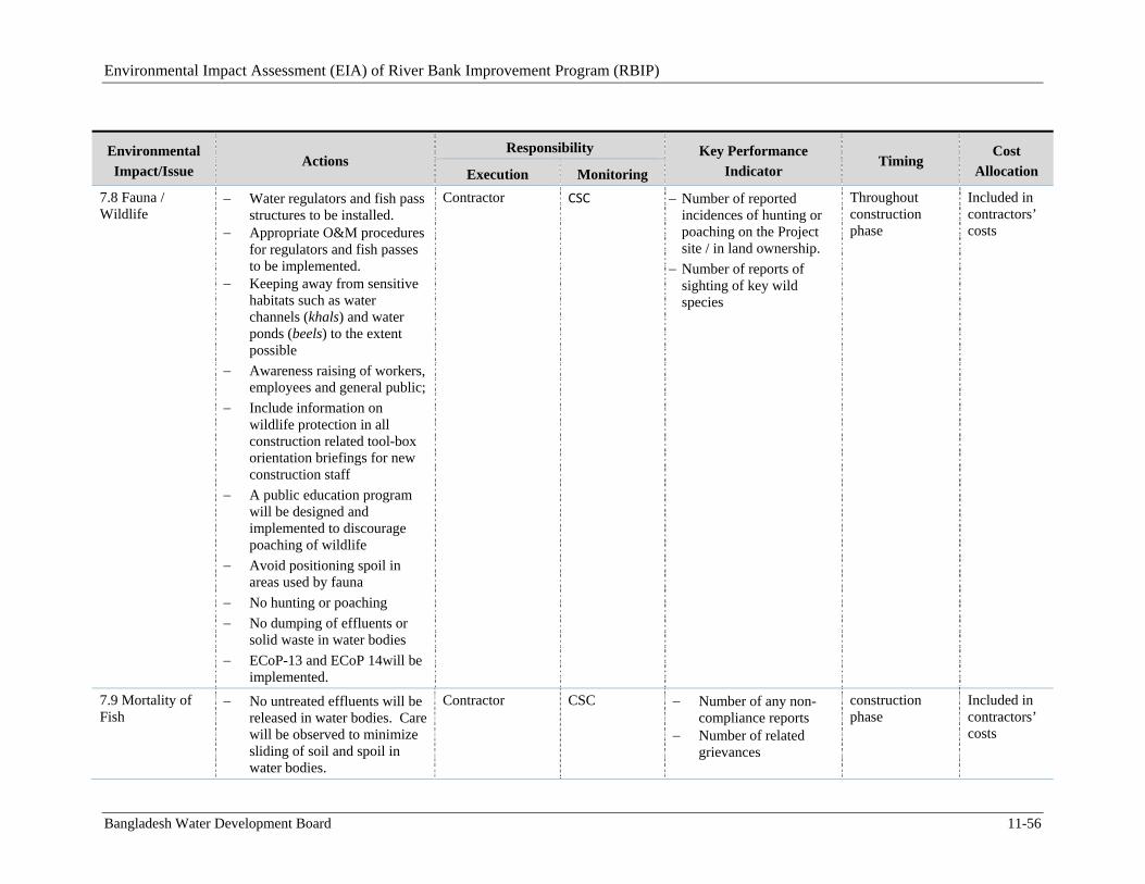
Environmental Impact Assessment (EIA) of River Bank Improvement Program (RBIP)
Bangladesh Water Development Board 11-56
Environmental
Impact/Issue Actions
Responsibility Key Performance
Indicator Timing
Cost
Allocation Execution Monitoring
7.8 Fauna / Wildlife
Water regulators and fish pass structures to be installed.
Appropriate O&M procedures for regulators and fish passes to be implemented.
Keeping away from sensitive habitats such as water channels (khals) and water ponds (beels) to the extent possible
Awareness raising of workers, employees and general public;
Include information on wildlife protection in all construction related tool-box orientation briefings for new construction staff
A public education program will be designed and implemented to discourage poaching of wildlife
Avoid positioning spoil in areas used by fauna
No hunting or poaching
No dumping of effluents or solid waste in water bodies
ECoP-13 and ECoP 14will be implemented.
Contractor CSC Number of reported incidences of hunting or poaching on the Project site / in land ownership.
Number of reports of sighting of key wild species
Throughout construction phase
Included in contractors’ costs
7.9 Mortality of Fish
No untreated effluents will be released in water bodies. Care will be observed to minimize sliding of soil and spoil in water bodies.
Contractor CSC Number of any non-compliance reports
Number of related grievances
construction phase
Included in contractors’ costs
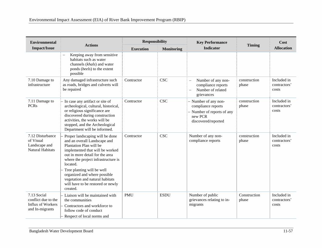
Environmental Impact Assessment (EIA) of River Bank Improvement Program (RBIP)
Bangladesh Water Development Board 11-57
Environmental
Impact/Issue Actions
Responsibility Key Performance
Indicator Timing
Cost
Allocation Execution Monitoring
Keeping away from sensitive habitats such as water channels (khals) and water ponds (beels) to the extent possible
7.10 Damage to infrastructure
Any damaged infrastructure such as roads, bridges and culverts will be repaired
Contractor CSC Number of any non-compliance reports
Number of related grievances
construction phase
Included in contractors’ costs
7.11 Damage to PCRs
In case any artifact or site of archeological, cultural, historical, or religious significance are discovered during construction activities, the works will be stopped, and the Archeological Department will be informed.
Contractor CSC Number of any non-compliance reports
Number of reports of any new PCR discovered/reported
construction phase
Included in contractors’ costs
7.12 Disturbance of Visual Landscape and Natural Habitats
Proper landscaping will be done and an overall Landscape and Plantation Plan will be implemented that will be worked out in more detail for the area where the project infrastructure is located.
Tree planting will be well organized and where possible vegetation and natural habitats will have to be restored or newly created.
Contractor CSC Number of any non-compliance reports
construction phase
Included in contractors’ costs
7.13 Social conflict due to the Influx of Workers and In-migrants
Liaison will be maintained with the communities
Contractors and workforce to follow code of conduct
Respect of local norms and
PMU ESDU Number of public grievances relating to in-migrants
Construction phase
Included in contractors’ costs
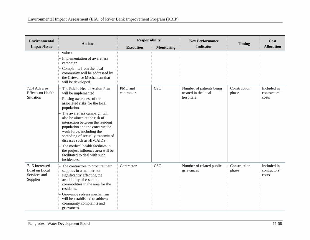
Environmental Impact Assessment (EIA) of River Bank Improvement Program (RBIP)
Bangladesh Water Development Board 11-58
Environmental
Impact/Issue Actions
Responsibility Key Performance
Indicator Timing
Cost
Allocation Execution Monitoring values
Implementation of awareness campaign
Complaints from the local community will be addressed by the Grievance Mechanism that will be developed.
7.14 Adverse Effects on Health Situation
The Public Health Action Plan will be implemented
Raising awareness of the associated risks for the local population.
The awareness campaign will also be aimed at the risk of interaction between the resident population and the construction work force, including the spreading of sexually transmitted diseases such as HIV/AIDS.
The medical health facilities in the project influence area will be facilitated to deal with such incidences.
PMU and contractor
CSC Number of patients being treated in the local hospitals
Construction phase
Included in contractors’ costs
7.15 Increased Load on Local Services and Supplies
The contractors to procure their supplies in a manner not significantly affecting the availability of essential commodities in the area for the residents.
Grievance redress mechanism will be established to address community complaints and grievances.
Contractor CSC Number of related public grievances
Construction phase
Included in contractors’ costs
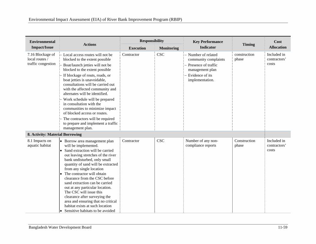
Environmental Impact Assessment (EIA) of River Bank Improvement Program (RBIP)
Bangladesh Water Development Board 11-59
Environmental
Impact/Issue Actions
Responsibility Key Performance
Indicator Timing
Cost
Allocation Execution Monitoring
7.16 Blockage of local routes / traffic congestion
Local access routes will not be blocked to the extent possible
Boat/launch jetties will not be blocked to the extent possible
If blockage of routs, roads, or boat jetties is unavoidable, consultations will be carried out with the affected community and alternates will be identified.
Work schedule will be prepared in consultation with the communities to minimize impact of blocked access or routes.
The contractors will be required to prepare and implement a traffic management plan.
Contractor CSC Number of related community complaints
Presence of traffic management plan
Evidence of its implementation.
construction phase
Included in contractors’ costs
8. Activity: Material Borrowing
8.1 Impacts on aquatic habitat
Borrow area management plan will be implemented.
Sand extraction will be carried out leaving stretches of the river bank undisturbed, only small quantity of sand will be extracted from any single location
The contractor will obtain clearance from the CSC before sand extraction can be carried out at any particular location. The CSC will issue this clearance after surveying the area and ensuring that no critical habitat exists at such location
Sensitive habitats to be avoided
Contractor CSC Number of any non-compliance reports
Construction phase
Included in contractors’ costs
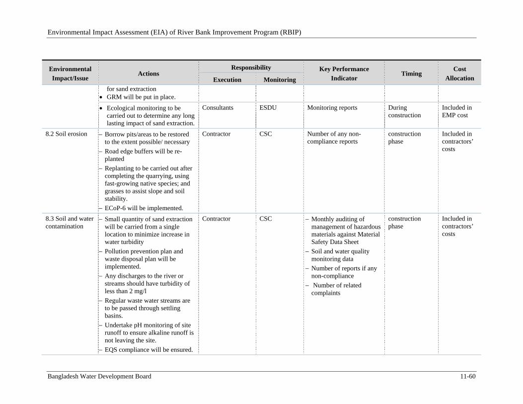
Environmental Impact Assessment (EIA) of River Bank Improvement Program (RBIP)
Bangladesh Water Development Board 11-60
Environmental
Impact/Issue Actions
Responsibility Key Performance
Indicator Timing
Cost
Allocation Execution Monitoring for sand extraction
GRM will be put in place.
Ecological monitoring to be carried out to determine any long lasting impact of sand extraction.
Consultants ESDU Monitoring reports During construction
Included in EMP cost
8.2 Soil erosion
Borrow pits/areas to be restored to the extent possible/ necessary
Road edge buffers will be re-planted
Replanting to be carried out after completing the quarrying, using fast-growing native species; and grasses to assist slope and soil stability.
ECoP-6 will be implemented.
Contractor CSC Number of any non-compliance reports
construction phase
Included in contractors’ costs
8.3 Soil and water contamination
Small quantity of sand extraction will be carried from a single location to minimize increase in water turbidity
Pollution prevention plan and waste disposal plan will be implemented.
Any discharges to the river or streams should have turbidity of less than 2 mg/l
Regular waste water streams are to be passed through settling basins.
Undertake pH monitoring of site runoff to ensure alkaline runoff is not leaving the site.
EQS compliance will be ensured.
Contractor CSC Monthly auditing of management of hazardous materials against Material Safety Data Sheet
Soil and water quality monitoring data
Number of reports if any non-compliance
Number of related complaints
construction phase
Included in contractors’ costs
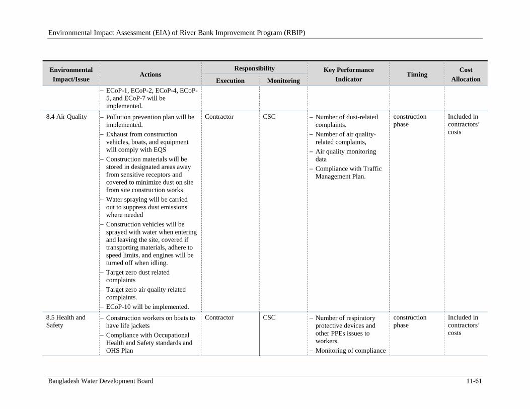
Environmental Impact Assessment (EIA) of River Bank Improvement Program (RBIP)
Bangladesh Water Development Board 11-61
Environmental
Impact/Issue Actions
Responsibility Key Performance
Indicator Timing
Cost
Allocation Execution Monitoring
ECoP-1, ECoP-2, ECoP-4, ECoP-5, and ECoP-7 will be implemented.
8.4 Air Quality
Pollution prevention plan will be implemented.
Exhaust from construction vehicles, boats, and equipment will comply with EQS
Construction materials will be stored in designated areas away from sensitive receptors and covered to minimize dust on site from site construction works
Water spraying will be carried out to suppress dust emissions where needed
Construction vehicles will be sprayed with water when entering and leaving the site, covered if transporting materials, adhere to speed limits, and engines will be turned off when idling.
Target zero dust related complaints
Target zero air quality related complaints.
ECoP-10 will be implemented.
Contractor CSC Number of dust-related complaints.
Number of air quality-related complaints,
Air quality monitoring data
Compliance with Traffic Management Plan.
construction phase
Included in contractors’ costs
8.5 Health and Safety
Construction workers on boats to have life jackets
Compliance with Occupational Health and Safety standards and OHS Plan
Contractor CSC Number of respiratory protective devices and other PPEs issues to workers.
Monitoring of compliance
construction phase
Included in contractors’ costs
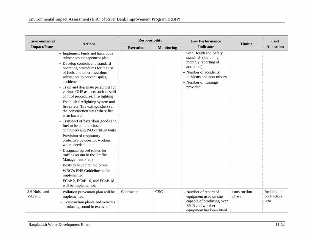
Environmental Impact Assessment (EIA) of River Bank Improvement Program (RBIP)
Bangladesh Water Development Board 11-62
Environmental
Impact/Issue Actions
Responsibility Key Performance
Indicator Timing
Cost
Allocation Execution Monitoring
Implement Fuels and hazardous substances management plan
Develop controls and standard operating procedures for the use of fuels and other hazardous substances to prevent spills, accidents
Train and designate personnel for various OHS aspects such as spill control procedures, fire fighting
Establish firefighting system and fire safety (fire extinguishers) at the construction sites where fire is an hazard
Transport of hazardous goods and fuel to be done in closed containers and ISO certified tanks
Provision of respiratory protective devices for workers where needed
Designate agreed routes for traffic (set out in the Traffic Management Plan)
Boats to have first aid boxes
WBG’s EHS Guidelines to be implemented
ECoP 2, ECoP 16, and ECoP-18 will be implemented.
with Health and Safety standards (including monthly reporting of accidents).
Number of accidents, incidents and near misses.
Number of trainings provided.
8.6 Noise and Vibration
Pollution prevention plan will be implemented.
Construction plants and vehicles producing sound in excess of
Contractor CSC Number of record of equipment used on site capable of producing over 85dB and whether equipment has been fitted
construction phase
Included in contractors’ costs
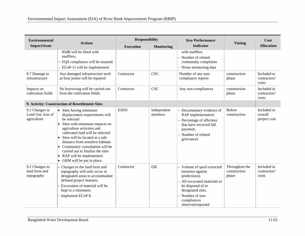
Environmental Impact Assessment (EIA) of River Bank Improvement Program (RBIP)
Bangladesh Water Development Board 11-63
Environmental
Impact/Issue Actions
Responsibility Key Performance
Indicator Timing
Cost
Allocation Execution Monitoring
85dB will be fitted with mufflers;
EQS compliance will be ensured.
ECoP-11 will be implemented.
with mufflers
Number of related community complaints
Noise monitoring data
8.7 Damage to infrastructure
Any damaged infrastructure such as boat jetties will be repaired
Contractor CSC Number of any non-compliance reports
construction phase
Included in contractors’ costs
Impacts on cultivation fields
No borrowing will be carried out from the cultivation fields.
Contractor CSC Any non-compliances construction phase
Included in contractors’ costs
9. Activity: Construction of Resettlement Sites
9.1 Changes in Land Use, loss of agriculture
Sites having minimum displacement requirements will be selected
Sites with minimum impacts on agriculture activities and cultivated land will be selected
Sites will be located at a safe distance from sensitive habitats
Community consultation will be carried out to finalize the sites
RAP will be implemented. GRM will be put in place.
ESDU
Independent monitors
Documentary evidence of RAP implementation
Percentage of affectees that have received full payment.
Number of related grievances
Before construction
Included in overall project cost
9.2 Changes to land form and topography
Changes to the land form and topography will only occur in designated areas to accommodate defined project features.
Excavation of material will be kept to a minimum.
Implement ECoP 8.
Contractor CSC Volume of spoil extracted (monitor against predictions).
All excavated materials to be disposed of in designated sites.
Number of non-compliances observed/reported
Throughout the construction phase
Included in contractors’ costs

Environmental Impact Assessment (EIA) of River Bank Improvement Program (RBIP)
Bangladesh Water Development Board 11-64
Environmental
Impact/Issue Actions
Responsibility Key Performance
Indicator Timing
Cost
Allocation Execution Monitoring
9.3 Soil erosion
Slopes will be re-vegetated
Areas exposed during construction will be re-vegetated (‘greened’) immediately
Adopt measures set out in the Landscaping and Plantation Plan
Replanting to occur prior to the commencement of operation, using fast-growing native species; and grasses to assist slope and soil stability.
ECoP-6 will be implemented.
Contractor CSC Compliance with the Landscaping and Plantation Plan. All replanting to be commenced prior to operation.
Throughout the construction phase and prior to operation
Included in contractors’ costs
9.4 Soil and water contamination
The contractor will prepare and implement a Pollution Prevention Plan prior to the start of the work. Proper baseline data will be collected.
Construction materials will be stored, used and handled appropriately.
Excavated material disposal methods to include measures to reduce risk of environmental pollution.
Reduce risk of a pollution event through adoption of measures set out in Solid Waste Management Plan and (Drinking Water ) and Sanitation Plan
Hazardous and toxic materials stored separately
The contractor will identify
Contractor CSC Monthly auditing of management of hazardous materials against Material Safety Data Sheet
Soil and water quality monitoring data
Number of reports if any non-compliance
Number of related complaints
Throughout the construction phase
Included in contractors’ costs
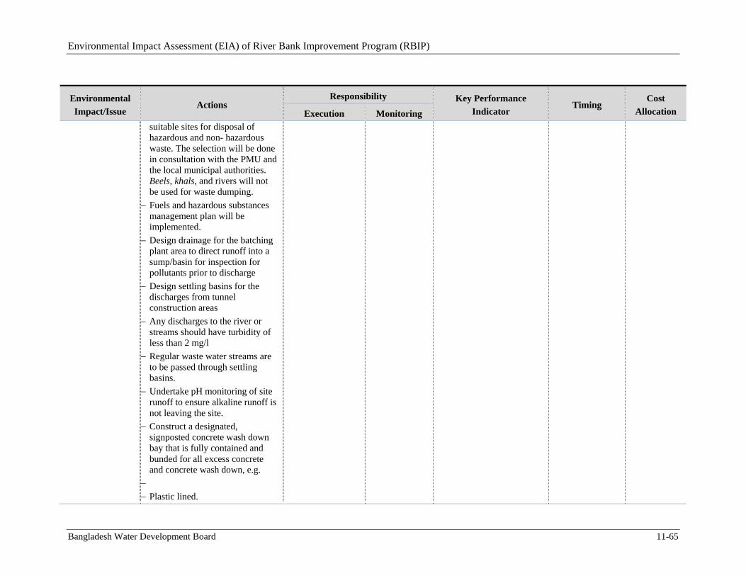
Environmental Impact Assessment (EIA) of River Bank Improvement Program (RBIP)
Bangladesh Water Development Board 11-65
Environmental
Impact/Issue Actions
Responsibility Key Performance
Indicator Timing
Cost
Allocation Execution Monitoring suitable sites for disposal of hazardous and non- hazardous waste. The selection will be done in consultation with the PMU and the local municipal authorities. Beels, khals, and rivers will not be used for waste dumping.
Fuels and hazardous substances management plan will be implemented.
Design drainage for the batching plant area to direct runoff into a sump/basin for inspection for pollutants prior to discharge
Design settling basins for the discharges from tunnel construction areas
Any discharges to the river or streams should have turbidity of less than 2 mg/l
Regular waste water streams are to be passed through settling basins.
Undertake pH monitoring of site runoff to ensure alkaline runoff is not leaving the site.
Construct a designated, signposted concrete wash down bay that is fully contained and bunded for all excess concrete and concrete wash down, e.g.
Plastic lined.
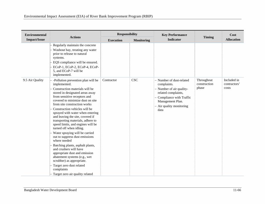
Environmental Impact Assessment (EIA) of River Bank Improvement Program (RBIP)
Bangladesh Water Development Board 11-66
Environmental
Impact/Issue Actions
Responsibility Key Performance
Indicator Timing
Cost
Allocation Execution Monitoring
Regularly maintain the concrete
Washout bay, treating any water prior to release to natural systems.
EQS compliance will be ensured.
ECoP-1, ECoP-2, ECoP-4, ECoP-5, and ECoP-7 will be implemented.
9.5 Air Quality
-Pollution prevention plan will be implemented.
Construction materials will be stored in designated areas away from sensitive receptors and covered to minimize dust on site from site construction works
Construction vehicles will be sprayed with water when entering and leaving the site, covered if transporting materials, adhere to speed limits, and engines will be turned off when idling.
Water spraying will be carried out to suppress dust emissions where needed
Batching plants, asphalt plants, and crushers will have appropriate dust and emission abatement systems (e.g., wet scrubber) as appropriate.
Target zero dust related complaints
Target zero air quality related
Contractor CSC Number of dust-related complaints.
Number of air quality-related complaints,
Compliance with Traffic Management Plan.
Air quality monitoring data
Throughout construction phase
Included in contractors’ costs
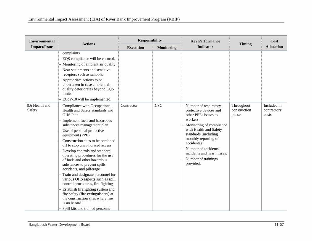
Environmental Impact Assessment (EIA) of River Bank Improvement Program (RBIP)
Bangladesh Water Development Board 11-67
Environmental
Impact/Issue Actions
Responsibility Key Performance
Indicator Timing
Cost
Allocation Execution Monitoring complaints.
EQS compliance will be ensured.
Monitoring of ambient air quality
Near settlements and sensitive receptors such as schools.
Appropriate actions to be undertaken in case ambient air quality deteriorates beyond EQS limits.
ECoP-10 will be implemented.
9.6 Health and Safety
Compliance with Occupational Health and Safety standards and OHS Plan
Implement fuels and hazardous substances management plan
Use of personal protective equipment (PPE)
Construction sites to be cordoned off to stop unauthorized access
Develop controls and standard operating procedures for the use of fuels and other hazardous substances to prevent spills, accidents, and pilferage
Train and designate personnel for various OHS aspects such as spill control procedures, fire fighting
Establish firefighting system and fire safety (fire extinguishers) at the construction sites where fire is an hazard
Spill kits and trained personnel
Contractor CSC Number of respiratory protective devices and other PPEs issues to workers.
Monitoring of compliance with Health and Safety standards (including monthly reporting of accidents).
Number of accidents, incidents and near misses.
Number of trainings provided.
Throughout construction phase
Included in contractors’ costs
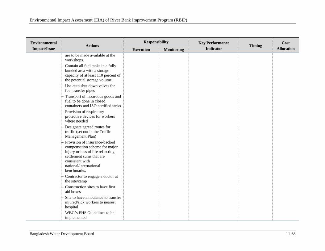
Environmental Impact Assessment (EIA) of River Bank Improvement Program (RBIP)
Bangladesh Water Development Board 11-68
Environmental
Impact/Issue Actions
Responsibility Key Performance
Indicator Timing
Cost
Allocation Execution Monitoring are to be made available at the workshops.
Contain all fuel tanks in a fully bunded area with a storage capacity of at least 110 percent of the potential storage volume.
Use auto shut down valves for fuel transfer pipes
Transport of hazardous goods and fuel to be done in closed containers and ISO certified tanks
Provision of respiratory protective devices for workers where needed
Designate agreed routes for traffic (set out in the Traffic Management Plan)
Provision of insurance-backed compensation scheme for major injury or loss of life reflecting settlement sums that are consistent with national/international benchmarks.
Contractor to engage a doctor at the site/camp
Construction sites to have first aid boxes
Site to have ambulance to transfer injured/sick workers to nearest hospital
WBG’s EHS Guidelines to be implemented
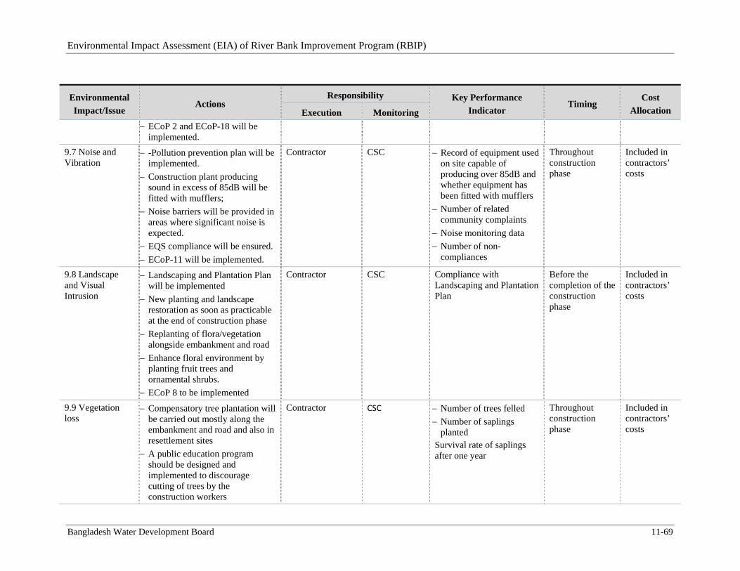
Environmental Impact Assessment (EIA) of River Bank Improvement Program (RBIP)
Bangladesh Water Development Board 11-69
Environmental
Impact/Issue Actions
Responsibility Key Performance
Indicator Timing
Cost
Allocation Execution Monitoring
ECoP 2 and ECoP-18 will be implemented.
9.7 Noise and Vibration
-Pollution prevention plan will be implemented.
Construction plant producing sound in excess of 85dB will be fitted with mufflers;
Noise barriers will be provided in areas where significant noise is expected.
EQS compliance will be ensured.
ECoP-11 will be implemented.
Contractor CSC Record of equipment used on site capable of producing over 85dB and whether equipment has been fitted with mufflers
Number of related community complaints
Noise monitoring data
Number of non-compliances
Throughout construction phase
Included in contractors’ costs
9.8 Landscape and Visual Intrusion
Landscaping and Plantation Plan will be implemented
New planting and landscape restoration as soon as practicable at the end of construction phase
Replanting of flora/vegetation alongside embankment and road
Enhance floral environment by planting fruit trees and ornamental shrubs.
ECoP 8 to be implemented
Contractor CSC Compliance with Landscaping and Plantation Plan
Before the completion of the construction phase
Included in contractors’ costs
9.9 Vegetation loss
Compensatory tree plantation will be carried out mostly along the embankment and road and also in resettlement sites
A public education program should be designed and implemented to discourage cutting of trees by the construction workers
Contractor CSC Number of trees felled
Number of saplings planted
Survival rate of saplings after one year
Throughout construction phase
Included in contractors’ costs
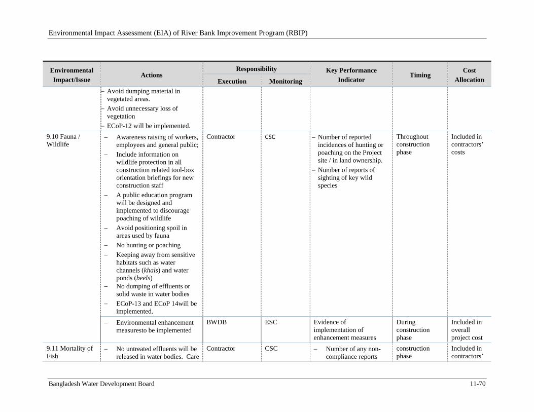
Environmental Impact Assessment (EIA) of River Bank Improvement Program (RBIP)
Bangladesh Water Development Board 11-70
Environmental
Impact/Issue Actions
Responsibility Key Performance
Indicator Timing
Cost
Allocation Execution Monitoring
Avoid dumping material in vegetated areas.
Avoid unnecessary loss of vegetation
ECoP-12 will be implemented.
9.10 Fauna / Wildlife
Awareness raising of workers, employees and general public;
Include information on wildlife protection in all construction related tool-box orientation briefings for new construction staff
A public education program will be designed and implemented to discourage poaching of wildlife
Avoid positioning spoil in areas used by fauna
No hunting or poaching
Keeping away from sensitive habitats such as water channels (khals) and water ponds (beels)
No dumping of effluents or solid waste in water bodies
ECoP-13 and ECoP 14will be implemented.
Contractor CSC Number of reported incidences of hunting or poaching on the Project site / in land ownership.
Number of reports of sighting of key wild species
Throughout construction phase
Included in contractors’ costs
Environmental enhancement measuresto be implemented
BWDB ESC Evidence of implementation of enhancement measures
During construction phase
Included in overall project cost
9.11 Mortality of Fish
No untreated effluents will be released in water bodies. Care
Contractor CSC Number of any non-compliance reports
construction phase
Included in contractors’
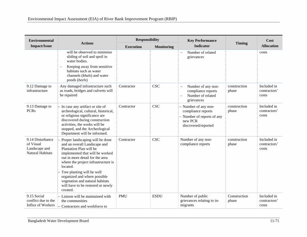
Environmental Impact Assessment (EIA) of River Bank Improvement Program (RBIP)
Bangladesh Water Development Board 11-71
Environmental
Impact/Issue Actions
Responsibility Key Performance
Indicator Timing
Cost
Allocation Execution Monitoring will be observed to minimize sliding of soil and spoil in water bodies.
Keeping away from sensitive habitats such as water channels (khals) and water ponds (beels)
Number of related grievances
costs
9.12 Damage to infrastructure
Any damaged infrastructure such as roads, bridges and culverts will be repaired
Contractor CSC Number of any non-compliance reports
Number of related grievances
construction phase
Included in contractors’ costs
9.13 Damage to PCRs
In case any artifact or site of archeological, cultural, historical, or religious significance are discovered during construction activities, the works will be stopped, and the Archeological Department will be informed.
Contractor CSC Number of any non-compliance reports
Number of reports of any new PCR discovered/reported
construction phase
Included in contractors’ costs
9.14 Disturbance of Visual Landscape and Natural Habitats
Proper landscaping will be done and an overall Landscape and Plantation Plan will be implemented that will be worked out in more detail for the area where the project infrastructure is located.
Tree planting will be well organized and where possible vegetation and natural habitats will have to be restored or newly created.
Contractor CSC Number of any non-compliance reports
construction phase
Included in contractors’ costs
9.15 Social conflict due to the Influx of Workers
Liaison will be maintained with the communities
Contractors and workforce to
PMU ESDU Number of public grievances relating to in-migrants
Construction phase
Included in contractors’ costs
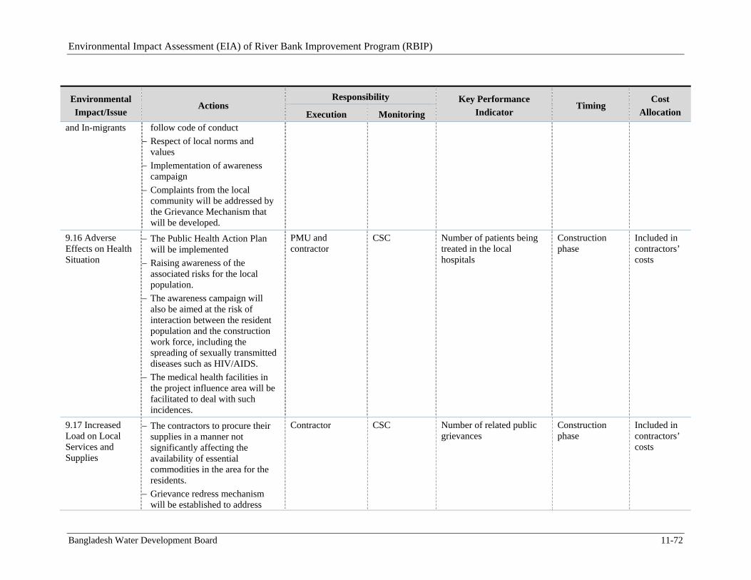
Environmental Impact Assessment (EIA) of River Bank Improvement Program (RBIP)
Bangladesh Water Development Board 11-72
Environmental
Impact/Issue Actions
Responsibility Key Performance
Indicator Timing
Cost
Allocation Execution Monitoring and In-migrants follow code of conduct
Respect of local norms and values
Implementation of awareness campaign
Complaints from the local community will be addressed by the Grievance Mechanism that will be developed.
9.16 Adverse Effects on Health Situation
The Public Health Action Plan will be implemented
Raising awareness of the associated risks for the local population.
The awareness campaign will also be aimed at the risk of interaction between the resident population and the construction work force, including the spreading of sexually transmitted diseases such as HIV/AIDS.
The medical health facilities in the project influence area will be facilitated to deal with such incidences.
PMU and contractor
CSC Number of patients being treated in the local hospitals
Construction phase
Included in contractors’ costs
9.17 Increased Load on Local Services and Supplies
The contractors to procure their supplies in a manner not significantly affecting the availability of essential commodities in the area for the residents.
Grievance redress mechanism will be established to address
Contractor CSC Number of related public grievances
Construction phase
Included in contractors’ costs
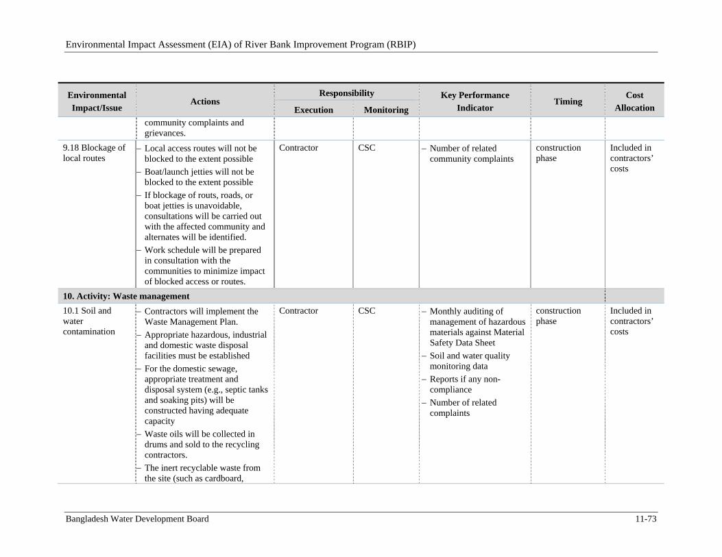
Environmental Impact Assessment (EIA) of River Bank Improvement Program (RBIP)
Bangladesh Water Development Board 11-73
Environmental
Impact/Issue Actions
Responsibility Key Performance
Indicator Timing
Cost
Allocation Execution Monitoring community complaints and grievances.
9.18 Blockage of local routes
Local access routes will not be blocked to the extent possible
Boat/launch jetties will not be blocked to the extent possible
If blockage of routs, roads, or boat jetties is unavoidable, consultations will be carried out with the affected community and alternates will be identified.
Work schedule will be prepared in consultation with the communities to minimize impact of blocked access or routes.
Contractor CSC Number of related community complaints
construction phase
Included in contractors’ costs
10. Activity: Waste management
10.1 Soil and water contamination
Contractors will implement the Waste Management Plan.
Appropriate hazardous, industrial and domestic waste disposal facilities must be established
For the domestic sewage, appropriate treatment and disposal system (e.g., septic tanks and soaking pits) will be constructed having adequate capacity
Waste oils will be collected in drums and sold to the recycling contractors.
The inert recyclable waste from the site (such as cardboard,
Contractor CSC Monthly auditing of management of hazardous materials against Material Safety Data Sheet
Soil and water quality monitoring data
Reports if any non-compliance
Number of related complaints
construction phase
Included in contractors’ costs
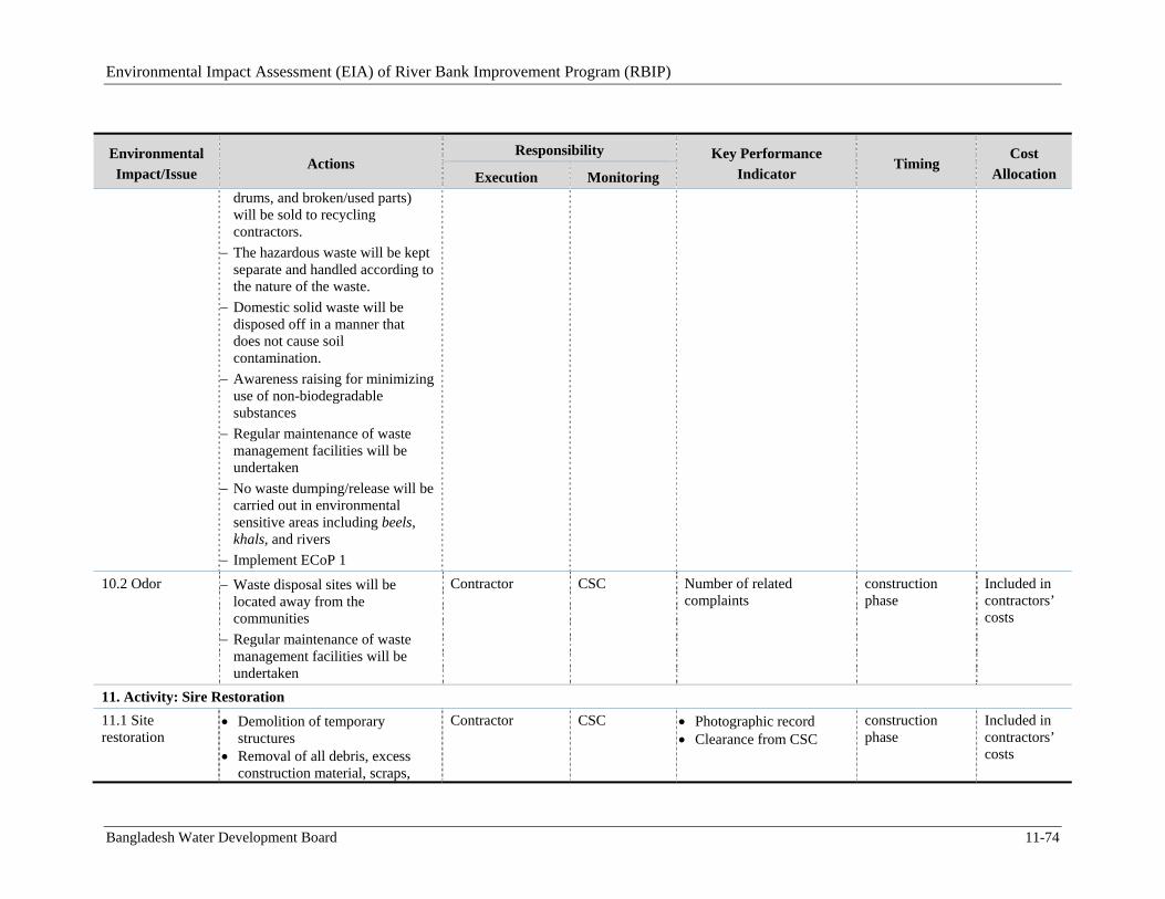
Environmental Impact Assessment (EIA) of River Bank Improvement Program (RBIP)
Bangladesh Water Development Board 11-74
Environmental
Impact/Issue Actions
Responsibility Key Performance
Indicator Timing
Cost
Allocation Execution Monitoring drums, and broken/used parts) will be sold to recycling contractors.
The hazardous waste will be kept separate and handled according to the nature of the waste.
Domestic solid waste will be disposed off in a manner that does not cause soil contamination.
Awareness raising for minimizing use of non-biodegradable substances
Regular maintenance of waste management facilities will be undertaken
No waste dumping/release will be carried out in environmental sensitive areas including beels, khals, and rivers
Implement ECoP 1
10.2 Odor Waste disposal sites will be located away from the communities
Regular maintenance of waste management facilities will be undertaken
Contractor CSC Number of related complaints
construction phase
Included in contractors’ costs
11. Activity: Sire Restoration
11.1 Site restoration
Demolition of temporary structures
Removal of all debris, excess construction material, scraps,
Contractor CSC Photographic record Clearance from CSC
construction phase
Included in contractors’ costs
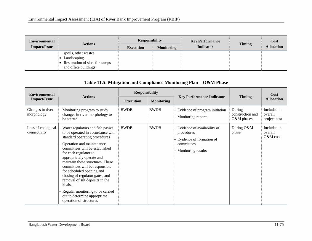
Environmental Impact Assessment (EIA) of River Bank Improvement Program (RBIP)
Bangladesh Water Development Board 11-75
Environmental
Impact/Issue Actions
Responsibility Key Performance
Indicator Timing
Cost
Allocation Execution Monitoring spoils, other wastes
Landscaping Restoration of sites for camps
and office buildings
Table 11.5: Mitigation and Compliance Monitoring Plan – O&M Phase
Environmental Impact/Issue
Actions Responsibility
Key Performance Indicator Timing Cost
Allocation Execution Monitoring
Changes in river morphology
Monitoring program to study changes in river morphology to be started
BWDB BWDB Evidence of program initiation
Monitoring reports
During construction and O&M phases
Included in overall project cost
Loss of ecological connectivity
Water regulators and fish passes to be operated in accordance with standard operating procedures
Operation and maintenance committees will be established for each regulator to appropriately operate and maintain these structures. These committees will be responsible for scheduled opening and closing of regulator gates, and removal of silt deposits in the khals.
Regular monitoring to be carried out to determine appropriate operation of structures
BWDB BWDB Evidence of availability of procedures
Evidence of formation of committees
Monitoring results
During O&M phase
Included in overall O&M cost
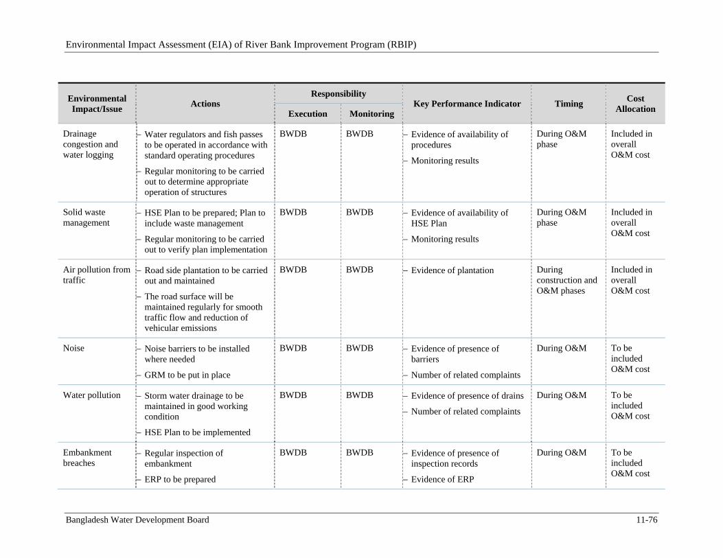
Environmental Impact Assessment (EIA) of River Bank Improvement Program (RBIP)
Bangladesh Water Development Board 11-76
Environmental Impact/Issue
Actions Responsibility
Key Performance Indicator Timing Cost
Allocation Execution Monitoring
Drainage congestion and water logging
Water regulators and fish passes to be operated in accordance with standard operating procedures
Regular monitoring to be carried out to determine appropriate operation of structures
BWDB BWDB Evidence of availability of procedures
Monitoring results
During O&M phase
Included in overall O&M cost
Solid waste management
HSE Plan to be prepared; Plan to include waste management
Regular monitoring to be carried out to verify plan implementation
BWDB BWDB Evidence of availability of HSE Plan
Monitoring results
During O&M phase
Included in overall O&M cost
Air pollution from traffic
Road side plantation to be carried out and maintained
The road surface will be maintained regularly for smooth traffic flow and reduction of vehicular emissions
BWDB BWDB Evidence of plantation
During construction and O&M phases
Included in overall O&M cost
Noise Noise barriers to be installed where needed
GRM to be put in place
BWDB BWDB Evidence of presence of barriers
Number of related complaints
During O&M To be included O&M cost
Water pollution Storm water drainage to be maintained in good working condition
HSE Plan to be implemented
BWDB BWDB Evidence of presence of drains
Number of related complaints
During O&M To be included O&M cost
Embankment breaches
Regular inspection of embankment
ERP to be prepared
BWDB BWDB Evidence of presence of inspection records
Evidence of ERP
During O&M To be included O&M cost
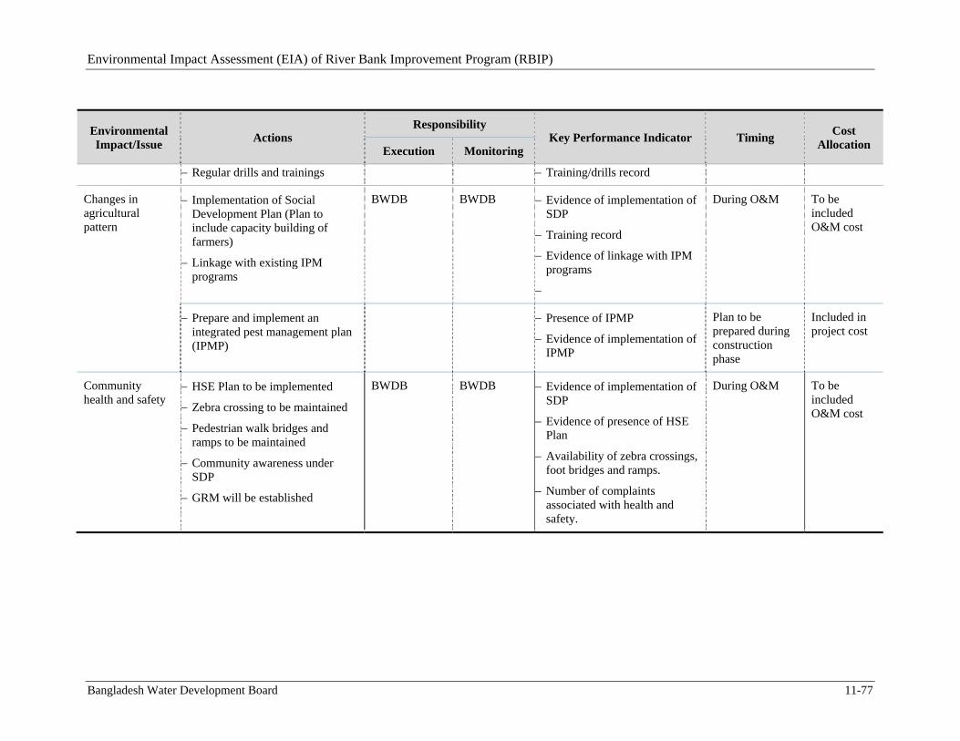
Environmental Impact Assessment (EIA) of River Bank Improvement Program (RBIP)
Bangladesh Water Development Board 11-77
Environmental Impact/Issue
Actions Responsibility
Key Performance Indicator Timing Cost
Allocation Execution Monitoring
Regular drills and trainings Training/drills record
Changes in agricultural pattern
Implementation of Social Development Plan (Plan to include capacity building of farmers)
Linkage with existing IPM programs
BWDB BWDB Evidence of implementation of SDP
Training record
Evidence of linkage with IPM programs
During O&M To be included O&M cost
Prepare and implement an integrated pest management plan (IPMP)
Presence of IPMP
Evidence of implementation of IPMP
Plan to be prepared during construction phase
Included in project cost
Community health and safety
HSE Plan to be implemented
Zebra crossing to be maintained
Pedestrian walk bridges and ramps to be maintained
Community awareness under SDP
GRM will be established
BWDB BWDB Evidence of implementation of SDP
Evidence of presence of HSE Plan
Availability of zebra crossings, foot bridges and ramps.
Number of complaints associated with health and safety.
During O&M To be included O&M cost
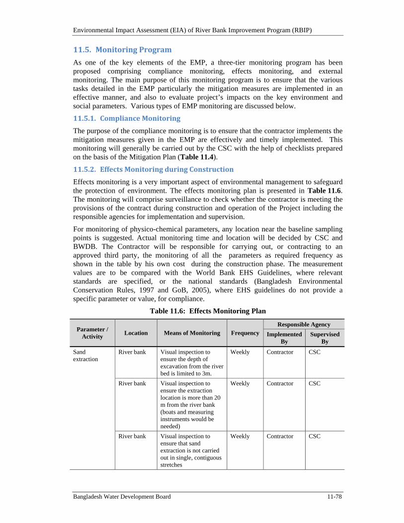
Environmental Impact Assessment (EIA) of River Bank Improvement Program (RBIP)
Bangladesh Water Development Board 11-78
11.5. MonitoringProgram
As one of the key elements of the EMP, a three-tier monitoring program has been proposed comprising compliance monitoring, effects monitoring, and external monitoring. The main purpose of this monitoring program is to ensure that the various tasks detailed in the EMP particularly the mitigation measures are implemented in an effective manner, and also to evaluate project’s impacts on the key environment and social parameters. Various types of EMP monitoring are discussed below.
11.5.1. ComplianceMonitoring
The purpose of the compliance monitoring is to ensure that the contractor implements the mitigation measures given in the EMP are effectively and timely implemented. This monitoring will generally be carried out by the CSC with the help of checklists prepared on the basis of the Mitigation Plan (Table 11.4).
11.5.2. EffectsMonitoringduringConstruction
Effects monitoring is a very important aspect of environmental management to safeguard the protection of environment. The effects monitoring plan is presented in Table 11.6. The monitoring will comprise surveillance to check whether the contractor is meeting the provisions of the contract during construction and operation of the Project including the responsible agencies for implementation and supervision.
For monitoring of physico-chemical parameters, any location near the baseline sampling points is suggested. Actual monitoring time and location will be decided by CSC and BWDB. The Contractor will be responsible for carrying out, or contracting to an approved third party, the monitoring of all the parameters as required frequency as shown in the table by his own cost during the construction phase. The measurement values are to be compared with the World Bank EHS Guidelines, where relevant standards are specified, or the national standards (Bangladesh Environmental Conservation Rules, 1997 and GoB, 2005), where EHS guidelines do not provide a specific parameter or value, for compliance.
Table 11.6: Effects Monitoring Plan
Parameter / Activity
Location Means of Monitoring Frequency Responsible Agency
Implemented By
Supervised By
Sand extraction
River bank Visual inspection to ensure the depth of excavation from the river bed is limited to 3m.
Weekly Contractor CSC
River bank Visual inspection to ensure the extraction location is more than 20 m from the river bank (boats and measuring instruments would be needed)
Weekly Contractor CSC
River bank Visual inspection to ensure that sand extraction is not carried out in single, contiguous stretches
Weekly Contractor CSC
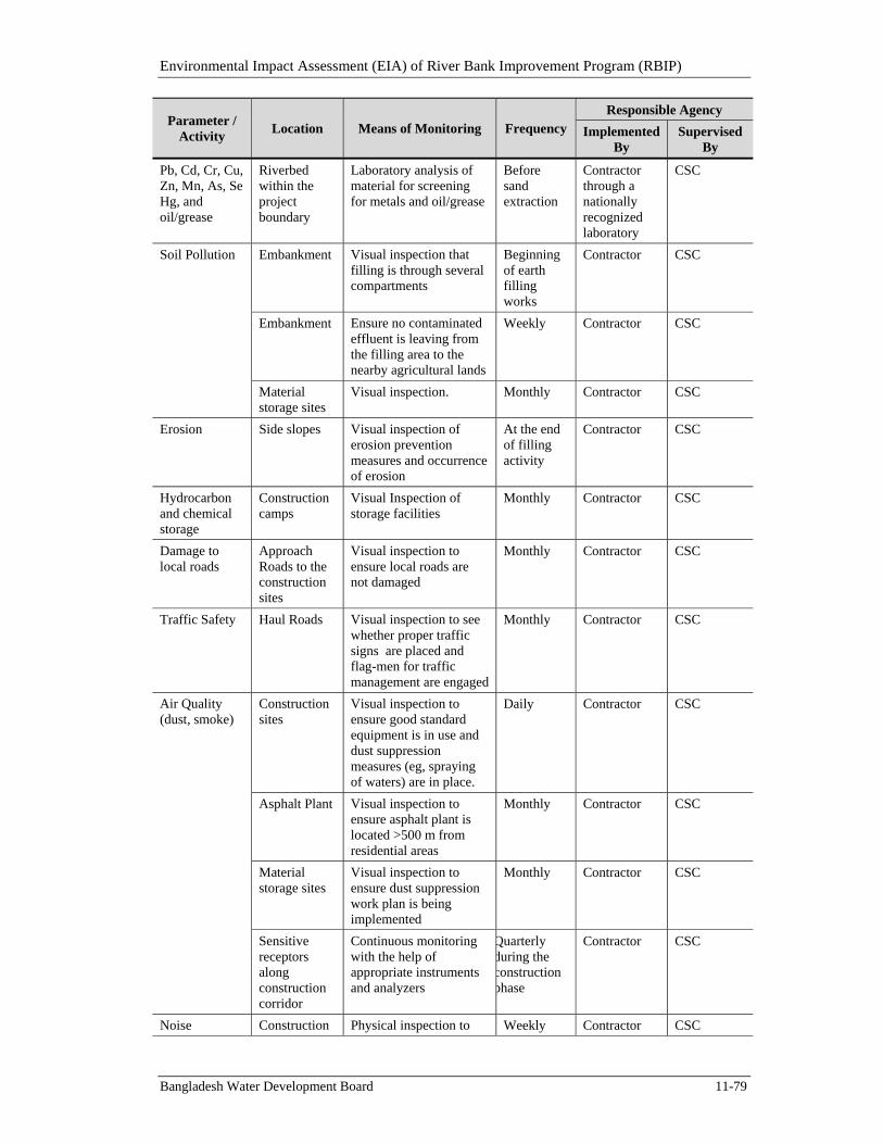
Environmental Impact Assessment (EIA) of River Bank Improvement Program (RBIP)
Bangladesh Water Development Board 11-79
Parameter / Activity
Location Means of Monitoring Frequency Responsible Agency
Implemented By
Supervised By
Pb, Cd, Cr, Cu, Zn, Mn, As, Se Hg, and oil/grease
Riverbed within the project boundary
Laboratory analysis of material for screening for metals and oil/grease
Before sand extraction
Contractor through a nationally recognized laboratory
CSC
Soil Pollution Embankment Visual inspection that filling is through several compartments
Beginning of earth filling works
Contractor CSC
Embankment Ensure no contaminated effluent is leaving from the filling area to the nearby agricultural lands
Weekly Contractor CSC
Material storage sites
Visual inspection. Monthly Contractor CSC
Erosion Side slopes Visual inspection of erosion prevention measures and occurrence of erosion
At the end of filling activity
Contractor CSC
Hydrocarbon and chemical storage
Construction camps
Visual Inspection of storage facilities
Monthly Contractor CSC
Damage to local roads
Approach Roads to the construction sites
Visual inspection to ensure local roads are not damaged
Monthly Contractor CSC
Traffic Safety Haul Roads Visual inspection to see whether proper traffic signs are placed and flag-men for traffic management are engaged
Monthly Contractor CSC
Air Quality (dust, smoke)
Construction sites
Visual inspection to ensure good standard equipment is in use and dust suppression measures (eg, spraying of waters) are in place.
Daily Contractor CSC
Asphalt Plant Visual inspection to ensure asphalt plant is located >500 m from residential areas
Monthly Contractor CSC
Material storage sites
Visual inspection to ensure dust suppression work plan is being implemented
Monthly Contractor CSC
Sensitive receptors along construction corridor
Continuous monitoring with the help of appropriate instruments and analyzers
Quarterly during the construction phase
Contractor CSC
Noise Construction Physical inspection to Weekly Contractor CSC
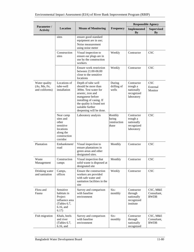
Environmental Impact Assessment (EIA) of River Bank Improvement Program (RBIP)
Bangladesh Water Development Board 11-80
Parameter / Activity
Location Means of Monitoring Frequency Responsible Agency
Implemented By
Supervised By
sites ensure good standard equipment are in use; Noise measurement using noise meter
Construction sites
Visual inspection to ensure ear plugs are in use by the construction workers
Weekly Contractor CSC
Ensure work restriction between 21:00-06:00 close to the sensitive locations
Weekly Contractor CSC
Water quality (As, Mn, Fe, and coliforms)
Locations of tube-well installation
Depth of tube well should be more than 300m. Test water for arsenic, iron and manganese before installing of casing. If the quality is found not suitable further deepening will be done.
During drilling of wells
Contractor trough a nationally recognized laboratory
CSC External Monitor
Near camp sites and other sensitive locations along the construction corridor
Laboratory analysis Monthly during construction phase
Contractor trough a nationally recognized laboratory
CSC
Plantation Embankment/road
Visual inspection to ensure plantations in green areas and other designated sites.
Monthly Contractor CSC
Waste Management
Construction camps
Visual inspection that solid waste is disposed at designated site
Monthly Contractor CSC
Drinking water and sanitation
Camps, offices
Ensure the construction workers are provided with safe water and sanitation facilities in the site
Weekly Contractor CSC
Flora and Fauna
Sensitive habitats in Project influence area (Tables 6.7, 6.16, and 6.17)
Survey and comparison with baseline environment
Six-monthly
Contractor through nationally recognized institute
CSC, M&E Consultant, BWDB
Fish migration Khals, beels and river (Tables 6.7, 6.16, and
Survey and comparison with baseline environment
Six-monthly
Contractor through nationally recognized
CSC, M&E Consultant, BWDB
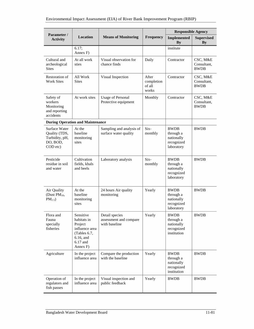
Environmental Impact Assessment (EIA) of River Bank Improvement Program (RBIP)
Bangladesh Water Development Board 11-81
Parameter / Activity
Location Means of Monitoring Frequency Responsible Agency
Implemented By
Supervised By
6.17; Annex F)
institute
Cultural and archeological Sites
At all work sties
Visual observation for chance finds
Daily
Contractor
CSC, M&E Consultant, BWDB
Restoration of Work Sites
All Work Sites
Visual Inspection After completion of all works
Contractor
CSC, M&E Consultant, BWDB
Safety of workers Monitoring and reporting accidents
At work sites Usage of Personal Protective equipment
Monthly Contractor CSC, M&E Consultant, BWDB
During Operation and Maintenance
Surface Water Quality (TDS, Turbidity, pH, DO, BOD, COD etc)
At the baseline monitoring sites
Sampling and analysis of surface water quality
Six-monthly
BWDB through a nationally recognized laboratory
BWDB
Pesticide residue in soil and water
Cultivation fields, khals and beels
Laboratory analysis
Six-monthly
BWDB through a nationally recognized laboratory
BWDB
Air Quality (Dust PM10, PM2.5)
At the baseline monitoring sites
24 hours Air quality monitoring
Yearly BWDB through a nationally recognized laboratory
BWDB
Flora and Fauna specially fisheries
Sensitive habitats in Project influence area (Tables 6.7, 6.16, and 6.17 and Annex F)
Detail species assessment and compare with baseline
Yearly BWDB through a nationally recognized institution
BWDB
Agriculture In the project influence area
Compare the production with the baseline
Yearly BWDB through a nationally recognized institution
BWDB
Operation of regulators and fish passes
In the project influence area
Visual inspection and public feedback
Yearly BWDB
BWDB
Environmental Impact Assessment (EIA) of River Bank Improvement Program (RBIP)
Bangladesh Water Development Board 11-82
11.5.3. ExternalMonitoring
The BWDB will engage an independent consulting firm to conduct external and independent monitoring of the EMP implementation. The main purpose of the external monitoring will be to ensure that all the key entities including EDSU, CSC, and contractors are effectively and adequately fulfilling their designated role for EMP implementation, and that all the EMP requirements are being implemented in a timely and effective manner. The ToR of the external monitoring is presented in Annex K (Volume II).
11.6. PerformanceIndicators
For evaluating the performance of the environmental management and monitoring plan, performance indicators are identified to for efficient and timely implementation of measures/actions proposed in EMP. The indicators are defined both for implementation phase and for operation phase. CSC will be responsible for compiling the information on these indicators and report to BWDB.
Separate performance indicators for each environmental issue have been specified in Table 11.4 and 11.5 earlier. To measure the overall environmental performance of the project, an additional list of performance indicators is given below.
Number of inspections carried out by CSC per month
Number of non-compliances observed by CSC or ESDU.
Availability of environmental specialists in ESDU.
Availability of environmental specialists in CSC.
Availability of environmental specialists with contractors.
Timely reporting of documents (as defined in EMP and monitoring plan)
Number of trainings imparted to stakeholders/other capacity building initiatives
Timely disbursement of compensation/ timely resettlement of project affectees
Timely implementation of resettlement schedule.
Number of grievances received.
Number of grievances resolved.
Number of construction related accidents.
11.7. GrievanceRedressMechanism10
The project will establish a grievance redress mechanism (GRM) for addressing grievances and complaints received from the project-affected persons. The fundamental objective of GRM will be to resolve any project-related grievances locally in consultation with the aggrieved party to facilitate smooth implementation of the social and environmental action plans. Another important objective is to democratize the development process at the local level and to establish accountability to the affected people. The procedures will however not pre-empt a person’s right to go to the courts of law.
10 Further details on GRM are available in RAP.
Environmental Impact Assessment (EIA) of River Bank Improvement Program (RBIP)
Bangladesh Water Development Board 11-83
Under the GRM, two grievance redress committees (GRCs) will be formed: local grievance redress committee (LGRC); and project grievance redress committee (PGRC). Most of the grievances would be resolved at LGRC while a few might be forwarded to PGRC. These GRCs are described below.
11.7.1. LocalGrievanceRedressCommittee
The following LGRC composition has been proposed for the project:
Executive Engineer – RBIP, BWDB: Convener
Representative of an international non-governmental organization: Member, Secretary
Chairman – concerned Union Parishad (UP): Member
Female member of concerned ward of the UP: Member
Representative of Women affected persons (APs): Member
LGRC meetings will be held in the convener’s office in the project influence area or other location(s) as agreed by the Committee members. If needed, LGRC members may undertake field visits to verify and review the issues, including titles/shares, reason for any delay in payments, or any concern regarding social or environmental impacts of the project.
11.7.2. ProjectGrievanceRedressCommittee
The grievances that are not resolved at the LGRC will be forwarded to the PGRC. The PGRC will be empowered to take a decision, which would be binding on BWDB but it would require approval of the Project Director for implementation of the decision. The Project Director will head the PGRC. The composition of the PGRC will be as follows:
Project Director: Chair Person
Head of ESDU: Member, Secretary (Team Leader of INGO will assist the Secretary in grievance redress mechanism).
Representative of Civil Society: Member (nominated by Project Director with the help of INGO).
The Secretary of PGRC with the help of INGO Team Leader will provide necessary knowledge and information regarding relevant project policies and agreements with development partner. The provision of PGRC will further establish fairness and transparency in the resolution of grievances of the project-affected persons. In case of technical nature of environmental issues, or any legal matters, Team Leader of INGO or environmental and social development specialists of CSC will advise the PGRC. In specific cases, external legal and or technical advice may also be sought, if required.
11.8. CapacityBuilding
Capacity building for effective implementation of the environmental and social safeguard requirements is a key element of the EMP. Capacity building for environmental and social safeguard management will need to be carried out at all tiers of the project, including BWDB, ESDU, CSC, and contractors. At the construction site, CSC will take the lead in implementing the capacity building plan, though the contractors will also be responsible to conduct trainings for their own staff and workers. The various aspects that are covered under the capacity building will include general environmental and social
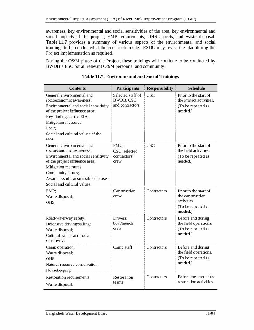
Environmental Impact Assessment (EIA) of River Bank Improvement Program (RBIP)
Bangladesh Water Development Board 11-84
awareness, key environmental and social sensitivities of the area, key environmental and social impacts of the project, EMP requirements, OHS aspects, and waste disposal. Table 11.7 provides a summary of various aspects of the environmental and social trainings to be conducted at the construction site. ESDU may revise the plan during the Project implementation as required.
During the O&M phase of the Project, these trainings will continue to be conducted by BWDB’s ESC for all relevant O&M personnel and community.
Table 11.7: Environmental and Social Trainings
Contents Participants Responsibility Schedule
General environmental and socioeconomic awareness; Environmental and social sensitivity of the project influence area; Key findings of the EIA; Mitigation measures; EMP; Social and cultural values of the area.
Selected staff of BWDB, CSC, and contractors
CSC Prior to the start of the Project activities. (To be repeated as needed.)
General environmental and socioeconomic awareness; Environmental and social sensitivity of the project influence area; Mitigation measures; Community issues; Awareness of transmissible diseases Social and cultural values.
PMU; CSC; selected contractors’ crew
CSC Prior to the start of the field activities. (To be repeated as needed.)
EMP; Waste disposal; OHS
Construction crew
Contractors Prior to the start of the construction activities. (To be repeated as needed.)
Road/waterway safety; Defensive driving/sailing; Waste disposal; Cultural values and social sensitivity.
Drivers; boat/launch crew
Contractors Before and during the field operations. (To be repeated as needed.)
Camp operation; Waste disposal; OHS Natural resource conservation; Housekeeping.
Camp staff Contractors Before and during the field operations. (To be repeated as needed.)
Restoration requirements;
Waste disposal.
Restoration teams
Contractors Before the start of the restoration activities.
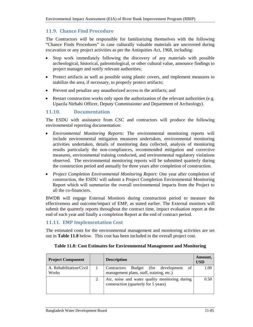
Environmental Impact Assessment (EIA) of River Bank Improvement Program (RBIP)
Bangladesh Water Development Board 11-85
11.9. ChanceFindProcedure
The Contractors will be responsible for familiarizing themselves with the following “Chance Finds Procedures” in case culturally valuable materials are uncovered during excavation or any project activities as per the Antiquities Act, 1968, including:
Stop work immediately following the discovery of any materials with possible archeological, historical, paleontological, or other cultural value, announce findings to project manager and notify relevant authorities;
Protect artifacts as well as possible using plastic covers, and implement measures to stabilize the area, if necessary, to properly protect artifacts;
Prevent and penalize any unauthorized access to the artifacts; and
Restart construction works only upon the authorization of the relevant authorities (e.g. Upazila Nirbahi Officer, Deputy Commissioner and Department of Archeology).
11.10. Documentation
The ESDU with assistance from CSC and contractors will produce the following environmental reporting documentation:
Environmental Monitoring Reports: The environmental monitoring reports will include environmental mitigation measures undertaken, environmental monitoring activities undertaken, details of monitoring data collected, analysis of monitoring results particularly the non-compliances, recommended mitigation and corrective measures, environmental training conducted, and environmental regulatory violations observed. The environmental monitoring reports will be submitted quarterly during the construction period and annually for three years after completion of construction.
Project Completion Environmental Monitoring Report: One year after completion of construction, the ESDU will submit a Project Completion Environmental Monitoring Report which will summarize the overall environmental impacts from the Project to all the co-financiers.
BWDB will engage External Monitors during construction period to measure the effectiveness and outcome/impact of EMP, as stated earlier. The External monitors will submit the quarterly reports throughout the contract time, impact evaluation report at the end of each year and finally a completion Report at the end of contract period.
11.11. EMPImplementationCost
The estimated costs for the environmental management and monitoring activities are set out in Table 11.8 below. This cost has been included in the overall project cost.
Table 11.8: Cost Estimates for Environmental Management and Monitoring
Project Component
Description Amount, USD
A. Rehabilitation/Civil Works
1 Contractors Budget (for development of management plans, staff, training, etc.)
1.00
2 Air, noise and water quality monitoring during construction (quarterly for 5 years)
0.50
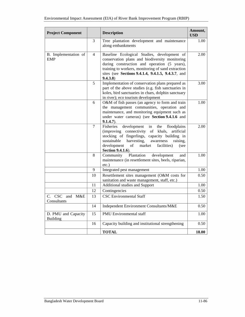
Environmental Impact Assessment (EIA) of River Bank Improvement Program (RBIP)
Bangladesh Water Development Board 11-86
Project Component
Description Amount, USD
3 Tree plantation development and maintenance along embankments
1.00
B. Implementation of EMP
4 Baseline Ecological Studies, development of conservation plans and biodiversity monitoring during construction and operation (5 years), training to workers, monitoring of sand extraction sites (see Sections 9.4.1.4, 9.4.1.5, 9.4.3.7, and 9.4.3.8)
2.00
5 Implementation of conservation plans prepared as part of the above studies (e.g. fish sanctuaries in koles, bird sanctuaries in chars, dolphin sanctuary in river); eco tourism development
3.00
6 O&M of fish passes (an agency to form and train the management communities, operation and maintenance, and monitoring equipment such as under water cameras) (see Section 9.4.1.6 and 9.1.4.7).
1.00
7 Fisheries development in the floodplains (improving connectivity of khals, artificial stocking of fingerlings, capacity building in sustainable harvesting, awareness raising, development of market facilities) (see Section 9.4.1.6).
2.00
8 Community Plantation development and maintenance (in resettlement sites, beels, riparian, etc.)
1.00
9 Integrated pest management 1.00
10 Resettlement sites management (O&M costs for
sanitation and waste management, staff, etc.) 0.50
11 Additional studies and Support 1.00
12 Contingencies 0.50C. CSC and M&E Consultants
13 CSC Environmental Staff 1.50
14 Independent Environment Consultants/M&E 0.50
D. PMU and Capacity Building
15 PMU Environmental staff 1.00
16 Capacity building and institutional strengthening 0.50
TOTAL 18.00
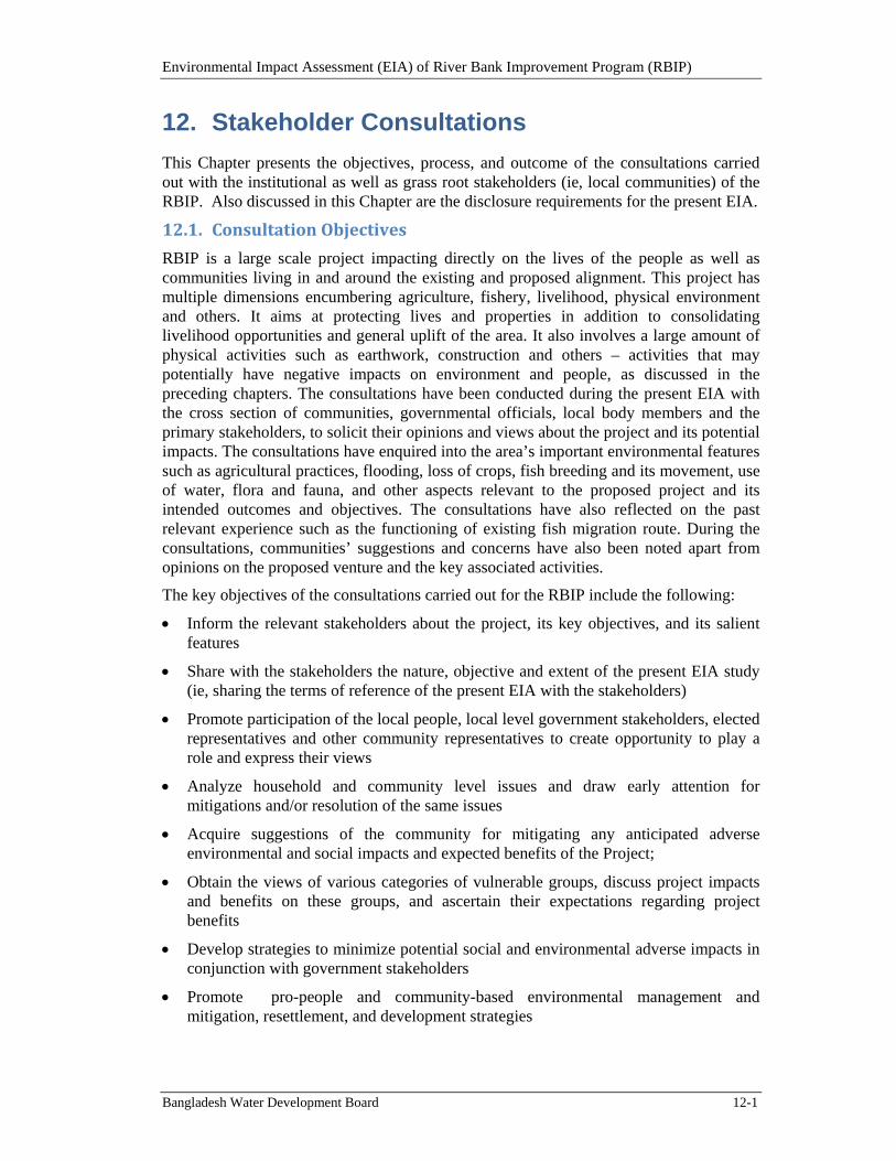
Environmental Impact Assessment (EIA) of River Bank Improvement Program (RBIP)
Bangladesh Water Development Board 12-1
12. Stakeholder Consultations
This Chapter presents the objectives, process, and outcome of the consultations carried out with the institutional as well as grass root stakeholders (ie, local communities) of the RBIP. Also discussed in this Chapter are the disclosure requirements for the present EIA.
12.1. ConsultationObjectives
RBIP is a large scale project impacting directly on the lives of the people as well as communities living in and around the existing and proposed alignment. This project has multiple dimensions encumbering agriculture, fishery, livelihood, physical environment and others. It aims at protecting lives and properties in addition to consolidating livelihood opportunities and general uplift of the area. It also involves a large amount of physical activities such as earthwork, construction and others – activities that may potentially have negative impacts on environment and people, as discussed in the preceding chapters. The consultations have been conducted during the present EIA with the cross section of communities, governmental officials, local body members and the primary stakeholders, to solicit their opinions and views about the project and its potential impacts. The consultations have enquired into the area’s important environmental features such as agricultural practices, flooding, loss of crops, fish breeding and its movement, use of water, flora and fauna, and other aspects relevant to the proposed project and its intended outcomes and objectives. The consultations have also reflected on the past relevant experience such as the functioning of existing fish migration route. During the consultations, communities’ suggestions and concerns have also been noted apart from opinions on the proposed venture and the key associated activities.
The key objectives of the consultations carried out for the RBIP include the following:
Inform the relevant stakeholders about the project, its key objectives, and its salient features
Share with the stakeholders the nature, objective and extent of the present EIA study (ie, sharing the terms of reference of the present EIA with the stakeholders)
Promote participation of the local people, local level government stakeholders, elected representatives and other community representatives to create opportunity to play a role and express their views
Analyze household and community level issues and draw early attention for mitigations and/or resolution of the same issues
Acquire suggestions of the community for mitigating any anticipated adverse environmental and social impacts and expected benefits of the Project;
Obtain the views of various categories of vulnerable groups, discuss project impacts and benefits on these groups, and ascertain their expectations regarding project benefits
Develop strategies to minimize potential social and environmental adverse impacts in conjunction with government stakeholders
Promote pro-people and community-based environmental management and mitigation, resettlement, and development strategies
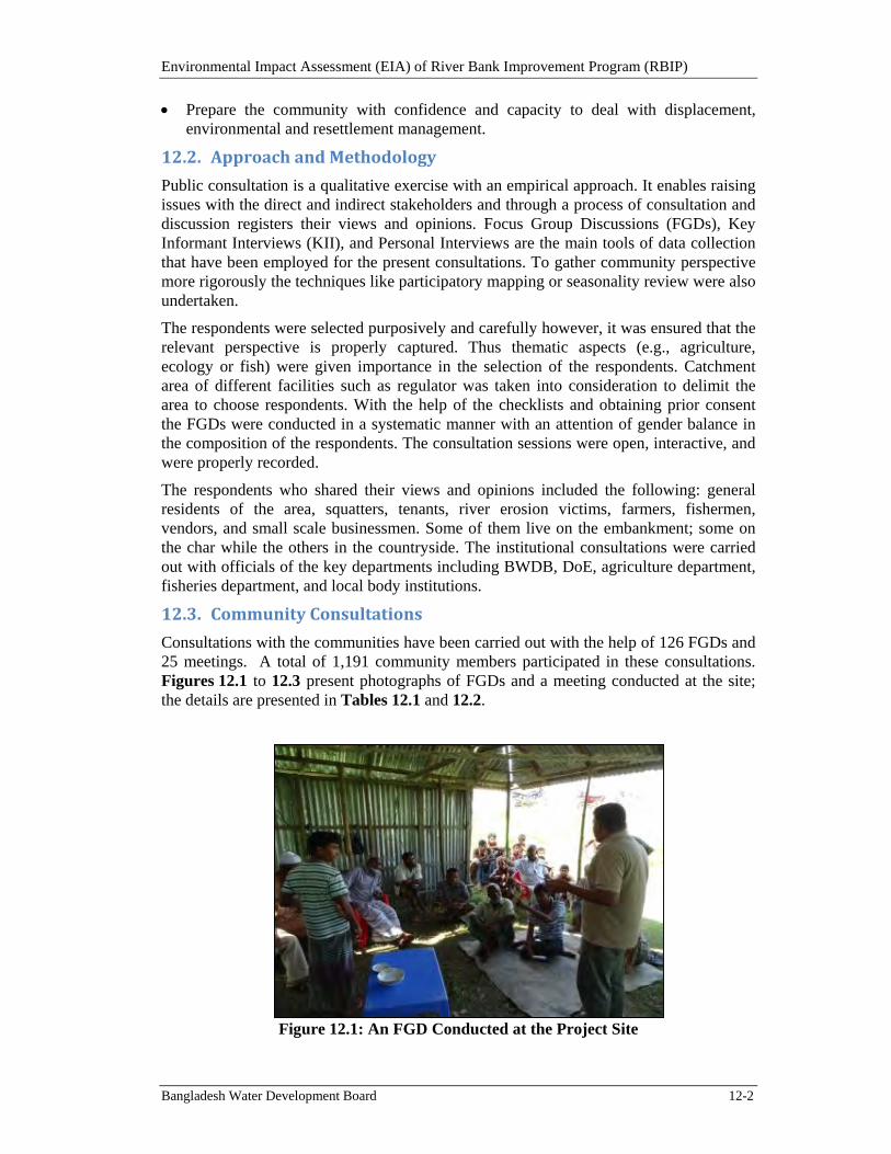
Environmental Impact Assessment (EIA) of River Bank Improvement Program (RBIP)
Bangladesh Water Development Board 12-2
Prepare the community with confidence and capacity to deal with displacement, environmental and resettlement management.
12.2. ApproachandMethodology
Public consultation is a qualitative exercise with an empirical approach. It enables raising issues with the direct and indirect stakeholders and through a process of consultation and discussion registers their views and opinions. Focus Group Discussions (FGDs), Key Informant Interviews (KII), and Personal Interviews are the main tools of data collection that have been employed for the present consultations. To gather community perspective more rigorously the techniques like participatory mapping or seasonality review were also undertaken.
The respondents were selected purposively and carefully however, it was ensured that the relevant perspective is properly captured. Thus thematic aspects (e.g., agriculture, ecology or fish) were given importance in the selection of the respondents. Catchment area of different facilities such as regulator was taken into consideration to delimit the area to choose respondents. With the help of the checklists and obtaining prior consent the FGDs were conducted in a systematic manner with an attention of gender balance in the composition of the respondents. The consultation sessions were open, interactive, and were properly recorded.
The respondents who shared their views and opinions included the following: general residents of the area, squatters, tenants, river erosion victims, farmers, fishermen, vendors, and small scale businessmen. Some of them live on the embankment; some on the char while the others in the countryside. The institutional consultations were carried out with officials of the key departments including BWDB, DoE, agriculture department, fisheries department, and local body institutions.
12.3. CommunityConsultations
Consultations with the communities have been carried out with the help of 126 FGDs and 25 meetings. A total of 1,191 community members participated in these consultations. Figures 12.1 to 12.3 present photographs of FGDs and a meeting conducted at the site; the details are presented in Tables 12.1 and 12.2.
Figure 12.1: An FGD Conducted at the Project Site
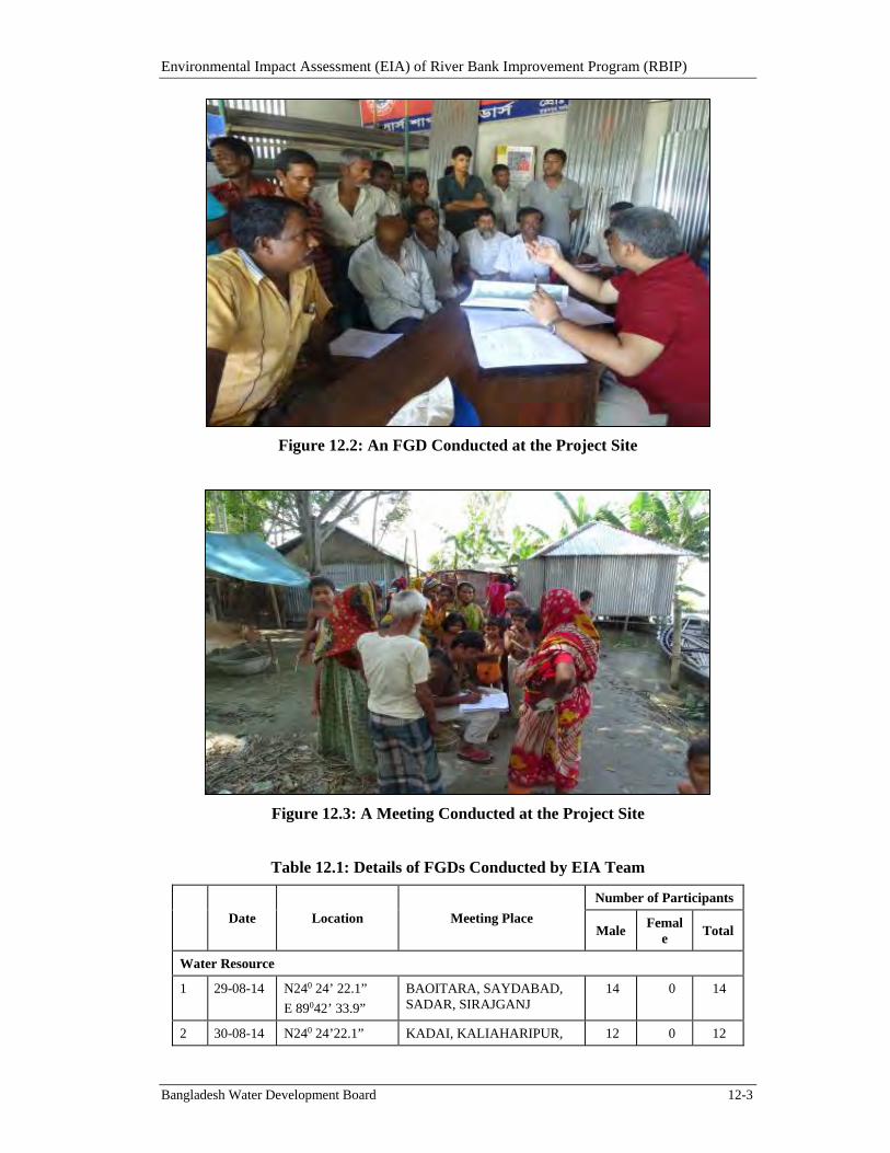
Environmental Impact Assessment (EIA) of River Bank Improvement Program (RBIP)
Bangladesh Water Development Board 12-3
Figure 12.2: An FGD Conducted at the Project Site
Figure 12.3: A Meeting Conducted at the Project Site
Table 12.1: Details of FGDs Conducted by EIA Team
Date Location Meeting Place
Number of Participants
Male Femal
e Total
Water Resource
1 29-08-14 N240 24’ 22.1”
E 89042’ 33.9”
BAOITARA, SAYDABAD, SADAR, SIRAJGANJ
14 0 14
2 30-08-14 N240 24’22.1” KADAI, KALIAHARIPUR, 12 0 12
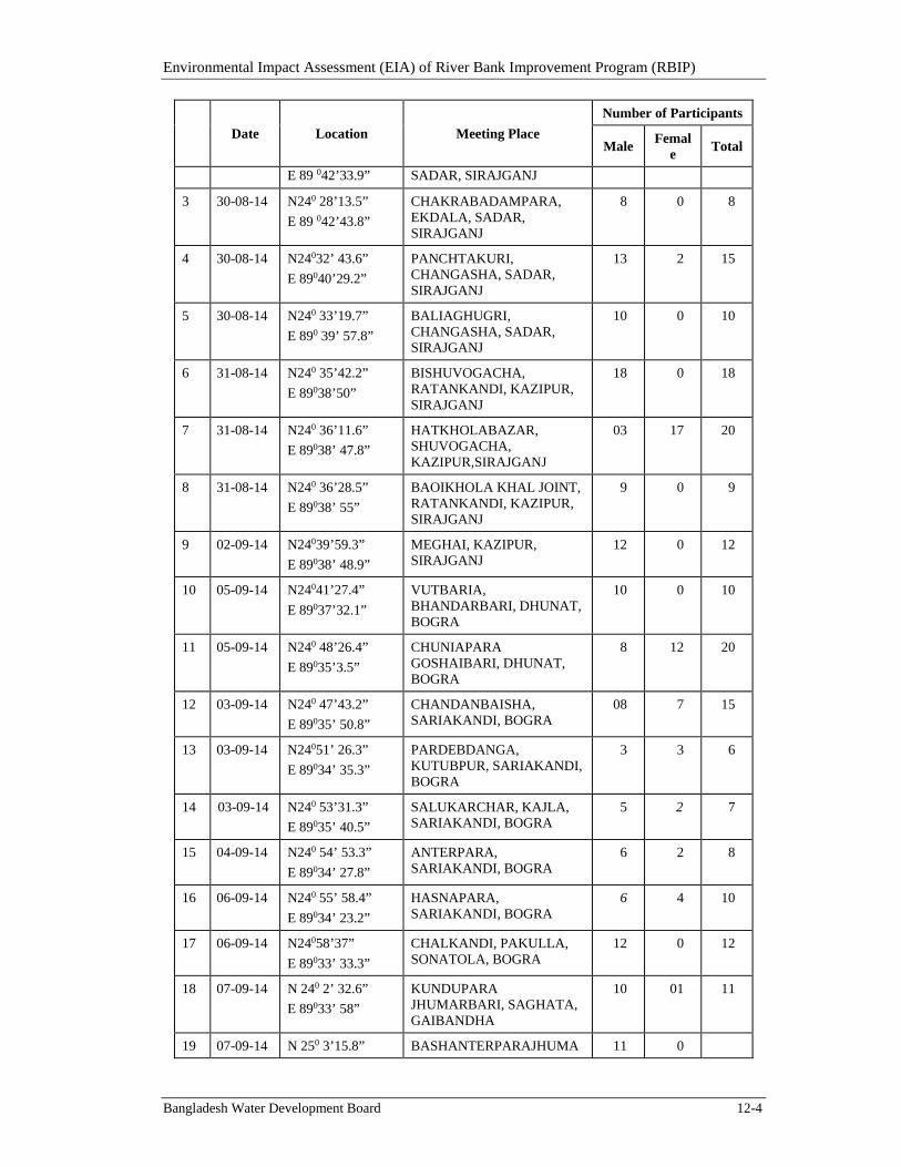
Environmental Impact Assessment (EIA) of River Bank Improvement Program (RBIP)
Bangladesh Water Development Board 12-4
Date Location Meeting Place
Number of Participants
Male Femal
e Total
E 89 042’33.9” SADAR, SIRAJGANJ
3 30-08-14 N240 28’13.5”
E 89 042’43.8”
CHAKRABADAMPARA, EKDALA, SADAR, SIRAJGANJ
8 0 8
4 30-08-14 N24032’ 43.6”
E 89040’29.2”
PANCHTAKURI, CHANGASHA, SADAR, SIRAJGANJ
13 2 15
5 30-08-14 N240 33’19.7”
E 890 39’ 57.8”
BALIAGHUGRI, CHANGASHA, SADAR, SIRAJGANJ
10 0 10
6 31-08-14 N240 35’42.2”
E 89038’50”
BISHUVOGACHA, RATANKANDI, KAZIPUR, SIRAJGANJ
18 0 18
7 31-08-14 N240 36’11.6”
E 89038’ 47.8”
HATKHOLABAZAR, SHUVOGACHA, KAZIPUR,SIRAJGANJ
03 17 20
8 31-08-14 N240 36’28.5”
E 89038’ 55”
BAOIKHOLA KHAL JOINT, RATANKANDI, KAZIPUR, SIRAJGANJ
9 0 9
9 02-09-14 N24039’59.3”
E 89038’ 48.9”
MEGHAI, KAZIPUR, SIRAJGANJ
12 0 12
10 05-09-14 N24041’27.4”
E 89037’32.1”
VUTBARIA, BHANDARBARI, DHUNAT, BOGRA
10 0 10
11 05-09-14 N240 48’26.4”
E 89035’3.5”
CHUNIAPARA GOSHAIBARI, DHUNAT, BOGRA
8 12 20
12 03-09-14 N240 47’43.2”
E 89035’ 50.8”
CHANDANBAISHA, SARIAKANDI, BOGRA
08 7 15
13 03-09-14 N24051’ 26.3”
E 89034’ 35.3”
PARDEBDANGA, KUTUBPUR, SARIAKANDI, BOGRA
3 3 6
14 03-09-14 N240 53’31.3”
E 89035’ 40.5”
SALUKARCHAR, KAJLA, SARIAKANDI, BOGRA
5 2 7
15 04-09-14 N240 54’ 53.3”
E 89034’ 27.8”
ANTERPARA, SARIAKANDI, BOGRA
6 2 8
16 06-09-14 N240 55’ 58.4”
E 89034’ 23.2”
HASNAPARA, SARIAKANDI, BOGRA
6 4 10
17 06-09-14 N24058’37”
E 89033’ 33.3”
CHALKANDI, PAKULLA, SONATOLA, BOGRA
12 0 12
18 07-09-14 N 240 2’ 32.6”
E 89033’ 58”
KUNDUPARA JHUMARBARI, SAGHATA, GAIBANDHA
10 01 11
19 07-09-14 N 250 3’15.8” BASHANTERPARAJHUMA 11 0
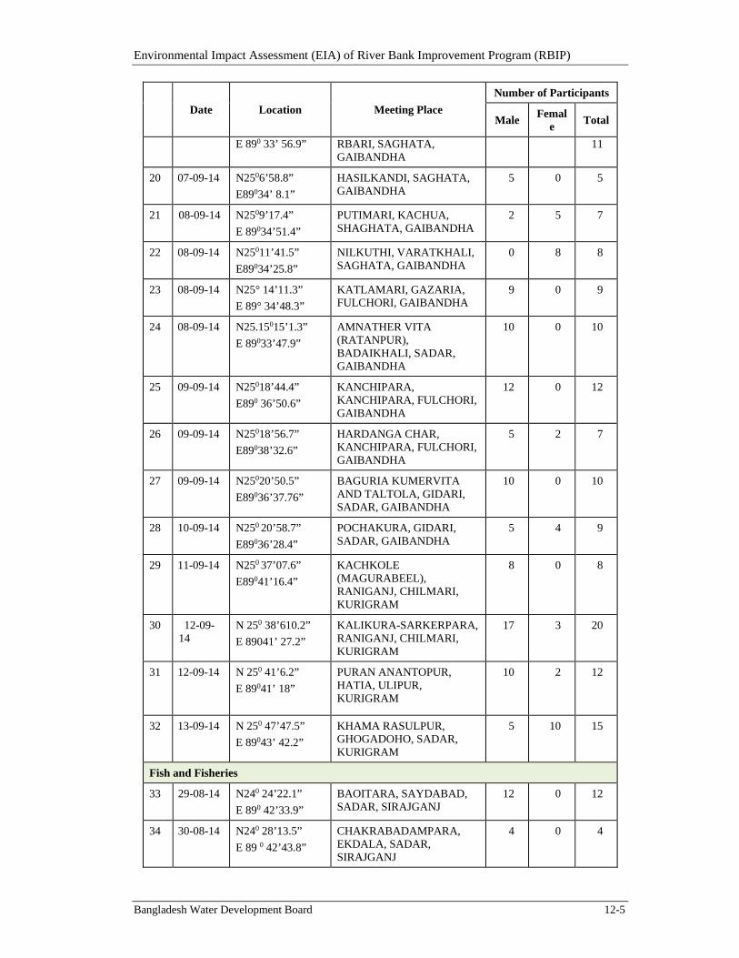
Environmental Impact Assessment (EIA) of River Bank Improvement Program (RBIP)
Bangladesh Water Development Board 12-5
Date Location Meeting Place
Number of Participants
Male Femal
e Total
E 890 33’ 56.9” RBARI, SAGHATA, GAIBANDHA
11
20 07-09-14 N2506’58.8”
E89034’ 8.1”
HASILKANDI, SAGHATA, GAIBANDHA
5 0 5
21 08-09-14 N2509’17.4”
E 89034’51.4”
PUTIMARI, KACHUA, SHAGHATA, GAIBANDHA
2 5 7
22 08-09-14 N25011’41.5”
E89034’25.8”
NILKUTHI, VARATKHALI, SAGHATA, GAIBANDHA
0 8 8
23 08-09-14 N25° 14’11.3”
E 89° 34’48.3”
KATLAMARI, GAZARIA, FULCHORI, GAIBANDHA
9 0 9
24 08-09-14 N25.15015’1.3”
E 89033’47.9”
AMNATHER VITA (RATANPUR), BADAIKHALI, SADAR, GAIBANDHA
10 0 10
25 09-09-14 N25018’44.4”
E890 36’50.6”
KANCHIPARA, KANCHIPARA, FULCHORI, GAIBANDHA
12 0 12
26 09-09-14 N25018’56.7”
E89038’32.6”
HARDANGA CHAR, KANCHIPARA, FULCHORI, GAIBANDHA
5 2 7
27 09-09-14 N25020’50.5”
E89036’37.76”
BAGURIA KUMERVITA AND TALTOLA, GIDARI, SADAR, GAIBANDHA
10 0 10
28 10-09-14 N250 20’58.7”
E89036’28.4”
POCHAKURA, GIDARI, SADAR, GAIBANDHA
5 4 9
29 11-09-14 N250 37’07.6”
E89041’16.4”
KACHKOLE (MAGURABEEL), RANIGANJ, CHILMARI, KURIGRAM
8 0 8
30 12-09-14
N 250 38’610.2”
E 89041’ 27.2”
KALIKURA-SARKERPARA, RANIGANJ, CHILMARI, KURIGRAM
17 3 20
31 12-09-14 N 250 41’6.2”
E 89041’ 18”
PURAN ANANTOPUR, HATIA, ULIPUR, KURIGRAM
10 2 12
32 13-09-14 N 250 47’47.5”
E 89043’ 42.2”
KHAMA RASULPUR, GHOGADOHO, SADAR, KURIGRAM
5 10 15
Fish and Fisheries
33 29-08-14 N240 24’22.1”
E 890 42’33.9”
BAOITARA, SAYDABAD, SADAR, SIRAJGANJ
12 0 12
34 30-08-14 N240 28’13.5”
E 89 0 42’43.8”
CHAKRABADAMPARA, EKDALA, SADAR, SIRAJGANJ
4 0 4
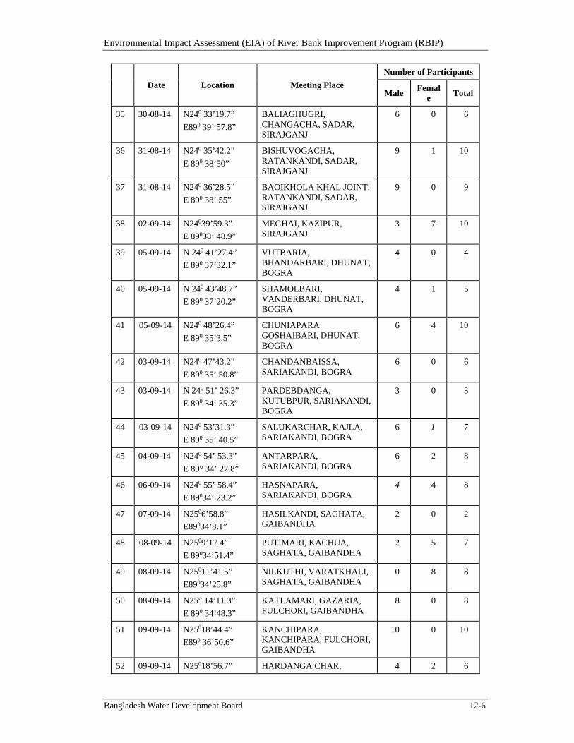
Environmental Impact Assessment (EIA) of River Bank Improvement Program (RBIP)
Bangladesh Water Development Board 12-6
Date Location Meeting Place
Number of Participants
Male Femal
e Total
35 30-08-14 N240 33’19.7”
E890 39’ 57.8”
BALIAGHUGRI, CHANGACHA, SADAR, SIRAJGANJ
6 0 6
36 31-08-14 N240 35’42.2”
E 890 38’50”
BISHUVOGACHA, RATANKANDI, SADAR, SIRAJGANJ
9 1 10
37 31-08-14 N240 36’28.5”
E 890 38’ 55”
BAOIKHOLA KHAL JOINT, RATANKANDI, SADAR, SIRAJGANJ
9 0 9
38 02-09-14 N24039’59.3”
E 89038’ 48.9”
MEGHAI, KAZIPUR, SIRAJGANJ
3 7 10
39 05-09-14 N 240 41’27.4”
E 890 37’32.1”
VUTBARIA, BHANDARBARI, DHUNAT, BOGRA
4 0 4
40 05-09-14 N 240 43’48.7”
E 890 37’20.2”
SHAMOLBARI, VANDERBARI, DHUNAT, BOGRA
4 1 5
41 05-09-14 N240 48’26.4”
E 890 35’3.5”
CHUNIAPARA GOSHAIBARI, DHUNAT, BOGRA
6 4 10
42 03-09-14 N240 47’43.2”
E 890 35’ 50.8”
CHANDANBAISSA, SARIAKANDI, BOGRA
6 0 6
43 03-09-14 N 240 51’ 26.3”
E 890 34’ 35.3”
PARDEBDANGA, KUTUBPUR, SARIAKANDI, BOGRA
3 0 3
44 03-09-14 N240 53’31.3”
E 890 35’ 40.5”
SALUKARCHAR, KAJLA, SARIAKANDI, BOGRA
6 1 7
45 04-09-14 N240 54’ 53.3”
E 89° 34’ 27.8”
ANTARPARA, SARIAKANDI, BOGRA
6 2 8
46 06-09-14 N240 55’ 58.4”
E 89034’ 23.2”
HASNAPARA, SARIAKANDI, BOGRA
4 4 8
47 07-09-14 N2506’58.8”
E89034’8.1”
HASILKANDI, SAGHATA, GAIBANDHA
2 0 2
48 08-09-14 N2509’17.4”
E 89034’51.4”
PUTIMARI, KACHUA, SAGHATA, GAIBANDHA
2 5 7
49 08-09-14 N25011’41.5”
E89034’25.8”
NILKUTHI, VARATKHALI, SAGHATA, GAIBANDHA
0 8 8
50 08-09-14 N25° 14’11.3”
E 890 34’48.3”
KATLAMARI, GAZARIA, FULCHORI, GAIBANDHA
8 0 8
51 09-09-14 N25018’44.4”
E890 36’50.6”
KANCHIPARA, KANCHIPARA, FULCHORI, GAIBANDHA
10 0 10
52 09-09-14 N25018’56.7” HARDANGA CHAR, 4 2 6
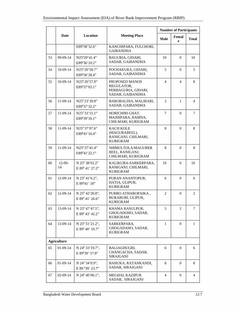
Environmental Impact Assessment (EIA) of River Bank Improvement Program (RBIP)
Bangladesh Water Development Board 12-7
Date Location Meeting Place
Number of Participants
Male Femal
e Total
E89038’32.6” KANCHIPARA, FULCHORI, GAIBANDHA
53 09-09-14 N25020’41.4”
E89036’10.2”
BAGURIA, GIDARI, SADAR, GAIBANDHA
10 0 10
54 10-09-14 N250 20’58.7”
E89036’28.4”
POCHAKURA, GIDARI, SADAR, GAIBANDHA
5 0 5
55 10-09-14 N250 20’57.9”
E89037’03.1”
PROPOSED MANOS REGULATOR, PERBAGURIA, GIDARI, SADAR, GAIBANDHA
4 4 8
56 11-09-14 N250 23’39.8”
E89037’32.2”
BAROBALDIA, MALIBARI, SADAR, GAIBANDHA
3 1 4
57 11-09-14 N250 33’15.1”
E89039’16.1”
HORICHIRI GHAT, MAJHIPARA, RAMNA, CHILMARI, KURIGRAM
7 0 7
58 11-09-14 N250 37’07.6”
E89041’16.4”
KACH KOLE (MAGURABEEL), RANIGANJ, CHILMARI, KURIGRAM
8 0 8
59 11-09-14 N250 37’41.4”
E89041’22.1”
SHIMULTOLA/MAGURER BEEL, RANIGANJ, CHILMARI, KURIGRAM
8 0 8
60 12-09-14
N 250 38’61.2”
E 890 41’ 27.2”
KALIKURA-SARKERPARA, RANIGANJ, CHILMARI, KURIGRAM
10 0 10
61 12-09-14 N 250 41’6.2”,
E 89041’ 18”
PURAN ANANTOPUR, HATIA, ULIPUR, KURIGRAM
6 0 6
62 12-09-14 N 250 42’20.8”,
E 890 41’ 26.6”
PURBO ATHAROPAIKA , BURABURI, ULIPUR, KURIGRAM
2 0 2
63
13-09-14 N 250 47’47.5”,
E 890 43’ 42.2”
KHAMA RASULPUR, GHOGADOHO, SADAR, KURIGRAM
5 2 7
64 13-09-14 N 250 51’21.2”,
E 890 40’ 10.7”
SARKERPARA, GHOGADAHO, SADAR, KURIGRAM
1 0 1
Agriculture
65 01-09-14 N 240 33’19.7”,
E 89039’ 57.8”
BALIAGHUGRI, CHANGACHA, SADAR, SIRAJGANJ
6 0 6
66 01-09-14 N 240 34’0.9”,
E 89 039’ 23.7”
BAHUKA, RATANKANDI, SADAR, SIRAJGANJ
8 0 8
67 02-09-14 N 240 40’06.1”, MEGHAI, KAZIPUR SADAR, SIRAJGANJ
4 0 4
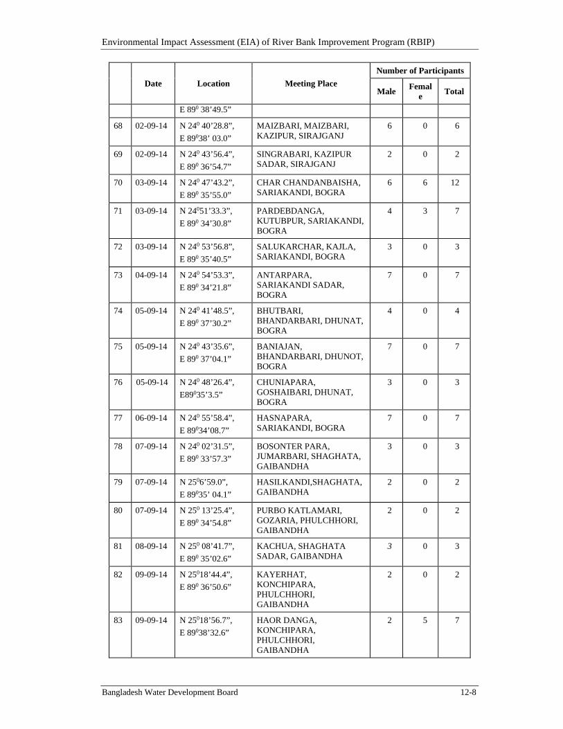
Environmental Impact Assessment (EIA) of River Bank Improvement Program (RBIP)
Bangladesh Water Development Board 12-8
Date Location Meeting Place
Number of Participants
Male Femal
e Total
E 890 38’49.5”
68 02-09-14 N 240 40’28.8”,
E 89038’ 03.0”
MAIZBARI, MAIZBARI, KAZIPUR, SIRAJGANJ
6 0 6
69 02-09-14 N 240 43’56.4”,
E 890 36’54.7”
SINGRABARI, KAZIPUR SADAR, SIRAJGANJ
2 0 2
70 03-09-14 N 240 47’43.2”,
E 890 35’55.0”
CHAR CHANDANBAISHA, SARIAKANDI, BOGRA
6 6 12
71 03-09-14 N 24051’33.3”,
E 890 34’30.8”
PARDEBDANGA, KUTUBPUR, SARIAKANDI, BOGRA
4 3 7
72 03-09-14 N 240 53’56.8”,
E 890 35’40.5”
SALUKARCHAR, KAJLA, SARIAKANDI, BOGRA
3 0 3
73 04-09-14 N 240 54’53.3”,
E 890 34’21.8”
ANTARPARA, SARIAKANDI SADAR, BOGRA
7 0 7
74 05-09-14 N 240 41’48.5”,
E 890 37’30.2”
BHUTBARI, BHANDARBARI, DHUNAT, BOGRA
4 0 4
75 05-09-14 N 240 43’35.6”,
E 890 37’04.1”
BANIAJAN, BHANDARBARI, DHUNOT, BOGRA
7 0 7
76 05-09-14 N 240 48’26.4”,
E89035’3.5”
CHUNIAPARA, GOSHAIBARI, DHUNAT, BOGRA
3 0 3
77 06-09-14 N 240 55’58.4”,
E 89034’08.7”
HASNAPARA, SARIAKANDI, BOGRA
7 0 7
78 07-09-14 N 240 02’31.5”,
E 890 33’57.3”
BOSONTER PARA, JUMARBARI, SHAGHATA, GAIBANDHA
3 0 3
79 07-09-14 N 2506’59.0”,
E 89035’ 04.1”
HASILKANDI,SHAGHATA,GAIBANDHA
2 0 2
80 07-09-14 N 250 13’25.4”,
E 890 34’54.8”
PURBO KATLAMARI, GOZARIA, PHULCHHORI, GAIBANDHA
2 0 2
81 08-09-14 N 250 08’41.7”,
E 890 35’02.6”
KACHUA, SHAGHATA SADAR, GAIBANDHA
3 0 3
82 09-09-14 N 25018’44.4”,
E 890 36’50.6”
KAYERHAT, KONCHIPARA, PHULCHHORI, GAIBANDHA
2 0 2
83 09-09-14 N 25018’56.7”,
E 89038’32.6”
HAOR DANGA, KONCHIPARA, PHULCHHORI, GAIBANDHA
2 5 7
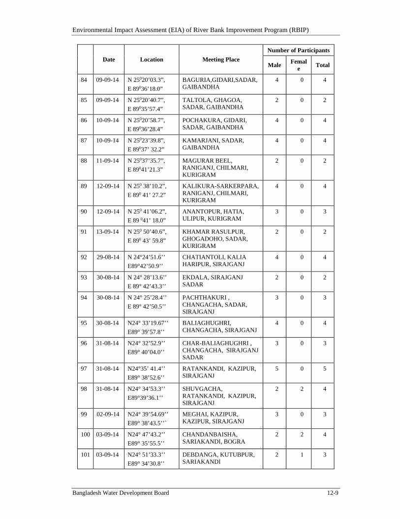
Environmental Impact Assessment (EIA) of River Bank Improvement Program (RBIP)
Bangladesh Water Development Board 12-9
Date Location Meeting Place
Number of Participants
Male Femal
e Total
84 09-09-14 N 25020’03.3”,
E 89036’18.0”
BAGURIA,GIDARI,SADAR, GAIBANDHA
4 0 4
85 09-09-14 N 25020’40.7”,
E 89035’57.4”
TALTOLA, GHAGOA, SADAR, GAIBANDHA
2 0 2
86 10-09-14 N 25020’58.7”,
E 89036’28.4”
POCHAKURA, GIDARI, SADAR, GAIBANDHA
4 0 4
87 10-09-14 N 25023’39.8”,
E 89037’ 32.2”
KAMARJANI, SADAR, GAIBANDHA
4 0 4
88 11-09-14 N 25037’35.7”,
E 89041’21.3”
MAGURAR BEEL, RANIGANJ, CHILMARI, KURIGRAM
2 0 2
89 12-09-14 N 250 38’10.2”,
E 890 41’ 27.2”
KALIKURA-SARKERPARA, RANIGANJ, CHILMARI, KURIGRAM
4 0 4
90 12-09-14 N 250 41’06.2”,
E 89 041’ 18.0”
ANANTOPUR, HATIA, ULIPUR, KURIGRAM
3 0 3
91 13-09-14 N 250 50’40.6”,
E 890 43’ 59.8”
KHAMAR RASULPUR, GHOGADOHO, SADAR, KURIGRAM
2 0 2
92 29-08-14 N 24°24’51.6’’
E89°42’50.9’’
CHATIANTOLI, KALIA HARIPUR, SIRAJGANJ
4 0 4
93 30-08-14 N 24° 28’13.6’’
E 89° 42’43.3’’
EKDALA, SIRAJGANJ SADAR
2 0 2
94 30-08-14 N 24° 25’28.4’’
E 89° 42’50.5’’
PACHTHAKURI , CHANGACHA, SADAR, SIRAJGANJ
3 0 3
95 30-08-14 N24° 33’19.67’’
E89° 39’57.8’’
BALIAGHUGHRI, CHANGACHA, SIRAJGANJ
4 0 4
96 31-08-14 N24° 32’52.9’’
E89° 40’04.0’’
CHAR-BALIAGHUGHRI , CHANGACHA, SIRAJGANJ SADAR
3 0 3
97 31-08-14 N24°35’ 41.4’’
E89° 38’52.6’’
RATANKANDI, KAZIPUR, SIRAJGANJ
5 0 5
98 31-08-14 N24° 34’53.3’’
E89°39’36.1’’
SHUVGACHA, RATANKANDI, KAZIPUR, SIRAJGANJ
2 2 4
99 02-09-14 N24° 39’54.69’’
E89° 38’43.5’’`
MEGHAI, KAZIPUR, KAZIPUR, SIRAJGANJ
3 0 3
100 03-09-14 N24° 47’43.2’’
E89° 35’55.5’’
CHANDANBAISHA, SARIAKANDI, BOGRA
2 2 4
101 03-09-14 N24° 51’33.3’’
E89° 34’30.8’’
DEBDANGA, KUTUBPUR, SARIAKANDI
2 1 3
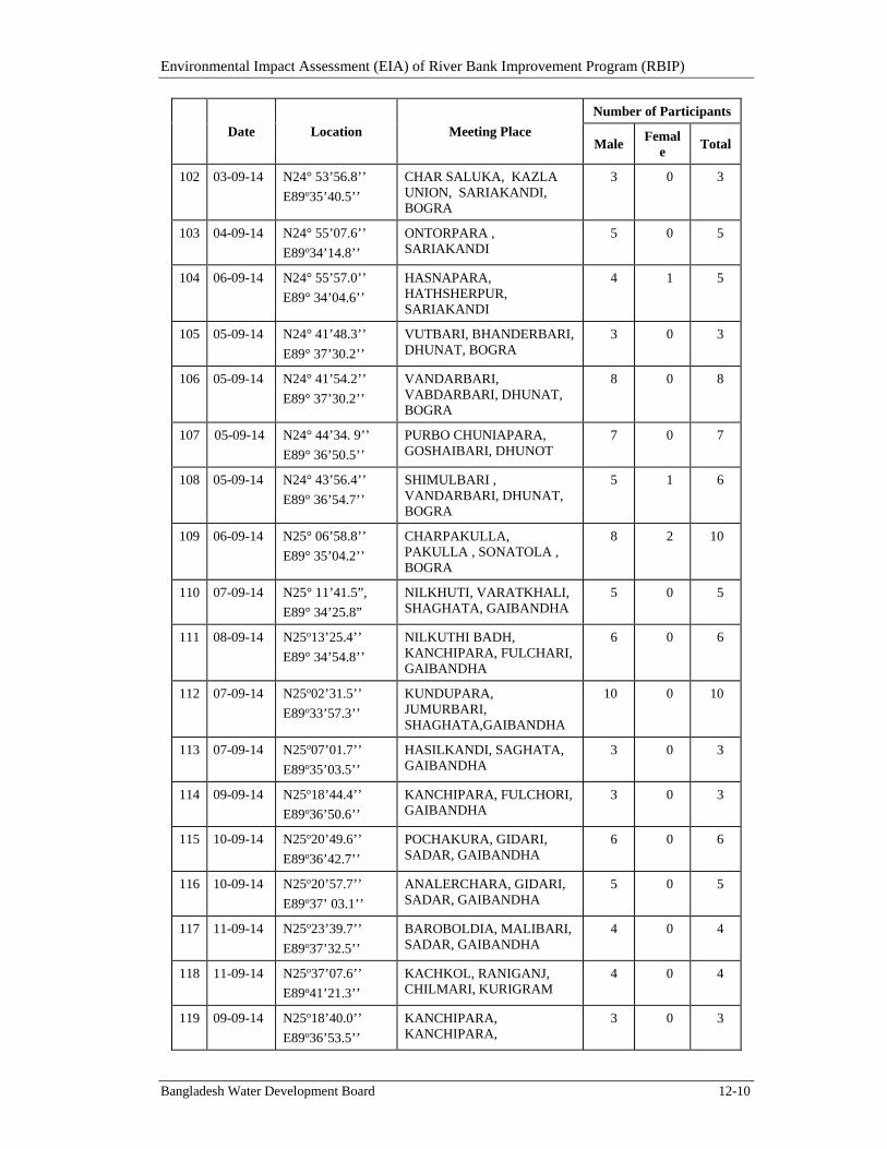
Environmental Impact Assessment (EIA) of River Bank Improvement Program (RBIP)
Bangladesh Water Development Board 12-10
Date Location Meeting Place
Number of Participants
Male Femal
e Total
102 03-09-14 N24° 53’56.8’’
E89o35’40.5’’
CHAR SALUKA, KAZLA UNION, SARIAKANDI, BOGRA
3 0 3
103 04-09-14 N24° 55’07.6’’
E89o34’14.8’’
ONTORPARA , SARIAKANDI
5 0 5
104 06-09-14 N24° 55’57.0’’
E89° 34’04.6’’
HASNAPARA, HATHSHERPUR, SARIAKANDI
4 1 5
105 05-09-14 N24° 41’48.3’’
E89° 37’30.2’’
VUTBARI, BHANDERBARI, DHUNAT, BOGRA
3 0 3
106 05-09-14 N24° 41’54.2’’
E89° 37’30.2’’
VANDARBARI, VABDARBARI, DHUNAT, BOGRA
8 0 8
107 05-09-14 N24° 44’34. 9’’
E89° 36’50.5’’
PURBO CHUNIAPARA, GOSHAIBARI, DHUNOT
7 0 7
108 05-09-14 N24° 43’56.4’’
E89° 36’54.7’’
SHIMULBARI , VANDARBARI, DHUNAT, BOGRA
5 1 6
109 06-09-14 N25° 06’58.8’’
E89° 35’04.2’’
CHARPAKULLA, PAKULLA , SONATOLA , BOGRA
8 2 10
110 07-09-14 N25° 11’41.5”,
E89° 34’25.8”
NILKHUTI, VARATKHALI, SHAGHATA, GAIBANDHA
5 0 5
111 08-09-14 N25o13’25.4’’
E89° 34’54.8’’
NILKUTHI BADH, KANCHIPARA, FULCHARI, GAIBANDHA
6 0 6
112 07-09-14 N25o02’31.5’’
E89o33’57.3’’
KUNDUPARA, JUMURBARI, SHAGHATA,GAIBANDHA
10 0 10
113 07-09-14
N25o07’01.7’’
E89o35’03.5’’
HASILKANDI, SAGHATA, GAIBANDHA
3 0 3
114 09-09-14
N25o18’44.4’’
E89o36’50.6’’
KANCHIPARA, FULCHORI, GAIBANDHA
3 0 3
115 10-09-14 N25o20’49.6’’
E89o36’42.7’’
POCHAKURA, GIDARI, SADAR, GAIBANDHA
6 0 6
116 10-09-14 N25o20’57.7’’
E89o37’ 03.1’’
ANALERCHARA, GIDARI, SADAR, GAIBANDHA
5 0 5
117 11-09-14 N25o23’39.7’’
E89o37’32.5’’
BAROBOLDIA, MALIBARI, SADAR, GAIBANDHA
4 0 4
118 11-09-14 N25o37’07.6’’
E89o41’21.3’’
KACHKOL, RANIGANJ, CHILMARI, KURIGRAM
4 0 4
119 09-09-14 N25o18’40.0’’
E89o36’53.5’’
KANCHIPARA, KANCHIPARA,
3 0 3
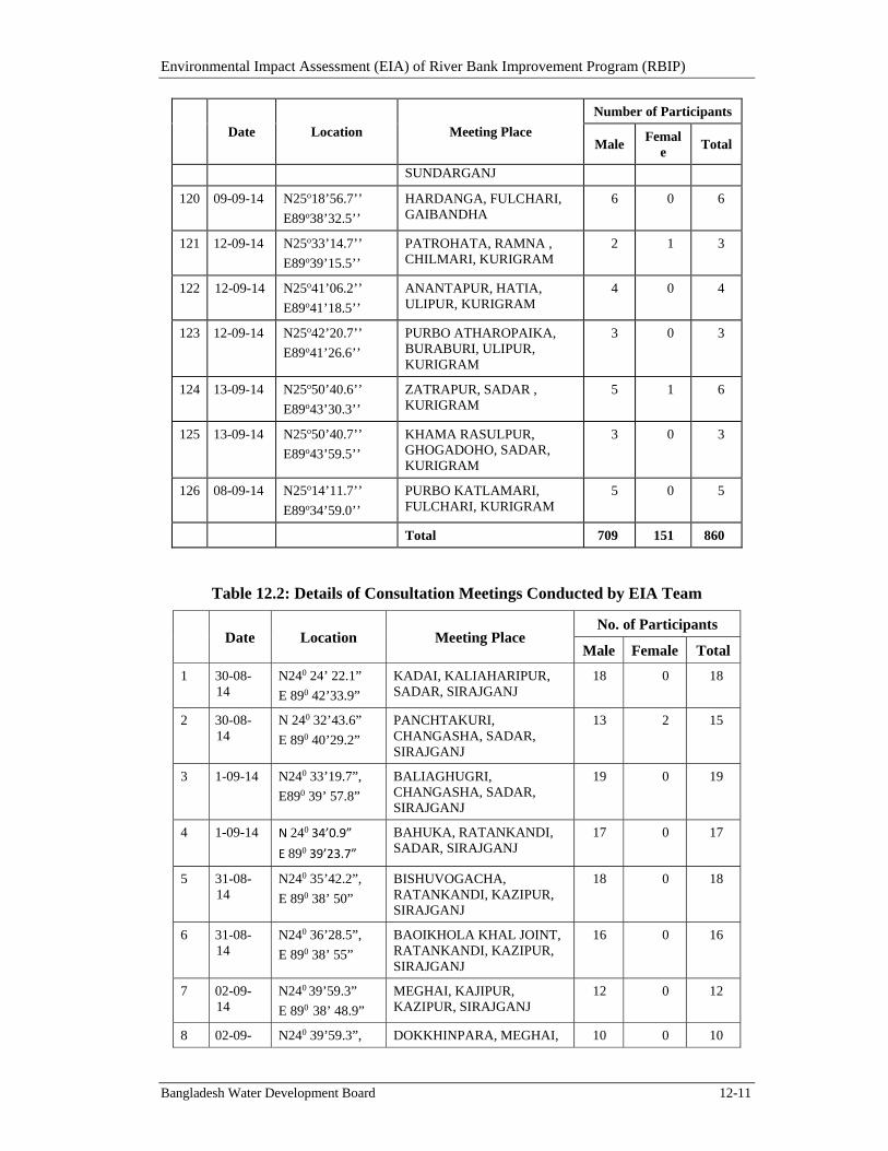
Environmental Impact Assessment (EIA) of River Bank Improvement Program (RBIP)
Bangladesh Water Development Board 12-11
Date Location Meeting Place
Number of Participants
Male Femal
e Total
SUNDARGANJ
120 09-09-14 N25o18’56.7’’
E89o38’32.5’’
HARDANGA, FULCHARI, GAIBANDHA
6 0 6
121 12-09-14 N25o33’14.7’’
E89o39’15.5’’
PATROHATA, RAMNA , CHILMARI, KURIGRAM
2 1 3
122 12-09-14 N25o41’06.2’’
E89o41’18.5’’
ANANTAPUR, HATIA, ULIPUR, KURIGRAM
4 0 4
123 12-09-14 N25o42’20.7’’
E89o41’26.6’’
PURBO ATHAROPAIKA, BURABURI, ULIPUR, KURIGRAM
3 0 3
124 13-09-14 N25o50’40.6’’
E89o43’30.3’’
ZATRAPUR, SADAR , KURIGRAM
5 1 6
125 13-09-14 N25o50’40.7’’
E89o43’59.5’’
KHAMA RASULPUR, GHOGADOHO, SADAR, KURIGRAM
3 0 3
126 08-09-14 N25o14’11.7’’
E89o34’59.0’’
PURBO KATLAMARI, FULCHARI, KURIGRAM
5 0 5
Total 709 151 860
Table 12.2: Details of Consultation Meetings Conducted by EIA Team
Date Location Meeting Place No. of Participants
Male Female Total
1 30-08-14
N240 24’ 22.1”
E 890 42’33.9”
KADAI, KALIAHARIPUR, SADAR, SIRAJGANJ
18 0 18
2 30-08-14
N 240 32’43.6”
E 890 40’29.2”
PANCHTAKURI, CHANGASHA, SADAR, SIRAJGANJ
13 2 15
3 1-09-14 N240 33’19.7”,
E890 39’ 57.8”
BALIAGHUGRI, CHANGASHA, SADAR, SIRAJGANJ
19 0 19
4 1-09-14 N 240 34’0.9”
E 890 39’23.7”
BAHUKA, RATANKANDI, SADAR, SIRAJGANJ
17 0 17
5 31-08-14
N240 35’42.2”,
E 890 38’ 50”
BISHUVOGACHA, RATANKANDI, KAZIPUR, SIRAJGANJ
18 0 18
6 31-08-14
N240 36’28.5”,
E 890 38’ 55”
BAOIKHOLA KHAL JOINT, RATANKANDI, KAZIPUR, SIRAJGANJ
16 0 16
7 02-09-14
N240 39’59.3”
E 890 38’ 48.9”
MEGHAI, KAJIPUR, KAZIPUR, SIRAJGANJ
12 0 12
8 02-09- N240 39’59.3”, DOKKHINPARA, MEGHAI, 10 0 10
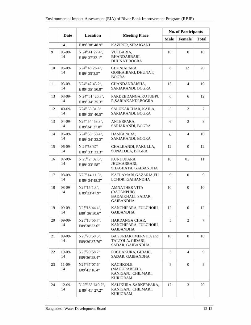
Environmental Impact Assessment (EIA) of River Bank Improvement Program (RBIP)
Bangladesh Water Development Board 12-12
Date Location Meeting Place No. of Participants
Male Female Total 14 E 890 38’ 48.9” KAZIPUR, SIRAJGANJ
9 05-09-14
N 240 41’27.4”,
E 890 37’32.1”
VUTBARIA, BHANDARBARI, DHUNAT,BOGRA
10 0 10
10 05-09-14
N240 48’26.4”,
E 890 35’3.5”
CHUNIAPARA GOSHAIBARI, DHUNAT, BOGRA
8 12 20
11 03-09-14
N240 47’43.2”,
E 890 35’ 50.8”
CHANDANBAISHA, SARIAKANDI, BOGRA
15 4 19
13 03-09-14
N 240 51’ 26.3”,
E 890 34’ 35.3”
PARDEBDANGA,KUTUBPUR,SARIAKANDI,BOGRA
6 6 12
12 03-09-14
N240 53’31.3”
E 890 35’ 40.5”
SALUKARCHAR, KAJLA, SARIAKANDI, BOGRA
5 2 7
13 04-09-14
N240 54’ 53.3”,
E 89034’ 27.8”
ANTERPARA, SARIAKANDI, BOGRA
6 2 8
14 06-09-14
N240 55’ 58.4”,
E 890 34’ 23.2”
HASNAPARA, SARIAKANDI, BOGRA
6 4 10
15 06-09-14
N 24058’37”
E 890 33’ 33.3”
CHALKANDI, PAKULLA, SONATOLA, BOGRA
12 0 12
16 07-09-14
N 250 2’ 32.6”,
E 890 33’ 58”
KUNDUPARA JHUMARBARI, SHAGHATA, GAIBANDHA
10 01 11
17 08-09-14
N250 14’11.3”,
E 890 34’48.3”
KATLAMARI,GAZARIA,FULCHORI,GAIBANDHA
9 0 9
18 08-09-14
N25015’1.3”,
E 89033’47.9”
AMNATHER VITA (RATANPUR), BADAIKHALI, SADAR, GAIBANDHA
10 0 10
19 09-09-14
N25018’44.4”,
E890 36’50.6”
KANCHIPARA, FULCHORI, GAIBANDHA
12 0 12
20 09-09-14
N25018’56.7”,
E89038’32.6”
HARDANGA CHAR, KANCHIPARA, FULCHORI, GAIBANDHA
5 2 7
21 09-09-14
N25020’50.5”,
E89036’37.76”
BAGURIAKUMERVITA and TALTOLA, GIDARI, SADAR, GAIBANDHA
10 0 10
22 10-09-14
N25020’58.7”
E89036’28.4”
POCHAKURA, GIDARI, SADAR, GAIBANDHA
5 4 9
23 11-09-14
N25037’07.6”
E89041’16.4”
KACHKOLE (MAGURABEEL), RANIGANJ, CHILMARI, KURIGRAM
8 0 8
24 12-09-14
N 250 38’610.2”,
E 890 41’ 27.2”
KALIKURA-SARKERPARA, RANIGANJ, CHILMARI, KURIGRAM
17 3 20
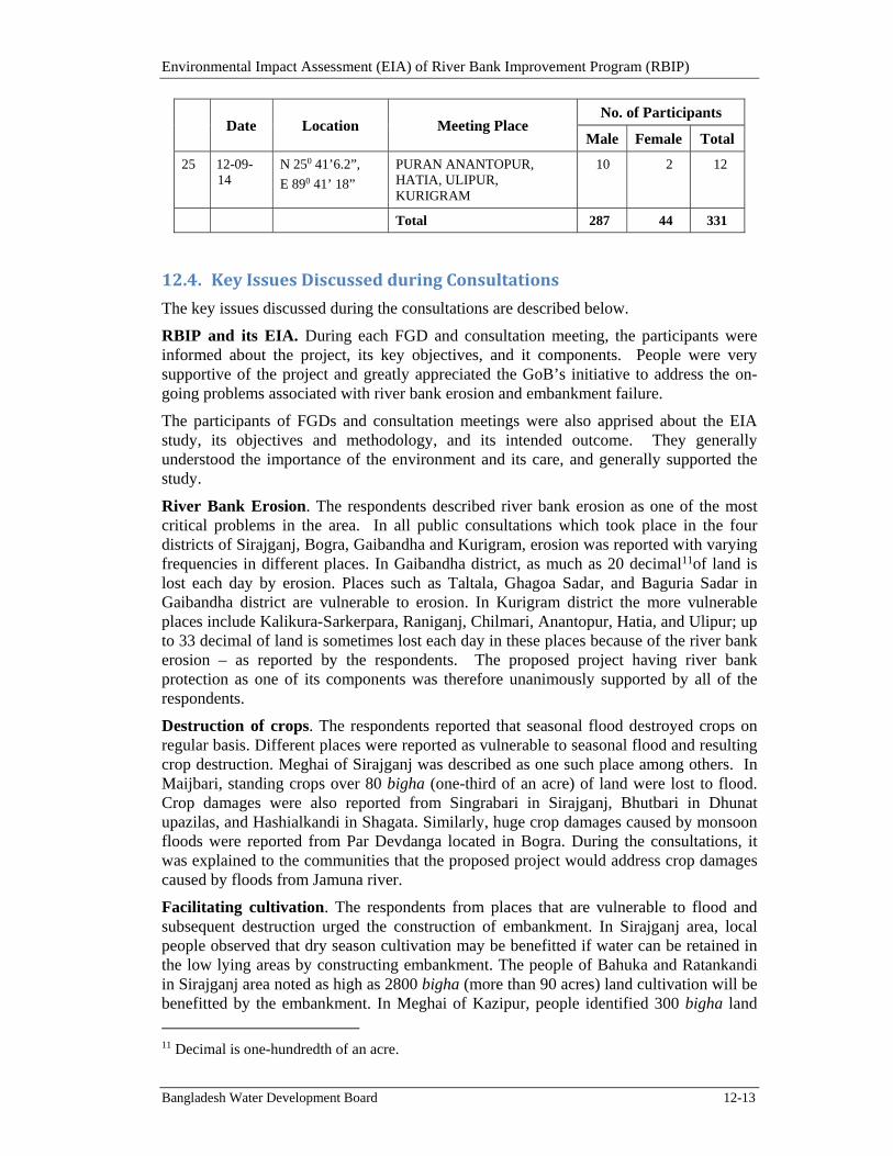
Environmental Impact Assessment (EIA) of River Bank Improvement Program (RBIP)
Bangladesh Water Development Board 12-13
Date Location Meeting Place No. of Participants
Male Female Total
25 12-09-14
N 250 41’6.2”,
E 890 41’ 18”
PURAN ANANTOPUR, HATIA, ULIPUR, KURIGRAM
10 2 12
Total 287 44 331
12.4. KeyIssuesDiscussedduringConsultations
The key issues discussed during the consultations are described below.
RBIP and its EIA. During each FGD and consultation meeting, the participants were informed about the project, its key objectives, and it components. People were very supportive of the project and greatly appreciated the GoB’s initiative to address the on-going problems associated with river bank erosion and embankment failure.
The participants of FGDs and consultation meetings were also apprised about the EIA study, its objectives and methodology, and its intended outcome. They generally understood the importance of the environment and its care, and generally supported the study.
River Bank Erosion. The respondents described river bank erosion as one of the most critical problems in the area. In all public consultations which took place in the four districts of Sirajganj, Bogra, Gaibandha and Kurigram, erosion was reported with varying frequencies in different places. In Gaibandha district, as much as 20 decimal11of land is lost each day by erosion. Places such as Taltala, Ghagoa Sadar, and Baguria Sadar in Gaibandha district are vulnerable to erosion. In Kurigram district the more vulnerable places include Kalikura-Sarkerpara, Raniganj, Chilmari, Anantopur, Hatia, and Ulipur; up to 33 decimal of land is sometimes lost each day in these places because of the river bank erosion – as reported by the respondents. The proposed project having river bank protection as one of its components was therefore unanimously supported by all of the respondents.
Destruction of crops. The respondents reported that seasonal flood destroyed crops on regular basis. Different places were reported as vulnerable to seasonal flood and resulting crop destruction. Meghai of Sirajganj was described as one such place among others. In Maijbari, standing crops over 80 bigha (one-third of an acre) of land were lost to flood. Crop damages were also reported from Singrabari in Sirajganj, Bhutbari in Dhunat upazilas, and Hashialkandi in Shagata. Similarly, huge crop damages caused by monsoon floods were reported from Par Devdanga located in Bogra. During the consultations, it was explained to the communities that the proposed project would address crop damages caused by floods from Jamuna river.
Facilitating cultivation. The respondents from places that are vulnerable to flood and subsequent destruction urged the construction of embankment. In Sirajganj area, local people observed that dry season cultivation may be benefitted if water can be retained in the low lying areas by constructing embankment. The people of Bahuka and Ratankandi in Sirajganj area noted as high as 2800 bigha (more than 90 acres) land cultivation will be benefitted by the embankment. In Meghai of Kazipur, people identified 300 bigha land
11 Decimal is one-hundredth of an acre.
Environmental Impact Assessment (EIA) of River Bank Improvement Program (RBIP)
Bangladesh Water Development Board 12-14
located in low lying areas that would be benefitted. In Chandanbaissa also people opined that embankment would benefit crop production.
Sluice gates. The respondent identified sluices as an important element of the embankment system in the area. They pointed out that with the help of these sluices, water flow of the river and water channels (khals) could be regulated to address among others the water logging problem in the area and hence enhance cultivation output.
The issue of sluice gates was raised during a number of consultation meetings and FGDs. In Chuniapara and Goshaibari of Dhunat (Bogra), the respondents indicated the need of a regulator to drain our water from water logged area. People of Purbo Katlamari, Gozaria, and Fulchari of Gaibandha also asked for a regulator to drain out water during monsoon and bring in river water during dry season. In Baguria, the community under its own initiative has installed a pipe to drain out water. Here also people asked for a sluice gate. In Taltola and Ghagoa in Gaibandha, the Puiagarir Beel remains under water so aman rice cannot be cultivated. The respondent pointed out that the problem could be adequately addressed if sluice gate was constructed. In Ponchakhuria, and Gidari of Gaibandha the Pakhimarar beel has the same problem and people asked for a regulator. In Kamarjani of Gaibandha, people had installed a pipe to clear water logging; however the authorities removed that pipe. Now the people asked for a sluice gate at this location. In Magurar Beel, Raniganj, and Chilmari of Kurigram the existing sluice gate was not working and hence the local people asked for rehabilitation of this gate. In Kalikura-Sarkerpara, Raniganj, and Chilmari of Kurigram the local people suggested shifting the proposed regulator to Boiragir vita, to make it more effective. The respondent also stressed that the existing regulator at Magura should be repaired to improve water logging. In Anantopur, Hatia, and Ulipur of Kurigram, crops over about 35000 acre of land were lost, hence the local community asked for a regulator. In Khamar Rosulpur, Ghogadaho, and Sadar of Kurigram the existing 4-vent regulator was not working anymore. The community therefore asked for a regulator with 8/9 vents. In Antarpara of Bogra, the local people asked that the site for proposed regulator should be moved towards the canal of Deuly beel.
Perceived benefits. The respondents indicated that they would construct houses in Shalukar char (Sariakandi), if embankment was built. In Banijan Dhunot, the community pointed out that agricultural marketing would be benefitted if the project as implemented. Stakeholders in Sirajganj opined that once the project was implemented, water passage could be controlled more effectively, thus benefiting cultivation.
Loss of land. Some respondents shared their concerns regarding the land that would be required for the project implementation. The people in Balighughri, Chhongachha and Sadar of Sirajganj noted that they would lose 20 acres of crop land as a result of the project. In Antarpara of Bogra, the respondents said that they would lose 20 bigha of land because of the new alignment of the embankment. The communities expected adequate compensation for their losses caused by the project.
Embankment infrastructure. In Sirajganj Sadar, the respondent pointed out that river bank protection would be needed before embankment was constructed. Above opinion was also shared by the people of Bishubgacha, Sirajganj. The respondents in Sirajganj pointed out that trees could not protect the embankment from flood. The people of Bahuka and Ratankandi stressed that sandy soil should not be used in the construction activities. The people of Purbo Katlamari, Gozaria, and Fulchari of Gaibandha asked to shift embankment towards river. People of Kachua also expressed similar opinion. Some
Environmental Impact Assessment (EIA) of River Bank Improvement Program (RBIP)
Bangladesh Water Development Board 12-15
respondents indicated that both drought and monsoon flood caused crop damages crops hence attention should be given to both. The people of Kayerhat, Konchipara, and Fulchari of Gaibandha suggested the placement of underground pipe to bring water for irrigation thus reducing the existing cost of irrigations. Local people Bahuka of Sirajganj asked for underground drainage arrangements to reduce water logging.
Water channels and water ponds (khals and beels). The presence of water channels (khals) and water ponds (beels) marks the area of Kadai and Saidabad in Sirajganj. Kata khal is one such water channel. There is also a BWDB channel here that is a fish breeding site as well as source of surface water irrigation. There is also Ghuria beel in the place with a connection with Jamuna river. During rainy season the surrounding places are inundated. Local people want to drain out the locality through Hurasagar River. There exists a section of old embankment here and flood water reaches to that level. Panchtakuri Changacha of Sirajganj is flooded regularly and in 1988 the flood water reached a height of 16 to 20 meters. Through small holes in the existing BWDB embankment, water seeps to the countryside affecting crops. The respondents reported that 27 villages of Bishubgacha and Ratankandi of Sirajganj went under water owing to recent flood triggered by the Banaijan khal and others. In Balighughri and Changacha of Sirajganj, there are two koles (a kind of a small lagoon) named Mothiarkul (panchtakuri) and Simla that are rich in fish diversity and are breeding ground of various fishes. In Meghai of Sirajganj there is the Paikartoli beel that remains waterlogged throughout the year and is blocked by the BWDB embankment. Halotkhal is also obstructed by BWDB embankment and its connectivity with the Ichamoti River is blocked. In this place a pond has been constructed by BWDB to facilitate fish cultivation. In Vutbaria, Pukuria, Shimulbari char, and Bhandarbari of Bogra the connection between Manos river and the Jamuna river at Daripara has been blocked by the BWDB embankment. In Chandanbaisha of Bogra the role of Bangali river is important; the water level of Bangali river influences Kutubpur khal of this locality, having an effect on flooding and inundation. The BWDB embankment is severely damaged here causing flooding in huge areas. In Kajla of Sariakandi, several chars such as Pukuria Char, Dakatmara Char, Ghaigar Char, Chera Pachbari char, Indurmara Char and Manik Char are inundated. Antarpara regulator remains dis-functional hence several areas of Bogra like Hasnapara suffer from water logging. In Gaibandha district also there are several khals and beels, for example in Kundupara, Jhumarbari of Saghata there are Kalihata Khal, Satbila khal, Bashanterpara Khal, Modhupur khal and Kundupara khal. The prominent beels are Burunga, Saluka, Gozaria and Shat Beel. These places are inundated flooding the surrounding areas as well. In Kanchipara and Fulchari of Gaibandha the condition of BWDB embankment is bad hence not much effective for flood control. Beels and khals are also found in Kurigram which also cause inundation in the surrounding areas. For example in Raniganj and Chilmari of Kurigram there are prominent khals and beels named Pakhimara beel and Puiya Gara which are inundated to some extent.
Khal excavation. The respondents indicated water congestion and irrigation as among the major issues in the project influence area. Retention capacity of the khals, beels and local rivers need to be increased according to the opinion of the community members consulted. Both small scale and large scale dredging has been suggested by the people. At the local level, khals and beels are suggested for dredging and at the higher level river dredging is also suggested. For example the people of Kadai in Sirajganj pointed out that the local canal should be dredged. The people of Panchtakuri Changacha of Sirajganj suggested the dredging of Ichamoti river for surface water irrigation to reduce pressure on
Environmental Impact Assessment (EIA) of River Bank Improvement Program (RBIP)
Bangladesh Water Development Board 12-16
ground water. Banaijan Canal and Baoaikhola khal of Sirajganj was also suggested for dredging. The respondents stressed that Paikartoli beel and Halot khal at Kazipur, Sirajganj should be dredged for proper connectivity with the Ichamoti and Jamuna rivers to ensure flood protection and facilitate irrigation, and Bhanderbari khal should be dredged in Vutbaria of Bogra. The people in Gaibandha and Kurigram suggested the dredging of Jamuna River and from Teesta Railway bridge to Bahadurabad Ghat to increase the flow of water.
Sedimentation. Community people pointed out the problems of water logging and flooding. In their opinion, the issue of sedimentation is related to some extent with this aspect. Huge amount of silt regularly flows through Jamuna river and its connected khals and smaller rivers raising the bed and reducing the depth. It has negative implication for the water retaining capacity. This issue was raised during consultations in all four districts of the project influence area. The volume of sedimentation was reported to range from 1 to 2 feet. The sedimentation problem was reported in Kadai, Saidabad, Panchtakuri Changacha or Maghai in Sirajganj, Bhutbaria of Dhunat, Bogra, as well as various locations in Gaibandha and Kurigram districts.
Ground water quality. The respondents informed that hand pump was generally used to procure drinking water in the project influence area. They informed that water was available at the depth of 40 to 50 feet. Drinking water was reported to be dull in color indicating the possible presence of iron or other minerals; also the presence of silt could not be ruled out. The people informed that many tube-wells were sealed because of arsenic presence in the water, though 20 percent of the people still depended on tube-wells with arsenic contamination.
Fishing. The people of Sirajganj living in the low lying areas observed that the construction of embankment would benefit fish cultivation in the area. In Bahuka of Sirajganj local people pointed out the positive effect of a regulator on fishing in the locality.
The respondents reported that the fish migration route at certain places were either blocked or hindered because of various reasons including blockage of khals and rivers. The one linking Banaijan khal, Baoaikhola khal and Ichamoti river at Ratankandi, Sirajganj is presently severely hindered requiring dredging and the placement of a box culvert to restore the migration route and enable surface water irrigation. The migration route at Meghai, Sirajganj facilitating fish migration could also be improved by dredging of Paikartoli beel and Halot khal. The migration route between Jamuna river and Bangali river through Manas river is obstructed by the embankment. Similarly the connectivity of Dauli beel and Vakir beel with Bangali river in Bogra is affected by a damaged regulator. A number of proposed regulators could be beneficial for fishing habitat by providing migration route and offering favorable conditions, as opined by the community members. For example the regulator in Chaitantoli area would allow fishing in Baoitara and Saidabad areas of Sirajganj. Similarly the proposed Baliaghugri regulator would increase the surface water availability thus facilitating pond aquaculture and crop cultivation in rainy season without irrigation, as opined by the people of Baliaghugri and Changacha, in Sirajganj. Gandu molar beel in at Sariakandi Bogra is another one requiring attention as the proposed alignment may take away its 40 percent area. The people pointed out that the proposed Baguria regulator in Sadar, Gaibandha would connect many water bodies with the Jamuna river, contributing to aquaculture in the surrounding area along with fish diversity. The people of Kurigram in the areas of Raniganj and Chilmari identified four
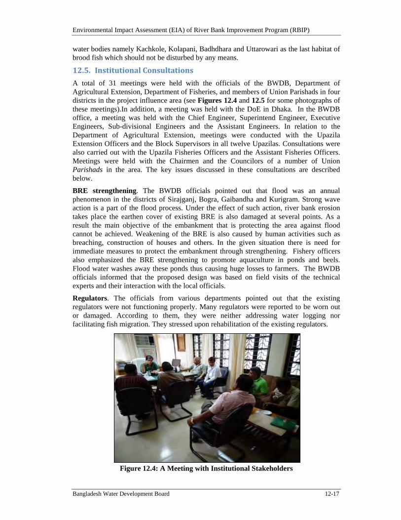
Environmental Impact Assessment (EIA) of River Bank Improvement Program (RBIP)
Bangladesh Water Development Board 12-17
water bodies namely Kachkole, Kolapani, Badhdhara and Uttarowari as the last habitat of brood fish which should not be disturbed by any means.
12.5. InstitutionalConsultations
A total of 31 meetings were held with the officials of the BWDB, Department of Agricultural Extension, Department of Fisheries, and members of Union Parishads in four districts in the project influence area (see Figures 12.4 and 12.5 for some photographs of these meetings).In addition, a meeting was held with the DoE in Dhaka. In the BWDB office, a meeting was held with the Chief Engineer, Superintend Engineer, Executive Engineers, Sub-divisional Engineers and the Assistant Engineers. In relation to the Department of Agricultural Extension, meetings were conducted with the Upazila Extension Officers and the Block Supervisors in all twelve Upazilas. Consultations were also carried out with the Upazila Fisheries Officers and the Assistant Fisheries Officers. Meetings were held with the Chairmen and the Councilors of a number of Union Parishads in the area. The key issues discussed in these consultations are described below.
BRE strengthening. The BWDB officials pointed out that flood was an annual phenomenon in the districts of Sirajganj, Bogra, Gaibandha and Kurigram. Strong wave action is a part of the flood process. Under the effect of such action, river bank erosion takes place the earthen cover of existing BRE is also damaged at several points. As a result the main objective of the embankment that is protecting the area against flood cannot be achieved. Weakening of the BRE is also caused by human activities such as breaching, construction of houses and others. In the given situation there is need for immediate measures to protect the embankment through strengthening. Fishery officers also emphasized the BRE strengthening to promote aquaculture in ponds and beels. Flood water washes away these ponds thus causing huge losses to farmers. The BWDB officials informed that the proposed design was based on field visits of the technical experts and their interaction with the local officials.
Regulators. The officials from various departments pointed out that the existing regulators were not functioning properly. Many regulators were reported to be worn out or damaged. According to them, they were neither addressing water logging nor facilitating fish migration. They stressed upon rehabilitation of the existing regulators.
Figure 12.4: A Meeting with Institutional Stakeholders
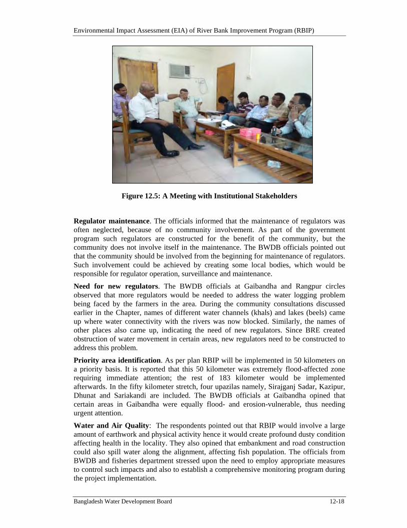
Environmental Impact Assessment (EIA) of River Bank Improvement Program (RBIP)
Bangladesh Water Development Board 12-18
Figure 12.5: A Meeting with Institutional Stakeholders
Regulator maintenance. The officials informed that the maintenance of regulators was often neglected, because of no community involvement. As part of the government program such regulators are constructed for the benefit of the community, but the community does not involve itself in the maintenance. The BWDB officials pointed out that the community should be involved from the beginning for maintenance of regulators. Such involvement could be achieved by creating some local bodies, which would be responsible for regulator operation, surveillance and maintenance.
Need for new regulators. The BWDB officials at Gaibandha and Rangpur circles observed that more regulators would be needed to address the water logging problem being faced by the farmers in the area. During the community consultations discussed earlier in the Chapter, names of different water channels (khals) and lakes (beels) came up where water connectivity with the rivers was now blocked. Similarly, the names of other places also came up, indicating the need of new regulators. Since BRE created obstruction of water movement in certain areas, new regulators need to be constructed to address this problem.
Priority area identification. As per plan RBIP will be implemented in 50 kilometers on a priority basis. It is reported that this 50 kilometer was extremely flood-affected zone requiring immediate attention; the rest of 183 kilometer would be implemented afterwards. In the fifty kilometer stretch, four upazilas namely, Sirajganj Sadar, Kazipur, Dhunat and Sariakandi are included. The BWDB officials at Gaibandha opined that certain areas in Gaibandha were equally flood- and erosion-vulnerable, thus needing urgent attention.
Water and Air Quality: The respondents pointed out that RBIP would involve a large amount of earthwork and physical activity hence it would create profound dusty condition affecting health in the locality. They also opined that embankment and road construction could also spill water along the alignment, affecting fish population. The officials from BWDB and fisheries department stressed upon the need to employ appropriate measures to control such impacts and also to establish a comprehensive monitoring program during the project implementation.
Environmental Impact Assessment (EIA) of River Bank Improvement Program (RBIP)
Bangladesh Water Development Board 12-19
Fish and fishing resources development. Immense concern was shown by the officials of Fishery, Agricultural Extension and BWDB about the fish and fishing resource development. Jamuna is famous for carp breeding thus it needs special attention. Fish habitats study in Jamuna river should be undertaken to ascertain the carp and other varieties of fish. Both the community members and officials indicated the hindrances faced by the fish population here. Some sanctuaries should be established at different points of the Jamuna river. There is also need for more fish migration routes. Thus planning is needed with the involvement of the community and experts to create new migration routes. In this respect connectivity of different rivers should be given attention. In this area earlier, there were splendid fish migration routes connecting different rivers; this connectivity needs to be restored. More fish migration structures are needed to facilitate fish migration from Jamuna to the other rivers and floodplain, similarly re-excavation of internal water bodies is also needed.
Irrigation and drainage. Special attention was demanded for provisioning irrigation through this project. In this regard internal chars and water channels need attention. Canals (khals) and lakes (beels) should be kept functional for the purpose of surface water irrigation and for different agricultural activities such as meeting water requirement at the time of jute putrefaction.
Resettlement planning. The respondents stressed that involvement of the BWDB officials was important for smooth resettlement planning and implementation. Proper compensation package should be proposed for the affected people including fisher folk households. During the construction period fishing would not be allowed on the side of the bank and it may affect the interest of the subsistence fishermen. Similarly the squatters also need special attention in the resettlement package. To compensate for the loss of livelihood of the affected community aquaculture pond may be created in the resettlement zone.
Expansion of flood protection. The places for which RBIP is designed are now also affected by the flooding from Teesta, Dharla and Dudhkumar rivers. The BWDB officials recounting their past experience argued that unless these rivers were also taken into consideration the outcome of RBIP could not be achieved. Hence the project should also cover these rivers.
12.6. ConsultationsbySocialSafeguardTeam
Comprehensive consultations have also been conducted by the social safeguard team and a total of 227 FGDs and 139 meetings have been held with the local communities in the project influence area. Table 12.3 presents the salient information on these consultations.
Table 12.3: Consultation Meetings Conducted by Social Safeguard Team
District Chainage Upazila Number of
Consultation Meetings
Number of FGD’s
Number of
Case Studies
Sirajganj
00+400
To
37+4000
Kazipur 30 50
6 Sirajganj Sadar 16 30
Bogra 37+400 Sonatola 4 21 6
Environmental Impact Assessment (EIA) of River Bank Improvement Program (RBIP)
Bangladesh Water Development Board 12-20
District Chainage Upazila Number of
Consultation Meetings
Number of FGD’s
Number of
Case Studies
To
80+000
Dhunut 4 18
Sariakandi 39 42
Gaibandha
80+000
To
146+400
Fulchari 6 11
4
Gaghata 10 5
Sundorgonj 3 8
Gaibandha Sadar
4 9
Kurigram
146+400
To
181+400
Kurigram Sadar 6 8
4 Chilmari 8 9
Nagesshari 4 10
Ulipur 5 6
Total = 139 227 20
The key outcomes of the consultations have been summarized in Table 12.4 below.
Table 12.4: Concerns and Expectations of Stakeholders
Primary Stakeholders Concerns / Expectations
Women Shelter during flood, health and sanitation, protection against flood and river bank erosion, security during flood situation, education and empowerment, awareness on early marriage and dowry
Day Laborers Employment opportunities during project implementation, losing contact with peer group due to displacement, livelihood opportunities in resettlement sites, market in the resettlement villages, losing access to common resources (eg, fish)
Land owners Protection from river bank erosion, proper evaluation of land, current market price of land, proper compensation, comparison of price of land to the river and countryside, compensation for structure and other assets.
Businessmen Compensation for loss of business, relocation of business structures
Community leaders Protection from river bank erosion, ensure proper compensation of the affectees, ensuring compensation is paid before displacement, possibility of toll system on the road, proper information dissemination system for flood forecasting.
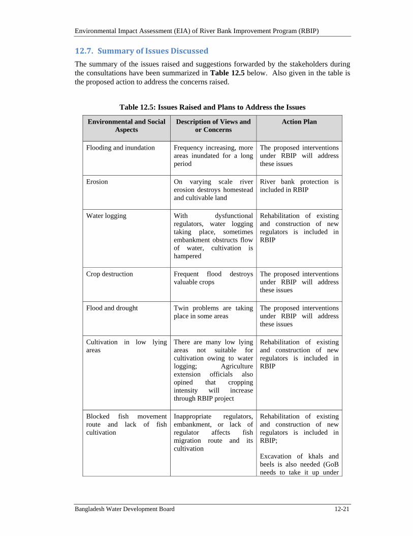
Environmental Impact Assessment (EIA) of River Bank Improvement Program (RBIP)
Bangladesh Water Development Board 12-21
12.7. SummaryofIssuesDiscussed
The summary of the issues raised and suggestions forwarded by the stakeholders during the consultations have been summarized in Table 12.5 below. Also given in the table is the proposed action to address the concerns raised.
Table 12.5: Issues Raised and Plans to Address the Issues
Environmental and Social Aspects
Description of Views and or Concerns
Action Plan
Flooding and inundation Frequency increasing, more areas inundated for a long period
The proposed interventions under RBIP will address these issues
Erosion On varying scale river erosion destroys homestead and cultivable land
River bank protection is included in RBIP
Water logging With dysfunctional regulators, water logging taking place, sometimes embankment obstructs flow of water, cultivation is hampered
Rehabilitation of existing and construction of new regulators is included in RBIP
Crop destruction Frequent flood destroys valuable crops
The proposed interventions under RBIP will address these issues
Flood and drought Twin problems are taking place in some areas
The proposed interventions under RBIP will address these issues
Cultivation in low lying areas
There are many low lying areas not suitable for cultivation owing to water logging; Agriculture extension officials also opined that cropping intensity will increase through RBIP project
Rehabilitation of existing and construction of new regulators is included in RBIP
Blocked fish movement route and lack of fish cultivation
Inappropriate regulators, embankment, or lack of regulator affects fish migration route and its cultivation
Rehabilitation of existing and construction of new regulators is included in RBIP;
Excavation of khals and beels is also needed (GoB needs to take it up under
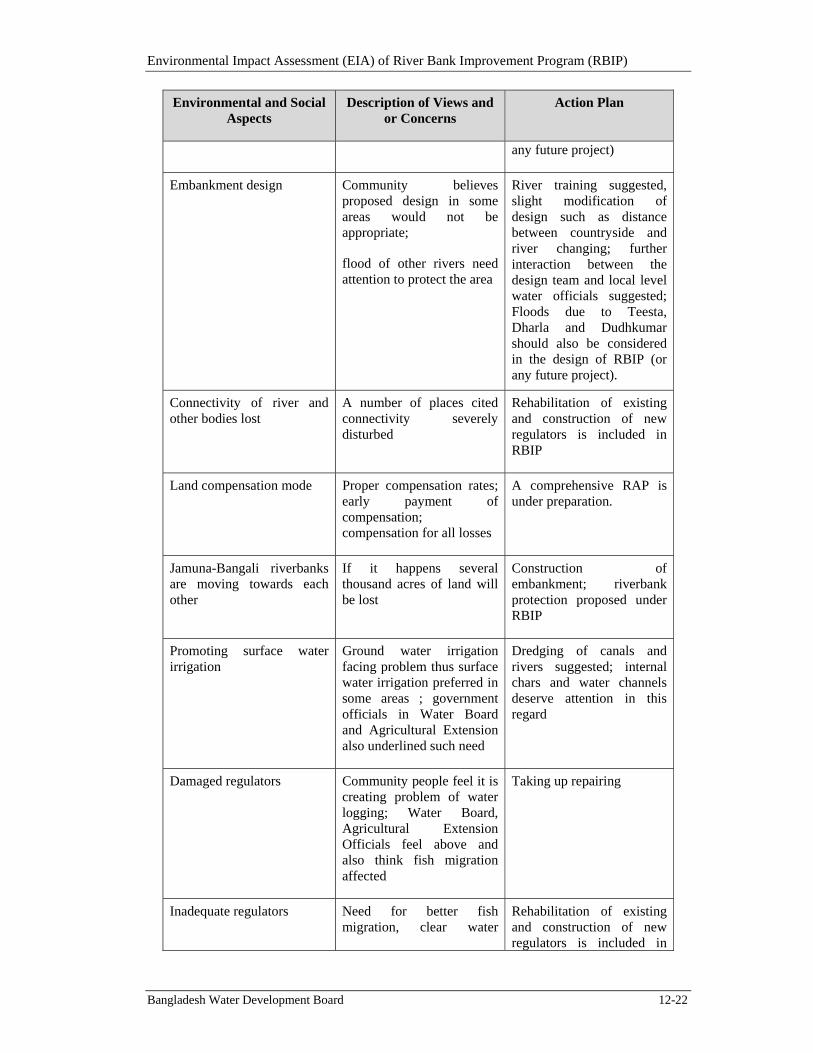
Environmental Impact Assessment (EIA) of River Bank Improvement Program (RBIP)
Bangladesh Water Development Board 12-22
Environmental and Social Aspects
Description of Views and or Concerns
Action Plan
any future project)
Embankment design Community believes proposed design in some areas would not be appropriate;
flood of other rivers need attention to protect the area
River training suggested, slight modification of design such as distance between countryside and river changing; further interaction between the design team and local level water officials suggested; Floods due to Teesta, Dharla and Dudhkumar should also be considered in the design of RBIP (or any future project).
Connectivity of river and other bodies lost
A number of places cited connectivity severely disturbed
Rehabilitation of existing and construction of new regulators is included in RBIP
Land compensation mode Proper compensation rates; early payment of compensation; compensation for all losses
A comprehensive RAP is under preparation.
Jamuna-Bangali riverbanks are moving towards each other
If it happens several thousand acres of land will be lost
Construction of embankment; riverbank protection proposed under RBIP
Promoting surface water irrigation
Ground water irrigation facing problem thus surface water irrigation preferred in some areas ; government officials in Water Board and Agricultural Extension also underlined such need
Dredging of canals and rivers suggested; internal chars and water channels deserve attention in this regard
Damaged regulators Community people feel it is creating problem of water logging; Water Board, Agricultural Extension Officials feel above and also think fish migration affected
Taking up repairing
Inadequate regulators Need for better fish migration, clear water
Rehabilitation of existing and construction of new regulators is included in
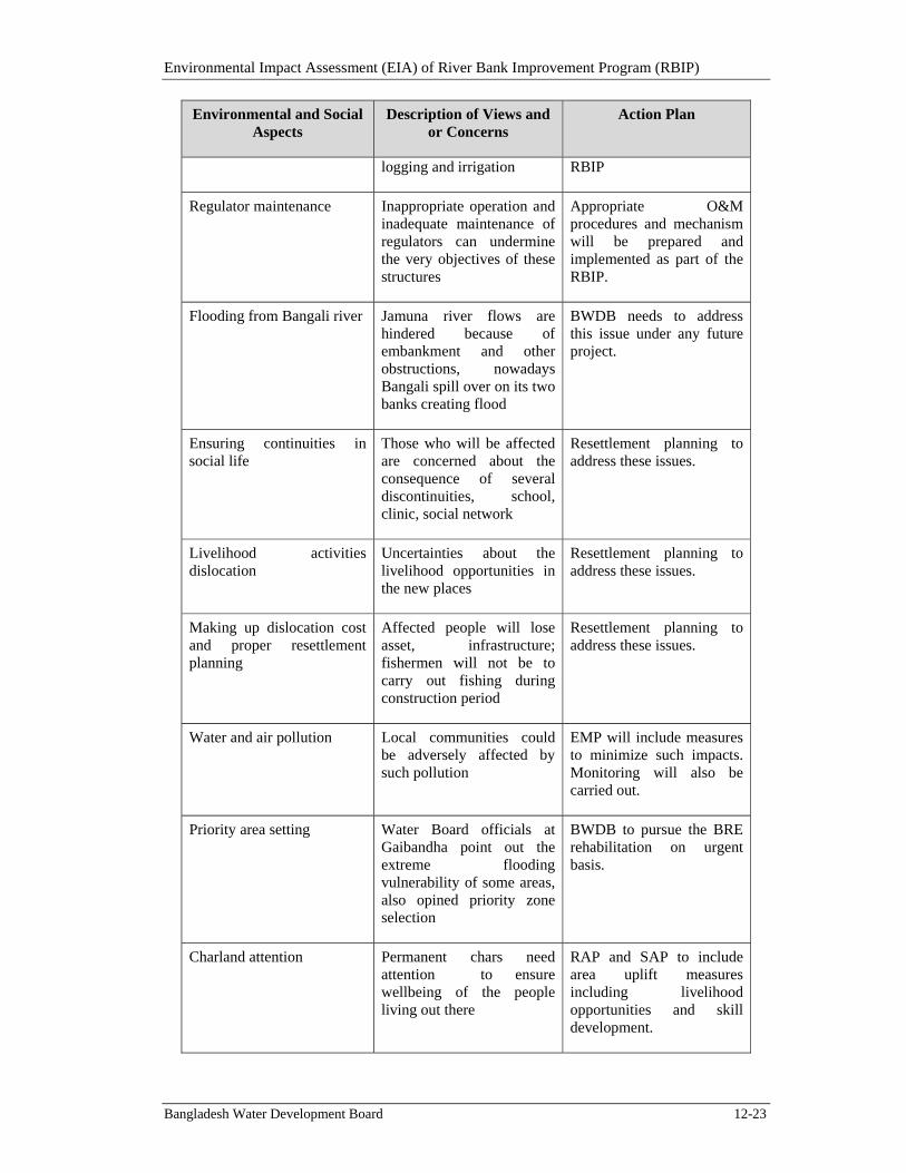
Environmental Impact Assessment (EIA) of River Bank Improvement Program (RBIP)
Bangladesh Water Development Board 12-23
Environmental and Social Aspects
Description of Views and or Concerns
Action Plan
logging and irrigation RBIP
Regulator maintenance Inappropriate operation and inadequate maintenance of regulators can undermine the very objectives of these structures
Appropriate O&M procedures and mechanism will be prepared and implemented as part of the RBIP.
Flooding from Bangali river Jamuna river flows are hindered because of embankment and other obstructions, nowadays Bangali spill over on its two banks creating flood
BWDB needs to address this issue under any future project.
Ensuring continuities in social life
Those who will be affected are concerned about the consequence of several discontinuities, school, clinic, social network
Resettlement planning to address these issues.
Livelihood activities dislocation
Uncertainties about the livelihood opportunities in the new places
Resettlement planning to address these issues.
Making up dislocation cost and proper resettlement planning
Affected people will lose asset, infrastructure; fishermen will not be to carry out fishing during construction period
Resettlement planning to address these issues.
Water and air pollution Local communities could be adversely affected by such pollution
EMP will include measures to minimize such impacts. Monitoring will also be carried out.
Priority area setting Water Board officials at Gaibandha point out the extreme flooding vulnerability of some areas, also opined priority zone selection
BWDB to pursue the BRE rehabilitation on urgent basis.
Charland attention Permanent chars need attention to ensure wellbeing of the people living out there
RAP and SAP to include area uplift measures including livelihood opportunities and skill development.
Environmental Impact Assessment (EIA) of River Bank Improvement Program (RBIP)
Bangladesh Water Development Board 12-24
12.8. DisclosureRequirements
The draft EIA has been shared with the stakeholders during a national workshop held in Dhaka in January 2015 (see Annex L in Volume II of this EIA for the report of this workshop). Similar workshops/meetings to disclose EIA and EMF will be held locally also in the project districts; for the EMF, such workshops will be held in the remaining reaches as well. Once finalized, the EIA will be submitted to the DoE for their review and clearance. The EIA and EMF will be available on the BWDB website and will also be sent to the WB InfoShop.
Environmental Impact Assessment (EIA) of River Bank Improvement Program (RBIP)
Bangladesh Water Development Board 1
13. References
A. U. Ahmed, M. M. Mirza, Q. K. Ahmed, A. K. Chowdhury, Azad, S. H. Imam, M. Sarker, & (Eds.) (Eds.), Perspectives on Flood 1998 (pp. 67-84). Dhaka: University Press Limited.
ADB, 2007. Bank Protection and Fisheries at JMREMP; Jamuna-Meghna River Erosion Mitigation Project, Special Report.
ADB 2002. Jamuna-Meghna River Erosion Project Document. RRP-BAN-34038-ADB, Asian Development Bank.
Ahmed, A. U., & Mirza, M. M., 2000. Review of causes and Dimensions of floods with Particular Reference to Flood '98: National Perspectives.
Ahmed, A.T.A., Kabir, S.M.H., Ahmad, M., Ahmed, Z.U., Begum, Z.N.T., Hassan M.A. and Khondker, M. (eds.) 2009.
Ali, M. M. and M. A. Bhuiyan. 2006. Investigation on plan-form changes of the Jamuna River.
amardesh.com/zila_kurigram.php, amardesh.com/zila_gaibandha.php
Arthington AH, Balcombe SR. 2011. Extreme hydrologic variability and the boom and bust ecology of fish in arid-zone floodplain rivers: a case study with implications for environmental flows, conservation and management. Ecohydrology (2011): DOI: 10.1002/eco.221.
Asian Development Bank. October 2002.
Asian Waterfowl Census (2008-2010), Wetland International.
Assessing current status of the Black-bellied Tern in Padma-Jamuna River Bangladesh, 2013. Bangladesh Bird Club.
Bashir, T., Khan, A., Gautam, P. and Behera, S.K. 2010. Abundance and Prey Availability Assessment of Ganges River Dolphin (Platanista gangetica gangetica) in a Stretch of Upper Ganges River, India. Aquatic Mammals, 36(1), 19-26.
Bates, B.C., Z.W. Kundzewicz, S. Wu and J.P. Palutikof, Eds., 2008: Climate Change and Water. Technical Paper of the Intergovernmental Panel on Climate Change, IPCC Secretariat, Geneva, 210 pp.
BBA (2010), Ecology Report, Environmental Assessment of Padma Multipurpose Bridge Design Project.
BBS (2007), Economic Census 2001 & 2003, Zila Series, Zila: Gaibandha, Ministry of Planning, GOB,
BBS (2007), Economic Census 2001 & 2003, Zila Series, Zila: Kurigram, Ministry of Planning, GOB,
BBS (2011), Census of Agriculture 2008, Gaibandha Series, Ministry of Planning, GOB; BBS(2007),
BBS (2011), Census of Agriculture 2008, Kurigram Series, Ministry of Planning, GOB.
BBS (2011), Census of Agriculture 2008, Zila Series Gaibandha, Ministry of Planning, GOB,
Environmental Impact Assessment (EIA) of River Bank Improvement Program (RBIP)
Bangladesh Water Development Board 2
BBS (2011), District Statistics 2011, Bogra, Ministry of Planning, GOB,
BBS (2011), District Statistics 2011, Sirajganj, Ministry of Planning, GOB,
BBS (2013), District Statistics 2011, Sirajganj and Bogra, Ministry of Planning, GOB; BBS (2013), District Statistics 2011, Sirajganj and Bogra Ministry of Planning, GOB.
BBS (2014), Statistical Pocketbook Bangladesh 2013, Ministry of Planning, GOB
BWDB, 2014. Feasibility Study of Capital Dredging and Sustainable River Management in Bangladesh, draft final report. Bangladesh Water Development Board, Dhaka, Bangladesh.
Bhuiyan, S.S., M. A. R . Joadder, and A.S.2 Bhuiyan 2008. Occurrence of fishes and non-fin fishes of the river Padma near Rajshahi, Bangladesh; Univ. j. zool. Rajshahi Univ. Vol. 27, 2008 pp. 99-100, ISSN 1023-6104. http://journals.sfu.ca/bd/ index.php/UJZRU. Last access on 17/08/09.
Biodiversity in the floodplain Ecosystem of Bera, Santhia, Sujanagar upazilas of Pabna District in Bangladesh. Department of Fisheries, GIZ and IUCN Bangladesh.
Biswas, S. P. and Baruah, S. 2000. Ecology of river dolphin (Platanista gangetica) in the Upper Brahmaputra. Hydrobiologia, Vol: 430, pp. 97–111.
BNBC 2006. Bangladesh National Building Code.
Bose S. & Jalal A. (2010), Modern South Asia, History, Culture, Political Economy, Oxford India Paperbacks..
Bose S. (1986), Agrarian Bengal: Economy, Social Structure and Politics, Cambridge University Press.
CARINAM. 2010. Survey of the breeding population of gharials (Gavialis gangeticus) in Bangladesh. CARINAM Report No. 2010-MBZ/001. Interim project report submitted to The Mohamed bin Zayed Species Conservation Fund, Abu Dhabi. 23 pp.
CARRINAM, (2012) Herpetological survey in Bera, Shanthia and Sujanagar Upazilla, Pabna. Report submitted to WBRP and GIZ. Herpetology Survey 2012-2013-CARINAM Bangladesh.
CEGIS, 2006, Environmental and Social Impact Assessment of Integrated Water Resources Management in Chalan Beel Area including Beel Halti Development Project.
CEGIS, 2009. Assessing the Extent of Erosion Behind East Guide Bund of Jamuna Bridge. Centre for Environmental and Geographic Information Services
Census of Agriculture and Economic Census of 2001 & 2003, Zila Series Gaibandha, Ministry of Planning, GOB.
Encyclopedia of Flora and Fauna of Bangladesh, Vol. 27: Mammals. Asiatic Society of Bangladesh, Dhaka, Bangladesh.
FAP, 1996 and 1997. Flood Action Plan, Government of Bangladesh .
FHRC, (2010). Water Bird Diversity and Population in Bera, Shanthia and Sujanagar Upazilla, Pabna. Report Submitted to GIZ and Wetland Biodiversity Rehabilitation Project.
Environmental Impact Assessment (EIA) of River Bank Improvement Program (RBIP)
Bangladesh Water Development Board 3
FHRC, (2013). Biodiversity Impact Surveys- Birds, Dolphin, Herpetofauna and Tree in Bera, Shanthia and Sujanagar Upazilla. An interim Report Submitted to GIZ and Wetland Biodiversity Rehabilitation Project.
FHRC, (2013). Fish catch impact monitoring Surveys in Bera, Shanthia and Sujanagar Upazilla, Pabna. Report Submitted to GIZ and Wetland Biodiversity Rehabilitation Project.
Fichtner, 2014. Draft Technical Note Comparison of Alternative River Bank Protection Structures for RBIP.
Field-Based Research on the Impacts of Climate Change on Bangladesh Rivers. Dhaka: ADB,
First record of Red Phalarope Phalaropus fulicariu from Bangladesh by A.B.M. Sarwar Alam & Sayam U. Chwodhury Birding Asia 2013.
Fisheries Statistical Year Book, 2013. Department of Fisheries.
Forest Department and Wildlife Society of Bangladesh, 1991. Draft report on implementation of
FRSS, 2013. Fisheries Resource Survey System, Department of Fisheries, Gov. of Bangladesh.
Goodbred Jr., S.L., Kuehl, S.A., Stecler, M.S. and Sarker, M.H., 2003; Controls on facies distribution and stratigraphic preservation in the Ganges-Brahmaputra delta sequence, Sedimentary Geology, Vol. 155, 301-316.
Hasan, M.K., Khan, M.M.H. and Feeroz, M.M. 2014. Amphibians and Reptiles of Bangladesh - A Field Guide. Arannayk Foundation, Dhaka, Bangladesh.
Hassan, M. A. 2003. Diversity and conservation of wild plants and alien invasive species in Bangladesh. Concept Note on Bangladesh National Conservation Strategy and Action Plan. IUCN Bangladesh Country Office.
Hossain, A.N.H.A. ( 2006). The Impact of Floods on Bangladesh and Options for Mitigation An Overview, In Siddiqui, K. and Hossain, A.N.H. ed. Options for Flood Risk and Damage Reduction in Bangladesh, The University Press Limited, Dhaka, p.60
Hossain, M.A.R., Nahiduzzman, M., Sayeed, M.A., Azim, M.E., Wahab, M.A. and Lin, P.G. 2009. 2009. The Chalan beel in Bangladesh: Habitat and biodiversity degradation, and implications for future management. Lakes and Reservoirs: Research and Management, 14: 3-19.
Household Survey, 2014, RBIP
Hydraulic Profiling of Important Fish Habitats of the Jamuna River. Institute of Water and Flood Management (IWFM), Bangladesh University of Engineering and Technology.
IFC/ World Bank Group, 2007. Environmental, Health, and Safety (EHS) Guidelines. IFC/World Bank Group.
IPCC, 2007. Climate Change 2007: Synthesis Report. Contribution of Working Groups I, II and III to the Fourth Assessment Report of the Intergovernmental Panel on Climate Change [Core Writing Team, Pachauri, R.K and Reisinger, A. (eds.)]. IPCC, Geneva, Switzerland, 104 pp.
IPCC, Fifth Assessment Report, 2013
Environmental Impact Assessment (EIA) of River Bank Improvement Program (RBIP)
Bangladesh Water Development Board 4
IPIECA/Energy Institute/Cedre 2004. IPIECA Report Series, Volume-12, “Guidelines for Oil Spill Waste Minimization and Management”.
IUCN-Bangladesh 2000. Red List of Threatened Animas of Bangladesh. IUCN-Bangladesh, Dhaka, Bangladesh.
IWM (Institute of Water Modeling). 2008. Hydrological Modeling for the Implication of Climate Change on Food Security of Bangladesh: A Menu of Adaptation Responses. Final Report. Dhaka, Bangladesh: Bangladesh Centre for Advance Studies, the World Bank.
Kabir, S.M.H., Ahmad, M., Ahmed, A.T.A., Rahman, A.K.A., Ahmed, Z.U., Begum, Z.N.T., Hassan, M.A. and Khondker, M. (eds.) 2009. Encyclopedia of Flora and Fauna of Bangladesh, Vol. 25: Amphibians and Reptiles. Asiatic Society of Bangladesh, Dhaka, Bangladesh.
Kasuya, T. and A. K. M. Aminul Haque. 1972. Some information on distribution and seasonal movement of Ganges dolphin. Sci. Rep. Whales Res. Inst. Vol: 24, pp. 109–115.
Khan, M.A.R. 1982. Wildlife of Bangladesh - A Checklist. University of Dhaka, Dhaka, Bangladesh.
Khan, M.A.R. 2010. Wildlife of Bangladesh - A Checklist with Bengali Names. Shahitya Prakash, Dhaka, Bangladesh.
Khan, M.M.H. 2008. Protected Areas of Bangladesh - A Guide to Wildlife. Nishorgo Program, Bangladesh Forest Dept., Dhaka, Bangladesh.
Khan, M.M.H. 2014. Introduction to the Wildlife of Bangladesh. Monitoring and Conservation of Wildlife in Kaptai National Park of Bangladesh - A sub-project of SRCWP Project of Bangladesh Forest Dept., Dhaka, Bangladesh.
Khan, M.S., Rahman, M.M. and Ali, M.A. (eds.) 2001. Red Data Book of Vascular Plants of Bangladesh. Bangladesh National Herbarium, Dhaka, Bangladesh.
Kostori, F.A., Parween, S. and Islam, M.N. 2011. Availability of small Indigenous Species (SIS) of Fish in the Chalan Beel: the largest wetland of Bangladesh. Univ. j. zool. Rajshahi Univ. 30: 67-72.
Kreb, D., & Budiono. 2005. Conservation management of small core areas: Key to survival of critically endangered population of Irrawaddy River dolphin Orcaella brevirostris in Indonesia. Oryx, 39, 178-188.
Krishi Diary 2014. Agriculture Information Service, Department of Agricultural Extension, Khamarbari, Farm gate, Dhaka.
Lasne E, Lek S, Laffaille P. 2007. Patterns in fish assemblages in the Loira floodplain: The role of hydrological connectivity and implications for conservation. Biological Conservation 139: 258-268.
Leigh C, Sheldon F, Kingsford RT, Arthington AH. 2010. Sequential floods drive ‘booms’ and wetland persistence in dryland rivers: a synthesis. Marine and Freshwater Research 61(8): 896–908.
March, 1997) Report. Wildlife Society of Bangladesh for Jamuna Multipurpose Bridge Authority
Environmental Impact Assessment (EIA) of River Bank Improvement Program (RBIP)
Bangladesh Water Development Board 5
Mirza, M.M.Q. 1997. Hydrological changes in the Ganges system in Bangladesh in the post-Farakka period. University of Waikato. Hamilton, New Zealand.
MoEF, 1997. Environment Conservation Rules, 1997.Ministry of Environment and Forests.
MoEF, 2006. Noise Pollution Standards. 2006. Ministry of Environment and Forests.
Mohan, R. S. L., Dey, S. C., Bairagi, S. P. and Roy, S. 1997. On a survey of the Ganges River Dolphin, Platanista gangetica of the Brahmaputra river, Assam. J. Bombay Nat. Hist. Soc., Vol: 94, pp. 483–495.
MPO 1986. National Water Plan. Master Plan Organisation.
Mukherjee, N., & Khan, M. F. 2009. Factoring Climate Change Considerations in the Design of Padma Multipurpose Bridge. Consultancy Report Prepared by the Center for Environmental and Geographic Information Services (CEGIS). Bangladesh Bridge Authority, Dhaka.
NCSIP-1, 2001. Report on the Survey of Fauna, NCSIP-1. Ministry of Environment and Forests,
near the confluence. Downloaded from internet, no publication reference provided.
Nishat A., B. Nishat and M F A Khan, 2011. “A Strategic View of Land Management Planning in Bangladesh” by in ‘Flood Risk Science and Management’ edited by G. Pender and H. Faulkner, published by Blackwell Publishers Ltd, 2011
Nishat, A. (1993). 'Freshwater Wetlands in Bangladesh: status and issues'. In: Ainun Nishat, Z. Hussain, M.K. Roy & A. Karim (eds.), p: 9-21. IUCN-The World Conservation Union, Gland, Switzerland.
Nishat, A., Huq, S.M.I., Barua, S.P., Reza, A.H.M.A. and Khan, A.S.M. (eds.) 2002. Bio-ecological Zones of Bangladesh. IUCN-Bangladesh, Dhaka, Bangladesh.
Nishat, A., Hussain, Z., Roy, M.K. and Karim, A. (eds.) 1993. Freshwater Wetlands in Bangladesh: Issues and Approaches for Management. IUCN, Gland, Switzerland.
Nishat, B. 2014. “Influence of the Brahmaputra - beyond the basin and into the sea” in “Brahmaputra: Towards Unity” published by The third Pole, February 2014, Available online in, http://www.thethirdpole.net/wp-content/uploads/2014/02/Brahmaputra-Towards-Unity1.pdf
Nuruzzaman, A.K.M. (1997). (Draft Final Report), Towards Sustainable Development: The National Conservation Strategy of Bangladesh. NCS Implementation Project-1. Ministry of Environment and Forest, Dhaka.
Rahman R., N. Mukherjee, B. Nishat, M F A Khan and S. Ahmed, 2011. Monitoring protocol for hydro-meteorological observatories in Bangladesh’ in ‘Protocol for Monitoring of Impacts of Climate Change and Climate Variability in Bangladesh’ edited by A. Nishat. IUCN (International Union for Conservation of Nature)
Rahman, A.K.A. 2005. Freshwater Fishes of Bangladesh. 2nd edition, Zoological Society of Bangladesh, Department of Zoology, University of Dhaka-1000, 263p.
Raihan S., et. al. (2009), Access to Land and Other Natural Resources by the Rural Poor: The Case of Bangladesh, South Asian Network on Economic Modeling (SANEM), Department of Economics, University of Dhaka, Bangladesh.
Environmental Impact Assessment (EIA) of River Bank Improvement Program (RBIP)
Bangladesh Water Development Board 6
Rahaman, M. M. and Varis, O. 2009. Integrated water management of the Brahmaputra basin: Perspectives and hope for regional development. Natural Resources Forum, 33: 60 – 75.
Rashid, S.M.A. and Swingland, I.R. (1997). On the Ecology of some freshwater turtles in Bangladesh. In: Van Abbema, J. (ed.). Proceedings: Conservation, Restoration and Management of Tortoise and Turtles: An international Conference: American Museum of natural History, New York, pp. 225-242.
River Dolphins in Bangladesh: Conservation and the Effects of Water Development.
Riverine Bird Project, 2014. Bangladesh Bird Club, 2013-14.
Rural population ( percent of total population) in Bangladesh: http://www.tradingeconomics.com/bangladesh/rural-population-percent-of-total-population-wb-data.html
Sarkar, S. U. and Husain, L. (1996). Population, eco-biological status, captive propagation and conservation problems of Lissemys punctata in Bangladesh. In: B. Devaux (ed.) Proceedings – International Congress of Chelonian Conservation, 43-45 pp. Gonfaron, France: Editions SOPTOM.
Sarker M. 2009. Morphological Response of the Brahmaputra-Jamuna-Padma-Lower Meghna River to the Assam Earthquake of 1950. PhD thesis, University of Nottingham, UK.
Schedule-2, Rule 12, Environment Conservation Rules of 1997 (Page 3123, Bangladesh Gazette, 28 August 1997. Translated from Bengali.
Second Crop Diversification Project, DAE, Khamarbari, Dhaka. Annual Report 2013-14, Monitoring and Evaluation Section: Internal Outcome Survey, p – 45
Siddiqui, K.U., Islam, M.A., Kabir, S.M.H., Ahmad, M., Ahmed, A.T.A., Rahman, A.K.A., Haque, E.U., Ahmed, Z.U., Begum, Z.N.T., Hassan, M.A., Khondker, M. and Rahman M.M. (eds.) 2008. Encyclopedia of Flora and Fauna of Bangladesh, Vol. 26: Birds. Asiatic Society of Bangladesh, Dhaka, Bangladesh.
Smith, B. D. and Reeves, R.R. 2000. Survey methods for population assessment of Asian river dolphins. In Biology and Conservation of Freshwater Cetaceans in Asia, Occasional Papers of the IUCN Species Survival Commission no. 23 (eds. R. R. Reeves, B. D. Smith and T. Kasuya), pp. 97-115. IUCN, Gland, Switzerland.
Smith, B.D. and Reeves, R.R. (eds.). 2000b. Report of the workshop on the effects of water development on river cetaceans in Asia, Rajendrapur, Bangladesh, 26-28 February 1997. Pages 15-21 In R.R. Reeves,
Smith, B.D., Haque, A.K.M. Aminul, Hossain, M.S. and Khan, A. 1998. River dolphins in Bangladesh: conservation and the effects of water development. Environmental Management 22(3):323-335.
Social Assessment of RBIP, 2014.
Status and distribution of Water Birds in the Jamuna River, Sirajganj, 2014. Jahangirnagar University.
Stocker, T.F., D. Qin, G.-K. Plattner, L.V. Alexander, S.K. Allen, N.L. Bindoff, F.-M. Bréon, J.A. Church, U. Cubasch, S. Emori, P. Forster, P. Friedlingstein, N. Gillett, J.M. Gregory, D.L. Hartmann, E. Jansen, B. Kirtman, R. Knutti, K. Krishna Kumar, P. Lemke,
Environmental Impact Assessment (EIA) of River Bank Improvement Program (RBIP)
Bangladesh Water Development Board 7
J. Marotzke, V. Masson-Delmotte, G.A. Meehl, I.I. Mokhov, S. Piao, V. Ramaswamy, D. Randall, M. Rhein, M. Rojas, C. Sabine, D. Shindell, L.D. Talley, D.G. Vaughan and S.-P. Xie, 2013: Technical Summary. In: Climate Change 2013: The Physical Science Basis. Contribution of Working Group I to the Fifth Assessment Report of the Intergovernmental Panel on Climate Change. Cambridge University Press, Cambridge, United Kingdom and New York, NY, USA.
Survey the critically endangered species – Gharials (Gavialis gangeticus) in the Padma, Teesta and Jamuna rivers. CARINAM Bangladesh
The Asiatic Society. (2006). www.banglapedia.org. Retrieved September 28, 2014, from Banglapedia: http://www.banglapedia.org/httpdocs/HT/C_0135.HTML
The history of Bogra district dates back to 4th century BC, please see amardesh.com/zila_bogra.ph
The World Bank 2009. The updated poverty maps to help targeted policy intervention for poverty reduction. Link: http://www.worldbank.org/en/news/press-release/2009/04/02/the-updated-poverty-maps-to-help-targeted-policy-intervention-for-poverty-reduction
Uddin, M.J. 2002. The Agricultural Potentiality of Wetlands: A Case Study of the Chalan beel area of Bangladesh. Dhaka Univ. J. Biol. Sci. 11(2): 139-145.
Yang, Y. C. E., Ray P. A., Brown, C. M., Khalil, A. F. and Yu, W. H. 2014. Estimation of flood damage functions for river basin planning – A case study in Bangladesh. Natural Hazards, accepted.
Yang, Y. C. E., Wi, S. Ray P. A., Brown, C. M. and Khalil, A. F. 2014. Modeling water resources the Brahmaputra River under future climate and social uncertainties. in preparation
Wildlife Protection and Monitoring (Wildlife Study Team), 1996. Annual Report, 1996. Wildlife
Wildlife Protection and Monitoring (Wildlife Study Team), 1997. Ninth Quarterly (January-
Willoughby, N.G., M S M Chowdhury, M H Rashid & H K Ratan, 2004. Studies On Environmental Issues In Shrimp Polders; Results of a Baseline Study on Polder Benthos. Report no. 38.19 Part B, ARDMCS, FFP.
World Bank, 2010. Bangladesh Economics of Adaptation to Climate Change, August 23, 2010, Consultation Draft, The World Bank.
World Bank, 2009. Updating Poverty Maps of Bangladesh, The World Bank, Bangladesh Bureau of Statistics, World Food Program.
World Bank. 2005. OP 4.10 – Indigenous People. The World Bank Operational Manual. The World Bank. July 2005.
World Bank. 2003. Social Analysis Sourcebook, Incorporating Social Dimensions into Bank-Supported Projects. Social Development Department, The World Bank. December 2003.
World Bank. 2001. OP 4.12 – Involuntary Resettlement. The World Bank Operational Manual. The World Bank. December 2001.
Environmental Impact Assessment (EIA) of River Bank Improvement Program (RBIP)
Bangladesh Water Development Board 8
World Bank. 2001. OP 4.04 – Natural Habitat. The World Bank Operational Manual. The World Bank. June 2001.
World Bank. 1999. OP 4.01 – Environmental Assessment. The World Bank Operational Manual. The World Bank. January 1999.
World Bank. 1994. OP 7.60 – Projects in Disputed Areas. The World Bank Operational Manual. The World Bank. November 1994.
Zellweger, Hannes, 2007. Geotextile Bags for River Erosion Control in Bangladesh, Under water behavior and environmental aspects.
Zug S. (2006), ‘Monga – Seasonal Food Insecurity in Bangladesh – Bringing the Information Together’ in Journal of Social Studies, No 111, July- Sept., p-2.
Zuo, Y. H, Liang, Y. and Bo Y. Z. 2008. Water Resources Management – The Analysis of “Greater Western Route Water Diversion Project,” Science Publisher, Beijing China, pp202.