Official PDF , 369 pages
369
“CAPACITY AUGMENTATION OF NATIONAL WATERWAY -1” (Jal Marg Vikas Project) ENVIRONMENTAL IMPACT ASSESSMENT REPORTS VOLUME-3: CONSOLIDATED ENVIRONMENTAL IMPACT ASSESSMENT (EIA) May2016 (Revised September 2016; Copy Edited November 2016) IRG Systems South Asia Pvt. Ltd. Abnaki Infrastructure Applications & Integrated Development Pvt. Ltd. INLAND WATERWAYS AUTHORITY OF INDIA Ministry of Shipping, Government of India EQMS India Pvt. Ltd. In JV with SFG2231 V1 REV Public Disclosure Authorized Public Disclosure Authorized Public Disclosure Authorized Public Disclosure Authorized
Transcript of Official PDF , 369 pages
“CAPACITY AUGMENTATION OF NATIONAL WATERWAY -1”
(Jal Marg Vikas Project)
ENVIRONMENTAL IMPACT ASSESSMENT REPORTS
VOLUME-3: CONSOLIDATED ENVIRONMENTAL
IMPACT ASSESSMENT (EIA)
May2016 (Revised September 2016; Copy Edited November 2016)
IRG Systems South Asia Pvt. Ltd. Abnaki Infrastructure Applications &
Integrated Development Pvt. Ltd.
INLAND WATERWAYS AUTHORITY OF INDIA
Ministry of Shipping, Government of India
EQMS India Pvt. Ltd. In JV with
SFG2231 V1 REVP
ublic
Dis
clos
ure
Aut
horiz
edP
ublic
Dis
clos
ure
Aut
horiz
edP
ublic
Dis
clos
ure
Aut
horiz
edP
ublic
Dis
clos
ure
Aut
horiz
ed

Consolidated Environmental Impact Assessment Report of National Waterways-1 : Volume - 3
ii
Table of Contents
Executive Summary ............................................................................................... XIII - XXIV Chapter 1. INTRODUCTION ........................................................................................... 1 1.1. Project Background ............................................................................................... 1 1.2. Need of Jal Marg Vikas Project – NW-1 ................................................................ 2 1.3. Overview of NW-1 ................................................................................................. 5 1.4. Objective of EIA study ........................................................................................... 6 1.5. Extent and Limitation of EIA Study ........................................................................ 6 1.6. EIA Contents ......................................................................................................... 7 1.7. Methodology ......................................................................................................... 8 1.8. Data Collection .................................................................................................... 10 1.9. Public Consultation ............................................................................................. 10 1.10. Cumulative Impact Assessment .......................................................................... 10 1.10.1. Cumulative Impact Assessment vs Environmental Impact Assessment:difference
and utility ............................................................................................................. 11 1.11. References .......................................................................................................... 12 Chapter 2. POLICY, LEGAL AND ADMINISTRATIVE FRAMEWORK ........................... 17 2.1. Introduction ......................................................................................................... 17 2.1.1. Overview of Indian Environmental Legislation and Administrative Framework .... 17 2.1.2. Applicable Environmental Legislation .................................................................. 18 2.2. International Best Practices & Guidelines ............................................................ 30 2.2.1. Operational Policies of World Bank ..................................................................... 30 2.2.2. Relevant International Environmental Convention ............................................... 34 2.3. Environmental Standards & Guidelines ............................................................... 36 2.3.1. Guideline, Standard and recommendations as published by Environmental
Committee of PIANC ........................................................................................... 37 2.4. Key safeguard documents ................................................................................... 37 Chapter 3. PROJECT DESCRIPTION ........................................................................... 38 3.1. Background ......................................................................................................... 38 3.2. Introduction- Jal Marg Vikas Project .................................................................... 38 3.3. Project Location .................................................................................................. 39 3.3.1. Rail and Road Connectivity to NW-1 ................................................................... 40 3.4. Size and Magnitude of the Project ....................................................................... 41 3.4.1. Existing and Anticipated Cargo at NW-1 ............................................................. 42 3.4.2. Depth of Navigation Channel .............................................................................. 45 3.4.3. Width of Navigation Channel ............................................................................... 46 3.4.4. Size of the Vessel/Ships...................................................................................... 46 3.5. Challenges for Project Development ................................................................... 46 3.6. River Morphology & Mobility ................................................................................ 49 3.7. Bathymetry of NW-1 & River Slope ..................................................................... 54 3.8. Available Flow in NW-1 ....................................................................................... 57 3.9. Sediment Load in NW-1 ...................................................................................... 59 3.10. Water Level of NW-1 ........................................................................................... 59 3.11. Tidal Variation in NW-1 ....................................................................................... 61 3.12. Analysis of Alternatives ....................................................................................... 62 3.12.1. Strategic Consideration ....................................................................................... 62 3.12.2. Planning Consideration ....................................................................................... 66 3.12.3. Technology Consideration ................................................................................... 93 3.12.4. Integration of Analysis of alternatives and Design Input in project Design: .......... 95 3.13. Least Available Depth for Navigation in NW-1 ..................................................... 96 3.14. Maintenance Dredging in NW-1 .......................................................................... 97 3.15. Physical Intervention ........................................................................................... 99 3.15.1. Navigation Aids ................................................................................................... 99 3.15.2. Navigations Infrastructure ................................................................................. 101 3.15.3. Description of Planned and Proposed Infrstructure ........................................... 109
Consolidated Environmental Impact Assessment Report of National Waterways-1 : Volume - 3
iii
3.16. Material Handling, Transportation and Storage ................................................. 131 3.17. Construction material Sourcing ......................................................................... 131 3.18. Waste Disposal ................................................................................................. 132 3.18.1. Sewage & Effluent ............................................................................................. 132 3.18.2. Solid Waste ....................................................................................................... 132 3.19. Dust Suppression .............................................................................................. 132 3.20. Green Belt ......................................................................................................... 133 3.21. Accident Prevention .......................................................................................... 133 3.22. Project Cost ...................................................................................................... 134 3.23. Project Schedule ............................................................................................... 134 Chapter 4. ENVIRONMENTAL IMPACTS AND MITIGATION MEASURES ................. 136 4.1. Introduction ....................................................................................................... 136 4.2. Valued Environmental Components .................................................................. 136 4.3. Environmental Profile of NW-1 .......................................................................... 137 4.4. Influence Area Considered for Environment Impact Assessment ...................... 138 4.5. Impact Identification .......................................................................................... 140 4.6. Impact Assessment of NW1 .............................................................................. 142 4.6.1. Maintenance Dredging for Maintaining Minimum LAD ....................................... 142 4.6.2. Operational Activity-Barge Movement & Maintenance ....................................... 150 4.6.3. Design, Construction, Operation and Maintenance of the Civil Interventions ..... 152 4.7. Impact on Climate Change & Mitigation Measures ............................................ 166 4.7.1. Meteorology of the NW-1 and the influence area .............................................. 166 4.7.2. Climate Change Scenario in India: .................................................................... 166 4.7.3. Impact of Shift of Freight Movement to IWT Mode on Rate of Emissions of GHG:
.......................................................................................................................... 167 4.7.4. Impact on Micro Climate of NW1 due to Civil Interventions: .............................. 170 4.7.5. Conclusion (Climate Change)............................................................................ 172 4.8. Impact Due to Natural Disasters & Mitigation Measures .................................... 172 4.9. Impact Due to Shifting of Existing Utilities & Mitigation Measures ..................... 173 4.10. Impact on Land Environment & Mitigation Measures ......................................... 174 4.10.1. Status of land environment along NW-1 and influence area .............................. 174 4.10.2. Impacts on Land Environment due to Maintenance Dredging for maintaining
minimum LAD in navigation channel ................................................................. 174 4.10.3. Impact on Land Environment Due to Operations- Barge Movement .................. 175 4.10.4. Impacts on Land Environment Due to Physical Interventions ............................ 176 4.10.5. Conclusion (Land Environment) ........................................................................ 180 4.11. Impact on Air Environment & Mitigation Measures ............................................ 181 4.11.1. Status of air quality along NW-1 and influence area .......................................... 181 4.11.2. Impacts on Air environment due to Maintenance Dredging for maintaining
minimum LAD in navigation channel ................................................................. 181 4.11.3. Impact on Air Environment Due to Operations- Barge Movement .................... 182 4.11.4. Impacts on Air Environment Due to Physical Interventions ................................ 184 4.11.5. Conclusion (Air Environment) ............................................................................ 191 4.12. Impact on Noise Environment ........................................................................... 191 4.12.1. Status of noise environment along NW-1 and influence area ............................ 191 4.12.2. Impacts on Noise Environment due to Maintenance Dredging for maintaining
minimum LAD in navigation channel ................................................................. 192 4.12.3. Impact Due to Operations- Barge Movement .................................................... 192 4.12.4. Impacts Due to Physical Interventions ............................................................... 193 4.12.5. Conclusion (Noise Environment) ....................................................................... 198 4.13. Impact on Water Environment & Mitigation Measures ....................................... 198 4.13.1. Status of water environment along NW-1 and influence area ............................ 198 4.13.2. Impacts on Water Environment due to Maintenance Dredging for maintaining
minimum LAD in navigation channel ................................................................. 199 4.13.3. Impact on Water Environment Due to Operations- Barge Movement ................ 204 4.13.4. Impacts on Water Environment Due to Physical Interventions........................... 207

Consolidated Environmental Impact Assessment Report of National Waterways-1 : Volume - 3
iv
4.13.5. Conclusion (Water Environment) ....................................................................... 212 4.14. Impact on Ecological Environment & Mitigation Measures ................................ 212 4.14.1. Status of ecological environment along NW-1 and influence area ..................... 212 4.14.2. Impacts on Ecological Environment due to Maintenance Dredging for maintaining
minimum LAD in navigation channel ................................................................. 215 4.14.3. Impact on Ecological Environment ( Aquatic Ecology) Due to Operations- Barge
Movement ......................................................................................................... 219 4.14.4. Impacts on Terrestrial Ecology Due to Physical Interventions ........................... 227 4.14.5. Impacts on Aquatic Ecology Due to Physical Interventions ............................... 230 4.14.6. Conclusion (Ecological Environment) ................................................................ 238 4.15. Impact on Social Environment& Mitigation Measures ........................................ 238 4.15.1. Status of social environment along NW-1 and influence .................................... 238 4.15.2. Impacts on Socio-Economic and Cultural Aspects due to Maintenance Dredging
.......................................................................................................................... 240 4.15.3. Impact on Socio-Economic and Cultural Aspects Due to Operations- Barge
Operations ........................................................................................................ 243 4.15.4. Impacts Due to Physical Interventions ............................................................... 247 4.15.5. Conclusion (Social Environment) ...................................................................... 253 4.16. Impact on Indo-Bangladesh Water Sharing Treaty and Downstream water users in
Bangladesh 253 4.16.1. Conclusion (Indo -Bangladesh Water Sharing Treaty and Downstream water users
in Bangladesh) .................................................................................................. 256 4.17. Impacts Due to Maintenance Facilities for Barge Repair and Maintenance ....... 256 4.18. Cumulative Impact Assessment ........................................................................ 267 4.18.1. Cumulative Impact Assessment Vs Environmental Impact Assessment:
Difference& Utility. ............................................................................................. 269 Chapter 5. PUBLIC CONSULTATIONS AND DISCLOSURE ...................................... 270 5.1. Introduction ....................................................................................................... 270 5.2. Methods of Public Consultation ......................................................................... 270 5.2.1. First Stage Consultations .................................................................................. 270 5.2.2. Second Stage Consultations ............................................................................. 271 5.3. Objective of Public Consultation ........................................................................ 272 5.4. Outcome of Informal Stakeholder Consultation ................................................. 272 5.4.2. Formal Public Consultation Meetings ................................................................ 280 5.5. Second Stage Consultation ............................................................................... 289 5.6. Conclusion and Disclosures: ............................................................................. 292 Chapter 6. ENVIRONMENTAL MANAGEMENT PLAN ................................................ 293 6.1. Introduction ....................................................................................................... 293 6.2. Objective of Environmental Management Plan .................................................. 293 6.3. Environmental Management Plan...................................................................... 293 6.3.1. Environmental Management Plan for Maintenance Dredging ............................ 294 6.3.2. Environmental Management Plan for Barge Movement .................................... 294 6.3.3. Environmental Management Plan for Civil Interventions.................................... 294 6.4. Institutional Framework of IWAI for Environmental Management ...................... 295 6.4.2. Effective Implementation of Environmental Management Plan during Construction
Phase ................................................................................................................ 297 6.5. Environmental Health & Safety (EHS) Policy and EHS Management System ... 297 6.6. Environmental Standards for operation and maintenance of Various Civil Interventions, Barge Movement and Dredging Operations ................................................ 298 6.7. Environment Monitoring Plan (EMoP) ............................................................... 299 6.8. Monitoring for Implementation of EMP .............................................................. 301 6.9. Reporting Requirement for EMP and EMoP ...................................................... 301 6.9.1. Reporting Requirement during Pre-Construction & Construction Phase ............ 301 6.9.2. Reporting Requirement during Operation Phase ............................................... 302 6.10. Audits & Inspection ........................................................................................... 302 6.11. Mechanism for Feedback and Adjustments ....................................................... 303

Consolidated Environmental Impact Assessment Report of National Waterways-1 : Volume - 3
v
6.12. Trainings & Capacity Building ............................................................................ 303 6.13. Emergency Response and Preparedness Plan and Contingency Response Plan 303 6.14. Authorities and their Responsibilities for Implementation of EMoP .................... 304 6.15. Enhancement Measures: Implementation Plan ................................................. 305 6.16. Regulatory Clearances /Permission Required ................................................... 305 6.17. Grievance Redress Mechanism ........................................................................ 305 6.18. Environment Budget .......................................................................................... 306 Chapter 7. SUMMARY, CONCLUSION AND RECOMMENDATIONS ......................... 320 7.1. Summary and Conclusions ............................................................................... 320
List of Tables
Table 1.1 : Cost of Transportation Through Different Modes ................................................. 3 Table 1.2 : Summary of Secondary Data with Sources ....................................................... 12 Table 2.1 : Summary of Environmental and Other Legislation with Applicability Screening . 18 Table 2.2 : Regulations Applicable on Vessels/Barges Plying in Inland Waterways ............ 30 Table 2.3 : World Banks Operational Policies - Environmental & Social Safeguard ............. 30 Table 3.1 : Road & Railway Infrastructure at Important Places Across NW-1 ...................... 40 Table 3.2 : Current Traffic Along NW-1 Stretch (2014) ........................................................ 42 Table 3.3 : Traffic Forecast for Stretch-1 (Haldia-Varanasi)................................................. 43 Table 3.4 : Traffic Forecast for Stretch-2 (Patna-Varanasi) ................................................. 44 Table 3.5 : Traffic Forecast for Stretch-3 (Haldia-Patna) ..................................................... 44 Table 3.6 : Traffic Forecast for Planned Navigational Infrastructural Facilities ..................... 45 Table 3.7 : Details of Critical Bridges on NW-1.................................................................... 47 Table 3.8 : Details of Navigationally Significant Bends in UP stretch of NW-1 ..................... 48 Table 3.9 : Morphology of River (NW-1) in different reached ............................................... 49 Table 3.10 : Longitudinal Profile of River Slope from Farakka to Allahabad ........................ 55 Table 3.11 : Annual minimum discharges obtained from statistical analysis ........................ 57 Table 3.12 : Annual Minimum Discharges at Different Locations in NW-1 ........................... 58 Table 3.13 : Sediment Load at Different Locations and Tributaries of NW-1 ....................... 59 Table 3.14 : Minimum Water Levels for a Range of Annual Probabilities ............................. 60 Table 3.15 : Maximum Water Levels for a Range of Annual Probabilities ............................ 60 Table 3.16 : Alternative Analysis- “With & Without Project Scenario” .................................. 62 Table 3.17 : Location Alternative Analysis ........................................................................... 68 Table 3.18 : Site Alternative Analysis .................................................................................. 77 Table 3.19 : Alternative Layout Analysis of Sahibganj Terminal .......................................... 87 Table 3.20 : Alternate Site Analysis (Option-I & Option-II) ................................................... 88 Table 3.21 : Alternative Road Alignment Analysis for Sahibganj Terminal ........................... 90 Table 3.22 : Alternative Railway Siding Alignment Analysis for Sahibganj Terminal ............ 91 Table 3.23 : Alternative Analysis for Dredging Quantity ....................................................... 92 Table 3.24 : Comparative Analysis of Dredgers and Their Relative Performance Related to
Environmental Aspects ................................................................................................ 93 Table 3.25 : Comparative Analysis of Different Type of Dredgers Related to Environmental
Aspects ........................................................................................................................ 94 Table 3.26 : Dredging Volumes in different Stretches for Maintaining LAD in Navigation
Channels and at terminal ............................................................................................. 97 Table 3.27 : Details of Existing Infrastructure in NW-1 ...................................................... 102 Table 3.28 : Salient Features of the Haldia Terminal ......................................................... 110 Table 3.29 : Salient Features of the Sahibganj Terminal ................................................... 114 Table 3.30 : Salient Features of Varanasi Terminal ........................................................... 119 Table 3.31 : Salient Features of New Lock ........................................................................ 123 Table 3.32 : Bank Protection Works as per Current Planning ............................................ 127 Table 3.33 : Construction Material Sourcing for already Planned Interventions ................. 131
Consolidated Environmental Impact Assessment Report of National Waterways-1 : Volume - 3
vi
Table 3.34 : Green Area and Tree Details for the Planned Intervention Sites .................... 133 Table 3.35 : Component Wise Tentative Project Cost of Components (Planned & Under
Planning) of Jal Marg Vikas Project............................................................................ 134 Table 3.36 : Implementation Time for Planned Interventions under Jal Marg Vikas Project
(Phase-1) ................................................................................................................... 135 Table 4.1 Salient Environmental Features along NW-1 Alignment .................................... 137 Table 4.2 Criteria for Demarcation of Influence Zone ........................................................ 139 Table 4.3 Interaction Matrix of Major Project Activities and VECs ..................................... 141 Table 4.4 Environmental Sensitivity Vs. ImpactIdentification Matrix for Maintenance Dredging
.................................................................................................................................. 143 Table 4.5 Projection of Likely Significance of Environmental Impacts Due to Maintenance
Dredging Operations .................................................................................................. 149 Table 4.6 Identification of Environmental Impacts Due to Barge Movement & Maintenance
.................................................................................................................................. 151 Table 4.7 Identification of Environmental Impacts Due to Design, Construction and Operation
of Civil Interventions ................................................................................................... 154 Table 4.8 : GHG savings due to Projcet Till 2045 .............................................................. 168 Table 4.9 GHG (CO2) Emission Generation Factor Estimation due to Material Transportation
in Terminals .................................................................... Error! Bookmark not defined. Table 4.10 GHG (CO2) Emission due to Material Transportation and Handling with
Terminals and Net GHG savings ..................................... Error! Bookmark not defined. Table 4.11 : Emission Factors Considered for Gaseous Pollutants ................................... 182 Source : HPC .................................................................................................................... 182 Table 4.12 Pollutant Emission Savings in “With” Project Scenario .................................... 182 Table 4.13 : Source of Construction Material for Planned Civil Interventions ..................... 186 Table 4.14 : Typical Noise Levels of Construction Machinery/Equipment .......................... 193 Table 4.15 : OSHA noise exposure limits for the work environment .................................. 194 Table 4.16 : Estimated Noise levels for the piling and dredging operations ....................... 195 Table 4.17 Salient features of Sanctuaries present within NW-1 ....................................... 212 Table 4.18 : Important Bird Area within 10 km area of the NW-1 ....................................... 213 Table 4.19 : Vessel noise at different speeds .................................................................... 222 Table 4.20 : Noise Level from Different Type of Vessel ..................................................... 223 Table 4.21 : Noise Level Modelling Result ........................................................................ 224 Table 4.22 : Distance estimation for achieving 150 d(B) of noise from centre of the vessel224 Table 4.23 : Noise exposure criteria for physiological (PTS and TTS) ............................... 225 Table 4.24 : Culturally and Religiously Important Places with Fair and Festivals ............... 239 Table 4.25 : Archeologically Protected area around 300 m of NW-1 ................................. 240 Table 4.26 : Analysis of Impact on Indo Bangladesh Water Sharing treaty and Down Stream
River Water Users ...................................................................................................... 255 Table 4.27 : Activities at Barge Maintenance & Repair Facilities, Their Impacts and Mitigation
Measures ................................................................................................................... 256 Table 5.1 : Detail of Developmental Activity and Period of Public Consultation ................. 271 Table 5.2 : Summary of Key Concerns raised by Stakeholders and its redressal. ............. 272 Table 5.3 : Summary of Formal Public Consultation Meeting at Sahibganj ........................ 281 Table 5.4 : Summary of formal Stakeholder Consultation, at Farakka ............................... 286 Table 5.5 : Summary of the Second Stage Consultation at Patna ..................................... 289 Table 6.1 Dredging and Disposal Management Plan for NW-1 ......................................... 307 Table 6.2 : Environment Monitoring Plan for Construction & Operation Phase .................. 309 Table 6.3 Training & Capacity Building ............................................................................. 312 Table 6.4 : Detail Break-up of Environment Management Budget ..................................... 316 Table 6.5 : Environmental Budget of Planned Civil Interventions ...................................... 319
List of Figures
Figure 1.1 : Location Map of NW-1........................................................................................ 2

Consolidated Environmental Impact Assessment Report of National Waterways-1 : Volume - 3
vii
Figure 3.1 : Alignment of NW-1 ........................................................................................... 38 Figure 3.2 : Location Map of NW-1...................................................................................... 40 Figure 3.3 : Satellite Imagery of Different Years to Study Change in River Morphology ...... 53 Figure 3.4 : Longitudinal profile of river bed from Haldia to Farakka .................................... 54 Figure 3.5 : Longitudinal profile of river bed from Farakka to Allahabad .............................. 54 Figure 3.6 : Cross-Sectional profile of river bed at Various Locations in NW-1 .................... 56 Figure 3.7 : Annual minimum discharges obtained from statistical analysis ......................... 57 Figure 3.8 : Annual Minimum Discharges at Different Locations in NW-1 ............................ 58 Figure 3.9 : Minimum Water Levels for a Range of Annual Probabilities ............................. 60 Figure 3.10 : Maximum Water Levels for a Range of Annual Probabilities .......................... 61 Figure 3.11 : Diagrammatic Presentation of Different Type of Dredgers Showing Different
Noise Source ............................................................................................................... 95 Figure 3.12 : LAD Along the waterway for the 10, 50 & 90% frequency value ..................... 97 Figure 3.13 : Existing Navigation Infrastructure Facilities in NW-1..................................... 105 Figure 3.14 : Photographs of Existing Infrastructure along NW-1 ...................................... 106 Figure 3.15 : Planned Navigation Infrastructure Facilities in NW-1 Under Jal Marg Vikas
project ........................................................................................................................ 108 Figure 3.16 : Location Map of Haldia Terminal .................................................................. 109 Figure 3.17 : Photographs of Haldia Terminal Site ............................................................ 109 Figure 3.18 : Layout of Haldia Terminal Site ..................................................................... 112 Figure 3.19 : Location Map of Sahibganj Terminal Site ..................................................... 113 Figure 3.20 : Photographs of Sahibganj Terminal Site ...................................................... 114 Figure 3.21 : Layout of Sahibganj Terminal Site ................................................................ 117 Figure 3.22 : Location of Varanasi Terminal Site ............................................................... 118 Figure 3.23 : Photographs of Varanasi Terminal Site ........................................................ 118 Figure 3.24 : Layout of Varanasi Terminal Site.................................................................. 121 Figure 3.25 : Location Map of Farakka Lock ..................................................................... 122 Figure 3.26 : Photographs of Farakka Lock Site ................................................................ 123 Figure 3.27 : Layout of Farakka Lock Site ......................................................................... 126 Figure 3.28 : Google Map Showing Proposed Terminal Site at Ghazipur at Nawapura ..... 128 Figure 3.29 : Google Map Showing Proposed Terminal Site at Kalughat .......................... 129 Figure 3.30 : Google Map Showing Proposed Terminal Site at Tribeni ............................. 130 Figure 4.1 : Output of Air Dispersion Modelling-Sahibganj Terminal .................................. 188 Figure 4.2 : Output of Air Dispersion Modelling-Haldia Terminal ....................................... 189 Figure 4.3 : Noise Modelling Output .................................................................................. 196 Figure 4.4 : Noise Modelling Output .................................................................................. 197 Figure 4.5 : Oxygen Depletion Rate vs Time for Dredge Disposal ..................................... 200 Figure 4.6 : Short-term Species Sensitivity Distribution (SSD) for Cadmium in Freshwater
derived by fitting the log-normal model to the short-term LC50s of 62 aquatic species. .................................................................................................................................. 201
Figure 4.7 : Broadband source levels against log10 (speed in knots) for different ship types .................................................................................................................................. 223
Figure 4.8 View of NW-1 route at Farakka and Control location for River Ganga Water flow to Bangladesh ............................................................................................................ 254
Figure 6.1 : Institutional Framework of IWAI ...................................................................... 296 Figure 6.2 : Grievance Redressal Cell ............................................................................... 306

Consolidated Environmental Impact Assessment Report of National Waterways-1 : Volume - 3
viii
Abbreviations
µg/m3 Microgram per cubic metre
A Ampere
AAQ Ambient Air Quality
AD Amphibian Dredger
amsl above men sea level
APHA American Public Health Association
AWPCPL Allahabad Waste Processing Company Pvt. Ltd
BCM Billion Cubic Microns
BDU Below Detection Unit
BDU Best Designated Unit
BHDs Backhoe Dredgers
BHU Banaras Hindu University
BOD Biochemical Oxygen Demand
BOQ Bill of Quantity
BTKM Billion Tonne Kilometres
BUIDCO Bihar Urban infrastructure development Corporation Ltd.
BWE Ballast Water Exchange
BWMP Ballast Water Management Plan
BWP Ballast Water Performance
CBWTF Common Bio Medical Waste Treatment Facility
CEC Cation Exchange Capacity
CERs Critical Environmental Resources
CGWA Central Ground Water Authority
CGWB Central Ground Water Board
CIFRI Central Inland Fisheries Research Institute
CIWTC Central Inland Water Corporation Limited
cm centimetre
CNG Compressed Natural Gas
CO Carbon Monoxide
COD Chemical Oxygen Demand
CPCB Central Pollution Control Board
Cr Crore
CRZ Coastal Regulation Zone
CSD Cutter Section Dredgers
CTE Consent to Establish
CTO Consent to Operate
cum cubic metre
dBs Decibels
DEAC District Environmental Impact Assessment Committee
DEIAA District Environmental Impact Assessment Authority
DEM Digital Elevation Model
DFCCIL Dedicated Freight Corridor Corporation of India Limited
DFO District Forests Officer
DFR Detailed Feasibility Report

Consolidated Environmental Impact Assessment Report of National Waterways-1 : Volume - 3
ix
DG Diesel Generators
DGPS Differential Global Positioning System
DO Dissolved Oxygen
DWT Dry Weight Tonnage
DWT Dead Weight Tonnage
E East
EC Electrical Conductivity
EDFC Eastern Dedicated FreightCorridor
EHS Environment, Occupational Health and Safety
EIA Environmental Impact Assessment
EMoP Environmental Monitoring Plan
EMP Environment Management Plan
EPC Engineering Procurement Contractor
ESAs Ecologically Sensitive Areas
ESC Environment and Social Cell
ESS Electrical Sub stations
FBP Farakka Barrage Project
GHG Green House Gases
GRIHA Green Rating for Integrated Habitat Assessment
GIS Geographical Information Systems
gm Gram
GoI Government of India
GPS Global Positioning System
GRB Ganga River Basin
GW Ground Water
ha Hectare
HAD Haldia Development Authority
HC Horizontal Clearance
HDC Haldia Dock Complex
HDPE High Density Poly Ethylene
HFL Highest Flood Level
hpa Hectopascal
HPC Name of a Consultant
hrs hours
HSD Hydraulic Surface Dredger
IARI Indian Agricultural Research Institute
IBA Important Bird Areas
IESWM Institute of Environmental Studies & Wetland Management
IITs Indian Institute of Technology
IMD India Meteorological Department
IMDG-code International Maritime Dangerous Goods Code
IMO International Maritime Organization
INTACH Indian National Trust for Art and Cultural Heritage
IRS Indian Remote Sensing Satellite
IS Indian Standards Published by Bureau of Indian Standards
Consolidated Environmental Impact Assessment Report of National Waterways-1 : Volume - 3
x
ISRO Indian Space Research Organization
IUCN International Union for Conservation of Nature
IWAI Inland Waterways Authority of India
IWC International Whaling Commission
IWT Inland Waterway Transport
JNNURM Jawaharlal Nehru National Urban Renewal Mission
kgs Kilograms
KLD Kilolitre per Day
km kilometre
KMC Kolkata Municipal Corporation
kmph Kilometre per Hour
KoPT Kolkatta Port Trust
KoPT Kolkata Port Trust
KW Kilo watt
LAD Least Available Draft
LC Level Crossing
Leq Equivalent continuous sound pressure level in dB
LPG Liquid Petroleum Gas
m Metre
M Million
MARPOL International Convention for the Prevention of Pollution from Ships
meq Milli equivalent
mg/l Milligram per litre
mg/l Milligram per litre
ill3 Microgram per cubic metre
mL Millilitre
MLD Millions of Litres Per Day
mmhos/cm Mili mho/ centimetre
MoEF&CC Ministry of Environment & Forests & Climate Change
mpn/100 ml Most Probable Number/100 millilitre
MSIHC Manufacture Storage import of Hazardous Chemicals
MSW Municipal Solid Waste
MSW Municipal solid Waste
MT Metric Tonnes
MTPA Million Tonne Per Annum
N North
NAAQS National Ambient Air Quality Standards
NABL National Accreditation Board for Testing and Calibration Laboratories
NCAER National Council of Applied Economic Research
NGBRA National Ganga Basin River Authority
NGO Non-Government Organization
NH National Highway
NMCG National Mission for Clean Ganga
NOC No Objection Certificate
Nox Oxides of Nitrogen
Consolidated Environmental Impact Assessment Report of National Waterways-1 : Volume - 3
xi
NRCD National River Conservation Directorate
NTPC National Transport Policy Committee
NTU Nephelometric Turbidity Unit
NW National Waterways
NW North West
ºC Degree Celsius
PCC Portland Cement Concrete
PCCF Principle Chief Conservator of Forests
PIANC World Association for Waterborne Transport Infrastructure
PM Particulate Matter
PMC Patna Municipal Corporation
PMU Project Management Unit
ppb parts per billion
ppm parts per million
PPP Public Private Partnership
PWD Public Works Department
QA/QC Quality Assurance/Quality Check
RCC Reinforced Cement Concrete
RET Rare Endangered and Threatened Species
RIS River Information System
RITES Name of Govt. Consultancy Organisation
ROB Rail Over Bridge
RO-RO Roll on and Roll Over
RWH Rain Water Harvesting
S South
SAV Submerged Aquatic Vegetation
SC Schedule Caste
SE South East
SEAC State Expert Appraisal Committee
SEIAA State Environmental Impact Assessment Authority
SH State Highway
SO2 Sulphur Dioxide
SPCB State Pollution Control Board
Sq.km Square kilometre
ST Schedule Tribe
STP Sewage Treatment Plant
SW Surface Water
SWDS Solid Waste Disposal Site
TDS Total Dissolved Solids
TKM Tonne Kilometres
TPD Tonnes per Day
TPP Thermal Power Plant
TSDF Treatment Storage and Disposal Facilities
TSHDs Trailer Suction Hopper Dredger
UNDP United Nations Development Programme
Consolidated Environmental Impact Assessment Report of National Waterways-1 : Volume - 3
xii
UP Uttar Pradesh
USA United States of America
USDA United States Department of Agriculture
USEPA United State Environment Protection Authority
VBREC Vikramshila Biodiversity Research and Education Centre
VC Vertical Clearance
VECs Valued Environmental Components
VMC Varanasi Municipal Corporation
W West
WB CZMA West Bengal Coastal Zone Management Authority
WDSC Whale and Dolphin Conservation Society
WHC Water Holding Capacity
WNW West North West
WWF World Wide Fund for NGO
Consolidated Environmental Impact Assessment Report of National Waterways-1 : Volume - 3
xiii
Disclaimer:
The report has been prepared by EQMS India Pvt. Ltd. in JV with IRGSSA & AIAID for
Inland Waterways Authority of India (IWAI). EQMS JV has undertaken detailed
environmental and social assessment complying with terms of reference issued by IWAI.
Any third party should obtain prior consent of IWAIbefore copying or reproducing in whole or
in part the contents of this report. EQMS JV disclaims any responsibility for any damage
suffered by any third party arising out of use of this report or part thereof without proper
context and consent. Furthermore, EQMS JVwill not be bound to discuss, explain or reply
to queries raised by any agency other than IWAI and other intended recipients of this report.
This report is the intellectual property of IWAI/EQMS JV.
The facts and figures and assessments presented in the report are based on the information
provided,collected and primary surveys undertaken during the study. The analysis and
conclusions are based on these sets of information available. EQMS JV is not responsible
for accuracy, reasonableness or completeness of either the information provided or
information collected from secondary sources. Information contained in the report could be
selective and is subject to updating, expansion, revision and amendments. The report does
not purport to contain all the information that a reader (other than IWAI or the
intendedrecipient) may require.
Consolidated Environmental Impact Assessment Report of National Waterways-1 : Volume - 3
xiv
SUMMARY
1.0 INTRODUCTION
Cargo movement through waterway is considered cheapest mode of transportation
internationally. However, cargo movement is very low in India compared to the
international scenario. To augment the capacity of waterways transportation in India,
Govt. of India has constituted Inland Waterways Authority of India (IWAI) in 1985.
IWAI has identified 5 river stretches as National priority and notified these stretches
as National Waterways. Amongst the five notified waterways, the national waterways
on Ganga (NW-1 between Haldia to Allahabad) is the longest waterway and is of
prime importance considering its locational advantages. IWAI since long has been
maintaining the least available depth (LAD) of 3m between Haldia and Farakka
(560km), 2.5m in Farakka – Barh (400km), 2m between Barh – Ghazipur (290km)
and 1.2 to 1.5m in Ghazipur – Allahabad (370km). Even currently this waterway (NW-
1) is being used for various cargo and tourist movements. Already good amount of
cargo movement is taking place between Haldia and Farakka. 3 million metric tonne
of imported coal from Haldia to National Thermal Power Plant ( NTPC) plant near
Farakka is being transported since October 2013 through 20 barges of 2000 dwt
capacity each. Considering such a large potential and demands, IWAI has initiated
the project of “Capacity Augmentation of National Waterway-1” between Haldia and
Allahabad named as “Jal Marg Vikas Project”. However, considering the available
LAD and cargo demand scenario, IWAI is focusing on the stretch between Haldia to
Varanasi at present.
The capacity augmentation of this magnitude under this project warrants additional
infrastructural components such as river terminals of appropriate cargo handling
capacity, provision of navigation aids; river information system; RO-RO jetties; bank
protection / slope protection works; river training works; inland vessels; survey
vessels, survey equipment and dredging facilities which are required to be developed
in a phased and programmatic manner. Certain facilities are already planned such as
multi-mode terminal at Ramnagar (Varanasi), Sahibganj and Haldia and new
navigation lock at Farakka. Other developments are under finalization stages. The
Environmental Impact Assessment study has been carried out for „Jal Marg Vikas
Project‟. Additional focused studies have been carried out for planned interventions
(terminalsand navigation ship lock), dredging and barge operations. Standalone
Environmental Management plan ( EMP) has also been prepared for these planned
interventions.
2.0 Project Need and Location
Inland waterways transport (IWT) is a competitive alternative to road and rail
transport, offering an economical, sustainable and environment friendly mode in
terms of energy consumption, noise and greenhouse gas emissions. Infrastructure
requirements of IWT in comparison to road and rail transport are also relatively low,
although certain investments are essential such as in port/terminal facilities,
connecting road/rail infrastructure, navigation aids and maintenance dredging
facilities. While cargo movement through other modes of transportation are often
confronted with congestion and capacity problems, IWT offers a relatively congestion
free and reliable mode of transport along with availability of unmatched capacity
expansion due to its large untapped potential.
Consolidated Environmental Impact Assessment Report of National Waterways-1 : Volume - 3
xv
Till the middle of 20th century, IWT was being used as an important mode of
transport in various parts of India but gradually it got confined to unorganized sector
except in few states namely Goa, Assam, West Bengal, Kerala and Maharashtra
primarily due to focus shift in transportation through rail and road modes. However,
IWT use has shown increasing trend since 2003-2004 and touched 70 Million tonnes
mark by 2011-2012 compared to only 32.48 Million tonnes in 2003-2004 which was
just 0.34% of total inland cargo movements of about 1000 btkm. IWAI has set the
target of increasing IWT share up to 2% of total inland cargo by 2025. The main
commodities carried by IWT (which are also true with NW-1) include building
materials (34%), metals ores (19%) and coal\coke (17%). On demand side in the
case of NW-1 (Allahabafd – Haldia) alone, there are9 thermal power plants located
along Ganga River stretch within UP & Bihar and 11 more are expected to become
operational soon. The total requirement of coal for these power plants alone will be
nearly 94.78 million tonnes per year, 21.4 MT of which will have to be imported
reflecting the sea connectivity of NW-1. In addition to this, there are 7 fertilizer plants
along NW-1. These are also estimated to generate an additional of 0.765 million ton
of cargo requirement per year. Further, there is also large prospect of container
movements for national as well as international trade. IWT in general and NW-1 in
particular would play a very vital role when high quality ports/terminals with waterway
connectivity is made available to facilitate the cargo movement in a cost effective and
environmental friendly manner catering to the needs of large transportation
movements due to enhanced industrial activities as compared to rail and/or road
modes.
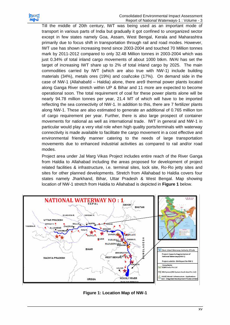
Project area under Jal Marg Vikas Project includes entire reach of the River Ganga
from Haldia to Allahabad including the areas proposed for development of project
related facilities & infrastructure, i.e. terminal sites, lock site, Ro-Ro jetty sites and
sites for other planned developments. Stretch from Allahabad to Haldia covers four
states namely Jharkhand, Bihar, Uttar Pradesh & West Bengal. Map showing
location of NW-1 stretch from Haldia to Allahabad is depicted in Figure 1 below.
Figure 1: Location Map of NW-1
Consolidated Environmental Impact Assessment Report of National Waterways-1 : Volume - 3
xvi
3.0 Project Description
Proposed Project-Jal Marg Vikas aims at improvement of navigation in entire stretch
of 1620 km. of NW-1 (Haldia to Allahabad)1. NW-1 is the Ganga - Bhagirathi -
Hooghly river system. NW-1 is being fed by various tributaries at different locations.
Major tributaries of river Ganga in NW-1 between Haldia to Allahabad are Tons,
Gomti, Ghagra, Son, Gandak, Punpun and Kosi.The following interventions have
been proposed and planned under the Jal Marg Vikas Project.
Maintenance dredging to provide the required LAD in this waterway channel and
also for various proposed terminal facilities.
Improved Navigation Infrastructure & Navigation Aids
o Construction of 5 Ro-Ro crossings & ferry passenger jetties. Locations of
these jetties are yet to be identified.
o Construction of 6 terminals: Site identification and planning for 3 terminals
sites at Sahibganj, Varanasi and Haldia is accomplished. Besides 2 more
potential sites for development of terminals are also identified at Ghazipur
and Kalughatand 1 site, i.e. at Kalyani in Tribeni is under consideration.
o Construction of one new navigation lock at Farakka, West Bengal.
o Provision for tow barges, inland vessels, survey vessels including rescue
boats and survey equipment. Development of low draught vessel2.
o Development of navigation aids along NW-1 for facilitation of day & night time
navigation.
Development of efficient River Information System with all hardware & software.
Provision for bank protection / slope protection and river training works for critical
locations.
The project also envisages the creation and improvement of integration opportunities
with other surface transport modes such as roads and railways, so as to improve the
overall efficiency of the logistics chain by linking the waterways through various well
equipped terminals and jetties.
Cargo proposed to be transported in NW-1 includes cement, fly ash, iron ore, iron ore
fines, coal, steel shed, tyres, iron fines, iron ingots, Galvanized steel plain sheets,
stone chips, furnace oil, high Speed diesel (HSD), lube oil, boulders, pulses,
aluminium block, sand, chips, ship blocks, food grains, manganese ore, petroleum
products, coke, cooking coal, rock phosphate, timber, peas, slag oil, and non-cooking
coal. As per the survey traffic, current traffic transported via rail & road between
Haldia & Varanasi is 121426130 tonne. Traffic projection studies are carried out and
as per the study, projected traffic for year 2045 is 4,80,11,367 tonne. Under NW-1, 6
nos of terminals are proposed out of whch planning for 3 terminals is completed. As
per the planning the cargo handling capacity for base year and year 2045 is given at
Table 1.
1At present IWAI plans to develop it from Haldia to Varansi only.
2In American system this is called low draft vessels.

Consolidated Environmental Impact Assessment Report of National Waterways-1 : Volume - 3
xvii
Table 1: Traffic Forecast for Planned Navigational Infrastructural Facilities
S. No. Infrastructural
Facility
Projected
Cargo-2015
(MTPA)
Projected
Cargo-2030
(MTPA)
Projected
Cargo-2045
(MTPA)
1 Sahibganj
Terminal
2.24 4.39 9.00
2 Varanasi
Terminal (with
current land)
0.54 1.22 1.22
3 Haldia Terminal 3.18MTPA
Source: HOWE Engineering Projects (India) Pvt.Ltd. (Design Consultant)
There are various challenges for Jal Marg Vikas Project development including
typical characteristics of alluvial river Ganga and its braiding, meandering
characteristics and large water fluctuations between summer and monsoon months
with high annual silt loads of 1600 million tonnes. The maintenance dredging
requirements including all other planned infrastructures facilities etc. are designed
addressing all such challenges besides projected transportation needs under
considerations. The salient features of this Jal Marg Vikas Project with the design
details of various planned and proposed developments are given at Table 2.
Table 2: Salient Features of Jal Marg Vikas Project
Salient Features Capacity/Quantity/Nos.
Facilities Planned 3 terminal sites (Sahibganj, Varanasi & Haldia)
1 new Navigation lock- Farakka
River bank protection works at planned terminal sites and along Feeder canal
Facilities under Planning Stage
3 additional terminal sites (at Ghazipur & Kalughat-site finalized and at Tribeni-under consideration)
5 ro-ro crossings
Barge repair and maintenance facilities
River training works
River bank protection works at the proposed civil intervention sites
Designed capacity of Terminals
Infrastructural Facility
Projected Cargo-2015 (MTPA)
Projected Cargo-2030 (MTPA)
Projected Cargo-2045 (MTPA)
Sahibganj Terminal
2.24 4.39 9.00
Varanasi Terminal (with current land)
0.54 1.22 1.22
Haldia Terminal 3.18 MTPA
Navigation Channel
Width-45 m LAD-3 m from Haldia to Barh, 2.5 m from Barh to
Ghazipur and 2.2 m from Ghazipur to Varanasi at present
Design Vessel Specifications
Vessels of maximum length of 110 m, beam of 11.4 m, draught of 2.5 m-2.8 m and air draught of 9 m will be
required in NW-1.
Size of Vessels 1500-2000 dWT

Consolidated Environmental Impact Assessment Report of National Waterways-1 : Volume - 3
xviii
River Slope Haldia to Farakka-1 in 11000 Farakka downstream-1 in 18000 Farakka to Allahabad-1 in 17,000
Maintenance Dredging Within Navigation Channel-14,850,000 cum/year*
Type of Dredgers CSD, Agitation dredgers/plough dredgers and back hoe dredgers
Dredge disposal Preferably off-shore, onshore only if sediments are found to be contaminated
* quantities are tentative and subject to change with revision in planning
3.1 Project Implementation Schedule, Cost and Implementation Responsibilities
The project being of large spatial extent, will be developed in phases. The
implementation period of 3 years is anticipated for completion of phase 1
components of the Jal Marg Vikas Project (6 terminal sites, maintenance dredging,
vessel management system, shore protection works and river training works). Overall
cost of the Jal Marg Vikas Project will depend on finalization of various components
proposed under the project. However, fund allotted by World Bank to Government of
India (GOI) for development of Jal Marg Vikas is about 650 million USD (~4200 Cr).
The Project Director and officer of the rank of Vice Chairman of IWAI will be in
charge of the implementation programme who will be assisted by Project
Management Unit and Regional Directors.
4.0 Environmental Impact Assessment Process
This project is classified as Category „A‟ operations under the world bank
environmental screening procedures specified under its operation policy 4.01. The
project triggers 6 of the World Bank safeguard policy3 and requires comprehensive
environmental assessment. The detailed environmental impact assessment study
has been undertaken for all the proposed components to identify the environmental
and social issues associated with the project. The environmental impact assessment
was carried out by a consortium led by EQMS India Pvt. Ltd. in line with World Bank
Operational Policies,IFC EHS Guidelines for Ports, Harbours and Terminals, IFC
General guidelines for EHS, MoEF&CC EIA Guidelines for Ports and Harbours,
findings of CIA and Standalone EIA studies carried out for civil interventions.
Initially a basin level critical environmental resource study was carried out to identify
“NOGO” and “Restricted areas”. The baseline survey planning was carried out
considering the output of this study as well. In addition to assessing the air, water,
noise soil quality and biological environment (aquatic and terrestrial ecological
aspects), sampling and testing of riverbed sediments quality (for physico-chemical
and contamination characteristics) at different locations in the entire stretch of NW-1
was also carried out. The baseline survey was carried out between: 15thSeptember,
2015 to 28th February 2016 for different period and frequency at different locations
covering the entire stretch of NW-1, finalised intervention areas, likely intervention
areas, likely maintenance dredging areas, existing select RO-RO jetty locations,
existing passenger select ferry locations and environmental sensitive areas.
Influence area was assessed based on different project activities on different VECs.
Being a liner project, the 500m radius on either side of the bank was assessed as
3The world bank safeguard policies triggered are environmental assessment (OP/BP 4.01), Natural Habitats (OP/BP 4.04),
Forests (OP/BP 4.36), Involuntary resettlement (OP/BP 4.12), Physical Cultural Resources (OP/BP 4.11) and Project on International Waterways (OP/BP 7.5)
Consolidated Environmental Impact Assessment Report of National Waterways-1 : Volume - 3
xix
core influence zone, 2 Km radius as extended influence area. The terminal site will
have influence area beyond 2 km. As per Indian standard practice, influence area is
considered as 10 km along the NW-1 stretch and intervention areas for study
purposes. The studies were carried out in tandem with preparation of detailed
engineering feasibility report. This has helped to analyse the suggested alternatives
with environmental perspective also. Further various design measures were modified
during the design stage keeping environmental perspective such as incorporation of
mechanical conveyance system at Sahibganj, mandatory green plantation all around
the periphery and along the roads, dust suppression system at storage and barge
loading areas, provision of storm water management system, separate for buildings
and for surface. Further basin level study has helped to identify the NOGO areas
which has helped to strikeout the environmental sensitive locations for development
of terminals, dredging and other project activities. Bhagalpur was avoided for
development of terminal due to presence of Dolphin sanctuary, even though this site
has good cargo generation potential and engineering feasibility.
Environment impact assessment process started with basin level critical resource
assessment study followed by cumulative impact assessment. Also separate
environmental impact assessment was carried out for each terminal / navigational
lock, maintenance dredging and barge operations. In line with all these studies, this
consolidated report is prepared for the entire NW-1 project. To ensure the public
participation as per World Bank Policies, two stage public consultations, both formal
&informal were undertaken as part of impact assessment process. The impact
assessment covers all three stages of the project viz. design, construction and
operation stages. The impacts are identified from all components and activities of the
project on physical, biological (terrestrial and aquatic ecology) and socio – economic
environment. Environmental management and monitoring programme are suggested
to minimize the identified impacts and sustain the benefits. Institutional Mechanism is
also proposed for effective implementation of environmental management and
monitoring plan.
As per EIA Notification, 2006 as amended at present the project components like
development of terminals & jetties does not requires environment clearance.
However, environment clearance may be required for the activities like borrowing of
earth which should be taken by the respective contractor. Additionally,
NOC/Permissions are required to be obtained by IWAI/Contractor for specific
activities like setting up Hot Mix Plant, DG Sets, STP from respective agencies as
indicated under legal and administrative framework. Each permission will have
associated conditions which need to be complied by contractors / IWAI and same will
be monitored by the permission granting agencies like State Pollution Control Boards
(SPCBs). None of these permissions require detailed environmental impact
assessment however, findings of this EIA and proposed mitigation measures would
be useful in obtaining these permissions.
5.0 Project, Legal and Administrative Framework
The project has been evaluated for applicability of all National, State Laws, Rules
and Regulations. The Acts, rules and guidelines applicable for the project are
critically analysed to list out the permits/NOC required to be obtained by
IWAI/contractor prior and during the development of the project. Environmental
legislations applicable for the project are (i) Environmental Protection Act, 1986 (ii)
Consolidated Environmental Impact Assessment Report of National Waterways-1 : Volume - 3
xx
EIA Notification, 2006 as amended till date (iii) Forest Conservation Act, 1980 (iv)
Wildlife Life Protection Act, 1972 (v) CRZ Notification, 2011 (vi) Air (Prevention and
Control) of Pollution Act 1981/1987 (vii) Water (Prevention and Control of Pollution)
Act, 1974/1988 (viii) Hazardous and Other Wastes (Management &Transboundary
Movement) Rules, 2016 (ix) Other waste management & safety rules, regulations
and guidelines; Construction and Demolition Waste Management Rules 2016, E-
Waste Management Rules, 2016; Plastic Waste Management Rules, 2016; The
Battery Management and Handling Rules, 2001;Ancient Monument and
Archaeological Site and Remains Act, 1958.
As per EIA Notification, 2006 as amended at present the project components like
development of terminals & jetties does not requires environment clearance.
However, Environmental clearance will need to be obtained for any project
component wherever found applicable due to any amendment to the above
notification. The environmental clearance under minor mineral category of EIA
notification 2006 should be taken by the contractors as applicable before borrowing
the earth and for setting up new quarry site. Consent to establish under Air and
Water Acts for setting up batching plant, hot mix plant, DG sets, soak pit & septic
tank/STP should be obtained by the contractor before setting up these facilities from
State Pollution Control Boards. The contractors / IWAI will ensure compliance to the
conditions of these permissions and should abide by the monitoring requirement to
be imposed by the permission granting agencies. No diversion of forest land is
involved in the project, however; cutting of trees will be carried out for construction of
terminals and other interventions and permission will be required from concerned
authorities or forests departments as per law of respective states. Waste/used oil is
the only hazardous waste likely to be generated during construction and operation
stage which should be managed as per Hazardous & Other Waste Management
Rules, 2016. Other waste related regulations should also be followed depending on
nature of waste generation during construction and operation stages as defined
above.
Permission under CRZ Notification, 2011 is required for establishing Haldia Terminal
from West Bengal Coastal Zone Management Authority. The process for this
permission has already been initiated. Permission for movement of vessel through
KashiTurtle Sanctuary & Vikramshila Gangetic Dolphin Sanctuary located under Wild
Life Protection Act, 19724. Process has already been initiated for obtaining these
permissions. There are nine archaeological sites located within 300m area of river
bank on NW-1. No construction activities are proposed closed to these sites.
Permissions should be obtained from archaeological department if any construction
is planned in near future within 300 m of these sites.
Additional international conventions/treaties applicable for the project have been
analysed. India being signatory of IMO, is obliged to follow the environmental and
safety guidelines prescribed under various conventions. Some of the regulation and
guidelines applicable to vessels plying in Indian inland waterways as per IWAI
includes (i) Prevention of Collision on National Waterways Regulations, 2002 (ii)
National Waterways, Safety of Navigation and Shipping Regulations, 2002 (iii) The
4As per notification, restriction are imposed for fishing (larvae of Hilsha & during breeding & spawning season) only in Hislha
Sanctuary
Consolidated Environmental Impact Assessment Report of National Waterways-1 : Volume - 3
xxi
National Waterway-1 Act, 1982 (iv) New Inland Vessel Act, 2015 & Rules Under IV
Act (v) Relevant other International Environmental Convention.
6.0 Key Safeguard documents
A detailed description of project baseline environmental conditions, identified positive
and negative environmental impacts, the mitigation measures to eliminate or
minimize the adverse impacts and enhance the positive impacts, detailed
environmental management plan including institutional responsibilities,
implementation schedule, environmental budget, arrangement for monitoring and
evaluation and grievance redressal mechanism are provided in the consolidated
environmental impact assessment report for NW-1 and environmental impact
assessment report of Ramnagar (Varanasi terminal), Sahibganj terminal, Farakka
Lock, and Haldia terminal. The other supplementary documents prepared under this
project are i) Basin Level Critical Environmental Resource Assessment report; ii)
Consolidated rehabilitation action plan for NW-1, iii) Rehabilitation action plan for
Sahibganj, iv) EIA Report for maintenance dredging and barge operations.
7.0 Public Consultation and Disclosure
Stakeholder‟s view and perception was assessed through informal and formal public
consultation meetings. The different stakeholders viz. Govt. officials, NGOs, Village
Panchayats (Village Administration), people (male, female) were contacted and
consulted during the course of the study. Stakeholders were informed about the
project components and likely environmental impacts before seeking their views. In
each consultation all efforts were made to have adequate participation from women
as well. Consultations has been carried out for the project in two stages. First stage
consultation was undertaken during impact assessment process to identify the
concerns of people which were duly addressed through appropriate mitigation
measures. Second stage consultation was undertaken after preparation of EIA report
so as to assess the adequacy and acceptability of the proposed mitigation measures
and management plan. Public consultations ensured involvement of public, NGO,
experts in the project‟s pre-planning stage itself and addressal of their concerns and
expectation from the project.
The community members, government officials and NGO members opined that the
proposed project would contribute to social and economic development of the region.
The proposed project would contribute to increase employment opportunities for the
local people during and after project implementation. The communities welcomed the
project and all were in favour of the project. However, some of the fishermen and
land holders have raised some concerns about the fishing activities/yield and the
compensation to be given. Major issues highlighted during consultation were
adequate compensation against the land, loss of livelihood, provision of alternate
employment, river water pollution, fish yield and disruption of fishing activities. Each
of the issues raised by stakeholders was analysed for practical and scientific basis,
and for developing an appropriate mitigation, management and monitoring plan,
depending on its importance and practicality.
An executive summary of consolidated EA report is available for public scrutiny in
local language (Hindi and Bengali) versions at IWAI website. EIA report for entire Jal
Marg Vikas Project and its executive summary is also disclosed at IWAI website and
Consolidated Environmental Impact Assessment Report of National Waterways-1 : Volume - 3
xxii
as per provisions of World Bank disclosure policies. A brief table illustrating the key
concerns of the informal stakeholders is given below in Table 3.
Table 3: Summary of Key Concerns raised by stakeholders and its redressal
S. No. Key Concerns Redressal
Social Concerns
1 Fishing community raised
concern regarding effect on fish
productivity and demanded
support from project for the
same.
Such impacts are unlikely from this
project. However, mitigation,
enhancement measures are
proposed under EMP for reduction
of impacts if any due to
construction & operation of NW-1
and its components. Some of the
measures includes:
Technical support for enhancing
fish productivity by setting up
demonstration nurseries and
training centre through institute of
repute like CIFRI
Regulated/slow speed of vessel at
select locations and Zero Pollution
approach from vessel and terminals
Intimation of dredging/piling plan to
fishermen community prior to
carrying out any activity
Provision of sirens and strong
search lights in vessels/barges to
pre-warn the fishermen
2 Provision should be made for
adequate compensation for land
acquisition wherever applicable.
SIA and RAP has been prepared for
Sahibganj and consolidate SIA/RAP
for NW-1. Provision of due
compensation has been made as
per these plans which are prepared
as per applicable R&R policies.
3 People desired to have the
relocation site for the people
likely to be displaced near river
Ganga.
Relocation site is proposed to be
selected by the concerned
authorities responsible for land
acquisition in consultation with
people concerned.
4 People demanded support for
the improvement in and around
local immersion Ghat at
Budgetary provision is made under
EMP for improvement of Ghats as
an enhancement measures.
Consolidated Environmental Impact Assessment Report of National Waterways-1 : Volume - 3
xxiii
Durgachak (near Haldia terminal
in West Bengal) to reduce
congestion, especially during the
local festival.
Additional enhancement measure
has been proposed for small
enclosed areas dedicated for
female bathing in every village
along the NW-1 to allow female
maintain their privacy while fulfilling
their religious belief of bathing in
river Ganga.
Environmental Concerns
1 People raised concern that the
terminal development may lead
to increased traffic on the
connecting roads which are not
suitable for such an increased
load and needs to be upgraded.
Project design has considered this
aspect and adequate provision is
made for developing access road to
the terminals to avoid any kind of
congestion at each terminal sites.
2 Turtleswill be affected due to
regular movement of vessels in
river in Kashi Turtle Sanctuary
Maximum of 1-2 vessels per hour
are expected to move in the
sanctuary area. Speed of vessels
shall be maintained to 5 kmph/2.7
knots in turtle sanctuary area.
Barge movement at this speed
generates noise in order of 110-
140dB. Threshold noise level of
turtles for change in behavioural
response is 150 dB which is above
the noise expected to be generated
by moving barges and the impact
on turtles behaviour responses is
anticipated to be insignificant. Other
measures are also being proposed
in the EMP to minimize impact of
barge movement on turtle.
3 Dolphins will be affected due to
barge movement during the
operation phase of the project.
Adequate mitigative measures have
been proposed in the project design
which includes provision of
propeller guards to prevent
entangling of dolphins and other
mammals, speed restriction in the
sanctuary area and a restrictive
buffer zone of 100m horizontally
and 500m longitudinally either side
of the river confluence areas for any
dredging activity. Other measures
are also proposed in management
plan to reduce the impact on
Consolidated Environmental Impact Assessment Report of National Waterways-1 : Volume - 3
xxiv
dolphins and other aquatic fauna.
4 Oil spillage from ships during
accident may impact the aquatic
flora, fauna, water quality and
anti-bacterial properties of river
Ganga.
Such situations are remote. Safety
measures are proposed in the EMP
for vessels as well. No vessels are
expected to discharge any of its
liquid or oily waste in the river.
Emergency response plan would
deal with such situations to
minimize the impact of emergency
situations. It is also proposed that
each vessel would have appropriate
sewage treatment, treated sewage
storage and waste management
facilities to prevent water pollution.
5 People raised concerns
regarding the likely impact on
water quality due to construction
and operation of terminal facility
and cargo movement.
Environment management plan has
incorporated the measures for
prevention of water pollution from
terminals, and barge operations.
Zero discharge approach is
proposed for terminals development
and barge operations.
6 People raised concern about
cutting of large no. of tree at
Sahibganj site.
Compensatory tree plantation (1:7
basis) at Sahibganj and additional
plantation is proposed to be
undertaken. At all the terminal/jetty
site green belt will be developed to
the extent possible. This will help in
minimizing the impact and will lead
to reduced impact of CO2.
7 The varying LAD may lead to
grounding of vessels.
LAD is proposed to be maintained
in the stretch between Haldia to
Varanasi during entire lean period
8 Dredging may have significant
impact on breeding and
spawning season of fishes.
Dredging is proposed to be
regulated during breeding and
spawning season of the fishes.
9 People have pointed
outtheexisting erosion problem
in the Farakka feeder canal and
voicedthe apprehension that the
NW-1 development and barge
movement may escalate this
problem.
Provision has been made in the
project design for bank protection
work of 9.438 km; it is proposed to
be undertaken on banks of feeder
canal to prevent the erosion.
Consolidated Environmental Impact Assessment Report of National Waterways-1 : Volume - 3
xxv
10 People have suggested that
appropriate parking facilities be
madeinside the proposed
terminals for better management
of goods carriers and to reduce
traffic on existing road due to
inappropriate parking on the
public roads.
Adequate parking provisions are
proposed in each terminal site
design.
11 People have proposed adequate
provisions forprevention of water
logging in and around the
terminals, and for firefighting.
Adequate drainage provision is
made for channelizing the rain
water at each terminal site. Fire-
fighting facility is also proposed at
each terminal site.
8.0 Alternative Analysis
Analysis of alternatives is an analytical comparison of the operational effectiveness,
costs and environmental and social risks of proposed development options. This
helps to analyse the options critically in relation to its impacts on all physical, social
and biological environments. For this project, alternative analysis has been made for
three considerations, i.e. strategic, planning and technology consideration. The
summary of these analysis is presented below:
8.1 Strategic Consideration
A comparison is made for “With” & “Without” project scenario for the physical, social
and biological environments and status of cargo transport scenario. “With Project
Scenario” is considered better for all physical, biological, social environmental and
cargo transport scenario compared to “Without Project Scenario”. With Project
Scenario will improve the freight transportation efficiency, reduce the GHG
emissions, fuel requirement, air emissions, land acquisition, and tree cutting for
maintaining and expanding cargo movement requirement. However, impacts are
anticipated more on water and aquatic ecology in “With Project” scenario compared
to rail and road for which mitigation and management plans are prepared to minimize
the impacts.
8.2 Planning Consideration:
This involves the consideration of options for location of the proposed interventions,
suitability of intervention sites, design of the project layout and dredging extent.
Locations are selected for proposed civil interventions (terminals/jetties) on the basis
of potential of freight/cargo movement in the area and its connectivity with other
modes of transport (Rail and Road). 10such locations were selected for development
of 6 terminals and 1 navigational lock. One of the probable locations at Bhagalpur
was ruled out due to presence of Vikramshila Gangetic Dolphin Sanctuary and based
on “NO GO” areas identified in Basin Level Critical Resources Assessment study.
Two sites at Varanasi and Sahibganj were identified few years back where land
acquisition process was either completed or is near completion and thus were not
included in the locational alternative analysis. However, acceptability of these sites
from environmental aspects were assessed which were found acceptable. The
Consolidated Environmental Impact Assessment Report of National Waterways-1 : Volume - 3
xxvi
terminal sites at Haldia, proposed to be located on Government Land (Kolkata Port
Trust Land) which is already being used for shipping and industrial purposes, were
considered acceptable from environmental and social aspects. The location of
navigational lock at Farakka is already existing and navigation lock parallel to existing
lock is proposed. Remaining seven sites were analysed from environmental and
social, design considerations. Based on alternative analysis three terminal sites at
Ghazipur, Tribeni (Kalyani), Kalughat near Doraiganjwere considered as preferred
sites for these interventions. The other three terminal sites at Barh, Kahalgaon
&Baliawere not considered feasible due to (i) various environmental consideration
including proximity to Vikramshila Dolphin sanctuary and Important Bird Areas, (ii)
design issues such as unstable river, presence of navigational hazards and high
sedimentation rate (iii) social issues concerning acquisition of land and (iv)
connectivity.
Further alternative analysis was carried out for probable two sites at each of the
above identified three terminal locations and Farakka lock, based on environmental,
social and design consideration. As per this analysis, the preferred sites for these
intervention locations were considered for design and environmental impact
assessment.
At the time of impact assessment terminal designs were ready for Varanasi,
Sahibganj, and Haldia terminals only. Considering technical feasibility, multiple layout
options were available only for Sahibganj terminal& Farakka lock. These layout
options were analysed for identification of most suitable design options. In case of
Sahibganj terminal, Alternative 1 involves construction of U shaped jetty (25 m),
aligned parallel to the River bank and connected to bank by approach trestle of 50 m
and alternative 2 involves construction of jetty at the river bank aligned parallel to it.
Both the alternatives were compared on multiple criteria, i.e. operational
considerations, navigational aspects, ease of construction & maintenance, flexibility
of expansion, construction cost and environmental considerations. Both the
alternative layouts have certain advantages as well as disadvantages. It could be
observed that in terms of available required depth throughout the year and marginal
cost difference between two alternatives and environmental consideration,
Alternative-I is found preferred alternative for development of IWT Terminal at
Sahibganj. In case of Farakka lock, alternative 1 involves construction of lock parallel
to the existing lock and in alternative 2, lock will be constructed D/S of the existing
lock. Considering the design, requirement of land, length of embankment, availability
of depth, dredging requirement etc. It is found that the alternative 1 is better than
alternative 2.
To maintain the river navigability, maintenance dredging is required to be planned so
as to maintain the length and width of the channel and maintain LAD near the
berths/jetty. IWAI proposed either maintaining 3m LAD throughout the NW-1 stretch
or maintained different LAD in different stretches (3 m Haldia to Barh, 2.5 m from
Barh to Ghazipur and 2.2 m from Ghazipur to Varanasi). Width5 of 45 m will be
maintained throughout the navigation channel with side slope of 1:5. Alternative
analysis was carried out for both these options considering environmental (dredge
quality, impact on aquatic ecology and water quality), social (cultural and aesthetic
5The channel width is proposed to limit to 45m in phase I which will further reduce the maintenance dredging requirements.
.
Consolidated Environmental Impact Assessment Report of National Waterways-1 : Volume - 3
xxvii
value, employment and socio-economic consideration) and technical feasibility
(dredge quantity, navigation feasibility, economic aspects, dredgers and other
infrastructure requirements). As per analysis option of maintaining different LAD at
different stretch was found most preferred option.
8.3 Technological Consideration:
The technological aspects were analysed in terms of dredging technology. Five type
of dredgers namely cutter suction dredgers (CSD), hopper dredgers, grab/bucket
dredgers and back-hoe dredgers were analysed. These were analysed based on
safety, accuracy, turbidity, spills and noise criteria as well as operational feasibility.
The CSD was considered as most preferred option due to least associated
environmental Impact and operational feasibility. Typically, CSDs have least effect on
turbidity at the dredging site. Grab dredgers and TSGDs when used with overflow,
produce significantly high turbidity throughout the water column near the dredging
site than do CSDs. Underwater noise generation in CDSs is comparatively lesser
than other dredgers. As per experience of KoPT and IWT also CSD has proven to be
the best option and is considered for maintenance dredging planning and
environmental impact assessment. Additionally, to further reduce disturbance to the
riverbed sediments, water injection dredgers would be used in the project.
8.4 Integration of analysis of Alternatives and Suggested Design Consideration
into Project Design
Since studies were being carried out along with the feasibility report preparation, the
output of alternative analysis and design consideration was discussed with the
design team and incorporated in the project design. Some of the design changes
include provision of mechanical material handling system at Sahibganj Terminal, dust
suppression system at each terminal, provision of green belt all along the terminal
boundary, integration of green building concept in terminal buildings, adoption of zero
discharge concept at terminals and barges, rain water harvesting, emergency
response planning, exploring feasibility of using low draft vessel and alternative fuels
for barge operations. The project description details presented below includes the
above considerations.
9.0 Salient Environmental Features of NW-1
The salient features of environmental resources within influence area (10 Km) of NW-
1, are presented at Table 4. Topography of the whole of NW-1 (Allahabad to Haldia)
falls within a relatively flat terrain of the Indo-Gangetic plain. The elevation within the
influence area of the NW-1 stretch, ranges between 1 m amsl (meter above sea
level) and 321 m amsl. Highest elevation levels were observed at Sahibganj area
(Jharkhand) due to presence of small hillocks. Land use within influence area of the
NW-1 is majorly dominated by agricultural land. About 78.9 % of the land is under
cultivation; about 7.18% land is under settlement, 7.21% of the land is under water
bodies, about 3.59% land is under vegetation, 2.82% land is under dry river bed and
rest of the land falls under other uses.

Consolidated Environmental Impact Assessment Report of National Waterways-1 : Volume - 3
xxviii
Table 4: Salient Environmental Features along NW-1 Alignment
S.
No.
Environmental
Features
Within 500 m
influence area
around NW-1
Within 2km
Influence area
around NW-1
Within 10km
influence area
around NW-1
1 Ecological Environment
A Presence of National Park/Biosphere Reserves, Tiger reserve etc.
None
None None
Presence of Wildlife Sanctuary
Yes 1. Kashi Turtle
Sanctuary at Varanasi 2. Vikramshila Dolphin
Sanctuary Kahalgaon to Sultanganj
3. Hilsa Sanctuary stretch in west Bengal
None Yes
Udhwa lake
sanctuary in
Jharkhand (about 9
km away from NW-1
B Reserved /Protected Forests
None None Yes (Bethuadahari
RF, Bahadurpur RF &
RF near Rajmahal
Hills)
C Wetland of state and national interest
None None Yes (Udhwa Bird sanctuary)
D Migratory route for
wild terrestrial
animals
None None None
E Presence of Schedule-I Terrestrial Fauna
None Yes Migratory birds near Farakka Barrage and surrounding
Yes Migratory birds at important birds‟ areas
F
Presence of Schedule-I Aquatic Fauna
Yes Dolphin, and Turtle (more frequently sighted)
Smooth Coated Otter and Crocodile (very rarely sited in Ganges system)
None None
G Important Bird Area Vikramshila sanctuary area
Yes 1. Danapur
Cantonment area 2. Mokamatal 3. Kurseala river
course and diyara flood plain.
4. Farakka Barrage and surround area
Yes Udhwa lake sanctuary
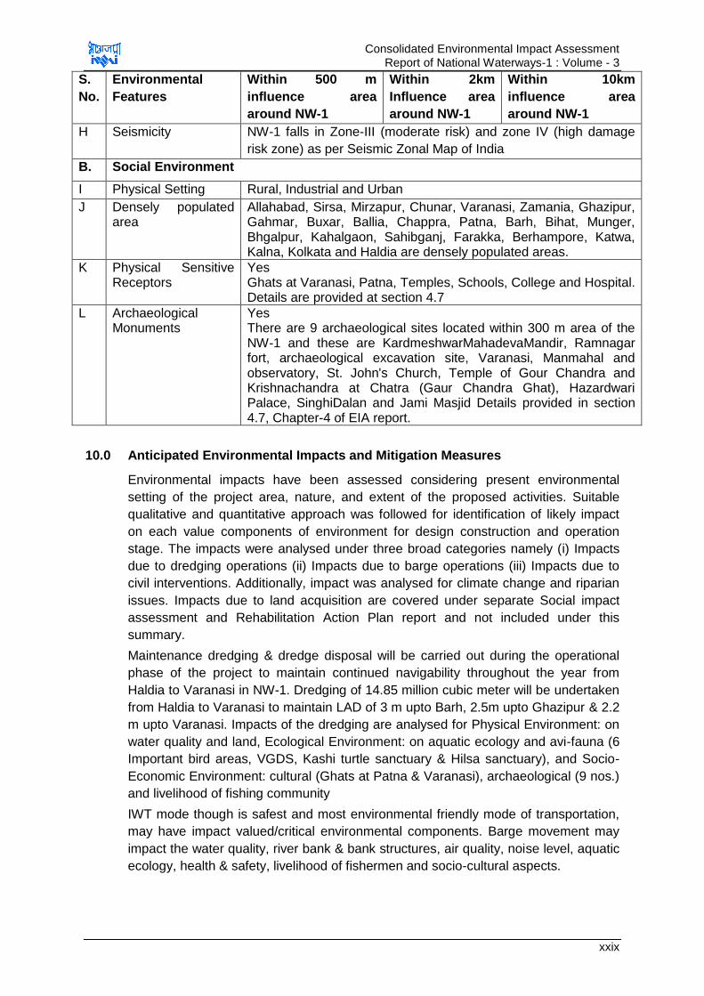
Consolidated Environmental Impact Assessment Report of National Waterways-1 : Volume - 3
xxix
S.
No.
Environmental
Features
Within 500 m
influence area
around NW-1
Within 2km
Influence area
around NW-1
Within 10km
influence area
around NW-1
H Seismicity NW-1 falls in Zone-III (moderate risk) and zone IV (high damage
risk zone) as per Seismic Zonal Map of India
B. Social Environment
I Physical Setting Rural, Industrial and Urban
J Densely populated area
Allahabad, Sirsa, Mirzapur, Chunar, Varanasi, Zamania, Ghazipur, Gahmar, Buxar, Ballia, Chappra, Patna, Barh, Bihat, Munger, Bhgalpur, Kahalgaon, Sahibganj, Farakka, Berhampore, Katwa, Kalna, Kolkata and Haldia are densely populated areas.
K Physical Sensitive Receptors
Yes Ghats at Varanasi, Patna, Temples, Schools, College and Hospital. Details are provided at section 4.7
L Archaeological Monuments
Yes There are 9 archaeological sites located within 300 m area of the NW-1 and these are KardmeshwarMahadevaMandir, Ramnagar fort, archaeological excavation site, Varanasi, Manmahal and observatory, St. John's Church, Temple of Gour Chandra and Krishnachandra at Chatra (Gaur Chandra Ghat), Hazardwari Palace, SinghiDalan and Jami Masjid Details provided in section 4.7, Chapter-4 of EIA report.
10.0 Anticipated Environmental Impacts and Mitigation Measures
Environmental impacts have been assessed considering present environmental
setting of the project area, nature, and extent of the proposed activities. Suitable
qualitative and quantitative approach was followed for identification of likely impact
on each value components of environment for design construction and operation
stage. The impacts were analysed under three broad categories namely (i) Impacts
due to dredging operations (ii) Impacts due to barge operations (iii) Impacts due to
civil interventions. Additionally, impact was analysed for climate change and riparian
issues. Impacts due to land acquisition are covered under separate Social impact
assessment and Rehabilitation Action Plan report and not included under this
summary.
Maintenance dredging & dredge disposal will be carried out during the operational
phase of the project to maintain continued navigability throughout the year from
Haldia to Varanasi in NW-1. Dredging of 14.85 million cubic meter will be undertaken
from Haldia to Varanasi to maintain LAD of 3 m upto Barh, 2.5m upto Ghazipur & 2.2
m upto Varanasi. Impacts of the dredging are analysed for Physical Environment: on
water quality and land, Ecological Environment: on aquatic ecology and avi-fauna (6
Important bird areas, VGDS, Kashi turtle sanctuary & Hilsa sanctuary), and Socio-
Economic Environment: cultural (Ghats at Patna & Varanasi), archaeological (9 nos.)
and livelihood of fishing community
IWT mode though is safest and most environmental friendly mode of transportation,
may have impact valued/critical environmental components. Barge movement may
impact the water quality, river bank & bank structures, air quality, noise level, aquatic
ecology, health & safety, livelihood of fishermen and socio-cultural aspects.
Consolidated Environmental Impact Assessment Report of National Waterways-1 : Volume - 3
xxx
The civil interventions will have largely construction and operation related impacts.
Impacts are summarised based on the impact assessment carried out for Varanasi,
Sahibganj and Haldia terminals and Farakka navigational lock. The impacts identified
for these four sites are likely to be the similar for other interventions sites barring few
site specific issues related to tree cutting, land acquisition, muck disposal and
construction material sourcing.
The impacts are summarised below for valued/critical environmental components in
two groups i) impacts due to dredging and barge operations and ii) impacts due to
civil interventions. The baseline conditions are summarised under first group itself.
The impacts on climate change and riparian issues are summarised following these
two groups impacts.
10.1 Impacts due to maintenance dredging and barge operations
10.1.1 Impact on land and water quality
A. Baseline conditions
Soil and River Bed Sediment Quality: Soil quality monitoring is carried out along
NW-1 and within the critical impact zones considered for planned civil interventions
as per CPCB guidelines. Soil type is influence area is dominated by alluvial soil. Soil
texture varies from sandy clay to clayey loam type and soils are marginally acidic to
slightly alkaline with pH ranging from 6.62-7.86. Electrical Conductivity ranges
between 135.4 & 360.5 µmhos/cm. Soils in the influence area are moderately fertile.
The concentration of heavy metal & pesticides in river bed sediments was found low
in concentration at each sampling location and are within acceptable limit for off-
shore disposal as per “Criteria for Off-Shore Dumping of Dredged Material”, USA
except for cadmium which is slightly above the prescribed limit in UP stretch.
Cadmium levels can be high due to industrial effluent discharge in this section.
Ground and Surface Water Quality: Ground water quality monitoring is carried out
along NW-1 and within the critical impact zones considered for planned civil
interventions as per CPCB guidelines. TDS, Total Hardness and chloride values at
Haldia and Sahibganj, Howrah and Kolkata are slightly above the desirable limit but
are within the permissible limits specified of IS: 10500. Fe and Zn were detected in
water samples but in lower concentration. Arsenic was detected in samples collected
from Bhagalpur and Munger but in lower concentration.
River water quality monitoring is carried out along NW-1 and u/s & d/s of planned civil
interventions as per CPCB guidelines. River water qualities meets BDU Class „D‟
Criteria of CPCB barring few parameters pH & DO which meets class „A‟ criteria, i.e.
for propagation of Wild life and fisheries
B. Impact on water quality & land due to dredging operations:
Impacts: Impact of dredging on water quality are increase in turbidity; reduced light
transmittance; reduced DO; changes in salinity, temperature, pH & concentration of
nutrients and release of heavy metals/chemicals. As per a study, DO level comes
down suddenly by 2 to 2.5 mg/l for maximum of 2 minutes only at the dredge plume
arrival point which is regained within 3-4 minutes as plume passes. As per baseline
study, river bed sediments are non-toxic except in Allahabad to Buxar stretch where
Consolidated Environmental Impact Assessment Report of National Waterways-1 : Volume - 3
xxxi
Cadmium level is found marginally higher compared to US standard for off-shore
sediment disposal. However, this higher level is unlikely to have toxic effect on
aquatic life considering the sensitivity level to cadmium exposure (short terms at LC50
level) to aquatic life as per Canadian Guidelines6. Pesticides are present in traces but
much below the safe limit for off-shore disposal. Turbidity of water also increases
substantially close to dredging point but it reduces with distance and almost get
normalise at a distance of 700 m from dredging point. Coarser sediments settle much
faster and at shorter distance. Presence of iron in sediments enhances settling of fine
sediments as it acts as coagulant. Land disposal of sediments is anticipated only
when sediments are contaminated and in case of Haldia terminal dredging. When the
dredged material is disposed on land in form of slurry, excess water drains back to
the water body which can affect the water quality.
Key Mitigation Measures: Key mitigation involves reduction in dredging quantity by
studying thalweg profiles, bandalling and usage of low draught vessels. Sediment
loss can be minimized by wise selection of dredger depending on strata and depth
and CSD are proposed accordingly. Selection of size of cutter head and other
technical specifications can further be reducing dredged sediment loss.
If dredge material is found contaminated at any particular location, then it should be
disposed on land after decontamination. On land disposal of dredged material should
be carried out only at approved TSDF site such as approved TSDF site of Haldia
Dock Complex at Sagar. The contaminated dredge material shall be collected in the
leak proof container for decontamination and disposal to the landfill site. The disposal
facilities should be designed with adequate liners to contained the leachate and also
should have provision of leachate collection and testing to periodically check the
functionality of the disposal site. If dredged material is disposed on land, then the
care should be taken that the tail water is collected and made free from sediments
prior to its discharge back to surface water body.
C. Impact on water quality due to barge operations:
Impacts: Vessels generate garbage, oily waste, sewage, bilge water & ballast water
which can affect the water quality of the river. Usage of antifouling paints may also
impact the water quality as the paints may contains toxins. Settling of the dust of the
material transported on river surface again can impact the river water quality. Ship
accidents/collision may lead to spillage of the commodities transported including oil
which may impact the water quality of the river.
Key Mitigation Measures: Management of wastewater, oily waste, bilge water,
noxious waste (if any), air emissions & garbage from vessels as per MARPOL can
prevent the water quality pollution. All maintenance & repair works should be carried
out at designated locations only. Only toxin free paints should be used for anti-fouling
purpose. Experienced crew should be hired to minimize the accident occurrence.
Information of available LAD in form of electronic charts should be made available to
navigators and intimation of navigational hazards in form of cautionary signage
should be displayed at required locations to minimize the accidents and spillage of
material in river. Oil carrying ships (>5000 dwT) should be double hulled as
prevention against oil spills.
6As per Canadian Environmental Quality Guidelines, Canadian Council of Ministers of the Environment, 2014
Consolidated Environmental Impact Assessment Report of National Waterways-1 : Volume - 3
xxxii
D. Impact on river bank & river bank structures due to barge operations:
Impacts: Wave generated due to vessel movement may lead to bank erosion.
Impacts are anticipated to be minimal except at Feeder canal which is narrow and
have erodible banks.
Key Mitigation Measures: Restricting speed of vessels in narrow stretches & along
sharp bends may minimize the erosion. Bank protection and bend straightening
works can protect banks from erosion.
10.1.2 Impact on Air Quality and Noise Level
A. Baseline conditions
Meteorology: The predominant wind direction in all IMD stations located along NW-1
is from North and Northwest direction in winters and South and Southeast direction
during rest of the season. The wind speed in the area ranges between 1.9 kmph
(Patna) and 8.7 kmph (Kolkata). December and January constitutes winter months
with daily mean minimum temperature of around 9.1oC at Patna and daily mean
maximum temperature of around 26.9oC at Kolkata. April and May are the hottest
months with daily mean minimum temperature of 24oC at Malda and daily mean
maximum temperature of 40.4oC at Varanasi. Relative humidity ranges between 25 &
84%. The annual rainfall in the project area ranges between 1000.3 mm (Varanasi)
and 1728.5 mm (Kolkata).
Air Quality: Ambient air quality monitoring (PM2.5, PM10, SO2, NO2 and CO) was
carried out along NW-1 and within the critical impact zones considered for planned
civil interventions as per CPCB guidelines. PM10 level varies from 39 to 145 µg/m3.
PM10 levels are within 100 µg/m3 at all the locations except Varanasi (near bridge),
Patna and Howrah. PM2.5 levels ranges from 16 to 58µg/m3 and are within the CPCB
limit of 60 g/m3. Level of SO2 & NOx ranges from 4.4 to 35.6µg/m3 and 9.0 to
48µg/m3 respectively and are within the prescribed limits of NAAQs, 2009. CO is
detected at Haldia, Howrah, Patna and Varanasi only. The 8hrs CO level at these
locations ranges from 0.18 to 1.2 mg/m3 and are within limits of NAAQs, 2009.
Noise Quality: Noise level monitoring is carried out along NW-1 and within the
critical impact zones considered for planned civil interventions as per CPCB
guidelines. Ambient noise levels at all monitored locations are found within the
prescribed Standards of CPCB as per land use except at Kashi turtle sanctuary
because of anthropogenic activities like worship, bathing etc.
B. Impact on Air Quality due to dredging and Barge movement:
Impacts: Barges also generate emissions but this is far less as compared to road
and rail for transportation of same quantity of cargo for the same distance. Thus
impacts on air quality are anticipated to be positive. As per analysis there is reduction
in emission generation of all the pollutants. Emission savings in “With project”
scenario is given in Table 5.
Table 5: Emission Savings Due to Shift of Freight from Road & Rail to IWT Mode
Year SO2 emissions (Tonne/Yr.)
NOx
emissions (Tonne/Yr.)
CO emissions (Tonne/Yr.)
HC emissions (Tonne/Yr.)
PM Emissions (Tonne/Yr)
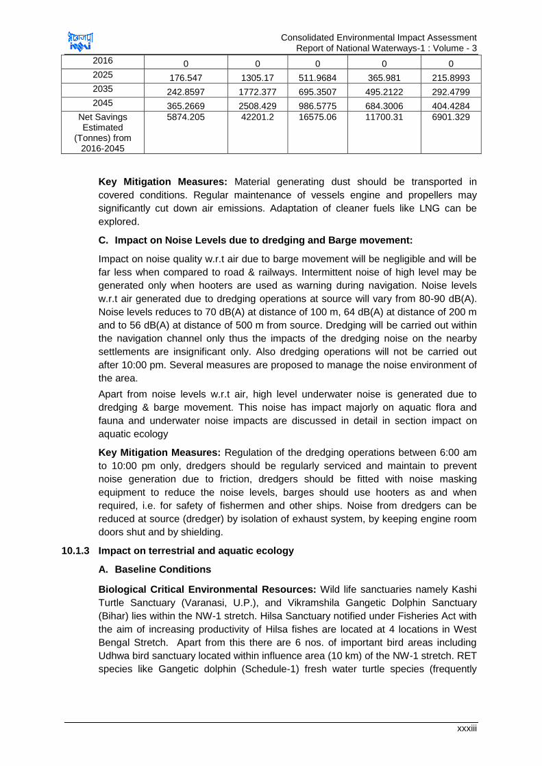
Consolidated Environmental Impact Assessment Report of National Waterways-1 : Volume - 3
xxxiii
2016 0 0 0 0 0
2025 176.547 1305.17 511.9684 365.981 215.8993
2035 242.8597 1772.377 695.3507 495.2122 292.4799
2045 365.2669 2508.429 986.5775 684.3006 404.4284
Net Savings Estimated
(Tonnes) from 2016-2045
5874.205 42201.2 16575.06 11700.31 6901.329
Key Mitigation Measures: Material generating dust should be transported in
covered conditions. Regular maintenance of vessels engine and propellers may
significantly cut down air emissions. Adaptation of cleaner fuels like LNG can be
explored.
C. Impact on Noise Levels due to dredging and Barge movement:
Impact on noise quality w.r.t air due to barge movement will be negligible and will be
far less when compared to road & railways. Intermittent noise of high level may be
generated only when hooters are used as warning during navigation. Noise levels
w.r.t air generated due to dredging operations at source will vary from 80-90 dB(A).
Noise levels reduces to 70 dB(A) at distance of 100 m, 64 dB(A) at distance of 200 m
and to 56 dB(A) at distance of 500 m from source. Dredging will be carried out within
the navigation channel only thus the impacts of the dredging noise on the nearby
settlements are insignificant only. Also dredging operations will not be carried out
after 10:00 pm. Several measures are proposed to manage the noise environment of
the area.
Apart from noise levels w.r.t air, high level underwater noise is generated due to
dredging & barge movement. This noise has impact majorly on aquatic flora and
fauna and underwater noise impacts are discussed in detail in section impact on
aquatic ecology
Key Mitigation Measures: Regulation of the dredging operations between 6:00 am
to 10:00 pm only, dredgers should be regularly serviced and maintain to prevent
noise generation due to friction, dredgers should be fitted with noise masking
equipment to reduce the noise levels, barges should use hooters as and when
required, i.e. for safety of fishermen and other ships. Noise from dredgers can be
reduced at source (dredger) by isolation of exhaust system, by keeping engine room
doors shut and by shielding.
10.1.3 Impact on terrestrial and aquatic ecology
A. Baseline Conditions
Biological Critical Environmental Resources: Wild life sanctuaries namely Kashi
Turtle Sanctuary (Varanasi, U.P.), and Vikramshila Gangetic Dolphin Sanctuary
(Bihar) lies within the NW-1 stretch. Hilsa Sanctuary notified under Fisheries Act with
the aim of increasing productivity of Hilsa fishes are located at 4 locations in West
Bengal Stretch. Apart from this there are 6 nos. of important bird areas including
Udhwa bird sanctuary located within influence area (10 km) of the NW-1 stretch. RET
species like Gangetic dolphin (Schedule-1) fresh water turtle species (frequently

Consolidated Environmental Impact Assessment Report of National Waterways-1 : Volume - 3
xxxiv
sighted), The smooth coated Otter and crocodile (very rarely sighted) are present in
the river stretch of the NW-1.
Terrestrial Flora: There is no major forests area present along the NW-1. The
riparian flora consists of commonly found trees, shrub and herb species. No rare and
endangered plant species observed in the riparian area of the NW-1.
Terrestrial Fauna: As no major forest area is present along the NW-1 stretch the
terrestrial fauna is restricted to commonly found terrestrial faunal species. No
Schedule-I terrestrial mammals‟ species observed along the NW-1 stretch. However,
6 IBA located within influence area of NW-1 are the major wintering site for many of
migratory water birds. Some of the rarer/endangered/vulnerable avifauna has been
reported in these IBAs.
Aquatic Flora & Fauna: The aquatic floral and faunal diversity of NW-1 stretch
comprise phytoplankton, zooplankton, zoo-benthos, fish and higher vertebrates.
Phytoplankton is represented by Chlorophyceae, Bacillariophyceae, Cyanophyceae,
Euglenophyceae, Xanthophyceae and Rhodophyceae groups. Dominance of
Bacillariophyceae members followed by Chrophyceae and Cyanophyceae was
observed in NW-1 stretch. Zooplankton comprises of Protozoans, Rotifers and
Crustaceans. Phytoplankton and zooplankton diversity is little higher in Farakka to
Haldia stretch in comparison of Allahabad to Farakka stretch. Macro benthos and
Macro-invertebrates constitute Annelida, Arthropoda insects and Mollusca. Fish in
the NW-1 stretch is represented by total of 106 species. The higher aquatic
vertebrates‟ mammalian fauna present in NW-1 stretch (Allahabad to Haldia area are
Gangetic dolphin (Platanistagangeticagangetica) andthe Smooth Coated Otter
(Lutrogale perspicillata) which are categorized as endangered species (Schedule-I).
Dolphin is found routinely moving between Allahabad to Farakka and post Farakka
region of NW-1. However, these mammals are rarely sighted in Allahabad and
Varanasiregion. TheSmooth Coated Otter is found throughout the length of the
gangetic system but in very poor numbers and it is one of the endangered category
animal as per IUCN list. Though it is not sighted during our study period but
fishermen at Bhagalpur and Sultanpur only has indicated its sighting. Its number has
depleted fast due to one of the most hunted animal because of its precious skin. The
reptile fauna found in Gangetic system are variety of fresh water turtle species, water
snake(Xenochrophispistator), Mugger Crocodile (Crocodilus Paluspris), estuarine
(East Coast) Crocodile (C. porosus) and Indian Gharial (Gavilialis Gangeticus). The
Mugger, Crocodile and Indian Gharial are very rarely seen in NW-1 stretch. Its
presence is more reported in tributaries (Chambal river) of Ganges. The turtle and
water snake are found more commonly in the NW-1. Other than water snake, other
reptile faunal species are classified as endangered species. Few researchers have
indicated presence of Ganges Shark (Glyphis Gangeticus) in the last part of Ganga
(Hoogly river region). However, there is no confirmed news or basis available yet for
the presence of this critically endangered species in the gangetic system.
B. Impact on Aquatic Ecology due to maintenance dredging:
Impact: Impact of dredging on aquatic ecology are change in diversity of benthic
habitat, impact on behavioural response & tissue injury of aquatic organism due to
increased noise levels, blocking of fish gills due to increased sediments, intake of
toxic pollutants by aquatic fauna as released during dredging, smothering of benthic
flora & fauna due to dredge disposal and loss of Submerged Aquatic Vegetation

Consolidated Environmental Impact Assessment Report of National Waterways-1 : Volume - 3
xxxv
(SAV). Noise generation from CSD is 160-180 d(B) and behavioural disturbance
criteria for dolphins, turtles, fishes (>2 gm) & fishes (<2 gm) from any continuous
noise exposures are 177 dB, 150 dB, 186 dB & 183 dB respectively. Noise sensitivity
reference are not available for other crocodile and Smooth Coated Otter but these
animals are rarely sighted. It is assumed that these animals will also have similar
sensitivity range. In any case these animals prefer to stay more on banks or on wet
land near banks and are unlikely to be impacts due to dredging which is most likely to
undertaken in the deep stream of river. In addition, no dredging operations are
proposed within or in vicinity of Kashi Turtle Sanctuary and Vikramshila Dolphin
Sanctuary that minimise the possibility of the impact of dredging on such vital
sensitive organisms. Thus the dredging operations noise will not lead to any
significant impact on aquatic organisms.
Key Mitigation Measures: Restricting dredging in biological sensitive locations like
VGDS & Kashi turtle sanctuary; confluence zone of major rivers (100 m horizontally
and 500m either side of major river confluence location) and during breeding
&spawning season of fishes and migratory bird season may minimize the impact on
aquatic fauna significantly. Reduction in dredging noise through regular servicing &
maintenance of dredgers and usage of bubble curtains can significantly reduce
underwater noise. Usage of bubble curtains can reduce underwater noise to appx. 10
dB.
C. Impact on aquatic ecology due to barge operations:
Impact: Impact of barge movement on aquatic ecology can be due to speeding
vessels, spillage of material transported (oil majorly) and generation of high level
underwater noise. Vessels if moving in high speed can collide with aquatic organisms
leading to mortality and injury to aquatic organisms. Spillage of material transported
can impact the habitat of the aquatic species. Oil spills are most significant among all
spills as oil can form a layer breaking contact between water & air and reducing DO
level, block gills and skin pores of aquatic organisms leading to mortality. Barge of
size 1500-2000 dWT are expected to move in the waterways which generate noise
levels of 110-180 dB as per speed. Speed is however restricted in sanctuary area to
5 kmph and noise levels will be maximum 140 dB. Tolerance level for behavioural
response of turtles and fishes are 150 dB & 177 dB. Thus impact of vessel
movement on dolphins and turtles is not anticipated. However underwater noise
modelling, considering noise generation of 160 dB is carried out and it is found that
noise levels will attenuate to 150 dB at distance of 4.6 m from vessel. As indicated
under dredging section above, Smooth Coated Otter and Crocodile are rarely sighted
and prefers to rest on wet lands of river banks, noise impacts are anticipated
negligible due to its fast attenuation. Accidental impact cannot be rules out however it
will of similar nature as to Dolphin and same precautions will apply for these animals
as well. Another impact on aquatic species is masking of biological important
sounds. Echoclation clicks of dolphins have dominant energy around 65 kHz and are
beyond the man made frequency range thus impact is not significant. However,
communication signals lie in same frequency range as of man-made noise and can
be masked but they are naturally masked many times by the natural noise
environment of water.
Consolidated Environmental Impact Assessment Report of National Waterways-1 : Volume - 3
xxxvi
Key Mitigation Measures: Restricting speed of vessels in sanctuary area can
maintain noise levels lower than 140 dB which are lower than tolerance levels of
turtle and dolphins thus minimizing impact of noise on turtles and dolphins. Vessels
should be fitted with propeller guards and dolphin deflectors to minimize dolphin
accidents.
D. Impact on Avifauna due to maintenance dredging:
Impact: Impact on avifauna is anticipated due to disturbance of the habitat due to
dredging & disposal of dredged material on banks/shallow waters and increased
ambient noise levels due to dredging operations. Noise level of 85 dB(A) are
generated during dredging which dissipates within 500 m distance making impact
localized.
Key Mitigation Measures: Restricting dredging operations during day time (6:00
am-10:00 pm) & during migratory season of birds near locations of IBAs will minimize
the disturbance to resting avifauna during night time. Regular maintenance and
servicing and usage of noise mufflers with dredgers can significantly reduce noise
levels. Isolation of exhaust system and by keeping engine room doors shut and by
shielding dredging noise can be reduced further. Onshore disposal, if required should
be undertaken only at TSDF.
10.1.4 Impact on Socio economic and cultural aspects
A. Baseline Conditions
NW-1 traverses through four states: Uttar Pradesh, Bihar, Jharkhand, and West
Bengal. There are various densely populated areas located along NW-1 such as
Allahabad, Farakka, Sahibganj, Berhampur etc. As per the Census, 2011, population
of the major cities & towns along NW-1 is 1,28,75,343 (67,82,150 male & 60,93,193
females) and the total numbers of Households are 2562165, population between 0-6-
year age is recorded as 13,08,682. Being project of such large spatial extent, NW-1
interfaces with various archaeological, social and culturally sensitive and important
locations. There are 9 archaeological important sites along NW-1 but no activity at
present is proposed to be undertaken within 300 m of these sites. Ghats at Patna
and Varanasi are another socially important features which may be impacted due to
project. However, measures are proposed to minimize such impacts. Several
festivals are celebrated on a large scale at the banks of river Ganges at different
locations and time period of year along NW-1. These locations and period of
celebrations are Kumbh Mela at Allahabad (between Jan-Feb), Ganga Mahotsav at
Varanasi (between Oct-Nov), Dhrupad Mela at Tulsi Ghat of Varanasi (between Feb
to March), Chatt Pooja at various location all along the river stretch passing through
Bihar& Jharkhand state (between Oct-Nov) and Ganga Sagar Mela at Sagar (in
January). Due to barge operation and dredging activities there could be interference
in these celebrations. Mitigation measures are proposed to be undertaken to
minimize such impacts. There are few archeologically protected monuments located
along the NW-1. Since regulations restricted 300m area around these monuments as
regulated zone,
B. Impacts on Socio-economy and cultural aspects due to maintenance
dredging:

Consolidated Environmental Impact Assessment Report of National Waterways-1 : Volume - 3
xxxvii
Impact: Impact of Dredging & disposal of dredged material are anticipated on
cultural &archaeological important locations and on livelihood of fishing community.
Dredging operations may impact socio-economy by disrupting fishing & boat
movement, generating high noise levels near dredging location, increased river water
pollution, unpleasant view and increased air pollutants. These impacts are however
short term and localized as will be confined to dredging locations only. Dredging
activity also pose threat to health & safety of the workers and other waterway users.
No construction or interventions are planned within 300m of any of Archeologically
protected monument. The Ramnagar fort is one of the protected monument. IWAI
has undertaken a study with the help of Indian Institute of Technology (IIT) Roorkee
to establish the effect of development of Varanasi terminal and NW-1 development.
IIT in its study has establish that these developments will have no impact on this
protected monument. No direct impact is anticipated on any such protected
monuments or other culturally important structure due to dredging activity.
Key Mitigation Measures: Dredging will be prohibited in biological & social sensitive
location and at time of religiously and culturally important festivals, during breeding &
spawning season of fishes and during migratory bird season to minimise impact on
socio-cultural aspects. A minimum of 100 m buffer zone from the religious Ghats at
Varanasi and Patna (the cultural heritagelocations) are proposed to be maintained as
prohibited area for dredging for the protection of Ghats. Precautions followed for
archeologically protected monument shouldalso be followed for any intervention near
any culturally important heritage structures.It is also proposed to report to IWAI and
ASI for any chance finding during excavation and construction stage. Timely
intimation to fishermen about dredging operation and location can minimize the
disturbance to fishermen. As enhancement fishermen can be provided with trainings
by institutions like CIFRI to learn better fishing practices and available aids for fishing
which will help them to enhance their livelihood. Measures for accident risks during
dredging and arrangement of all first-aid should be available at dredging locations all
the time.
C. Impact on Socio-economy and Cultural Aspects due to barge operations:
Vessel movement are subjected to various threats of accidents related to natural
disasters like flood or cyclonic and operational hazards like Collison, fires and
spillages. However, these accidents and accident intensity can be minimised with
appropriate preventive measures.
Key Mitigation Measures: Provision of night time navigation system, maintenance
dredging, adequate and efficient river information system, vessel tracking system,
Electronic Charts Display Information System - ECDIS, and Automatic Information
System – AIS can minimize the accidents. Most of these measures are already under
implementation by IWAI in some stretches of the NW-1 and there is proposal of
extending these facilities to entire NW-1. All safety regulations as per SOLAS should
be followed to maintain safety during navigation and minimize accidents. Barge
operations should be regulated in consultation with local bodies during religious and
culturally importantfestivals.
Enhancement Measures: Support for promoting fish productivity through setting up
or supporting existing fish nurseries. Also providing training and awareness support
through reputed institutes or experts like CIFRI for better fishing techniques and

Consolidated Environmental Impact Assessment Report of National Waterways-1 : Volume - 3
xxxviii
Provision of supporting Studies for conservation of Dolphin and other sensitive
studies should be made.
10.2 Impact & Mitigation Due to Civil Interventions
Impacts due to civil interventions are expected to occur during the design,
construction and operation stage of the project. Impacts due to civil interventions
during different phases are discussed below
A. Impact during design phase:
Activities to be carried out during design phase which can impact the physical,
biological and social environment are site clearance & preparation, acquisition of land
& change in land use land cover. Major impacts anticipate are Removal of vegetation
& tree cutting, Unpleasant view, Increased GHG emissions due to operation of
construction vehicle/machinery & removal of trees, Impact on regular day to day
activities in area of development due to shifting of utilities, Impact due to change in
land use, Impact on drainage, Loss of households, land and assets and Loss of
income source and impact on quality of life
Key Mitigation Measures
Tree cutting should be minimized by efficient planning of the interventions.
Permission from forest department is essential prior to cutting of trees besides,
compensatory plantation to be carried out as per respective state forest policy.
Restoration and rehabilitation of locations occupied or used for construction purposes
immediately after the given task(s) is over. Dedicated approach roads and
improvement of haul roads should be considered to minimize the traffic congestion
and air emissions. Traffic management should be undertaken to avoid peak hours.
Utility shifting should be carried out during or prior construction phase but without
disrupting common service. Necessary permissions from the area development
authorities and local bodies should be obtained prior development of proposed
interventions. Natural drainage pattern should be maintained by provision of
adequate drainage. Compensation should be given to affected households as per R
& R Act, 2013.
B. Impact during construction phase
Activities to be carried out during design phase which can impact the physical,
biological and social environment are construction activities, material transportation
and operation of machinery & construction equipment. Major impacts due to these
activities are Loss of top soil, Soil contamination due to spillage of material, Bank
Erosion/bed scouring, Surface water contamination due to increased run-off from
construction site, High noise levels and disturbance to nearby habitation, Traffic
jams, wear & tear of existing roads, increased accidents and air pollution, Unpleasant
view due to construction activities, construction material storage and waste storage,
Health & safety of Workers and people in nearby areas, Quality of Life, Mortality,
disturbance to habitat and change in behavioural response and Tree cutting &
vegetation removal
Key Mitigation Measures
The top soil should be preserved and used for landscaping purpose and should be
given to farmers in nearby areas, if asked by them. Clean up operations should be
taken up immediately after spillage of any material. Debris and excavated earth
Consolidated Environmental Impact Assessment Report of National Waterways-1 : Volume - 3
xxxix
should be disposed-off as per defined plan. Provision should be made for Septic tank
& soak pit/STP, maintenance waste collection and treatment before reuse. Concreted
floor for storage of fuel and oils should be proposed. Excavated earth should be
reutilized to the extent possible in the construction activity and balance will be used
for road construction or disposed for designated places like mines in case of
Sahibganj. Bank/scour protection works required at planned and under planning civil
intervention locations. Adequate shore & scour protection measures should be taken
at Sahibganj terminal, Varanasi terminal and Farakka Lock site. Provision of acoustic
enclosures for DG sets to reduce noise levels. Noise causing activities should not be
carried out close to settlement areas and during night hours. Haulage
roads/approach roads to be used should be maintained regularly. Restoration and
rehabilitation of the areas occupied or used for construction purpose immediately
after use is over. Preparation and implementation of emergency preparedness and
response plan and contingency plan by contractor. Implementation of proposed
environment management plant to minimize the environmental pollution and stress
on existing infrastructure resources. Management of surface run-off to prevent from
mixing with contaminant, provision of storm water management system, provision of
sediment traps, oil interceptors with storm water drains in parking areas. Impact of
piling & construction dredging should be managed by adoption of vibratory piling and
usage of bubble curtains to disperse the fauna and reduce the noise level.
C. Impact during operation phase at intervention sites
Activities to be carried out during design phase which can impact the physical,
biological and social environment are barge mooring & berthing, operational activities
at terminal site and discharge of waste/waste water from intervention sites. Major
impacts anticipate are Increased GHG emissions near the terminal/jetty locations due
to increased material transportation and dredgers operation, Increased pollutant
emissions near the terminal/jetty locations due to increased material transportation
and dredgers operation, Generation of employment, Infrastructural development,
Increased run-off from site, Increased noise levels and disturbance to nearby
residents & Polluted water quality
Key Mitigation Measures
Development of thick green belt area and avenue plantation at all proposed
intervention sites. Provision of sprinklers and dust suppressors at terminal sites for
dust suppression should be made at site. Employment should be given to local
people preferably. Skill development trainings can be undertaken for locals to train
them for jobs. Storm water drainage should be collected and reuse for dust
supersession. Sewage should be treated in STP constructed at site and treated
water should be used for dust suppression and horticulture.
10.3 Impact on Climate Change
IWT mode is most efficient and environmental friendly mode of transportation,
involving least CO2 generation when compared to rail & road. Analysis is made to
estimate the CO2 emissions from different mode of transportation for transportation of
same quantum of cargo for similar distance. It is estimated that due to project
development (model shift) CO2 emissions will be reduced and net saving of 4.54
million tonnes will be realised over a period of 30 years (till 2045).

Consolidated Environmental Impact Assessment Report of National Waterways-1 : Volume - 3
xl
10.4 Impact on Indo-Bangladesh Water Sharing Treaty (Riparian Treaty)
The impact on Indo-Bangladesh water sharing treaty was analysed in terms of water
flow to Bangladesh and impact on aquatic ecology and sedimentation load due to
NW-1. This impact was analysed nil since no water storage or diversion structure is
proposed under Jal Marg Vikas Project. Aquatic life is already fragmented due to
Farakka barrage and no change is expected due to Jal Marg Vikas Project as its
route diverts to feeder canal through navigation channel (Farakka navigation lock) at
Farakka.
10.5 Cumulative Impact Assessment
CIA is one of several tools to consider as part of an overall process of environmental
and social risk assessment and management. Scope of the CIA both temporally and
spatially is much larger than the EIA studies and other tools for environment and
social assessment. CIA not only captures the project induced impacts but also
consider the status of the already impacted VECs7/CERs, communities and
considers the existing, proposed, planned and anticipated developments which may
come in the influence (impact) area of the project so as the impacts of not only the
project but these other developments can also be assesses cumulatively. CIA study
carried out for the project in similar way has captured other developments to be
undertaken in the influence area other than the proposed NW-1 project which
includes railways, roadways, urban agglomerations, TPPS, Irrigation schemes etc.
Difference between the CIA study and the EIA studies is elaborated in the section
below which justifies the reason of carrying out multiple studies for the proposed
project to assess the environmental and social impacts due to it.
Cumulative Impact Assessment (CIA) of NW-1 from Allahabad to Farakka has been
carried out for (a) analysing the potential impacts and risks of proposed, indirect &
induced developments in the context of water flow, water availability and water
quality, considering human activities and natural environmental and social
external drivers on the chosen VECsover time, and (b) proposing concrete
measures to avoid, reduce, or mitigate such cumulative impacts and risk to the
extent possible in the influence area (10 km) on both sides of the NW-1.
The influence area considered for study of the impact is based on multi dimension
criteria and same is used for carrying out the EIA study of the project. At first
Cumulative opinions of various stakeholders which are directly & indirectly impacted
due to proposed development, and extensive review of the consolidated EIA report &
basin critical resources study of the proposed project has been carried out to identify
the VECs. Further, overlay mapping and GIS have been extensive used for
identifying the spatial distribution of VECs. Also indicators have been identified which
can determine status/conditions of VECs. Baseline study has been conducted to
assess the existing condition or status of the identified VECs based on these
7VECs are environmental and social attributes that are considered to be important in assessing risks; they may be: • physical
features, habitats, wildlife populations (e.g., biodiversity), • ecosystem services, • natural processes (e.g., water and nutrient cycles, microclimate), • social conditions (e.g., health, economics), or • cultural aspects (e.g., traditional spiritual ceremonies). Critical Environmental Resource (CER) and Valued Environmental Components (VEC) are technically same referring to various key environmental resource or component like natural habitat. Critical Environment Resource word is used for Basin Level study as per terms of reference of these studies. However, for EIA studies VEC word is used.
Consolidated Environmental Impact Assessment Report of National Waterways-1 : Volume - 3
xli
indicators in the influence area. Further VECs under stress have been identified and
are termed as hotspots. Also nature of the impacts due to proposed/planned &
anticipated development on these hotspots has been assessed. It has been found
that cumulative impacts due to proposed development of NW-1 on the hotspots will
not be significant. Further, impacts triggered due to induced & indirect development
can be mitigated & monitored due to construction & operation stage of the project.
10.5.1 Cumulative Impact Assessment Vs Environmental Impact Assessment:
Difference& Utility
CIA and EIA shares the same basic framework and analytical process for impact
assessment but still the perspectives are different. EIA can be termed as project
centred and CIA is always VECs centred. The CIA is prepared following preparation
of Basin Level Critical Resource Study6 and takes into account the overall project
perspective. The CIA is focused on existing condition of VECs which may be
changed due to intervention of project and the other simultaneous developments
taking place in the influence area.Theecological and social impacts are determined
considering, past, present, and natural drivers that effects the VECs in the influence
area. The assessment reflects the geographical and temporal context in which the
effectis aggregating and interacting with river landscape, catchment area, town, etc8.
The CIA provides the strategic consideration for project design and intervention
proposed and environmental assessment to be undertaken for the Jal Marg Vikas
Project. The influence area consideration for respective intervention is also derived
based on CIA outcome.
The focus of EIA has been on impacts assessment of specific intervention or activity
on the VECs.The EIA is undertaken following CIA preparation and considering
outcome of CIA such as influence area recommendations for EIA studies.In EIA
study specific mitigation measures are proposed to avoid, minimize or eliminate
them.Environmental Management Plan is also prepared in EIA for each intervention
for effective implementation of identified mitigation measures.
11.0 Environmental Management Plan
The Environmental Management Plan (EMP) is a plan of actions for avoidance,
mitigation and management of the negative impacts of the project and enhancement
of positive impacts. The detailed intervention and activity specific plans for
Maintenance dredging, barge operations, civil interventions are given at Chapter 6 in
EIA Report. EMP includes the environmental monitoring plan (specifying the
parameters, frequency and responsibilities of monitoring), institutional framework,
reporting requirements, auditing requirements, training awareness and capacity
building programme, grievance redress mechanism and environmental budget.
Consolidated EIA provides institutional mechanism, budgetary provisions and other
systems and plans which are commonly applicable to all intervention and operations
of NW-1. The EMPs prepared for dredging and barge operations are commonly
applicable to the terminal development and operation and other intervention sites.
Consolidated EIA also provide generic EMP for the interventions such as Ro-Ro
Jetties, embankment protection. Additionally, standalone EMPs prepared based on
8IFC Good Practice Handbook for Cumulative Impact Assessment and Management: Guidance for the Private Sector in
Emerging Markets
Consolidated Environmental Impact Assessment Report of National Waterways-1 : Volume - 3
xlii
site specific terminal developments at Varanasi, Sahibganj and Haldia and
Navigational Lock at Farakka. These standalone EMPs are included in additional
volumes (4 to 9) to this report.
Environment Health & Safety (EHS) Policy and Management System: An
effective environmental health and safety policy is essentially to demonstrate top
management commitment for environmental protection and occupational health and
safety. The policy should be communicated to all stakeholders including workers and
should be freely available to them on demand.
For effective and systematic implementation of the project, it is desirable that IWAI
develops its Environmental and Social management systems which is auditable and
effectively enforceable. Parallel can be drawn from the experience of National
Highway Authority of India or Delhi Metro Rail Corporation and adopt EHS system on
the similar lines. Each contractor should be contractually bound to follow such
system and must have EHS management system in line with EA‟s management
system. IWAI should also develop its standard technical guidelines for Environmental
Assessment, Management and Reporting. Training and awareness will be an
essential component of the EMPand EHS management system. It should include use
of posters, bill boards/glow boards around project site and barge NW-1 alignment in
Hindi, English & Regional language so as it can be understood by the workforce and
community as well. Some of the important days‟celebrations such as Environment
Day (June 5), Red Cross Month (March), Emergency Preparedness Week (May 1-7),
National safety day (4th April), National Health Day (7th April), Fire safety day (14th
April), 20th April (Earth day) can be planned for spreading the awareness for
Environment Protection, Cleanliness and safety among work force and community
through campaigning.
Emergency Response and Preparedness Plan and Contingency Response
Plan:
Risks and hazards are associated with every construction site as it involves usage of
heavy machinery and equipment. Similarly, risks are also associated with the
operation phase are listed below:
Vessel Accidents and spillage of commodities (especially oil)
Leakage or spillage of oil from ships and barges at terminal/jetty
Drowning in River during material handling and vessel movement
Hazard to Fishing vessels/gears
It is proposed that IWAI must equipped itself with guidelines and equipment for
handling the emergencies. PMU should evolve its environmental, Occupational
health and safety guidelines and performance protocol. Budgetary provision has
been made under environmental budget. The same should be developed with the
help of reputed institutions and organisation of repute. It should also follow the
system of emergency response and suggested emergency response and
management plan is included in the report.
Responsible Carrier Programme of IWAI9: It is proposed that IWAI develops Indian
Waterways Operations Responsible Carrier Programme which should be developed
as part of its EHS ManagementSystemsand Emergency Response Plan and
9Reference is drawn to the successful similar programme of American Waterways Organisation‟s Responsible Carrier
Programme. http://www.americanwaterways.com/rcp-2016.
Consolidated Environmental Impact Assessment Report of National Waterways-1 : Volume - 3
xliii
Protocols Development. The programme should have the following components as
well:
Protocol for speed control, monitoring, and vessel tracking
Protocol of waste management for barge operations and terminals
management. (including zero discharges and waste disposal to river by
barges and terminals. This protocol should also define about waste handling
facilities at barges and waste disposal facilities at terminals for maintain zero
discharge concept.
Biodiversity protection including accident reporting with Aquatic mammals
(dolphin)
Oil spills reporting and control and remediation
Near-miss reporting/lessons learned and corrective actions program
Risk assessment procedures to assess and manage risks to personnel,
vessels and the environment
Identification of critical or essential equipment/systems
Authority of the master, crew and shore side personnel
Addition of document control procedures
Tracking of number and volume of spills in performance measurement
requirements
Internal and external audit procedures and frequency
Institutional Framework of IWAI: IWAI has set up a project management unit which
is staffed with Environmental and Social specialists. These specialists would work as
an environment and social cell (ESC) within PMU. It is proposed that each field unit
will have one designated officer responsible for environment and social aspects who
will also coordinate with ESC. The responsibility of ESC will be (i) development of
mechanism to ensure implementation of suggestive management plans and to
integrate this at policy level so as the measures can be made mandate to be followed
during respective project stage (ii) to review, monitor and inspect implementation of
the EMP during design, construction and operation stages; (iv) implementation of the
environmental capacity building and awareness programme; (v) coordinating with
field units(iv) Reviewing and ensuring effective implementation of EMP and
regulatory compliance by contractor, and IWAI and (v) managing the environmental
reporting, and audit process. Contractor will be responsible for implementation of
Environmental Management Plan and ensuring health and safety of the construction
workers at site during pre-construction & construction phase of the project
Environment & Safety Compliance and Monitoring Responsibility: Project
design and implementationstage: The respective contractors should be liable for
implementation of suggestive EMPs and IWAI will be responsible to monitor the
contractor‟s performance and adequacy of implementation of EMPs directly or
through third party (PMC).
Environment & Safety Compliance and Monitoring Responsibility: During
Operation Phase and Emergency Situations e: IWAI should be solely responsible
for implementation of the EMP and emergency response. IWAI should be liable to
ensure that suggestive mitigation measures are taken up by the shippers, dredgers
and other stakeholders in time and adequately. IWAI should develop the mechanism
so as to ensure the adherence and compliance of the EMP. It is proposed that IWAI
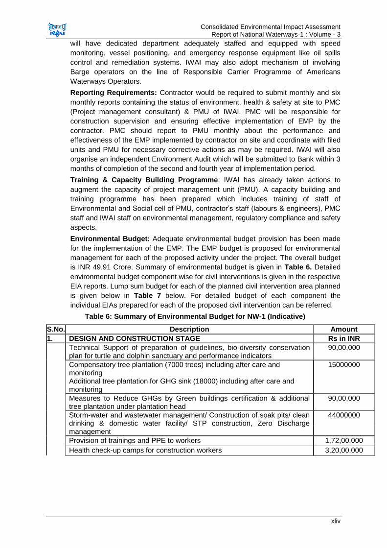
Consolidated Environmental Impact Assessment Report of National Waterways-1 : Volume - 3
xliv
will have dedicated department adequately staffed and equipped with speed
monitoring, vessel positioning, and emergency response equipment like oil spills
control and remediation systems. IWAI may also adopt mechanism of involving
Barge operators on the line of Responsible Carrier Programme of Americans
Waterways Operators.
Reporting Requirements: Contractor would be required to submit monthly and six
monthly reports containing the status of environment, health & safety at site to PMC
(Project management consultant) & PMU of IWAI. PMC will be responsible for
construction supervision and ensuring effective implementation of EMP by the
contractor. PMC should report to PMU monthly about the performance and
effectiveness of the EMP implemented by contractor on site and coordinate with filed
units and PMU for necessary corrective actions as may be required. IWAI will also
organise an independent Environment Audit which will be submitted to Bank within 3
months of completion of the second and fourth year of implementation period.
Training & Capacity Building Programme: IWAI has already taken actions to
augment the capacity of project management unit (PMU). A capacity building and
training programme has been prepared which includes training of staff of
Environmental and Social cell of PMU, contractor‟s staff (labours & engineers), PMC
staff and IWAI staff on environmental management, regulatory compliance and safety
aspects.
Environmental Budget: Adequate environmental budget provision has been made
for the implementation of the EMP. The EMP budget is proposed for environmental
management for each of the proposed activity under the project. The overall budget
is INR 49.91 Crore. Summary of environmental budget is given in Table 6. Detailed
environmental budget component wise for civil interventions is given in the respective
EIA reports. Lump sum budget for each of the planned civil intervention area planned
is given below in Table 7 below. For detailed budget of each component the
individual EIAs prepared for each of the proposed civil intervention can be referred.
Table 6: Summary of Environmental Budget for NW-1 (Indicative)
S.No. Description Amount
1. DESIGN AND CONSTRUCTION STAGE Rs in INR
Technical Support of preparation of guidelines, bio-diversity conservation plan for turtle and dolphin sanctuary and performance indicators
90,00,000
Compensatory tree plantation (7000 trees) including after care and monitoring Additional tree plantation for GHG sink (18000) including after care and monitoring
15000000
Measures to Reduce GHGs by Green buildings certification & additional tree plantation under plantation head
90,00,000
Storm-water and wastewater management/ Construction of soak pits/ clean drinking & domestic water facility/ STP construction, Zero Discharge management
44000000
Provision of trainings and PPE to workers 1,72,00,000
Health check-up camps for construction workers 3,20,00,000
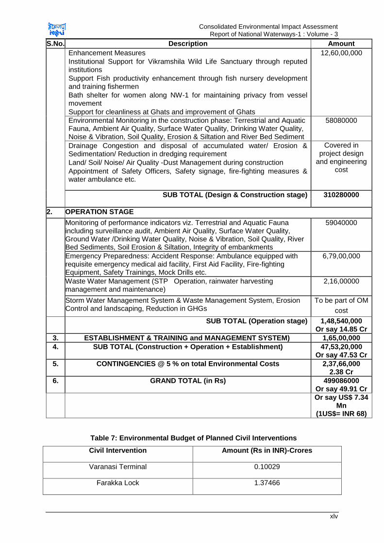
Consolidated Environmental Impact Assessment Report of National Waterways-1 : Volume - 3
xlv
S.No. Description Amount
Enhancement Measures
Institutional Support for Vikramshila Wild Life Sanctuary through reputed institutions
Support Fish productivity enhancement through fish nursery development and training fishermen
Bath shelter for women along NW-1 for maintaining privacy from vessel movement
Support for cleanliness at Ghats and improvement of Ghats
12,60,00,000
Environmental Monitoring in the construction phase: Terrestrial and Aquatic Fauna, Ambient Air Quality, Surface Water Quality, Drinking Water Quality, Noise & Vibration, Soil Quality, Erosion & Siltation and River Bed Sediment
58080000
Drainage Congestion and disposal of accumulated water/ Erosion & Sedimentation/ Reduction in dredging requirement
Land/ Soil/ Noise/ Air Quality -Dust Management during construction
Appointment of Safety Officers, Safety signage, fire-fighting measures & water ambulance etc.
Covered in project design
and engineering cost
SUB TOTAL (Design & Construction stage) 310280000
2. OPERATION STAGE
Monitoring of performance indicators viz. Terrestrial and Aquatic Fauna including surveillance audit, Ambient Air Quality, Surface Water Quality, Ground Water /Drinking Water Quality, Noise & Vibration, Soil Quality, River Bed Sediments, Soil Erosion & Siltation, Integrity of embankments
59040000
Emergency Preparedness: Accident Response: Ambulance equipped with requisite emergency medical aid facility, First Aid Facility, Fire-fighting Equipment, Safety Trainings, Mock Drills etc.
6,79,00,000
Waste Water Management (STP Operation, rainwater harvesting management and maintenance)
2,16,00000
Storm Water Management System & Waste Management System, Erosion Control and landscaping, Reduction in GHGs
To be part of OM
cost
SUB TOTAL (Operation stage) 1,48,540,000 Or say 14.85 Cr
3. ESTABLISHMENT & TRAINING and MANAGEMENT SYSTEM) 1,65,00,000
4. SUB TOTAL (Construction + Operation + Establishment) 47,53,20,000 Or say 47.53 Cr
5. CONTINGENCIES @ 5 % on total Environmental Costs 2,37,66,000 2.38 Cr
6. GRAND TOTAL (in Rs) 499086000 Or say 49.91 Cr
Or say US$ 7.34 Mn
(1US$= INR 68)
Table 7: Environmental Budget of Planned Civil Interventions
Civil Intervention Amount (Rs in INR)-Crores
Varanasi Terminal 0.10029
Farakka Lock 1.37466

Consolidated Environmental Impact Assessment Report of National Waterways-1 : Volume - 3
xlvi
Haldia Terminal 1.20246
Sahibganj Terminal 1.64136
12.0 Conclusion & Recommendations
The development of project “Jal Marg Vikas” is beneficial for the economic
development of country and environment due to expected model shift of cargo
movement from rail and road to IWT. With the effective implementation of the
proposed mitigation measures and environment management plan, anticipated
negative impacts of project can be minimised and benefits further enhanced. The
project will overall bring development in the area.
It is recommended that IWAI should provide desired resources for implementation of
EMPs and ensure that EMPS are effectively implemented. It must institutionalize the
system of period monitoring against the defined performance indicators and establish
the system of half yearly reporting. It should also develop its own EHS guidelines and
protocols for managing all the projects uniformly from environment health and safety
prospective. System should be self-responding in nature for initiating timely
corrective and preventive action if any required for the protection of environment.
Adequate training should be imparted as proposed under environmental
management plan to enhance the capability of concerned EA officials. Awareness
programme for contractor and workers should also be organised for effective
implementation of EMP.
IWAI should adopt the measures for reduction of dredging. Dredging management
plan including compliance to defined restriction for dredging and disposal of dredged
material close to cultural and aquatic sensitive locations should be followed.
It should adopt the concept of green building and energy efficient terminals. The
GRIHA guidelines should be adopted for terminal design. All terminals should be
designed with zero waste discharge concept to prevent pollution to river Ganga.
Similarly, all barges should have integration of zero pollution concept. Each barge
should be inspected by IWAI for compliance of these requirements before allowing its
operation in NW-1. All consequent waste from the vessels should be managed at
terminals and barge maintenance facilities. All possible measures should be adopted
for GHG emission reduction including exploring the feasibility of fuel switch to LNG
operated vessels.
It should take all measures for conservation of aquatic sanctuaries including
reduction of impact on aquatic fauna. All possible efforts should be made to minimize
the impact considering the findings of CIA, Critical Resource Basin Study,
Consolidated EIA Study and proposed conservation studies. IWAI should facilitate
development of conservation plan for Dolphin, Turtle and sensitive species in NW-1
with the help of reputed institutions.
IWAI should develop all facilities for handling emergencies as part of emergency
response plan. IWAI should develop Indian Waterways Operations Responsible
Carrier Programme on the line of American Waterways Operators Responsible
Carrier Programme for accident and pollution free waterways operations

Consolidated Environmental Impact Assessment Report of National Waterways-1 : Volume - 3
xlvii
The EIA was carried out while the feasibility study was being prepared and initial
finding of DPR preparation stage. Therefore, the detailed engineering design was not
available. In this regard, any major changes during detailed design, or any major
additional work other than the proposed project activities will require updating this
environmental assessment. Also it may have to be sent to World Bank for
concurrence before works commence.
Consolidated Environmental Impact Assessment Report of National Waterways-1 : Volume - 3
1
CHAPTER 1. INTRODUCTION
1.1. Project Background
Cargo movement through waterway is considered cheapest mode of transportation
internationally. However, cargo movement is very low in India compared to the
international scenario. To augment the capacity of waterways transportation in India,
Govt. of India has constituted Inland Waterways Authority of India (IWAI)through IWAI
Act in 1985. Since then IWAI, with the empowerment under above mentioned Act, has
identified potential waterways and has further undertaken the task to develop, maintain
and regulate the waterways for navigation. IWAI has also declared following five
waterways as the national priority:
• NW-1 -The Ganga (Haldia to Allahabad-1620 km)
• NW-2- The Brahmaputra (Dhubri to Sadiya-891 km)
• NW-3 The West Coast Canal (Kottampuram to Kollam with Udyogmandal and
Champakara canals- 205 km)
• NW-4- The Kakinda-Puducherry stretch of Canals with Godavari & Krishna
Rivers (1078 km)
• NW-5-The East Coast Canal with Brahami Rivet and Mahanadi Delta (588 km)
Amongst the above five waterways, the national waterways on Ganga (NW-1 between
Haldia to Allahabad) is the longest waterway (1620 km) and is of prime importance
considering its locational advantages. IWAI since long has been maintaining the least
available depth (LAD) of 3m between Haldia and Farakka (560km), 2.5m in Farakka –
Barh (400km), 2m between Barh – Ghazipur (290km) and 1.2 to 1.5m in Ghazipur –
Allahabad (370km). Even currently this waterway (NW-1) is being used for various cargo
movements, as well as tourists. Already good amount of cargo movement is taking place
between Haldia and Farakka (e.g. 3 million metric tonne of imported coal from Haldia to
NTPC plant is being transported since October 2013 through 20 barges of 2000 dwt
capacity each). Considering such a large potential and demands, IWAI has initiated the
project of “Capacity Augmentation of National Waterway-1” between Haldia and
Allahabad named as “Jal Marg Vikas Project”. The capacity building of this magnitude
under this project warrant‟s number of additional infrastructural components (such as
construction of terminals for cargo handlings, provision of navigation aids, river
information systems) which are required to be developed in a phased manner. The
locational overview of NW-1 is shown at Figure 1.1.
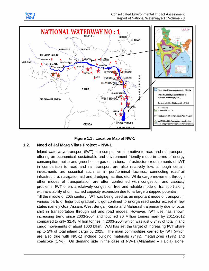
Consolidated Environmental Impact Assessment Report of National Waterways-1 : Volume - 3
2
Figure 1.1 : Location Map of NW-1
1.2. Need of Jal Marg Vikas Project – NW-1
Inland waterways transport (IWT) is a competitive alternative to road and rail transport,
offering an economical, sustainable and environment friendly mode in terms of energy
consumption, noise and greenhouse gas emissions. Infrastructure requirements of IWT
in comparison to road and rail transport are also relatively low, although certain
investments are essential such as in port/terminal facilities, connecting road/rail
infrastructure, navigation aid and dredging facilities etc. While cargo movement through
other modes of transportation are often confronted with congestion and capacity
problems, IWT offers a relatively congestion free and reliable mode of transport along
with availability of unmatched capacity expansion due to its large untapped potential.
Till the middle of 20th century, IWT was being used as an important mode of transport in
various parts of India but gradually it got confined to unorganized sector except in few
states namely Goa, Assam, West Bengal, Kerala and Maharashtra primarily due to focus
shift in transportation through rail and road modes. However, IWT use has shown
increasing trend since 2003-2004 and touched 70 Million tonnes mark by 2011-2012
compared to only 32.48 Million tonnes in 2003-2004 which was just 0.34% of total inland
cargo movements of about 1000 btkm. IWAI has set the target of increasing IWT share
up to 2% of total inland cargo by 2025. The main commodities carried by IWT (which
are also true with NW-1) include building materials (34%), metals\ores (19%) and
coal\coke (17%). On demand side in the case of NW-1 (Allahabad – Haldia) alone,

Consolidated Environmental Impact Assessment Report of National Waterways-1 : Volume - 3
3
there are 9 thermal power plants located along Ganga River stretch within UP & Bihar
and 11 more are expected to become operational soon. The total requirement of coal for
these power plants alone will be nearly 94.78 million tonnes per year, 21.4 MT of which
will have to be imported reflecting the sea connectivity of NW-1. In addition to this, there
are 7 fertilizer plants along NW-1. These are also estimated to generate an additional of
0.765 million ton of cargo requirement per year. Further, there is also large prospect of
container movements for national as well as international trade. IWT in general and
NW-1 in particular would play a very vital role when high quality ports/terminals with
waterway connectivity is made available to facilitate the cargo movement in a cost
effective and environmental friendly manner catering to the needs of large transportation
movements due to enhanced industrial activities as compared to rail and/or road modes.
Economic Advantage: The economic advantages of this mode compared to other
surface modes have been emphasized by a number of high-powered Committees
including the National Transport Policy Committee (NTPC) (GOI, 1980), the Steering
Committee on Transport Planning (GOI, 1987) and a number of reports and studies
(NCAER, 1974, UNDP, 1993, Rao and Kumar, 1996). Some of these studies also
pointed out the potential role of connectivity that this mode could perform besides cargo
movements, like providing access and connectivity to far- flung areas and the
maintenance of ecological balance. The cost advantages include:
Low capital Cost-Cost of development of inland waterways is estimated to be a
mere 5-10 percent of the cost of developing an equivalent 4-lane highway or
railway. Cost for transportation of cargo through various modes is given in Table 1.1
below in reference to the “Report of the Inter–Ministerial Committee to Identify New
Areas of Private Investment in the Inland Waterways Transport (IWT) Sector”
Planning Commission, (Transport Division)
Table 1.1 : Cost of Transportation Through Different Modes
Mode VOC/Freight (Rs/Km) Taxes Total Rs/TKm
Railway* 1.36 3.71% 1.41
Highways** 2.50 3.09% 2.58
IWT 1.06 Nil 1.06
Source: Railways-Ministry of Railways, Road-TTSS, IWT-IWAI
* Service Tax on rail Transport is 15.0% abatement is 70%
**Service Tax on road Transport is 15.0% abatement is 75%
Low maintenance cost -Cost of maintenance of inland waterway is about 20
percent of that of roads.
Low Operation Costs – This is also least costs mode of transportation. According
to Ministry of Railways, the freight costs by IWT are estimated as 1.06 Rs/ tkm
compared to 1.41 Rs / tkm by railways and Rs 2.58 Rs/ tkm by highways.
Large Cargo Potential – There is large cargo potential generation from areas
along and close to NW-1 but the transportation facilities are insufficient. The
potential can be judge from few of the following need:
Consolidated Environmental Impact Assessment Report of National Waterways-1 : Volume - 3
4
o NW-1passes through Kolkata which is having connectivity with other
states/cities and country through road and railway. Such place offers an
appropriate location for development of cargo. Cargo generated at Kolkata or
brought in to Kolkata from nearby areas through road/railway can be further
transported to other destinations through NW-1 at lower cost
o U.P. & Bihar is large agricultural belt and have high potential of producing
wheat. This wheat transportation can be undertaken through NW-1 to other
parts of the country
o There are about 9 existing Thermal Power Plant (TPP) around NW-1 and 15
TPP under construction having total power generation potential of 21820 MW.
Total coal requirement of these projects is 94.78 million tons per annum. Out of
which imported coal requirement is 21.4 million tons per annum. At present on 3
million MTPA of coal is being transported to Farakka STPS. Coal is transported
to these existing TPP through railways and all existing TPPs have their own
railway siding. Imported coal is brought at Paradeep and Haldia ports. Further
adequate depth is not available at Haldia port so 70% of coal is received at
Paradeep port only. From these ports, coal is transported to destined locations
through railways. However due to constrain capacity of railways, these power
plants regularly face shortage. Pressure on railways will further increase after
development of the 15 more TPP. NW-1 thus will serve as mode for
transportation of coal to above listed TPPs will reduce burden on railways and
reduce the gap in demand and supply of the coal.
o Jharkhand is one of the major coal producing state of India and is endowed with
app. 80 billion tons of coal of all categories. App. 70 MT of coal is transported to
various part of the country from Jharkhand. Coal transportation from Jharkhand
can be taken through NW-1 through destined locations
o TPPs located around NW-1 will generate fly-ash which serves as raw material
for cement plants and road construction. Fly-ash thus can be transported
through NW-1. Assuming 25% of ash content in coal, it is estimated app. 24
million tone of fly-ash will be generated per annum.
o Large quantity of cargo of construction material, fertilizers, coal, minerals and
chemicals, project cargo, food & food stuff, containers and vehicles are
transported across NW-1 through road & railway. These commodities if
transported through NW-1 can significantly cut down the emissions and
transportation cost.
o Planning of IFFCO to use NW-1 for transportation of fertilizers produced at
Paradeep plant to U.P. & Bihar
Environmental Need: Potential for Fuel Efficiency and GHG Emission: As per an
estimate, 1 horse power can carry 4,000-kilogram load in water compared to 150
kilograms and 500-kilogram load by road and rail respectively. In one study10 it is
estimated that 1 litre of fuel can move 105 ton-km by inland water transport whereas the
10
As per German Federal Waterways and Shipping Administration, Error! Hyperlink reference not valid.
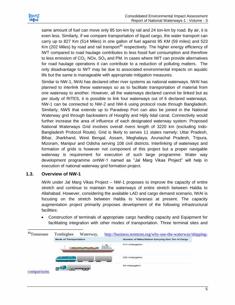
Consolidated Environmental Impact Assessment Report of National Waterways-1 : Volume - 3
5
same amount of fuel can move only 85 ton-km by rail and 24 ton-km by road. By air, it is
even less. Similarly, if we compare transportation of liquid cargo, the water transport can
carry up to 827 Km (514 Miles) in one gallon of fuel against 95 KM (59 miles) and 523
Km (202 Miles) by road and rail transport11 respectively. The higher energy efficiency of
IWT compared to road haulage contributes to less fossil fuel consumption and therefore
to less emission of CO2, NOx, SOX and PM. In cases where IWT can provide alternatives
for road haulage operations it can contribute to a reduction of polluting matters. The
only disadvantage to IWT may be due to associated environmental impacts on aquatic
life but the same is manageable with appropriate mitigation measures.
Similar to NW-1, IWAI has declared other river systems as national waterways. IWAI has
planned to interlink these waterways so as to facilitate transportation of material from
one waterway to another. However, all the waterways declared cannot be linked but as
per study of RITES, it is possible to link four waterways out of 6 declared waterways.
NW-1 can be connected to NW-2 and NW-6 using protocol route through Bangladesh.
Similarly, NW5 that extends up to Paradeep Port can also be joined in the National
Waterway grid through backwaters of Hooghly and Hijily tidal canal. Connectivity would
further increase the area of influence of each designated waterway system. Proposed
National Waterways Grid involves overall rivers length of 3220 km (excluding Indo-
Bangladesh Protocol Route). Grid is likely to serves 11 states namely; Uttar Pradesh,
Bihar, Jharkhand, West Bengal, Assam, Meghalaya, Arunachal Pradesh, Tripura,
Mizoram, Manipur and Odisha serving 108 civil districts. Interlinking of waterways and
formation of grids is however not component of this project but a proper navigable
waterway is requirement for execution of such large programme. Water way
development programme onNW-1 named as “Jal Marg Vikas Project” will help in
execution of national waterway grid formation project.
1.3. Overview of NW-1
IWAI under Jal Marg Vikas Project – NW-1 proposes to improve the capacity of entire
stretch and continue to maintain the waterways of entire stretch between Haldia to
Allahabad. However, considering the available LAD and cargo demand scenario, IWAI is
focusing on the stretch between Haldia to Varanasi at present. The capacity
augmentation project primarily proposes development of the following infrastructural
facilities:
Construction of terminals of appropriate cargo handling capacity and Equipment for
facilitating integration with other modes of transportation. Three terminal sites and
11
Tennessee Tombigbee Waterway, http://business.tenntom.org/why-use-the-waterway/shipping-
comparisons
Consolidated Environmental Impact Assessment Report of National Waterways-1 : Volume - 3
6
one lock site have already been identified namely terminals at Haldia, Sahibganj&
Varanasi and new lock site at Farakka. Kalughat and Ghazipur are identified
potential sites for terminal development. One more site is to be finalized for
development of terminal, currently Tribeni is under consideration.
Provision of all types of navigation aids for day and night navigation.
River information system with all hardware and software
Provision of RO-RO Jetties
Provision for bank protection / slope protection
Provision of river training works for critical locations
Provision for tow barges, inland vessels, survey vessels including rescue boats and
survey equipment
Dredging facilities for maintenance of waterways
Barge Maintenance & Repair Facilities
Some of the above facilities are finalised and some are in the process of identification
and design.
1.4. Objective of EIA study
The implementation and development infrastructure facilities as mentioned above under
this project will cause various associated environmental & social impacts. The objective
of this study primarily focuses on identification, assessment and quantification of the all
significant impacts and their mitigation to bring them within acceptable threshold
associated with all stages of project implementation namely- design, construction and
operation phases of project implementation in accordance with World Bank Operational
Policies, IFC Guidelines and related Guidelines published by MOEF&CC. The likely
impacts are first identified for all project implementation activities with respect to physio-
chemical, ecological and social environments. Institutional mechanism is also proposed
to make the implementation effective to ensure that there are no significant impacts left
by incorporating the requisite EMP and EMoP. Attempts have been made to identify
impacts for potential activities and measures suggested to be incorporated in the design
as feasible. These measures will be further updated once design aspects are fully
finalised.
1.5. Extent and Limitation of EIA Study
The Environmental Assessment was done in tandem with the preparation of Feasibility
Report of the proposed project design. Design details and detailed layout plans of
various proposed infrastructural facilities and civil interventions associated with NW-1
implementation are not yet finalized for all the components. Therefore, the EIA is based
on up-to-date project details provided by the engineering consultant during the
preparation of the report12, primary field investigations / assessment, secondary data
collated from different Gov. Departments (centre as well as of four states as UP, Bihar,
12
The engineering details may change at detailed project report preparation stage. In the situation of change of the design, the EIA
and EMP reports will be updated accordingly.

Consolidated Environmental Impact Assessment Report of National Waterways-1 : Volume - 3
7
Jharkhand and W. Bengal). The secondary data/information was collated from agencies
such as Inland Waterways Authority of India, State Pollution Control Board, Indian
Meteorological Department, Public Works Department, Public Health & Engineering
Department, District Collectorate, Irrigation Department, Statistic Department, District
Fisheries Department, Mining Department, Ganga Pump Canal Nahar Pariyojna Office,
Forest Department, published journals\books besides various local bodies. Summary
table of secondary data sources concerning different aspects is tabled in the end of this
chapter. Inputs from the extensive public consultation (as described in the report) were
also taken into consideration. Professional judgement and subjective interpretation of
facts and observations has been applied for the preparation of the EIA Report, since the
entire project is under various stages of development. As the project is under design
phase thus the figures presented for planned and proposed facilities are tentative and
are subject to change with the changes proposed to be undertaken by Design
Consultant of the project
1.6. EIA Contents
The EIA report is presented in different volumes:
Main Volume: Environmental Assessment
Sub Volumes: Description of Environment, annexures to Main Volume, EMP
Framework for future interventions.
Additional volumes: EMPs for various activities and already planned interventions
Main Volume on Environmental Assessmenthas 7chapters following this introduction
chapter
Chapter 1: Introduction: This chapter describes project framework, objective and
background including the need of the project.
Chapter 2: Policy, Legal and Administrative Framework: This chapter deals with the
identification & listing of applicable legislations and applicable administrative framework.
It also provides screening of applicable operational policies of World Bank and other
international practices and guidelines.
Chapter 3: Description of Project: This chapter describes the various project
components incorporated in the overall project framework. It also provides details the
alternatives analysed before final selection of the most appropriate option having
minimal environmental and social impact implications.
Chapter 4: Anticipated Environmental Impacts and Mitigation Measures: This
chapter presents summary environmental baseline condition and linked identification
with magnitude of anticipated potential impact for each environmental and cultural
resource. For each potential impact the mitigation measures are delineated in order to
mitigate the impacts up to the threshold of acceptable residual levels.
Chapter 5: Environmental Management Plan and Grievances Redress Mechanism:
This chapter provide the details on the management plans and the institutional
mechanism required along with resources required for effective implementation of the
proposed mitigation measures and the monitoring framework essential during
Consolidated Environmental Impact Assessment Report of National Waterways-1 : Volume - 3
8
construction as well as operation period. It also highlights the institutional mechanism as
well as capacity building needs for the implementation.
Chapter 6: Information Disclosure, Consultation, and Participation: This chapter
highlights the process followed for the public consultation carried out with the various
stakeholders namely public, NGO, Government bodies, prominent local bodies upfront of
the project implementation initiatives. It also highlights the information generated during
this process for incorporating in the final version of the report
Chapter 7: Conclusions and Recommendations: This chapter provide the summary
of findings and concluding remarks.
Sub Volume on Description of Environment (Environmental profile and baseline of
the project and influence area): Thisvolume provides background information based
on primary and secondary information for physical, biological, social and cultural
resources of project and influence areas.
Sub Volumeon Framework for Future Intervention:It provides framework of activities
and TOR for different intervention to be undertaken in future.
AdditionalVolumes: EMPs: These volumesprovide EMPs for terminals already
planned, navigation lock, dredging, barge operations.
1.7. Methodology
This project is classified as Category „A‟ operations under the world bank environmental
screening procedures specified under its operation policy 4.01. The project triggers 6 of
the World Bank safeguard policy13 and requires comprehensive environmental
assessment. The detailed environmental impact assessment study has been undertaken
for all the proposed components to identify the environmental and social issues
associated with the project. The environmental impact assessment was carried out by a
consortium led by EQMS India Pvt. Ltd. in line with World Bank Operational Policies, IFC
EHS Guidelines for Ports, Harbours and Terminals, IFC General guidelines for EHS,
MoEF&CC EIA Guidelines for Ports and Harbours, findings of CIA and Standalone EIA
studies carried out for civil interventions.
Initially a basin level critical environmental resource study was carried out to identify
“NOGO” and “Restricted areas”. Input of this study was used for this environmental
assessment and specially designing baseline monitoring network and preparation of
environment management plans.
The EIA study was carried out using recommendations and findings of CIA and
individual EIA studies for civil interventions, reconnaissance survey, review of previous
studies, field visits, consultation with stakeholders & NGOs, review of existing data and
primary data collection. The methodology was evolved in line with the CIA study,
considering the defined terms of reference of IWAI for the study and IFC EHS guidelines
for general industries and for ports, harbours and terminals. Extensive use of geographic
information system is made to analyse the land use, drainage pattern, elevation profile
13
The world bank safeguard policies triggered are environmental assessment (OP/BP 4.01), Natural Habitats (OP/BP 4.04), Forests
(OP/BP 4.36), Involuntary resettlement (OP/BP 4.12), Physical Cultural Resources (OP/BP 4.11) and Project on International Waterways (OP/BP 7.5)
Consolidated Environmental Impact Assessment Report of National Waterways-1 : Volume - 3
9
and identify the environmental features of the influence area. Topo-sheets as available
and Google maps were used for the above. Since it is having strong interface with
aquatic ecology, larger emphasis was given for primary data collection with regard to
zooplanktons, phytoplankton, fishes and aquatic fauna. Establish sampling, and
observation techniques were applied for this assessment.
The scope of the EIA extends well beyond the vicinity of the NW-1. The area considered
for collection of data and assessment of impacts is termed as influence area for this
study purpose. Influence area considered for this project is 500 m, 2 km and 10 kms in
line with the CIA study recommendationsand EIA study carried out for each civil
intervention. The influence area was assessed based on different project activities on
different VECs. Criteria for demarcation of the influence area is discussed in detail in CIA
report and is briefed in Chapter 4 of this report also. Details of the parameters studied in
each zone is given below
500 m radius: All the parameters of environmental, socio-economy and cultural
importance are studied within this zone.
2 km radius: All the parameters of environmental, socio-economy and cultural
importance are studied within this zone also.
10 km radius: Parameters studied under this zone include environmental sensitive
locations as notified by GoI, land use change, socio-economy, and geology, seismicity&
drainage pattern.
Since project is based on river, alternative analysis is undertaken for with and without
project, technological aspects and sitting of interventions. Alternate analysis of the sites
has been undertaken for selection of sites and infrastructure like roads, railway etc. for
proposed interventions under this project. Analysis was carried out considering physical,
biological and socio-economic impacts and technical and financial feasibility. Analysis of
alternatives has also been considered at planning level of each proposed intervention.
The established practices (like trend analysis, expert assessment, stakeholders‟
perception and concerns, resource availability) were followed to identify potential impact
associated with the proposed project activities. Appropriate tools and techniques (like
use of Air Quality and Noise prediction models) were used to identify and predict the
magnitude of the impacts. Suitable mitigation measures are suggested based on the
intensity of the impacts identified for offshore and onshore activities both. The
Environmental Management and Monitoring plan with institutional requirements is also
prepared to ensure effective implementation of the mitigation measures proposed.
As per EIA Notification, 2006 as amended at present, the project components like
development of terminals & jetties does not requires environment clearance. However,
environment clearance may be required for the activities like borrowing of earth which
should be taken by the respective contractor. Additionally, NOC/Permissions are
required to be obtained by IWAI/Contractor for specific activities like setting up Hot Mix
Plant, DG Sets, STP from respective agencies as indicated under legal and
administrative framework. Each permission will have associated conditions which need
to be complied by contractors / IWAI and same will be monitored by the permission
granting agencies like State Pollution Control Boards (SPCBs). None of these
Consolidated Environmental Impact Assessment Report of National Waterways-1 : Volume - 3
10
permissions require detailed environmental impact assessment however, findings of this
EIA and proposed mitigation measures would be useful in obtaining these permissions.
1.8. Data Collection
The objective of data collection was to provide a database of existing conditions, to be
used for predicting the likely changes that are expected and for monitoring such
changes. The first step was to undertake a project scoping exercise, identify the
parameters to be considered, and outline the activities for collecting data on identified
parameters. Sources of data were identified. Relevant available data pertaining to
physical, biological (terrestrial and aquatic), and socio-economic aspects of the
environment was collected from various secondary sources supported by primary data
collection.
Primary data was also collected with focus on sensitive receptors like religious places,
habitat areas, noise, air quality, water quality (ground and surface water both), soil,
biodiversity (terrestrial and aquatic both). The air quality data was collected as per latest
National Ambient Air Quality standards. The Ambient air quality monitoring stations were
selected over the influence area to get representative data of the area. Similarly,
ambient noise level was monitored for day and night near sensitive locations, residential,
and project areas. The water quality of surface and ground were monitored in the
influence area to get representative water quality information. River bed samples were
also tested to assess the contamination level of river bed materials. The primary data
was collected between September, 2015 & February, 2016
1.9. Public Consultation
Local knowledge about the ecosystem and problems associated with such a
development project including sourcing of construction material and men river interface
were carefully assessed and used in impact assessment and for developing mitigation
plans. Consultations were held focusing on air quality, noise effect, water supply,
drainage, aquatic and terrestrial flora and fauna, physical cultural resource of
importance, environmental sensitive ecosystems or areas that may be affected by the
project. Formal institutional level public consultation and opportunistic informal meetings
involving local villagers and those who are likely to be affected due to the proposed
projects were organized to determine potential environmental and socio-economic
impacts. Interactions were also made with NGOs and concerned government officials.
Consultation was carried out in two stage: Stage I during EIA report Preparation and
stage II post EIA report preparation. A detailed description of the public consultation is
presented in Chapter 6.
1.10. Cumulative Impact Assessment
CIA is one of several tools to consider as part of an overall process of environmental and
social risk assessment and management. Scope of the CIA both temporally and spatially
is much larger than the EIA studies and other tools for environment and social
assessment. CIA not only captures the project induced impacts but also consider the
Consolidated Environmental Impact Assessment Report of National Waterways-1 : Volume - 3
11
status of the already impacted CERs or VECs14, communities and considers the
existing, proposed, planned and anticipated developments which may come in the
influence (impact) area of the project so as the impacts of not only the project but these
other developments can also be assesses cumulatively. CIA study carried out for the
project in similar way. Difference between the CIA study and the EIA studies is
elaborated in the separate section below. Cumulative Impact Assessment (CIA) of NW-1
from Allahabad to Farakka has been carried out for (a) analysing the potential impacts
and risks of proposed, indirect & induced developments in the context of water flow,
water availability and water quality, considering human activities and natural
environmental and social external drivers on the chosen Valued Environmental
Components (VECs) over time, and (b) proposing concrete measures to avoid,
reduce, or mitigate such cumulative impacts and risk to the extent possible in the
influence area on both sides of the NW-1.
The influence area considered for study of the impact is based on multi dimension
criteria and same is used for carrying out the EIA study of the project. At first Cumulative
opinions of various stakeholders which are directly & indirectly impacted due to
proposed development, and extensive review of the consolidated EIA report & basin
level critical resources study of the proposed project has been carried out to identify the
VECs. Further, overlay mapping and GIS have been extensive used for identifying the
spatial distribution of VECs. Also indicators have been identified which can determine
conditions of VECs. Baseline study has been conducted to assess the existing condition
or status of the identified VECs based on these indicators in the influence area. Further
VECs under stress have been identified and are termed as hotspots. Also nature of the
impacts due to proposed/planned & anticipated development on these hotspots has
been assessed. It has been found that cumulative impacts due to proposed development
of NW-1 on the hotspots will not be significant. Further, impacts triggered due to induced
& indirect development can be mitigated & monitored due to construction & operation
stage of the project. Some of the mitigation measures proposed under the CIA includes
additional tree plantation particularly to the area prone to erosion in the catchment area
of the river, control of noise and vibration for the development of the railways (EDFC),
promotion of bio-pesticides and organic manure to reduce the use of chemical pesticides
and resultant reduction in river pollution from the run off from the agriculture field,
promotion of electric crematorium to prevent pollution from the wood burning in the
crematoriums located on the river banks. The agency involved includes urban local
bodies, DFCCIL, industrial development agencies, water resource departments and
irrigation department. It is also proposed for IWAI to take initiative for creating
awareness and bringing these departments on board for promotion of these measures
through established administrative process.
1.10.1. Cumulative Impact Assessment Vs Environmental Impact Assessment: difference and utility
14
Critical Environmental Resource (CER) and Valued Environmental Components (VEC) are technically same reffering to various
key environmental resourceor component like natural habitat. Critiacl Environment Resouce word is used for Basin Level study as per terms of reference of these studies. However, for EIA studies VEC word is used.
Consolidated Environmental Impact Assessment Report of National Waterways-1 : Volume - 3
12
CIA and EIA shares the same basic framework and analytical process for impact
assessment but still the perspectives are different. EIA can be termed as project centred
and CIA is always VECs centred.
The CIA is prepared following preparation of Basin level Critical Resource Study and
takes into account the overall project perspective. The CIA is focused on existing
condition of VECs which may be changed due to intervention of project and the other
simultaneous developments taking place in the influence area.Theecological and social
impacts are determined considering, past, present, and natural drivers that effects the
VECs in the influence area. The assessment reflects the geographical and temporal
context in which the effectis aggregating and interacting with river landscape, catchment
area, town, etc15. The CIA provides the strategic consideration for project design and
intervention proposed and environmental assessment to be undertaken for the Jal Marg
Vikas Project. The influence area consideration for respective intervention is also
derived based on CIA outcome.
The focus of EIA has been on impacts assessment of specific intervention or activity on
the VECs. The EIA is undertaken following CIA preparation and considering outcome of
CIA such as influence area recommendations for EIA studies.In EIA study specific
mitigation measures are proposed to avoid, minimize or eliminate them.Environmental
Management Plan is also prepared in EIA for each intervention for effective
implementation of identified mitigation measures.
1.11. References
Secondary data for areas along NW-1 was also referred to authenticate & validate the
primary information collected. The list of information sources, nature of data collected,
purpose of data use and other reference are presented at Table 1.2.
Table 1.2 : Summary of Secondary Data with Sources
Source organisation Report/source Name Type of data
CPCB &MOEF&CC
CPCB Gazette notification dated 18.11.2009 on AAQ, Noise Notification, and BDU criteria
AAQ Standards BDU Criteria Standards Noise Standards
Water Quality Assessment River Ganga 2013
Water Quality of NW-1 stretch
MOEF & CC Endangered Species Brochure, 2009 Endangered Species
Indian Meteorological department
Climatological Normal 1961-1990 Met Data
First order seismic micro zonation IMD
Seismicity and seismic map and Cyclone Hazard Prone Map
MOEF & CC Jharkhand Wetland Atlas, Prepared by Wetland information
15
IFC Good Practice Handbook for Cumulative Impact Assessment and Management: Guidance for the Private Sector in Emerging
Markets
Consolidated Environmental Impact Assessment Report of National Waterways-1 : Volume - 3
13
Source organisation Report/source Name Type of data
Space Applications Centre (ISRO), Ahmedabad and Institute of Environmental Studies & Wetland Management (IESWM), Kolkata)
MOEF & CC Information on Wetlands Wetland information
Central Ground Water Board Ground Water Boucher of Project Districts
Geology, Ground water related information
Botanical Survey of India Red Data Book of Indian Plants RET species
Zoological Survey of India Red data book on Indian Animal RET species
IUCN (International Union for Conservation of Nature) 1980
Gland, Switzerland: International Union for Conservation of Nature. IUCN (International Union for Conservation of Nature) 1980.World Conservation Strategy: Regional strategies for international river basins and seas.
RET species
IWC (International Whaling Commission) 2000
Report of the standing sub-committee on small cetaceans. Journal of Cetacean Research and Management 1 (Supplement),
Cetacean fauna
Mohan, R. S. L. and Kunhi, K. V. M. 1996.
Fish oil as alternative to river dolphin, PlatanistaGangetica(Lebeck) oil for fishing catfish Clupisomagaruain the River Gangetic, India. Journal of the Bombay Natural History Society 93, 86-88.
Oil impact on Aquatic fauna
Gland, Switzerland: IUCN.Perrin, W.F. 1999.
Selected examples of small cetaceans at risk. Pp. 296-310 in: Conservation and Management of Marine Mammals (eds. J.R. Twiss, Jr. and R.R. Reeves) Smithsonian Institution Press, Washington, DC.
Aquatic fauna
NGBRA (Indian Institutes of Technology)
GRB EMP: Ganga River Basin Environment Management Plan
Flora& Fauna
NGBRA (IIT Consortium) Main Plan Document by Consortium of 7 Indian Institute of Technology‟s (IITs)
Ganga basin
NGBRA (Indian Institutes of Technology)
Status of Higher aquatic vertebrates in Ganga River (Ganga River Basin Management Plan) By Consortium of India‟s IIT Institutes
Higher aquatic vertebrates
NGBRA
Hilsa an assessment of in lower ganga basin (Ganga River Basin Management Plan) By Consortium of India‟s IIT Institutes
Fish
NGBRA Status of fish and fisheries in Ganga Fish
Consolidated Environmental Impact Assessment Report of National Waterways-1 : Volume - 3
14
Source organisation Report/source Name Type of data
(Indian Institutes of Technology)
River (Ganga River Basin Management Plan) By Consortium of India‟s IIT Institutes
NGBRA River Ganga at a Glance: Identification of Issues and Priority Actions for Restoration
Waterways quality
NGBRA (IIT Consortium) Main Plan Document by Consortium of 7 Indian Institute of Technology‟s (IITs)
Ganga basin
Publication of BHU university Flora of BHU Flora
Kashi Turtle Sanctuary Management Plan of Kashi turtle sanctuary
Turtle
Kalpavirksha
India‟s Notified Ecologically Sensitive Areas (ESAs)
Sensitive ecosystem
Chaudhary, S. K., Smith, B.D., Dye, S., Dye, S. And Prakash, S. 2006.
Conservation and Biomonitoring in the Vikramshila Gangetic Dolphin Sanctuary, Bihar, India. Oryx, 40 (2), 189-197
Dolphin
Quaritich.Braulik, G. 2000.
Entrapment of Indus dolphins (Platanista minor) in irrigation canals: incidence, implications and solutions. International Whaling Commission, Scientific Committee Document SC/52/SM9, Cambridge, UK.
Dolphin
Harison, R. J. 1972. Reproduction and reproductive organs in Platanistaindiand Platanista Gangetica. Invest Cetacea.
Dolphin
Hua, Y., Zhao, Q., & Zhang G. 1989.The habitat and behaviour of Lipotesvexillifer. In W. F. Perrin, R. L. Jr. Brownell, K. Zhou & J. Liu (Eds.)
Biology and conservation of the river dolphins Occasional Paper of the IUCN Species Survival Commission (No.3., pp. 92-98).
Conservation Dolphin
Kannan, K. Sinha, R.K., Tanabe, S., Ichihashi, H. and Tatsukawa, R. 1993
Heavy metals and organochlorine residues in Gangetic Dolphin from India. Marine Pollution Bulletin Vol. 26 No. 3 pp 159-162 pergamon press U.K.
Heavy metal impact on Dolphin
Kannan, K., Tanabe, S., and Tatsukawa, R. And Sinha R.K. 1994.
Biodegradation capacity and residue pattern of organochlorines in Gangetic Dolphins from India. Toxicological and
Dolphin toxicology
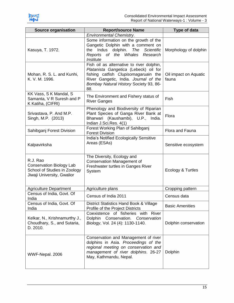
Consolidated Environmental Impact Assessment Report of National Waterways-1 : Volume - 3
15
Source organisation Report/source Name Type of data
Environmental Chemistry.
Kasuya, T. 1972.
Some information on the growth of the Gangetic Dolphin with a comment on the Indus dolphin. The Scientific Reports of the Whales Research Institute
Morphology of dolphin
Mohan, R. S. L. and Kunhi, K. V. M. 1996.
Fish oil as alternative to river dolphin, Platanista Gangetica (Lebeck) oil for fishing catfish Clupisomagaruain the River Gangetic, India. Journal of the Bombay Natural History Society 93, 86-88.
Oil impact on Aquatic fauna
KK Vass, S K Mandal, S Samanta, V R Suresh and P K Katiha, (CIFRI)
The Environment and Fishery status of River Ganges
Fish
Srivastava, P. And M.P. Singh, M.P. (2013)
Phenology and Biodiversity of Riparian Plant Species of Ganga River Bank at Bharwari (Kaushambi), U.P., India. Indian J.Sci.Res. 4(1)
Flora
Sahibganj Forest Division Forest Working Plan of Sahibganj Forest Division
Flora and Fauna
Kalpavirksha
India‟s Notified Ecologically Sensitive Areas (ESAs)
Sensitive ecosystem
R.J. Rao Conservation Biology Lab School of Studies in Zoology Jiwaji University, Gwalior
The Diversity, Ecology and Conservation Management of Freshwater turtles in Ganges River System
Ecology & Turtles
Agriculture Department Agriculture plans Cropping pattern
Census of India, Govt. Of India
Census of India 2011 Census data
Census of India, Govt. Of India
District Statistics Hand Book & Village Profile of the Project Districts
Basic Amenities
Kelkar, N., Krishnamurthy J., Choudhary, S., and Sutaria, D. 2010.
Coexistence of fisheries with River Dolphin Conservation. Conservation Biology, Vol. 24 (4): 1130-1140.
Dolphin conservation
WWF-Nepal. 2006
Conservation and Management of river dolphins in Asia. Proceedings of the regional meeting on conservation and management of river dolphins. 26-27 May, Kathmandu, Nepal.
Dolphin

Consolidated Environmental Impact Assessment Report of National Waterways-1 : Volume - 3
16
Source organisation Report/source Name Type of data
Forest Division Forest Working Plan of Kashi Forest
Division,Farakka Division Flora and Fauna
Guideline, Standard and recommendations as published by Environmental Committee of PIANC
Initial Assessment of Environmental Effect of Navigation and Infrastructure Project (WG 143-2014)
Sustainable waterway within the context of Navigation and Flood Management (WG 107-2009)
Climate Change and Navigation (TG3-2008)
Dredging Management Practices for the Environment (WG 100-2009)
Dredging Material as a Resources (WG 104-2009)
Environmental Impact Assessments of Dredging and Disposal Operation (WG 10-2006)
Biological Assessment Guidance for Dredged Material (WG 8-2006)
Ecological and Engineering Guidelines for Wetland Restoration in relation to the Development, Operation and Maintenance of Navigational Infrastructure (WG 7-2003)
Management of Aquatic Disposal of dredged material (WG 1-1998)
Dredged Material Management Guide 1997.
Guidelines for sustainable Inland Waterways and Navigation WG 6-2003
Environmental guidelines for aquatic, nearshore and upland confined disposal facilities for contaminated dredged material WG 5-2002
Dredging the environmental facts-where to find what you need to know? PIANC-IADC-WODA brochure-2001
Environmental management framework for ports and related industries WG 4-1999
Dredging: the fact WODA brochure-PIANC-IADC-CEDA-IAPH1999
IFC, World Bank Group General Environment Health & Safety Guidelines
Environment Health and Safety Guidelines for Ports, Harbours and terminals
NMCG & WWF Recommendations of the Workshop on Operationalization of
Dolphin Action Plan 2010 – 2020
IFC & EBRD Workers‟ accommodation: processes and standards A
guidance note by IFC and the EBRD
Consolidated Environmental Impact Assessment Report of National Waterways-1 : Volume - 3
17
Chapter 2. POLICY, LEGAL AND ADMINISTRATIVE FRAMEWORK
2.1. Introduction
India has well defined institutional and legislative framework. The legislation covers all
components of environment viz. air, water, soil, terrestrial and aquatic flora and fauna,
natural resources, and sensitive habitats. India is also signatory to various international
conventions and protocols. The environmental legislations in India are framed to protect
the valued/critical environmental components and comply with its commitment to
international community under various conventions and protocols. World Bank has also
defined its Environmental and Social Safeguard Operational Policies. This assessment
is about the applicability of above laws and regulations, conventions, protocols, and
safeguards.
The applicability of legislation to the navigational channel (waterway) improvement, will
be assessed under separate EIA being carried out for waterways and NW-1 as a whole.
2.1.1. Overview of Indian Environmental Legislation and Administrative Framework
The Government of India has framed various laws and regulations for protection and
conservation of natural environment. The legislations are broadly divided under following
categories.
Environmental Protection
Forests Conservation
Wild Life Protection
The umbrella legislation under each of above category is highlighted below:
The Environment (Protection) Act 1986 was enacted with the objective of providing for
the protection and improvement of the environment. It empowers the Central
Government to establish authorities charged with the mandate of preventing
environmental pollution in all its forms and to tackle specific environmental problems that
are peculiar to different parts of the country. Various rules are framed under this Act for
grant of environmental clearance for any developmental project, resources conservation
and waste management.
The Forest Conservation Act 1980 was enacted to help conserve the country's forests.
It strictly restricts and regulates the de-reservation of forests or use of forest land for
non-forest purposes without the prior approval of Central Government. To this end the
Act lays down the pre-requisites for the diversion of forest land for non-forest purposes.
Wild Life (Protection) Act 1972 amended 2003 was enacted with the objective of
effectively protecting the wild life of this country and to control poaching, smuggling and
illegal trade in wildlife and its derivatives. It defines rules for the protection of wild life and
ecologically important protected areas.
The MoEF&CC and the pollution control boards (CPCB - Central Pollution Control Board
and SPCBs - State Pollution Control Boards) together form the regulatory and
administrative core of the part. Other Ministries/Statutory Bodies/Departments
responsible for ensuring environmental compliance and granting various clearances
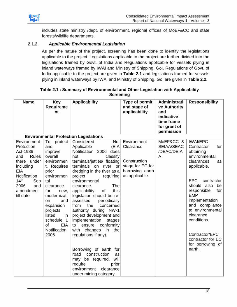
Consolidated Environmental Impact Assessment Report of National Waterways-1 : Volume - 3
18
includes state ministry /dept. of environment, regional offices of MoEF&CC and state
forests/wildlife departments.
2.1.2. Applicable Environmental Legislation
As per the nature of the project, screening has been done to identify the legislations
applicable to the project. Legislations applicable to the project are further divided into the
legislations framed by Govt. of India and Regulations applicable for vessels plying in
inland waterways framed by IWAI and Ministry of Shipping, GoI. Regulations of Govt. of
India applicable to the project are given in Table 2.1 and legislations framed for vessels
plying in inland waterways by IWAI and Ministry of Shipping, GoI are given in Table 2.2.
Table 2.1 : Summary of Environmental and Other Legislation with Applicability Screening
Name Key Requireme
nt
Applicability Type of permit and stage of applicability
Administrative Authority and indicative time frame for grant of permission
Responsibility
Environmental Protection Legislations
Environment Protection Act-1986 and Rules there under including EIA Notification 14th Sep 2006 and amendment till date
To protect and improve overall environment. Requires prior environmental clearance for new, modernization and expansion projects listed in schedule 1 of EIA Notification, 2006
Considered Not Applicable (EIA Notification 2006 does not classify terminals/jetties/ floating terminals on river or dredging in the river as a project requiring environmental clearance. The applicability of this legislation should be re-assessed periodically from the concerned authority during NW-1 project development and implementation stages to ensure conformity with changes in the regulations if any).
Borrowing of earth for road construction as may be required, will require prior environment clearance under mining category.
Environment Clearance
Construction stage for EC for borrowing earth as applicable
MoEF&CC & SEIAA/SEAC/DEAC/DEIAA
IWAI/EPC Contractor for obtaining environmental clearances as applicable.
EPC contractor should also be responsible for EMP implementation and compliance to environmental clearance conditions.
Contractor/EPC contractor for EC for borrowing of earth.
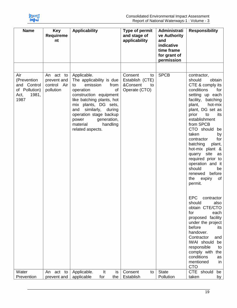
Consolidated Environmental Impact Assessment Report of National Waterways-1 : Volume - 3
19
Name Key Requireme
nt
Applicability Type of permit and stage of applicability
Administrative Authority and indicative time frame for grant of permission
Responsibility
Air (Prevention and Control of Pollution) Act, 1981, 1987
An act to prevent and control Air pollution
Applicable. The applicability is due to emission from operation of construction equipment like batching plants, hot mix plants, DG sets, and similarly, during operation stage backup power generation, material handling related aspects.
Consent to Establish (CTE) &Consent to Operate (CTO)
SPCB contractor, should obtain CTE & comply its conditions for setting up each facility, batching plant, hot-mix plant, DG set as prior to its establishment from SPCB CTO should be taken by contractor for batching plant, hot-mix plant & quarry site as required prior to operation and it should be renewed before the expiry of permit.
EPC contractor should also obtain CTE/CTO for each proposed facility under the project before its handover. Contractor and IWAI should be responsible to comply with the conditions as mentioned in CTO
Water Prevention
An act to prevent and
Applicable. It is applicable for the
Consent to Establish
State Pollution
CTE should be taken by

Consolidated Environmental Impact Assessment Report of National Waterways-1 : Volume - 3
20
Name Key Requireme
nt
Applicability Type of permit and stage of applicability
Administrative Authority and indicative time frame for grant of permission
Responsibility
and Control of Pollution) Act, 1974, 1988
control water pollution.
projects having potential to generate effluent during any stage of the project. Effluents are expected to be generated during both the construction and operation phase of the project.
&Consent to Operate
Control Boards
contractor for disposal of sewage and construction of septic tank/soak pit prior to start of construction from SPCB. Compliance to the conditions mentioned in the CTE should be done by EPC Contractor CTE/CTO for each proposed facility under the project should also be obtained by EPC contractor along with CTE / CTO under Air Act. IWAI should ensure the conditions specified in CTO are complied with
Noise Pollution (Regulation and Control Act) 2000 and amendment till date
Ambient Noise Standards for different areas and zones
Applicable due to generation of noise during construction and operation stage.
No permits issued under this act
SPCB & CPCB
EPC contractor and IWAI to ensure compliance to Ambient Noise Level Standards.
Hazardous & Other Wastes (Management and Transboundary
Protection to general public against improper handling storage and
Applicable. Project has potent to generate hazardous waste (Waste Oil) during both construction and operation phase.
Authorization for storage and handling hazardous waste
SPCB & MoEF&CC
EPC Contractor should obtain authorization for handling, storage and disposal of hazardous waste
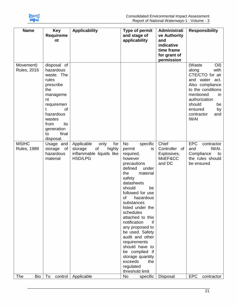
Consolidated Environmental Impact Assessment Report of National Waterways-1 : Volume - 3
21
Name Key Requireme
nt
Applicability Type of permit and stage of applicability
Administrative Authority and indicative time frame for grant of permission
Responsibility
Movement) Rules, 2016
disposal of hazardous waste. The rules prescribe the management requirement of hazardous wastes from its generation to final disposal.
(Waste Oil) along with CTE/CTO for air and water act. Also compliance to the conditions mentioned in authorization should be ensured by contractor and IWAI
MSIHC Rules, 1989
Usage and storage of hazardous material
Applicable only for storage of highly inflammable liquids like HSD/LPG
No specific permit is required, however precautions defined under the material safety datasheets should be followed for use of hazardous substances listed under the schedules attached to this notification if any proposed to be used. Safety audit and other requirements should have to be complied if storage quantity exceeds the regulated threshold limit
Chief Controller of Explosives, MoEF&CC and DC
EPC contractor and IWAI. Compliance to the rules should be ensured
The Bio To control Applicable No specific Disposal EPC contractor
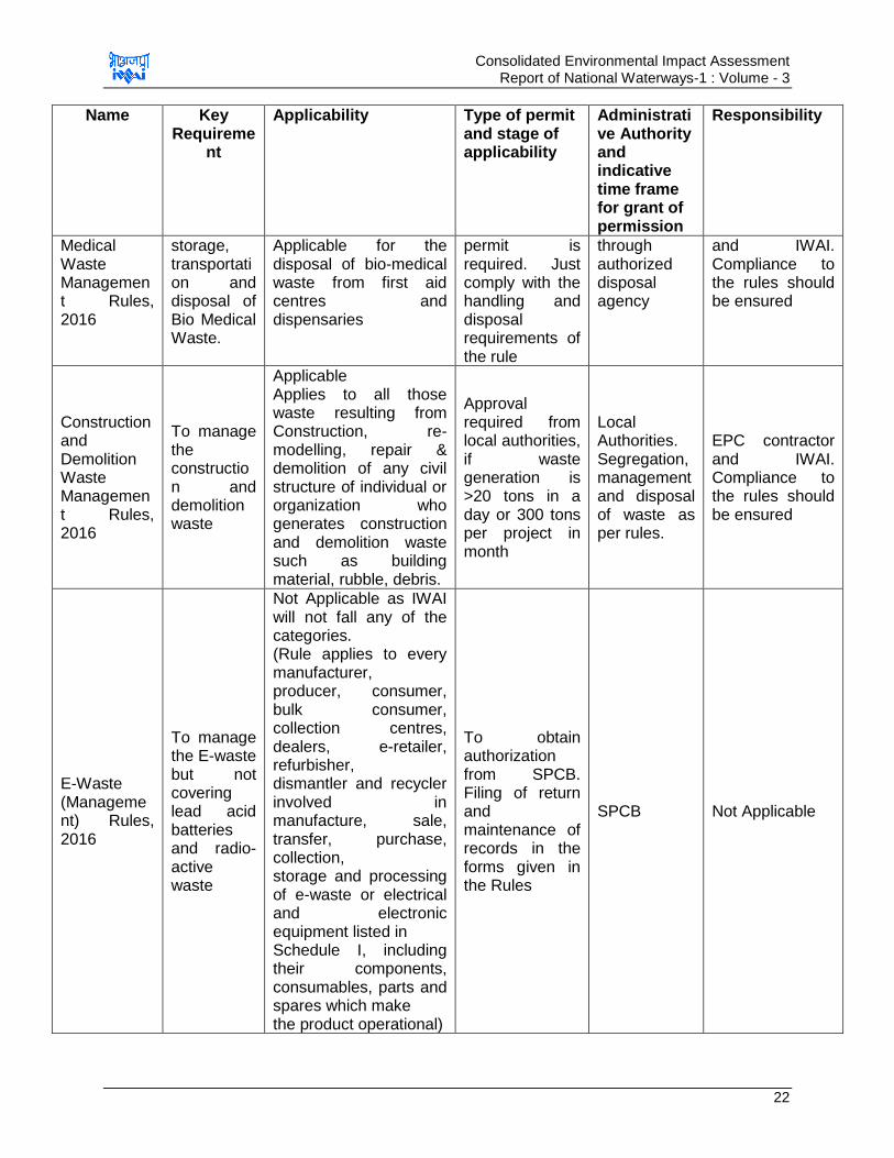
Consolidated Environmental Impact Assessment Report of National Waterways-1 : Volume - 3
22
Name Key Requireme
nt
Applicability Type of permit and stage of applicability
Administrative Authority and indicative time frame for grant of permission
Responsibility
Medical Waste Management Rules, 2016
storage, transportation and disposal of Bio Medical Waste.
Applicable for the disposal of bio-medical waste from first aid centres and dispensaries
permit is required. Just comply with the handling and disposal requirements of the rule
through authorized disposal agency
and IWAI. Compliance to the rules should be ensured
Construction and Demolition Waste Management Rules, 2016
To manage the construction and demolition waste
Applicable Applies to all those waste resulting from Construction, re-modelling, repair & demolition of any civil structure of individual or organization who generates construction and demolition waste such as building material, rubble, debris.
Approval required from local authorities, if waste generation is >20 tons in a day or 300 tons per project in month
Local Authorities. Segregation, management and disposal of waste as per rules.
EPC contractor and IWAI. Compliance to the rules should be ensured
E-Waste (Management) Rules, 2016
To manage the E-waste but not covering lead acid batteries and radio-active waste
Not Applicable as IWAI will not fall any of the categories. (Rule applies to every manufacturer, producer, consumer, bulk consumer, collection centres, dealers, e-retailer, refurbisher, dismantler and recycler involved in manufacture, sale, transfer, purchase, collection, storage and processing of e-waste or electrical and electronic equipment listed in Schedule I, including their components, consumables, parts and spares which make the product operational)
To obtain authorization from SPCB. Filing of return and maintenance of records in the forms given in the Rules
SPCB Not Applicable
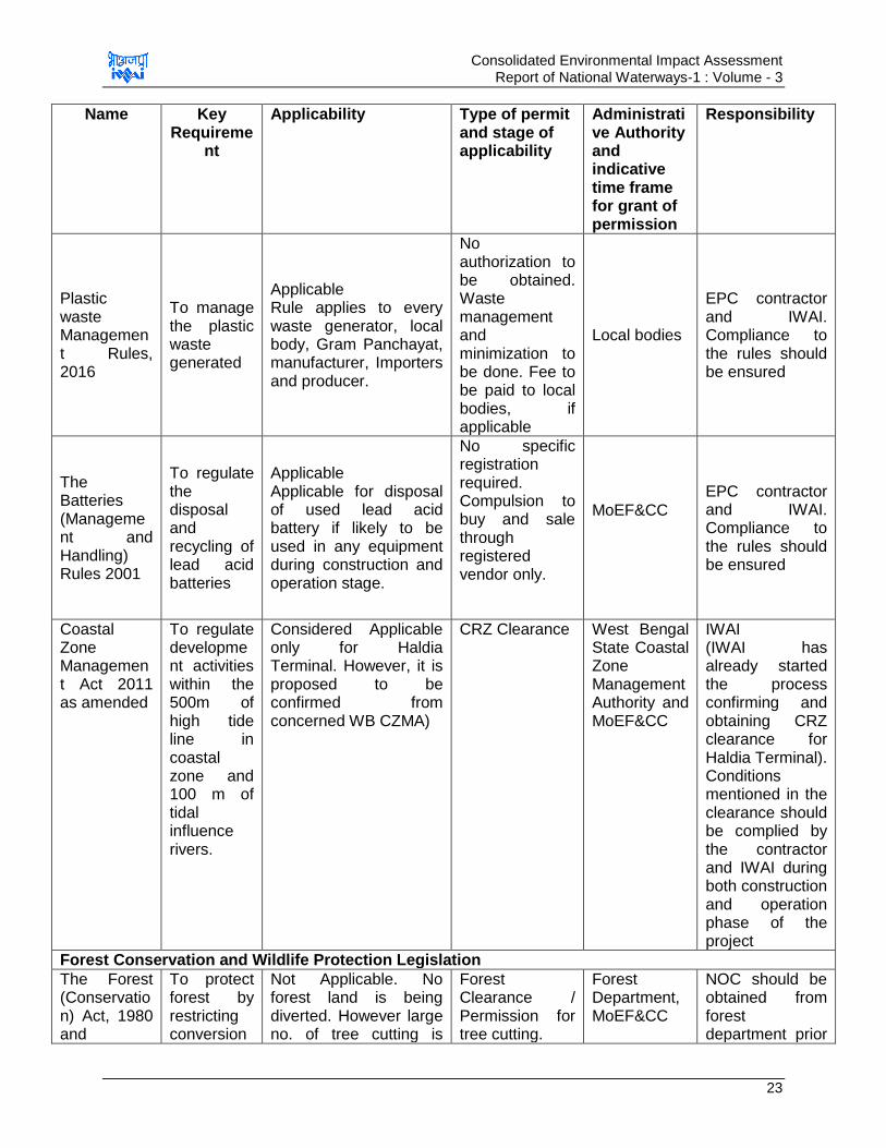
Consolidated Environmental Impact Assessment Report of National Waterways-1 : Volume - 3
23
Name Key Requireme
nt
Applicability Type of permit and stage of applicability
Administrative Authority and indicative time frame for grant of permission
Responsibility
Plastic waste Management Rules, 2016
To manage the plastic waste generated
Applicable Rule applies to every waste generator, local body, Gram Panchayat, manufacturer, Importers and producer.
No authorization to be obtained. Waste management and minimization to be done. Fee to be paid to local bodies, if applicable
Local bodies
EPC contractor and IWAI. Compliance to the rules should be ensured
The Batteries (Management and Handling) Rules 2001
To regulate the disposal and recycling of lead acid batteries
Applicable Applicable for disposal of used lead acid battery if likely to be used in any equipment during construction and operation stage.
No specific registration required. Compulsion to buy and sale through registered vendor only.
MoEF&CC
EPC contractor and IWAI. Compliance to the rules should be ensured
Coastal Zone Management Act 2011 as amended
To regulate development activities within the 500m of high tide line in coastal zone and 100 m of tidal influence rivers.
Considered Applicable only for Haldia Terminal. However, it is proposed to be confirmed from concerned WB CZMA)
CRZ Clearance West Bengal State Coastal Zone Management Authority and MoEF&CC
IWAI (IWAI has already started the process confirming and obtaining CRZ clearance for Haldia Terminal). Conditions mentioned in the clearance should be complied by the contractor and IWAI during both construction and operation phase of the project
Forest Conservation and Wildlife Protection Legislation
The Forest (Conservation) Act, 1980 and
To protect forest by restricting conversion
Not Applicable. No forest land is being diverted. However large no. of tree cutting is
Forest Clearance / Permission for tree cutting.
Forest Department, MoEF&CC
NOC should be obtained from forest department prior
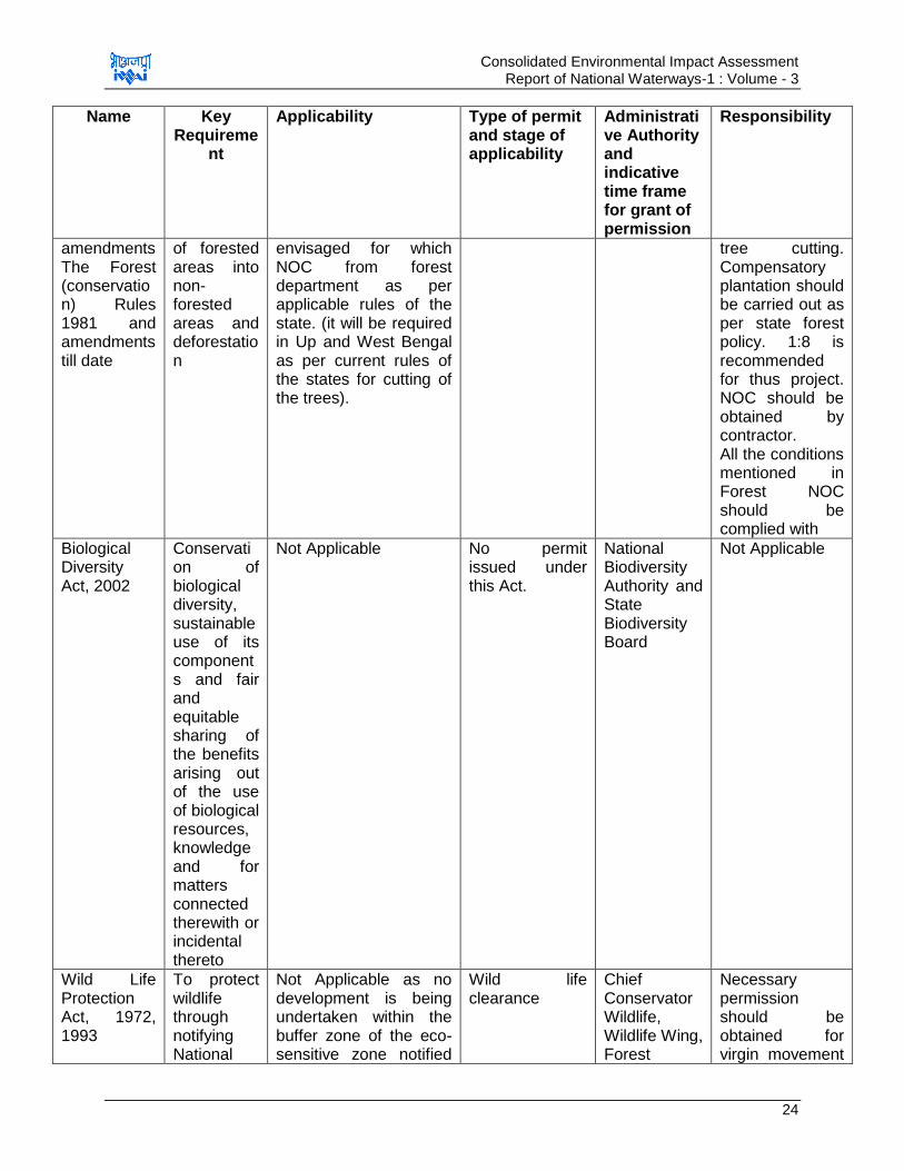
Consolidated Environmental Impact Assessment Report of National Waterways-1 : Volume - 3
24
Name Key Requireme
nt
Applicability Type of permit and stage of applicability
Administrative Authority and indicative time frame for grant of permission
Responsibility
amendments The Forest (conservation) Rules 1981 and amendments till date
of forested areas into non- forested areas and deforestation
envisaged for which NOC from forest department as per applicable rules of the state. (it will be required in Up and West Bengal as per current rules of the states for cutting of the trees).
tree cutting. Compensatory plantation should be carried out as per state forest policy. 1:8 is recommended for thus project. NOC should be obtained by contractor. All the conditions mentioned in Forest NOC should be complied with
Biological Diversity Act, 2002
Conservation of biological diversity, sustainable use of its components and fair and equitable sharing of the benefits arising out of the use of biological resources, knowledge and for matters connected therewith or incidental thereto
Not Applicable
No permit issued under this Act.
National Biodiversity Authority and State Biodiversity Board
Not Applicable
Wild Life Protection Act, 1972, 1993
To protect wildlife through notifying National
Not Applicable as no development is being undertaken within the buffer zone of the eco-sensitive zone notified
Wild life clearance
Chief Conservator Wildlife, Wildlife Wing, Forest
Necessary permission should be obtained for virgin movement

Consolidated Environmental Impact Assessment Report of National Waterways-1 : Volume - 3
25
Name Key Requireme
nt
Applicability Type of permit and stage of applicability
Administrative Authority and indicative time frame for grant of permission
Responsibility
Parks and Sanctuaries and buffer areas around these zones
under this act.
Necessary permission should be obtained for virgin movement of vessel through these zone (Kashi Turtle Sanctuary andVikramshila Dolphin sanctuary). Permission should be taken for any intervention if planned at any stage within the buffer zone of eco-sensitive zones.
No clearance is required under Hilsa Sanctuary as it is enacted only for fish productivity enhancement under Fisheries Act and not under this Act.
Department, MoEF&CC
of vessel through these zone (Kashi Turtle Sanctuary and Vikramshila Dolphin sanctuary). Permission should be taken for any intervention if planned at any stage within the buffer zone of eco sensitive zones.
(IWAI has already started process of obtaining permission for movement of vessel through these sanctuaries have already been started) Compliance to the conditions mentioned in permits should be complied by the IWAI
Safety and Other Related Legislations
Chemical
Accidents
(Emergency
Planning,
Preparednes
s and
Response)
Requireme
nt of
preparation
of on-site
and off-site
Disaster
Manageme
Not Applicable. The
project does not involve
handling of any
hazardous chemical
during both construction
and operation phase
which may lead to
No permits
issued under
this act
Central,
State &
District Crisis
Group
Not Applicable
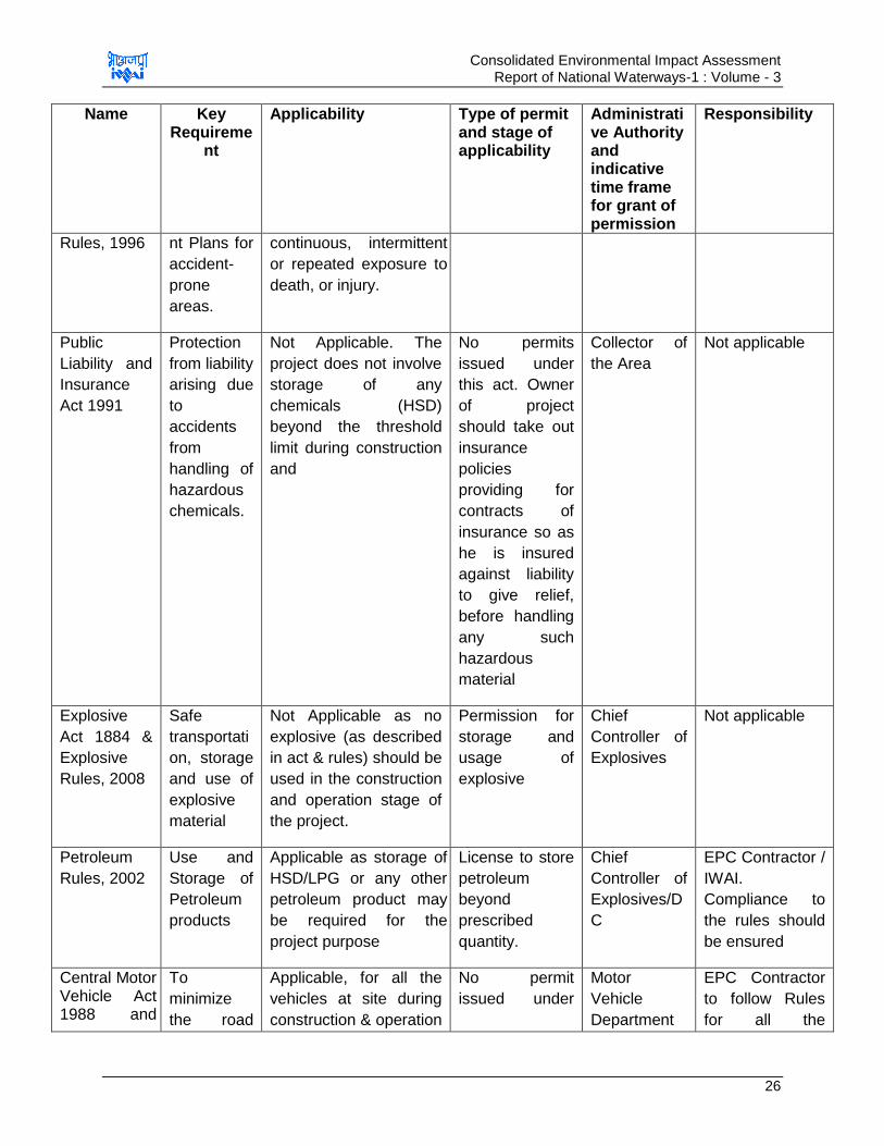
Consolidated Environmental Impact Assessment Report of National Waterways-1 : Volume - 3
26
Name Key Requireme
nt
Applicability Type of permit and stage of applicability
Administrative Authority and indicative time frame for grant of permission
Responsibility
Rules, 1996 nt Plans for
accident-
prone
areas.
continuous, intermittent
or repeated exposure to
death, or injury.
Public
Liability and
Insurance
Act 1991
Protection
from liability
arising due
to
accidents
from
handling of
hazardous
chemicals.
Not Applicable. The
project does not involve
storage of any
chemicals (HSD)
beyond the threshold
limit during construction
and
No permits
issued under
this act. Owner
of project
should take out
insurance
policies
providing for
contracts of
insurance so as
he is insured
against liability
to give relief,
before handling
any such
hazardous
material
Collector of
the Area
Not applicable
Explosive
Act 1884 &
Explosive
Rules, 2008
Safe
transportati
on, storage
and use of
explosive
material
Not Applicable as no
explosive (as described
in act & rules) should be
used in the construction
and operation stage of
the project.
Permission for
storage and
usage of
explosive
Chief
Controller of
Explosives
Not applicable
Petroleum
Rules, 2002
Use and
Storage of
Petroleum
products
Applicable as storage of
HSD/LPG or any other
petroleum product may
be required for the
project purpose
License to store
petroleum
beyond
prescribed
quantity.
Chief
Controller of
Explosives/D
C
EPC Contractor /
IWAI.
Compliance to
the rules should
be ensured
Central Motor Vehicle Act 1988 and
To
minimize
the road
Applicable, for all the
vehicles at site during
construction & operation
No permit
issued under
Motor
Vehicle
Department
EPC Contractor
to follow Rules
for all the
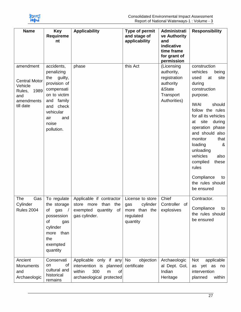
Consolidated Environmental Impact Assessment Report of National Waterways-1 : Volume - 3
27
Name Key Requireme
nt
Applicability Type of permit and stage of applicability
Administrative Authority and indicative time frame for grant of permission
Responsibility
amendment
Central Motor Vehicle Rules, 1989 and amendments till date
accidents,
penalizing
the guilty,
provision of
compensati
on to victim
and family
and check
vehicular
air and
noise
pollution.
phase this Act (Licensing
authority,
registration
authority
&State
Transport
Authorities)
construction
vehicles being
used at site
during
construction
purpose.
IWAI should
follow the rules
for all its vehicles
at site during
operation phase
and should also
monitor that
loading &
unloading
vehicles also
complied these
rules
Compliance to
the rules should
be ensured
The Gas
Cylinder
Rules 2004
To regulate
the storage
of gas /
possession
of gas
cylinder
more than
the
exempted
quantity
Applicable if contractor
store more than the
exempted quantity of
gas cylinder.
License to store
gas cylinder
more than the
regulated
quantity
Chief
Controller of
explosives
Contractor.
Compliance to
the rules should
be ensured
Ancient
Monuments
and
Archaeologic
Conservation of cultural and historical remains
Applicable only if any
intervention is planned
within 300 m of
archaeological protected
No objection
certificate
Archaeologic
al Dept. Gol,
Indian
Heritage
Not applicable
as yet as no
intervention
planned within
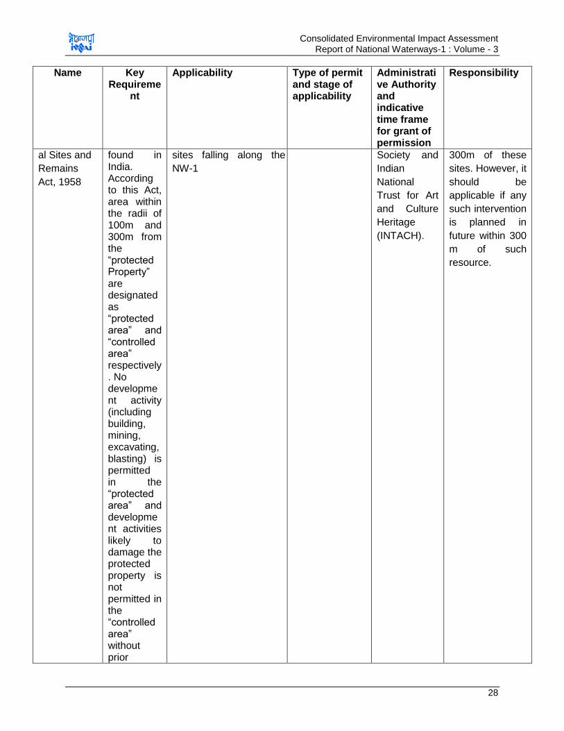
Consolidated Environmental Impact Assessment Report of National Waterways-1 : Volume - 3
28
Name Key Requireme
nt
Applicability Type of permit and stage of applicability
Administrative Authority and indicative time frame for grant of permission
Responsibility
al Sites and
Remains
Act, 1958
found in India. According to this Act, area within the radii of 100m and 300m from the “protected Property” are designated as “protected area” and “controlled area” respectively. No development activity (including building, mining, excavating, blasting) is permitted in the “protected area” and development activities likely to damage the protected property is not permitted in the “controlled area” without prior
sites falling along the
NW-1
Society and
Indian
National
Trust for Art
and Culture
Heritage
(INTACH).
300m of these
sites. However, it
should be
applicable if any
such intervention
is planned in
future within 300
m of such
resource.

Consolidated Environmental Impact Assessment Report of National Waterways-1 : Volume - 3
29
Name Key Requireme
nt
Applicability Type of permit and stage of applicability
Administrative Authority and indicative time frame for grant of permission
Responsibility
permission of the Archaeologi
cal Survey
of India
(ASI).
Merchant
Shipping
Act, 1958
To prevent
marine
pollution
from ships
beyond 5
km of the
coastline
and to
make the
transportati
on safe.
Considered Applicable
as these cargos are
also required to register
in India under this act.
Registration
Certificate
National
Shipping
Board
IWAI should
ensure that all
the barges plying
in the waterways
are complying
with the rule as
applicable
Guidelines
for
evaluation of
proposals/re
quests for
ground
water
abstraction
for drinking
and
domestic
purposes in
Notified
areas and
Industry/Infr
astructure
project
proposals in
Non-notified
To regulate
extraction
of ground
water for
drinking
and
domestic
purpose
Applicable if ground
water is extracted for
meeting
drinking/domestic water
needs of employees
and visitors at proposed
facility& vessels
No objection
certificate
Central
ground Water
Authority/Boa
rd &
MoEF&CC
Contractor/IWAI
should obtain
NOC from
CGWA/CGWB
prior digging any
bore well during
construction &
operation phase.
Compliance to
the rules should
be ensured by
IWAI and
contractor
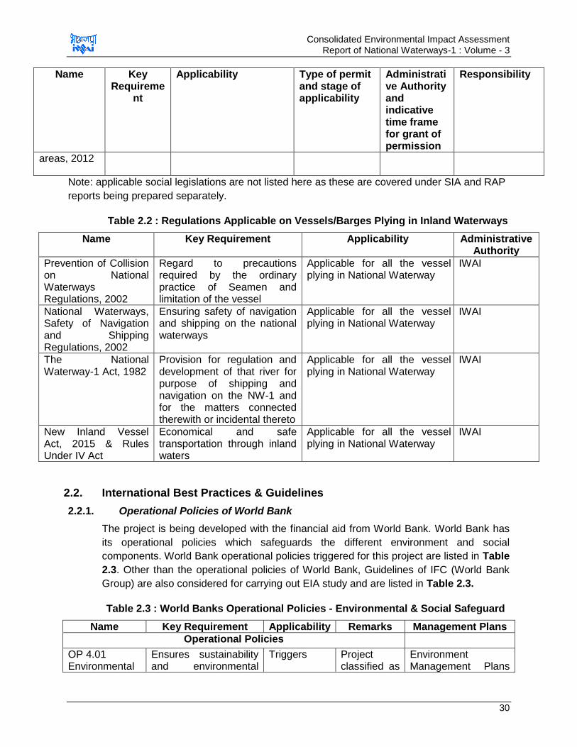
Consolidated Environmental Impact Assessment Report of National Waterways-1 : Volume - 3
30
Name Key Requireme
nt
Applicability Type of permit and stage of applicability
Administrative Authority and indicative time frame for grant of permission
Responsibility
areas, 2012
Note: applicable social legislations are not listed here as these are covered under SIA and RAP
reports being prepared separately.
Table 2.2 : Regulations Applicable on Vessels/Barges Plying in Inland Waterways
Name Key Requirement Applicability Administrative Authority
Prevention of Collision on National Waterways Regulations, 2002
Regard to precautions required by the ordinary practice of Seamen and limitation of the vessel
Applicable for all the vessel plying in National Waterway
IWAI
National Waterways, Safety of Navigation and Shipping Regulations, 2002
Ensuring safety of navigation and shipping on the national waterways
Applicable for all the vessel plying in National Waterway
IWAI
The National Waterway-1 Act, 1982
Provision for regulation and development of that river for purpose of shipping and navigation on the NW-1 and for the matters connected therewith or incidental thereto
Applicable for all the vessel plying in National Waterway
IWAI
New Inland Vessel Act, 2015 & Rules Under IV Act
Economical and safe transportation through inland waters
Applicable for all the vessel plying in National Waterway
IWAI
2.2. International Best Practices & Guidelines
2.2.1. Operational Policies of World Bank
The project is being developed with the financial aid from World Bank. World Bank has
its operational policies which safeguards the different environment and social
components. World Bank operational policies triggered for this project are listed in Table
2.3. Other than the operational policies of World Bank, Guidelines of IFC (World Bank
Group) are also considered for carrying out EIA study and are listed in Table 2.3.
Table 2.3 : World Banks Operational Policies - Environmental & Social Safeguard
Name Key Requirement Applicability Remarks Management Plans
Operational Policies
OP 4.01 Environmental
Ensures sustainability and environmental
Triggers Project classified as
Environment Management Plans
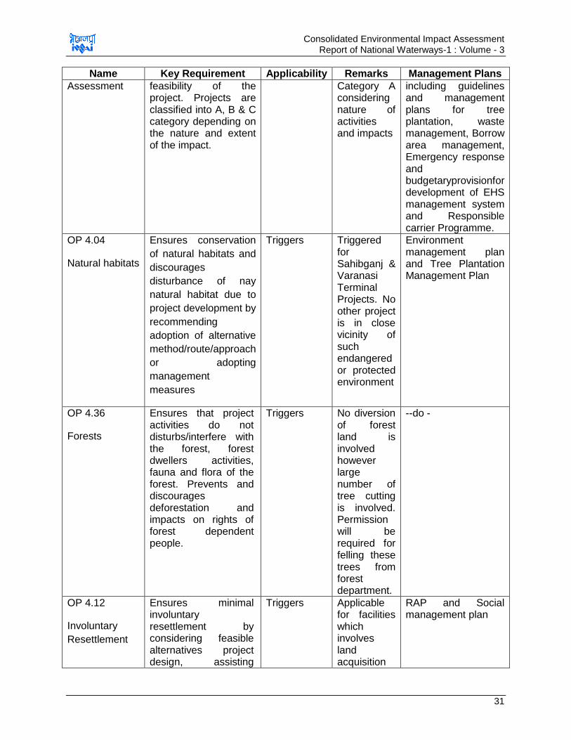
Consolidated Environmental Impact Assessment Report of National Waterways-1 : Volume - 3
31
Name Key Requirement Applicability Remarks Management Plans
Assessment feasibility of the project. Projects are classified into A, B & C category depending on the nature and extent of the impact.
Category A considering nature of activities and impacts
including guidelines and management plans for tree plantation, waste management, Borrow area management, Emergency response and budgetaryprovisionfor development of EHS management system and Responsible carrier Programme.
OP 4.04
Natural habitats
Ensures conservation
of natural habitats and
discourages
disturbance of nay
natural habitat due to
project development by
recommending
adoption of alternative
method/route/approach
or adopting
management
measures
Triggers Triggered for Sahibganj & Varanasi Terminal Projects. No other project is in close vicinity of such endangered or protected environment
Environment management plan and Tree Plantation Management Plan
OP 4.36
Forests
Ensures that project activities do not disturbs/interfere with the forest, forest dwellers activities, fauna and flora of the forest. Prevents and discourages deforestation and impacts on rights of forest dependent people.
Triggers No diversion of forest land is involved however large number of tree cutting is involved. Permission will be required for felling these trees from forest department.
--do -
OP 4.12
Involuntary
Resettlement
Ensures minimal involuntary resettlement by considering feasible alternatives project design, assisting
Triggers Applicable for facilities which involves land acquisition
RAP and Social management plan
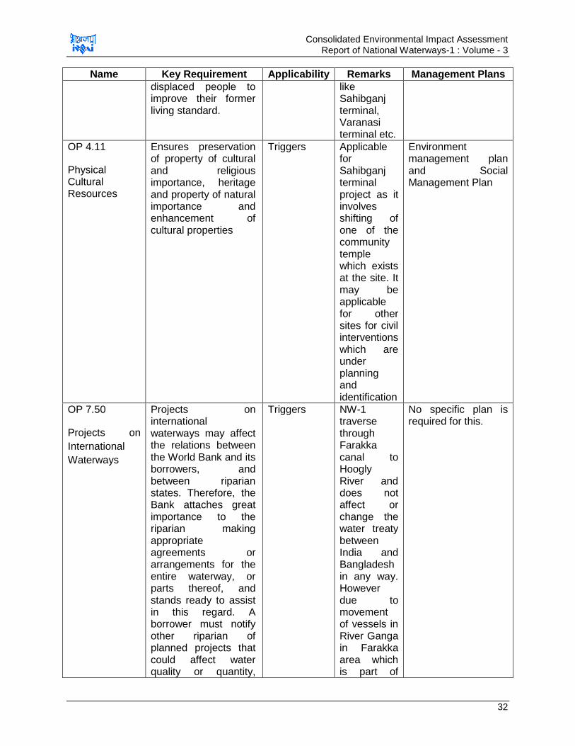
Consolidated Environmental Impact Assessment Report of National Waterways-1 : Volume - 3
32
Name Key Requirement Applicability Remarks Management Plans
displaced people to improve their former living standard.
like Sahibganj terminal, Varanasi terminal etc.
OP 4.11
Physical Cultural Resources
Ensures preservation of property of cultural and religious importance, heritage and property of natural importance and enhancement of cultural properties
Triggers Applicable for Sahibganj terminal project as it involves shifting of one of the community temple which exists at the site. It may be applicable for other sites for civil interventions which are under planning and identification
Environment management plan and Social Management Plan
OP 7.50
Projects on
International
Waterways
Projects on international waterways may affect the relations between the World Bank and its borrowers, and between riparian states. Therefore, the Bank attaches great importance to the riparian making appropriate agreements or arrangements for the entire waterway, or parts thereof, and stands ready to assist in this regard. A borrower must notify other riparian of planned projects that could affect water quality or quantity,
Triggers NW-1 traverse through Farakka canal to Hoogly River and does not affect or change the water treaty between India and Bangladesh in any way. However due to movement of vessels in River Ganga in Farakka area which is part of
No specific plan is required for this.
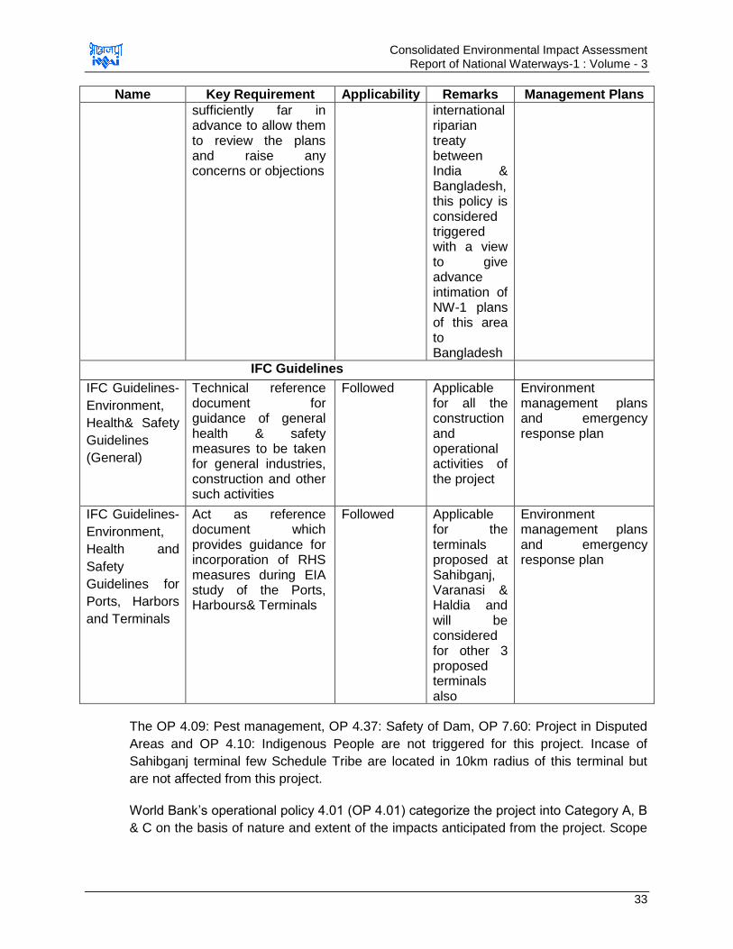
Consolidated Environmental Impact Assessment Report of National Waterways-1 : Volume - 3
33
Name Key Requirement Applicability Remarks Management Plans
sufficiently far in advance to allow them to review the plans and raise any concerns or objections
international riparian treaty between India & Bangladesh, this policy is considered triggered with a view to give advance intimation of NW-1 plans of this area to Bangladesh
IFC Guidelines
IFC Guidelines-
Environment,
Health& Safety
Guidelines
(General)
Technical reference document for guidance of general health & safety measures to be taken for general industries, construction and other such activities
Followed Applicable for all the construction and operational activities of the project
Environment management plans and emergency response plan
IFC Guidelines-
Environment,
Health and
Safety
Guidelines for
Ports, Harbors
and Terminals
Act as reference document which provides guidance for incorporation of RHS measures during EIA study of the Ports, Harbours& Terminals
Followed Applicable for the terminals proposed at Sahibganj, Varanasi & Haldia and will be considered for other 3 proposed terminals also
Environment management plans and emergency response plan
The OP 4.09: Pest management, OP 4.37: Safety of Dam, OP 7.60: Project in Disputed
Areas and OP 4.10: Indigenous People are not triggered for this project. Incase of
Sahibganj terminal few Schedule Tribe are located in 10km radius of this terminal but
are not affected from this project.
World Bank‟s operational policy 4.01 (OP 4.01) categorize the project into Category A, B
& C on the basis of nature and extent of the impacts anticipated from the project. Scope
Consolidated Environmental Impact Assessment Report of National Waterways-1 : Volume - 3
34
of Environmental assessment studies depends on the category in which the project falls
and is defined below.
Category A - Projects with significant environmental impacts and requiring a full
Environmental Assessment (EA),
Category B - Projects with moderate environmental impacts and requiring a lesser
level of environmental assessment,
Category C - Projects which require no environmental analysis.
Proposed Project involves augmentation of navigation capacity of NW-1 by developing
various facilities like terminals, jetties, navigation aids etc. along the NW-1. Project is
spread over app 1600 km and has impacts on various environment and social
component. Components to be impacted due to project development are quality of life,
livelihood, terrestrial and aquatic ecology, air quality, water quality, economy of the
country, noise levels etc. Also it is anticipated impacts are both positive and negative but
will be significant. Thus the project is classified as Category A and a detailed
environment and social assessment study has been undertaken for the project.
2.2.2. Relevant International Environmental Convention
A. International Maritime Organization Conventions
India is member state of the International Maritime Organization (IMO). All the vessels
plying in marine environment are bound to follow these conventions. These conventions
are aimed at ensuring environmental protection and safety of seamen. These guidelines
should also be followed by vessels/barges plying in inland water bodies to the extent
possible. IMO Conventions/ Protocols relevant to the project are given in Annexure2.1
(Volume 3C). Conventions which majorly are in environmental context include MARPOL
Convention 1973/78 & Ballast Water Management, 2004.
MARPOL Convention, 1973/78 : The MARPOL Convention, an international convention
is responsible for the preventing pollution of the marine environment by operational or
accidental discharges from the ships. It is a combination of two treaties adopted in 1973
and 1978 respectively and updated by amendments through the years.
This international convention was adopted in 1973 at International Maritime Organization
(IMO) and covered pollution by oil, chemicals, and harmful substances in packaged
form, sewage and garbage. The Protocol of 1978 relating to the 1973 International
Convention for the Prevention of Pollution from Ships (1978 MARPOL Protocol) was
adopted at a Conference on Tanker Safety and Pollution Prevention in February 1978
held in response to a spate of tanker accidents in 1976-1977. Measures relating to
tanker design and operation were also incorporated into a Protocol of 1978 relating to
the 1974 Convention on the Safety of Life at Sea, 1974.
The MARPOL Convention includes regulations that are aimed at preventing and
minimizing pollution from ships - both accidental pollution and that from routine
operations – The convention currently includes six technical annexes delineate below:
Annex I: Regulations for the Prevention of Pollution by Oil
Annex II: Regulations for the Control of Pollution by Noxious Liquid Substances in Bulk
Consolidated Environmental Impact Assessment Report of National Waterways-1 : Volume - 3
35
Annex III: Prevention of Pollution by Harmful Substances Carried by Sea in Packaged
Form
Annex IV: Prevention of Pollution by Sewage from Ships
Annex V: Prevention of Pollution by Garbage from Ships
Annex VI: Prevention of Air Pollution from Ships (entry into force 19 May 2005)
Ballast Water Management, 2004: Under this heading, IMOs‟ setup “International
Convention for the Control and Management of Ship‟s Ballast Water and Sediments,
2004” for preventing the introduction of unwanted organisms and pathogens from ship‟s
ballast water and sediment discharges. This is aimed to arrest the potentially devastating
effects of the spread of harmful aquatic organisms carried by ballast water. This
convention will require all ships to implement a Ballast Water Management Plan
(BWMP) and delineates the standards for the Ballast Water Exchange (BWE) and
Ballast Water Performance (BWP) under BWMP.
List of Safety Related Regulations:All the legislations and regulations as per IMO
applicable for vessel movements and cargo transportations through waterways is listed
in Annexure 2.1. However, few are listed below, which should specifically be referred to
ensure the safety of the personnel
Initial Assessment of Environmental Effects of Navigation and Infrastructure
Projects (WG 143 -2014)
Sustainable Waterways Within the Context of Navigation and Flood Management
(WG 107 -2009)
Climate Change and Navigation (TG3 -2008)
International Labour Organization (ILO) Code of Practice for Safety and Health in
Ports (2005);
General Conference of the International ILO Convention concerning Occupational
Safety and Health in Dock Work, C-152, (1979)
General Conference of the ILO Recommendation concerning Occupational Safety
and Health in Dock Work, R-160
IMO Code of Practice for Solid Bulk Cargo (BC Code)
International Code for the Construction and Equipment of Ships carrying
Dangerous Chemicals in Bulk (IBC Code)
International Code for the Safe Carriage of Grain in Bulk (International Grain
Code)
Code of Practice for the Safe Loading and Unloading of Bulk Carriers (BLU Code)
International Maritime Dangerous Goods Code (IMDG Code)
B. United Nations Convention on the Law of the Sea, Montego Bay, (1982):
This Convention was adopted by India on 10th December 1982 at Montego Bay,
Jamaica. Main objectives of the convention are:
Consolidated Environmental Impact Assessment Report of National Waterways-1 : Volume - 3
36
To set up a comprehensive new legal regime for the sea and oceans, as far as
environmental provisions are concerned, to establish material rules concerning
environmental standards as well as enforcement provisions dealing with pollution
of the marine environment; and
To establish basic environmental protection principals and rules on global and
regional cooperation, technical assistance, monitoring, and environmental
assessment, and adoption and enforcement of international rules and standards
and national legislation with respect to all sources of marine pollution.
Thus the convention can be referred to understand the environmental protection
principals and procedures to minimize the environmental pollution due to movement of
vessels/barges and related operations
C. International Maritime Dangerous Goods Code (IMDG-code)
The IMDG code relates to methods of safe transport of dangerous cargoes and related
activities. It sets out procedures for documentation, storage, segregation, packing,
marking and labelling of dangerous goods. This convention can also be referred to
understand the procedures followed by the vessels carrying the dangerous goods to
ensure safety and avoid spillage and accidents.
2.3. Environmental Standards & Guidelines
Project involves various activities, which may interfere with various environmental
components. Thus it is required to control those activities so as the concentration of
pollutant in environment should not exceeds its assimilation capacity. CPCB has issued
some standards for disposal of effluents and quality of surface water body which should
be referred and adhered to with regards to prescribed discharge standards at any point
of time. India does not have any standard yet for disposal of dredged material, water
quality in and around harbour/ports/terminals, thus standards issued by other renowned
bodies are referred. Suggested list of standards is listed below and given in detail at
Annexure 2.2(Volume 3C).
Standards for discharge of effluent in inland surface water bodies and Marine
Coastal Areas (Source: G.S.R 422 (E) dated 19.05.1993 and G.S.R 801 (E) dated
31.12.1993 issued under the provisions of E (P) Act 1986)
Classification of Surface water Bodies on basis of Quality (Source: Guidelines for
Water Quality Management-CPCB, 2008)
Water Quality Standards for Coastal Waters, SW-IV & V-Harbour and Navigation
& controlled waste disposal (EIA Guidance Manual for Ports & Harbours,
MoEF&CC, GoI)
Standards for permissible level of water quality indicators (Source: Assessment of
the Environmental Impact of Port Development, United Nations, New York, 1992)
Permissible limit for off-shore dumping of dredged material (Source: Assessment
of the Environmental Impact of Port Development, United Nations, New York,
1992)
Consolidated Environmental Impact Assessment Report of National Waterways-1 : Volume - 3
37
Criteria for harmful bottom sediments (Source: Assessment of the Environmental
Impact of Port Development, United Nations, New York, 1992)
Approximate Quantity of Suspended Sediments Generated by Dredging or
Dumping Operations (Source: Assessment of the Environmental Impact of Port
Development, United Nations, New York, 1992).
2.3.1. Guideline, Standard and recommendations as published by Environmental Committee of PIANC
PIANC- the World Association for Waterborne Transport Infrastructure is the forum
which provides expert advice on cost-effective, reliable and sustainable infrastructures to
facilitate the growth of waterborne transport. PIANC has published various guidelines for
ensuring the sustainable development of waterborne transport. Some of the guidelines
as applicable to the project are listed below. These guidelines can be referred to make
the Inland water transportation system sustainable and environmental friendly.
Dredging Management Practices for the Environment (WG 100-2009)
Dredging Material as a Resources (WG 104-2009)
Ecological and Engineering Guidelines for Wetland Restoration in relation to the
Development, Operation and Maintenance of Navigational Infrastructure (WG 7-
2003)
Management of Aquatic Disposal of dredged material (WG 1-1998)
Dredged Material Management Guide 1997.
Guidelines for sustainable Inland Waterways and Navigation WG 6-2003
2.4. Key safeguard documents
A detailed description of project baseline environmental conditions, identified positive
and negative environmental impacts, the mitigation measures to eliminate or minimize
the adverse impacts and enhance the positive impacts, detailed environmental
management plan including institutional responsibilities, implementation schedule,
environmental budget, arrangement for monitoring and evaluation and grievance
redressal mechanism are provided in the consolidated environmental impact
assessment report for NW-1 and environmental impact assessment report of Ramnagar
(Varanasi terminal), Sahibganj terminal, Farakka Lock, Haldia terminal. The other
supplementary documents prepared under this project are i) Basin Level Critical
Environmental Resource Assessment report; ii) Consolidated rehabilitation action plan
for NW-1, iii) Rehabilitation action plan for Sahibganj, iv) EIA Report for maintenance
dredging and barge operations.
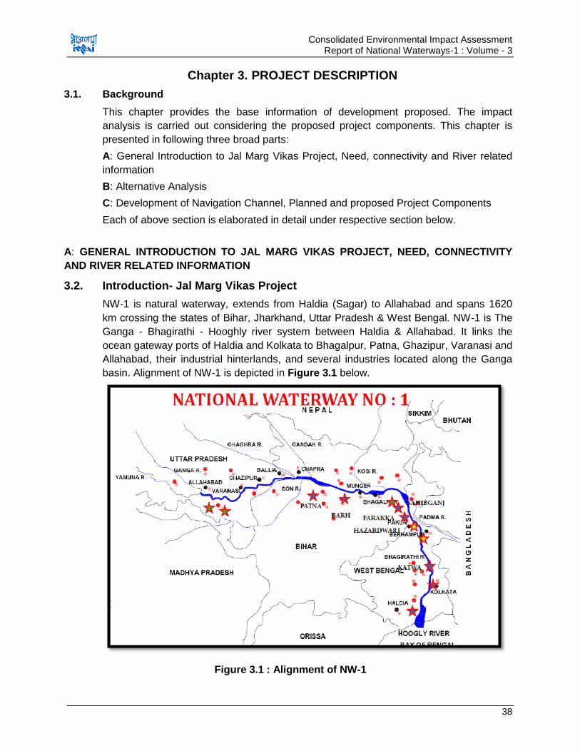
Consolidated Environmental Impact Assessment Report of National Waterways-1 : Volume - 3
38
Chapter 3. PROJECT DESCRIPTION
3.1. Background
This chapter provides the base information of development proposed. The impact
analysis is carried out considering the proposed project components. This chapter is
presented in following three broad parts:
A: General Introduction to Jal Marg Vikas Project, Need, connectivity and River related
information
B: Alternative Analysis
C: Development of Navigation Channel, Planned and proposed Project Components
Each of above section is elaborated in detail under respective section below.
A: GENERAL INTRODUCTION TO JAL MARG VIKAS PROJECT, NEED, CONNECTIVITY
AND RIVER RELATED INFORMATION
3.2. Introduction- Jal Marg Vikas Project
NW-1 is natural waterway, extends from Haldia (Sagar) to Allahabad and spans 1620
km crossing the states of Bihar, Jharkhand, Uttar Pradesh & West Bengal. NW-1 is The
Ganga - Bhagirathi - Hooghly river system between Haldia & Allahabad. It links the
ocean gateway ports of Haldia and Kolkata to Bhagalpur, Patna, Ghazipur, Varanasi and
Allahabad, their industrial hinterlands, and several industries located along the Ganga
basin. Alignment of NW-1 is depicted in Figure 3.1 below.
Figure 3.1 : Alignment of NW-1

Consolidated Environmental Impact Assessment Report of National Waterways-1 : Volume - 3
39
NW-1 is being fed by various tributaries at different locations. Major tributaries to NW-1
between Haldia to Allahabad are Tons, Gomti, Ghagra, Son, Gandak, Punpun and Kosi.
Jal Marg Vikas project is aimed at augmentation of navigation in the waterway by
maintaining the LAD in the waterway throughout the year for navigation, development of
the navigational infrastructure and navigation aids, river training works at critical location,
equipment of the necessary barges/dredgers/boats for navigation purpose and
development of efficient River information system. However, to optimize the project
impacts and the cost, at present it is proposed to augment the stretch between Haldia
and Varanasi only. Dredging operations for maintenance of LAD will be carried out
between Haldia and Varanasi only.
3.3. Project Location
Project area includes entire reach of the River Ganga from Haldia to Allahabad including
the areas proposed for development of project related facilities & infrastructure, i.e.
terminal sites, lock site, Ro-Ro jetty sites and sites for other planned development.
Stretch from Allahabad to Haldia covers four states namely Jharkhand, Bihar, Uttar
Pradesh & West Bengal. Map showing location of NW-1 stretch from Haldia to Allahabad
is depicted in Figure 3.2.
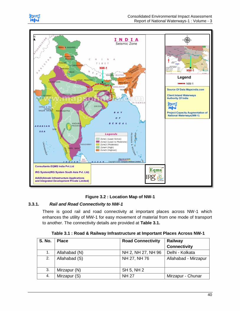
Consolidated Environmental Impact Assessment Report of National Waterways-1 : Volume - 3
40
Figure 3.2 : Location Map of NW-1
3.3.1. Rail and Road Connectivity to NW-1
There is good rail and road connectivity at important places across NW-1 which
enhances the utility of MW-1 for easy movement of material from one mode of transport
to another. The connectivity details are provided at Table 3.1.
Table 3.1 : Road & Railway Infrastructure at Important Places Across NW-1
S. No. Place Road Connectivity Railway
Connectivity
1. Allahabad (N) NH 2, NH 27, NH 96 Delhi - Kolkata
2. Allahabad (S) NH 27, NH 76
Allahabad - Mirzapur
3. Mirzapur (N) SH 5, NH 2
4. Mirzapur (S) NH 27 Mirzapur - Chunar

Consolidated Environmental Impact Assessment Report of National Waterways-1 : Volume - 3
41
5. Varanasi (N) NH 29, NH 56, NH
233
Varanasi-Ghazipur
6. Varanasi (S) NH 2, NH 7 Mirzapur-Buxar
7. Ghazipur (N) NH 19 Ghazipur - Ballia
8. Ghazipur (S) NH 30, NH 97 Chunar-Buxar
9. Ballia (N) NH 19 Ballia - Chapra
10. Buxar (S) NH 30
11. Patna (N) NH 77 Chapra - Begusarai
12. Patna (S) NH 30A,31,83 & 98 Patna - Jamalpur
13. Bhagalpur (N) NH 31, NH 106 Bhagalpur-Sahibganj
14. Bhagalpur (S) NH 80 Patna - Jamalpur
15. Katihar (N) NH 31, NH 131A
16. Sahibganj (S)
NH 80
Sahibganj-Farakka
17. Farakka (E) NH 81, NH 34
18. Farakka (W) NH 80, NH 60
Farakka -
Behrampur
19. Behrampur
NH 34
Behrampur -
Nabadwip
20. Nabadwip
NH 34
Nabadwip -
Raghunathpur
21. Barrackpur
NH 34, NH 35
Barrackpur-Kolkata
22. Kolkata NH 34, NH 35 Kolkata - Bagnan
23. Howra NH 6, NH 2
24. Haldia (W) NH 6, NH 41, NH
116B
Howra- Haldia
25. Haldia (E) NH 117 --
3.4. Size and Magnitude of the Project
Proposed Project-Jal Marg Vikas aims at improvement of navigation in entire stretch of
NW-1 (Haldia to Allahabad). Length of the waterway is about 1620 km and traverses
through 4 states namely Jharkhand, Uttar Pradesh, Bihar and West Bengal.
Developments planned under the Jal Marg Vikas project includes
Maintenance dredging to maintain the required LAD in waterway/channel and at the
proposed terminal facilities
Improved Navigation Infrastructure& Navigation Aids
o Construction of 5 Nos. of Ro-Ro crossings & ferry passenger jetties. Location for
these jetties is not yet identified.
o Construction of 6 Nos. of terminals. Site identification and planning for 3
terminals sites at Sahibganj, Varanasi and Haldia is accomplished. Besides 2
more potential sites for development of terminals are identified at Ghazipur and
Kalughat. These two sites are at initial stage of planning. One more terminal site
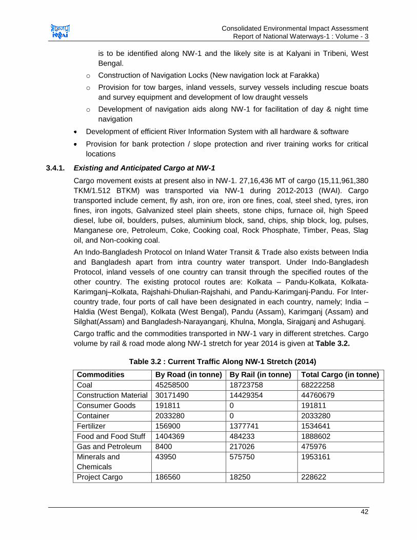
Consolidated Environmental Impact Assessment Report of National Waterways-1 : Volume - 3
42
is to be identified along NW-1 and the likely site is at Kalyani in Tribeni, West
Bengal.
o Construction of Navigation Locks (New navigation lock at Farakka)
o Provision for tow barges, inland vessels, survey vessels including rescue boats
and survey equipment and development of low draught vessels
o Development of navigation aids along NW-1 for facilitation of day & night time
navigation
Development of efficient River Information System with all hardware & software
Provision for bank protection / slope protection and river training works for critical
locations
3.4.1. Existing and Anticipated Cargo at NW-1
Cargo movement exists at present also in NW-1. 27,16,436 MT of cargo (15,11,961,380
TKM/1.512 BTKM) was transported via NW-1 during 2012-2013 (IWAI). Cargo
transported include cement, fly ash, iron ore, iron ore fines, coal, steel shed, tyres, iron
fines, iron ingots, Galvanized steel plain sheets, stone chips, furnace oil, high Speed
diesel, lube oil, boulders, pulses, aluminium block, sand, chips, ship block, log, pulses,
Manganese ore, Petroleum, Coke, Cooking coal, Rock Phosphate, Timber, Peas, Slag
oil, and Non-cooking coal.
An Indo-Bangladesh Protocol on Inland Water Transit & Trade also exists between India
and Bangladesh apart from intra country water transport. Under Indo-Bangladesh
Protocol, inland vessels of one country can transit through the specified routes of the
other country. The existing protocol routes are: Kolkata – Pandu-Kolkata, Kolkata-
Karimganj–Kolkata, Rajshahi-Dhulian-Rajshahi, and Pandu-Karimganj-Pandu. For Inter-
country trade, four ports of call have been designated in each country, namely; India –
Haldia (West Bengal), Kolkata (West Bengal), Pandu (Assam), Karimganj (Assam) and
Silghat(Assam) and Bangladesh-Narayanganj, Khulna, Mongla, Sirajganj and Ashuganj.
Cargo traffic and the commodities transported in NW-1 vary in different stretches. Cargo
volume by rail & road mode along NW-1 stretch for year 2014 is given at Table 3.2.
Table 3.2 : Current Traffic Along NW-1 Stretch (2014)
Commodities By Road (in tonne) By Rail (in tonne) Total Cargo (in tonne)
Coal 45258500 18723758 68222258
Construction Material 30171490 14429354 44760679
Consumer Goods 191811 0 191811
Container 2033280 0 2033280
Fertilizer 156900 1377741 1534641
Food and Food Stuff 1404369 484233 1888602
Gas and Petroleum 8400 217026 475976
Minerals and
Chemicals
43950
575750 1953161
Project Cargo 186560 18250 228622

Consolidated Environmental Impact Assessment Report of National Waterways-1 : Volume - 3
43
Vehicles 37100 100000 137100
Total Cargo (in
tonnes)
79492360 35926112 121426130
Source: HPC&HOWE ENGINEERING PROJECTS (INDIA) PVT. LTD. (DESIGN CONSULTANT)
As per projection study undertaken by survey and marketing consultant HPC for growth
of traffic for planned project life of 30 years. Three scenarios are considered for
forecasting, i.e. base case (in absence of Jal Marg Vikas Project), Medium
Augmentation case (Jal Marg Vikas project with 3 m LAD upto Barh, 2.5 m until
Ghazipur and 2 m upto Varanasi) and Full augmentation case (LAD of 3 m upto Patna
and 2.5 m upto Varanasi). For the study purpose HPC has considered medium case
augmentation. Since traffic will es expected to be different for different stretches, the
separate traffic projections is made for Haldia-Varanasi, Haldia-Patna & Patna-Varanasi.
The traffic projection for these stretches as per medium case augmentation is given at
Table 3.3, 3.4 & 3.5.
Table 3.3 : Traffic Forecast for Stretch-1 (Haldia-Varanasi)
Cargo
Type
Commodity Forecast Medium Augmentation Case (tons)
Forecast
MAC
2015 (t)
Forecast
MAC 2020
(t)
Forecast
MAC 2025
(t)
Forecast
MAC 2035
(t)
Forecast
MAC 2045
(t)
Dry Bulk Stone chips 99,336 1,01,52,467 1,27,98,104 1,70,90,680 1,98,68,049
Dry Bulk Coal 32,82,875 74,05,156 84,57,510 1,04,26,875 1,16,59,733
Dry Bulk Iron ore 0 85,444 1,12,020 1,52,328 1,61,924
Dry Bulk Limestone 0 3,889 4,932 6,925 8,050
Dry Bulk Sand 0 1,38,070 1,74,090 2,32,932 2,70,785
Bagged Food &
Foodstuff
0 15,61,662 18,88,883 23,85,956 25,19,450
Bagged Cement 0 8,27,552 12,13,633 20,34,856 25,62,950
Bagged Fertilizer 0 60,061 66,117 75,037 80,216
Bagged Plastic
granules
0 9,383 12,270
18,713
24,250
Bagged Textile 0 1,25,941 1,80,823 3,11,868 3,99,577
Neo-bulk Logs &
woods
63,151 86,976
1,08,042 1,45,196
1,82,878
Neo-bulk Paper 0 3,745 5,282 8,320 10,480
Neo-bulk Petroleum 2,62,460 5,15,815 6,61,925 9,25,784 10,70,067
Neo-bulk Project
cargo
0 3,79,560 4,43,000 5,67,556 7,14,850
Neo-bulk Statues 0 1,07,208 1,21,296 1,37,339 1,37,339
Neo-bulk Steel
products
0 8,86,183 10,89,119 14,69,146 18,50,424
Ro-Ro Vehicles 0 47,863 65,484 1,09,045 1,45,370
Container General 0 18,72,123 27,83,131 48,68,543 63,44,978
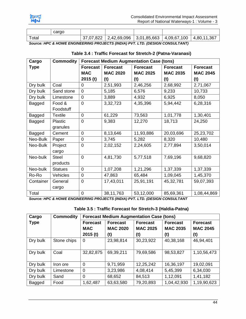
Consolidated Environmental Impact Assessment Report of National Waterways-1 : Volume - 3
44
cargo
Total 37,07,822 2,42,69,096 3,01,85,663 4,09,67,100 4,80,11,367
Source: HPC & HOWE ENGINEERING PROJECTS (INDIA) PVT. LTD. (DESIGN CONSULTANT)
Table 3.4 : Traffic Forecast for Stretch-2 (Patna-Varanasi)
Cargo
Type
Commodity Forecast Medium Augmentation Case (tons)
Forecast
MAC
2015 (t)
Forecast
MAC 2020
(t)
Forecast
MAC 2025
(t)
Forecast
MAC 2035
(t)
Forecast
MAC 2045
(t)
Dry bulk Coal 0 2,51,993 2,46,256 2,68,992 2,71,067
Dry bulk Sand stone 0 5,185 6,576 9,233 10,733
Dry bulk Limestone 0 3,889 4,932 6,925 8,050
Bagged Food &
Foodstuff
0 3,32,723 4,35,396 5,94,442 6,28,316
Bagged Textile 0 61,229 73,563 1,01,778 1,30,401
Bagged Plastic
granules
0 9,383 12,270 18,713 24,250
Bagged Cement 0 8,13,646 11,93,886 20,03,696 25,23,702
Neo-Bulk Paper 0 3,745 5,282 8,320 10,480
Neo-Bulk Project
cargo
0 2,02,152 2,24,605 2,77,894 3,50,014
Neo-bulk Steel
products
0 4,81,730
5,77,518 7,69,196
9,68,820
Neo-bulk Statues 0 1,07,208 1,21,296 1,37,339 1,37,339
Ro-Ro Vehicles 0 47,863 65,484 1,09,045 1,45,370
Container General
cargo
0 17,43,011 25,91,191
45,32,781
59,07,393
Total 0 38,11,763 53,12,000 85,69,361 1,08,44,869
Source: HPC & HOWE ENGINEERING PROJECTS (INDIA) PVT. LTD. (DESIGN CONSULTANT
Table 3.5 : Traffic Forecast for Stretch-3 (Haldia-Patna)
Cargo
Type
Commodity Forecast Medium Augmentation Case (tons)
Forecast
MAC
2015 (t)
Forecast
MAC 2020
(t)
Forecast
MAC 2025
(t)
Forecast
MAC 2035
(t)
Forecast
MAC 2045
(t)
Dry bulk Stone chips 0 23,98,814
30,23,922
40,38,168 46,94,401
Dry bulk Coal 32,82,875 69,39,211
79,69,586
98,53,827 1,10,56,473
Dry bulk Iron ore 0 9,71,959 12,25,242 16,36,197 19,02,091
Dry bulk Limestone 0 3,23,986 4,08,414 5,45,399 6,34,030
Dry bulk Sand 0 68,652 84,513 1,12,091 1,41,182
Bagged Food 1,62,487 63,63,580 79,20,893 1,04,42,930 1,19,90,623

Consolidated Environmental Impact Assessment Report of National Waterways-1 : Volume - 3
45
&Foodstuff
Bagged Fertilizers 0 17,94,026 26,47,350 45,96,517 59,75,527
Bagged Plastic
granules
0 23,258 32,621
50,627
58,517
Bagged Textile 0 2,22,364 3,02,610 4,71,792 5,99,523
Neo-Bulk Logs and
wood
0 6,47,972
8,16,828
10,90,798
12,68,061
Neo-bulk Petroleum 2,62,460 14,63,318 18,43,599 24,76,593 28,74,916
Neo-Bulk Project
cargo
0 2,64,189 3,15,652 4,24,786 5,19,963
Neo-bulk Steel
products
0 9,39,231 11,52,032 15,42,578 19,02,495
Ro-Ro Vehicles 0 25,886 30,543 41,522 53,199
Container General
cargo
0 2,17,457
2,95,933 4,65,037 5,85,405
Total 37,07,822 2,26,63,903 2,80,69,739 3,77,88,862 4,42,56,407
Source: HPC& HOWE ENGINEERING PROJECTS (INDIA) PVT. LTD. (DESIGN CONSULTANT
Though above traffic projection indicated sufficient traffic cargo potential till 2045,
however design consultant has considered different traffic forecasted the traffic again for
the presently designed infrastructure facility. These terminals are designed on the basis
of the traffic expected to be shifted at these sites from rail/road to IWT mode. Traffic
projections for the planned infrastructure site are given below in Table 3.6.
Table 3.6 : Traffic Forecast for Planned Navigational Infrastructural Facilities
S.No. Infrastructural
Facility
Projected
Cargo-2015
(MTPA)
Projected
Cargo-2030
(MTPA)
Projected
Cargo-2045
(MTPA)
1 Sahibganj
Terminal
2.24 4.39 9.00
2 Varanasi
Terminal (with
current land)
0.54 1.22 1.22
3 Haldia Terminal 3.18 MTPA
Source: HOWE ENGINEERING PROJECTS (INDIA) PVT. LTD. (DESIGN CONSULTANT
3.4.2. Depth of Navigation Channel
It is planned to maintain depth of 3 m all along the stretch from Haldia to Allahabad but
to optimize the cost and minimize the environmental damage, it is planned to maintain
depth of 3 m from Haldia to Barh, 2.5 m from Barh to Ghazipur and 2.2 m from Ghazipur
to Varanasi at present16.
16
Source of Data:(Detailed Feasibility Study for Jal Marg Vikas Project and Detailed Engineering for its Ancillary Works
and Processes between Haldia to Allahabad by HOWE Engineering Projects (India) Pvt. Ltd).
Consolidated Environmental Impact Assessment Report of National Waterways-1 : Volume - 3
46
3.4.3. Width of Navigation Channel
It is planned to provide two-way cargo movements in the navigation channel and
maintaining the width of channel between 60-120 m. However, at present it is planned to
maintain the channel width17 of 45 m and side slopes of 1:5 from section Haldia to
Varanasi.18
3.4.4. Size of the Vessel/Ships
As per IWAI planning, vessels of maximum length 110 m, beam 11.4 m, draught 2.5 m-
2.8 m and air draught of 9 m will ply in NW-1 waterway19. However, the vessel size will
vary in different stretched as per the available LAD and type and quantity of cargo to be
transported. Vessels of size 1500-2000 DWT is expected to ply in the waterway. Study
for cargo estimation is under process and size of the vessels will be finalized
accordingly.
At present, planned vessels designed run on diesel, however IWAI is planning to switch
to CNG for operating the vessels. Proposal and study for the feasibility of using CNG as
fuel is under process. IWAI is interacting with various agencies for design of the high
capacity vessels which can move in low draft so as to reduce the dredging requirement.
3.5. Challenges for Project Development
When it comes to the implementation of Jal Marg Vikas Project to ensure navigation in
entire NW-1 throughout the year, various challenges come in picture. NW-1 is alluvial
river with typical characteristic of braiding, meandering and large water level fluctuation
between summer and monsoon months.
Wide variations in water level are observed ranging from 2.5 m at Farakka to 16.5 m at
Allahabad. Current velocity varies between 0.2m/s during lean season to 4.0 m/s during
flood season in the stretch between Allahabad to Farakka. Current velocity is 1.2 m/s in
Feeder Canal & 1.7 m/s (max.) in Bhagirathi river stretch.
Ganga carries annual silt load of 1600 million tons. Fine silt leads to rapid shoal
formation. It becomes difficult to maintain even 2 m depth during low water season
throughout the stretch. The stretch between Haldia and Tribeni (196 km) is tidal and the
Least Available Depth (LAD) of more than 3.0 m is maintained naturally therein. IWAI
has to erect bandals and carry out dredging to maintain the LAD in upper stretches of
Tribeni. Due to unavailability of adequate depth/width and navigational infrastructure
facilities, navigation of the large cargos throughout the year is not possible. Major
challenges for navigation in NW-1 are listed below
1. Highly braiding and meandering river
2. Large water level fluctuation
3. Unavailability of LAD for navigation throughout NW-1 and unreliable water depths
17
The width of the channel is being reduced to 45 m under phase I development. This will further reduce he dredging
requirements. However, these details are under finalization stage. 18
Source of Data:(Detailed Feasibility Study for Jal Marg Vikas Project and Detailed Engineering for its Ancillary Works
and Processes between Haldia to Allahabad by HOWE Engineering Projects (India) Pvt. Ltd). 19
(reference Detailed Feasibility Study for Jal Marg Vikas Project and Detailed Engineering for its Ancillary Works and
Processes between Haldia to Allahabad prepared by HOWE Engineering Projects (India) Pvt. Ltd)
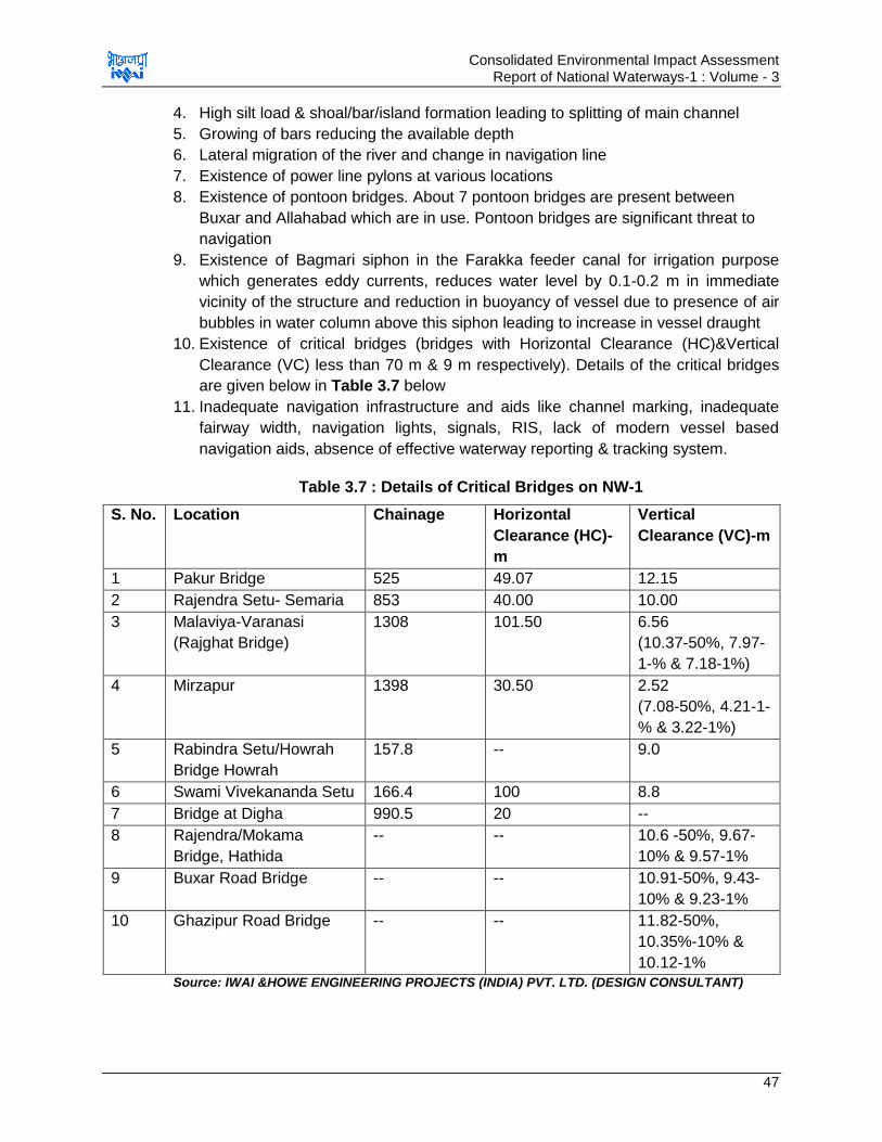
Consolidated Environmental Impact Assessment Report of National Waterways-1 : Volume - 3
47
4. High silt load & shoal/bar/island formation leading to splitting of main channel
5. Growing of bars reducing the available depth
6. Lateral migration of the river and change in navigation line
7. Existence of power line pylons at various locations
8. Existence of pontoon bridges. About 7 pontoon bridges are present between
Buxar and Allahabad which are in use. Pontoon bridges are significant threat to
navigation
9. Existence of Bagmari siphon in the Farakka feeder canal for irrigation purpose
which generates eddy currents, reduces water level by 0.1-0.2 m in immediate
vicinity of the structure and reduction in buoyancy of vessel due to presence of air
bubbles in water column above this siphon leading to increase in vessel draught
10. Existence of critical bridges (bridges with Horizontal Clearance (HC)&Vertical
Clearance (VC) less than 70 m & 9 m respectively). Details of the critical bridges
are given below in Table 3.7 below
11. Inadequate navigation infrastructure and aids like channel marking, inadequate
fairway width, navigation lights, signals, RIS, lack of modern vessel based
navigation aids, absence of effective waterway reporting & tracking system.
Table 3.7 : Details of Critical Bridges on NW-1
S. No. Location Chainage Horizontal
Clearance (HC)-
m
Vertical
Clearance (VC)-m
1 Pakur Bridge 525 49.07 12.15
2 Rajendra Setu- Semaria 853 40.00 10.00
3 Malaviya-Varanasi
(Rajghat Bridge)
1308 101.50 6.56
(10.37-50%, 7.97-
1-% & 7.18-1%)
4 Mirzapur 1398 30.50 2.52
(7.08-50%, 4.21-1-
% & 3.22-1%)
5 Rabindra Setu/Howrah
Bridge Howrah
157.8 -- 9.0
6 Swami Vivekananda Setu 166.4 100 8.8
7 Bridge at Digha 990.5 20 --
8 Rajendra/Mokama
Bridge, Hathida
-- -- 10.6 -50%, 9.67-
10% & 9.57-1%
9 Buxar Road Bridge -- -- 10.91-50%, 9.43-
10% & 9.23-1%
10 Ghazipur Road Bridge -- -- 11.82-50%,
10.35%-10% &
10.12-1%
Source: IWAI &HOWE ENGINEERING PROJECTS (INDIA) PVT. LTD. (DESIGN CONSULTANT)
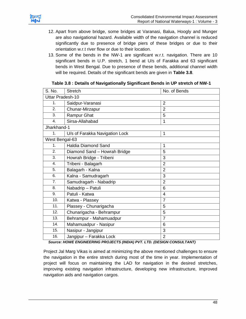
Consolidated Environmental Impact Assessment Report of National Waterways-1 : Volume - 3
48
12. Apart from above bridge, some bridges at Varanasi, Balua, Hoogly and Munger
are also navigational hazard. Available width of the navigation channel is reduced
significantly due to presence of bridge piers of these bridges or due to their
orientation w.r.t river flow or due to their location.
13. Some of the bends in the NW-1 are significant w.r.t. navigation. There are 10
significant bends in U.P. stretch, 1 bend at U/s of Farakka and 63 significant
bends in West Bengal. Due to presence of these bends, additional channel width
will be required. Details of the significant bends are given in Table 3.8.
Table 3.8 : Details of Navigationally Significant Bends in UP stretch of NW-1
S. No. Stretch No. of Bends
Uttar Pradesh-10
1. Saidpur-Varanasi 2
2. Chunar-Mirzapur 2
3. Rampur Ghat 5
4. Sirsa-Allahabad 1
Jharkhand-1
1. U/s of Farakka Navigation Lock 1
West Bengal-63
1. Haldia Diamond Sand 1
2. Diamond Sand – Howrah Bridge 5
3. Howrah Bridge - Tribeni 3
4. Tribeni - Balagarh 2
5. Balagarh - Kalna 2
6. Kalna - Samudragarh 3
7. Samudragarh - Nabadrip 2
8. Nabadrip – Patuli 6
9. Patuli - Katwa 4
10. Katwa - Plassey 7
11. Plassey - Chunarigacha 5
12. Chunarigacha - Behrampur 5
13. Behrampur - Mahamuadpur 7
14. Mahamuadpur - Nasipur 6
15. Nasipur - Jangipur 3
16. Jangipur – Farakka Lock 2
Source: HOWE ENGINEERING PROJECTS (INDIA) PVT. LTD. (DESIGN CONSULTANT)
Project Jal Marg Vikas is aimed at minimizing the above mentioned challenges to ensure
the navigation in the entire stretch during most of the time in year. Implementation of
project will focus on maintaining the LAD for navigation in the desired stretches,
improving existing navigation infrastructure, developing new infrastructure, improved
navigation aids and navigation cargos.
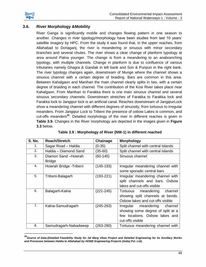
Consolidated Environmental Impact Assessment Report of National Waterways-1 : Volume - 3
49
3.6. River Morphology &Mobility
River Ganga is significantly mobile and changes flowing pattern in one season to
another. Changes in river typology/morphology have been studies from last 10 years‟
satellite imagery by HPC. From the study it was found that, in the upper reaches, from
Allahabad to Doriaganj, the river is meandering or sinuous with minor secondary
branches and several chutes. The river shows a clear change of planform typology at
area around Patna younger. The change is from a meandering to an anabranching
typology, with multiple channels. Change in planform is due to confluence of various
tributaries namely Ghagra & Gandak in left bank and Son & Punpun in the right bank.
The river typology changes again, downstream of Munge where the channel shows a
sinuous channel with a certain degree of braiding. Bars are common in this area.
Between Kahalgaon and Manihari the main channel clearly splits in two, with a certain
degree of braiding in each channel. The contribution of the Kosi River takes place near
Kahalgaon. From Manihari to Farakka there is one main sinuous channel and several
sinuous secondary channels. Downstream stretches of Farakka to Farakka lock and
Farakka lock to Jangipur lock is an artificial canal. Reaches downstream of JangipurLock
show a meandering channel with different degrees of sinuosity, from tortuous to irregular
meanders. From Jangipur Lock to Tribeni the presence of oxbow Lakes is common, and
cut-offs meanders20. Detailed morphology of the river in different reaches is given in
Table 3.9. Changes in the River morphology are depicted in the images given in Figure
3.3 below.
Table 3.9 : Morphology of River (NW-1) in different reached
S. No. Reach/Stretch Chainage Morphology
1. Sagar Road – Haldia (0-35) Split channel with central islands
2. Haldia – Diamond Sand (35-60) Split channel with central islands
3. Diamon Sand –Howrah
Bridge
(60-145) Sinuous channel
4. Howrah Bridge -Tribeni (145-193) Irregular meandering channel with
some sporadic central bars
5. Tribeni-Balagarh (193-221) Irregular meandering channel with
split channels and bars. Oxbow
lakes and cut-offs visible
6. Balagarh-Kalna (221-245) Tortuous meandering channel
showing split channels at bends.
Oxbow lakes and cut-offs visible
7. Kalna-Samudragarh (245-263) Irregular meandering channel
showing some degree of split at a
few locations. Oxbow lakes and
cut-offs visible
8. Samudragarh-Nabadweep (263-280) Tortuous meandering channel with
20
Source of Data:(Detailed Feasibility Study for Jal Marg Vikas Project and Detailed Engineering for its Ancillary Works
and Processes between Haldia to Allahabad by HOWE Engineering Projects (India) Pvt. Ltd).
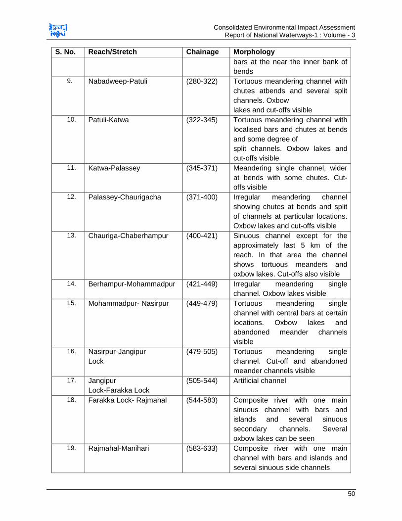
Consolidated Environmental Impact Assessment Report of National Waterways-1 : Volume - 3
50
S. No. Reach/Stretch Chainage Morphology
bars at the near the inner bank of
bends
9. Nabadweep-Patuli (280-322) Tortuous meandering channel with
chutes atbends and several split
channels. Oxbow
lakes and cut-offs visible
10. Patuli-Katwa (322-345) Tortuous meandering channel with
localised bars and chutes at bends
and some degree of
split channels. Oxbow lakes and
cut-offs visible
11. Katwa-Palassey (345-371) Meandering single channel, wider
at bends with some chutes. Cut-
offs visible
12. Palassey-Chaurigacha (371-400) Irregular meandering channel
showing chutes at bends and split
of channels at particular locations.
Oxbow lakes and cut-offs visible
13. Chauriga-Chaberhampur (400-421) Sinuous channel except for the
approximately last 5 km of the
reach. In that area the channel
shows tortuous meanders and
oxbow lakes. Cut-offs also visible
14. Berhampur-Mohammadpur (421-449) Irregular meandering single
channel. Oxbow lakes visible
15. Mohammadpur- Nasirpur (449-479) Tortuous meandering single
channel with central bars at certain
locations. Oxbow lakes and
abandoned meander channels
visible
16. Nasirpur-Jangipur
Lock
(479-505) Tortuous meandering single
channel. Cut-off and abandoned
meander channels visible
17. Jangipur
Lock-Farakka Lock
(505-544) Artificial channel
18. Farakka Lock- Rajmahal (544-583) Composite river with one main
sinuous channel with bars and
islands and several sinuous
secondary channels. Several
oxbow lakes can be seen
19. Rajmahal-Manihari (583-633) Composite river with one main
channel with bars and islands and
several sinuous side channels
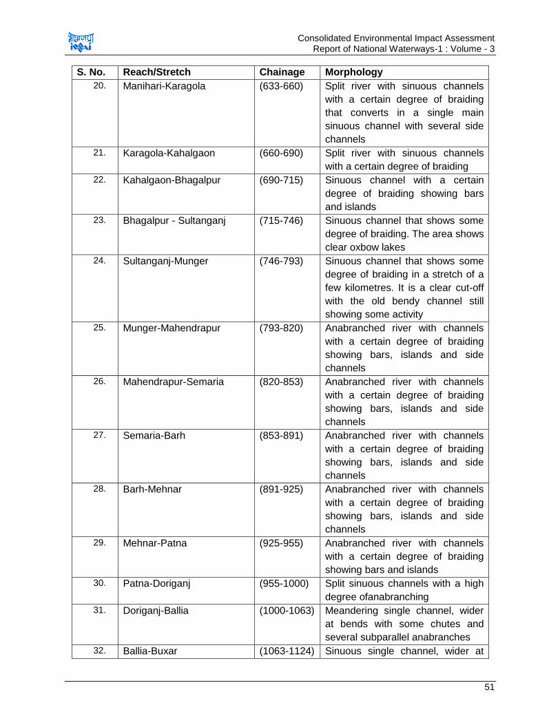
Consolidated Environmental Impact Assessment Report of National Waterways-1 : Volume - 3
51
S. No. Reach/Stretch Chainage Morphology
20. Manihari-Karagola (633-660) Split river with sinuous channels
with a certain degree of braiding
that converts in a single main
sinuous channel with several side
channels
21. Karagola-Kahalgaon (660-690) Split river with sinuous channels
with a certain degree of braiding
22. Kahalgaon-Bhagalpur (690-715) Sinuous channel with a certain
degree of braiding showing bars
and islands
23. Bhagalpur - Sultanganj (715-746) Sinuous channel that shows some
degree of braiding. The area shows
clear oxbow lakes
24. Sultanganj-Munger (746-793) Sinuous channel that shows some
degree of braiding in a stretch of a
few kilometres. It is a clear cut-off
with the old bendy channel still
showing some activity
25. Munger-Mahendrapur (793-820) Anabranched river with channels
with a certain degree of braiding
showing bars, islands and side
channels
26. Mahendrapur-Semaria (820-853) Anabranched river with channels
with a certain degree of braiding
showing bars, islands and side
channels
27. Semaria-Barh (853-891) Anabranched river with channels
with a certain degree of braiding
showing bars, islands and side
channels
28. Barh-Mehnar (891-925) Anabranched river with channels
with a certain degree of braiding
showing bars, islands and side
channels
29. Mehnar-Patna (925-955) Anabranched river with channels
with a certain degree of braiding
showing bars and islands
30. Patna-Doriganj (955-1000) Split sinuous channels with a high
degree ofanabranching
31. Doriganj-Ballia (1000-1063) Meandering single channel, wider
at bends with some chutes and
several subparallel anabranches
32. Ballia-Buxar (1063-1124) Sinuous single channel, wider at
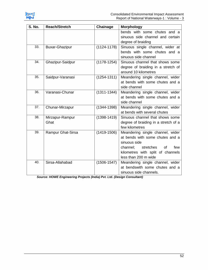
Consolidated Environmental Impact Assessment Report of National Waterways-1 : Volume - 3
52
S. No. Reach/Stretch Chainage Morphology
bends with some chutes and a
sinuous side channel and certain
degree of braiding
33. Buxar-Ghazipur (1124-1178) Sinuous single channel, wider at
bends with some chutes and a
sinuous side channel
34. Ghazipur-Saidpur (1178-1254) Sinuous channel that shows some
degree of braiding in a stretch of
around 10 kilometres
35. Saidpur-Varanasi (1254-1311) Meandering single channel, wider
at bends with some chutes and a
side channel
36. Varanasi-Chunar (1311-1344) Meandering single channel, wider
at bends with some chutes and a
side channel
37. Chunar-Mirzapur (1344-1398) Meandering single channel, wider
at bends with several chutes
38. Mirzapur-Rampur
Ghat
(1398-1419) Sinuous channel that shows some
degree of braiding in a stretch of a
few kilometres
39. Rampur Ghat-Sirsa (1419-1506) Meandering single channel, wider
at bends with some chutes and a
sinuous side
channel; stretches of few
kilometres with split of channels
less than 200 m wide
40. Sirsa-Allahabad (1506-1547) Meandering single channel, wider
at bendswith some chutes and a
sinuous side channels.
Source: HOWE Engineering Projects (India) Pvt. Ltd. (Design Consultant)

Consolidated Environmental Impact Assessment Report of National Waterways-1 : Volume - 3
53
Formation of a big island with two main channels upstream of Farakka Barrage.
Images from 2011(left) and 2015 (right)
Example of the decay of a main channel occurring in three years
Example of formation of a new channel
Example of lateral migration of main channel Source: IWAI &HOWE ENGINEERING PROJECTS (INDIA) PVT. LTD. (DESIGN CONSULTANT)
Figure 3.3 : Satellite Imagery of Different Years to Study Change in River Morphology
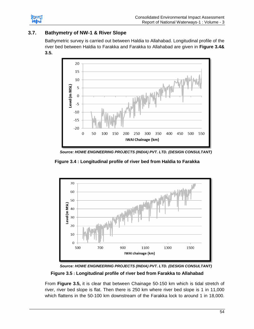
Consolidated Environmental Impact Assessment Report of National Waterways-1 : Volume - 3
54
3.7. Bathymetry of NW-1 & River Slope
Bathymetric survey is carried out between Haldia to Allahabad. Longitudinal profile of the
river bed between Haldia to Farakka and Farakka to Allahabad are given in Figure 3.4&
3.5.
Source: HOWE ENGINEERING PROJECTS (INDIA) PVT. LTD. (DESIGN CONSULTANT)
Figure 3.4 : Longitudinal profile of river bed from Haldia to Farakka
Source: HOWE ENGINEERING PROJECTS (INDIA) PVT. LTD. (DESIGN CONSULTANT)
Figure 3.5 : Longitudinal profile of river bed from Farakka to Allahabad
From Figure 3.5, it is clear that between Chainage 50-150 km which is tidal stretch of
river, river bed slope is flat. Then there is 250 km where river bed slope is 1 in 11,000
which flattens in the 50-100 km downstream of the Farakka lock to around 1 in 18,000.

Consolidated Environmental Impact Assessment Report of National Waterways-1 : Volume - 3
55
River slope from Farakka to Allahabad is 1 in 17,000. Longitudinal profile of river slope
from Farakka to Allahabad is given in Table 3.10 below.
Table 3.10 : Longitudinal Profile of River Slope from Farakka to Allahabad
Reach General slope for the 50
km reach
General slope for the 100
km each
550-600 1 in 10,000 1 in 32,000
600-650 Flat
650-700 1 in 12,000 1 in 12,000
700-750 1 in 12,000
750-800 1 in 12,000 (flat) 1 in 10,000
800-850 1 in 5,000
850-900 1 in 350,000 (flat) 1 in 15,000
900-950 1 in 7,000
950-1000 Flat 1 in 25,000
1000-1050 1 in 10,000
1050-1100 1 in 18,000 1 in 15,000
1100-1150 1 in 14,000
1150-1200 1 in 22,500 1 in 26,000
1200-1250 1 in 30,000
1250-1300 Flat 1 in 15,000
1300-1350 1 in 7,000
1350-1400 1 in 75,000 1 in 50,000
1400-1450 1 in 37,000
1450-1500 Flat 1 in 12,000
1500-1550 1 in 5,000
Source: IWAI &HOWE ENGINEERING PROJECTS (INDIA) PVT. LTD. (DESIGN CONSULTANT)
Cross section profile of the NW-1 at various location has also been studied by design
consultant at various locations like Haldia, d/s Farakka lock, around island near Patna,
Ghazipur, Varanasi, Allahabad & at meandering bend. Cross section profile of river is
given at Figure 3.6.
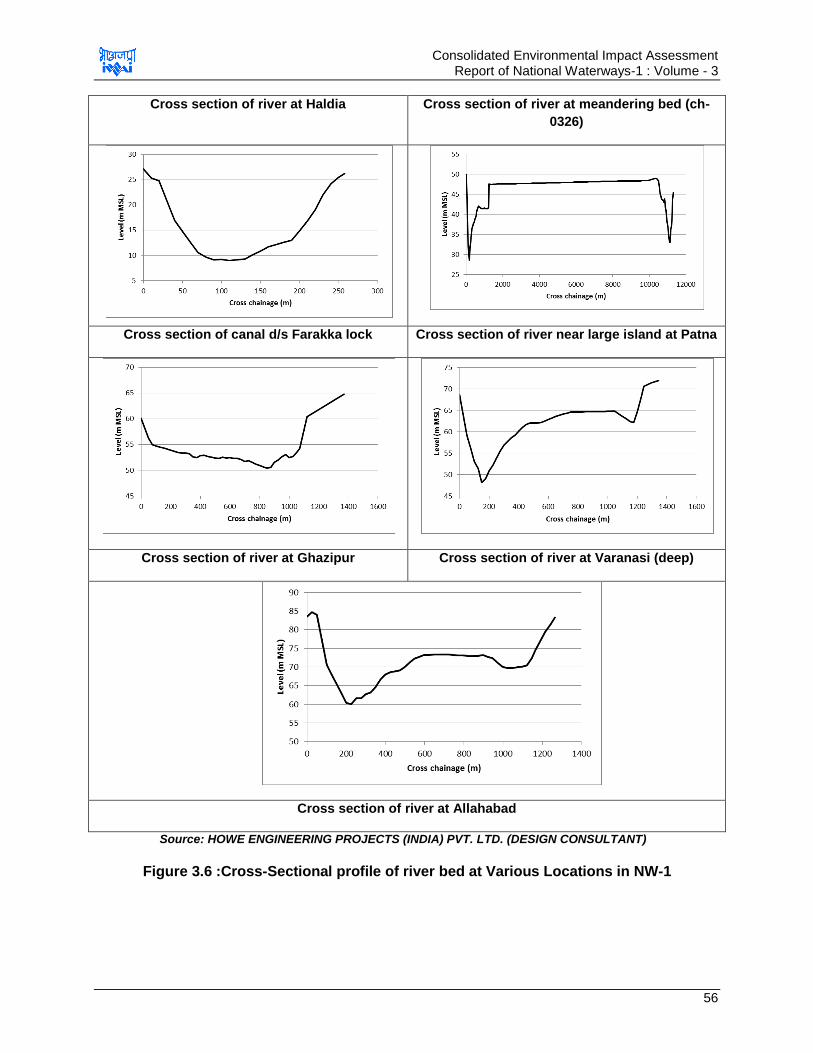
Consolidated Environmental Impact Assessment Report of National Waterways-1 : Volume - 3
56
Cross section of river at Haldia Cross section of river at meandering bed (ch-
0326)
Cross section of canal d/s Farakka lock Cross section of river near large island at Patna
Cross section of river at Ghazipur Cross section of river at Varanasi (deep)
3.
Cross section of river at Allahabad
Source: HOWE ENGINEERING PROJECTS (INDIA) PVT. LTD. (DESIGN CONSULTANT)
Figure 3.6 :Cross-Sectional profile of river bed at Various Locations in NW-1
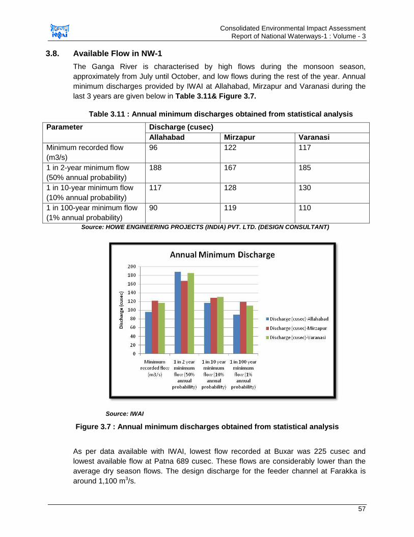
Consolidated Environmental Impact Assessment Report of National Waterways-1 : Volume - 3
57
3.8. Available Flow in NW-1
The Ganga River is characterised by high flows during the monsoon season,
approximately from July until October, and low flows during the rest of the year. Annual
minimum discharges provided by IWAI at Allahabad, Mirzapur and Varanasi during the
last 3 years are given below in Table 3.11& Figure 3.7.
Table 3.11 : Annual minimum discharges obtained from statistical analysis
Parameter Discharge (cusec)
Allahabad Mirzapur Varanasi
Minimum recorded flow
(m3/s)
96 122 117
1 in 2-year minimum flow
(50% annual probability)
188 167 185
1 in 10-year minimum flow
(10% annual probability)
117 128 130
1 in 100-year minimum flow
(1% annual probability)
90 119 110
Source: HOWE ENGINEERING PROJECTS (INDIA) PVT. LTD. (DESIGN CONSULTANT)
Source: IWAI
Figure 3.7 : Annual minimum discharges obtained from statistical analysis
As per data available with IWAI, lowest flow recorded at Buxar was 225 cusec and
lowest available flow at Patna 689 cusec. These flows are considerably lower than the
average dry season flows. The design discharge for the feeder channel at Farakka is
around 1,100 m3/s.
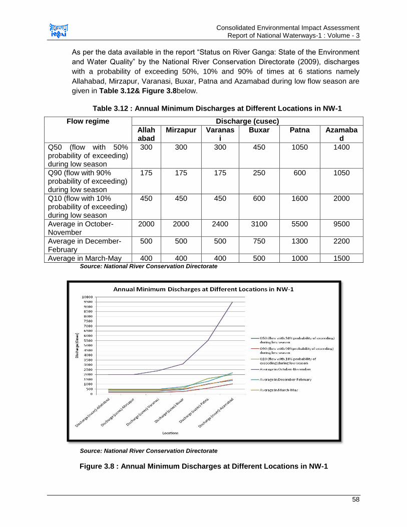
Consolidated Environmental Impact Assessment Report of National Waterways-1 : Volume - 3
58
As per the data available in the report “Status on River Ganga: State of the Environment
and Water Quality” by the National River Conservation Directorate (2009), discharges
with a probability of exceeding 50%, 10% and 90% of times at 6 stations namely
Allahabad, Mirzapur, Varanasi, Buxar, Patna and Azamabad during low flow season are
given in Table 3.12& Figure 3.8below.
Table 3.12 : Annual Minimum Discharges at Different Locations in NW-1
Flow regime Discharge (cusec)
Allahabad
Mirzapur Varanasi
Buxar Patna Azamabad
Q50 (flow with 50% probability of exceeding) during low season
300 300 300 450 1050 1400
Q90 (flow with 90% probability of exceeding) during low season
175 175 175 250 600 1050
Q10 (flow with 10% probability of exceeding) during low season
450 450 450 600 1600 2000
Average in October- November
2000 2000 2400 3100 5500 9500
Average in December- February
500 500 500 750 1300 2200
Average in March-May 400 400 400 500 1000 1500 Source: National River Conservation Directorate
Source: National River Conservation Directorate
Figure 3.8 : Annual Minimum Discharges at Different Locations in NW-1
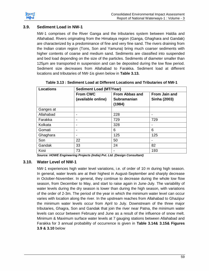
Consolidated Environmental Impact Assessment Report of National Waterways-1 : Volume - 3
59
3.9. Sediment Load in NW-1
NW-1 comprises of the River Ganga and the tributaries system between Haldia and
Allahabad. Rivers originating from the Himalaya region (Ganga, Ghaghara and Gandak)
are characterized by a predominance of fine and very fine sand. The rivers draining from
the Indian craton region (Tons, Son and Yamuna) bring much coarser sediments with
higher contents of coarse and medium sand. Sediments are classified into suspended
and bed load depending on the size of the particles. Sediments of diameter smaller than
125µm are transported in suspension and can be deposited during the low flow period.
Sediment size decreases from Allahabad to Farakka. Sediment load at different
locations and tributaries of NW-1is given below in Table 3.13.
Table 3.13 : Sediment Load at Different Locations and Tributaries of NW-1
Locations Sediment Load (MT/Year)
From CWC
(available online)
From Abbas and
Subramanian
(1984)
From Jain and
Sinha (2003)
Ganges at
Allahabad - 228 -
Farakka - 729 729
Kolkata - 328 -
Gomati - 6 6
Ghaghara - 125 125
Son 22 50 -
Gandak 33 24 82
Kosi 73 - 193
Source: HOWE Engineering Projects (India) Pvt. Ltd. (Design Consultant)
3.10. Water Level of NW-1
NW-1 experiences high water level variations, i.e. of order of 10 m during high season.
In general, water levels are at their highest in August-September and sharply decrease
in October-November. In general, they continue to decrease during the whole low flow
season, from December to May, and start to raise again in June-July. The variability of
water levels during the dry season is lower than during the high season, with variations
of the order of 2-3m. The period of the year in which the minimum water level can occur
varies with location along the river. In the upstream reaches from Allahabad to Ghazipur
the minimum water levels occur from April to July. Downstream of the three major
tributaries, Ghagra, Son and Gandak that join the river near Patna, the minimum water
levels can occur between February and June as a result of the influence of snow melt.
Minimum & Maximum surface water levels at 7 gauging stations between Allahabad and
Farakka for 3 annual probability of occurrence is given in Table 3.14& 3.15& Figures
3.9 & 3.10 below
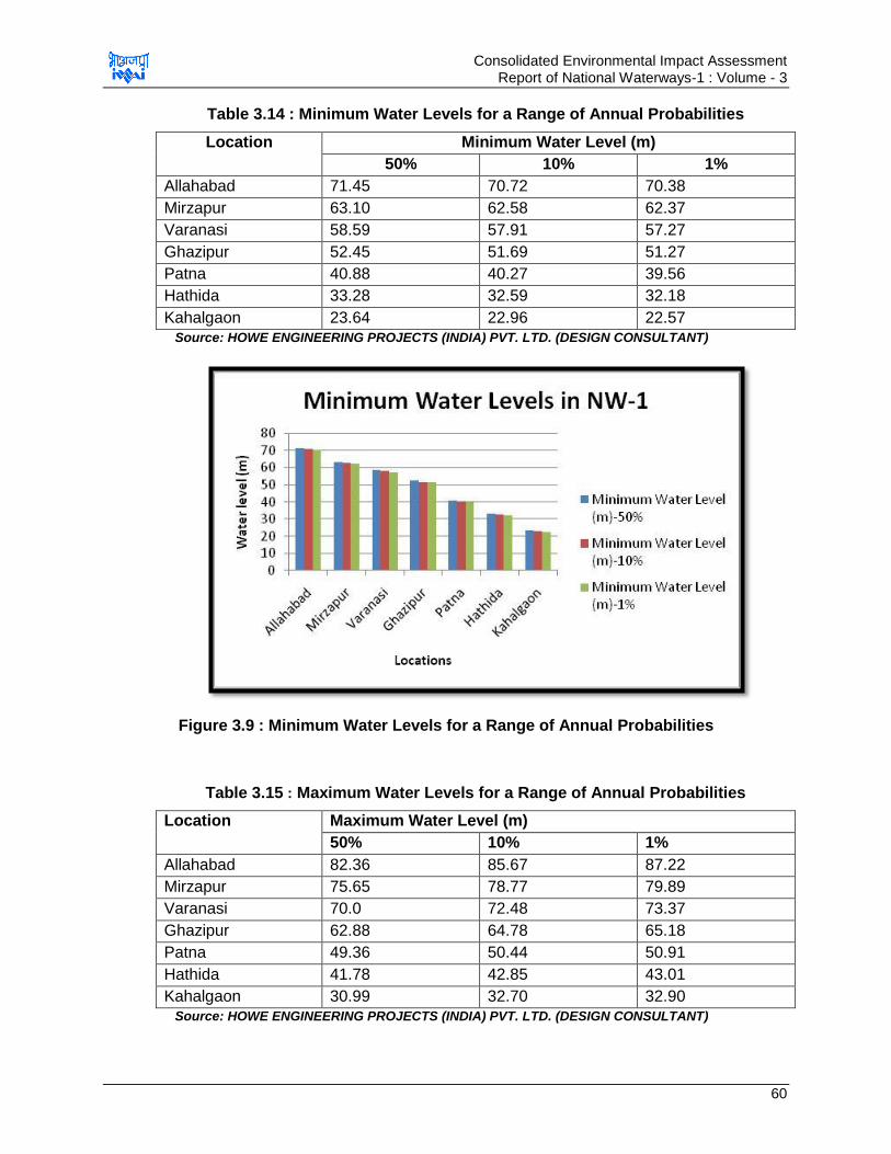
Consolidated Environmental Impact Assessment Report of National Waterways-1 : Volume - 3
60
Table 3.14 : Minimum Water Levels for a Range of Annual Probabilities
Location Minimum Water Level (m)
50% 10% 1%
Allahabad 71.45 70.72 70.38
Mirzapur 63.10 62.58 62.37
Varanasi 58.59 57.91 57.27
Ghazipur 52.45 51.69 51.27
Patna 40.88 40.27 39.56
Hathida 33.28 32.59 32.18
Kahalgaon 23.64 22.96 22.57
Source: HOWE ENGINEERING PROJECTS (INDIA) PVT. LTD. (DESIGN CONSULTANT)
Figure 3.9 : Minimum Water Levels for a Range of Annual Probabilities
Table 3.15 : Maximum Water Levels for a Range of Annual Probabilities
Location Maximum Water Level (m)
50% 10% 1%
Allahabad 82.36 85.67 87.22
Mirzapur 75.65 78.77 79.89
Varanasi 70.0 72.48 73.37
Ghazipur 62.88 64.78 65.18
Patna 49.36 50.44 50.91
Hathida 41.78 42.85 43.01
Kahalgaon 30.99 32.70 32.90
Source: HOWE ENGINEERING PROJECTS (INDIA) PVT. LTD. (DESIGN CONSULTANT)
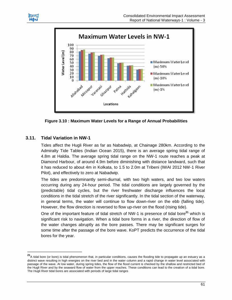
Consolidated Environmental Impact Assessment Report of National Waterways-1 : Volume - 3
61
Figure 3.10 : Maximum Water Levels for a Range of Annual Probabilities
3.11. Tidal Variation in NW-1
Tides affect the Hugli River as far as Nabadwip, at Chainage 280km. According to the
Admiralty Tide Tables (Indian Ocean 2015), there is an average spring tidal range of
4.8m at Haldia. The average spring tidal range on the NW-1 route reaches a peak at
Diamond Harbour, of around 4.9m before diminishing with distance landward, such that
it has reduced to about 4m in Kolkata, to 1.5 to 2.0m at Tribeni (IWAI 2012 NW-1 River
Pilot), and effectively to zero at Nabadwip.
The tides are predominantly semi-diurnal, with two high waters, and two low waters
occurring during any 24-hour period. The tidal conditions are largely governed by the
(predictable) tidal cycles, but the river freshwater discharge influences the local
conditions in the tidal stretch of the river significantly. In the tidal section of the waterway,
in general terms, the water will continue to flow down-river on the ebb (falling tide).
However, the flow direction is reversed to flow up-river on the flood (rising tide).
One of the important feature of tidal stretch of NW-1 is presence of tidal bore21 which is
significant risk to navigation. When a tidal bore forms in a river, the direction of flow of
the water changes abruptly as the bore passes. There may be significant surges for
some time after the passage of the bore wave. KoPT predicts the occurrence of the tidal
bores for the year.
21
A tidal bore (or bore) is tidal phenomenon that, in particular conditions, causes the flooding tide to propagate up an estuary as a
distinct wave resulting in high energies on the river bed and in the water column and a rapid change in water level associated with passage of the wave. At low water, during spring tides, the flow of the flood current is checked by the shallow and restricted bed of the Hugli River and by the seaward flow of water from the upper reaches. These conditions can lead to the creation of a tidal bore. The Hugli River tidal bores are associated with periods of large tidal ranges

Consolidated Environmental Impact Assessment Report of National Waterways-1 : Volume - 3
62
B: ALTERNATIVE ANALYSIS
3.12. Analysis of Alternatives
Analysis of alternatives is an analytical comparison of the operational effectiveness,
costs and environmental and social risks of proposed development options. This helps to
analyse the options critically in relation to its impacts on all physical, social and biological
environment. For this project, alternative analysis has been made for three
considerations, i.e. strategic, planning and technology consideration and they are briefed
below
3.12.1. Strategic Consideration
This analysis enables us to justify that why and how much the project is viable. A
comparison is made for “With” & “Without” project scenario for the physical, social and
biological environments. This helped in assessment and comparison of the potential
impacts on these environments in both the scenario. The scenario having minimal
impact is recommended for selection. This has helped us to find the benefit of
development of the project. Detailed analysis is given below in Table 3.16.
Table 3.16 : Alternative Analysis- “With & Without Project Scenario”
Environment Without Project With Project
Status of Transportation Infrastructure22
IR is oversaturated23 in many sections. Ideally coal and iron ore are supposed to be trucked by road for short distances, mainly from mines to rail sidings only. However, at present larger volume of cargo is being transported via road due to insufficient capacity of IR. Road network is also not sufficient and adequately developed especially in minor towns/villages. Density of road network in India is high but the road quality suffers in terms of pavement thickness, distressed bridges etc. Thus to cater the freight transportation, there is high need of
IWT mode will facilitate shift of the freight from roads & IR leading to reduction in congestion on already congested IR & roads. This may reduce the need of expansion and will make the transportation safe and reliable. Infrastructure development for developing waterway involves comparatively lesser expenditure than required for developing IR & road network for transportation of equivalent amount of freight.
22
Transportation network for freight and passenger is backbone of economy of every country. Transportation network should be
robust, reliable, cost efficient, time efficient, energy efficient and environment friendly which can ensure in time delivery of goods with no or minimal emissions or pollution involved. Economy of India is world seventh largest in the world by nominal GDP. But various hurdles are in the way to achieve further higher economic growth and some are inadequate transportation network & infrastructure, poverty, unemployment etc. India‟s rail network is world‟s 4th longest and most heavily used system in the world and India‟s road network is 2nd largest road network in the world. But due to its high population, India‟s road & railway network is over utilized and insufficient to cater the freight transportation requirement of the country. Thus there is need of expansion of the road/ railway network or to find out alternate & efficient mode of transportation 23
Oversaturation has implications for the quality of service of freight trains and severely restricts IR to meet customer expectation.
Some of the section of IR has been working above their capacity, especially on eastern corridor line, i.e. Delhi-Howrah Currently this route face 140-150% of capacity utilization and rail route is considered congested, if its utilization is more than 80%. Speed of the freight trains remained stagnant from 25-29 kmph against design average speed of 60 kmph. Majorly nine commodities are transported through trains such as coal (46%), iron ore (13%), cement (11%), fertilizers (5%), steel (5%), raw material for steel plants (5%) except iron ore, cement (11%), food grains (5%), petroleum products (4%) and container traffic (4%) and others (2%)
Consolidated Environmental Impact Assessment Report of National Waterways-1 : Volume - 3
63
Environment Without Project With Project
expansion & improvement of IR & road network.
Physical Environment
GHG Emissions: In this scenario GHG emissions associated with freight transportation through rail/road mode will continue to generate GHG (under as usual scenario), there by continuous increase in the CO2 emissions take place. GHG Emissions associated for movement of cargo (based on maximum terminal capacity as planned in phase I) through rail & road modes (without NW1 as business as usual scenario) are 84 billion & 277 billion g/yr respectively. Ambien Air Quality: There are three aspects: one is the continuation of increase in air pollutants(calculated for maximum terminal capacity as planned in phase I) through rail & road modes are 9.9, 2.8; 1.3, 1.28; 3.9, 1.06; 1.6, 0.5 & 2.77, 0.5 billion g/yr respectively. The second is the additional increase traffic on roads or rail network because of additional rise in cargo transport. Such additional rise is going to create congestion in the roots used and thereby causing more emission per km travel. Third is need for additional infrastructure to cater the new higher transport demand by road and/or rail modes which will costly and require additional land as compared to IWT as well as higher pollution. Besides, the impact on terrestrial biology due to cutting of trees required for expansion of road/railway network will further deteriorate the air quality.
GHG Emissions: Their will be overall reduction in GHG emissions in case the cargo transport mode is changed to IWT as this mode is energy efficient (detailed GHG emission estimates have been made for LCA analysis) As per analysis carried out, it is estimated that CO2 (potential GHG) emissions associated with IWT for freight transportation (calculated for maximum cargo upto maximum terminal capacity as planned in phase I) from Haldia to Varanasi is 4.54 million tonnes/yr. Air Quality: As IWT is more energy efficient the exhaust related emissions are going to reduce proportionally. As per these estimates that the NOx; SOx; CO; PM & HC emissions associated with the model shift in transport to IWT for freight transportation (calculated for maximum terminal capacity as planned in phase I) from Haldia to Varanasi is 2.3; 0.36; 0.99; 0.2 & 0.5 billion g/yr. However, the truck exhaust related air pollutant emissions in immediate vicinity of the terminals are likely to increase due to rise in vehicular activity of trucks and other vehicles due to requisite pre and post haulage from cargo terminals. The impacts of such in ambient air quality can be mitigated or reduced by adopting the proposed EMP which includes even measures like site planning, adopting fuel shift or vessel/barge design, requisite operational norms of IWT vessels/barges etc., Besides there are number of impacts during construction as well as operational phase of different interventions envisaged for IWT mode warranting compromise EMP
Consolidated Environmental Impact Assessment Report of National Waterways-1 : Volume - 3
64
Environment Without Project With Project
Water Quality: Due to construction of
more roads for rise in road traffic
demand will result in more paved
surfaces, there by rising the surface
run-off (which may also be
contaminated with oil and grease-
accidental or used oil/grease) causing
pollution of water bodies land
environmental impacts.
Loss of agricultural land and top
soil: The continual expansion of
railway and road network to meet the
additional freight & passenger
transportation requirement of the
country, warrant additional acquisition
of agricultural land and loss of top soil
(more probable). Also construction
soil is to be sourced to burrow pits
which is often located in agricultural
fields.
Material Sourcing: Construction
materials like asphalt, aggregates,
soil, paints, steel, cement etc. will be
required for repair and maintenance
of existing road/railway and
expansion of road/railway. Material
requirement for construction of
road/railway are fairly large as
compared to IWT interventions
required.
to mitigate the respective impacts. .
Water Quality: Similarly, there are
number of activities (as detailed in
respective reports) during
construction as well operational
phase of IWT implementation
however, these impacts have been
assessed and mitigated to the
extent that residual impacts are
minimal and not significant. The
examples of such activities include
increased contaminated run-off
from construction site, pilling and
dredging activities, plying of
vessels/barges, usage of
antifouling paints, accidental
release of spillage of oil cargo etc.
Loss of agricultural land and top
soil: Land requirement is minimal
and is required only for
development of civil interventions
like terminal, jetties, locks. Land
requirement is far less than the
land required for road & railway
projects.
Material Sourcing: Construction
material like aggregates, cement,
sand, steel etc. will be required for
construction of navigational
facilities and river bank protection
works. However, the material
requirement is comparatively lesser
than required for maintenance and
expansion of road & railway
networks essential for these
transport modes
Terrestrial & Aquatic ecology
Terrestrial Ecology:
Terrestrial ecology will not be directly
Terrestrial Ecology: Impact on terrestrial flora is
Consolidated Environmental Impact Assessment Report of National Waterways-1 : Volume - 3
65
Environment Without Project With Project
impacted in without project scenario.
However, the very need of expansion
of road & railway network to increase
the freight transportation may involve
cutting of large nos. of trees and/or
impacting the forest areas affecting
the terrestrial ecology. Also the
existing road crosses various eco-
sensitive zones & forest areas and
expansion if such roads will have
greater impact on terrestrial ecology.
Aquatic ecology
Road/railways running along NW-1
crosses river Ganga at various
locations. Construction of bridges
leads to deterioration of aquatic
ecology due to reduction in flow.
Expansion of these bridges &
construction of new bridges will have
significant impact on aquatic ecology
anticipated only if the land acquired for development of civil interventions supports vegetation. While selection of site, areas of ecological importance and protected areas are avoided.
Aquatic Ecology:
Development of off-shore
structures, barge operations and
dredging activities has significant
impact on aquatic ecology which
requires to be managed adequately
to minimize the impact.
Socio-economic Environment
Loss of Valuable Time and efforts: In without project scenario, insufficient transportation system will persist. Delays in material transportation and gaps in need and supply will persist. Public at large will continue to waste time in waiting at traffic jams triggered at railway crossings and roads. Pressure on land: Expansion of road/railway network will involve loss of land and livelihood of the farmers.
Pressure on Existing Resources:
People tends to settle in the area
which has good connectivity leading
to congestion in the area and
increased pressure on the existing
resources of that area.
Movement safety: Road transportation is highly vulnerable to accidents. Accidents involve loss of life, injuries and damage of road infrastructure.
Loss of Valuable Time and efforts: Shift of freight to IWT mode will reduce the congestion on road/rails thereby reducing the congestion. Also IWT ensures timely delivery/transportation of the material due to systemized movement of the vessels.
Pressure on land: Land acquisition may be required for development of the civil intervention facility but it will be comparatively lesser than rail/road projects Pressure on Existing Resources: Increased traffic movement and other activities are anticipated at location of civil interventions which may lead to increase in pressure of existing resources like road, water supply etc. of that area. Movement safety: IWT mode is
safest mode of transportation.

Consolidated Environmental Impact Assessment Report of National Waterways-1 : Volume - 3
66
Environment Without Project With Project
Employment Opportunities: Employment generation involved only for construction of new road/railway alignment and maintenance of road/rail networks
Employment Opportunities:
Employment generation is
anticipated at proposed civil
interventions and large no. of
indirect employment may generate
due to the increased freight
transportation
Conclusion for Strategic Alternative Analysis:
Analysing both the scenarios for above mentioned criteria it is concluded that “With
Project Scenario” is beneficial for all physical, biological and social environment when
compared to “Without Project Scenario”. With Project Scenario will improve the freight
transportation efficiency, reduce the GHG emissions, fuel requirement, air emissions,
land acquisition, tree cutting and land requirement required for maintaining and
expanding road/railway network. However significant impact is anticipated on water and
aquatic ecology in “With Project” scenario for which mitigation and management plans
are prepared to minimize the impact.
3.12.2. Planning Consideration
This involves the consideration of options involved in planning stage, i.e. location of the
proposed interventions, suitability of site, design of the project layout and dredging
extent. This enables to select the option having best planning/design with minimal
implication on physical, biological & socio-economic environment. Since the EIA is
carried out in tandem with the detailed engineering study, thus this facilitated to
undertake the analysis of proposed alternatives with environmental point of view and
planning is done on the basis of suggestive outcome of the environmental alternative
analysis study. Detailed planning alternative analysis carried out with environmental
perspective is discussed in sections below
a. Selection of Locations for Civil Interventions
Locations are selected for proposed civil interventions (terminals/jetties) on the basis of
potential of freight/cargo generation of the area and its connectivity with other modes of
transport (rail & road). Ten such locations were selected for development of 6 nos. of
terminals and 1 no. of lock.
One of the probable location at Bhagalpur was ruled out due to presence of Vikramshila
Gangetic Dolphin Sanctuary and based on “NO GO” areas identified in Basin Level
Critical Resources Assessment study. Some sites like site at Varanasi and Sahibganj
were already identified by IWAI for development of terminals and land acquisition
process was initiated so no alternatives were considered for such sites. Also alternatives
for sites located on Government owned lands like Haldia terminal (located within
industrial area) are not considered due to its insignificant impacts on socio-economy and
Consolidated Environmental Impact Assessment Report of National Waterways-1 : Volume - 3
67
environment. However, acceptability of these sites from environmental aspects were
assessed which were found acceptable. Also with location perspective, a lock is required
to be constructed at Farakka only near the existing lock. Thus for construction of lock
also the location is pre-decided as per requirement. Alternative analysis of locations was
carried out for social, environment and engineering feasibility. Detailed location
alternatives analysis is given below in Table 3.17 below.

Consolidated Environmental Impact Assessment Report of National Waterways-1 : Volume - 3
68
Table 3.17 : Location Alternative Analysis
S. No.
Development, Site & Location
Advantages Disadvantages Selection
Status
Remarks Site Map
1. Terminal
site at
Varanasi,
U.P.
Environment Considerations:
Very less tree cutting associated (8 khajur tree & 4-5 babool shrubs)
Social Considerations:
Site is agricultural fallow land with no development
Site already acquired by IWAI
Site is accessible and is close to highways, roads & railway
Settlements located are at app. 500 m from site thus minimal impact due to project activities
Design Considerations:
Availability of LAD required for berthing and movement of barges
Environment Considerations:
Varanasi turtle sanctuary located at app. 2.3 km downstream of the site in North direction
Social Considerations:
Site not directly connected to any public paved road at present
Selected
No alternatives assessed as site already selected and land already acquired. Anticipated impact on turtles due to barge movement is analysed to be low as nos. of barge movement will be app. 1-2 per day with regulated speed of 5kmph.
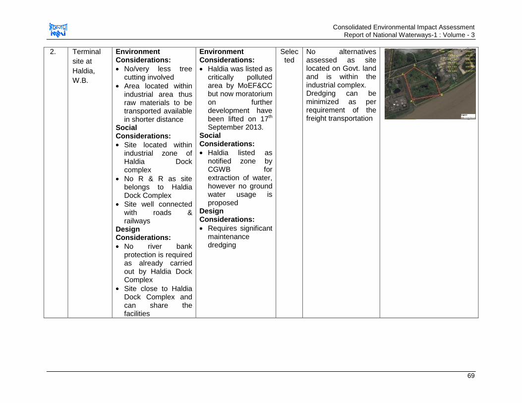
Consolidated Environmental Impact Assessment Report of National Waterways-1 : Volume - 3
69
2. Terminal
site at
Haldia,
W.B.
Environment Considerations:
No/very less tree cutting involved
Area located within industrial area thus raw materials to be transported available in shorter distance
Social Considerations:
Site located within industrial zone of Haldia Dock complex
No R & R as site belongs to Haldia Dock Complex
Site well connected with roads & railways
Design Considerations:
No river bank protection is required as already carried out by Haldia Dock Complex
Site close to Haldia Dock Complex and can share the facilities
Environment Considerations:
Haldia was listed as critically polluted area by MoEF&CC but now moratorium on further development have been lifted on 17th September 2013.
Social Considerations:
Haldia listed as notified zone by CGWB for extraction of water, however no ground water usage is proposed
Design Considerations:
Requires significant maintenance dredging
Selected
No alternatives assessed as site located on Govt. land and is within the industrial complex. Dredging can be minimized as per requirement of the freight transportation
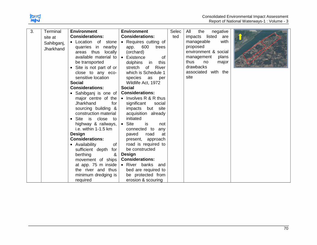
Consolidated Environmental Impact Assessment Report of National Waterways-1 : Volume - 3
70
3. Terminal
site at
Sahibganj,
Jharkhand
Environment Considerations:
Location of stone quarries in nearby areas thus locally available material to be transported
Site is not part of or close to any eco-sensitive location
Social Considerations:
Sahibganj is one of major centre of the Jharkhand for sourcing building & construction material
Site is close to highway & railways, i.e. within 1-1.5 km
Design Considerations:
Availability of sufficient depth for berthing & movement of ships at app. 75 m inside the river and thus minimum dredging is required
Environment Considerations:
Requires cutting of app. 600 trees (orchard)
Existence of dolphins in this stretch of River which is Schedule 1 species as per Wildlife Act, 1972
Social Considerations:
Involves R & R thus significant social impacts but site acquisition already initiated
Site is not connected to any paved road at present, approach road is required to be constructed
Design Considerations:
River banks and bed are required to be protected from erosion & scouring
Selected
All the negative impacts listed are manageable with proposed environment & social management plans thus no major drawbacks associated with the site
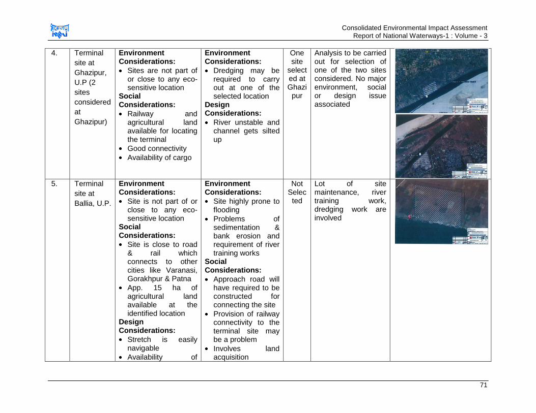
Consolidated Environmental Impact Assessment Report of National Waterways-1 : Volume - 3
71
4. Terminal
site at
Ghazipur,
U.P (2
sites
considered
at
Ghazipur)
Environment Considerations:
Sites are not part of or close to any eco-sensitive location
Social Considerations:
Railway and agricultural land available for locating the terminal
Good connectivity
Availability of cargo
Environment Considerations:
Dredging may be required to carry out at one of the selected location
Design Considerations:
River unstable and channel gets silted up
One site
selected at Ghazi
pur
Analysis to be carried out for selection of one of the two sites considered. No major environment, social or design issue associated
5. Terminal
site at
Ballia, U.P.
Environment Considerations:
Site is not part of or close to any eco-sensitive location
Social Considerations:
Site is close to road & rail which connects to other cities like Varanasi, Gorakhpur & Patna
App. 15 ha of agricultural land available at the identified location
Design Considerations:
Stretch is easily navigable
Availability of
Environment Considerations:
Site highly prone to flooding
Problems of sedimentation & bank erosion and requirement of river training works
Social Considerations:
Approach road will have required to be constructed for connecting the site
Provision of railway connectivity to the terminal site may be a problem
Involves land acquisition
Not Selected
Lot of site maintenance, river training work, dredging work are involved

Consolidated Environmental Impact Assessment Report of National Waterways-1 : Volume - 3
72
sufficient cargo for transportation
Design Considerations:
River is unstable and show migration
High sedimentation due to confluence of secondary channel & tributaries near the site
Presence of migration sand bars
Potential of complex flows at confluence points of primary & secondary channel during medium & low flow
6. Terminal
site at &
near
Doriaganj
(Semaria),
Bihar (2
sites
considered
at
Doraiganj
&
Kalughat)
Environment Considerations:
Locally available raw material (sand) for transportation
Site is not part of or close to any eco-sensitive location
Social Considerations:
Area well connected by road & Railways to all major cities
Agricultural land available for setting up terminal facility
Design
Environment Considerations:
Requires tree cutting
Social Considerations:
May Involves land acquisition
One of the two sites considered
is select
ed
No major environmental engineering and social issues associated with the site
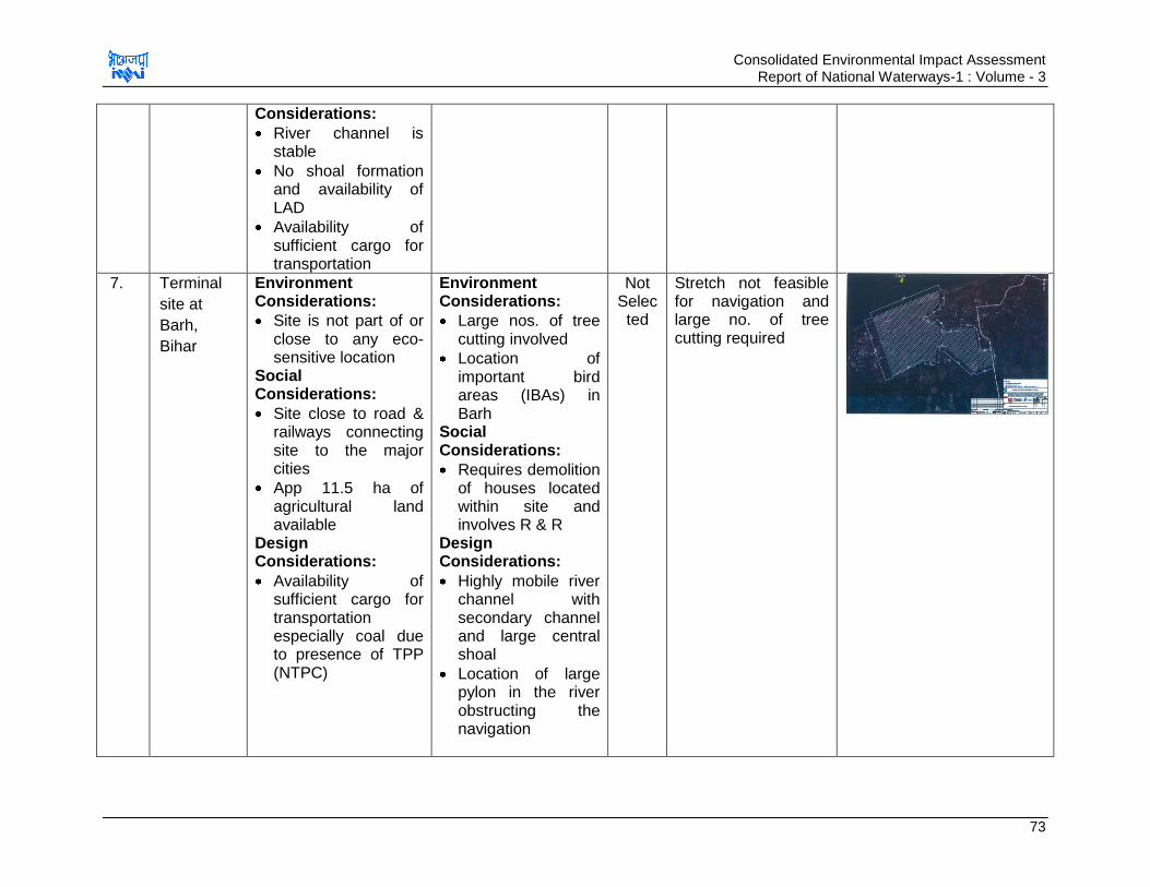
Consolidated Environmental Impact Assessment Report of National Waterways-1 : Volume - 3
73
Considerations:
River channel is stable
No shoal formation and availability of LAD
Availability of sufficient cargo for transportation
7. Terminal
site at
Barh,
Bihar
Environment Considerations:
Site is not part of or close to any eco-sensitive location
Social Considerations:
Site close to road & railways connecting site to the major cities
App 11.5 ha of agricultural land available
Design Considerations:
Availability of sufficient cargo for transportation especially coal due to presence of TPP (NTPC)
Environment Considerations:
Large nos. of tree cutting involved
Location of important bird areas (IBAs) in Barh
Social Considerations:
Requires demolition of houses located within site and involves R & R
Design Considerations:
Highly mobile river channel with secondary channel and large central shoal
Location of large pylon in the river obstructing the navigation
Not Selected
Stretch not feasible for navigation and large no. of tree cutting required
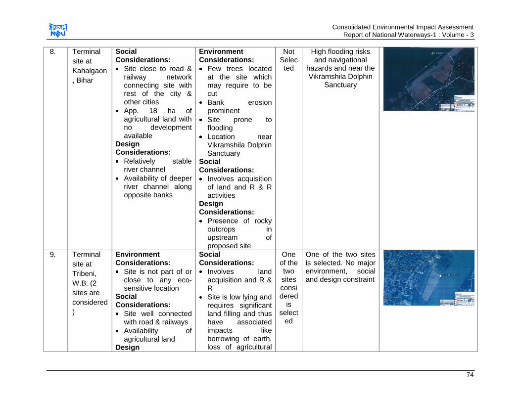
Consolidated Environmental Impact Assessment Report of National Waterways-1 : Volume - 3
74
8. Terminal
site at
Kahalgaon
, Bihar
Social Considerations:
Site close to road & railway network connecting site with rest of the city & other cities
App. 18 ha of agricultural land with no development available
Design Considerations:
Relatively stable river channel
Availability of deeper river channel along opposite banks
Environment Considerations:
Few trees located at the site which may require to be cut
Bank erosion prominent
Site prone to flooding
Location near Vikramshila Dolphin Sanctuary
Social Considerations:
Involves acquisition of land and R & R activities
Design Considerations:
Presence of rocky outcrops in upstream of proposed site
Not Selected
High flooding risks and navigational
hazards and near the Vikramshila Dolphin
Sanctuary
9. Terminal
site at
Tribeni,
W.B. (2
sites are
considered
)
Environment Considerations:
Site is not part of or close to any eco-sensitive location
Social Considerations:
Site well connected with road & railways
Availability of agricultural land
Design
Social Considerations:
Involves land acquisition and R & R
Site is low lying and requires significant land filling and thus have associated impacts like borrowing of earth, loss of agricultural
One of the two sites considered
is select
ed
One of the two sites is selected. No major environment, social and design constraint
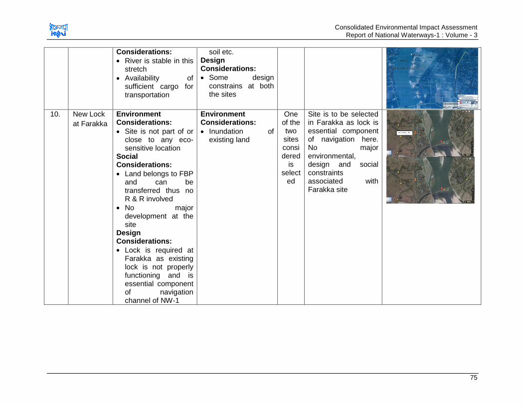
Consolidated Environmental Impact Assessment Report of National Waterways-1 : Volume - 3
75
Considerations:
River is stable in this stretch
Availability of sufficient cargo for transportation
soil etc. Design Considerations:
Some design constrains at both the sites
10. New Lock
at Farakka
Environment Considerations:
Site is not part of or close to any eco-sensitive location
Social Considerations:
Land belongs to FBP and can be transferred thus no R & R involved
No major development at the site
Design Considerations:
Lock is required at Farakka as existing lock is not properly functioning and is essential component of navigation channel of NW-1
Environment Considerations:
Inundation of existing land
One of the two sites considered
is select
ed
Site is to be selected in Farakka as lock is essential component of navigation here. No major environmental, design and social constraints associated with Farakka site
Consolidated Environmental Impact Assessment Report of National Waterways-1 : Volume - 3
76
Conclusion for Location Alternative Analysis:
Out of the total 10 locations, 6 locations were finalized for construction of terminal and
one location is finalized for development of lock. Varanasi, Sahibganj & Haldia terminal
sites were pre-decided. Also location of lock was pre-decided, i.e. Farakka. There is
requirement of navigation lock in that stretch due to large water level difference in river &
feeder canal and existing lock does not work optimally. Environmental, social and
biological impacts of development of terminal & lock on these locations are identified and
accordingly mitigation and management plans are developed.
Remaining six sites were analysed from environmental, social, design considerations.
Based on alternative analysis three terminal sites at Ghazipur, Tribeni, Kalughat near
Doraiganj were considered as preferred sites for these interventions. The other three
terminal sites at Barh, Kahalgaon &Balia were not considered feasible due to (i) various
environmental considerations including proximity to Vikramshila Dolphin sanctuary and
Important Bird Areas, (ii) design issues such as unstable river, presence of navigational
hazards and high sedimentation rate (iii) social issues concerning acquisition of land and
(iv) connectivity.
Further alternative analysis was carried out for probable two sites at each of the above
identified three terminal locations and Farakka lock based on environmental, social and
design consideration. As per this analysis the preferred sites for these intervention
locations were considered for design and environmental impact assessment.
b. Selection of specific site at each selected location
One or more sites were analysed at each selected locations for setting up proposed
terminal or lock facility. Sites were selected and analysed for environmental, social and
design consideration and the analysis is given in Table 3.18.

Consolidated Environmental Impact Assessment Report of National Waterways-1 : Volume - 3
77
Table 3.18 : Site Alternative Analysis
S. No.
Development, Site &
Location
Advantages Disadvantages Selection Status
Remarks Site Map
1a Termina
l site at
Ghazipu
r, U.P.-
Site 1
Environment Considerations:
Site is not part of or close to any eco-sensitive location
Social Considerations:
Site belongs to Indian railways and thus does not involve R & R
Site directly connected with existing IR and connects to NH through small paved road
Availability of the cargo traffic. NH-97 has large volume of traffic which can be diverted here
Environment Considerations:
Requires large quantity of dredging and thus high threat to aquatic ecosystem and issues of disposal of dredged sand
Social Considerations:
Land available is only 3 ha which is insufficient for terminal development without any demolition and requires demolition of 20 houses to acquire 2 ha additional land
Design Considerations:
Site located on secondary channel of River
Not selected
Dredging requirement is too high and it will have high associated cost and damage to aquatic environment
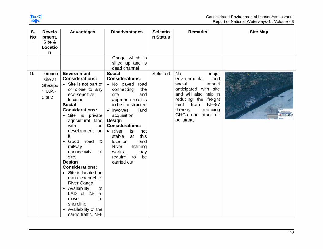
Consolidated Environmental Impact Assessment Report of National Waterways-1 : Volume - 3
78
S. No.
Development, Site &
Location
Advantages Disadvantages Selection Status
Remarks Site Map
Ganga which is silted up and is dead channel
1b Termina
l site at
Ghazipu
r, U.P.-
Site 2
Environment Considerations:
Site is not part of or close to any eco-sensitive location
Social Considerations:
Site is private agricultural land with no development on it
Good road & railway connectivity of site.
Design Considerations:
Site is located on main channel of River Ganga
Availability of LAD of 2.5 m close to shoreline
Availability of the cargo traffic. NH-
Social Considerations:
No paved road connecting the site and approach road is to be constructed
Involves land acquisition
Design Considerations:
River is not stable at this location and River training works may require to be carried out
Selected No major environmental and social impact anticipated with site and will also help in reducing the freight load from NH-97 thereby reducing GHGs and other air pollutants

Consolidated Environmental Impact Assessment Report of National Waterways-1 : Volume - 3
79
S. No.
Development, Site &
Location
Advantages Disadvantages Selection Status
Remarks Site Map
97 has large volume of traffic which can be diverted here
2a Termina
l site at
Doriaga
nj
(Semari
a),
Bihar
Environment Considerations:
Locally available raw material (sand) for transportation
Site is not part of or close to any eco-sensitive location
Social Considerations:
Area well connected by road & Railways to all major cities
App. 12 ha of agricultural land is available for development of terminal. Land does not support and development at present
Design Considerations:
Environment Considerations:
Requires tree cutting
Social Considerations:
Involves land acquisition
Not Selected
Involves tree cutting and acquisition of agricultural land

Consolidated Environmental Impact Assessment Report of National Waterways-1 : Volume - 3
80
S. No.
Development, Site &
Location
Advantages Disadvantages Selection Status
Remarks Site Map
River channel is stable
No shoal formation and availability of LAD
Availability of sufficient cargo for transportation
2b Termina
l at
Kalugha
t,
Sitabga
nj, Bihar
Environment Considerations:
Locally available raw material (sand) for transportation
No environmental sensitive location will be affected
Social Considerations:
Availability of sufficient land
Site well connected by road & railway
Site is vacant and involves no development
Design Considerations:
Social Considerations:
Involves acquisition of land
Selected Site has no environmental, design
& social issues associated
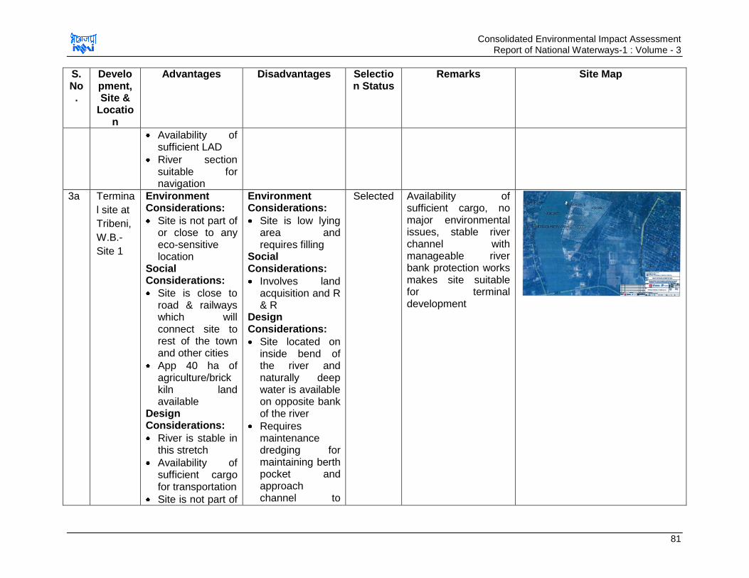
Consolidated Environmental Impact Assessment Report of National Waterways-1 : Volume - 3
81
S. No.
Development, Site &
Location
Advantages Disadvantages Selection Status
Remarks Site Map
Availability of sufficient LAD
River section suitable for navigation
3a Termina
l site at
Tribeni,
W.B.-
Site 1
Environment Considerations:
Site is not part of or close to any eco-sensitive location
Social Considerations:
Site is close to road & railways which will connect site to rest of the town and other cities
App 40 ha of agriculture/brick kiln land available
Design Considerations:
River is stable in this stretch
Availability of sufficient cargo for transportation
Site is not part of
Environment Considerations:
Site is low lying area and requires filling
Social Considerations:
Involves land acquisition and R & R
Design Considerations:
Site located on inside bend of the river and naturally deep water is available on opposite bank of the river
Requires maintenance dredging for maintaining berth pocket and approach channel to
Selected Availability of sufficient cargo, no major environmental issues, stable river channel with manageable river bank protection works makes site suitable for terminal development
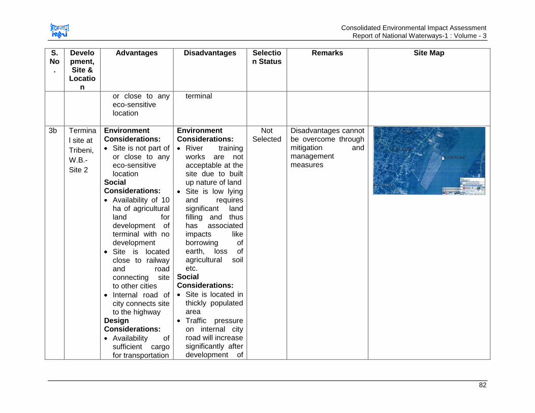
Consolidated Environmental Impact Assessment Report of National Waterways-1 : Volume - 3
82
S. No.
Development, Site &
Location
Advantages Disadvantages Selection Status
Remarks Site Map
or close to any eco-sensitive location
terminal
3b Termina
l site at
Tribeni,
W.B.-
Site 2
Environment Considerations:
Site is not part of or close to any eco-sensitive location
Social Considerations:
Availability of 10 ha of agricultural land for development of terminal with no development
Site is located close to railway and road connecting site to other cities
Internal road of city connects site to the highway
Design Considerations:
Availability of sufficient cargo for transportation
Environment Considerations:
River training works are not acceptable at the site due to built up nature of land
Site is low lying and requires significant land filling and thus has associated impacts like borrowing of earth, loss of agricultural soil etc.
Social Considerations:
Site is located in thickly populated area
Traffic pressure on internal city road will increase significantly after development of
Not Selected
Disadvantages cannot be overcome through mitigation and management measures
Consolidated Environmental Impact Assessment Report of National Waterways-1 : Volume - 3
83
S. No.
Development, Site &
Location
Advantages Disadvantages Selection Status
Remarks Site Map
terminal and its expansion will be problem due to location in thickly populated area
Design Considerations:
Extension of railway line to the site is not easily feasible
Possible water intake is located within the site
A channel connecting to the main river at both ends is traversing the area & is probably a source of water for intake structure for water supply to the town
Shallow water depth along the river bank and dredging will be required to
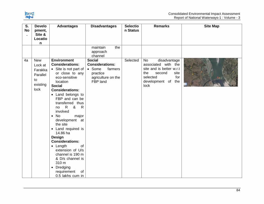
Consolidated Environmental Impact Assessment Report of National Waterways-1 : Volume - 3
84
S. No.
Development, Site &
Location
Advantages Disadvantages Selection Status
Remarks Site Map
maintain the approach channel
4a New
Lock at
Farakka
Parallel
to
existing
lock
Environment Considerations:
Site is not part of or close to any eco-sensitive location
Social Considerations:
Land belongs to FBP and can be transferred thus no R & R involved
No major development at the site
Land required is 14.86 ha
Design Considerations:
Length of extension of U/s channel is 190 m & D/s channel is 310 m
Dredging requirement of 0.5 lakhs cum in
Social Considerations:
Some farmers practice agriculture on the FBP land
Selected No disadvantage associated with the site and is better w.r.t the second site selected for development of the lock
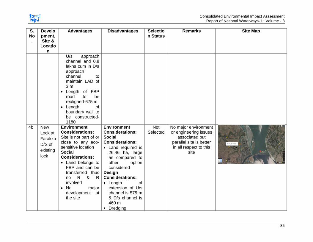
Consolidated Environmental Impact Assessment Report of National Waterways-1 : Volume - 3
85
S. No.
Development, Site &
Location
Advantages Disadvantages Selection Status
Remarks Site Map
U/s approach channel and 0.8 lakhs cum in D/s approach channel to maintain LAD of 3 m
Length of FBP road to be realigned-675 m
Length of boundary wall to be constructed-1180
4b New
Lock at
Farakka
D/S of
existing
lock
Environment Considerations: Site is not part of or close to any eco-sensitive location Social Considerations:
Land belongs to FBP and can be transferred thus no R & R involved
No major development at the site
Environment Considerations: Social Considerations:
Land required is 26.46 ha, large as compared to other option considered
Design Considerations:
Length of extension of U/s channel is 575 m & D/s channel is 460 m
Dredging
Not Selected
No major environment or engineering issues
associated but parallel site is better in all respect to this
site
Consolidated Environmental Impact Assessment Report of National Waterways-1 : Volume - 3
86
S. No.
Development, Site &
Location
Advantages Disadvantages Selection Status
Remarks Site Map
requirement of 1.5 lakhs cum in U/s approach channel and 1.5 lakhs cum in D/s approach channel to maintain LAD of 3 m
Length of FBP road to be realigned-980 m
Length of boundary wall to be constructed-1672
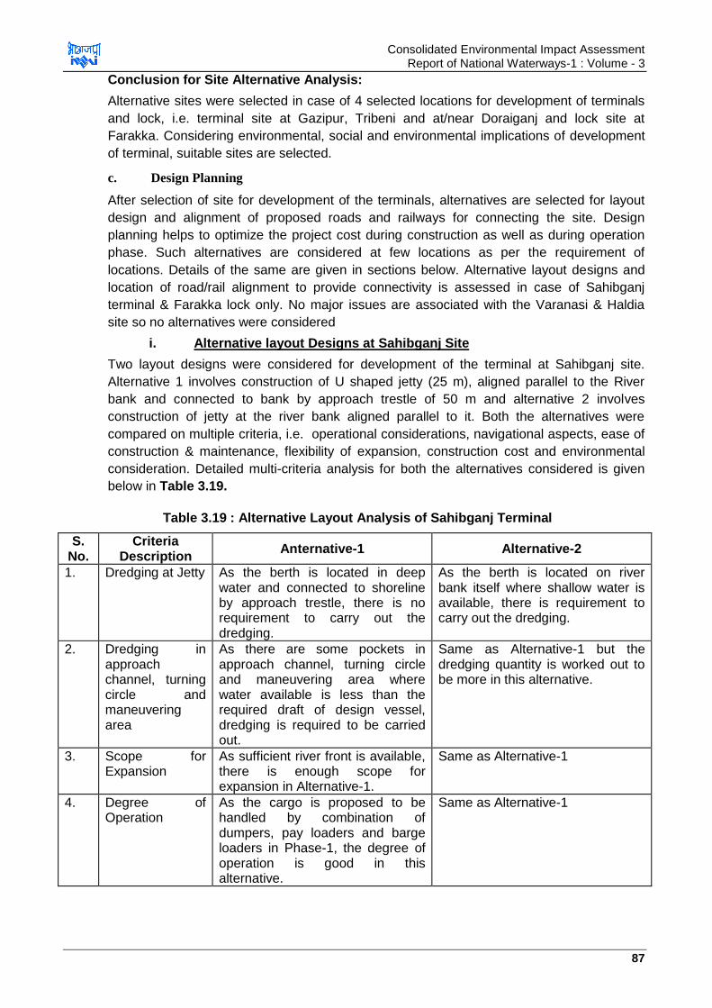
Consolidated Environmental Impact Assessment Report of National Waterways-1 : Volume - 3
87
Conclusion for Site Alternative Analysis:
Alternative sites were selected in case of 4 selected locations for development of terminals
and lock, i.e. terminal site at Gazipur, Tribeni and at/near Doraiganj and lock site at
Farakka. Considering environmental, social and environmental implications of development
of terminal, suitable sites are selected.
c. Design Planning
After selection of site for development of the terminals, alternatives are selected for layout
design and alignment of proposed roads and railways for connecting the site. Design
planning helps to optimize the project cost during construction as well as during operation
phase. Such alternatives are considered at few locations as per the requirement of
locations. Details of the same are given in sections below. Alternative layout designs and
location of road/rail alignment to provide connectivity is assessed in case of Sahibganj
terminal & Farakka lock only. No major issues are associated with the Varanasi & Haldia
site so no alternatives were considered
i. Alternative layout Designs at Sahibganj Site
Two layout designs were considered for development of the terminal at Sahibganj site.
Alternative 1 involves construction of U shaped jetty (25 m), aligned parallel to the River
bank and connected to bank by approach trestle of 50 m and alternative 2 involves
construction of jetty at the river bank aligned parallel to it. Both the alternatives were
compared on multiple criteria, i.e. operational considerations, navigational aspects, ease of
construction & maintenance, flexibility of expansion, construction cost and environmental
consideration. Detailed multi-criteria analysis for both the alternatives considered is given
below in Table 3.19.
Table 3.19 : Alternative Layout Analysis of Sahibganj Terminal
S. No.
Criteria Description
Anternative-1 Alternative-2
1. Dredging at Jetty As the berth is located in deep water and connected to shoreline by approach trestle, there is no requirement to carry out the dredging.
As the berth is located on river bank itself where shallow water is available, there is requirement to carry out the dredging.
2. Dredging in approach channel, turning circle and maneuvering area
As there are some pockets in approach channel, turning circle and maneuvering area where water available is less than the required draft of design vessel, dredging is required to be carried out.
Same as Alternative-1 but the dredging quantity is worked out to be more in this alternative.
3. Scope for Expansion
As sufficient river front is available, there is enough scope for expansion in Alternative-1.
Same as Alternative-1
4. Degree of Operation
As the cargo is proposed to be handled by combination of dumpers, pay loaders and barge loaders in Phase-1, the degree of operation is good in this alternative.
Same as Alternative-1

Consolidated Environmental Impact Assessment Report of National Waterways-1 : Volume - 3
88
5. Ease of Construction
As Alternative-1 involves construction of jetty along with 50 m long approach trestle, the construction can be carried out easily by well-established methods.
As Alternative-2 involves construction of jetty at river bank only, the construction can be done easily in relatively short time as compared to Alternative-1.
6. Cost of Construction
The cost of construction for Alternative-1 works out to be marginally higher in comparison to Alternative-2.
The costs of construction for Alternative-2 is marginally lower than Altenrative-1.
7. Environmental Consideration
Reduced dredging requirement will have lesser need for disposal of dredged material and also will have lesser disturbance to river system and aquatic life.
Larger dredging will have comparatively larger disturbance to river system and aquatic life.
8. Layout
Based on multi criteria matrix presented above, both the alternative layouts have certain
advantages as well as disadvantages. It could be observed that in terms of available
required depth round the year without need of dredging and marginal cost difference
between two alternatives, and environmental consideration Alternative-I is preferred
alternative for development of IWT Terminal at Sahibganj in Jharkhand.
ii. Alternative Layout Design of Farakka Lock
Two Options for locating the new navigation lock have been considered. In Option - I, the
new lock will be located parallel to the existing lock and in Option - II, it will be located D/S
of the existing lock. Sufficient distance between the two locks has been kept in Option 1 so
that there is no danger to the structure of existing navigation lock. Detail comparison of
Option-I and Option II is provided in Table 3.20.
Table 3.20 : Alternate Site Analysis (Option-I & Option-II)
S. No.
Parameter Option-I Option-II Remarks
1 Land Required (ha)
14.86 26.46 Land required in Option-II is almost two times
2 Length of extension of U/S Approach Channel (m)
190 575 Length is almost three times in Option-II as compared to Option-I.
While Option-I involves construction of only the left Bank of the channel and protection works on left bank only, Option-II involves construction of both the banks of the channel and bank protection works on both the banks. This means additional cost in Option-II.
3 Assuming 0.05 0.15 Quantity of excavation in Option-II is
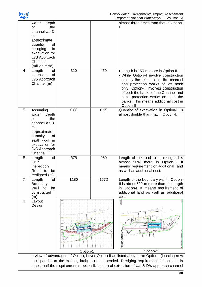
Consolidated Environmental Impact Assessment Report of National Waterways-1 : Volume - 3
89
water depth of the channel as 3-m, approximate quantity of dredging in excavation for U/S Approach Channel (million mm3)
almost three times than that in Option-I.
4 Length of extension of D/S Approach Channel (m)
310 460 Length is 150-m more in Option-II.
While Option–I involve construction of only the left bank of the channel and protection works of left bank only, Option-II involves construction of both the banks of the Channel and bank protection works on both the banks. This means additional cost in Option-II
5 Assuming water depth of the channel as 3-m, approximate quantity of earth work in excavation for D/S Approach Channel
0.08 0.15 Quantity of excavation in Option-II is almost double than that in Option-I.
6 Length of FBP Inspection Road to be realigned (m)
675 980 Length of the road to be realigned is almost 50% more in Option-II. It means requirement of additional land as well as additional cost.
7 Length of Boundary Wall to be constructed (m)
1180 1672 Length of the boundary wall in Option-II is about 500-m more than the length in Option-I. It means requirement of additional land as well as additional cost.
8 Layout Design
Option-1
Option-2
In view of advantages of Option, I over Option II as listed above, the Option I (locating new
Lock parallel to the existing lock) is recommended. Dredging requirement for option I is
almost half the requirement in option II. Length of extension of U/s & D/s approach channel
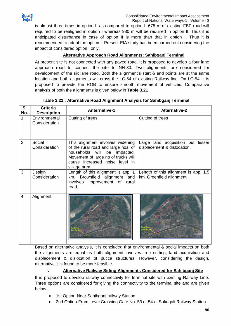
Consolidated Environmental Impact Assessment Report of National Waterways-1 : Volume - 3
90
is almost three times in option II as compared to option I. 675 m of existing FBP road will
required to be realigned in option I whereas 980 m will be required in option II. Thus it is
anticipated disturbance in case of option II is more than that in option I. Thus it is
recommended to adopt the option I. Present EIA study has been carried out considering the
impact of considered option I only.
iii. Alternative Approach Road Alignments: Sahibganj Terminal
At present site is not connected with any paved road. It is proposed to develop a four lane
approach road to connect the site to NH-80. Two alignments are considered for
development of the six lane road. Both the alignment‟s start & end points are at the same
location and both alignments will cross the LC-54 of existing Railway line. On LC-54, it is
proposed to provide the ROB to ensure smooth movement of vehicles. Comparative
analysis of both the alignments is given below in Table 3.21
Table 3.21 : Alternative Road Alignment Analysis for Sahibganj Terminal
S. No.
Criteria Description
Anternative-1 Alternative-2
1. Environmental Consideration
Cutting of trees Cutting of trees
2. Social Consideration
This alignment involves widening of the rural road and large nos. of households will be impacted. Movement of large no of trucks will cause increased noise level in village area.
Large land acquisition but lesser displacement & dislocation.
3. Design Consideration
Length of this alignment is app. 1 km. Brownfield alignment and involves improvement of rural road.
Length of this alignment is app. 1.5 km. Greenfield alignment.
4. Alignment
Based on alternative analysis, it is concluded that environmental & social impacts on both
the alignments are equal as both alignment involves tree cutting, land acquisition and
displacement & dislocation of pucca structures. However, considering the design,
alternative 1 is found to be more feasible.
iv. Alternative Railway Siding Alignments Considered for Sahibganj Site
It is proposed to develop railway connectivity for terminal site with existing Railway Line.
Three options are considered for giving the connectivity to the terminal site and are given
below.
1st Option-Near Sahibganj railway Station
2nd Option-From Level Crossing Gate No. 53 or 54 at Sakrigali Railway Station
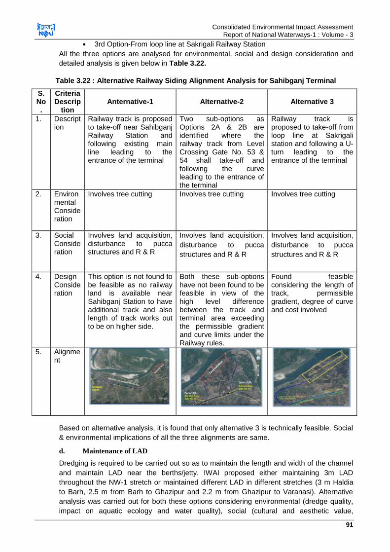
Consolidated Environmental Impact Assessment Report of National Waterways-1 : Volume - 3
91
3rd Option-From loop line at Sakrigali Railway Station
All the three options are analysed for environmental, social and design consideration and
detailed analysis is given below in Table 3.22.
Table 3.22 : Alternative Railway Siding Alignment Analysis for Sahibganj Terminal
S. No.
Criteria Descrip
tion Anternative-1 Alternative-2 Alternative 3
1. Description
Railway track is proposed to take-off near Sahibganj Railway Station and following existing main line leading to the entrance of the terminal
Two sub-options as Options 2A & 2B are identified where the railway track from Level Crossing Gate No. 53 & 54 shall take-off and following the curve leading to the entrance of the terminal
Railway track is proposed to take-off from loop line at Sakrigali station and following a U-turn leading to the entrance of the terminal
2. Environmental Consideration
Involves tree cutting Involves tree cutting Involves tree cutting
3. Social Consideration
Involves land acquisition, disturbance to pucca structures and R & R
Involves land acquisition,
disturbance to pucca
structures and R & R
Involves land acquisition,
disturbance to pucca
structures and R & R
4. Design Consideration
This option is not found to be feasible as no railway land is available near Sahibganj Station to have additional track and also length of track works out to be on higher side.
Both these sub-options have not been found to be feasible in view of the high level difference between the track and terminal area exceeding the permissible gradient and curve limits under the Railway rules.
Found feasible considering the length of track, permissible gradient, degree of curve and cost involved
5. Alignment
Based on alternative analysis, it is found that only alternative 3 is technically feasible. Social
& environmental implications of all the three alignments are same.
d. Maintenance of LAD
Dredging is required to be carried out so as to maintain the length and width of the channel
and maintain LAD near the berths/jetty. IWAI proposed either maintaining 3m LAD
throughout the NW-1 stretch or maintained different LAD in different stretches (3 m Haldia
to Barh, 2.5 m from Barh to Ghazipur and 2.2 m from Ghazipur to Varanasi). Alternative
analysis was carried out for both these options considering environmental (dredge quality,
impact on aquatic ecology and water quality), social (cultural and aesthetic value,

Consolidated Environmental Impact Assessment Report of National Waterways-1 : Volume - 3
92
employment and socio-economic consideration) and technical feasibility (dredge quantity,
navigation feasibility, economic aspects, dredgers and other infrastructure requirements).
Both the options have their pros and cons and are discussed at Table 3.23.
Table 3.23 : Alternative Analysis for Dredging Quantity
Considerations Option 1 (3 m LAD
in entire NW-1)
In
CUM
Option 2 (LAD of 3 m
Haldia to Barh
(Bihar), 2.5 m from
Barh to Ghazipur and
2.2 m from Ghazipur
to Varanasi)
In CUM
Remarks
Dredging Quantity in
Dry Season
31,079,576 1,48,50,000 Option 2 is app. 50%
of option 1 hence less
environmental, social
and economic impacts
associated with option
2
Navigation In entire NW-1 Possible from Haldia
to Varanasi during dry
season
Option 1 provides
better navigation
facilities
Cost High Comparatively lower Cost in option 1 is app.
double the cost in
option 2 due to
doubling of quantity
Dredgers and other
infrastructure
requirement
32-33 (if dredgers
work for 10 hours in
month of 25 days in
double shift)
12 (if dredgers work
for 10 hours in month
of 25 days in double
shift for 8 months)
Requirement of
dredgers and dredging
infrastructure is more
than double in option 1
as compared to option
2
Disturbance to social,
cultural and aesthetic
value
Comparatively more
than option 2
Comparatively less
than option 1
Option 1 will have
more disturbance as it
covers the larger
stretch
Disturbance to aquatic
flora & fauna
Comparatively more
than option 2
Comparatively less
than option1
Option 1 will have
more disturbance as it
covers the larger
stretch
Employment More Less Since the dredging is
to be undertaken at
larger stretch in option
1, employment to
larger nos. of people
will be provided in

Consolidated Environmental Impact Assessment Report of National Waterways-1 : Volume - 3
93
option 1.
As per above analysis option of maintaining different LAD at different stretch was found
most preferred option.
3.12.3. Technology Consideration
This enables to select the technology best suited for the site specific environment and
having minimal implication of environment, social and biological component of environment.
Technological consideration for selection of type of dredgers is made as maintenance
dredging is one of the crucial activities of operational phase which will be continued for app.
8 month every year.
a. Selection of Material Conveying System Within Terminal Site
Initially it was planned to transport the material from Railway siding to stockyards to barges
and vice versa through the barges/dumpers at Sahibganj Terminal as per feasibility report.
But looking into the environmental impacts including the dust emissions during loading and
unloading, vehicular emissions, oil spillages from transportation vehicle movement and
repair, alternative system for material transportation within the terminal called as mechanical
conveying system was analysed and considered as best option as it can drastically reduce
the dust emissions. It was found more suitable also due to presence of residential areas
(villages) closet Sahibganj terminal. This has been adopted in the plan of Sahibganj
terminal.
b. Selection of Dredger
Selection of dredgers is important as selection of dredger has environmental implications
such as effect of production rate on the project duration, the levels of turbidity and
suspended sediment concentrations generated relative to background levels, the proportion
of total sediment lost to the environment and the degree of contamination in the sediment.
Typically, CSDs have least effect on turbidity at the dredging site and TSFDs produce
similar low turbidity when used without overflow. Grab dredgers and TSGDs when used with
overflow, produce significantly high turbidity throughout the water column near the dredging
site than do CSDs. However, reverse is true for placement site. CSDs and TSHDs fluidise
the sediments by mixing them with water than the mechanical dredgers do. Fluidized
sediments by CSDs and TSHDs causes discharged material to cover larger area when
unconfined. Comparative analysis of types of dredger and their relative performance related
to environmental aspects is given below in Table 3.24& 3.25.
Table 3.24 : Comparative Analysis of Dredgers and Their Relative Performance Related to Environmental Aspects
Type of
Dreger
Safety Accuracy Turbidity Mixing Spill Dilution Noise
Suction
dredger
+ - + - - 0 +
CSDs + + 0/+ 0/+ 0 0 +
TSHD +/0 - -/0 - 0 - +
Bucket
Ladder
Dredger
- + -/0 0/+ + + -
Backhoe - + -/0 + + + +
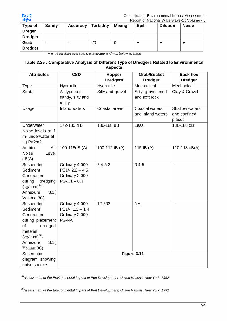
Consolidated Environmental Impact Assessment Report of National Waterways-1 : Volume - 3
94
Type of
Dreger
Safety Accuracy Turbidity Mixing Spill Dilution Noise
Dredger
Grab
Dredger
- - -/0 0 + + +
+ is better than average, 0 is average and – is below average
Table 3.25 : Comparative Analysis of Different Type of Dredgers Related to Environmental Aspects
Attributes CSD Hopper
Dredgers
Grab/Bucket
Dredger
Back hoe
Dredger
Type Hydraulic Hydraulic Mechanical Mechanical
Strata All type-soil,
sandy, silty and
rocky
Silty and gravel Silty, gravel, mud
and soft rock
Clay & Gravel
Usage Inland waters Coastal areas Coastal waters
and inland waters
Shallow waters
and confined
places
Underwater
Noise levels at 1
m- underwater at
1 μPa2m2
172-185 d B 186-188 dB Less 186-188 dB
Ambient Air
Noise Level
dB(A)
100-115dB (A) 100-112dB (A) 115dB (A) 110-118 dB(A)
Suspended
Sediment
Generation
during dredging
(kg/cum)24-
Annexure 3.1(
Volume 3C)
Ordinary 4,000
PS1/- 2.2 – 4.5
Ordinary 2,000
PS-0.1 – 0.3
2.4-5.2 0.4-5 --
Suspended
Sediment
Generation
during placement
of dredged
material
(kg/cum)25-
Annexure 3.1(
Volume 3C)
Ordinary 4,000
PS1/- 1.2 – 1.4
Ordinary 2,000
PS-NA
12-203 NA --
Schematic
diagram showing
noise sources
Figure 3.11
24
Assessment of the Environmental Impact of Port Development, United Nations, New York, 1992
25
Assessment of the Environmental Impact of Port Development, United Nations, New York, 1992
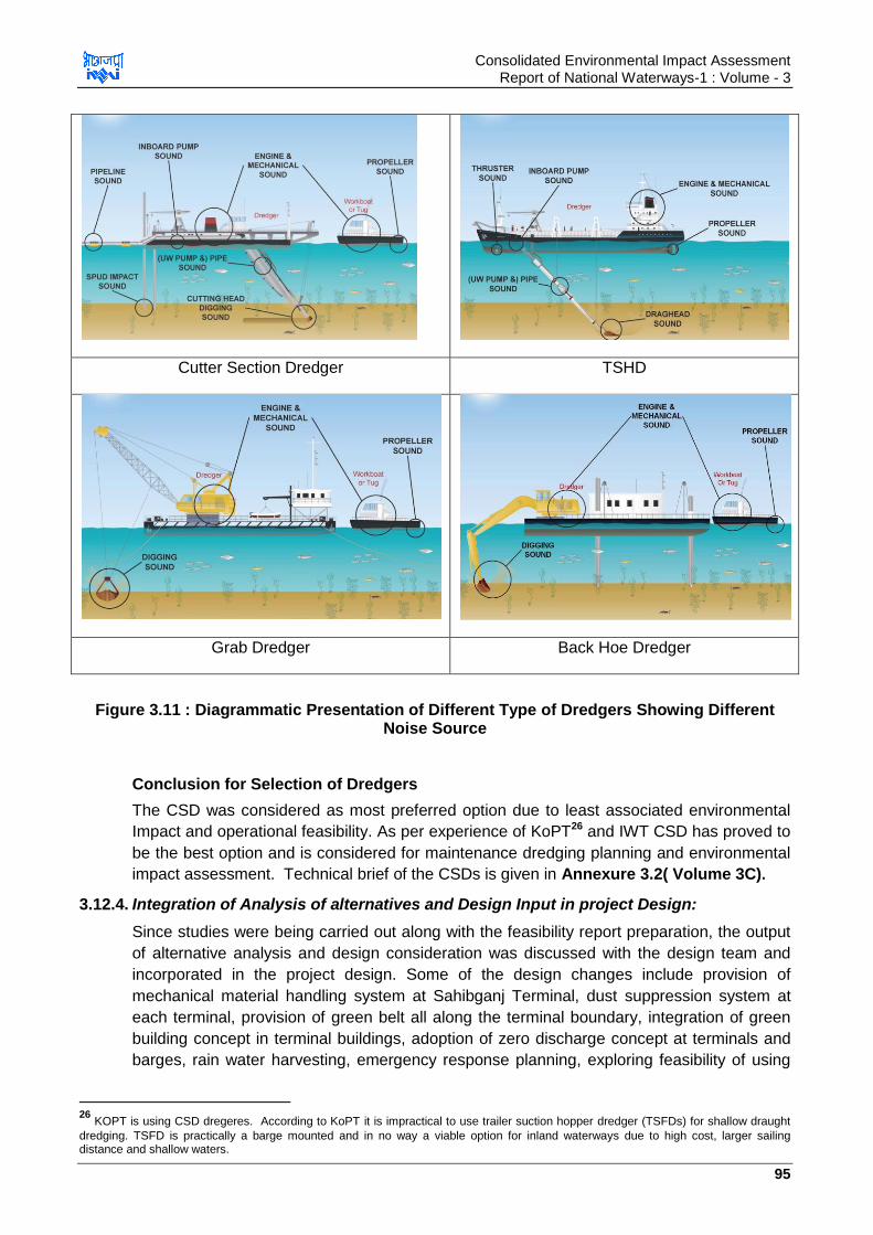
Consolidated Environmental Impact Assessment Report of National Waterways-1 : Volume - 3
95
Cutter Section Dredger TSHD
Grab Dredger Back Hoe Dredger
Figure 3.11 : Diagrammatic Presentation of Different Type of Dredgers Showing Different Noise Source
Conclusion for Selection of Dredgers
The CSD was considered as most preferred option due to least associated environmental
Impact and operational feasibility. As per experience of KoPT26 and IWT CSD has proved to
be the best option and is considered for maintenance dredging planning and environmental
impact assessment. Technical brief of the CSDs is given in Annexure 3.2( Volume 3C).
3.12.4. Integration of Analysis of alternatives and Design Input in project Design:
Since studies were being carried out along with the feasibility report preparation, the output
of alternative analysis and design consideration was discussed with the design team and
incorporated in the project design. Some of the design changes include provision of
mechanical material handling system at Sahibganj Terminal, dust suppression system at
each terminal, provision of green belt all along the terminal boundary, integration of green
building concept in terminal buildings, adoption of zero discharge concept at terminals and
barges, rain water harvesting, emergency response planning, exploring feasibility of using
26
KOPT is using CSD dregeres. According to KoPT it is impractical to use trailer suction hopper dredger (TSFDs) for shallow draught
dredging. TSFD is practically a barge mounted and in no way a viable option for inland waterways due to high cost, larger sailing distance and shallow waters.

Consolidated Environmental Impact Assessment Report of National Waterways-1 : Volume - 3
96
low draft vessel and alternative fuels for barge operations. The project description details
presented below includes the above considerations.
C: DEVELOPMENT OF NAVIGATION CHANNEL, PLANNED AND PROPOSED PROJECT
COMPONENTS
The developmental activities include maintenance of Navigational Channel (Least Available
Depth for Navigation), Barge operations, and Physical interventions (Such as construction
of Terminals, Navigation Lock, River training structures, RO-RO Jetties). Details of these
interventions are described below.
3.13. Least Available Depth for Navigation in NW-1
For navigation purpose, it is essential that minimum depth of the water is maintained in the
river all the time of navigation. IWAI is currently maintaining LAD for managing the
navigation in NW-1 through dredging and bandalling. Depths27 maintained by IWAI in
different stretches currently is given below
Haldia (Sagar) - Farakka (560 km)-2.8-3.0 m
Farakka - Barh (400 km)-2.1-2.5 m
Barh - Ghazipur (290 km)-1.6-2 m
Ghazipur – Chunar/Allahabad (124 km)-1.2-1.5m
Chuna-Allahabad (246 km)-No maintenance
However, “Jal Vikas Marg” Project aims at maintenance of LAD to 3 m in entire NW-1. But
to optimize the cost, deployment of dredgers, manage man-power and minimize
environmental impacts, IWAI is focussing on different depths in different stretches at
present.
Haldia to Tribeni : 3 m (naturally available LAD)
Tribeni to Farakka : 3 m (including Farakka Lock)
Farakka to Barh : 3 m
Barh to Ghazipur : 2.5 m
Ghazipur to Varanasi : 2.2 m
Varanasi to Allahabad (236 km)- no maintenance The above consideration also takes into
account assessment of 10%, 50% and 90% frequency of occurrence of LAD during the dry
season (Nov-June) for 2010-2015 carried out by design consultant which is shown at Figure
3.12.
27
As per the surveys carried out by IWAI, depths available in NW-1 naturally are as follows:.
Haldia to Tribeni (196 km)- LAD of 3m- throughout the year
Tribeni to Farakka (364 km)- LAD of 2.5 m – 320 days
Farakka to Ghazipur (690 km)- LAD of 2 m- 200 days
Ghazipur to Allahabad (370 km)-LAD of 1.5 m-170 days
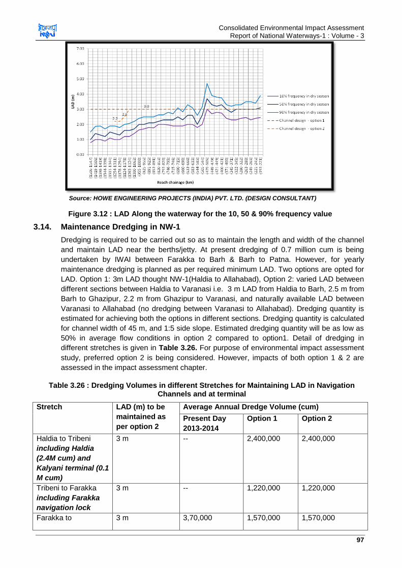
Consolidated Environmental Impact Assessment Report of National Waterways-1 : Volume - 3
97
Source: HOWE ENGINEERING PROJECTS (INDIA) PVT. LTD. (DESIGN CONSULTANT)
Figure 3.12 : LAD Along the waterway for the 10, 50 & 90% frequency value
3.14. Maintenance Dredging in NW-1
Dredging is required to be carried out so as to maintain the length and width of the channel
and maintain LAD near the berths/jetty. At present dredging of 0.7 million cum is being
undertaken by IWAI between Farakka to Barh & Barh to Patna. However, for yearly
maintenance dredging is planned as per required minimum LAD. Two options are opted for
LAD. Option 1: 3m LAD thought NW-1(Haldia to Allahabad), Option 2: varied LAD between
different sections between Haldia to Varanasi i.e. 3 m LAD from Haldia to Barh, 2.5 m from
Barh to Ghazipur, 2.2 m from Ghazipur to Varanasi, and naturally available LAD between
Varanasi to Allahabad (no dredging between Varanasi to Allahabad). Dredging quantity is
estimated for achieving both the options in different sections. Dredging quantity is calculated
for channel width of 45 m, and 1:5 side slope. Estimated dredging quantity will be as low as
50% in average flow conditions in option 2 compared to option1. Detail of dredging in
different stretches is given in Table 3.26. For purpose of environmental impact assessment
study, preferred option 2 is being considered. However, impacts of both option 1 & 2 are
assessed in the impact assessment chapter.
Table 3.26 : Dredging Volumes in different Stretches for Maintaining LAD in Navigation Channels and at terminal
Stretch LAD (m) to be
maintained as
per option 2
Average Annual Dredge Volume (cum)
Present Day
2013-2014
Option 1 Option 2
Haldia to Tribeni
including Haldia
(2.4M cum) and
Kalyani terminal (0.1
M cum)
3 m -- 2,400,000 2,400,000
Tribeni to Farakka
including Farakka
navigation lock
3 m -- 1,220,000 1,220,000
Farakka to 3 m 3,70,000 1,570,000 1,570,000
Consolidated Environmental Impact Assessment Report of National Waterways-1 : Volume - 3
98
Kahalgaon including
Sahibganj
terminal(0.1 M cum)
Kahalgaon to Barh 3 m 2,390,000 2,390,000
Barh to Patna 2.5 m 3,30,000 3,189,534 1,600,000
Patna to Buxar
Including Kalughat
terminal (0.5 M cum)
2.5 m -- 4,999,253 2,770,000
Buxar to Ghazipur
including Ghazipur
terminal at
Nawapura (0.1 M
cum)
2.5 m -- 5,793,355 1,060,000
Ghazipur to Varanasi
including Varanasi
terminal (0.1 M cum)
2.2 m -- 1,840,000
Varanasi to
Allahabad
Natural depth -- 9,816,710 Nil
Total 7,00,000 31,079,576 14,850,000
Source: HOWE Engineering Projects (India) Pvt. Ltd. (Design Consultant) India
a. Requirement of Dredgers for Maintaining LAD in Navigation Channels:
Maximum capacity of one dredger in one month is to dredge 50,000 cum of sand if there are
25 working days in month of 8 hours each. If dredger works at its maximum capacity for 6
months, then dredging volume per dredger of 3,00,000 cum can be achieved. Average
volume to be dredged to maintain LAD in navigation channel as per option 2 is 14,850,000
cum/year thus it would require 50 dredgers working at their maximum capacity for 6 months.
To optimize the nos.of dredgers, it is proposed to extend daily operation hours from 8 to 10
hrs so as nos. of dredgers required will be 40. If dredger works for 10 hrs in a day for 8
months, then dredgers required will be 24 nos. only. If dredgers work this way in 2 shifts,
then no. of dredgers required will be 12 only. However excess dredging may be required
when water levels are lower than average water levels during dry season. Dredging should
be supplemented by bandalling works so as to increase effectiveness of dredging and
reducing requirement of dredging.
b. Type of Dredgers:
CSD (cutter section dredgers) is proposed to be used for Jal Marg Vikas Project along with
the agitation (plough dredger) dredgers and Backhoe Dredgers (BHDs). The dredging plant
will require support vessels, including bunkering, survey, accommodation and tugs.
Plough/agitation dredgers could be used to dredge shallow waters or removing high spots
(dredge cut <0.5 m). Channel width is 45 m and CSDs used by IWAI have swing width of
35-40 m thus two CSDs can be deployed in pairs leaving the off-set to prevent overlap to
dredge the channel. Dredging depth varies from 0.5-3 m, means about 1-4 cuts will be
required to achieve the required depth (dredge cut <0.5 m).
Water levels start reducing from mid-October and dredging operation would be required to
be started during this period. Plough/agitation dredgers can be used in initial period to
dredge shallow waters/ high spots. When depth reduces significantly by November CSDs
will be used for dredging. Dredging operations will continue from mid-October to June.
During monsoon season, i.e. July-mid October repair & maintenance of dredgers can be
taken up.

Consolidated Environmental Impact Assessment Report of National Waterways-1 : Volume - 3
99
c. Dredge Disposal:
Disposal of dredged material through CSDs will be done through pipeline into the free
stream of the river in a way to avoid material working its way back to dredged channel. This
can be achieved by disposing in faster flowing water, downstream and to the side of the
working dredgers and disposal of material into secondary channels or redundant channels.
Material dredged by BHD will need to be placed in a barge and disposed of away from the
channel as the reach of the BHD is unlikely to be sufficient enough to reach the faster flow
for dispersion of the material. Therefore, it is required to find potential disposal sites for this
material.
3.15. Physical Intervention
3.15.1. Navigation Aids
a. Existing Navigation Aids on NW-1
Temporary channel marks for day navigation maintained between Tribeni and
Allahabad all-round the year.
Night navigation aids were maintained between Tribeni and Varanasi (1187km) with
country boats/ MS poles fitted with navigational lights and beacons
DGPS stations at Bhagalpur, Patna and Swaroopganj.
12 Nos. survey vessels. Thalweg surveys conducted fortnightly during low water
period and on monthly basis in flood season
77 Cargo vessels deployed in operations between Haldia & Kolkata
3 nos. cargo vessels on voyage charter basis and 3 nos. cargo vessels on bare boat
charter basis on NW-1, NW-2 and Indo-Bangladesh Protocol route
Eight Cutter Suction Dredgers (CSD) one Hydraulic Surface Dredger (HSD) and one
Amphibian Dredger (AD) for maintain LAD in NW-1
River Information System Development for Haldia to Farakka stretch which is 545
km in length. The project has 7 base stations, 2 control stations and has 30 vessel
stations. Project costs app. INR 26.3 Cr. River information system is a form of vessel
traffic management system using combination of modern technologies like automatic
identification system, Radar, Meteorological & hydrological equipment and software
information technology related services designed to optimize traffic and transport
processes in inland navigation. The system enhances swift electronic data transfer
between mobile vessels and shore stations through advance and real time exchange
of information. RIS aims to streamline the exchange of information between various
stakeholders of Inland Water Transport. The system facilitates exchange of real time
information like, wind speed, fog conditions, danger areas, depth information, route
details between operators and vessel masters. This system will enhance the inland
navigation safety in ports and rivers and optimize the resource management of the
waterborne transport chain which will enhance the efficiency of inland navigation and
help in providing traffic and transport information to the operators for an efficient &
optimal navigation on Ganga. This immensely helps in optimization of navigation and
minimizes collision risks in the waterway thus benefitting the users greatly.

Consolidated Environmental Impact Assessment Report of National Waterways-1 : Volume - 3
100
b. Planned/Proposed Navigation Aids on NW-1 under Jal Marg Vikas Project
It is planned to develop navigation aids all along the NW-1 so as to ensure better navigation
both during day and night. Navigation aids to be provided includes the following as per IWAI
planning
Upgrade the physical aids to navigation like channel marks, navigation lights, and
signals between Haldia to Farakka
Install comprehensive physical aids to navigation including navigation lights between
Farakka and Allahabad
Extending the NW-1 River Information System (RIS) to cover Farakka to Allahabad
section also. Farakka to Allahabad stretch is further divided into Farakka to Patna
and Patna to Varanasi stretch. Work on Farakka to Patna has already been started
which is 410 km in length and the section Patna to Varanasi which measures 356
km is under tendering process. Farakka to Patna stretch will comprise of 6 base
stations and 1 control station and cost for this stretch will cost INR 15.89 Cr. Patna
to Varanasi stretch will comprise of 4 base stations and 1 control station and will cost
INR 14.56 Cr.
Communicating the key navigation data to users in real time e.g. detailed LAD, water
levels, flow speeds, visibility, vessel congestion, operational status (one way/two
traffic) etc.
Other planned development to build better understanding of the waterway performance and
sharing knowledge with the waterway users are detailed below.
Target and prioritise immediate/short-term physical intervention measures based on
feedback and reports of experience from waterway users.
Collect comprehensive data on all navigation incidents, and near-misses. Analyse
these data, and take appropriate actions to prevent similar occurrences in the future.
Collect detailed waterway performance data e.g. vessel congestion bottlenecks,
incident hotspots, and effectiveness of dredging/bandalling activities. Continuously
monitor and analyse the performance to identify and prioritise waterway
management activities, and report to users.
Publish detailed navigational guidance information for key navigation challenges and
bottlenecks.
Update and upgrade the pilotage information available in the NW-1 River Pilot
(particularly for middle and upper sections of the waterway)
Introduce immediate- to short-term skills training programme for IWT vessel masters
and crews
Establish and enforce minimum competency levels and qualifications for all IWT
commercial masters and crews.
Establish a long-term training and apprentice scheme/system for all IWT commercial
users.
Build engagement with local waterway users (fishermen, ferrymen and sand miners).
Establish an information feedback mechanism with these users.
Raise awareness of risks (to all waterway users) and opportunities associated with
additional IWT traffic on the waterway.
Consolidated Environmental Impact Assessment Report of National Waterways-1 : Volume - 3
101
3.15.2. Navigations Infrastructure
a. Existing Navigation Infrastructure
Navigation infrastructure existing at NW-1 which facilitates the cargo transportation are
listed below
Low& High level jetties at Patna
GR jetty in Kolkata
Fixed Jetty at Farakka & Pakur
Floating terminals at Haldia, BISN & Botanical Garden in Kolkata, Tribeni,
Shantipur, Swaroopganj, Katwa, Hazardwari, d/s Farakka, u/s Farakka,
Manglahaat (Rajmahal), Samdaghat (sahebganj), Bateshwarsthan, Bhagalpur,
Munger, Semaria, Buxar, Ghazipur, Ramnagar (Varanasi) and Allahabad.
Details of the location, Chainage, capacity, area, facilities of these above mentioned existing
facilities in NW-1 are given below in Table 3.27. Map showing location of the existing
developments in NW-1 is given in Figure 3.13 below. Photographs of some of existing
facilities along NW-1 are given in Figure 3.14.

Consolidated Environmental Impact Assessment Report of National Waterways-1 : Volume - 3
102
Table 3.27 : Details of Existing Infrastructure in NW-1
A. Floating Terminals
Sl. No. Name of terminal with chainage (In km)
Land area (in Sq. m)
Size of berth, water front (In metre)
No. of Pontoon Barge & Gangway
Cargo Handling equipment
Storage area Link approach road
Security (in each
shift)
Water/ Lighting facility
Remarks
1 Allahabad (Ch. 1535)
8.759 Hectare Land 35 m berth & 300 WF
01 Pontoon Barge 01 Pontoon Gangway
Nil To be stored on Pontoon and open space of IWAI‟s land 5000 Sq. m
Pucca Rasta (Concreted road)500 m and metalled road 2 kmconnected with NH 76
01 no. armed 01 no.unarmed
Drinking Water facility available
Generator could be provided for lighting if required
2 Ramnagar (Varanasi) (Ch. 1315)
5.586 Hectare Land 35 m berth & 300 WF
01 Pontoon Barge 01 Pontoon Gangway
Nil To be stored on Pontoon and open space of IWAI‟s land 2000 Sq. m
Land acquisition in process for approach road of about 700m connecting with NH 07
01 no. armed 01 no. unarmed
- Being developed under Jal Marg Vikas Project
3 Ghazipur (Ch. 1177 Km) / Rajghat (Varanasi)
- 35 m berth
01 Pontoon Barge 01 Pontoon Gangway
Nil To be stored on Pontoon. Private land could be made available if required
KachchaRasta (Earthen Road) 100m and Pucca road 100 m connected with NH 19
- Drinking Water facility available
Generator could be provided for lighting if required
4 Buxar (Ch. 1124 Km)
- 35 m berth
01 Pontoon Barge 01 Pontoon Gangway
Nil To be stored on Pontoon. Private land could be made available if required
KachchaRasta100m and Pucca road 400 m connected with NH 84
- Drinking Water facility available and Street Lights available as provided by Local Administration
4 Semaria (Ch. 850 Km)
- 35 m berth
01 Pontoon Barge 01 Pontoon Gangway
Crane on Pontoon available
To be stored on Pontoon. Private land could be made available if required
Kachcha Rasta 200m and Pucca road 300 m connected with NH 31
- Drinking Water facility available
5 Munger (Ch.793Km.)
3.40 Acre Land 35 m berth
01 Pontoon Barge 01 Pontoon Gangway
Nil To be stored on Pontoon and open space of IWAI‟s land 1000 Sq. m
Pucca Rasta 100 m and metalled road 5 km connected with NH 80
01 no. armed 01 no. unarmed
Drinking Water facility available and Street Lights available provided by Local Administration
Generator could be provided for lighting whenever required
6 Bhagalpur (Ch715Km.)
3.86 Acre Land 35 m berth
01 Pontoon Barge 01 Pontoon Gangway
Nil To be stored on Pontoon and open space of IWAI‟s land 1000 Sq. m
Pucca Rasta 300 m and metalled road 2 km connected with NH 80
01 no. armed 02 nos unarmed
Drinking Water Sodium Vapour Lamps (Full Illumination)
DGPS Station is operational and being utilized since 2010.
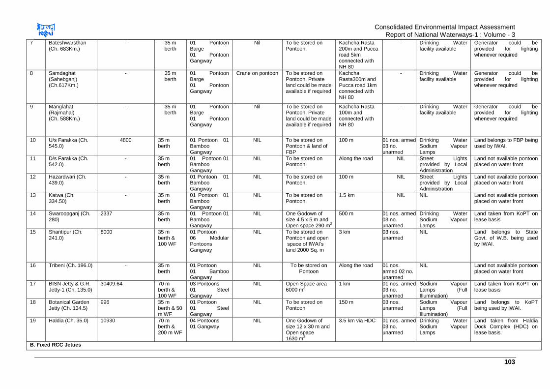
Consolidated Environmental Impact Assessment Report of National Waterways-1 : Volume - 3
103
7 Bateshwarsthan (Ch. 683Km.)
- 35 m berth
01 Pontoon Barge 01 Pontoon Gangway
Nil To be stored on Pontoon.
Kachcha Rasta 200m and Pucca road 5km connected with NH 80
- Drinking Water facility available
Generator could be provided for lighting whenever required
8 Samdaghat (Sahebganj) (Ch.617Km.)
- 35 m berth
01 Pontoon Barge 01 Pontoon Gangway
Crane on pontoon To be stored on Pontoon. Private land could be made available if required
Kachcha Rasta300m and Pucca road 1km connected with NH 80
- Drinking Water facility available
Generator could be provided for lighting whenever required
9 Manglahat (Rajmahal) (Ch. 588Km.)
- 35 m berth
01 Pontoon Barge 01 Pontoon Gangway
Nil To be stored on Pontoon. Private land could be made available if required
Kachcha Rasta 100m and connected with NH 80
- Drinking Water facility available
Generator could be provided for lighting whenever required
10 U/s Farakka (Ch. 545.0)
4800 35 m berth
01 Pontoon 01 Bamboo Gangway
NIL To be stored on Pontoon & land of FBP
100 m 01 nos. armed 03 no. unarmed
Drinking Water Sodium Vapour Lamps
Land belongs to FBP being used by IWAI.
11 D/s Farakka (Ch. 542.0)
- 35 m berth
01 Pontoon 01 Bamboo Gangway
NIL To be stored on Pontoon.
Along the road NIL Street Lights provided by Local Administration
Land not available pontoon placed on water front
12 Hazardwari (Ch. 439.0)
- 35 m berth
01 Pontoon 01 Bamboo Gangway
NIL To be stored on Pontoon.
100 m NIL Street Lights provided by Local Administration
Land not available pontoon placed on water front
13 Katwa (Ch. 334.50)
- 35 m berth
01 Pontoon 01 Bamboo Gangway
NIL To be stored on Pontoon.
1.5 km NIL NIL Land not available pontoon placed on water front
14 Swaroopganj (Ch. 280)
2337 35 m berth
01 Pontoon 01 Bamboo Gangway
NIL One Godown of size 4.5 x 5 m and Open space 290 m
2
500 m 01 nos. armed 03 no. unarmed
Drinking Water Sodium Vapour Lamps
Land taken from KoPT on lease basis
15 Shantipur (Ch. 241.0)
8000 35 m berth & 100 WF
01 Pontoon 06 Modular Pontoons Gangway
NIL To be stored on Pontoon and open space of IWAI‟s land 2000 Sq. m
3 km 03 nos. unarmed
NIL Land belongs to State Govt. of W.B. being used by IWAI.
16 Tribeni (Ch. 196.0) - 35 m berth
01 Pontoon 01 Bamboo Gangway
NIL To be stored on Pontoon
Along the road 01 nos. armed 02 no. unarmed
NIL Land not available pontoon placed on water front
17 BISN Jetty & G.R. Jetty-1 (Ch. 135.0)
30409.64 70 m berth & 100 WF
03 Pontoons 01 Steel Gangway
NIL Open Space area 6000 m
2
1 km 01 nos. armed 03 no. unarmed
Sodium Vapour Lamps (Full Illumination)
Land taken from KoPT on lease basis
18 Botanical Garden Jetty (Ch. 134.5)
996 35 m berth & 50 m WF
01 Pontoon 01 Steel Gangway
NIL To be stored on Pontoon
150 m 03 nos. unarmed
Sodium Vapour Lamps (Full Illumination)
Land belongs to KoPT being used by IWAI.
19 Haldia (Ch. 35.0) 10930 70 m berth & 200 m WF
04 Pontoons 01 Gangway
NIL One Godown of size 12 x 30 m and Open space 1630 m
2
3.5 km via HDC 01 nos. armed 03 no. unarmed
Drinking Water Sodium Vapour Lamps
Land taken from Haldia Dock Complex (HDC) on lease basis.
B. Fixed RCC Jetties
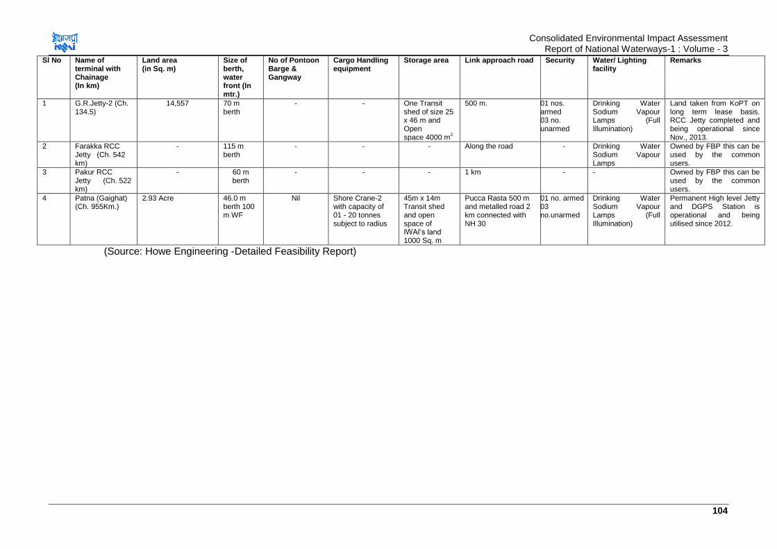
Consolidated Environmental Impact Assessment Report of National Waterways-1 : Volume - 3
104
Sl No Name of terminal with Chainage (In km)
Land area (in Sq. m)
Size of berth, water front (In mtr.)
No of Pontoon Barge & Gangway
Cargo Handling equipment
Storage area Link approach road Security Water/ Lighting facility
Remarks
1 G.R.Jetty-2 (Ch. 134.5)
14,557 70 m berth
- - One Transit shed of size 25 x 46 m and Open space 4000 m
2
500 m. 01 nos. armed 03 no. unarmed
Drinking Water Sodium Vapour Lamps (Full Illumination)
Land taken from KoPT on long term lease basis. RCC Jetty completed and being operational since Nov., 2013.
2 Farakka RCC Jetty (Ch. 542 km)
- 115 m berth
- - - Along the road - Drinking Water Sodium Vapour Lamps
Owned by FBP this can be used by the common users.
3 Pakur RCC Jetty (Ch. 522 km)
- 60 m berth
- - - 1 km - - Owned by FBP this can be used by the common users.
4 Patna (Gaighat) (Ch. 955Km.)
2.93 Acre 46.0 m berth 100 m WF
Nil Shore Crane-2 with capacity of 01 - 20 tonnes subject to radius
45m x 14m Transit shed and open space of IWAI‟s land 1000 Sq. m
Pucca Rasta 500 m and metalled road 2 km connected with NH 30
01 no. armed 03 no.unarmed
Drinking Water Sodium Vapour Lamps (Full Illumination)
Permanent High level Jetty and DGPS Station is operational and being utilised since 2012.
(Source: Howe Engineering -Detailed Feasibility Report)
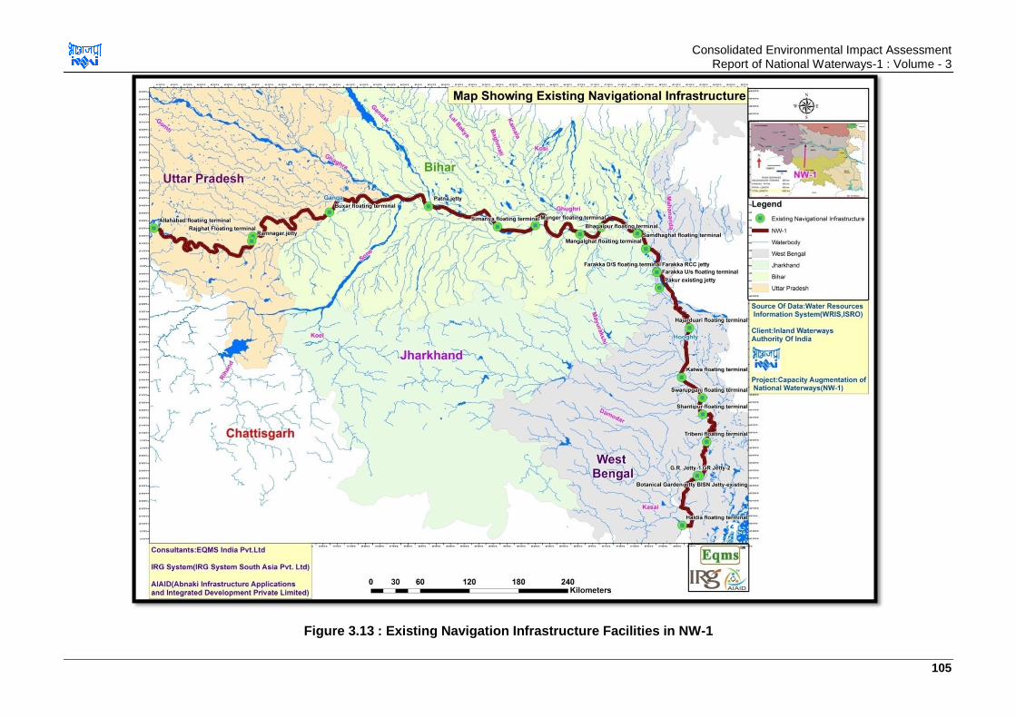
Consolidated Environmental Impact Assessment Report of National Waterways-1 : Volume - 3
105
Figure 3.13 : Existing Navigation Infrastructure Facilities in NW-1

Consolidated Environmental Impact Assessment Report of National Waterways-1 : Volume - 3
106
Mangal Haat, Jhakhand Pakur Jetty
Farakka Lock Existing Patna Terminal
Figure 3.14 : Photographs of Existing Infrastructure along NW-1
b. Planned/Proposed Infrastructure on NW-1 under Jal Marg Vikas Project
Jal Marg Vikas project involves development of various components for capacity
augmentation of NW-1. Some of these components are already planned and being
implemented, some are at initial stage of planning and some are yet to be planned. Details
of all such components is given below
Planned Infrastructure
i. Terminal sites at Haldia, Sahibganj & Varanasi ii. New Lock at Farakka iii. Bank Protection and River Training Works at existing and planned civil
interventions iv. Maintenance dredging for maintenance of waterways and proposed civil
interventions/navigation infrastructure
Infrastructure Facilities at Initial Planning Stage
i. Terminals at Ghazipur and Kalughat
Facilities yet to be planned
i. One similar terminal site (Kalyani at Tribeni)
ii. 5 Nos. Ro-Ro Crossings and Passenger Ferry Jetties
iii. Development of low draught vessel
iv. River Training Works at Critical Locations like bends and civil interventions under
planning
Consolidated Environmental Impact Assessment Report of National Waterways-1 : Volume - 3
107
v. Bank/slope & scour protection works
vi. Equipment of tow barges, inland vessels, survey vessels including rescue boats
and survey equipment
vii. Barge maintenance and repair facility
Location of existing and proposed navigation infrastructure facilities for NW-1 under Jal Marg Vikas Project are shown at Figure 3.15.
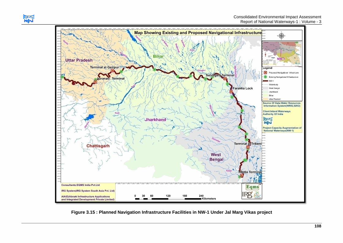
Consolidated Environmental Impact Assessment Report of National Waterways-1 : Volume - 3
108
Figure 3.15 : Planned Navigation Infrastructure Facilities in NW-1 Under Jal Marg Vikas project

Consolidated Environmental Impact Assessment Report of National Waterways-1 : Volume - 3
109
3.15.3. Description of Planned and Proposed Infrstructure
a. Terminal at Haldia
Haldia inland water terminal at River Hooghly (NW-1) is proposed to be located at River
Hooghly at Industrial Zone of Haldia dock Complex near Durga Chak (J.L. No-135,
Barmurchak-138 & JagatChak J.L. No-140), Haldia, District Purbi Medinipur, West Bengal.
River Hooghly flows in South direction of the terminal site. Map showing location of Terminal
at Haldia is given in Figure 3.16.
Figure 3.16 : Location Map of Haldia Terminal
24.68 ha of land in the Haldia Dock Complex has been leased and transferred by the
Kolkata Port Trust to IWAI on 30-year lease on June, 2015 for development of terminal. Site
is low lying area with elevation ranging from 4-9 m amsl. Photographs of the site are given
in Figure 3.17. It is required to fill the site to achieve finished level of 7 m, i.e. 2.54 m above
HFL. Soil required for filling is 3.3 lakhs cum. At present site is well connected with 7 m wide
paved road (Haldia-Macheda Road) connecting the site with NH-41 as well as Haldia town.
The NH-41 (Haldia-Kolaghat road) is located towards west direction at about 6.0 km from
the site.
Figure 3.17 : Photographs of Haldia Terminal Site
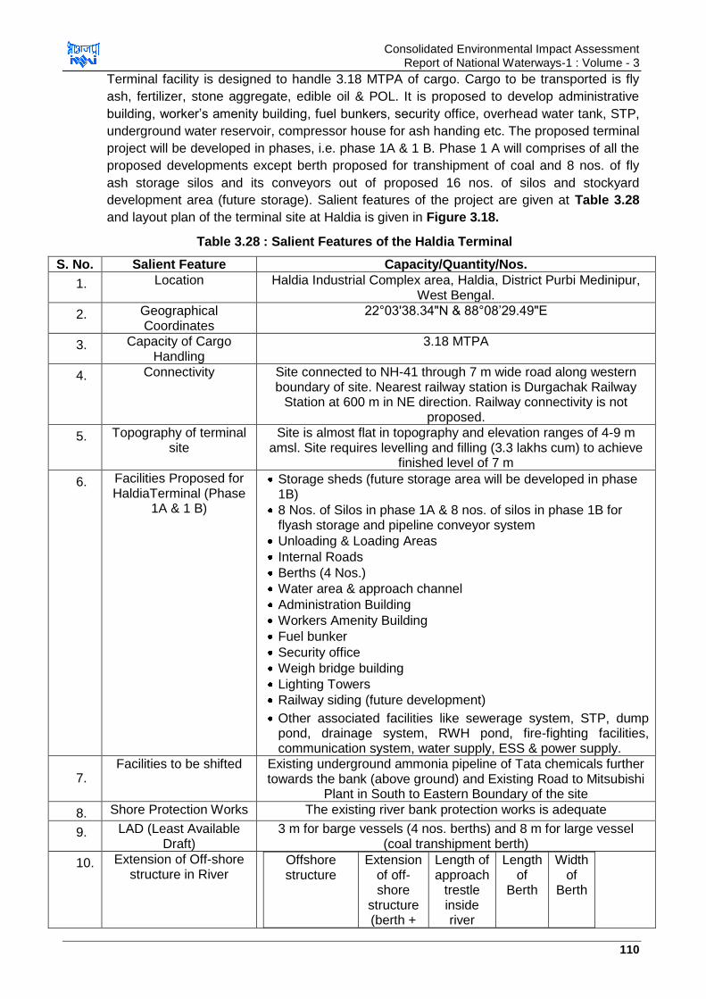
Consolidated Environmental Impact Assessment Report of National Waterways-1 : Volume - 3
110
Terminal facility is designed to handle 3.18 MTPA of cargo. Cargo to be transported is fly
ash, fertilizer, stone aggregate, edible oil & POL. It is proposed to develop administrative
building, worker‟s amenity building, fuel bunkers, security office, overhead water tank, STP,
underground water reservoir, compressor house for ash handing etc. The proposed terminal
project will be developed in phases, i.e. phase 1A & 1 B. Phase 1 A will comprises of all the
proposed developments except berth proposed for transhipment of coal and 8 nos. of fly
ash storage silos and its conveyors out of proposed 16 nos. of silos and stockyard
development area (future storage). Salient features of the project are given at Table 3.28
and layout plan of the terminal site at Haldia is given in Figure 3.18.
Table 3.28 : Salient Features of the Haldia Terminal
S. No. Salient Feature Capacity/Quantity/Nos.
1. Location Haldia Industrial Complex area, Haldia, District Purbi Medinipur, West Bengal.
2. Geographical Coordinates
22°03'38.34"N & 88°08‟29.49"E
3. Capacity of Cargo Handling
3.18 MTPA
4. Connectivity Site connected to NH-41 through 7 m wide road along western boundary of site. Nearest railway station is Durgachak Railway
Station at 600 m in NE direction. Railway connectivity is not proposed.
5. Topography of terminal site
Site is almost flat in topography and elevation ranges of 4-9 m amsl. Site requires levelling and filling (3.3 lakhs cum) to achieve
finished level of 7 m
6. Facilities Proposed for HaldiaTerminal (Phase
1A & 1 B)
Storage sheds (future storage area will be developed in phase 1B)
8 Nos. of Silos in phase 1A & 8 nos. of silos in phase 1B for flyash storage and pipeline conveyor system
Unloading & Loading Areas
Internal Roads
Berths (4 Nos.)
Water area & approach channel
Administration Building
Workers Amenity Building
Fuel bunker
Security office
Weigh bridge building
Lighting Towers
Railway siding (future development)
Other associated facilities like sewerage system, STP, dump pond, drainage system, RWH pond, fire-fighting facilities, communication system, water supply, ESS & power supply.
7. Facilities to be shifted Existing underground ammonia pipeline of Tata chemicals further
towards the bank (above ground) and Existing Road to Mitsubishi Plant in South to Eastern Boundary of the site
8. Shore Protection Works The existing river bank protection works is adequate
9. LAD (Least Available Draft)
3 m for barge vessels (4 nos. berths) and 8 m for large vessel (coal transhipment berth)
10. Extension of Off-shore structure in River
Offshore structure
Extension of off-shore
structure (berth +
Length of approach
trestle inside river
Length of
Berth
Width of
Berth
Consolidated Environmental Impact Assessment Report of National Waterways-1 : Volume - 3
111
approach trestle)
inside the river
2 Nos of berths for
barges
200 170 30 105
1 Nos of berths for
barges
200 170 30 120
1 No of berth for
barges/Berth No. 4
200 150 50 120
* length of 4 nos. approach trestle at terminal site is 145 m
11. HFL of the River 4.46 m amsl
12. Finished level of site 7 m
13. Top level of berth & approach trestle
14 m
14. Dredging During Construction Phase
7 lakhs cum
15. Material Transportation System
Trucks, Pay loaders, Barge loaders, mobile harbour cranes &gantry cranes.
Fly ash will be transported by trucks and loaded to the silos pneumatically by pumps and then it will be loaded to barge by pipe
conveyor system. 16 Nos. silos of 1200 Tonne capacity will be provided for ash storage
16. Maintenance Dredging during operation phase
2.3lakhs cum/year
17. Water Requirement-construction phase
90 KLD
18. Water Requirement-operation phase
70 KLD 20 KLD-Raw water requirement and 50 KLD potable water
requirement
19. Power Requirement Connected load-5500 KW Demand Load-2400 KW
20. Storm Water System Open Storm water drains of total length 6 km Stock yard, parking area & roads –dump pond
Buildings- Rain water storage sump
21. STP Capacity-Operation Phase
30 KLD
22. Dust Suppression Methods
Fly Ash-Dust extraction system on top of silos Aggregate & fertilizers stockyards- Swivelling plain water
sprinklers for abatement of aggregate dust generation along the length of the stockpile.
Source: Site visit & HOWE Engineering Projects (India) Pvt. Ltd. (Design Consultant) India
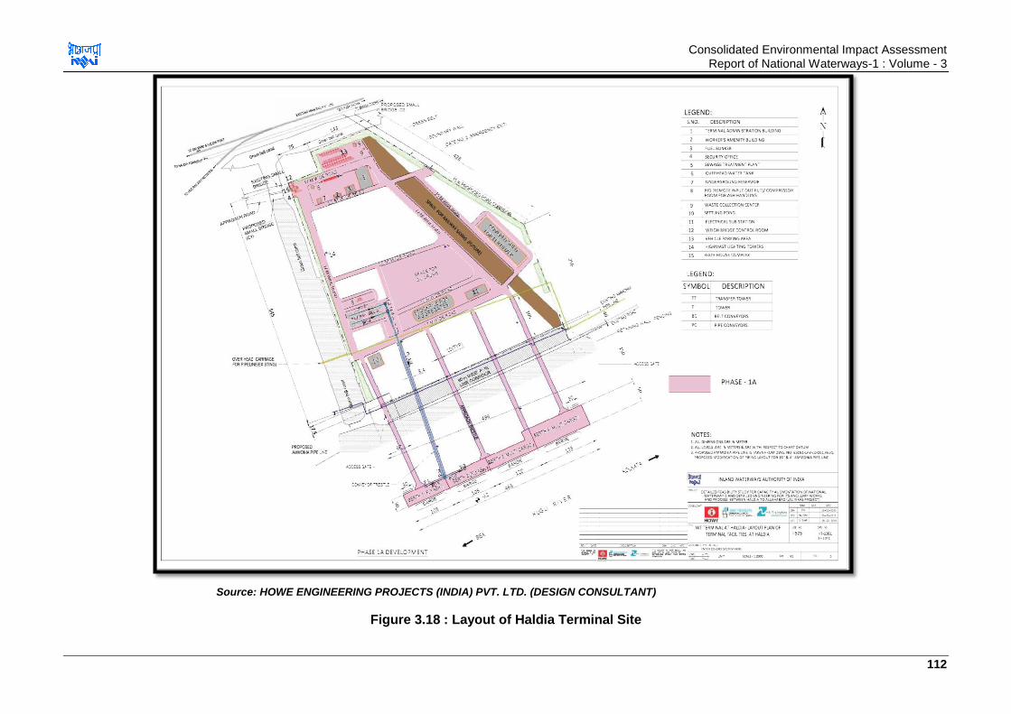
Consolidated Environmental Impact Assessment Report of National Waterways-1 : Volume - 3
112
Source: HOWE ENGINEERING PROJECTS (INDIA) PVT. LTD. (DESIGN CONSULTANT)
Figure 3.18 : Layout of Haldia Terminal Site

Consolidated Environmental Impact Assessment Report of National Waterways-1 : Volume - 3
113
b. Terminal at Sahibganj
Sahibganj terminal will be developed along River Ganga, Village Samdha Nala & Rampura,
Tehsil & District Sahibganj, Jharkhand. Map showing location of Terminal at Sahibganj is
given in Figure 3.19.
Figure 3.19 : Location Map of Sahibganj Terminal Site
The requirement of land for construction of the terminal with road and rail connectivity has
been estimated at 78.91 ha. The facility will be developed in two Phases. Approximately
23.98 ha of will be required for Phase- I to build the terminal. 54.93 ha will be required for
the expansion of the terminal and for providing road connectivity, which is proposed to be
taken up in Phase- I (B). However, the District Administration, Sahibganj has initiated
acquisition proceedings for 45.20 ha of private land for the terminal under RFCTLARR
2013. In addition to this, 2.89 ha of government land will also be transferred to IWAI.
Land is currently under residential and agricultural use, orchards (mango trees) and
settlements. Land is undulating with level variation of 30-56 m amsl. Photographs of the site
are given in Figure 3.20. At present site is not connected with any paved road. Nearest
highway to the site is NH-80 (Sahibganj-Rajmahal road) located at 1.0 km from site in
Southern direction. PWD is to construct a road to connect the terminal site with NH-80.
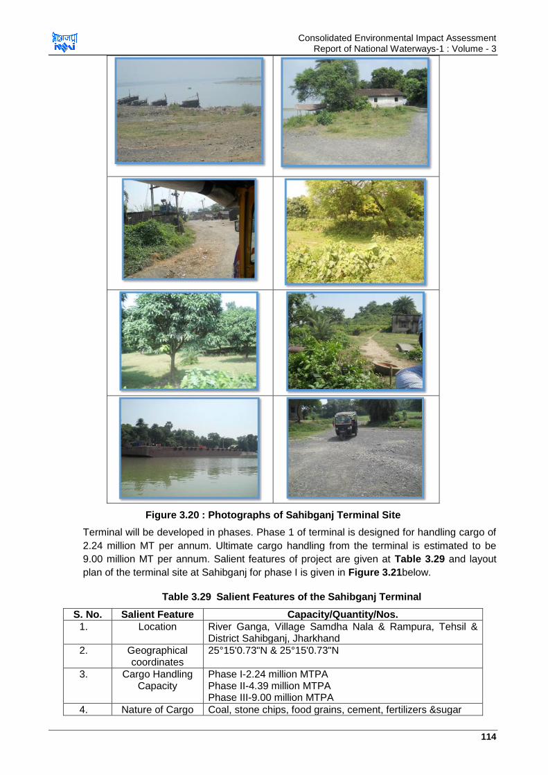
Consolidated Environmental Impact Assessment Report of National Waterways-1 : Volume - 3
114
Figure 3.20 : Photographs of Sahibganj Terminal Site
Terminal will be developed in phases. Phase 1 of terminal is designed for handling cargo of
2.24 million MT per annum. Ultimate cargo handling from the terminal is estimated to be
9.00 million MT per annum. Salient features of project are given at Table 3.29 and layout
plan of the terminal site at Sahibganj for phase I is given in Figure 3.21below.
Table 3.29 Salient Features of the Sahibganj Terminal
S. No. Salient Feature Capacity/Quantity/Nos.
1. Location River Ganga, Village Samdha Nala & Rampura, Tehsil & District Sahibganj, Jharkhand
2. Geographical coordinates
25°15'0.73"N & 25°15'0.73"N
3. Cargo Handling Capacity
Phase I-2.24 million MTPA Phase II-4.39 million MTPA Phase III-9.00 million MTPA
4. Nature of Cargo Coal, stone chips, food grains, cement, fertilizers &sugar
Consolidated Environmental Impact Assessment Report of National Waterways-1 : Volume - 3
115
to be handled
5. Connectivity Approach road to be constructed by PWD to connect to NH-80 and Railway connectivity to be developed to link the existing railway line Nearest Railway Station: Sakrigali Railway Station (1.1 km, S) & Sahibganj Railway Station (6 km, W) Nearest Airport: Patna Airport (270 km, NW) Ferry Service: Sahibganj Ghat to Manihari Ghat
6. Topography of terminal site
Undulating with level variation of 30 m-56 m
7. On-shore Facilities
Proposed for Phase I
Stockyard for coal (6 stock piles-1.12 ha), for stone chips (8 stock piles-0.875 ha) & 1 covered shed (0.416 ha)
Unloading & Loading Areas
Internal Roads (12 m wide & 3.6 km length)
Administration Building
Workers Amenity Building
Lighting Towers
Other associated facilities like sewerage system, STP, drainage system, fire-fighting facilities, communication system, water supply & power supply (ESS)
Boundary wall of 2.4 m high
Green belt- 15-20 m (2.9 ha) To be developed by PWD/Railways:
Approach Road (1 km connecting to NH-80 crossing LC-54)
Railway Connectivity (through Sagrakali Railway Station) with provision of ROB over LC-54 for approach road to be developed
8. Off-shore Facilities
Proposed for Phase I
Jetty & Berth (1 Nos.)
Water area & approach channel
Turning Circle (2 Nos. at starting & end of channel)
Shore protection (1.5 km along River Bank, 800 m in Phase I & 700 m in phase II)
9. Extension of Off-shore structure
(jetty & Berths) in River
75 m (50 m-approach trestle & 25 m jetty) length & 270 m width.
10. Off-shore facilities in Phase II & III (Master Phase)
Phase II-3 nos. of berths (1 each for coal-270 m, stone chips-270 m&other cargo-160 m) Phase III-3 nos. od berths (1 each for coal-400 m, stone chips-400 m &other cargo-160 m)
11. Shore Protection Works
Retaining wall and stone pitching (30-50 kg) along the length of bank (1.5 km total, 800 m in phase I & 700 m in phase II) and 40 m apron inside the River.
12. LAD 1-2.5 m near shoreline 7-11 m at distance of 50 m
13. Water level fluctuation of River near
Terminal Site
10 m
14. HFL of Site 30.91 m amsl
15. Finished Level of Site
37 m amsl
16. Top level of Berth & Jetty
33.5 m
17. Earthwork Phase Cut: 14.25 lakhs cum
Consolidated Environmental Impact Assessment Report of National Waterways-1 : Volume - 3
116
I Fill: 2.15 lakhs cum Muck for disposal: 12.1 lakhs cum
18. Dredging During Construction
Phase
1.5 lakhs cum
19. Material Transportation
System
In Phase-1 of terminal, it is proposed to provide hopper at the coal and stone chips stockyard and the cargo should be carried through conveyor system to the berth where it should be discharged to the vessels through barge loader
20. Maintenance Dredging during operation phase
0.1 M cum in lean season
21. River Water Requirement for dust suppression and horticulture
Phase 1: 162 KLD Phase II: 210 KLD Phase III: 350 KLD
22. Municipal supply water for
domestic purpose (staff & vessels)
Phase 1: 46.5 KLD Phase II: 65 KLD Phase III: 90 KLD
23. Power Requirement
Phase 1: 588 KW Phase II: 2535 KW Phase III: 1897 KW
24. Storm Water System
Storm water drain of length 3.05 km Stock yard, parking area & roads –dump pond Buildings- Rain water storage sump
25. Sewage Generation &
STP
Phase 1: 30 KLD Phase II: 36 KLD Phase III: 40 KLD STP: 40 KLD capacity
26. Dust Suppression Methods
Barge Loaders- Plain water fine spray with medium pressure standard hydraulic system using raw water Coal Stock Yard-Swivelling plain water sprinklers for abatement of coal dust generation along the length of the stockpile.
27. Vehicle Parking Area
App. 1 ha
28. Solid Waste Generation & management
Solid waste to be generated from terminal facility will include majorly the food waste and the garden waste. This waste can be disposed through the local agency in the area responsible for waste handling. Dustbins should be provided at the site for collection of the waste. Used oils from DG sets/transformers/pumps etc. may also generate at the site. Used/Waste oil will be stored in HDPE containers at the site in isolated location and will be sold to authorized vendors
29. Equipment Mobile Harbour Crane,
Barge Loader, Front End Loader,
Conveyor System with Fixed Hopper,
Navigation Aids,
Dust Suppression System Road over Bridge,
Fire Fighting System,
Communication and IT System, Source: Site visit &HOWE Engineering Projects (India) Pvt. Ltd. (Design Consultant) India

Consolidated Environmental Impact Assessment Report of National Waterways-1 : Volume - 3
117
Source: HOWE ENGINEERING PROJECTS (INDIA) PVT. LTD. (DESIGN CONSULTANT)
Figure 3.21 : Layout of Sahibganj Terminal Site
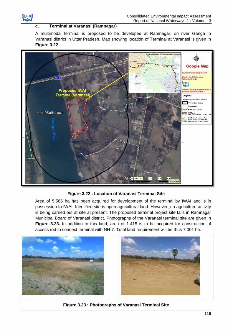
Consolidated Environmental Impact Assessment Report of National Waterways-1 : Volume - 3
118
c. Terminal at Varanasi (Ramnagar)
A multimodal terminal is proposed to be developed at Ramnagar, on river Ganga in
Varanasi district in Uttar Pradesh. Map showing location of Terminal at Varanasi is given in
Figure 3.22
Figure 3.22 : Location of Varanasi Terminal Site
Area of 5.586 ha has been acquired for development of the terminal by IWAI and is in
possession fo IWAI. Identified site is open agricultural land. However, no agriculture activity
is being carried out at site at present. The proposed terminal project site falls in Ramnagar
Municipal Board of Varanasi district. Photographs of the Varanasi terminal site are given in
Figure 3.23. In addition to this land, area of 1.415 is to be acquired for construction of
access rod to connect terminal with NH-7. Total land requirement will be thus 7.001 ha.
Figure 3.23 : Photographs of Varanasi Terminal Site
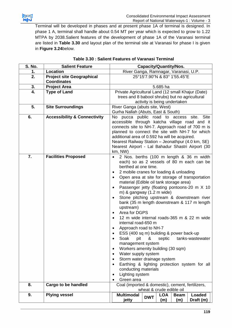
Consolidated Environmental Impact Assessment Report of National Waterways-1 : Volume - 3
119
Terminal will be developed in phases and at present phase 1A of terminal is designed. In
phase 1 A, terminal shall handle about 0.54 MT per year which is expected to grow to 1.22
MTPA by 2038.Salient features of the development of phase 1A of the Varanasi terminal
are listed in Table 3.30 and layout plan of the terminal site at Varanasi for phase I is given
in Figure 3.24below.
Table 3.30 : Salient Features of Varanasi Terminal
S. No. Salient Feature Capacity/Quantity/Nos.
1. Location River Ganga, Ramnagar, Varanasi, U.P.
2. Project site Geographical Coordinates
25°15'7.90"N & 83° 1'55.45"E
3. Project Area 5.685 ha
4. Type of Land Private Agricultural Land (12 small Khajur (Date) trees and 8 babool shrubs) but no agricultural
activity is being undertaken
5. Site Surroundings River Ganga (abuts site, West) Gurha Nallah (Abuts, East & South)
6. Accessibility & Connectivity No pucca public road to access site. Site accessible through katcha village road and it connects site to NH-7. Approach road of 700 m is planned to connect the site with NH-7 for which additional area of 0.592 ha will be acquired. Nearest Railway Station – Jeonathpur (4.0 km, SE) Nearest Airport - Lal Bahadur Shastri Airport (30 km, NW)
7. Facilities Proposed 2 Nos. berths (100 m length & 36 m width each) so as 2 vessels of 80 m each can be berthed at one time.
2 mobile cranes for loading & unloading
Open area at site for storage of transportation material (Edible oil tank storage area)
Passenger jetty (floating pontoons-20 m X 10 m) & gangway (1.2 m wide)
Stone pitching upstream & downstream river bank (35 m length downstream & 117 m length upstream)
Area for DGPS
12 m wide internal roads-365 m & 22 m wide internal road-650 m
Approach road to NH-7
ESS (400 sq m) building & power back-up
Soak pit & septic tanks-wastewater management system
Workers amenity building (30 sqm)
Water supply system
Storm water drainage system
Earthing & lighting protection system for all conducting materials
Lighting system
Green area
8. Cargo to be handled Coal (imported & domestic), cement, fertilizers, wheat & crude edible oil
9. Plying vessel Multimodal jetty
DWT LOA (m)
Beam (m)
Loaded Draft (m)
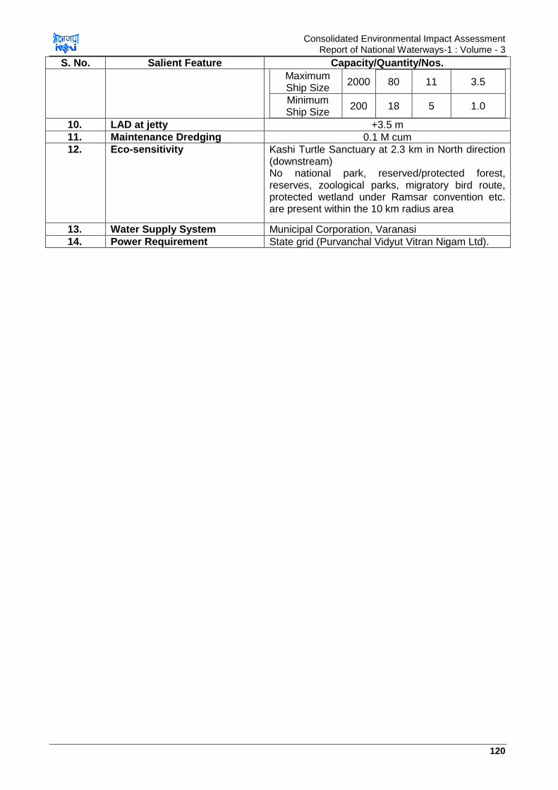
Consolidated Environmental Impact Assessment Report of National Waterways-1 : Volume - 3
120
S. No. Salient Feature Capacity/Quantity/Nos.
Maximum Ship Size
2000 80 11 3.5
Minimum Ship Size
200 18 5 1.0
10. LAD at jetty +3.5 m
11. Maintenance Dredging 0.1 M cum
12. Eco-sensitivity Kashi Turtle Sanctuary at 2.3 km in North direction (downstream) No national park, reserved/protected forest, reserves, zoological parks, migratory bird route, protected wetland under Ramsar convention etc. are present within the 10 km radius area
13. Water Supply System Municipal Corporation, Varanasi
14. Power Requirement State grid (Purvanchal Vidyut Vitran Nigam Ltd).
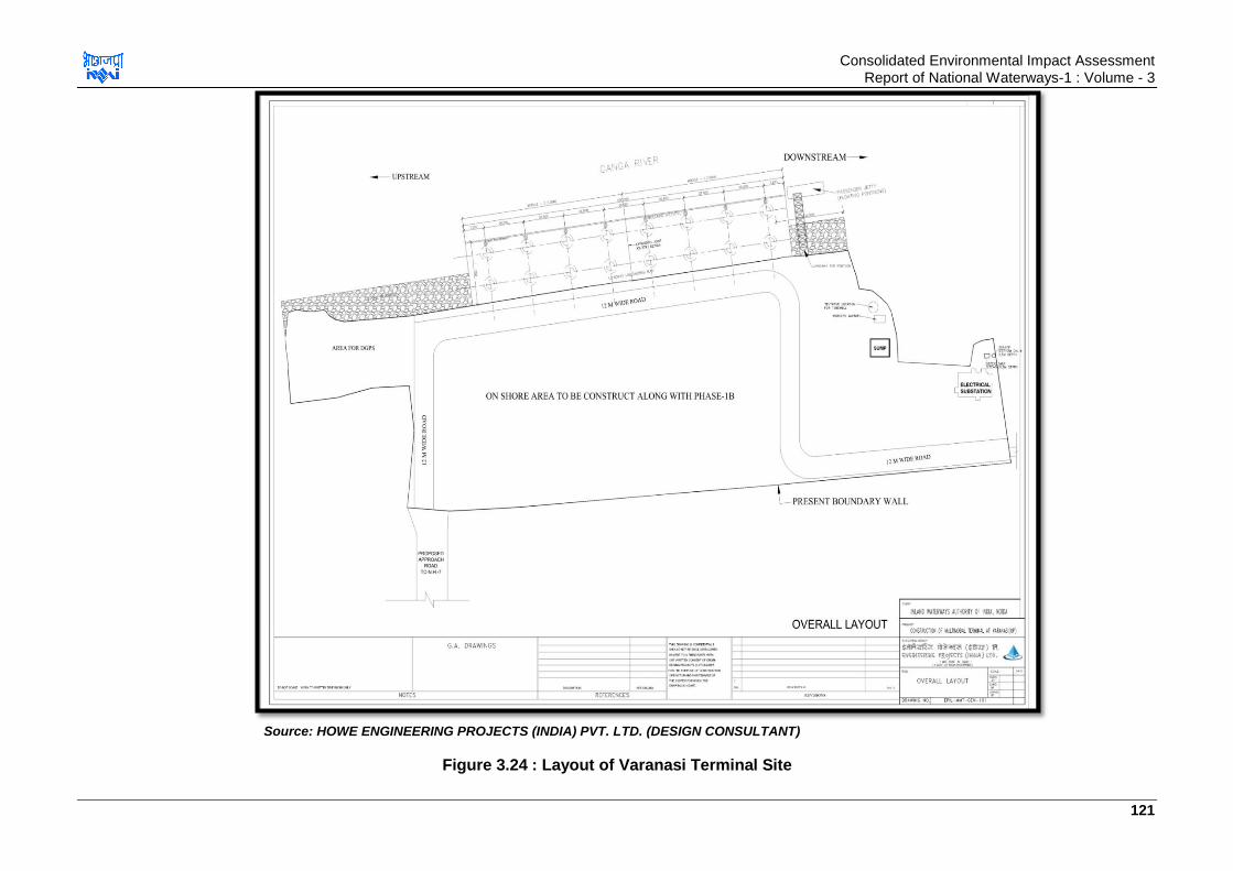
Consolidated Environmental Impact Assessment Report of National Waterways-1 : Volume - 3
121
Source: HOWE ENGINEERING PROJECTS (INDIA) PVT. LTD. (DESIGN CONSULTANT)
Figure 3.24 : Layout of Varanasi Terminal Site
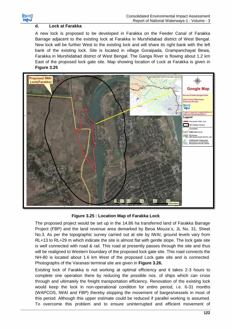
Consolidated Environmental Impact Assessment Report of National Waterways-1 : Volume - 3
122
d. Lock at Farakka
A new lock is proposed to be developed in Farakka on the Feeder Canal of Farakka
Barrage adjacent to the existing lock at Farakka in Murshidabad district of West Bengal.
New lock will be further West to the existing lock and will share its right bank with the left
bank of the existing lock. Site is located in village Goraipada, Grampanchayat Bewa,
Farakka in Murshidabad district of West Bengal. The Ganga River is flowing about 1.2 km
East of the proposed lock gate site. Map showing location of Lock at Farakka is given in
Figure 3.25
Figure 3.25 : Location Map of Farakka Lock
The proposed project would be set up in the 14.86 ha transferred land of Farakka Barrage
Project (FBP) and the land revenue area demarked by Beoa Mouza`s, JL No. 31, Sheet
No.3. As per the topographic survey carried out at site by IWAI, ground levels vary from
RL+13 to RL+29 m which indicate the site is almost flat with gentle slope. The lock gate site
is well connected with road & rail. This road at presently passes through the site and thus
will be realigned to Western boundary of the proposed lock gate site. This road connects the
NH-80 is located about 1.6 km West of the proposed Lock gate site and is connected.
Photographs of the Varanasi terminal site are given in Figure 3.26.
Existing lock of Farakka is not working at optimal efficiency and it takes 2-3 hours to
complete one operation there by reducing the possible nos. of ships which can cross
through and ultimately the freight transportation efficiency. Renovation of the existing lock
would keep the lock in non-operational condition for entire period, i.e. 6-31 months
(WAPCOS, IWAI and FBP) thereby stopping the movement of barges/vessels in most of
this period. Although this upper estimate could be reduced if parallel working is assumed.
To overcome this problem and to ensure uninterrupted and efficient movement of

Consolidated Environmental Impact Assessment Report of National Waterways-1 : Volume - 3
123
vessels/barges in NW-1, IWAI has proposed to construct a new lock at Farakka parallel to
existing lock.
Figure 3.26 : Photographs of Farakka Lock Site
The new lock like the existing lock will facilitate the movement of vessels/barges from main
River Ganga upstream to River Bhagirathi-Hooghly downstream through feeder canal
negotiating the significant difference in water level existing in main River Ganga and feeder
canal. Water level in the River Ganga and feeder canal varies according to the flow in River
Ganga & the feeder canal. New lock is required as the existing lock is not functioning
adequately and obstructs the movement of the vessels. The length and width (size) of the
proposed lock is similar to the existing lock. Length & width of new lock will be 179.0 m &
25.148 m respectively. Lock is designed to handle four vessels of size 85 m (length) X 12
m, (width) so as two vessels are moored lengthwise and two sidewise like existing lock. The
salient features of the existing lock site are given in Table 3.31 and layout plan of the lock
site at Farakka for phase I is given in Figure 3.27.
Table 3.31 : Salient Features of New Lock
S. No. Parameters Value
1 Location Feeder Canal, village Goraipada, Grampanchayat Bewa, Farakka in Murshidabad district of West
Bengal.
2 Geographical Coordinates 24°48'32.38"N to 24°49'02.23"N & 87°54' 05.63"E to 87°54' 17.18"E.
3 Land Required 14.86 ha
4 Topography RL+13 to RL+29m
5 Finished Level of Site 28.44 m
6 High Water Level U/S High Water Level D/S
RL + 26.30 m RL +24.38 m
7 Length of Lock 179 m
8 Width of Lock 25.148 m
9 Av. Depth of Lock 13.10 m
10 Capacity of Lock to handle no. of vessels of size 85 m (length) X 12 m (width)
four vessels of size 85 m (length) X 12 m, (width) so as two vessels are moored lengthwise and two
sidewise like existing lock
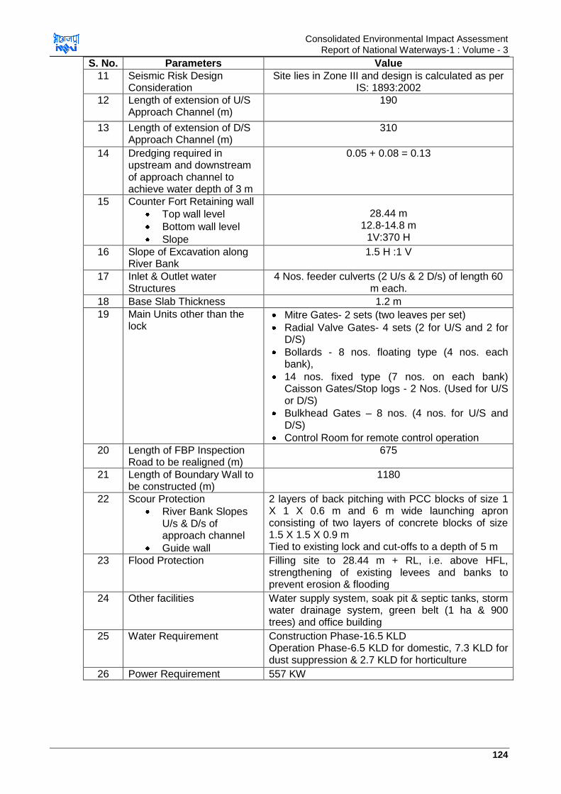
Consolidated Environmental Impact Assessment Report of National Waterways-1 : Volume - 3
124
S. No. Parameters Value
11 Seismic Risk Design Consideration
Site lies in Zone III and design is calculated as per IS: 1893:2002
12 Length of extension of U/S Approach Channel (m)
190
13 Length of extension of D/S Approach Channel (m)
310
14 Dredging required in upstream and downstream of approach channel to achieve water depth of 3 m
0.05 + 0.08 = 0.13
15 Counter Fort Retaining wall
Top wall level
Bottom wall level
Slope
28.44 m
12.8-14.8 m 1V:370 H
16 Slope of Excavation along River Bank
1.5 H :1 V
17 Inlet & Outlet water Structures
4 Nos. feeder culverts (2 U/s & 2 D/s) of length 60 m each.
18 Base Slab Thickness 1.2 m
19 Main Units other than the lock
Mitre Gates- 2 sets (two leaves per set)
Radial Valve Gates- 4 sets (2 for U/S and 2 for D/S)
Bollards - 8 nos. floating type (4 nos. each bank),
14 nos. fixed type (7 nos. on each bank) Caisson Gates/Stop logs - 2 Nos. (Used for U/S or D/S)
Bulkhead Gates – 8 nos. (4 nos. for U/S and D/S)
Control Room for remote control operation
20 Length of FBP Inspection Road to be realigned (m)
675
21 Length of Boundary Wall to be constructed (m)
1180
22 Scour Protection
River Bank Slopes U/s & D/s of approach channel
Guide wall
2 layers of back pitching with PCC blocks of size 1 X 1 X 0.6 m and 6 m wide launching apron consisting of two layers of concrete blocks of size 1.5 X 1.5 X 0.9 m Tied to existing lock and cut-offs to a depth of 5 m
23 Flood Protection Filling site to 28.44 m + RL, i.e. above HFL, strengthening of existing levees and banks to prevent erosion & flooding
24 Other facilities Water supply system, soak pit & septic tanks, storm water drainage system, green belt (1 ha & 900 trees) and office building
25 Water Requirement Construction Phase-16.5 KLD Operation Phase-6.5 KLD for domestic, 7.3 KLD for dust suppression & 2.7 KLD for horticulture
26 Power Requirement 557 KW

Consolidated Environmental Impact Assessment Report of National Waterways-1 : Volume - 3
125
S. No. Parameters Value
Green Area 10000 m2 (1000 m X 10 m). 900 trees to be planted
27 Total time per operation 38 minutes for average water vessel. If movement of a vessel is followed by movement of another vessel in the reverse direction, the operating time is 23 minutes.
Source: HOWE Engineering Projects (India) Pvt. Ltd. (Design Consultant) India

Consolidated Environmental Impact Assessment Report of National Waterways-1 : Volume - 3
126
Source: HOWE ENGINEERING PROJECTS (INDIA) PVT. LTD. (DESIGN CONSULTANT)
Figure 3.27 : Layout of Farakka Lock Site

Consolidated Environmental Impact Assessment Report of National Waterways-1 : Volume 3
127
e. Bank Protection and River Training Works
Erosion of banks is natural phenomenon in the alluvial rivers. However, erosion is
aggravated due to construction of any structure like bridge, terminal and jetty on the
river. Thus river training works includes the engineering works carried out in river to
prevent the erosion of the banks, control and guide the river. It is proposed to carry out
bank protection works of total 48.168 kms in the areas where erosion is observed and
where civil interventions are planned to be carried out and details of the same are given
at Table 3.32. Bank protection additionally also be carried out at other interventions yet
to be finalised.
Table 3.32 : Bank Protection Works as per Current Planning
S. No. Location App. Length (km)
1. Varanasi 0.35
2. Sahibganj 1.1
3. Farakka Navigation Lock 0.75
4. Three new terminal 2.5
5. Farakka Feeder Canal 9.438
6. Farakka to Tribeni 27.43
7. Barge Repair and maintenance facility 2
8. Existing Terminals & Jetties 4.6
Source: HOWE ENGINEERING PROJECTS (INDIA) PVT. LTD. (DESIGN CONSULTANT)
Bends are navigational hazard which requires straitening. Crucial bends likely to be
considered for straightening are Bend near Mirzapur, bend near Patauli & Agradwip,
bend near Sanudragrah, bend near Chumariagacha, bend near Digibaraj and sharp
bend just u/s of Farakka navigation lock. These task will be taken up after detailed study
on a later date.
f. Terminal at Ghazipur (Nawapura)
It is planned to develop terminal at Ghazipur, U.P. Planning is at initial stage for this
terminal. Site finalization has been carried out. Two sites were identified and considered
for development of project. Out of the two sites, preferable site is located at Village
Chaukiya, Ghazipur near Nawapura. This site is located on left bank of River Ganga
(main channel) and downstream of NH-97. The site is agricultural land with no
development or facilities or settlements on it. Area of the site identified is app. 22 ha.
Site is well connected with road & railway. Depth of the channel is more than 2.5 m close
to the shoreline. However, approach road will be required to be constructed for
connecting the terminal site to NH-19. Google map showing the site considered for
development of terminal at Ghazipur is given in Figure 3.28.
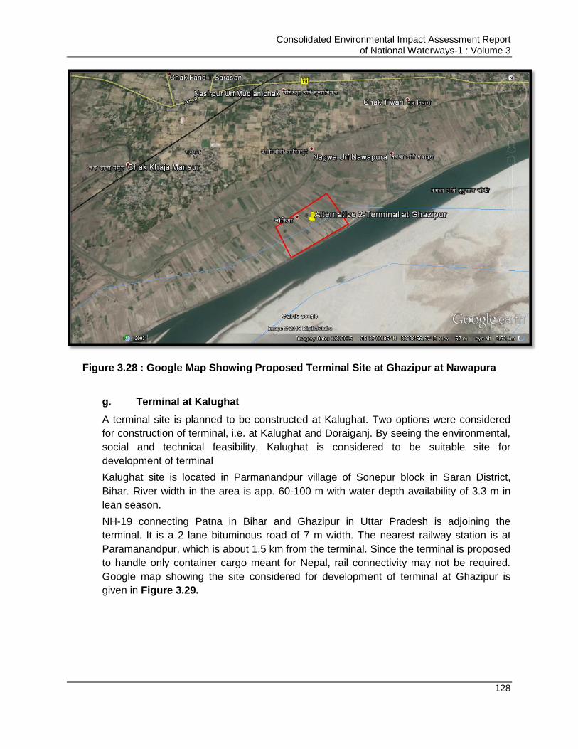
Consolidated Environmental Impact Assessment Report of National Waterways-1 : Volume 3
128
Figure 3.28 : Google Map Showing Proposed Terminal Site at Ghazipur at Nawapura
g. Terminal at Kalughat
A terminal site is planned to be constructed at Kalughat. Two options were considered
for construction of terminal, i.e. at Kalughat and Doraiganj. By seeing the environmental,
social and technical feasibility, Kalughat is considered to be suitable site for
development of terminal
Kalughat site is located in Parmanandpur village of Sonepur block in Saran District,
Bihar. River width in the area is app. 60-100 m with water depth availability of 3.3 m in
lean season.
NH-19 connecting Patna in Bihar and Ghazipur in Uttar Pradesh is adjoining the
terminal. It is a 2 lane bituminous road of 7 m width. The nearest railway station is at
Paramanandpur, which is about 1.5 km from the terminal. Since the terminal is proposed
to handle only container cargo meant for Nepal, rail connectivity may not be required.
Google map showing the site considered for development of terminal at Ghazipur is
given in Figure 3.29.
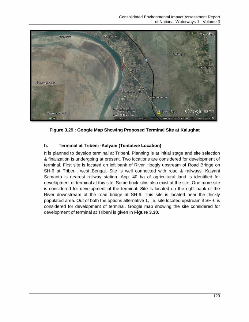
Consolidated Environmental Impact Assessment Report of National Waterways-1 : Volume 3
129
Figure 3.29 : Google Map Showing Proposed Terminal Site at Kalughat
h. Terminal at Tribeni -Kalyani (Tentative Location)
It is planned to develop terminal at Tribeni. Planning is at initial stage and site selection
& finalization is undergoing at present. Two locations are considered for development of
terminal. First site is located on left bank of River Hoogly upstream of Road Bridge on
SH-6 at Tribeni, west Bengal. Site is well connected with road & railways. Kalyani
Samanta is nearest railway station. App. 40 ha of agricultural land is identified for
development of terminal at this site. Some brick kilns also exist at the site. One more site
is considered for development of the terminal. Site is located on the right bank of the
River downstream of the road bridge at SH-6. This site is located near the thickly
populated area. Out of both the options alternative 1, i.e. site located upstream if SH-6 is
considered for development of terminal. Google map showing the site considered for
development of terminal at Tribeni is given in Figure 3.30.

Consolidated Environmental Impact Assessment Report of National Waterways-1 : Volume 3
130
Figure 3.30 : Google Map Showing Proposed Terminal Site at Tribeni
i. Barge Maintenance & Repair Facility
Barge maintenance and repair facility is essential component of Jal Marg Vikas Project.
At present no location has been finalized for the purpose but this development is under
planning. Barge maintenance and repair facility will comprise of the following
Slipway: It is a ramp, which helps in moving the barge/ship to and fro from
water to land. Slipway will be provided in deeper water conditions so as design
vessels can be taken in docking conditions.
Winch House: It should be provided in straight-line to main slipway. It is
generally a single room like structure and should have adequate space for
winch and electrical equipment
Repair bay for large & small vessels: Repair bay for vessels should be inclined
so as the vessels can slide towards the river on its own after repair under
control of winch.
Transfer bays: To transfer small vessels between slipway and repair bay
Winches and trolleys. Winches should be provided at winch house and at
transfer bay. Trolleys should be provided to receive the vessels on main
slipway.
Workshops and buildings with all basic utilities like water, electricity, storm
water management system and waste management system.

Consolidated Environmental Impact Assessment Report of National Waterways-1 : Volume 3
131
j. Details pf Planned /Proposed Infrastructure : Waste Management at Maintenance & Repair Facility
Since at this facility, vessel repair, maintenance and waste management will be carried
out, proper waste management facility is required for these facilities. These facilities
should be designed on Zero discharge basis and should have Effluent treatment plant so
as the oil water, vessel washing water, floor washing water can be treated here. Further
STP are required at these sites to treat sewage generated at facility and sewage
generated from vessels. These facilities should have a proper waste management plan
which should detail about segregation of different type of waste which may generate at
this site or can be received from the vessels, e.g. municipal waste, recyclable waste, bio-
medical waste, packaging waste, sweeping waste, plastic waste etc. For each type of
waste, a specific waste management plan should be prepared. Waste treatment facility
to the extent possible should be proposed within the maintenance and repair facility. For
the waste which cannot be treated in-house, should be sent for treatment and disposal
to authorized vendors only. List of those authorized vendors for each type of waste
should be available in the plan.
3.16. Material Handling, Transportation and Storage
Material handling including transportation, storage, loading and unloading will be
involved at terminals and jetty sites. Material handling at some planned site is manual,
i.e. is through pay loaders, barge loaders, dumpers, trucks and at some sites is
mechanical through conveyor belts and pneumatically depending on type and quantum
of cargo to be transported. Considering the environmental effect, it is strongly suggested
to adopt mechanical mode of material handling only for loading & unloading of barges
and pneumatic transportation of the fly ash to minimize dust generation.
3.17. Construction material Sourcing
Construction materials required majorly for the project development are bricks, steel,
cement, timbers, sand etc. It is preferred that construction material will be sourced from
nearby areas preferably. Details for construction material sourcing for the planned
infrastructure under Jal Marg Vikas Project are given as a reference in Table 3.33
below.
Table 3.33 : Construction Material Sourcing for already Planned Interventions
S. No. Location Construction Material Sourcing
1 Haldia Terminal Stone chips- Pakur quarry in Jharkhand (370 km from site)
Sand- Villages Kasthakbali and Barsundra (20 km) and
Damodar River (100 km)
2 Farakka Lock Stone and aggregates- Rajmahal hills (Sahibganj) at app.100
km from site
3 Sahibganj Terminal Stone and aggregates- Rajmahal hills (Sahibganj) near the
site
4 Varanasi Terminal Stone and aggregates- Sirsa, Mirzapur at app. 45 km from site
Consolidated Environmental Impact Assessment Report of National Waterways-1 : Volume 3
132
3.18. Waste Disposal
It is likely that waste and sewage will be generated due to anticipated human activities at
major intervention locations (terminal, locks & jetties). Details of waste generation and its
management is given below
3.18.1. Sewage & Effluent
It is likely that sewage will be generated at the locations where interventions are
proposed only. For management of sewage measures like provision of mobile toilet with
anaerobic digester, provision of toilets with septic tank & soak pits are proposed during
construction phase. It is proposed that soak pits should be provided in the locations
away from river. During operation phase sewage should be managed by provision of
well-developed sewage collection system and the collected sewage should be treated in
STP (if sewage generation >5-10 KLD) and should be disposed in septic tank/soak pit if
<5-10 KLD.
No vessels will be allowed to discharge its waste in river during navigation or berthing.
Vessels should follow MARPOL guidelines for management of sewage.
3.18.2. Solid Waste
Solid waste will be generated due to project activities at the locations where
interventions are expected majorly. Expected solid waste to be generated from the site is
mainly municipal in nature. Some quantity of hazardous waste in form of used oil from
operation of DG sets, cleaning operations etc. is expected to be generated from the
intervention sites.
No vessels will be allowed to discharge its waste in river during navigation or berthing.
Vessels should follow MARPOL guidelines for management of solid waste. No
maintenance or repair work of ships/vessels and related facilities should be undertaken
at the proposed intervention sites. Site will be identified for development of
workshops/maintenance hubs. Adequate waste management system should be
designed for such sites for prevention of soil and water pollution.
3.19. Dust Suppression
Activities like vehicular movement, material loading, unloading from trucks, material
loading and unloading from barge, storage of material etc. will generate the dust during
the operation phase of the project. Materials like coal, fly ash, stone aggregates, stone
chips, sand etc. are likely to generate more dust as compared to other commodities like
fertilizers, oil, textiles etc. Adequate dust suppression measures should be undertaken
depending on the potential of dust generation. Dust suppression measures include
development of green belt, provision of dust sprinklers, mechanical transportation
system for loading/unloading of barges, pneumatically transportation of fly ash, and
transportation of material in covered vehicles and storage of material under covered
sheds. Such provisions are already incorporated under the planned navigation
infrastructures (terminals at Varanasi, Sahibganj & Haldia) such as material
loading/unloading through mechanical conveyor system at Sahibganj, provision of
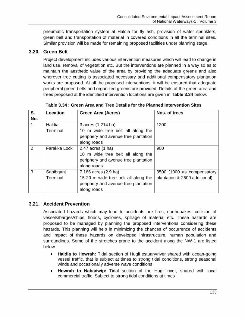
Consolidated Environmental Impact Assessment Report of National Waterways-1 : Volume 3
133
pneumatic transportation system at Haldia for fly ash, provision of water sprinklers,
green belt and transportation of material in covered conditions in all the terminal sites.
Similar provision will be made for remaining proposed facilities under planning stage.
3.20. Green Belt
Project development includes various intervention measures which will lead to change in
land use, removal of vegetation etc. But the interventions are planned in a way so as to
maintain the aesthetic value of the area by providing the adequate greens and also
wherever tree cutting is associated necessary and additional compensatory plantation
works are proposed. At all the proposed interventions, it will be ensured that adequate
peripheral green belts and organized greens are provided. Details of the green area and
trees proposed at the identified intervention locations are given in Table 3.34 below.
Table 3.34 : Green Area and Tree Details for the Planned Intervention Sites
S.
No.
Location Green Area (Acres) Nos. of trees
1 Haldia
Terminal
3 acres (1.214 ha)
10 m wide tree belt all along the
periphery and avenue tree plantation
along roads
1200
2 Farakka Lock 2.47 acres (1 ha)
10 m wide tree belt all along the
periphery and avenue tree plantation
along roads
900
3 Sahibganj
Terminal
7.166 acres (2.9 ha)
15-20 m wide tree belt all along the
periphery and avenue tree plantation
along roads
3500 (1000 as compensatory
plantation & 2500 additional)
3.21. Accident Prevention
Associated hazards which may lead to accidents are fires, earthquakes, collision of
vessels/barges/ships, floods, cyclones, spillage of material etc. These hazards are
proposed to be managed by planning the proposed interventions considering these
hazards. This planning will help in minimizing the chances of occurrence of accidents
and impact of these hazards on developed infrastructure, human population and
surroundings. Some of the stretches prone to the accident along the NW-1 are listed
below
Haldia to Howrah: Tidal section of Hugli estuary/river shared with ocean-going vessel traffic, that is subject at times to strong tidal conditions, strong seasonal winds and occasionally adverse wave conditions
Howrah to Nabadwip: Tidal section of the Hugli river, shared with local commercial traffic. Subject to strong tidal conditions at times
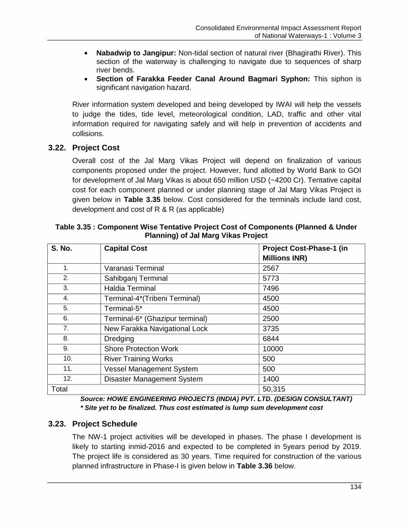
Consolidated Environmental Impact Assessment Report of National Waterways-1 : Volume 3
134
Nabadwip to Jangipur: Non-tidal section of natural river (Bhagirathi River). This section of the waterway is challenging to navigate due to sequences of sharp river bends.
Section of Farakka Feeder Canal Around Bagmari Syphon: This siphon is significant navigation hazard.
River information system developed and being developed by IWAI will help the vessels
to judge the tides, tide level, meteorological condition, LAD, traffic and other vital
information required for navigating safely and will help in prevention of accidents and
collisions.
3.22. Project Cost
Overall cost of the Jal Marg Vikas Project will depend on finalization of various
components proposed under the project. However, fund allotted by World Bank to GOI
for development of Jal Marg Vikas is about 650 million USD (~4200 Cr). Tentative capital
cost for each component planned or under planning stage of Jal Marg Vikas Project is
given below in Table 3.35 below. Cost considered for the terminals include land cost,
development and cost of R & R (as applicable)
Table 3.35 : Component Wise Tentative Project Cost of Components (Planned & Under Planning) of Jal Marg Vikas Project
S. No. Capital Cost Project Cost-Phase-1 (in
Millions INR)
1. Varanasi Terminal 2567
2. Sahibganj Terminal 5773
3. Haldia Terminal 7496
4. Terminal-4*(Tribeni Terminal) 4500
5. Terminal-5* 4500
6. Terminal-6* (Ghazipur terminal) 2500
7. New Farakka Navigational Lock 3735
8. Dredging 6844
9. Shore Protection Work 10000
10. River Training Works 500
11. Vessel Management System 500
12. Disaster Management System 1400
Total 50,315
Source: HOWE ENGINEERING PROJECTS (INDIA) PVT. LTD. (DESIGN CONSULTANT)
* Site yet to be finalized. Thus cost estimated is lump sum development cost
3.23. Project Schedule
The NW-1 project activities will be developed in phases. The phase I development is
likely to starting inmid-2016 and expected to be completed in 5years period by 2019.
The project life is considered as 30 years. Time required for construction of the various
planned infrastructure in Phase-I is given below in Table 3.36 below.
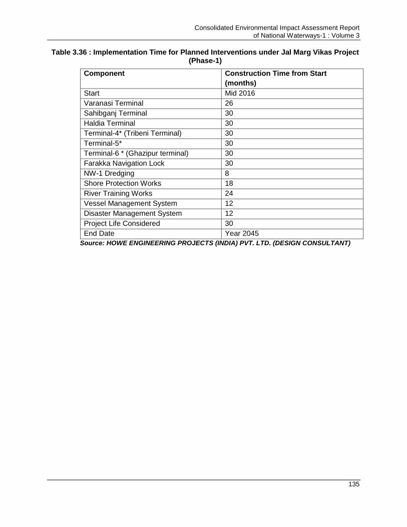
Consolidated Environmental Impact Assessment Report of National Waterways-1 : Volume 3
135
Table 3.36 : Implementation Time for Planned Interventions under Jal Marg Vikas Project (Phase-1)
Component Construction Time from Start
(months)
Start Mid 2016
Varanasi Terminal 26
Sahibganj Terminal 30
Haldia Terminal 30
Terminal-4* (Tribeni Terminal) 30
Terminal-5* 30
Terminal-6 * (Ghazipur terminal) 30
Farakka Navigation Lock 30
NW-1 Dredging 8
Shore Protection Works 18
River Training Works 24
Vessel Management System 12
Disaster Management System 12
Project Life Considered 30
End Date Year 2045
Source: HOWE ENGINEERING PROJECTS (INDIA) PVT. LTD. (DESIGN CONSULTANT)
Consolidated Environmental Impact Assessment Report of National Waterways-1 : Volume 3
136
Chapter 4. ENVIRONMENTAL IMPACTS AND MITIGATION MEASURES
4.1. Introduction
Environmental Impact Assessment helps in identifying the likely impacts due to project
activities for all stages of the project viz, design, construction and operation stage on the
physical, biological and social environment. Impacts are quantified using established
practices, tools and mathematical models followed by identification of mitigation
measures to mitigate the impacts to acceptable levels.
The project “Jal Marg Vikas” (NW-1) is a kind of a programme comprising of various
infrastructural interventions such as construction of terminals, navigational lock, river
training works, bank protection works, dredging for maintaining LAD, development of
navigational aids and operation of barges. Project is at planning and feasibility stage.
Impact analysis has been carried out for all proposed activities28 under NW-1 and for all
three broad aspects of environment namely physical, biological and socio-economic
aspects.
4.2. Valued Environmental Components
Valued or critical environmental components29 (VECs) are defined as fundamental
elements of the physical, biological or socio-economic environment, including physical
features, habitats, wildlife populations (e.g., biodiversity), ecosystem services, natural
processes (e.g., water and nutrient cycles, microclimate), social conditions (e.g., health,
economics), or cultural aspects (e.g., traditional spiritual ceremonies) air, water, soil,
terrain, vegetation, wildlife, fish, birds and land use that may be affected by a proposed
project. VECs are environmental and social attributes that are considered to be
important in assessing risks..
Critical Environmental Resource (CER) and Valued Environmental Components (VEC)
are technically same referring to various key environmental resource or component like
natural habitat. Critical Environment Resource word is used for Basin Level study as per
terms of reference of these studies. However, for EIA studies VEC word is used.
Key VECsidentified for this project requiring greater attention in reference to CIA study
are climate, micro climate, aquatic ecology, impact on sensitive species namely Dolphins
and Turtles, Water quality, Terrestrial flora (cutting of trees at intervention sites),
Avifauna, ambient noise levels and air quality pollution from barge movement, dredging
and terminal operations, land use, soil quality & ground water due to dredge (dredging)
28
Three terminals namely Ramnagar at Varanasi, Sahibganj, and Haldia and Farakka lock are the four firm up interventions.
Separate EIA has also been prepared for these interventions. Outcome of these EIAs has been included in this report as well. No barrage is proposed for NW-1. DPR consultant has indicated a need of barrage for the operation of NW-1 between Varanasi and Allahabad. Since IWAI do not want to construct any Barrage on NW-1 NW-1 is likely to operate between Haldia to Varansi at this stage. 29
As per TOR of theCritical Environmental Resources (CER) was used for preparation of basin level study. The CER and VEC is
same otherwise.
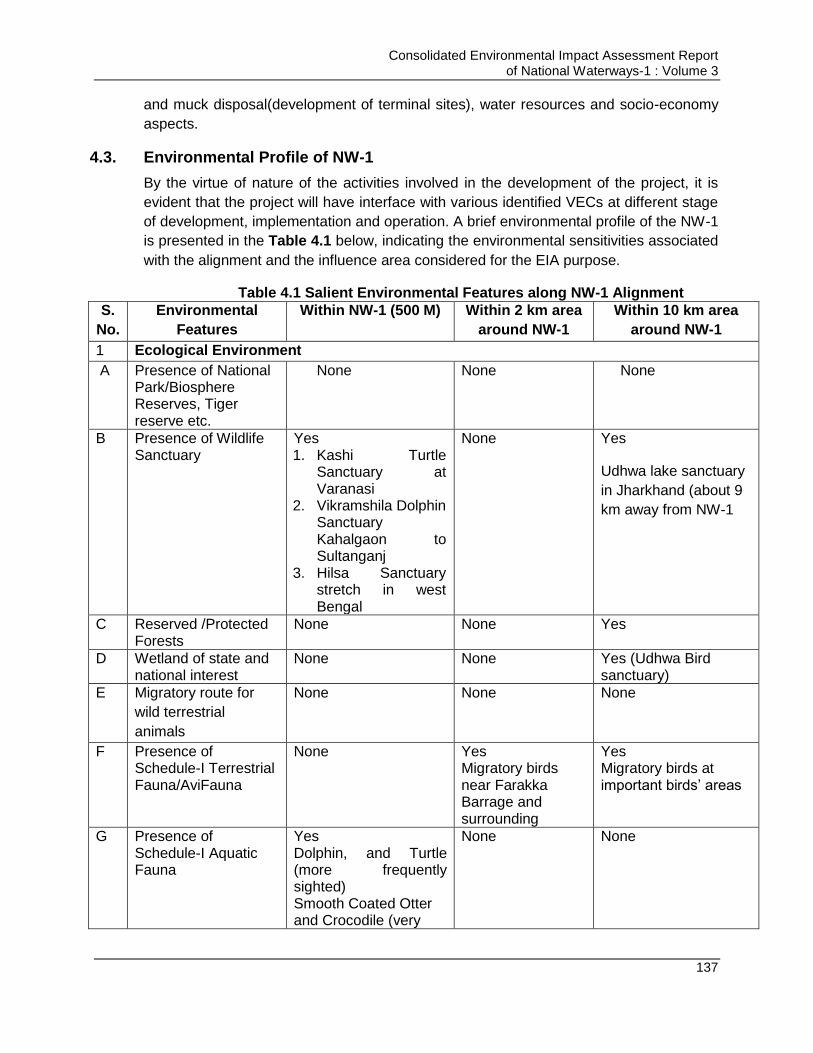
Consolidated Environmental Impact Assessment Report of National Waterways-1 : Volume 3
137
and muck disposal(development of terminal sites), water resources and socio-economy
aspects.
4.3. Environmental Profile of NW-1
By the virtue of nature of the activities involved in the development of the project, it is
evident that the project will have interface with various identified VECs at different stage
of development, implementation and operation. A brief environmental profile of the NW-1
is presented in the Table 4.1 below, indicating the environmental sensitivities associated
with the alignment and the influence area considered for the EIA purpose.
Table 4.1 Salient Environmental Features along NW-1 Alignment
S.
No.
Environmental
Features
Within NW-1 (500 M) Within 2 km area
around NW-1
Within 10 km area
around NW-1
1 Ecological Environment
A Presence of National Park/Biosphere Reserves, Tiger reserve etc.
None
None None
B Presence of Wildlife Sanctuary
Yes 1. Kashi Turtle
Sanctuary at Varanasi
2. Vikramshila Dolphin Sanctuary Kahalgaon to Sultanganj
3. Hilsa Sanctuary stretch in west Bengal
None Yes
Udhwa lake sanctuary
in Jharkhand (about 9
km away from NW-1
C Reserved /Protected Forests
None None Yes
D Wetland of state and national interest
None None Yes (Udhwa Bird sanctuary)
E Migratory route for
wild terrestrial
animals
None None None
F Presence of Schedule-I Terrestrial Fauna/AviFauna
None Yes Migratory birds near Farakka Barrage and surrounding
Yes Migratory birds at important birds‟ areas
G
Presence of Schedule-I Aquatic Fauna
Yes Dolphin, and Turtle (more frequently sighted) Smooth Coated Otter and Crocodile (very
None None
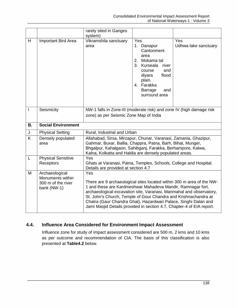
Consolidated Environmental Impact Assessment Report of National Waterways-1 : Volume 3
138
rarely sited in Ganges system)
H Important Bird Area Vikramshila sanctuary area
Yes 1. Danapur
Cantonment area
2. Mokama tal 3. Kurseala river
course and diyara flood plain.
4. Farakka Barrage and surround area
Yes Udhwa lake sanctuary
I Seismicity NW-1 falls in Zone-III (moderate risk) and zone IV (high damage risk
zone) as per Seismic Zone Map of India
B. Social Environment
J Physical Setting Rural, Industrial and Urban
K Densely populated area
Allahabad, Sirsa, Mirzapur, Chunar, Varanasi, Zamania, Ghazipur, Gahmar, Buxar, Ballia, Chappra, Patna, Barh, Bihat, Munger, Bhgalpur, Kahalgaon, Sahibganj, Farakka, Berhampore, Katwa, Kalna, Kolkatta and Haldia are densely populated areas.
L Physical Sensitive Receptors
Yes Ghats at Varanasi, Patna, Temples, Schools, College and Hospital. Details are provided at section 4.7
M Archaeological Monuments within 300 m of the river bank (NW-1)
Yes
There are 9 archaeological sites located within 300 m area of the NW-1 and these are Kardmeshwar Mahadeva Mandir, Ramnagar fort, archaeological excavation site, Varanasi, Manmahal and observatory, St. John's Church, Temple of Gour Chandra and Krishnachandra at Chatra (Gaur Chandra Ghat), Hazardwari Palace, Singhi Dalan and Jami Masjid Details provided in section 4.7, Chapter-4 of EIA report.
4.4. Influence Area Considered for Environment Impact Assessment
Influence zone for study of impact assessment considered are 500 m, 2 kms and 10 kms
as per outcome and recommendation of CIA. The basis of this classification is also
presented at Table4.2 below.
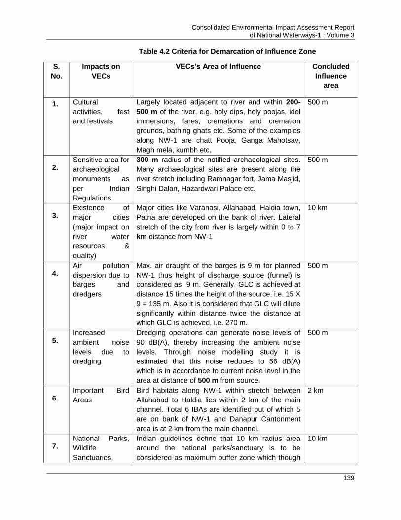
Consolidated Environmental Impact Assessment Report of National Waterways-1 : Volume 3
139
Table 4.2 Criteria for Demarcation of Influence Zone
S.
No.
Impacts on
VECs
VECs’s Area of Influence Concluded
Influence
area
1. Cultural
activities, fest
and festivals
Largely located adjacent to river and within 200-
500 m of the river, e.g. holy dips, holy poojas, idol
immersions, fares, cremations and cremation
grounds, bathing ghats etc. Some of the examples
along NW-1 are chatt Pooja, Ganga Mahotsav,
Magh mela, kumbh etc.
500 m
2. Sensitive area for
archaeological
monuments as
per Indian
Regulations
300 m radius of the notified archaeological sites.
Many archaeological sites are present along the
river stretch including Ramnagar fort, Jama Masjid,
Singhi Dalan, Hazardwari Palace etc.
500 m
3. Existence of
major cities
(major impact on
river water
resources &
quality)
Major cities like Varanasi, Allahabad, Haldia town,
Patna are developed on the bank of river. Lateral
stretch of the city from river is largely within 0 to 7
km distance from NW-1
10 km
4. Air pollution
dispersion due to
barges and
dredgers
Max. air draught of the barges is 9 m for planned
NW-1 thus height of discharge source (funnel) is
considered as 9 m. Generally, GLC is achieved at
distance 15 times the height of the source, i.e. 15 X
9 = 135 m. Also it is considered that GLC will dilute
significantly within distance twice the distance at
which GLC is achieved, i.e. 270 m.
500 m
5. Increased
ambient noise
levels due to
dredging
Dredging operations can generate noise levels of
90 dB(A), thereby increasing the ambient noise
levels. Through noise modelling study it is
estimated that this noise reduces to 56 dB(A)
which is in accordance to current noise level in the
area at distance of 500 m from source.
500 m
6. Important Bird
Areas
Bird habitats along NW-1 within stretch between
Allahabad to Haldia lies within 2 km of the main
channel. Total 6 IBAs are identified out of which 5
are on bank of NW-1 and Danapur Cantonment
area is at 2 km from the main channel.
2 km
7. National Parks,
Wildlife
Sanctuaries,
Indian guidelines define that 10 km radius area
around the national parks/sanctuary is to be
considered as maximum buffer zone which though
10 km

Consolidated Environmental Impact Assessment Report of National Waterways-1 : Volume 3
140
4.5. Impact Identification
Impacts are highly specific and depends on the nature of the activities to be undertaken
at different stages viz. design/pre-construction, construction & operation phase.
The three major activities involved in the project development which may have impacts
on environment at different stages are construction and operation of civil interventions,
maintenance dredging and operation of barges. These activities may impact different
environmental components at different stages of project life cycle. But this is always
possible that all these three activities may not impact the same VECs, one activity may
have more impact on one identified VECS and none on another. Thus to identify the
VECs which will be impacted by each of these three activity, an interaction matrix has
been developed and is presented in Table 4.3.
Wetlands vary depending on nature and location of
Sanctuary. VGDS and Kashi Turtle Sanctuary is
located within NW-1. Udhwa bird Sanctuary is
located at 9 Km from the NW-1. Considering
presence of these sanctuaries and
Indianguidelines10 Km radius is considered as
influence zone.
8. Flood Plains Flood plains of the Ganga River extends to kms
and varies with the stretch. The length of flood
plain varies from no flood plain on one side of bank
to few kms. As per study carried out by IIT
Consortium “Active floodplain mapping: Defining
the “River space””, it is mentioned that flood plains
of river vary in different stretch. From Kanpur to
Buxar, it varies from 1 km to 7.5 km but
downstream of Buxar to Farakka, flood plain
widens upto 42 km. Thus consideration to flood
plains cannot be undertaken directly.
However, as per NMCG and book “Large Rivers:
Geomorphology and Management”, width of River
Ganga and its active flood plains varies in range
of0.5-3 kms. Active flood plain is as an area on
either side of a stream/river which is regularly
flooded on a periodic basis which is designated on
the basis of hydrogeological criteria set for this
reach, i.e. 2.33 year return period of the flood.
3 kms
9. General Practise
in India for
carrying out EIA
studies
As per the EIA guidance/technical manual
prepared by MoEF&CC for various sectors, the EIA
study area is desired as 10km radius around the
project site.
10 km

Consolidated Environmental Impact Assessment Report of National Waterways-1 : Volume 3
141
Table 4.3 Interaction Matrix of Major Project Activities and VECs
Project
Activity
VECs
Maintenance
Dredging
Barge
Operations
Civil Interventions
Pre-
Construction/
Construction
Operations
Climate No Yes No No
Micro-climate Yes Yes Yes Yes
Aquatic Ecology Yes Yes Yes Yes
Dolphins &
Turtles
No
* Not to be
carried out in
sanctuary areas
Yes No No
Water Flow Yes Yes No Yes
Water Quality Yes Yes Yes Yes
Terrestrial
Flora/Cutting of
Trees
No No Yes Yes
Avifauna Yes No Yes Yes
Ambient Noise
Levels
Yes No Yes No
Air Quality Yes Yes Yes Yes
Land use No No Yes No
Water resources No No Yes Yes
Socio-economy Yes Yes Yes Yes
From the above matrix, it can be seen which activity is anticipated to affect which VECS.
It is apparent that barge movement and maintenance dredging are operational part of
the project but civil interventions involve all design, construction & operation stages.
Thus all the associated activities with different stages of development of civil
interventions are identified and a matrix is developed phase wise to identify the impact of
all the identified activities (activities in different stages of development of civil
interventions, barge movement and maintenance dredging operations).
The section below identifies the impacts which these three activities will have on the
identified VECs. Identified incremental impacts due to NW1 activities are superimposed
to assess the significance of identified impacts on these critical environmental resources.
Thereafter, cost-effective but appropriate mitigation measures are proposed to mitigate
impacts and bring the residual impacts within acceptable thresholds. An EMP has been
designed to ensure the effective implementation of proposed mitigation measures (refer
chapter 6).
Consolidated Environmental Impact Assessment Report of National Waterways-1 : Volume 3
142
4.6. Impact Assessment of NW1
„Jal Marg Vikas” NW-1 project has many components namely Terminal construction,
navigation lock construction, maintenance dredging, river bank protection, river training, Ro-
Ro jetty construction, navigational aids and barge operations. Some components have
already been finalised and some are under finalisation stage depending on the feasibility.
The finalised components are terminals at Varanasi, Sahibganj, & Haldia and navigation
lock at Farakka. Other terminal sites and intervention are being finalised. This EIA reports
covers impact associated components of NW-1 (finalised or planned components both).
Output of CIA study and EIAs prepared for finalised components are used as reference
input for carrying out impact assessment of all components. Impact assessment has been
carried out for all design, construction and operation stages of the project implementation.
Impacts have been assessed for all the project activities in entire project life cycle for all the
physical, biological and social environmental components. Brief on the various components
of the NW-1 on which EIA study has been undertaken is presented below
4.6.1. Maintenance Dredging for Maintaining Minimum LAD
NW-1 aims to maintain navigation channel width of 45m and side slope of 1:5 from Haldia to
Varanasi. Maintenance dredging is an essential continual activity for navigation channel to
maintain the requisite LAD in different NW1 stretches to facilitate smooth and efficient
navigation. Maintenance dredging is to be carried out periodically as per requirement during
project initiation as well as during entire operation phase of the project. To meet the
objective of project, IWAI though wanted to maintain LAD of 3 m in entire NW-1 but for
optimizing the dredging requirement certain minimal LAD are defined for different stretches
of NW1 as indicated below:
Haldia to Tribeni : 3 m (naturally available LAD)
Tribeni to Farakka : 3 m (including Farakka Lock)
Farakka to Barh : 3 m
Barh to Ghazipur : 2.5 m
Ghazipur to Varanasi : 2.2 m
The above LAD rationalisation and selection of appropriate site will reduce dredging
requirement from 31.08 million cubic meter at 3m LAD to 14.85 million cubic meter which
amounts to reduction of more than half of dredging volume there by reducing the impact to
the extent more than 50%.
Table 4.4 indicates the stretch where dredging is planned with corresponding associated
environment, cultural and social sensitivities of the respective river stretches. Impacts of
dredging operations in NW-1 are assessed considering the respective sensitivities. Detailed
assessment of impacts of maintenance dredging has been carried out and is given in the
sections below. Impact identification matrix for maintenance dredging is given below in
Table 4.5.
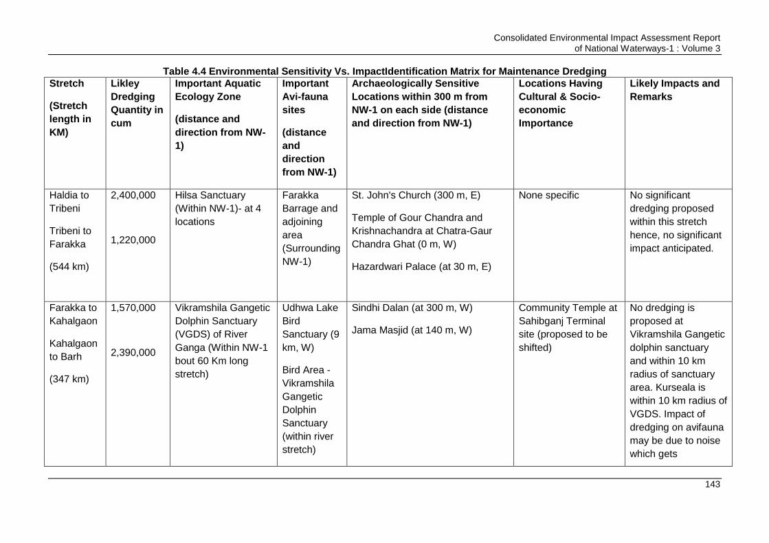
Consolidated Environmental Impact Assessment Report of National Waterways-1 : Volume 3
143
Table 4.4 Environmental Sensitivity Vs. ImpactIdentification Matrix for Maintenance Dredging
Stretch
(Stretch
length in
KM)
Likley
Dredging
Quantity in
cum
Important Aquatic
Ecology Zone
(distance and
direction from NW-
1)
Important
Avi-fauna
sites
(distance
and
direction
from NW-1)
Archaeologically Sensitive
Locations within 300 m from
NW-1 on each side (distance
and direction from NW-1)
Locations Having
Cultural & Socio-
economic
Importance
Likely Impacts and
Remarks
Haldia to
Tribeni
Tribeni to
Farakka
(544 km)
2,400,000
1,220,000
Hilsa Sanctuary
(Within NW-1)- at 4
locations
Farakka
Barrage and
adjoining
area
(Surrounding
NW-1)
St. John's Church (300 m, E)
Temple of Gour Chandra and
Krishnachandra at Chatra-Gaur
Chandra Ghat (0 m, W)
Hazardwari Palace (at 30 m, E)
None specific No significant
dredging proposed
within this stretch
hence, no significant
impact anticipated.
Farakka to
Kahalgaon
Kahalgaon
to Barh
(347 km)
1,570,000
2,390,000
Vikramshila Gangetic
Dolphin Sanctuary
(VGDS) of River
Ganga (Within NW-1
bout 60 Km long
stretch)
Udhwa Lake
Bird
Sanctuary (9
km, W)
Bird Area -
Vikramshila
Gangetic
Dolphin
Sanctuary
(within river
stretch)
Sindhi Dalan (at 300 m, W)
Jama Masjid (at 140 m, W)
Community Temple at
Sahibganj Terminal
site (proposed to be
shifted)
No dredging is
proposed at
Vikramshila Gangetic
dolphin sanctuary
and within 10 km
radius of sanctuary
area. Kurseala is
within 10 km radius of
VGDS. Impact of
dredging on avifauna
may be due to noise
which gets

Consolidated Environmental Impact Assessment Report of National Waterways-1 : Volume 3
144
Stretch
(Stretch
length in
KM)
Likley
Dredging
Quantity in
cum
Important Aquatic
Ecology Zone
(distance and
direction from NW-
1)
Important
Avi-fauna
sites
(distance
and
direction
from NW-1)
Archaeologically Sensitive
Locations within 300 m from
NW-1 on each side (distance
and direction from NW-1)
Locations Having
Cultural & Socio-
economic
Importance
Likely Impacts and
Remarks
Mokama
Taal -Barah
Wetlands
(Along NW-
1)
Kurseala
River Course
and Diyara
Flood Plains
(along river)
attenuated beyond
500 m of dredging
locations to the
prescribed day time
ambient noise level of
55 dB(A) for
residential areas.
Noise impact on
avifauna of Udhwa
sanctuary thus is
considered minimal.
Mokama Taal is close
to river and its avi
fauna can be impact
from dredging noise.
Dredge material in
this stretch not found
contaminated. Its
disposal in river is
likely to have impact
on aquatic ecology

Consolidated Environmental Impact Assessment Report of National Waterways-1 : Volume 3
145
Stretch
(Stretch
length in
KM)
Likley
Dredging
Quantity in
cum
Important Aquatic
Ecology Zone
(distance and
direction from NW-
1)
Important
Avi-fauna
sites
(distance
and
direction
from NW-1)
Archaeologically Sensitive
Locations within 300 m from
NW-1 on each side (distance
and direction from NW-1)
Locations Having
Cultural & Socio-
economic
Importance
Likely Impacts and
Remarks
and water quality.
Barh to
Patna
(64 km)
1,600,000 None None None Ghats at Patna Non as no sensitivity
associated. Dredge
material in this
stretch is not found
contaminated. Its
disposal in river is
likely to have impact
on aquatic ecology
and water quality.
Patna to
Buxar
(169 km)
2,770,000
None Danapur
cantonment
area (at 2
km, S)
None None specific Impact of dredging on
avifauna may be due
to noise which gets
attenuated beyond
500 m of dredging
locations to the
prescribed day time
ambient noise level of
55 dB(A) for
residential areas.

Consolidated Environmental Impact Assessment Report of National Waterways-1 : Volume 3
146
Stretch
(Stretch
length in
KM)
Likley
Dredging
Quantity in
cum
Important Aquatic
Ecology Zone
(distance and
direction from NW-
1)
Important
Avi-fauna
sites
(distance
and
direction
from NW-1)
Archaeologically Sensitive
Locations within 300 m from
NW-1 on each side (distance
and direction from NW-1)
Locations Having
Cultural & Socio-
economic
Importance
Likely Impacts and
Remarks
Noise impact on
avifauna of Danapur
Cantonment zone
thus is considered
minimal. Dredge
material in this
stretch not found
contaminated. Its
disposal in river is
likely to have impact
on aquatic ecology
and water quality.
Buxar to
Ghazipur
Ghazipur
to Varanasi
(187)
1,060,000
1,840,000
None None None None specific Dredge material in
this stretch not found
contaminated except
marginal higher
cadmium as per US
standard at two
locations. However,
this level is also well
below the aquatic

Consolidated Environmental Impact Assessment Report of National Waterways-1 : Volume 3
147
Stretch
(Stretch
length in
KM)
Likley
Dredging
Quantity in
cum
Important Aquatic
Ecology Zone
(distance and
direction from NW-
1)
Important
Avi-fauna
sites
(distance
and
direction
from NW-1)
Archaeologically Sensitive
Locations within 300 m from
NW-1 on each side (distance
and direction from NW-1)
Locations Having
Cultural & Socio-
economic
Importance
Likely Impacts and
Remarks
sensitivity analysis
reported by Canadian
guidelines30. Its
disposal in river is
likely to have some
impact on aquatic
ecology and water
quality.
Varanasi to
Allahabad
(236 km)
Nil Kashi Turtle
Sanctuary (within
river water about 7
km stretch)
None Kardmeshwar Mahadeva Mandir
(at 240 m, W)
Ramnagar, fort (at 40 m, E)
Archaeological excavation site,
Varanasi (at 130 m, E)
Manmahal and observatory (at 40
m, W)
Ghats (0 m, W) No impact anticipated
on these
archaeological sites
and Kashi Turtle
Sanctuary as no
dredging is proposed
in this stretch.
30
There are no Indian Standard for Bed sediment levels and aquatic sensitivity. In absence of Indian standards assessment is carried out against international standards and guidelines.
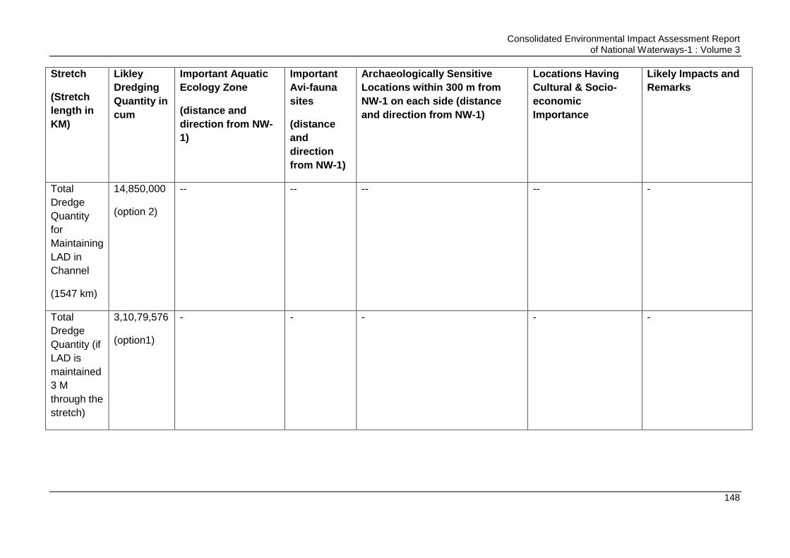
Consolidated Environmental Impact Assessment Report of National Waterways-1 : Volume 3
148
Stretch
(Stretch
length in
KM)
Likley
Dredging
Quantity in
cum
Important Aquatic
Ecology Zone
(distance and
direction from NW-
1)
Important
Avi-fauna
sites
(distance
and
direction
from NW-1)
Archaeologically Sensitive
Locations within 300 m from
NW-1 on each side (distance
and direction from NW-1)
Locations Having
Cultural & Socio-
economic
Importance
Likely Impacts and
Remarks
Total
Dredge
Quantity
for
Maintaining
LAD in
Channel
(1547 km)
14,850,000
(option 2)
-- -- -- -- -
Total
Dredge
Quantity (if
LAD is
maintained
3 M
through the
stretch)
3,10,79,576
(option1)
- - - - -
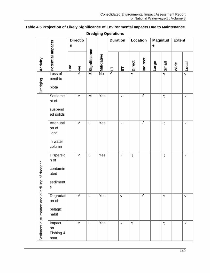
Consolidated Environmental Impact Assessment Report of National Waterways-1 : Volume 3
149
Table 4.5 Projection of Likely Significance of Environmental Impacts Due to Maintenance
Dredging Operations
Ac
tiv
ity
Po
ten
tial Im
pa
cts
Directio
n
Sig
nif
ican
ce
Mit
igati
ve
Duration Location Magnitud
e
Extent
+v
e
-ve
LT
ST
Dir
ec
t
Ind
ire
ct
Larg
e
Sm
all
Wid
e
Lo
cal
Dre
dg
ing
Loss of
benthic
biota
M No
Se
dim
ent
dis
turb
an
ce a
nd
ove
rfill
ing o
f d
red
ger
Settleme
nt of
suspend
ed solids
M Yes
Attenuati
on of
light
in water
column
L Yes
Dispersio
n of
contamin
ated
sediment
s
L Yes
Degradati
on of
pelagic
habit
L Yes
Impact
on
Fishing &
boat
L Yes
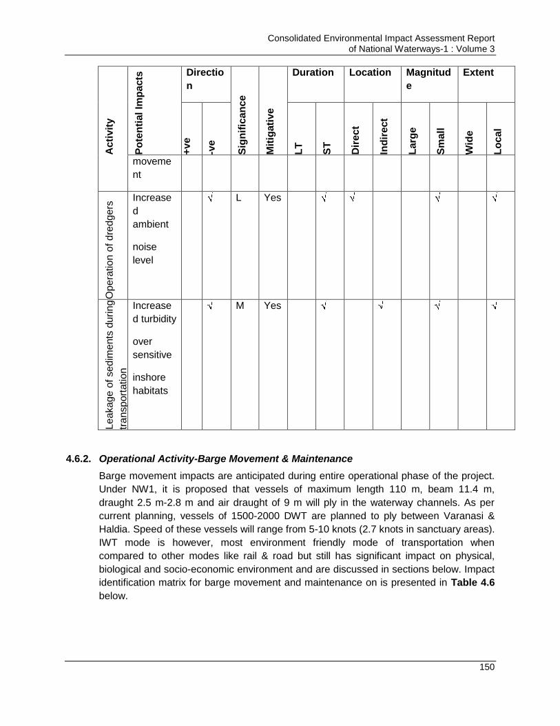
Consolidated Environmental Impact Assessment Report of National Waterways-1 : Volume 3
150
Ac
tiv
ity
Po
ten
tial Im
pa
cts
Directio
n
Sig
nif
ican
ce
Mit
igati
ve
Duration Location Magnitud
e
Extent
+v
e
-ve
LT
ST
Dir
ec
t
Ind
ire
ct
Larg
e
Sm
all
Wid
e
Lo
cal
moveme
nt
Op
era
tio
n o
f d
redg
ers
Increase
d
ambient
noise
level
L Yes
Lea
kag
e o
f se
dim
ents
du
ring
tra
nsp
ort
atio
n
Increase
d turbidity
over
sensitive
inshore
habitats
M Yes
4.6.2. Operational Activity-Barge Movement & Maintenance
Barge movement impacts are anticipated during entire operational phase of the project.
Under NW1, it is proposed that vessels of maximum length 110 m, beam 11.4 m,
draught 2.5 m-2.8 m and air draught of 9 m will ply in the waterway channels. As per
current planning, vessels of 1500-2000 DWT are planned to ply between Varanasi &
Haldia. Speed of these vessels will range from 5-10 knots (2.7 knots in sanctuary areas).
IWT mode is however, most environment friendly mode of transportation when
compared to other modes like rail & road but still has significant impact on physical,
biological and socio-economic environment and are discussed in sections below. Impact
identification matrix for barge movement and maintenance on is presented in Table 4.6
below.

Consolidated Environmental Impact Assessment Report of National Waterways-1 : Volume 3
151
Table 4.6 Identification of Environmental Impacts Due to Barge Movement & Maintenance A
cti
vit
y
Po
ten
tial Im
pa
cts
Directio
n
Sig
nif
ican
ce
Mit
igati
ve
Duration Location Magnitud
e
Extent
+v
e
-ve
LT
ST
Dir
ec
t
Ind
ire
ct
Larg
e
Sm
all
Wid
e
Lo
cal
Ba
rge
Mo
vem
ent
Air
emission
M Yes
Underwat
er Noise
generatio
n and
impact on
aquatic
organism
s
M Yes
Disposal
of
waste/se
wage
M Yes
Water
Quality
degradati
on
M Yes
Collision
with
aquatic
organism
L Yes
Bank
erosion/s
couring
L Yes
Consolidated Environmental Impact Assessment Report of National Waterways-1 : Volume 3
152
Ac
tiv
ity
Po
ten
tial Im
pa
cts
Directio
n
Sig
nif
ican
ce
Mit
igati
ve
Duration Location Magnitud
e
Extent
+v
e
-ve
LT
ST
Dir
ec
t
Ind
ire
ct
Larg
e
Sm
all
Wid
e
Lo
cal
Impact
on socio-
cultural
practises/
rituals
L Yes
Oil
spillages/
leakage
L Yes
Improved
Freight
Transport
ation
System
M Yes
Reductio
n in GHG
emission
M Yes
4.6.3. Design, Construction, Operation and Maintenance of the Civil Interventions
Civil interventions proposed under the project includes terminals, locks, Ro-Ro jetties,
passenger jetties, river training works, bed & scour protection works, bend correction
works, and barge maintenance facility. These interventions involve civil construction
activities and associated operational activities depending on the nature of intervention
for barges/vessels movement such as loading and unloading activity at terminals. These
interventions will have three major phases, i.e. design/pre construction, construction and
operation phases. Activities during these phases will have interaction with the various
components of environment and may have associated impacts which may affect the
environment potentially if not addressed and mitigation measures are not taken. Most of
the impact are common in nature for all the different civil interventions. However, some
impacts will be specific to nature and location of the intervention. EIA studies have been
carried out for four already finalised interventions namely Varanasi terminal, Sahibganj
terminal, Haldia terminal and Farakka lock. Outcome of these EIA studies have been
referred to conduct the environment impact assessment study of the entire project. This

Consolidated Environmental Impact Assessment Report of National Waterways-1 : Volume 3
153
EIA study defines the overall impact of the all civil interventions but it is suggested to
conduct separate EIA study for the any new civil interventions yet to be planned to study
site specific impacts. Impacts during different phases of interventions‟ construction and
operation on physical, biological and socio-economic environment are presented in the
sections below for all the environmental attributes. Impact identification matrix for civil
interventions is presented below in Table 4.7 below.

Consolidated Environmental Impact Assessment Report of National Waterways-1 : Volume 3
154
Table 4.7 Identification of Environmental Impacts Due to Design, Construction and Operation of Civil Interventions
S. No.
Activities
Impacts Negative Impact Positive Impact Specific Applicability in the Planned Components
Broad mitigation approach applicable to all similar
impacts caused at various intervention sites under Jal
Marg Vikas Project
Short Term
Long
Term
Reversible
Irreversibl
e
Short Term
Long Term
A Pre-Construction Phase
i Site Clearance & Preparation
Removal of Vegetation. Loss of green cover including trees.
Major Tree felling is required in case of Sahibganj terminal project among the current planned interventions. The requisite compensatory plantation is proposed to compensate the loss.
Removal of vegetation like shrubs, herbs and some trees may be unavoidable at different intervention sites. Permission from forest department in UP and West Bengal and District Authorities in Bihar and Jharkhand is essential prior to cutting of trees besides, compensatory plantation to be carried out as per respective state policies.
Impact on aesthetic values of project site
Restoration and rehabilitation of all such locations occupied or used for construction purposes immediately after the given task(s) is over
The aesthetic values of different intervention site may be disturbed due to construction activities Provision of project design to align the Restoration and rehabilitation of all such locations occupied or used for construction purposes immediately after the given task(s) is over
Impact on -- The air pollution and GHG
Consolidated Environmental Impact Assessment Report of National Waterways-1 : Volume 3
155
microclimatic status caused due to tree cutting
emission from different terminal and jetty sites will increase due to increased local traffic and/or tree cutting. Dedicated approach roads and improvement of haul roads should be considered to minimize the traffic congestion. Traffic management should be undertaken to avoid peak hours.
Impact on Eco Sensitive Areas
Eco sensitive areas of Kashi Turtle Sanctuary and Vikramshila Dolphin Sanctuary are identified as restricted areas. No intervention is proposed in these areas to avoid any impact on these sensitive areas.
No intervention is proposed in eco sensitive areas to avoid any impact on these sensitive areas.
Utility Shifting and Safety
Shifting of utilities is required in Sahibganj, and Haldia.
To be carried out during prior or during construction but without disrupting service to public.
Change in Land Use
Change in land use from agriculture to industrial in all identified locations except at Haldia
Necessary permission from the area development authorities and local bodies to be obtained prior to development
Consolidated Environmental Impact Assessment Report of National Waterways-1 : Volume 3
156
Change in Topography
Filling of site is required at Haldia,
Natural drainage pattern to be maintained by provision of adequate drainage
ii Acquisition of Land
Displacement of People (R & R)
Land acquisition in
case of Sahibganj, and Varanasi
Due compensation and other support to be provided to affected families as per RAP.
Loss of Livelihood
Land acquisition in case of Sahibganj, and Varanasi
Should be given adequate compensation and alternate livelihood options and assistance as suggested by people during public consultation
B Construction Phase
i
Construction of Terminal
Loss of Top soil
Top soil should be preserved and used for land escaping and green belt development at site or other locations
The top soil should be preserved and used for landscaping purpose and should be given to farmers in nearby areas, if asked by them
Soil contamination due to spillage of material
Provision made for Sewage Treatment plant, maintenance waste collection and treatment before reuse. Concreted floor for storage of fuel and oils Excavated earth should be reutilized to the extent possible in the construction activity and balance will be used for road
Clean-up operations should be taken up immediately after spillage. Debris and excavated earth should be disposed as per defined plan.

Consolidated Environmental Impact Assessment Report of National Waterways-1 : Volume 3
157
construction or disposed for designated places like mines in case of Sahibganj.
Surface water contamination
Turtle sanctuary lying at app. 2.3 km distance from the Varanasi terminal site and the waters near Sahibganj terminal supports dolphins. Thus the utmost care should be taken at these locations to minimize surface water pollution and impact on these species.
Measures should be taken to prevent contamination of run-off and mixing of contaminated run-off with River.
Air pollution
Habitations are located close to the site at Sahibganj Terminal site. Provisions are made for air dust pollution on land or water during material handling, loading and unloading.
Measures to be taken to minimize air pollutant generation by minimizing usage of DG sets, using low Sulphur diesel, implementing proposed air pollution control measures etc. No air pollution causing activities should be carried out in upwind direction of any settlement or sensitive area
Noise pollution
Habitations are located close to the site at Sahibganj Terminal site.
Measures to be taken to minimize noise levels by DG sets & other machinery/equipment
Consolidated Environmental Impact Assessment Report of National Waterways-1 : Volume 3
158
Measures are proposed for noise reduction.
provided with acoustic enclosures. Noise causing activities should not be carried out close to settlement areas and during night hours.
Increase in Traffic-Congestion
Measures are proposed to avoid traffic congestion where required
Traffic management required so as to avoid traffic jams if any such situation arises.
Temporary change in Aesthetic (Unpleasant view)
Restoration and rehabilitation of the areas occupied or used for construction purpose immediately after use is over.
Restoration and rehabilitation of the areas occupied or used for construction purpose immediately after use is over.
Impact on Health & safety of Workers and people in nearby areas
Provision to minimize exposure to Workers. Use of PPEs and safety precautions defined.
Exposure to pollutants will be only during construction phase. Mitigation measures should be taken to minimize pollutant generation
Social impact
-- Exposure to pollutants, loss of land, loss of livelihood, displacement etc., all are negative impacts. These can be minimized taking suggested mitigation measures Generation of employment is positive impact of the project
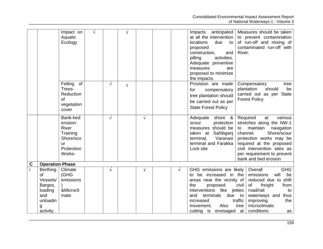
Consolidated Environmental Impact Assessment Report of National Waterways-1 : Volume 3
159
Impact on Aquatic Ecology
Impacts anticipated at all the intervention locations due to proposed construction, and pilling activities. Adequate preventive measures are proposed to minimize the impacts.
Measures should be taken to prevent contamination of run-off and mixing of contaminated run-off with River.
Felling of Trees-Reduction of vegetation cover
Provision are made
for compensatory
tree plantation should
be carried out as per
State Forest Policy
Compensatory tree plantation should be carried out as per State Forest Policy
Bank-bed erosion: River Training Shore/scour Protection Works-
Adequate shore &
scour protection measures should be taken at Sahibganj terminal, Varanasi terminal and Farakka Lock site
Required at various stretches along the NW-1 to maintain navigation channel. Shore/scour protection works may be required at the proposed civil intervention sites as per requirement to prevent bank and bed erosion
C Operation Phase
i
Berthing of Vessels/Barges, loading and unloading activity,
Climate (GHG emissions) &Microclimate
GHG emissions are likely
to be increased in the areas near the vicinity of the proposed civil interventions like jetties and terminals due to increased traffic movement. Also tree cutting is envisaged at
Overall GHG emissions will be reduced due to shift of freight from road/rail to waterways and thus improving the microclimatic conditions as

Consolidated Environmental Impact Assessment Report of National Waterways-1 : Volume 3
160
storage of material, transportation of material via road &railway, and Maintenance Dredging Operations at terminals
proposed intervention development sites especially Sahibganj. Both the factors together may contribute in micro climatic changes in the area. For the same compensatory plantation should be carried out minimum as per state forest policy, installation of mechanical transportation mechanism for unloading & loading of barges and development of thick peripheral and avenue plantation. GHG emissions may also increase due to operation of dredgers (fuel based)
waterway movement cause least emission generation when compared to road & rail. Thus reduced GHG emissions will contribute in reducing the enhanced anthropogenic climate change.
Air Quality (material handling and spontaneous fire in coal stockyards)
Air emissions near the
proposed civil intervention sites like jetties & terminal are like to increase due to increased vehicular movement and removal of the vegetation near the intervention sites. Air emissions are expected to be generated from dredgers.
Air emissions in overall NW-1 stretch will reduced as the vehicular movement and fuel burning in transportation of cargo will be reduced significantly due to shift of cargo from road/rail to waterways. In addition to this it is made mandatory to have thick green belt area and avenue plantation at all
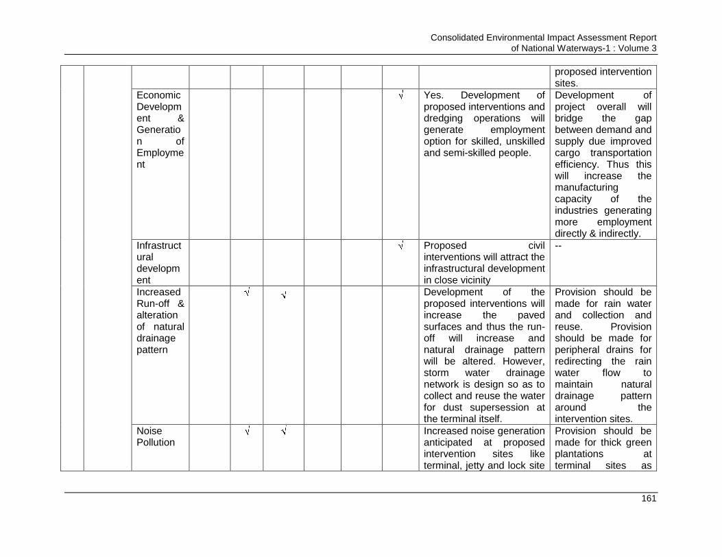
Consolidated Environmental Impact Assessment Report of National Waterways-1 : Volume 3
161
proposed intervention sites.
Economic Development & Generation of Employment
Yes. Development of
proposed interventions and dredging operations will generate employment option for skilled, unskilled and semi-skilled people.
Development of project overall will bridge the gap between demand and supply due improved cargo transportation efficiency. Thus this will increase the manufacturing capacity of the industries generating more employment directly & indirectly.
Infrastructural development
Proposed civil
interventions will attract the infrastructural development in close vicinity
--
Increased Run-off & alteration of natural drainage pattern
Development of the
proposed interventions will increase the paved surfaces and thus the run-off will increase and natural drainage pattern will be altered. However, storm water drainage network is design so as to collect and reuse the water for dust supersession at the terminal itself.
Provision should be made for rain water and collection and reuse. Provision should be made for peripheral drains for redirecting the rain water flow to maintain natural drainage pattern around the intervention sites.
Noise Pollution
Increased noise generation anticipated at proposed intervention sites like terminal, jetty and lock site
Provision should be made for thick green plantations at terminal sites as
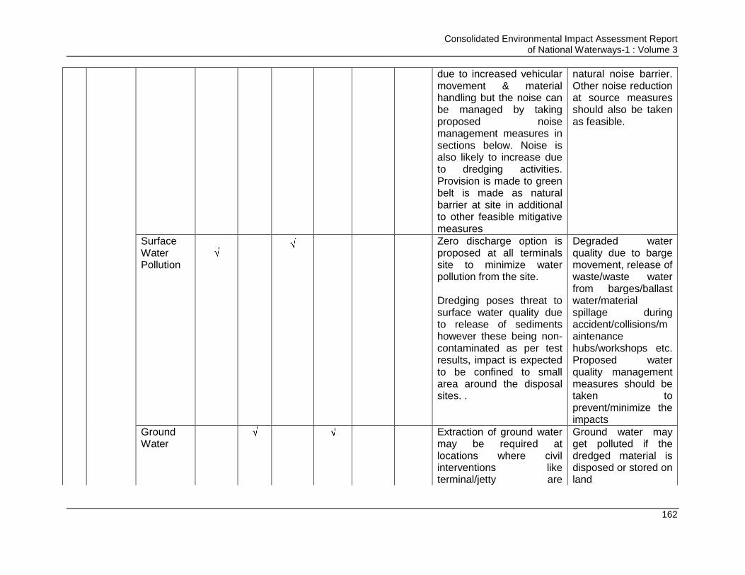
Consolidated Environmental Impact Assessment Report of National Waterways-1 : Volume 3
162
due to increased vehicular movement & material handling but the noise can be managed by taking proposed noise management measures in sections below. Noise is also likely to increase due to dredging activities. Provision is made to green belt is made as natural barrier at site in additional to other feasible mitigative measures
natural noise barrier. Other noise reduction at source measures should also be taken as feasible.
Surface Water Pollution
Zero discharge option is
proposed at all terminals site to minimize water pollution from the site. Dredging poses threat to surface water quality due to release of sediments however these being non-contaminated as per test results, impact is expected to be confined to small area around the disposal sites. .
Degraded water quality due to barge movement, release of waste/waste water from barges/ballast water/material spillage during accident/collisions/maintenance hubs/workshops etc. Proposed water quality management measures should be taken to prevent/minimize the impacts
Ground Water
Extraction of ground water may be required at locations where civil interventions like terminal/jetty are
Ground water may get polluted if the dredged material is disposed or stored on land
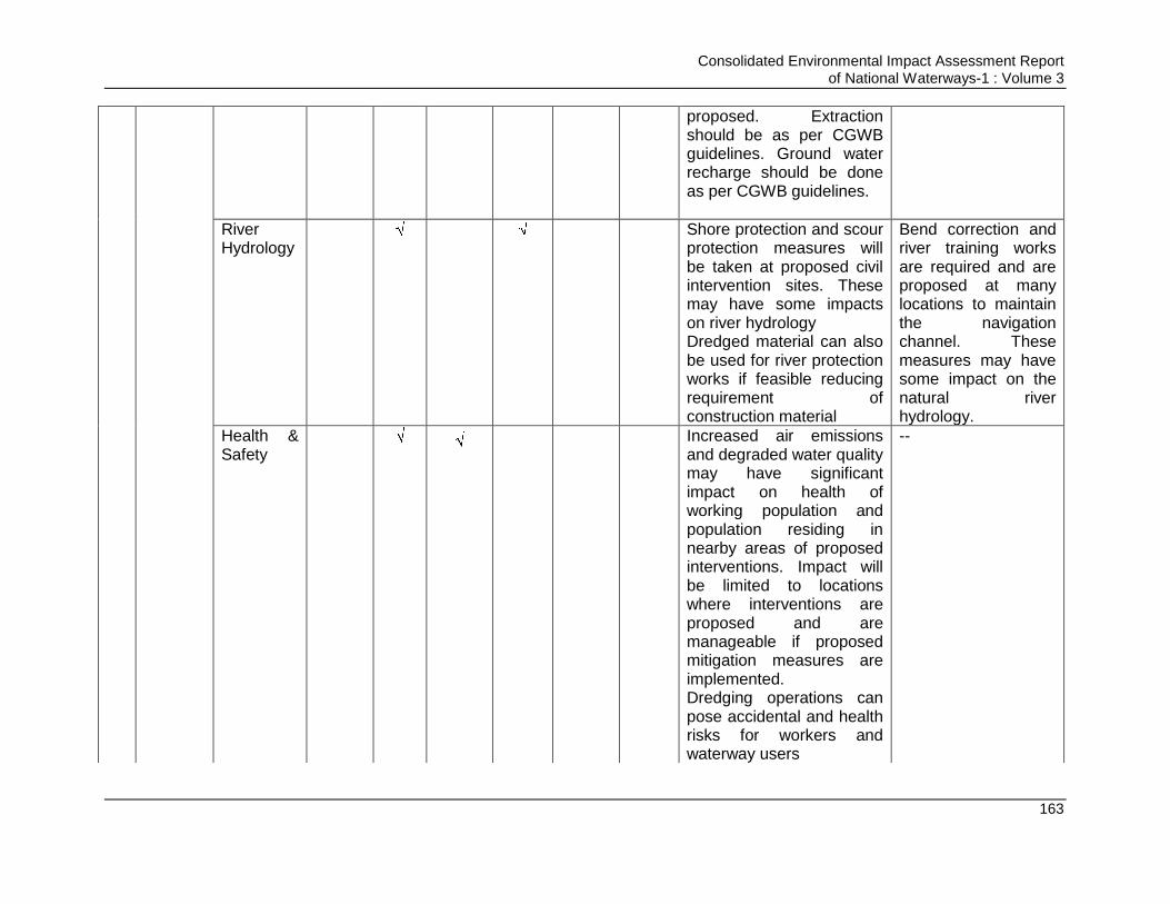
Consolidated Environmental Impact Assessment Report of National Waterways-1 : Volume 3
163
proposed. Extraction should be as per CGWB guidelines. Ground water recharge should be done as per CGWB guidelines.
River Hydrology
Shore protection and scour protection measures will be taken at proposed civil intervention sites. These may have some impacts on river hydrology Dredged material can also be used for river protection works if feasible reducing requirement of construction material
Bend correction and river training works are required and are proposed at many locations to maintain the navigation channel. These measures may have some impact on the natural river hydrology.
Health & Safety
Increased air emissions and degraded water quality may have significant impact on health of working population and population residing in nearby areas of proposed interventions. Impact will be limited to locations where interventions are proposed and are manageable if proposed mitigation measures are implemented. Dredging operations can pose accidental and health risks for workers and waterway users
--
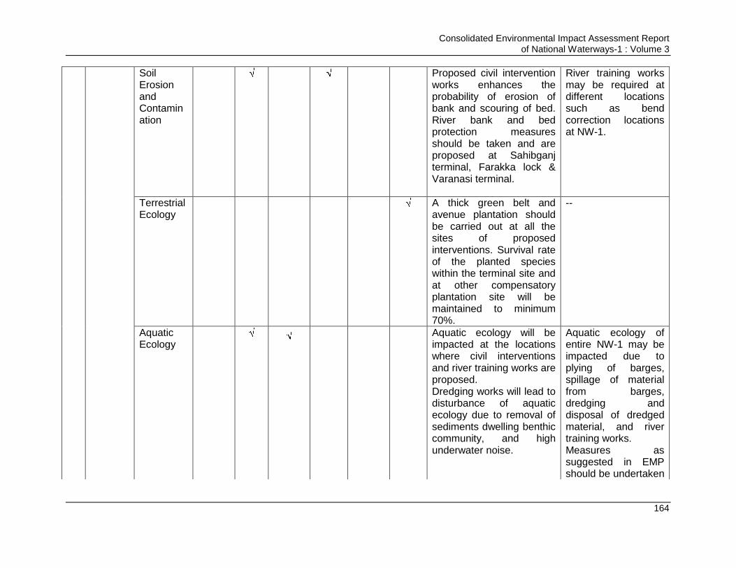
Consolidated Environmental Impact Assessment Report of National Waterways-1 : Volume 3
164
Soil Erosion and Contamination
Proposed civil intervention
works enhances the probability of erosion of bank and scouring of bed. River bank and bed protection measures should be taken and are proposed at Sahibganj terminal, Farakka lock & Varanasi terminal.
River training works may be required at different locations such as bend correction locations at NW-1.
Terrestrial Ecology
A thick green belt and avenue plantation should be carried out at all the sites of proposed interventions. Survival rate of the planted species within the terminal site and at other compensatory plantation site will be maintained to minimum 70%.
--
Aquatic Ecology
Aquatic ecology will be impacted at the locations where civil interventions and river training works are proposed. Dredging works will lead to disturbance of aquatic ecology due to removal of sediments dwelling benthic community, and high underwater noise.
Aquatic ecology of entire NW-1 may be impacted due to plying of barges, spillage of material from barges, dredging and disposal of dredged material, and river training works. Measures as suggested in EMP should be undertaken

Consolidated Environmental Impact Assessment Report of National Waterways-1 : Volume 3
165
so as to prevent the impacts on aquatic ecology of the area
Aesthetics
Will be improved due to development of infrastructure, green belt and other facilities.
--
Consolidated Environmental Impact Assessment Report of National Waterways-1 : Volume 3
166
4.7. Impact on Climate Change& Mitigation Measures
4.7.1. Meteorology of the NW-1 and the influence area
A. Meteorology:
The predominant wind direction in all IMD stations located along NW-1 is from North and
Northwest direction in winters and South and Southeast direction during rest of the
season. The wind speed in the area was mostly ranges between 1.9 km/hour at Patna
IMD and maximum of 8.7 km/hour at Kolkatta IMD for all the months of a year.
December and January constitutes winter months with daily mean minimum temperature
of around 9.10C at Patna (IMD Station) and daily mean maximum temperature of around
26.90C at Kolkatta. April and May are the hottest months with daily mean maximum
temperature varying around 40.40C at Varanasi and daily mean minimum temperature
around 240C at Malda. Relative humidity ranges between 25-84%. The annual total
rainfall in all IMD stations (representing respective city/towns) ranges between 1000.3
mm at Varanasi and 1728.5 mm at Kolkatta.
B. Visibility:
Visibility is of key concern for safe navigation all along NW1. There are occasions with
reduced visibility (characterised by the average number of days affected by fog) in NW-1
stretch. The time period over which fog is likely to affect the NW-1 route extends from
October to March inclusive. There is a subtle difference in the period of the year when
fog is more likely to affect navigation on different locations particularly the locations
falling nearer the coast (Haldia and Kolkata) are having a larger window over which fog
could occur (October to March). Berhampur is having the narrowest window (January to
March). The greatest probability of fog occurring at locations along the NW-1 route is
during January, the potential inland locations (Patna and Varanasi) to be affected by fog
on more than 50% of days during December and January. During such conditions, the
performance of vessel-mounted navigation aids, such as radar, may also be affected.
4.7.2. Climate Change Scenario in India:
Generally, IWT is considered more energy efficient and emit less CO2 per ton-km
performance compared to other two transport modes namely road or rail transport
modes. The average emissions from IWT mode range from 25 g CO2/ton-km to 70 g
CO2/ton-km. Whereas from road transport by truck it varies from 60-120 gr CO2/ton-km
and in the case of rail mode it varies from 20-80 g CO2/ton-km depending upon fuel use
transport capacity etc. In the case of IWT the variations are due to fleet structure, age
and engine of vessels, fuel use, market conditions etc. All these factors are associated
with IWT system efficiency which can be planned and managed to make the IWT system
more efficient. Besides, the impacts of climate change are required to be managed
depending upon the events occurring due to the changes in climate taking place. This
type of mitigation management is known as Adoption need in IWT facilities. For
example, as per World Bank report on impacts of changes in climate in India are
concerned, the erratic behaviour of Indian monsoon has become a reality and is
considered to be the major manifestation of climate change impacts in India. The
frequency of droughts or short spells of heavy rainfall events are now being experienced
Consolidated Environmental Impact Assessment Report of National Waterways-1 : Volume 3
167
at much higher rate. It is pertinent to mention that agriculture productivity is life line of
India. An abrupt change in the monsoon could precipitate a major crisis, triggering more
frequent droughts as well as greater flooding in large parts of India. Droughts are
expected to be more frequent in some areas, especially in north-western India,
Jharkhand, Orissa and Chhattisgarh. At 2.5°C warming, melting glaciers and the loss of
snow cover over the Himalayas are expected to threaten the stability and reliability of
northern India‟s primarily all glacier-fed rivers, particularly the Indus and the
Brahmaputra. The Ganges will be less dependent on melt water due to high annual
rainfall downstream during the monsoon season. As per WB reports downward trend of
river flow of the Indus, Ganges, and Brahmaputra rivers alone could significantly impact
irrigation, affecting the amount of food that can be produced in their respective river
basins thereby adversely impacting livelihoods of millions of people (209 million in the
Indus basin, 478 million in the Ganges basin, and 62 million in the Brahmaputra basin in
the year 2005). The Indus and the Ganges-Brahmaputra-Meghna Basins are the major
trans-boundary rivers, and the increasing demand for water is already leading to
tensions among countries over water sharing (World Bank).
4.7.3. Impact of Shift of Freight Movement to IWT Mode on Rate of Emissions of GHG:
Any transport system viz rail, road and IWT has emission of GHG. It is also well
established that different mode of transport has different intensity of GHG emission.
However, it is already established that when we talk about bulk cargo transportation,
IWT consumes the minimal fuel thus have associated minimal emissions and minimal
transportation cost
A detailed analysis of GHG emission to be emitted during cargo transportation in “with
and without project” scenario for all the three modes has been carried out to find out the
net GHG savings due to the project implementation in CIA report. It is estimated that in
IWT mode emissions will be generated during construction of the proposed infrastructure
due to material transportation, due to material transportation by IWT mode (barges) &
trucks within terminals during operation phase and due to dredging during operation
phase. These emissions were computed and were compared with emissions to be
generated vide road and rail mode. Comparison of emission generation due to freight
transportation vide rail, road & IWT mode and the savings of GHG emission for “With
project” scenario is given in Table 4.8. Emissions expected to be generated due to
material transportation during construction of the planned navigation infrastructure is
given in Table 4.9.
On comparison it was found that emissions generation in IWT mode is least and savings
in emission is 4875601.76 tonnes. From these savings emissions to be generated during
construction of the proposed infrastructure due to material transportation, due to material
transportation by trucks within terminals during operation phase and due to dredging
during operation phase were deducted and the net GHG savings are computed. Net
GHG emissions is estimated to be 4544037.4 tonnes. Net GHG savings due to project,
i.e. in “With project” scenario is given in Table 4.10.
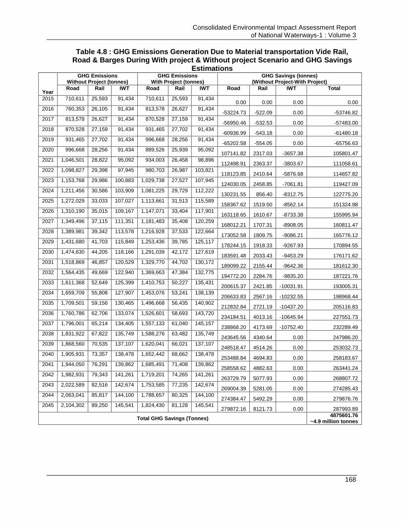
Consolidated Environmental Impact Assessment Report of National Waterways-1 : Volume 3
168
Table 4.8 : GHG Emissions Generation Due to Material transportation Vide Rail, Road & Barges During With project & Without project Scenario and GHG Savings
Estimations
Year
GHG Emissions Without Project (tonnes)
GHG Emissions With Project (tonnes)
GHG Savings (tonnes) (Without Project-With Project)
Road Rail IWT Road Rail IWT Road Rail IWT Total
2015 710,611 25,593 91,434 710,611 25,593 91,434 0.00 0.00 0.00 0.00
2016 760,353 26,105 91,434 813,578 26,627 91,434 -53224.73 -522.09 0.00 -53746.82
2017 813,578 26,627 91,434 870,528 27,159 91,434 -56950.46 -532.53 0.00 -57483.00
2018 870,528 27,159 91,434 931,465 27,702 91,434 -60936.99 -543.18 0.00 -61480.18
2019 931,465 27,702 91,434 996,668 28,256 91,434 -65202.58 -554.05 0.00 -65756.63
2020 996,668 28,256 91,434 889,526 25,939 95,092 107141.82 2317.03 -3657.38 105801.47
2021 1,046,501 28,822 95,092 934,003 26,458 98,896 112498.91 2363.37 -3803.67 111058.61
2022 1,098,827 29,398 97,945 980,703 26,987 103,821 118123.85 2410.64 -5876.68 114657.82
2023 1,153,768 29,986 100,883 1,029,738 27,527 107,945 124030.05 2458.85 -7061.81 119427.09
2024 1,211,456 30,586 103,909 1,081,225 29,729 112,222 130231.55 856.40 -8312.75 122775.20
2025 1,272,029 33,033 107,027 1,113,661 31,513 115,589 158367.62 1519.50 -8562.14 151324.98
2026 1,310,190 35,015 109,167 1,147,071 33,404 117,901 163118.65 1610.67 -8733.38 155995.94
2027 1,349,496 37,115 111,351 1,181,483 35,408 120,259 168012.21 1707.31 -8908.05 160811.47
2028 1,389,981 39,342 113,578 1,216,928 37,533 122,664 173052.58 1809.75 -9086.21 165776.12
2029 1,431,680 41,703 115,849 1,253,436 39,785 125,117 178244.15 1918.33 -9267.93 170894.55
2030 1,474,630 44,205 118,166 1,291,039 42,172 127,619 183591.48 2033.43 -9453.29 176171.62
2031 1,518,869 46,857 120,529 1,329,770 44,702 130,172 189099.22 2155.44 -9642.36 181612.30
2032 1,564,435 49,669 122,940 1,369,663 47,384 132,775 194772.20 2284.76 -9835.20 187221.76
2033 1,611,368 52,649 125,399 1,410,753 50,227 135,431 200615.37 2421.85 -10031.91 193005.31
2034 1,659,709 55,808 127,907 1,453,076 53,241 138,139 206633.83 2567.16 -10232.55 198968.44
2035 1,709,501 59,156 130,465 1,496,668 56,435 140,902 212832.84 2721.19 -10437.20 205116.83
2036 1,760,786 62,706 133,074 1,526,601 58,693 143,720 234184.51 4013.16 -10645.94 227551.73
2037 1,796,001 65,214 134,405 1,557,133 61,040 145,157 238868.20 4173.69 -10752.40 232289.49
2038 1,831,922 67,822 135,749 1,588,276 63,482 135,749 243645.56 4340.64 0.00 247986.20
2039 1,868,560 70,535 137,107 1,620,041 66,021 137,107 248518.47 4514.26 0.00 253032.73
2040 1,905,931 73,357 138,478 1,652,442 68,662 138,478 253488.84 4694.83 0.00 258183.67
2041 1,944,050 76,291 139,862 1,685,491 71,408 139,862 258558.62 4882.63 0.00 263441.24
2042 1,982,931 79,343 141,261 1,719,201 74,265 141,261 263729.79 5077.93 0.00 268807.72
2043 2,022,589 82,516 142,674 1,753,585 77,235 142,674 269004.39 5281.05 0.00 274285.43
2044 2,063,041 85,817 144,100 1,788,657 80,325 144,100 274384.47 5492.29 0.00 279876.76
2045 2,104,302 89,250 145,541 1,824,430 81,128 145,541 279872.16 8121.73 0.00 287993.89
Total GHG Savings (Tonnes) 4875601.76
~4.9 million tonnes
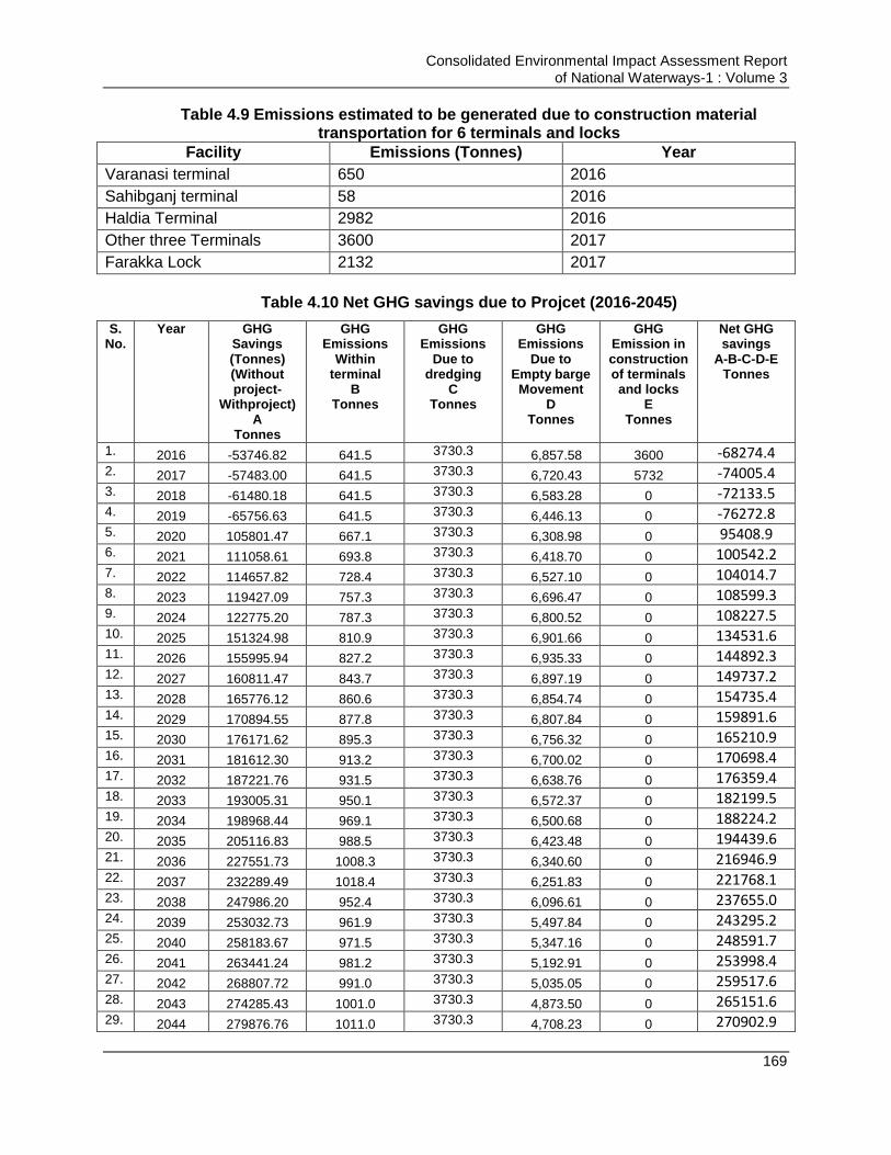
Consolidated Environmental Impact Assessment Report of National Waterways-1 : Volume 3
169
Table 4.9 Emissions estimated to be generated due to construction material transportation for 6 terminals and locks
Facility Emissions (Tonnes) Year
Varanasi terminal 650 2016
Sahibganj terminal 58 2016
Haldia Terminal 2982 2016
Other three Terminals 3600 2017
Farakka Lock 2132 2017
Table 4.10 Net GHG savings due to Projcet (2016-2045)
S. No.
Year GHG Savings (Tonnes) (Without project-
Withproject) A
Tonnes
GHG Emissions
Within terminal
B Tonnes
GHG Emissions
Due to dredging
C Tonnes
GHG Emissions
Due to Empty barge
Movement D
Tonnes
GHG Emission in construction of terminals and locks
E Tonnes
Net GHG savings
A-B-C-D-E Tonnes
1. 2016 -53746.82 641.5 3730.3 6,857.58 3600 -68274.4 2. 2017 -57483.00 641.5 3730.3 6,720.43 5732 -74005.4 3. 2018 -61480.18 641.5 3730.3 6,583.28 0 -72133.5 4. 2019 -65756.63 641.5 3730.3 6,446.13 0 -76272.8 5. 2020 105801.47 667.1 3730.3 6,308.98 0 95408.9 6. 2021 111058.61 693.8 3730.3 6,418.70 0 100542.2 7. 2022 114657.82 728.4 3730.3 6,527.10 0 104014.7 8. 2023 119427.09 757.3 3730.3 6,696.47 0 108599.3 9. 2024 122775.20 787.3 3730.3 6,800.52 0 108227.5 10. 2025 151324.98 810.9 3730.3 6,901.66 0 134531.6 11. 2026 155995.94 827.2 3730.3 6,935.33 0 144892.3 12. 2027 160811.47 843.7 3730.3 6,897.19 0 149737.2 13. 2028 165776.12 860.6 3730.3 6,854.74 0 154735.4 14. 2029 170894.55 877.8 3730.3 6,807.84 0 159891.6 15. 2030 176171.62 895.3 3730.3 6,756.32 0 165210.9 16. 2031 181612.30 913.2 3730.3 6,700.02 0 170698.4 17. 2032 187221.76 931.5 3730.3 6,638.76 0 176359.4 18. 2033 193005.31 950.1 3730.3 6,572.37 0 182199.5 19. 2034 198968.44 969.1 3730.3 6,500.68 0 188224.2 20. 2035 205116.83 988.5 3730.3 6,423.48 0 194439.6 21. 2036 227551.73 1008.3 3730.3 6,340.60 0 216946.9 22. 2037 232289.49 1018.4 3730.3 6,251.83 0 221768.1 23. 2038 247986.20 952.4 3730.3 6,096.61 0 237655.0 24. 2039 253032.73 961.9 3730.3 5,497.84 0 243295.2 25. 2040 258183.67 971.5 3730.3 5,347.16 0 248591.7 26. 2041 263441.24 981.2 3730.3 5,192.91 0 253998.4 27. 2042 268807.72 991.0 3730.3 5,035.05 0 259517.6 28. 2043 274285.43 1001.0 3730.3 4,873.50 0 265151.6 29. 2044 279876.76 1011.0 3730.3 4,708.23 0 270902.9
Consolidated Environmental Impact Assessment Report of National Waterways-1 : Volume 3
170
S. No.
Year GHG Savings (Tonnes) (Without project-
Withproject) A
Tonnes
GHG Emissions
Within terminal
B Tonnes
GHG Emissions
Due to dredging
C Tonnes
GHG Emissions
Due to Empty barge
Movement D
Tonnes
GHG Emission in construction of terminals and locks
E Tonnes
Net GHG savings
A-B-C-D-E Tonnes
30. 2045 287993.89 1021.1 3730.3 4,539.16 0 279183.7 Total 4875602 25986 111909 187230.5 9332 4544037.4
Net GHG savings from Proposed Jal Marg Vikas Project is estimated to be 4544037.4
tonnes. These emissions can be further reduced by design and operational measures.
Measures for Avoidance and Mitigation of Impacts
Adoption of modern designed vessels to be operated having more load carrying
capacity and less draught requirement.
Operating the freight vessels at slow speeds to increase the fuel efficiency and
reducing the emissions.
Adoption and strictly adhering to the standards as prescribed by MARPOL for
managing the emissions.
Switching to LNG based vessels. LNG is not only cleaner but have comparatively
higher calorific value than gasoline and diesel.
4.7.4. Impact on Micro Climate of NW1 due to Civil Interventions:
A. Impacts During Design & Construction Phase
Impact during design and construction phase can be co-related with the increased CO2
emission due to the associated activities. CO2 emissions increase is also associated with
various other NW1 project activities such as burning of fossil fuels in the vehicles, DG
sets and construction equipment & machinery and cutting of existing vegetation. CO2
being one of the most potential GHG will contribute in increasing GHG concentration and
associated increased average temperature/climate change phenomenon. At this stage
the proposed facilities include 3 terminal sites and 1 lock site to be developed. No major
tree cuttings are anticipated with the development of Farakka lock site, Haldia terminal
site and Varanasi site. However, app. 500 trees are to be cut for development of
Sahibganj terminal site. Cutting of app. 500 trees may lead to sequestration of app. 855
tons of carbon.
Measures for Avoidance and Mitigation of Impacts
Planning and design of the project layout should be done so as to minimize the
clearance of existing vegetation and felling of trees
Permission from DFO should be taken prior undertaking any tree cutting.
Compensatory plantation should be carried out as per state forest policy. Apart from
compensatory plantation additional plantation should also be carried out so to
recover the Carbon sequestration earlier. Considering average life cycle of trees as
30 years, the number of trees to be planted against loss should be 30 times to
Consolidated Environmental Impact Assessment Report of National Waterways-1 : Volume 3
171
recover in one year, but, it is not feasible practically, thus ratio of compensatory
plantation should be kept as much as possible. In case of Sahibganj terminal project,
compensatory plantation will be carried out in ratio of 1:7 (1:2-mandatory & 1:5
additional). Thus 3500 trees (1000-mandatory & 2500-additional) will be planted in
place of 500 trees cut. Plantation of additional 2500 trees will help in recovering
Carbon sequestration in 5-6 years in place of 6-7 years.
In terms of Carbon value, trees of high Organic Carbon contents31 need to be
planted more for faster recovery of C loss.
Project design should incorporate usage of low embodied energy building &
construction material, energy efficient electric equipment, water conservation fixture,
and rain water harvesting measures to make project energy efficient and sustainable
and to minimize the associated emissions and discharges.
All terminal buildings should have energy efficient design. It should follow GRIHA
guidelines and aim for highest ratings under GRIHA.
Minimizing the resource requirement and waste generation through best
management practices like re-use, reduce, recycle and recover.
B. Impacts During Operation Phase
Operation phase of these interventions will not have any significant impact on climate
change drivers or climate change. However, GHG emissions are expected due to
transportation of material to & fro from terminal site, material handling within the terminal
sites, operation of the machinery/equipment/pumps and operation of DG sets. Though
these emissions will not be significant enough however these may increase in a situation
like traffic congestions if to and fro or on terminal traffic is not managed effectively. The
Inland transportation will result in overall GHG emission due to model shift from rail and
road to IWT as per analysis carried out in section 5.6.
Measures for Avoidance and Mitigation of Impacts
Management of the traffic carrying cargo to be received at the terminal/jetty site by
fixing the hours and route of transportation
Development of adequate road/rail infrastructure for transportation of material to &
fro from terminal/jetty site to minimize the emission generation due to traffic
congestion
Usage of low sulphur diesel/CNG based vehicles to transport the material
Adoption of energy efficient machinery for material handling & barge loading to
minimize energy consumption
Adoption of 4Rs, i.e. Reduce, Re-use, Recycle and Re-use for material use and fuel
consumption
Ensuring survivability of the plantation within site and at other locations under Jal
Marg Vikas project to minimum 70%.
31
Mid-term and long-term rotational species like Jamun and Aam (Mango) are referred. These are species with life span ranging
from 20 to 100 years approximately
Consolidated Environmental Impact Assessment Report of National Waterways-1 : Volume 3
172
Adoption of clean energy options like solar energy, designing building to obtain
green building rating of Platinum level etc.
4.7.5. Conclusion (Climate Change)
From the above discussion, it can be concluded that overall GHG emissions will reduce
after operationalization of the NW-1 due to shift of freight from road/rail to NW-1.
However, the GHG emissions near the civil interventions may increase due to enhanced
traffic movement in nearby areas and within terminal areas. The emission may also
increase due to tree cutting which may be required for development of these
terminals/locks. Tree cutting reduces the carbon sequestration potential of that area
thereby leading to persistence of CO2 (potential GHG) in atmosphere for longer time. But
with the various mitigation measures like compensatory plantation, maintenance of thick
green belt around the site boundary & along the road, usage of mechanical conveying
system for material transportation inside the terminal can reduce the GHG emissions
significantly.
4.8. Impact Due to Natural Disasters & Mitigation Measures
Natural hazard anticipated at the site are floods, cyclones and earthquake. As per
seismic zone map of India, India is divided into 4 seismic zones, i.e. zone 2, 3, 4 &5.
Zone 2 is least hazard zone and zone 5 is most hazardous zone. NW-1 traverses
through 4 states namely: Uttar Pradesh, Bihar, Jharkhand and West Bengal. As per
seismic zone map of India, these states fall under category III & IV, i.e. moderate and
high damage risk zone. Thus it is essential to take this in consideration while designing
the structure of proposed intervention so as the site can withstand the earthquake of
moderate and high intensity.
All the interventions will be developed along the river thus are prone to the flooding. The
intervention should be designed considering the 50 years return HFL level of the river.
Finished level of both the off-shore & on-shore structures should be above the HFL of
river to prevent the flood hazard. Bunds/levees should be constructed along the
stretches which floods heavily leading to high damage. At Haldia terminal site,
embankments are already developed along the river by Haldia Dock Complex thus the
site is not prone to flooding. Further flood protection measures are proposed at the site.
Another natural hazard associated with the project is cyclone. Only the Haldia site is
prone to cyclone. As per cyclone hazard map of India, region lies in very high cyclone
prone area. Also the tidal variations are high in Haldia region. Thus safety and
prevention measures should be included in project design to minimize the damage due
to these events. Cyclone threat is not anticipated at any other planned or proposed civil
intervention site.
Apart from above natural disasters other occupational disasters may also occur at the
site like electricity fire, fall/trip, injury, fire in stored oil etc. These hazards can be
mitigated if adequate emergency preparedness plan is in place and followed during
emergency situation.
Consolidated Environmental Impact Assessment Report of National Waterways-1 : Volume 3
173
Measures for Avoidance and Mitigation of Impacts:
Structure design of the building should be prepared considering the seismicity of the
area and building should be designed for one higher seismic zone.
All structures should be designed above the HFL of the river for 50 years return flood
period.
Adequate fire-fighting facilities/infrastructure should be provided at each intervention
site
Mock drills should be conducted for the workers to handle various emergency
situations like floods, earthquake, cyclones etc.
Emergency response cell should be developed for each site to take care and handle
the expected emergency situation
Emergency collection area and emergency control room should be provided at the
site. Display of emergency contact nos. should be made in the emergency room and
at other site locations. Emergency cell should be comprising of personnel well
trained in health & safety management at sites
Fuel should be stored in isolated location in HDPE tanks along with firefighting
facilities provided at all fuel storage locations.
Entry to high risk area like electrical panels, control room, HT lines, fuel storage area
should be restricted only for authorized & trained personnel
Ensure availability of the first aid & ambulance facility at each site
Tie-ups with the local hospitals of the area to handle various emergency situations
Regular supervision and maintenance for adequacy and intactness of the flood
control measures provided at each site
Nearest cyclone shelter should be notified to all the workers at the site
Regular health check-ups should be conducted for the workers at site to detect the
occupational hazards if any.
4.9. Impact Due to Shifting of Existing Utilities& Mitigation Measures
Utility shifting may be required to be carried out at the sites where civil interventions are
proposed. No utility shifting is required at Varanasi terminal. However, at Farakka site a
FBP road will require to be realigned and at Haldia site existing ammonia pipe line of
Tata Chemical plant and a road to Mitsubishi plant are required to be shifted. Shifting of
these utilities may cause substantial inconvenience to users depending on the nature of
utility to be shifted.
Measures For Avoidance of Impacts:
Shifting of any utility should be carried out prior to the start of construction and with
consent of users to minimize the disturbance to them.
Users should be pre-informed about the shifting of utility and support should be
provided to users for alternate arrangement as feasible to minimise inconvenience to
existing users.
Consolidated Environmental Impact Assessment Report of National Waterways-1 : Volume 3
174
4.10. Impact on Land Environment& Mitigation Measures
4.10.1. Status of land environment along NW-1 and influence area
A. Land Use: Land use within the 10 km Radius of the NW-1 is majorly dominated by agricultural land.
About 78.9 % of the land is under cultivation; about 7.18% land is under settlement,
7.21% of the land is under water bodies, about 3.59% land is under vegetation, 2.82%
land is under dry river bed and rest of the land falls under other uses.
B. Cropping Pattern: The Ganga River with its fertile soil is having a great influence to the agricultural
economies of adjoining district along the NW-1. The Ganges and its tributaries provide a
constant source of irrigation water catering to the agricultural needs of an extensive area
along the NW-1. The major crops cultivated in that area include rice, lentils, sugarcane,
potatoes, oil seeds and wheat. Along the banks of the river, the existence of swamps
and lakes also provide a rich fertile soil for crops like legumes, chilies, sesame, mustard,
sugarcane, and jute.
C. Soil Quality: Most of the NW-1 stretch is dominated by alluvial soil type. The entire alluvial formation
is endowed with rich soil nutrients. Soil texture along the NW-1 can be described as
Sandy Clay, Sandy Loam and Clay Loam type. Soils along the NW-1 are generally
neutral to slightly alkaline nature. Overall soil along the NW-1 area is of moderately
fertile and not expected to be detrimental to the growth of agricultural and forest crops.
D. River Bed Sediments Quality: The concentration level of heavy metal was found low in concentration and within
acceptable limit as per standard (Criteria for Off-Shore Dumping of Dredged Material,
USA) except cadmium which is slightly above the USA standard at some location in UP
stretch that may be due to industrial effluent discharge in this section. Pesticide
concentration in all sample were found far below the USA criteria. The pesticides
presence is on expected line as these are predominantly used for various agriculture
applications. The source of these pesticide parathion and endosulphan might be from
indiscriminate applications of insecticides and pesticides for agriculture.
E. Existing Waste Management Facilities along NW-1: The municipal and bio-medical waste management facility is available at select cities like
Allahabad, Varanasi, Patna, Kolkatta and Haldia in the entire stretch of NW-1. Common
Hazardous waste facility is available only at Haldia in NW-1 area.
4.10.2. Impacts on Land Environment due to Maintenance Dredging for maintaining minimum LAD in navigation channel
Impact due to maintenance dredging on land environment is anticipated only due to
dredge disposal. On land/on shore disposal is proposed only in case the river bed
sediments are contaminated or in case of Haldia terminal dredging. On land or on shore
disposal of river bed sediment has the potential to impact soil quality and as the excess

Consolidated Environmental Impact Assessment Report of National Waterways-1 : Volume 3
175
water in sediments leaches down to ground can also affect the ground water quality. If
sediments contain heavy metals or any toxins, then the soil quality of the area may get
affected and these pollutants may travel along with the seeping leachant.
If the dredged material is disposed on land near the water body in form of slurry, excess
water drains back to the water body thereby polluting it. This excess water may contain
significant sediment load and constituent of land surface which may pollute the water
quality and also may affect the shallow water area of the river which may even be
breeding or spawning ground.
In case situation arise for disposal of dredge sediments on river banks or land, the
impact intensity would vary depending on the site sensitivity. For example, location of
Eco sensitive receptors, presence of places of cultural importance, presence of
spawning and breeding grounds, presence of archeologically protected places.
Measures for Avoidance and Mitigation of Impacts
Mitigation measures are proposed considering for the action required at design and
operation stage of the project.
Standards should be developed by concerned authorities for onshore and off-shore
dredged material disposal and development of the process to ensure its compliance
Dredged material should be checked for toxicity and contamination prior its disposal
for prevention of contamination of water and its impacts on aquatic life. International
standards for judging onshore & off-shore disposal of dredged material are given in
Annexure 4.1 ( Volume 3C).
If any stage onland disposal of dredge material is planned, then dewatering of the
dredged sediments should be carried out prior to onland disposal.
If dredge material is found contaminated at any particular location then it should be
disposed on land after decontamination. Onland disposal of dredged material should
be carried out only at approved TSDF site such as approved TSDF site of Haldia
Dock Complex at Sagar. The contaminated dredge material should be collected in
the leak proof container for decontamination and disposal to the landfill site.
The disposal facilities should be designed with adequate liners to contained the
leachate and also should have provision of leachate collection and testing to
periodically check the functionality of the disposal site.
Dredge material should not be disposed in river banks;Disposal should be in line with
the dredging sensitivity analysis defined at Table 4.4.
If dredged material is disposed on land, then the care should be taken that the tail
water is collected and made free from sediments prior to its discharge back to
surface water body.
4.10.3. Impact on Land Environment Due to Operations- Barge Movement
Barge movement generates the ripples and waves which have potential to affect the
river banks and the structures at river banks if proper mitigation measures are not taken.
Waves generated due to vessel movement are of varied intensity and depends on
vessel‟s speed, hull shape, and draft. The River Ganga has wide width and navigational
channel mostly to be confined in middle reached of the river. Bank erosion due to vessel
Consolidated Environmental Impact Assessment Report of National Waterways-1 : Volume 3
176
movement is anticipated to be minimal along NW-1 except at Farakka feeder canal
which has smaller width and has eroding banks and at bends or at narrow stretches of
river. Erosion can be prevented by taking avoidance and mitigation measures as given
below.
Waste generated from barges if disposed off at the terminal facilities or nearby areas
may impact the soil quality. Thus control measures should be taken to prevent any
unaurhorized waste/sewage dumping so as impact can be avoided.
Measures for Avoidance and Mitigation of Impacts
Restricting the ship speed in the stretches where river is narrow and in feeder canal
to prevent impact on the river banks.
Entire stretch of NW-1 should be studied and speed regulations should be made for
the different sections in the NW-1 as per sensitivity to erosion
River bank protection works should be carried out at the bank locations which are
prone to erosion. Opt for the bank protection measures in feeder canal to maintain
the speed of the barges.
All barges should have zero discharge facility they should have sewage treatment
systemon board along with treated sewage storage facility. It should also have facility
to store for the storage of other domestic and maintenance and material handling
waste.
Each barges should dispose these wastes at barge maintenance facilities. In
absence of these facilities such waste should be disposed of at terminals. Each
terminal should have the facility for suction and treatment of treated sewage from the
barges and facility to handle all kind of wastes generated at the barges. These
services can be provided to the barge operators on chargeable basis.
4.10.4. Impacts on Land Environment Due to Physical Interventions
A. Pre-Construction/Design and Construction Stage
Typical impact associated with land environment component during design and
construction stage of implementation of proposed civil interventions are listed below
Change in land use& Loss of agricultural land and/or fertile agricultural soil
Land acquisition
Change in topography
Soil quality deterioration due to spillage of fuel/paint, disposal of muck or soil
contamination with other construction material
i. Impact on Land Use& Land Acquistion
Development of terminals/jetty or other proposed structures under NW-1 can be in
general classified under industrial/transportation infrastructure category. Development of
these intervention will cause changes from pristine land use class. Varanasi site (5.685
ha) is already under possession of IWAI. However additional land of 1.415 ha is required
to be acquired to provide connectivity to terminal site with NH-7 which is agricultural
land. For development of Sahibganj terminal, total 78.91 ha of land will be required
including road & rail connectivity. For phase I, 23.98 ha of land will be required and
Consolidated Environmental Impact Assessment Report of National Waterways-1 : Volume 3
177
remaining 54.93 ha will be required for phase II. Acquistion of 45.20 ha has been
initiated by IWAI. Thus change in land use is associated at Varanasi & Sahibganj sites.
Land at Farakka is Government land and has been transferred to Ministry of Shipping,
with IWAI the custodian. Haldia site currently lie within industrial zone of Haldia Dock
Complex (HDC) and no changes in land use is anticipated at this site. Land of 24.68 ha
has been leased out by HDC to IWAI for 30 years.
ii. Impact on Topography
Varanasi site is slightly undulating with elevation varying from RL+74.0 to RL +77.0.
Sahibganj site is highly undulating with level difference of 16 m and elevation range
within 30-56 amsl. Excess unused muck of 12.1 lakh cum will be generated at the
Sahibganj site. Haldia terminal site is a low lying area with elevation variation of 4-9 m
amsl. Site requires additional filling of 3.3 lakh cum to achieve the desired level above
HFL of Hoogly river. Farakka lock site is also undulating with elevation variation of
RL+13-RL+29 m. To achieve the requisite level of 28.44 m so as the site is above HFL
excess muck of 7.63 cum will be generated from the proposed Farakka site. So such
preconstruction land levelling tasks will disturb the natural topography of the site.
Excavation and filling tasks at site will lead to the loss of precious top soil. As the soil of
the intervention sites being from agricultural lands thus site development tasks will lead
to a loss of fertile top soil. Such land use or topographical changes are permanent in
nature but the resultant impacts will not be significant once mitigated properly as the
project is to be implemented keeping the overall associated economic gains of the
region.
iii. Impact on Soil Quality
Construction waste (debris, unused iron bars or damaged support structures, quarry
dustetc.) if discarded or duped in river in an uncontrolled manner may affect soil of the
site or river water quality. Fuel oil/lubricants/chemicalsmay be stored at site thus the
occurrence of accidental fuel spillage or leakage cannot be ruled out which eventually
can contaminate the adjoining soil strata. Such soil contamination can be severe in case
of voluminous leakage. Thus the mitigation measures are required to be taken to prevent
the spillages & leakages so as the impacts arising due to oily spillages can be
minimized.
Movement of construction vehicles and equipment may lead to soil compaction on
haulage roads as well as nearby areas. Soil may also be contaminated due to
inappropriate disposal of used oil, lubricating oil, fuel, waste oil, effluent from
vehicle/equipment washing area and oily solid waste (fuel filters, oily rags) which are
likely to be generated from repair and maintenance of transport vehicles, construction
equipment and machinery. Soil may also be contaminated due to inappropriate and
untreated disposal of domestic solid waste and sewage from construction camps and
toilets at site. Such contamination can be prevented by taking appropriate measures for
mitigation of impacts. Also these impacts are short term confining to construction period
only and will not be of high significance.
Apart from this dredging will be required for construction of off-bank structures like
berths & jetties. Construction of jetty at Sahibganj will require dredging of 0.15 million
cum of river sediments and construction of jetties & berths at Haldia will require dredging

Consolidated Environmental Impact Assessment Report of National Waterways-1 : Volume 3
178
of 0.7 million cum river sediments. The river dredge material is not found contaminated
(refer Table 4.59 for dredge material quality) and should be disposed-off by the
contractor at site as per norms proposed under mitigation. Uncontrolled disposal of large
quantity of dredged material on the banks may contaminate the productive site or
aesthetic of disposal area which can be prevented by implementing dredging
management plan which is provided as standalone EMP in Volume 9. The dredged
sediments can also be used as fillers (for cut and fill tasks for land levelling) where ever
required.
Measures for Avoidance and Mitigation of Impacts
Excavation and filling tasks should be carried out in parallel so as to minimize the
soil erosion. Unusable debris material should be suitably disposed at pre
designated disposal locations, with approval of the concerned authority.
Compaction of soil should be undertaken by controlled sprinkling the water to
minimize the surface runoff and erosion.
Agricultural land should not be selected for setting up construction camps,
borrow area (if any), plant site or any other construction purpose
Well-designed water sprinkling to be carried out for dust suppression
15 cm of top soil layer should be stripped off prior to excavation and should be
stored separately in covered condition and used for landscaping purpose at a
later stage. This should be stored in the form of the heap with the slide slopes
covered with grass
Remaining excavated soil should be used for filling purpose and left over should
be stored in covered conditions for use in future for construction of approach
road & railway connectivity and mine rehabilitation located at 4-5 km from site.
The soil storage location should be identified in advance in consultation with
PWD which is likely to construct the approach road.
Dredge soil should also be either utilised for construction activity or disposed
along with excavated soil to the identified debris disposal site
Fuel should be stored in HDPE containers on paved surfaces with provision of
catchment pit to prevent soil contamination from oil spillages.
Arrangement should be made for segregation of municipal solid waste into
recyclable and non-recyclable waste
Non-recyclable waste generated should be disposed regularly through authorized
agency. Recyclable waste should be sold to authorized vendors
Construction waste generated should be segregated at site into recyclable,
reusable & rejected fraction. Recyclable should be sold to authorized vendor,
reusable waste should be stored at site for usage and rejected fraction should be
disposed at designated sites by the municipal authority
If no debris or waste disposal site exists in the area then a site should be
identified by contractor for debris disposal, should be approved by IWAI and
should be used & manage for the same as per the Debris Management Plan
Septic tank or mobile toilets fitted with anaerobic treatment facility should be
provided at construction camp
Consolidated Environmental Impact Assessment Report of National Waterways-1 : Volume 3
179
Aggregates will be sourced from existing licensed quarries. Copies of consent/
approval / rehabilitation plan for a new quarry or use of existing source will be
obtained by DBOT contractor and submitted to IWAI.
Geometric adjustment should be made if required and technically safe to
minimise cutting of the tree for rail & railway construction. Separate provision
should be made for compensatory tree plantation if any tree cutting is carried out
for construction of road & railway link32.
Hazardous waste like used oil from DG sets should be stored in HDPE
containers and should be stored on paved surfaces in isolated location to prevent
its spillage and contamination of soil. Used oil should be disposed through
authorized vendors only.
Movement of construction vehicles should be restricted to the designated
haulage roads only to prevent compaction of soil in other areas
The earth stockpiles to be provided with gentle slopes to prevent soil erosion.
Sedimentation tanks should be provided with storm water drain to arrest the
sediments and these sediments should be removed and stored with remaining
excavated soil
Provision of cross drainage structure like culverts should be made in the access
road if required to maintain the natural drainage pattern and prevent soil erosion.
Provision of side drain should be made in access road if required to prevent
water logging.
Shore protection works like stone pitching, and geo-textile matting along the bank
and construction of stone apron in the river to prevent the scouring of banks
should be undertaken
Bio-turfing of embankments should be made enhance the slop stabilization
Wash-off from concrete mixing tanks and wash from washing area should not be
allowed to enter the soil. This wash should be collected through drains into tanks
and concrete should be settled, collected, dried and re-used in the site again.
B. Operation Stage
Solid waste to be generated during the operation phase includes waste generated at
terminal sites and waste generated in vessels which is to be received at terminal sites till
the time vessel maintenance and repair facility is developed. The waste may include
food waste, plastic, metal tins, papers, dredged sediments, STP sludge, e-waste and
used oil from DG sets at terminal site and. These impacts could be significant and may
persist for long periods if left unadressed and unless mitigated. Hence, appropriate
mitigation measures are warranted to minimize the impacts.
32
Approach rroad construction is proposed to be undertaken by other agency PWD and road design shall be evolved by them only.
Rail link construction will also be taken up by railways
Consolidated Environmental Impact Assessment Report of National Waterways-1 : Volume 3
180
Measures for Avoidance and Mitigation of Impacts
Fuel should be stored in HDPE containers on paved surfaces only to prevent
spillage of fuels on the soil and thus soil contamination
Periodic checking to be carried to assess the effectiveness of the stabilization
measures viz. turfing, stone pitching, river training structures etc.
Necessary checks and actions are required wherever there are failures
Dustbins should be provided at all the required locations at the site for collection
of recyclable and non-recyclable waste. Recyclable waste should be sold to
authorized vendors and non-recyclable waste should be disposed through
authorized agencies and should not be dumped in open.
Used oil from DG sets and other equipment should be stored in HDPE containers
in isolated location on paved surfaces and should be disposed through
authorized vendors only and should not be dumped in open.
Room should be provided for storage of E-waste at site and this waste should be
sold to authorized vendors periodically and should not be dumped in open.
Bio- medical waste likely to be generated at first aid centre should be disposed of
following the bio medical waste disposal rules.
Municipal waste generated at terminal should either be sent for landfilling through
authorized agencies or should be composted within the terminal site and manure
should be used for maintaining the green area within the site
Vessel waste reception facility should be available at the terminal site incase
maintenance facility is not in place. The waste should be received from the
vessel in proper segregated and packed form.. This waste should be treated and
disposed within the terminal site only but in case it is not feasible, tie ups with
Government and authorized private agencies can be made for handling,
treatment, storage and disposal of this waste. Also fee can be imposed on the
vessel operator for letting them dispose their waste at terminal/maintenance
facilities.
4.10.5. Conclusion (Land Environment)
From the above discussion, it can be concluded that the land use &soil quality of the
influence area may be impacted majorly due to development of civil interventions if
proper mitigation measures are not taken. To mitigate the impact, efforts are done to
identify non-agricultural lands for development of these facilities. However, at some
sites, this cannot be avoided due to unavailability of non-agricultural land along the river,
e.g. Sahibganj.
Soil quality can be impacted, if sewage and waste from civil intervention sites and from
vessels is not managed properly and disposed of in soil. Thus, it is essential to develop
waste reception and management facility so as to prevent degradation of the soil quality
near banks. Another threat to soil quality can be due to disposal of contaminated river
bed sediments in soil. Thus disposal should preferably be carried out within water or in
the designated TSDF sites only,to prevent soil contamination. Impacts are avoidable and

Consolidated Environmental Impact Assessment Report of National Waterways-1 : Volume 3
181
mitigable and thus will not affect the sland environment significantly if all the proposed
mitigation measures are implemented.
4.11. Impact on Air Environment& Mitigation Measures
4.11.1. Status of air quality along NW-1 and influence area
Ambient air quality monitoring was carried within the respective critical impact zones as
per CPCB guidelines. PM2.5, PM10, SO2, NO2 and carbon monoxide were monitored at
different locations in the influence area. Particulate Matter PM10 level at proposed and
planned terminal and existing jetty locations along NW-1 varies from 39 to 145µg/m3.
PM10 values in all locations are within the specified limit of 100 g/m3 except at Varanasi,
Patna and Howrah location. PM2.5 levels were found ranging from 16 to 58 µg/m3. All
value of PM2.5 is within the specified limit of 60 g/m3 except Varanasi, Patna and
Howrah locations. Background level of SO2 ranged from 4.4 to 35.6µg/m3. The NOx
levels were found ranges between 9.0 to 48µg/m3. The observed SO2 and NOx level was
found within the national Ambient Air Quality Standard. Carbon Mono-oxides was
detected in few locations i.e. Haldia, Howrah, Patna and Varanasi. The 8hrs CO level
was found ranging between 0.18 to 1.2 mg/m3, which is found within the national
Ambient Air Quality Standard.
The PM (particulate matter) level in Varanasi, Patna and Howrah is slightly above the
national ambient air quality standard (NAAQS) that is because of heavy traffic movement
and presence of industries in these cities.
4.11.2. Impacts on Air environment due to Maintenance Dredging for maintaining minimum LAD in navigation channel
Dredging does not significantly affect the air quality, but operation of dredgers involves
generation of emissions which may have effect on the air quality. However, the impact
anticipated are localized and short term as it will be confined for the duration for which
dredger will be operated and to the area where the dredger will be operated. Measures
are proposed so as to minimize the emissions from dredger and the anticipated impacts.
Measures for Avoidance and Mitigation of Impacts
Development of emission standards by concerned authorities for regulating the
dredgers emissions and development of process to ensure its compliance
Usage of low sulphur content fuel
Adoption of electrically operated dredgers
Optimizing the dredging requirement
Provision of stack of adequate height for dispersion of pollutants
Adoption of catalytic reduction/convertor technology for dredgers also so as to
minimize the emissions
Adoption of the dredgers with most modern design which may have low fuel
requirement, more efficient pumps, low resistance hull design and optimal jet
system.
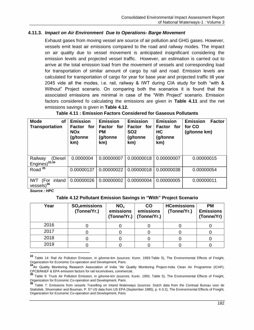
Consolidated Environmental Impact Assessment Report of National Waterways-1 : Volume 3
182
4.11.3. Impact on Air Environment Due to Operations- Barge Movement
Exhaust gases from moving vessel are source of air pollution and GHG gases. However,
vessels emit least air emissions compared to the road and railway modes. The impact
on air quality due to vessel movement is anticipated insignificant considering the
emission levels and projected vessel traffic. However, an estimation is carried out to
arrive at the total emission load from the movement of vessels and corresponding load
for transportation of similar amount of cargo by rail and road. Emission levels are
calculated for transportation of cargo for year for base year and projected traffic till year
2045 vide all the modes, i.e. rail, railway & IWT during CIA study for both “with &
Without” Project scenario. On comparing both the scenarios it is found that the
associated emissions are minimal in case of the “With Project” scenario. Emission
factors considered fo calculating the emissions are given in Table 4.11 and the net
emissions savings is given in Table 4.12.
Table 4.11 : Emission Factors Considered for Gaseous Pollutants
Mode of Transportation
Emission Factor for NOx (g/tonne km)
Emission Factor for PM (g/tonne km)
Emission Factor for SO2 (g/tonne km)
Emission Factor for HC (g/tonne km)
Emission Factor for CO (g/tonne km)
Railway (Diesel
Engines)33,34
0.0000004 0.00000007 0.00000018 0.00000007 0.00000015
Road 35 0.00000137 0.00000022 0.00000018 0.00000038 0.00000054
IWT (For inland vessels)36
0.00000026 0.00000002 0.00000004 0.00000005 0.00000011
Source : HPC
Table 4.12 Pollutant Emission Savings in “With” Project Scenario
Year SO2emissions (Tonne/Yr.)
NOx
emissions (Tonne/Yr.)
CO emissions (Tonne/Yr.)
HCemissions (Tonne/Yr.)
PM Emissions (Tonne/Yr)
2016 0 0 0 0 0
2017 0 0 0 0 0
2018 0 0 0 0 0
2019 0 0 0 0 0
33
Table 14: Rail Air Pollution Emission, in g/tonne-km (sources: Kurer, 1993-Table 5), The Environmental Effects of Freight,
Organization for Economic Co-operation and Development, Paris 34
Air Quality Monitoring Research Association of India “Air Quality Monitoring Project-India Clean Air Programme (ICAP),
CPCB/MoEF & EPA emission factors for rail locomotives, commercial. 35
Table 9: Truck Air Pollution Emission, in g/tonne-km (sources: Kurer, 1993, Table 5), The Environmental Effects of Freight,
Organization for Economic Co-operation and Development, Paris 36
Table 7: Emissions from vessels Travelling on Inland Waterways (sources: Dutch data from the Centraal Bureau voor de
Statistiek, Shoemaker and Bouman, P. 57 US data from US EPA (September 1985), p. II-3.2), The Environmental Effects of Freight, Organization for Economic Co-operation and Development, Paris

Consolidated Environmental Impact Assessment Report of National Waterways-1 : Volume 3
183
Year SO2emissions (Tonne/Yr.)
NOx
emissions (Tonne/Yr.)
CO emissions (Tonne/Yr.)
HCemissions (Tonne/Yr.)
PM Emissions (Tonne/Yr)
2020 130.1969 918.6861 360.6105 254.1557 150.5532
2021 136.3225 963.9684 378.4112 266.7546 157.9367
2022 140.2691 995.3974 390.2841 276.8844 164.4477
2023 145.6836 1036.694 406.2616 289.1165 171.9205
2024 141.0999 1057.2 414.4643 297.9594 175.7725
2025 176.547 1305.17 511.9684 365.981 215.8993
2026 182.2369 1345.672 527.8671 377.2085 222.5415
2027 188.1166 1387.441 544.2629 388.7823 229.3908
2028 194.1929 1430.518 561.1718 400.7131 236.4536
2029 200.4729 1474.944 578.6102 413.012 243.7369
2030 206.9639 1520.764 596.5951 425.6908 251.2477
2031 213.6735 1568.021 615.1439 438.7612 258.9933
2032 220.6094 1616.762 634.2748 452.2357 266.9814
2033 227.7801 1667.035 654.0066 466.1268 275.2198
2034 235.1939 1718.89 674.3585 480.4478 283.7165
2035 242.8597 1772.377 695.3507 495.2122 292.4799
2036 274.6302 1971.27 773.3545 548.7043 324.8223
2037 280.7583 2012.696 789.6145 560.0438 331.5812
2038 301.0431 2146.086 844.7553 589.1356 345.49
2039 307.6028 2190.205 862.0995 601.1279 352.6094
2040 314.3153 2235.255 879.8085 613.3684 359.8795
2041 321.1844 2281.255 897.8903 625.8624 367.3038
2042 328.2142 2328.227 916.3532 638.6153 374.8855
2043 335.4089 2376.192 935.2056 651.6328 382.6284
2044 342.7726 2425.173 954.456 664.9204 390.5359
2045 365.2669 2508.429 986.5775 684.3006 404.4284
Savings Estimated (Tonnes)
5874.205
42201.2 16575.06 11700.31 6901.329 Source : HPC
Material to be transported through NW-1 includes building construction materials like
sand, stone aggregates, coal, textiles, fertilizers etc. Some of these commodities have
potential to generate the dust majorly sand, stone aggregates, coal etc which may affect
the air quality. Measures are proposed which if implemented can minimize the impacts
Measures for Avoidance and Mitigation of Impacts
Development of emission standards by concerned authorities for regulating the
vessel emissions and development of process to ensure its compliance
Consolidated Environmental Impact Assessment Report of National Waterways-1 : Volume 3
184
Material having potential to generate the dust like coal, sand stone aggregates
should be transported under covered conditions.
Air emissions from the vessel should be under the prescribed limits as per
MARPOL and the standards (refer Annexure 4.2 in Volume 3C for standards).
Regular maintenance of vessels engine and propellers. IWAI should develop the
stringent norms to be followed by vessel operators and should develop the
system of penalizing based on polluters pay principle in case the standards are
not met or violated
Adoption of cleaner fuels such as low sulphur bunker oil as per USEPA norms,
2000 (sulphur content is 0.25% for diesel oil and 2.7% for residual oil) or
switching to LNG based vessels37
The vessel should operate at partial power while docking at the terminal and
achieve full power back again after leaving the port area.
4.11.4. Impacts on Air Environment Due to Physical Interventions
A. Pre-Construction/Design Stage
Site preparation, vegetation removal and construction material handling are the key air
activities during this phase of project implementation which may generate the dust and
other emissions which have potential to disturb the air quality of the area if left
unadressed.
Preparation of site involves cut and fill activity to achieve relatively a flat surface for
development. Excavation/filling activities and piled up excavated soil will generate
fugitive dust emissions which may affect air quality if adequate mitigation measures are
not taken. Emissions will also be generated from operation of excavators & levellers.
These emissions may increase the concentration of PM (particulate matters) SO2, NOx,
& CO in the project area. Vegetation existing at site will be removed for developing the
project. Bare & loose soil after vegetation uprooting/removal will be exposed to wind and
will add on to the concentration of ambient dust levels. Air quality will also be affected in
case tree cutting is undertaken at site as the tree act as air purifiers.
As per baseline study, concentration of air pollutants in the influence area are within the
prescribed limits as per NAAQS38 (National Ambient Air Quality Standards., 2009) at all
37
IWAI has initiated a talk with international agencies to design LNG based vessels for plying in NW-1 as per the
requirement/dimensions of NW-1. A study has been carried out by Department of Engineering & Architecture, university of Trieste37 to assess the feasibility of LNG usage as fuel in IWT. As per the study LNG usage is advantageous due to associated less SOx emissions (0.00154 g/kWh which complies with SECA-Sulphur Emission Control Area Requirements), low NOx emissions (1.42 g/kWh), lower cost than diesel and gasoline, higher energy content when compared to diesel and gasoline (Refer Table 5.6), easy availability, lower bunkering price, lower fuel consumption & lower maintenance costs compared with a Diesel engine, lower noise generation and also price of LNG is not variable and is locked under long time contracts. As per the market study in the above mentioned study LNG can help in enhancing the IWT sector. However, some of the disadvantages of LNG based vessels involves increment of investment cost by 10-20% due to provision of LNG storage tank onboard, fuel piping system and additional safety measures and inadequate or no LNG bunkering facility availability including LNG terminals, ship supply networks 38
Central Pollution Control Board has notified National Ambient Air Quality Standards for different pollutants. The prescribed limits
for relevant pollutants for 24 hourly concentration level basis are as follows:
Particulate matters of 10 micron Size ( PM10 ) : 100 µ/m324 hourly average
Particulate matters of 2.5 micron Size (PM2.5 ) : 60 µ/m324 hourly average
Oxides of Sulphur (SO2 ) : 80 µ/m3 24 hourly average
Oxides of Nitrogen (NOx ) : 80 µ/m3 24 hourly average
Consolidated Environmental Impact Assessment Report of National Waterways-1 : Volume 3
185
the planned intervention sites and also within 2 km area of the proposed site limits
except at Ramnagar which being close to the road bridge. The resultant baseline level is
unlikely to increase beyond prescribed NAAQS since dust emission will settle down
within short distance of its source and vehicular exhaust emission will be low in quantity
Above mentioned activities will increase ambient pollutants level (dust or PM, SO2, NOx,
& CO) but temporarily and will be localised. Further mitigation measures are proposed
which can minimize the impacts.
Measures for Avoidance and Mitigation of Impacts
Provision should be made for:
Excavation and filling tasks to be carried out in parallel (at any one site) and in a
phased manner. The water used for sprinklers should be controlled to avoid any
water pounding.
Water sprinkling to be used at all dust generating sites to suppress the dust
generated.
Appropriate schedule of aggressive preventive maintenance of
excavators/levellers/loaders and other machinery is recommended to minimize
the emission generation and enhance their efficiency.
Top fertile soil layer stripping is to be implementing before excavating the soil
and should be stored under covered conditions for usage in landscaping at later
stages
Storage of surplus excavated soil in covered conditions for its use for various
construction activities e.g. for filling the low lying/ depressed areas.
Proper identification and marking should be done for trees to be cut and cutting
permission from concerned forests department should be in place before any
cutting.
Compensatory plantation of trees having adequate canopy as per CPCB
guidelines should be implemented. The mandatory requirement of 1:2 ratios is to
be observed. and additional plantation if required, should also be carried apart
from mandatory compensatory plantation as has been proposed in the ratio of
1:5 in the case of Sahibganj terminal site.
Ensure survival rate of compensatory plantation at a minimum of 70% and for
this a periodical monitoring and reporting (at least half yearly interval) is
recommended.
B. Construction Stage
Construction activities to be undertaken at the planned intervention site may include an
administration building, worker‟s amenity building, internal roads, lighting towers, storage
yards, security sheds, berths, jetties, DGPS etc. depending on the facilities to be
constructed. All the construction activities lead to generation of dust along with other
pollutants. Operation of construction machinery & equipment including transport
Carbon Mono Oxide (CO ) : 2 mg/m
38hourly Average
Consolidated Environmental Impact Assessment Report of National Waterways-1 : Volume 3
186
vehicles, DG sets etc. generate emissions and may increase the ambient concentration
of SO2, NOx, PM &CO within the construction site though confining to construction period
on that site. Transportation of raw materials will generate dust and emissions from the
transportation vehicles though for short duration along the transportation route.
However, it will be preferable to use locally available construction material so as to
reduce the transportation emissions and cost for material transport. Source of
construction material for the planned facilities is given below in Table 4.13 below.
Impacts anticipated during construction phase confine to the construction period only
which may vary fromapproximately1.5-3 years for each facility. Thus the anticipated
impacts are localized and short term. However, for the sites located close to any
residential area/habitations impacts could be significant if not addressed adequately.
Thus a comprehensive mitigation planning is warranted. Mitigation measures
recommended to minimize the ambient air pollution (not exceeding NAAQS).
Table 4.13 : Source of Construction Material for Planned Civil Interventions
S. No. Location Construction Material Sourcing
1 Haldia Terminal Stone chips- Pakur quarry in Jharkhand (370 km from site)
Sand- Villages Kasthakbali and Barsundra (20 km) and
Damodar River (100 km)
2 Farakka Lock Stone and aggregates- Rajmahal hills (Sahibganj) at app.100
km from site
3 Sahibganj Terminal Stone and aggregates- Rajmahal hills (Sahibganj) near the
site
4 Varanasi Terminal Stone and aggregates- Sirsa, Mirzapur at app. 45 km from site
Measures for Avoidance and Mitigation of Impacts
All vehicles delivering any material particularly any loose and fine materials like
sand and aggregates should be covered. Scaffoldings, open dumps of raw
material at site or construction debris should be covered with tarpaulin at all
construction sites and situations.
Periodic water sprinkling is mandatory at all site roads particularly the haul roads
Masks and other PPE should be provided to people working in high dusty
environment and the workers should be educated on the benefits of use.
Loading and unloading of construction materials should be carried out preferably
at designated locations in the respective projects wherein the provisions of water
fogging to prevent any dust dispersion around these locations.
Construction vehicle, machinery & equipment should be regularly serviced and
maintained and the vehicles selected for use should comply with emission
standards as per CPCB norms. Vehicles entering the construction site should
also carry valid PUC certificate
Low sulphur diesel should be used for operating DG sets and various other
construction equipment(s) if applicable.

Consolidated Environmental Impact Assessment Report of National Waterways-1 : Volume 3
187
Diesel Generating (DG) set(s) should have adequate stack height as per
regulations (Height of stack = height of the building + 0.2 √ KVA.). Here the
building height is the building attached to DG.
Wheel wash facility should be provided at exit gate of the project site.
LPG should be used as source of domestic fuel in construction camps instead of
wood. Any tree cutting should not be allowed for fuel wood or any other wood
requirement for construction.
Mixing Plant, crushers and batching plant (fitted with adequate stack height)
should preferably be located on downwind direction to ensure enough dispersion
of their exhaust gases and also fitted with appropriate pollution control devices
(where ever mandatory). This construction equipment should ensure preventive
measures like usage of low sulphur diesel, provision of adequate stack heights,
regular maintenance and regular stack monitoring.
Ambient monitoring of air quality should be carried out on monthly basis to check
the level of pollutants and effectiveness of proposed mitigation and EMP.
C. Operation Stage
Various associated air pollution sources during operation phase will primarily be with
proposed civil interventions like terminal/jetties. The activities which may generate
emissions at jetty/terminals are primarily due to transportation & storage activities of
material (off the river& on-the river), such as loading and unloading of materials at the
site (at stock yards and shed area), and loading/unloading of barges. Materials proposed
to be transported include large number of diverse items such as cement, fly ash, iron
ore, iron ore fines, coal, steel shed, tyres, iron fines, iron ingots, Galvanized steel plain
sheets, stone chips, furnace oil, HF HSD, lube oil, boulders, pulses, aluminium block,
sand, chips, ship block, log, pulses, manganese ore, petroleum coke, cooking coal, rock
phosphate, timber, peas, slag oil, and non-cooking coal as per existing system.
Transportation of material like coal, stone aggregates, and sand may generate dust
emissions if transported in open wagons or stored in open stock yards which is likely to
affect the air quality if not mitigated properly. Air quality modelling study has been carried
out for select two (Sahibganj & Haldia) Terminals to predict the concentration of the
pollutants due to transportation activity of cargo material to & fro from the terminal/jetty
site and is given at following se ction below. For management of these emissions,
mitigation measures are proposed which will significantly reduce the anticipated impacts
on air quality.
i. Air Modelling Study for Sahibganj terminal Site ( Operation Stage Impact)
Capacity of Sahibganj terminal is 2.24 million metric tons per annum or 6788 metric tons
per day. App. 400 trucks are estimated to ply both ways from terminal site daily.
Transportation of cargo material through trucks will generate pollutants which will impact
the ambient air quality at the site as well as on transportation roots. To predict the level
of degradation of air quality, air dispersion modelling study has been carried out to
predict concentration of PM10 (being the most prominent pollutant) at the time of
unloading from 400 trucks based on the software AERSCREEN Model 15181. The
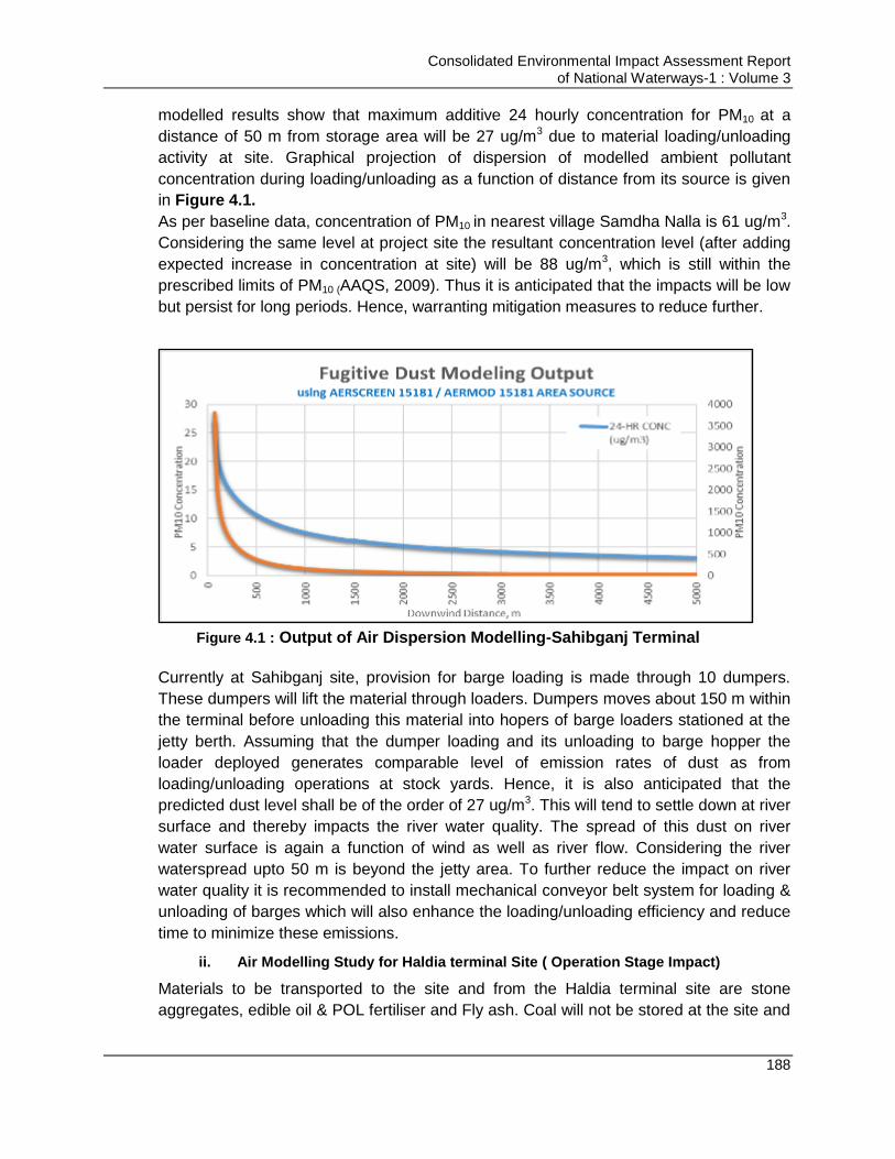
Consolidated Environmental Impact Assessment Report of National Waterways-1 : Volume 3
188
modelled results show that maximum additive 24 hourly concentration for PM10 at a
distance of 50 m from storage area will be 27 ug/m3 due to material loading/unloading
activity at site. Graphical projection of dispersion of modelled ambient pollutant
concentration during loading/unloading as a function of distance from its source is given
in Figure 4.1.
As per baseline data, concentration of PM10 in nearest village Samdha Nalla is 61 ug/m3.
Considering the same level at project site the resultant concentration level (after adding
expected increase in concentration at site) will be 88 ug/m3, which is still within the
prescribed limits of PM10 (AAQS, 2009). Thus it is anticipated that the impacts will be low
but persist for long periods. Hence, warranting mitigation measures to reduce further.
Figure 4.1 : Output of Air Dispersion Modelling-Sahibganj Terminal
Currently at Sahibganj site, provision for barge loading is made through 10 dumpers.
These dumpers will lift the material through loaders. Dumpers moves about 150 m within
the terminal before unloading this material into hopers of barge loaders stationed at the
jetty berth. Assuming that the dumper loading and its unloading to barge hopper the
loader deployed generates comparable level of emission rates of dust as from
loading/unloading operations at stock yards. Hence, it is also anticipated that the
predicted dust level shall be of the order of 27 ug/m3. This will tend to settle down at river
surface and thereby impacts the river water quality. The spread of this dust on river
water surface is again a function of wind as well as river flow. Considering the river
waterspread upto 50 m is beyond the jetty area. To further reduce the impact on river
water quality it is recommended to install mechanical conveyor belt system for loading &
unloading of barges which will also enhance the loading/unloading efficiency and reduce
time to minimize these emissions.
ii. Air Modelling Study for Haldia terminal Site ( Operation Stage Impact)
Materials to be transported to the site and from the Haldia terminal site are stone
aggregates, edible oil & POL fertiliser and Fly ash. Coal will not be stored at the site and

Consolidated Environmental Impact Assessment Report of National Waterways-1 : Volume 3
189
only transhipment is proposed at 5th No jetty. Quantity of the material excluding the coal
to be transported to and from the site is 1.57 million MTPA, i.e. 4757.6 MT (metric
tonnes) per day. Thus app. 317 nos. of trucks are required for transportation of this
material. Total nos. of truck movement (to & fro) will be 2 X 317, i.e. 634 trucks.
Transportation of material through trucks will generate pollutants which will lead to
degradation of air quality of the influence area. To predict the level of degradation of air
quality, air dispersion modelling study has been carried out to predict concentration of
PM10 at the time of loading & unloading from 634 trucks using the software
AERSCREEN Model 15181. The results show that maximum 24 hourly concentration for
PM10 at a distance of 50 m from storage area will be 21.38 ug/m3 due to material
unloading activity at site. Graphical depiction of dispersion of pollutants to be generated
during unloading at various distances from generation source is given in Figure 4.2.
As per baseline data, mean concentration of PM10 in near site is 29 ug/m3. Considering
the same level at project site the resultant concentration level (after adding expected
increase in concentration at site) will be 50.38 ug/m3, which is still within the prescribed
limits of NAAQS, 2009. Thus it is anticipated that the impacts will be moderately
significant but long term.
Figure 4.2 : Output of Air Dispersion Modelling-Haldia Terminal
Currently provision for barge loading is made through 10 no of dumpers. These dumpers
will lift the material through loaders. Dumpers moves almost 275 m within the terminal
and unloaded the material into hopers of barge loaders at the jetty. The dumper loading
and material unloading to hopper of barge loader generates similar level of dust as from
unloading of incoming material at stock yards. It is anticipated that the predicted dust
level shall be of the order of 21.38 ug/m3. This will tend to settle down at river and effect
river water quality considering its spread upto 50 m which is beyond the jetty area. Thus

Consolidated Environmental Impact Assessment Report of National Waterways-1 : Volume 3
190
it is recommended to install mechanical conveyor belt system for loading 7 unloading of
barges to minimize these emissions.
Apart from material handling & transportation, other source of emissions at site are:
Emissions from DG sets
Emissions due to fire in coal/oil stored at site
DG sets however will be operated only in case of power failure thus expected impact is
low & insignificant. But emissions result due to accidental burning of coal/oil or other
stored material will be significant & will have significant impact on air quality of the area.
Temperature of Varanasi & Sahibganj site is hot which can trigger fire in coal/oil. Thus
mitigation measures should be taken to prevent any such accident at the site. However,
climate of Haldia site is moderate so such fires are not anticipated at Haldia terminal
site. Mitigation measures proposed for managing the air pollution at the planned site are
discussed below.
Measures for Avoidance and Mitigation of Impacts
Material should be transported in covered vehicles
Transportation vehicle should be properly serviced and maintain and should
carry PUC certificate
Material should be stored under cover sheds only especially coal, sand,
aggregates etc.
Thick green belt should be developed as per the provision already made in the
design and maintained all along the periphery and along the roads. The green
belt should be developed in canopy39 shape with local species of broad leaf
variety.
Species selected for development of green belt shall also be tolerant to expected
pollutants and shall have the ability to adsorb the pollutants. Suggested species
are suitable for different areas are also listed under CPCB guidelines for green
Belt development40.
Water sprinkling should be carried out during all loading and unloading activities
and storage period. Further dust suppression measures should be taken at the
site like vaccum collectors at dust generation areas.
More frequent water sprinkling should be carried out at coal yard during summer
season to prevent spontaneous fire.
Storage of oil should be as per MSDS and all fire prevention & fighting measures
should be provided at site
39
Canopy shape green belt design includes three row of trees with middle tree species gore more in height compared to inside and
outside tree species. Each of tree will have wider leaf which forms like a curtain and acts as beerier to dust spread. Dust accumulated over leaf falls down within the site boundary. Similarly external dust gets prevented from entering the terminal site. http://cpcb.nic.in/upload/Publications/Publication_513_GuidelinesForDevelopingGreenbelts.pdf 40
CPCB guidelines for green Belt development
http://cpcb.nic.in/upload/Publications/Publication_513_GuidelinesForDevelopingGreenbelts.pdf
Consolidated Environmental Impact Assessment Report of National Waterways-1 : Volume 3
191
It is recommended to provide mechanical conveying system with provision of
dust collection system for loading/unloading material from barges. Pneumatic
transfer only should be preferred for flyash transportation
Minimizing free fall of materials to reduce the dust generation
Minimizing dry cargo pile heights and containing piles with perimeter walls
Removing materials from the bottom of piles to minimize dust re-suspension
Regularly sweeping docks and handling areas, truck / rail storage areas, and
paved roadway surfaces
Monitoring of air quality should be carried out on monthly basis to check the level
of pollutants and effectiveness of proposed EMP
Keeping transfer equipment (e.g. cranes, forklifts, and trucks) in good working
condition41
Upgrading the land vehicle fleet with less-polluting trucks and vehicles, and using
alternative fuels and fuel mixtures
Encouraging reduction in engine idling during on- and off-loading activities
Encouraging storage planning to avoid or minimize restorage and reshuffling of
cargo
VOC emissions from fuel storage and transfer activities should be minimized by
means of equipment selection, such as the use of floating top storage tanks or
vapour recovery systems for fuel storage, loading / offloading, and fuelling
activities (depending on the type of material to be stored), and adoption of
management practices such as limiting or eliminating loading / unloading during
poor air quality episodes or implementing tank and piping leak detection and
repair programs
Explore feasibility of using telescoping chutes to reduce the fugitive emissions
and reduce the need for slingers for material loading & unloading.
4.11.5. Conclusion (Air Environment)
From the above discussion, it can be concluded that impacts are anticipated due to
excavation, material transportation, storage of raw material and vehicular transportation
majorly. The residential areas close to these civil interventions are likely to be affected
majorly if the adequate mitigation measures are not taken. Also impacts are likely to be
occur within 2 km radius of the intervention sites. With the above proposed mitigation
measures impacts can be minimized to large extent.
4.12. Impact on Noise Environment
4.12.1. Status of noise environmentalong NW-1 and influence area
The noise level was measured as per the monitoring plan approved by IWAI/world bank
at proposed terminals/locks, around sensitive receptors and existing Ro-Ro/jetty along
the NW-1.
41
IFC Environmental, Health & Safety Guidelines-Ports, Harbors and Terminals
Consolidated Environmental Impact Assessment Report of National Waterways-1 : Volume 3
192
A. Terminal/lock sites:Ambient noise levels of the entire NW1 stretch are within the
prescribed National Ambient Noise Quality Standard as well as standards prescribed
in IFC general EHS guidelines for respective category for respective residential and
commercial category at all the monitored locations.
B. Sanctuary Area:The noise level recorded within Vikramshila dolphin sanctuary area
was also found within the sensitive category threshold at all monitoring locations.
However, the noise level was not meeting the sensitive criteria for Kashi turtle
sanctuary area because of anthropogenic activities. There are 81 ghats along with
few temples within the limit of Kashi turtle Sanctuary area. There is a large gathering
of people in Ghat area in most of the time. Loud speakers in nearby temples is the
another source of noise in the sanctuary area.
4.12.2. Impacts on Noise Environment due to Maintenance Dredging for maintaining minimum LAD in navigation channel
Dredging operations generates noise levels of app. 85-90 dB(A). This noise level adds to
the ambient noise levels of the area thereby exceeding the baseline noise levels. High
noise level have serious impacts on human health and the flora & fauna residing in the
area. But the noise significantly reduces and dissipates with distance. Dredging will be
carried out within the river thus the noise levels due to dredging operation will reduce by
the time it reaches the habitation area. Through noise modelling study as presented in
section 4.12.4.1 (Table 4.14), it is seen that noise levels reduce to 56 dB(A) at distance
of 500 m from source which is equivalent to baseline noise levels of the area.Thus the
impact is likely to be within 500 m distance from the dredging location. Noise level due to
dredging and its impact on workers and resident population can be further minimized by
undertaking the following mitigation measures.
Dredging also generates significant underwater noise. Impact on underwater noise
generation due to dredgers is discussed in section of impact on aquatic ecology.
Measures for Avoidance and Mitigation of Impacts
Dredgers should be regularly serviced and maintained so as to prevent noise due
to friction
Workers should be provided with ear plugs to prevent exposure to high noise
levels
A survey on sensitive noise receptors should be carried out for area within 500 m
of dredging operations
Provision of noise barrier in the impacted area if any sensitive receptor is located
within 500 m distance
No dredging activity should be carried out beyond 10:00 PM and before 6:00 Am
Formulation of noise limit standards by concerned authorities for dredgers also
similar to other construction machineries and vehicles
4.12.3. Impact Due to Operations- Barge Movement
Barge movement does not involve significant ambient noise generation, however
significant underwater noise is generated. Impact due to underwater noise generation on
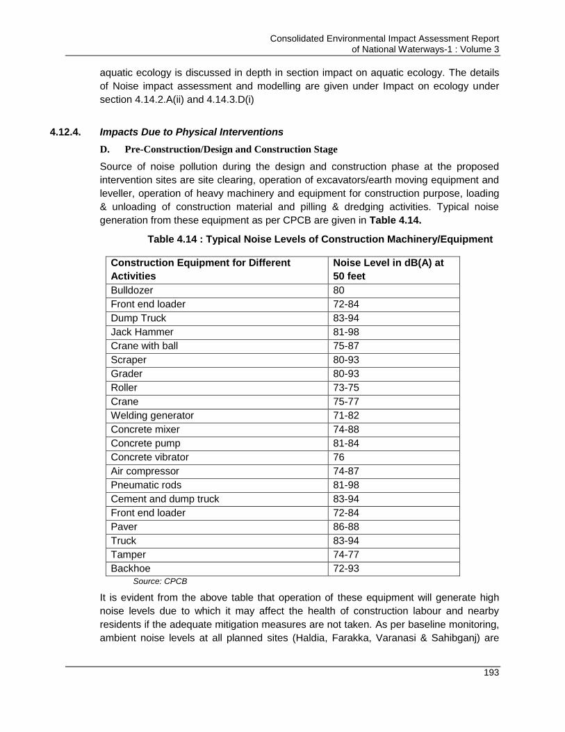
Consolidated Environmental Impact Assessment Report of National Waterways-1 : Volume 3
193
aquatic ecology is discussed in depth in section impact on aquatic ecology. The details
of Noise impact assessment and modelling are given under Impact on ecology under
section 4.14.2.A(ii) and 4.14.3.D(i)
4.12.4. Impacts Due to Physical Interventions
D. Pre-Construction/Design and Construction Stage
Source of noise pollution during the design and construction phase at the proposed
intervention sites are site clearing, operation of excavators/earth moving equipment and
leveller, operation of heavy machinery and equipment for construction purpose, loading
& unloading of construction material and pilling & dredging activities. Typical noise
generation from these equipment as per CPCB are given in Table 4.14.
Table 4.14 : Typical Noise Levels of Construction Machinery/Equipment
Construction Equipment for Different
Activities
Noise Level in dB(A) at
50 feet
Bulldozer 80
Front end loader 72-84
Dump Truck 83-94
Jack Hammer 81-98
Crane with ball 75-87
Scraper 80-93
Grader 80-93
Roller 73-75
Crane 75-77
Welding generator 71-82
Concrete mixer 74-88
Concrete pump 81-84
Concrete vibrator 76
Air compressor 74-87
Pneumatic rods 81-98
Cement and dump truck 83-94
Front end loader 72-84
Paver 86-88
Truck 83-94
Tamper 74-77
Backhoe 72-93
Source: CPCB
It is evident from the above table that operation of these equipment will generate high
noise levels due to which it may affect the health of construction labour and nearby
residents if the adequate mitigation measures are not taken. As per baseline monitoring,
ambient noise levels at all planned sites (Haldia, Farakka, Varanasi & Sahibganj) are

Consolidated Environmental Impact Assessment Report of National Waterways-1 : Volume 3
194
within the permissible limits as prescribed by CPCB for residential areas. But resultant
noise level (ambient noise level + increase noise levels due to operation of equipment)
can be higher than the prescribed limits of CPCB. However the noise associated with the
construction activity will be restricted to construction period only and thus the impact is
considered to be short term & temporary. Construction machinery & equipment will not
be operated throughout the day thus noise generation from these equipment is
considered to be of intermittent type. Further by undertaking the mitigation measures like
provision of earplugs to the workers engaged in high noise generating activities, impact
due to noise pollution can be managed.
As per occupation standards, workers‟ exposure to 90 dB(A) noise level should not be
more than 8 hours. OSHA guidelines should be followed for exposure to specific noise
levels for workers and are listed in Table 4.15. Conducting hearing tests for workers may
help in monitoring the impact of the higher noise level on workers‟ health.
Table 4.15 : OSHA noise exposure limits for the work environment
Noise Levels in dB(A) Permissible Exposure (hours & minutes)
85 16 hrs
90 8 hrs
96 3 hrs 30 minutes
102 1 hr 30 minutes
108 40 min
115 15 min
121 6 min
127 3 min
130 1 min
Source: Marsh, 1991, p.322
Thus the high noise levels are required to be managed by taking proper noise level
reduction measures and preventive measures so as to minimize the impact on health
due to exposure to high noise level.
Noise attenuates with the distance, thus the impact of high noise level reduces with the
increase in distance from activity area. Impact on nearby residents due to the noise
generated is low in case of all presently planned site as habitations are located at more
than 100 m at all the presently planned site. Noise level attenuation with the distance is
governed by the following equation.
L2 = (L1 - 20 log D2/D1-Ae-An)
Wherein, L1 and L2 are the noise levels at a distance of D1 and D2 from the noise
source;
Ae and an are attenuation coefficient due to environment correction and background
respectively.

Consolidated Environmental Impact Assessment Report of National Waterways-1 : Volume 3
195
Apart from above activities piling and dredging activities are to be carried out in river for
construction of berths. These activities also generate significant level of noise ranging
from 85-90 dB(A). However, this will also be confined to the piling and dredging period.
Noise level assessed at varying distance due to dredging or piling operations are given
in Table 4.16 below.
Table 4.16 : Estimated Noise levels for the piling and dredging operations
Distance from
noise source
location (m)
Predicted Noise Level
Piling operations Dredging
10 85.00 90.00
30 75.46 80.46
50 71.02 76.02
100 65.00 70.00
200 59.00 64.00
500 51.00 56.00
If mitigation measures are taken, then the noise levels at the site can be reduced
significantly and thus the impacts can be minimised.
Measures for Avoidance and Mitigation of Impacts
Provision should be made for:
Barricading (Temporary noise barrier) the construction site to minimize the noise
level outside the site boundary
No piling and dredging activity should be carried out at night time.
Restriction on Honking at the project site
Hearing test for the workers prior to deployment at site and high noise areas
followed by periodic testing every six months.
Job rotations systems for workers, working in high noise level areas
Restriction of high noise generating activity between 6:00 AM to 10:00 PM.
Periodic monitoring (monthly level) of noise levels to check the level of pollutants
and effectiveness of proposed EMP
Protection devices (earplugs or earmuffs) should be provided to the workers
operating near high noise generating machines. Construction equipment and
machinery should be fitted with silencers and maintained properly. Noise
measurements should be carried out to ensure the effectiveness of mitigation
measures and develop a mechanism to record and respond to complaints on
noise.
All equipment should be fitted with silencers/noise mufflers and will be properly
maintained to minimize its operational noise. Noise level will be one of the
considerations in equipment selection, which will favour lower sound power
levels.

Consolidated Environmental Impact Assessment Report of National Waterways-1 : Volume 3
196
E. Operation Stage
Noise generation sources during operation phase are primarily loading and unloading of
material at site and vessel/barges, movement of dumpers & vessel, operation of backup
power generators, pumps and other equipment. However, the main effect on the
environmental noise level will be from increased transportation of goods entering and
leaving the terminal site. To estimate the increased noise levels generated due to
material transportation, noise modelling study has been carried out Sahibganj & Haldia
Terminal site. Noise modelling study for the Haldia and Sahibganj Terminal sites are
given below. The anticipated impact could be significant if left unadressed. Thus
adequate avoidance and mitigation measures are required to mitigate the anticipated
impacts.
A. Noise Modelling Study for Sahibganj Terminal Site
The bulk cargo is anticipated to be carried to the site by trucks, which could result in
movement of 800 trucks per day (400 coming and going out, i.e. 400 X 2) considering
maximum load. Noise prediction modelling has been carried out for trucks movement in
and out of the terminal for material transportation which is expected to increase all along
the approach road and terminal area. The maximum noise level generation from these
truck movement is estimated to be 77.6 dB (A) which will be attenuated to 65 dB (A)
within a distance of 21m. Noise modelling output for movement of transportation vehicles
indicating the attenuation of noise with distance is given in Figure 4.3.
Figure 4.3 : Noise Modelling Output
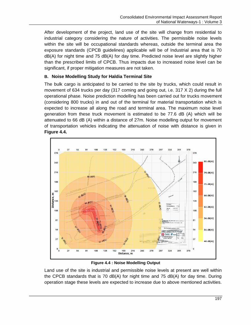
Consolidated Environmental Impact Assessment Report of National Waterways-1 : Volume 3
197
After development of the project, land use of the site will change from residential to
industrial category considering the nature of activities. The permissible noise levels
within the site will be occupational standards whereas, outside the terminal area the
exposure standards (CPCB guidelines) applicable will be of Industrial area that is 70
dB(A) for night time and 75 dB(A) for day time. Predicted noise level are slightly higher
than the prescribed limits of CPCB. Thus impacts due to increased noise level can be
significant, if proper mitigation measures are not taken.
B. Noise Modelling Study for Haldia Terminal Site
The bulk cargo is anticipated to be carried to the site by trucks, which could result in
movement of 634 trucks per day (317 coming and going out, i.e. 317 X 2) during the full
operational phase. Noise prediction modelling has been carried out for trucks movement
(considering 800 trucks) in and out of the terminal for material transportation which is
expected to increase all along the road and terminal area. The maximum noise level
generation from these truck movement is estimated to be 77.6 dB (A) which will be
attenuated to 66 dB (A) within a distance of 27m. Noise modelling output for movement
of transportation vehicles indicating the attenuation of noise with distance is given in
Figure 4.4.
Figure 4.4 : Noise Modelling Output
Land use of the site is industrial and permissible noise levels at present are well within
the CPCB standards that is 70 dB(A) for night time and 75 dB(A) for day time. During
operation stage these levels are expected to increase due to above mentioned activities.

Consolidated Environmental Impact Assessment Report of National Waterways-1 : Volume 3
198
However, the noise levels can be maintained within the prescribed limits of CPCB by
undertaking the mitigation measures as listed below. Also measures will be taken to
maintain the work zone noise levels as per OSHAS guidelines as given above in Table
4.13. Exposure of workers to the noise levels will be maintained as per the OSHAS
norms. Further measures listed below will help minimizing the impact on increased noise
level during the operation phase.
Measures for Avoidance and Mitigation of Impacts
Site boundary should be provided which can act as noise barrier
Earplugs should be provided to workers involved in unloading operations
Provision of thick green belt along the boundary and roads which will act as noise
buffer
Timely maintenance and servicing of transportation vehicles and the
machinery/pumps to be used during operation phase to reduce the noise
generation due to friction and abrasion
Honking should be prohibited at the project site
Hearing test for the workers should be undertaken before employing them and
thereafter should be done after every six months
Job rotations should be practised for people, working in high noise level areas
Noise generating activity should be undertaken between 6:00 am to 10:00 pm.
DG sets should be provided with acoustic enclosure
Monitoring of Noise levels should be carried out on monthly basis to check the
level of pollutants and effectiveness of proposed EMP
4.12.5. Conclusion (Noise Environment)
From the above discussion, it can be concluded that civil interventions are likely to affect
the ambient noise levels of the area if the mitigation measures are not taken. The
proposed mitigation measures can reduce the anticipated impacts to a large extent.
Some of these measures are preventive which will prevent the damage due to increase
in noise levels and some are mitigable which will help in reducing the noise levels.
4.13. Impact on Water Environment& Mitigation Measures
4.13.1. Status of water environment along NW-1 and influence area
A. Ground Water Quality:
Three ground water samples were collected from three locations around the proposed
terminal site. 8 nos. of ground water sample were also collected from the stretches
facing populated zones all along the NW-1. The Physico-chemical characteristics of the
ground water samples were in good agreement with IS:10500 permissible limits. The
TDS, Total Hardness and chloride values at Haldia and Sahibganj, Howrah and Kolkata
are slightly above the desirable limit but were within the permissible limits specified
under Drinking Water Standard (IS: 10500). Heavy metals, only Fe and Zn were found
present but were quite lower in concentration. The arsenic content in ground water
sample of Bhagalpur and Munger were found present in lower concentration. Other
Consolidated Environmental Impact Assessment Report of National Waterways-1 : Volume 3
199
heavy metals were found in traces. Overall all the ground water quality at all sampling
site is within the permissible limits specified under Drinking Water Standard (IS: 10500).
B. Surface Water Quality:
Surface water sample were collected from the upstream and downstream of the
proposed and planned terminals/ lock and also at the river location of environmental
sensitive receptors present all along the NW-1. One sample each were also collected
from the other infrastructural interventions (existing ro-ro/jetty/floating terminals).
Samples were collected as per the standard protocol mentioned earlier.
The river water quality observations reflect that water quality meets with BDU Class D
Criteria of CPCB barring few parameters PH, DO which meets „A‟ class criteria. Metallic
and pesticide level is within prescribed limit of Drinking water standard. The primary data
results are similar to secondary data analyzed. The analysis concludes that the river
water is good for propagation of Wild life and fisheries
C. River Water Quality at dredging locations:
IWAI undertakes dredging to maintain the LAD for effective navigation. To analyses the
effect of dredging activity on water quality water samples in upstream and downstream
of the river at different distance from the operating dredger were taken and analyses
during study period. The river water quality observations reflect that the parameters like
turbidity and total suspended solid increases in downstream of the dredging location up
to 700 m, which gradually normalized at a distance of 1000 m from the dredging
location. In upstream side of the river there were no major changes has been observed
in these parameter. However, the metals like iron, copper, cadmium and lead were also
detected in traces in water sample close to the dredging location in downstream. No
variation was observed in other water quality parameter.
D. Waste Water Generation from Major cities along NW-1:
Waste water generation from cities and towns along NW-1 in Uttar Pradesh segment
generated 422.6 MLD i.e. 26. % of total wastewater generation. Waste water generation
from cities and towns along NW-1 in Bihar segments 376.5 MLD i.e. 14 % of total
wastewater generation. The major city is Patna which generates 249.2 MLD of total
waste water generated from this stretch. The cities/towns located along NW-1segment of
West Bengal generate about 1311 MLD i.e. about 50 %. Out of the total waste water
generation in NW-1 segment. Kolkata alone contributes 47% and Howrah generates
10% of the total waste water generation of west Bengal stretch.
4.13.2. Impacts on Water Environment due to Maintenance Dredging for maintaining minimum LAD in navigation channel
Impact of dredging on water environment is anticipated due to degradation of water
quality during the dredging and off-shore dredge disposal operations. Impacts on water
quality due to dredging activities & off-shore dredged disposal are variable in space and
time depending upon the turbidity and suspended solids levels and are domination in
light transmittance of river water, reduced DO, changes in salinity, temperature, pH,
availability of river water nutrients, and heavy metals/chemicals. Most significant change
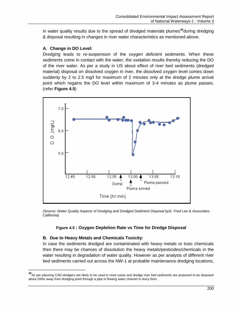
Consolidated Environmental Impact Assessment Report of National Waterways-1 : Volume 3
200
in water quality results due to the spread of dredged materials plumes42during dredging
& disposal resulting in changes in river water characteristics as mentioned above.
A. Change in DO Level:
Dredging leads to re-suspension of the oxygen deficient sediments. When these
sediments come in contact with the water, the oxidation results thereby reducing the DO
of the river water. As per a study in US about effect of river bed sediments (dredged
material) disposal on dissolved oxygen in river, the dissolved oxygen level comes down
suddenly by 2 to 2.5 mg/l for maximum of 2 minutes only at the dredge plume arrival
point which regains the DO level within maximum of 3-4 minutes as plume passes.
(refer Figure 4.5)
(Source: Water Quality Aspects of Dredging and Dredged Sediment Disposal byG. Fred Lee & Associates, California)
Figure 4.5 : Oxygen Depletion Rate vs Time for Dredge Disposal
B. Due to Heavy Metals and Chemicals Toxicity:
In case the sediments dredged are contaminated with heavy metals or toxic chemicals
then there may be chances of dissolution the heavy metals/pesticides/chemicals in the
water resulting in degradation of water quality. However as per analysis of different river
bed sediments carried out across the NW-1 at probable maintenance dredging locations,
42
As per planning CSD dredgers are likely to be used in most cases and dredge river bed sediments are proposed to be disposed
about 200m away from dredging point through a pipe in flowing water channel in slurry form.
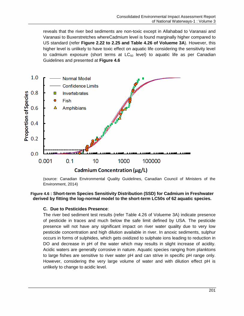
Consolidated Environmental Impact Assessment Report of National Waterways-1 : Volume 3
201
reveals that the river bed sediments are non-toxic except in Allahabad to Varanasi and
Varanasi to Buxerstretches whereCadmium level is found marginally higher compared to
US standard (refer Figure 2.22 to 2.25 and Table 4.26 of Volueme 3A). However, this
higher level is unlikely to have toxic effect on aquatic life considering the sensitivity level
to cadmium exposure (short terms at LC50 level) to aquatic life as per Canadian
Guidelines and presented at Figure 4.6
(source: Canadian Environmental Quality Guidelines, Canadian Council of Ministers of the
Environment, 2014)
Figure 4.6 : Short-term Species Sensitivity Distribution (SSD) for Cadmium in Freshwater derived by fitting the log-normal model to the short-term LC50s of 62 aquatic species.
C. Due to Pesticides Presence:
The river bed sediment test results (refer Table 4.26 of Volueme 3A) indicate presence
of pesticide in traces and much below the safe limit defined by USA. The pesticide
presence will not have any significant impact on river water quality due to very low
pesticide concentration and high dilution available in river. In anoxic sediments, sulphur
occurs in forms of sulphides, which gets oxidized to sulphate ions leading to reduction in
DO and decrease in pH of the water which may results in slight increase of acidity.
Acidic waters are generally corrosive in nature. Aquatic species ranging from planktons
to large fishes are sensitive to river water pH and can strive in specific pH range only.
However, considering the very large volume of water and with dilution effect pH is
unlikely to change to acidic level.
Consolidated Environmental Impact Assessment Report of National Waterways-1 : Volume 3
202
D. Due to Turbidity and Ferrous Effect:
Hydraulic dredging involves slurring the sediments with water in a one-part sediment to
four-parts water mixture where this mixture is typically then proposed to be pumped as a
slurry through floating pipe for disposal to flowing water channel away from (about 200
m) from dredging site. This dredging and disposal action will lead to increase in turbidity
around dredging point and at disposal point.
To analyse the effect of dredging on turbidity by CSD, primary data analysis was carried
out for at varying distance before and after the dredging point. These results are
presented at Table 2.23 of Volueme 3A. It establishes that turbidity of water increases
substantially close to dredging point but it reduces with distance and almost get
normalise at a distance of 700 m from dredging point. The instantaneous suspended
sediment concentration due to disposal of dredge slurry results in the plume of fine and
coarser sediments. The plume is dispersed over a significant distance by the river flow at
the point of disposal which also leads to increased sediment dispersion. Coarser
sediments settle much faster and at shorter distance. Fine sediments also settle faster
due to the presence of iron in dredge sediments. Iron in sediments exists in a ferrous
form43. Upon contact with waters containing dissolved oxygen, it is rapidly oxidized by
the dissolved oxygen to ferric iron which precipitates as ferric hydroxide. Freshly
precipitated ferric hydroxide has a large surface which can sorb (act as coagulant)
significant amounts of a wide variety of constituents released from the sediment in water.
While they are released, they are rapidly taken back to the sediments by the ferric
hydroxide scavenging. Ganga River carry high sediment load and its aquatic life is
accustomed to high sediment level of river. The most of fishes‟ activities are found in 15-
30 cm depth of the river. The fishes‟ activities may be impacted depending on the depth
of discharge of dredge sediment slurry in the flowing river. The impact is likely to be
minimal considering the quality of dredge sediments. This impact on aquatic life/water
quality will vary depending on the concentration of constituents in sediments. The impact
assessment carried out is based on the constituent analysis carried out by us at current
level. The disposal of dredge sediment can result in the burial of aquatic organisms
leading to their death. Various studies show that many organisms that live in sediments
43
Lee et al. (1978) and Jones and Lee (1978) as part of the Corps of Engineers Dredged Materials Research Program
(DMRP) conducted extensive laboratory and field studies at dredging and dredged sediment disposal sites located in
many parts of the US. They found that as long as the sediment water slurry was oxic (contained dissolved oxygen) that of
the over 30 chemical parameters they measured, including heavy metals, a variety of organics, and other constituents,
only ammonia and manganese were released from the sediments. However, if the slurrying of the sediments with
dredging site water took place in the absence of dissolved oxygen (anoxic), a large number of constituents were released
to the water. This pattern of release under anoxic conditions and no release under oxic conditions is strongly supportive of
the role of ferric hydroxide in acting as an efficient scavenger for constituents released from the sediments. Lee (1975)
pointed out that it is important to distinguish between the scavenging ability of freshly precipitated ferric hydroxide and
aged ferric hydroxide precipitate. While freshly precipitated ferric hydroxide has a high sorption capacity, aged ferric
hydroxide has limited sorption capacity and will release constituents sorbed at the time of formation of the ferric hydroxide,
especially if it has become dry. This is an important phenomenon that occurs in some confined dredged sediment disposal
projects that leads to the potential for water quality problems associated with this method of dredged sediment disposal.

Consolidated Environmental Impact Assessment Report of National Waterways-1 : Volume 3
203
are able to migrate through appreciable depths of sediments dumped on them
depending on the oxygen level in water. With the proposed mode of disposal in slurry
form sudden burial level is unlikely to arrive and aquatic organism will get enough time to
migrate.
Measures for Avoidance and Mitigation of Impacts
Mitigation measures are proposed considering for the action required at design and
operation stage of the project.
Standards should be developed by concerned authorities for onshore and off-
shore dredged material disposal and development of the process to ensure its
compliance
Attempt should be made to minimizing and optimizing the dredging requirements
by effective assessment and study of the Thalweg profiles of the river. This can
be achieved some of the following measures:
o Increase use of bandalling which helps in diverting the flow of river
towards the channel and reduces the quantity of dredging
o Low draft vessels should be deployed which will reduce the requirement
of dredging
Dredged material should be checked for toxicity and contamination prior its
disposal onshore for prevention of contamination of water and its impacts on
aquatic life. Standards for judging onshore & off-shore disposal of dredged
material are given in Annexure 4.1 ( Volume 3C).
Dredging should not be carried out during very low flow seasons so as to
minimize the dispersion of fine sediments
Usage of silt or air bubble screens/curtains should be explored to minimize the
sediment release during dredging operations. Silt/air bubble screens can hang
from surface floats or stands attached to the bottom and held upright by sub-
surface floats (PIANC). The use of silt curtains is reported to considerably reduce
the loss of suspended sediments from the dredge area, by up to 75% where
current velocities are very low. However, they are generally ineffective in areas
with high current velocities which exceed 0.5 m/s (UK Marine SACs Projects).
To minimize the sediment dispersal during disposal of dredge sediments, it
should be place as close to the bed possible preferable at a level of 1m above
the bed to minimise the dispersal of sediments.
Provision should be made of emergency response equipment like floating blooms
to deal with any emergency of oil spills or leakages. Regular servicing and
maintenance of dredgers should be taken up so as to prevent any leakage of the
dredged material. Leakage detection of the sediment transportation pipe should
be carried out regularly to prevent any sediment loss and water pollution at
leakage location. Corrective actions should be taken immediately after detection
of such leaks.
Consolidated Environmental Impact Assessment Report of National Waterways-1 : Volume 3
204
Dredgers should be selected so as there is minimal loss of sediments during
dredging and disposal both. For inland waterways and off-shore disposal of the
sediments, it is found that CSD is most feasible.
Ratio of cutter revolutions and pump velocity should be adjusted to ensure that
cutter advancement rate is not greater than the ability of the suction pump to
remove the material that is cut. This will prevent the suspension of the dredged
material.
Dredge cuts and lifts should be designed so as to prevent undercutting of
material and hence a collapse of material locally at the cutter head, leading to an
increase in the sediment being disturbed by dredging.
If dredge material is found contaminated at any particular location that it should
be disposed off shore. Off-shore disposal of dredged material should be carried
out only at approved TSDF site such as approved TSDF site of Haldia Dock
Complex at Sagar.
Sensitivity along NW-1 for dredge disposal is discussed in Table 4.4 above.
Dredge material if disposed on river banks or on land caution should be
exercised as per the Dredging and Disposal Management Plan is prepared for
entire for NW-1 considering the sensitivities discussed in Table 4.4 and is this
plan is given in volume 8. Table 6.1.
4.13.3. Impact on Water Environment Due to Operations- Barge Movement
Major impact on water environment is anticipated due to degradation of water quality
due to discharge of liquid and solid waste from vessels into the river, dissolution of anti-
fouling paints used for painting hull of the ships and oil spillages from the barges.
A. Impact Due to Discharge of Liquid and Solid Waste in river:
The vessels moving in waterway generates both black & grey waste water. Black water
include sewage, wastewater from toilets and medical facilities, which can contain
harmful bacteria, pathogens, viruses, intestinal parasites, besides many other harmful
ingredients. Discharge of these black wastes untreated or inadequately treated can
cause bacterial and/or viral contamination of agriculture produce, fisheries, causing risks
to public health. Nutrients in sewage, such as nitrogen and phosphorus, promote
excessive algal blooms, which consumes oxygen in the water and can lead to fish kills
and destruction of other aquatic life. However, in this project majorly freight vessel are
expected to ply. Few passenger vessels may also ply. Thus the quantity of sewage to be
generated will not be large. Also it will be made mandatory that no vessel/ship can
discharge its wastewater into the river. Grey water is wastewater from the sinks,
showers, galleys, laundry, and cleaning activities aboard a ship. It can also contain a
wide range of contaminants, including even fecal coliforms, detergents, oil and grease,
metals, organic compounds, petroleum hydrocarbons, nutrients, food waste, medical and
dental waste (EPA). Grey water has potential to cause adverse environmental effects
because of concentrations of nutrients and other oxygen-demanding materials in
particular.

Consolidated Environmental Impact Assessment Report of National Waterways-1 : Volume 3
205
Solid waste generated on a ship includes glass, paper, cardboard, aluminium and steel
cans, plastics and maintenance waste. It can be either non-hazardous or hazardous in
nature. Solid waste that enters the water body becomes aquatic debris, and can then
pose a threat to aquatic organisms, humans, coastal communities, and people that use
the river water.
B. Impact Due to Usage of Anti-fouling Paint: Antifouling paints with toxic content
can affect the aquatic life though to a very limited extent.
C. Impact Due to Settlement of Dust from Materials handling: Dust may settle on
the surface of river during loading & unloading and operation of barges if appropriate
preventive measures are not opted for. This dust will increase turbidity in water, and
will impact the water quality and aquatic life.
D. Impact Due to Oil Spillage from barges/Vessels: There could be oil
spillage/leakage during the oil transportation due to leakage in oil tankers transported
or due to accidents between the two vessels or due to leakages from engines of the
barges and vessels. Oil spills severely affects the water quality as well the aquatic
fauna. Oil forms the layer over the water and cut down the contact of atmosphere
with the water lying below reducing the oxygen levels in the water. Due to generation
of anoxic conditions, anaerobic digestion of organic matter starts taking place in
water which leads to generation of foul smell and some acids which deteriorates the
water quality. Further due to lack of oxygen, aquatic flora gets killed and add to the
organic mass in the water, further reducing the dissolved oxygen levels and the
water quality degradation
Measures for Avoidance and Mitigation of Impacts
All waste water and solid waste or maintenance waste should be disposed at the
designated barge maintenance facility only. Till the time such facility is not
developed, terminals should have arrangement for reception of the waste and
wastewater from vessels so as to prevent its unauthorized disposal in river. A
procedure should be developed by terminal facilities for reception of vessel waste,
its storage and treatment and respective charges.
Further a waste management plan is requisite to be formed indicating the entire
process of waste segregation, collection, storage, handling over to be followed by
vessels. This plan can also indicate the fee amount to be paid by waste generator
as per the weight of the garbage.. Penalties should be imposed on the vessel
operators in case the plan is not followed
The wastewater from vessels can be sent to STP for treatment and the treated
water can be used for landscaping and dust suppression at terminal sites
Vessels alsomay have some facilities for treatment of the waste generated onboard
like recycling/chemical toilets. Standards for discharge of wastewater & garbage
from barges as per MARPOL is attached as Annexure 4.3 & 4.4 ( Volume 3C).
Consolidated Environmental Impact Assessment Report of National Waterways-1 : Volume 3
206
Vessel crew/captain should be aware about the waste handling and reception
facilities and procedure at terminals and should be in line with above mentioned
MARPOL standards.
Further it is suggested that standards should be formulated for barges for disposal
of waste and sewage as per Indian scenario w.r.t to NW-1 by concerned authorities
Material having potential to generate the dust like coal, sand stone aggregates
should be transported under covered conditions to minimize dust generation and its
settlement on river surface. Terminals should have facility to control dust pollution
during barge loading and unloading actions.
Provision of oil water interceptors with the bilge tank to separate oil prior discharge
of bilge water into river. Bilge water should be discharged as per MARPOL
requirements. Bilge water tank should be maintained as per MARPOL requirement.
Standards for discharge of oily waste is attached as Annexure 4.5 ( Volume 3C).
Usage of non-toxic and non TBT containing anti-fouling paints for painting vessel
Oil spill control and management plan should be prepared for each terminal facility
and for barge operations inNW-1 as part of EHS management system of IWAI
which should be duly communicated to vessel operator. Immediate/quick clean-up
of oil/other spills to prevent damage on aquatic organisms should be undertaken
and ship owners should be liable for the same. Facilities should be made to ensure
quick rescue and clean-up operations in case of accidents. An oil spill management
plan proposed for the NW-1 by IWAI is attached as Annexure 4.6 ( Volume 3C).
Crew of the vessel carrying especially oil should be competent and experienced so
as they can prevent the accidents to happen as much as possible
IWAI should develop the stringent norms to be followed by vessel operators and
should develop the system of penalizing based on polluters pay principle in case the
standards are not met or violated
Ship design (of capacity > 5000 DWT) should be as per MARPOL and should be
provided with double hulls/double bottoms. Speed of oil carrying vessels should be
maintained to prevent accidents due to high speed.
Vessels should not be washed or cleaned at terminal/jetty facility and washings
should not be discharge at the terminal/jetty location. Washing should be
undertaken only at the maintenance facility only. Standards for discharge of
washing water from the vessels carrying noxious chemicals (vessel washing water)
as per MARPOL is given in Annexure 4.7 ( Volume 3C).
Incase maintenance facility is not in place then washing can be done at terminal
sites also but terminal sites should have proper system for handling the washing
waste from barges. All washing water should be directed through closed drains to
settling tank. Supernatant water should be tested and if suitable should be sent to
STP for treatment. Sludge should be tested and disposed of to municipal waste
disposal facility or hazardous waste disposal facility depending on thequality of
sludge.
Consolidated Environmental Impact Assessment Report of National Waterways-1 : Volume 3
207
4.13.4. Impacts on Water Environment Due to Physical Interventions
A. Pre-Construction/Design and Construction Stage
Major impact on water environment associated with the design & construction of the
physical intervention are degradation of quality and depletion of resources due to usage.
Activities involved during design and construction phase are excavation and vegetation
removal from the site, construction activities, dust suppression, washing & cleaning and
domestic use of construction workers. Water will be required for compaction of the soil,
construction activities, dust suppression, washing & drinking purposes of construction
workers and can be sourced from authorized private water tankers supplier or municipal
supply. Water requirement during construction phase may vary from 30-90 KLD as per
the nature of activity involved. For extraction of ground water (if required), prior
permission from CGWB should be obtained. All planned sites lie within the safe zone as
per CGWB classification except Haldia terminal site thus no significant impact is
anticipated on the ground water resources. Haldia industrial zone is classified as notified
zone by CGWB thus restricting withdrawal of ground water. No ground water will be
used for construction purpose at Haldia site. Stage of development of ground water
should also be reviewed for other planned site and the source of water should be
decided accordingly to minimize the impact.
All the planned sites about the water bodies, but no surface body exists within the
planned sites. Thus there is potential of contamination of the water bodies abutting the
site due to mixing of run-off and discharge of wastewater generated at construction site.
Also due to filling, excavation works at site, natural drainage pattern at site may get
disturbed. Thus it is required to keep the site free of debris and contaminants, preventing
entry of wastewater in the water bodies and reestablishment of storm water drainage
network by provision of well-planned storm water drainage network.
Off-shore activities like piling and dredging operations for construction of berths and
jetties have potential to impact river water quality. During piling & dredging operation
river bed sediments will be released, increasing water turbidity and suspended soil
concentration. If settled sediments are contaminated, then there is also potential of the
river water to get contaminated due to mixing of contaminated bed sediments. However
as per baseline study, river bed sediments of NW-1 are not contaminated. Pesticides like
alpha, beta & gama endosulphan are found but are present in very low concentration.
Concentrations of these pesticides are within the limits for both the on-shore & off-shore
disposal of these sediments as per Japanese and Canadian standards (Refer Annexure
4.1 in Volume 3C for Standards). No standards are prescribed in India for disposal of
river bed sediments. No impact on ground water quality is anticipated during
construction phase of the project. Mitigation measures proposed for preventing pollution
of the water resources in influence area during construction stage of project are given
below.
Consolidated Environmental Impact Assessment Report of National Waterways-1 : Volume 3
208
Measures for Avoidance and Mitigation of Impacts
Excavation should not be carried out during monsoon season. Excavated areas
should be covered to the extent possible to prevent entry of rainfall run-off in
case of rains. Excavation, filling and levelling should be carried out parallel so as
to minimize the exposure of loose soil to wind/water. Levelled areas should be
compacted.
Garland drains should be provided around the excavated/activity area so as to
prevent entry of run-off from nearby areas to excavated/activity area.
The storm water drain should be connected to a collection cum sedimentation
pond to arrest the sediments from the run-off arising from construction site.
Temporary rain water storage structures should be provided at the site to store
rain water and this water should be used for dust suppression and construction
activities
Storm water drains should be provided in the parking areas also and these drains
should be provided with oil & grease trap
No waste should be disposed in river or should be littered in areas near the River
bank. Site should be cleaned regularly. Proper collection, management and
disposal of construction and municipal waste from site should be made to
prevent mixing of the waste in run-off and entering the water bodies.
Washing of vehicle and equipment should not be carried out at river or green belt
canal or any other waterbody. Washing area should be provided with the storm
water drains fitted with oil & grease trap.
Monitoring of surface water quality should be carried out on monthly basis to
check the level of pollutants and effectiveness of proposed EMP
No ground water or river water should be used for construction purpose without
permission of competent authority.
Piling of the raw materials & debris should be avoided at the site. Storage of
debris and raw material should be carried out in paved and covered areas. This
will minimize interface of run-off with raw material and debris.
Septic tank/soak pit should be provided at site for disposal of sewage from the
toilets at site and from the labour camps. Soak pits should not be provided close
to water body. In case toilets are provided near waterbody septic tanks along
anaerobic digestion tank should be provided. Sewage should not be discharged
into the River.
Adequate number of toilets & bathrooms should be provided to prevent open
defecation.
Wastewater generated from the washing/cleaning area after passing through oil
& grease trap & curing area should be re-used for water sprinkling and wheel
washing
Water use should be minimized by using RMC, practicing curing by water
sprinkling, maintaining flow of sprinklers, covering the water storage tanks to
minimize water evaporation, creating awareness for water conservation and
regular inspections at site to monitor the leakages in water storage area
Consolidated Environmental Impact Assessment Report of National Waterways-1 : Volume 3
209
In case RMC is not used then concrete transit mixer should be washed and
cleaned daily. Wash from these mixers should be collected in block work tanks
which will allow settling of concrete, removal of aggregates and allowing the
waste to wastewater drain. This collected waste concrete can be dried and used
for various purposes at site like construction of temporary roads at site.
Fuel should be stored in leak proof containers and containers should be placed
on paved surface.
The piling work in river should be undertaken during low flow period.
Turbidity traps/curtains or Geo-Textile synthetic sheet curtain should be placed
around pilling and construction area to prevent movement of sediments and
construction waste. Provision should be made for geo Synthetic Screen for
arresting silt flowing down stream.
Sedimentation tanks should be provided at the site so as run-off from site should
enter the sedimentation tanks before discharging into the river. Sedimentation
tanks will trap the sediments in the run-off
Natural Drainage pattern of area around should be maintained to the extent
possible
Dredged soil should not be dumped at river bank area and should be re-used for
filling purpose if possible. Dredged sand should be disposed within river only at
shoal area/areas of low environmental sensitivity. Off-shore disposal should be
carried out only if sediments are contaminant. One of the site for disposal of the
dredged sediments is approved TSDF site of Haldia Dock Complex.
Preference should be given to source water from rivers wherever feasible in the
project area with due permission from authorities
Permission should be obtained from irrigation department in case river water is
used and from CGWA/CGWB in case ground water is used.
No dumping of waste/wastewater in the ground. Hazardous waste (if any) or
wastewater should not be stored in unlined ponds
Substructure construction should be limited to the dry season and cofferdams
may be constructed and utilized to lift the spoil directly out of it and carried to the
riverbank for land disposal.
Restoration of changes in the stream, if any, made during construction to its
original level
Provision should be made for collection and draining of water for the piling earth.
It should be used for embankment protection or road construction depending on
its suitability.
B. Operation Stage
Water will be required during operation phase at terminal/jetties/lock sites for purpose of
consumption, dust suppression, cleaning, washing, cooling and landscaping. Potable
water can be sourced from ground water or municipal supply. Permission should be
taken for both prior sourcing the water from CGWB or municipal department as
applicable. No significant impact is anticipated on water resources as the water

Consolidated Environmental Impact Assessment Report of National Waterways-1 : Volume 3
210
requirement is not very high. Also it is proposed to treat the wastewater generated at site
in STP and re-use the treat water for landscaping & dust suppression to reduce fresh
water requirement. To further reduce fresh water requirement, it is proposed to provide
water conservation fixtures at site. Thus impact on water resources is anticipated to be
low. As Haldia is categorized as notified zone by CGWB, it is proposed that ground
water will not be used during operation phase of the project at Haldia terminal site. If
ground water is used, prior permission will be taken from CGWB.
Run-off from the site will increase after development of the planned facilities due to
increase paved areas. However, quality of the run-off in terms of sediments will improve.
But the run-off may contain the oil & grease from roads & parking area and dust from
storage yards. If water contaminated with this pollutant will enter the river may pollute
the water and will impact the aquatic life. This run-off should not be allowed to discharge
to river. Run-off from roof-top is proposed to be recharged into the ground through RWH
pits and run-off from paved & green area will be discharged in dump pond. Where the
run-off will be retained and the clarified water will be used at site for landscaping,
cleaning and dust suppression purpose.
Apart from above sources, maintenance dredging & on-shore dumping of dredged
material are another sources which may impact the water quality of river during
operation phase of the project. IWAI intends to maintain LAD of 3 m throughout the
waterway but looking into the environmental impact of the project, IWAI at present has
planned to achieve variable LAD in different stretch. Now IWAI intend to maintain LAD of
3 m from Haldia to Barh, 2.5 m from Barh to Ghazipur and 2.2 m from Ghazipur to
Varanasi and no dredging proposed at present beyond Varanasi. This will reduce
dredging requirement from 31.08 million cum/year to 14.85 million cum which is more
than half the volume there by cutting down impact to more than 50%. This dredging
quantity includes the dredging to be carried out at terminal sites for maintaining
navigability throughout year. Dredging & dredge disposal activities have potential to
pollute the water quality by increasing turbidity and due to mixing of contaminated
sediments with water. Dredged sediments are oxygen deficient and their re-suspension
in water lead to oxidation of sediments reducing DO of the water. In some cases, water
may also turn slightly acidic due to suspension of anoxic sediments. To minimize the
impact on water quality due to operational stage activities and dredging operations,
following mitigation measures are proposed:
Measures for Avoidance and Mitigation of Impacts
Regular checks should be made for soil erosion and turfing conditions of river
training structures for its effective maintenance
Regular visual checks and cleaning of drains should be done along the alignment
to ensure that flow of water is maintained through cross drains and other
channels/streams
Toilets to be provided with running water facility to prevent open defecation.
Consolidated Environmental Impact Assessment Report of National Waterways-1 : Volume 3
211
STP to be provided to treat the sewage generated. Treated water should be used
for horticulture purpose at the site and dust suppression purpose. STP is
proposed to be provided at all the planned terminal sites at Varanasi, Haldia &
Sahibganj. Disposal of sewage is proposed to be undertaken through septic
tank/soak pit at Farakka lock site as sewage to be generated during operation
phase is estimated to be low.
Storm water drainage system should be provided at the site. Arrangement should
be made to collect the roof water from the building separately into a tank so as
this water can be used for horticulture activity directly or can be recharged into
the ground. Storm water from other areas like storage yards, stock piles and
roads should be directed into a collection/dump pond. Storm water should be
retained in pond so as to allow the settling of dust and suspended particles in the
water, this water should be used for cleaning and dust suppression. Sludge from
the dump pond should be sent for disposal along with other municipal waste
Storm water drains provided in parking & road areas should be provided with oil
& grease traps
Monitoring of water borne diseases due to stagnant water bodies
Drains should be regularly cleaned and de-silted
Water conservation fixtures should be installed in toilets and kitchen area. Some
of the water conservation fixtures which can be installed are dual flushing
cisterns, sensor taps, low water urinals etc.
No wastewater should be received from vessels and vessels should not be
allowed to discharge their wastewater and solid waste in river
No waste/wastewater should be discharged in river or dumped into the ground
Fuel should be stored in leak proof containers and containers should be placed
on paved surfaces
Dredged soil should be tested for toxicity, if toxic should not be disposed back in
water and should be send for disposal to approved TSDF site only.
Oil should be stored in leak proof containers and storage area should be
provided with facility of collecting the oil in case of spillage. The storage facility
should be so designed that spilled oil should not enter the storm water and
sewage drains or storm water storage pits. Oil storage facility should be
contained. Oil & grit separators should be provided in the storm water drains in
these areas.
Fuelling of vessels is not proposed at terminal facility but in case fuelling is
carried out then Fuel dispensing equipment should be equipped with
“breakaway” hose connections that provide emergency shutdown of flow..
Fuelling equipment should be inspected daily to ensure all components are in
satisfactory condition.
Ship design (of capacity > 5000 DWTat Haldia site for coal transhipment) should
be as per MARPOL and should be provide with double hulls/double bottoms.
Speed of oil carrying vessels should be maintained to prevent accidents due to
high speed. Sensors and hooters should be fitted with vessel which can notify the
Consolidated Environmental Impact Assessment Report of National Waterways-1 : Volume 3
212
closeness of another ship or any other potential matter which can cause
accident.
Immediate/quick clean-up of such spills should be undertaken and ship owners
should be liable for the same.
Crew of the vessel carrying the oil should be competent and experienced so as
they can prevent the accidents to happen as much as possible
IWAI should carry out the inspections of the vessels which are transporting the
material to and fro from the terminal.
Monitoring of surface water quality should be carried out on monthly basis to
check the level of pollutants and effectiveness of proposed EMP
4.13.5. Conclusion (Water Environment)
Water environment is likely to be affected at all the stages and due to all proposed
project activities. Impact are likely to be significant also if not mitigated. However the
impacts can be minimized by taking above mentioned measures to a larger extent.
Regular monitoring of water quality is essential to check the adequacy and effectiveness
of the proposed measures.
4.14. Impact on Ecological Environment& Mitigation Measures
4.14.1. Status of ecological environment along NW-1 and influence area
A. Critical Environment Resources or VECs:
Biological VECs in NW-1 are located in ecologically fragile zones which need to be
protected on account of their importance for providing suitable habitats for wildlife,
humans, and their role in sustaining ecological functions.
There are two notified wild life sanctuaries (Kashi Turtle Sanctuary, Varanasi, UP, and
Dolphin Sanctuary, Bihar and one Hilsa Sanctuary notified under Fisheries Act, WB
located within the NW-1 stretch. RET (Rare, endangered and Threatened) species like
Gangetic dolphin (Schedule-1) fresh water turtle species (frequently sighted), The
smooth coated Otter and crocodile (very rarely sighted) are present in the river stretch of
the NW-1.Hilsa fish is the another important species found in NW-1 stretch. Fishing of
Hilsa is prohibited in the notified Hilsa sanctuary area. details of the Sanctuaries present
in NW-1 stretch is given in Table 4.17 below.
Table 4.17 Salient features of Sanctuaries present within NW-1
Sr.
No. State
Wildlife
Sanctuary Protection status
Applicabilit
y of Wild
life act for
NW-1
operations
Applicabilit
y of Forest
act for NW-
1
operations
Regulated
buffer
Zone (Km
radius)
1 UP Turtle sanctuary,
Varanasi
Officially protected
Under Wildlife
Protection Act, 1972
Yes
No 10
2 Bihar VikramshilaGan Officially protected Yes No 10

Consolidated Environmental Impact Assessment Report of National Waterways-1 : Volume 3
213
Sr.
No. State
Wildlife
Sanctuary Protection status
Applicabilit
y of Wild
life act for
NW-1
operations
Applicabilit
y of Forest
act for NW-
1
operations
Regulated
buffer
Zone (Km
radius)
getic Dolphin,
Sultanganj to
Kahalgaon
pahad
Under Wildlife
Protection Act, 1972
3 West
Bengal Hilsa Sanctuary
West Bengal inland
Fisheries
Rules, 1985 to facilitate
spawning of Hilsa fish
only
No No 10
Note: ESZ have not been notified for above sanctuaries hence default area of 10 km from the boundary of
sanctuary is considered as the Eco-sensitive zone (ESZ)
Terrestrial Flora: There is no major forests area present along the NW-1. The riparian
flora consists of commonly found trees, shrub and herb species. No rare and
endangered plant species observed in the riparian area of the NW-1.
Terrestrial Fauna: As no major forest area is present along the NW-1 stretch the
terrestrial fauna is restricted to commonly found terrestrial faunal species. No Schedule-I
terrestrial mammals species observed along the NW-1 stretch. However, 6 IBA located
within influence area of NW-1 are the major wintering site for many of migratory water
birds. Some of the rarer/endangered/vulnerable avifauna has been reported in these
IBA‟s.
There are 6 nos. of important bird areas including Udhwa bird sanctuary. However,
Udhwa bird sanctuary is located about 9.0 km away from the NW-1 stretch. Many
migratory birds come to visit these IBA sites every winter from several parts of the world,
including Siberia and Europe. Details of the IBAs located within 10 km area of the NW-1
are provided in Table 4.18.
Table 4.18 : Important Bird Area within 10 km area of the NW-1
Name of
State Important Bird Area
in Ganga Basin Coordinates
Protection status
Migration period for
Birds
Distance from NW-1
(km)
1
Bihar
Danapur cantonment area
25°39‟N 85°02‟E
Officially Not
protected
Winter 2 km S
2 Kurseala River Course
and Diyara Flood Plains
25°27‟N 87°15‟E
Officially
Not
protected
Winter
2 km E along NW-1
3 Mokama Taal (Barah)
Wetlands 25°28‟N 85°42‟E
Officially Winter Close to NW-1

Consolidated Environmental Impact Assessment Report of National Waterways-1 : Volume 3
214
Not
protected
4 Vikramshila Gangetic
Dolphin Sanctuary Bird area
25°17‟N 86°56‟E
Officially
Not
protected
Winter
Within NW-1
5 Jharkhand Udhwa Lake Bird
Sanctuary 25°0‟N 87°49‟E
Protected
as
Sanctuary
Winter
9 km W
6 West
Bengal Farakka Barrage and
adjoining area
24°48' to 14.05"N, 87°55' to 44.28"E
Officially
Not
protected
Winter
Surrounding NW-1
B. Aquatic Flora and Fauna:
There are several aquatic floral species present in the riparian zone and in aquatic
habitat along the whole NW-1 stretch. The floral and faunal diversity comprises
phytoplankton, zooplankton, zoo-benthos including macro-invertebrates, fish and higher
vertebrates. In Ganga river from Allahabad to Haldia, NW-1 segment total of 90 taxa (28
sp. of Chlorophyceae, 39 sp. of Bacillariophyceae, 11 sp. of Cyanophyceae, 5 sp. of
Euglenophyceae, 5 sp. of Rhodophyceae were observed. Bacillariphyceae (diatoms)
dominated having maximum abundance as compared to Cholophyceae and
Cyanophyceae. The Zooplankton comprises of Protozoans (11 sp.), Rotifers (10 sp.),
and Crustaceans (3 sp. of Copepods and 7 sp. of Cladocerans) were observed during
study period. Habitat for Benthos in the river is aphotic zone or benthic zone. Aphotic
zone of the aquatic ecosystem is zone where sunlight is completely absent. These are
depending on sediments and they take the nutrients for their survival from sediments.
The soil samples for benthos were collected from the sediment throughout the NW-1
stretch. The most common Benthos observed in Ganga River was Gabbia sp.Bellamya
sp. Lymnaeasp, Belostomaindica and Cybister confuses.
The Ichthyo-fauna is represented by 106 species, out of which 103 species belonging to
family Balilooridae, Siluridae, Cyrinidea, Channidaea, Cobitidaea, Osplronemidae and
Nandidae. The higher aquatic vertebrates mammalian fauna present in NW-1 stretch
(Allahabad to Haldia area are Gangetic dolphin (Platanistagangeticagangetica) and the
Smooth Coated Otter (Lutrogale perspicillata) which are categorized as endangered
species (Schedule-I). Dolphin is found routinely moving between Allahabad to Farakka
and post Farakka region of NW-1. However, these mammals are rarely sighted in
Allahabad and Varanasi region. The Smooth Coated Otter is found throughout the length
of the gangetic system but in very very poor numbers and it is one of the endangered
category animal as per IUCN list. Though it is not sighted during our study period but
fishermen at Bhagalpur and Sultanpur only has indicated its sighting. Its number has
Consolidated Environmental Impact Assessment Report of National Waterways-1 : Volume 3
215
depleted fast due to one of the most hunted animal because of its precious skin. The
reptile fauna found in Gangetic system are variety of fresh water turtle species, water
snake (Xenochrophispistator), Mugger Crocodile (Crocodilus Paluspris), estuarine (East
Coast) Crocodile (C. porosus) and Indian Gharial (Gavilialis Gangeticus). The Mugger,
Crocodile and Indian Gharial are very rarely seen in NW-1 stretch. Its presence is more
reported in tributaries (Chambal river) of Ganges. The turtle and water snake are found
more commonly in the NW-1. Other than water snake, other reptile faunal species are
classified as endangered species. Few researchers have indicated presence of Ganges
Shark (Glyphis Gangeticus) in the last part of Ganga (Hoogly river region). However,
there is no confirmed news or basis available yet for the presence of this critically
endangered species in the gangetic system.
C. RET Species:
Gangetic dolphin and fresh water turtle species (endangered and vulnerable turtle
species), Smooth Coated Otter and Crocodile areSchedule I species found in the river
stretch of the NW-1. Some of the vulnerable and endangered species of migratory birds
are also sighted in the IBAs located along the NW-1.
4.14.2. Impacts on Ecological Environment due to Maintenance Dredging for maintaining minimum LAD in navigation channel
A. Impact on Aquatic Ecology
Impacts due to maintenance dredging are anticipated largely on aquatic ecology. Impact
of dredging on aquatic ecology are change in diversity of benthic habitat, impact on
behavioural response & tissue injury of aquatic organism due to increased noise levels,
blocking of fish gills due to increased sediments, intake of toxic pollutants by aquatic
fauna as released during dredging, smothering of benthic flora & fauna due to dredge
disposal and loss of Submerged Aquatic Vegetation (SAV). Impacts are assessed for
different scenarios as given in the following section:
i. Changes in Diversity of Benthic Habitat:
The impacts on diversity may range from abundance of certain species of the prevailing
community or even habitat community. itself Such changes in diversity may be caused
due to change occurring in river hydrodynamics and chemical or physical characteristics
of river bed sediments of the impacted area. As during dredging the settled sediments
are dredged thereby impacting the whole range of flora and fauna which dwells in the
river bed sediments. Once the sediment organisms are dredged and removed along with
the sediments the dredging process may even cause mortality of benthic organisms.
However, recolonization of habitats after dredging at the site may initiate soon after
dredging but it may take significant rehabilitation time though the benthic organisms are
essential components for river health as being ingredients of the aquatic food chain.
Rate of rehabilitation of fresh colonies is highly variable as it is governed by
characteristics of remaining sediment portions. Faster recoveries have been observed in
finer sizes sediments and of less saline character. Diversity rich and stable benthic
habitat is most unlikely wherever regular maintenance dredging is required (which is the
Consolidated Environmental Impact Assessment Report of National Waterways-1 : Volume 3
216
case here as suspended solids get quickly settled on the bed) of the river beds in the
stretches such as adjoining the terminal berths and river bed of navigation channel
having lower LAD warranting regular maintenance dredging. However, it may be
pertinent to point out that the habitat loss caused may not significantly impact the river
ecological health because the maintenance dredging is confined to navigational channel
of 45 m width in comparison to the total width of the Ganga River on the such locations.
Dredging activity will not have significant impact on the larger mobile faunal species
such as fishes, dolphins, and turtles. The impact assessments carried out based on
under water modelling of dredging noise indicated that the noise impacts on these
species for their behavioural changes may not be significant. Because these organisms
normally move away from the dredging spots resulting in high underwater noise
generation. In any case mortality of these aquatic species due to dredging is not
anticipated. Besides, in case minimum LAD is maintained in the channel, then it also
facilitates the movement of these aquatic species as enough space is available to avoid
any injury from dredger or barge movements44.
ii. Increased Noise Levels:
Noise generation due to dredging operations also disturb the aquatic life either leading to
behavioural changes, tissue/gill injury, temporary loss of habitat for the dredging period
or mortality (rarely) due to dredging operations. Noise generation during dredging
operations is of order of 160-180 d(B) for CSD category of dredgers. Behavioural
disturbance criteria for Dolphins & turtles from any continuous noise exposures are 177
d(B) and 150 d(B) respectively45 . Noise sensitivity reference are not available for other
crocodile and Smooth Coated Ottor but these animals are rarely sighted. It is assumed
that these animals will also have similar sensitivity range. In any case these animals
prefer to stay more on banks or on wet land near banks and are unlikely to be impacts
due to dredging which is most likely to undertaken in the deep stream of river. In
addition, no dredging operations are proposed within or in vicinity of Kashi Turtle
Sanctuary and Vikramshila Dolphin Sanctuary that minimise the possibility of the impact
of dredging on such vital sensitive organisms. However, in addition various mitigation
measures are still proposed to further minimize the impact of dredging on aquatic
species. As per U.S. Fish and Wildlife Service (USFWS), sensitivity level for injury in
fishes is 186 dB for fish size of >2gm and 183 dB for <2gm. Thus the dredging
operations noise will not lead to any injury to the fishes. Also it is likely that fishes and
other moving organisms will move away from the source of disturbance and since the
dredging activity is short term, the aquatic fauna will move back after the disturbance is
removed.
44
Impact Analysis on “Ecology, Flora and Fauna including Fish and Fisheries due to Movement of Barges Carrying Coal Through
National Waterway-1, Sagar to Farakka, ICAR-CIFRI 45
As per Environmental Impact Statement of South of Embley Project.
Consolidated Environmental Impact Assessment Report of National Waterways-1 : Volume 3
217
iii. Increased Sediment Load/Turbidity:
Bothdredging as well as in-stream (dumping) disposal of dredged sediments have
potential to increase the sediments or turbidity load of river water due to generation of
sediment plumes during the dredging and disposal operations. Increased suspended
sediments can affect filter feeding organisms, such as shellfish, through clogging and
damaging feeding and breathing equipment (Brehmer 1965; Parr et al 1998). Similarly,
young fish can be damaged if suspended sediments become trapped in their gills and
increased fatalities of young fish which have been observed in heavily turbid water
(Wilbur 1971). Adult fish are likely to move away from or avoid areas of high suspended
solids, such as dredging sites, unless food supplies are increased as a result of
increases in organic material (ABP Research R701 1997). Suspended sediment due to
dredging operations in the water column blocks available light for photosynthesis,
reducing benthic primary productivity and inhibiting the ability of benthic plants to recover
from dredging impacts. However, the effect of suspended sediments and turbidity in
open environment like river are generally short term (<1 week after activity) and near
field (<1km from activity)46. There is only need to be concern if sensitive species are
located in the vicinity of the maintained channel. Since river width is wide enough
compare to 45 m wide navigational channel, it is anticipated that aquatic life will get
accustomed fast to regular activity phenomenon of the river and adjust their behaviour
accordingly.
iv. Release of Locked Pollutants in Bed Sediments:
Sediments settled on the bed may have trapped toxins, chemicals and pollutants which
are trapped in them and are not affecting the water quality. The most important among
the toxic pollutants are pesticides, and heavy metals. However as per analysis carried
out for river bed sediments, sediments are not contaminated as covered in previous
section. Therefore, any significant impacts on water quality/habitat-health of aquatic
species are not anticipated.
v. Disposal of Dredged Material in Aquatic Environment:
Disposal of dredged material may lead to burial of existing benthic community at the
location of disposal and Submerged Aquatic Vegetation (SAV) on the river bed, leading
to mortality of buried community. In case of high turbidity and disposal heap is below the
photosynthetic depth (adequate light penetration) then SAV cannot recover. However as
discussed above, impact of suspended sediments and increased turbidity is of
temporary being confined to disposal location besides of short term in nature.
vi. Increased Depth During Dredging:
In shallow waters, the light necessary for photosynthesis penetrates to the bottom of the
water column. The LAD proposed is 3 m so the availability of sun light at bottom for
clean river water will supports the growth of SAV and algae. SAV at the bottom provides
46
.As per UK Marine SACs Projects assessments
Consolidated Environmental Impact Assessment Report of National Waterways-1 : Volume 3
218
shelter and food for young fish and helps reduce turbidity by resisting water flow and
thus, allow sediment generated during dumping to settle out. The benthic algae are an
important component of food chain and serve as a food source for some fish species.
When the water gets too deep (below 6 feet/1.8 m) the available sun light decreases and
plants growth is restricted as it can no longer photosynthesize in the deep channel area.
Measures for Avoidance and Mitigation of Impacts
Certain measures proposed under previous sections are applicable for mitigating the
impacts on aquatic ecological as well. These measures are not repeated here. Only
additional measures are proposed below:
Dredging plan including timeframe should be prepared for each stretch prior
initiating dredging activity. No dredging should be undertaken within VGDS,
Turtle sanctuaryandconfluence zone of major rivers (100 m horizontally and
500m either side of major river confluence location).
Dredging operations should not be carried out during the breeding and spawning
season of the valued aquatic species which is from June to August (Monsoon
season). Bends and meandering locations are the most potential breeding
grounds and are presented in baseline volume (Sub volume 3A) of the report.
No dredging should be carried out in winter season (November to February)
along Mokama Taal to minimize impact on aquatic species and avifauna.
Dredging if required to be taken at critical stretches (Turtle and Dolphin
Sanctuaries) as mention above then dredgers should be provided with turtle and
Dolphin deflectors. This would prevent the sucking of the animals (fish or turtle)
swimming nearby. But such dredgers are inefficient and costly.
Measures like provision of bubble curtains or creation of agitation in water should
be carried out prior carrying out dredging operations so as to provide avoidance
time and let the species move away from drudging point. and to prevent any
injury/mortality. Dredging operations should be halted in case of sighting of
aquatic mammal in adjoin locations.
Contractors should submit SOPs and action time chart with risk management
plan prior to any dredging work. Dredging sub-contractor should follow the
defined safety procedures to avoid accidents and spills, and IWAI should ensure
that other vessel users are provided with adequate information and instruction to
avoid conflict with the dredgers.
B. Impacts on Avifauna
Dredging and dredge Sediment disposal activities may also have certain impact on the
avifauna having its habitats identified as Important Bird Area (IBA) located close to or
along shallow waters areas of the river (Refers Chapter for IBA locations). However, the
dredging impact will be localized and will be confined within the impact zone (may be of
500 m or less) and duration of dredging only. Avifauna may be affected during dredging
periods due to high noise levels, reduction in availability of aquatic food such a fishes in
dredging stretches and increase in various human activity at dredging sites. Noise level

Consolidated Environmental Impact Assessment Report of National Waterways-1 : Volume 3
219
of the order 80 dB(A) is expected to be generated from dredging operations. Apart from
dredging effect, disposal of dredged material in mud flats and reed land which are
habitat of the migratory and other water birds, may impact the aquatic birds. The most
impacts will be confined to initial period only as on later stage avifauna will gets
acclimatized to the situation.
Measures for Avoidance and Mitigation of Impacts
Dredging operations should be undertaken primarily to day time, i.e. 6:00 am-
10:00 pm only to minimize noise impacts on the avifauna near Important Bird
Areas listed at Table 4.18above and located close to river.
Dredgers should be equipped with the noise reduction/masking equipment to
reduce the noise generation inside and outside water. Noise from dredgers can
be reduced at source (dredger) by isolation of exhaust system, by keeping
engine room doors shut and by shielding.
4.14.3. Impact on Ecological Environment ( Aquatic Ecology) Due to Operations- Barge Movement
A. Impact Due to Vessel Speed and Movement on Aquatic Organisms
Aquatic mammals are subjected to threat of collision by vessel speeds causing injury
and death. Dolphins, fishes moving in river can collide with the moving vessels which
may cause them injury and even mortality. To minimise the chances of collision,
restricted vessel speed of 2.7 knots (5 kmph) is proposed within VGDS and in Kashi
turtle sanctuary. Even in low speed danger still exists for juveniles of dolphins and other
fishes which can get trapped / entangled with propeller‟s blades leading to injury or
death. Smooth Coated Otter and Crocodile are rarely sighted speciesand prefers to rest
on wet lands of river banks, noise impacts are anticipated negligible due to its fast
attenuation. Accidental impact cannot be rules out however it will of similar nature as to
Dolphin and same precautions will apply for these animals as well.
B. Impact Due to Ballast Water Discharges on Aquatic Organisms
Ballast water discharges by vessel can have a negative impact on the aquatic
environment. Bulk cargo carriers use a huge amount of ballast water, which is often
taken in from the coastal waters from one region and may be discharged at the next
location. Such Ballast water typically contains a variety of biological materials, including
plants, animals, viruses, andbacteria from the sea water intake location. As blast water
may have various non-native, nuisance, invasive, exotic species that can cause
ecological imbalance and economic damage to the receiving aquatic ecosystems
besides certain human health problems. Since NW1 is an inland waterway transport
project with movement of vessel only within same aquatic river environment no impacts
due to ballast water discharges are anticipated. Though coastal vessel arrives Haldia
Terminal but loaded with coal and thus will not require to discharge any ballast water.
Therefore, no impact due to ballast water discharge is anticipated.

Consolidated Environmental Impact Assessment Report of National Waterways-1 : Volume 3
220
C. Impact Due to Spillage of Oil/Material in River on Aquatic Organisms
Materials like coal, oil, building construction material, textiles, fertilizers etc. are
proposed to be transported through the waterway. In case of accidents these materials
can spill in the River and may pollute the water quality and may have significant impact
on aquatic ecology. Oil spill may also occur during material unloading and loading at
terminal sites. Oil spills are well known to cause significant harmful impacts on sea
aquatic ecology as the oil leaks form a thin film floating over the sea water and thereby
breaking contact between seawater & air (DO reaeration). This floating oil may enters
the gills of fishes and other organism and block the gills, skin pores and may impact the
normal functioning of the aquatic organisms. Impact of oil spills on various aquatic
organisms is summarised below:
Plankton: Oil spills can lead to plankton kills. The recovery of plankton will be
however quicker through repopulation of the community by fresh planktons from
adjacent areas not affected by oil. Eggs and larvae of fishes, crustaceans and
molluscs which are highly sensitive to even low concentrations of PHc (10-100 μg/l)
and aromatics (1 - 5 μg/l) in particular will be severely affected. However, it is
unlikely that any localised losses of fish eggs and larvae caused by a spill will have
discernible effect on the size or health of future adult populations.
Benthos: These organisms have limited movements and hence, are more
vulnerable to oil spills. If the thick weathered oily mass spread on intertidal areas,
immediate mortalities of organisms in the zones of physical contact are expected.
Sub-tidal benthos of shallow waters might also be killed or tainted if the sinking
residue affects their habitats. If the residue persists for longer time in the sub-tidal or
intertidal segments due to poor circulation, the recovery will be delayed. Thus, the
benthic organisms near to the berth area will recover slower than the organism away
from berth area due to poor water circulation near the berthing area.
Fishes: A large oil spill can temporarily reduce the fish catch from the area as fish
might migrate from the affected zone. Limited mortality may also occur particularly
when the oil concentrations in water go abnormally high. Fishes are sensitive to oil
and tend to avoid petroleum. Often fishes get tainted and unpalatable but become
normal when the ambient PHC level approaches the baseline which is expected
within a few days. The area which is the breeding and nursery grounds for a variety
of fish and shell fish, large scale mortality of eggs and larval stages of several
economically important groups may occur if oil is transported to these habitats during
major accidental oil spill. Local fishermen may get affected by getting either
contaminated fishes/crabs/larvae etc. or poor catch.
Thus measures should be taken to prevent any oil spillage and also a plan is required to
handle oil spills, if any occurs to minimize its affect on aquatic ecology.
D. Impact Due to High Noise Generation During Movement on Aquatic Organisms
Cargo vessels generate substantial broadband underwater noise from their propellers,
motors, auxiliary machinery, gear boxes and shafts, plus their hull wake and turbulence.
Diesel motors produce more noise than steam or gas turbines, but most long distance
Consolidated Environmental Impact Assessment Report of National Waterways-1 : Volume 3
221
(low frequency) noise is generated by the „hissing‟ cavitation of spinning propellers.
Noise generation from the ship movement is continuous type of noise generation. Noise
generation from ship movement (1500-2000 DWT) vary from 110-140 d(B). This order of
noise generation may have impact on behaviour of various aquatic organisms and may
lead to other injuries like tissue injury, temporary & permanent hearing loss. However
physical impact on aquatic species is not anticipated as the aquatic species moves away
from the source of disturbance (barge) and usually do not come close. But impacts of
this level of noise can be significant on behavioural responses and audiometry of aquatic
species, turtles and dolphins in particular. These impacts are analysed and presented in
the following sections:
i. Impacts on Behavioural Response of Aquatic Organisms and on
Auditory System of Dolphins Due to Noise Generation from Moving
Barges
This assessment has been carried out considering the outputs of various studies vs
noise and using mathematical techniques (underground noise modelling) to assess the
expected noise from vessel movement in IWT in NW-1. The studies references are
presented first followed by noise modelling outputs followed by impact on auditory
System of Dolphins.
Study by Southall et al. (2007)47 and Environmental Impact Statement of South
Embley Project: A review of various studies into behavioural disturbance in high-
frequency cetaceans from continuous man-made noise was carried out. As per review it
was concluded that not all behavioural responses are equally significant. Behavioural
changes may be relatively minor and/or brief, have the potential to affect important
behaviours such as foraging, breeding and resting. Study concluded that the behavioural
changes to levels below 120 dB re 1 μPa were relatively minor or brief in case of harbour
porpoise. Significant and sustained avoidance behaviour was recorded when noise
levels exceeded 140 dB re 1 μPa in case of harbour porpoise. For turtles and Dolphin
this level is 150 dB and 177 d(B) respectively.
Study by Kelkar (2008)48 into the habitat use and distribution of the Ganges River
Dolphin in the VGDS. As per the study it was concluded that the number of motorised
boats and boat noise were not significantly correlated with dolphin encounter rates.
Small boats equipped with outboard engines can produce source levels in the order of
160 dB re 1 μPa at 1 m, with the received levels of over 120 dB re 1 μPa at 1 m up to
500 m. Although the study results suggest that boat noise is not displacing dolphins, it is
not conclusively showing that such noise levels do not impact Dolphin behaviour.
Study “Acoustics in marine ecology-vessel noise effects on dolphin
communication -Vol. 395: 161–175, 2009 doi: Under this study sound source levels of
various vessel types at different speeds are measured which are given at Table 4.19.
The vessels which will be diploid in the NW-1 passing through Sanctuary areas (VGDS
47
Southall et al. (2007). Marine Mammal Noise Exposure Criteria: Initial Scientific Recommendations. Aquatic Mammals, 33(4). 48
Kelkar, N. (2008). Patterns of habitat use and distribution of Ganges river dolphins Platanista gangetica gangetica in a human-
domintaed riverscape in Bihar, India. Master Thesis, Manipal University, Centre for Wildlife Studies, Bangalore
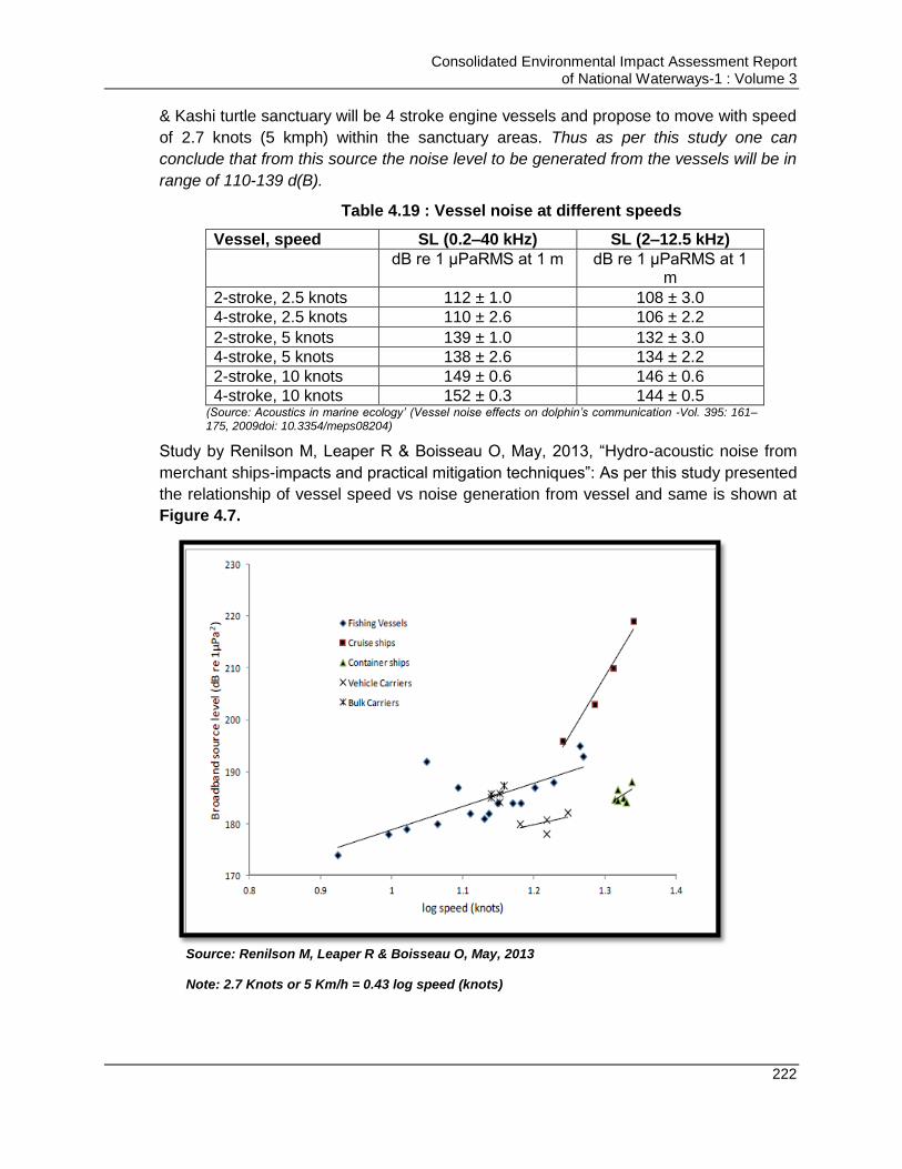
Consolidated Environmental Impact Assessment Report of National Waterways-1 : Volume 3
222
& Kashi turtle sanctuary will be 4 stroke engine vessels and propose to move with speed
of 2.7 knots (5 kmph) within the sanctuary areas. Thus as per this study one can
conclude that from this source the noise level to be generated from the vessels will be in
range of 110-139 d(B).
Table 4.19 : Vessel noise at different speeds
Vessel, speed SL (0.2–40 kHz) SL (2–12.5 kHz)
dB re 1 μPaRMS at 1 m dB re 1 μPaRMS at 1 m
2-stroke, 2.5 knots 112 ± 1.0 108 ± 3.0
4-stroke, 2.5 knots 110 ± 2.6 106 ± 2.2
2-stroke, 5 knots 139 ± 1.0 132 ± 3.0
4-stroke, 5 knots 138 ± 2.6 134 ± 2.2
2-stroke, 10 knots 149 ± 0.6 146 ± 0.6
4-stroke, 10 knots 152 ± 0.3 144 ± 0.5 (Source: Acoustics in marine ecology’ (Vessel noise effects on dolphin’s communication -Vol. 395: 161–175, 2009doi: 10.3354/meps08204)
Study by Renilson M, Leaper R & Boisseau O, May, 2013, “Hydro-acoustic noise from
merchant ships-impacts and practical mitigation techniques”: As per this study presented
the relationship of vessel speed vs noise generation from vessel and same is shown at
Figure 4.7.
Source: Renilson M, Leaper R & Boisseau O, May, 2013 Note: 2.7 Knots or 5 Km/h = 0.43 log speed (knots)

Consolidated Environmental Impact Assessment Report of National Waterways-1 : Volume 3
223
Figure 4.7 : Broadband source levels against log10 (speed in knots) for different ship types
Vessels to be used for material transportation from the NW1 terminal can be considered
under category of bulk carriers. Ship movement speed in the sanctuary areas is to be
restricted to 5 km/h only. The above given graph it is established that the noise level
generated from bulk carriers moving with speed of 5 kmph (2.7 knots) will not be more
than 130-140 d(B) (arrived based on extrapolation of above graph).
Study by Plon, S, Koper, R.P., and Endangered Wildlife Trust: This study
establishes the noise level generation from different vessel types. The noise level from
different types of vessel is given in Table 4.20. But no relation between the noise
generated with the speed of vessel is highlighted in this study.
Table 4.20 : Noise Level from Different Type of Vessel
Sound sources Types of sound
Pulse duration (sec)
Main Frequency (KHZ)
Source sound level d(B)
Cargo vessels Continuous n.a. 0.0-0.5 195 Small vessels Continuous n.a. 1.0-10.0 160-170
(Source: Plon, S, Koper, R.P., Endangered Wildlife Trust)
Based on above studies it is established that bulk vessels moving at a speed of 2.7
knots (5 kmph) generates noise of range 130-140 d(B). However, considering the
variation upper limit of 160 d9B) is also considered underwater noise modelling
assessment.
Under Ground Noise Modelling: Noise are the mechanical waves and the energy content
dissipates in surroundings with the distance of the waves movement. Noise level
received by the receiver is not of same intensity as the noise intensity at the source.
There is always a propagation loss associated with the noise transmission distance.
Thus noise received can be written as follows:
RL = SL-PL
RL- Received noise level
SL- Source Sound Level
PL-Propagation Loss
PL can be estimated using simple equation PL = Nlog10 (R), where N is scaling factor
and R is distance of receptor from source. N values differ for different environments. For
the convenience here N value is taken for shallow water environment in reference with
the study by Kongsberg Maritime Limited on “underwater noise propagation modelling
and estimate of impact zones for seismic operations in the Moray Firth”. As per this
study propagation loss is high in shallow waters due to strong interface with the surface
of the river bed. N values for shallow waters vary from 15-20.
For noise modelling purpose minimum noise levels considered are 130 d(B) due to
barge movement and maximum noise levels are taken to be 160 d(B) (20 d(B) more
than highest noise levels as per reference studies above to consider worst case
scenario). Considering the noise level variation from 130-160 d(B) and N value variation
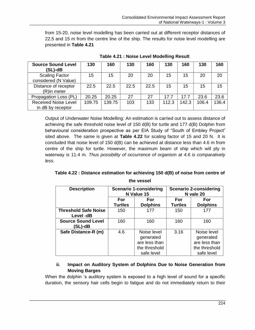
Consolidated Environmental Impact Assessment Report of National Waterways-1 : Volume 3
224
from 15-20, noise level modelling has been carried out at different receptor distances of
22.5 and 15 m from the centre line of the ship. The results for noise level modelling are
presented in Table 4.21
Table 4.21 : Noise Level Modelling Result
Source Sound Level (SL)-dB
130 160 130 160 130 160 130 160
Scaling Factor considered (N Value)
15 15 20 20 15 15 20 20
Distance of receptor (R)in meter
22.5 22.5 22.5 22.5 15 15 15 15
Propagation Loss (PL) 20.25 20.25 27 27 17.7 17.7 23.6 23.6
Received Noise Level in dB by receptor
109.75 139.75 103 133 112.3 142.3 106.4 136.4
Output of Underwater Noise Modelling: An estimation is carried out to assess distance of
achieving the safe threshold noise level of 150 d(B) for turtle and 177 d(B) Dolphin from
behavioural consideration prospective as per EIA Study of “South of Embley Project”
sited above. The same is given at Table 4.22 for scaling factor of 15 and 20 N. It is
concluded that noise level of 150 d(B) can be achieved at distance less than 4.6 m from
centre of the ship for turtle. However, the maximum beam of ship which will ply in
waterway is 11.4 m. Thus possibility of occurrence of organism at 4.6 is comparatively
less.
Table 4.22 : Distance estimation for achieving 150 d(B) of noise from centre of
the vessel
Description Scenario 1-considering N Value 15
Scenario 2-considering N vale 20
For Turtles
For Dolphins
For Turtles
For Dolphins
Threshold Safe Noise Level -dB
150 177 150 177
Source Sound Level (SL)-dB
160 160 160 160
Safe Distance-R (m) 4.6 Noise level generated
are less than the threshold
safe level
3.16 Noise level generated
are less than the threshold
safe level
ii. Impact on Auditory System of Dolphins Due to Noise Generation from
Moving Barges
When the dolphin „s auditory system is exposed to a high level of sound for a specific
duration, the sensory hair cells begin to fatigue and do not immediately return to their
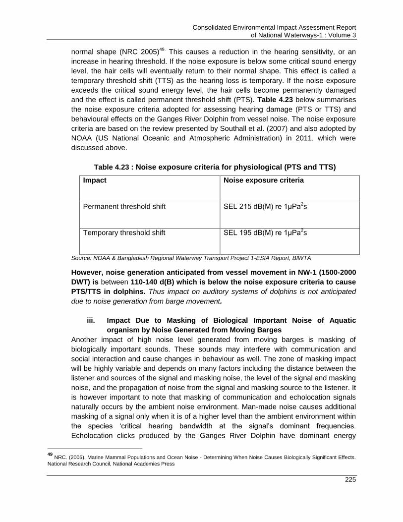
Consolidated Environmental Impact Assessment Report of National Waterways-1 : Volume 3
225
normal shape (NRC 2005)49. This causes a reduction in the hearing sensitivity, or an
increase in hearing threshold. If the noise exposure is below some critical sound energy
level, the hair cells will eventually return to their normal shape. This effect is called a
temporary threshold shift (TTS) as the hearing loss is temporary. If the noise exposure
exceeds the critical sound energy level, the hair cells become permanently damaged
and the effect is called permanent threshold shift (PTS). Table 4.23 below summarises
the noise exposure criteria adopted for assessing hearing damage (PTS or TTS) and
behavioural effects on the Ganges River Dolphin from vessel noise. The noise exposure
criteria are based on the review presented by Southall et al. (2007) and also adopted by
NOAA (US National Oceanic and Atmospheric Administration) in 2011. which were
discussed above.
Table 4.23 : Noise exposure criteria for physiological (PTS and TTS)
Impact
Noise exposure criteria
Permanent threshold shift
SEL 215 dB(M) re 1μPa2s
Temporary threshold shift
SEL 195 dB(M) re 1μPa2s
Source: NOAA & Bangladesh Regional Waterway Transport Project 1-ESIA Report, BIWTA
However, noise generation anticipated from vessel movement in NW-1 (1500-2000
DWT) is between 110-140 d(B) which is below the noise exposure criteria to cause
PTS/TTS in dolphins. Thus impact on auditory systems of dolphins is not anticipated
due to noise generation from barge movement.
iii. Impact Due to Masking of Biological Important Noise of Aquatic
organism by Noise Generated from Moving Barges
Another impact of high noise level generated from moving barges is masking of
biologically important sounds. These sounds may interfere with communication and
social interaction and cause changes in behaviour as well. The zone of masking impact
will be highly variable and depends on many factors including the distance between the
listener and sources of the signal and masking noise, the level of the signal and masking
noise, and the propagation of noise from the signal and masking source to the listener. It
is however important to note that masking of communication and echolocation signals
naturally occurs by the ambient noise environment. Man-made noise causes additional
masking of a signal only when it is of a higher level than the ambient environment within
the species „critical hearing bandwidth at the signal‟s dominant frequencies.
Echolocation clicks produced by the Ganges River Dolphin have dominant energy
49
NRC. (2005). Marine Mammal Populations and Ocean Noise - Determining When Noise Causes Biologically Significant Effects.
National Research Council, National Academies Press
Consolidated Environmental Impact Assessment Report of National Waterways-1 : Volume 3
226
around 65 kHz (Sugimatsu et al., 2011)50. This is well above the dominant frequency
range of most man-made noise, including pump noise. Masking of echolocation signals
is therefore not a significant issue for most man-made sources (Richardson et al., 1995).
Thus it can be concluded that noise generation due to barge movement is not
anticipated to interfere with echolocation ability of Ganges Dolphins. The Ganges
River Dolphin is likely to produce communication signals, such as whistles, squeals or
clicks, based on communication signals produced by other river dolphins. These signals
generally have energy at much lower frequencies than the echolocation clicks, i.e. as
low as 1-6 kHz. Communication signals are therefore more likely to be masked by
man-made noise than echolocation clicks. Noise reduction measures will help in
minimizing the noise generation from barge movement and will minimize masking of
communication signals generated by dolphins.
Measures for Avoidance and Mitigation of Noise Impacts on Aquatic Ecology
Vessel speed should be restricted to 2.7 knots in VSDS and Kashi turtle
sanctuary areas to reduce the noise generation from propeller. Hooting should
also be prohibited in sanctuary areas.
Vessel should be fitted with the dolphin reflectors
Usage of non-toxic and non TBT containing anti-fouling paints for painting vessel
Provision of propeller guards with vessel to minimize injury to the aquatic fauna
Barge/vessel movement will be restricted to the designate route only to minimize
noise disturbance of Aquatic life.
If any aquatic mammal spotted, then the measures should be taken to push it
away through sirens/signals and creating noise signals.
If any accident of aquatic mammal occurs, then that should be reported to IWAI
for rescue action through wild life or forests departments.
All vessels should follow MARPOL for managing their liquid and solid waste. No
vessel should discharge the liquid and solid waste in the river. All waste should
be discharged at vessel repair facility only. IWAI should develop the stringent
norms to be followed by vessel operators and should develop the system of
penalizing based on polluters pay principle in case the standards are not met or
violated
Material having potential to generate the dust like coal, sand stone aggregates
should be transported under covered conditions to minimize dust generation and
its settlement on river surface.
Provision of oil water interceptors with the bilge tank to separate oil prior
discharge of bilge water into river. Bilge water should be discharged as per
MARPOL requirements. Bilge water tank should be maintained as per MARPOL
requirement.
50
Sugimatsu et al. (2011). Annual Behavioral Changes of the Ganges River Dolphins (Platanista gangetica) Based on the Three
Long-Term Monitoring Seasons using 6-Hydrophone Array System. IEEE Symposium on and 2011 Workshop on Scientific Use of Submarine Cables and Related Technologies, (pp. 1-7). Tokyo
Consolidated Environmental Impact Assessment Report of National Waterways-1 : Volume 3
227
The proposed oil spill control and management plan (attached as Annexure 4.6
Volume 3C) should be effectively communicated for any emergency situations.
Crew of the vessel carrying especially oil should be competent and experienced
so as they can prevent the accidents to happen as much as possible
Regular maintenance of vessels engine and Propellers.
River training works should be carried out at the bank locations which are prone
to erosion to minimize sedimentation & impact on water quality &aquatic
organisms
Adequate depth to be maintained to prevent grounding under low flow conditions.
Information on available depths should be conveyed to the navigators through
online systems by IWAI. River Information System being developed by IWAI will
serve this purpose.
Maintaining flood plains & riparian corridors wherever possible and limit potential
damage to the navigation channel. Restricting the project activities in breeding
and spawning ground of the fisheries which are majorly the bends in the
meandering river.
Design measures like bandalling and design of groin should be considered which
can reduce the dredging requirement and help in meeting depth, width and
steerage needs and reduces dredging requirement
Modern design vessels having low draught say 2 m instead of 2.5 m for equal
payload should be procured by IWAI for transportation. Modern vessel- better
technology vessels or with retrofits with quieting techniques to reduce further the
noise generation (specifically cavitation‟s noise).
Regular patrol and inspections should be carried out to monitor the activities in
waterway. Also regular monitoring of environmental attributes as proposed in
environment planning plan of this should be carried out for the waterway to keep
track of the condition of the environmental attributes.
The navigation channel should maintain a minimum distance of 100m
horizontally and 500m either side along the river at the confluence point of major
tributaries with river Ganga.
Enhancement Measures:
Support for promoting fish productivity through setting up or supporting existing
fish nurseries. Also providing training and awareness support through reputed
institutes or experts like CIFRI for better fishing techniques.
Provision of supporting Studies for conservation of Dolphin and other sensitive
studies should be made.
4.14.4. Impacts on Terrestrial Ecology Due to Physical Interventions
A. Pre-Construction/Design and Construction Stage
Development of the civil interventions may require clearing of the vegetation from the
proposed site. No significant vegetation is present at Farakka lock, Haldia terminal and
Varanasi terminal site thus no significant impact on terrestrial ecology is anticipated. But
Consolidated Environmental Impact Assessment Report of National Waterways-1 : Volume 3
228
app. 500 trees are present at identified terminal site in Sahibganj. Mango orchards are
present at the planned terminal site at Sahibganj thus tree cutting for terminal
development is likely to affect the terrestrial ecology. This impact can be minimized by
designing terminal to minimize tree cutting and to carry out adequate compensatory
plantation. No wildlife is reported or observed during the visit at any of the proposed
sites. Thus no impact on wildlife is anticipated during construction phase of the project.
However, avifauna of the area may be impacted due to loss of their habitat (trees),
majorly at Sahibganj site. But the site is surrounded by agricultural land and mango
orchards thus sufficient habitat is present for the avifauna. Also it is proposed to plant
3500 trees in place of 500 trees which will be cut for development of the project. Trees
proposed to be planted are 7 times the nos. of trees to be cut. Trees after growing up will
provide excellent habitat to avifauna and insects. Also it is proposed to develop thick
peripheral green belt and avenue plantation at each of proposed civil intervention site.
This will help in improving the ecology of the area.
For development of the project, project site may be required to excavated and filled
which may impact the micro-fauna & flora residing within the soil. Also riparian
fauna/flora is also likely to be affected due to project development but since construction
phase is temporary and short term thus it is likely for vegetation to recover after removal
of disturbance or completion of construction activities. Thus the impact anticipated due
to project design & construction on terrestrial ecology are low-moderate.
Also during the construction of project the transportation of heavy vehicle carrying the
construction material will move in the project area. It will generate dust and noise during
movement. The dust will be settled on the nearby flora of the roads and adjoining area,
and covering the leaf and hence reducing the photosynthetic activity. Noise created due
to increased traffic will have impact on the nearby fauna, it may have impact on the
nocturnal animals/birds also. However, impact is anticipated to be short term and
temporary and will be confined to construction phase only. Anticipated impacts can be
minimized by taking proposed mitigation measures.
None of the planned intervention site is proposed within eco-sensitive zone. Eco-
sensitive zones within 10 km radius of the NW-1 alignment are Udhwa lake bird
sanctuary, Farakka barrage & surrounding areas, Mokama Taal Wetlands and Kurseala
River Course, Diyara Flood Plains and Danapur cantonment area. No impacts are
anticipated on flora/fauna of these areas during construction & design phase as no
construction activities are proposed within the river stretch along these areas. Mitigation
measures proposed to minimize the anticipated impact on the terrestrial ecology are
given below.
Measures for Avoidance and Mitigation of Impacts
Project layout design should be in a way to minimize tree cutting
Consolidated Environmental Impact Assessment Report of National Waterways-1 : Volume 3
229
Permission should be obtained from forest department prior tree cutting and only
the identified and permitted tree should be cut and remaining should be
maintained properly
Thick green belt should be developed at the periphery and along the roads on
the project site which will prevent spread of dust and reduce noise propagation.
Areas reserved for future development at site should also be made green by
growing grass and shrubs and herbs
Caution sign should be placed to prevent hunting of animals
Construction activities should be undertaken from 6:00 Am-10:00 Pm especially
noise generating activities.
Compensatory plantation should be carried out as per state forest policy. Apart
from mandatory requirement additional compensatory plantation should be
carried out as being done in case of Sahibganj terminal.
Green belt to be developed should be mainly naturally growing native species of
the area. Green belt should be developed as per the CPCB guidelines proposed
above climate section.
Survival rate for compensatory plantation and green belt to be developed at the
site should be monitored regularly and measures should be taken so as to
achieve minimum rate of 70%
All efforts should be made to minimise the cutting of tree through design
changes. Layout should be designed in a way so as to minimize the tree cutting.
Only trees identified for cutting should be cut. Tree cutting should be carried out
only after obtaining due tree cutting permission from forest department.
Workers should not use any timber or firewood as fuel for any purpose. LPG
should be made available to workers in construction camp.
No hazardous material or waste should be disposed in the other land or nearby
area as it may harm the animals, if consumed accidently
Speed limit will be regulated to prevent any accidents of animals. Regular
maintenance of the dumper should be done to prevent leakage of oil so as to
prevent pollution of the soil and impact on fauna and flora dependant on soil.
Regular Water Sprinkling should be carried out to minimize dust generation and
settling the dust on surface of flora.
Trees retained at the site (after site clearance) should not be disturbed, cut or
harmed in anyway. These trees should be maintained.
Adequate parking space should be provided within the site for construction
vehicle and equipment so as they are not parked in other areas like road side,
others agricultural field, and open areas to avoid any harm to flora of that area
due to movement of heavy vehicles.
Construction camps should not be established inside or near the forest area
Construction activities and vehicle washing should not be undertaken at the river
or any other water body or close to the water body
Site should be barricaded to prevent entry/trespassing of the animal in the site
Consolidated Environmental Impact Assessment Report of National Waterways-1 : Volume 3
230
Hunting, poaching and harming any animal (wild or domestic)/birds by any
worker or project related person should be strictly prohibited and monitored.
Provision should be made for strict penalty for hunting/harming any animal/birds
Illumination at the night time should be reduced during the night time (if no
activity is going on) as it may disturb the nocturnal animals
Noise generating activity should not be undertaken during night time to minimize
disturbance to animals/birds. Noise levels should be maintained within the
prescribed CPCB limits to the extent possible during the day time.
Workers should not use any timber or firewood as fuel for any purpose. This will
minimize the tree cutting requirement
B. Operation Stage
Positive impact on ecology is anticipated during the operation stage of planned
interventions majorly. Thick peripheral green belt will be developed and avenue
plantation will be carried out at all the proposed intervention sites. Green belt will provide
excellent habitat to avifauna, insects, small animals like squirrels, lizards, chameleons
etc. Tree survival rate will be monitored and will be maintained to minimum 70%. Proper
after care will be done for the planned green belt and this has separate budgetary
provision under the EMP. But as the interventions like terminals and jetties involve
movement of vehicles at and around the site, dust level may increase in the area. This
dust when settles on the leaves of the trees will hamper the photosynthesis activity.
Measures for Avoidance and Mitigation of Impacts
Proper aftercare and monitoring of the green belt & avenue plantation
Maintaining survival rate of plantation to minimum 70%
Regular watering and cleaning of the leaves to remove the accumulated dust on
the leaves
4.14.5. Impacts on Aquatic Ecology Due to Physical Interventions
A. Pre-Construction/Design and Construction Stage
Eco-sensitive aquatic habitats identified within NW-1 are Vikramshila Dolphin sanctuary
(Sultanpur-Kahalgaon) and Kashi Turtle Sanctuary at Varanasi. No civil interventions ae
proposed within these locations. Also it is proposed no dredging/dredge disposal will be
carried out within this stretch. Thus impacts anticipated on these eco-sensitive zones
during design & construction phase are minimal. However, construction activities like
dredging/piling is proposed to be carried out in river stretch along the planned
terminal/jetties site. Piling & dredging activities have potential to impact aquatic ecology
of the area. Anticipated impacts during construction phase on aquatic ecology for the
project are given below:
i. Impact of Piling/Dredging Activity due to sound Generation on Aquatic ecology:
Pilling & dredging activities will be carried out for construction of proposed off-site
facilities like jetties & berths. For the purpose, dredger will be placed in the River which
Consolidated Environmental Impact Assessment Report of National Waterways-1 : Volume 3
231
will occupy some physical space in the River. This space was being used by the biotic
components of the river. As a behavioural response, instinctively animals at the first
encounter avoid approaching the site of unknown object. This is done using
echolocation, olfaction or chemo-reception, if the object is not making any sound. If
object / machine starts making sound / noise, then all vertebrates through auditory
acoustic sense avoid the area which has disturbing range of sound and hampers to the
natural acoustic behaviour and physiology of these vertebrate fauna from fishes to
dolphins.
Apart from occupying the physical space, dredging and pilling activity will generate
significant noise. Exposure to low levels of sound for a relatively long period of time, or
exposure to higher levels of sound for shorter periods of time, may result in auditory
tissue damage in fish, though recovery is generally possible within 24 hrs (Popper et al.
2005). Oscillations induced by high sound pressure levels can cause swim bladders in
fishes to tear or rupture (Hastings and Popper 2005). Whereas it is possible that some
(although not all) species of fish would swim away from a sound source, thereby
decreasing exposure to sound, larvae and eggs of fish are often at the mercy of currents
or move very slowly. Movement of the fishes and dolphins away from these places
makes the place unused for foraging, spawning and local movement. This would cause
crowding of organisms at other places and enhanced struggle for space and other
requirements, till the disturbance has not ceased/completed.
Measures for Avoidance and Mitigation of Impacts
The area in which the construction of the Berth (jetty) is planned, advisable to
carefully determine drop sites before anchor placement to ensure that Dolphin
and fish communities that could locally still be present in the area are not
unnecessarily damaged.
Before starting piling allow some time to aquatic fauna to displace from the piling
area. Bubble curtains can be provided at the time of pilling so as to displace the
aquatic fauna prior start of construction activities
Fish exclusion devises should be installed in water column around the pile driving
area to prevent fish access
The piling activities must be carried out in shortest possible timeframe as
possible
All the debris should be disposed away from river course as per debris
management plan of the project.
Decisions on method of construction and type of technology and equipment to be
used must consider the noise and vibration levels and extent of siltation being
generated. Noise and vibration levels must be far below levels that can cause
injury to dolphins and other wildlife.
Noise reducing devices like mufflers, enclosures should be fitted with the
equipment as much as feasible. Noise barriers should also be installed

Consolidated Environmental Impact Assessment Report of National Waterways-1 : Volume 3
232
Geo Textile synthetic sheet curtain & turbidity traps should be placed around
pilling and construction area to prevent movement of sediments and construction
waste
Appropriate protocols and procedures must be prepared for sighting of dolphins
and other endangered wildlife species within the vicinity of the dredging site. The
objective of the protocols and procedures must be aimed at having no or minimal
impacts on the respective wildlife species.
ii. Impact of Piling/Dredging Activity: loss of habitat
Large amount of river bed sediment (dredged Material) will be removed for carrying out
bank & bed scouring and erosion protection. Bed and bank erosion/scour prevention
works involve stone pitching of banks upstream & downstream, concreting of banks,
construction of retaining walls/embankments along the river banks, construction of
aprons across the river along the length of the proposed terminal/jetty, construction of
guide walls in case of Farakka lock etc. These sediments are in habituated by various
benthos (molluscs, arthropods, juvenile fishes, amphibians and reptiles etc.). Removal of
these sediments will lead to mortality of these communities. Also the actual habitat will
be lost permanently in the activity area due to bed and bank erosion/scour prevention
works. Impact on the moving aquatic species is however anticipated to be low as they
disperse when any activity is being carried out in the river.
The major impact on larger organism is that the movement routes, spawning activities
and foraging grounds of these organisms may be affected. These animals would also
struggle for normal conditions due to increased turbidity and increased sedimentation
during the dredging activity. Increased sediments and turbidity can impact the aquatic
life by reducing visibility, making water coarse, choking gills of fishes etc. Thus
measures should be taken to quicken up the dredging and piling activities, minimizing
the noise level and controlling the sediments generation. Among the floral components
rooted plants will be uprooted and destroyed totally. The primary productivity by
phytoplankton will be lowered, on account of lowered transparency for light.
iii. Impact of Piling, dredging and other construction activities due to release of
sediments
The riparian area soils are loose and sticky/clayey. Release of these sediments would
cause high increase in turbidity of water during and sometime after the dredging/oiling
activity. Such soil has a tendency of sticking over the skin and gills and blocking the
pores and is hence harmful. Suspended sediment due to dredging operations in the
water column blocks available light for photosynthesis, reducing benthic primary
productivity and inhibiting the ability of benthic plants to recover from dredging impacts.
But the effect of suspended sediments and turbidity in open environment like river are
generally short term (<1 week after activity) and near field (<1km from activity). There is
only need to be concern if sensitive species are located in the vicinity of the maintained
channel.
Some pollutants such as insecticides, pesticides, fertilizers may be unlocked from
sediments when dredged. But soon it will be washed away along the flow. The test
Consolidated Environmental Impact Assessment Report of National Waterways-1 : Volume 3
233
results show very low concentration of pesticide. Even then there are chances that it
may enter the food chain.
Construction activities to be undertaken involves storage of raw material, debris, fuel,
paints etc. There are likely chances that, the run-off from the site may get contaminated
with these materials and when it will enter the water body may also degrade the water
quality of the river.
Measures for Avoidance and Mitigation of Impacts
To avoid the construction debris, wash or blown into the water the area should be
surrounded by silt screens, which must be placed in the water before the work
starts. Geo-Textile synthetic sheet curtain can act silt screen which should be
placed around pilling and construction area to prevent movement of sediments
and construction waste The screens should also be placed around storage
areas, to prevent waste from blowing away and to prevent sediment run-off into
the river. The storm water drain should be connected to temporary sedimentation
pit and collected water should be used for dust suppression. Run-off from site
should also pass through oil/grease traps and flow down to the same
sedimentation tank before its reuse
In addition to silt screens, building guidelines of the Bonaire National Marine Park
require that storage areas for sand and soil, and all work areas, must be at least
20 meters away from the high water mark and construction equipment must not
be cleaned or washed within 50 meters of the high water mark.
Piling and dredging activities should be carried out rapidly. Piling should not be
carried out during breeding and spawning season means during rainy season. It
should be carried out in low water season, i.e. pre-monsoon
Piling/Dredging should be stopped for some time, if any dolphin/RET species is
sighted in activity area
Equipment should be maintained in good condition to prevent leaks or spills of
potentially hazardous materials like hydraulic fluid, diesel, gasoline and other
petroleum products
Excavation activities onshore should not be undertaken during monsoon season
so as to minimize sediment load of run-off
Soil stabilization works in the bank must consider implications on changes in
hydrological flow, current and behaviour of the river. Such changes may create
new problems such as change of river course, erosion of river embankment,
change in erosion and inundation pattern of the bank etc. which will in turn
impact the habitat of aquatic life
Workers should be trained to handle the equipment and material at site so as to
minimize the spillage of materials and contamination of water
All workers should be made aware of not throwing any waste in the river or any
drain
No construction debris/ already accumulated solid waste at site or waste
generated from labour camp should be thrown in river or any drain
Consolidated Environmental Impact Assessment Report of National Waterways-1 : Volume 3
234
Sewage generated from labour camp should not be directed into river but should
be disposed through septic tank/soak pit
Run-off from site should pass through oil/grease traps and sedimentation tank
prior discharging into the river
All construction and operation equipment should be maintained in good condition
should be checked for oil & grease leakage
Dredged soil should not be disposed in river or its banks especially during
breeding spawning seasons of aquatic organisms
Aquatic ecology monitoring should be carried out prior start of construction and
after completion of construction so as to assess the impact of construction
activities on aquatic life.
All construction and operation equipment should be maintained in good condition
should be checked for oil & grease leakage
Nesting grounds, breeding & spawning grounds should be identified and project
activities should be minimized in those areas
B. Operation Stage
Impact due to operation of any project is of main concern as it always persists.
Construction of berths, jetties and other off-shore structure will consume physical space
in water reducing the available space for the aquatic organism. Planktonic population at
berth area and nearby area will reduce or will decrease drastically which will impact the
primary productivity of the water body. Planktons is feed for various big fishes, thus
reduce in plankton population will affect the aquatic food chain. However, area to be
covered by berth is very less as compared to width of the river. Thus reduction of this
much space will not have significant impact. Also it is possible that aquatic organisms
may collide with these newly constructed structures. But as behavioural response,
instinctively aquatic animals at the first encounter avoid approaching the site of unknown
object. This is done using echolocation, olfaction or chemo-reception, if the object is not
making any sound. Thus the space occupied by unknown structures will be avoided by
aquatic organisms thereby reducing the chances of collisions and injury to aquatic
organisms.
During rains, run-off from the stockyards at jetty/terminal sites may enter the river and
may contain the contaminants. This contaminated run-off may pollute river water quality,
if discharged in river. Thus proper storm water collection and management system is
required so as water from stockyards do not enter the river directly. Sewage & waste will
be generated at intervention sites (terminal/jetties/locks) and in vessel. If this waste is
disposed on the land or in river, then this waste can pollute the soil impacting the
terrestrial ecology and can pollute the water impacting aquatic ecology. Release of coal
dust during coal transhipment and may settle on surface of the river and will have a
negative impact aquatic life.
Other activities at the sites of civil interventions which may have impact on aquatic
ecology are berthing & mooring of vessel, oil/material spillage, dust generation from
Consolidated Environmental Impact Assessment Report of National Waterways-1 : Volume 3
235
material transportation, barge movement and maintenance dredging for keeping the
berth area navigable. Berthing & mooring of the vessel at terminal/jetties reduces the
circulation of water in the area thereby reducing the air flow in the water and self-
assimilative capacity of river in that stretch. If vessel is berthed for longer duration at
terminal/jetty sites, then there are increased chances of release of toxins from anti-
fouling coating of vessel or leakage of some oil from bilge tank into the river. All these
may pollute the river water quality near the terminal/jetty sites. Movement of barges in
the civil intervention area will increase after development of the proposed interventions
and thus the transportation of commodities will also increase. Some of the commodities
to be transported include building & construction material, and coal which may generate
the dust and this dust can settle over the surface of the river. This dust will increase
turbidity of water and may reduce the visibility of the water there by impacting the SAV,
planktonic communities and other aquatic fauna. This dust if consumed by aquatic
organisms may cause respiratory and other related problems in organisms. Thus it is
required for transportation of dust generating material under covered conditions. Also
coal should be kept moist so as to reduce the dust generation potential during
transportation. It is proposed to transport edible oil/POL at Haldia terminal site so there
are likely chances of accidental oil spillage near the terminal site or in the waterway. Oil
spillages are threat to aquatic organisms and can lead to mass mortality also. Oil spills
can affect all planktons, benthos and Fishes.
Maintenance dredging and disposal of dredged material will also be required to be
undertaken at the proposed intervention sites so as make them navigable throughout the
year. As per the planning, insignificant quantity of dredging will require to be carried out
at Sahibganj & Varanasi terminal site. Dolphins are found in the river stretch along
Sahibganj terminal. Terminal site is located in the secondary channel so impact of
dredging near terminal site on the dolphins is nil.
Dredging of 30-60 lakh cum will be required at Haldia Terminal site but no dolphins are
observed in that stretch of river. Quantity of dredging will depend on the duration for
which terminal will be kept navigable and nos. of berths to be kept navigable. Dredging
operations generate high noise levels, increased turbidity of the water, and removal of
benthic community thus impacting aquatic ecology, reduce DO level in water thus
reducing available oxygen for aquatic organisms, may unlock toxins trapped in the
sediments etc. All these impact the aquatic environment and organisms. Impacts of
dredging operation and disposal of dredged material on aquatic ecology are discussed in
detail in section 5.4 of this chapter. Mitigation measures are proposed to prevent the
impact of project on aquatic ecology and are given below
Measures for Avoidance and Mitigation of Impacts
Dust generation during loading & unloading of barges should be minimized by
adopting mechanical conveying system and provision of water sprinklers for dust
suppression. This will reduce the chances of disposal of dust on river surface.
Materials like coal should be kept moist to suppress the dust generation.

Consolidated Environmental Impact Assessment Report of National Waterways-1 : Volume 3
236
The solid wastes, sewage, oily ballast, bilge water and bunker fuel bottoms
generated from barge should not be discharged directly and it should be
discharged as per the norms. Cargo Operators needs to exercise all caution to
avoid any kind of accidental discharge of such wastes. Maintenance and
repairing and fuel refilling of barge and vessels should be carried out at approved
locations only and measures for separation and removal of oil/grease from
wastewater should be kept at that site.
The opposite bank of river should remain untouched to balance the impacts of
active site.
To the extent possible river training works (RTW) must be avoided as it destroys
the natural aquatic ecosystem
Location of river training works must avoid key habitat areas such as breeding
and feeding grounds etc. of key biodiversity species found in the project area
such as dolphins, migratory birds, reptiles, benthic organism and others. If it is
necessary to do river training in key biodiversity areas, appropriate compensation
with similar area and habitat type must be included in the plan
Nesting grounds, breeding & spawning grounds should be identified and project
activities should be minimized in those areas
Dolphin Conservation: The Gangetic dolphin belongs to Order Cetacea of Class
Mammalia and has been categorized as 'Endangered' by the International Union
for Conservation of Nature (IUCN) in 1996. It is included in Appendix I of the
Convention on International Trade in Endangered Species of Flora and Fauna
(CITES), and in Appendix II of Convention on Migratory Species (CMS).
Government of India provided legal protection to this species by including it in
Schedule I of the Wildlife (Protection) Act 1972. It was declared as the National
Aquatic Animal of India by Honourable Prime Minister, Dr. Man Mohan Singh, on
5 October, 2009. Considering this it is proposed to support Dolphin conservation
activity. It is proposed to allocate a separate budget for this activity. This task
may be undertaken through “The Vikramshila Biodiversity Research and
Education Centre (VBREC)” together with the Whale and Dolphin Conservation
Society (WDCS), the Environmental Biology Laboratory of Patna University, and
T.M. Bhagalpur University, who has jointly initiated a project to improve the
conservation value of Vikramshila Gangetic Dolphin Sanctuary.
No wastewater or waste should be disposed in river from terminal site or from
vessel into the water. Penalty should be imposed on the vessels reported of
disposing waste/wastewater in the river
Surface run-off from site should be collected separately in dump pond, retained
and then clear water should be re-used at site for dust suppression. Run-off from
building roof-top should be collected separately and should be used for plantation
and cleaning purpose or should be recharged into the ground.
STP should be provided at site for treatment of sewage generated. Treated water
from STP should be reused completely at site and should not be discharged into
river
Consolidated Environmental Impact Assessment Report of National Waterways-1 : Volume 3
237
Dredged sand should not be disposed at river banks especially during breeding
spawning seasons of aquatic organisms. Dredging should be avoided during the
breeding and spawning seasons
Instruction should be given to all vessels and all employee and staff that no
dolphin or any other endangered species should be harmed due to any reason
Instruction should be given to vessel operator that in case any accident with
dolphin occurs that should be reported immediately to terminal authority
Waiting time of vessel should be reduced at the terminal by providing the
adequate loading and unloading equipment and vehicles.
Vessel should be instructed for not using sharp lights and sounds as they may
disturb aquatic organisms
Ship speed should be controlled especially in dolphin habituated stretch to
minimize dolphin kill and the design of vessel and acoustic treatment should be
done for vessel so as to minimize the sound exposure of dolphins.
Propeller guards should be provided for all the vessels to minimize the propeller
inflicted injuries and scars.
No developments should be brought up on other bank of river opposite to
terminal site so as to provide the ground to aquatic organisms for their activities
Dust suppressors should be used at site and at barge while loading & unloading
of material to suppress the dust level.
Quick clean-up operations should be carried out in case of accidents. Vessel
owner should be responsible for paying the clean-up expenses in case of the
accidents and pollution of river water quality
Time schedule and the quantity of material allowed should be strictly checked
and monitored for each ship. This will prevent overcrowding of the vessels at
terminal site and thus no obstruction will be there on movement of the aquatic
organisms due to vessel.
Vessel should be instructed for not using sharp lights and sounds as they may
disturb aquatic organisms
Ship design (of capacity > 5000 DWT) should be as per MARPOL and should be
provide with double hulls/double bottoms. Speed of oil carrying vessels should be
maintained to prevent accidents due to high speed. Sensors and hooters should
be fitted with vessel which can notify the closeness of another ship or any other
potential matter which can cause accident.
Survival rate of planted tree species should be monitored after every six months.
Crew of the vessel carrying the oil should be competent and experienced so as
they can prevent the accidents to happen as much as possible
IWAI should carry out the inspections of the vessels which are transporting the
material to and fro from the terminal.
Aquatic ecology monitoring should be carried out yearly so as to assess the
impact of terminal activities on aquatic life.

Consolidated Environmental Impact Assessment Report of National Waterways-1 : Volume 3
238
4.14.6. Conclusion (Ecological Environment)
From the above discussion, it is evident that physical interventions development can
affect both the terrestrial and aquatic ecology however barge operations and
maintenance dredging operations are likely to affect the aquatic ecology if the issues
identified are not addressed and mitigated adequately. Significance of the impacts of
physical interventions will be different in different phases of development on both the
components however the impact on aquatic ecology due to dredging and barge
operations is anticipated only during operation phase of the project. The impacts can
affect the ecology of the area significantly if left unadressed. Mitigation measures as
proposed are essentially required to be implemented to prevent the identified impact on
the terrestrial and aquatic ecology. This measures will prevent the impacts as well as will
reduce the intensity of the impact on the ecology.
4.15. Impact on Social Environment& Mitigation Measures
4.15.1. Status of social environment along NW-1 and influence
A. Demography:
NW-1 mainly passes through four Indian states namely Uttar Pradesh, Bihar, Jharkhand,
and West Bengal. Each of the state has distinct socio-economic profile. Allahabad,
Sirsa, Mirzapur, Chunar, Varanasi, Zamania, Ghazipur, Gahmar, Buxar, Ballia, Chappra,
Patna, Barh, Bihat, Munger, Bhgalpur, Kahalgaon, Sahibganj, Farakka, Berhampore,
Katwa, Kalna, Kolkatta and Haldia are densely populated areas along NW-1. As per the
Census Record of India 2011 the population of major cities/ town located along the
Ganga river in NW-1 section was recorded as 12875343 comprising 6782150 male and
6093193 females. Total numbers of „Households‟ was also recorded as 2562165 and 0-
6-year age population was also recorded as 1308682.
B. Fishing and Livelihood along NW-1:
Ganga is the most important river and source of livelihood for countless fishers
inhabiting on its bank. It is reported that almost every village along the both sides of the
river are having some fishermen who earn their livelihood by fishing in the Ganga river.
There is no census data available regarding fishers specifically involved in capture
fisheries in the whole NW-1 stretch. Generally, one member of the family is engaged in
fishing in lower stretch of NW-1(Farakka to Haldia), sometimes two, the average comes
to be 1.5. However, in upper stretch (Allahabad to Farakka) the average person
engaged in fishing is 1.2 that is mainly due to low catch of commercially important fish in
this stretch. The fishermen do fishing for 5-12 hours daily, depending upon the season.
Fishing activities is very less during monsoon season. Fishing is the main occupation to
90% of the fishers, which contribute to more than 80% of their household income. Other
major occupation includes fish vending, ferry service, tourism, driving and daily labour.
Most of the fisherman does not have agricultural land and small amount of income
comes from labour wage, service, and petty business. In the season of less catch the
youth generally engage themselves in labour works or rickshaw van pulling to earn their
livelihood.
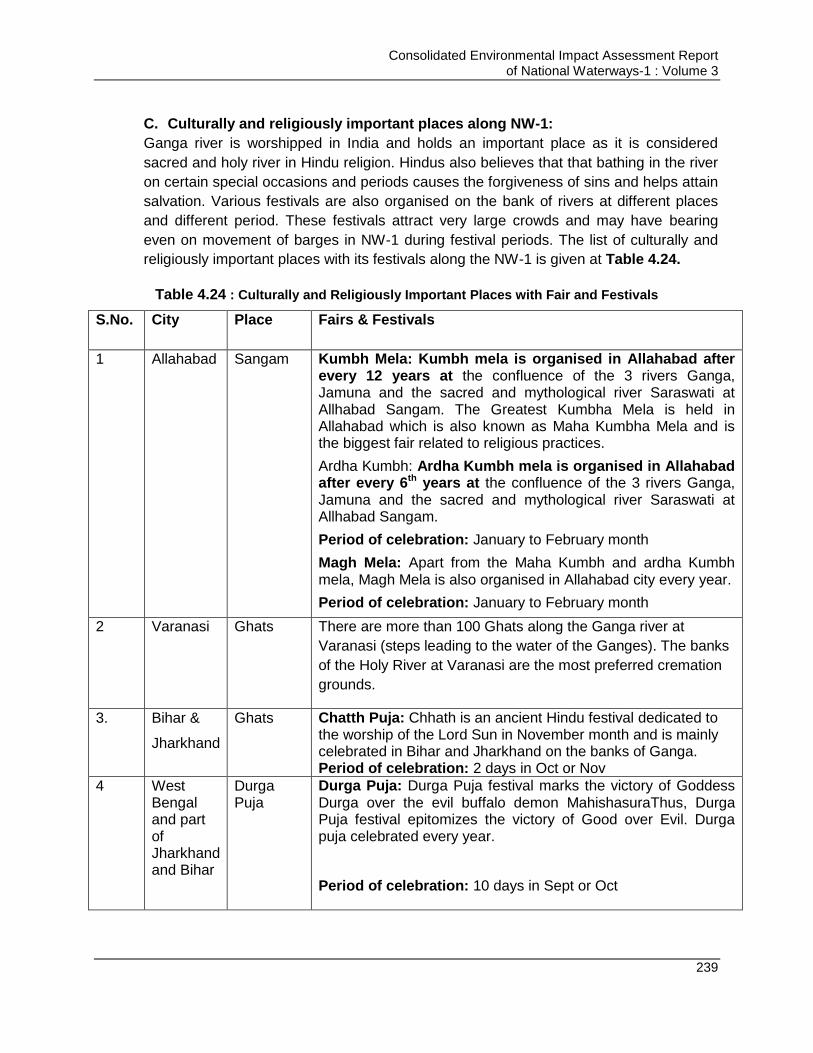
Consolidated Environmental Impact Assessment Report of National Waterways-1 : Volume 3
239
C. Culturally and religiously important places along NW-1:
Ganga river is worshipped in India and holds an important place as it is considered
sacred and holy river in Hindu religion. Hindus also believes that that bathing in the river
on certain special occasions and periods causes the forgiveness of sins and helps attain
salvation. Various festivals are also organised on the bank of rivers at different places
and different period. These festivals attract very large crowds and may have bearing
even on movement of barges in NW-1 during festival periods. The list of culturally and
religiously important places with its festivals along the NW-1 is given at Table 4.24.
Table 4.24 : Culturally and Religiously Important Places with Fair and Festivals
S.No. City Place Fairs & Festivals
1 Allahabad Sangam Kumbh Mela: Kumbh mela is organised in Allahabad after every 12 years at the confluence of the 3 rivers Ganga, Jamuna and the sacred and mythological river Saraswati at Allhabad Sangam. The Greatest Kumbha Mela is held in Allahabad which is also known as Maha Kumbha Mela and is the biggest fair related to religious practices.
Ardha Kumbh: Ardha Kumbh mela is organised in Allahabad after every 6th years at the confluence of the 3 rivers Ganga, Jamuna and the sacred and mythological river Saraswati at Allhabad Sangam.
Period of celebration: January to February month
Magh Mela: Apart from the Maha Kumbh and ardha Kumbh mela, Magh Mela is also organised in Allahabad city every year.
Period of celebration: January to February month
2 Varanasi Ghats There are more than 100 Ghats along the Ganga river at
Varanasi (steps leading to the water of the Ganges). The banks
of the Holy River at Varanasi are the most preferred cremation
grounds.
3. Bihar &
Jharkhand
Ghats Chatth Puja: Chhath is an ancient Hindu festival dedicated to the worship of the Lord Sun in November month and is mainly celebrated in Bihar and Jharkhand on the banks of Ganga. Period of celebration: 2 days in Oct or Nov
4 West Bengal and part of Jharkhand and Bihar
Durga Puja
Durga Puja: Durga Puja festival marks the victory of Goddess Durga over the evil buffalo demon MahishasuraThus, Durga Puja festival epitomizes the victory of Good over Evil. Durga puja celebrated every year.
Period of celebration: 10 days in Sept or Oct

Consolidated Environmental Impact Assessment Report of National Waterways-1 : Volume 3
240
D. Tourist Place along NW-1:
There are many cities along the banks of NW-1 specially Allahabad, Varanasi and
Kolkata which are important from tourism prospective and attract thousands of religious
and non-religious tourists every year. Varanasi, a pilgrim place for Hindus and Buddhists
alone attracts over one million pilgrims every year followed by Allahabad.
E. Archaeological sites along 300 m of NW-1:
The archeologically protected structures/monument51 located within 300 m of NW-1 is
listed at Table 4.25.
Table 4.25 : Archeologically Protected area around 300 m of NW-1
No. Name Latitude& Longitude Place
Distance from NW-1
km
Direction from NW-
1
1 KardmeshwarMahadeva
Mandir 25°19'13.13"N 83° 1'20.91"E
Varanasi, UP 0.24 W
2 Ramnagar, fort, 25°16'9.17"N
83° 1'28.17"E Varanasi, UP 0.04 East
3 Archaeological
excavation site, Varanasi 25°19'33.72"N 83° 2'4.47"E
Varanasi, UP 0.13 North
4 Manmahal and
observatory 25°18'27.83"N 83° 0'38.55"E
Varanasi, UP 0.04 West
5 Sindhi Dalan 25° 3'15.32"N
87°49'51.17"E Rajmahal, Jharkhand
0.3 West
6 Jami masjid 25° 4'25.73"N
87°46'39.01"E Mangalhat, Jharkhand
0.14 West
7
St. John's Church 22°34'11.38"N 88°20'45.27"E
Council house street, Kolkata,
WB
0.3 East
8
Temple of Gour Chandra and Krishnachandra at Chatra (Gaur Chandra
Ghat)
22°45'48.96"N 88°20'13.76"E
Hoogly, WB 0 West
9 Hazardwari Palace 24°11'10.27"N
88°16'5.73"E Murshidabad,
WB 0.03 East
4.15.2. Impacts on Socio-Economic and Cultural Aspects due to Maintenance Dredging
Impact of Dredging & disposal of dredged material are anticipated on cultural &
archaeological important locations and on livelihood of fishing community.Dredging
operations may impact socio-economy and noise levels near dredging location,
increased river water pollution, unpleasant view and increased air pollutants. These
impacts are however short term and localized as will be confined to dredging locations
51
As per Indian regulation no construction activity can take place within 300 m of archeologically protected monuments/
structures/site without written permission from archeological department.
Consolidated Environmental Impact Assessment Report of National Waterways-1 : Volume 3
241
only. Dredging activity also pose threat to health & safety of the workers and other
waterway users. No construction or interventions are planned within 300m of any of
Archeologically protected monument. The Ramnagar fort is one of the protected
monument. IWAI has undertaken a study with the help of Indian Institute of Technology
(IIT) Roorkee to establish the effect of development of Varanasi terminal and NW-1
development. IIT in its study has establish that these developments will have no impact
on these protected. As per analysis and planning no dredging is proposed near the
important cultural areas/Ghat (Refer Table 5.2 for list of Ghats). Placement of dredgers
in river may disrupt the fishing activities, however dredging activities at any particular
location will be for short duration and thus the impacts will not be significant. Dredging
operations generate noise of 80 dB(A) which can create discomfort for the population
residing on the banks specially in the night time. Dredging operations required
manpower for carrying and controlling dredging operations. Thus generation of
employment for skilled, semi-skilled and unskilled labour can be taken as positive impact
of dredging operations. Dredging operations will enable navigation of the barges in the
waterway throughout the year thereby increasing the IWT mode of transportation. This
will have positive socio-economic impact in terms of employment generation.
Measures for Avoidance and Mitigation of Impacts
Dredging should be prohibited in biological & social sensitive location and at time
of religiously and culturally important festivals, during breeding & spawning
season of fishes and during migratory bird season to minimise impact on socio-
cultural aspects.
A minimum of 100 m buffer zone from the religious Ghats at Varanasi and Patna
(the cultural heritage locations) is proposed to be maintained as prohibited area
for dredging for the protection of Ghats.
Precautions followed for archeologically protected monument should also be
followed for any intervention near any culturally important heritage structures.
It is also proposed to report to IWAI and ASI for any chance finding during
excavation and construction stage.
Timely intimation to fishermen about dredging operation and location can
minimize the disturbance to fishermen. As enhancement fishermen should be
provided with trainings by institutions like CIFRI to learn better fishing practices
and available aids for fishing which will help them to enhance their livelihood.
Measures for preventing accident risks during dredging and arrangement of all
first-aid should be available at dredging locations all the time
Dredging operations should be carried out primarily to day time, i.e. 6:00 Am-
10:00 Pm only to minimize noise impacts on the residents of nearby settlements.
Dredgers should be equipped with the noise reduction/masking equipment to
reduce the noise generation
Dredgers should be placed in consultation with the fishermen so as to minimize
the impact on their equipment/gears and their fishing activities
Consolidated Environmental Impact Assessment Report of National Waterways-1 : Volume 3
242
Dredging should not be carried out in the areas close to Ghats in Varanasi and
buffer of 2 km should be maintained for dredging during time of religious
gatherings during Chat and Kumbh festivals.
In case contaminated dredged material is disposed on land, then it should be
disposed at approved TSDF sites to prevent any harm to community residing in
nearby areas. One of such approved TSDF site is located Sagar (Haldia Dock
Complex site)
Material to be disposed on land may create nuisance odour due to exposure of
anaerobic sediments with air. Thus if land disposal is involved than disposal site
should not be in upwind direction of any settlement area or sensitive locations
like hospitals, schools etc.
Log book should be maintained for recording the accidents at site/mortality of the
any marine mammal should be maintained. Analysis should be carried out to
assess the reason for the accident/mortality and measures should be taken to
prevent repetition of the event.
Contractors having experience of dredging and well trained staff should only be
allowed to carry out dredging. This will help in prevention of spillage of dredged
material or any accidents during the dredging operations
Dredging plan should be prepared by contractor and submitted to IWAI for
approval prior to carrying out dredging operations. Dredging plan should be
reviewed considering its location w.r.t environmental sensitive
locations/archaeological locations/cultural festival/pollution influx in the
area/dredged material quality & texture/available depth etc. as given in this EIA
report and through local sources and past experience.
Contractors should submit method statement & risk assessment plan prior to
carrying out any dredging work. Dredger should follow the defined safety
procedures to avoid accidents and spills, and IWAI should ensure that other
vessel users are provided with adequate information and instruction to avoid
conflict with the dredgers.
Post-dredging monitoring of the sediment nature, rate of sedimentation should be
made part of contractor‟s job as best dredging practise. This will provide
information which can be taken into consideration before the next maintenance
dredge is carried out.
Re-use of dredged material should be explored if dredged material is not
contaminated. Economically and environmentally feasible options can be
adopted to minimize the dredge spoil burdens. Some of such measures include
o Dredged sediment can be used for beach nourishment/development of
artificial beach/deposition on shoal & thus enrichment of habitat
o Dredged material can be explored for its usage for coast/bank protection
purpose/flood protection
o Use of dredged material can be explored for land filling, as construction
material for road foundations, dikes, mounds, noise/wind barriers.
Consolidated Environmental Impact Assessment Report of National Waterways-1 : Volume 3
243
4.15.3. Impact on Socio-Economic and Cultural Aspects Due to Operations- Barge Operations
A. Impact on Health & Safety
Vessel movement(Shipping operations) are subjected to various threats of accidents
related to natural disasters like flood or cyclonic and operational like Collison, fire,
spillages. However, these accidents and accident intensity can be minimised with
appropriate preventive measures.
A. Natural Hazard:
River Ganga is snow fed river and is perennial in nature and floods every year. Thus
threats to navigation are anticipated during the heavy flow and flood like situation
especially to smaller vessels. Also Haldia is located in coastal region and is prone to
cyclonic threats. Haldia is classified as high cyclone risk zone as per Cyclone Hazard
Map of India. Thus it is mandatory for vessels to adopt the measures and prepare
emergency preparedness plan to handle emergency situations like floods and storms.
B. Operational Hazard:
There is also existence of various man-made navigational obstacles which pose threat to
navigation such as presence of critical brides (ref Chapter 3), presence of siphon to
extract water for irrigation scheme in Farakka feeder canal, presence of pylons,
meandering of river, change in river course, variable depths, sharp bends. However, all
these threats can be reduced and managed by physical interventions and operational
controls such as provision of night time navigation system, maintenance dredging,
adequate and efficient river information system, vessel tracking system, Electronic
Charts Display Information System - ECDIS, and Automatic Information System – AIS.
Most of these measures are already under implementation by IWAI in some stretches of
the NW-1 and there is proposal of extending these facilities to entire NW-1. However,
there are still possibility of collision, fire and spillages which can impact water quality and
aquatic life both significantly depending on the material being transported. The effect can
be more severe in case of transportation of petroleum products. This can also have
effect of health of crew and nearby habitats.
Measures for Avoidance and Mitigation of Impacts
Provision of night time navigation system, maintenance dredging, adequate and
efficient river information system, vessel tracking system, Electronic Charts Display
Information System - ECDIS, and Automatic Information System – AIS can minimize
the accidents.
Also record of the accidents should be maintained regularly by IWAI, analysis of
each accident should be carried out by IWAI to know the reason for accident and
preventions should be undertaken so as not to repeat the same cause
Adoption of SOLAS for maintaining the safety in vessel. Safety equipment, safety
boats, lights, and signalling system should be as per the requirement of SOLAS
Provision of storm shelters and other infrastructure should be provided for vessel in
waterways to manage the severe weather conditions like storms, floods.

Consolidated Environmental Impact Assessment Report of National Waterways-1 : Volume 3
244
Minimum passing distance between vessel and from vessel to the banks must be
ensured for safe traffic conditions
Establishment of signalling system and patrol services by IWAI
Vessels licensed by IWAI and meeting the specified norms by IWAI should only be
allowed to ply in the waterway. Each vessel should be thoroughly inspected by IWAI
for compliance of require safetyand pollution control (Zero Discharge) measures
before granting operational permit in NW-1.
Regular echo-soundings to be carried out by IWAI to identify LAD in different
stretches and draw Thalweg profiles of various stretches. This information should be
made available to the users through online system
Proper River information system, electronic charts display system, vessel tracking
system automatic information system etc. should be developed by IWAI for its users.
RIS system is already developed by IWAI for Haldia to Farakka stretch and RIS
system implementation is under process for Farakka to Patna. Work for Patna to
Varanasi is also under consideration. Installation of DGPS for maintaining positioning
and communication system. This is already in place for NW-1
Maintenance of buoys, beacons, signs, gauges & limiting the shoals through
maintenance dredging. Marking of navigation channel through beacons and
communicating information about the navigation channel monthly to fishermen and
the expected timing or frequency of barges to fishing community so as they can be
pre-informed and he damage to their boats and gears can be reduced. Barge
movement schedule should be prepared in advance and should be shared with the
fishermen
Carrying out river training works at critical bend locations and provision of cautionary
signage at the navigational hazard locations
Provision of Radar navigation during night time and low visibility timing
Installation of navigation lights to make channel visible and painting beacons & bays
with refractive paints for enhancing night time visibility
A direct investigation of accidents through an interactive system may serve the
purpose of both developing an authentic and reliable accident database and
updating the current faults
Sensors and hooters should be fitted with vessel which can notify the closeness of
another ship or any other potential matter which can cause accident.
Crew of the vessel carrying especially oil should be competent and experienced so
as they can prevent the accidents to happen as much as possible
Enhancement of fishing in the area by boosting and funding fish nurseries and
provision of better fishing aids
There should be 24-hour functional dedicated disaster management cells/ control
rooms established along the waterway for monitoring movement of barges and to
deal with emergencies.
Provision of backup medical facility for rescue operations. This can be arranged
through tie up with hospitals located along the NW-1
Consolidated Environmental Impact Assessment Report of National Waterways-1 : Volume 3
245
B. Impact on Livelihood of Fishing Communities
Fishing is major occupation of the people of the nearby villages. The monthly average
income of the fisherman ranged from Rs.4000 to 7000 in Allahabad to Patna stretch.
However, in Varanasi stretch the most of the fisherman is engaging in boating and ferry
services and earning more than fishing. In lower zone (Farakka to Haldia) the average
income of fisherman is slightly high and ranging between 7000 to Rs. 10,000. The
income is higher in lower zone (Farakka to Haldia) because of higher catch and high
value fish (mainly Hilsa) in the catch.
As per study carried out by CIFRI “Impact analysis on Ecology, Flora and Fauna
including Fish and Fisheries due to movement of Barges carrying coal through National
waterway no. 1 (Sagar to Farakka)”, it is found that barge movement significantly impact
the fishing operations in that stretch resulting in reduction in their income. Thus similar
nature impacts are anticipated due to the project. Stretch downstream of Farakka is
already impacted due to existing barge movement. Impacts on stretch upstream of
Farakka are anticipated to be comparatively lower than the stretch downstream. Fishing
is done using large nets placed across the river in areas near Farakka and downstream
of Farakka, whereas in areas upstream Farakka fishing is done near the bank areas
using small size mesh gill net, traps and hooks and lines.
Measures for Avoidance and Mitigation of Impacts
Barge/vessel movement will be restricted to the designate navigation route only.
Maintenance of buoys, beacons, signs, gauges to mark the navigation channel
Crew of the vessel carrying especially oil should be competent and experienced so
as they can prevent the damage to fishing gears and boats.
Marking of navigation channel through beacons and communicating information
about the navigation channel monthly to fishermen and the expected timing or
frequency of barges to fishing community so as they can be pre-informed and the
damage to their boats and gears can be reduced. Barge movement schedule should
be prepared in advance and should be shared with the fishermen
Regularizing the barge speed to 7-8 knots in bending areas so as bank erosion can
be reduced due to barge movement resulting in lesser turbidity, enhanced planktonic
growth and thus increased fish yield.
River training/bank protection works should be carried out at the bank locations
which are prone to erosion to reduce the turbidity in shallow areas and its impact on
fish yield.
All measures to reduce the water quality pollution & to prevent damage to ecology
due to barge movement as proposed above should be adequately addressed and
implemented so as to minimise impact on fish yield due to the project.
In case of damage of fishing nets, fishing crafts and other gears of fishers, arising
due to barge operation, appropriate and quick compensations may be given to the
aggrieved fishers.
Consolidated Environmental Impact Assessment Report of National Waterways-1 : Volume 3
246
The barges may be fitted with powerful searchlight and may sound horn so that
fishermen can realize arrival of barge at least from 500 m-1 km away to prevent
damage to fishing nets
Regular consultations to be carried out with the fishing communities to get their
feedback on the impact due to barge movement on fishing and problems they are
facing
Enhancement Measures
Support for promoting fish productivity through setting up or supporting existing fish
nurseries. Also providing training and awareness support through reputed institutes
or experts like CIFRI for better fishing techniques and Provision of supporting
Studies for conservation of Dolphin and other sensitive studies should be made.
C. Impact on Socio-Cultural Aspects
Barge movement though restricted to the defined navigation channel but have potential
to impact and interrupt the fest and festivals and other day to day activities being carried
out or performed at river by the people. There are several festivals which are being
celebrated at River Ganga and several rituals being performed at River by people.
These activities are also likely to be impacted due to increased barge movement. Some
of the important festivals are Kumbh at Allahabad (Jan-Feb), Ganga Mahotsav at
Varanasi (Oct-Nov), Dhrupad Mela at Tulsi Ghat of Varanasi (Feb to March), Chatt at
Bihar & Jharkhand (Oct-Nov) and Ganga Sagar Mela at Sagar (January). Thus it is
essential that barge movement should be regularized at these locations during these
festivals so as to prevent social conflicts. Apart from this there are about 100 ghats at
Varanasi used for various purposes like bathing, idol immersion and asthi visarjan.
Cremation ceremony is performed at several locations along the bank of river. Also
locals of nearby villagers (both males and females) bath in river. Due to barge
movement there could be uncomforting for the female bathing in the river. Barge
movement may bring certain social conflict if appropriate and timely measures are not
put in place.
Measures for Avoidance and Mitigation of Impacts
Vessel movement should be regularise in consultation with local bodies during the
identified major festival period.
No waste form barges should be discharged in the river.
Enhancement Measures
Support for establishment of small enclosed areas dedicated for female bathing in
every village along the NW-1 to allow female maintain their privacy.
Support for improving cleanliness and at existing ghats at Varanasi and other
locations
Provision for improving selected Ghats as per the demand raised during public
consultation.

Consolidated Environmental Impact Assessment Report of National Waterways-1 : Volume 3
247
4.15.4. Impacts Due to Physical Interventions
A. Pre-Construction/Design and Construction Stage
Land is one of the major requirements for project development. At some of the proposed
site it is also required to acquire private land.
Varanasi site (5.685 ha) is already under possession of IWAI. However additional land of
1.415 ha is required to be acquired to provide connectivity to terminal site with NH-7
which is agricultural land. For development of Sahibganj terminal, total 78.91 ha of land
will be required including road & rail connectivity. For phase I, 23.98 ha of land will be
required and remaining 54.93 ha will be required for phase II. Acquistion of 45.20 ha has
been initiated by IWAI. There are few household and community temple located at
Sahibganj terminal site. Acquisition of land will disturb their livelihood & living and will
make them landless. However, it is proposed to provide them adequate compensation
as per R & R Act, 2013 and resettlement & rehabilitation of the displaced population
should be as per R & R Plan. Further land may be required for setting up labour camps,
batching plant etc. But the land will be required temporarily for construction phase.
Adequate compensation should be given for the land to be used for these activities and
then the land should be rehabilitated in its original condition before handing back to the
owner. Any utility or CPR like community temple, school, hospital, hand pump, well etc. if
required to be shifted should be shifted immediately after the dismantling so as to
minimize disturbance to people. Shifting should preferably be carried out on private land.
No private land acquisition is envisaged at present for Farakka lock & Haldia terminal
site.
Construction activities at sites of civil intervention involves excavation, filling, parking of
machinery/equipment etc. which may be threat to the population and can lead to any
accident. Thus it is required that site should be barricaded and entry to the site should
be strictly restricted to authorized personnel only. Construction of the terminal will
require transportation of raw material to the site and debris from the site. Transportation
of material may increase pressure on the roads which are used by villagers. Thus the
haul roads should be well maintained and in case any diversion of traffic is required on
these land alternate arrangements should be made. Traffic management is utmost
required so as to prevent the congestion &accidents on these roads during peak hours.
Construction activities will generate high dust and noise levels which can be
uncomfortable for nearby residing population. However, no habitation is within 100 m of
all planned site but to mitigate this impact measures for controlling air and noise pollution
are proposed to be taken during construction phase. These measures will significantly
reduce the emissions and noise level.
Development of the project will generate employment options for local people as
construction worker, supervisors etc. thereby improving the quality of life of people.
Consolidated Environmental Impact Assessment Report of National Waterways-1 : Volume 3
248
Measures for Avoidance and Mitigation of Impacts
Separate SIA, LA and RAP are being prepared for the sites which involves land
acquisition. Adequate compensation should be given to the people losing the
land
People have sentiments associated with River Ganga so relocation of people
should also be given near to River only as desired by them
Shifting of utilities/CPRs if any should be done immediately so as to minimize
disturbance to the people or owner of the utility. Shifting should preferably be
carried out at private land. The location proposed for shifting should also be
acceptable by people.
Skill training and assistance should be given to people so as they can get other
jobs or get into other business. NGOs should be hired for this purpose
Small loans should be given to the farmers losing the land and wishing to start
new business
Infrastructure development in form of small school, hospital, library etc. can be
undertaken in the village as compensation to the disturbance caused
Rest area should be provided at site in which workers can rest after the lunch
hours and should not lie at site in open. This will help in preventing the accidents
at site
Adequate illumination should be provided at site during evening and night time till
the work is being carried out
Site should be barricaded and should have entry guarded by security guard.
Register should be maintained for entry of outsiders. No unauthorized person
should be allowed to enter the site especially village children
A board should be displayed at entrance of site displaying name of project, area
and hazards associated with the site on entrance and activities prohibited within
and near site area in local language
Workers should wear the personal protective equipment like helmet, gum boots,
safety shoes, safety jackets, ear plugs, gloves etc. while working
Noise level in the work zone should be maintained and followed as per OSHAS
norms.
Non-productive lands, barren lands, raised lands; wastelands should be used for
setting up labour camps, plant sites and debris disposal site. Agricultural land
should be avoided. Land should be used for establishment of construction
camps, debris disposal site and plant site only after obtaining consent from land
owner.
Fishermen should be consulted prior restricting fishing activity in the activity area
Necessary permits should be obtained by contractor from concerned authorities
for setting up any batching plant or hot mix plant.
Labour camps, plant sites and debris disposal site should not be located close to
habitations, schools, hospitals, religious places and other community places. A
minimum distance of 500 m should be maintained for setting up such facilities.

Consolidated Environmental Impact Assessment Report of National Waterways-1 : Volume 3
249
Management, rehabilitation and closure of these sites should be as per the
Management plans proposed for these sites. Records for starting, maintaining
and closure should be maintained and should be approved by site engineers
Contractors should adopt and maintain safe working practices. SOPs should be
prepared for each and every activity and all activities should be undertaken as
per SOPs under supervision of site engineer
Training should be given to workers to handle the heavy equipment so as to
prevent accidents
Training should be given to workers to handle emergency situation like fire, earth
quake and flood
Complete medical check-up should be done for workers prior to joining and after
six months of joining
First aid facilities, first aid room, first aid trained personnel and ambulance should
be provided at the site 24 X 7. Also tie-ups with local hospital should be done to
handle emergency case, if any
List of emergency nos., hospital contacts, ambulance contacts and doctors
contacts should be displayed in first aid room, rest area and at all required
location
Working hours of labour should not exceed than standard norms as per state
factory law
Labour camps should be located at neat and clean location with no water logging
issues and should be well ventilated with adequate illumination, kitchen and safe
drinking water facility
Construction labour camps and site should be properly cleaned and hygiene
should be maintained
Proper sanitation facility like toilet and bathing facility should be provided at site
and labour camps. Wastewater generated from these facilities should be
disposed through septic tanks and soak pit
LPG should be provided as fuel for cooking to workers and open burning of fuel
should not be allowed
Wastewater from construction site should not be allowed to accumulate at site as
standing water may lead to breeding of mosquitoes. Septic tanks/soak pits
should be provided for its disposal
Sprinkling of water should be carried out at site and haul roads, so as to minimize
dust generation due to movement of construction vehicles and its impact on
nearby residing population
Temporary storm water drainage system should also be provided at camp site
and construction site so as to drain the storm water and prevent accumulation of
storm water at site and thus breeding of mosquitoes/flies
Safety officers should be appointed at site so as to ensure all safety measures
are taken at the site

Consolidated Environmental Impact Assessment Report of National Waterways-1 : Volume 3
250
All construction workers should be provided with personal protective equipment
like helmet, gloves, gumboots, safety jackets etc. and fines should be imposed if
found not wearing
Job rotation should be carried out for workers exposed to high noise and dust
areas
Activity like smoking and consuming liquor should be prohibited at the site
Awareness on AIDS should be spread among the workers
Traffic manager should be present at the site all the time to manage incoming
and outgoing traffic to prevent accidents
Crèche facility should be provided for kids if female workers are employed
Regular inspection for hygiene and safety in labour camps should be done
Provision of cautionary and guiding signage in local and English language
indicating the hazard associated with the site & activities. Usage of fluorescent
signage, in local language at the construction sites
Speed limit of vehicles should be restricted at site to prevent any accidents and
fines should be imposed on vehicles if same is not maintained. All construction
vehicles should follow the designated routes & timings only.
Construction vehicle movement should be restricted to non-peak hours, i.e. late
evening (7-12:00 pm) only. Villagers should also be given intimation of these
timings.
Noise level in the work zone should be maintained and followed as per OSHA
norm
Employment should be provided preferable to local & affected people
Dustbins should be provided at labour camps for collection of waste and waste
should be regularly disposed through the concerned agency
Arrangement of fire-fighting should be made at site and workers should be
trained to use the system in case of fire
All construction vehicles should be regularly serviced and maintained and carry
pollution under control certificate
All proposed environmental pollution measures should be taken during
construction of phase of terminal to minimize the harm to existing environmental
quality of the area, which is being enjoyed by the residents of that area
B. Operation Stage
Civil intervention works will involve development of terminals, jetties, locks, river training
work, bank and bed erosion/scour protection works etc. These developments will lead to
further development of infrastructure like roads to connect these sites to the existing
roads, water supply system, power supply system etc. All these facilities will also be
beneficial for nearby residing population. River bank protection works, construction of
bunds/levees etc. will help in controlling the floods in area thus will be beneficial for
people. Development of NW-1 project does not involve extraction of water from the river,
thus no impact is anticipated on existing irrigational schemes set up on the NW-1.
Consolidated Environmental Impact Assessment Report of National Waterways-1 : Volume 3
251
All the civil intervention works are components of Jal Marg Vikas project which aims at
enhancing the IWT mode of freight transportation. IWT is most environment friendly, cost
efficient and safest mode of transportation. Transportation of material through waterway
will reduce the risk of accidents, cost of transportation and GHG emissions associated
with transportation. Reduced cost of transportation will reduce the ultimate cost of the
goods to be manufactured thereby benefiting the consumers. Increased freight
movement and low transportation cost will boost the economy of the country. Shift of
freight from road or railway to waterway will also reduce the GHG emissions & other
associated pollutants with the project. Also this will reduce the pressure on existing
roads and railways there by reducing the need of further land acquisition for expansion
or development of new roads.
Project will also generate large scale direct and indirect employment for unskilled,
semiskilled and skilled workers. Employment opportunity will improve the quality of life of
people in the area. Project may also induce development of various other facilities like
warehouses, industries, roads, power supply etc. in the area. Thus project will lead to
overall development of the whole area.
However, there may be some negative impacts of the project at sites of proposed
interventions. Traffic movement near these sites will increase due to increased nos. of
vehicles carrying goods to & fro from these sites. Increased traffic involves generation of
increased air emissions, increased pollution, increased noise level and increased risks of
accidents in the area. Increased traffic will exert the pressure on the existing roads near
the site. All these may increase the pollution level in the area and quality of life of people
in nearby area may get affected. Thus it is required to upgrade the infrastructure like
roads which will be used for project during operation phase and adoption of proposed
pollution control measures to minimize the negative impact of project on society.
Development of these civil interventions also may impact the quality of River Ganga.
People are spiritually attached with the river thus impact on the quality of water of River
Ganga will impact the sentiment and spiritual value of people. Increased cargo
movement may also hamper fishing movement or damage the fishing gear of fishermen.
Also there may be chances of reduction of fish yield in the river due to increased barge
movement and increased pollution thereby impacting livelihood of farmers. Mitigation
measures are required to be taken to prevent the impact on socio-economic
environment
Measures for Avoidance and Mitigation of Impacts
Traffic management should be carried out at site so as to reduce the congestion
and accident risk. Roads to be used for material transportation should be
maintained. Routes and time for material transportation should be fixed. All
vehicles carrying the material should be green tagged and should carry PUC
certificate. All vehicles carrying transportation material should be properly
serviced and maintained. All vehicles carrying material should have some
Consolidated Environmental Impact Assessment Report of National Waterways-1 : Volume 3
252
restricted speed limits and should not be overloaded. Monitoring of these
vehicles should be done through GPS.
Separation of people from vehicles and making vehicle passageways one-way,
to the extent practical.
Regular maintenance of plantation along the roadside should be done. No
invasive plantation near the road. Plantation along the road side should be
maintained and trimmed timely to prevent accidents. Proper street lighting should
be given at site and at approach road to prevent accidents.
Traffic managers should be deputed at haul roads, approach roads and within
the site.
All the workers at site involved in material handling, traffic management and
other such operations should wear the safety equipment like helmets, gum boots,
safety shoes etc.
Honking within the site should be prohibited.
Spill prevention and control and emergency responsive system including spill
control and management plan should be developed and effectively implemented
at the terminal facilities & jetties
Surface of terminal areas should be of adequate strength to support the heaviest
expected loads; level, or with only a slight slope; free from holes, cracks,
depressions, unnecessary curbs, or other raised objects; continuous; and skid
resistant
Providing safe access arrangements suitable for the sizes and types of vessels
calling at their facilities. These access arrangements should include guard rails
and / or properly secured safety nets to prevent workers from falling into the
water between the vessel side and the adjacent quay.
Provision should be made for inspection and approval all slings before use
Clearly marking (indicating its own weight) all lifting beams and frames, vacuum
lifting, or magnetic lifting device which does not form an integral part of a lifting
appliance and every other item of loose gear weighing more than 100 kilograms
(kg)
Development of system to Inspectdisposable pallets and similar disposable
devices before use and avoiding re-use of such disposable devices,equipping
lifting appliances with means of emergency escape from the driver's cabin and a
safe means for the removal of an injured or ill driver
Risk of free fall of materials should be minimized by installing telescoping arm
loaders and conveyors
Materials handling operations should follow a simple, linear layout to reduce the
need for multiple transfer points
Emergency plan for vehicles carrying hazardous material should be in place
Implementation of the environment management plan as proposed to prevent the
environmental pollution during operation phase

Consolidated Environmental Impact Assessment Report of National Waterways-1 : Volume 3
253
Vessel should comply with safety norms and should maintain the speed so as to
prevent the accidents. In case of accidents, ship owner should be responsible for
clean-up operations
Employment should preferably be given to local people. Women should be given
equal opportunity for work.
Emergency preparedness and response plan should be available at the site for
all the natural and occupational hazards associated with the site. The plan should
be approved by health & safety officer. The plan should be implemented by EHS
cell at the site.
Safety training should be given to the terminal staff for managing the floods,
earthquake, fire, ship accidents like situation. Emergency collection area should
be designated at the site which is safe. All workers should be directed to collect
at this area in case of emergency.
Fire-fighting facility should be provided at site and trained personnel should be
available at site who can operate the fire extinguishers and other fire-fighting
equipment.
Development activities as CSR should be carried out in the village and nearby
areas for development of area
Meetings should be conducted with nearby people six monthly to address the
problems they are facing. A grievance redressal cell should be set up at each
intervention site. People should be communicated about the facility & system of
grievance redressal so as they can launch their complaints, if any easily
Fishing activity should not be stopped in the entire river. However docking of the
boats by fishermen in zone of 100 m around the terminal facility/jetty should be
prohibited so as their boats are not damaged due to arrival and wave action of
ships approaching the terminals and jetties.
4.15.5. Conclusion (Social Environment)
From the above discussion, it is evident that all the three activities (physical
interventions, barge movement and maintenance dredging) have potential to affect the
various aspects of the social environment. River Ganga is considered sacred and lots of
spiritual activities are associated with the River. Other than these many people depend
on the River for livelihood. Also river is source of water in many villages located at its
bank. Thus any interference with the river may affect the cultural and social activities
associated with the river. These impacts may be significant and may lead to social
issues if not mitigated at right stage of project development. To prevent these impacts,
mitigation measures are proposed for each of the proposed activity and for each stage of
project. These measures are to be implemented strictly to prevent the identified impacts.
4.16. Impact on Indo-Bangladesh Water Sharing Treaty and Downstream water users in Bangladesh
River Ganga flows to Bangladesh after Farakka. A feeder canal is constructed to divert
water from Ganga to Hooghly river as per agreement between India and Bangladesh.
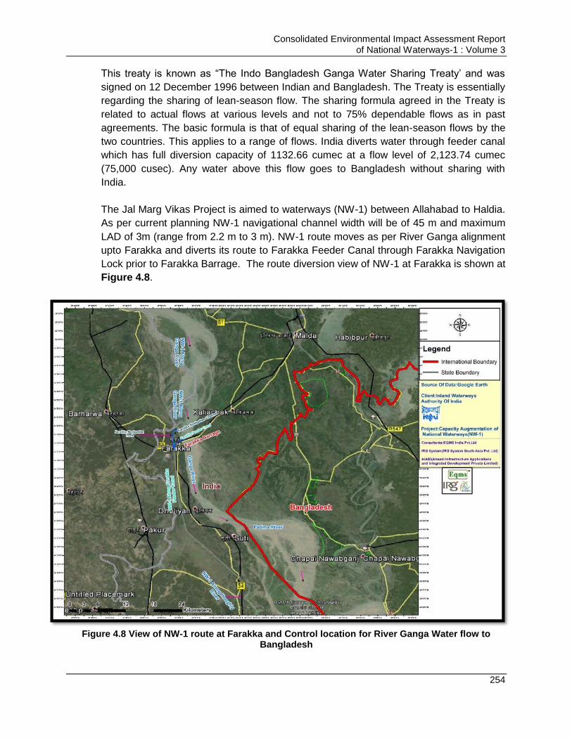
Consolidated Environmental Impact Assessment Report of National Waterways-1 : Volume 3
254
This treaty is known as “The Indo Bangladesh Ganga Water Sharing Treaty‟ and was
signed on 12 December 1996 between Indian and Bangladesh. The Treaty is essentially
regarding the sharing of lean-season flow. The sharing formula agreed in the Treaty is
related to actual flows at various levels and not to 75% dependable flows as in past
agreements. The basic formula is that of equal sharing of the lean-season flows by the
two countries. This applies to a range of flows. India diverts water through feeder canal
which has full diversion capacity of 1132.66 cumec at a flow level of 2,123.74 cumec
(75,000 cusec). Any water above this flow goes to Bangladesh without sharing with
India.
The Jal Marg Vikas Project is aimed to waterways (NW-1) between Allahabad to Haldia.
As per current planning NW-1 navigational channel width will be of 45 m and maximum
LAD of 3m (range from 2.2 m to 3 m). NW-1 route moves as per River Ganga alignment
upto Farakka and diverts its route to Farakka Feeder Canal through Farakka Navigation
Lock prior to Farakka Barrage. The route diversion view of NW-1 at Farakka is shown at
Figure 4.8.
Figure 4.8 View of NW-1 route at Farakka and Control location for River Ganga Water flow to
Bangladesh
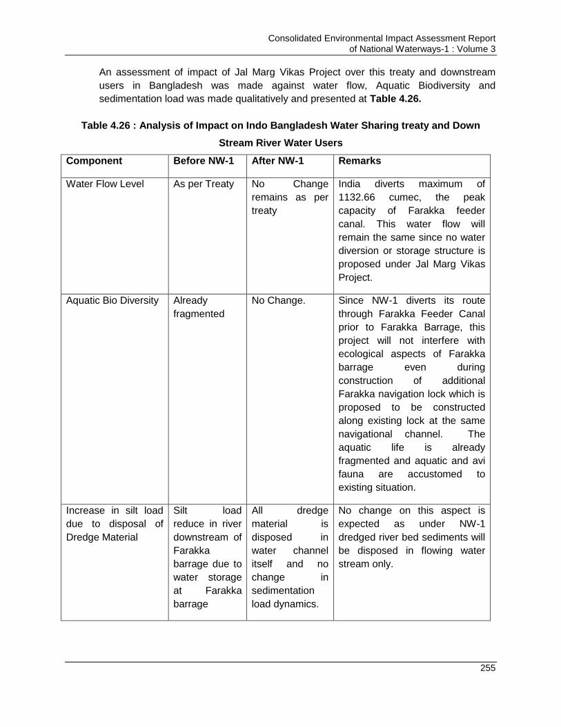
Consolidated Environmental Impact Assessment Report of National Waterways-1 : Volume 3
255
An assessment of impact of Jal Marg Vikas Project over this treaty and downstream
users in Bangladesh was made against water flow, Aquatic Biodiversity and
sedimentation load was made qualitatively and presented at Table 4.26.
Table 4.26 : Analysis of Impact on Indo Bangladesh Water Sharing treaty and Down
Stream River Water Users
Component Before NW-1 After NW-1 Remarks
Water Flow Level As per Treaty No Change
remains as per
treaty
India diverts maximum of
1132.66 cumec, the peak
capacity of Farakka feeder
canal. This water flow will
remain the same since no water
diversion or storage structure is
proposed under Jal Marg Vikas
Project.
Aquatic Bio Diversity Already
fragmented
No Change. Since NW-1 diverts its route
through Farakka Feeder Canal
prior to Farakka Barrage, this
project will not interfere with
ecological aspects of Farakka
barrage even during
construction of additional
Farakka navigation lock which is
proposed to be constructed
along existing lock at the same
navigational channel. The
aquatic life is already
fragmented and aquatic and avi
fauna are accustomed to
existing situation.
Increase in silt load
due to disposal of
Dredge Material
Silt load
reduce in river
downstream of
Farakka
barrage due to
water storage
at Farakka
barrage
All dredge
material is
disposed in
water channel
itself and no
change in
sedimentation
load dynamics.
No change on this aspect is
expected as under NW-1
dredged river bed sediments will
be disposed in flowing water
stream only.

Consolidated Environmental Impact Assessment Report of National Waterways-1 : Volume 3
256
4.16.1. Conclusion (Indo -Bangladesh Water Sharing Treaty and Downstream water users in Bangladesh)
Jal Marg Vikas project will not change river dynamics in terms of water flow, or aquatic
biodiversity or sedimentation load. Therefore, this project will not have any impact on this
treaty and downstream users of water in Bangladesh.
4.17. Impacts Due to Maintenance Facilities for Barge Repair and Maintenance
It is proposed to develop the maintenance facilities for barge/vessel repair and
maintenance along the NW-1, however the location of same has not been finalized yet.
Thus the location specific impact of the maintenance facilities could not be assessed.
However, impacts due to such facilities in general are discussed in this section.
Maintenance facilities use and store a wide range of chemicals and other materials,
many of which may be hazardous. Examples include fuels, oils, alkaline and acidic
solutions, cleaning solvents, disinfectants, detergents, degreasers, rust inhibitors and
antifouling paints. These materials need to be used carefully and stored securely to
prevent leakage and spills and pollution of soil in the area. There are fair possibilities of
soil, water, noise and air pollution due to construction and operation of such facilities.
Some of the activities undertaken at these facilities having potential to pollute
environment arecleaning of the hulls scraping & sanding; water based pressure cleaning
of hulls & exterior of boat; painting; Fiberglassing; welding& metal fabrication; engine
maintenance & repair and generation of solid waste due to cleaning, repair &
maintenance. All these activities may have significant impact on the environmental and
social components, if not managed properly. Table below details out the activities and
type of pollution resulting from it and the management required for the same.
Table 4.27 : Activities at Barge Maintenance & Repair Facilities, Their Impacts and
Mitigation Measures
S.
No.
Activities Affect Impact on
Environment
Mitigation Measures
1 Hazardous
Materials &
Chemicals
use and
storage
Spillage and
Leakage
Soil quality deterioration
Surface and ground water quality deterioration
Contamination of land
Effect on flora and fauna in nearby areas
Air pollution due to odour
Impact on society due to
Storage of these materials in contained facilities in isolated location
These storage facilities should have dedicated drainage system provided with oil interceptors
Training of the workers on handling of these materials and chemicals to prevent spillage and wastage
Availability of the emergency response plan for handling such spillage and leakage as soon as any such spillage or leakage happen
Quick clean up mechanism after
Consolidated Environmental Impact Assessment Report of National Waterways-1 : Volume 3
257
environmental pollution and odour
Exposure of workers to the chemicals and hazardous materials
Fire accidents may happen in this area
such spillage and leakage
List and quantity of the hazardous materials and chemicals should be available at the site
MSDS for each chemical should be available at the site and all the workers should be trained and instructed about the possible hazard of each chemical stored or used in case of spillage and exposure. Material should be handled as per MSDS
Workers should be trained to handle situations after leakage, spillage and accidental exposure of workers due to spillage/leakage
Fire evacuation plan should be displayed everywhere in location so as it is legitimate and this plan should be explained and communicated to all workers.
Fire mock drills should be conducted every quarter and all the workers should know how to operate fire extinguishers
Fire alarm/hooter should be provided. Fire exits which are LED Lit should be provided
Emergency assembly area should be provided and it should be closed to the exit door and should be communicated to all the worker
Drivers transporting these materials should be given the induction on safe driving and vehicle should be maintained as per the Haz waste, 2016 rules
Combustible waste materials should not be stored in these areas
Material should be stored as per requirement and excess piling up of materials should be avoided
Store volatile and flammable solvents and other liquids in sealed containers away from heat, naked flames, direct sunlight, oil or other flammable liquids and fire hazards.
Store incompatible chemicals separately (e.g., the fibre glassing catalyst methyl ethyl ketone peroxide should not be stored anywhere near flammable liquids or other dangerous goods)
Seal and clearly label all storage
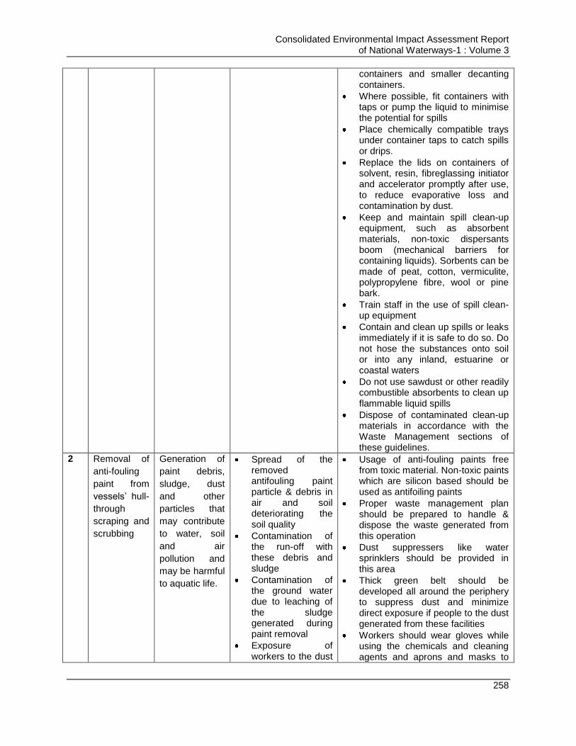
Consolidated Environmental Impact Assessment Report of National Waterways-1 : Volume 3
258
containers and smaller decanting containers.
Where possible, fit containers with taps or pump the liquid to minimise the potential for spills
Place chemically compatible trays under container taps to catch spills or drips.
Replace the lids on containers of solvent, resin, fibreglassing initiator and accelerator promptly after use, to reduce evaporative loss and contamination by dust.
Keep and maintain spill clean-up equipment, such as absorbent materials, non-toxic dispersants boom (mechanical barriers for containing liquids). Sorbents can be made of peat, cotton, vermiculite, polypropylene fibre, wool or pine bark.
Train staff in the use of spill clean-up equipment
Contain and clean up spills or leaks immediately if it is safe to do so. Do not hose the substances onto soil or into any inland, estuarine or coastal waters
Do not use sawdust or other readily combustible absorbents to clean up flammable liquid spills
Dispose of contaminated clean-up materials in accordance with the Waste Management sections of these guidelines.
2 Removal of
anti-fouling
paint from
vessels‟ hull-
through
scraping and
scrubbing
Generation of
paint debris,
sludge, dust
and other
particles that
may contribute
to water, soil
and air
pollution and
may be harmful
to aquatic life.
Spread of the removed antifouling paint particle & debris in air and soil deteriorating the soil quality
Contamination of the run-off with these debris and sludge
Contamination of the ground water due to leaching of the sludge generated during paint removal
Exposure of workers to the dust
Usage of anti-fouling paints free from toxic material. Non-toxic paints which are silicon based should be used as antifoiling paints
Proper waste management plan should be prepared to handle & dispose the waste generated from this operation
Dust suppressers like water sprinklers should be provided in this area
Thick green belt should be developed all around the periphery to suppress dust and minimize direct exposure if people to the dust generated from these facilities
Workers should wear gloves while using the chemicals and cleaning agents and aprons and masks to
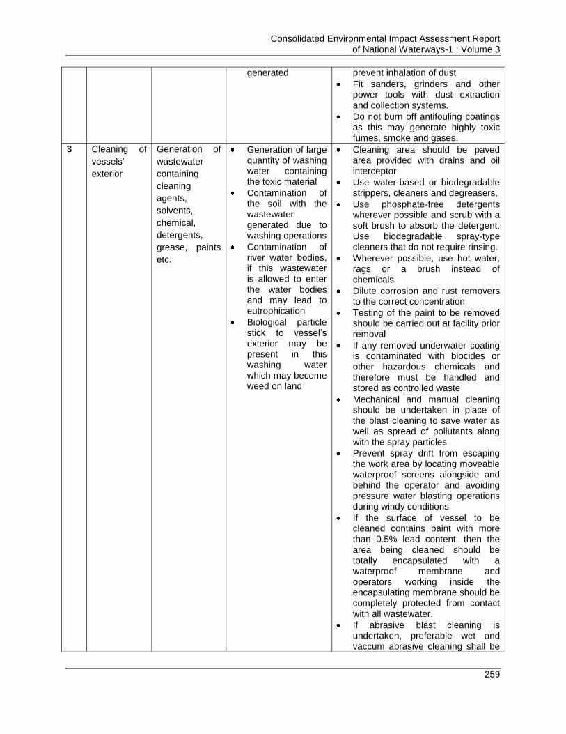
Consolidated Environmental Impact Assessment Report of National Waterways-1 : Volume 3
259
generated prevent inhalation of dust
Fit sanders, grinders and other power tools with dust extraction and collection systems.
Do not burn off antifouling coatings as this may generate highly toxic fumes, smoke and gases.
3 Cleaning of
vessels‟
exterior
Generation of
wastewater
containing
cleaning
agents,
solvents,
chemical,
detergents,
grease, paints
etc.
Generation of large quantity of washing water containing the toxic material
Contamination of the soil with the wastewater generated due to washing operations
Contamination of river water bodies, if this wastewater is allowed to enter the water bodies and may lead to eutrophication
Biological particle stick to vessel‟s exterior may be present in this washing water which may become weed on land
Cleaning area should be paved area provided with drains and oil interceptor
Use water-based or biodegradable strippers, cleaners and degreasers.
Use phosphate-free detergents wherever possible and scrub with a soft brush to absorb the detergent. Use biodegradable spray-type cleaners that do not require rinsing.
Wherever possible, use hot water, rags or a brush instead of chemicals
Dilute corrosion and rust removers to the correct concentration
Testing of the paint to be removed should be carried out at facility prior removal
If any removed underwater coating is contaminated with biocides or other hazardous chemicals and therefore must be handled and stored as controlled waste
Mechanical and manual cleaning should be undertaken in place of the blast cleaning to save water as well as spread of pollutants along with the spray particles
Prevent spray drift from escaping the work area by locating moveable waterproof screens alongside and behind the operator and avoiding pressure water blasting operations during windy conditions
If the surface of vessel to be cleaned contains paint with more than 0.5% lead content, then the area being cleaned should be totally encapsulated with a waterproof membrane and operators working inside the encapsulating membrane should be completely protected from contact with all wastewater.
If abrasive blast cleaning is undertaken, preferable wet and vaccum abrasive cleaning shall be

Consolidated Environmental Impact Assessment Report of National Waterways-1 : Volume 3
260
undertaken
In case dry abrasive blast cleaning is carried out then it should not be carried out during windy days and abrasive blast chamber vented to atmosphere via an effective dust collector
Ensure that the screening material for outdoor/open-air blasting is tear-resistant, UVresistant, fire retardant and of suitable material and construction (preferably fully enclosed) to prevent the escape of fine dust
Avoid the use of silica sands (e.g. river sand, beach sand or quartz rock) and avoid using copper slag, zinc slag or any other abrasives that contain toxic heavy metals.
Use recyclable and more environmentally benign abrasives such as garnet, ilmenite, chilled iron grit, cast steel grit or cast iron shot.
ETP should be provided to treat the washing water generated
STP should be provided to treat the sewage generated due to domestic use
No-run-off from site should allow to get into rivers or accumulate at site or nearby areas
Proper waste management plan should be developed so as to handle, store, manage and dispose the waste generated
Treated water should be re-used for dust suppression, colling and landscaping and no treated water should be disposed off in river or in ground
Workers should wear gloves while using the chemicals and cleaning agents and aprons
4 Painting of
Vessels
Spillage of
paints and
emissions of
VOC while
spray or
manual
painting
Deterioration of soil quality and may be ground water due to leaching of the spillage paints
Emission of VOCs from paints and deterioration of air quality which may also have health
Usage of Paints containing low VOCs
Spray painting should be minimized so as to minimize the spraying of tiny particles into the air while spray painting
Painting should be carry out on the paved surfaces which should have drains fitted with oil interceptors
Paint storage facilities should also
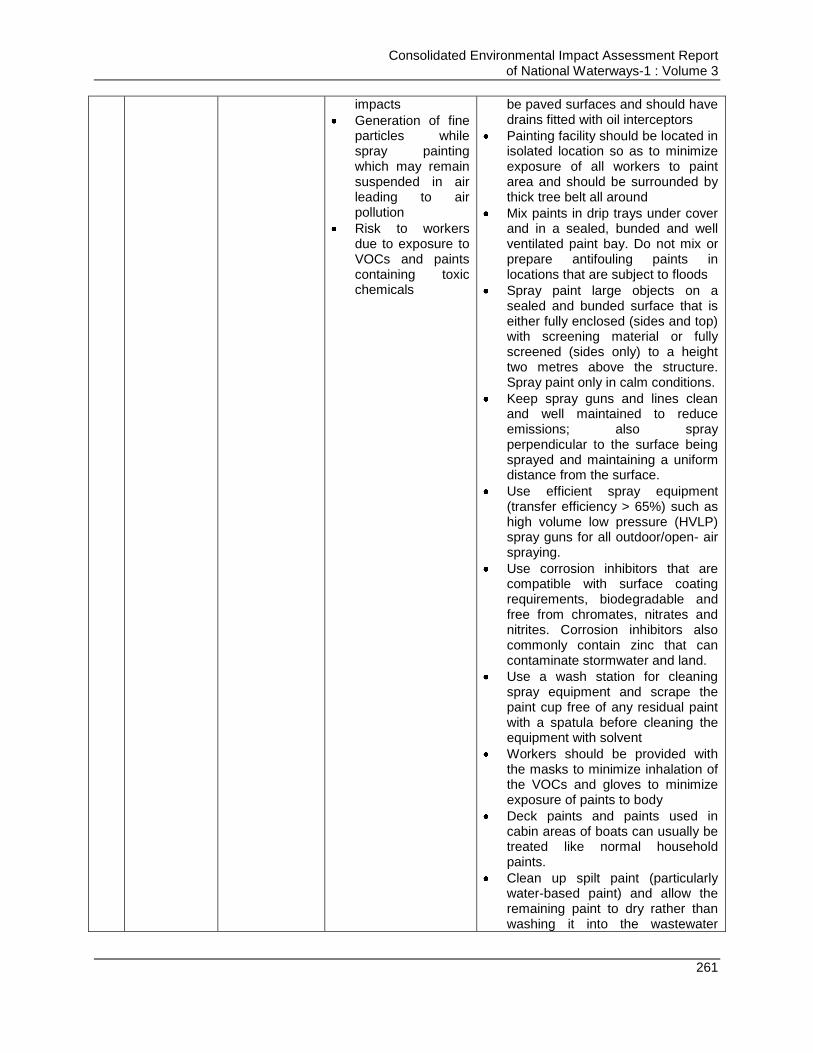
Consolidated Environmental Impact Assessment Report of National Waterways-1 : Volume 3
261
impacts
Generation of fine particles while spray painting which may remain suspended in air leading to air pollution
Risk to workers due to exposure to VOCs and paints containing toxic chemicals
be paved surfaces and should have drains fitted with oil interceptors
Painting facility should be located in isolated location so as to minimize exposure of all workers to paint area and should be surrounded by thick tree belt all around
Mix paints in drip trays under cover and in a sealed, bunded and well ventilated paint bay. Do not mix or prepare antifouling paints in locations that are subject to floods
Spray paint large objects on a sealed and bunded surface that is either fully enclosed (sides and top) with screening material or fully screened (sides only) to a height two metres above the structure. Spray paint only in calm conditions.
Keep spray guns and lines clean and well maintained to reduce emissions; also spray perpendicular to the surface being sprayed and maintaining a uniform distance from the surface.
Use efficient spray equipment (transfer efficiency > 65%) such as high volume low pressure (HVLP) spray guns for all outdoor/open- air spraying.
Use corrosion inhibitors that are compatible with surface coating requirements, biodegradable and free from chromates, nitrates and nitrites. Corrosion inhibitors also commonly contain zinc that can contaminate stormwater and land.
Use a wash station for cleaning spray equipment and scrape the paint cup free of any residual paint with a spatula before cleaning the equipment with solvent
Workers should be provided with the masks to minimize inhalation of the VOCs and gloves to minimize exposure of paints to body
Deck paints and paints used in cabin areas of boats can usually be treated like normal household paints.
Clean up spilt paint (particularly water-based paint) and allow the remaining paint to dry rather than washing it into the wastewater
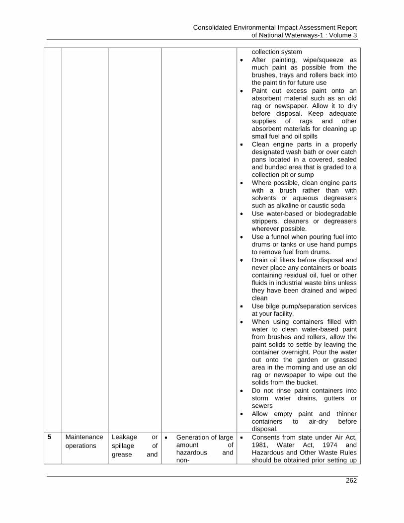
Consolidated Environmental Impact Assessment Report of National Waterways-1 : Volume 3
262
collection system
After painting, wipe/squeeze as much paint as possible from the brushes, trays and rollers back into the paint tin for future use
Paint out excess paint onto an absorbent material such as an old rag or newspaper. Allow it to dry before disposal. Keep adequate supplies of rags and other absorbent materials for cleaning up small fuel and oil spills
Clean engine parts in a properly designated wash bath or over catch pans located in a covered, sealed and bunded area that is graded to a collection pit or sump
Where possible, clean engine parts with a brush rather than with solvents or aqueous degreasers such as alkaline or caustic soda
Use water-based or biodegradable strippers, cleaners or degreasers wherever possible.
Use a funnel when pouring fuel into drums or tanks or use hand pumps to remove fuel from drums.
Drain oil filters before disposal and never place any containers or boats containing residual oil, fuel or other fluids in industrial waste bins unless they have been drained and wiped clean
Use bilge pump/separation services at your facility.
When using containers filled with water to clean water-based paint from brushes and rollers, allow the paint solids to settle by leaving the container overnight. Pour the water out onto the garden or grassed area in the morning and use an old rag or newspaper to wipe out the solids from the bucket.
Do not rinse paint containers into storm water drains, gutters or sewers
Allow empty paint and thinner containers to air-dry before disposal.
5 Maintenance
operations
Leakage or
spillage of
grease and
Generation of large amount of hazardous and non-
Consents from state under Air Act, 1981, Water Act, 1974 and Hazardous and Other Waste Rules should be obtained prior setting up
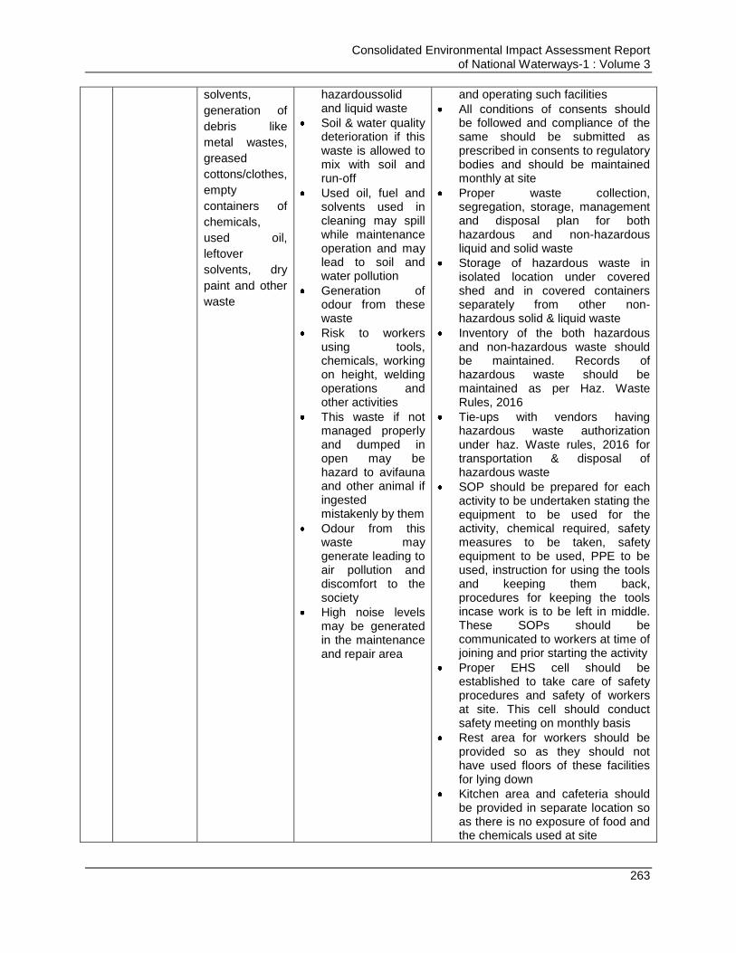
Consolidated Environmental Impact Assessment Report of National Waterways-1 : Volume 3
263
solvents,
generation of
debris like
metal wastes,
greased
cottons/clothes,
empty
containers of
chemicals,
used oil,
leftover
solvents, dry
paint and other
waste
hazardoussolid and liquid waste
Soil & water quality deterioration if this waste is allowed to mix with soil and run-off
Used oil, fuel and solvents used in cleaning may spill while maintenance operation and may lead to soil and water pollution
Generation of odour from these waste
Risk to workers using tools, chemicals, working on height, welding operations and other activities
This waste if not managed properly and dumped in open may be hazard to avifauna and other animal if ingested mistakenly by them
Odour from this waste may generate leading to air pollution and discomfort to the society
High noise levels may be generated in the maintenance and repair area
and operating such facilities
All conditions of consents should be followed and compliance of the same should be submitted as prescribed in consents to regulatory bodies and should be maintained monthly at site
Proper waste collection, segregation, storage, management and disposal plan for both hazardous and non-hazardous liquid and solid waste
Storage of hazardous waste in isolated location under covered shed and in covered containers separately from other non-hazardous solid & liquid waste
Inventory of the both hazardous and non-hazardous waste should be maintained. Records of hazardous waste should be maintained as per Haz. Waste Rules, 2016
Tie-ups with vendors having hazardous waste authorization under haz. Waste rules, 2016 for transportation & disposal of hazardous waste
SOP should be prepared for each activity to be undertaken stating the equipment to be used for the activity, chemical required, safety measures to be taken, safety equipment to be used, PPE to be used, instruction for using the tools and keeping them back, procedures for keeping the tools incase work is to be left in middle. These SOPs should be communicated to workers at time of joining and prior starting the activity
Proper EHS cell should be established to take care of safety procedures and safety of workers at site. This cell should conduct safety meeting on monthly basis
Rest area for workers should be provided so as they should not have used floors of these facilities for lying down
Kitchen area and cafeteria should be provided in separate location so as there is no exposure of food and the chemicals used at site

Consolidated Environmental Impact Assessment Report of National Waterways-1 : Volume 3
264
Proper cleaning and washing facility should be provided at the site for cleaning up after working
First-aid room should be provided at the site with stretcher, first-aid box containing materials as per State‟s Factory law, ambulance facility and certified First Aid Trainers
List of contact nos. of safety officers and other emergency control services like hospital, fire brigade should be displayed everywhere in the plant and should be communicated tow worker
Proper lux levels should be maintained at site and working hours should be restricted to day time. If working in night time lux levels should be maintained as per IFC General EHS guidelines
Workers should be provided with air masks, ear plugs, safety shoes, googles as required as per EHS plan and SOP of each activity
Work zone noise levels should be maintained as per OSHAS norms and ambient noise levels should be as per standards given in Noise Rules 2000. No noise generation activity should be carried out during night time.
Incorporate acoustic barriers, damping and insulating materials in the facility‟s design and layout. Use the natural topography and consider landscaping improvements (fencing, mounds and structures) to serve as noise barriers
No facility should be established within 500 m of habitation area/forest area/sensitive areas like school, hospital & temple
Fit mechanical ventilation systems (e.g. air conditioners and fans) with noise-proof ducting and acoustically designed intake and exhaust openings
Enclose or acoustically screen potentially noisy equipment and undertake noisy activities in areas where noise can be muffled.
Fit silencers and/or exhaust
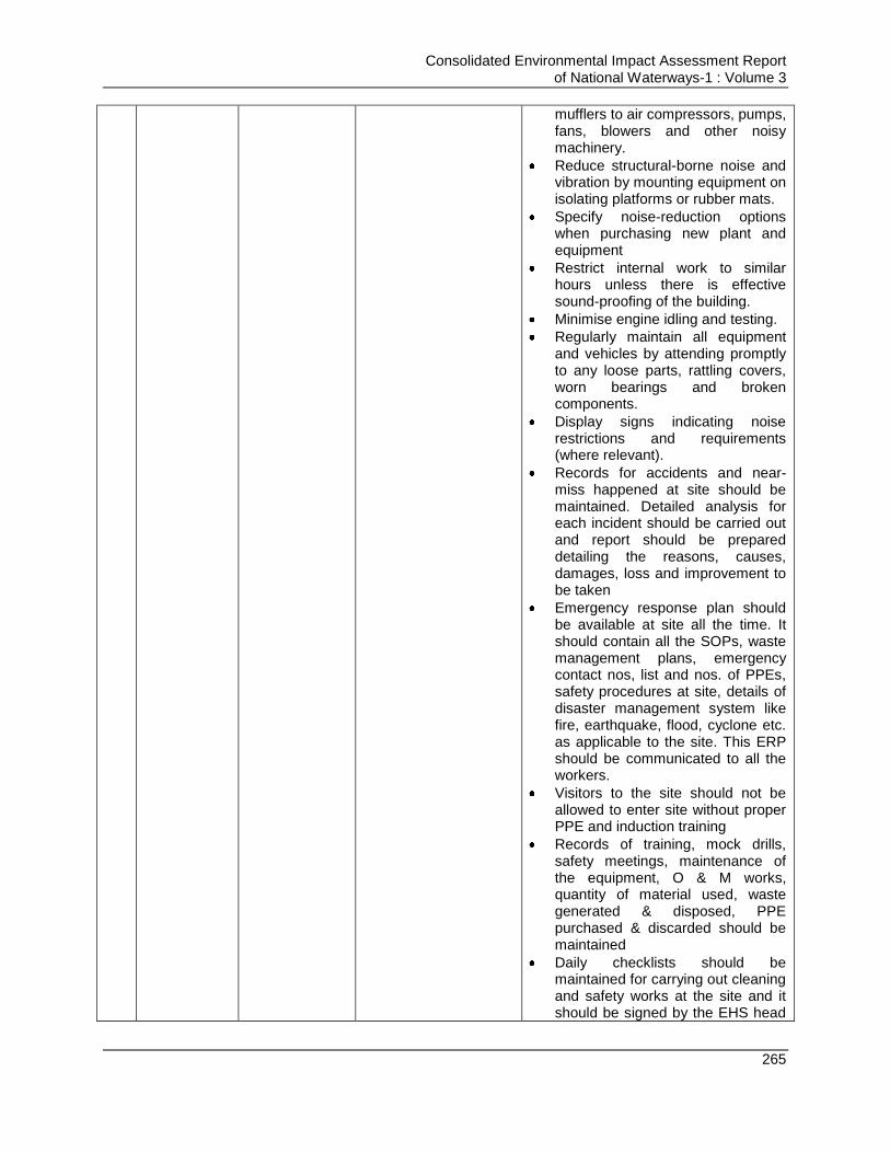
Consolidated Environmental Impact Assessment Report of National Waterways-1 : Volume 3
265
mufflers to air compressors, pumps, fans, blowers and other noisy machinery.
Reduce structural-borne noise and vibration by mounting equipment on isolating platforms or rubber mats.
Specify noise-reduction options when purchasing new plant and equipment
Restrict internal work to similar hours unless there is effective sound-proofing of the building.
Minimise engine idling and testing.
Regularly maintain all equipment and vehicles by attending promptly to any loose parts, rattling covers, worn bearings and broken components.
Display signs indicating noise restrictions and requirements (where relevant).
Records for accidents and near-miss happened at site should be maintained. Detailed analysis for each incident should be carried out and report should be prepared detailing the reasons, causes, damages, loss and improvement to be taken
Emergency response plan should be available at site all the time. It should contain all the SOPs, waste management plans, emergency contact nos, list and nos. of PPEs, safety procedures at site, details of disaster management system like fire, earthquake, flood, cyclone etc. as applicable to the site. This ERP should be communicated to all the workers.
Visitors to the site should not be allowed to enter site without proper PPE and induction training
Records of training, mock drills, safety meetings, maintenance of the equipment, O & M works, quantity of material used, waste generated & disposed, PPE purchased & discarded should be maintained
Daily checklists should be maintained for carrying out cleaning and safety works at the site and it should be signed by the EHS head
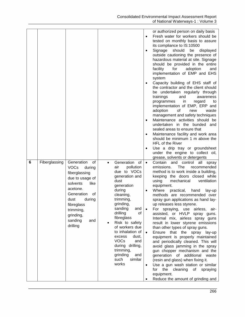
Consolidated Environmental Impact Assessment Report of National Waterways-1 : Volume 3
266
or authorized person on daily basis
Fresh water for workers should be tested on monthly basis to assure its compliance to IS:10500
Signage should be displayed outside cautioning the presence of hazardous material at site. Signage should be provided in the entire facility for adoption and implementation of EMP and EHS system
Capacity building of EHS staff of the contractor and the client should be undertaken regularly through trainings and awareness programmes in regard to implementation of EMP, ERP and adoption of new waste management and safety techniques
Maintenance activities should be undertaken in the bunded and sealed areas to ensure that
Maintenance facility and work area should be minimum 1 m above the HFL of the River
Use a drip tray or groundsheet under the engine to collect oil, grease, solvents or detergents
6 Fiberglassing Generation of
VOCs during
fiberglassing
due to usage of
solvents like
acetone.
Generation of
dust during
fibreglass
trimming,
grinding,
sanding and
drilling
Generation of air pollution due to VOCs generation and dust generation during cleaning, trimming, grinding, sanding and drilling of fibreglass
Risk to safety of workers due to inhalation of excess dust, VOCs and during drilling, trimming, grinding and such similar works
Contain and control all spray emissions. The recommended method is to work inside a building, keeping the doors closed while using mechanical ventilation equipment.
Where practical, hand lay-up methods are recommended over spray gun applications as hand lay-up releases less styrene.
For spraying, use airless, air-assisted, or HVLP spray guns. Internal mix, airless spray guns result in lower styrene emissions than other types of spray guns.
Ensure that the spray lay-up equipment is properly maintained and periodically cleaned. This will avoid glass jamming in the spray gun chopper mechanism and the generation of additional waste (resin and glass) when fixing it.
Use a gun wash station or similar for the cleaning of spraying equipment.
Reduce the amount of grinding and
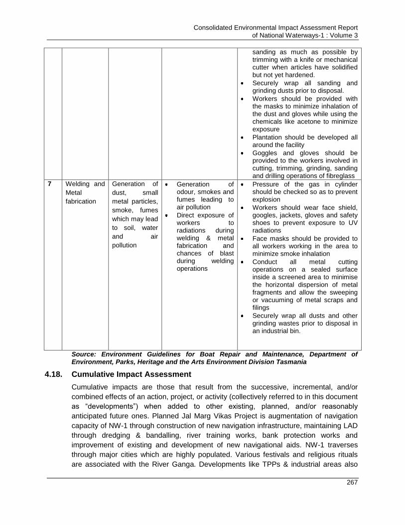
Consolidated Environmental Impact Assessment Report of National Waterways-1 : Volume 3
267
sanding as much as possible by trimming with a knife or mechanical cutter when articles have solidified but not yet hardened.
Securely wrap all sanding and grinding dusts prior to disposal.
Workers should be provided with the masks to minimize inhalation of the dust and gloves while using the chemicals like acetone to minimize exposure
Plantation should be developed all around the facility
Goggles and gloves should be provided to the workers involved in cutting, trimming, grinding, sanding and drilling operations of fibreglass
7 Welding and
Metal
fabrication
Generation of
dust, small
metal particles,
smoke, fumes
which may lead
to soil, water
and air
pollution
Generation of odour, smokes and fumes leading to air pollution
Direct exposure of workers to radiations during welding & metal fabrication and chances of blast during welding operations
Pressure of the gas in cylinder should be checked so as to prevent explosion
Workers should wear face shield, googles, jackets, gloves and safety shoes to prevent exposure to UV radiations
Face masks should be provided to all workers working in the area to minimize smoke inhalation
Conduct all metal cutting operations on a sealed surface inside a screened area to minimise the horizontal dispersion of metal fragments and allow the sweeping or vacuuming of metal scraps and filings
Securely wrap all dusts and other grinding wastes prior to disposal in an industrial bin.
Source: Environment Guidelines for Boat Repair and Maintenance, Department of Environment, Parks, Heritage and the Arts Environment Division Tasmania
4.18. Cumulative Impact Assessment
Cumulative impacts are those that result from the successive, incremental, and/or
combined effects of an action, project, or activity (collectively referred to in this document
as “developments”) when added to other existing, planned, and/or reasonably
anticipated future ones. Planned Jal Marg Vikas Project is augmentation of navigation
capacity of NW-1 through construction of new navigation infrastructure, maintaining LAD
through dredging & bandalling, river training works, bank protection works and
improvement of existing and development of new navigational aids. NW-1 traverses
through major cities which are highly populated. Various festivals and religious rituals
are associated with the River Ganga. Developments like TPPs & industrial areas also

Consolidated Environmental Impact Assessment Report of National Waterways-1 : Volume 3
268
exist along the NW-1. Total 5 bird areas and 3 eco-sensitive zones, i.e. Kashi turtle
sanctuary, dolphin sanctuary & Udhawa sanctuary exists within 10 km of the NW-1.
Planned developments, existing developments and existing sensitive zones will interact
with each other to produce the cumulative impacts.
Cumulative Impact Assessment (CIA) of NW-1 from Allahabad to Haldia has been
carried out for (a) analysing the potential impacts and risks of proposed, indirect &
induced developments in the context of water flow, water availability and water quality,
considering human activities and natural environmentaland social external drivers on the
chosen Valued Environmental Components (VECs)52/Critical Environmental Resources
(CERs) over time, and (b) proposing concrete measures to avoid, reduce, or
mitigatesuchcumulativeimpactsandrisktotheextentpossible in the influence area (10 km
delineated boundary on both sides of the NW-1). At first Cumulative opinions of various
stakeholders which are directly & indirectly impacted due to proposed development, and
extensive review of the consolidated EIA report & basin critical resources study of the
proposed project has been carried out to identify the VECs. Further, overlay mapping
and GIS have been extensive used for identifying the spatial distribution of VECs. Also
indicators have been identified which can determine status/conditions of VECs. Baseline
study has been conducted to assess the existing condition or status of the identified
VECs based on these indicators in the influence area. Further VECs under stress have
been identified and are termed as hotspots. These hotspots have also been verified
through stakeholder consultation. Total 14 zones are identified as hotspots. These
include Haldia, Daimond Harbor to Nischintpura, Kolkata, Mahesthala, Katwa to Hoogly
Ghat, Lalbagh in Farakka to Murshidabad, Mangalghat, Rajmahal, Sahibganj, Pirpanti,
Kahalgaon, Bhagalpur, Munger, Semaria, Begusarai, Barh, Patna, Buxar, Ghazipur,
Varanasi & Allahabad.
Also nature of the impacts due to proposed/planned & anticipated development on these
hotspots has been assessed. Type and nature of the cumulative impact has been
evaluated on all VECs in each hotspot. It has been identified that nature of impact varied
from low to moderate. For example, Varanasi, Patna and Howrah, air quality of the area
is already impacted due to high PM10 concentration. Varanasi turtle sanctuary and
Dolphin sanctuary are the eco-sensitive zones in NW-1 which are being impacted due to
existing development and will be impacted due to development of NW-1 and other
upcoming and planned development in the area. Other areas like Barh, Danapur,
Bhagalpur etc are sensitive due to presence of important bird area. Varanasi will be the
common station of upcoming EDFC and NW-1 and exchange of material will be taking
place between these two points. Rating is provided to assess impact of each identified
52
VECs are environmental and social attributes that are considered to be important in assessing risks; they may be: • physical
features, habitats, wildlife populations (e.g., biodiversity), • ecosystem services, • natural processes (e.g., water and nutrient cycles, microclimate), • social conditions (e.g., health, economics), or • cultural aspects (e.g., traditional spiritual ceremonies). Critical Environmental Resource (CER) and Valued Environmental Components (VEC) are technically same referring to various key environmental resource or component like natural habitat. Critical Environment Resource word is used for Basin Level study as per terms of reference of these studies. However, for EIA studies VEC word is used.

Consolidated Environmental Impact Assessment Report of National Waterways-1 : Volume 3
269
activity on VECs and it is found that impact on these hotspots due to existing, planned
and upcoming development varies from low to moderate. As per the impact assessment,
it is also found that the identified impacts are mitigable and mitigation plan for the
impacts has been described. Further, impacts triggered due to induced & indirect
development can be mitigated & monitored due to construction & operation stage of the
project.
4.18.1. Cumulative Impact Assessment Vs Environmental Impact Assessment: Difference& Utility.
CIA and EIA shares the same basic framework and analytical process for impact
assessment but still the perspectives are different. EIA can be termed as project centred
and CIA is always VECs centred. The CIA is prepared following preparation of Basin
Level Critical Resource Study6 and takes into account the overall project perspective.
The CIA is focused on VECs thus it considers the existing condition of VECs, conditions
of VECs which may be changed due to intervention of project and the condition of VECs
which may be changed due to other simultaneous developments taking place in the
same influence area. The ecological and social impacts are determined considering,
past, present, and natural drivers that effects the VECs in the influence area. The
assessment reflects the geographical and temporal context in which the effect is
aggregating and interacting with river landscape, catchment area, town, etc.53 . It
defines the GHG assessment due to the project. The CIA provide the strategic
consideration for project design and intervention proposed for example for Barge
movement and operations. The influence area consideration for respective intervention
is also derived based on CIA outcome.
In EIA the focus has been on project, its activities and the impacts its activities will have
on the VECs. The ESIA is undertaken following CIA preparation and considering
outcome CIA such as influence area recommendations for ESIA studies. In EIA study,
impact on VECs is identified due to the project and mitigation measures proposed to
avoid them, minimize them or eliminate them and if any of it is not possible then
compensating the affected individual. It defines the environmental plan to mitigate the
identified impacts.
53
IFC Good Practice Handbook for Cumulative Impact Assessment and Management: Guidance for the Private Sector in Emerging
Markets
Consolidated Environmental Impact Assessment Report of National Waterways-1 : Volume 3
270
Chapter 5. PUBLIC CONSULTATIONS AND DISCLOSURE
5.1. Introduction
Public consultation is one of the key components of the environmental assessment. The
environmental and social impact assessment team conducted public consultations in
project site and influence areas. The approach involved a mix of conventional as well as
participatory/ rapid rural appraisal (PRA/ RRA), focus group discussions (FGD) and one-
to-one discussion. Two stage consultations have been carried out in line with World
Bank Guidelines for conducting public consultations. First level consultations was carried
out prior and during impact assessment studies and second level consultations was
carried out after completion of impact assessment studies.
This chapter provides details of the public consultations and participation activities
undertaken during the environmental and social impact assessment studies for the
project “Jal Marg Vikas” extending from Allahabad to Haldia. During public consultation,
emphasis was placed on a fully-inclusive, open and transparent public participation
process in the transfer of information regarding the project and likely impacts from the
project on each component of environment. A number of stakeholders are involved in
this project ranging from the locals, local bodies, state ¢ral level Government
agencies and Non-Government Organizations.
5.2. Methods of Public Consultation
5.2.1. First Stage Consultations
Both the informal and formal consultations were conducted during the EIA study to
obtain the views of people about the project and to ensure their involvement. Issues
pertaining to both environment and social were discussed in depth during the
consultations.
A. Informal Consultation:
Informal consultations were carried out between June, 2015 to February, 2016, prior and
during the EIA studies of different components of the Jal Marg Vikas project. Informal
consultations are undertaken in reference to proposed interventions and activities of
NW-1 at respective locations. One to one and focused consultations were conducted
following informal interview approach. No questionnaires/ brochures were supplied to the
participants.
The discussions were primarily focused on receiving maximum inputs from the
participants regarding their acceptability and environmental concerns arising out of the
project. Consultation was started with the short description of the upcoming project
components under Jal Marg Vikas Project. The objectives, proposed developments and
the possible impacts of the project components and connectivity aspects the project
were also explained. The study team recorded their perceptions, demands and
recommendations, about the project. Informal consultation was carried out for different
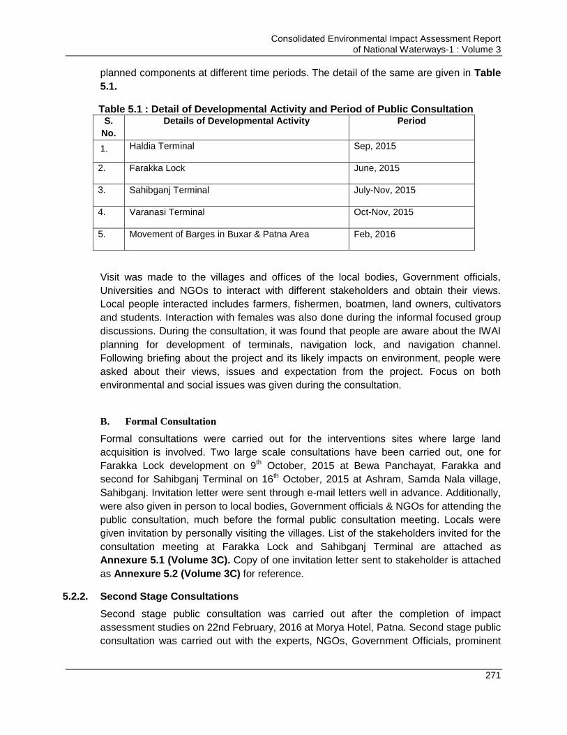
Consolidated Environmental Impact Assessment Report of National Waterways-1 : Volume 3
271
planned components at different time periods. The detail of the same are given in Table
5.1.
Table 5.1 : Detail of Developmental Activity and Period of Public Consultation S.
No.
Details of Developmental Activity Period
1. Haldia Terminal Sep, 2015
2. Farakka Lock June, 2015
3. Sahibganj Terminal July-Nov, 2015
4. Varanasi Terminal Oct-Nov, 2015
5. Movement of Barges in Buxar & Patna Area Feb, 2016
Visit was made to the villages and offices of the local bodies, Government officials,
Universities and NGOs to interact with different stakeholders and obtain their views.
Local people interacted includes farmers, fishermen, boatmen, land owners, cultivators
and students. Interaction with females was also done during the informal focused group
discussions. During the consultation, it was found that people are aware about the IWAI
planning for development of terminals, navigation lock, and navigation channel.
Following briefing about the project and its likely impacts on environment, people were
asked about their views, issues and expectation from the project. Focus on both
environmental and social issues was given during the consultation.
B. Formal Consultation
Formal consultations were carried out for the interventions sites where large land
acquisition is involved. Two large scale consultations have been carried out, one for
Farakka Lock development on 9th October, 2015 at Bewa Panchayat, Farakka and
second for Sahibganj Terminal on 16th October, 2015 at Ashram, Samda Nala village,
Sahibganj. Invitation letter were sent through e-mail letters well in advance. Additionally,
were also given in person to local bodies, Government officials & NGOs for attending the
public consultation, much before the formal public consultation meeting. Locals were
given invitation by personally visiting the villages. List of the stakeholders invited for the
consultation meeting at Farakka Lock and Sahibganj Terminal are attached as
Annexure 5.1 (Volume 3C). Copy of one invitation letter sent to stakeholder is attached
as Annexure 5.2 (Volume 3C) for reference.
5.2.2. Second Stage Consultations
Second stage public consultation was carried out after the completion of impact
assessment studies on 22nd February, 2016 at Morya Hotel, Patna. Second stage public
consultation was carried out with the experts, NGOs, Government Officials, prominent
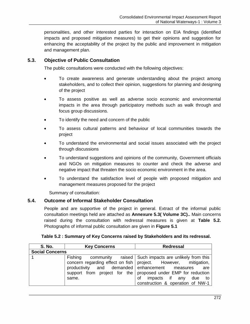
Consolidated Environmental Impact Assessment Report of National Waterways-1 : Volume 3
272
personalities, and other interested parties for interaction on EIA findings (identified
impacts and proposed mitigation measures) to get their opinions and suggestion for
enhancing the acceptability of the project by the public and improvement in mitigation
and management plan.
5.3. Objective of Public Consultation
The public consultations were conducted with the following objectives:
To create awareness and generate understanding about the project among
stakeholders, and to collect their opinion, suggestions for planning and designing
of the project
To assess positive as well as adverse socio economic and environmental
impacts in the area through participatory methods such as walk through and
focus group discussions.
To identify the need and concern of the public
To assess cultural patterns and behaviour of local communities towards the
project
To understand the environmental and social issues associated with the project
through discussions
To understand suggestions and opinions of the community, Government officials
and NGOs on mitigation measures to counter and check the adverse and
negative impact that threaten the socio economic environment in the area.
To understand the satisfaction level of people with proposed mitigation and
management measures proposed for the project
Summary of consultation:
5.4. Outcome of Informal Stakeholder Consultation
People and are supportive of the project in general. Extract of the informal public
consultation meetings held are attached as Annexure 5.3( Volume 3C).. Main concerns
raised during the consultation with redressal measures is given at Table 5.2.
Photographs of informal public consultation are given in Figure 5.1
Table 5.2 : Summary of Key Concerns raised by Stakeholders and its redressal.
S. No. Key Concerns Redressal
Social Concerns
1 Fishing community raised concern regarding effect on fish productivity and demanded support from project for the same.
Such impacts are unlikely from this project. However, mitigation, enhancement measures are proposed under EMP for reduction of impacts if any due to construction & operation of NW-1
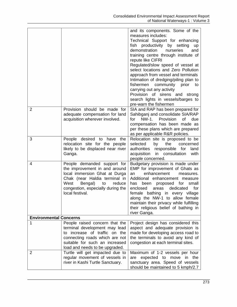
Consolidated Environmental Impact Assessment Report of National Waterways-1 : Volume 3
273
and its components. Some of the measures includes: Technical Support for enhancing fish productivity by setting up demonstration nurseries and training centre through institute of repute like CIFRI Regulated/slow speed of vessel at select locations and Zero Pollution approach from vessel and terminals Intimation of dredging/piling plan to fishermen community prior to carrying out any activity Provision of sirens and strong search lights in vessels/barges to pre-warn the fishermen
2 Provision should be made for adequate compensation for land acquisition wherever involved.
SIA and RAP has been prepared for Sahibganj and consolidate SIA/RAP for NW-1. Provision of due compensation has been made as per these plans which are prepared as per applicable R&R policies.
3 People desired to have the relocation site for the people likely to be displaced near river Ganga.
Relocation site is proposed to be selected by the concerned authorities responsible for land acquisition in consultation with people concerned.
4 People demanded support for the improvement in and around local immersion Ghat at Durga Chak (near Haldia terminal in West Bengal) to reduce congestion, especially during the local festival.
Budgetary provision is made under EMP for improvement of Ghats as an enhancement measures. Additional enhancement measure has been proposed for small enclosed areas dedicated for female bathing in every village along the NW-1 to allow female maintain their privacy while fulfilling their religious belief of bathing in river Ganga.
Environmental Concerns
1 People raised concern that the terminal development may lead to increase of traffic on the connecting roads which are not suitable for such an increased load and needs to be upgraded.
Project design has considered this aspect and adequate provision is made for developing access road to the terminals to avoid any kind of congestion at each terminal sites.
2 Turtle will get impacted due to regular movement of vessels in river in Kashi Turtle Sanctuary.
Maximum of 1-2 vessels per hour are expected to move in the sanctuary area. Speed of vessels should be maintained to 5 kmph/2.7
Consolidated Environmental Impact Assessment Report of National Waterways-1 : Volume 3
274
knots in turtle sanctuary area. Barge movement at this speed generates noise in order of 110-140 dB. Threshold noise level of turtles for change in behavioural response is 150 dB which is above the noise expected to be generated by moving barges and the impact on turtles behaviour responses is anticipated to be insignificant. Other measures are also being proposed in the EMP to minimize impact of barge movement on turtle.
3 Dolphins will be affected due to barge movement during the operation phase of the project.
Adequate mitigative measures have been proposed in the project design which includes provision of propeller guards to prevent entangling of dolphins and other mammals, speed restriction in the sanctuary area and a restrictive buffer zone of 100m horizontally and 500m longitudinally either side of the river confluence areas for any dredging activity. Other measures are also proposed in management plan to reduce the impact on dolphins and other aquatic fauna.
4 Oil spillage from ships during accident may impact the aquatic flora, fauna, water quality and anti-bacterial properties of river Ganga.
Such situations are remote. Safety measures are proposed in the EMP for vessels as well. No vessels are proposed to discharge any of its liquid or oily waste in the river. Emergency response plan is proposed to deal with emergency situations to minimize the impact of emergency situations. It is also proposed to mandate that each vessel would have appropriate sewage treatment, treated sewage storage and waste management facilities to prevent water pollution.
5 People raised concerns regarding the likely impact on water quality due to construction and operation of terminal facility and cargo movement.
Environment management plan has incorporated the measures for prevention of water pollution from terminals, and barge operations. Zero discharge approach is proposed for terminals development and barge operations.
6 People raised concern about cutting of large no. of tree at
Compensatory tree plantation (1:7) basis at Sahibganj and additional
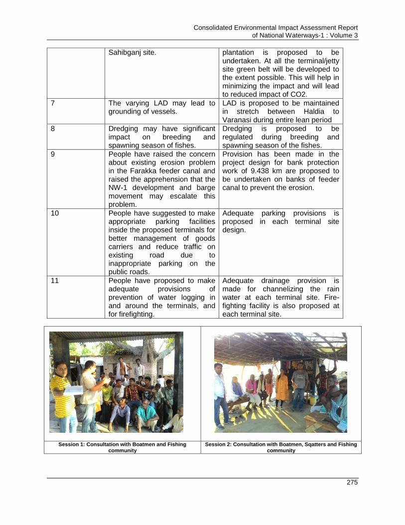
Consolidated Environmental Impact Assessment Report of National Waterways-1 : Volume 3
275
Sahibganj site. plantation is proposed to be undertaken. At all the terminal/jetty site green belt will be developed to the extent possible. This will help in minimizing the impact and will lead to reduced impact of CO2.
7 The varying LAD may lead to grounding of vessels.
LAD is proposed to be maintained in stretch between Haldia to Varanasi during entire lean period
8 Dredging may have significant impact on breeding and spawning season of fishes.
Dredging is proposed to be regulated during breeding and spawning season of the fishes.
9 People have raised the concern about existing erosion problem in the Farakka feeder canal and raised the apprehension that the NW-1 development and barge movement may escalate this problem.
Provision has been made in the project design for bank protection work of 9.438 km are proposed to be undertaken on banks of feeder canal to prevent the erosion.
10 People have suggested to make appropriate parking facilities inside the proposed terminals for better management of goods carriers and reduce traffic on existing road due to inappropriate parking on the public roads.
Adequate parking provisions is proposed in each terminal site design.
11 People have proposed to make adequate provisions of prevention of water logging in and around the terminals, and for firefighting.
Adequate drainage provision is made for channelizing the rain water at each terminal site. Fire-fighting facility is also proposed at each terminal site.
Session 1: Consultation with Boatmen and Fishing
community Session 2: Consultation with Boatmen, Sqatters and Fishing
community

Consolidated Environmental Impact Assessment Report of National Waterways-1 : Volume 3
276
Session 3: Consultation with Boatmen and Fishing community
Photograph of Baluva Ghat
FGD at Gharaipara Village with local villagers.
Socio-economic survey carried out by AIAID representative
Consultation with villagers in Ashram, Rampur
and Samdhanala Consultation with villagers in Ashram,
Samdhanala
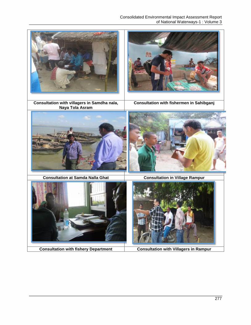
Consolidated Environmental Impact Assessment Report of National Waterways-1 : Volume 3
277
Consultation with villagers in Samdha nala, Naya Tola Asram
Consultation with fishermen in Sahibganj
Consultation at Samda Nalla Ghat Consultation in Village Rampur
Consultation with fishery Department Consultation with Villagers in Rampur
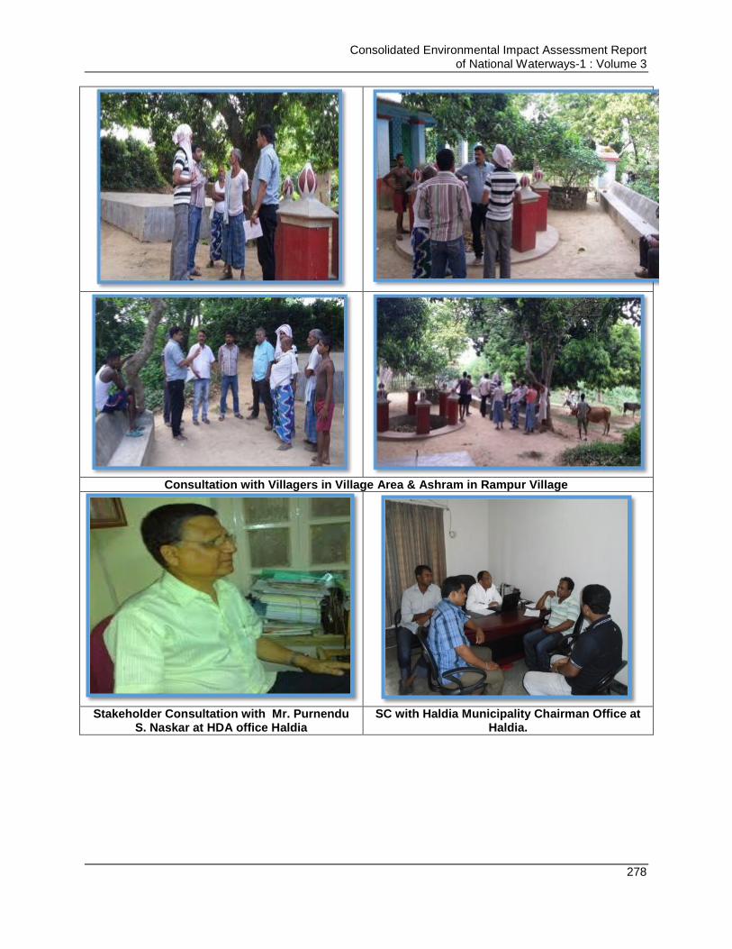
Consolidated Environmental Impact Assessment Report of National Waterways-1 : Volume 3
278
Consultation with Villagers in Village Area & Ashram in Rampur Village
Stakeholder Consultation with Mr. Purnendu
S. Naskar at HDA office Haldia SC with Haldia Municipality Chairman Office at
Haldia.
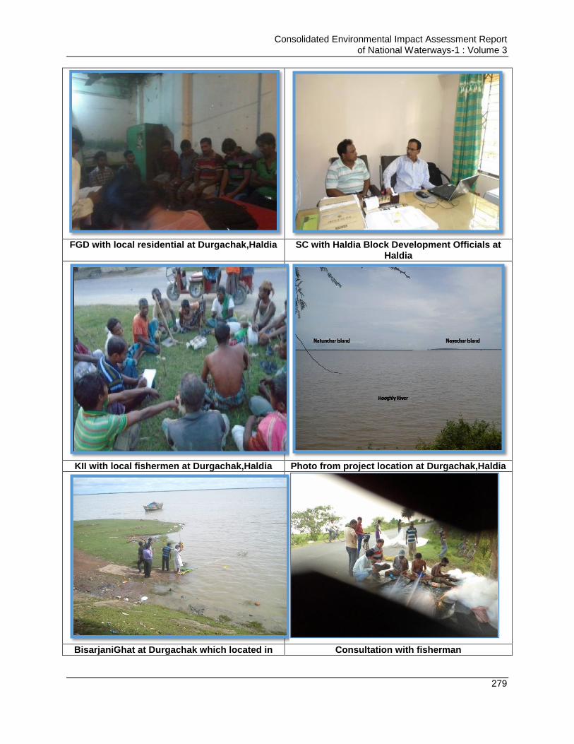
Consolidated Environmental Impact Assessment Report of National Waterways-1 : Volume 3
279
FGD with local residential at Durgachak,Haldia SC with Haldia Block Development Officials at
Haldia
KII with local fishermen at Durgachak,Haldia Photo from project location at Durgachak,Haldia
BisarjaniGhat at Durgachak which located in Consultation with fisherman
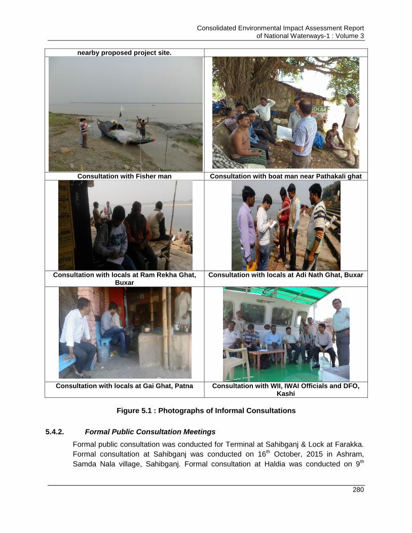
Consolidated Environmental Impact Assessment Report of National Waterways-1 : Volume 3
280
nearby proposed project site.
Consultation with Fisher man Consultation with boat man near Pathakali ghat
Consultation with locals at Ram Rekha Ghat,
Buxar Consultation with locals at Adi Nath Ghat, Buxar
Consultation with locals at Gai Ghat, Patna Consultation with WII, IWAI Officials and DFO, Kashi
Figure 5.1 : Photographs of Informal Consultations
5.4.2. Formal Public Consultation Meetings
Formal public consultation was conducted for Terminal at Sahibganj & Lock at Farakka.
Formal consultation at Sahibganj was conducted on 16th October, 2015 in Ashram,
Samda Nala village, Sahibganj. Formal consultation at Haldia was conducted on 9th
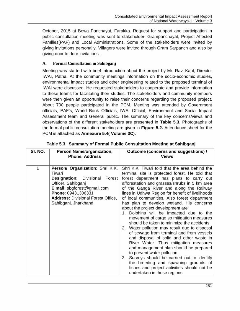
Consolidated Environmental Impact Assessment Report of National Waterways-1 : Volume 3
281
October, 2015 at Bewa Panchayat, Farakka. Request for support and participation in
public consultation meeting was sent to stakeholder, Grampanchayat, Project Affected
Families(PAF) and Local Administrations. Some of the stakeholders were invited by
giving invitations personally. Villagers were invited through Gram Sarpanch and also by
giving door to door invitations.
A. Formal Consultation in Sahibganj
Meeting was started with brief introduction about the project by Mr. Ravi Kant, Director
IWAI, Patna. At the community meetings information on the socio-economic studies,
environmental impact studies and other engineering related to the proposed terminal of
IWAI were discussed. He requested stakeholders to cooperate and provide information
to these teams for facilitating their studies. The stakeholders and community members
were then given an opportunity to raise their concerns regarding the proposed project.
About 700 people participated in the PCM. Meeting was attended by Government
officials, PAF‟s, World Bank Officials, IWAI Official, Environment and Social Impact
Assessment team and General public. The summary of the key concerns/views and
observations of the different stakeholders are presented in Table 5.3. Photographs of
the formal public consultation meeting are given in Figure 5.2. Attendance sheet for the
PCM is attached as Annexure 5.4( Volume 3C).
Table 5.3 : Summary of Formal Public Consultation Meeting at Sahibganj
Sl. NO. Person Name/organization, Phone, Address
Outcome (concerns and suggestions) / Views
1 Person/ Organization: Shri K.K. Tiwari Designation: Divisional Forest Officer, Sahibganj E mail: [email protected] Phone: 09431306331 Address: Divisional Forest Office, Sahibganj, Jharkhand
Shri K.K. Tiwari told that the area behind the terminal site is protected forest. He told that forest department has plans to carry out afforestation and grasses/shrubs in 5 km area of the Ganga River and along the Railway lines in Udhwa Region for benefit of livelihoods of local communities. Also forest department has plan to develop wetland. His concerns about the project development are 1. Dolphins will be impacted due to the
movement of cargo so mitigation measures should be taken to minimize the accidents
2. Water pollution may result due to disposal of sewage from terminal and from vessels and disposal of solid and other waste in River Water. Thus mitigation measures and management plan should be prepared to prevent water pollution.
3. Surveys should be carried out to identify the breeding and spawning grounds of fishes and project activities should not be undertaken in those regions
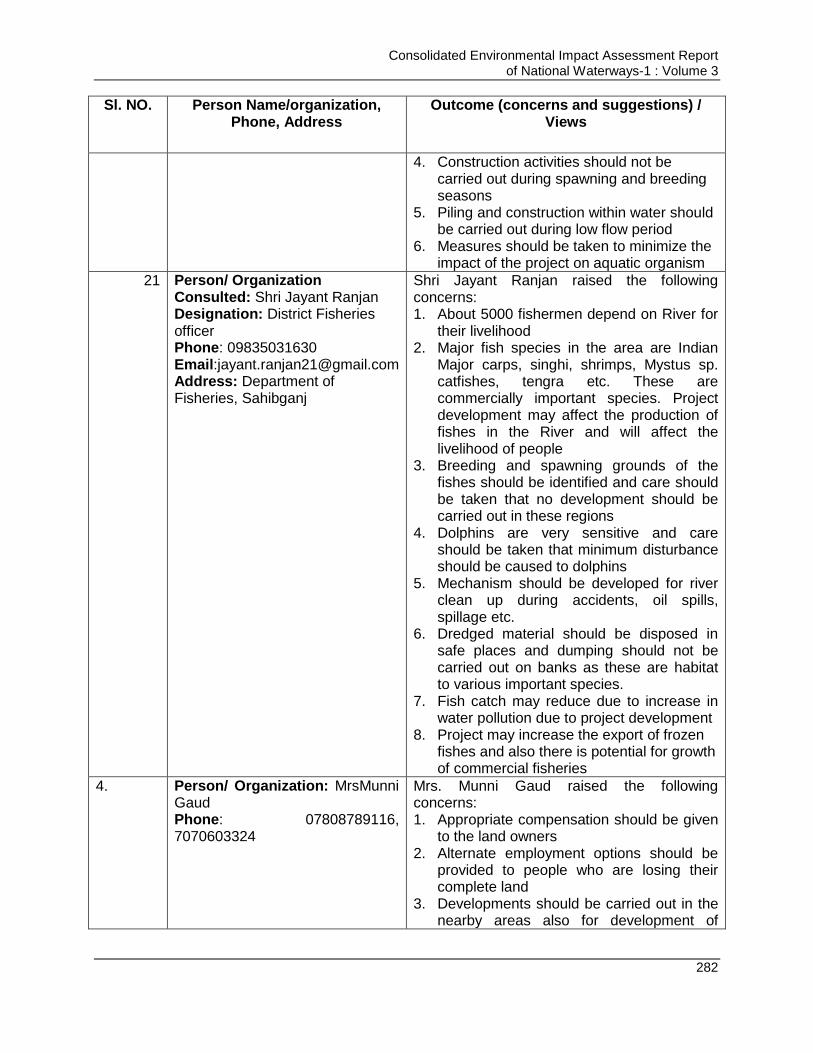
Consolidated Environmental Impact Assessment Report of National Waterways-1 : Volume 3
282
Sl. NO. Person Name/organization, Phone, Address
Outcome (concerns and suggestions) / Views
4. Construction activities should not be carried out during spawning and breeding seasons
5. Piling and construction within water should be carried out during low flow period
6. Measures should be taken to minimize the impact of the project on aquatic organism
4. 21 Person/ Organization Consulted: Shri Jayant Ranjan Designation: District Fisheries officer Phone: 09835031630 Email:[email protected] Address: Department of Fisheries, Sahibganj
Shri Jayant Ranjan raised the following concerns: 1. About 5000 fishermen depend on River for
their livelihood 2. Major fish species in the area are Indian
Major carps, singhi, shrimps, Mystus sp. catfishes, tengra etc. These are commercially important species. Project development may affect the production of fishes in the River and will affect the livelihood of people
3. Breeding and spawning grounds of the fishes should be identified and care should be taken that no development should be carried out in these regions
4. Dolphins are very sensitive and care should be taken that minimum disturbance should be caused to dolphins
5. Mechanism should be developed for river clean up during accidents, oil spills, spillage etc.
6. Dredged material should be disposed in safe places and dumping should not be carried out on banks as these are habitat to various important species.
7. Fish catch may reduce due to increase in water pollution due to project development
8. Project may increase the export of frozen fishes and also there is potential for growth of commercial fisheries
4. Person/ Organization: MrsMunni Gaud Phone: 07808789116, 7070603324
Mrs. Munni Gaud raised the following concerns: 1. Appropriate compensation should be given
to the land owners 2. Alternate employment options should be
provided to people who are losing their complete land
3. Developments should be carried out in the nearby areas also for development of

Consolidated Environmental Impact Assessment Report of National Waterways-1 : Volume 3
283
Sl. NO. Person Name/organization, Phone, Address
Outcome (concerns and suggestions) / Views
villages 4. Fishing activity should not be prohibited in
river after development of terminals 5. Farmers practising river terrace agriculture
should not be stopped
5. Person/ Organization: Mrs Usha Khalkoo Phone: 9801018326,9801352024 Address: Gram Panchyat Head, Hathigarhi
Mrs. Usha Khalkoo raised the following concerns: 1. Villagers are opposing the project as they
are losing their land and they do not have any alternate employment option and are completely dependent on agriculture for their livelihood
2. Compensation should be given to villagers as per prevailing market rate, then they may get interested in selling their land
3. Alternate livelihood options should be provided to affected people
4. Pollution should not increase at the site and nearby areas due to project development
6. Person/ Organization: Mr Niranjan Kumar Designation: Additional Deputy Collector + Land Acquisition officer, Sahibganj Phone: 09431306331 Location/ Address: District Collectorate Office Sahibganj, Jharkhand
Mr. Niranjan Kumar informed the survey of land is under process and some more time is required to finalize the award list and land details.
7. Person/ Organisation: Mr Vishal Chandra Address: Jharkhand RajyaVidutVitran Nigam Ltd Sahibganj Jharkhand
Mr Vishal Chandra raised the following points: 1. He was in favour of project and said that
the project is good for betterment of the area
2. This project will increase the development opportunities in the area
3. Shifting of LT line may be required from village which will be a challenging task
4. IWAI should be responsible to compensate for shift of the utilities
8. Person/ Organization: Mr Sushil Kumar Executive Engineer PWD Address: Public works Department Sahibganj, Jharkhand
Mr Sushil Kumar said that project is good for development of the area and raised the following points: 1. Land acquisition will be the major hurdle
for project development as one of the PWD project of road is also on hold due to difficulties in land acquisition
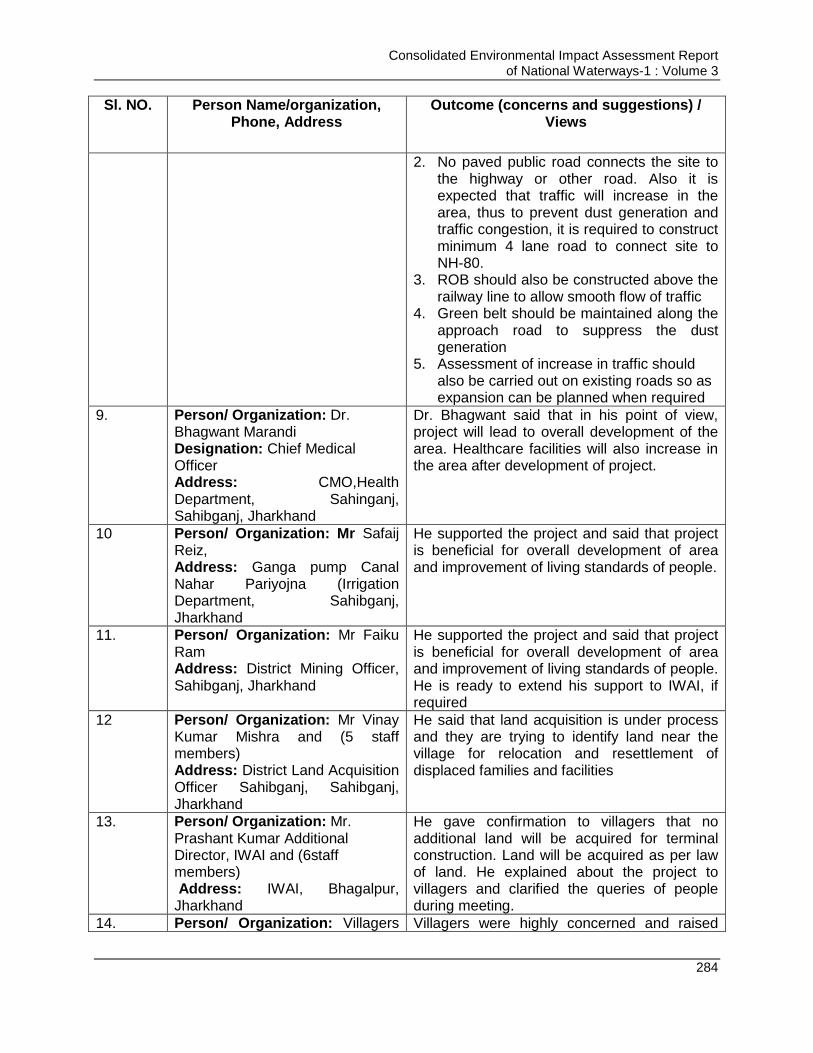
Consolidated Environmental Impact Assessment Report of National Waterways-1 : Volume 3
284
Sl. NO. Person Name/organization, Phone, Address
Outcome (concerns and suggestions) / Views
2. No paved public road connects the site to the highway or other road. Also it is expected that traffic will increase in the area, thus to prevent dust generation and traffic congestion, it is required to construct minimum 4 lane road to connect site to NH-80.
3. ROB should also be constructed above the railway line to allow smooth flow of traffic
4. Green belt should be maintained along the approach road to suppress the dust generation
5. Assessment of increase in traffic should also be carried out on existing roads so as expansion can be planned when required
9. Person/ Organization: Dr. Bhagwant Marandi Designation: Chief Medical Officer Address: CMO,Health Department, Sahinganj, Sahibganj, Jharkhand
Dr. Bhagwant said that in his point of view, project will lead to overall development of the area. Healthcare facilities will also increase in the area after development of project.
10 Person/ Organization: Mr Safaij Reiz, Address: Ganga pump Canal Nahar Pariyojna (Irrigation Department, Sahibganj, Jharkhand
He supported the project and said that project is beneficial for overall development of area and improvement of living standards of people.
11. Person/ Organization: Mr Faiku Ram Address: District Mining Officer, Sahibganj, Jharkhand
He supported the project and said that project is beneficial for overall development of area and improvement of living standards of people. He is ready to extend his support to IWAI, if required
12 Person/ Organization: Mr Vinay Kumar Mishra and (5 staff members) Address: District Land Acquisition Officer Sahibganj, Sahibganj, Jharkhand
He said that land acquisition is under process and they are trying to identify land near the village for relocation and resettlement of displaced families and facilities
13. Person/ Organization: Mr. Prashant Kumar Additional Director, IWAI and (6staff members) Address: IWAI, Bhagalpur, Jharkhand
He gave confirmation to villagers that no additional land will be acquired for terminal construction. Land will be acquired as per law of land. He explained about the project to villagers and clarified the queries of people during meeting.
14. Person/ Organization: Villagers Villagers were highly concerned and raised
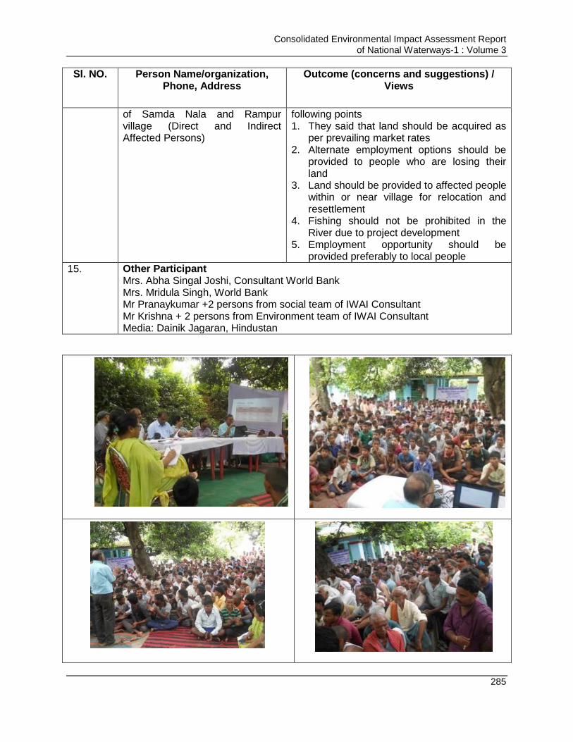
Consolidated Environmental Impact Assessment Report of National Waterways-1 : Volume 3
285
Sl. NO. Person Name/organization, Phone, Address
Outcome (concerns and suggestions) / Views
of Samda Nala and Rampur village (Direct and Indirect Affected Persons)
following points 1. They said that land should be acquired as
per prevailing market rates 2. Alternate employment options should be
provided to people who are losing their land
3. Land should be provided to affected people within or near village for relocation and resettlement
4. Fishing should not be prohibited in the River due to project development
5. Employment opportunity should be provided preferably to local people
15. Other Participant Mrs. Abha Singal Joshi, Consultant World Bank Mrs. Mridula Singh, World Bank Mr Pranaykumar +2 persons from social team of IWAI Consultant Mr Krishna + 2 persons from Environment team of IWAI Consultant Media: Dainik Jagaran, Hindustan
Consolidated Environmental Impact Assessment Report of National Waterways-1 : Volume 3
286
Figure 5.2 : Photographs of Formal Consultation at Samda Nala Village, Sahibganj
B. Formal Consultation in Farakka
Meeting was started with a brief about the project, objective of the Environmental and
social impact assessment studies, associated likely environmental and social issues
requiring attention for sustainable development. The stakeholders and community
members were then given an opportunity to raise their concerns and suggestions
regarding the proposed project. The summary of the key concerns/views and
observations of the different stakeholders are presented in Table 5.4. Photographs of
the formal public consultation meeting are given in Figure 5.3.
Table 5.4 : Summary of formal Stakeholder Consultation, at Farakka
Sl. NO.
Person Name/organization, Phone, Address
Outcome (concerns and suggestions) / Views
1. Kesang Dhendup Bhutia BDO & Block Executive Officer Farakka Block Development Office,Farakka,Murshidabad
BDO,Farakka, welcomed the project development and assured his and local administration cooperation for the project implementation.
Also mentioned that without addressing environmental and social concern/impact in a structured manner no project can be completed on time successfully.
Any kind of toxic pollution by the vessel like oil spillage and chemicals in the river water, transport emissions, needs to be considered.
The project implementing agency should be careful about river erosion during the vessels movement. River bank erosion has a permanent effect upon the socio-economic conditions and demographic dislocation.
As Farakka BDO, he appealed to the authority that they should provide jobs to the local unemployed youth based on their skill and should give business opportunities to the local people.
The access road needs to be widened and upgraded to ensure smooth traffic movement because it has an important link with NH-34. A traffic management plan needs to be in place.
He suggested that the project should employ local people in the proposed location on a priority basis provided
Consolidated Environmental Impact Assessment Report of National Waterways-1 : Volume 3
287
they have the required skills.
The health safety and protection of labour and other community members should be considered on project site as well as nearest locality of the villages during the operation phase.
Also suggested for adequate mitigation measures in EIA/SIA to address to erosion if and where identified.
The public consultation meeting should be held at different places for awareness of the people and Grievance RedressalCommittees should be active with timely conflict resolution.
The interviewee was optimistic that implementation of this project would change the current socio-economic scenario of the local communities.
2. Kesang Dhendup Bhutia BDO & Block Executive Officer Farakka Block Development Office,Farakka,Murshidabad
BDO,Farakka, welcomed the project development and assured his and local administration cooperation for the project implementation.
Also mentioned that without addressing environmental and social concern/impact in a structured manner no project can be completed on time successfully.
Any kind of toxic pollution by the vessel like oil spillage and chemicals in the river water, transport emissions, needs to be considered.
The project implementing agency should be careful about river erosion during the vessels movement. River bank erosion has a permanent effect upon the socio-economic conditions and demographic dislocation.
As Farakka BDO, he appealed to the authority that they should provide jobs to the local unemployed youth based on their skill and should give business opportunities to the local people.
The access road needs to be widened and upgraded to ensure smooth traffic movement because it has an important link with NH-34. A traffic management plan needs to be in

Consolidated Environmental Impact Assessment Report of National Waterways-1 : Volume 3
288
place.
He suggested that the project should employ local people in the proposed location on a priority basis provided they have the required skills.
The health safety and protection of labour and other community members should be considered on project site as well as nearest locality of the villages during the operation phase.
Also suggested for adequate mitigation measures in EIA/SIA to address to erosion if and where identified.
The public consultation meeting should be held at different places for awareness of the people and Grievance RedressalCommittees should be active with timely conflict resolution.
The interviewee was optimistic that implementation of this project would change the current socio-economic scenario of the local communities.
3. Mr. Arnab Chakraborty Journalist(Malda&Murshidabad Division) UttarbangaSamgbad Farakka,Murshidabad
He suggested that the project should employ local people in the proposed location on a priority basis provided they have the required skills.
The health safety and protection of labour and other community members should be considered on project site as well as nearest locality of the villages during the operation phase.
The interviewee was optimistic that implementation of this project would change the current socio-economic scenario of the local communities.
4. Mr.Jahid Hussain Arun Director, Mahadevnagar Rural Welfare Society, Farakka,Murshidabad
The authority can support them through livelihood restoration programmes.
Also suggested for safety and protection from the construction site near the locality of the villages and
The consensus described as during the construction period authority should consider the vulnerable health issues like HIV/AIDS because Murshidabad is one of the vulnerable health related district in West Bengal.
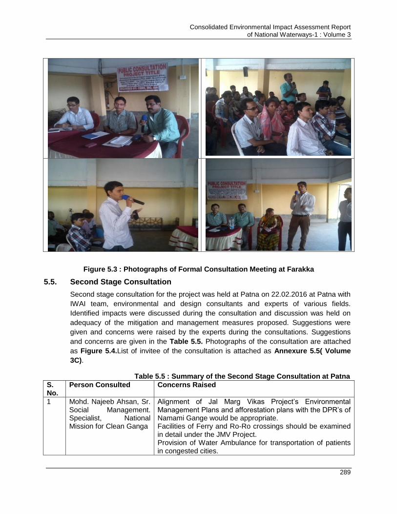
Consolidated Environmental Impact Assessment Report of National Waterways-1 : Volume 3
289
Figure 5.3 : Photographs of Formal Consultation Meeting at Farakka
5.5. Second Stage Consultation
Second stage consultation for the project was held at Patna on 22.02.2016 at Patna with
IWAI team, environmental and design consultants and experts of various fields.
Identified impacts were discussed during the consultation and discussion was held on
adequacy of the mitigation and management measures proposed. Suggestions were
given and concerns were raised by the experts during the consultations. Suggestions
and concerns are given in the Table 5.5. Photographs of the consultation are attached
as Figure 5.4.List of invitee of the consultation is attached as Annexure 5.5( Volume
3C).
Table 5.5 : Summary of the Second Stage Consultation at Patna
S. No.
Person Consulted Concerns Raised
1 Mohd. Najeeb Ahsan, Sr. Social Management. Specialist, National Mission for Clean Ganga
Alignment of Jal Marg Vikas Project‟s Environmental Management Plans and afforestation plans with the DPR‟s of Namami Gange would be appropriate. Facilities of Ferry and Ro-Ro crossings should be examined in detail under the JMV Project. Provision of Water Ambulance for transportation of patients in congested cities.
Consolidated Environmental Impact Assessment Report of National Waterways-1 : Volume 3
290
S. No.
Person Consulted Concerns Raised
Disaster Management and Emergency Response System should be developed under the project. Plan for treatment of waste water and re-use should be developed. As traffic on NW-1 would increase in future; proper planning for deployment of river patrolling and security is required. Last mile connectivity should be examined properly.
2 Dr. S. Samanta, Principal Scientist, CIFRI
Documenting the impacts along the river and understanding the various relationships with the river is important. IWAI is also a stakeholder in river. As other stakeholders need water in river for different uses as irrigation, drinking etc., IWAI also require water for navigation. The role of the project on overall water management in the river must be clarified.
3 Shri Vishva Ranjan, Urban Planning & Urban Development Specialist, Patna
Environment friendly waste disposal mechanism is required for vessels. Need of a Charter for ensuring waste is not directly discharged in the river and third party monitoring to ensure the same. Waste management has been included in the draft revised Indian Vessels Act.
4 Shri K. Praveen Rao, Chief Conservator of Forests-Kanpur, Department of Forest, U.P
Reconstitution of Project Oversight Committees with representation of appropriate Forest Officers. Afforestation along the banks of Ganga should be done under the project.
5 Professor R.K Sinha, Head, Zoology Dept., Patna University
Vessel traffic management system should be developed under the Project. Dolphins are National aquatic animals and are blind. Noise generated due to vessel movement should be controlled to avoid adverse impact on dolphins. Propellers on the vessels should be caged for safety of the dolphins
6 Shri Rakesh Tiwary, Astt. Professor, A.N. Sinha Institute of Social Studies
Proper planning should be done to maintain sufficient depth by conserving wet lands and constructing reservoirs (rain water harvesting) and releasing them in the river during lean season in the system. Long term modelling of rivers should be ensured to meet the water depth requirement Cumulative impact on the society due to the project should be studied in details and proper mitigation measures should be adopted
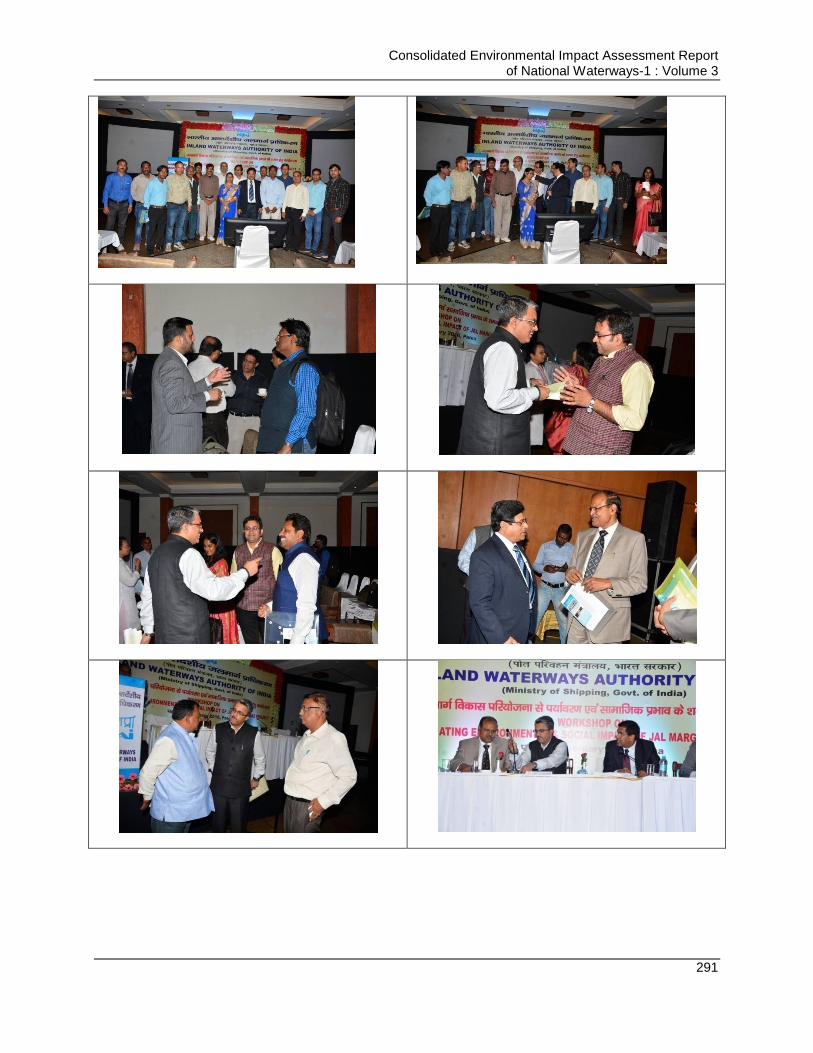
Consolidated Environmental Impact Assessment Report of National Waterways-1 : Volume 3
291
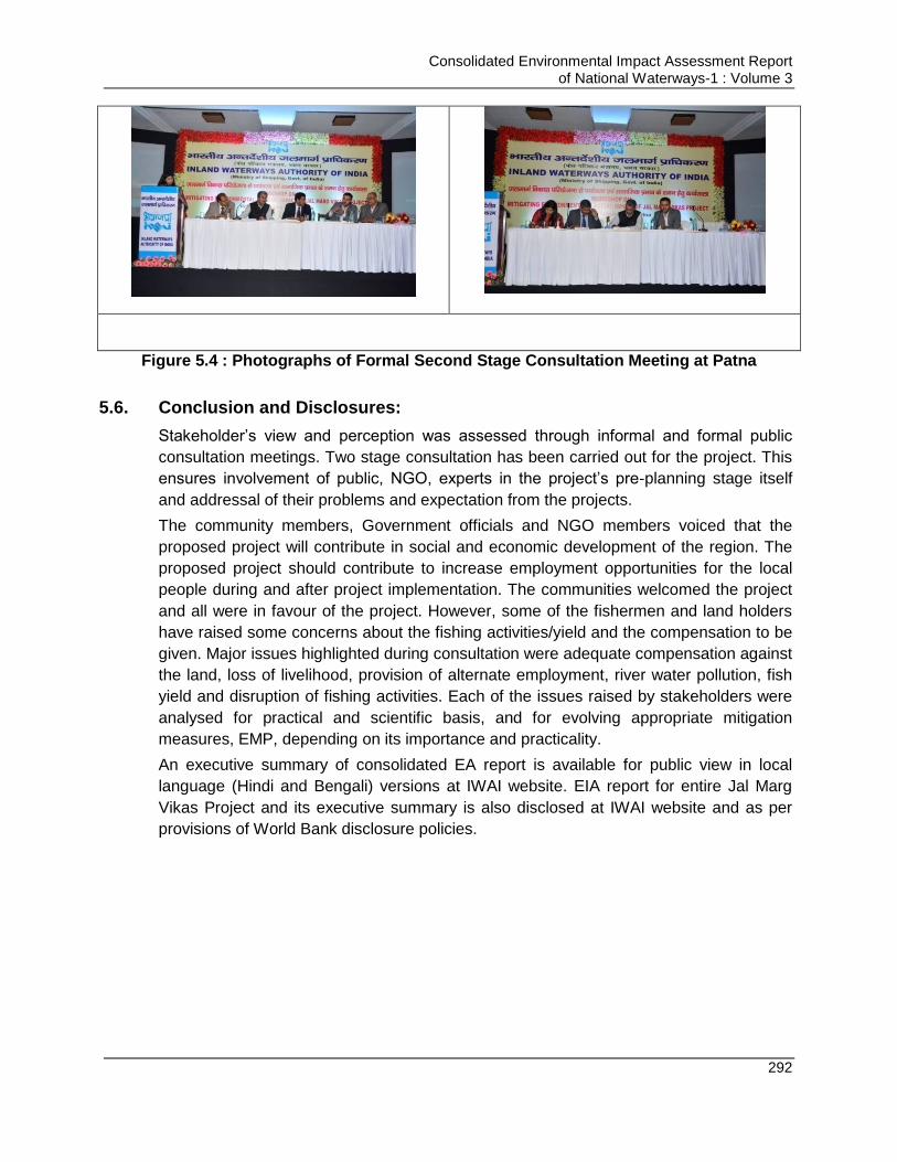
Consolidated Environmental Impact Assessment Report of National Waterways-1 : Volume 3
292
Figure 5.4 : Photographs of Formal Second Stage Consultation Meeting at Patna
5.6. Conclusion and Disclosures:
Stakeholder‟s view and perception was assessed through informal and formal public
consultation meetings. Two stage consultation has been carried out for the project. This
ensures involvement of public, NGO, experts in the project‟s pre-planning stage itself
and addressal of their problems and expectation from the projects.
The community members, Government officials and NGO members voiced that the
proposed project will contribute in social and economic development of the region. The
proposed project should contribute to increase employment opportunities for the local
people during and after project implementation. The communities welcomed the project
and all were in favour of the project. However, some of the fishermen and land holders
have raised some concerns about the fishing activities/yield and the compensation to be
given. Major issues highlighted during consultation were adequate compensation against
the land, loss of livelihood, provision of alternate employment, river water pollution, fish
yield and disruption of fishing activities. Each of the issues raised by stakeholders were
analysed for practical and scientific basis, and for evolving appropriate mitigation
measures, EMP, depending on its importance and practicality.
An executive summary of consolidated EA report is available for public view in local
language (Hindi and Bengali) versions at IWAI website. EIA report for entire Jal Marg
Vikas Project and its executive summary is also disclosed at IWAI website and as per
provisions of World Bank disclosure policies.

Consolidated Environmental Impact Assessment Report of National Waterways-1 : Volume 3
293
Chapter 6. ENVIRONMENTAL MANAGEMENT PLAN
6.1. Introduction
The Environmental Management Plan (EMP) is the synthesis of all proposed mitigation
and monitoring actions, set to a time frame with specific responsibility assigned and
follow-up actions defined. EMP is a plan of actions for avoidance, mitigation and
management of the negative impacts of the project. Environmental enhancement is also
an important component of EMP. A detailed set of mitigation measures have been
compiled in view of the likely impacts associated with the proposed “Jal Marg Vikas”
Project.
6.2. Objective of Environmental Management Plan
The EMP consists of a set of mitigation, monitoring and institutional measures to be
taken during the design, construction and operation (post-construction) stages of the
project. The EMP has been designed keeping in view the regulatory and other
requirements to ensure the following:
Minimum disturbance to the environment and social components
Compliance with the environmental acts, rules and guidelines of GoI & maintaining
the quality of air, water, soil and noise as per the prescribed norms by regulatory
bodies.
Conservation of natural resources to the extent possible
Enhancement of Project benefits for Society & Environment
Sustainable development and operation of project
6.3. Environmental Management Plan
Major activities associated with the project are construction and operation of the civil
interventions, barge movement and maintenance dredging. Barge movement and
maintenance dredging will be carried out during the operation phase of the project only
whereas development of civil interventions will have components distributed during
design, construction and operation phases. Civil interventions include construction of
jetty, terminals, river training works, bend corrections, barge maintenance facility, and
RO-RO jetties. A detailed environmental management plan for each associated
development for all the three phases of the project, i.e. design/pre-construction,
construction and operation phase is prepared as applicable. EMP lists the activities
involved, associated impact with each activity on environment, suggestive mitigation
measures, allocated environment budget for impact mitigation,implementationplan
covering monitoring, reporting and implementation and supervisory responsibility.
Consolidated EIA provides institutional mechanism, budgetary provisions and other
systems and plans which are commonly applicable to all intervention and operations of
NW-1. The EMPs prepared for dredging and barge operations are commonly applicable
to the terminal development and operation and other intervention sites. Consolidated
Consolidated Environmental Impact Assessment Report of National Waterways-1 : Volume 3
294
EIA also provide generic EMP for the interventions such as Ro-Ro Jetties, embankment
protection. Additionally, standalone EMPs prepared based on site specific terminal
developments at Varanasi, Sahibganj and Haldia and Navigational Lock at Farakka.
6.3.1. Environmental Management Plan for Maintenance Dredging
Maintenance dredging will be carried out during operation phase of the project to
maintain LAD for navigation. Maintenance dredging will be carried out as per the
availability of the depth naturally and depth required for movement of the cargo
depending on the size of the cargo planned to ply in the stretch. Estimation of the
required amount of maintenance dredging in different stretch of the waterway is
estimated by the design consultant. A sensitivity analysis was carried out of the entire
NW-1 stretch from environmental biological and social sensitivity prospective v/s
dredging and dredge disposal. This analysis is presentedat Table 6.1. Consideration
dredging practices impact analysis and the above sensitivity the environmental
management plan for dredging is given in Volume 8.
6.3.2. Environmental Management Plan for Barge Movement
The project Jal Marg Vikas aims ensuring the movement of barges in NW-1 during the
entire year. Barge movement as discussed in Chapter 5 have certain associated impacts
on environment which is required to be mitigated and managed to prevent environmental
damage. Environmental management plan for barge movement is given in Volume 9.
6.3.3. Environmental Management Plan for Civil Interventions
Civil interventions proposed to be undertaken for the project are Terminals, navigational
lock, Ro-Ro jetties, Bank protection measures, barge maintenance slipway and river
training works. Terminal construction involves construction of berths, jetties, loading and
unloading areas, material storage areas, internal roads, and administration building. Ro-
Ro jetties are the extension inside the river from land facilitating movement of vehicles
carrying cargo onto the vessel directly on wheels. Ro-Ro jetty involve development of
the walkway and area for berthing of the vessels. No material loading/unloading
operations are undertaken at Ro-Ro jetties. Bank protection works includes stone
pitching, and construction of retaining walls. River training works will include bend
corrections, closure of secondary channel, and construction of guide walls. All these
activities will interface with various environmental, biological and socio-economic
components of the influence area and will impact them. Assessment of those impacts is
carried out in detail in Chapter 5 and mitigation measures are suggested to minimize the
impacts. Management plan has been prepared for implementation of suggestive
mitigation measures along with the budget and responsibility of the agencies involved.
Environmental management plan for (general) terminal, navigation locks & River
Training Structures/Bank Protection measures for construction and operation phase and
for Ro-Ro Jetties are given in Annexure 6.1 & 6.2( Volume 3C).
Consolidated Environmental Impact Assessment Report of National Waterways-1 : Volume 3
295
C. EMPs for Planned Civil Interventions
Standalone specific EMPsare prepared for each of proposed civil intervention i.e.
Sahibganj, Varanasi& Haldia Terminal and Farakka NavigationLock based on these
intervention specific EIA studies. These EMPs are included in Volume 4, 5, 6 & 7.
6.4. Institutional Framework of IWAI for Environmental Management
For effective implementation of the proposed environmental management plan, it is
necessary to have permanent organizational set up charged with the task of ensuring
effective implementation of EMP and to monitor the implementation efficiency. IWAI has
set up a project management unit which is staffed with environmental and social
specialists. These specialists would work as an Environment, Occupational Health &
Safety and Social management cell (EHS) within PMU. It is proposed that each field unit
will have one designated officer responsible for environment and social aspects who will
also coordinate with EHS Cell. The major responsibilities of IWAI and of EHS cell would
be:
To develop the mechanism so as to ensure that proposed mitigation measures are discussed and integrated at policy level so as they become mandate for various stakeholders to be followed
To implement the environmental management plan
To assure regulatory compliance with all relevant rules and regulations
To ensure regular operation and maintenance of pollution control devices
To minimize environmental impacts of operations as by strict adherence to the EMP
To initiate environmental monitoring as per approved schedule
Review and interpretation of monitoring as per approved schedule
Review and interpretation of monitoring results and corrective measures in case monitored results are above the specified limit
Maintain documentation of good environmental practices and applicable environmental laws as ready reference
Maintain environmental related records
Coordination with regulatory agencies, external consultant, monitoring laboratories
Maintain log of public complain and the action taken
Efforts should be made for setting up of common conservation cell consisting of one marine biologist, and ecologist, a sociologist and a fishery expert
The EHS cell should have all basic record keeping facilities such as hard ware/software
facilities, adequate space, vehicle (transport) and basic furniture and all simple
instruments such as GPS, Digital camera, Hand held noise metre etc. The cell should
have all basic environmental management data of the project that includes but not
limited to the following:
Environmental Impact Assessment Report (both well preserved soft and hard copy) and Environmental Management Plan
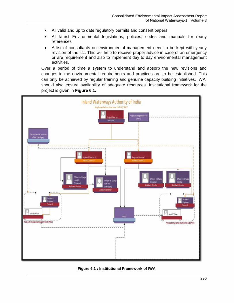
Consolidated Environmental Impact Assessment Report of National Waterways-1 : Volume 3
296
All valid and up to date regulatory permits and consent papers
All latest Environmental legislations, policies, codes and manuals for ready references
A list of consultants on environmental management need to be kept with yearly revision of the list. This will help to receive proper advice in case of an emergency or are requirement and also to implement day to day environmental management activities.
Over a period of time a system to understand and absorb the new revisions and
changes in the environmental requirements and practices are to be established. This
can only be achieved by regular training and genuine capacity building initiatives. IWAI
should also ensure availability of adequate resources. Institutional framework for the
project is given in Figure 6.1.
Figure 6.1 : Institutional Framework of IWAI
Consolidated Environmental Impact Assessment Report of National Waterways-1 : Volume 3
297
6.4.2. Effective Implementation of Environmental Management Plan during Construction Phase
Pre-construction and construction activities are taken by the contractor to whom work
will be awarded. For implementation of Environmental Management Plan during pre-
construction and construction phase, it is necessary that EMP for construction phase
should be shared with the contractor so as he is aware of the environmental provision he
has to keep during construction phase and he can do budgeting accordingly. This will
ensure effective implementation of the EMP. Thus IWAI should include the EMP as
environmental and social safeguard measures in the bid document. EMP implementation
by contractor can be achieved by following ways:
Incorporation of contractor‟s EMP in bid document and instructing him to keep
environmental provisions in planning while budgeting
Contractor should have full-fledged environment health and safety management
cell (EHS Cell) to ensure the implementation of the EMP and the SHE policy
aiming at achieving the goals of safety, health and environmental management.
The contractor EHS cell should have all the expertise in the field of Environment
Health and Safety. The designated EHS officers should have adequate experience
for implementing and monitoring the similar nature of EMPs. The contractor EHS
cell should function in close coordinationwith PMU of IWAI and PMC to the project.
The contractor EHS cell should submit the EMP compliance and applicable
regulatory and IWAI EHS systems compliance on monthly basis.
Mandatory Deputation of environmental and social expert (by contractor) at site
Environmental & social experts to be deputed should have broad experience of
working in similar field
Linking payments of the contractor to environmental performance
Assigning penalties in case the environmental safeguard measures are not taken
up adequately
Appointing PMU/PMC to monitor the performance of contractor and compliance of
the EMP by contractor. PMU/PMC is responsible to communicate the status of
compliance/non-compliance of EMP by contractor to project proponent and
suggest the measures to be taken to contractor to meet the gaps/non-compliances.
PMU/PMC can be appointed by IWAI through tendering process again and the
company‟s having experience of managing similar kind of projects should only be
appointed for the PMU/PMC work only.
6.5. Environmental Health & Safety (EHS) Policy and EHS Management System
An effective environmental health and safety policy is essentially to demonstrate top
management commitment for environmental protection and occupational health and
safety. The policy should be communicated to all stakeholders including workers and
should be freely available to them on demand. required to be prepared for the project
and it should be communicated to the workforce through displaying posters/bill
boards/posters/glow boards and campaigning around the work site. Posters should be in
Consolidated Environmental Impact Assessment Report of National Waterways-1 : Volume 3
298
Hindi, English & Regional language so as it can be understood by the workforce. Verbal
communication through campaigning also should be carried out. Some of the important
days such as Environment Day (June 5), Red Cross Month (March), Emergency
Preparedness Week (May 1-7), National safety day (4th April), National Health Day (7th
April), Fire safety day (14th April), 20th April (Earth day) can be planned for spreading
the awareness for Environment Protection, Cleanliness and safety among work force
through campaigning.
For effective and systematic implementation of the project, it is desirable that IWAI (The
EA) develops its Environmental and Social management systems which is auditable and
effectively enforceable. Parallel can be drawn from the experience of National Highway
Authority of India or Delhi Metro Rail Corporation and adopt EHS system on the similar
lines. Each contractor should be contractually bound to follow such system and must
have EHS management system in line with EA‟s management system. IWAI should also
develop its standard technical guidelines for Environmental Assessment, Management
and Reporting. Training and awareness will be an essential component of the EMP and
EHS management system. It should include use of posters, bill boards/glow boards
around project site an d barge NW-1 An effective environmental health and safety policy
is essentially required to be prepared for the project and it should be communicated to
the workforce through displaying posters/bill boards/posters/glow boards and
campaigning around the work site. Posters should be in Hindi, English & Regional
language so as it can be understood by the workforce. Verbal communication through
campaigning also should be carried out. Some of the important days such as
Environment Day (June 5), Red Cross Month (March), Emergency Preparedness Week
(May 1-7), National safety day (4th April), National Health Day (7th April), Fire safety day
(14th April), 20th April (Earth day) can be planned for spreading the awareness for
Environment Protection, Cleanliness and safety among work force through campaigning.
6.6. Environmental Standards for operation and maintenance of Various Civil Interventions, Barge Movement and Dredging Operations
Mentioned activities have potential to pose threat on the environmental quality.
Regulatory Authorities of India and other countries have specified certain limits of
pollutants which, if maintained, environmental pollution can be maintained.
No guidelines and standards are as of now available in India, which deals with the liquid
and sewage waste management & disposal and air emissions from barges, terminal
sites and at arrange maintenance facility during barge movement. Also no guidelines or
standards on dredging and dredge disposal is available in India either for onshore or off-
shore disposal. Guidelines are also not available on EHS management system to be
followed by barges, terminal sites, dredging contractors, jetty sites, maintenance
facilities. Such guidelines and standards should be developed by IWAI and other
regulatory bodies in close association with IWAI. Further a monitoring mechanisms
should also be developed so as to monitor the compliance of these guidelines and
standards. Until the guidelines or standards are developed, IWAI can refer to the
international guidelines and can make it mandatory to follow these guidelines by the
Consolidated Environmental Impact Assessment Report of National Waterways-1 : Volume 3
299
stakeholders (terminal & jetty operators, barge operators, material transportation
company, maintenance facility operators and other). until the new guidelines come up.
Further IWAI is required to develop the infrastructure which is essential need as per
these guidelines so as no violation of the guidelines happen.
Some of the international standards available in relation to dredge disposal, waste
disposal, emissions management and some of national standards on water, air and
construction standards are listed below. Details of Environmental standards applicable
for the operation and maintenance stage of the project and that should be adhered to
are listed below. Details of each of the standards are given in Annexure 2.2 (Volume 3C)
of this report.
Standards for discharged of effluent in inland surface water bodies and Marine
Coastal Areas (Source: G.S.R 422 (E) dated 19.05.1993 and G.S.R 801 (E) dated
31.12.1993 issued under the provisions of E (P) Act 1986)
Classification of Surface water Bodies on basis of Quality (Source: Guidelines for
Water Quality Management-CPCB, 2008)
Water Quality Standards for Coastal Waters, SW-IV & V-Harbour and Navigation &
controlled waste disposal (EIA Guidance Manual for Ports & Harbours, MoEF&CC,
GoI)
Standards for permissible level of water quality indicators (Source: Assessment of
the Environmental Impact of Port Development, United Nations, New York, 1992)
Permissible limit for off-shore dumping of dredged material (Source: Assessment of
the Environmental Impact of Port Development, United Nations, New York, 1992)
Criteria for harmful bottom sediments (Source: Assessment of the Environmental
Impact of Port Development, United Nations, New York, 1992)
Approximate Quantity of Suspended Sediments Generated by Dredging or
Dumping Operations (Source: Assessment of the Environmental Impact of Port
Development, United Nations, New York, 1992)
MARPOL 73/78 for prevention of pollution from ships
SOLAS (Safety of Life at Sea) as per latest amendments (Chapter I-XII)
CPWD Norms for construction of off-shore works, river bank protection structure,
carrying out dredging works, river raining works
6.7. Environment Monitoring Plan(EMoP)
The objective of environmental monitoring during the construction and operation phases
is to compare the monitored data against the baseline condition collected during the
study period to assess the effectiveness of the mitigation measures and the protection of
the ambient environment based on national standards. The following are the main
objectives of the environmental monitoring program:
Provides information for documentation of monitoring of mitigation measures and
impacts
Consolidated Environmental Impact Assessment Report of National Waterways-1 : Volume 3
300
Tool for the statutory authority of unanticipated adverse impacts or sudden
changes in the environmental condition due to the proposed project
Provides information that could be used for evaluating the effectiveness of
implemented mitigation measures
Provides information that could be used to verify predicted impacts and thus
validate impact prediction techniques
The effectiveness of the mitigation measures being followed during construction
and operational phases can be assessed and the measures can be revised, made
more stringent and reinforced based on the monitoring results
Environmental Monitoring can also serve a basic component of a periodic
environmental regulatory auditing program for the proposed project
A monitoring schedule has been developed based on the environmental components
that may be affected during the construction & operation phase of the project and is
given in Table 6.2. Environment monitoring indicators identified are listed below
Monitoring Indicators
Air quality- ambient air quality levels & stack emissions
Surface Water quality
Drinking water quality- for construction labours
Noise levels- ambient noise level and work zone noise levels
Soil quality- dredged sand quality and soil quality
Solid & Hazardous Waste Management
Wastewater disposal
Re-plantation success / survival rate
Soil Erosion at river banks and bed scours
Aquatic ecology– plankton, benthic communities, dolphins, turtles and other
aquatic species
These indicators should be evaluated periodically based on the monitoring results,
baseline conditions, predicted impacts and mitigation measures.
Water Quality: No significant change in water quality is perceived due to the project in the
operation phase. Hence, it is suggested that if the monitored value for any water quality
parameter exceeds by more than 20% of its last monitored status the monitoring
frequency should be increased and suitable measures taken if increase in value is due to
project activity reasons
Tree Plantation: The 70% survival rate of re-plantation should be monitored on the first
year of the operation phase in consultation agency assigned for tree plantation. If the
survival rate is found below 70%, additional tree should be planted and survival rate
monitoring should be again taken up after 3 years. This cycle should continue until the
70% survival rate is achieved
Consolidated Environmental Impact Assessment Report of National Waterways-1 : Volume 3
301
Aquatic Ecology: Details about ecological aspect should be periodically collected in
terms of effect on breeding and spawning ground, accidental damage to dolphin if any or
other aquatic fauna, fish productivity. Corrective action should be initiated if IWAI activities
or Barge operation are resulting in any damage to Aquatic fauna or fishermen activities.
Soil Erosion: No significant soil erosion is anticipated during construction and operation
phase. In the construction phase some localised bank erosion may be noticed. Erosion
may be noticed in the narrow areas of Farakka Canal. However, if bank soil erosion is
noticed during construction and operation phase, the corrective action should be initiated
and frequency of check be increased to assessed the tendency of recurrence.
Safety and Emergency Preparedness: Safety measures like signage board, navigation
GPS system, and other accident prevention measures for barge movement are proposed.
Periodic physical and preparedness check should be carried out. If any aspects of safety
and emergency preparedness is found ineffective than appropriate corrective action
should be taken.
6.8. Monitoring for Implementation of EMP
During project design and implementation stage the respective contractors should be
liable for implementation of suggestive EMPs and IWAI will be responsible to monitor the
contractor‟s performance and adequacy of implementation of EMPs directly or through
third party (PMC). However, during operation stage, IWAI should be solely responsible for
implementation of the EMP& Emergency Management. IWAI should be liable to ensure
that suggestive mitigation measures are taken up by the shippers, dredgers and other
stakeholders in time and adequately. IWAI should develop the mechanism so as to ensure
the adherence and compliance of the EMP.
6.9. Reporting Requirement for EMP and EMoP
6.9.1. Reporting Requirement during Pre-Construction & Construction Phase
Contractor is responsible for implementation of Environmental Management Plan and
ensuring health and safety of the construction workers at site during pre-construction &
construction phase of the project. Thus it is required by contractor to submit the monthly
and six monthly compliance reports containing the status of environment, health & safety
at site to PMC (Project Management Consultant) & PMU of IWAI. PMC/IWAI will be
responsible for construction supervision and ensuring effective implementation of EMP by
the contractor. PMC should report to PMU monthly about the performance and
effectiveness of the EMP implemented by contractor on site and coordinate with filed units
and PMU for necessary corrective actions as may be required. PMC will be hired by IWAI
who will be responsible to identify gaps between the proposed environmental, safety and
health management plan and actually implemented status of the system by contractor.
PMU on basis of site inspections and PMC reporting, will issue orders to contractor for
corrective actions with time in which gap is to be met and penalty clause in case of non-
compliance. Submissions to be made by contractor to PMC/PMU are given below:

Consolidated Environmental Impact Assessment Report of National Waterways-1 : Volume 3
302
Monthly SHE Report- Details of daily & monthly man hours of workers; fresh incident
analysis; detail of SHE inspection, internal audits & SHE communication activities;
data on air, noise, soil and water quality; housekeeping details and health & welfare
details
Monthly Environment Reports- Details of environmental monitoring parameters and
monitoring data as per proposed EMoP; nos. of work fronts open & associated issues;
compliance to management Systems, ILO and National legislative requirements as
applicable; compliance to world bank requirement; green belt management status,
tree cutting & afforestation and PUC & green tag status of vehicles at construction site
Monthly Progress Report: Detailing tasks undertaken till date, tasks under progress
and the planned tasks for next months
Monthly Accidental Reporting and Investigation Report
Six monthly compliance reports for compliance of regulatory permits and EMP
requirements.
6.9.2. Reporting Requirement during Operation Phase
IWAI should ensure the implementation of Environmental Management Plan for the
operation phase as suggested. IWAI should maintain the following records/reports
Six monthly compliance report of suggested EMP
Audit Report for compensatory plantation
Energy audit reports of the terminal buildings
Accident and Investigation Report
Report containing details of dredging quantities and LAD maintained in different
stretches
IWAI should be liable to ensure that suggestive mitigation measures are taken up by the
shippers, dredgers and other stakeholders in time and adequately. IWAI should develop
the mechanism so as to ensure the adherence and compliance of the EMP. It is proposed
that IWAI will have dedicated department adequately staffed and equippedwithspeed
monitoring, vessel positioning, and emergency response equipemnts(like oil spills control
and remediation systems). IWAI may also adopt mechanism of involving Barge operators
on the line of Responsible Carrier Programme of Americans Waterways Operators.
6.10. Audits & Inspection
Audits and inspections are integral part of the Environmental Management Plan. Audits
and inspection helps to evaluate the performance of the implemented system and provides
the rating and identify the non-compliances and gaps between the proposed and
implemented system. Audits should be regularly held so as non-compliances can be
identified at each stage and can be complied with by taking corrective actions. Some of
the audits to be taken up by contractors include
SHE management system
LEED or GRIHA certification of green building compliance for terminal buildings.
Regulatory Compliance
Consolidated Environmental Impact Assessment Report of National Waterways-1 : Volume 3
303
IWAI will also organise an independent Environment Audit which will be submitted to Bank
within 3 months of completion of the second and fourth year of implementation period
6.11. Mechanism for Feedback and Adjustments
As part of the feedback mechanism, the EHS of PMU should monitor project compliance
based on monitoring reports, audit and inspection reports with respect EMP, EMoP and
applicable laws, rules and regulations. EHSwill report to PD quarterly. In case, any
deviation from the contract requirements with respect to proposed EMP is observed, the
same should be corrected within a fortnight through contractor and PMC and records
maintained for the same. EHS will also verify the facts reports through periodic site visits.
Public involvement should be encouraged and ensured throughout the lifecycle of the
project. The EHSshould gather and maintain information on any damage or public concern
that may be raised by the local people, NGOs and local authorities. While immediate
solutions are to be worked out with the help of contractor, a detailed report will be
submitted to the PMU and PD for information or detailed consideration, as the case may
be. The PMC and ESC will be responsible to bring it to the notice of the PMU and PD.
Resulting decisions should be communicated back to PMC and contractor for correction
and future implementation.
6.12. Trainings & Capacity Building
Trainings are essential for skill building and making people competent in carrying out the
operations/tasks and handling emergency situation in planned manner.IWAI has already
taken actions to augment the capacity of project management unit (PMU). A capacity
building and training programme has been prepared which includes training of staff of
Environmental and Social cell of PMU, contractor‟s staff (labours & engineers), PMC staff
and IWAI staff on environmental management, regulatory compliance and safety aspects.
Some of the trainings which are required to be conducted are given in Table 6.3.
6.13. Emergency Response and Preparedness Plan and Contingency Response Plan
Risks and hazards are associated with every construction site as it involves usage of
heavy machinery and equipment. Similarly, risks are also associated with the operation
phase are listed below:
Vessel Accidents and spillage of commodities (especially oil)
Leakage or spillage of oil from ships and barges at terminal/jetty
Drowning in River during material handling and vessel movement
Hazard to Fishing vessels/gears
It is proposed that IWAI must equipped itself with guidelines and equipment for handling
the emergencies. PMU should evolve its environmental, Occupational health and safety
guidelines and performance protocol. Budgetary provision has been made under
environmental budget. The same should be developed with the help of reputed
institutions and organisation of repute. It should also follow the system of emergency
Consolidated Environmental Impact Assessment Report of National Waterways-1 : Volume 3
304
response. A suggested Emergency management and Response plan is included at
Annexure 6.3( Volume 3C).
Responsible Carrier Programme of IWAI54: It is proposed that IWAI develops Indian
Waterways Operations Responsible Carrier Programme which should be developed as
part of its EHS Management Systems and Emergency Response Plan and Protocols
Development. The programme should have the following components as well:
Protocol for speed control, monitoring, and vessel tracking
Protocol of waste management for barge operations and terminals management.
(including zero discharges and waste disposal to river by barges and terminals.
This protocol should also define about waste handling facilities at barges and
waste disposal facilities at terminals for maintain zero discharge concept.
Biodiversity protection including accident reporting with Aquatic mamals (dolphin)
Oil spills reporting and control and remediation
Near-miss reporting/lessons learned and corrective actions program
Risk assessment procedures to assess and manage risks to personnel, vessels
and the environment
Identification of critical or essential equipment/systems
Authority of the master, crew and shore side personnel
Addition of document control procedures
Tracking of number and volume of spills in performance measurement
requirements
Internal and external audit procedures and frequency
6.14. Authorities and their Responsibilities for Implementation of EMoP
The authorities and responsibilities for the implementation of the environmental management plans should be tiered based on the activity and as per institutional framework.
All the policy decisions, including incorporation of the EMP requirements in compliance to loan covenants should be the responsibility of the IWAI (EA).
Projects should be implemented by Project Management Units (PMU). IWAI has set up
Environmental, Occupational Health & Safety and Social Management Cell (EHS) within
PMU. EHS will ensure that the environmental mitigation measures are being
implemented effectively. The EHSshould, among others ensure that the EIA Reports
comply with national and Bank guidelines, monitor the status of implementation, and
preparation of monitoring reports. PMU will depute its officer at filed level unit with
additional responsibility for Environmental and social management who will also
coordinate with EHScell at PMU. It is also proposed to appoint PMC who will supervise
contractor and PMU to ensure effective implementation of management plan proposed.
EHScell will be technically supported by independent subject experts who should be
hired on need basis (Air, Noise, Water, and Aquatic).
54
Reference is drawn to the successful similar programme of American Waterways Organisation‟s Responsible Carrier Programme.
http://www.americanwaterways.com/rcp-2016.
Consolidated Environmental Impact Assessment Report of National Waterways-1 : Volume 3
305
The most essential component of the Environment Monitoring Plan is the execution of
the Plan in accordance with the monitoring schedule provided therein. The EHScell
andconcerned field unit will be responsible for timely monitoring of various parameters
and compliance with the mitigative measure proposed. A resultant data base is
proposed to be maintained. A Management Information System (MIS) is also proposed
to be put in place for effective flow of information between various levels and functions
within PMU, EHS cell, PMC and contractor.
6.15. Enhancement Measures: Implementation Plan
The enhancement measures are proposed to meet stakeholders‟ expectation and
enhance the positive impacts. Three proposal regarding dolphin conservation, fish
productivity and cultural aspects.
IWAI will be having prime responsibility for the same. Budgeting provision is made in the
EMP for all the three enhancement proposal. EHS cell will obtain quotations and finalise
implementation modalities, success indicators in consultation with proposed agency. The
implementation plan will also be submitted to World Bank for information.
6.16. Regulatory Clearances /Permission Required
Statutory clearances will be obtained for any project component wherever found
applicable. Certain other permits are required for example consent to establish from
State Pollution Control Board for setting up hot mix plant. All such permits are supposed
to be obtained by the contractor who should obtain it before setting up any facility
attracting these permissions. The most important and time-consuming clearances are
permission for barge movement through Kashi Turtle Sanctuary and Vikramshila Dolphin
Sanctuary but this permission is required for operation stage of project for movement of
vessel through these sanctuaries. This process has already been initiated by IWAI.
6.17. Grievance Redress Mechanism (GRM)
The concern/grievances from local/affected people may come up related to inappropriate
implementation of various components of EMP. These issues can be easily addressed
through acknowledgement, evaluation and corrective action and response approach. To
resolve grievance from public or stakeholders concerning the project will be directed to the
PMU/Director concerned. Firstly, it will be assessed if the grievances are genuine or
suggestion is acceptable. Accordingly, response will be given within 15-30 days by the
PMU in consultation with PMC and Director concerned. In case the PMU is unable to
resolve the issue, the matter will be forwarded to Project Director at Head Quarter. The
corrective action will be started as per the response or action plan indicated to the
stakeholder. The outcome should also form part of quarterly report to World Bank.
Hierarchy of escalation of complaint though GRM is presented below. GRM pocess flow
diagram is given in Figure 6.2. Detailed GRM is given in RAP prepared for the project.

Consolidated Environmental Impact Assessment Report of National Waterways-1 : Volume 3
306
Hierarchy of escalation of Complaint
Figure 6.2 : Grievance Redressal Cell
6.18. Environment Budget
Environment budget has been prepared for design, construction and operation phase of
the project. The Environmental budget includes the cost of environmental structures like
Sewage Treatment Plant, Air Pollution Control System at terminals, monitoring,
enhancement measures, GHG reduction, training and awareness and technical support for
establishment, enhancement measures and environmental guidelines. Environmental
budget is estimated as Rs 49.9 crores. The detailed break-up of costs is given at Table
6.4. Lump sum budget for each of the planned civil intervention area planned is given
below in Table 6.5 below. For detailed budget of each component the individual EIAs
prepared for each of the proposed civil intervention can be referred.
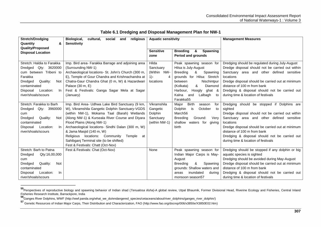
Consolidated Environmental Impact Assessment Report of National Waterways-1 : Volume 3
307
Table 6.1 Dredging and Disposal Management Plan for NW-1
Stretch/Dredging
Quantity &
Quality/Proposed
Disposal Location
Biological, cultural, social and religious
Sensitivity
Aquatic sensitivity Management Measures
Sensitive
zone
Breeding & Spawning
Period and grounds
Stretch: Haldia to Farakka
Dredged Qty: 3620000
cum between Tribeni to
Farakka
Dredged Quality: Not
contaminated
Disposal Location: In
river/shoals/scours
Imp. Bird area- Farakka Barrage and adjoining area
(Surrounding NW-1)
Archaeological locations- St. John's Church (300 m,
E), Temple of Gour Chandra and Krishnachandra at
Chatra-Gaur Chandra Ghat (0 m, W) & Hazardwari
Palace (30 m, E)
Fest & Festivals: Ganga Sagar Mela at Sagar
(January)
Hilda
Sanctuary
(Within NW-
1)- 4
locations
Peak spawning season for
Hilsa is July-August
Breeding & Spawning
grounds for Hilsa: Stretch
between Nischintpur
(Kolkata) & Diamond
Harbour, Hoogly ghat &
Kalna and Lalbagh to
Farakka55
Dredging should be regulated during July-August
Dredge disposal should not be carried out within
Sanctuary area and other defined sensitive
locations
Dredge disposal should be carried out at minimum
distance of 100 m from bank
Dredging & disposal should not be carried out
during time & location of festivals
Stretch: Farakka to Barh
Dredged Qty: 3960000
cum
Dredged Quality: Not
contaminated
Disposal Location: In
river/shoals/scours
Imp. Bird Area- Udhwa Lake Bird Sanctuary (9 km,
W), Vikramshila Gangetic Dolphin Sanctuary-VGDS
(within NW-1), Mokama Taal (Barah) Wetlands
(Along NW-1) & Kurseala River Course and Diyara
Flood Plains (Along NW-1)
Archaeological locations- Sindhi Dalan (300 m, W)
& Jama Masjid (140 m, W)
Religious locations: Community Temple at
Sahibganj Terminal site (to be shifted)
Fest & Festivals: Chatt (Oct-Nov)
Vikramshila
Gangetic
Dolphin
Sanctuary
(within NW-1)
Major Birth season for
Dolphin is October to
March56
Breeding Ground: Very
shallow waters for giving
birth
Dredging should be stopped if Dolphins are
sighted
Dredge disposal should not be carried out within
Sanctuary area and other defined sensitive
locations
Dredge disposal should be carried out at minimum
distance of 100 m from bank
Dredging & disposal should not be carried out
during time & location of festivals
Stretch: Barh to Patna
Dredged Qty:16,00,000
cum
Dredged Quality: Not
contaminated
Disposal Location: In
river/shoals/scours
Fest & Festivals: Chat (Oct-Nov) None
Peak spawning season for
Indian Major Carps is May-
August
Breeding & Spawning
grounds: Shallow waters and
areas inundated during
monsoon season57
Dredging should be stopped if any dolphin or big
aquatic species is sighted
Dredging should be avoided during May-August
Dredge disposal should be carried out at minimum
distance of 100 m from bank
Dredging & disposal should not be carried out
during time & location of festivals
55
Perspectives of reproductive biology and spawning behavior of Indian shad (Tenualosa ilisha)-A global review, Utpal Bhaumik, Former Divisional Head, Riverine Ecology and Fisheries, Central Inland
Fisheries Research Institute, Barrackpore, India 56
Ganges River Dolphins, WWF (http://wwf.panda.org/what_we_do/endangered_species/cetaceans/about/river_dolphins/ganges_river_dolphin/) 57
Genetic Resources of Indian Major Carps, Their Distribution and Characterization, FAO (http://www.fao.org/docrep/006/x3850e/X3850E02.htm)

Consolidated Environmental Impact Assessment Report of National Waterways-1 : Volume 3
308
Stretch/Dredging
Quantity &
Quality/Proposed
Disposal Location
Biological, cultural, social and religious
Sensitivity
Aquatic sensitivity Management Measures
Sensitive
zone
Breeding & Spawning
Period and grounds
Stretch: Patna to Buxar
Dredged Qty:27,70,000
cum
Dredged Quality: Not
contaminated
Disposal Location: In
river/shoals/scours
Imp. Bird Area- Danapur cantonment area (2 km, S)
Fest & Festivals: Chatt (Oct-Nov)
None
Peak spawning season for
Indian Major Carps is May-
August
Breeding & Spawning
grounds: Shallow waters and
areas inundated during
monsoon season
Dredging should be stopped if any dolphin or big
aquatic species is sighted
Dredging should be avoided during May-August
Dredge disposal should be carried out at minimum
distance of 100 m from bank
Dredging & disposal should not be carried out
during time & location of festivals
Stretch: Buxar to Varanasi
Dredged Qty: 29,00,000
cum
Dredged Quality: Not
contaminated
Disposal Location: In
river/shoals/scours
Archaeological locations- Kardmeshwar Mahadeva
Mandir (240 m, W), Ramnagar, fort (40 m, E),
archaeological excavation site, Varanasi (130 m, E)
& Manmahal and observatory (40 m, W)
Cultural locations: Ghats
Fest & Festivals: Ganga Mahotsav at Varanasi
(Oct-Nov) & Dhrupad Mela at Tulsi Ghat of
Varanasi (Feb to March)
None
Peak spawning season for
Indian Major Carps is May-
August
Breeding & Spawning
grounds: Shallow waters and
areas inundated during
monsoon season
Dredging should be stopped if any dolphin or big
aquatic species is sighted
Dredging should be avoided during May-August
Dredge disposal should be carried out at minimum
distance of 100 m from bank
Dredging & disposal should not be carried out
during time & location of festivals
Stretch: Varanasi to
Allahabad
Dredged Qty: Nil
Dredged Quality: NA
Disposal Location: NA
Fest & Festivals: Ganga Mahotsav at Varanasi
(Oct-Nov), Dhrupad Mela at Tulsi Ghat of Varanasi
(Feb to March) & kumbh at Allahabad (Jan-Feb)
Kashi Turtle
Sanctuary
(within NW-1)
Spawning season for River
Turtles: March-April
Breeding & Spawning
grounds: Wetlands/River
banks
Dredging should be regulated during July-August
Dredge disposal should not be carried out within
Sanctuary area and other defined sensitive
locations
Dredge disposal should be carried out at minimum
distance of 100 m from bank
Dredging & disposal should not be carried out
during time & location of festivals
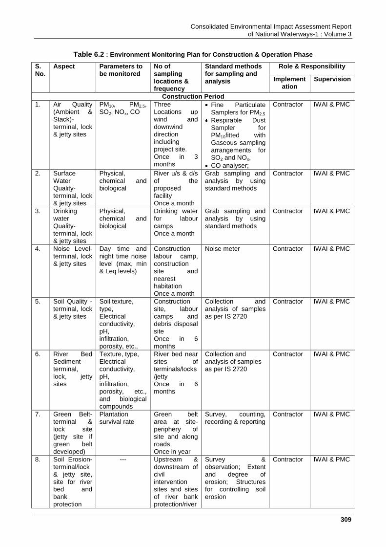
Consolidated Environmental Impact Assessment Report of National Waterways-1 : Volume 3
309
Table 6.2 : Environment Monitoring Plan for Construction & Operation Phase
S. No.
Aspect Parameters to be monitored
No of sampling locations & frequency
Standard methods for sampling and analysis
Role & Responsibility
Implementation
Supervision
Construction Period
1. Air Quality (Ambient & Stack)- terminal, lock & jetty sites
PM10, PM2.5, SO2, NOx, CO
Three Locations up wind and downwind direction including project site. Once in 3 months
Fine Particulate Samplers for PM2.5
Respirable Dust Sampler for PM10fitted with Gaseous sampling arrangements for SO2 and NOx,
CO analyser;
Contractor IWAI & PMC
2. Surface Water Quality- terminal, lock & jetty sites
Physical, chemical and biological
River u/s & d/s of the proposed facility Once a month
Grab sampling and analysis by using standard methods
Contractor IWAI & PMC
3. Drinking water Quality- terminal, lock & jetty sites
Physical, chemical and biological
Drinking water for labour camps Once a month
Grab sampling and analysis by using standard methods
Contractor IWAI & PMC
4. Noise Level- terminal, lock & jetty sites
Day time and night time noise level (max, min & Leq levels)
Construction labour camp, construction site and nearest habitation Once a month
Noise meter Contractor IWAI & PMC
5. Soil Quality - terminal, lock & jetty sites
Soil texture, type, Electrical conductivity, pH, infiltration, porosity, etc.,
Construction site, labour camps and debris disposal site Once in 6 months
Collection and analysis of samples as per IS 2720
Contractor IWAI & PMC
6. River Bed Sediment- terminal, lock, jetty sites
Texture, type, Electrical conductivity, pH, infiltration, porosity, etc., and biological compounds
River bed near sites of terminals/locks/jetty Once in 6 months
Collection and analysis of samples as per IS 2720
Contractor IWAI & PMC
7. Green Belt-terminal & lock site (jetty site if green belt developed)
Plantation survival rate
Green belt area at site-periphery of site and along roads Once in year
Survey, counting, recording & reporting
Contractor IWAI & PMC
8. Soil Erosion-terminal/lock & jetty site, site for river bed and bank protection
--- Upstream & downstream of civil intervention sites and sites of river bank protection/river
Survey & observation; Extent and degree of erosion; Structures for controlling soil erosion
Contractor IWAI & PMC

Consolidated Environmental Impact Assessment Report of National Waterways-1 : Volume 3
310
S. No.
Aspect Parameters to be monitored
No of sampling locations & frequency
Standard methods for sampling and analysis
Role & Responsibility
Implementation
Supervision
and sites of river training structures development
training works Six monthly
9. Aquatic ecology-terminal/lock & jetty site, site for river bed and bank protection and sites of river training structures development
Phytoplankton, Zooplankton and species diversity index
U/s and d/s of the civil intervention sites and location of river training works/bank protection works Six monthly
Plankton net of diameter of 0.35 m, No.25 mesh size 63 and analysis by using standard methods.
Contractor IWAI & PMC
10. Integrity of embankment- locations of existing & newly constructed embankments along NW-1
--- locations of existing & sites of proposed sites for embankments construction along NW-1
Survey & observation; Extent and degree of erosion; Structures for controlling soil erosion
Contractor IWAI & PMC
Operation Phase
1. Air Quality (Ambient & Stack)- terminal, lock & jetty sites
PM10, PM2.5, SO2, NO2, HC and CO
Three Locations up wind and downwind direction including project site. Once in 6 months
Fine Particulate Samplers for PM2.5
Respirable Dust Sampler for PM10fitted with Gaseous sampling arrangements for SO2 and NOx
CO analyser
NABL accredited Lab to be contracted by IWAI
IWAI
2. Surface Water Quality- terminal, lock & jetty sites
Physical, chemical and biological
River u/s & d/s of the proposed facility Once in quarter
Grab sampling and analysis by using standard methods
NABL accredited Lab to be contracted by IWAI
IWAI
3. Drinking water Quality-terminal, lock & jetty site
Physical, chemical and biological
Drinking water for staff Once a quarter
Grab sampling and analysis by using standard methods
NABL accredited Lab to be contracted by IWAI
IWAI
4. Noise Level- terminal, lock & jetty sites
Day time and night time noise level (max, min & Leq levels)
Two locations: Project site & nearest habitation -Once in quarter
Noise meter NABL accredited Lab to be contracted by IWAI
IWAI
5. Wastewater Management -terminals
Physical, chemical and biological of sewage and
Terminal site, testing of sewage and STP treated
-- NABL accredited Lab to be contracted
IWAI

Consolidated Environmental Impact Assessment Report of National Waterways-1 : Volume 3
311
S. No.
Aspect Parameters to be monitored
No of sampling locations & frequency
Standard methods for sampling and analysis
Role & Responsibility
Implementation
Supervision
STP treated water
water Once in quarter
by IWAI
6. Plantation- terminal & lock site (jetty site if green belt developed)
Plantation survival rate of 70%
Maintenance and survival loss of existing - Once in year
Survey, counting, recording & reporting
IWAI IWAI
7. Soil Erosion-terminal/lock & jetty site, site for river bed and bank protection and sites of river training structures development
--- Upstream & downstream of civil intervention sites and sites of river bank protection/river training works Six monthly
Survey & observation; Extent and degree of erosion; Structures for controlling soil erosion
IWAI IWAI
8. Aquatic ecology-terminal/lock & jetty site, site for river bed and bank protection and sites of river training structures development
Phytoplankton, Zooplankton and species diversity
U/s and d/s of the civil intervention sites and location of river training works/bank protection works Six monthly
Plankton net of diameter of 0.35 m, No.25 mesh size 63 and analysis by using standard methods.
IWAI IWAI
9. River Bed Sediments- terminal, lock, jetty sites
Physio-Chemical Parameters
River bed near sites of terminals/locks/jetty Once in 6 months
Depth Sampler IWAI IWAI
10. Integrity of embankment- locations of existing & newly constructed embankments along NW-1
--- locations of existing & newly constructed embankments along NW-1
Survey & observation; Extent and degree of erosion; Structures for controlling soil erosion
IWAI IWAI
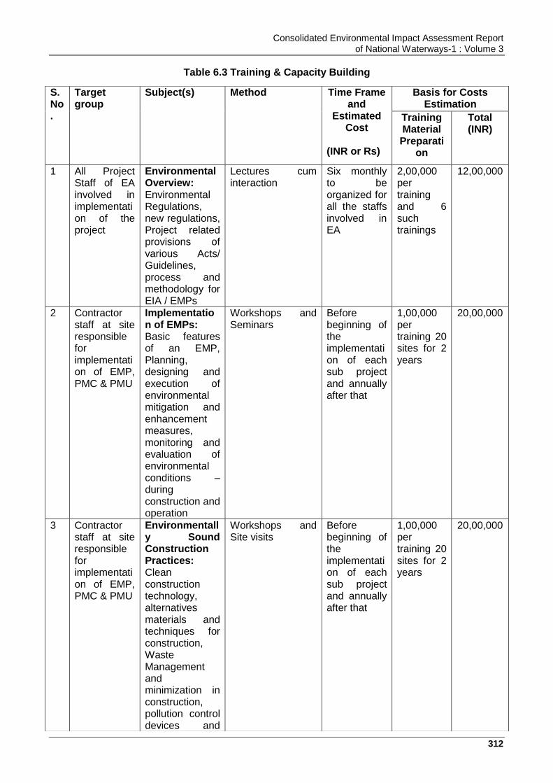
Consolidated Environmental Impact Assessment Report of National Waterways-1 : Volume 3
312
Table 6.3 Training & Capacity Building
S. No.
Target group
Subject(s) Method Time Frame and
Estimated Cost
(INR or Rs)
Basis for Costs Estimation
Training Material Preparati
on
Total (INR)
1 All Project Staff of EA involved in implementation of the project
Environmental Overview: Environmental Regulations, new regulations, Project related provisions of various Acts/ Guidelines, process and methodology for EIA / EMPs
Lectures cum interaction
Six monthly to be organized for all the staffs involved in EA
2,00,000 per training and 6 such trainings
12,00,000
2 Contractor staff at site responsible for implementation of EMP, PMC & PMU
Implementation of EMPs: Basic features of an EMP, Planning, designing and execution of environmental mitigation and enhancement measures, monitoring and evaluation of environmental conditions – during construction and operation
Workshops and Seminars
Before beginning of the implementation of each sub project and annually after that
1,00,000 per training 20 sites for 2 years
20,00,000
3 Contractor staff at site responsible for implementation of EMP, PMC & PMU
Environmentally Sound Construction Practices: Clean construction technology, alternatives materials and techniques for construction, Waste Management and minimization in construction, pollution control devices and
Workshops and Site visits
Before beginning of the implementation of each sub project and annually after that
1,00,000 per training 20 sites for 2 years
20,00,000
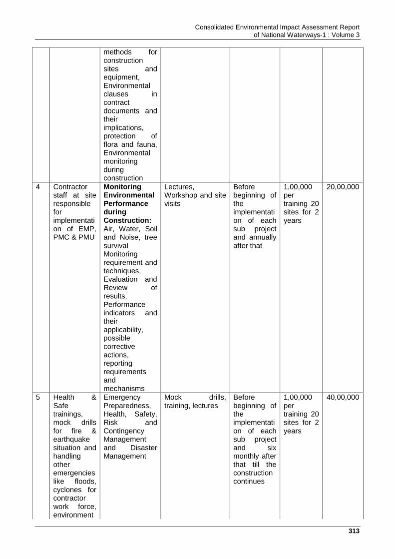
Consolidated Environmental Impact Assessment Report of National Waterways-1 : Volume 3
313
methods for construction sites and equipment, Environmental clauses in contract documents and their implications, protection of flora and fauna, Environmental monitoring during construction
4 Contractor staff at site responsible for implementation of EMP, PMC & PMU
Monitoring Environmental Performance during Construction: Air, Water, Soil and Noise, tree survival Monitoring requirement and techniques, Evaluation and Review of results, Performance indicators and their applicability, possible corrective actions, reporting requirements and mechanisms
Lectures, Workshop and site visits
Before beginning of the implementation of each sub project and annually after that
1,00,000 per training 20 sites for 2 years
20,00,000
5 Health & Safe trainings, mock drills for fire & earthquake situation and handling other emergencies like floods, cyclones for contractor work force, environment
Emergency Preparedness, Health, Safety, Risk and Contingency Management and Disaster Management
Mock drills, training, lectures
Before beginning of the implementation of each sub project and six monthly after that till the construction continues
1,00,000 per training 20 sites for 2 years
40,00,000
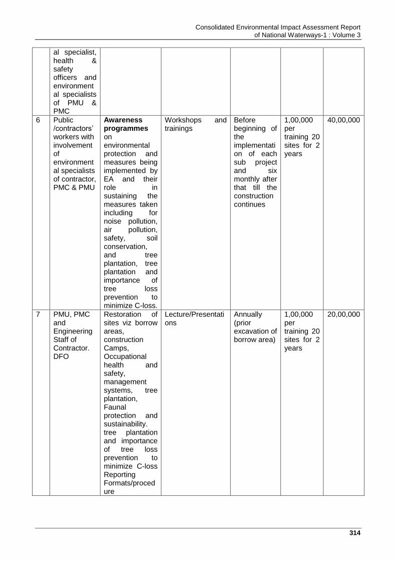
Consolidated Environmental Impact Assessment Report of National Waterways-1 : Volume 3
314
al specialist, health & safety officers and environmental specialists of PMU & PMC
6 Public /contractors‟ workers with involvement of environmental specialists of contractor, PMC & PMU
Awareness programmes on environmental protection and measures being implemented by EA and their role in sustaining the measures taken including for noise pollution, air pollution, safety, soil conservation, and tree plantation, tree plantation and importance of tree loss prevention to minimize C-loss.
Workshops and trainings
Before beginning of the implementation of each sub project and six monthly after that till the construction continues
1,00,000 per training 20 sites for 2 years
40,00,000
7 PMU, PMC and Engineering Staff of Contractor. DFO
Restoration of sites viz borrow areas, construction Camps, Occupational health and safety, management systems, tree plantation, Faunal protection and sustainability. tree plantation and importance of tree loss prevention to minimize C-loss Reporting Formats/procedure
Lecture/Presentations
Annually (prior excavation of borrow area)
1,00,000 per training 20 sites for 2 years
20,00,000
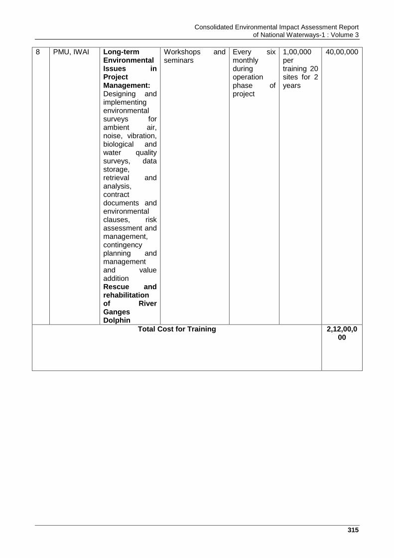
Consolidated Environmental Impact Assessment Report of National Waterways-1 : Volume 3
315
8 PMU, IWAI Long-term Environmental Issues in Project Management: Designing and implementing environmental surveys for ambient air, noise, vibration, biological and water quality surveys, data storage, retrieval and analysis, contract documents and environmental clauses, risk assessment and management, contingency planning and management and value addition Rescue and rehabilitation of River Ganges Dolphin
Workshops and seminars
Every six monthly during operation phase of project
1,00,000 per training 20 sites for 2 years
40,00,000
Total Cost for Training 2,12,00,000
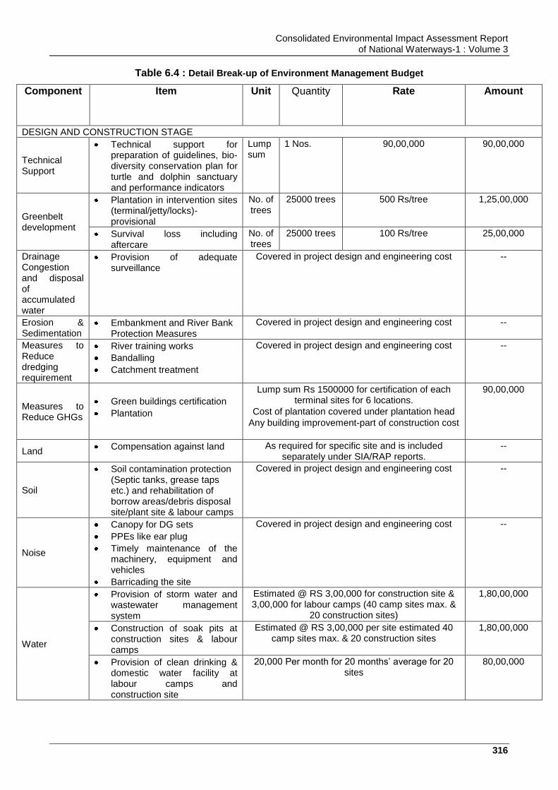
Consolidated Environmental Impact Assessment Report of National Waterways-1 : Volume 3
316
Table 6.4 : Detail Break-up of Environment Management Budget
Component Item Unit Quantity Rate
Amount
DESIGN AND CONSTRUCTION STAGE
Technical Support
Technical support for preparation of guidelines, bio-diversity conservation plan for turtle and dolphin sanctuary and performance indicators
Lump sum
1 Nos. 90,00,000 90,00,000
Greenbelt development
Plantation in intervention sites (terminal/jetty/locks)-provisional
No. of trees
25000 trees 500 Rs/tree 1,25,00,000
Survival loss including aftercare
No. of trees
25000 trees 100 Rs/tree 25,00,000
Drainage Congestion and disposal of accumulated water
Provision of adequate surveillance
Covered in project design and engineering cost --
Erosion & Sedimentation
Embankment and River Bank Protection Measures
Covered in project design and engineering cost --
Measures to Reduce dredging requirement
River training works
Bandalling
Catchment treatment
Covered in project design and engineering cost --
Measures to Reduce GHGs
Green buildings certification
Plantation
Lump sum Rs 1500000 for certification of each terminal sites for 6 locations.
Cost of plantation covered under plantation head
Any building improvement-part of construction cost
90,00,000
Land Compensation against land As required for specific site and is included
separately under SIA/RAP reports. --
Soil
Soil contamination protection (Septic tanks, grease taps etc.) and rehabilitation of borrow areas/debris disposal site/plant site & labour camps
Covered in project design and engineering cost --
Noise
Canopy for DG sets
PPEs like ear plug
Timely maintenance of the machinery, equipment and vehicles
Barricading the site
Covered in project design and engineering cost --
Water
Provision of storm water and wastewater management system
Estimated @ RS 3,00,000 for construction site & 3,00,000 for labour camps (40 camp sites max. &
20 construction sites)
1,80,00,000
Construction of soak pits at construction sites & labour camps
Estimated @ RS 3,00,000 per site estimated 40 camp sites max. & 20 construction sites
1,80,00,000
Provision of clean drinking & domestic water facility at labour camps and construction site
20,000 Per month for 20 months‟ average for 20 sites
80,00,000

Consolidated Environmental Impact Assessment Report of National Waterways-1 : Volume 3
317
STP construction, Zero Discharge management (collection of storm water and its distillation and use, and rain water harvesting
Including I project design and engineering costs -
Air Quality -Dust Management during construction
Water Sprayer / Watering for Dust suppression
Covered in project design and engineering cost --
Green belt development, dust control system, mechanized material handling systems for material loading and unloading at terminal and vessel.
Covered in project design and engineering cost
Safety Appointment of Safety Officers
Covered in project design and engineering cost --
Safety signage, fire-fighting measures& water ambulance etc.
Covered in project design and engineering and cost
--
Provision of trainings and PPE to workers
-- 1,72,00,000
Health Health check-up camps for construction workers
Camp
s
2 camp
/year/site-20
sites for 2
years of
construction
period
4 lakhs/camp 3,20,00,000
Enhancement Measures
Institutional Support for Vikramshila Wild Life Sanctuary through reputed institutions
No 1 Lump sum 1,00,00,000
Support for Fish Nurseries Development for enhancing Fish productivity, and training of fishermen from CIFRI or similar institute of repute
No 1 Lump sum
(@ Rs 1,50,00,000 per
year for three years)
4,50,00,000
Bath shelter for women along NW-1 for maintaining privacy from vessel movement
No 305 shelter On average one shelter
per village @ Rs 2,00,000
per shelter
6,10,00,000
Support for cleanliness at Ghats and improvement of Ghats such as for Durga Chak Emersion Ghat
No 1 Lump sum 1,00,00,000
Environmental Monitoring in the construction phase
Terrestrial and Aquatic Fauna 3,00,000 per season per site (Once in six month)
20 sites for 2 years
2,40,00,000
Ambient Air Quality 50,000 per monitoring per site (Once in three
month)
20 sites for 2 years
80,00,000
Surface Water Quality 24,000 for upstream & downstream (Once in
month)
20 sites for 2 years
1,15,20,000
Drinking Water Quality 12,000 (Once in month)
20 sites for 2 years
57,60,000
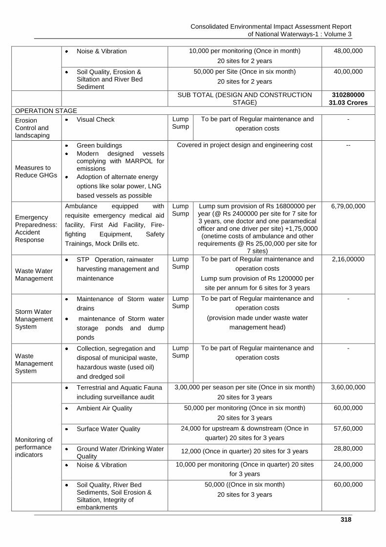
Consolidated Environmental Impact Assessment Report of National Waterways-1 : Volume 3
318
Noise & Vibration 10,000 per monitoring (Once in month)
20 sites for 2 years
48,00,000
Soil Quality, Erosion & Siltation and River Bed Sediment
50,000 per Site (Once in six month)
20 sites for 2 years
40,00,000
SUB TOTAL (DESIGN AND CONSTRUCTION STAGE)
310280000
31.03 Crores
OPERATION STAGE
Erosion Control and landscaping
Visual Check Lump Sump
To be part of Regular maintenance and
operation costs
-
Measures to Reduce GHGs
Green buildings
Modern designed vessels complying with MARPOL for emissions
Adoption of alternate energy
options like solar power, LNG
based vessels as possible
Covered in project design and engineering cost --
Emergency Preparedness: Accident Response
Ambulance equipped with
requisite emergency medical aid
facility, First Aid Facility, Fire-
fighting Equipment, Safety
Trainings, Mock Drills etc.
Lump Sump
Lump sum provision of Rs 16800000 per year (@ Rs 2400000 per site for 7 site for 3 years, one doctor and one paramedical officer and one driver per site) +1,75,0000
(onetime costs of ambulance and other requirements @ Rs 25,00,000 per site for
7 sites)
6,79,00,000
Waste Water Management
STP Operation, rainwater
harvesting management and
maintenance
Lump Sump
To be part of Regular maintenance and
operation costs
Lump sum provision of Rs 1200000 per
site per annum for 6 sites for 3 years
2,16,00000
Storm Water Management System
Maintenance of Storm water
drains
maintenance of Storm water
storage ponds and dump
ponds
Lump Sump
To be part of Regular maintenance and
operation costs
(provision made under waste water
management head)
-
Waste Management System
Collection, segregation and
disposal of municipal waste,
hazardous waste (used oil)
and dredged soil
Lump Sump
To be part of Regular maintenance and
operation costs
-
Monitoring of performance indicators
Terrestrial and Aquatic Fauna
including surveillance audit
3,00,000 per season per site (Once in six month)
20 sites for 3 years
3,60,00,000
Ambient Air Quality 50,000 per monitoring (Once in six month)
20 sites for 3 years
60,00,000
Surface Water Quality 24,000 for upstream & downstream (Once in
quarter) 20 sites for 3 years
57,60,000
Ground Water /Drinking Water Quality
12,000 (Once in quarter) 20 sites for 3 years 28,80,000
Noise & Vibration 10,000 per monitoring (Once in quarter) 20 sites
for 3 years
24,00,000
Soil Quality, River Bed Sediments, Soil Erosion & Siltation, Integrity of embankments
50,000 ((Once in six month)
20 sites for 3 years
60,00,000

Consolidated Environmental Impact Assessment Report of National Waterways-1 : Volume 3
319
SUB TOTAL (OPERATION PHASE) 1,48,540,000(14.85 Cr)
TRAINING and AWARENESS
Training Environmental training & awareness
- - Included in overall NW-1 Project Budget
40,00,000
ESTABLISHMENT AND SYSTEMS
Establishment Supervision Consultant (environment and Social)
- - Included in overall NW-1 Project Budget
-
Construction Stage (Site Environmental officer)
- Included in overall NW-1 Project Budget
-
Operation Stage - - Included in overall NW-1 Project Budget
-
Management Systems
Adoption of EHS management systems
1 1 Lump sum 50,00,000
Management Information and tracking system
1 1 Lump sum 75,00,000
SUBTOTAL (ESTABLISHMENT & TRAINING and MANAGEMENT SYSTEM) 1,65,00,000
SUB TOTAL (Construction, and Operation and mobilization) 450258000
45.025 Cr
CONTINGENCIES @ 5 % on total Environmental Costs 2,37,66,000
Or say 2.38 Cr
GRAND TOTAL (in Rs) 499086000
Or say 49.91 Cr
Or say US$7.34 Mn
(1US$ - INR 68)
Table 6.5 : Environmental Budget of Planned Civil Interventions
Civil Intervention Amount (Rs in INR)-Crores
Varanasi Terminal 0.10029
Farakka Lock 1.37466
Haldia Terminal 1.20246
Sahibganj Terminal 1.64136
Consolidated Environmental Impact Assessment Report of National Waterways-1 : Volume 3
320
Chapter 7. SUMMARY, CONCLUSIONAND RECOMMENDATIONS
7.1. Summary and Conclusions
Jal Marg Vikas Project involves navigation capacity augmentation of the NW-1 so as to
ensure the navigation through IWT mode throughout the year in entire NW-1. NW-1 is
natural waterway, extends from Haldia (Sagar) to Allahabad and spans 1620 km crossing
the states of Bihar, Jharkhand, Uttar Pradesh & West Bengal. Project area includes entire
reach NW-1 (Haldia to Allahabad) including the areas proposed for development of project
related facilities & infrastructure, i.e. terminal sites, lock site, Ro-Ro jetty sites and sites for
other planned development. NW-1 stretch traverses through various major cities and towns
which are well connected by roads and railways. Developments proposed under Jal Marg
Vikas project includes maintenance of LAD in navigation channel (3 m from Haldia to Barh,
2.5 m from Barh to Ghazipur and 2.2 m from Ghazipur to Varanasi), development of
navigation infrastructure such as navigation aids, terminals (6 nos.), ro-ro crossings (5
nos.)/locks (1 no.), procurement of barges/dredgers and other necessary equipment,
development and implementation of river information system, treatment of navigational
hazards and carrying out bank protection and river training works at required locations.
Studies were carried out by survey consultant, existing cargo movement across the stretch
of NW-1 through road & rail is 121426130 tonnes. Forecasted cargo studies are carried out
by the survey consultant and cargo generation potential across NW-1 (Haldia to Varanasi)
by year 2045 is expected to be 4,80,11,367 tonnes. The project being of large spatial extent,
is planned to be developed in phases. At present planning has been carried out at 3 terminal
sites, i.e. at Sahibganj, Varanasi and Haldia. Sahibganj, Varanasi and Haldia terminal are
designed to handle the cargo of 2.24 MTPA, 0.54 MTPA and 3.18 MTPA respectively for
phase I depending on available infrastructure. Navigation channel of 45 m width is planned
to be maintained from Haldia to Varanasi stretch through dredging between Haldia and
Varanasi. No dredging beyond Varanasi is planned to be undertaken at present. Dredging
quantity of app. 14.85 million cum is estimated to be undertaken between Haldia and
Varanasi to ensure year round navigation. This also includes the dredging quantity to be
undertaken at the terminal sites. Major dredging requirement is anticipated at Haldia terminal
only. For purpose of dredging, 12 nos. of dredgers are estimated to be required. CSD along
with agitation dredgers and backhoe dredgers are proposed to be used for carrying out
dredging. Dredged material will majorly be disposed within the river and will be taken to land
for disposal, if found to be contaminated.
Baseline study has been carried out in the project area to study the existing conditions of
environmental and social parameters at site. The whole NW-1 (Allahabad to Haldia) falls
within a relatively flat terrain of the Indogangetic plain. The elevation within the 10 km area of
the NW-1 stretch ranges between 321 m to 1 m. highest elevation was observed at
Sahibganj area (Jharkhand) that is because of small hills present in this area. Land use
within the 10 km Radius of the NW-1 is majorly dominated by agricultural land. The
predominant wind direction in all IMD stations located along NW-1 is from North and
Northwest direction in winters and South and Southeast direction during rest of the season.
The wind speed in the area was mostly ranges between 1.9 km/hour at Patna IMD and
maximum of 8.7 km/hour at Kolkata IMD for all the months of a year. December and January
constitutes winter months with daily mean minimum temperature of around 9.10C at Patna
(IMD Station) and daily mean maximum temperature of around 26.90C at Kolkata. April and
May are the hottest months with daily mean maximum temperature varying around 40.40C at
Consolidated Environmental Impact Assessment Report of National Waterways-1 : Volume 3
321
Varanasi and daily mean minimum temperature around 240C at Malda. Relative humidity
ranges between 25-84%. The annual total rainfall in all IMD stations (representing respective
city/towns) ranges between 1000.3 mm at Varanasi and 1728.5 mm at Kolkata.
PM10 values in all locations are within the specified limit of 100 g/m3 except at Varanasi,
Patna and Howrah location. All value of PM2.5 is within the specified limit of 60 g/m3 except
Varanasi, Patna and Howrah locations. The observed SO2 and NOx level was found within
the national Ambient Air Quality Standard. Carbon Mono-oxides was detected in few
locations i.e. Haldia, Howrah, Patna and Varanasi and is found within the national Ambient
Air Quality Standard. Ambient noise levels of the entire NW-1 stretch are within the
prescribed National Ambient Noise Quality Standard for respective residential and
commercial category at all the monitored locations. The Physico-chemical characteristics of
the ground water samples collected for study purpose were in good agreement with
IS:10500 permissible limits except TDS & total hardness values at Haldia, Sahibganj,
Howrah & Kolkata. As is found to be present in ground water of Bhagalpur & Munger but in
low concentration. As per surface water quality monitoring, river water quality observations
reflect that water quality meets with BDU Class D Criteria of CPCB barring few parameters
PH, DO which meets A class criteria. Metallic and pesticide level is within prescribed limit of
Drinking water standard. Most of the NW-1 stretch is dominated by alluvial soil type. The
texture of soil along NW-1 stretch is sandy clay and clay loam type. The analysis reflected
that the soils are generally neutral to slightly alkaline nature. Overall soil along the NW-1
area is of moderately fertile. The concentration level of heavy metal in river bed sediments
was found low in concentration and within acceptable limit as per standard (Criteria for Off-
Shore Dumping of Dredged Material, USA) except cadmium which is slightly above the USA
standard at some location in UP stretch that may be due to industrial effluent discharge in
this section. Pesticide concentration in all sample were found far below the USA criteria. The
pesticides presence is on expected line as these are predominantly used for various
agriculture applications. There are three notified wild life sanctuaries (Kashi Turtle
Sanctuary, Varanasi, UP, Dolphin Sanctuary, Bihar and Hilsa Sanctuary, WB located within
the NW-1 stretch. There are 6 nos. of important bird areas including Udhwa bird sanctuary,
located within 10 km area of the NW-1 stretch. Gangetic dolphin (Schedule-1) and fresh
water turtle species are present in the river stretch of the NW-1.
On the basis of the baseline data and associated project activities, impacts of the project
activities on social and environmental parameters were analysed. It is predicted that project
will have impact on air, water, noise, soil, drainage, hydrology and ecology and socio-
economy of the area. However, mitigation measures and management plans are proposed
for mitigating the anticipated negative impacts of the project.
Environment management plans are prepared to prevent/control/abatement of pollution
resulting from project activities in different stages. Environment management plan defines
the institutional framework responsible for implementation of EMP, environment monitoring
plan and environment management budget.
As per the EIA study, it is concluded that the development of project “Jal Marg Vikas” is
beneficial for the economic development of country by increasing the freight transportation
and is beneficial for environment by shifting freight load from road/railway to waterways and
cutting down carbon emission. However, project development will have many impacts on
social and environmental parameters. Mitigation measures and management plans are
prepared in line with impacts anticipated. If the proposed mitigation measures are taken and

Consolidated Environmental Impact Assessment Report of National Waterways-1 : Volume 3
322
environment management plan is implemented, anticipated negative impacts of project can
be reduced and benefits can be further enhanced. The project will overall bring development
in the area.
Recommendations:
It is recommended that IWAI should provide desired resources for implementation of EMPs
and ensure that EMPS are effectively implemented. It must institutionalize the system of
period monitoring against the defined performance indicators and establish the system of
half yearly reporting. It should also develop its own EHS guidelines and protocols for
managing all the projects uniformly from environment health and safety prospective. System
should be self-responding in nature for initiating timely corrective and preventive action if any
required for the protection of environment.
Adequate training shall be imparted as proposed under environmental management plan to
enhance the capability of concerned EA officials. Awareness programme for contractor and
workers shall also be organised for effective implementation of EMP.
IWAI should adopt the measures for reduction of dredging. Dredging management plan
including compliance to defined restriction for dredging and disposal of dredged material
close to cultural and aquatic sensitive locations shall be followed.
It should adopt the concept of green building and energy efficient terminals. The GRIHA
guidelines shall be adopted for terminal design. All terminals shall be designed with zero
waste discharge concept to prevent pollution to river Ganga. Similarly, all barges shall have
integration of zero pollution concept. All consequent waste from the vessels shall be
managed at terminals and barge maintenance facilities. All possible measures shall be
adopted for GHG emission reduction including exploring the feasibility of fuel switch to LNG
operated vessels.
It should take all measures for conservation of aquatic sanctuaries including reduction of
impact on aquatic fauna. All possible efforts shall be made to minimize the impact
considering the findings of CIA, Critical Resource Basin Study, Consolidated EIA Study and
proposed conservation studies. IWAI should facilitate development of conservation plan for
Dolphin, Turtle and sensitive species in NW-1 with the help of reputed institutions.
IWAI should develop all facilities for handling emergencies as part of emergency response
plan.IWAI shall develop Indian Waterways Operations Responsible Carrier Programme on
the line of American Waterways Operators Responsible Carrier Programme for accident and
pollution free waterways operations
The EIA was carried out while the feasibility study was being prepared and initial finding of
DPR preparation stage. Therefore, the detailed engineering design was not available. In this
regard, any major changes during detailed design, or any major additional work other than
the proposed project activities will require updating this environmental assessment. Also it
may have to be sent to World Bank for concurrence before works commence.