Official PDF , 180 pages
180
E833 V. 2 November 2003 ROAD AGENCY FORMATION UNIT MINISTRY OF WORKS, HOUSING AND COMMUNICATION KAMPALA-GAYAZA-BUGEMA-ZIROBWE-WOBULENZI ROAD PACKAGE 1: UPGRADING AND STRENGTHENING OF THE KAMAPALA-GAYAZA-ZUIOBWE ROAD PACKAGE II: UPGRADING TO PAVED (BITUMEN) STANDARD OF THE ZIROBWE-WOBULENZI ROAD PHASE II: DETAILED ENGINEERING DESIGN FINAL REPORT wT .1 VOLUME B.1.2/1 ENVIRONMENTAL IMPACT ASSESSMENT Preared by PHOENIX ENCINEERING & RESEARCH LTD P 0 Box 28442 Plot 7, Sunmit View Road, Naguru - Kmnpala Novefber. 2003 Public Disclosure Authorized Public Disclosure Authorized Public Disclosure Authorized Public Disclosure Authorized Public Disclosure Authorized Public Disclosure Authorized Public Disclosure Authorized Public Disclosure Authorized
Transcript of Official PDF , 180 pages
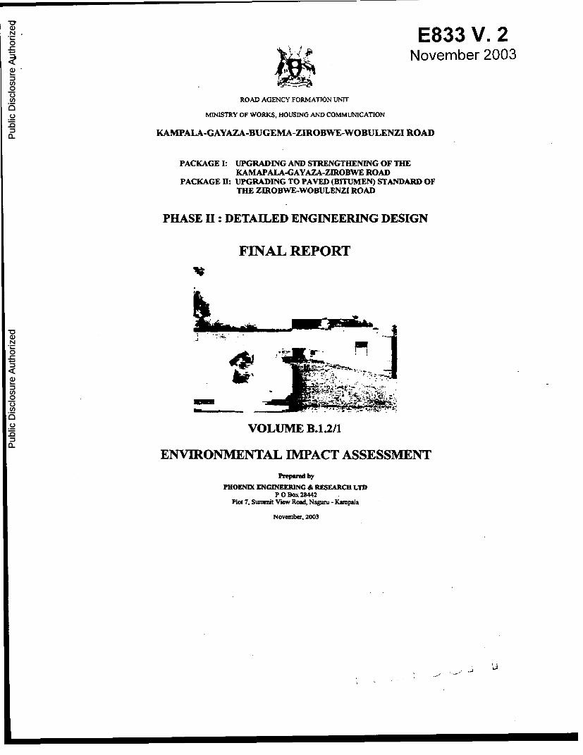
E833 V. 2November 2003
ROAD AGENCY FORMATION UNIT
MINISTRY OF WORKS, HOUSING AND COMMUNICATION
KAMPALA-GAYAZA-BUGEMA-ZIROBWE-WOBULENZI ROAD
PACKAGE 1: UPGRADING AND STRENGTHENING OF THEKAMAPALA-GAYAZA-ZUIOBWE ROAD
PACKAGE II: UPGRADING TO PAVED (BITUMEN) STANDARD OFTHE ZIROBWE-WOBULENZI ROAD
PHASE II: DETAILED ENGINEERING DESIGN
FINAL REPORT
wT.1
VOLUME B.1.2/1
ENVIRONMENTAL IMPACT ASSESSMENT
Preared by
PHOENIX ENCINEERING & RESEARCH LTDP 0 Box 28442
Plot 7, Sunmit View Road, Naguru -Kmnpala
Novefber. 2003
Pub
lic D
iscl
osur
e A
utho
rized
Pub
lic D
iscl
osur
e A
utho
rized
Pub
lic D
iscl
osur
e A
utho
rized
Pub
lic D
iscl
osur
e A
utho
rized
Pub
lic D
iscl
osur
e A
utho
rized
Pub
lic D
iscl
osur
e A
utho
rized
Pub
lic D
iscl
osur
e A
utho
rized
Pub
lic D
iscl
osur
e A
utho
rized

I
Kamoala-Gayaza-Zirobwc-Wobulenzi Road EIA
ENVIRONMENTAL IMPACT ASSESSMENT
TABLE OF CONTENTS
EXECUTIVE SUMMARY v
1 INTRODUCTION ........... ...... ._ I1.1 The Project ..... . ... ............... ... ........ .. .
1.2 Scope Of Work For Feasibility Study (Terms Of Reference) ..... 1
1.3 Feasibility Study Final Report..... . _ .
1.4 Work Carried Out ............................. .
2 PROJECT DESCRIPTION._..................... ___ ~.__._. .......... __.__._.__ ....... _ 5
2.1 The Project Works ..... . ... . .......... .5
2.1.1 Alignment Option A - Existing Alignment . . 62.1.2 Alignment Option B - Optimised Alignient . . 62.1.3 Alignment Option C - Deviations . . 7
2.2 Scope of the Study...._......_ ... _ 8
2.3 Previous Reports . ______ .... .____.. ....... _. . .. .
3 INSTITUTIONAL AND LEGAL FRA^MEWORK OFENVIRONMENTAL
3.1 Overview _. ....... ...... 9
3.2 Institutional Framework-..............._ 103.2.1 National Environment Management Authority (NEMA) . 03.2.2 Environmental Liaison Unit (ELU) .103.2.3 The Uganda Land Commission .03.2.4 Non Government Organisations (NGO) .II
3.3 Environmental and Social Assessment Regulations1 ..... _.._..__...._ 1l3.3.1 Enviromnental regulations . I3.3.2 Social Laws and Regulations .11
4 ENVIRONMENTAL SETT7NG: BASELINE CONDITIONS 1..124.1 Location ........ ______ .... _._ _._ .... _ ___..12
4.2 The Biophysical Environment ... 124.2.1 Topography . .124.2.2 Climate . .124.2.3 Geology and Soils . .134.2.4 Water . .134.2.5 Air Quality . .13
eIA Final Reporl/28-11-03 Phoenix
Kamoala-Garaza.Zirobwe-Wobuienzi Road EILA
4.2-6 Vegetation .......................... 164.2.7 Fauna. ................................ 17
4.3 The Human Environment ............ . 174.3.2 Population .. 174.3.2 Demographic Structure . .184.3.3 Population Density .. 184.3.4 Urban and Rural Population . .184.3.5 Social Organisation .. 184.3.6 Ethnic Groups.114.3.7 Land Tenure .194.3.8 Economic Activities and Standards of Living . . 204.3.9 Agriculture .. 214.3.10 Animal Resources . .21
4.4 Cultural Heritage in the Project Area ...... ............. ............ 22
4.5 Administrative A. .... 224.6 Public Services .................. 23
4.6.1 Fuel Supply .. 234.6.2 Water Supply . .234.6.3 Public Health .. 234.6.4 HIV/AIDS Control . .244.6.5 Schools . .244.6.6 Lack of Ancillary Road Facilities . .24
4.7 The Existing Kampala-Gayaza-Zirobwe-Wobulenzi Road_.264.8 Settlement Pattern Along the Road ...... .... _ .. _ . _31
5 PROJECTALTERNA T7VES AND ROAD STRUCTURE REQUIREMENT._... 335.1 Road Reserve Area (RRA) and Resettlement Approach....__.. ..335.2 The Project Road: Realignment Opffons............................
6 ENVIRONMENTAL IMPACTS AND MITIGATION..__.. ........ _.396.1 General ............ ... ._ .. .. ... .....
6.2 Impact Evaluation Approach . . ...... . ... 396.3 Environmental Impacts of the Existing Road ............................. 416.3.1 Health Effects Of Present Road Use.41
6.3.2 Current Traffic Accidents .. 416.4 Planned Road Works ............. . .. . 436.5 Traffic Growth Forecasts...-. ......................._._.. .. 43
6.5.1 Impacts Of Road Works and Future Road Use .446.5.2 Short-termn Negative Impacts of Road Works.446.5.3 Short-term positive impacts of road works .446.5.4 Long-Term Negative Impacts Of Road Works .446.5.5 Long-Tersn Positive Impacts Of Road Works .446.5.6 Direct Impacts Of Future Road Use .456.5.7 Negative Impacts:.46.5.8 Positive, Indirect Impacts Of Future Road Use .456.5.9 Impacts and Mitigation Measures 45
EIA Final RepoV28. 11-03 ii Phoenix
Kampala-Gayaza-Zirobwe-Wobulenzi Road ELA
6.5.10 Biophysical Environment .......... ............................... 466.5.11 Human Environrent ......................................... 49
7 ENVIRONMENT MANAGEMENTPLAN ............................... 59
7.1 Context of the Plan ................................. 59
7.2 Environment Management Plan : Phase I Project Execution ......... 597.2.1 Final formulation of the environmental packages . .597.2.2 Environmental and Social mitigation at the Implementation Stage: .... 617.2.3 Monitoring and Responsibility: EMP Phase I . .61
7.3 Environment Management Plan Phase 1 Budget . ... 62
7.4 Environment Management Plan: Phase 2 After Opening Road Upgrade637.4.1 Taffic Management ................................... 637.4.2 Construction of Ancillary Infatructures ................................... 647.4.3 Ecosystem Protection in the Road Influence Zone ................................ 647.4.4 Advised Benefit Enhancement Measures ................................... 647.4.5 Phasing of the Environment Management Plan ................................... 65
8 DISPLACEMENTAND INVOLUNTARYSETTLEMENT ........ .. 67
8.1 Main Characteristics of Settlements along the Project Road.___..... 678.1.1 Expected impacts .678.1.2 Impact on land and cropped area .678.1.3 Impact on constructions .68
8.2 Recommended Mitigation Measures.___ . . .......8.2.1 Community participation . . 71
9 RESETTLEMENT IMPACTASSESSMENT . ...... 72
9.1 Objective of the Resettlement Impact Assessment ........... 729.1.1 The Project Impact in respect to resettlement: ................................. 729.1.3 Cutting of economic valuable trees .............. ................... 739.1.4 Loss of agricultural production . ................................ 739.1.5 Displacement of stalls and demolition of Houses . ......................... 739.1.6 Institutions and Organizations ............ .. ................... 739.1.7 Public Utilities and Infrastructure . ................................ 749.1.8 Land Acquisition .. ............................... 74
9.2 Infrastructure and Social Improvement ...... . . ..
9.3 Consultation and participation of the population in the resettlementActivities ........ ................... 74
9.4 Institutional Arrangement _.9.4.1 Sites Affected by the Project ........... ............................. 759.4.2 Entitlement Framework ........................................ 759.4.3 Institutional Framework & Involvement of Local leaders ....................... 769.4.4 Implementation strategies of the plan ..................... ................... 779.4.5 Payment for the lost property and Transparency ..................................... 819.4.6 Monitoring and Mitigation Measures .................... .................... 83
9.5 Reporting Arrangemen ... ......... . .
9.6 Resettlement Implementation and Evaluation ...... .......... .................... 85
EIA Final Rpofl2811-03 iii Phoenix

Kamoaia-Gavaza-Zirobwe-Wobuienzi Road EIA
10 TOTAL COSTS . .. .... ............... _ _ 8610.1 CostofEnvironmentManagementPlan: Phase .... 8610.2 Resettlement Costs ......... 8810.3 Total Cost of the Environment Management Plan and Resettlement .... 90
11 CONCLUSIONAND RECOMMENDATIONS ........-. .............. 9311.1 Conclusion ....... . .. ......... . 9311.2 Recommendations . . . .............. . 93
APPENDIX A: REPORT ON PUBLIC CONSULTATION ACTIVITY
APPENDIX B: REPORT ON RESETTLEMENT CONSULTATION
APPENDIX C: STATISTICAL ABSTRACTS
APPENDIX D: BIBLIOGRAPHY
EIA Firal ReporV28-11-03 iv Phoenix
Kamnala-Gavaza-Zirobwe-Wobulenzi Road EIA
EXECUTIVE SUMMARY
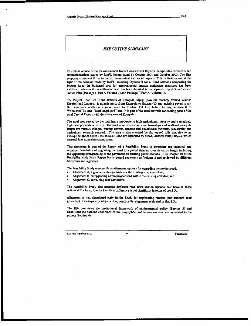
This Final version of the Environmental Impact Assessment Reports incorporates comments andrecommendations issued by RAFU letters dated 11 October 2001 and October 2003. The EIAproposes alignment B on technical, economical and social aspects. This is furthermore at thelight of the decision madc by RAFU selecting Options B for all road sections composing theProject Road the budgeted cost for environmental impact mitigation measures has beenvalidated, whereas the.resettlemcnt cost has been detailed in the separate report ResettlementAction Plan (Packagc I, Part A Volumc I) and Package 11 Part A, Volume 1).
The Project Road lies in the districts of Kampala, Mpigi (now the recently forned WakisoDistrict) and Luwero. It extends north from Kampala to Gayaza (13 km, existing paved road),then continucs north on a gravel road to Zirobwe (31 km) before turning north-west toWobulenzi (23 kIn). Total length is 67 km. It is part of the road network connecting parts of therural Central Region with the urban area of Kampala.
The rural area served by the road has a moderate to high agricultural intensity and a relativelyhigh niral population density. The road connects several rural townships and scattered along itslength are various villages, trading centres, schools and educational institutes (University andagricultural research centres). The area is characterised by flat-topped hills that rise to anaverage height of about 1250 m (asl.) and are separated by broad, uniform valley slopes, whichdescend into extensive swamp areas.
This document is part of the Report of a Feasibility Study to determine the technical andeconomic feasibility of upgrading the road to a paved standard over its entire length includingthe upgrading/strengthening of the pavement on existing paved sections. It is Chapter 10 of theFeasibility study Main Report but is bound separately as Volume 2 and reviewed by differentMinistries and Agencies.
The Feasibility Study assesses three alignment options for upgrading the project road.* Alignment A, a geometric design laid over the existing road centreline;* Alignment B, an upgrading of the project road within the existing corridor, and* Alignment C, containing four deviations.
The Feasibility Study also assesses different road cross-section options, but because theseoptions differ by up to only I m, their difference is not significant in terms of the EIA.
Alignment A was abandoned early in the Study for engineering reasons (sub-standard roadgeometry). Consequently Alignment option B is the alignment evaluated in this EIA.
The EIA overviews the institutional framework of environmental policy (Section 3) andestablishes the baseline conditions of the biophysical and human environment as related to theproject (Section 4).
EIA Final Rewoni25-l 1-03 v Phoenix
Kampala-Gavaza-Zirobwe-Wobulcnzi Road EIA
Public consultation has been carried out at two levels. Firstly public consultation wasundertaken with stakeholders along the project corridor. The participants in the consultationprocess had a strong conviction that paving the road will have a positive and profound impact ontheir lives and livelihood, and they were genuinely grateful for this "overdue" development.Negative impacts, like road safety, were cited. (Refer Appendix A).
The second level of consultation was with representatives of affected people. (Refer AppendixB). People were in favour of the project from a development viewpoint, but sought fair andreasonable compensation, being replacement cost. Time for people to construct new homes wascommonly cited. The feedback from this consultation process has been taken account of indetermining the Resettlement Action Plan and RAP budget. (Sections 8 and 9).
On the basis of compensation rates determined by the Chief Government Valuer, the RAPbudget is Ush 638,155,641=(Package I USh 428,229,500= package II Ush 209,826,141=) forAlignment B.
The EIA identifies the following categories of impacts:
Biophysical Environment* Erosion from new excavations and other works* Water and soil pollution* Air pollution and dust during and post construction* Noise and vibration during and post construction* Landscape deterioration by earthworks* Surface and groundwater drainage obstruction and pollution* Soil erosion and sedimentation
Human Environment* Loss of farmland and habitat* Construction safety risks* Health hazards during road construction* Employment generated by the project* Benefits for local SME* Water-borne diseases.* Displacement and Involuntary Resettlement* Expansion of feeder road network* Hazards for livestock* Activation of transmission corridors for diseases, pests and weeds* Road safety hazards* Demographic pressure and unsustainable land use* Community and environmental services* Economic benefits
The positive and negative effects of these impacts are assessed in relation to the constructionphase and the post-construction phase since the control and mitigation of the two phases areundertaken by different agencies. The construction phase includes all impacts resulting fromthe construction of the road and the activities of road construction itself. These will largely beunder the control of the Contractor under the supervision of RAFU Environmental Unit who, inclose collaboration with MOWHC, will have responsibility for monitoring and control. Thepost-construction impacts are the more indirect impacts resulting from the changes in theenvironment due to the road upgrading.
EIA Final Report/28-11-03 vi Phoenix
Kamoala-Gavaza-Zirobwe-Wobuienzi Road EIA
Suitable mitigation measures are proposcd in Section 6 and form the basis of the EnvironmentManagement Plan. The budget for the EMP is USh 886,400,0001= for Alignment B
The Resettlement Action Plan (RAP) provides the detailed assessment of resettlement needs andevaluates the funding rcquirements in compliance with the World Bank OP 4.12
Budget costs for the EMP and the RAP have becn incorporated in the Main Report on theFeasibility Study for the road upgrade and will be fully reflected in the allocated project funding.
The recommendation of the Environmental Impact Assessment is for Alignment B.* The Environment Management Plan described therein is implemented;
* The budget for the Environment Management Plan identified therein is included in the costof the project put forward for funding;
* The budget for the Resettlement Action Plan also identified therein is included in the cost ofthe project put forward for funding.
It is also a recommendation of the EIA to follow the suggestions of the World Bank to limit theareas to be cleared from constructions and crops to the minimum indispensable for roadwidening.
EIA FiA Rpozmtn-I 1-03 vii Phoenix

I
Kamoala-Gavaza-Zirobwe-Wobulenz Road EIA
I INTRODUJCTION
1.1 The Project
The Kampala-Gayaza Road is a paved road, which commences at the Kalerwe roundabouton the Bombo Road and initially passes through the urban fringe of Kampala (4.51an) thentraverses (9km) through a rural environment in rolling terrain to Gayaza. The Gayaza-Bugema-Zirobwe-Wobulenzi Road is a murram (gravel) road (53.9km). From Gayaza, theroad traverses fertile agricultural countryside in a rolling terrain via Zirobwe to Wobulenziwhere it rejoins the Bombo Road, which is the primary road linking Kampala with the Guluarea in the north of Uganda.
The location of the project road is illustrated in the Figure 1.1.
The Project is in two parts. The objective of each part of the Project is
Part A: Feasibility Study.Objective: To determine the technical and economic feasibility of strengthening the
existing paved road and upgrading the existing murram road to paved standards.
Part B: Detailed EngineeringObjective: To undertake detailed engineering design, depending on the results of the
feasibility study, and prepare standard bidding documents for bidding.
The present reporting is for Part A: Feasibility Study and this Environmental ImpactAssessment is part of the Final Report for the Feasibility Study.
1.2 Scope Of Work For Feasibility Study (Terms Of Reference)
The scope of consultancy services for the Feasibility Study are fully detailed in Clauses 6 toClause 9 of the Terms of Reference (TOR). In summary, the scope of works for theFeasibility Study are:
* to review the available documentation provided by the Client;* to perform works required to obtain objective (a) of the Project objectives;* to carry out an Environmental Impact Assessment and a Resettlement Impact
Assessment;* to consider alternate design standards and alignments as a basis for economic
evaluation;* to prepare financial and economic cost estimates for the proposed altematives;* to determine optimum alignments, design standards, starting date and staging schedule
for the upgrading works;to present detailed benefit streams for each alternative.
EIA Fiml ReponV28-11-03 Phoenix
Kampala-Gavaz-Zirobwe-Wobulenzi Road EIA
13 Fesibility Study Final Report
A Final Report, which summariscs all the work perforned and the findings andrecommcndations of the Feasibility Study, has been prepared. The Final Report is comprisedof a Main Report, Drawings and Annex (as detailed below). This Environmental ImpactAssessment is part of the Main Report but it is bound separately for independent review byvarious agencies. The structure of the Final Report is as follows:
VolumeB.l.I MainReportChapter 1: IntroductionChapter 2: Geology And CtimateChapter 3: Soils And MaterialsChapter 4: TopographyChapter 5: Hydrology And HydraulicsChapter 6: TrafficChapter 7: Alternative AlignmentsChater 8: Road Geometric DesignChaptr 9: Pavement DesignChapter 10: Environmental Impact Assessment (bound as Volume 2)Chapter II: Bill Of Quantities And Construction Cost EstimatesChapter 12: Economic And Financial EvaluationChapter 13: ConclusionsAppendices A CBR Tables and Plots
B Run-Off and Peak Discharge CalculationsC Preliminary Hydraulic Design For Bridges And Pipe CulvertsD References for Hydrology and Hydraulics StudyE Tables of Geometric DesignF HDM-4 Outputs
Volume B.1.2/1 Environmental and Social Impact Assessment
Volume B. 1.3 Drawings: Maps, Plans, Profiles, Typical Cross-sections and Details.
VolumeB.1.4 Drawings: Cross-sections
Volume B.1.5 Annex I Traffic Count And O-D Survey2 Soils And Materials Investigations And Tests3 Benchmark Description Cards4 Road Design Geometric Tables5 Unit Rate Cost Analysis
A Resettlement ACtion Plan for alignment (Kampala to Zirobwe) and *(Zirobwe-Wobuleuzi) bas been prepared as part of the Project and presented as an addendum to theFeasibility Study Final RepoTt (Volume B.l.l). Progress to date, which includesidentification of affected propeties and consultation with representatives of affected persons,is assessed herein in this EIA to evaluate the cost of resetlement for inclusion in theeconomic analysis and to determine acceptance of the proposed works by affected people foroverall project viability .A more deailed chapter in respect to the resettlement and relocationof project affected persons is incorporated as chapter 7 of this report
ETA Final R3poW-1 1-03 2 Phoenix
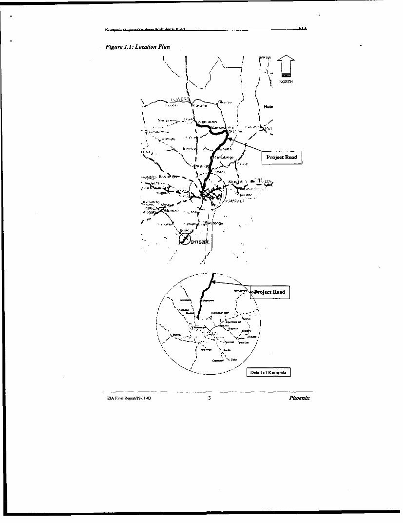
Figure 1.1: Location Plan
x1.. g I g iNORTH
\ 24 4.4,.t 2 -r Road. -
4~
.r-~~ ~~ ( ^s :.rJ / \N3
~sm.nunil,- / Project Roa
;oJ"""~~~"' \ >.% 4WZaP:uis.I vr4
of~~~~\
-,onj, ISn-D ' Sj,)t
/X . - AJ' Project Road
A
.------ Detilof Kapa
EIA Final Rqop8-1 1-03 3 Phoenix
Kamoala-Gavaza-Zirobwe-Wobulenzi Road EIA
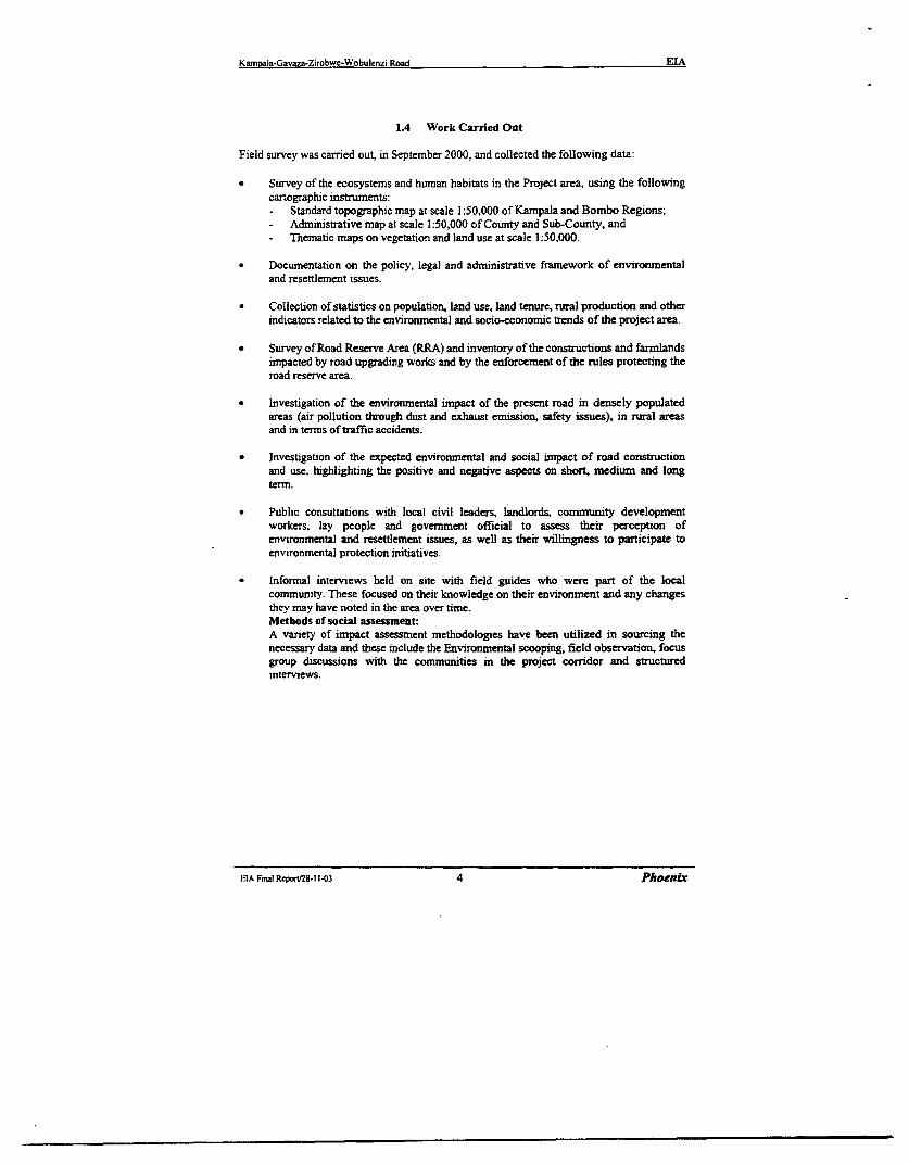
1.4 Work Carried Out
Field survey was carried out, in September 2000, and collected the following data:
* Survey of the ecosystems and human habitats in the Project area, using the followingcartographic instruments:- Standard topographic map at scale 1:50,000 of Kampala and Bombo Regions;- Administrative map at scale 1:50,000 of County and Sub-County, and- Thematic maps on vegetation and land use at scale 1:50,000.
* Documentation on the policy, legal and administrative framework of environmentaland resettlement issues.
* Collection of statistics on population, land use, land tenure, rural production and otherindicators related to the environmental and socio-economic trends of the project area.
* Survey of Road Reserve Area (RRA) and inventory of the constructions and farmlandsimpacted by road upgrading works and by the enforcement of the rules protecting theroad reserve area.
* Investigation of the environmental inpact of the present road in densely populatedareas (air pollution through dust and exhaust emission, safety issues), in rural areasand in terms of traffic accidents.
* Investigation of the expected environmental and social impact of road constructionand use. highlighting the positive and negative aspects on short, medium and longterm.
* Public consultations with local civil leaders, landlords, community developmentworkers, lay people and government official to assess their perception ofenvironmental and resettlement issues, as well as their willingness to participate toenvironmental protection initiatives.
* Informal interviews held on site with field guides who were part of the localcommunity. These focused on their knowledge on their environment and any changesthey may have noted in the area over time.Methods of socisl assessment:A variety of impact assessment methodologies have been utilized in sourcing thenecessary data and these include the Environmental scooping, field observation, focusgroup discussions with the communities in the project corridor and structuredinterviews.
IA Final Repor/2S.l1-03 4 Phoenix
Kamoala-Gavaza-Zirobwe-Wobulen7i Road EIA
2 PROJECT DESCRIPTION
2.1 The Project Works
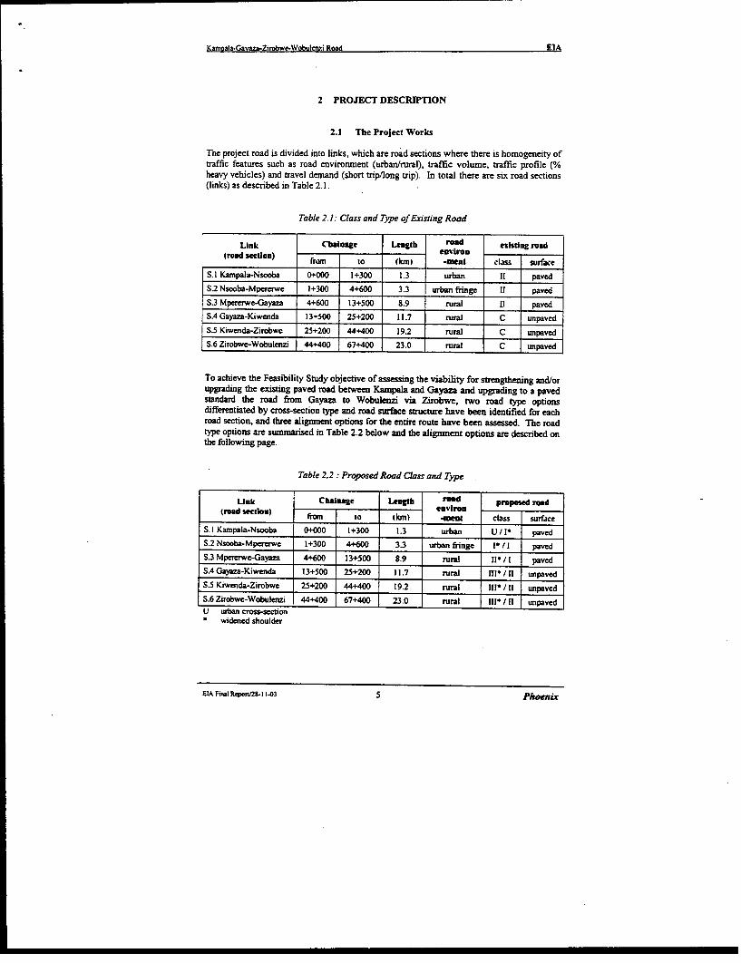
The project road is divided into links, which are road sections where there is homogeneity oftraffic features such as road envirornment (urban/rural), traffic volume, traffic profile (%heavy vehicles) and travel demand (short trip/long trip). In total there are six road sections(links) as described in Table 2.1.
Table 2.1: Class and Type ofExisting Road
Link Cbhalage Lengtb read ezistiug road(road section) trn to snenviroc
_____o__ km -iteal ls surface
S.l Kamnpala-Nsooba 0+000 1+300 1.3 urban pavedS.2 Nsooba-Mpererwe 1+300 4+600 3.3 urban fringe 11 pavedS.3 Mpererwe-Gayaza 4+600 13+500 8.9 rural ll pavedS.4 Gayaza-Kiwenda 13+500 25+200 11.7 rural C unpavedS.5 Kiwenda-Zirobwc 25+200 44+400 19.2 rural C unpavedS.6 Zirobwe-Wobulenzi 44+400 67+400 23.0 rural C unpaved
To achieve the Feasibility Study objective of assessing the viability for strengthening and/orupgrading the existing paved road between Kampala and Gayaza and upgrading to a pavedstandard the road from Gayaza to Wobulenzi via Zirobwe, two road type optionsdifferentiated by crss-section type and road surface structure have been identified for eachroad section, and three alignment options for the entire route have been assessed. The roadtype options are summarised in Table 2.2 below and the alignment options are described onthe following page.
Table Z2: Proposed Road Class and Type
Unk Chalge Length roo osed read(road setIon) environ
fTen to tkn) 1-eat cbss surface
S. l Kampala-Nsooba 0+000 1+300 1.3 urban U/l* pavedS.2 Nsooba-Mpererwe 1+300 4+600 3.3 urban fringe * I/ paved
S.3 Mpererwe-Gayaza 4+600 13+500 8.9 rural II* /I pavedS.4 Gayaza-Kiwenda 13+500 25+200 11.7 rural nl- /11 unpaved
S.5 Kiwenda-Zirobwe 25+200 44+400 19.2 rural IIf/*11 unpavcd
S.6 Zirobwe-Wobulenzi 44+400 67+400 23.0 rural 1I/* 11 unpavedU urban cross-section* widened shoulder
EIA Final Report/2-I 103 5 Phoezix
Kam ala-Gavaza-Zirobwe-Wobulenzi Road EIA
2.1.1 Alignment Option A - Existing Alignment
Early in the Feasibility Study, following completion of the topographic survey, a geometricdesign was laid over the existing road centreline. This alignment became Alignment OptionA - Existing Alignment.
For this alignment option, in the vertical profile the road level was redesigned to elevate itacross swamp areas to accommodate drainage requirements. On the horizontal profile, thealignment closely followed the existing road centreline.
Developed with the intention of having, if compared to other potential options, the leastimpact on adjacent land use and the least demand for additional land occupation, this optionhas many deficiencies at regular intervals along the road length after Gayaza where theexisting unpaved road is to be upgraded to a paved road.
From Kampala to Gayaza, the existing road geometry is generally consistent with thestandards set in the MOWHC Road Design Manual. After Gayaza, through to Zirobwe andWobulenzi, for a road to be upgraded to a paved road with an 80 kph design speed, theexisting road alignment has deficiencies, sometimes through the horizontal curves being tootight a radius, but more often through the adverse combination of horizontal curves.
At many locations there are* Several consecutive short horizontal curves separated by short straights, or* small radii S-bends, or* comnbinations of consecutive S-bends, or* kinks in what would otherwise be either a straight road section or a section on a large
radius.
Not only is such a design standard inconsistent with the RDM and in particular the sectionon design form, but the alignment imposes limitations on the occurrence and frequency offorward sight distance necessary for safe overtaking at the higher travel speeds afforded bythe paved road surface. This will affect travel safety.
Consequently, the option for a horizontal aligrnent which rigidly follows the existing roadcentreline was abandoned due to these serious deficiencies.
2.1.2 Alignment Option B - Optimised Alignment
This alignment solution follows the existing road corridor and optimises the separatedemands of engineering design standards and social impact limitation.
The horizontal alignment is consistent with the standards specified in the MOWHC RoadDesign Manual for the appropriate road class design speed, and at trading centres, in villagesand through townships, the horizontal and vertical alignment design is typically determinedto reduce cut/fill depths and reduce the degree of shift between the existing and design roadcentrelines, thereby limiting social impact effects in terms of resettlement and propertyaccess.
This is the alignment which is shown on the plans (RP series) and the longitudinalprofiles(PR series) contained in Volume 3: Drawings, and on the cross-sections contained inVolume 4 of the Feasibility Study Final Report.
EIA Final Repon-I 1303 6 Phoenix
Kamnala-Gavaza-Zirobwe-Wobulcnzi Road EIA
Whilst thc design seeks to limit social impacts, they are not eliminated. These issues arefully explored and plans for the resettlement of affected persons are presented herein in thisEnvironmental Impact Assessment, which is Volume 2 of the Feasibility Study Final Report.
2.1.3 Alignment Option C - Deviations
Over the length of the project road, there are four locations where deviation of the roadalignment, away from the existing road corridor, would present a shorter route with potentialimprovement in travel conditions and safety for the through traffic movement. These fourdeviations are shown on Appendix G of the Feasibility Study Main Report (Volume 1) and acopy of this Appendix has been inserted in this volume following this page. The plans andprofiles for each deviation are presented on drawings AA-OOla to AA-004d contained inVolume 3 of the Feasibility Study Final Report.
* Deviation No I - near Gayaza
From km 11+570 at Kasangati on the Mpererwe-Gayaza link to km 14+620, 1.2 km north ofGayaza on the Gayaza-Kiwenda link, this deviation is essentially a by-pass of Gayaza. Thebypass is about 650. m shorter than the route through Gayaza.
Gayaza is an important district centre and traffic produced by the activities of the centrepredominantly travels southwards to Kampala. Although essentially a by-pass of Gayaza,the volume of traffic expected to use the deviation is very low, possibly less than 250 vpd,and the deviation would not obviate the need to strengthen and/or upgrade the portion of theMpererwe-Gayaza link from Kasangati through to Gayaza.
* Deviation No 2 - north of Busika
From km 31+680 to km 32+890, this deviation will eliminate four bends and the road sectionlength will be reduced by approximately 200 m. The deviation crosses an intensive farmedarea.
* Deviation No 3 - from Vvumba to Kabulanaka, south of Zirobwe
From km 33+510 tokm 39+860, this deviation will reduce the actual length of this section ofroad by abouL 480 meters. The deviation starts north of Vvumba, bypasses Kakoni andbecomes co-incident with the existing road near Ndeeba before bypassing the market area ofBulami village and re-joining the existing road alignment south of Kabulanaka.
Deviation No 4- West of Zirobwe, from Namawogya through to Bamunanika
From km 48+500 to kmn 57+270. The deviation (7.3 km long) will reduce the project roadlength by about 1.5 km. After Namawogya trading centre, the deviation leaves the existingalignment and leading to the north-west enters an area noticeable for the fertility of the soiland the presence of the original vegetation. The deviation generally follows a feeder roadserving the Magogo village area and, after crossing the Kayiwagobe river, reaches Kikabyaand Kisaku village areas before turning west to join the existing road corridor atBamunanika.
EIAFinalRcpo,rV2-11-03 7 Phoenix

Kanmala-Gava7a-Zirobwc-Wobulenzi Road EIA
2.2 Scope of the Study
The Terms of Reference require that "an Environmental Impact Assessment (EIA) andResettlement Impact Assessment (RIA) will be carried out in accordance with therequirements of EIA legislation by the Government of Uganda (GOU) and of the FinancingAgency as part of the feasibility study".
Any road development has a range of impacts on the environment and community in the areaserved by the road. These can be considered as positive or negative impacts on the physicalor social environment, to be assessed in terms of intensity and duration of impact, andwhether they are direct or indirect impacts.
In line with the Terms of Reference, the study has adopted the enviromnental assessmentmethodologies advised by the World Bank, to analyze the direct and indirect impactsstemming from:
the road construcion process, and:the use of the road after its opening to service.
23 Previous Reports
A detailed engineering study and economic evaluation for upgrading/regravelling of theGayaza-Zirobwe-Wobulenzi section of the project road was carried out by Gauff Ingenieurein 1993. This study was titled Transport Rehabilitation Project: Upgrading, Regravelling,Rehabilitation of Roads (IDA Credit No P593-UG). Its scope included several roads in theMpigi and Luwero Districts, one of which was the Gayaza-Zirobwe-Wobulenzi Road.
Available documents from this study are* Part 1, Volume 1: Engineering Report (Detailed Engineering Study), Oct. 1993.* Part 1, Volume I (Annex): Engineers Cost Estimate, Oct 1993.* Part 1, Volume IIC: Materials Report, Feb. 1993.* Part 1, Volume IV: Economic Evaluation, May 1993.* Volume IIC: Book of Drawings (A3 size), Feb. 1993.* Volume 1: Contract Documents, Feb. 1995.
The available documents from the previous study by Gauff Ingenieure in 1993 have beenreviewed and the outcomes of such reviews are reported separately in the various technicalsections of the Draft Final Report. These earlier documents are reviewed in their historicalcontext and the Feasibility Study reported herein is essentially a stand-alone project
The Gauff study did not assess the environmental and social impact of the road development.
EIA Fircl Riort2S-11-03 8 Phoenxv
Kanm,ala-Gavaza-Zirobwe-Wobulenzi Road EIA
3 INSTITUTIONAL AND LEGAL FRAMEWORK OF ENVIRONMENTALPOLICY
3.1 Overview
The National Environment Management Policy for Uganda, stemmed in 1994 from theNational Environmental Action Plan (NEAP), is to maintain or enhance environmentalquality and resource productivity on a long-term basis while promoting sustainable socialand economic development One of the key objectives of the policy is to integrateenvironmental concerns into all development policies, planning and activities at all levels,and to encourage participation by the people during the development process. With regard toEnvironmental Impact Assessments (EIA), the policy's objective is to provide a system ofEIA and environmental monitoring so that negative impacts arising from a development canbe foreseen, eliminated or mitigated. In order to achieve this goal, the policy outlines itsstrategies as being to:
* create a legal EIA process necessitating environmental impact assessments,environmental impact statements and environmental audits for all private and publicdevelopment projects;
* establish a national environmental authority whose function would be to oversee EIA,while leaving the actual implementation to the lead agencies involved;
* develop EIA capacity/capability in sectarian ministries and departments.
Subsequently in May 1995, the National Environment Statute was passed which provided forthe establishment of the National Environment Management Authority (NEMA) whosefunctions are to co-ordinate, monitor and supervisc the sustainable management of theenvironment. The National Environment Action Plan (1995) outlines different roles playedby different government ministries and departments in developing environmental awareness.NEAP reqwures that, each sector ministry has an Environmental Liaison Unit (ELU). NEAPalso provides for the creation of District and Local Environment Committees (DECs) and(LECs) at the district and local community levels respectively. Among other responsibilities,these committees are to ensure that; environment related issues are taken into considerationin all developmental projects in their areas.
ELA Final Repor/28-I 1103 9 Phoenix
Kamla-Gavaza-Zirobwe-Wobulenzi Road EIA
3.2 Institutional Framework
3.2.1 National Environment Management Autbority (NEMA)NEMA is the principal agency in Uganda for the management of the environment and is toco-ordinate, monitor and supervise all activities in the field of the environment.
The functions of the Authority are to:* co-ordinate the implementation of Government policy and the decision of the Policy
Committee;a ensure the integration of environmental concerns in overall national planning through
co-ordination with the relevant ministries, departments and agencies of Govermnent;* liaise with the private sector, intergovemrnental agencies, NGOs and* other states on issues relating to the environment;* propose environmental policies and strategies to the Policy Committee,* initiate legislative proposals, standards and guidelines on environment in compliance
with the Statute* review and approve environmental impact assessmnent and environmental impact
statements submitted in accordance with this Statute or any other law;* promote public awareness through fonnal and informal education about environmental
issues;* undertake such studies and submit such reports and recommendations with respect to
the environment as the Government or the Policy Committee may consider necessars,* ensure observance of proper safeguards in the planning and execution of all
development projects, including those already in existence that have or are likely tohave significant impact on the environment determined in accordance with Part V ofthis Statute;undertake research, and disseminate information about the environment;prepare and dismate a state of the environment report once in every two years;
* mobilise, expedite and monitor resources for environmental management; and* perform such other functions as the Government may assign to the Authority or as are
conductive to the exercise by the Authority of any or all of the functions provide forunder this Statute.
This project development therefore, has to be undertaken bearing in mind, the environmentallaw detailed in the National Environment Statute of 1995
3.2.2 Environmental Liaison Unit (ELU).The MOWHC aheady has such a unit. It is hoped, that the ELU will play an important rolein environmental monitoring and management in the road sector rather than simply, liaison.
3.23 The Uganda Land CommissionThis, agency is responsible for registration of land titles and is operating under the DistrictLand Boards, Water and Environment. The operations of the Commission are governed bythe Land Act of 1998. The Commission has District Land Boards, District Land Tribunalsand Parish Land Committees to assist its operations in the field.
ElAFinaiReporu28 1.03 10 Phoenix
Kamnala-Gavaza-Zirobwe-Wobulenzi Road EIA
3.2.4 Non Government Organisations (NGO)A number of NGO's assist in the development of the social enviromment. The include theNational Council For Children and the Child Welfare NGO, Women advocacy NGOs e.g.FIDA, Action For Development (ACFODE), FEMBUTE and National Association ofWomen of Uganda (NAWOU) etc.
3.3 Environmental and Social Assessment Regulations
3.3.1 Environmental regulations.The EIA Regulations of 1998 make it mandatory for all projects listed in the Third Scheduleof the Statutc and any major repairs, extensions or routine maintenance of any existingproject included in the Third Schedule of the Statute to conduct EIA in accordance with theregulations before implementation. These regulations are therefore applicable to all majorroad development projects (such as Kampala-Gayaza-Bugema-Zirobwe-Wobulenzi road)and all roads in "scenic, wooded or mountainous areas". In line with these requirements,Section 97(b) of the Environrment Statute, stipulates that "Any person who fails to prepare anEIA contrary to the Third Schedule commits an offence and is liable, on conviction, toimprisonment for a term not exceeding 18 months or a fine of not less than 180 thousandUSh and not more than 18 million USh or both". These legal instruments and obligations aregeared towards ensuring that, environment and natural resources at large are protected toensure sustainability and social well being of Ugandans.
3.3.2 Social Laws and Regulations.i. The Employment Decree of 1975 which prohibits employment of persons below the
age of 18 unless authorised by the Commissioner of Labour.ii The law of equal opportunity of employment for men and women.iii The. Land Act (1998) which makes provision for land ownership titles and
compensation for and required by projects.
EIA Fini Rn/epm 1143 11l Phoenix
Kanmoaa-Gavsa-Zirobwc-Wobulenzi Road EIA
4 ENVIRONMENTAL SETTING: BASELINE CONDITIONS
4.1 Location
The existing road (67 kIn) lies in the districts of Kampala, Mpigi' and Luwero and is part ofthe road system connecting the Central Region with the Kampala urban area (refer Figure 1,page 2). The road serves an area between two major tnunk roads: to the west the paved roadGulu-Luwero-Kampala that serves the north of the country and at east the Kampala-Mukono-Bukoloto road that channels the traffic going to Kampala and coming from north ofMukono and Kamuli districts. In fact the project road stretches for all its length almost inthe middle of these two roads and collects the traffic coming from and going to the north asfar as Wabusana and Kakukulu in Luwero District, and Kazwama in the recently establishedNakasongola District.
4.2 The Biophysical Environment
4.2.1 Topography.The project area is part of the Central Plateau Ecological Region, which has intermediatealtitudes (1,100-1,300 meters as.l.). The area is characterised by flat-topped hills that rise toan average height of about 1250m.as.l. and they are separated by broad, uniform valleyslopes which descend into extensive papyrus wetlands draining north-east to river Lwajaliand lake Kyoga and west to river Kafu. The area hosts a variety of ecosystems, ranging frompermanent to seasonal wetland, forest/savanna mosaic of mixed tree, thicket, shrub andgrassland including post cultivation vegetation types. All ecosystems are heavily modifiedby human action, including deforestation, overgrazing, nature depleting farm practices andexcessive urbanization.
4.2.2 Climante.Although the project area lies within the equatorial belt, the would-be tropical climate of thisarea is considerably modified by its elevation above sea level and its vicinity to lakeVictoria. The mean diurnal maximum temperatures range between 180 and 350 while thecorresponding minimum diurnal range is 8° and 250. Temperatures peaks are in the monthsof January to March and October to December. Cloudiness and rainfall affects temperaturesslightly. For most of the year the area records less han 55% sunshine. This leads to areduction in the net radiation recorded on the ground and hence low surface air temperature.Rainfall patemns are bi-modal. There are two wet seasons runmning from April to May andSeptember to November. The pnncipal rainfall peak is in April while the minor one is inNovember. The dry months are January-February and June-August and are frequentlybroken by thunderstorms. The annual rainfall mean is between 1125 and 1350 num and theaverage monthly days of rainfall are 10. Relative humiity is high in the project area due toits equatorial position, high rainfall and its proximity to lake Victoria. It is highest in theearly hours of the day (85% at 0600 GMT) but decreases rapidly during the afternoon (61%at 1200 GMT). Thie winds of the area are however modified by the increased rough surface
' In February 2001, the Mpigi district has been split into two separne admuinisttive units: Mpigi district(Wcstern part) and Wakiso distict (Eastern part). The project road actuatlly lies in te new established Wakisodistrict. Since statistical data are not available, at present, for Wakiso district, this rTqort still refer to the forarMpigi districc
EIA Final RFpor258. 103 12 Phoenix
Kampala-Gavaza-Zirobwe-Wobulenzi Road EIA
due to the numerous flat topped hills and tree vegetation. The average annual wind speed is7.8 knots. Anyhow the area experiences localized strong winds in form of eddies during thedry season and the rainstorms accompanied by strong breezes and moderate gals that oflenlead to breaking of tree branches.
4.2.3 Geology and Soils.Most of Central Uganda, including the project area, is represented under the Buganda-Toro
System. Argillites predominate, but basal or near basal arenites are an important feature.Locally, as west of Kampala, occur tick anphibolites which are probably derived frombasaltic material. Large tracts of the system are granitized; on the other band low gradephyllites also occur. While in general the system appears to lie upon a gneissose basement,this basement has been mobilised and it is, in some places, difficult to distinguish fromgranitized Buganda-Toro System rocks. Folding is fairly tight on predominantly east-north-easterly axes in the east but varies in the west. Axial planes are steep and there is a tendencyfor this folding to decrease in intensity with lowering of metamorphic grade southwards. Agedetermination suggest a metamorphic age of approximate 1,800 million years. Provisionallyincluded within the Buganda-Toro system are the Igara Shists composed mainly of quarzitesmica schists and gneisses, the Buamba Pass Series of Ruwenzori which is made up of grits,sand stone, slates and phyllites and the Kilembe Series of Toro.Soil conditions are very uniform in spite of the hilly topography. Hill summits and upperslopes consist of shallow, skeletal soils developed from quartzite or iron stone (ferraliticsoils). Deep red clays occur on the pediments and are the main crop soils. Soils on the slopesmerge into grey, swamp edge soils and finally, into the true swamp soils. Fertility of the soilsdrop with cropping intensity or if less productive soils of the system are used in response toland pressure. However, natural fertility is high in areas where the soils are protected againsterosion and crops are rotated.
4.2.4 WaterBased on previous envirornmental studies, the water quality indicators of river Lwajali, themain collector of waters from the project area, can be summarized as follows:the water tends to vary from neutral to basic conditions (pH = 7.821). This also means littledissolved oxygen in the water probably due to a lot of organic matter that tends to raise theBiochemical Oxygen Demand (BOD) of the micro-organisms involved in the decayprocesses.The Electrical Conductivity (87,6) is indicative of fresh water free from industrial pollutantsthat tend to give water acidic properties. and high EC, which is contrary to the observed.The organic matter is therefore originating from the wetland, which has its own naturalprocesses of pollution control without causing a danger to the environment.
4.2.5 Air QualtyThe existing road environment is extremely dusty in dry weather due to vehicles traveUing athigh speeds along the road. Roadside plants and crops are covered with a thick layer of dust.Local residents are constantly exposed to a high level of dust from the road, particularly indry conditions when mini-buses and trucks pass at high speed.
ELAFinalReponi2S-1.03 13 Phoenix
K aGa cw c7Road EB
'sS,.~* Sti
,, s,, ' '','.i
it
SLA Final epnV2S- II-3
14 Phoenix
doN asn pu7 (qa ) , I
'k~~~~~~''-.,_ 5 --.-. " - -. c;j
- .. . . ,.v* .% , J
-.... 4 iX .',-: .-- --. I : x , % . -
_,_,rn ~ ~ ~ ~ ~ ~ .5 : '.5.'- * : -,- !\'
.~~~~~~~I- -~
J; # s n ,.
f. ;I- .,
;.j
-- ,~~~~~~' -- ----'r_ .5 - -
._ eL I . .A ._1.' ' i
r ~ ~ ~ ~ ~~.
~~~~1 V -~~~~~~~~~~~~~
KamDaIa-Gavaza-ZirObwC-WobuiCn7J Road EIA
4.2.6 Vegetation.The vegetation of the project area (Figures 5.1.1 and 5.1.2) follows the existing rainfall andrelief pattern. It is a relic of the original vegetation where there are remnants of communitiesrelated to the savanna woodland climax and the Combretum/Cyrmbopogon afronardus fireclimax tree savanna, particularly on the hills. This area is believed to have been covered byforests prior to the introduction of agriculture. The vegetation of the project area comeswithin the study carried out by the National Biomass Study team of the Uganda ForestDepartment. The study divides the vegetation into six major classes as follows:
Subsistence Mzxed FarmlandsThis comprises of land recently or currently under use with or without trees and agriculturalfallow areas. It ranks first in size and covers about 80% of the project area. The plants foundin these farmlands are food crops, which include cassava and maize. Almost the totality ofhomesteads have small plots with coffee shrubs and banana plantains (matoke). Fruit treessuch as the mango and Jackfruit and other multipurpose trees integrated in the farmingsystems are found in the vicinity of homesteads. In some of the farmnlands, an abundance ofeucalyptus spp, Markhania platycalyx and Musa spp (bananas) are found. The dominantweeds in this sub-division include: Digitaria scalprum. Oxalis latifolia, Commelinabingalensis, Imperata cylindrica, Cynodon dactylon and Euphorbtaprostuata.
Vegetation in Built-up AreasThis covers a large part of the project area. It includes urban areas, villages, compounds,school recreational grounds etc. along the road. Around homesteads are trees that havebeen planted for both shade and ornamental purposes. The most common species are: cassiaagnes, markhamia plazycalyx and Jacaranda mimosifolia. Other plant species includeBougainvillaea spp, Acallpha spp and grasses such as Brachiaria spp, Hiyparrhenia spp, ezc.
Woodland Trees and ShrubsThis vegetation represents most wooded areas where trees and shrubs are the predominantcover. These are mostly of an average height of 4m. It is found mainly in parts of projectarea in Luwero district. Wet woodland communities occur along wetlands and the drywoodlands appear on the dry grass covered areas. Deciduous trees are also common.
Bush, Thickets and ScrubsThis kind of vegetation is found in most part of project area with an average height of lessthan 4m. The bushes, scrubs and thickets grow together as an entity. This vegetation alsooccurs on abandoned farmland in form of late fallow with rapid re-growth of mainly Lantanacamara.
Wetland VegetatonThe project area has several permanent and seasonal wetlands covering about 5% of the area.The major wetlands are associated with Lake Kyoga drainage systems. Many wetlandsaround Kampala district have been drained and turned into agricultural areas or developedfor commercial, industrial and sometimes residential purposes. The unclaimed wetlandsalong the project road are covered by both grasses and sedges. The most common speciesare papyrus, Miscanthidium violeceum, Phragmites maurtianus, Cyperus latifolius andTypha australis. Indicator tree species associated with this vegetation include Acaciasieberana and palms.
Post cultivation communitiesThese arise as a result of intensive farming on the soil and thereafter abandonment due toloss of fertility. They are associated with poor and heavily leached soils and are a stage in thesequence from agricultural crops to the climax vegetation associated with.particular area.The majority of post cultivation communities are short-lived and contain many of the species
EIA Final ReporV28-11-03 16 Phoenix
Kanalma-Gavaza-Zirobwc-Wobulenzi Road EIA
found in the grass layers of their more stable successors. In places of high populationdensity, overexploitation of the land without remedial measures has resulted into soil fertilitydegradation. Hillsides have bee opened for cultivation and left bear at times thus acceleratingthe threat of soil erosion. Loss of soil fertility is observed in most parts of the road influencearea (mainly in Kyambogo and Nangabo sub-counties) and many areas are also experiencingserious soil erosion problems and gullies formations are evident. Overgrazing is moreevident in Zirobwe and Bumunanika sub-counties.
4.2.7 Fauna
At the moment, the actual faunal situation in Kampala, Mpigi and Luwero districts is notknown. However, the proposed upgrading road works are within the present road and settledarea. This means human activities such as deforestation, cultivation, draining of swamps andurbanization have affected the existence of wildlife along the present road and endangeredwildlife has disappeared since decades from the project area. The faunal groups weredocumented and part of the information was from local communities. No wild mammalswere encountered in the project area except for local communities reports on the occurrenceof the Common Rats, Giant Otter Shrew and Vervet and Red tailed monkeys. Opportunisticdocumentation of avifauna group was made during the survey. Birds recorded included:Ring-necked Dove, Weaver bird, Hammerkop, Common Bulbul, Black Flycatcher andGuineafowl. Fish species such as, protopterus aethiopicus (mud fish), clarius gariepinus andbagrus paludinus were among those reportedly caught by the local communities in seasonalwetlands around. Fishing is not significant in the project area since there is little open water.
43 The Human Environment
43.1 Population.
The population of Kampala, Mpigi2 and Luwero districts, the administrative units where theproject area lies, was 2.6 miliion people in June 2000, according to the mid-year populationprojections estimated by the Uganda Bureau of Statistics (see Annex 1), based on theprojection of the official series shown below (Table 4. 1). The inter-census growth rate of thethree districts interested by the project area increased from 2.5% in 1969-80 to 2.6% in 1980-91, contrary to the national demogrphic trend that reflects a slow-down (from 2.7% to2.5%).
Table 4.1: Official data on the population of Kampala, Mpigi and Luwero Ditricts(1969-96)
Pw_aution Annual zrowth rateDismaws 1969 I 40 e991 200 1969- 1980- 1969-
1969 1930 1991 ~~~estimate 1930 1991 1991
Karnpala 330,700 458,500 774,200 902,900 3.1 4.8 4.0Mpigi 513,500 661,200 913,900 1.175,700 2.4 2.9 2.7Luwero 268,000 338,500 349,200 512,700 2.2 0.3 1.2TIJa I 1.112.200 1.45S,200 2.037300 2,591.300 2.5 2.6 2.6Total Uganda 9.535,100 12,636.200 16,671,700 22,210.300 2.7 2.5 2.6SouaCs, a) Populaion Cemus: 1969.i980and 199 IId otlrcial adiinisamin figues for 2000
During the period 1980-91 the district of Luwero experienced a remarkable slow-down,which is attributable to out-migration due to the civil war. Kampala's population is expected
' See footnowe al pagc 12
EIA Final RepoOQ28-1 .03 17 Phoenix
Kmnmial-Gavaza-Zirobwc-Wobulenzi Road ETA
to grow at a rate of 5.7% per annum between now and 2004 which is almost double thenational growth rate. This will result in an estimated total population of 1.5 million personsthat is double the population recorded in 1991 census. The average household size increasedfrom 4.1 in 1969 to 4.3 in 1991.
4.3.2 Demographic Structure.Population is young: 49% are under 15 years while the active group 15 to 64, or core laborforce, is 47 %. Males outnumber females in the age group under 15 years. while females 15-64 are more numerous than males specially in Wakiso and Luwero districts, testifying theout-migration of male labor force. The group aged 65 and over is higher than 3% except inKampala where it is less than 2%. The dependence ratio is a higher in Kampala than inMpigi and Luwero districts, meaning that a large number of people are being supported byfewer workers in the active group.
4.3.3 Population Density.Within the project area, density is higher in Kampala district (over 5000 inh/km2 inKawernpe division) and much less in wakiso(about 400 inh./km2 in Nangabo and Kyambogosub-counties) and Luwero district (about 250 inh./km2 in Kailagala, Zirobwe, Bumunanikaand Katikamu sub-counties). The above figures show that the project area is denselypopulated and higher the regional and national average (Table 4.2).
Table 4.2: Population density of Kampala. Wakiso and Luwero Districts (1980-2000)
Kampala 1c69 45,500 774,200i 902,900y 27130 45T8 5340rWakiso 4514 661,200 913.9001 1,175,7001 1461 202 260Luwero 5360 33S,500 349,2001 512,7001 63 65 951
Upnda 197096 12.636.200 16.671.700 22,210,300 64 85 1 12Source Uganda Bureau otStanscs. 999
4.3.4 Urban and Rural Population.
Within the project area, the urban segment amounts to 222,000 people, mostly concentratedin Kawernpe division of Kampala city (180,000 inhabitants in the year 2000). The remaining42.000 people are distributed in Town Councils and other growth centres.
4.3.5 Social Organisation.The family is the main unit of social organisation. It includes both the nuclear family and theextended family. The nuclear family is usually headed by a male who yields considerableauthonty over the other members. He is the main decision-maker on matters concerning thefamily members and the family's economic and productive resources. Families make upclans whose members share common ancestry and facilities such as burial grounds. Beyondthe family and the clan, there is currently a socio-political system of organisation, the LocalCouncil (LC) system which was introduced by the National Resistance Movement (NRM)governmient in 1986. It starts from the village level up to the District level. The role of thelocal councils in conununity matters such as social infrastructure development and land, isgreat and inevitable. The project area also belong to the traditional Buganda Kingdom.Although the monarchy does not hold political power, the king plays significant socio-cultural role. Matters involving the people's loss of and compensation for land therefore, may
EIA FRmal Repon12-11.03 18 Phoenix
Kamcals-GavazaZ,robwc-Wobulerri Road EIA
call the attention of the relevant ministry in the Kingdom government The nuclear family,the extended family and to some extent, the clans constitute significant traditional socialsupport system for their members especially in times of difficulty.
4.3.6 Ethnic GroupsThe 1991 census singled out 34 ethnic groups present in Kampala, Mpigi and Luwerodistricts. In terms of numerical strength, the most important ethnic group in the project areaare the Buganda, belonging to the Bantu linguistic group. They comprise almost the 85% ofthe population that occupies the central and the southem part of the country, from lakeVictoria to lake Kyoga in Central Uganda, better defined as Buganda region. The Bugandaare homogeneous both linguistically and culturally. They are hard working people who havetaken full advantage of their favourable geographical and economic position. Many otherethnic groups have however settled in Buganda region (Banyankore, Basoga and Bakiga ofthe Bantu area, the Nilo Hamitic lteso coming from East, the Nilotic Langi and Acholipeople coming from northern Uganda).
4.3.7 Land Tenure.Land Tenure systems in Uganda are a mix of traditional practice, colonial regulations, andpost colonial legislations. Land holdings differ across the project area and currently fallunder the following categories: Private mailo, Freehold, Leases holdings and Customaryholdings (Bibanja).
Mailo TenureThis was introduced in Buganda following the Buganda Agreement of 1900. OriginaDly, itwas of two categories, notably private and official mailo. Subsequently in 1967 officialmailo was transformed into public land. A principal feature of the mailo system was that ofmodified freehold. Mailo estates were surveyed and the holders given certificates of titlewhich could easily be transferred. Consequently, many sub-divisions of the original mailoholdings have taken place. These title deeds have also been used as collateral security infinancial institutions and have thus contributed to developmnent. About 70 % of the land isheld under the mailo system. It has been argued that this kind of tenure hindersdevelopments in the agricultural sector. Land is an asset that has to be protected. However,mailo tenure is such that ownership and tenancy are not the same in many cases. Therefore,tenants on such land have tended to neglect looking after and investing in land because oflack of security of tenure. Also, occupants have neither been alowed to plant trees on suchland nor reap benefits without permission from the landlords.
Freehold TenureIn the project area, there are very few freehold tenures. These are mainly held by religiousbodies such as the church of Uganda, the catholic church.
Leasehold EstateA leasehold estate is an estate created in land as a result of an agreement between a leaserand a lessee. The lessee thereafter enjoys exclusive usage and possession of the land of theleasor for a specified period of time. This is in consideration of a cash payment called rentmoving from the lessee to the leasor. The majority of leasehold titles over public land in thedistrict are granted by the Uganda Land Commission while those over urban areas by theurban authorities. Urban authorities hold such land on statutory leases from Uganda LandCommission. In urban areas leases are granted for 99 years after completion of developmentwhile in the rural areas the period granted is usually 45 years. However, leaseholds are notvery common in the rural areas. This may be partly due to the lengthy bureaucratic processthat has to be followed before lease application can be considered by Uganda Land
EtA Final Rqa,/3-1 1.03 19 Phoenix
Kamcalja-avazp-Zirobwe.Wobuicnzi Road EIA
Commission. The other hindrance is usually the huge task of compensating and resettingpeople who may be settled on such land. Leasehold tenure, therefore, is more common inthe urban areas than the rural ones.
Customary TenureThis is the oldest system of tenure in the project area. It is also the most wide-spread. Mostpeople occupy land under this system. In the past, there used to be four categories of rightsof control. They included:Right of clans over land (obutaka),Rights of the Kabaka and /or chiefs (obutongole),Individual hereditary rights (obwesengeze),Peasant rights of occupation.
Overtime this tenure has been overtaken by histoncal events and at the moment it is atenancy on mailo land.
Various attempts have been made to address developmental concems arising from thesevarious systems with a view to stimulating development and preserving the environmentArticle 26 of the 1995 Constitution of the republic of Uganda empowers individuas toown property and also protects them from compulsory deprivation of such property.The artide further states that If such property (in this case land) is required for publicuse or interest, the affected individual be adequstely compensated. Clause 4 and 5 ofarticle 237 further provide that customary and leasehold tenure systems can be converted tofreehold by registration and in accordance with a law to be made by Parliament respectively.Statutory leases by urban authorities are also affected. In essence, the 1995 constitution seeksto give more powers to the people in so far as ownership is concerned.
Land holding in Kampala district currently falls under the following categories:* private mailo,* statutory leases held by the Kampala City Council,* land under direct control of Uganda Land Comnmission,* freehold and leases held by institutions.
More than 90%o of land holdings in Kawempe division is private mailo. In Mpigi and Luwerodistricts the most wide-spread landholding is the customary tenure and the majority of peopleoccupy land under this system. At the household level, land is traditionally owned andcontrolled by the male head of the household. A discussion with a women group however,indicated that some independent women do buy land and own land while others inherit andcontrol it. Value of land in the area ranges between USh. 700,000 and USh. 900,000 peracre. The value is relatively higher in Kiadondo county than in Bumunanika county. InKampala urban district the value of land passes I million Acre/acre.
4.3.8 Economic Aetivities and Standards of Living.Agriculture employs 84 % of the manpower in Mpigi and Luwero districts, and accounts for65% of the districts gross domestic product. In Kampala district, agriculture is an activity ofrelatively less significance and the main sources of livelihood are employment and trading(80% of manpower). Industrial sector in Kampala district is still dominated by small-scaleindustries. Informal industrial activities are common throughout the project area inKawempe division, on residential plots, unofficial markets and roadsides. Small scale semi-formal activity is found in and around official markets and in formally licensed premises.Industrial establishments on Mpigi and Luwero districts are confined to small-scale, agro-based mainly seasonal coffee processing. Trading is diffused but insufficiently organized interms of wholesale facilities and distribution infrastructure. Albeit far from being developed
E1A Final RtpVS-.t103 20 Phoenix
Ka2maa-GavvazaZirobwc-WobuIe=i Road EIA
in terms of monetary incomes, the economy of the region, however, is not affected by acutepoverty. The food balance is almost in equilibrium, thanks to subsistence-oriented farmingand the wealth of livestock resources. Children, in general, do not appear to suffer frommalnutrition or widespread diseases.
4.3.9 Agriculture.The Field observations and interviews identified subsistence farming as the main economicactivity in the project area. Coffee was identified as the main cash crop. In fact, despite itslarge contribution to the economy, agriculture largely remains of the subsistence type.Farmers produce mainly to feed their families, though cash crop farming is well developed.Farming in the project area can be categorized in intensive banana-coffee lake shore farmingsystem. This system covers Kampala, north of Wakiso and south of Luwero districts. Muchof the farming is based on the growing bananas and coffee. In addition to these two perennialcrops, a number of annual crops are grown. They include maiz, cassava, sweet potatoes,beans etc. Vegetable and fruits are also grown (tomatoes, cabbages, pineapples, mangos,passion fruits). The bananas and coffee are grown around the homesteads and sometimesthey are inter-cropped. the presence of perennial crops along the project road has beneficialeffects on soil conservation by providing cover throughout the year. Table 4.3 shows themost recent statistics about agricultural output in Wakiso and Luwero districts.
Staple food crops - bananas (matoke), sweet potatoes, cassava, beans - represent almost 92%of the area's agricultural output, against just 8% for cash crops like coffee, even thoughbananas are largely produce for household consumption as well as for the market. Thevicinity of Kampala district offers a ready market for all farm products, There is highdemand of agricultural products because of the high human population to the extent thatwhat is produced in the district is just a small fraction of what is consumed.
Table 4.3 : Agncurlural production of Wakiso and Luwro districts
Maize 27.000Sorghum 3.000Sweet potatoes 65.000Cassava 83.000Bananas 267.000Beans 31.000Coffee 41.000Source: SLatistial yearbook, 1999
43.10 Animal Resources.Since no rangeland lies in the project area, herding is non existent along the project road. InKampala district the number of cattle has shrunk due the crack down by the city authoritieson free range cattle keeping. Small herd of cattle (maximum 20 heads) is possible to meetalong the project road in Zirobwe and Bamunanika sub-counties, but the most commonsystem to raise cattle in the project area is the one called zero grazing. The cattle numberskept under this system range mainly within 1-3 animals and mainly milking ones. Theanimals are fed on crop residues, planted grass and commercially prepared feeds. Ranchesare present in Bumunanika sub-county (six ranches) and mainly raise beef animals, sold toKampala abattoirs. Goats, sheep, pigs and chicken are few, save a big poultry farm located inMagigye along the project road.
EIA F-,,l Repon/28-11-03 21 Phoenix
Kamnala-Gavaza-Zirobwe-Wobulerizi Road ELA
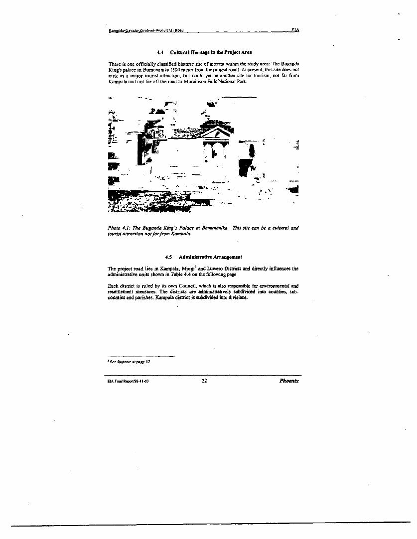
4.4 Cultural Heritage in the Project Area
There is one officially classified historic site of interest within the study area: The BugandaKing's palace in Bumunanika (500 meter from the project road). At present, this site does notrank as a major tourist attraction, but could yet be another site for tourism, not far fromKampala and not far off the road to Murchison Falls National Park.
-ors ttato ntaromK pa.
r~ ~~ -,. ..
-. _ .d.
4.5 Ad ministratIve Arrangement
The project road lies in Kampala, Mpigi.) and Luwero Distncts and directly influences theadministrative units shown in Table 4.4 on the following page
Pach district is ruled by its own Council, which is also resposible for enviromental andresettlement measures. The districts are administratively subdivided into counties, sub-countics and parishes. Kampala district is subdivided into divisions.
sSeefootnoteat page 12
ELA Fnal Report28-11-03 22 Phoerni
Kamoala-Gavaza-Zirobwe-Wobulenzi Road EIA
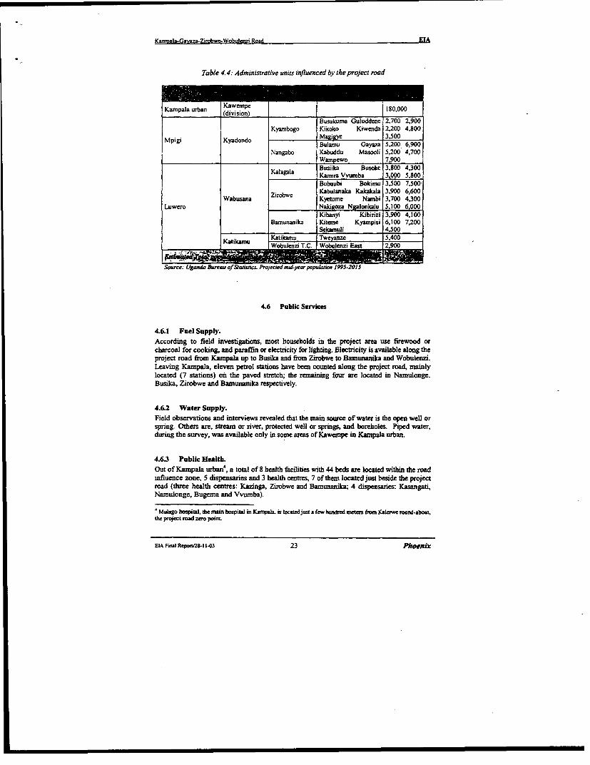
Table 4.4: Administrative units influenced by the project road
Kampala urban division 180,000
Busukuma Guluddenc 2,700 2,900Kyambogo Kikoko Kiwenda 2,200 4,800
Mpigi Kyadondo Magigye 35500Mpigi Kyadondo ~~~~~~~Bulam,u Gayaza 5,200 6,900
Nangabo Kabuddu Masooli 5,200 4,700Wampewo 7,900Busiika Busoke 3,800 4,300
Kalagala Kamira Vvumba 3,000 5,800Bubuubi Bokimu 3,500 7,500
Ziro.we Kabulanaka Kakakala 3,900 6,600Wabusana Zirobwc Kyetume Nambi 3,700 4,300
Luwero Nakigoza Ngalonkalu 5,100 6,000Kibanyi Kibinzi 3.900 4.100
Barnunanika Kiteme Kyampisi 6,100 7,200Sekamuli 4,500
Katikamu LKatikarnu Tweyanze 5,400Kattkamu Wobulenzi T.C. Wobulenzi East 2,900
Soure: Uganda Bureau of Statisncs. Projected mid-year population 1995-2015
4.6 Public Services
4.6.1 Fuel Supply.According to field investigations, most households in the project area use firewood orcharcoal for cooking, and paraffin or electricity for lighting. Electricity is available along theproject road from Kampala up to Busika and from Zirobwe to Bamunanika and Wobulenzi.Leaving Kampala, eleven petrol stations have been counted along the project road, mainlylocated (7 stations) on the paved stretch; the remaining four are located in Namulonge.Busika, Zirobwe and Bamunanika respectively.
4.6.2 Water Supply.Field observations and interviews revealed that the main source of water is the open well orspTing. Others are, stream or river, protected well or springs, and boreholes. Piped water,during the survey, was available only in some areas of Kaweipe in Kampala urban.
4.6.3 Public HealtD.Out of Kampala urban4 , a total of 8 health facilities with 44 beds are located within the roadinfluence zone, 5 dispensaries and 3 health centres, 7 of themn located just beside the projectroad (three health centres: Kazinga, Zirobwe and Bamunanika; 4 dispensaries: Kasangati,Namulonge, Bugema and Vvumba).
Mulago hospital, the main hospital in Kampala. is locted just a few hundred meters fm galerwe rouni-about,the project road zero point
EIA Final Repon'28.-1 "3 23 Phoenix
Mpmyala-GaYaza2irobwe-Wobu1enxi Road EIA
According to the 1997 Health Services Inventory, geographical access to health facilities inMpigi and Luwero districts is limited to only 49% of the household, and only 42.7% of theparishes, the smallest administrative unit, have some forn of health facilities.While it is believed that Government health units provide free medical services, the practiceis that patients bring their own bedding and pay for most essential drugs.Malaria, the leading cause of death in the districts is most prevalent in the brick making areasand near wetlands because mosquitoes breed in water that collects in the clay pits, and instagnant water in the wetlands.Personnel of health facilities along the Gayaza-Zirobwe-Wobulenzi road also talk of cases ofrespiratory complications and suspected allergies due to dust from the road especially in thedry season.
4.6.4 HIV/AIDS Control.Under the supervision and the coordinaion of the Uganda AIDS Commission, governmentalinstitutions and over 1000 NGOs, religious groups and individuals, are involved in theprevention, provision of care and support to people infected and affected with HIV/AIDS.One of the more actives in the project area, with operational units located at Wobulenzi andBamunanika, is Plan International.There is a reported general decline in the HIV prevalence from about 30X/ in 1993 to about10% by 1996. According to the 2000 HIV/AIDS Surveillance Report, data from HIVinfection sentinel surveillance sites in Kampala, Mpigi and Luwero districts, continue toshow declining trends in urban areas. In rural areas where trends in the past exhibited amixed pattern of stabilization and decline, prevalence rates appear to be clearly declining(from 27.1%. in1993 to 12.3% in 1999).In spite of the observed dent in the HIV/AIDS epidemic, the infection rates are still high inthe whole Country. As for the year 1999, a cumulative total of 55.861 AIDS cases has beenreported to surveillance unit of the AIDS Control Programme and at present the total numberof people living with HPV/AIDS is estimated at 1.44 million.It is believed that every households in the project area has in some way been affected by theepidemic.
4.6.5 Schools.According to field surveys, more than 5000 pupils attend to 30 primary and secondaryschools located on either sides of the project road. The road serves also the BugemaUniversity Campus and High School located in the homonymous village. However, some 18schools are recorded within 1 kilometers off the road.
4.6.6 Lck of Ancillary Road FacilitfesThe present road is not endowed with ancillary infrastructure suitable to sustain the expectedtraffic increase and its impact on the economy.
Major shortcomings bear upon.i. traffic police facilities outside Kampala urban areaii. axle load control servicesiii. motor parks and land transport stationsiv. organsed parking areas for trucks at major stopoversv. workshop areas for vehicle repairvi. communication services for transport-related and safety management needs
Traffic police posts presently exist along the gravel road, at Namulonge, Bugena, Zirobweand Bamunanika. The environmental specialist has surveyed the existing motor park of
EIA Final Rep rU28-11-03 24 Pheoisx
Kamnala-GaXjza-Zirobwe.WobuIlezi Road EIA
Zirobwe, which consists of a dirt space of some 1000 m2 without fencing and is devoid ofessential facilities as a shade for travelers. If the road is upgraded, it will be necessary toupgrade Zirobwe motor park and develop another one in Bamnunanika.
- ~ !S
* >~~~~~~~~~~~~~~-.
Photos 4.2 and 4.3: Zirobwe-WobulenziRoad Section. Schoolplayground on the roadside.and ...
... an "up-and-coming" using the road berm as a playground. Road safety management andproper school courses on road safety and safe behaviour when near the road will reduce therisk ofroad accidents.
EIA Final ReporV28- 1-03 25 Phoenix
Kanyala-GaVaza-Zirobwe-WObu1enzi Road EIA
4.7 The Exrisng Kampala-Gmyaza-Zirobwe-Wobulenzi Road
The Kampala-Gayaza-Zirobwe-Wobulenzi road (67 kim) is part of the dense networkconnecting north Kampala with Mpigi, Luwero, Mukono and Nakasongola districts. Theproject road (Figure 1.1, page 3; and Figures 4.2, 4.3, 4.4 and 4.5 on the following pages)consist of 14 kIn asphalt road, starting at Kalerwe roundabout (0 km) and stretching northbetween Kampala and Gayaza (13 km paved road), followed by 53 km gravel road leadingnorth-east to Zirobwe before turning west to join the main road Kampala-Luwero-Gulu atWobulenzi town. The first section (asphalt) holds the intense urban traffic of Kampala North,while the gravel road serves a densely populated agricultural area and canalizes thecommercial traffic coming from the rural network intersected. Major rural centers along theproject road are: Kasangati (11 km), Gayaza (14 kIn), Namulonge (22 km) in Mpigi districtand Zirobwe (44 kin) and Bamunanika (57 km) in Luwero district. It is proposed to resurfacethe existing asphalt road from Kampala to Gayaza, while the Gayaza-Bugema-Zirobwe-Wobulenzi gravel road will be upgraded to a 5.6 meters wide class HI asphalt road with 1.5meters shoulders on either side.
Altogether, the landscapes traversed by the road have been profoundly altered by the actionof man, especially though excessive pressure on farming.
For environmental purposes the road can be divided in two sections:
* Kampala-Gayaza. A section of paved road (14 km) further sub-divided in urban, semi-urban and rural road. The urban (1.6 km) and semi-urban (3.1 km) section (7-8 meterswide) commences at Kampala/Kalerwe round-about and ends at Mpererwe junction(4.7 km) The rural section (6 meters wide) leaves Mpererwe Jktn and reaches Gayazatownship (14 km). The terrain is mostly hilly, with downward slopes to the road axis.The road lies in a densely populated area that shows environmental decay due to thehuman encroachment. Built up areas and farmland intermingled with residual bushland and thicket formations stretch on both sides of the road. Commercial and artisanactivities are widespread along the road keeping the area permanently busy.
* Gayaza-Zirobwe-Wobulenzi. A section (53 km) of gravel road, 6 to 4 meters wide, thatfrom Gayaza takes a north-easterly direction and continues this way up to Zirobwetrading centre. From Zirobwe the road takes a distinct westerly direction andapproaches Wobulenzi township, on the main Kampala-Gulu road, affer passing theBamunanika trading centre. The terrain is generally hilly. The landscapes are similarto those of paved rural section, but with a lower human pressure on the environment.The road traverses a vast agricultural area; household scale banana and coffeeplantations are predominant, there are residual forest groves and wetlands. Presenceof small herds of cattle moving along the road and existence of mango tree plantationsare met especially on Zirobwe-Wobulenzi section.
Most of the road was still in reasonable condition during the field reconnaissance carried outin Septemnber 2000. However, the surface of the gravel road is rough and creates a largeamount of dust when traffic passes. Interviewed road users have reported that during heavyrain storms, traffic becomes difficult and dangerous for all vehicles, especially along the linkbetween Gayaza and Zirobwe.
EIA Final RapomM- 1-3 26 Phoenix
Y.affwala-Gavaza-Zirobwc-Wobulaezi Road EIA
4~~~~~~~~~~~~~~~
IA.~~~~~~~~~~~~~~~~~~~~~~~~~~~~~~~~~~~.
V ; ^ 9. ; .. f oI.4 4. 'I .. -
* I' j¶ ft t' ',4
-b~ -4 -a.>,';
-50
| I
s si t- * -o wo-*;-;; KaaaaIa(.yasn-Lkmjwe-w'SaturSeuRood PiutaJr
Pisnect R .lunserp
Pnn"ci R,t hap~-Z|' bA, t fl-r aeJ
-IA F8D^t RepS A A27I. *zS. g
ESA Final RcpocvV28-I 1-3 27 Phoenix
Kam,aIa-Gavza-Zirobwe-Wobulenzi Road EIA
¢ -, ' wh. .s.^/. iP.S. . £t, ~-_ -, ,. *
* ~~~~-,, / ~. I 1 y-;'v' -ss 1'j~~~~~~~~4
' S. -. , * ' a' .
K..d rrnnIc
'0^~ - , :- .* Fn~u,, . | P t P R4ud.al,
r
<1,(4,*;f', ' ~~~~~. 13. R fifth..
I,~~~~~~~~~.
EI Final RepaorV28-11-03 28 Phoenix
Kamrala-Gavaza-Zirobwe-Wobuirmzi Road EIA
-i ~ ~ ~ p. * .. !~ . ¶L Xszss
3. .
* * ' ; 'i e ; ' s-Z _ *ropmW lil t 7m
;'* *.. l V' !.d
.~~~~~~~ /iO p l Ib P L 8|
'; '!., \- ,7't . M ; ' ~~' ; t
.~ ~ , I ,,l ;-l , *, +
Project R oad Map , , . , , - * CD- ,
Sapa.amua.&10.-Wbk,
E Fin,.a.l, _eport2a ik ;'-' Phoenix4 ~~Figutre 4.4 ..1s e, , .- v
.;,. Project Road Map ;.;!
O NAJ **4;4zv-.a. i
. j t S Q- ;. ; L ..*j % ;":
SPA*** - -,d ' ' . t
EtA FimiJ Repoer/28-i 3.3 29 PhOeIEnLz
KamozIa-Gm%m-Zitobwe-Wobulon7i Road EIA
-,~~~~~~~~~~~~~~~~~~~~~~~~6..... ...... <~ <..--;.- ^
. *s *8e} ~~~~"*. Sj3
EIA Fini RporV. -.1s!03 30 :hoir.;
-~~~-- 1 i J ^
.. 1 , < ..... : ,4.+ . ............... Figure 4.5'- 'a~s - ' '11 . 4. Pi,tl cRoadtMap .,
*^~~~- - >. , zAr .................... fw - - ; .;;','.__,,__-it
r_ .4 I, _. *,h.~'t 8
X 1 _ ;
EL ,i RinpoSt2 -013 30 Phoenx
KamRala.Gavaza-Zirobwe-Wobulenzi Road EIA
4.8 Settlement Pattern Along the Road
The first section of the road (14 Iam paved) traverses the high densely populated andcommercially busy area of Kampala north in Kawempe division. From Km 0 (Kalerweround-about) to Km 4.7 (Mpererwe junction) the roadside is exclusively occupied with anintense commercial activity carried out in market areas (Kalerwe mkt), permanent shops,temporary stalls and tables and with a continuous presence (day and night) of thousand ofpedestrians, bicycles and motor-vehicles. From Mpererwe junction to Gayaza Township,commercial activity along the road is less intense, but still consistent during day hours due tothe presence of many shops and industrial complexes. A physical count of residential housesalong the first section of the road yielded an average of about 120 houses on everyKilometers of the road, either side, ranging between 85 and 270 houses per Kilometers.From Gayaza up to Zirobwe and Wobulenzi, the entire stretch of the road is relativelydensely populated and the houses are concentrated in or around trading centres. Housingdensity of this section (gravel road) is about 24 houses/Kilometer of road. Some areas arerelatively unpopulated, but few stretches of the roadside are without any house. The case ismore prevalent for the stretch in Zirobwe, Bumunanika and Katikamu sub-counties.
Vegetal landscapes and land use along the road. As shown in Table 4.5 and Figures 5.1 (a)and 5.1 (b) on pages 15 and 16, about 60 Ian out of the 67 km length of the project road arelined by more or less densely farmed fields or fallow spaces, where a derived bush-typevegetation grows, not particularly prone to fire. In terms of bush-fire and deforestation risks,no critical areas have been located along the project road.
Table 4.5 Land use along the road
I Built up area with subsistence farm plots 42.2 63.02 Small-scale farmland with mixed cropping 14.1 21.03 Lare scale farnland 0.7 1.04 Tree plantation 0.4 0.56 Bushland, grasland, fallow land 4.0 6.07 Woodland 3.3 5.08 Swampland 2.3 3.5
Souer: Consudanm's Suwy
Crossing protected areas.The present road don't crosses wildlife areas, forest reserves or historical protected sites.
Crossings of settlements.The existing gravel road runs through several villages (refer Table 4.6 on the followingpage), some of them having more or less defined commercial areas. Some houses and shopswill have to be dislocated for road upgrading.Bugema is hosting the homonymous University Campus and High School while Namulongeis hosting the Agricultural & Animal Research Institute.In terms of population, the rural centres are fast growing and road safety measures arerequired.
Crossing offarming areas.Agricultural land use prevails along the gravel road Gayaza-Zirobwe and Zirobwe-Wobulenzi. Afterwards, farming is constrained by built up areas (asphalt road Kampala-Gayaza). Annual subsistence crops dominate everywhere.
EIA Fmal Rfpo25-l 143 31 Phoenix
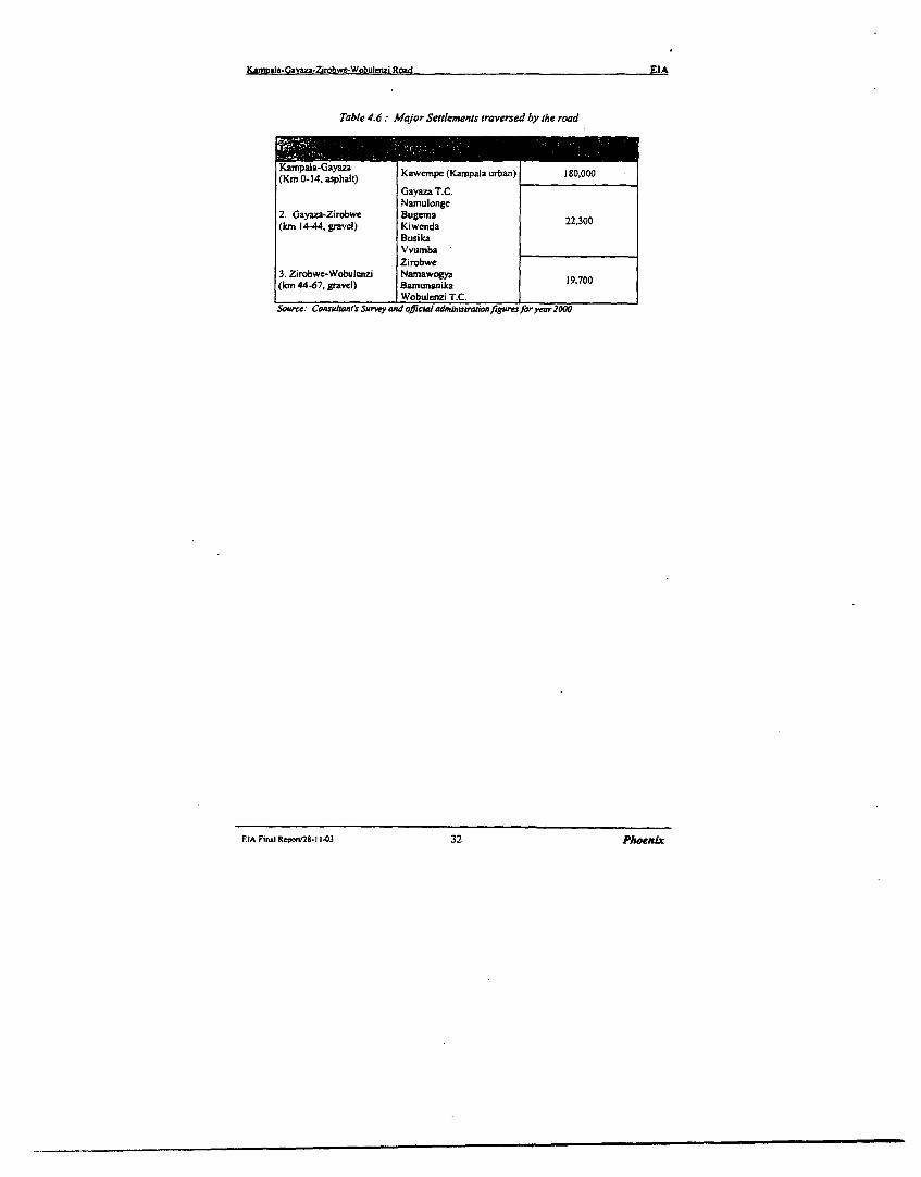
Kamoa-a.Oayaza-Zirobwe-Wobulenzi Road EIA
Table 4.6: Major Settlements traversed by the road
KaIpala-Gayaza KawmF (Kapala urban) IJO,OOO(Km 0-14. asphalt) Kacp(K paarbn10,0Gayaza T.C.Namulonge
2. Gayaza-Zirobwe Bugema(km 14-44, gravcl) Kiwenda 22,300
BusikaVvumbaZirobwe
3. Zirobwe-Wobulenzi Namawogya(km 44-67, gravel) Bamunanika i9,700
_ Wobulci T.C. _Source: Conslant's Surney ald official admizisionfuresforyear2OOO
FDA Final Repor/2S-11403 32 PhoeiLr
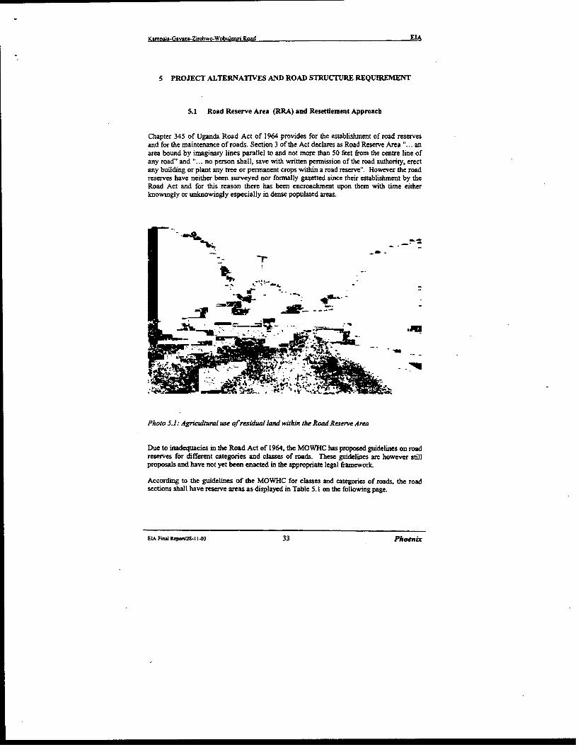
Kamrnala-Gavaza-Zirobwc-Wobulenzi Road EIA
5 PROJECT ALTERNATIVES AND ROAD STRUCTURE REQUIREMENT
5.1 Road Reserve Area (RRA) and Resettlement Approach
Chapter 345 of Uganda Road Act of 1964 provides for the establishment of road reservesand for the maintenance of roads. Section 3 of the Act declares as Road Reserve Area "... anarea bound by imaginary lines parallel to and not more than 50 feet from the centre line ofany road" and "... no person shall, save with written permission of the road authority, erectany building or plant any tree or permanent crops within a road reserve". However the roadreserves have neither been surveyed nor formally gazetted since their establishment by theRoad Act and for this reason there has been encroachment upon them with time eitherknowingly or unknowingly especially in dense populated areas.
_ ~ ~~~ -- : X -_
Photo 5.1: Agricultural use of residual land within theRoadReserveArea
Due to inadequacies in the Road Act of 1964, the MOWHC has proposed guidelines on roadreserves for different categories and classes of roads. These guidelines are however stillproposals and have not yet been enacted in the appropriate legal framework.
According to the guidelines of the MOWHC for classes and categories of roads, the roadsections shall have reserve areas as displayed in Table 5.1 on the following page.
Et Final ReponZS-I 1-03 33 Phoenix
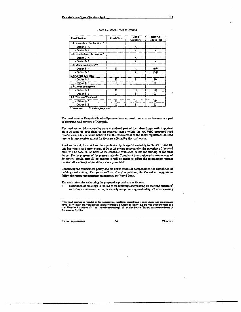
Kmrival-Gavaza-Zimbwe-Wobuleiizi Road EIA
Table 5.1: Road Areas by section
Road Section Road Class Caeor ddth (m)
S.l Kampala-NsoobaStm.. I*Optionl-A I A-Option I- B A A
S.2: Nsooba Strn..- Mpererwe *
-Option2-A l A-Option2-B A -
S.3: Mpererwe-Gayaza**-Option 3- A 11 A (30)-Option 3- B I A (30)
S.4: Gayaza-Kiwenda-Option 4- A ii B 30-Option 4- B II _ B 25
S.5: Kiwenda-Zirobwe-Option 5- A B 30-Option 5- B i B 25
S.6: Zirobwe-Wobuienzi-Option 6- A II B 30-Option 6- B Ill B 25
* Urban rad ** Urbanfringe road
The road sections Kampala-Nsooba-Mpererwe have no road reserve areas because are partof the urban road network of Kampala.
The road section Mpererwe-Gayaza is considered part of the urban fringe with importantbuild-up areas on both sides of the roadway laying within the MOWHC proposed roadreserve area. The consultant believes that the enforcement of the above regulations on roadreserve is inappropriate except for the areas affected by the road works.
Road sections 4, 5 and 6 have been preliminarily designed according to classes II and ILthis implying a road reserve area of 30 or 25 meters respectively, the selection of the roadclass will be done on the basis of the economic evaluation before the stat-up of the finaldesign. For the purposes of the present study the Consultant has considered a reserve area of30 meters, should class I be selected it will be easier to adjust the resettlement inpactbecause all necessary information is already available.
Concerning the resettlement policy and the linked issues of compensation for demolition ofbuildings and cutting of crops as well as of land acquisition, the Consultant stuggests tofollow the recent reconmendations made by the World Bank.
The main pnnciples underlying the proposed approach are as follows:* Demolition of buildings is limited to the buildings encroaching on the road structure5
including maintenance berms, or severely compromising road safety; all other existing
'The road sutnaure is intended as the caeiageway, shoulders, enbanenk t slopes, drains and maintenancebermis. The width of the road structue wrnes according to a number of factors; eg. the road structre width of aclass i1 road with shoulders of 1.5 m, the embankment height of Im. side drains of3m and naintenancebemr of2rn, accounts for 23m.
EIA Fiwl Rpron2S- 11-03 34 Phoenix
Kaniaa-Gavaza-Zirobwe-Wobulcrizi Road EIA
buildings not encroaching with the road will be allowed to remain in place, and aftergazetting of the road reserve the construction of new buildings will be prohibited.
* Crops and trees cutting is limited to crops and trees encroaching on the road structureincluding maintenance berms, trees cutting is also admitted to the ones located beyondthe above mentioned area when they severely compromise road safety.
* Land acquisition will be limited to the area needed by the widening of the existingroad structure.
The evaluation of resettlement cost (see Section 10) has been carried on the basis of theabove principles, however it is worth recalling that cost evaluation has to be reviewed at thelight of the detailed design of the project road.
5.2 The Project Road: Realignment Options
The engineering design for the Feasibility Study has considered realignment of the existingroad in order to comply with requirements of the MOWHC Road Design Manual (RDM) orto improve the alignment for safety reasons, and different road type options forcapacity/economic reasons. The difference between road type options is essentially a changein the carriageway width of 1.0 m (Class I or II) or 0.4 m (Class 11 or 111). This difference isof little significance in terms of environmental impacts when assessed as outlined above.Consequently assessment focuses on the evaluation of alignment options withoutdifferentiating between road type options.
Three alignment options have been studied, although Alignment Option A was abandonedfor engineering reasons. A detailed EIA was carried out for alignment B after having done anenvironmental scooping for the option C. Alignment Option B aims at correcting the lay-outof existing road, whereas Alignment Option C includes major deviations identified to reducethe length of the project road.
Alignment Option B realignments consist of:
* the correction of curves, which currently have radii below the minimum valueestablished by the RDM. These realignments (Table 5.2, following page) will liberatea total of 2.1ha of existing RRA and will, simultaneously, require the expropriation ofland most of which encroaches onto occupied areas.
* the elimination of unnecessary kinks will make for safer vehicle movement. Theseminor realignments will also require the expropriation of 6.5 ha of land and someresettlement of homesteads and crop cutting.
Alignment Option C included four major deviations from the existing alignment to reducethe road length.
* Deviation 1.From km 11+570 to km 14+620. This by-pass will reduce the road length of about 650meters. The present alignment has the double purpose to serve the Gayazacommercial area as well as to allow north-south and east-west traffic. The studieddeviation will allow the traffic -moving north-south on the project road to bypassGayaza. The deviation will encroach on an area near Kasangati which is denselypopulated with the presence of public and private activities (police quarters, prison,schools, cottage factories, etc).
F.A Fiml RepwV25-1 "3 35 Phoenix
Kamnala-Gavaza-Zirobwe-Wobulmzi Road EIA
Table 5.2: Location of minor realignments (Alignment Option B)
Smootbening of Road section Areacurves From km TO km m2Busika 31+685 31+965 3764Bulami 38+150 38+625 7837Janda 41+635 42+020 5612Namawogia 48+600 48+950 3855Sub-Total m2 21068
Magigye 17+520 17+785 4947Bugema 28+490 28+790 3420Bulamni 39+715 39+975 4691Zirobwe 44+500 45+100 9926Nampun^ge 49+110 49+370 2613Nampunge 49+400 50+650 20265Kasenene 51+160 51+540 3411Lukyamu 62+475 62+900 6800Wobulenzi 65+450 66+350 9301
Source: Coasuiant 's Survey
Deviation 2.From km 31+700 to km 33+100. The realignment (about 1200 meters) has beenevaluated in order to eliminate four bends; the road section length will be reduced ofapproximately 200 m. This realignment, crossing an intensive farmed area, has thepurpose of optimising the road design and reduce cost for road users.
* Deviation 3.From km 33+500 to km 39+100. This deviation will reduce the actual length of thissection of road of about 480 meters. The deviation starts at Vvwnba village andtraverses several large banana and coffee plantations, thickets and woodland with thepresence of large aees such as muwafu (Conarium Schweinerfurtbii) and mvule(Melicia Excelsa). Afler coinciding with the existing road at Ndeeba village; thedeviation continues north by-passing the market area of Bulami village. Thisrealignment has the purpose of optiniising the road design and reduce cost for roadusers.
Deviation 4.From lan 48+600 to km 55+700. With the deviation (7.247 Ian), the project roadlength will be reduced of about 1500 meters. After Namawogya trading center, thedeviation leaves the existing alignment and leading north-west enters in aenvironmentally balanced rural babitat. Noticeable is the fertility of the soil and thepresence of the original vegetation. Compoundsr are surrounded by plantations,mainly bananas (matoke). A large number of mangoes and jack fruit trees have beenevaluated on the basis of a representative sample. The area is served by feeder roadsand paths. The deviation follows the feeder road serving Magogo village area andafter crossing Kayiwagobe river, reaches Kikabya and Kisaku village areas where
EIA Final RlepoV28-1 1-03 36 Phoenix
Kamrnala-Gavaza-Zirobwe-Wobulerai Road EIA
turns west to join the project road at Bamunanika. This realignment has the purposeof optimising the road design and reduce cost for road users.
The positive and negative impacts of the studied deviations can be summarised as follows:
* Positive impacts:- Reduction of the length of road with economic benefit for road users.- Improvement of vehicle circulation and road users safety- For deviation n°l, reduction of vehicles pollution due to the diversion of traffic
directed north-south and not needing to stop in Gayaza (deviation n° 1). Thereduction will not be significant because North-south transit traffic accounts for16% of the total traffic of the road section.
- Valorisation of agricultural production in neighbouring areas (deviation n° 4)
* Negative impacts:- Expropriation of farmland- Destruction of trees and crops- Dislocation of a large numnber of homesteads and consequent involuntary
resettlement (mainly for deviation n° I and 4).- Disruption of on-going commercial activities along the existing alignments
(deviations n° 2, 3, and 4).- Great disturbance of a well balanced habitat (deviation n° 4).- Exclusion from the upgraded road of Bamunanika health centre, teacher's college
and part of the commercial centre (deviation n° 4).
The proposed deviations together wiLI reduce the length of the project road of about 3kilometers and perhaps will reduce also the construcion costs. The deviations will notinterfere negatively with the surrounding environment since it is the same environmentcrossed by the existing road, but some reflections on the validity of deviations, apart fromthe positive and negative impacts mentioned above, should be taken into account.
* The sections of the existing road excluded by the deviations do not present eitherengineering difficulties or problematic impacts on the environment and resettlementcaused by the road upgrading works.
* The road Gayaza-Zirobwe-Wobulenzi, the secton of project road where the proposeddeviations are located, is not an arterial road like the Kampala-Wobulenzi-Gulu road.Traffic is limited and mainly directed to the rural settlements actually linked by theexisting road.
* The deviations will cut-off economic activities already established along the excludedroad sections and will penalise people that have invested in such activities.
* The deviations will encompass intensive farmed areas, causing the destruction ofabout 25 hectares of cultivated land, mostly subsistence crop fields. For the affectedfarmers will be difficult to found new land for farming. At the same time more than100 homesteads, encroaching the deviations, risk to be dislocated with the consequentresenlement problem. It is interesting to notice that during consultation meeting withsakeholders, farmers were more worried to loose the farm than to have the housedisplaced. Almost the totality of farmers are squatters and have no title on land buttheir subsistence and incomes depend on the land they are farming. In exploited areas,
EIA Finail RepourRS-I 1.03 37 Phoenix
Kamnal-Gava7za-Zirobwc-Wobujcnzi Road EIA
like the ones encompassed by the deviations, will be difficult for displaced people tofound new land for farming.
* The rising of land prices and the settlement of new comers along the deviations, willturn badly for rcsident farmers and maybe cause of discontent and conflicts.
in the light of the above reflections, the solution to upgrade the existing road by Realignmentoptions B was considered for environmental assessment
EIA Final RI epW2811-03 38 Phoenix
Kamnala-Gavaza-Zirobwc-Wobulanzi Road EIA
6 ENVIRONMENTAL LMPACTS AND MMGATION
6.1 General
In line with the Terms of Reference, the study has adopted the environmental assessmentmethodologies advised by the World Bank the National Environment ManagementAurthority guidelines and the Statute (1994 and l 995 respectively), to analyze the direct andindirect impacts stemming from:* the road construction process, and:* the use of the road after its opening to service.
Accordingly, the impacts are categorized taking notice of:a. their relations with the project : direct and indirect impactsb. environmental receptors: ecosystems, human habitat
a. Direct and indirect imnacts: Upgrading project road will exert direct short term impactslimited to the construction period. Direct long-term impacts will appear during and afterconstruction, related both to road construction works and the subsequent moderate increasein traffic volumes. Indirect impacts will stem from multiplier effects on ecosystem andhuman habitat, induced by increase in traffic volumes and greater accessibility throughoutthe project area.
b. Enviromnental receotors have been distinguished into two categories:natural ecosystems: forests, grasslands, swamps, with their characteristic wildlife
* human modoeiud ecosystems: focusing upon the farmlands, range land andconstructions affected by road upgrading works (dislocation and resettlement)
Table 6.1 on the following page displays an overview of the direct and indirect impactsgenerated by Kampala-Gayaza-Zirobwe-Wobulenzi Road Upgrading Project, specifyiag theenvironmental and social receptors, the sources of impact and the related time frame.
6.2 Irapact Evaluation Approach
The impacts of the project road upgrading are assessed in relation to the Construction phascand the Post construction phase since the control and mitigation of the two phases areundertaken by different agencies.
The Construction phase includes all impacts resulting from the construction of the road andthe activities of road construction itself These will largely be under the control of theContractor under the supervision of MOWHC.
The post-construction impacts are the more indirect impacts resulting from the changes inthe environment due to the road upgrading.
EIA Finlu Rpor/2S 11-03 39 Phoenix
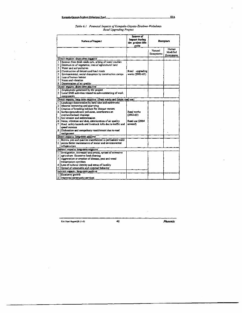
Kamnala-Gavaza-Zirobwe-Wobulenzi Road EIA
Table 6.1 Potential Impacts of Kampala-Gayaza-Zirobwe-WobulenziRoad Upgrading Project
Soorce ofNatre of Impct lnkpact during Recepton
tbe project life-cycle
Natural HumanNtrl ModifiedEcosystcms Ecosysterns
Dirct impacts: short-term negativeI Erosion from fresh roads cuts, silting of watcr courses2 Destruction of vegetation, loss of agricultural land3 Water and soil pollution4 Construction of detours and haul roads Road upgrading5 Environmental, social disruption by construction canps works (2002-03)6 Loss of human habitat7 Noise and vibration
I Deterioration of air qualityDirect impacts: shon-tern positiveI Employment geneated by the project2 Local SME activities related to sub-contracting of work
componentsD -rct impacts: long-term negative (trom works and future road uselI Landscape deterioration by land take and earthworks2 Material borrowing and quarrying3 Creation of breeding habitats for disease vectors4 Surface/groundwater pollution, interference on Road works
overland/subsoil drainage (2002.03)5 Soil erosion and sedimentation6 Noise, vibration and dust, deterioration of air quality Road use (20047 Road safety hazards and livestock kills due to traffic and onward)
speed increase8 Dislocation and compulsory resettlement due to road
_ realignmentDirect impacts: long-term positieI Borrow pits and quarries transformed in permancnt water2j points Better maintenance of social and environmental
infrastructureIndirect impacis: long-term negativeI In-migration, increased land prices, spread of extensive2 agriculture Excessive land clearing3 Aggravation or creation of disease, pest and weed
transmission corridors4 Loss of cultural identity and sense of locality5 Spread of unsociable and criminal behaviorIndirect ampact. long-term positive1 Economic growth2 Improved community services
EIA Final Report25-1 1-03 40 Phoenix

Kampala-Gavaga-Zirobwe.Wobulenzi Road EIA
6.3 Environmental Impacts of the Existing Road
The environmentally negative impacts exerted by the present unpaved road include:- deterioration of air quality- noise of vehicular movement, enhanced by low-speed driving- dust during non-rainy periods, water stagnation in wet seasons- traffic accidents
6.3.1 Health Effects Of Present Road UseSome of the impacts of present traffic may affect the health of village residents along theroad, causing lung and bronchial disorders. Clouds of dust may also cause accidents byhindering visibility to drivers. Traffic growth has been restrained, in part due to the poor roadcondition, curbing such negative impacts as air pollution and noise. From the socialviewpoint, however, limited accessibility hinders the development of health services, leadingto lower possibility to cure the diseases related to the poor environmental quality of theexisting road. Similarly, water supply infrastructure suffers from lack of maintenance,compounded by transport cost and difficult accessibility. Therefore, local communtrities relymore and more on polluted water sources, adding to the critical picture of human ecologyfeatures across large tracts of the project area.
63.2 Current Traffic AccidentsOf all the places along the Kampala-Gayaza-Zirobwe-Wobulenzi road, Zirobwe-Wobulenzisection seems to be the most prone to accidents. The accident rate of this road section isundoubtedly due to the narrow road conditions. Table 6.2 presents the traffic accident datarecorded for Gayaza-Zirobwe-Wobulenzi road over the last decade.
According to local police officers, most accidents reported on the gravel section are notsevere and mainly involve cyclists and school children. As a matter of fact, only two fatalaccidents, caused by capsized vehicles, occurred over the last two years. No real black spothas been identified by the traffic police, save the small section linking the rural centre ofBamunanika (km 57.2) and the Lutete Junction (km 56.2), one km away. This part of theroad is narrow, saggy and lined by schools, one health center and a weekly market area. Stillaccording to the police, accident relief services are inadequate and victims wait a long timebefore being attended by traffic police, ambulances and wreck hauling trucks.
Table 6.2 Traffic accidents along Gayaza-Zirobwe- Wobudenzi Road. 1989-99
Year Ma~~NjorYear Accidents
1989 71990 101991 61992 71993 131994 171995 121996 151997 9199S 111999 12Total 119
Sources: Police slauons in Zirobwe. Bumunanika and Bugema
EIAFinalReponS28-11403 41 Phoenix
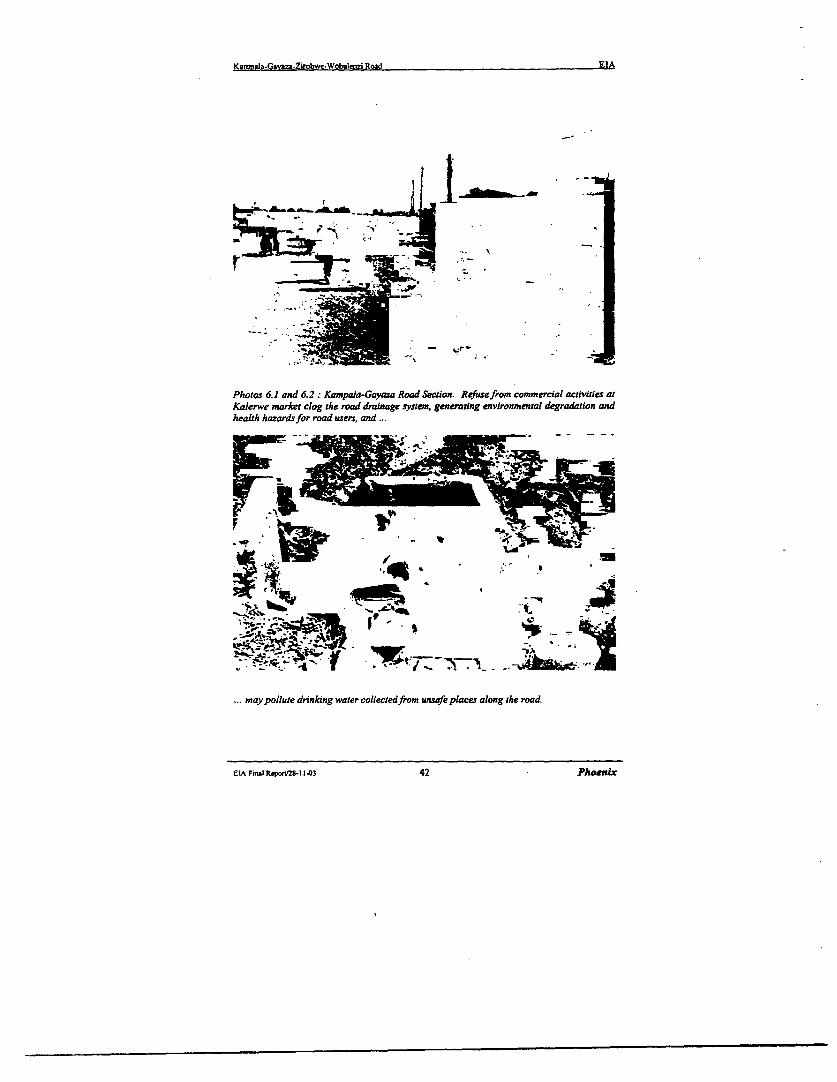
Kamopala-Gavza-Zirobwe-Wobuleo7i Road EIA
T~~~~~~~~~~~
Photos 6.1 and 6.2: Kampala-Gayaza Road Section. Refutsefrom commercial activities atKalerwe market clog the road drainage system, generating environmental degradation andhealth hazardsfor road users, and
q~ jit> -
may pollute drinking water collectedfrom unsafe places along the road.
eLA Fitui Repor/28-11403 42 Pheenix
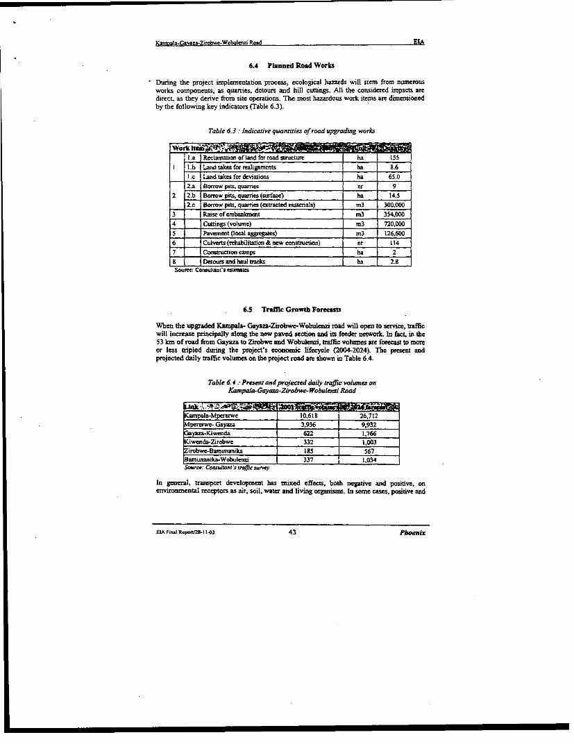
Kamnala-Gavaza-Zirobwe-Wobuienzi Rood EIA
6.4 Planned Road Works
During the project iniplementation process, ecological hazards will stem from numerousworks components, as quarries, detours and hill cuttings. All the considered impacts aredirect, as they derive from site operations. The most hazardous work items are dimensionedby the following key indicators (Table 6.3).
Table 6.3: Indicative quantities of road upgrading works
Wori;n_ S_ _La Reclaation of land for road structure ha 155
1 L.b Land takes for realignments ha 8.6I .c Land takes for deviations ha 65.02.a Borrow pits, quarries nr 9
2 2.b Borrow pits, quarries (surface) ha 14.52.c Borrow pits, quarries (extracted materials) m3 300,000
3 Raise of embanrnent m3 3540004 Cuttings (volutme) m3 720,0005 Pavement (ocal aggregates) m3 __6,600
6 = 0 Culverts (rehabilitation & new construction) nr 1147 Construction camps ha 28 Detours and haul tracks ha 2.8Source: Consultant's estimates
6.5 Traffic Growth Forecasts
When the upgraded Kampala- Gayaza-Zirobwe-Wobulenzi road will open to service, trafficwill increase principally along the new paved section and its feeder network. In fact, in the53 km of road from Gayaza to Zirobwe and Wobuleazi, traffic volumes are forecast to moreor less tripled during the project's economic lifecycle (2004-2024). The present andprojected daily traffic volumes on the project road are shown in Table 6.4.
Table 6.4: Present andprojected daily traffic volunes onKamzpala-Gayaza-Zirobwe-Wobulenzi Road
iZ .~., t , .z, '.^^
Kampala-Mpererwc 10,618 26,712Mipererwe- Gayaza 3,936 9,932G3ayaza-Kiwenda 622 1,766LKiwenda-Zirobwe 332 1,003Zirobwe-Bamunanika 185 567
unanika-Wobulcnzi 337 1.034Source: Consultant'S traffic survey
In general, transport development has mixed effects, both negative and positive, onenvironmental receptors as air, soil, water and living organisms. In some cases, positive and
EIA Final Report2S-I 1.03 43 Phoenix
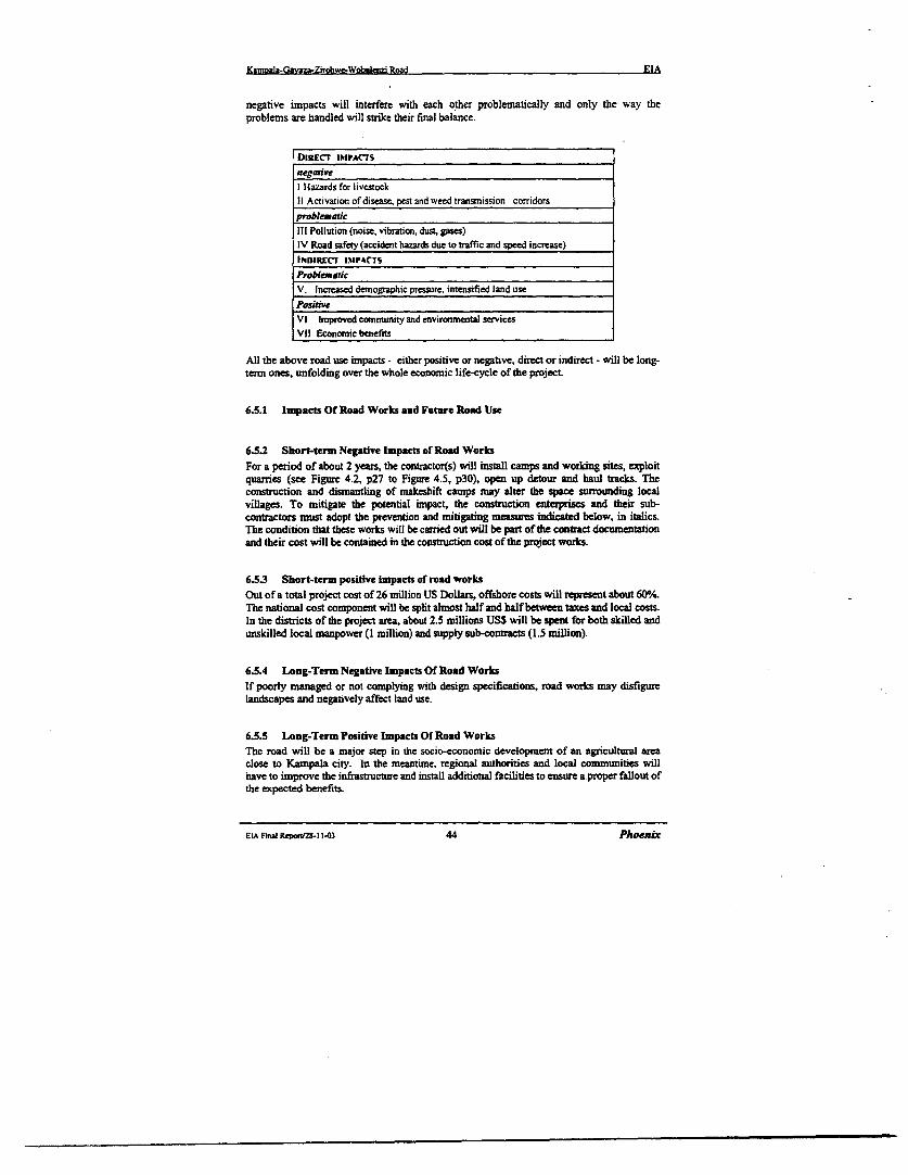
Ksmpala-Gavaz-Zirobwe-Wobulenzi Road EIA
negative impacts will interfere with each other problematically and only the way theproblems are handled will strike their final balance.
i DR1ECr IMPACTSnegative
I Hazards for livestock_I Activation of disease, pest and weed transmission corridorsproblematic
III Pollution (noise, vibration, dust, gases)IV Road safety (accident hazards due to traffic and speed increase)I14DIRECT 1I%§PCTS
Problematic
V. Incressed demographic pressure. intensified land usePosithveV] Improved community and environmentl servicesVIl Economic benefits
All the above road use impacts - either positive or negative, direct or indirect - will be long-tern ones, unfolding over the whole economic life-cycle of the project
6.5.1 Impacts Of Road Works and Future Road Use
6.5.2 Short-term Negative Impacts of Road WorksFor a period of about 2 years, the contractor(s) will install camps and working sites, exploitquarries (see Figure 4.2, p2 7 to Figure 4.5, p30), open up detour and haul tracks. Theconstruction and dismantling of makeshift camps may alter the space surrounding localvillages. To mitigate the potential impact, the construction enterprises and their sub-contractors must adopt the prevention and mitigating measumes indicated below, in italics.The condition that these works will be carried out will be part of the contract documentationand their cost will be contained in the construction cost of the project works.
6.53 Short-term positive lmpaets of road worksOut of a total project cost of 26 million US Dollars, offshore costs will represent about 600/.The national cost component will be split almost half and half between taxes and local costs.In the districts of the project area, about 2.5 millions USS will be spent for both skilled andunskilled local manpower (I million) and supply sub-contracts (1.5 million).
6.5.4 Long-Term Negative Impacts Of Road WorksIf poorly managed or not complying with design specifications, road works may disfigurelandscapes and negatively affect land use.
6.5.5 Long-Term Positive Impacts Of Road WorksThe road will be a major step in the socio-economic development of an agricultural areaclose to Kampala city. In the meantime, regional authorities and local communities willhave to improve the infrastructure and install additional facilities to ensure aproper fallout ofthe expected benefits.
ELA Finl, RepoV/28-11.03 44 Phoenix
Kamoala-Gavaza-Zirobwe-Wobulnzi Road EIA
6.5.6 Direct Impacts Of Future Road UseThe direct impacts of additional traffic on the physical and social environment will be eithernegative or problematic. All of them are potentially long-term ones. In general, however,such impacts will not represent a severe deterioration as compared with the present situation.
6.5.7 Negative Impacts:The present ecological conditions in project area can be aggravated by rapid demographiicincrease and the consequent spreading of settlements and farns over increasingly marginalsoils. The residual natural resources are concentrated in the wetlands in the northern part ofthe project area. In dry lands, almost all suitable land for farming has been exploited, wipingout most of the original vegetation. The vegetation cover will disappear and will takeconsiderable time to recover to its natural state. This is most especially where borrow pitsand Quarry sites exploitation will be effected. The natural status of the eco-system of suchaffected sites will be changed and serious rehabilitation will be called for.
Exploitation of the Quarry site and Bonrow pits will generate stone dust that will affect thenear by communities. Blasting and noise from equipment and the risks of flying will affectfarming acvtivities and settlement at such locations.Estalishment of Contractor labour canpswill exert pressure on the existing stock of the fuel wood in the area .Fuelwood will berequired in heating the Bitumen and cooking at construction camps.
There is likely growth of demographic density, along the project road. The road will act asa pulling factor in respect to attracting linear setlements. More pressure on the availablesocial services is expected.
Road upgrading brings about great benefits in terms of access to potential farmlands, cropmarketing opportunities and multiplier effects on regional rural revenues, natural resourcesoften bear the hidden costs of such development. To curb the costs of environmentaldegradation entailed by increased pressure of population and economic activities on thenatural resource base and achieve sustainable rural growth, protection measures must begradually phased in.
6.5.8 Positive, Indirect Impacts Of Future Road UseAmong the transport-depending economic and administrative activities, those ones whichdeserve greatest attention in terms of supportive investments are public services.
6.5.9 Impacts and Mitigation Measures
Below is a description of the expected impacts and the recommended mitigation measures.The significance of the identified impacts is rated in Table 6.7, page 56, on a scale of low:moderate: high.
ELA Final Repwl28-1 1-43 45 Phoenix
Ka?n?l-Gavsza.ZirObweC-Wobulenzi Road EIA
6.5.10 Biophysical Environment
6.5.10.1 Erosion from new road works
Expected impactsErosion, caused by wrong work methods leaving soils unnecessarily exposed, stems fromexcavations, detours, haul tracks and may lead to silting of natural drainage ways.
Recommended mitigation measuresAs road works proceeding, abandoned excavations, detoursthaul tracks will be ripped up andtopsoil reinstated.
6.5.10.2 Water and soil -llution
Expected impactsDue to construction methods or accidental spiDage, works may polute soil and waterespecially at river and swamp crossings. Culverts will be installed or upgraded all along theroad, discharging particulate matter and stirring river bed deposits into suspension. Whilelarge suspended parts settle quickly, the finer ones last longer, but turbidity will be short-lived since stream crossings are built in a few weeks. Drainage channels will be dug to drainrun-off from the road surface and its vicinity. In flat terrain, drainage channels will beprolonged claiming land take. In rolling terrain, as off-side structures may erode the soilcausing pollution of water sources and lakes. Workers will dispose human and associatedexcreta a short distance from the road under repairs. This could lead to spread of gastro-enteric diseases through contamination of water resources with the human waste.
Recommended mitigation measuresAs the road crosses permanent and seasonal wetlands, care should be taken in theconstruction of culverts. Water for coostuction will be drawn from surface waters and nolong-term impact on aquifers is expected, as works will not demand exhaustive wateramounts. Accidental spillage of fuel or chemicals is a risk, but spillage is likely to be localand remediation should be easy. Spillage to water course is harmful for all living beings. Thecontractor must exercise utmost care to avoid such hazards. Proper pit latrines for roadworkers shall be installed. Careless behaviour will be sanctioned
6.5.10.3 Air pollution and dust
E:pected mpactsThe existing road environment is extremely dusty in dry weather due to vehicles traveling athugh speeds along the road. Roadside plants and crops are covered with a thick layer of dust,which must reduce yields of the crops. Local residents are constantly exposed to high levelof dust, which must also cause health problems.To transport workers to/from sites, it has been assumed, for the purposes of assessment, thatthree camps will be built, that occupy 9 Ha. in total. The camps will be located near Gayaza,Zirobwe. For logistic purposes may a small camp is needed at Wobulenzi. Heavy machineswill open detours or haul tracks and excavate pits. In dry weather, dust will disturb localpeople. Hot asphalt will generate hazardous smoke fumes to the environment. Constructionworkers will be exposed to high levels of dust over the construction period.
EIA FmalI Rornaj8I 1i03 46 Phoenix

Kamnala-Gavaza-Zirobwe-Wobulenzi Road EIA
Recommended mitigation measuresThe nuisance will be tranSient and good work practice will curb it. Dust is already an every-day nuisance close to the existing gravel road. Wetting with water the detours and haultracks as well as the road under construction will minimize dust. The contractor will adviselocal households on dust and other dangers.The construction of a sealed road will eliminate the existing problems of dust during dryperiods. The respiratory problems associated with dust should therefore be significantlyreduced when the road uograde is completed
6.5.10.4 Noise and vibration
Expected impactsPlant and construction traffic will make vibration and substandard houses close to the roadmay collapse. The noise from construction plant will interfere with school learning activitiesand worship in mosques and churches within the road area.Vibration and gas emission will increase with the increasen in traffic after the road isupgraded.
Recommended mitigation measuresDuring construction, the nuisance will be transient and good work practice will curb it. Thecontractor will advise local households schools and institutes on noise, vibration and otherdangers.After construction, forecast traffic growths are moderate. Speed limits and exhaust emissioncontrols must be enforced, especially in towns. Hedges and trees must be planted along theroad. Traffic police, forestry staff, local coninunities and road users must be mobilised.
6.5.10.5 Landscape deterioration by earthworks
Expected impactsThe upgraded road will require new land take along the gravel road section. About 21,000sqm of soil will be exposed to erosion by the cuts. The project road traverses some plainsand wetlands on small embankments, which require raising. Quarrying entails vegetationclearing and transportation of materials, causing unsightly effects. Quarrying and disposalcan destroy the economic and aesthetic value of land. Abandoned borrow pits along theexisting road are example of their damaging effects.
Recommended mitigation measuresThe design cut/fill balance minimises net materials import. Good construction methods willminimise visual impairment. The exposed cut areas be planted with grass; ideally a mixtureof indigenous grass seeds (paspalum grass). Re-passing should be carried out in stages asconstruction proceeds. This will reduce erosion and sedimentation. Slope failures ofembankments will be minimised by implementing the road design manual recommendations.In addition, borrow pits should be rehabilitated after use and this should be done by thecontractor according to MOWH&C General Specifications. The contractor should undertakethe borrow-pit rehabilitation work in consultation with the land owner.
ELA Final lteponI28-1103 47 Phoenix
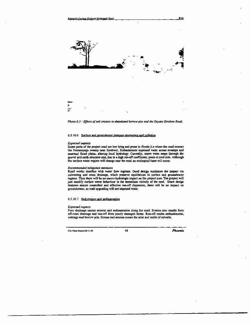
Ka&njla-Gavaza.ZiTobwe-Wobulenzi Road EIA
-~ ~ ~ ~ ~ ~ ~ ~ ~ ~~~-a
Photo 6.3 Effects of soil erosion in abandoned borrow pits and the Gayaza-Zfrobwe Road
6.5.10.6 Surface and rzroundwater drainaae obstruction and nollution
Expected impactsSome parts of the project road are low lying and prone to floods (i.e where the road crossesthe Namunyaga swamp near Zirobwe). Embankments inpound water across swaxmps andseasonal flood plains, altering local hydrology. Currently, storm water seeps through thegravel and earth structure and, due to a high run-off coefficient, pools at road side. Althoughthe surface water regime will change near the road, no ecological harm will occur.
Recommended mitigation measuresRoad works interfere with water flow regimes. Good design mizumises the inpact viaculverting and cross drainage, which presrve equilibriunm in surface and groundwaterregime. Thus there will be no macro-hydrologic impact on the project area. The project willjust nodify surface water behaviour in the immediate vicinity of the road. Since designfeatures ensure controlled and effective run-off dispersion, there will be no impact ongroundwater, as road upgrading will not impound water.
6.5.10.7 Soil erosion and sedimentation
Expected impactsPoor drainage causes erosion and sedimentation along the road. Erosion also results fromoff-road drainage and run-off fromn poorly managed farms. Run-off erodes embankments,cuttings and borrow pits. Stream bed erosion scours the inlet and outlet of culverts.
EIA Final RcponIs. 1-03 48 Phoenix
Kam=ab-Gavaza-Zirobwe-Wobulenzi Road EIA
Recommended mitigation measuresCareful engineering design and re-vegetation will control erosion of embankment, drains andadjacent land. Improper works management may spark erosion processes and scar adjacentslopes. Erosion prevention measures foresee that all areas impacted by the works be re-vegetated using reinstated topsoil with local species as soon as the sites are closed. Localenvironmental authorities will inspect that such rules are complied with.
6.5.11 Human Environment
6.5.11.1 Lossoffarrnlandandhabitat
Expected impactsCrops, trees, topsoil will be cleared from the project road alignment. Haul tracks will beopened for wagons to shuttle to/from pits, with extensive bush clearing. Camps and detourswill also be created. Works will disturb habitat close to the road. The impact of this iscumulatively quite high, but the major impact is to the farmers or land owners resident in theareas interested by the road works.
Recommended mitigation measuresNo protected species is likely to be disturbed. As most of road upgrading works will interestthe existing alignment, the impact on fatnland and habitat will be small. On minorrealignments and deviations, vegetation clearance should be limited to the area effectivelyneeded for road construction. Farmers will be warned to harvest on time and compensated tocreate new farms. Land is available near the villages, so the harm should not be great. Cropsand planted trees will be reinstated on completion.l8 borrow pit sites, 15 of which arealready under exploitation, have been already identified. According to the estimated potentialof existing borrow pits, opening of new pits may not be necessary.
6.5.11.2 Safety risks durina construction
Expected impactsThe working site is a dangerous place. Children are vulnerable to heavy plant andmachinery. Public safety may be a problem in two areas: (a) The immnediate vicinity of theplant. (b) the detours around the working front, unfamiliar to drivers and of lower standardsthan permanent roads. There will also be additional traffic on the detours for constructionneeds.
Recommended mitigation measuresPlant operators must ensure that children are not allowed close to the machines. Accidentsare likely to occur to labourers. Effective management of the camps and working sites willprevent nuisance and accidents. Detours and temporary haul tracks shall be well planned,signed and maintained to reduce safety risks for drivers and pedestrians.
6.5.11.3 Health hazards
Expected impactsRoad construction exposes the labourers and the general public to bronchial and otherpathological risks. Moreover, the most serious health concern haunting local conmmunities isAIDS-HIV. The disease can spread as a result of the influx of construction workers intoareas. Even though the rate of infection is already high both in Kampala suburbs and thesettlements along the road, the presence of the worker may further accelerate the epidemic.
EIA Fi-I Repn/2S- 1143 49 Phoenix
Kaznala-Gavaza-Zirobwc-Wobulenzi Road EIA
Recommended mitigation measuresProvision of working figures and good camp management is required. First aid facilitiesshall be installed in all camps. AIDS-HIV should be closely monitored under theresponsibility of the medical unit of the Contractor(s), which should proceed to regularchecks of the health status of the workers. One NGO, Plan International, is present in thearea and is already operates AIDS-HIV monitoring facilities in the districts traversed by theroad.
6.5.11.4 Employment generated by the oroiect
Expected impactsRoad works will create job opportunities for some 100 workers recruited on the spot alongeach particular road section, with the advantage of social harmony between the workers andlocal communities. The influx of labour will also increase commercial revenues, thanks tomultiplier effects.
Recommended enhancement measuresWorkers should be briefed by the contractor on their tasks and the prevention of inherentrisks. The contractor will also be responsible for on-theob training of semi-skilled labourforce. Work certificates will be given to skilled and semi-skilled workers by the contractorand the Labour Office upon good performance.
6.5.11.5 Benefits for local SME
Expected impactsPart of the works will be sub-contracted to local enterprises, with economnic spill-overbenefits in terms of multiplication effects and spread of construction know-how and privatesector capacity building.
Recommended enhancement measuresThe Contractors will be given a roster of local SME by the competent regional authorities.International credit lines should be mobilised in due advance to support local entrepreneurialcapacities in connection with the project.
6.5.11.6 Water-borne diseases.
Expected impactsAbandoned pits and quarries filled with rain water may represent a danger for children.Stagnant water in borrows pits and quarries becomes breeding habitats of pests and diseasevectors (malaria, schistosomiasis, d etc.).
Recommended mitigation measuresThe contractors will reinstate, in consultation with the local comnmunity, the borrow pits andquarries areas to permit the re-establishment of vegetation. The Consultant suggests to planttrees for charcoal and firewood production (i.e. gassia "cassia spectabilis", omusasasapium ellipticumw) or for timber and environmental protection (i.e. mvule " melicia
excelsa ).
EL Final Re2poll- 1.03 50 Phoenix
KamDala-Gavaza-Zirobwe-Wobulenzi Road EIA
6.5.11.7 Displacement and Involuntary Resettlement
Expecaed impactsResettlement of homesteads encompassing the RRA will not be the major issue where theproject road follows the existing alignment The impact on resettlement will be much higherin the areas where minor realignments are foreseen by the road works. The smoothening ofcurves (mainly located in village trading centres) and rectification of kinks will affect homesand shops.
Recommended mitigation measuresThe Consultant has taken into consideration the possibility of relaxation when the projectroad encroaches some villages, but there is still sufficient width to construct the road, toallow the buildings to stay in the road reserve.
Displacement and involuntary resettlement impacts are detailed in section 8.
6.5.11.8 Extansion of the feeder road network
Expected impactsThe road project area is densely settled, with scattered hamlets and homesteads. Thedevelopment of service roads and detours during the construction phase will enable someexisting tracks and footpaths to be transformed into motorable feeder roads.
Recommended enhancement measuresIn collaboration with local communities, the Local Governments should select the serviceroads and detours which can be usefully transformed mto pennanent feeder roads. Thecompetent authorities should earnark the funds and the local participation to ensure theirmaintenance after the end of the road upgrading works. The integration of the new feederroads into the rural transport network is likely to regard a total length estimated at about 15km.
6.5.11.9 Hazards for livestock
Expected impactsSmall herds trek along the shoulders of the project road in Luwero district and animals crossthe road itself
Advised mitigation measuresSpeed limits and installation of road signs indicating the presence of cattle, especialy on thestretch between Bulami (kIm 37,0) and Bamunanika (km 57,0), will help curbing accidentrisks. The collaboration of traffic police and local communities will be essential.
6.5.11.10 Activation of transmission corridors of diseases. ests and weeds
Expected impactsThe upgrading of the road makes will enhance this impact. Congestion in settlements alongthe road may intensify diseases as malaria, dysentery, meningitis, measles, aids, or sparkepidemics as cholera, typhoid.
ELA Final Repon2S-1103 51 Phoenix
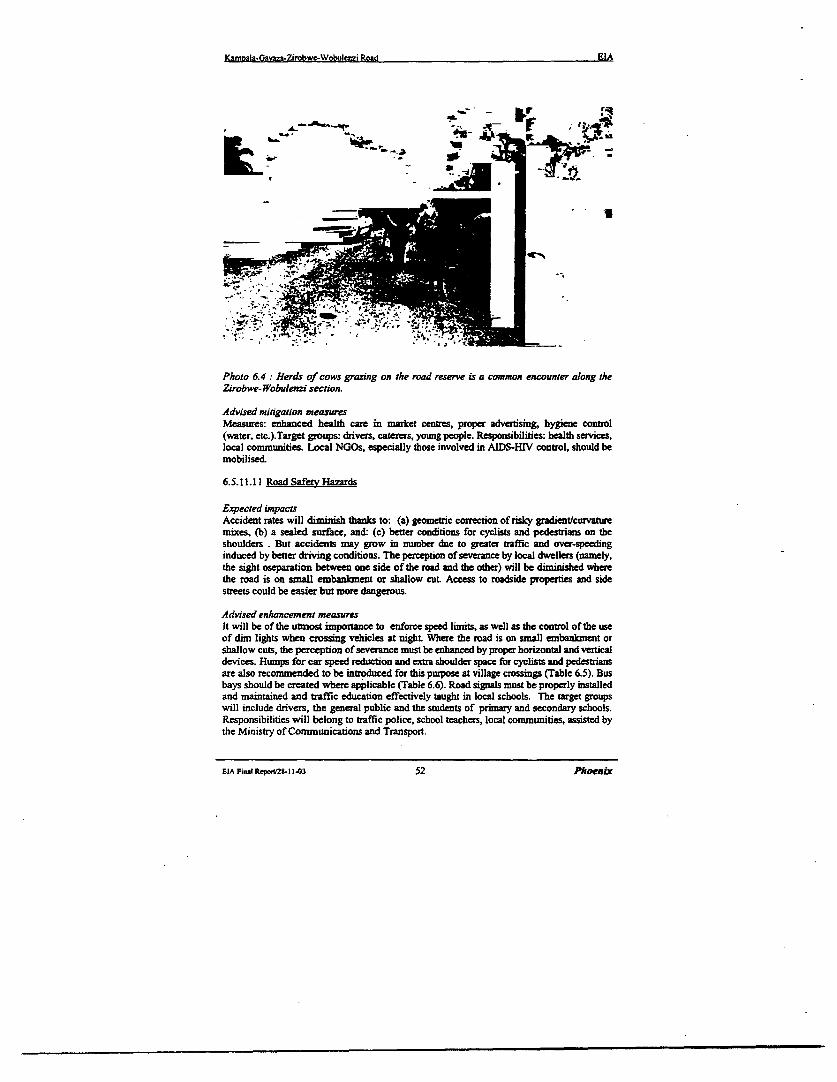
Kanmala-Gavaza-Zirobwe-Wobuienzi Road EIA
- -S C I-r
~~~~~~~~~~- U
Photo 6.4 Herds of cows grazing on the road reserve is a common encounter along theZirobwe-Wobuienzi section.
Advised mi igation measuresMeasures: enhanced health care in market centres, proper adverinsmg, hygiene control(water, etc.).Target groups: drivers, caterers, young people. Responsibilities: bealth services,local communities. Local NGOs, especially those involved in AIDS-HIV control, should bemobilised.
6.5.11.11 Road Safety Hazards
Expected impactsAccident rates will diminish thanks to: (a) geometric correction of risky gradient/curvaturemixes, (b) a sealed surface, and: (c) better conditions for cyclists and pedestrians on theshoulders . But accidents may grow in number due to greater traffic and over-speedinginduced by better driving conditions. The perception of severance by local dwellers (namely,the sight oseparation between one side of the road and the other) will be diminished wherethe road is on small embankment or shallow cut. Access to roadside properties and sidestreets could be easier but more dangerous.
Advised enhancement measuresIt will be of the utmost importance to enforce speed lirnits, as well as the control of the useof dim lights when crossing vehicles at night Where the road is on small embank2nent orshallow cuts, the perception of severance must be enhanced by proper horizontal and verticaldevices. Humps for car speed reduction and extt shoulder space for cyclists and pedestriansare also recommended to be introduced for this purpose at village crossings (Table 6.5). Busbays should be created where applicable (Table 6.6). Road signals must be properly installedand maintained and traffic education effectively taught in local schools. The target groupswill include drivers, the general public and the students of primary and secondary schools.Responsibilities will belong to traffic police, school teachers, local conmunities, assisted bythe Ministry of Communications and Transport.
ElA Final Req/2I8-1 1-03 52 PhoernlX

Kazmiala-Gavza-Zironbwe-Wobuienzi Road EIA
Table 6.5 : Location of extra shoulders in village crossing
14.0 Gayaza 40017.7 Magigye 20020.5 Busukuma 20022.6 Namulonge 40025.2 Kiwenda 30026.8 Lukyamu 20028.0 Bugema 30031.1 Busika 20033.5 Vvumba 20037.9 Bularni 20044.2 Zirobwe 70049.3 Namawogya 30055.5 Lutete 20058.0 Bamunanika 40061.9 Lukyarnu 20067.0 Wobulenzi 400
Source: Field survey
Table 6.6: Location of bus bays
23.1 DispensaryNamulonge 60025.4 Kiwenda junction 60028.4 Dispcnsary Bugama 60032.1 Dispensary Busika 60044.5 Taxi park Zirobwe 60049.2 Namawogyajunction 60057.0 Health Centre Bamunanika 600
'.int .-T 2XEV],Source: Field survey
6.5.11.12 Increased demo=eanhic pressure and unsustainable land use
Expected impactsIn-migration will raise pressure on laind, boosting ribbon development along the road andtriggering land price rises. Higher prices of land are often viewed as positive impacts, whichthey might be when everyone owns their land. Less than 30N of the people own their land inthe project area, so that the benefits of price rises will be felt by a minority, while the greatmajority will feel the disadvantages of hire rents. Farms will be bought by newcomers.Albeit consensual, such transactions will create landless households, pushing margina]
EIA Final Repo.28t11.03 53 Phoenix
Kamwala-Gavasa.Zirobwe.Wpbulenzi Road EIA
farmers to seek land in remote places and spreading extensive, environment-hostilecultivation practices.
Advised enhancement measuresTown planning capabilities must be strengthened to prevent congestion of construction justbeyond the road reserve area. Rural co-operatives and credit lines -hould be assisted in orderto sustain smallholders and avoid excessive sale of farmlana to commercial farmingcompanies. Agricultural extension networks should also be fortified, in order to ensuresustainable cropping patterns and avoid soil depletion due to practices maximisingimmediate returns, as it usually happens when land is leased by owners to landless farmerswho care for just immediate return and neglect the long-term effects of poor soilmanagement.
6.5.11.13 ImDroved Community and Environmental Services
Expected impactsImproved transport will help the distribution of drugs. Patients will receive faster medicalattention. Health workers will enjoy easier access to work places. More doctors and nursesmay reach the northern part of the project area.
Advised enhancenent measuresRegional investment budgets should target the rehabilitation of water supply, rural and urbanhealth services and educational facilities, taking advantage of lower transport costs and betteraccessibility to the road influence zone.
6.5.11.14 Economic benefits
Expected impactsTraffic increase will benefit the national and local economy, stimulating investment andintensifying trade. Household eamnings should improve as a result of better access to the area.Farmers can be able to sell produce from stalls on the roadside and additional jobs will becreated with the development of new small scale industries along the road. At the same time,public services will become more diffuse and delivered at cheaper costs. The fallout of suchbenefits will however be constrained by the lack of ancillary facilities to receive additionaltraffic and sustain the offer of local products and private, public services.
The cost of crops hauled from the project area to Kampala urban markets will be reduced. Atpresent, food staple crops as banana plantain (matoke) and sweet potatoes (hmnonde) aretransported to Kampala from Kalagala, Zirobwe and Bamunanika production areas at thecost of 450-500 and 900-1100 USh per ton/kzm, respectively. Due to the road conditions,mainly pick-up cars are utilized along the project road for the transport of staple crops,keeping high the transport costs. The likely cost after the rehabilitation of the road isexpected to drop respectively to 350-400 and 650-700 USh per ton/km as the same rates paidutilizing trucks on the tarmac road Wobulenzi-Kampala via Bombo. A lowering of thesupply cost will increase the quantities sold on the market. In fact, although the farmlands ofthe project area are fully exploited and in some cases overexploited, the farmers will havethe opportunity to intensify crop productivity, re-injecting transport cost savings in thepurchase of production input as fertilisers, pest control products and post-harvest facilities.In fact, it has been widely observed that cropping patterns are usually intensified andagricultural infrastructures developed along rehabilitated road sections in rural areas.
EIA F=nlReponr2S-11-03 54 Phoenix
Kmoala-GavazL.Zirobwe-Wobulezi Road EIA
Improved access must be matched by an expansion of capacity of the existing health andeducational establishment to avoid congestion, which is already high especially in the najorhospitals and clinics of Kampala urban area.
Recommended enhancement measuresBasic facilities to be developed include: (a) parking places for transit vehicles at stopovers,(b) traffic police facilities, (c) organised local markets, (d) workshop areas with basicamenities, (e) motor parks and stations. Public services will also need to be strengthened,particularly primary and secondary schools and health establishment. An increase of at least5% of accommodation capacity is recommended, on top of the expansion programs targetingnatural population increase.
EIA Final RqWO28-1 1.03 55 Phoenix
Kamola-Gavya-Zirobwe-Wobulcnzi Road EIA
Table 6.7: Environmental and Social Impacl Matrir:
Activities Affccted Potential Duration Degree DegreeResources Impact Deee of of
of tlr sigc Ig seniaSaem B C
APreConstruction .
Social * Inducement of land Short tern XSite Surveys ecoromic speculationcondinion
* - inscrcrity among mong thePAPs
XLand Social - Loss of the primc land will LOng term. XAcquisition Envitonment affecet the farming communities
along dhe Right of Way,Site cleamnce Land.Water . - increase in soil erosion due to Long tcrm XFlora and los soil cover and loosening of
Fauna th soils.
* -Sediment deposition due to loss Long termof Ground cover in the water Xbodies.
* -Drainage. Slight increase in the Short termrun -off due to loss of theveptazion and compaction of theearth.
xSite Noise * Increase in the noise polution ShortClearance condition andl coused by machine vibation in teXClearance ~the Qualituy of operaton. Life
Construction Water * Sanitation and waste disposal in Short term Xand camp coronuction camps.establishment
Quality of * incred prissrc on the localHuman life social services. The contuctor
might use the villagse eg watersupoly and wood stock
Short termn
xOperation of Lnd and * Increase in the sedimnestation Longterm XQuarries Noise deposits.The impact is due tounafe pracdces_
EIA Final Repoui2-t 1-03 56 Phoenix
Kamnala-Gavaza-Zirobwe-Wobulenzi Road EIA
Estalishiment Water * Pollution from run off Shon term xand operationt tc tion oble.of tite spoildisposal areas Land Long term X
. inerae s in slope instatbility.
Fauna/Flora Long tern X* Loss of sensitive
habitat/Vegatation cover.
Long tenn X* Loss of the land productivity due
to usage of land for theestsbhshimern of
* spoil disnosal areas.Mobilisationof heavy plant Land * Compaction of soils Long tern x
and * Contermination of soils bymachinery lublicants atd fuel. Shorterm x
Constructionof earth works Water * Interference with nraturml drainage Long term x
patterns
* Pollution from run -off Long term xconrstuction waste
* Increase in the sedimentation / Shito teamt xerosion
* Dqnletpon of nurerajound water Shortterm xdue to exploitation
Air Gentiraton of air pollution Tthe majorforn of air polution will be in form Sha term
dust
Emission from hot mix plants Sontennx
Dust romn tranportation of matrials. Shon term x
Dust from the borrow ueas. Short ten X
Dust from blasting operations at Short tm xousrv
Noise Gcneration ofnoise pollution due to Short term xheavy machine operation.
Noise from the Quarry activities Short term XLand land insutbility Shont term x
Entbarkmeists rmight couse flooding ifadquate drainage of water flow is not Short tess xprovided I
EIA Fina Report/28 11-03 57 Phoenix
Kamnala-Gavtza.Zirobwe-Wobulezi Road EIA
Long term xFlora Damage to flora
Fauna Danuge to Fauna Long tcrm x
Base course Workers Risks while handling hazard nmterials.and surfacing acctdents
risks Operational X
Note:
O The degree of significance A indicates higher level of sensitivity*. The degree of signficance B indicates medium level off sensitivity
The degree of sigficance C indicates low level of sensitivity
EIA Final Repo,tM-l 1403 58 Phoenix
Kanoaa-Gavaza-Zirobwe-wobuienzi Road EIA
7 ENVIRONMENT MANAGEMENT PLAN
7.1 Context of the Plan
This chapter outlines an Environment Management Plan (EMP) to consolidate theenvironmental mitigation measures and social compensation packages required by theproject. The intervention embrace both the works phase and the post-construction phase(use/maintenance of the upgraded road).
Radionale of EMP. Co-ordinated schemes and a tight working schedule are needed to offsetthe adverse impacts of the road project, or downsize them below the risk threshold at whichthey would make the project unfeasible. Some of the solutions put forth in the previouschapters are nothing more than good engineering practice. Others require that publicauthorities mobilise at national and regional scale, with the participation of road users andlocal commnunities. Since road upgrading will yield not only negative, but also positiveimpacts, measures are cxtended to encompass a package of supportive measures, geared toenhance and multiply the benefits generated by the project.
Target areas. Environmental and social protection measures can be grouped in seven focalareas, with their respective thematic stages and time frames, namely:* Road-related environmental engineering design (year 2001)* Works management during the project implementation phase (year 2002-003)* Exprpriation and resettlement (year2002)* Traffic management after re-opening of the road to traffic in 2004* Construction of ancillary or complementary infrastructure (2004 onward)* Environmental protection across the Road Reserve Area (2004 onward)* Benefit enhancement measures (2004 onward).
7.2 Environment Managemet Plan: Phase I Project Execution
7.2.1 Final formulation of the environmental packages
Design is a critical stage, during which the Consultant conceives and executes in detail -under the direction of the Ministry of Works - all further steps in the Action Plan cycle.During the final engineering stage, the environmental measures advised by the present report(Table 7.1) must be incorporated in detail into the drawings, bills of quantities, contractdocuxnents and other output of thc detailed design work.
ElA Finui Repot2S-11-03 59 Phoenik
Kamnrla-Gavza-Zirobvve-Wobuierei Road EIA
Table 7.1 : Mitigation measures to be incorporated in the detailed road design andimplementation ofproject activities:
0 Realign to avoid sensitive areas spotted by thesurveys.
Human habitat and setlements * The project road follow the existingI. along the ROW allaignment.('Right Of Way) * Where relocation ofcommunkities will occur
fair and adguate compensation will be made to___________________________ all thos eaffected.
* Stabilize cuts andfills with vegetation* Use of strip bands of grass
2. Instability of road cuts and fills * Planting of mult purpose trees ltat willstaiblise the excavated landscape and also tobenefit the communities withfuelwood. fruits
__________ _ _ _ ______ _ _andfodder.
* Architectural design to "blend " withlandscape, avoid cuttingfliflling and pits infinescenery-
* Plant trees in all impaced areas.Earthworks and Associated * Avoid stock-pilling near waterways water3. Activities including the Borrow sourcesand on slopes.
pits and Quarry sites * Avoid ponding either by backfllling openditches or by constructing interception ditchesor settling ponds to ;prevfent the muddy waterfrom reaching the water courses.
4. Soil crosion and sedimentation * Increase drain outlets, avoid cascade effect.. Sdline receiving susrace with stone, conerete
5. Harms to surface and groundwater ' Culvrrs. css-dringe deign to keep_ ____________________ hydrological equilibrium* Design of borrow pi excavation, exploitation
6. Water stagnation in borrow pits and restoraion system* Rehablititaon of pits i required byplantigtrems at at all impacted sites.
7 Barrers to aquatic life * Design large size culverts in swamplands
* Provide adequate signals in areas of presence8. Hazard for livestock herds * commuity awareness in respecibto theHighway code and road use during and afire
construiction.
9 Trafric adent risks * Design road safety components* community education .
The EMP will consist of a set of mitigation ,monitoring and the institutional measures to beurndertaken during the implementation (construCion) and operational stages of the project toelkminoate adverse enviroanmental and social impactfs off-set them or reduce them to theacceptable levels.Special provisions in respect to the effective implementation of the planhave to be taken into account .Adquate financing of the plan has to be put intoconsident ion.Depending on the the sensitivity of the social and environment concern of the project road anEnvironmental monitor may be assigned to the project. Environmental monitoring will becarried out to ensure that all construction activities comply and adhere to the environmentspecial provisions and the environmental standard specifications, and that all mitigationmeasures are imiplemented and compulsary plans are constructed.
rLA Fi,il Rept/281- i-03 60 Phoenix
Kamvala-Gavaz-Zirobwe-Wobuleni Road EIA
Tbe implementation EMP will also direct a mult-year post-construction monitoringprogramme to ensure that mitigation or compensatory features or structures are perfomingas designed, remediation measures may be instituted to ensure performance.
7.2.2 Environmental and Social mitigation at the Implemnentation Stage:
Earthworks activities, land takes, materials spoiling, plant operation, haul traffic and roadequipment and the associated noise are the typical features of the road construction processmay have adverse effects, like soil erosion, water pollution, encroachment into natural andhuman habitats. Part of the danger can be offset by good construction practice, in line withthe engineering design.
Table 7.2: Proposed mitigation measures during construction:
* Proper timing of works. Topsoil stock piledforl. Land take. earthworks later use com4pesation to all the affected persons
for all land impacted* Rehabilitate the pits after use* Consider the noise barriers.* Ensure that all comnpesation to the owners is
2. Borrow pits, quarries promptly andfairly made.* Fit the stone crushing plants with approwed dust
control devices.* Protect the exposed slopes by utsing the Bio-
_ ____________________ engineering techiniques.3. Detours and hul roads * Minimize vegetation clearance. Restore sites after
use* Careful camp location, construction, management* locate the project offi cs, sheds and the
4. Construction Camps constution plant awyfrom settlement* The site should be reso red to near natural or stable
state after its use.Plant nachinery (noise, * Install mufflers on mackines Control dust with
5 vibrtion, air po Slubon) Suspend heavy works on Sundays and othervibration, ar pollution)holidarys
6. Water and soil pollution * Collect, recycle lubricants. Precautions to avoidaccidental spills
7. Site and detour hazards * Propersignaling. Careful driving of haul trucks
8. Heath hazrds duing ~ Periodic health examination of workers with8. Health hazards during works treatment when needed
9. Breeding habitat of disease * Improved landscaping, filling or drainage to avoidv_ovectors creating breedinggrounds for vecors.
These mitigation measures will form part of the contract documentation for the roadupgrading works.
7.2.3 Monitoring and Responsibility: EMP Phase I
The Contractor - overseen by the Works Supervisor - will carry out the mitgation worksand bear the related costs. The Environmental Unit of RAFU, in close collaboration with theMinistry of Health, Lands, Water and Environment, the Forestry Department and other
EIA Final lteponi28-1 3 61 Phoenix
Ka&moatsGaaza-ZinobweWobuIenzi Road EIA
environmental authorities, has the responsibility for inspection and sanctioning the followingcomponents of the works implementation cycle:* limitation of land takes to the minimum requiredl stockpiling of topsoil and cut vegetation for reinstatement after works completion* excavation, cultivation and finishing of borrow pits and quarries* drainage and erosion control systems* installation and running of sanitation, health facilities in construction camps
adoption of hazard control devicestimely notification of dislocation and resettlemnent notices
* any other works component impacting on the physical and human environmeut.
Supervision costs will be born by the Consultant in charge. Environmental inspection costswill be bom by the budgets of the responsible Government Agencies. The contractor and theworks supervisor shall make available logistic means to the inspectors in accordance with therequirements of the contract documentaion.
During the project implementation phase, the mitigation of adverse envirownental effectsprimarily rests with the Contractor. Compliance by the Contractor in carrying out thesemitigation works is secured by the contract documentation and by the sum allowed forconstruction supervision which is included in the cost of the Project works.
723 Environment Management Plan Phase I Budget
The cost of the mitigation measures included in the Environment Management Plan is fullydetailed in Section 10 herein. The total of these costs is the budget for the EMP as detailedbelow. These costs have been taken through to the Main Report on the Feasibility Study forthe road upgrade and will be fully reflected in the allocated project funding.
The EMP Phase I budget is:
0 Alignment B: USh 886,400,000/- (Eight hundred and eighty six million four hundredthousand Uganda Shillings)
EtA FinalRpor2S-t 1-03 62 Phoenix
Ka&m=la-G*v&a-Zir*bwc-Wobulenzi Road EIA
7.4 Environment Management Plan: Phase 2 After Opening Road Upgrade
The Phase 2 of the Environmental Action Plan, will go through five basic environmental andsocial impact management processes or stages, namely:i. Traffic Managementii. Development of Ancilary Infrastructureiii. Ecosystem Protection in the Road Influence Zoneiv. Environmentally Sustainable Road Maintenancev. Benefit Enhancement Measuresand summarised below.
7.4.1 Taffic Management
As traffic is expected to progressively raise, risks will increase proportionally, uniess curbedby appropriate measures, as suggested in Table 7.3.
Table 7.3 Traffic managementpponties and duties
Pontetial rlskis Mteasures Reponsibliftes
Accidents Safety management MoT, MoW, Traffic PoliceHazards for livestock Installation of road signs MoT, MoANoisc, vibration, air pollution Vehicle checks, speed control MoT, Traffic Police
Damnagc to pavement (overloading) Axle load control MoW, Traffic Police
Central Govemment duties will be shared with the corresponding services of DistrictGovernments.
7.4.1.1 Safety manaiemnentThe Ministry of Transport will check that speed-reducing humps are properly advertised andmaintained in the road's urban segments. Traffic police wil enforce safety rules, bycontrolling dnving speed, exhaust emission, axle load limits, vehicle age and efficiency. TheMinistry of Transport, together with Traffic Police, will collaborate with local schools todeliver courses on road traffic behaviour. Where the road traverses towns and villages, speedrestnction signing is essential. Rumble strips must be engineered into the road on theapproaches and through the settlements. Intersection layout, channelling of flow, accessrestnctions. foot paths, bus stops and crossing signs should be installed. Road markings,crash barriers and guard-rails are recommended on certain bends. Wherever the road goesthrough shallow cuttings or small embankmnents in urban areas or villages, local amenitymust be maintained. The side slopes of earthworks must be smoothly shaped, so as to easepedestrnan access. Side drainage must be designed to allow both vehicular and pedestrianaccess to side streets and nearby properties. Pathways for pedestrians and cyclists will beprovided at culvert crossings. Road signs and safety measures will prevent hazards s whereis presence of livestock on the road. Checks of vehicle age, efficiency and axle load byTraffic Police is essential and must be reinforced by timely inSpections form central trafficauthorities. Controls are insufficient to cope even with the present, low traffic rates.
EIA Fimul ReporV28-11-03 63 PhoenLx
Kannala-Gavza-Zirobwe-Wobulmzi Road EIA
7.4.1.2 Environmentally Sustainable Road MaintenanceEnvironmental-friendly methods must be introduced in both routine and periodicmaintenance. Over the 20-year economic lifecycle of an upgraded road, the money spent inmaintenance and upgrading usually exceeds the initial investment. Therefore, theenvironmental impact of routine and periodic maintenance works risks to be, if improperlyplanned and executed, proportionally high. The Ministry of Works will prepare aMaintenance Handbook for the proiect road, incorporating the standards introduced by theFinal Engineering Design for the various links, with special focus on:* vegetation cover of cuttings and embankment slopes
borrow pit and quarry management* drainage, erosion control, pollution control from accidental spillage.
Given the ecological implications of the road project, the maintenance handbook should beprepared in collaboration between NEMA, the Ministry of Works and the other concernedMinistries.
7.4.2 Construction of Ancillary Infrastructures
As soon as the upgrading works are over, ancillary facilities should start being implementedas part of the environmental and social mitigation measures required by the project.Ancillary road infrastructure will feature raffic stations and motor parks. Zirobwe andBamunanika should be endowed with proper parking station, with fuel refilling facilities,cafe, toilets, tyre maintenance, mechanical workshops and telecom facilities. Police stationsshould be strengthened to better cope with accident relief standards, including adequatetelecommunication.
7A.3 Ecosystem Protection in the Road Influence Zone
Potential risks at macro-environmental scale can hardly be predicted at the present stage.District authorities should adjust settlement planning rules to avoid densification of buildingsand commercial services just beyond the right of way of the upgraded road. The DistrictLand Board should assist local planners by providing updated, large-scale topographic mapsof the road, enabling them to control its spatial inpact on land use. Ideally, strip mappingshould be expanded to provide the basis for cadastral mapping of the settlements impactedby higher traffic rates and consequent urban congestion risks. With the increase of trafficflows, the likelihood of new diseases being introduced by immigrants and road usersdemands a close assessment. Health checks and vaccination facilities should bestrengthened. Investigation of vector ecology should enable epidemics to be prevented.
7.4.4 Advised Benefit Enhancement Measures
The upgrading of Gayaza-Zirobwe-Wobuienzi road can generate great social opportunities inthe project area, including:
* the renovation of the struggle against poverty* increase m land prices and related tax revenues
upgraded educational and health services, especially in rural areas* job generation* creation of a favourable business environment and new credit lines for SME
EIA Final Repon2S-11-03 64 Phoenix
Kamrala-Gavaza-Zirobwe-Wobulmtzi Road EIA
Increased land prices represent both an opportunity and a social evil, as they may tend tomarginalise indigenous farmers. Even though occupancy rights on land are exchanged on aconsensual basis, in the long run the best land may end up in the hands of commercialinvestors, while smallholders are pushed towards less productive areas, with an increase ofextensive, destructive agriculture on marginal soils. The project should identify at-riskpopulation groups and incorporate their interests into project planning and cost analysis,minimising losses and offsetting any adverse consequence.
The responsible administrations should identify, in collaboration with local businessmen andNGOs, detailed investment guidelines and implementation schedules, for both environmentaland social benefit enhancing initiatives.
7.4.5 Phasing of the Environment Management Plan
The time frames correspond to the project's short, medium and long term impacts, bothdirect and indirect. The stages are not necessarily sequential, and may partially overlap witheach other. The first three stages - Engineering Design. Works Management andExpropriation/Resettlemen: - fall within the project implementation process. As aconsequence, they mainly concern direct, shot-term impacts. The remaining three Stages(Traffic Management, Ancillary Infrastructure and Environmental Protection) will start afterwork completion and will focus, to a large extent, long-term, on indirect impacts.
Therefore, the seven stages can be grouped under two major Phases of the Action Plan cycle,respectively:
L, Proiect Imolementation (2001 - 2003), and:11. Environmental Manaaement of the Uonraded Road (year 2004 onward).
Benefit enhancemeret measur, Thanks to the project, Ugandan Government will be able toimprove health care, education facilities, water supply, power plants, rural conmunicationsand other amenities. Benefits can be intensified and expanded by strengthening theinstitutions and economic sectors, which depend on trnsport services.
Overall phasing of the Managems eat Plan. In 2001, the environmental specifications of theproject will be worked out in terms of detailed engineering design. Implementation steps willfollow in cascade, involving the contractor, the works supervisor, government authorities,road users and the local population at large (Table 7.4).
Ambivawlce approach. Road related development may involve both adverse and favourableimpacts. For instance:* speed increase is both a time-saving factor and a hazard for safety;* population inflow may be viewed as an economic blessing but is, at the same time, a
source of congestion and pollution.
The final balance between envirownental costs and benefits depends on how simultaneouslyand interactively the former are mitigated, the second enhanced. In other words, the netoutcome is yielded by the way the whole process is steered by Government authorities andcivil society at large. The EMP described herein suggests methods to strike the balance onthe positive side.
EIA Final RepoWZ& 1143 65 Phoenix
Kamoala-Gavza-Zirobwe-Wobulenzi Road EIA
Table 7.4: Phesing ofthe Environment Management Plan
Phase 1. PRaFECTXECU _ U77_N
I.Environmental dessign C onsulting engineers under_ _ _ _ _ _ _ _ _ _ ~~~~~~~~Contractor, MinistrKes of2.Works management Works, Health, etc.
3.Expropriation. District Land Boardsrths tement I
Phase 2 FoLLow-uP
.S s,N T. Tr.ffic Pjrlve. Rord 1.1e r4 Tr.tti; nmJnJgtentm .Z Z Asxal
_~~~~1 . . M.eD@_ intw%r . t %kOrki. LUwa5 kw;ll4r% X m Ir.stracture ,, \ , S toerns
:! E I. Enrmmonwell ind Heallh6 Ecoimirem man.eencnt C'u orheIiC. L-''l
_ , ,;,,J Go%ernmenn_- \ ark.bs CCnrrTJI and Loe,l7 BFnepio enhdnt .c3-m 6 'hoen
EIA Firzl Rept28-1 1-03 66 Phoenrx
Kamwala.Gavaza-Zirobwe-wobuenzi Road EIA
8 DISPLACEMENT AND INVOLUNTARY SETrLEMENT
8.1 Main Characteristics of Settlements along the Project Road
Along the paved section (14 km), most buildings close to the road are used for commercialpurposes like shops, guesthouses, restaurants, kiosks, groceries and bars. Some buildingshost community services, grain milling machines, garages and various workshops. Asmentioned in Section 7, this section is considered urban and peri-urban road and will not beaffected by any displacement since the new road structure will follow the existing alignment.Along the rural section (53 lun of gravel road), houses, surrounded by crops, are located onboth sides of the road. Most of the houses are made with locally produced buildingmaterials: 75% are of burnt bricks for foundations and walls and corrugated iron sheets forroofing. 20% are made of raw bricks or mud-and-poles for walls, but just few with grassthatching for roofs. Village trading centres and small open air markets are located at themajor road junctions. School buildings and playgrounds are also found near the road as wellas places of worship.
8.1.1 Expected impacts
8.1.2 Impact on lnd and cropped area
Most of the upgraded road in the Alignment B option will follow the existing alignmentexcept where realignments have been introduced which will entail additional acquisition ofland, displacements of homesteads and crop/trees cutting. Table 8.1 shows the quantity ofland taken up by the road assuming the existing RRA width of 30 meters related toAlignment Option B (minor realignments). The 14 km paved section is not included, sinceno resettlement impacts have been spotted along this section of road, except one minor case.
Table 8. 1: Land taken up by the project road
Project ris ~Leqib RRA-I (km) (bha
Optimisedalignment | 52.7 158.130 meters width of Road Remerve Area according to the Uganda Road Act
Source: Field Srvey
Concerning the present occupation of the RRA by crops and tree plantations, a widespreadincompliance with present regulations has been observed. The rural sections of the roadhave an average width of about 15 meters including side drains and irregular berms, beyondthis limit areas are fairly intensively cropped. Assuming that along 45 km of the ruralsections of the road an average strip of 7.5 meters on both sides of the road is occupied bysmall-scale farms with mixed cropping (mainly banana and coffee trees), the total croppedarea encompassed in the road reserve area accounts for about 67.5 Ha.
EIA Final Repont28-11-03 67 Phoenzx
KnDmal;-Gavy2-Zirobwe-Wobulenzi Road EIA
;F ';- -
p r
Photo 8.1: Gayawa-Zirobwe Road. Coffee and banana trees growing on the road sides.Farming activities in the rad reserve may also negatively affect the road draingage system.
The imnpact on land and cropped area caused by the foreseen RRA of deviations stretches isdetailed in Table 8.2.
Table 8.2 :A impact on land and cropped area by deviation
Decviation n° I 2399 7,2 1.5Deviation n° 2 1211 3.6 2.6Deviation n° 3 6564 19.7 I .SDeviation n° 4 7247 21.7 17.0
Source: Cons,lgt'g 'swwy
8.1.3 Impact on const,rctions
The constructions (all dethed homes) encompassed in the RRA have been divided in twogroups:* constructions in the reserve area along the existing alignment sections of Alignment B,* constructions in the reserve area along the realigmnent sections of Alignment B.
Table 8.3 on the following page displays the number of constructions located within thereserve area of the existing and maintained alignment as well as those encompassed in thereserve area determied by the minor realignments.
EIA Fial Report/28-11-03 68 Phoenir
KamDaia-Gavaz&-Zirobwc-Wobujcnzi Road EIA
Table 83: Constructions encompassed in the RRA - Alignment Option B
5.800 Kumar 50 507.100___ Kumanboa .30
9.300 Lutele 35GayazaGa 10
14.900 Gayaa 2518.500 Magigye 60 60_18.500 MaRijYe 50 5021.800 Namulomge 40 4022.000 Namulon e 60 6023.100 Namulonge 20 2025.900 Kiwenda 7 latrines27.700 Kiseli 40 4027.800 Kiseli 40 4036.600 Ndoeda 70 7041.700 1Jw 50 so 541.7D00 JanR;t _ SO _ 50 _56.900D B munattka 50 5056.900 Bamur nikit I _ 35 1 35 66.500 Wobulenzi 1 20
21.000 Kas ombi 50 50-h
28.800O Bugest 40 = 40 aeY
2.8.O Buse_ 30 3028.900 Bugema 40 _402S.900 Bun so 5031.2000 B"usika C-fi facor = 0abardon
38.200 Bulami 400 403S.200 Bula ni 40 40
_38.300 Bulami 30 30
39.300 Bulamni 40 ._ 4038.300 Bul mi 50 5039.900 Kabulanka 30 3039.800 KabWanaka 25 -2539.800 K&Wank 25 2539.900 Katbulanaka 740 4039.900 K bulanaka 25 2539.900 Kzbubnaka 25 - 2539.9D0 K bulanaka IDO 10039.900 Ka hiak too 10042Z400 Janz SO 504U.600 Nawrswogy 60 _ 6048.600 NamXawogya 50 5049.500 Nanuawogya 40 4050.000 Nampunge 40 40
-51.300 N-ii-une 2Z5 _ 2551 .300 Nanwpung1e 25 2 551.300 Namwunge 25 - 25
62.500 Lukyanu40_0 _62.SOD Lm D - 4
Sob tatanL: ilE
EIA Fi;li Repon/28 11403 69 PhoenLDc
Kampla-Gava7A-Zirobwe-Wobulenzi Road EIA
So.rsc: Field sunkv
From the table, the number of constructions laying within the RRA results to be:* 36 homesteads* 8 shops* 120 m fence walls* 7 latrines* I gateway (Bugema University Campus)* I abandoned coffee factory
8.2 Recommended Mitiption Measures
Displacement and crop-trees cutting issues will be addressed during the projectimplementation phase, giving timely notice to owners and carrying out the compensationprocedure before the works are over. At least equal standards of living shall be ensured. Theprocess will be co-ordinated by the District Land Boards.
As mentioned in the general approach to involuntary settlement issues the Consultantrecommends that the following principles are applied:
* Expropriation of land, crops and trees cutting is limited to crops and trees encroachingon the road structure including maintenance berms; trees cutting is also admitted tothe ones located beyond the above mentioned area when they severely compromiseroad safety.
* Demolition of constructions is limited to the constuctions encroaching oni the roadstructure including maintenance berms, or severely compromising road safety, allother existing constructions not encroaching with the road will be allowed to remain inplace, and after gpzetting of the road reserve the construction of new buildings will beprohibited.
Taking into consideration the mentioned principles, on the existing road alignment (15mwidth) only a strip on an average four meters large is needed on each side of the road, whilefor minor realignments and deviations an average 23 meters of width are required for theroad structure.Using the above parameters, the extra land required by the project road sttucture, for theoptimised and with deviations alternatives, is 44.00 ha and 66,62 ha, respectively.
The road widening will interest about 47,9 km of the existing alignment, out of which 39.25kn are flanked with cropped areas, mainly banana and coffee plots.During the sample survey carried out on a number of sections of the existing road, anaverage of 36 economic valuable trees were counted per 100 metres of cropped roadside.This means that for the optimised alternative, 14,140 trees shall be cut for widening of theexistimg road. For the road including deviations, the number of cut trees will reduce to10,180.
For the srnoothening of curves and rectification of kinks, the optimised alternative willrequire the destruction of 4.32 ha of cropped area, while for the alternative with deviationsthe cropped area that shall be destroyed is much higher (26.00 ha).
6 Tbe road snicure is intndd as die cariageway. shouldem enbanent slopes, drains and maaiebans. The width of the rod stucntre varies accodin to a numiber of factors; c.g the road atn,c width of acbass road with shouldes of 1.5 m. the crnbankment height of I m side drains of 3m and maintenance ber.n or2mr, accoints for 23m.
EIA Final Rcpon28-11-03 70 Pheenix
Kantria-lpvaza-Zirobwe-Wobulen,.i Road EIA
The road construction works will temporarily occupy about 20 hectares of land forborrowing, installation of camps, haul tracks and detours. Most of the occupied land ismarginal or fallow land, but sometimes cropped areas will be affected. The Consultant hasestimated in 3.00 ha the cropped area that will be destroyed for the temporary occupation ofland during construction works.
The number of constructions encroached by the 23 m road structure is estimated at 800/% ofthe total constructions laying in the RRA. The exact number of constructions encroachingthe road structure will be determined on the basis of the detail design of the project road.The typical rural lay-out of villages in the project area, with detached homes surrounded bycropped plots, will permit the resettlement in the same spot of displaced families, but justfew meters behind the previous location. For the majority of cases furthermore theavailability of free plots close to existing settlements may ease the process of displacement.
The impact of the road structure on land, trees and buildings for the two alternatives of roadupgrading are displayed in Table 8.5, while the impacts caused by each deviation stretch aredisplayed in Table 8.6.
Table 8.4: Land, valuable trees and constructions encompassing theproject road structure
extra land for road structure ha 44.00Valuable trees n. 14,140
cropped area ha 4.32BuilIt up area sqm 15118*80% oftotal bult up area laying in the road reserve area.Source. Consultant s Survey
82.1 Conimunity participation
During the field mission, prehminary field checks were made to gauge the opinion of localleaders and community members toward the ecological and resettlement implications of roadproject. Consultations have also been carfied out with regional and district authorities andvillage groups. The report on the public consultation activity is presented in Appendix A.
The response has been largely positive at all levels, but the approach was intvitably generaland somehow abstract In fact, the respondents usually enthused vis-i-vis the perspective ofsolving the major transport problems of the region. The ecological and resettlement costs andimplications were inevitably overshadowed by the expected benefits. Therefore, after the keyenvironmental themes were analytically focused by the public consultations, a secondpassage was required to carry out consultation meetings with representatives of personsaffected by the road upgrading works and of NGOs, in order to elicit comnents andsuggestions on the resettlement program, and in particular on the compensation policy(Appendix B).
EtA Final Rcpo1/28F 1103 71 Phoenix
tamraa-UGasaza-Zirmb se-Wa,ulenzi Road EIA
9 RESETTLEMENT IMPACT ASSESSMENT
9.1 Objectivc of the Resettlement impact Assessment
The objective of the Resettlement Impact Assessment was to provide for the resettlement andrehabilitation of Project Affected Persons (PAPs) so that their losses would be compensatedand their standards of living would be inmproved or at least restored to the pre-project levelsalong the Kampala -Gayaza-Zirobwe and Zirobwe -Wobulenzi alignments.
To achieve this objective the resettlement impact assessment provided rehabilitationmeasures so that the income earning potential of individuals are restored to sustain theirlivelihoods.The specific aims of the Resettletnent inpact Assessment was:
* To identify persons (individuals or groups) who are affected by the Project either by thenecessary destruction of existing buildings, constructions or crops. or by the need toacquire land,
* To identify, through consultation. appropriate options for resettlement and compensationof project affected persons (PAPs). which accord with the legal requirements of UgandaLaw and are consistent with the relevant policies of MOWH&C/RAFU and the WorldBank; and
* To determine a process for the successful and timely implementation of resettlement,compensation and land acquisition. consistent with the Project objectives.
Principles
A. Resettlemenit planning should be based on the property indexes and compensationstandards to ihprove. or at least the original production and living conditions of theresettlers.
B. The resettlement of the project shall be combined with the regional experience inresettlement tnatters. resource development. and economic development andenvironment management plans and protection. Considering the actual conditions.Practical and feasible measures shall be worked out for restoring and developing theproduction and living of the resettlers ease by case, meanwhile, some necessaryconditions shall be created for self-development of the resettlers.
C. Planning should be based on the principle - Beneficial to the production and makethe life convenient".
9.1.1 The Project Impact in respect to resettlement:
The Proposed road development for the Kampala Gayaza-Wobulenzi road is about 67.4 Kmand basicaliv follows the existing alignmetit. The recommended aligntnent serves moderateand relativei) high population density. The project road connects several rural townships andtrading centres. The Horizontal profile closely follows the existing centerline. The alignmentis divided into 2 sections.I Kampala - Gayaza -Bugema - Zirobwe which is 44 Kms.Zirobwe - NamawojjaNampunge - *Bamunanika - Wobuienzi which is 23.4 - Kms.
1IA hnal Rcp.V2X-1)-1)', 72 Phoeenix
Kamsala-Gavaza-Zirohwe-Wobuienzi Road _ EIA
The project alignments therefore serves the population and districts of Kampala. Luweero.Wakiso. Nakasongola and Mukono. The development of the alignment will highly transfonndevelopment and enable cominitinities to tap the existing and potential resources formeaningful development.The proposed project road will therefore effect some considerable impact on the populationin the Direct impact zones.
9.1.3 Cutting of economic valuable trees
The banana tree (matoke) is the most common tree in the project area and for local farmers isboth staple food and an income generating product. The economic,value of a mature bananaclump. producing about five stems per year sustains the household in food security matters.For mature coffee trees. appropriate to be extended to all trees that shall be cut for roadwidening. The present survey has estimated at 14.140 the total number of trees that to be cutduring the works.Loss of such valuable trees and crops was realised during cadastral surveys and
construction. Project activities will considerably affect the farming potential along the rightof way.
9.1.4 Loss of agricultural production
During the road upgrading works, an estimated area of 3 hectares of cultivated land will betemporarily taken up for camp sites. borrow pits, quarries. service roads, an estimation ofaccidental construction damage and detours.Adding this area with the cropped areaexpropriate for road realignments (4,32 ha). the total cropped area that will be destroyed bythe road works will amount at about 7.32 hectares. The preliminary surveys indicated thatfarmers grow a lot of perennial trees. mainly bananas and coffee intercropped with a largeamotint of other crops. like cassava and sweet potatoes. The value will be determined duringproperty valuation by the Chief Government Valuer.
9.1.5 Displacement of stalls and demolition of Houses
During the preliminary surveys, more than 100 market stalls and kiosks. mainly locatedalong the paved road section. were identified as encroaching onto the upgraded roadstructure. The project was obliged to compensate such structures and houses that are with inright of way. It provided replacement land acceptable to the project-affected persons andensured that all PAPs were assisted in both reconstructing their homes or premises andrelocating.
9.1.6 Institutions and Organizations
From the field studies and consultation with the communities. it was realisesd thatthe impact on institutions was not there and as such that no Institution was relocated.Cultural Institutions
In this category no cultural Institution facility was relocated. However considerable numberof commercial establishment shops. kiosks and lock-ups will be relocated. Special measureswere taken to minimize the demolition and total relocation and if possible. the influence ofdemolition of such facilities as the impact extends to people using the facilities.
I,IA hl.al Rcp n28-1 I -U3 73 Plwoenax
K~i,ptnal.GvaL,-7ir ve-Wobutcn7i io;d EIA
If deemed necessary by the PAPs in their new locations similar facilities for thc communitieswill be set --up after close consultation with the affected communities. The business aspectsofthe facilities will be compensated in forn of the disturbance allowance provided for by theLand Act of (1998) of the Republic of Uganda. Crops, Trees. Agriculture farm and vacantLanid wi ll be comnputed to Units at replacement Cost.
9.1.7 Public Utilities and Infrastructure
All public Utilities and Infrastructure would be restored to the original service scale.Communication power and water supply vill be adjusted and restored to non-PAPs ill thearea belor-e demolitioni of designated structures. The relevant utility companics Linder closecollaboration were to under take drainage tacilities for the afTected areas most especiallyKampala- Gayaza and Wobulenzi would be reconstructed in the process of road constructionby the project work on public utilities with the contractor and project supervisor.
9.1.8 Land Acquisition
Land acquisition of farmland will be required for widening of some sections on thealignment land will acquired during land cuts, fills. borrow pits and contractors labor camps.In some Instances Land acquisition will affect the loss of some agriculture land and crops;All property loss of the affected rural production teams wi l have to he compensated.
9.2 Infrastructure and Social Improvement
In the selection of design options for the road upgrading, the existing social and cotnniercialentity of communities along the corridor were taken into account. For instance. at Bulamiand Janda, options to bypass these communities were rejected because such options wouldsever the communities from their principle trading market and thus adversely effect thefabric and integrity of the village commercial and social environment. Because suchdecisions have been made in the feasibility design process, the project works are notexpected to adversely affect the existing infrastructure and social systems withincommunities along the project route.
Over the length of the project, relatively few people are affected by the works and requirerelocation, but nevertheless. compensation must be set so that affected persons are notdisadvantaged compared to others and can accrue the benefits realised by the road upgrade.
9.3 Consultation and participation of the population in the resettlement Activities
The atTected people and leaders in the project-impacted area are being consulted andencouraged to participate in all the process of the resettlement. During Environment andsocial impact assessment studies on the project road, communities along the project road andcorridor at large (opinion leaders + key stake holders) were consulted and informed about theproject at an carly stage. They have; will participate in census surveys. socio Economicstudies. land and property valuation. identification of all the project affected persons. Moreso. thcir participation in Monitoring and Evaluation of the resettlement exercise isindispensable.It summary the affected persons will parlicipate in* Information dissemination and community meetings* Grievance office set -up* Idcntification of property aflected persons.* Land and property valuation* Resettlement consultation process.
1 14 ln.- Rcp.no28-114; 74 Plhoeniv
Kamniga- GavaJ z-Zirob%ve-Wobulenzi Road EIA
* Identification of problems and soLiutions that may emanate from resettlement exerciseamong others.
9.4 Institutional Arrangement
Ministries of works, Housing and Communication. Justice and RAFU together with theDistrict Land Boards are key Institutions responsibilities for the resettlement exercise.Together they will follow the Constitution of the Republic of Uganda (1998), the Land Act1998. the Town and country Planning Act 1964 and Land Acquisition framework producedby RAFU (2001). RAFU and MOWHC will have to put in place a commendableexperienced team for the resettlement process. Co-ordination while undertaking the task iscalled for. The local leaders, landlords. cultural heads, District Land Boards. Ministry ofLands Water. Environment and chief govemment valuer's office have been involved in onewav or another for instance in the following activities
Identification of PAPs and lawful landholdersProperty verification and Valuation
-le Issuance of New Land TillesCompensation and restoration of livelihood of the affected personsEvaluation of the key activities undertaken during the resenlement process.
9.4.1 Sites Affected by the Project
Essentially the Project involves widening the existing road structure over the entire length ofthe project road and, at various locations, to either straighten or otherwise improve thehorizontal alignment of the road. raise the road level over swamp areas and improve the roadgradient by cutting (lowering) high points.
For most of the length of the project road. the road construction will be within the corridor ofthe existing nominal road reserve. which is defined in the Roads Act of 1964 as being thatarea bounded by imaginary lines parallel to and not more than fifty feet (I5 m) distant fromthe centreline of any road. On arable ground, the land within this road reservation which isnot occupied by the existing road is typically cultivated and cropped. The road constructionworks will affect these crops, but not necessarily to the full width of the road reserve.
At some locations where the upgraded road alignment departs from the existing alignment.the roadworks will extend outside the width of the existing road reserve. At these locations.land acquisition is required in addition to crop compensation.
The main impact of the Project construction works. in the context of this report. is thedestruction of crops on land required for the construction. Of lesser scale. but of no lessimportance. is the demolition of houses, shops. market stalls and other erections on landaffected by the works. Over the length of the Project, fifty-two buildings and otherpermanent constructions are so affected. The degree of demolition of permanent structuresis limited by the road upgrading design, which purposefully optimised engineering criteriaand resenlement/social issues.
9.4.2 Entitlement Framework
The Project implementation and construction activities will result in the displacement ofpeople, acquisition of land and property and the destruction of crops along the alignment.
EiL.% 1i=1 Rvp.,rJ2x.1 1.f; 75 Plioenir
Karnnaia.Gaya-oZimcbWobulenzr Road EIA
The impacts of these effects are measured in terms of the number of properties lost, size ofproperty, the type of property (residential, business or commercial) and ownership of suchproperty for displaced affected persons (PAPs). The Resettlement Action Plan for theproposed road project will describe and enumerate the extent of negative impacts likely to beimposed on the people and their property because of construction.
The Plan will present the extent of the entitlement framework that is to be adopted tominimise then irnpact and compensate for losses that will be experienced by the ProjectAffected Persons (PAPs).These entitlements are to cover the loss of land, structures and other assets, such as crops,houses, land, stalls. The PAPs in this respect are entitled to a disturbance allowance (TownPlanning Act 1964) and coumseling on alternative assistance.
Under the Land Acquisition Act (1965) compensation for property structures and otherassets such as crops that will be lost to the project are of important as far as compensationand relocation of communities is concemed.The Land Act (1998) requires compensation to be at market value. The Government Valuerwill effect market value assessment of the property for affected persons. Assessment todetermiine whether additional assistance is necessary to reach the real market value has to beput into account
Compensation to the project affected persons (PAPs) should adequately address their lossesbased upon the entitlements approved by the Government of Uganda in applying the LandAct (1998) and the Town and Country Planning Act of (1964) respectively. The entitlementframework therefore comprehensively addresses all of the resettlement issues that arepredicted for the Project.
The framework conforms to the legal framework of Uganda Law. In particular itaccommodates the provisions of the followings Acts and Statutes:
* The Town and Countty Planning Act (1964)* The National Environment Managanent Statute (1995)* The Land Act (1998)* The Decentralisation Act (1997).
9.53 Institutional Framework & Involvement of Local leaders
The implementation of the project will require organizational framework, that will ensureappropriate co-ordiation between the implementing agency MOWH&C/RAFU and wilutilize the MOWH&C Resettlement Framework November 2001.The LCI will be involvedin the resettlement process. They will help in identification of lawful PAPs and assist in thecompensation process, in resettlement implementation and in the monitoring and evaluationof the relocation process. Their responsibilities during the resettlement period will include;assistance in the identification of the actual affected persons and in the monitoring ofresettlement activity, amongst other responsibilities.
There is a need to establish an independent grievance committees through which the projectaffected persons could channel their complaints in case there is need to do so. The grievancecommittee will comprise of the following
* RAFU-To explain technical matters to the affected persons and local councils during themeetings
EIA Flaa RepwoM2 1.03 76 Phoenix
Kamnnata-Gava7z-Zirobwc-Wnbulen7i Road EIA
* Chief Administration Officer (CAO)-Role is to monitor the progress on theimplementation of the programme on behalf of the Government possible through theAssistant Chief Administration Officer in Charge of land matters
* District land Officer-technical issues on land management and administration* Local Council Chairperson- to asccrtain ownership within the affected areas.All the committee have the same voting rights.The committee should be established and start work before the relocation excise starts.
9.4.4 Implementation strategies of the plan
Consultation Strategr:
A key strategy for the RAP implementation activities to be effective is for collaboration bothin the vertical and horizontal levels between communities and Government representativeson one hand and between Local Govemment Councilors and Government Ministries(Justice, MOWHC and Lands. Water and Natural Resources) on the other. Cross sectionallinkages to enhance co-ordination, enabling a sharing of experiences that will permit theRAP process will have to be consolidated.
To effect the Resettlement Action Plan, RAFU will form a Resettlement ImplementationTeam . This Team will be charged with forming. in association with Local councilors.various stakeholders representing PAPs in communities along the road. Each committee willinclude the LCI chairperson. registered landlords of affected properties (or representatives),community elders and representatives of NGO's operating at community level. TheResettlement Implementation Team (RIT) will identify the land which will be affected by theproject works and it is the function of RAFU in collabortion with the local leaders toidentify Affected Persons and represent their. interests in determining an agreedcompensation and resettlement solution.Consolidation of Monitoring and Evaluation Systems with Stakehol(ders
Monitoring and purposeful evaluation are key factors in implementing successfulresetnlement activities and it is also important to note that different stakeholders havediffcrcnt intcrest in the project outcomes. The work of the RIT and committees will effectparticipatory rcpresentation. monitoring and evaluation within the affected communities,witl indicators designed by the community and leaders of the affected communities. Thiswill help to determinc the cffective level of progress. The justification for the collaborationis that. all interested stakeholdets will attain a significant participation and thus ensure thesuccess of the project.
lnsw,ivement of NGOs and CBOs
A number of NGOs and CBOs are currently working in the project corridor on integrateddevelopment activities. The Consultant has interacted with a number of them during socialand Environmcnt Impact asscssment field studies and they have showed a willingness topanicipate with Government and local leaders in relocation process. NGOs that have showninterests in resettlement activities include Plan International. World Vision. BusoFoundation. lJganda Women Credit Finance and the Catholic parishes of Natyole andZirobwe. Thcsc institutions are community based and understand the communities they workamong. They will be involved. along with Local Councilors. in resettlement implementationact ivities.
I1i.l l ,,.lI R.p nxSv 12l:' 77 PlwoenLr
Kanwta-GaY=-Zirobwe-Wobulenzi Road EIA
Notification:
Formal notification of the affected people about the project should be done as part of theongoing public consultation. Several steps should be considered to make sure that theaffected population is properly informed.
* Distribution of information and explanations to Local and District Authorities in theform of an information leaflet, outlining the major characteristics of the project and ageneral schedule or at least a chronology of events.
* Information brochures that will be distributed to village leaders will also be distributedto villagers at the community meetings
* The legal requirements of publication of the intent to acquire will be published in theUganda gazette and displayed along the project road.
* Follow-up meetings should then be held with District Authorities and with local leaders,including the Local Councils and Communities, which have overall responsibility forco-ordination.
* Open meetings in which the project is presented to the general population
This notification procedure sets the scene for the registration and detailed recording ofassets.These registration details will supplement the information in the socio-economic surveycarried out by the RIT. Information from that survey should be used to cross-check theclaims and details recorded at the time of registration.
Compensation will be conducted within the legal framework of Uganda Law. Transparencywill be maintained in all aspects of the property valuation and compensation. These are thefollowing aspects of transparency that need to be adhered to:* The list of Entitled Persons (EPs) shall be displayed, as a minimun, in areas accessible
for all the EPs and other PAPs. These public places should preferably be LC Offices.* The entitlement framework for the replacement value will be cotnmunicated to all EPs
and will be explained to the EPs and others in village meetings organised by the RIT andthe hired consultant.
* Disbursement of all payments due to the PAPs is to be made in public meetings only.* A quarterly report on implementation of the RAP, which may be delineated as per
District boundary and which must contain details of 'assistance" compensation will besimilarly displayed.A quarterly report on the grievance procedure and the final award in all cases ofgrievances will also be displayed in the same public places (specifically mentioning thesame name of the EP and the difference in awards before and after the grievancehearing).
All decisions regarding individual/group/community entitlements and the contents of alldecision shall be made public.
Payment of compensation and assistance will take place during public meetings with all theother EPs of the area included, and will be witnessed by the committees/ groups formed forthe resettiement inplementation and the LCs relevant to particular sections of the Project.Members of the Grievance Committee may also be present.
The RAP will include a time schedule, which anticipates that all PAPs will be compensatedand relocated before the scheduled end of the resettlement period, March 2003. This is fivemonths prior to the scheduled commencement of the physical works.
EIA Final Rqwt/2. 11403 78 Phoenix

.imrnsaia-Cs-azia-Zirob%'e-W.ibuienze Road EIA
Inventory of Affected Properties and Persons:
An inventorv ofaffected properties and registrationi of affected pcrsons was prepared.T'he registration procedure for affected properties and persons consisted of formalnotification to the affected people and the establishnient of so-called "cut-off date" and the" actual' registration of the affected persons.
A grievance committee that will be established for the purpose of resettlementitnplementation and scrutinising the interests of the affected people informed about theregistration. The committee should include members of the LC for the respective villages,village elders, representatives ol'registered local property owners and landlords members ofthe District land Boards and voluntary development organisations. The registration processis intended to involve diffcrent panies in different villages in the resettlement;compensationprocess to avoid disputes or misunderstanding at a later date. Registration form should beprepared to ease the task.
The registration fonm could include the following elements:
* Household information: means and details about each member. including economicactivities and number of dependants outside the village
* Relocation information about present situation and preferences* List of fixed assets including buildings. penranent gardens, wells and other water
sources. If any* Identification of possible factors that would place a particular household under the
category of "vulnerable" such as the number of dependants. single parent. femalehousehold head, lack of ample land or income, etc.
A complete form will be developed by the Consultant and should be agreed to by RAFU inco-operation with other Goveminent authorities and assistance of legal experts.
This registration could supplement the information that vill be obtained during socio-economic survey. Data from that survey should be used to cross-check the claims anditformation at the time of registration since most. if not all. of the households in the DirectImpact Zone have been recorded during the earlier Environment lmpact Assessment carriedout as part of the Project Feasibility Study. There could be a risk that some of the peoplemay be tired of being asked the same sort of questions, but it should be reiterated that theregistration is absolutely necessary for a fair compensation and successful relocation offamilies.
Registration and the recording of assets should occur directly after notification of the cut-offdate and the general information meeting at the various villages in the Direct Impact Zone.One should use this meeting to explain why the registration is taking place.
The cut-off date is difficult to establish in any road project that involves resettlement andcompensation for loss of land. especially in regions where there are no land documents. Thedanger with this type of project is that speculators will take advantage of local people andgrab land.
Experience shows that any retrospective dates are problematic. It is better to choose a datethat is close enough to the proposed project start date such that the situation on the ground
T IA final Repon/2Mt& I - 79 Phoentix
KarGasQavaza-Zifobwe-WpbulCzi Road EIA
will not be seriously altered in the interim period. Deciding on the cut- offdate will be theresponsibility of RAFU and the Government in co-operation with the Solicitor-General.Once the date is agreed upon, the affected peoples should be informed immediately. Timingis important so as to avoid speculators.This can be done as part of the formal notification. The principle is that all people who areresident on the land on that day will be entitled to resettlement and compensation. Theregistration and record of assets will be conducted immediately after notification.
Flexibilty and Contingency Management
RAFU will identify the risks and benefits associated with each option of entitlement policy.Contingency plans and a flexible programme of implementation will ensure that PAPs arenot disadvantaged by the project by unforeseen circumstances. The contingency plan andany other addition/alteration/modification to the resettlement plan for the project will need tobe endorsed by the Resettlement implementation Team to be effective.
Rescttlement and Cempensaton
Two of the most important aspects of the Resettlement Action Plan are resettlement ofaffected persons and compensation to entitled persons for loss of property, land and crops,either temporaty or permanent. It is essential that compensation and resettlement be handledpromptly and fairly since many will judge the success of other mitigation measures by howthese two issues are handled.
Whilst the resettlement and compensation measures are based on the World Bank's OP 4.12on Resettlerent, they aim to exceed these guidelines and provide the population withimprovement to the existing situation, not merely a re-establishment of existing levels thatreflect a very low standard of living (NTEC 1988). This is necessary if affected persons areto be in a position to realise the overall benefits of the Project. Compensation andresettlement in respect to the project road will concern individual households and owners offields, which are located in the Direct Impact Zone/Corridor.
Resetteynent Options
In a review of procedures and policies (WB 1994b), the World Bank acknowledged a linkbetween displacing people and restoring their property without affecting their livelihood(Scudder & Coision 1982). It is therefore strongly recommended that in the resettlementprocess emphasis be placed on establishing new households in viable areas within theirexisting community and preferably within the vicinity of their original plots andneighborhood.
Although affected persons could be encouraged to pursue resettlement in line with the aboverecommendation, there are a number of options available to those who will have to berelocated. The folowing options are based on out-come of interviews with PAPs aboutcompensation and resettlement.
* Laud for land within the area -some could prefer this option since it would allowthem to remain in the same communities and also benefit from the expected socialimprovements by the project. This option would involve purchasing or acquiring landwithin the communities and arranging matters with the Las.
* Cash for land - some people could prefer cash.
* Relocation in another part of the District where they had relatives to help them getstarted.
EIA Final ReponlS-1 103 80 Phoenix
Kanrnala-Gavaza-Zirobwe-Wobuleti Road EIA
However cash payment may generate some problems. Experience from other resettlementschemes within the project Districts, as well as general experience with resettlement, hasshown that there is a danger that the cash will be spent quickly and the impacted family maynot be able to set up house in another place without help.If families prefer this option, there should be an agreement on the purchasing of land
elsewhere and co-operation with District Authorities. In other words, there should notmerely be a handing over of a lump sum.
9.5.5 Payment for the lost property and Transparency
The estimated budget cost for Resettlement Action Plan implementation for the project is asshown in the table below and based on projections but will be conclusively ascertained afterproperty valuation and actual preparation of the resettlement plan.
Budget Costs
Item Ced (USh)
Land 58,269,639
Structures 279,747,159
Crops 34.356.68
Total before 15% Disturbance 372,373,478
15% DisturbanceGrand Total
Property valuation will be conducted by the Chief Government Valuer's office who willreport to RAFU but co-ordinate with the Resettlernent Implementation team (RIT and thegrievance comrnittees to be established along the route for the purpose of resettlementimplementation. The Consultant will identify the properties affected and the local leaderswill assist in identifying the bona fide/lawful property owners to be compensated If ahousehold asset is to be taken, compensation should be given to the lega titleholder but ifcompensation is in form of a parcel of land or a structure, the registration will be in names ofthe title holder, his/her spouse or children. Compensation will be conducted within the legalframework of Uganda Law.
Transparency should be maintained in all aspects of the property valuation andcompensation. These are the following aspects of transparency that need to be adhered to:
* The list of PAPs shall be displayed, as a minimum, in areas accessible for all the PAPs.These public places should preferably be LC Offices.
* The entitlement framework for the replacement value will be communicated to all PAPsand will be explained to them in village meetings organised by the RAFIT and theConsultant.
EIA Final RepoV25-1 1.03 81 Phoeniv
Ka,mala-Gavaza-Zirobwe-Wobulenzi Road EIA
* Disbursement of all payments due to the PAPs is to be made in public meetings only.* A quarterly report on implementation of the RAP, which may be delineated as per
District boundary and which must contain details of "assistance" compensation will besimilarly displayed.
* A quarterly report on the grievance procedure and the final award in all cases ofgrievances will also be displayed in the same public places (specifically mentioning thesame name of the PAP and the difference in awards before and after the grievancehearing).
All decisions regarding individual/group/community entitlements and the contents of alldecision shall be made public.
Payment of compensation and assistance will take place during public meetings with all theother PAPs of the area included, and will be witnessed by the CBO groups formed for theresettlement implementation and the LCs relevant to particular sections of the Project.Members of the Grievance Committee may also be present.Grievance centers for registration of grievances should be established at Sub-county officesat Kira, Nangambo, Busukuma, Kalagala, Zirobwe, Bamunanika, Katikamu and WobulenziTown Council.
Pardicipaton of Chief Govenment Valuer in the Resetleant Acivity
The Chief Government Valuer is the Govemment person identified to determine the value ofproperty and land and the level of compensation for all the affected persons along the route.The CGV will report to RAFU and will need to be involved early in the resettlement processto ensure that valuations are determined in time to allow the payment and grievanceprocedures to proceed.
IiplementadieolResp.nsihile and Procedure
RAFU are responsible for implementation of the RAP as part of the road upgrade project.Through the project, the GoU will technically and financiaUly assist PAPs with a rebuildingof their lives, livelihoods and social and economic networks. The RAP is a developmentpackage, not simply a welfare solution. It encourages PAPs to help themselves, by enablingthem to actively participate in the selection of an appropriate compensation and assistanceoptions.
RAFU's function will be to implement and monitor the RAP and its associated activities.This will be accomplished by RAFU and the Consultant whose functions are to include:
* identification and marking of land to be acquired and properties affected by the works;* determination of legal title and ownership of affected properties;* preparation of an inventory of affected properties;* survey of baseline socio-economic conditions;* formation of comnnittees for the purpose of resettlement implementation, as necessary
'along the route;* organisation of meetings with CBOs as necessary to effect resettlement
The Consultant will need to put in place the following personnel:
. A Sociologist with responsibility to establish grievance committees, undertakecommnimty meetings and consultations, source for survey baseline information, organisemeetings with the CBOs, PAPs and local leaders, promote and report resettlemrent
EIA Final Rcport28-l 1403 82 Phoenix
KanmWa-GaYaza-Zitobwo-Wobulnzi Road EIA
progress including identification of social developments during implementation andpotential gnevances;
* A Surveyor to undertake cadastral surveys, land surveying and marking of the centrelineof the designed road upgrade for resettlement purposes. There will also be need to assistthe affected persons with getting the new land Titles.
A socio-economic survey of the PAPs is to be conducted. The objectives of the survey is togather all requisite baseline information about likely PAPs, namely:
* To attach actual values to key indicators of the PAPs social and economic status.andtheir vulnerability to social and economic changes as a result of the project; and,
* To provide a benchmark for further information needed to monitor and evaluate EPs inthe future.
9.5.6 Monitoring and Mitigation Measures
The objectives of monitoring the RAP activities of the project are to provide RAFU with aneffective tool for assessing resettlement progress, identifying potential difficulties andproblem areas, and providing an early warning system for areas, which may need correcting.Some of the risks associated with resettlement include impoverishment, malnutrition,increased morbidity, and dependency; break down of community norms and mutual supportsystems. Monitoring can be carried out specialised groups who will report to the RAFU.
Ongoing evaluation should address complex social, cultural and economic issues.Monitoring should assess in particular the situation of the vulnerable groups such as smalland marginal landholders, unskilled laborers, mobile vendors, tribal populations, ethnicminorities, women, children, and the elderly and disabled persons.
Baseline survey data is necessary to provide the benchmark for measuring and evaluating thesuccess of the RAP. There is one reason for the completion of the socio-economic surveysby the Implementation team prior to resettlement imnplementation.
Monitoring wiU cover the physical progress of the resettlement site including preparation ofland, construction of houses, construction of facilities, provision of infrastructure and othernecessities. The monitoring should also cover the relocation of people and their goods to thenew sites as well as the allocation of replacement assets.The consultant and RAFU will ensure that the PAPs take active part in process of theirrehabilitation.Independent monitoring agency will observe the functioning of the resettlement Networkincluding adjustment of the PAPs to their New locations and compensation of the affectedproperty. Monitoring reports will be submitted to RAFU, World Bank reports Governmentof Uganda.
For buildings needing to be demolished, the registration form will include the followingelements:* Household information: means and details about each member, including economic
activities and number of dependants outside the village;* Relocation information about present situation and preferences;* List of fixed assets including buildings, permanent gardens, wells and other water
sources;
EIA Final Report/28- 1103 83 Phoenix
Kaznala-Gavaza-Zirobwe-Wobulcnzi Road EIA
Identification of possible factors which would place a particular household under thecategory of "vulnerable" such as the number of dependants, single parent, femalehousehold head, lack of ample land or income, etc.
9.6 Reporting Arrangements
The RAFU will be responsible for monitoring the project. A performance standard will needto be developed to monitor the project at both the District and project level. Quarterlyreports should be received from those in the Districts and fed to the RAFU who will beresponsible for the project level monitoring.
Monitoring and evaluation should continue for several years after the relocation andcompensation of the project affected persons, but at less frequent intervals, for exampleannually. The benchnarks during the socio-economic surveys of the PAPs will be comparedto evaluate changes in the socio-economnic conditions of the PAPs.
An independent Consultant with experience in resettlement activities could be engaged tocarry out the evaluation of the imnplementation of the resettlement and rehabilitation of thePAP. Deficiencies in the resettlement implementation shall be assessed and changes toprocedures on future projects shall be recommended to ensure the problems do not occur.
Having identified and determined the situation on the ground and based on the reactions ofthe consulted key stakeholders in the project corridor, the following approaches are proposedto be used during the monitoring and evaluation of resettlement and compensation activitiesof all the entitled persons along the route
Reporting and field appraisais
This is to be effected from the management level (RAFU) to co-ordination in the field (RIT).Arrangements should be made regarding the reporting system to be used. The responsiblepersormel should make all the reporting. The RIT Manager should be responsible for thefield reporting exercise. RAFU then should be responsible for submission of the reports toWorld Bank and Government Authorities.The reporting should be made bi-monthly. Periodical field activity reviews must beundertaken. These reviews should be done at field (RIT) and management (RAFU) levels ofthe programmne. The field activity reviews should report the outcomes of meetings, fieldvisits with the local Councils, and meetings/discussions with project affected persons,families and groups. RAFU and field staff should decide upon the frequency of suchmeetings.The RAFU Officer-in-Charge of the programme, with the field staff, should from time totime visit the field to assess the situation on the ground and confirm progress of theresettlement activity along the route. Analysis of the information gathered from such visitscould be helpful in finding in finding solutions to potential problems during the resettlementexercise.
ElA Final Repon/2S-01-3 84 Phoenix
Kaoniala-Gjwava-Zirob%w-Wobuicnzi Road EIA
9.6 Resettlement Implementation and Evaluation
Resettlement implementation evaluation needs to be conducted to ensure that checks andbalances are effected for the successful implementation of the project. Mid-term and end-of-activity evaluation was conducted.
EIA Flnl Rcrrt/28-11413 85 PhoenLv
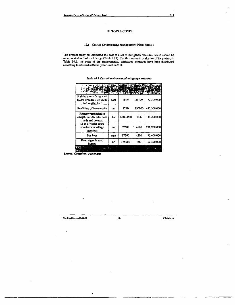
Kamoala-Gavaza-Zirobwe-Wobuienzi Road EIA
10 TOTAL COSTS
10.1 Cost of Environment Management Plan: Phase I
The present study has estimated the cost of a set of mitigation measures, which should beincorporated in final road design (Table 10.1). For the economic evaluation of the project, inTable 10.2, the costs of the environmerital mitigation measures have been distributedaccording to six road sections (refer Section 2.1).
Table 10.1 Cost of environmental mitigation measures
Siabilizan:on ocuts siihh% dro-bmaudcast of seedi sqmi I 50tl- 2 21 it. 3 .l4!o
and vegetal turf
Re-filling of borrow pits cm 1750 250000 437,300,000
Restore vegetation incamrps, borrow pits, haul ha 2,000,000 19.6 39,200,000
roads and detours1,5 m of width extra-shoulders in village m 52500 4800 251,900,000
crossings
Bus bays sqm 17500 4200 73,400,000
Road signs & road no 175000 300 52,300,000h
Source: Consultant's estimates
EtA Final Roport/28-11t03 86 Phoencx
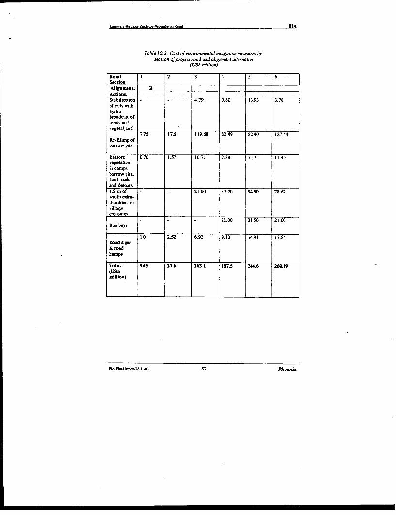
Kamnala-Gavaza-Zirobwc-Wobulenzi Road EIA
Table 10.2: Cost of environmental mitigation measures bysection of project road and alignment alternative
(USh million)
Road 1 2 3 4 5 6SectionAlignment: BActions: _Stabilization 4.79 9.80 13.93 3.78of cuts withhydro-broadcast ofseeds andvegetal turf
7.75 17.6 119.68 82.49 82.40 127.44Re-filling ofborrow pits
Restore 0.70 1.57 10.71 7.38 7.37 11.40vegetationin camps,borrow pits,haul roadsand detours1,s m of 21.00 57.70 94.50 78.62width extra-shoulders invillagecrossings
- -- 21.00 31.50 21.00Bus bays
1.0 2.52 6.92 9.13 14.91 17.85Road signs& roadhumps
Total 9.45 21.6 163.1 187.5 244.6 260.09(UShmillion)
EIA Fial Recpon2t- 1 103 87 Phoenix

Kamnsfa-(si3-,*-7.rnb sl: Wht leni R.,xid __ __ _EIA
10.2 Resettlement Costs
The Feasibility Study has quantified the approximate physical and economic impact ofresettlement. as tabulated below (Table 10.3 bclos%). For the economic evaluation of theproject. in Table 10.4 (following page). the resettlement costs have been distributedaccording to six project road sections.
Detailed field checks during the final design stage will assist in speeding up thecompensation procedure.
Table 10.3: Resettlement components: size and cost
tini Ilnit crnst A ient B.Aet,0nl iI.tM Q.ti Toial co-.4
Acquisition of new land ha 700.000 44.00 30.800.000
v" If -A O~¢.1) __- ........ , -- " .
e .. , .. s .l.,
fIV .., il ._1 NA I .. .. . . . .I _
possihle d,sloaaioti Ifc''nij ,graves. Disturbance allowance also is included.The .vn,al/l pper fac,oru- encompassing thte dleiiation n'1 i.Y not inclutdedSewr,r. C onsultant s estimat_e
HIA 1..ai 11..reggIFY 1.1 88 PloenLr
Kamrala-(iJvsrs-Zirobs%t.Wobuienzi Rjd __ EIA
Table 10. 4. Resettlemnent a ompensation costs bhy road section and alternativetUSh tmillion)
Road Section: 1 2 3 4 5 6Alignment: B B_|_B_,B B B_ I
Actions: '___ _ _ _ _ ,
Acquisition of 0.62 4.59 11.58 14.02nev. land I_ __ __ __ __
Destruction of _ 1crops trees for 1.73 47.36 80.35 82.67road widening
Destruction ofcrops for road 4.85 - 19.56 27.48realignments anddeviations
Destruction ofcrops foropening of i 5.15 9.80 15.11 5.94borrow pits. i
yards. haulroads. etc. _
Demolition of 3 | ;50 1790 59.36 2548constructions .
Others (fences. Ilatrines. ;Gateway. . i
mosque) jDislocation ofIstalls. market 1.50 3.00 0.40 - 1.00 0.50tables
Total 1.50 3.00 19.25 79.65 193.46 156.09
Sovrce:Field
FIAA Fin.t Rqxrt-2 lI t.u3 89 Phoenix
Kampala-Ga)a-Zirobwe-Wobula=i Road EIA
10.3 Total Cost of the Environment Management Plan and Resettlement
Environmental/social mitigation and enhancement measures - including resettlement andremedial works to offset construction damages and post-construction impacts of road useAlignment B -is approximately from USh 1,339.4 million Additional costs for ancillaryinfrastructure and other follow-up interventions will be bome by the central and regionaladministrations, with the participatory effort of local urban and rural communities.
The cost for mitigation measures is substantially higher than the cost for resettlement andcompensations, mainly due to the important mitigation works during the construction stage.In average the proportion between the above costs is 63% for mitigation measures and 37%for resettlement.
The incidence of mitigation measures and resettlement on total construction cost of theproject road is approximately 2.9% for Alignment B
Tbe summary of mitigation measures and resettlement cost for Alignment B is displayed inTable 10.5 overleaf
The distribution among the six road setions of the mitigation and resettlement cost isvariable. The first two sections traversing the urban area of Kampala require less importantmeasures because the areas needed by the road widening are prevalently free of obstaclesand will not be affected by construction operations such as borrow pits, haul roads and otherancillary facilites.
The rural areas will be more affected than urban areas at both stages of road construction andutilization, as well as concerning mitigation measures and resettlement
The cost under review per ian of road in the urban area amoumts to USh 7.75 mrllion, whilethe same cost for the road sections in rural reas varies from USh 21.37 million to USh 24.5million per km, according to the road Alignment B. In Table 10.6 overleaf are summarizedthe costs of mitigation measures and resettlement by road section according to Alignment B
ECi Final Reprtaz-I 1-03 90 Phoecir
Kamoa-aGavaza-Zfrobwe-Wobulenzi Road EIA
Table 10.5: Summary of costfor mitigation measures and resettlement
Actions Alignune B CosUSh USS
(rnillion) ISEnvironmental mitigation measuresI. Stabilisation of cuts with hydro- 32.3 18,457broadcast of seeds and vegetal turf2. Re-filling of borrow pits, carnps 437.4 249,9203. Restoration of vegetation in borrow 391 22,360pits, camps, haul roads and detours4. Extra shoulders for pedestrians and 251.8 143,897cyclists 258 148915. Bus bays 73.5 42,0006. Road signs &road bumps 52.3 29,903Sub-total Aligmnent B 886.4 506,537Resenlement and comipensation costsI. Additional area for road widening 30.8 17,6062. Destruction of crop trees 212.1 121,2063. Crops destruction for realignrnents 51.9 29,651and deviations 51.9 29_6514. Crops destruction for opening of 36.0 20,571borrow pits, yards and haul roads5. Demolition of construction 106.2 60,7096. Others (fences, latrines, gateways..) 9.5 5,4297. Dislocation of stalls, market tables 6.4 3,657Sub-total Alignment B 453.0 258,829Total Aligntent B 133939 76S,366
() 1US$ = 1750 USIi
ELA FmiRepornt2811.03 91 Phoenix
Ka&mab-Gavaza-Zirobwe-Wobuienzi Road EIA
Table O. 6: Costs (USS) of mitigarion measures and resettlement by road section
Alignment B
Road Section lizlIgdo CoRpenst Te uMIeasures e.
.1 Kampala- Nsooba 5,398 857 6,255
.2 Nsooba- Mpcrerwe 12,396 1,714 14,11S 3 M erwe -Gayaza 9.......3. 9 1,00_ 104,198S.i Gayaza - kiwenda 107,14 _ i5,Si4 1s2,6**S.5 Kiwenda - Zirobwe 139,77 .- 110,549 250,326S.6 Zirobwe - Wobulenzi 148,62 89,194 237,8 1Total road 506,531 25M,82 7653
ElA Final Repont IJ303 92 Phoenix
Kumoala-Ga aza-Ziroex&e-Wobuienzi Road EIA
II CONCLUSION AND RECOMMENDATIONS
11.1 Conclusion
The Environmental Impact Assessment has addressed Alignment B. which has beenpreferred from the technical, economical and social aspects.If the project is implemented taking into account the impacts identified and thecorresponding mitigation measures. the ovcrall impact on the environment will be minimal.
On the alignment B, the highest risk will be in the area of compensation which. if notproperly addressed. will lead to local discontent and possible delays in the construction. Therealignment within the existing corridor, this should not however be a problem since, fromthe results of the completed Resettlement Consultation (Appendix B): the local people are allin favour of the road development.
11.2 Recommendations
* The Environment Management Plan described herein is implemented:
* The budget for the Environment Management Plan identified herein is included in thecost of the project put forward for funding;
Finally it is recommended to limit the areas to be cleared from constructions and crops to theminimum indispensable for road widening.
EItA F,Il Repo'2t-1 1-3 93 Phtoenix

I
I
KE iampab - Gazm -Zirobwc .Wobuiaz Road
L ~ ~ , -,' ':
- . Reviewv arnd Update of Feasibility Study and Defailed Design of i
KAMPALA - GAYAZA - ZIROBWE - WOBULENZI ROAD
Feasibility Study Draft Final Report
I
4,, I} APPEINDIX A
RE'PCRT ONA | PUBLIC CONSULTATION ACTIVITY
.,~
.7________ ______________________________________
,~~~~~~~~~~~~~~~~~~~~lci

I
Karnpala-Gayaza-Zirobwe-Wobulenzi Road
Ministry of Works, Housing and Communications
Report on the Public Consultation Activity
in Respect to Kampala - Gayaza - Bugema -
Zirobwe - Wobulenzi Road
Phoenix Engineering & Research ltd.
Plot 7, Sumnnt View Drive, Naguru
P. O. Box 28442 - Kampala Uganda
Telephone /Fax 256 - 041-285379
E-mail: phoenix -us!Qinfocom.co.ue.
Public Consultation Report April 2001

I
KpalaGayaza-Zirobwe-Wobulenzi Road
TABLE OF CONTENTS
Content Page
Executive Summary
1.0 Introduction I
1I.1 Description of the project area I
1.2 Methodology for public consultation I
1.3 Socio-Econornic organisation of the people along the project corridor 2
1.4 Timeline for consultation activity 2
1.5 Public participation 3
2.0 Key issues raised during consultation 4
2.1 Traffic Safety and Community awareness 4
2.2 Compensation of the project affected persons 5
2.3 Environment management and training 5
2.4 Legal policy and institutional framework 5
2.5 Communities and their perception about consultation activities 7
2.6 Administrative framework 7
3.0 Community perception and project impact 8
4.0 Expected benefits to Women 11
5.0 Opinion about Zirobwe - Wobulenzi Route 13
6.0 Recommendations and Highlights from public consultation Activity 13
7.0 General Comments and Conclusion 14
Appendix 15-20
Public Consultation Report April 2001

I I
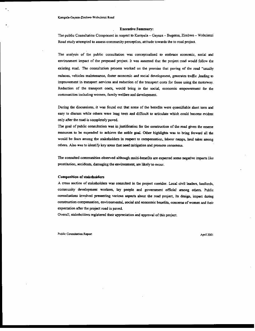
Kwmpala-Gayaza-Zirobwe-Wobulenzi Road
Executive Summary:
The public Consultation Component in respect to Kampala - Gayaza - Bugema, Zirobwe - Wobulenzi
Road study attempted to assess community perception, attitude towards the to road project.
The analysis of the public consultation was conceptualised to embrace economic, social and
environment impact of the proposed project. It was assumed that the project road would follow the
existing road. The consultation process worked on the premise that paving of the road "usually
reduces, vehicles maintenance, foster economic and social development, generates traffic ,leading to
improvement in transport services and reduction of the transport costs for those using the motorway.
Reduction of the transport costs, would bring in the social, economic empowerment for the
communities including women, family welfare and development.
During the discussions, it was found out that some of the benefits were quantifiable short term and
easy to discuss while others were long term and difficult to articulate which could become evident
only after the road is completely paved.
The goal of public consultation was in justification for the construction of the road given the emerse
resources to be expended to achieve the noble goal. Other highlights was to bring forward all the
would be fears among the stakeholders in respect to compensation, labour camps, land takes among
others. Also was to identify key areas that need mitigation and promote consensus.
The consulted communities observed although multi-benefits are expected some negative impacts like
prostitution, accidents, damaging the environment, are likely to occur.
Composition of stakeholders
A cross section of stakeholders was consulted in the project corridor. Local civil leaders, landlords,
community development workers, lay people and government official among others. Public
consultations involved presenting various aspects about the road project, its design, impact during
construction compensation, environmental, social and economic benefits, concerns of women and their
expectation after the project road is paved.
Overall, stakeholders registered their appreciation and approval of this project.
Public Consultation Report April 2001
Kampala - Gayaza - Zirobwe - Wobulenzi Road feasibility study and dewailed cngineenng design
1.0 Introduction
The Kampala - Gayaza - Zirobwe - Wobulenzi project is one of the classified roads for up grading.This will involve construction of a paved ( (bitomen surface) road on the general alignment of theexisting road will have to be widened. Where the alignment has to be improved, road construction willaffect some crops and land. Some of the materials will be obtained from borrow pits and the quarry sitesalready in the area. Upgrading of Gayaza - Zirobwe will probably start in 2004 and will take 1-2 yearsto complete.
The Zirobwe - Wobulenzi may also be upgraded similar to the Gayaza - Zirobwe depending on theavailability of resources and analysis. The Zirobwe - Gayaza road will involve improving the drainage,widening of the shoulders and resurfacing of the road with an asphalt concrete layer. This work isexpected to start in 2004.
1.1 Description of the project area
Kampala - Gayaza - Zirobwe - Wobulenzi is located in the North - West of Kampala and serves thedistricts of Karnpala, Wakiso, Luweero, Mukono, and Nakasongola. The project cuts across, Kira,Busukuma, Bumunanika and Katikamu counties. The project area is mainly an agricultural area,producing banana, cassava, potatoes, coffee and other plantations. It is one of the food basket forKampala. The project area has over 30 primary schools, Bugema University the Namulonge Agriculturalresearch Institute of Makerere Unviersity, Mairye and Magigye poultry and flower projectsrespectively. The project area has sounding potential for development and investmnent. One of therestraints to development in the area is poor road network.
1.2 Methodology for the Public Consultation:
Consultantions were organised with a number of stakeholders along the project corridor. Consultativemeetings were conducted at Busukuma (Busukuma) and Mpigi (Kalagala and Zirobwe)
Public Consultation Report April 2001
Kampala - Gayaza - Zirobwe - Wobulenzi Road feasibility study and detailed engineeng design
Participants included:
• Local development leaders
• Opinion leaders'
• Teachers
• Quany and borrow pit owners
• Community development leaders
• Personnel from NGOs and CBOs woiling in the area.
• Government officials
• Local leaders
> Landlords and residents along the alignment
Consultation meeting elucidated the current development potential of the project corridor. inpact of the
project at the pre-construction, construction and operational stages. The attitude towards land takes,
impact of Noise, Pollution and inconvenience that might be accrued to the settled people along the
alignment and the corridor at large. Also discussed were the gender specifics and benefits and
sustainability of the environment management programmes related to the project impact.
1.3 Socio - Economic organisation of people along the project Corridor:
About 90%/o of the population in the direct impact and indirect project zones depend on agriculture and
animal husbandry. However, there is petty trading in trading centres along the project alignment.
It was established that the majority of the population grows coffee, maize, vegetables and bananas,
cassava for domestic and market especially in Kampala.
The project corridor is one of the potential food baskets for Kampala City. However, the poor road
network has compromised with the population capacity to engage in monetisation of agriculture.
1.4 Time - line consultation activity:
The exercise was estimnated to be conducted with in 10 days. It was however, spread for a period of two
weeks to cover community mobilisation, identification and booking of venues for group consultation
and consultation with individuals (key stakeholders) and NGOs working in the area on integrated
Public Consultation Report April 2001
2
Kampala - Gayaza - Zirobwe - Wobulenzi Road feasibility study and detailed engine-ring design
development programnmes. Other activities for the consultation process included: transcribing responsesfrom the participants and report writing.
Pre -consultation visits - 2 0 "h -24'h April 2001
Consultation with key stakeholders - 2 0 'h _2 7 'h April 2001
Consultation at Group levels (meeting) - 26k' - 27' 2001Transcribing of responses and report writing -28th - 30 'h April 2001
1.5 Public Participation
A cross section of stakeholders was consulted in and along the project corridor. Members of Parliamentfrom the area, local civil leaders, religious leaders, community development workers, chairpersons ofNGOs and CBOs working on integrated Community and Area development programmes. More so,Government officials, lay people were among the people that were involved in the consultationactivities. Consultation involved discussions of various aspects, constraints, opportunities and thegeneral impact that could accrued by the communities in the direct impact and indirect impact zones byGayaza - Zirobwe road project.
The consulted persons view the road project as a remedy to their social, political and economicproblems. Communities are optimistic and aware of positive impact of the project and are willing toconsolidate grassroots road maintenance and environment conservation structures in maintenance of theroad. Most consulted persons observed that conmmunity participation could be mainly in the environmentmanagement plan of the project. Once given guidelines, technical and financial support communitiescould actively rehabilitated exploited borrow pits and quarry sites through environmental managementstructures already in existence.
Public Consultation Report April 2001
3
Kampala - Gayaza - Zirobwe - Wobu/enzi Road feasibility study and derailed engineenng design
2.0 Key issues that raised concern during consultation:
2.1 Trafric safety and community awareness:
During public consultation many people commented that when new roads are upgraded or constructed
there is tendency for an increase in speed and that the commnunities will be un accustomed to traffic
moving at higher speed.
A number of accidents are likely to occur. Communities have suggested a need for speed reduction and
public awareness at the opening of the facility. Stakeholders recommended that speed limit signs and
relevant warning signs should be installed at appropriate points along the road. Rumble strips should be
placed before schools and trading centres.
Part of the required awareness is for the community to get to knowledge about Highway Code and safe
road practices. Costs for the public awareness should be put in place under the guidelines of National
Road Safety Council .
Stakeholders raised a need for community sensitisation about the nature and sensitivity of Luzibwe and
Namagombe wetlands that are cut through by the road. The concern was that road widening will lead to
soil erosion and siltation of the wetlands and their associated streams. Community suggested to
contractor to use grass bands for soil stabilisation and effect community mobilisation. This two - way
process will make communities a long the road become involved right from the start so that mutual
benefits are achieved and adhered to between all the agencies.
The success of environmental intervention will basically depend on a unified approach to development.
Participants suggested that ministry of works, transport, Housing and communication, National
Wetlands programme local govenmuent councils and institutions, schools, youth and women groups and
above all communities along the corridor should work together in environment management of the
project.
Public Consultaaon Report April 2001
4
Kampala - Gayaza - Zirobwe - Wobulenzi Road feasibility study and detailed engineering design
2.2 Compensation of the Project Affected Persons:
Comnmunities along the road are concerned about the compensation for land takes and crops for accessroad to quarry sites and borrow pits. They suggested that the government and Ministry of WorksHousing and Communication should laise with local council authorities along the project corridor.Participants in consultation activities attested that government should provide compensation for bothtemporally and permanent land takes. It was further suggested that local councils should act asintermediaries between government, contractors and affected persons.
2.3 Environment Management and training:
Through consultation it was observed that environment management and training are indispensable inrespect to the project. It was suggested that government should liase with line ministries, variousdepartments at district and sub-county levels for effective environment management training andmonitoring. Stakeholders at consultation meetings wanted to participate in this undertaking so that it canbe effective during construction and operational stages and to ensure that environmental managementmeasures are successful. The extension personnel in relevant departments at the sub-county levels wiUlparticipate as change agents in this activity.
2.4 Legal Policy and the Institutional framework:
One of the critical observations that came to light during meetings was the legal policy and institutionalframework. It was observed that the economic and social success of the project should depend on thelegal back-up and absorption of the institutional arrangement of the country. Participants in communityconsultation therefore put these into serious consideration and enabled participants to intemalise bothaspects for the success of the project. The up grading of the road in one way or the other have some legalimpact on the stakeholders and development potential along the corridor. The impact is manifested inthe social, political and economic set up of the people in the area.
Public Consultation Report April 2001
5
Kampala - Gayaza - 7irobwe - Wobuienzi Road feasibility study and detailed engineering desaign
During the consultation activities it was established that Environment Management Policy (1994) and
the Ministry of water, lands and natural resources in line with the Land Act (1998) and the Enviromnent
Regulatory Policy (1994) were pertinent. It was concluded that all these are intended to support suitable
socio-economic development that enhances and maintains environment equity, quality and resource
productivity.
Participants further observed that Gayaza - Zirobwe Road passes though a lot of property both public
and private. All these are protected by the Constitution of the Republic of Uganda. Article `26" prohibits
forceful Seizure of individual property including land in the country without adequate compensation.
Participants in the concluded consultative meeting therefore are in favor of fair compensation in respect
to their property in case the project takes their land. It was observed that timely compensation for all
project-affected people have to be taken into account before construction begins.
These policies addresses the promotion of a long term sustainable socio - economic concens of the
development policies; planning and implementation of activities with full participation of people; raising
peoples' awareness and understanding of the linkage between man and development.
For meaningful development participants in Busukuma consultative meeting noted that among others the
Government should avail:
> Town and Country planning Act 1964
> Land Act 1998
> Constitution of Uganda 1995
> The Decentralisation Act 1997
> Wetland policy and Environment
> Management policy respectively (1995)
> Local government Act 1992
It was further noted that Gayaza - Zirobwe road project is well encompassed among similar projects
listed by the National Environment Statute (1995) of which even the Environment Management plan of
the project is of a serious concern.
Public Consultaton Report April 2001
6
Kampala - Gayaza - Zirobwe - Wobulenzi Road feasibility study and detailed enginee!nng design
2.5 Communities and their perception about the consultation activities:
Participants in Consultative meetings commended the idea of consultation. This brought in light inrespect to the positive and negative impact of the project. It was observed that all stakeholders(government, the districts and the direct beneficiaries along the project corridor) could appropriatelymitigate of negative impacts. It was stressed that consultation exercise was a great opportunity that wastaken to fulfill policy objectives with respect to community participation to raise people awareness andto gauge the feeling and perception from the stakeholders.
2.6 Administrative framework:
Gayaza - Zirobwe Road Projects cuts across three sub-counties namely*, Busukuma, Kalagala andZirobwe sub-counties. A local government under a five - tier local council run each village along thealignment. The local councils are involved in day to day administration and community developmentinterventions at various levels in their respective areas. Participants therefore acknowledged theirinvolvement in comrnunity consultative process as regards the project that cuts across their respectiveareas.
Inclusion of the local representatives in the consultation process was therefore very imnportant in fluturedevelopment of the project most especially in contain law and order and identification c orojectaffected person for compensation if there is need, effecting public sensitisation and educaion onhighway traffic code among the communities and consolidation of the environmnent management plan ofthe project. Since the consultation activity was carried out along the road aligment, it did raise, highexpectation among the people regarding the project related opportunities and therefore communitiesaccord it higher priority.
Public Consultarion Report April:2001
7
Kampala - Gayaza - Zirobwe - Wobulenzi Road feasibility study and detailed engineenng design
3.0 Community's perception and the project impact;
During the public consultation exercise, stakeholders observed that upgrading of Gayaza - Zirobwe -
Wobulenzi road will have significant impact on the people in the area.
* Improved housebold incomes
The upgraded road is expected increased accessibility and availability of motorized transport for both
passengers and goods, will give the rural households better opportunities to engage in a market
economy. First of all, prices paid for farmers are also expected to improve since new buying centres may
be established in the villages. As a result, farmers will benefit from competition and save time normally
spent on ferrying produce to markets, which are currently very far. The time saved could then be used on
other activities to further improve household incomes.
Secondly, the upgraded road will bring more opportunities for employment and earning cash income
from the construction phase through to the operational phase. For example, the able-bodied will be
employed by the road project and workers will need services such as food, medical facilities,
entertainment to mention but a few. During operational stages, communities along the road will be able
to sell goods and services to the travelling public thereby getting employment and eaming some income.
* Improved accessibility and its accruing benerits
The project will bring improved accessibility to tie productive agricultural areas, health facilities,
educational institutions, administrative and trading centres and other facilities in the project area. In the
existing situation, the study area does not have any paved roads and therefore, accessibility is poor to
most areas including even those along the project road. Once the new road starts operating, there will be
a lot of activity and possible increase in traders, investors, transporters, industrialists, etc. as a result the
existing institutions will benefit from this increased activity and offer quality services.
Public Consultation Report April 2001
8
Kampala - Gayaza - Zirobwe - Wobulerzi Road feasibility study and detailed engineering design
* Better investment opportunities
Up to today, a number of investors have been reluctant to put their money in the project area due to poorcommunication and accessibility. With the improved road, however, it is expected that more investmentwill be attracted to this area which will contribute to improvement of the standard of living.New investment will compliment the existing Mairye flowers growing project, coffee factories andpoultry breeding facility at Magigye.
* Increased interaction between the project area and other parts of the corridor:
The upgraded road will even benefit districts outside the project area particularly Nakasongola,Luweero, Wakiso and Mukono. There will be more interactions between people in the area and the restof Uganda, which will likely stimnulate additional development.
* Reduced transport costs and associated benefits;
It is anticipated that the volume and quality of motorized transport will increase as a result of improvedroad alignment and reduced vehicle-operating costs. Consequently, there wil be reduced transport costson the part of travelling public and saving travelers' time formerly spent on the bad road. The saved timeand money from reduced transport costs will be put to other alternative uses, which would bring morebenefits to the people in the project area Because of reductions in vehicle operating costs created by theimproved road, the price of goods into the region from elsewhere in the country should reduce currenttransport fares between 1500/= - 2000/=. Transport fares are likely to reduce to 1000/= from Kampalato Zirobwe.
* Increased opportunities in education:
With improved household incomes, there will be more opportunities for children to extend school timeespecially in post primary institutions. This will subsequently reduce school drop out rates, which willalso lead to reduction in un employment, literacy and fertility rates. There is likelihood that the area
Public Consultation Report April 2t.,I
9
Kampala - Gayaza - Zirobwe - Wobulenzi Road feasibility study and detailed enginring deign
might attract more and better qualified teachers due to easy accessibility unlike to day, which will
eventually improve the quality of education. The capable parents may be in position to send their
children to better schools in Wakiso and Kampala districts after the road has been improved because
transport costs would be low and time spend on travelling would reduce. As a result of the on-going
privatization program in the country, there might be a possibility of people investing in education in the
project area by establishing better and high quality education facilities, which will be affordable by the
parents after improved household incomes associated with the new road.
* Possible shortage of fuel wood:
Wood fuel is the main source of energy in the project area. Fuel wood consumption is therefore likely to
increase if the road is upgraded. The main reason being that existing trading centres (Gayaza.
Namulonge, Busiika, Zirobwe) may expand due to increased population attracted to them and more
traders especially from Kampala may come for charcoal and agricultural produce since the road will be
good. This will increase the demand of wood fuel in the project area and may cause general scarcity to
the point that even households may face problems in getting ample supplies of fuel wood for domestic
use. Workers in the construction camps may also use wood fuel for their cooking and the existing plots
of wood on private land and some forest reserves may be depleted. The potential is considered to be
moderate but of long-term significance.
* The induced development;
With the upgraded road, participants noted that a lot of development will be attracted to it and so the
influx of an expected number of people within and outside the project conidor. As a result there will be
pressure on the existing water, health, sanitation, energy and food resources. Increased demand for the
consumer goods is also likely to occur and as a result prices for such goods will increase. Un planned
structures will come up, waste disposal management might be a problen, proliferation of diseases may
occur. It was also noted that breakdown of traditional methods of social control and discipline may
occur.
Public Consultation Repon April 2001
I0
Kampala - Gayaza - Zirobwe - Wobulenzi Road feasibility study and detailed engineering design
4.0 Expected benefits to womenParticipants during the Public Consultation observed that if the road is upgraded women are likely tobenefit in saving time.
The implication to women economic activities are:> That many women, particularly the married, would be attracted to travel to potentially better markets
and sources of products which they used to fear because of their familiar responsibilities and culturalproscriptions.
> Women would actively engage in market farming activities, for instance sale of milk to institutionsin and outside the area. Improvement in zero grazing among women was one of the key market -farning sectors suggested during the consultation.
> Security for their goods and losses due vehicle breakage's enroute would be minimised, goodswould be able to arrive faster reducing the tension.
> Accessibility to modern and functional health facilities out the project corridor will become easier.> With the paving of the route, there would be reduced transport fares ranging from 10% - 30% of the
current costs. During discussions one woman councillor from Kalagala noted rnsport fares to andfrom Kampala are to reduce from Ug shs 2,000/= to 1,200-1,600/= and that as many traders comein the project corridor to look for agricultural produce many women would be encouraged toproduce more agricultural products for sale and other things commonly dealt in by women such ashandcrafts. The councilor gave evidence to this and succinctly statod:
"Agriculhure necessitates marketyou cannot access market
unless you have good roads"
The increased production will lead to increased household income.> Improvement of education for girl - child for higher opportmities. Having realised enough savings,
girls will not only stop at Universal Primary Education level. Parents will now afford to pay fortheir school fees elsewhere. This was stressed by women councilor in Zirobwe as she put it.
" Poverty is the chief cause ofgirls gettng out of school and optng tomarry early. Getng schoolfeesfor their higher educaton is edremelydifficuk in rural areas".
Public Consultation Report April 2001
Kampala - Gayaza - Zirobwe - Wobulenzi Road feasibility study and derailed engineerng design
> Employment opportunities for women and youths during road construction. Women are willing to
provide labour during construction and food services to contractor.
However, women noted upgrading of the road would have negative impact
> Children: the road may attract children on the road side to do petty trade while this could have some
positive impact on the income earning levels at household level, the negative effect will be the
tendency for comrnercial activities to attract children out of school.
> Prostitution: some women might think contractor workers have a lot of women and this might
influence prostitution.
Public Consultation Report April 2001
12
Kampala - Gayaza - Zirobwe - Wobuenzi Road feasibiiry study and detailed engineering design
5.0 Opinion about the Zirobwe - Wobulenzi Route:
Participants were in agreement with the need to finish the whole stretch from Kampala - Gayaza -Zirobwe to Wobulenzi.
They were of the view that upgrading the road to Zirobwe without extending to Wobulenzi wouldrestrain the economic development in the corridor. Communities would wish to exploit the market forproduce both in Kampala, Bombo and Luweero.
6.0 Recommendations / highlights from the Public Consultation activity:
Groups were unanomymous on the need for the contractor wide shoulders for pedestrian and cyclists inareas with higher concentration of people such as schools, markets and trading centres. Maintenance ofthe shoulders would be taken into account. Participants (Busukuma) observed that if grass in the roadreserve is left to grow up to the margins of the carriage way would force pedestrians and cyclists to walkand cycle on the motor way thus accidents.
In the public consultation, participants proposed the following facilities as important in promoting thesafety of road users.
) Humps should be put at busy points for instance, schools, markets and trading centres.Zebra crossings at schools
It was also recomnnended that traffic code should be provided to local leaders and schools in order toeducate the communities about traffic issues and safety on the road. More so, it was proposed thatenough road signs be put on the paved road as guidance to all road users.
Public Consultation Report April 2001
13
Kampala - Gayaza - Zirobwe - Wobulenzi Road feasibility study and detailed engineerng design
7.0 General observation and conclusion
During discussions and consultation with stakeholders in the project corridor, acceptability of the projectwas effected. Paving of the Kampala - Gayaza - Zirobwe and Wobulenzi road will make a greatdifference in lives of all people of the project corridor. It will bring and foster development in the projectcounties, reduce the isolation and reported marginalisation of the project corridor and the isolatedwomen in particular. The participants in the public consultation activities had a strong conviction thatpaving the road will have positive and profound impact on the people of the project corridor of Luweero,Wakiso, Nakasongola, Kampala and Mukono districts. Although some negative impacts like accidents,prostitution, disfiguring of the environment were cited, participants are grateful to government and theWorld Bank for this over due development intervention.
Public Consultation Report April'2001
14
Kampala - Gayaza - Zirobwe - Wobulenzi Road feasibility study and detailed engineeing dengn
APPENDIX
LIST OF PARTICIPANTS IN COMMUNITY CONSULTATION ACTMITIES
SUB COUNTY: ZIROBWE
NAME OF THE PARTICIPANT DESIGNATION IN THE COMMUNITYSSETTUBA STEPEN COUNCILLOR
2 WABWIR GABRIEL RESIDENT3 SINAANI MUBIRU RESIDENT4 H. SAKKA SENJALA C/P LC 15 H. ABDU NKOOLA P/C6 STUART LWASA CHAIRPERSON L.C.1 17 ERIZALI NSEREKO CHAIRPERSON L.C.18 NAKACWA CATE SECRETARY LC 1 JANDA9 A. NYANZI BODA BODA TRAINER10 MUHENGA BONNY CITIZEN11 SEFALAYO OCH MULIMI12 SEBAGGALA MUHAMUDU VICE C/P LC III13 HELLEN NSEREKO COUNCILLOR LC V14 JOYCE SIMBWA COUNCILLOR1 5 ROBINAH KIGGUNDU COUNCILLOR LC 11 116 SEKABOGA MILLY CIP L.C.I KASOLOOSO17 KIGONGO FRED LC III EXECUTIVE MEMBER18 KIROLI SPERITO LC III EXECUTIVE MEMBER19 BUKENYA EDWARD COUNCILLOR20 SIMBWA - KAYIWA LC III CHAIRPERSON21 OCHERA JOSEPH COUNCILLOR (BUKIMU)22 DANIEL SEKABOGA CLERK TOWN COUNCIL23 SEKAMANI SENKUBUGE LUBOWA KASAKOSO - ZIROBWE ELDER
Public Consultation Report Ap/ri2001
15
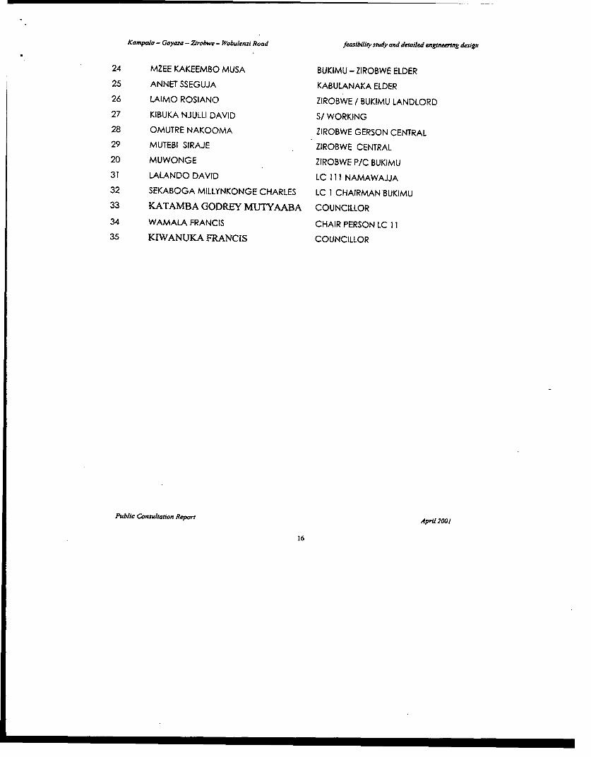
Kampala - Gayaza - Zirobwe - Wobulenzi Road feasibility snudy and detailed engineenng design
24 MZEE KAKEEMBO MUSA BUKIMU - ZIROBWE ELDER
25 ANNET SSEGUJA KABULANAKA ELDER
26 LAIMO ROSIANO ZIROBWE / BUKIMU LANDLORD
27 KIBUKA NJULLI DAVID S/ WORKING
28 OMUTRE NAKOOMA ZIROBWE GERSON CENTRAL
29 MUTEBI SIRAJE ZIROBWE CENTRAL
20 MUWONGE ZIROBWE P/C BUKIMU
31 LALANDO DAVID LC 111 NAMAWAJJA
32 SEKABOGA MILLYNKONGE CHARLES LC I CHAIRMAN BUKIMU
33 KATAMBA GODREY MUTYAABA COUNCILLOR
34 WAMALA FRANCIS CHAIR PERSON LC 11
35 KlWANUKA FRANCIS COUNCILLOR
Public Consultation Report April 2001
16
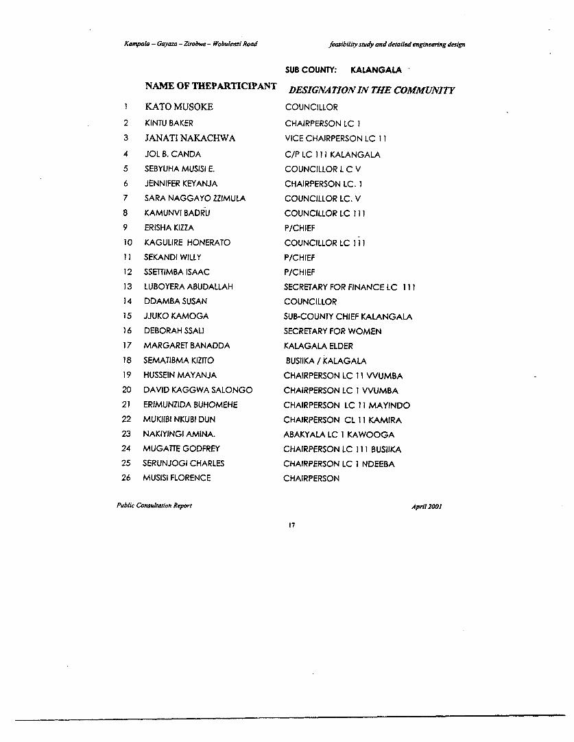
Kampala - Gayaza - Zirobwe - Wobulenzi Road feasibility study and detailed engneenng design
SUB COUNTY: KALANGALANAME OF THEPARTICIPANT DESIGNATIONIN THE COMMUNITY
1 KATO MUSOKE COUNCILLOR
2 KINTU BAKER CHAIRPERSON LC 13 JANATI NAKACHWA VICE CHAIRPERSON LC 114 JOL B. CANDA C/P LC 11I KALANGALA5 SEBYUHA MUSISI E. COUNCILLOR L C V6 JENNIFER KEYANJA CHAIRPERSON LC. 17 SARA NAGGAYO ZZIMULA COUNCILLOR LC. V8 KAMUNVI BADRU COUNCILLOR LC 1119 ERISHA KIZZA P/CHIEF10 KAGULIRE HONERATO COUNCILLOR LC 1i1111 SEKANDI WILLY P/CHIEF12 SSETTIMBA ISAAC P/CHIEF13 LUBOYERA ABUDALLAH SECRETARY FOR FINANCE LC 11 114 DDAMBA SUSAN COUNCILLOR1 SJJUKO KAMOGA SUB-COUNTY CHIEF KALANGALA16 DEBORAH SSALI SECRETARY FOR WOMEN17 MARGARET BANADDA KALAGALA ELDER18 SEMATIBMA KIZITO BUSIIKA / KALAGALA19 HUSSEIN MAYANJA CHAIRPERSON LC 11 VVUMBA20 DAVID KAGGWA SALONGO CHAIRPERSON LC I VVUMBA21 ERIMUNZIDA BUHOMEHE CHAIRPERSON LC 11 MAYINDO22 MUKIIBI NKUBI DUN CHAIRPERSON CL 11 KAMIRA23 NAKIYINGI AMINA. ABAKYALA LC 1 KAWOOGA24 MUGATrE GODFREY CHAIRPERSON LC 111 BUSIIKA25 SERUNJOGI CHARLES CHAIRPERSON LC I NDEEBA26 MUSISI FLORENCE CHAIRPERSON
Public Consultation Repon April 2001
17
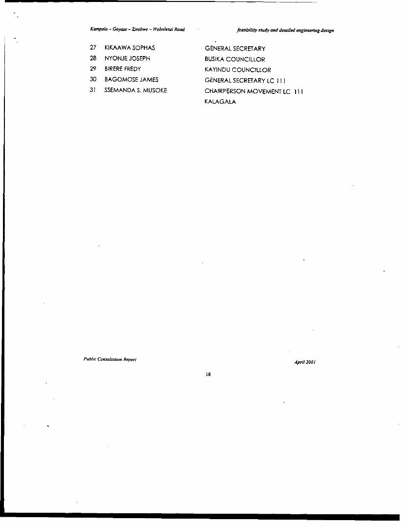
Kampala - Gayaza - Zirobwe - Wobulenzi Road feasibility study and detailed engineering design
27 KIKAAWA SOPHAS GENERAL SECRETARY
28 NYONJE JOSEPH BUSIKA COUNCILLOR
29 BIRERE FREDY KAYINDU COUNCILLOR
30 BAGOMOSE JAMES GENERAL SECRETARY LC 111
31 SSEMANDA S. MUSOKE CHAIRPERSON MOVEMENT LC 111
KALAGALA
Public Consultation Report April 2001
18
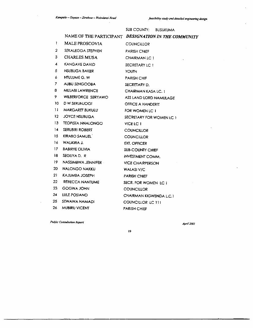
Kampala - Gayaza -Z2robw - Wobulenri Road feasibility study and detailed engineering design
SUB COUNTY: BUSUKUMANAME OF THE PARTICIPANT DESIGNATIONIN THE COMMUNITY
I MALE PROSCOVIA COUNCILLOR
2 SEKALEGGA STEPHEN PARISH CHIEF3 CHARLES MUSA CHAIRMAN LC I4 KANGAVE DAVID SECRETARY LC 15 NSUBUGA BAKER YOUTH6 NTULUME G. W PARISH CHIF7 AUBU SENGOOBA SECRETARY D.8 MUJABI LAWRENCE CHAIRMAN KASA LC. 19 WILBERFORCE SERYAWO ASS LAND LORD NAMULAGE10 D W SERUNJOGI OFFICE A HANDERIT11 MARGARET BUKULU FOR WOMEN LC 112 JOYCE NSUBUGA SECRETARY FOR WOMEN LC 113 TEOPISTA NNALONGO VICE LC 114 SERUBIRI ROBERT COUNCILLOR15 KIRABO SAMUEL COUNCILLOR16 WALIKIRA J. EXT. OFFICER17 BABIRYE OLIVIA SUB-COUNTY CHIEF18 SEGUYA D. R INVESTMENT COMM.19 NASSIMBWA JENNIFER VICE CHAIRPERSON20 NALONGO NAKKU WALASI V/C21 KAJUMBA JOSEPH PARISH CHIEF22 REBECCA NANTUME SECR. FOR WOMEN LC 123 GOGWA JOHN COUNCILLOR24 LULE POSIANO CHAIRMAN KIGWENDA L.C.125 SEWAWA HAMADI COUNCILLOR LC 11126 MUBIRU VICENT PARISH CHIEF
Public Consultation Reporr April 2001
19
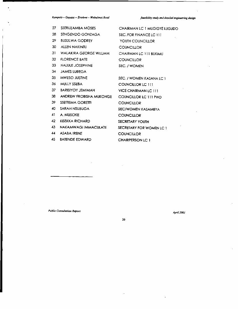
Kampala - Gayaza - Zirobwe - Wobu/enzi Road feasibility study and detailed engineering design
27 SSERUZAMBA MOSES CHAIRMAN LC 1 MUGIGYE LUGUDO
28 SENGENDO GONZAGA SEC. FOR FINANCE LC 111
29 BUSULWA GODREY YOUTH COUNCILLOR
30 ALLEN NAKINTU COUNCILLOR
31 WALAKIRA GEORGE WILLIAM CHAIRMAN LC 111 BUKIMU
32 FLORENCE BATE COUNCILLOR
33 NALULE JOSEPHINE SEC. / WOMEN
34 JAMES LUBEGA
35 MWESO JUSTINE SEC. / WOMEN KASANA LC 1
36 MULLY SSEBA COUNCILLOR LC 111
37 BARISIYOY JEMIMAH VICE CHAIRMAN LC 111
38 ANDREW FROBISHA MUKONGE COUNCILLOR LC 111 PWD
39 SSETTEMA GORETTI COUNCILLOR
40 SARAH NSUBUGA SEC/WOMEN KASAMBYA
41 A. MUSOKE COUNCILLOR
42 KISEKKA RICHARD SECRETARY YOUTH
43 NAKAMWAGI IMMACULATE SECRETARY FOR WOMEN LC 1
44 ASABA IRENE COUNCILLOR
45 BATENDE EDWARD CHAIRPERSON LC 1
Public Consultation Report April 2001
20

I
I
-~r-~t # s - - -
j K.J.Kpaias -Gayaza -Zirob% -Wobulczi Road
I~~~~~~~~~~~~~~~
Revieiv arrd Update of Feasibility Study and Detailed Design of
2 - CKAMPALA - GAYAZA - ZIROBI3E - WOBULENZI ROAD
Fersibility Study Draft Final Rcport
_
APPENDIX B
REPORT ONRE, SETTLEM-ENT CONSULTATION.
L
C>
- I _ _ _ _ _ _ _ _ _ _ _
.. .~~~~~~~~~~~~~~~~~~~~i e i

I
Ministry of Works, Housing
And
Communications
Resettlement Plan Consultation Report onKampala - Gayaza - Bugema - Zirobwe - Wobulenzi Road Project
Phoenix Engineering and Research LtdPlot 7 Summit View Drive - NaguruP. O. Box 28442 - Kampala - UgandaTelephone / Fax: 256 -041- 285379E-mail: nhoenix.u%!Ainfocom.co.ue
June 2001

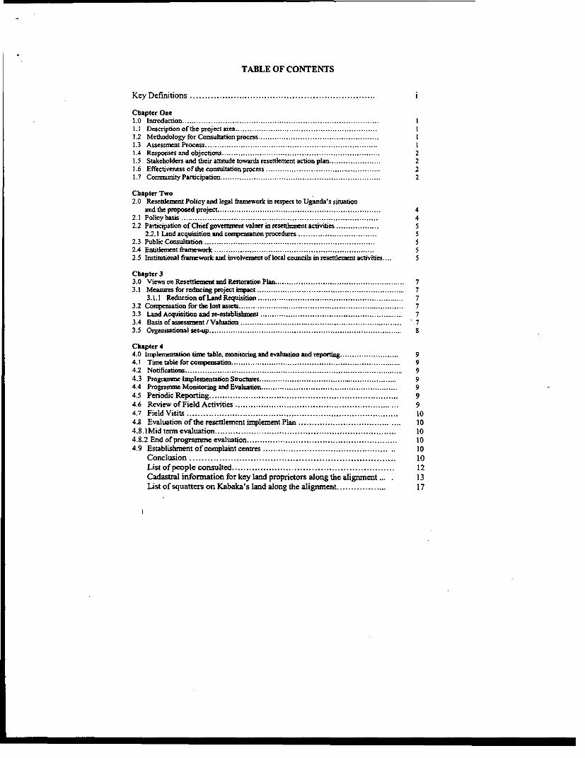
TABLE OF CONTENTS
Key Definitions ................................................................. i
Chapter One1.0 Introduction ................................................................... I1.1 Description of the project area ............................................................ .1.2 Methodology for Consultation process ................................................... I1.3 Assessnent Proc ................................................................... I1.4 Resporises and objections ................................................................... 21.5 Stakeholders and their attitude towards resettlemnent action plan . . 21.6 Effectiveness of the consultation process ...................................... . 21.7 Comrnunity Participation ................................................................... 2
Chapter Two2.0 Resettlement Policy and legal framework in respect to Uganda's situation
and the proposed project ................................................................... 42.1 Policy basis ......................... .......................................... 42.2 Participation of Chief government valuer in resettlement activities .................. 5
2.2.1 Land acquisition and coqpensation procedures ......... ........................ 52.3 Public Consultation ................................................................... 52.4 Entitlement framework ................................................................... 52.5 Institutional firaework and involvement of local councils in resettlement activities .... 5
Chapter 33.0 Views on Resettlement and Restoration Plan ....................................................... 73.1 Measures for reducing project impact . .............................................................. 7
3.1.1 ReductionofLandRequisition .............................................................. 73.2 Compensation for the lost assets ................................. ............. 73.3 Land Acquisition and re-establishment .............................. , . , ............. 73.4 Basis of assessment / Valuation .................................................................. 73.5 Organisational set-up .................................................................. 8
Chapter 44.0 Imnplementation time table, monitoring and evaluation and reporting ......................... 94.1 Tirne table for compensation .................................................................. 94.2 Notifications .................................................................. 94.3 Progranme Imnplementation Structures ........................................................... 94A Progranmne Monitoring and Evaluation .......................................................... 94.5 Periodic Reporting .................................................................. 94.6 Review of Field Activities ............................................................ ... 94.7 Field Visits .. 104.8 Evaluation of the resettlement implement Plan ........... ............................ 104.8. I Mid term evaluation .................................................................. 104.8.2 End of programmn e evaluation .......................................................... 104.9 Establishmnent of comnplaint centres ................................ . 10
Conclusion .................................................................. 10List of people consulted ......................................................... 12Cadastral informnation for key land proprietors along the alignment ... 13
List of squatters on Kabaka's land along the aligrunent .................. 17
Kampala - Gayaza - Bugema - Zirobwe -Wobulenzi Road Project
Key Definitions:
PAP's: Project Affected Persons (PAPS) are individuals who may be impacted directly orindirectly by the Project.
PAH's: Project Affected Households Are Households that may be impacted by the Project as aHouseholds that may be impacted by the Project as a household unit.
PAG's: Project Affected Groups. Are Groups or Communities that may be affected by the project.A group is generally y limited by geographical location. As far as group entitlement is concemedwith focus / weaker groups in the society.
EP's: Entitled Persons.EP's are PAPS who quality for or are entitled to assistance / compensation since they will berelocated or otherwise impacted by the ProjecL EP's are deemed to include entitled tocompensation under the legal framework of Uganda.All PAPs are entitled to the improvement or at least restoration of their standards of living, andcompensation for the material losses they suffer. Compensation for assets will cover replacementcost. No deductions or discounts will be applied to the compensation amount for depreciation orother reasons. All PAPs deriving an economic benefit from the affected land and property areentitled to receive rehabilitation benefits in addition to the compensation for their assets lost.Those PAPs without title, authorization or legal permission to reside, conduct business, cultivateland or construct structures are eligible for rehabilitation of their livelihoods and compensationfor their assets on an equal footing with those with formal legal title, authorization or penmussionsto the assets.
"Resettlement""Resettement" means to provide the arrangement of product and livelihood for the PAPs and toensure they will benefit from the project. It mainly includes:
1) The relocation of living quarters;2) Finding acceptable new employment for those whose jobs are affected;3) Restoration (or compensation) of affected productive resources such as land,
workplaces, trees and infrastructure;4) Restoration of other adverse effect on PAPs' living standards (quality of life) through
land requisition (such as the adverse effects of pollution);5) Restoration of or compensation for affected private and public enterprises;6) Restoration of adversely affected on cultural or common property.
"Rehabilitation""Rehabilitation" means the restoration of the PAPs' resource capacity to continue with productiveactivities or lifestyles at a level higher or at least equal to that before the project.The objective of this RAP is to provide a plan for the resettlement and rehabilitation of the PAPsso that their losses will be compensated and their standards of living will be improved or at leastrestored to the pre-project levels. To achieve these objectives the plan provides for rehabilitationmeasures so that the income earning potential of individuals are restored to sustain theirlivelihoods.
Kampata-Gaya=-Zmbwe-Wobuenzi Road Restelement Consutation Report
1A Responses and objectionsThere were no actual objection of the resettlement programme from the officials andrepresentative of NGO's and CBO's in respect to project benefits and developmentopportunities that are likely to emerge after the completion of the project. There is no surprisebecause most people in the project corridor are in favour of the project.
1.5 Stakeholders and their attitude towards Resettlement Action PlanThe consultant discussed with a wide range of key stakeholders and local leaders in the area. Itis assumed that the infornnation obtained is useful for the Resettlement Action Plan.
> Some of the consulted persons-have expressed fears that the "compensation" package mightnot enable PAPs to acquire similar social cohesion, sense of identity and very likely toaffect their children education (relocation to areas where no good schools).
> The 15% disturbance allowance is too small since the value of land and prices of buildingmaterials are too high. PAPs have fears in respect to the inflation. 80% of those consultedare wondering whether government will put that into consideration.
> Some participants in the consultation exercise observed that compensation might becomeirrelevant as it is quite inconceivable such that compensation cannot meet the gross damagebeing inflicted on the families.
> That compensation package might not enable communities to resettle comfortablyelsewhere with in the environs of Bulami (the most affected village along the alignment).Information obtained from the discussion indicated that some will miss friends and relatives
Basing on the information collected; the consultant has the following observations to make:> People still not trusting the government with timely compensation> Affected persons are willing to work with committees that will be put in place to ensure
successful implement of the resettlement programme.For obvious and entirely rational reasons PAPs prefer adequate, prompt and fair compensation.
1.6 Effectiveness of the consultation processGiven the level of participation of the stakeholders in the consultation process and a number ofresponses and proposals given, the consultation exercise in respect to the resettlement andcompensation must be regarded as a success.
1.7 Community Participation:Consultant Observaton:It was observed that great majority rural communities have little influence on or do noteffectively participate in development interventions that concern them. The developmentexperience in the project area that communities have limited control over the whole range offactors that threaten their livelihood and little chance to participate in Programme designs andactual implementation. It is therefore important to involve Communities and the local Councilsin the resettlement and Compensation activities.
Active participation by the PAPs and PAGs will enable them to understand and appreciate thelevels of development and ascertain timely gains and control over forces that affect their lives.Participation has no universally accepted definition and only a working understanding isattempted here. In context of the resettlement plan participation is taken to mean a wideningand redistribution of opportunities to PAPs. It is inportant that community meetings with PAPsto increase receptivity and ability to face the challenges of relocation should precedeparticipation.
p. 2
Kamp ya-Znowe-WObuIki Road Resetlemeat Considtatieo Reprt
All PAPs are entitled to the improvement or at least restoration of their standards of living, andcompensation for the material losses they suffer. Compensation for assets will coverreplacement cost. No deductions or discounts will be applied to the compensation amounted fordepreciation or other reasons. All PAPs deriving an economic benefit from the affected landand property are entitled to receive rehabilitation benefits in addition to the compensation fortheir assets lost. Those PAPs without title, authorisation or legal permission to reside, conductbusiness, cultivate land or construct structures are eligible for rehabilitation of their livelihoodsand compensation for their assets on an equal footing with those with formal legal title,authorisation to the assets.
p. 3
KampzIa-GayaZirobwe-WobuIcnzi Road Ieseutlement Consuation Report
Chapter Two
2.0 RESETTLEMENT POLICY AND LEGAL FRAMEWORK IN RESPECT TO UGANDA'SSITUATION AND THE PROPOSED PROJECT
2.1 Policy basisThe success of the resettlement plan for Kampala Gayaza Zirobwe Wobulenzi Road will dependon internalising of the institutional framework and application of the legal framhework within thecontext of the Republic of Uganda. The major goal is to ensure that the resettlement activitiesare effected without causing considerable negative impact to the PAPs and the relocatees. Allthese should be addressed in accordance to the Town Plamuing Act of 1964, the Land Act of1998, and the Kampala, Luweero and Wakiso District compensation rates approved by theseDistricts during the current fiscal year.The success of resettlement action plan for the proposed project will depend on the legal backup and support of .the institutional arrangement of Uganda and decentralisation process in thedistricts. The planned project activities will have some legal impact on the stakeholders and thedevelopment potential along the corridor. Impact is manifested in social, political and theeconomic standards of the people and the area. It came to light during the discussions that mostpeople in the project corridor are very conversant with the Land Act.
Kampala- Gayaza- Zirobwe - Wobulenzi road passes through a lot of property both private andpublic. All these are protected by the Constitution of the Republic of Uganda. Article '237nvests all the land in the country to the people. While Article '26" prohibitsforcefuI seizure ofindividual property including land by any authority including government with out adequatecompensation. The Land Act of 1998 regulates all the iusues related to development and land inUganda. This implies that the proposed resettlement activity will put into account all theseprovision.
Land ownershipThere is a diversity of land ownership along the right of way. The consulted communitiesobserved that the most prominent land holding is Mailo and Crown land (Kabaka's land). TheMailo land is pronounced between. On the mailo land tenure, there are different ownershipinterest between the registered owners and lawfil occupants. All those with vested intereststherefore have to be treated fairly during the land acquisition and compensation. Seriousscrutiny of ownership has to be effected during cadastral survey.
This plan on the proposed road should be based on national laws and regulations of the republicof Uganda belovw
* Constitution of Uganda (1995)* The Land Act (1998)* Town and Country Planning Act (1964)* Local Govermment Act (1992)* The Decentralisation Act (1997)* Road Safety and Traffic Act (1991)* Land Acquisition Act 1965
All these have serious consideration impact in respect to the proposed RAP.
2.2 Participation of Chief Government Valuer in the resettlement activityThe Chief Government Valuer is a key Government person to handle the property valuation,land acquisition and compensation of all the affected persons along the right of way. The CGVwill therefore be involved in ensuring that PAPs are valuated in time, compensated fairly andpromptly. The CGV will also act as a springboard between the PAPs and the government inmatters reiated to compensation.
p. 4
Kamp yan-.rob.e-Wobunzi Road Resetiment Consultation Report
2.2.1 Land acquisition and compensation ProceduresFor the purposes of this road project, the following major categories of the people are tohave legal/proprietary interest in the land to be affected.- Mailo land owners (titled/ registered)- Leasehold owners (titled/ registered)- Customary land owners (on forner public land-untitled)- Tenants- in occupancy/Kibanja owners (lawful or bonafide occupants on mailo land)
2.3 Public ConsultationPublic AwarenessThe Relocation activities will have significant impacts on the project-affected persons inparticular. There is a strong need to develop a program that allows the affected personsto be informed, have a centre, project offices that can imnpart infornation on theresettlement activities and associated stages and also serve to hear complaints. This willbe crucial in monitoring and evaluation of the whole exercise. Information centresshould be established at local councils offices across the impacted corridor.
2.4 Entitlement FrameworkThese entitlements are to cover the loss of land, structures and other assets, such as crops,houses, land, stalls,The PAPs in this respect are entitled to the disturbance allowance (Town Planning Act 1964)and Counselling on alternative assistance.Under the Land Acquisition Act (1965) compensation for property structures and other assetssuch as crops that will be lost to the project are of serious concern as far as compensation andrelocation of conmunities is concerned.
The Land Act (1998) requires compensation to be at market value. Govermnent valuer willeffect market value assessment of the property for affected persons. Assessment to deterninewhether the additional assistance is necessary to reach the real market value has to be put intoaccount.
2.5 lnstitutional Framework & Involvement of the loa coumets in the Resettement Activities:The local councils at the village (LCI, IL I11) have high expectations of the project and itsrelated opportunities. In this regard it is irresponsible not to involve the Local Councils in theresettlement process. They can help in identification of lawful PAPs, for compensation andrelocation; and implementation, monitoring and evaluation of the relocation process. Theirresponsibilities during the resettlement period might be in identification of the actual affectedpersons, monitoring of resettlement activity among others.
There is a serious need to establish an independent committee to assess the market value foreach affected possession. The committee should include:* Luweero District administration* Wakiso District Planning Office* Local council Officials* Member from Ministry of Land. Water and Natural resources* Ministry of Justice* Chief Governmnent Valuer.The comnnittee should be established and start work before the relocation excise starts. If ahousehold asset is to be taken compensation should be given to the Iegal titleholder but ifcompensation is in form of a parcel of land or a structure, the registration will be in Names ofthe title holder, his /she spouse / children.
p. 5
KampaaCAyza-Zffobwe-Wobulenzi Red Retdement Consuitanon RAeert
Development of the Project and construction activities will result in the displacement of people,acquisition of land, property and crops along the alignment.The impacts are measured in terms of the number of properties lost, size of property, the type ofproperty (residential, business or commercial) and ownership of such property for displacedaffected persons (PAPs). The resettlement plan for the proposed road project describes andenumerates the extent of negative impacts likely to be imposed on the people and their propertybecausc of construction.
The plan presents the extent of the entitlement framework that is to be adopted to minimise thenimpact and compensate for losses that will be experienced by the Project Affected Persons(PAPs). Compensation to the project affected persons (PAPs) should adequately address theirlosses based upon the entitlements approved by the Government of Uganda in applying theLand Act (1998) and the Town and Country Planning Act of (1964) respectively. Theentitlement framework therefore comprehensively addresses all of the resettlement issues thatare predicted for the Project. The framework conforms to the legal and institutional frameworkof the Republic of Uganda.In this respect it will accommodate;* Town and Country Planning Act (1964)* National Environment Managemnent Statute (1995)* The Land Act (1998)* Decentralisation Act (1997).The issue at hand in respect to the resettlement plan for Kampala-Gayaza- Zirobwe- Wobulenziroad will therefore address the concems and benefits to all the affected relocates and ProjectAffected Persons along.
p. 6
Kampala.Gsyaza-Zirobwe-Wohbuki Road Resdlement Censeition RApen
Chapter 3
3.0 Views on Resettlement nd Restoration plan
3.1 Measures for Reducing Project Impact3.1.1 Reduction of Land Requisition
Construction of the project will unavoidably cause land acquisition and resettlement, thusaffecting the original production and living conditions of the local people to some extent.Participants observed that the most affected village is Bulami at Km 39. In order to reduce jandrequisition and number of inhabitants to be resettled, efforts have been made by design to keepthe project site along the existing alignment away from the residential areas and to minimise thequantity of requisitioned land.
3.2 Compensation for the lost assetsThere are two major issues in respect to loss of land and crops, either temporally orpermanently. That compensation and resettlement be handled promptly and fairly since manyaffected persons will judge the success of the mitigation measures by how these issues werehandled by the Uganda Government. Although the affected persons in the alignment havehetro-socio-economic background, it would be necessary to compensate them with cash. This iswhat has been preferred during the consultation with PAPs.
The recommended and compensation mitigation measures are based on the operationaldirectives (of the World Bank) and aimed at providing the affected population withimprovements to the existing situation, not merely a re-establishment of existing levels thatreflect a very low standard of living.Compensation and resettlement in this respect will mainly target the affected persons mostespecially those in the direct itnpact zone (right of way).
3.3 Land Acquisition and re-establshmentKampala Gayaza Zirobwe Wobulenzi road is a works project and as such the land is to beacquired in the public interest and for use as established under the 1995 constitution.
Land acquisition therefore will be governed by the following enactment: -> The 1995 Constitution, which demands for prompt payment of fair and adequatecompensation prior to the taking of possession or acquisition of property.
> The Land Act (199S) set out the legal process and basis of assessment of land. It has beenestablished that the project impacted on several land tenure holdings. Land holdings likethe "Kibanja ' system whereby the head of the household has access to land on freeholdbasis, without title of ownership or paying rent. This type of holding is common underMailo Land. Some land is being held under customary rights. For all the land take promptand fair compensation should be necessary. For the land take, compensation should not bebelow the market value at the time in that particular locality. Cadastral survey should beeffected in time before compensation to ascertain the nature of interest attached to landamong the Project Affccted Persons.
3.4 Basis of Assessment / ValuationThe most critical perspective at the moment is land. It should be valued on basis of openmarket value, having regarded to use of land and the prevailing market price of similarland in the Neighbourhood. Crops, trees and semi permanent buildings should be assessedbased on the compensation rates set by the Districts.
p. 7
KmapaJ-aGayaznZirobwe-Wobuleni Road Resdtlement Consuhlaton Report
3.5 Organisational set-upImplementation of the Resettlement Action Plan needs highly an experienced team. It has to beemphasised that relocation exercise has an impact on mental and physical life of affectedpersons. In this regard the principle co-ordinator of the exercise (RAFU) should deploy a strongteam properly during valuation and compensation.The team should comprise of:> Chief Government Valuer> Specialist in resettlement> Surveyor to survey> Sociologist to handle the social issues.> Representative from Ministry of Works, Transport Housing and Communication and RAFU> Representative from the district
Team should also be involved in monitoring, reporting and evaluation of the resettlementprogramme. The whole activity should be co-ordinated through bottom-up and up-bottomapproach. RAFU should co-ordinate the exercise with help of local council chairmen anddistrict political heads.
p. 8
Kampe-GayazZe-robwe-WoJa, Road Resckment C,nsujtalon Report
Chapter Four
4.0 Implementation timetable, monitoring and evaluation and reporting:Putting into place of the proper legal, procedural and consolidation of the institutionalframework into the resettlement process the following recommendations are proposed and willact as guiding principles for implementation process of the resettlemient plan.
4.1 Time table for compensationAll families affected by the project should be compensated and relocate themselves else wherebefore construction activities starts in January 2004. In other wards resetlement and in mostcases compensation should occur in the pre-construction phase to avoid both delays in theproject construction and stress to the Project Affected Persons. Farming households should beallowed and given time to harvest all crops. In general, all affected persons should be given atnot less than six months to relocate themselves.
4.2 NotIications
During the compensation and relocation activities, there is need for formal notification of thePAPs, the establishment of a date for expected time for registration, property evaluation andcommencement for compensation. This could allow the relocates to find else were to resetlebefore the project starL
43 Programme Implementation Structures
In the discussion of the Resettlement Programme with stakeholders the Consultant envisagevarious actors. Although different People at different levels wili perform various activities ithas to be emphasised that the overall approach of the plan is to implement a Pro-people'sintervention. All probable strategies and concepts to be used will address relocation exercisewith limited Negative impact to the Project affected groups and Persons. The consultedstakeholders proposed the following approaches.
4.4 Programme MonItoring and Evaluation:
The Consultant having internalised the situation on the ground and basing on the reactions ofthe Consulted key stakeholders in the Project Corridor, the following approaches are proposedto be used during the monitoring and evaluation of resettlement and compensation activities ofall the entitled persons along the route.
4.5 Periodic Reporting:
This is to be effected from the management level to the Co-ordination in the field.Arrangements should be made regarding the reporting system to be used. The responsiblepersonnel should make all the reporting. The Progrmme Manager shouWd be responsible withthe reporting exercise. RAFU then should be responsible for submission of the reports to WorldBank and Goverment Authorises. The reporting should be made at bi-monthly levels.
4.6 Review of Fieid Activities: -
Periodical Field activity reviews must be taken into account. These reviews should be done atfield and Management levels of the programme. For review reports in puts several meetings,field visits should be effected with the local Councils, Project Affected groups and Persons /Families. RAFU and field Staff should decide upon the frequency of these meetings.
p. 9
Kampah-4Gya-Zirbwe-Wobukozi Rod Resdetlement Coasuiation RWert
4.7 Field Visits:
The Officer in Charge of the Programme with field Staff from time to time should visit the fieldto internalise the situation on the ground and the progress of the resettlement activity along theroute. Analysis of information gathered from such visits could be helpful in finding solution tothe problems during the resettlement exercise.
4.8 Evaluation of the resettlement implement Plan:
This should be conducted to ensure that checks and balances are effected for the successfulimplementation of the Project. Mid term and End of activity evaluation should be conducted.
4.8.1 Mid term Evaluation:
It is proposed that a mid term evaluation should be done during the relocation exercise .At thistime quite a number of property and crops will have been compensated for. ProgrammeManagement Staff and Key personnel from Governnent, NGOs working in the Project Corridorshould be involved in the mid term evaluation.
4.8.2 End of Programme evaluation:
End of resettlement activity evaluation should be conducted towards the ftnal stages of theactivity. This activity should attract team members from line Governnent Ministries, the WorldBank, RAFU, NGOs and CBOs, and local leaders in the direct impact Project Zones.
The date should be announced on which development and occupation of the affected landshould stop. Immediately, property valuation and compesation should start. After valuation,consider appreciation pay according to the market value.After the valuation give each person a document indicating the worth of his / her property.From the day a person gets his cheque a deadline of quitting the land should be given (notbeyond six months).It should be convenient if you could issue the cheques soon after valuation with taxes andcommissions charged by banks included.
4.9 Establishment of complaint centres
There is need to establish centres along the alignment where the affected persons could getassistance in case of problems for instance delay in compensation or failure to meet the requiredreplacement value by government.
ConclusionFrom responses obtained during the consultation process. A considerable number of people arein favour of the project from a development viewpoint However there is a natural concemabout the nature of compensation and property valuation to be effected.
In terms of responses it is apparently clear that land and compensation issues comes top of thelist of priorities for most PAPs. It is also apparent that;People do not fully trust the government with timely compensation and acquisition of land, payin full.
The significant majority of representatives for the project affected persons commendedfor full replacement value and that the government of Uganda should avail the necessaryfunds in time to avoid unnecessary sufferings to the PAPs and since the project is for public usetherefore replacement value should be reasonable.
P. 1 0
Kanj ZeGaybeZ W *buinzi Read Rwsulem ent Conl asion Report
People want fair and reasonable compensation (replacement cost)It came clear through the discussions that there are three categories of people aTnong the (PAPs)> Those who are willing able to take money offered for their property) provided it is fair and
reasonable for compensation / resettlement and find land, build elsewhere> Those who will need help with resettlement including the widows orphans and aged> Those who think that government compensation procedure cannot enable them to get
enough land or settle elsewhere.
One request was made. More time should be given to allow people time to construct new housesbefore construction starts. Given the anticipated compensation programme. Quit notice shouldbe effected in time in order not to destruct construction activities Participants. requested for aperiod of Nine months for the affected persons quit their land.
Participants suggested that governmsent should monitor the resettlement process exhaustivelyand see that the affected people are properly compensated and resettled elsewhere becausecurrently are properly settled.
P. II
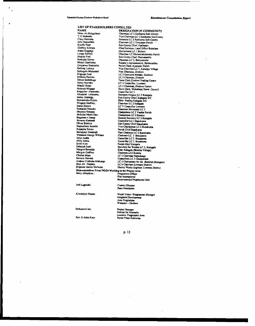
K&mpala-Gay&.Zirob-Wohbuezi Road Rneslement Consulation Report
LIST OF STAKEHOLDERS CONSULTEDNAME DESIGNATION IN COMMUNITYOrmar Ali Kyagulanyi Chairman LC 3 Katikamu Sub-CountyY.K Mulondo Vice Chairman LC 3 Katikamu Sub-CountyCissy Namitala Secretary LC 3 Katikamu Sub-CountyJohn Massembe Chairman LC 2 Tweynze ParishKyoffa Pcter Sub-County Chief, KatikamuGodfrey Kitenda ChiefSurveyor, Land Offce BukalasaAnnet Seggoija chairpersons LC I BulamiLwasa Ssewali Chairman LC 2Bulamiabulanaka ParishMukibi Fred Sub-County Chief, BamunanikaSsebidde Steven Chairman LC 3, BanunanikaMisaki Ssettimba Kabaka's representative, BamunanihkaGonjebwa Ssettimba Parish Chief, Kyampisi PalishKalungi Lukoya Vice Chairman LC 1. Kalungu VillageSsebagala Muhamed Vice Chairman, ZirobweKigongo Fred LC 3 Executive Membe ZirobweSimbwa Kayiwa LC 3 Chairffn. ZirobweDaniel Ssekabuga Town Ocrk Zirobwe Trading CentreHenry Nscreko LC V Councillor, LuweeoMutebi Siraje LC 2 Chairtan, Zirobwe CentreMuluuta Mugaga Town Clerk. Wobulenzi Town CouncilKagurilev Honerantto. Councillor LC 3Abudalah Luboyera. Secretary Finance LC 3 KalagalaJuuko Kamga. Sub-County Chief. Kalagala S/CSseamtimba Kizito. Elder Busiika Kslgaka S/CMugapte Godfrey. Chairman LC 3 KkgalaSarah Zimula LC V Councillor LuweeoSsananda Musoke Chairman Movenment LC 3Mayanja Hussein Chpeson LC 2 Vuoba ParishMukiibe Nkobi Dan Chairperson LC 2 KamiraBagmos e James General Secretay LC 3 KalagaaSewava Ahemedi Councillor LC 3 BusukusnaOlivia Babirye Sub-County ChiefBasukumnaNassimbwa Jennifer Vice Chasperson LC 3 BusuktrnaKajumba Steven Pansh ChieflBusukumaBarisiyoyi Jeremiah Vice Chairman LC 3 BusukumaWalakira George William Chaiman LC 3 BusukumaIrene Asaba Councillor LC 2 BusukunaMilly Sebba Counelor LC 3 BusukunaErish Kiza Parish Chief KalapaDeborah Ssali Secreutry for Wonsen LC 3, KalaglaMargret Banadda Elder Kalapla (Busiika Village)Margret Godfrey Chrmn LC2 BusiikaCharles Musa LC I Chtainm NamulongeSewava Hamadi Councillors LC 3 ChaipersonAndrew Frobisha Mukonge LC 3 Chairperson for the disabled (Kalagala)Haji Ali Nadduli LC S Chairman Laweero DistrictEngineer Jemba Nicholas Distict Works Engineer Luweero DisoictRepresentadves From NGOs Working In the Project AreaMary Alinyikira: Progranme Officer
Plan InternioralBamwananika Prograumme Uit
Joel Lugolobi: Country DirectorBuso Foundation
Kiwalabye Moses: World Vision / Programme Mnagerintegrated DeloprmeArea ProgrammeWakatayi - Ziobwe
Ssekatawa Isa; Project ManagerHabitat for HumanityLuweeo Programme Area
Rev. Fr John Kato: Parish Priest Katikamu
p. 12
Kaimp ayaza-Ziobwe.Wobukmi Road ResEJefnte Censultatien Repert
AVAILABLE CADASTRAL INFORMATION FOR KEY LANDPROPRIETOR ALONG THE ALAIGNMENT:
BLOCK NO. NAME OF THE PROPRIETORBULEMEZI BLOCKBLOCK 15:Plot144 Samuel Nsozi Njuki
BLOCK 16:Plot 34Plot 27 Uganda Muslim CommunityPlot 21 Bugana ChurchPlot 22 Church Land
BLOCK 22:Plot I I J.K. KabogozaPlot 6 Kerement TamusangePlot 14 Kivumbi Kabogoza
BLOCK 21:Plot 70 Zedekiya SerwamalaPlot 59 Kaloli MukasaPlot 37 Mosque SitePlot 44 Uganda Company LtdPlot 72 Busujiu General TradersPlot 73 B. KakunguluPlot 71Plot 25 NassaliPlot 7 Stanley SemnbajwePlot 19 Stanley SembajwePlot 33 S.SsendagirePlot 4 Bulasio SempaPlot 77Plot 62 Erasito KaferoPlot 34 Lamanzae SsaliPlot 35 A lmnanzane SsaliPlot 15 Budala Mukasa
BLOCK 6Plot 27 Roman Catholic ChurchPlot 41 Tereza BasirikaPlot 40 T. BasirikaPlot 46 T. BasirikaPlot 5 Tomasi KiribwaPlot 49 Yasoni MukasaPlot 39 T. BasirikaPlot 47 Yasoni MukasaPlot 48 Yasoni MuksaPlot 28 T. BasirikaPlot 37 Basirika
p. 13
K-mpGay=-Ziubwo.bujazi Road REuttement Consuligaon Repon
BLOCK 7Plot 3 Lenbeni SebowaPlot 2 N. BaziwancPlot 62 A.Ssali & WaswaPlot 32 Alubera SsaliPlot 63 E. KafeeroPlot 17 Natanayi MugerwaPlot 39 Y.MusokePlot 52 Y. GwayambaddePlot 30Plot 25 Yolamu MusokcPlot 53 Samwili MukasaPlot 76 J. SsebirumbiPlot 81 Yolamu Musoke
BLOCKSPlot I Z. SembajwePlot 17 A. KyezaPlot 45 Amisi KyezaPlot 130 Amisi KyezaPlot 136 J. SekizivuPlot 127 J.C. MigandaPlot 123 Haji MwanjePlot Ill Mariamu NakiddePlot 125 Mariamu NakiddePlot 37 Petero MuchwaPlot 138 S. SajjabiPlot 137 B.K.KawandaPlot I Petero ZakePlot 16 Yusufu WalyezingaPlot 12 E. Nalubowa
BLOCK 57Plot 410Plot 401 Y. WaluiznbiPlot 409Plot 230 Y. SerabiddePlot 320 S. G. KatabuPlot 303 A. MukasaPlot 202 S. MamboPlot 183 BaligeyaPlot 50 BaligeyatakaPlot 162Plot 420 Y. Kapinyi Salongo
BLOCK 57Plot 421Plot 155 L. SebowaPlot 153 Hajii A. KasirycPlot 152 A. KateregaPlot 151 M. KakemnboPlot 267 H.B.J KyankyaPlot 300 Y. NamugenbePlot 422 NakibirangaPlot 164 P.KaperePlot 353Plot 214 Y.LubowaPlot 213 Y. LubowaPlot 222 B. Kayita
p. 14
Kamp yzZ ww ti ROW Resement Can=&azon RAert
BLOCK 56Plot 37 Asumani KiyagaPlot 35 Haji. J.KiyagaPlot 34 K. GagangaPlot 36 Asumani KiyagaPlot 43 Y. SerwangaPlot 44 Y. WalusimbiPlot 27 B. SekamwaPlot 63 D. SekabogoPlot 69 Haji Asumani KiyagaPlot 61 D. SekabogoPlot 38 Zirobwe Farmers LtdPlot 59 D. SekabogoPlot 65 Alistaliko Mpanp
BLOCK 56Plot 70 D. SekabogoPlot 66 A. MpangaPlot 60 D. Sekabogo
BLOCK 58Piot 4 Yafesi MuktasaPlot 67 K NabagalaPlot 54 V. KatongolePlot 22 J. MusokePlot 6 P. NakyarziPlot 72 Kalooli MuldibiPlot 50 Joziwe MusokePlot 65 A. S. KawesiPlot 61 L N. GanmukulyaPlot 62 L. N. Gavamukulya
BLOCK 59Plot 3 Sulemtani SetuwaPlot 8 Kasalina Naziwa
BLOCK 60Plot 282 Z. SempalaPlot 446 Mukamudu NakugobaPlot 442 H.A. WamalaPlot 285 Misaki SerumaPlot 286 S. Z. NabagalaPlot 288 Maliyamu NabanobaPlot 299 lbulaimu SebiriPlot 241 B.KibirangoPlot 5 Yubu SempaPlot 150 Bulaimu Matovu
BLOCK 60Plot 473 S. KisubiPlot 415 H. B. MatovuPlot 149 Zefaniya NsemkoPlot II Manuel Muyanja
BLOCK 123Kabaka's Land
p. 15
Kampala-y.jYnb*oe- WobulmZi Road Reseleement Consuhation Report
BLOCK 153Plot 257 B. K.KavumaPlot 341 K. LubegaPlot 258Plot 201 M.NantalePlot 163 Filipo AsanePlot 314 J. NdwadcwazibwaPlot 348 Z. MukotePlot 316 T. MukotePlot 336 Andereya AlidekiPlot 335 Andereya AlidckiPlot 105 Lazaro NsubugaPlot 81 J. Ndwadawa7ibwaPlot 146 Y. KikonyogoPiot 236 National Anglican ChurchPlot 376 Andereya KizitoPlot 138 Y. KikonyogoPlot 137 E. SewanyanaPlot 136 Samusoni KalanziPlot 323 Manjeri NakimeraPlot 349 M. Matovu
BLOCK 153Plot 320 F. SempiraPlot 330 KanyereziPlot 273 S. KalibbalaPlot 272 S. KalibbalaPlot 277 KanyereziPlot 229Plot 230 K. M. NalugotiPlot 134 Efulaimu MpagiPlot 381Plot 252 Maliyaloza NagawaPlot 253 Y. SebowaPlot 233Plot 232 Y. SebowaPiot 361 SendikwanawaPlot 339 S. KalanziPlot 340Plot 326 Kafeero LPlot 250 Kafeero L
BLOCK 151Plot 27 Y. MuwaJuziPlot 3 L. YatuwakwalanaPlot II TebesigwaPlot 9 N. BaziwanePlot 60 I. NamuliPlot 59 Tabisa NamuliPlot 62 G. MuyimbwaPlot 64 A.MuyimbwaPlot 37 Yokana. Z SempaPlot 65 S. MikandokandoPlot 5 t M. Nakimera
p. 16
Kan"h.Ga=-ZhbwL.Wobukiuzi Road RcLeftlement Conssdation Report
BLOCK 151Plot 72 Enoka MukasaPlot 71 Isaac KasoziPlot 31 Manjeru NakimeraPlot 44 Zerida NamudduPlot 67 Levi Kalule
BLOCK 158Plot 104 Lazaro MusokcPlot 65 Lazaro MusokePlot 93 Lazaro MusokePlot 88 R. KizzaPlot 99 T. Tamale
BLOCK 159Lighton NankyaKyobe Kaddu MukasaKirimanyi
In,raemadon Seurce: Lswre DLint Lend Office (fBlasa)
p. 1 7
KampysaaoZiobwe.WebubIzi Road Rcsatlement Consutation Repoen
List ofSquatters on Kabaka's Land along Right ofway (Bamunanika)
KASENENE LUTEETE LC I1. Walusimbi Chrizestom 1. S.Salongo Zzimula 53. Kinene2. Kyeswa Ssalongo 2. Sarah Namnuleme 54. Balaka3. Nsereko Charles 3. Namnwandu Edinansi Kaganda 55. Nakaffu4. Nakigudde Anna 4. Ssempa Kaganda Christopher 56. Ssctyabule5. Kisitu 5. Mpoza Paskali 57. Bogere6. Nsubuga Abdul 6. Lubega Emmily Kapacya 58. Swaibu7. Ssentongo 7. Victo Namutebi 59. Nasozzi Teddy8. Tereza Nyense 8. Kaddu David 60. Sczzi9. Mbuga YA KABAKA 9. Mukiibi Yosia 61. Nassozi Teddy10. Kalema IO. Ssekweyarna Kasim 62. SsemandaI 1. Namugembe I1. Nagitta Babuuba 63. Sande12. Makona 12. Lugwaana Lameca 64. Mukiibi13. Kimegga 13. Kabonge Sam 65. Mugenyi14. Ssali 14. Nantume Serina 66. Najiemba Anna15. Kityo 15. Kaggwa Ssalongo 67. Nviiri16. Kaddu 16. Muky. Ssewanyana 68. Lutabi17. Kakooza 17. Ntabazi Yusufu . 67. Nantumbwe Betty18. Ndiwalana 18. Sserwanga Joseph 68. Mulamba19. Kiwanuka Peter 19. Mutyaba Deo 69. Kabergwa20. Narnwandu Kizito 20. Musuza God21. Kasereka 21. Mukiibi Bcnon22. Ssemuyaba 22. Nantorngo Benadeta Nalongo23. Nnabuuso 23. Kateregga Lozio24. Gitta C 24. Kayiza Ssalongo25. Magero K 25. Ssegujja26. Nakakande Alene 26. Nkulukiye Kamya27. Ssemambo Yozefu 27. Kato Kafeero28. Ntege F. 28. Kalyango29. Kasamba 29. Mukiibi Yosia30. Ssekabira 30. Kasozi Bonny31. Natnwandu Sande 31. Nakato32. Nkuba Willy 32. Nsubuga Edward33. Namwanje 33. Kibalama Ssalongo34. Kigongo Willy 34. Ssewakiryanga35. Kazooya George 35. Nakawunde36. Kisekka 36. Nabyonga Dativa37. Ssentongo 37. Betty Nabagesem38. Nakku Margret 38. Mukasa James39. Kanyike 39. Luteete S.S.S40. Nansubuga 40. Nnamwandu Kibirango (Bydesiyane)41. Kagulire luma 41. Luteete College42. Haji Lamanzani Bbos 42. Mr. Munge43. Mubiru 43. Luteae Den. School44. Kibinge 44. Chrizestom Kigundu45. Tebusuweke 45. Mugomba Joseph46. Kato 46. Kangave LS47. Kyeswa 47. Bale Joseph48. Bwete Mulengera 48. Mugomba Joseph49. Nayasa Coffee Factory 49. Mukasa50. Ziwa 50. Kigozi51. Ochamn 51. Ssempa52. Kasimu 52. Nantumbwe Mary
p. 18
Kampsla-GCyaza-Znobwe.Wobuienzi Road Rwsetleme t Censutwi. Rqepe.r
BAMUNANIKA1. Bctnard Kamya 60. Bbowa Willy
2. Matiya Kakumirizi 61. Mutebi Robert3. Paul Mitala 62.Nakubugwe Monica4. Kasereka 63. Mutebi Robert5. Bulya 64. Kabengwa Ssalongo6. Benon Mukiibi 65. Kabengwa Ssalongo7. Stephen Musisi 66. Ssaka Lorence8. Kata Moses 67. Sseruwagi Ali9. Hussein Matovu 68. Shiragi Ssempa Ssalongo10. Eloni Nnalongo Ssajjabi 69. Budala KawekeI1. Nabagala Janet 70. Ssebiina Eriyabu12. Nakku Mary 71. Njub13. Juma Lureka Mulyazawo 72. Limbo (Gombolola Mutuba VI] Care taker)14. Vanila Nnalumansi Gorreti 73. Chrizestom KigunduIS. Hajara Nalwanga 74. HajJi Abujjere16. Lubwama Moses 75. Abdul Lukengc17. Nakamande 76. Karoli Ssenda18. Abumbakari Kamoga 77. Hajji Nassuru19. Kato Walusimbi 78. Hajji Nassuru
20. Marian Nantumbwe 79. Sonko Wilson21. Vincent Kizza 80. Luteete C.U22. Vincent Kizza 81. Solofne Namusoke23. Ismail Senkulc Ssemnpa 82. Brahim Opere24. Muwonge 83. Erunasani Kiwanuka25. Ssengiri Jonathan 84. Manjeri Nabnukasa26. Jonathan Kasule 85. Bumunni,ka UMEA27. Degeya Ssalongo 86. Mulajje Catholic Parish28. Haiji Hussein Matovu 87. Masomero (Gombolola Mulaba Vll Care taker)29. Ssekiwala 88. Isa Ssearito30. Kabalu Yowana 89. Chrizcstom Kigundu31. Masenuka Ssalongo 90. Misi Lubowa32. Caltex Mafuta 91. Vincent Kizza33. Baguma Habart 92. Muwanga Donozio Buwembo34. Abiyasali Kabuye 93. Nakato Kasule35. Emirio Lubega 94. Ntwanita Nakityo36. Kabengwa Silvest Ssalongo 95. Mugenyi Livingstone37. Edward Nsubuga 96. Bumbakari Matovu38. George William Sseruwagi 97. Kimbowa Godfrey39. Edward Nsubuga 98. Nanfuma Juliet Debula40. Robert Sserunjogi 99. Ginnary Block41. Kabuye Abiyasali 100. Wampamba Bety42. Ssemujju George Wilson 101. Banamasaka43. Kisamba Mugerwa Hon. 102. Badiru Kalule44. Degeya Ssalongo CR. 103. Nekeneya Kawuma45. Kabalu Yoana 104. Kivumbi Erukana46. Shiragi Ssentamu Hajji 105. Ronald Kanwanga47. Ssaijabi Nalongo 106. Chrizestom Kigundu48. Wasswa Ssaijabi 107. Haiii Abdul Lukenge49. Badiru Mulumba 108. Federesi Namulindwa50. Abuduru Kasozi 109. Nakimbugwe Monica51. Nabatanzi Giradesi 110. Edward Katunde52. Kasifa Namukasa 111. Akhmada Kirumira53. Ssentongo Emmanuel 112. Chrizestom Kigundu54. Kabengwa Ssalongo 113. Yusufu Sebi55. Mukasa Mwanwnugimu 114. Madi Yusufu56. Kizza 115. Jumna Yusufu57. Mulondo 116. Lumu Kibonerezo lgnatius58. Kikesa - Ssempa 117. Nusula Adye59. Nsubuga 118 . Ssenkunba
119. Archilo Mukiibi
I.femaaop S~" Kabo" LieIe Oc
P. 19
lampala -Gayaza -Zirobwc -Wobulczi Road
Review and Update oj/Feasibility Study and Detaied Design rfKAMPALA - GAYAZA - ZIROBWE - WOB ULENZI ROAD
Fcasibility Study Draft Final Report
APPENDIX C
STASTICAL ABSTRACTS
L Phoenix

I
. I
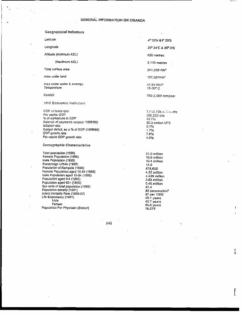
GENERAL INFORMATION ON UGANDA
Geographical Indicators
Latitude 40°12'N &10 29'S
Longitude 290 34'E & 350 O'E
Altitude (minimum ASL) '620 metres
(maximum ASL) 5.110 metres
Total surface area 241,038 KM2
Area under land 197,097KM'
Area under water & swamps 4894 1 KM2
Temperature 15-30° C
Rain fl 750-2,000 mnmyear
Q998 Economic lndiccaorf
CDP t.! factor cost 7'413,70E r ;:. shsPet capitai GDP -5C.223 shs% of agricul:ure in GDP 42. 7Ealance of payments surplus (1998199) 56.3 million U(nInnation rate 0.1%kEudget deficit, as a % of GDP (1 998/99) 1.7%GDP growtIh rate 7.8%Per capita GDP growth rate 4.9%
Demographic Characteristics
Total population (1998) 21.0 millionFemale Population (1998) 10.6 millionMale Population (1998) 10.4 m!llionPercentage Urban (1998) 14.9Population of Kampala (1998) 878,600Female Population aged 15-54 (1995) 4.32 millionMale Population aged 15-54 (1995) 4.438 millionPopulation aged 0-4 (1995) 3.83 millionPopulation aged 65t (1995) 0.4G millionSex ratio of total population (1995) 97.4Population densifty (1991) 85 persons/kMl< 2
Infant M 1ortality Rate (1988-92) 97 per 1000Life Expectancy (1991) 48.1 years
Mlzle 45.7 yearsFemale 505 years
Population Per Physician (Doctc) 18.575
(vii)
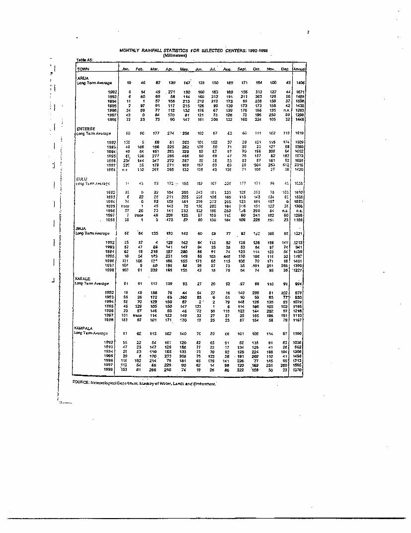
7
MONTHLY RAINFALL STATISICS FOR SELECTED CENTERS: 1992-1998(MDUmulraes)
Table AS:
TOWN Jan. Feb. Mar. Apr. May. Jun. JuL. Aug. Sept. Oct Nov. Dec. Annual
ARUALcng TannAverage 19 46 87 139 147 129 150 1E9 171 184 100 45 1406
1992 0 14 49 271 190 160 163 189 156 313 122 44 16711993 6 so 69 58 114 160 212 191 211 203 129 56 1489199 11 1 57 156 213 212 212 17a 69 238 159 37 15381995 2 97 91 117 215 126 99 139 173 173 156 42 14301996 24 59 77 112 132 176 67 139 176 186 135 na. 12831997 43 0 84 170 81 121 73 12P 73 196 230 99 12981996 72 23 73 90 147 191 209 122 160 224 105 32 1448
LongTerESAvE, 9e S0 SC 177 274 258 102 67 e3 60 111 162 is1 1619
1992 13f S £9 £1 255 101 152 27 _9 1;1 ;;5 174 13091993 40 108 196 225 2Ea 179 f0 71 3S 3; 127 E9 13901994 40 S4 151 2£3 329 S2 E7 S7 70 196 209 E4 1G52l955 6f 126 277 295 466 90 eg 47 76 197 82 183 173;996 23i 144 347 272 367 7S 3 ES £3 f7 161 93 1eSe1S97 22 ;5 179 271 1G9 167 E0 69 2S 301 253 512 23151sse n E 1;0 266e 365 132 1-e 40 126 71 108 7 E6 1420
|GULUtcr.T n AvUr C( £ re c2 c, 1f5 1f 2 1 E -T7 1,1 c : 15
!992 2. S 22 154 255 t43 10, 2; 126 3-_ 7±10_ 16101S93 e 22 -e 211 225 I09 16 169 113 143 124 EL 153919S94 74 0 92 1f9 161 252 272 29S 123 191 197 0 18231995 t'rcr 1 4S 143 75 15c 202 164 2:6 121 12 2 3£ 1306sSS6 57 26 73 141 313 132 15e 260 ZS 2eo 64 na. na.19S7 7 trace 46 208 120 67 150 115 60 241 192 90 1296
.199F 35 1 3 173 57 90 10 164 106 226 .151 23 1159
JINJALoegTerniAvae I | 6e 84 135 193 140 60 f8 7n 93 1*2 166 95 .1321
1992 25 12 4 129 142 94 1;3 92 135 128 198 141 .12131993 52 47 9S '141 147 94 35 38 53 64 6T 74 9411594 62 15 216 187 280 68 91 74 123 114 153 54 1439199S 10 f4 1P.9 251 149 66 103 44E 170 19E 11g 30 :71996 131 108 134 186 155 171 66 115 108 79 171 18 14611997 107 5 to 15 8e 39 27 73 35 :le1 291 259 13901998 160 91 239 169 155 42 16 75 s4 74 95 35 1227
KAEALELon Tc-rmAverage 61 91 117 139 93 27 20 52 S7 96 110 91 994
1992 1I 49 158 76 44 54 27 16 149 205 81 392 9791993 96 26 172 ES .160 83 0 61 10 59 95 7 9301994 56 70 129 150 87 2 2 79 14E 126 135 93 10791S95 46 129 105 150 147 123 1 6 114 166 105 103 11951996 70 57 146 93 46 72 50 118 123 144 202 97 12181997 101 trace 114 122 149 33 27 27 25 155 196 151 11101998 1E3 97 101 171 '70 19 25 23 87 154 58 79 1167
KAMPALALongTernmAvcraEc f1 62 113 1c72 140 7S S0 C6 101 109 114 97 110O
1992 5E 22 s4 161 120 82 ES 91 56 135 91 63 10361993 47 23 147 129 168 77 23 ;7 134 126 41 26 9621994 2S E3 110 1.65 133 73 70 92 125 224 188 104 13661995 29 8 170 293 208 75 133 38 191 202 110 41 14981996 11£ 192 214 79 181 65 179 141 226 77 145 95 17121997 112 54 66 229- 90 62 14 98 120 169 251 280 15651998 153 81 266 210 74 19 26 86 222 115 50 23 1370
SOURCE: UcerroIogic: Dcr,:,SncnL nM b usry c1 W2:er. LnCrd and Ensvbv.ncnt
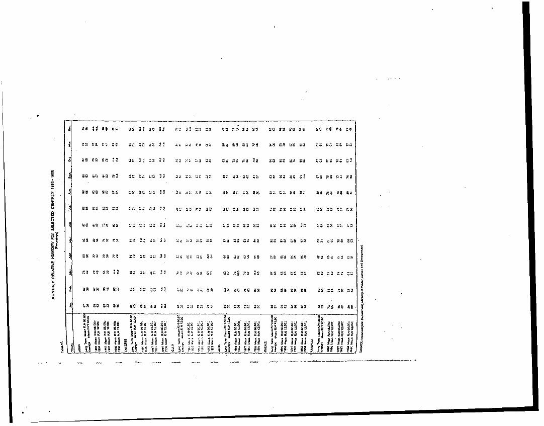
WOW 00 1' ,....~~~~~~~~~~~~~ ,~~~., 00 00 00~~4z ., am. ::, ; - ~ O r
- Y 40 00 C C ,..,-~~~~~~~~~~~~~~~~ C. oc .. i U. QV . oo . ;
-x -i gg k 2 Z ~ A 4-;2. 4;Z sa 29;Zt ;u
'0.~~~~~I vs
CN, v L
U,~~~~~~~~~~~~~~~~~~~~~~~~~~~~~~~~~~~zg 2 9 22 3 2 Z9tg
:Q2 4 % sZ ,A9 2A g9 z 3t2 Al94 .
H H I~~~~~~~
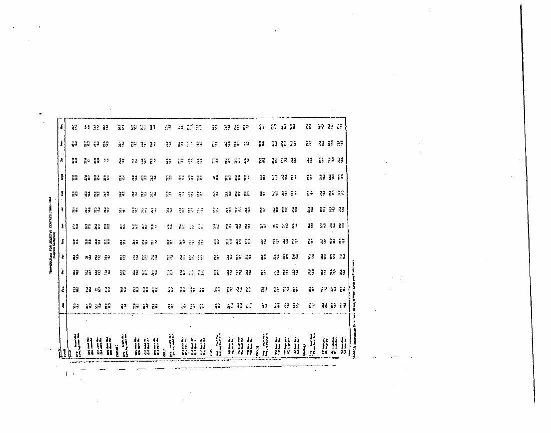
A ~~~~~~~~~~~~~~~~~AX -
-q a
,t
J.4R>s*Xf;4 :w gtgr : R.a-N"J Y~ ;1 x h gD
q A~ ~ ~ ~ ~~~~~~~~
Cf ij~~~~~~~~~~~~~~~~~~~~~~~~~~~~~t
U.~~~~~~~~~~~~~~~~~~10
14g flCf t ilt gs~.,j. .. y M.X
4 fi jOr M4 C-fO tt i;t
x<; sa9 aa 'n: ^: aa a q
X~~~~~~~ 2 ' R ' .b-
9 9 t9 YRaq 2R ,_gg i i
4~~~~~~~~~~~~~~~~~~~
Cf' S >9 t c. - jti-. f ai j ;6 ';4Cf ; 3_; r J JCNCi
X -jbq Xb j' e X~~Y ^qY iifl ;q;Y ,9jJ jj; ;6 2S^; IJ ne iSq :>3 aq xe x f - *f*ii I f l fJs
_ .
-q DS '4 I M ' 4' '
16
THE 1991 POPULATION AND HOUSING CENSUSTable B3:
Region & Sex Residence 1 PercentDISTRICT Male |Female Rural Urban Total Urban
CENTRAL S.. iKasangala 9,929 6,442 14,995 1,376 16,3711 8.41Kampala 377,225 397,016 0 774.241 774.241 100.00Kiboga 72.538 69,069 136,330 5,277 141,607 3.73Luwero 173,926 1,75,268 320,977 28.217 . 8.06lMasaka 343,346 351,351 620.952 73.745 692657' 10.62t..pl9i 1 455.703 45£.164 776,741 137,126 913,867 15.01Mubende 254.061 246.895 466,435 34,541 500,976 6.69Mukono 413.550 411.024 725,869 56,735 824,604 11.97
Nzlcpsonrcolt 50.472 50024 92.183 8.3,14 C 100,497 E.27PRs.i S68 06? .94' 4 0 'i9 368,622 14.869: 383,501 .E£8Serr.tbulc _72_206 7i,£3_ 140.se _ 3.451 144.039 2 zlf,Rcgion 2,412,Q0£ j 'Aa2 .5051 S,666,702 ,1,7e.692 4,843,594 - 24.S6
Ei,STER14l t Eugiri 117,0271 22.260( 234.735 C4.572 239.3071Eua 7§.400 84 197 1-5.62Z0 | 27,S67 163,5S7IG; n44X |:3CC,O 7'.C2C2.241 G67,04C | 2'i.G6 136,7e .706it.
.S1¢.. ! t2,2f: ;C.to p0856e 6GE'2! 269.47e& :, .j 7.!7 , titi,'7 _,2 l12,C.Lj ,C2c . 6 2 2
-71 .14110 144.5702z K;:al.:¢!: L, . i,42t.; 72-.uG2.> 1C1,70f. I 2,4§2 i4c,597.1 ; i2!~~~_.r =J5 112M 4.71.474~ ~~ 1.1,0 274 103 2112,71S!1 17275t 224.945 I.7 4S 236,69s41 4c.S355,.60j S 5o- 177 650.f82 60.296 710.9601 G.4'173,t301 | *E-,20t 354,729 2,S27 357,655 0.C2
Soro:i 13SOGj 147.697 243.012 42.78S 2B5.793 14.F7
ororc 193.620 196.157 355.,27 35,6S0 391,677 _ 5'1Rcgion 2,025,613 2,1C2,856 3,Sb5,803 322,666 4.128,4691 7.82
NORTHE-RN. _ _ .. _Adjumani 4c,323 49,941 .94,156 2.108 96,264 | , Apec 222,854 231,650 446.721 5.783 454,504 1.27Anru 307,679 : 3_0,262 611,229 26,712 637,941 4.19.Gulu 166.316 172.109 300.130 3£.297 338,427 11.32Kilgun 172,640 164 544 341 857 15.327 357,184 4.29Kotido 92,481 103.525f 186:304 9,702 196,006 4 9SLira 247.607 253,3'' 473.397 27.568 500,965 5.50Moroto 60.061 494356 161.436 12,961 174.417 7.44Mcyo 36.731 | 40650 72,702 I 6,679 79.381 6.41N'ebbi 152.093 154.773 292.923 23,943 316.6661 7.5GRegionr 1.5265,787 1,.;'51661 26982,855 169,100 3.151,955 S.36
WESTERNBundibugyo 57,816 58,750 107.351 9.215: 116.566 7.616ushenyi 279.543 299.5941 564.942 14.195 579,137 2.45Hoi.a 99.547 96,304 193.235 4,616 197,851 2.33Kabale 1 197.6S5 219,523, 367.972 29.246 417.218 7.01Kab2ro!c 369.816 376.962 709,646 36,954 746,600 4.95Kascsc II 167.672 175.929 303.7039 39.892 343.601 11.61Kibcjlc 109,756 110.505 217.853 2.408 220.261 1.09Kisoro 66,406 100,275r 179,196 7.45 1i 186,661 4.01M,-indi 1.31.936 12.5, 60k 2C6,444 14.352 260,7961 5.50Mbasra 39C,101 i 40:673Z 754,769 44C.05 7977C4 '5.51Nluncrr.o 139,063 150.139. 266611 2.611 289,=22 0.90Rukungiri 187.865 2 22.695r 377.795 12.965 390.7801 3.32Regicn 2.221.258,2.326,429 4.329,723 217.964 4,547.687i 4.79
UGAh'DA |' 8.185.747 8.4E!5,,q5Pi 14,762.063 11.33
'COURCP: c'En-c PL"ezu of S;3V¢!.S.
3E~~~~~~~~~~~~~~~~~~Z S, _ N S 1- c-
8.E~~~~~~~~
~ ~~~~~~~~~~~~~~~~~~~~~~ .1 .j w .ii Vs _ SM e O S ° o r. _ rO r/ r} 8 us3 u 3 c Y v ., c. sl 3" Y, UW 10g_UZ; W- Ut1 |a Va- 1ooc
Swe
N - _ 4MNM0V l " vC r-_ .l . q _
Ci nR ow Iq 41
Rg ~1 RI
is~~~~~~I, o, XY 0 WIt wt q Itrs .r o ys ! AY q q q r% - y- - 1% -~ Iq "I vq ! y~ C vR -t ' wK r I s fA at- Y . r ri 'R R 'I &R t; s
O rx r uX *N Nm4r V,s I s .D14 .: s. - - v . . . - , 4 1 -l -NVNv| lNN-Vu >O
%} v .ir * "~~~~~~~~~~~~~~~~~
. il Ine
.X~O , .1- {_ Xvi vl il_i _ 8 jvi i uu rz>;j;aE r -1 r°V v vq3 @rNr N -W _ S§ | ri V r rrj V9; 4; 4 V V ~~~i
-i V%
Cy I )qV sFs 1 1 v y V I r ! -w % r, V _ Cr N eNl iO worr qo yq9 wo O ry 4? ruur. ,tj.{-; i _vyr.- oqr
C. N V, w -r. VVO _r w- , u- v, 1
1_~~~~~~~~~~~~~~~~~~~~~~~~~~~~~~~~~~~~~~~~~~~~~~~~~~~1 _ 8 w
19
POPULATION DENSIlY BY REGION AND DISTRICT: 1969, 1980 AND 1991 CENSUSTable B
6:
Region & Tot;l Population Land I Po ulation DensitYDISTRICT 1969 18eo 1991 Arra 1969 1980 1991
.C£NTfiALK(alangala 6.8 8.6 16.4 432 16 20 38Ksampaa 330.7 458.5 7742 169 1.957 2,713 4.5e1Kiboga 75.7 138.7 141.S 3.672 20 36 37Luwcro 266.0 338.5 349.2 5.360 50 63 e5t:Msaka 391.9 520.3 694 7 3.214 122 162 216I.4pici 513.5 661.2 913.9 4 4514 114 146 202Mubende 255.3 371.6 501.0 5.949 43 62 64lQiukono 5410. 634.3 £324.6 4.594 118 136 179Nt4kasornola 7.2 74.0 17 15 23 32R~kzi 182.6 274.0 383-.5 3.179 47 71, seiC rn±sulc 59.4 1,02- 144.0 2.317V 26 _44 62|Rcg;on 2.672.0 ZE3E2.4 2.7<3.6 37,489 71 961 I29
eASTERN I 102.1 55.5 , 239.3 S. 14531 70 107 165Eiugiia .j S02 126.2! 1631 70T ; 2e 179 2t2Icans 3t6E.1 SE.&i 706.5' R370 109 *4CS 2'i~f);;~ ? 196E3 226.5 2es.sl 677 2SO 428P;:1u?, 'i 27£._1 349.! ces.21 3E2!22EL 1kS, -4c
:.l;-;Jo;**:. ! t.<.! ,.!- '1~~~~~C.. 7 '7-7,.
C' 711.0~~~~~~~ -7 7I c.:- :lo.:' -. !. 20r2: 4,r1 67. 1
202 -C. IC, 15C 12:1 1E7 i2SECWG;, h ~~23O.15 92 2EE, S,.S79 s 77' 74Tc:crc 234.7t ;1l.0 392.0E 1eE1 _ 144 172 _ 240
itecicn 2.528.4 3.2 7.4' 412 27,e57 so 116' 1/NORTHERN 4.4 :
Adcjmanai 42.1 486 96 t' 2.E 15 17 .33Apzc 225.4': 315 c45s1 5,87 38 53 77Aauz 4,I369.e ;.2 637.- 7.595f 49 62 64Gulu 223.7 7.0.1 S33 51150 19 23 29Kltgum 240.1O 30.7 s57.2 16,136 1s 19 22Kolido 105 6 161.4 19601 13:208C E 12 iSLira . 27E.z 370.3 2 1.0 6.151 [ 45 60 81f4orcto r 164.7 1E666 174 41 .c1131 12 13 121.1.0o 4 7e9F 57.7 1 sC 170 7 215 45
{ t4'ebti 1,' 204.1 233.0 316.9 2.761 73 64 114Reion I 1,S02.2 2,424.2 3.1520 2 82.09S 23 301 36
WESTERN I -- '' IEundibuoyo 79.4 112.2| 116 6 2.097 -6 54 55Euhsfnyi 307.6 408.7 579.1 3.6227 0 107 151Hoiman 112.7 14221 197.9 3.563 32 40 56Kabzae 288.6| 328.61 417.2 1.698 170 194 246KaLero! e 328.0 519.E 746.8. 6.1OS 40 64 92Kasese. 164.1 277.7 343.6 2,724J 60 102 126Kit)aale e3.7 152.1 220.33 4.206; 20 36 52Kisoro 114.8 126.7 16.76 620il 1e5 204 3011a2smndi | 155.5 223.2 260.6 8,456 1 6 26 3S1Mbarara 376.9 5S1.0 796.A 9.733 a9 61 82KI.Jnmoai7'o t 174.6 21 2 2E8.2 I.961 66 106 146Rukungin li 244.61 298.e 390.8 2 .E 95 115 151Rfecion 2,432.1E 3,'92. i 4,647.71 49,551 491 681 92
UGANDA 9.535.11 12,636.21 16.671 197.096. C£ 64 65
NOTES: The total poLpulation is given with rsfSrence to the area of each dislricr as of 1st July 1997. hencethese tolals do not agree with those given in earlier publications for the aS.ected districts
Sr x Ratio = Vales per 100 Fcmales
SOtJRCF: tVlcznCd Evrenu c? S1:iticr.
21
PROJECTD OO00YEAR POPILATIN DIST81=11REGMO. UOAJ4O&. 1085 -2015
01Oa C... 1995 80 107 19 1999 2 2005 2010 20t1
l66M0. 10.37 IT.=0 16.80 182W 18.400 175 1.0 880 2.0 101,,,Wp. 674.241 840.700 SU=30 SW0.O0 878.6000 8.00 020 4500 9100 I07055bwo 141.607 128.400 163.400 107.20 171.00 1405 1880 19.0 1.0 3.0
L. M 348.164 423.700 441.00 4m"80 67.0 9.0 1.0 03.000 710.80 82,09ug. W8.897 7M020 011.400 832.0 852.2 874.200 MAW00 00.0 1.101.400 1.238.MAUi03.0 1.03.75 .000.405 1.083.700 1.121.000 1.140.400 1.17.05 1.300.400 1.444.305 1.83.3ks.~~4 000.870 888.800 272.203 584~~S.400 800.600 800.85 100 5 673.200 733.100 000.80
I4A8 234.004 942.80 897.000 1.MAM0 1.063.200 1.05.05 1.128.80 1.27.100 1.472.805 1.701.000"a-O 100.497 110.80 112.900 115.000 t1I7.ODO 119.0co 121.105 138.300 13.30 141.5005-n..6 ISE,=29 10.00 10. 160.105 162.200 .7 164.25 l800 173.000 180.105 180.2058r0a 383.201 423.805 _322-00 4.0.0 40.05w - 458.802 AA 1 497,.400 S3u=0 I n.7c5R.-n '.C42,004 5.408.00 _ 5.E27.8O0 E. 7t7?.;0 7.500.806 1.04f8.701J .185400 C*915400o 7,1.0 C438.200o
8A5TEm
8.141r Zaf.307 204 202' 207C.405 274.350 27.007 28300 I 2.1o 850 308.00 33200 34?000183.27 107.700 107.100 18-.1I 2.92 250207 714700, 230.803 2CS.200 3=8.50'oo' 0.478 t--.200 E34.W.0 84.800 06.700o tOU.00 50M1m)0 1.0004.05 I 113.00 1.24L.8500200 .47C 344.000 Z7.=0 3-70.833 UJ0.28) 307.807 41I6.003 479.205 528.005 862.2
4U.16.214 505.005 577400 Z1.503 811.802 "2.703 007.002 7.7.40 3.32 75.386Ult,~ 1.703 248 12 127pm 14 3.702 W14.00 1.52I 1.0: 2.50 172.272 704
L W.2.22 it:.t... . 7.07. - 2 L..~ 7.0, ::
...... 3 '4 *4r7.'1 408..C1..: '2..2 02..2 85&2, 0.6
1K..14 0.50 107.900 100803 11180 113.!OD 110.400 12245 138.500 IMA.MAW I 4S4.u 00 0.0 21.380 032X.00 4.0 555.050 !x7.300 e10.80 672.895 741.25WA. 1 87.641 731.=0 732000 778.M0 700.1001 810.700 041.300 5432.0 1.052600 1.211.300Ow.k5242 Y. * .00 412.605 4MM00 I4.:00 4C6.5.4 480.700 040.80 MIMI4 731.700K2- 27.164 4.20 437.205 47.2.700 4.8520 483.80 490.105 078w.5 6 0e.900 700.808V86664 100.038 m 00 228205 234.345 240.100 205.90 251.700 278.10 30800 34.0Lk,5 22 .5.8:5= 05800O 88300 019.800 8330 5.105 724.40 80.0 15.105M.-~l A<2 1 2420 348.03 250.055 271.40 2WA.7) 35.800 42.10 5.800
I4o~~~ 70 321 9:000 0~~~~4.80 07 78.3 105.80 103.400 104.0 120.200 130.800 Ise.00:10800 371500 384.003 200~~~~.800 40000 goo 400 4325 408.400 813.500 3
R- -Z-2 3jC3.00 it 4-Z.( Z.82,200 4.108.4oo '4.220.780 4.771 .4OC 6.419.000 8.20.200
I 61.70 11.566 1427400 j 146.A00 M=53 181.800 168.305 174.60 205.800 230.100 =~.S50!TF.137 CU4.=0 ( 80)2.0 717.80 738.800 701.000 743.000 000.60 1.1.0 .17-.405I' 023. 233.40 21.0 20. 250.400 M=00 275.0 31720 WA3N.80 431.1050.540 77218 6.0 3.0 8.0 882.050 58.70* 83830 752.0 SW .00 108.0
K-e 748.80 64.25 Z 2300 803.057 80.00 0124.30 544.80 I..04' 1.13.00 35.3003.... .5016 38.05 0570 44.0 425.00 430205 U47.200 400200( 507205 83.400156.., 320.381 24.33 24.:' 22.5 257.100 20.0 8.5 020 301.402 2..700
K- 160.&801 223.20 232.050 240.800 240.82 200A00 2e7.70W 313.200 307.800 43e.30246.4 83.780 310.400 321.0 M 3.5 340.00 37.700 388.800 4230.2 503.80 594.40Ml.. 0.774 512.100 032.300 882405 87.400 1.012.460 1.03730 1.15.100 1.206.O0 1.422.10
as= Jutim 3u8ooq 371.400 50470 388=0 4A1.80 460.100 08z2.2) 085.700I ~ ~ ~~~~ ~~~ I_ 1 "1.SC.0 20.Li4 21.02.3000 21610.705 540 25.2009 702003L 2
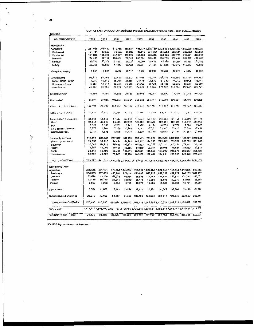
2e
GDP AT FACTOR COST AT CURRENT PRICES: CALENDAR YEARS 1989- 1a99 (mlt6ions hellngs)JTable D2:
INDUSTRY GROUP 1989 1990 1991 1992 1993 1994 1995 1996 1997 1998
MONETARYAgriulture 281.855 365.487 510,765 850.854 866,133 1.278,759 1.423.435 1.478.330 1.569275 1,850.217
Cash crops 21.781 33.533 70.625 86.002 87.610 271,572 281.558 268.641 300.232 327.564Foo Crops 151.818 185.728 242,177 485.299 461.668 630.518 668,125 652.726 716,361 887.317I-Neslock 74,455 97.117 128,483 160.806 200.504 245,480 306.789 353.484 353.520 400.463
Foresbty 10.512 15.309 21.637 29,326 34.080 39,468 45,378 50.204 50;890 61,1S2Frsting 23.288 33,800 47.843 69.422 82271 91.721 121.585 153275 148272 173,680
Mining 6 quanr,.9 1.065 3.296 6,420 10.617 13.118 12203 16,E28 27,679 41,374 48.199
Maenuaurins: 59.711 67.485 122A4S7 193.t12 227.5e5 30S.096 3e7.373 4C3.59£ 573.314 66e.1923Cof.G, c.cn. :u-ar 726S 10.14L 1f,207 21.15S 21X8 C47.639 61.330 74.048 60.906 £3.44,M:nut OurfC tice S.EES 12.047 1C.4S8 2C,E83 ;1.26 40.424 55.408 C6.22S ES,307 93,00CtMtince ;2neo0u 4E.0OE C 5.25_ 080,21 145,.23 1,.5C.1 215.035 270.E 5 .32t 407,040 491,74?
Electrick:ywetev 6.380 10,.5E 17.56S 2..465 3f.076 S5.087 62.890 73.£E5 S r 1,34e 101.720
Ceasnt,sct.e. 35.574 C;.E5, 10C.171 72.36 205.053 17 319.901 E5.007 '55.1CL 520.290
tv:.rc2:crlr 4 !.~t;::1'icc I 71 167 1f ?,i-2C 2?7.;£( 32C .13 Z4.r. 3 7f.77f C3L.f3(771.?C 795.18! i ,198.0P9
~ .c:::.:er. .. . 3f., '-0 l fE.5S £,.;r1; i:i _ Et 4377 21?.SC_ :;,; 4. 1.577 t3L.8~~0~ ~L.L55 87.9C*~~ 1.01C.7,3 14 Z4 I12.501 471 ES.C- 5L3 5 3. 1.7ReCa 2e.5t.- 4,.£07 C.St, 103.502,S ;2_2E: 1350 152.4E1 1E9.t3 .2S.61_ 255,9R,;: Z.3,615 ; 318 G.202 E,7CE 7.17 Z ,124 10205 f .709 F,0e6 7.0eeAir 6Su,-PC:, SCMiicez 3E.76 4.701 7.325 12.74C 13.C.41 ;7.7.61 22.913 30.C1. 3.:5i0 47.63eCorVrnu..caVio 2.312 5.93t E.G1G 11.177 13.470 1_.730 18.013 21.764 . E57 27.05£
Comrnnuni seniecs 119,197 200.456 317.577 510.459 654.S11 751.024 E94.506 1,043.010 1.145.277 1,252.666Geneerzticm-mrnenn 24,356 37.295 74,4S4 124.762 i62.312 1945523 225,512 255.789 2E3.509 301.906Educabon 30.640 51.93S 75.63 117.877 167.693 1E2.373 207,141 245.134 272.641 69,.196Hezth 9.357 1E.09: 30.411 49.36$ 56.079 C0,754 69,9f5 79.624 E3.662 67.845PCents 21.112 43.406 63.763 100.511 122,321 145.66' 157247 239,073 266,617 308.421l.is2cetlaneous 33.732 49.722 73.045 117,920 144,S07 167.401 194.691 223.390 242.646 265.495
TOIAL MONETARY 703277 991.311 1.433.053 2.329.9C .2.0f5.603 3.414.946 4.050.293 4.568.150 5,086.670 5.e21.173
NON4-.ONETARYAgricultLre 386.615 451.151 575.334 1.045C277 955.364 1.2S2.468 1232.855 1.151.051 1212.803 1269.965Food Crops 338.883 3E7,005 490.960 922.448 813.012 1.066,33 1.037.212 927.929 266.255 1.026.929Liestoct 32.679 43.168 57.076 E2.564 95.51e 111.682 134,413. 152.820 174.791 185,271Forestry 12.116 16.715 21244 31,510 36.476 40.266 45.896 50.970 53,056 55.6SSFishir.p 2.937 4263 G.034 6.756 10.376 11.566 15.335 19.332 16.701 21.906
Construvion 8,584 11.642 15.683 23.559 27.310 30254 34.546 36.386 39.926 41.986
O.nrr-occrupieCd DwCflans 25240 47.102 63.457 91.74S 10*.720 122.EC3 i64.617 198.675 223.657 260.590
TOTAL r40141.OI4ETARY 420.438 510,095 es4.674 1,1E0,5£5 1.0E9.415 1.S85.5£5 1.4:Z.021 1.386.312 1.476.5E7 1.592.53S
TC1AL GAL C1-123,715 1,501.40C 2.007.727 3.490.4EC 3.72521e 4.E0,.531 5.482.313 5.956.462 6.5G5.456 7,413.79'
FEFR CAP.tA CDP (SHS) 70,37_ 91.35 *23.5X 1SS.46F 208235 2Z7.71S 285,656 301.715 323.786 356.,25
SOURCE: Uganda Bureau of Stetisbrz..
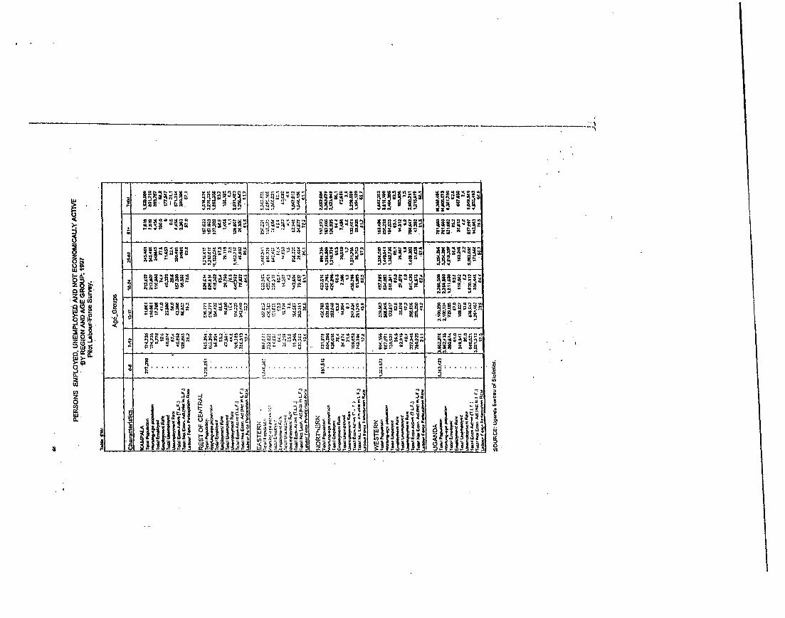
Ur _-
.- .- .. ____ . .v
_ .~--- . ..
n O .- _ -. .
0i*11
*1 El. .E
.
.Xi i . Z . ~~~~~.~ . _I
. . .I _ _ _Z 5 ___ > 2jjII~ Ji1 'sj~iz 4 d tI
cIr l

0 , 2 --- 9 q GI 0.-v I t 1 -
_ __
________._____
0 j 4 -R -g I e v ,I iR - .
i i. - _ _ _ _ _ _ _ _ _ _ __ _ -. _ _ _ _ _ _ _ _ _ _ _ _ _ _
w _ C - - O Mj_~ ~~~~~"
3- -________.____-__-_-_---,
-- lu @9 f ai. s; v. |8 , : .fi ,u i
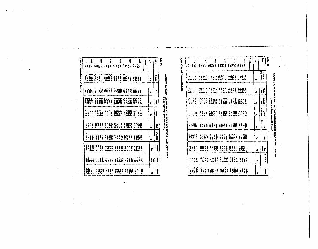
^ 3 to i .b 4 bC>11 , ,, b wo . bb i l 2. ^iroisoAi0. ,i ,iX 4OM ni 'b ii-A
b~~~ .; i l t. k . .kw .b,
.. b L.5
> :p#8h-;iw W1 b b vL >v4 b i 4o 3,..,,.. ,b _ i.1
b b b-h > b v L. bb Z b " I. b C: b v . . - b 4 b b 4. b iv L, 'w v lb.
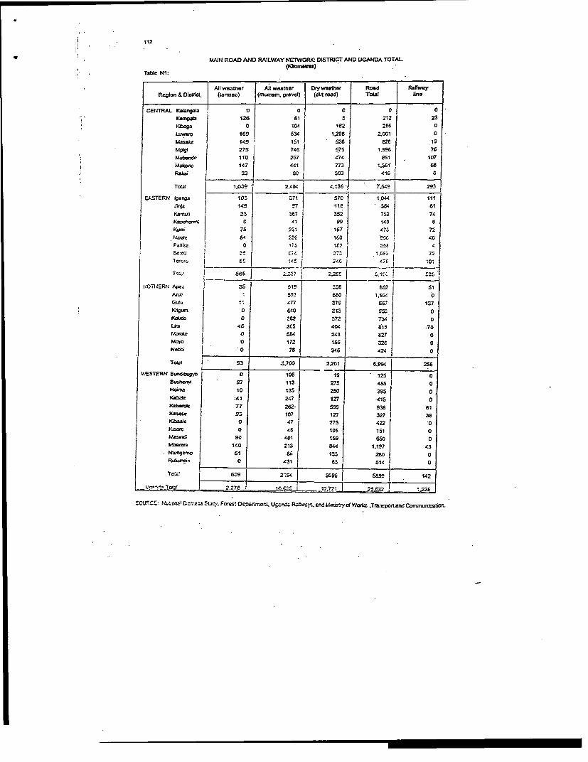
112
MAIN ROAD AND RAILWAY NETWORI(: DLSTRICT AND UGANDA TOTAL
Table Ni:
Att weather AJi weather Drytweather Road RaiwayRegion & DistUct. (tarmac) (mrnrnm, gravel) (dirt rad) Total Une
CENTRAL KaarqpaIa 0 0 0 0 0Kampala 126 S1 5 212 23KIboga 0 104 182 286 0LLwemo 169 534 1,298 2.001 0
.asake 149 151 526 826 isMpigl 275 746 575 1.595 76Mubnde 110 267 474 e51 1 107Mukicor 147 441 773 1.3G1 68Rabi 33 80 303 416 0
Total 1.009* 2.,404 4.1368 7,549 293
EASTERN l8arra 103 371 570 1.044 I IIiJirqz 149 g7 118 .364 61RamuS 33 3E7 352 752 74
K2pohe 0 41 99 140 OKLsmi 75 231 167 47i 72MtWIe CA4 23 160 5CC 40
P~0etl 0 175 IO.3 4sg scm5 . E 4 37- Z 72'to.or i E'
1 4' 24C 4 10.
Te_ i 8se5 ;-"37 I 2.28E ._535
l:OTl4SRN Ape: 351 519 306 6ti2 j51aru . 503 6.0 1.164
477 378 687 137Kitgutn 0 60 Z13 g5' 0KoWdo 0 i62 372 734 0Lka 46 3C5 404 B15 .70I.or(ol 0 584 243 E27 0Moyo 0 172 15t 32f 0Ncb~ c'O0 78 346 424 0
TOeLZ S' 3 3 | 3.201 6,993 276
WESTERN BSundibuy 0 105 19 125 08ustbenyi 97 113 275 4BS | HoiamI 103 250 385 0Kabtle ,41 247 127 -415 0Kabamlc 77 262- 59 S938 61Kasese 93 107 127 327 38K0aie 0 47 Z 75 422 | 0KMs=n 0 46 105 151 0W.Asin | 90 -401 159 GS0 0Mbaar2 | 140 213 4.4 1.187 43.nU2rnoj 61 66 133 280 0RukLmnpn~0 .431 83 514 0
Tctcl 1 605 | 2I54 j 3096 5699 142
o.e7o ls' 2 6I _ 25,§132 12 2f
E CUFRC: N;J :Ws! 0~E s:5 Stoey. Forest DePar3rner U cnta Rf ery L 1. Mras of WorL_r .ran-srporl. 8 o ond n tbor1-
NEW REGISTRATION OF VEHICLES BY TYPE 1989-1998
Table N6:
Velsid TYPE 1989 1990 1991 1S92 1S93 1994 1995 1996 1997 1998
GOVERNMsENT
Cars 16 55 25 85 52 60 37 41 51 n.e.TnJcks 90. 174 72 143 42 32 49 24 32 n.8.Pick-UpS&4-Wheelr rive 539 266 255 392 221 457 175 387 378 n.e.Minibuses 37 219 263 24 20 28 220 10 17 n.F.Lar96 buscs 3 3 C 12 3 7 0 0 0 nx.Tra or. 19 95 45 92 15 9 39 55 77 n.e.MOtorydFee 131 E67 296 430 333 712 443 1064 951 nA.Other 2S S2 61 31 52 23 30 5 2 n.s.
Totlrl E66 172 1t'_Z 1209 732 1329 J 923 1586 1506[n.e.
PRIVATE 6 Ccg< 2e C S :;, <S 7C9 i-EES !"fCE CEeC f79s .
rucS: 7sf 3' 20C C;, 717 .74 2e3 4.7 CC r1 :7;_ r.
4..1celdri it "? ;,44_ ; 1049 1713 2735 47C9 5600 45S4 n.zMuoksr6e 571 6E: 632 613 1450 2497 2474 242Z
2176 n.e.
Lorge buscs 45 19 30 45 38 64 1;9 3E 46 n.E.Tractors 90 162 116 215 241 221 210 n.a.Lc,Otrcycles 55 E94 14e F16 1411 4160 10560 15042 14163 n.e.Other 699 535 66 129 C6 se 23 214 E3 n.a.
Tcsel 5950 *574 . 5139 4655 6653 14061 2C191 30929 287S3 n.e.
TOTAL i
Cam | .6E'- 740 1153 1550 1846 3949 5323 S 710 8364 4980Tnucks E85 468 378 317 305 749 748 741 7820 1617Pick-Ups45
4-Vheeldnlve 2156 1711 16E9 1441 1934 1392 4944 5987 6326 4205MnWbuse6 9 05 S03 5 837 1470 2515 2694 2438 2876 1797Largebnuss 52 21 36 57 41 71 139 38 43 62Cractors 1s 95 125 254 133 224 260 276 321 213LMotorcyries 695 1770| 1729 1248 1744 4878 11003 16106 16798 13730Others 729 627 147 110 116 81 53 219 276 39
TCSEI G6816 6365 6152 U54 7591 3213859 2515 37795 26C43
SOUICE: LMWsIry of Wories. Houskn and CnIrmxJcat'ons.
_i I- _ _ _ _ _ _ _ _ __ . . . . . - _ _ ~ _
_ _______ ______. ___ I_ ___a -i _ ._ ___ ___ __a
0~~~~~~~~~~~1 E.-a _ ~ ~~~~______ ___ _ .______ _________
ti _ c n X g S z s a ~r . U v V Fwr 3la _ ___ _ *-___ ____I.i . _ __ _______
Li.
i- ~ ~ ~ ~ ~ ~ ~ ~ _ _ _ -~ ~di .~ _ _ .I ._ ___ __ _
I~~~~~~~~~~~~~~~~~~~~~~~~~~~~~~~~~~~~~~~~~~~v;
g. _ . .._ _ . . _.__ _ l~~~~~~~~~~~~~~~~~~~~~~~~~~~~~~~~~~~~~~~~~~~~~~~~~~~. .....
:> a M _ . 1--1 ~~~~-~ - I z . . I . _ I I-.
t ~ ~~~~~~~ ~ { , 8~fo* |r| fs|, uCRJ0W|, uRl2rx

-~~~~~~~~~~~~I-__ _ _ _ _ _ __ _ _ __14 _ _ _ _ _n i _
~~~~~1~~~~ .._ _I , I~i, - - I . _ _ - _ _ _ _
-
4. ~ ~ ~ W '4 -_
-~ ~ > .fl4
C
U S
I~~~_ -___
127
PERCENTAGE SHARES OF TOTAL CONSUMPTION FOR UGANDA. 1992-96
Table 01:
Component 1992 1994 1995 19S6
Food 58.6 56.6 54.7 52.7
Beverages and Tobacco 3.1 4.1 4.5. 3.7
Restaurants 1.4 2.5 22 2.0
Clothing and foot w6ar 4.5 4.4 4.0 5.1
OtJcr goods 7.0 '.0 S.7 e.6
Rent, fuel and power '2.7 14.6 15.0 1 14.6
Transport and Cornnunic2U.on 0.7 2.7 3.0 3.6
Heailth 42 3.C C2 4..
Eductlion eC I E.1 j 2
Ocfler- acric r .. 4 I ._c C
'OCURCE: UCand s Burecu ct Stat!stic-.
h3VERTY EY EMIPLOYMIEN'T SECTOR OF HOUSEHOLD HEAD: 1992193 -19951J6.
Table 02:
bSean Consumptlon Per | Head Coun' cr Povert
Employment Secicr Adult Equlvalent (1289 Prices .
1992193 1995/96 1992193 1995/26
,- Food Crop i,710 6.160 64.1 58.3
CCcsh Crop 6,090 E.070 59.6 40.5
Non-Crop Agriculture 6,950 8,770 51.7 41.0
Mining E,470 ' 6.040 43.4 74.2
Manufac'uring £.210 11.170 46.3 27.9
Public Utiities 9,20C 15,010 43.3 10.S
Construction 11,31Q 10,080 38.3 34.6
Trade 12.3s0 14,36C 26.4 16.7
HOtGLS O,G10 S2,040 26.6 17.0
Tfsnspcrt and Communicatlon 10.310 15,340 31.9 14.3
MIscellaneous services 13,530 11,750 27.7 26.9
Goveronment services 1110 1 6 33.5 26.2
NOTE. * E red on tho .Total Poverty line for Uganda.
50;rRCE: Ucar.ed Eurreau of Ste.1s',ic!.

Karmpala -Gmy=za -Zifobw -WobufcnflL Ra2
Review and Update cf Feasibility Study and Detailed Design of
KAMPALA - GAYAZA - ZIROBNVE - WOBULENZI ROAD
Feasibility Study Draft Final Report
APPENDrX '
1311BLIO GRkPHYX
I. _ , _ _ _ _ _ _ _ _ _ _ _ _ _ _ _ _ _ _ _ _ _ _ h _
PAloer. i.r

I I t
KarpatiaGayaza.-Ziobwc-WobuIcnzi Road SA
BIBLIOGRAPHY
Uganda Bureau of statistics:l999 Staristical AbstractMOF Statistics Department: The 199! population and housing census Luwero DistrictMOF Statistics Department: The 199! population and housing census Mpigi DistrictMOF Statistics Dcpartmcnt: The 199! population and housing census Kampala DistrictMpigi District Land Board: Compensation Ratesfor Year 2000NEMA: State of.Environmient Report for Uganda 1996NEMA: State of Environnment Reportfor Uganda 1998NEMA: District State of Environment Report, 1997, LuwveroNEMA: District State ofEm iroionienr Report, 1997, ApigiNEMA: Distric State of Enviromneni Rcport, 1997, KampalaNEMA: Guidelinesfor environnmentli impact assessMnCHt in Uganda. 1997.NEMA: Environmental Audit Guideli'wesfor Uganda, 1999NEMA: Coringfor our Environment. A handbookfor local LeadersUNDP/NIEMA: Environmental Economic Manualfor UgandaGovcrnmcnt of Uganda: Tlue nafional Environment (hilly and mountainous orcasmanagement) regulationss,2000Gcvc nmcnllt O} Ucanid:: 77; ;:c.'!ion,1l i;k o!e/a SU;.< c 1: ( wtC7rJxw1ation7 5mWl;, ,'V;1
ci i;rxiui of U;nv:is i/il cmopli.;;ed IproperT ies 1',v'u;i,/;sV1, I990Go\cr'ncnt of Uandnd;: 7i; at\i;onal cnvironment S;eanc, 1995Gnvc;lnmcint of Ugandi.: I opular version of .ie A'clio:;au Environment Sttlute, i995Govcnmicni of Ueandn: The Environ;eltal Imipact Assessment Regulations, 1998Gox miment of Uganda: The I1'ater Rcsources Regulations, 195SGovernment of Uganda: TI;e Local Gcvernments Act, 1997Govcrnmcnt of Uganda: The Land Act. 1998MOWLUE: Guidelines on the management of Laid and other related issues under the LandAct, 1998Fountain Publishcrs: Uganda Districts Information Hlandbook, 1997198MOWT&C: General specif cationsfor Road and bridge Works 1992MO\ IH&C/BCEOM: Feasihility study of Kampala Aorthern by-pass. Environment7 l Ie pactAssessment, 2000Transport & Road Researci Laboratory: Towi'ards safer r oads in developing comnDric-.e, 1991Transport & Road Rcsearch Laboratory: A review of some recent geom7etric road standardsand their application to developing countries, 1987Austroads: Rural Road Design. 1989MONT&C/JBG Gauff Ingenicure: Tratnsport Rehobilitation Project, 1993MO1T&C/FEDERIC] : Upgrading of Iganga-Mbale Road, 1994MOWT&C/RAFU: Ten-y ears Road Sector Development Programme 1996/7-2005/6MOHA: National Health Policy, 1999Uganda AIDS Commission: HJMIAIDS in Uganda. Sumnmamy ofprevalence, impact andnotional sirategies, 2000MiOWi/ EpidcniioiogylSurncillancc Unit: 1111 /AIDSSurveillance Repart. 2000 update

. .1>