Of tHE NORtHwESt tERRitORiES taiGa PLaiNS
1
Narrow spires of widely-spaced white and black spruce with an understory of ground birch, willow, northern Labrador tea and lichens in the Travaillant Uplands are typical of the Northern Great Bear Plains High Subarctic (HS) Ecoregion. Soils are frozen for much of the year and only a thin surface layer thaws during the short summer. Northern Great Bear Plains High Subarctic (HS) Ecoregion The Northern Great Bear Plains High Subarctic (HS) Ecoregion occupies 170,000 km 2 in the northern portion of the Taiga Plains and includes 14 smaller ecoregions. Higher elevation areas within some of these ecoregions share similar climatic and vegetation characteristics with Low Arctic areas to the north. The landscape is a mix of rolling to hummocky glacial plains, rolling and rocky glacial uplands, and active permafrost features such as raised peat mounds and earth hummocks. Slow- Central Great Bear Plains Low Subarctic (LS) Ecoregion The Central Great Bear Plains Low Subarctic (LS) Ecoregion contains 14 smaller ecoregions that cover the central 160,000 km 2 of the Taiga Plains, along with one outlying ecoregion along the Northwest Territories-Alberta border. The region spans approximately 650 km in a north-south direction; towards the north and at higher elevations, harsher climates result in permafrost features such as peat plateaus and slow- growing upland forests. Glaciers have left gently sloping, Great Slave Uplands High Boreal (HB) Ecoregion The Great Slave Uplands High Boreal (HB) Ecoregion occurs generally at higher elevations in the southern Taiga Plains. It contains 6 smaller ecoregions totalling over 42,000 km 2 . It is surrounded by or lies immediately north of the lower elevation Mackenzie and Slave Lowlands Mid-Boreal (MB) Ecoregion. Permafrost and colder conditions result in slow-growing forests. Low-canopy open black spruce, treed bogs, horizontal Mackenzie and Slave Lowlands Mid-Boreal (MB) Ecoregion The Mackenzie and Slave Lowlands Mid-Boreal (MB) Ecoregion consists of 11 smaller ecoregions spanning an area of nearly 107,000 km 2 across the southern third of the Taiga Plains and includes parts of Great Slave Lake and the southern reaches of the Mackenzie River. The region has the mildest climate in the Taiga Plains. Extensive lakebed plains left behind after the retreat of glacial Lake McConnell, mounds of rock and soil produced by melted glacial ice, and river deposits are growing white and black spruce forests occur across the region. Extensive fires have resulted in large areas of regenerating ground birch. Lichen-ground birch communities cover much of the region’s peatlands. The region contains Canada’s largest delta – the Mackenzie, and Great Bear Lake – the largest lake entirely within Canada. Aside from the Mackenzie River, other major rivers that flow into or out of the region include the Great Bear, Mountain, Arctic Red, Peel and Anderson. fens and peat plateaus are common on wet, poorly drained sites. More diverse mixed-wood, deciduous and conifer stands are locally abundant on warmer and better-drained slopes, on hummocky and ridged landforms, and on sites with coarse- textured materials. With the exception of Trout Lake, there are few named lakes and no major rivers in the region. The black bear is one of many wide- ranging wildlife species that are found throughout the Great Slave Uplands High Boreal (HB) Ecoregion. The diverse assemblage of fruit-bearing shrubs and forbs within the ecoregion provides good habitat for this ubiquitous omnivore. typical landforms. Cold, wet conditions in low-lying, poorly drained areas result in deep and extensive deposits of peat on permanently frozen organic soils with black spruce and lichen cover. Moss, sedge and shrubby or treed fens are also common. On better-drained uplands, frequent fires have resulted in a patchwork of diverse deciduous, mixed-woods and coniferous forests. Main watercourses in the region are the Mackenzie, Liard, Slave and Hay rivers. undulating and level deposits of rock and soil throughout the region. Large areas have been burned at various times, resulting in a mosaic of low-canopy black or white spruce and successional shrub lands and regenerating forests. Extensive peatlands form where drainage is poor. Mixed-wood, deciduous or conifer forests grow only on warm and well-drained sites. There are several large lakes in this region, including Lac la Martre, Keller and Blackwater. Ecosystems play an important role to produce oxygen, clean water and enhance our environment with numerous forests, wetlands, peat bogs, lakes and rivers. The different combinations of climate, soils and terrain in the Northwest Territories create a variety of landscape ecosystems, ranging in size from a city block to the size of Great Bear Lake. To better understand, monitor and manage the unique biological patterns of these ecosystems, scientists subdivide the landscape into smaller ecological regions, or ‘ecoregions’. The Northwest Territories requires an ecologically based landscape classification for environmental assessment, cumulative effects management, biodiversity monitoring and reporting, forest resource analysis and planning, wildlife habitat evaluation and conservation, and protected area identification. Such a classification is essential for responding to local, regional, national and international enquiries. Earlier national classifications that covered the Northwest Territories have had limited application for resource management. Other provinces are currently revising their own classifications by using new information. The Northwest Territories also recognizes a need for an updated ecosystem classification. Given the increasing pace and scale of development, especially in the Mackenzie Valley, the Taiga Plains was selected as the first region to be reclassified. Methods to classify and map ecoregions look at how physical and biological features such as climate, geology, landforms, soils, vegetation and wildlife differ across the landscape. The Northwest Territories has revised its ecological classification and mapping for the Taiga Plains within a framework for continental North America that includes four levels of ecoregions, from very large Level I ecoregions to relatively small Level IV ecoregions. The Northwest Territories contains three Level I ecoregions: Tundra, Taiga and Northwest Forested Mountains. Eight Level II ecoregions, including the Taiga Plains, are nested within the Level I ecoregions, and 17 Level III ecoregions are within the Level II ecoregions. There are four Level III ecoregions within the Taiga Plains: the Northern Great Bear Plains High Subarctic (HS), the Central Great Bear Plains Low Subarctic (LS), the Great Slave Uplands High Boreal (HB), and the Mackenzie and Slave Lowlands Mid-Boreal (MB). Level III ecoregions are identified primarily by regional climate differences that can be seen in the soils and vegetation unique to each ecoregion. Within the Level III ecoregions, 45 new Level IV ecoregions have been identified. These smaller Level IV ecoregions are typically recognized by their physiographic characteristics. Muskoxen were formerly restricted to tundra areas east and northeast of the Northern Great Bear Plains High Subarctic (HS) Ecoregion, but have expanded their range westward considerably in recent years. Small populations of muskoxen now occur throughout the eastern and southern portions of the ecoregion wherever suitable habitat can be found. Upland areas with shallow snow depths close to lush sedge and shrub lowlands provide optimal habitat. Muskoxen have recently extended their range into the adjacent Central Great Bear Plains Low Subarctic (LS) Ecoregion as far south as Norman Wells. Photo: R. Popko This vast hummocky till plain in the Travaillant Uplands of the Northern Great Bear Plains High Subarctic (HS) Ecoregion shows the harsh effects of climate on tree growth. Trees grow only in sheltered locales and on coarser- textured soils around lakes and along creeks, where the growing season is just long enough to allow their survival. Photo: D. Downing Photo: J. Nagy Boreal caribou are found throughout most of the Taiga Plains, with the exception of the Mackenzie River delta and the lowlands of the Slave River. These reclusive mammals generally occur at low density and most often as small groups or solitary individuals. Boreal caribou prefer open mature coniferous forests and associated bogs during winter, where ground and tree lichens are abundant. In spring and summer they favour wetter areas such as fens, marshes, river and lake shorelines. The Northern Great Bear Plains High Subarctic (HS) Ecoregion, as well as other ecoregions within the Taiga Plains, provides important habitat needed to sustain viable boreal caribou populations. A view to the northwest across the Mackenzie River delta within the Northern Great Bear Plains High Subarctic (HS) Ecoregion shows an area of relatively large white spruce on a sheltered slope in the foreground, behind which is a complex of stunted white spruce on frozen river-laid soils, active and abandoned river channels, and shallow ponds. The HS climate gives way to more arctic conditions about 20 km north, where the last few trees struggle to survive on windswept river flats. Photo: R. Decker Stunted white spruce grow very slowly on permanently frozen soils near the treeline on the Mackenzie River delta within the Northern Great Bear Plains High Subarctic (HS) Ecoregion. The largest trees here are over 300 years old and only a few meters tall. Willows, lichens, northern Labrador tea and arctic bearberry grow in patches underneath the sparse tree canopy. Photo: R. Decker Photo: R. Decker Limestone cliffs along “The Ramparts” of the Mackenzie River south of Fort Good Hope within the Central Great Bear Plains Low Subarctic (LS) Ecoregion, provide exceptional nesting habitat for the peregrine falcon, a raptor species that is currently threatened in Canada. This bird can be found throughout the entire Taiga Plains, however, it occurs in the Northwest Territories only as a seasonal migrant, nesting wherever suitable sites such as steep banks and cliffs occur. Photo: M. Bradley Open stands of slow-growing black and white spruce with a shrubby understory of ground birch, northern Labrador tea, mosses and lichens are a common forest type throughout the Central Great Bear Plains Low Subarctic (LS) Ecoregion in areas that have not burned recently. Photo: R. Decker Photo: M. Bradley Photo: R. Decker Photo: R. Decker A large complex of cold-sulphur springs occurs at the eastern end of the Horn Plateau within the Great Slave Uplands High Boreal (HB) Ecoregion. Salt and gypsum deposits produce sparsely vegetated mineral plains that harbour uncommon and rare plant species. Photo: D. Downing Photo: M. Bradley In summer bison often forage in recent burns on the succulent new growth. Nearly all of the optimal habitat and current populations in the Northwest Territories occur within the Mackenzie and Slave Lowlands Mid-Boreal (MB) Ecoregion; areas with extensive sedge and grass meadows are particularly favoured. Bison are concentrated in the Slave River valley and the lowlands north of the Mackenzie River near Fort Providence and west of Great Slave Lake. A small population of wood bison also occurs in the Liard River valley. Photo: R. Decker Viburnum edule, or high-bush cranberry as it is commonly known in the Northwest Territories, occurs throughout much of the Taiga Plains. It is particularly common in the Mackenzie and Slave Lowlands Mid-Boreal (MB) Ecoregion where it is often a dominant shrub in mixed-wood and deciduous forest stands. The berries are a favoured food of people and wildlife alike. Photo: M. Bradley Shallow calcium-rich ponds bordered by lime deposits, low, wet greyish- green black spruce fens, and bright green jack pine stands on coarser materials (foreground) are typical of the Great Slave Uplands High Boreal (HB) Ecoregion. An abandoned channel of the Liard River filled with sedges and horsetails, and flanked on both sides by highly productive aspen, balsam poplar and white spruce forests, Mackenzie and Slave Lowlands Mid-Boreal (MB) Ecoregion. Photo: D. Downing Diverse stands of white spruce, aspen and balsam poplar are common on well-drained sites within the Mackenzie and Slave Lowlands Mid- Boreal (MB) Ecoregion. Extensive areas of highly productive, large-diameter mixed-wood stands are common in the Liard River valley, where these trees may grow to 30 meters in height in less than 100 years. Understory vegetation is highly diverse, with lush and vigorous high-bush cranberry, prickly rose, red-osier dogwood, dewberry, meadow-horsetail and other herbs. Photo: R. Decker Photo: M. Bradley ECOLOGICAL REGIONS OF THE NORTHWEST TERRITORIES TAIGA PLAINS Photo: D. Downing Photo: M. Bradley Sparse tree growth is typical of the alvar terrain that occurs along the Mackenzie River near Fort Good Hope. Alvars occur on thin soils over flat limestone bedrock with a generally sparse vegetation cover of mosses, lichens, herbaceous plants and stunted shrubs. Plants that can survive on these bedrock barrens need to be adapted to extreme conditions of windswept, freezing cold in winter and hot, dry conditions in summer. These unique areas often contain rare or unusual plants. This area of the Central Great Bear Plains Low Subarctic (LS) Ecoregion contains what is likely the most northerly occurrence of alvars in North America. A sedge-covered fen fed by a flowing spring at the far end of the meadow. Springs and seepage areas are common features of slopes in the Ebbutt Hills within the Great Slave Uplands High Boreal (HB) Ecoregion. The great grey owl is a year-round resident found throughout the southern half of the Taiga Plains in habitats that range from dense coniferous and mixed-wood boreal forests to open spruce and tamarack taiga forests. This large owl feeds mainly on small mammals, particularly voles, small rodents that are especially common in the Great Slave Uplands High Boreal (HB) Ecoregion. Photo: A. Korpach Photo: J. Wilson The willow ptarmigan is a common winter resident of the Taiga Plains. Areas with abundant willows, the principal diet of ptarmigan during the winter months, tend to be favoured. Although willow ptarmigan generally breed in the tundra areas north of treeline, some sporadically summer on the Horn Plateau in the Central Great Bear Plains Low Subarctic (LS) Ecoregion. Small numbers may breed elsewhere, especially in the Northern Great Bear Plains High Subarctic (HS) Ecoregion wherever suitable summer habitat conditions exist. Photo: R. Popko The red fox occurs throughout the entire Taiga Plains and is common in the Northern Great Bear Plains High Subarctic (HS) Ecoregion. This adaptable species is the most wide-ranging carnivore on the planet. In North America it occupies many biomes – from southern prairies and shrublands to northern forests and tundra. Photo: B. Oosenbrug Photo: R. Decker A mossy spring, mid-slope on a hillside within the Ebbut Hills, Great Slave Uplands High Boreal (HB) Ecoregion. Groundwater seepage, together with south-facing aspects supports diverse mixed-wood forests on the slopes. Northern Great Bear Plains High Subarctic (HS) Ecoregion Central Great Bear Plains Low Subarctic (LS) Ecoregion Great Slave Uplands High Boreal (HB) Ecoregion Mackenzie and Slave Lowlands Mid-Boreal (MB) Ecoregion This poster accompanies the ENR technical report: “Ecological Regions of the Northwest Territories – Taiga Plains” Additional copies of the poster and report may be obtained from: Department of Environment and Natural Resources P.O. Box 1320, Yellowknife, NT X1A 2L9 Phone: (867) 873-8064, Fax: (867) 873-0293, Web site: www.enr.gov.nt.ca
Transcript of Of tHE NORtHwESt tERRitORiES taiGa PLaiNS
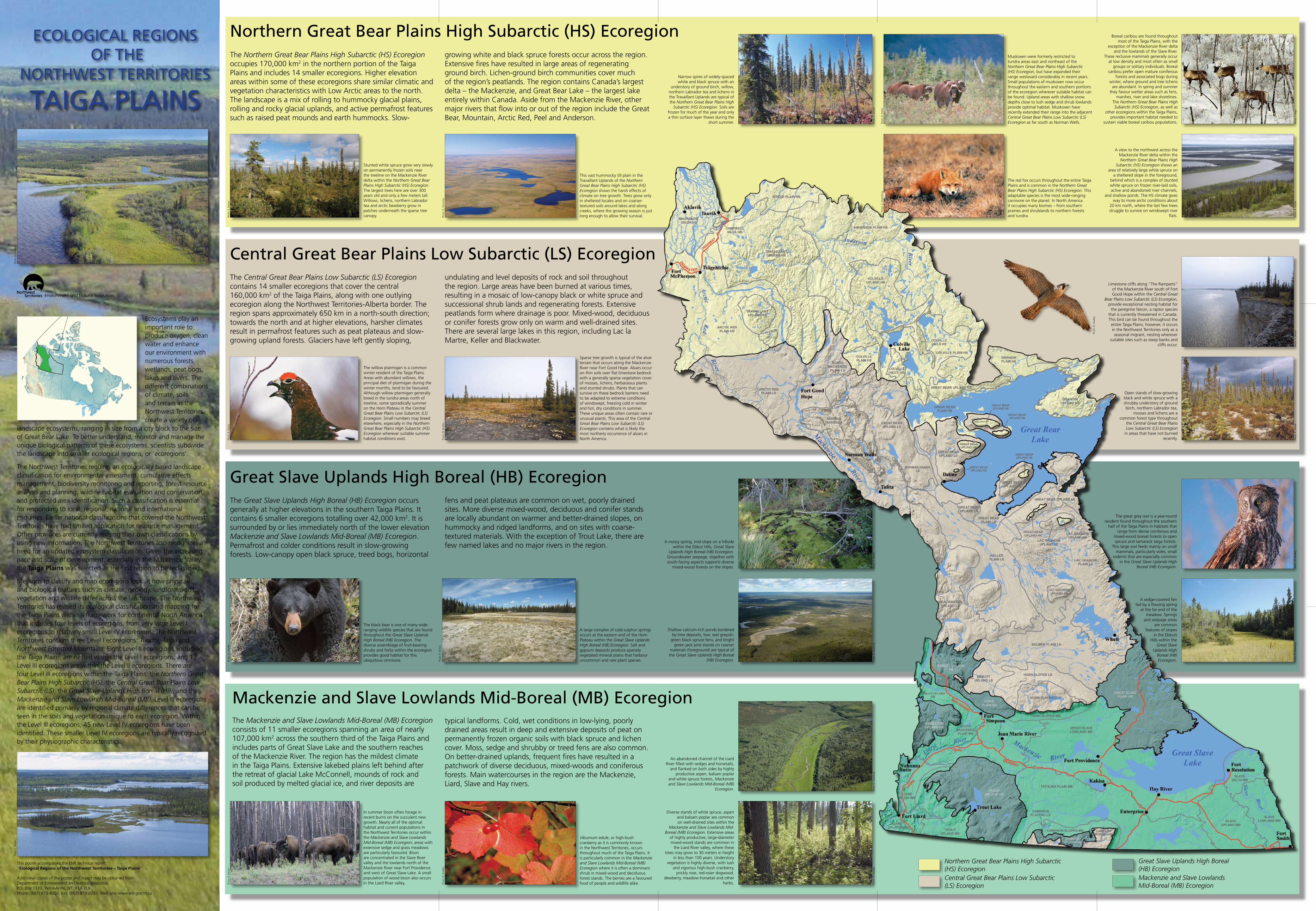
Narrow spires of widely-spaced white and black spruce with an
understory of ground birch, willow, northern Labrador tea and lichens in the Travaillant Uplands are typical of the Northern Great Bear Plains High
Subarctic (HS) Ecoregion. Soils are frozen for much of the year and only a thin surface layer thaws during the
short summer.
Northern Great Bear Plains High Subarctic (HS) EcoregionThe Northern Great Bear Plains High Subarctic (HS) Ecoregion occupies 170,000 km2 in the northern portion of the Taiga Plains and includes 14 smaller ecoregions. Higher elevation areas within some of these ecoregions share similar climatic and vegetation characteristics with Low Arctic areas to the north. The landscape is a mix of rolling to hummocky glacial plains, rolling and rocky glacial uplands, and active permafrost features such as raised peat mounds and earth hummocks. Slow-
Central Great Bear Plains Low Subarctic (LS) EcoregionThe Central Great Bear Plains Low Subarctic (LS) Ecoregion contains 14 smaller ecoregions that cover the central 160,000 km2 of the Taiga Plains, along with one outlying ecoregion along the Northwest Territories-Alberta border. The region spans approximately 650 km in a north-south direction; towards the north and at higher elevations, harsher climates result in permafrost features such as peat plateaus and slow-growing upland forests. Glaciers have left gently sloping,
Great Slave Uplands High Boreal (HB) EcoregionThe Great Slave Uplands High Boreal (HB) Ecoregion occurs generally at higher elevations in the southern Taiga Plains. It contains 6 smaller ecoregions totalling over 42,000 km2. It is surrounded by or lies immediately north of the lower elevation Mackenzie and Slave Lowlands Mid-Boreal (MB) Ecoregion. Permafrost and colder conditions result in slow-growing forests. Low-canopy open black spruce, treed bogs, horizontal
Mackenzie and Slave Lowlands Mid-Boreal (MB) EcoregionThe Mackenzie and Slave Lowlands Mid-Boreal (MB) Ecoregion consists of 11 smaller ecoregions spanning an area of nearly 107,000 km2 across the southern third of the Taiga Plains and includes parts of Great Slave Lake and the southern reaches of the Mackenzie River. The region has the mildest climate in the Taiga Plains. Extensive lakebed plains left behind after the retreat of glacial Lake McConnell, mounds of rock and soil produced by melted glacial ice, and river deposits are
growing white and black spruce forests occur across the region. Extensive fires have resulted in large areas of regenerating ground birch. Lichen-ground birch communities cover much of the region’s peatlands. The region contains Canada’s largest delta – the Mackenzie, and Great Bear Lake – the largest lake entirely within Canada. Aside from the Mackenzie River, other major rivers that flow into or out of the region include the Great Bear, Mountain, Arctic Red, Peel and Anderson.
fens and peat plateaus are common on wet, poorly drained sites. More diverse mixed-wood, deciduous and conifer stands are locally abundant on warmer and better-drained slopes, on hummocky and ridged landforms, and on sites with coarse-textured materials. With the exception of Trout Lake, there are few named lakes and no major rivers in the region.
The black bear is one of many wide-ranging wildlife species that are found throughout the Great Slave Uplands High Boreal (HB) Ecoregion. The diverse assemblage of fruit-bearing shrubs and forbs within the ecoregion provides good habitat for this ubiquitous omnivore.
typical landforms. Cold, wet conditions in low-lying, poorly drained areas result in deep and extensive deposits of peat on permanently frozen organic soils with black spruce and lichen cover. Moss, sedge and shrubby or treed fens are also common. On better-drained uplands, frequent fires have resulted in a patchwork of diverse deciduous, mixed-woods and coniferous forests. Main watercourses in the region are the Mackenzie, Liard, Slave and Hay rivers.
undulating and level deposits of rock and soil throughout the region. Large areas have been burned at various times, resulting in a mosaic of low-canopy black or white spruce and successional shrub lands and regenerating forests. Extensive peatlands form where drainage is poor. Mixed-wood, deciduous or conifer forests grow only on warm and well-drained sites. There are several large lakes in this region, including Lac la Martre, Keller and Blackwater.
Ecosystems play an important role to produce oxygen, clean water and enhance our environment with numerous forests, wetlands, peat bogs, lakes and rivers. The different combinations of climate, soils and terrain in the Northwest Territories create a variety of
landscape ecosystems, ranging in size from a city block to the size of Great Bear Lake. To better understand, monitor and manage the unique biological patterns of these ecosystems, scientists subdivide the landscape into smaller ecological regions, or ‘ecoregions’.
The Northwest Territories requires an ecologically based landscape classification for environmental assessment, cumulative effects management, biodiversity monitoring and reporting, forest resource analysis and planning, wildlife habitat evaluation and conservation, and protected area identification. Such a classification is essential for responding to local, regional, national and international enquiries. Earlier national classifications that covered the Northwest Territories have had limited application for resource management. Other provinces are currently revising their own classifications by using new information. The Northwest Territories also recognizes a need for an updated ecosystem classification. Given the increasing pace and scale of development, especially in the Mackenzie Valley, the Taiga Plains was selected as the first region to be reclassified.
Methods to classify and map ecoregions look at how physical and biological features such as climate, geology, landforms, soils, vegetation and wildlife differ across the landscape. The Northwest Territories has revised its ecological classification and mapping for the Taiga Plains within a framework for continental North America that includes four levels of ecoregions, from very large Level I ecoregions to relatively small Level IV ecoregions. The Northwest Territories contains three Level I ecoregions: Tundra, Taiga and Northwest Forested Mountains. Eight Level II ecoregions, including the Taiga Plains, are nested within the Level I ecoregions, and 17 Level III ecoregions are within the Level II ecoregions. There are four Level III ecoregions within the Taiga Plains: the Northern Great Bear Plains High Subarctic (HS), the Central Great Bear Plains Low Subarctic (LS), the Great Slave Uplands High Boreal (HB), and the Mackenzie and Slave Lowlands Mid-Boreal (MB). Level III ecoregions are identified primarily by regional climate differences that can be seen in the soils and vegetation unique to each ecoregion. Within the Level III ecoregions, 45 new Level IV ecoregions have been identified. These smaller Level IV ecoregions are typically recognized by their physiographic characteristics.
Muskoxen were formerly restricted to tundra areas east and northeast of the Northern Great Bear Plains High Subarctic (HS) Ecoregion, but have expanded their range westward considerably in recent years. Small populations of muskoxen now occur throughout the eastern and southern portions of the ecoregion wherever suitable habitat can be found. Upland areas with shallow snow depths close to lush sedge and shrub lowlands provide optimal habitat. Muskoxen have recently extended their range into the adjacent Central Great Bear Plains Low Subarctic (LS) Ecoregion as far south as Norman Wells.Ph
oto:
R. P
opko
This vast hummocky till plain in the Travaillant Uplands of the Northern Great Bear Plains High Subarctic (HS) Ecoregion shows the harsh effects of climate on tree growth. Trees grow only in sheltered locales and on coarser-textured soils around lakes and along creeks, where the growing season is just long enough to allow their survival. Ph
oto:
D. D
owni
ng
Phot
o: J
. Nag
y
Boreal caribou are found throughout most of the Taiga Plains, with the
exception of the Mackenzie River delta and the lowlands of the Slave River.
These reclusive mammals generally occur at low density and most often as small
groups or solitary individuals. Boreal caribou prefer open mature coniferous
forests and associated bogs during winter, where ground and tree lichens
are abundant. In spring and summer they favour wetter areas such as fens,
marshes, river and lake shorelines. The Northern Great Bear Plains High Subarctic (HS) Ecoregion, as well as
other ecoregions within the Taiga Plains, provides important habitat needed to
sustain viable boreal caribou populations.
A view to the northwest across the Mackenzie River delta within the Northern Great Bear Plains High
Subarctic (HS) Ecoregion shows an area of relatively large white spruce on
a sheltered slope in the foreground, behind which is a complex of stunted white spruce on frozen river-laid soils, active and abandoned river channels,
and shallow ponds. The HS climate gives way to more arctic conditions about
20 km north, where the last few trees struggle to survive on windswept river
flats. Phot
o: R
. Dec
ker
Stunted white spruce grow very slowly on permanently frozen soils near the treeline on the Mackenzie River delta within the Northern Great Bear Plains High Subarctic (HS) Ecoregion. The largest trees here are over 300 years old and only a few meters tall. Willows, lichens, northern Labrador tea and arctic bearberry grow in patches underneath the sparse tree canopy. Ph
oto:
R. D
ecke
r
Phot
o: R
. Dec
ker
Limestone cliffs along “The Ramparts” of the Mackenzie River south of Fort Good Hope within the Central Great
Bear Plains Low Subarctic (LS) Ecoregion, provide exceptional nesting habitat for
the peregrine falcon, a raptor species that is currently threatened in Canada. This bird can be found throughout the
entire Taiga Plains, however, it occurs in the Northwest Territories only as a seasonal migrant, nesting wherever
suitable sites such as steep banks and cliffs occur.
Phot
o: M
. Bra
dley
Open stands of slow-growing black and white spruce with a shrubby understory of ground birch, northern Labrador tea,
mosses and lichens are a common forest type throughout
the Central Great Bear Plains Low Subarctic (LS) Ecoregion
in areas that have not burned recently. Ph
oto:
R. D
ecke
r
Phot
o: M
. Bra
dley
Phot
o: R
. Dec
ker
Phot
o: R
. Dec
ker
A large complex of cold-sulphur springs occurs at the eastern end of the Horn Plateau within the Great Slave Uplands High Boreal (HB) Ecoregion. Salt and gypsum deposits produce sparsely vegetated mineral plains that harbour uncommon and rare plant species. Ph
oto:
D. D
owni
ng
Phot
o: M
. Bra
dley
In summer bison often forage in recent burns on the succulent new growth. Nearly all of the optimal habitat and current populations in the Northwest Territories occur within the Mackenzie and Slave Lowlands Mid-Boreal (MB) Ecoregion; areas with extensive sedge and grass meadows are particularly favoured. Bison are concentrated in the Slave River valley and the lowlands north of the Mackenzie River near Fort Providence and west of Great Slave Lake. A small population of wood bison also occurs in the Liard River valley. Ph
oto:
R. D
ecke
r
Viburnum edule, or high-bush cranberry as it is commonly known in the Northwest Territories, occurs throughout much of the Taiga Plains. It is particularly common in the Mackenzie and Slave Lowlands Mid-Boreal (MB) Ecoregion where it is often a dominant shrub in mixed-wood and deciduous forest stands. The berries are a favoured food of people and wildlife alike. Ph
oto:
M. B
radl
ey
Shallow calcium-rich ponds bordered by lime deposits, low, wet greyish-
green black spruce fens, and bright green jack pine stands on coarser
materials (foreground) are typical of the Great Slave Uplands High Boreal
(HB) Ecoregion.
An abandoned channel of the Liard River filled with sedges and horsetails,
and flanked on both sides by highly productive aspen, balsam poplar
and white spruce forests, Mackenzie and Slave Lowlands Mid-Boreal (MB)
Ecoregion. Phot
o: D
. Dow
ning
Diverse stands of white spruce, aspen and balsam poplar are common on well-drained sites within the
Mackenzie and Slave Lowlands Mid-Boreal (MB) Ecoregion. Extensive areas
of highly productive, large-diameter mixed-wood stands are common in
the Liard River valley, where these trees may grow to 30 meters in height
in less than 100 years. Understory vegetation is highly diverse, with lush
and vigorous high-bush cranberry, prickly rose, red-osier dogwood,
dewberry, meadow-horsetail and other herbs.
Phot
o: R
. Dec
ker
Phot
o: M
. Bra
dley
ECOLOGiCaL REGiONS Of tHE
NORtHwESt tERRitORiES
taiGa PLaiNS
Phot
o: D
. Dow
ning
Phot
o: M
. Bra
dley
Sparse tree growth is typical of the alvar terrain that occurs along the Mackenzie River near Fort Good Hope. Alvars occur on thin soils over flat limestone bedrock with a generally sparse vegetation cover of mosses, lichens, herbaceous plants and stunted shrubs. Plants that can survive on these bedrock barrens need to be adapted to extreme conditions of windswept, freezing cold in winter and hot, dry conditions in summer. These unique areas often contain rare or unusual plants. This area of the Central Great Bear Plains Low Subarctic (LS) Ecoregion contains what is likely the most northerly occurrence of alvars in North America.
A sedge-covered fen fed by a flowing spring
at the far end of the meadow. Springs
and seepage areas are common
features of slopes in the Ebbutt
Hills within the Great Slave
Uplands High Boreal (HB) Ecoregion.
The great grey owl is a year-round resident found throughout the southern
half of the Taiga Plains in habitats that range from dense coniferous and
mixed-wood boreal forests to open spruce and tamarack taiga forests.
This large owl feeds mainly on small mammals, particularly voles, small
rodents that are especially common in the Great Slave Uplands High
Boreal (HB) Ecoregion.
Phot
o: A
. Kor
pach
Phot
o: J
. Wils
on
The willow ptarmigan is a common winter resident of the Taiga Plains. Areas with abundant willows, the principal diet of ptarmigan during the winter months, tend to be favoured. Although willow ptarmigan generally breed in the tundra areas north of treeline, some sporadically summer on the Horn Plateau in the Central Great Bear Plains Low Subarctic (LS) Ecoregion. Small numbers may breed elsewhere, especially in the Northern Great Bear Plains High Subarctic (HS) Ecoregion wherever suitable summer habitat conditions exist. Ph
oto:
R. P
opko
The red fox occurs throughout the entire Taiga Plains and is common in the Northern Great Bear Plains High Subarctic (HS) Ecoregion. This adaptable species is the most wide-ranging carnivore on the planet. In North America it occupies many biomes – from southern prairies and shrublands to northern forests and tundra.
Phot
o: B
. Oos
enbr
ug
Phot
o: R
. Dec
ker
A mossy spring, mid-slope on a hillside within the Ebbut Hills, Great Slave
Uplands High Boreal (HB) Ecoregion. Groundwater seepage, together with south-facing aspects supports diverse
mixed-wood forests on the slopes.
Northern Great Bear Plains High Subarctic (HS) EcoregionCentral Great Bear Plains Low Subarctic (LS) Ecoregion
Great Slave Uplands High Boreal (HB) EcoregionMackenzie and Slave Lowlands Mid-Boreal (MB) Ecoregion
This poster accompanies the ENR technical report: “Ecological Regions of the Northwest Territories – Taiga Plains”
Additional copies of the poster and report may be obtained from:Department of Environment and Natural ResourcesP.O. Box 1320, Yellowknife, NT X1A 2L9Phone: (867) 873-8064, Fax: (867) 873-0293, Web site: www.enr.gov.nt.ca