ODFW AQUATIC INVENTORY PROJECT RESTORATION...
11
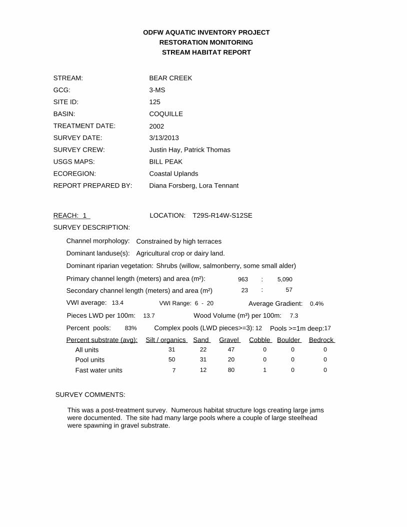
ODFW AQUATIC INVENTORY PROJECT RESTORATION MONITORING BEAR CREEK SITE ID: 125 GCG: 3-MS SURVEY DATE: 3/13/2013 STREAM: STREAM HABITAT REPORT BASIN: TREATMENT DATE: SURVEY CREW: REPORT PREPARED BY: USGS MAPS: ECOREGION: SURVEY DESCRIPTION: SURVEY COMMENTS: COQUILLE Justin Hay, Patrick Thomas BILL PEAK Coastal Uplands Diana Forsberg, Lora Tennant Primary channel length (meters) and area (m²): VWI average: Average Gradient: Wood Volume (m³) per 100m: Pieces LWD per 100m: Dominant landuse(s): Dominant riparian vegetation: Secondary channel length (meters) and area (m²) 963 5,090 23 57 13.4 VWI Range: 6 - 20 0.4% 7.3 13.7 : : Percent pools: Complex pools (LWD pieces>=3): Pools >=1m deep:17 Constrained by high terraces Channel morphology: Agricultural crop or dairy land. Shrubs (willow, salmonberry, some small alder) Percent substrate (avg): Silt / organics Sand Gravel Cobble Boulder Bedrock 31 22 47 0 0 0 All units 50 31 20 0 0 0 Pool units 7 12 80 1 0 0 Fast water units 83% 12 This was a post-treatment survey. Numerous habitat structure logs creating large jams were documented. The site had many large pools where a couple of large steelhead were spawning in gravel substrate. 2002 REACH: 1 __________ LOCATION: T29S-R14W-S12SE
-
Upload
hoangkhanh -
Category
Documents
-
view
215 -
download
0
Transcript of ODFW AQUATIC INVENTORY PROJECT RESTORATION...
ODFW AQUATIC INVENTORY PROJECT
RESTORATION MONITORING
BEAR CREEK
SITE ID: 125
GCG: 3-MS
SURVEY DATE: 3/13/2013
STREAM:
STREAM HABITAT REPORT
BASIN:
TREATMENT DATE:
SURVEY CREW:
REPORT PREPARED BY:
USGS MAPS:
ECOREGION:
SURVEY DESCRIPTION:
SURVEY COMMENTS:
COQUILLE
Justin Hay, Patrick Thomas
BILL PEAK
Coastal Uplands
Diana Forsberg, Lora Tennant
Primary channel length (meters) and area (m²):
VWI average: Average Gradient:
Wood Volume (m³) per 100m:Pieces LWD per 100m:
Dominant landuse(s):
Dominant riparian vegetation:
Secondary channel length (meters) and area (m²)
963 5,090
23 57
13.4 VWI Range: 6 - 20 0.4%
7.313.7
:
:
Percent pools: Complex pools (LWD pieces>=3): Pools >=1m deep:17
Constrained by high terracesChannel morphology:
Agricultural crop or dairy land.
Shrubs (willow, salmonberry, some small alder)
Percent substrate (avg): Silt / organics Sand Gravel Cobble Boulder Bedrock
31 22 47 0 0 0All units
50 31 20 0 0 0Pool units
7 12 80 1 0 0Fast water units
83% 12
This was a post-treatment survey. Numerous habitat structure logs creating large jams were documented. The site had many large pools where a couple of large steelhead were spawning in gravel substrate.
2002
REACH: 1__________ LOCATION: T29S-R14W-S12SE
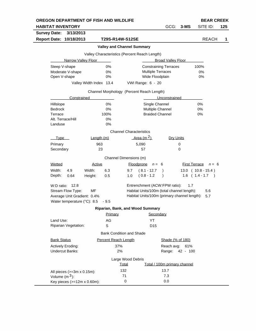
OREGON DEPARTMENT OF FISH AND WILDLIFE
HABITAT INVENTORY
Report Date: 10/18/2013
BEAR CREEK
REACH 1T29S-R14W-S12SE
SITE ID: 125GCG: 3-MS
Survey Date: 3/13/2013
Valley and Channel Summary
Narrow Valley Floor Broad Valley Floor
Valley Characteristics (Percent Reach Length)
Steep V-shape
Moderate V-shape
Open V-shape
Constraining Terraces
Multiple Terraces
Wide Floodplain
Valley Width Index
Channel Morphology (Percent Reach Length)
Hillslope
Constrained Unconstrained
Bedrock
Terrace
Alt. Terrace/Hill
Landuse
Single Channel
Multiple Channel
Braided Channel
Channel Characteristics
Type Length (m) Area (m ) Dry Units
Primary
Secondary
Channel Dimensions (m)
Wetted Active Floodprone First Terrace
Width:
Depth:
Width:
Height:
W:D ratio: Entrenchment (ACW:FPW ratio):
Stream Flow Type:
Average Unit Gradient:
Habitat Units/100m (total channel length):
0%
0%
0%
0%
100%
0%
0%
0%
0%
0%
0%
100%
0%
0%
13.4 VWI Range: 6 - 20
23 57
0
0
963 5,090
4.9
0.64
6.3
0.5
9.7
1.0
13.0
1.6
12.8 1.7
MF
0.4%
5.6
Riparian, Bank, and Wood Summary
Primary Secondary
Land Use:
Riparian Vegetation:
AG
S
YT
D15
Bank Condition and Shade
Bank Status Percent Reach Length Shade (% of 180)
Reach avg:
Undercut Banks:
Large Wood Debris
Total Total / 100m primary channel
All pieces (>=3m x 0.15m):
Volume (m ):
Key pieces (>=12m x 0.60m):
132
71
0
13.7
7.3
0.0
37%
2%
61%Actively Eroding:
8.5 9.5Water temperature (°C): -
42Range: 100 -
3
6n = 6n =
( 8.1 - 12.7
( 0.8 - 1.2
( 10.8 - 15.4
( 1.4 - 1.7
)
)
)
)
5.7Habitat Units/100m (primary channel length):
2
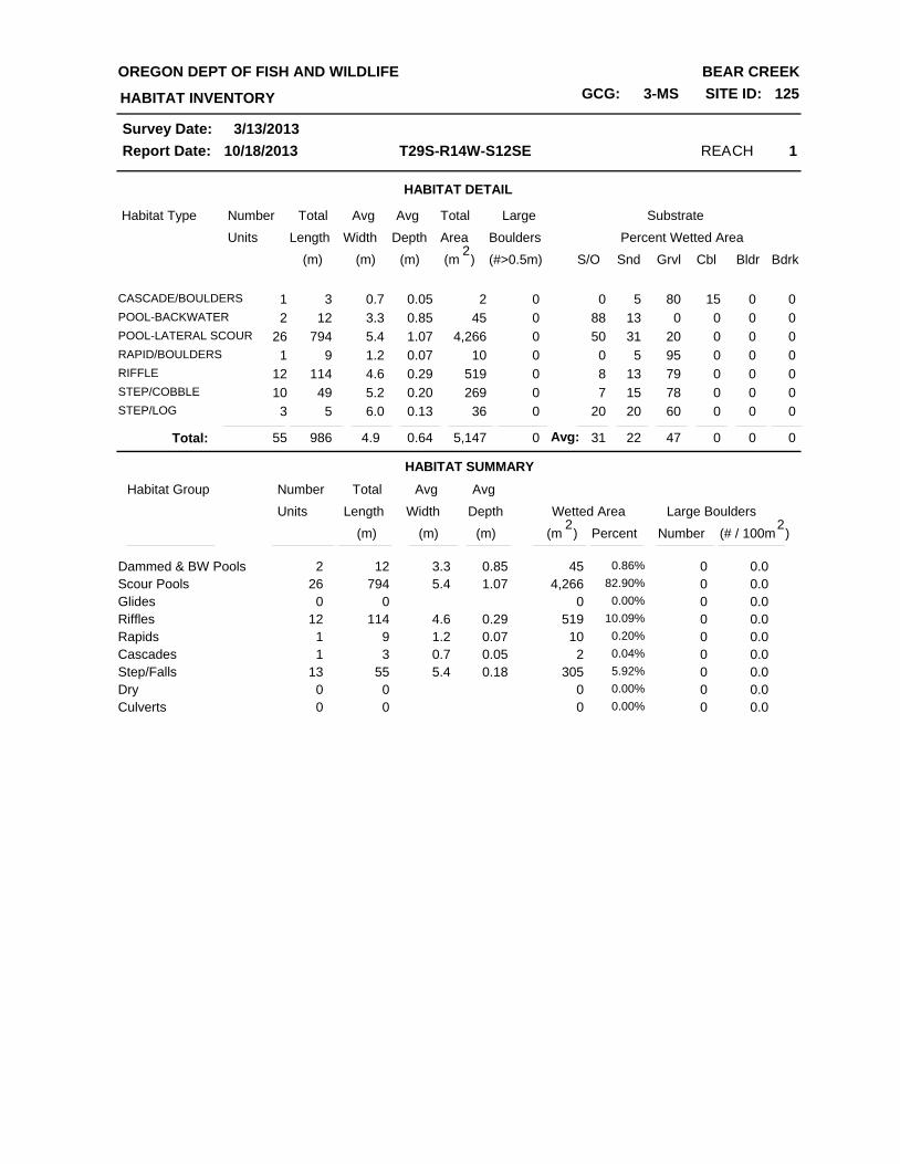
HABITAT DETAIL
Habitat Type Number Total Avg Total Large Substrate
Percent Wetted Area Units Length Width
Avg
Depth Area Boulders
(m) (m) (m) (m )2
(#>0.5m) S/O Snd Grvl Cbl Bldr Bdrk
REACH 1T29S-R14W-S12SE
HABITAT INVENTORY
Report Date: 10/18/2013
OREGON DEPT OF FISH AND WILDLIFE BEAR CREEK
GCG: 3-MS SITE ID: 125
Survey Date: 3/13/2013
1CASCADE/BOULDERS 3 0.7 0.05 2 0 0 5 80 15 0 0
2POOL-BACKWATER 12 3.3 0.85 45 0 88 13 0 0 0 0
26POOL-LATERAL SCOUR 794 5.4 1.07 4,266 0 50 31 20 0 0 0
1RAPID/BOULDERS 9 1.2 0.07 10 0 0 5 95 0 0 0
12RIFFLE 114 4.6 0.29 519 0 8 13 79 0 0 0
10STEP/COBBLE 49 5.2 0.20 269 0 7 15 78 0 0 0
3STEP/LOG 5 6.0 0.13 36 0 20 20 60 0 0 0
HABITAT SUMMARY
55 986 4.9 0.64 5,147 0 31 22 47 0 0 0Total:
Habitat Group Number Total Avg
Wetted Area Large Boulders Units Length Width
Avg
Depth
Number (m) (m) (m) )2
(# / 100mPercent
Scour Pools
Glides
Riffles
Rapids
Cascades
Step/Falls
Dry
Dammed & BW Pools 4512 3.3 0.852 0.86%
4,266794 5.4 1.0726 82.90%
000 0.00%
519114 4.6 0.2912 10.09%
109 1.2 0.071 0.20%
23 0.7 0.051 0.04%
30555 5.4 0.1813 5.92%
Culverts
000 0.00%
000 0.00%
0
0
0
0
0
0
0
0
0
0.0
0.0
0.0
0.0
0.0
0.0
0.0
(m )2
0.0
0.0
Avg:
REACH 1T29S-R14W-S12SE
HABITAT INVENTORY
Report Date: 10/18/2013
OREGON DEPT OF FISH AND WILDLIFE BEAR CREEK
GCG: 3-MS SITE ID: 125
Survey Date: 3/13/2013
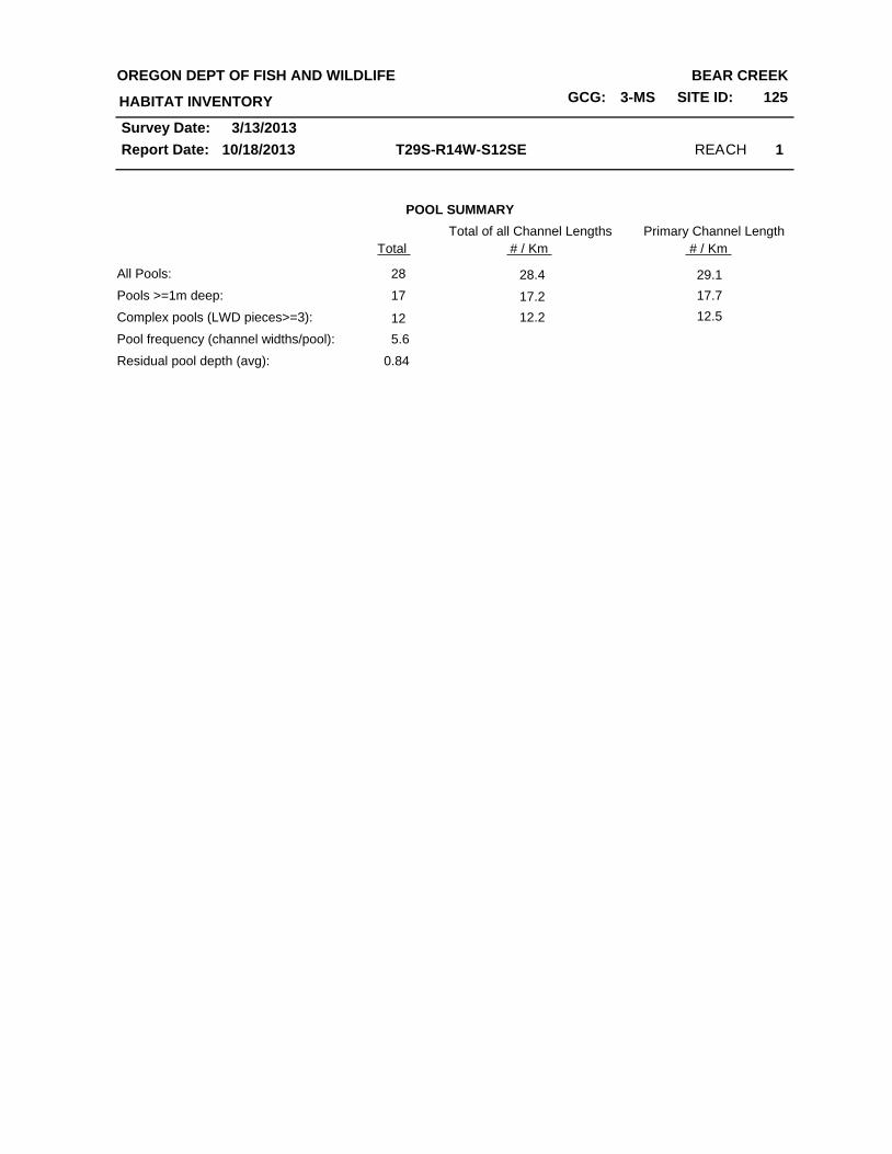
POOL SUMMARY
Total
All Pools:
Pools >=1m deep:
Complex pools (LWD pieces>=3):
Pool frequency (channel widths/pool):
28
Residual pool depth (avg): 0.84
5.6
17
12
Total of all Channel Lengths
28.4
17.2
12.2
29.1
17.7
12.5
# / Km
Primary Channel Length
# / Km
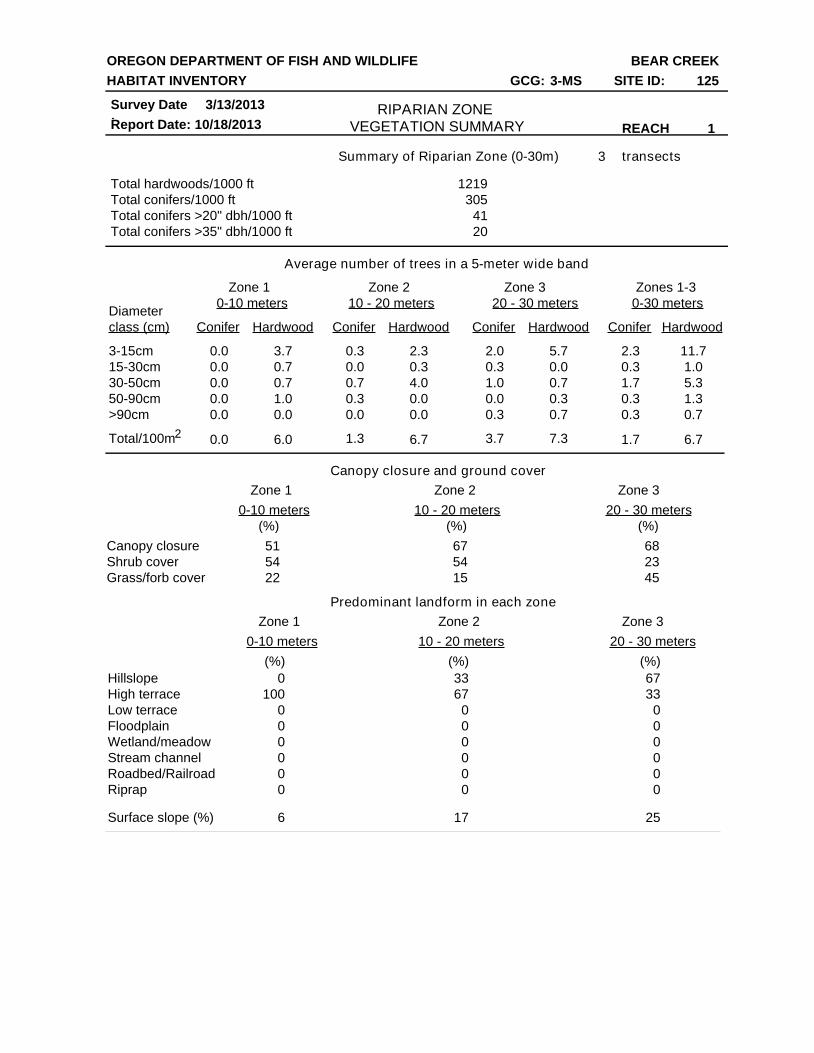
Summary of Riparian Zone (0-30m) transects
Total hardwoods/1000 ft
Total conifers/1000 ft
Total conifers >20" dbh/1000 ft
Total conifers >35" dbh/1000 ft
Average number of trees in a 5-meter wide band
Canopy closure and ground cover
Predominant landform in each zone
Zone 1 Zone 2 Zone 3 Zones 1-3
0-10 meters 10 - 20 meters 20 - 30 meters 0-30 meters
Conifer Hardwood Conifer Hardwood Conifer Hardwood Conifer Hardwood
Diameter
class (cm)
3-15cm
15-30cm
30-50cm
50-90cm
>90cm
Total/100m
Zone 1 Zone 2 Zone 3
0-10 meters 10 - 20 meters 20 - 30 meters
Zone 1 Zone 2 Zone 3
0-10 meters 10 - 20 meters 20 - 30 meters
Canopy closure
Shrub cover
Grass/forb cover
Hillslope
High terrace
Low terrace
Floodplain
Wetland/meadow
Stream channel
Roadbed/Railroad
Riprap
Surface slope (%)
3
1219
305
41
20
0.0
0.0
0.0
0.0
0.0
0.0
3.7
0.7
0.7
1.0
6.0
0.0
0.3
0.0
0.7
0.3
0.0
2.3
0.3
4.0
0.0
0.0
2.0
0.3
1.0
0.0
0.3
5.7
0.0
0.7
0.3
0.7
2.3
0.3
1.7
0.3
1.7
0.3
11.7
1.0
5.3
1.3
6.7
0.7
51
54
22
67
54
15
68
23
45
0
100
0
0
0
0
0
0
33
67
0
0
0
0
0
0
67
33
0
0
0
0
0
0
6 17 25
1.3 6.7 3.7 7.3
(%) (%)(%)
(%) (%)(%)
RIPARIAN ZONE VEGETATION SUMMARY REACH 1
OREGON DEPARTMENT OF FISH AND WILDLIFE
HABITAT INVENTORY
Report Date:
BEAR CREEK
10/18/2013
Survey Date:
3/13/2013
GCG: 3-MS SITE ID: 125
2
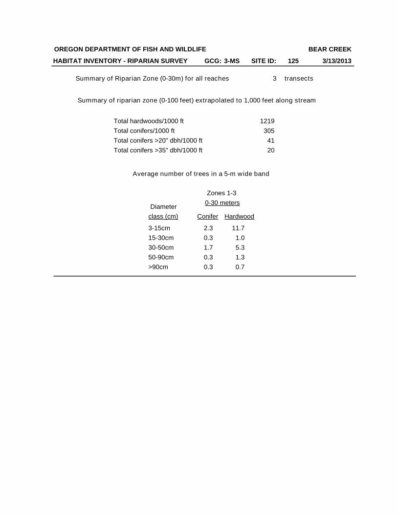
Summary of Riparian Zone (0-30m) for all reaches transects
Total hardwoods/1000 ft
Total conifers/1000 ft
Total conifers >20" dbh/1000 ft
Total conifers >35" dbh/1000 ft
3
1219
305
41
20
Zones 1-3
0-30 meters
Conifer Hardwood
2.3
0.3
1.7
0.3
0.3
11.7
1.0
5.3
1.3
0.7
Diameter
class (cm)
3-15cm
15-30cm
30-50cm
50-90cm
>90cm
Average number of trees in a 5-m wide band
OREGON DEPARTMENT OF FISH AND WILDLIFE
HABITAT INVENTORY - RIPARIAN SURVEY
BEAR CREEK
3/13/2013
Summary of riparian zone (0-100 feet) extrapolated to 1,000 feet along stream
GCG: 3-MS SITE ID: 125
3/13/2013Survey Date:10/18/2013
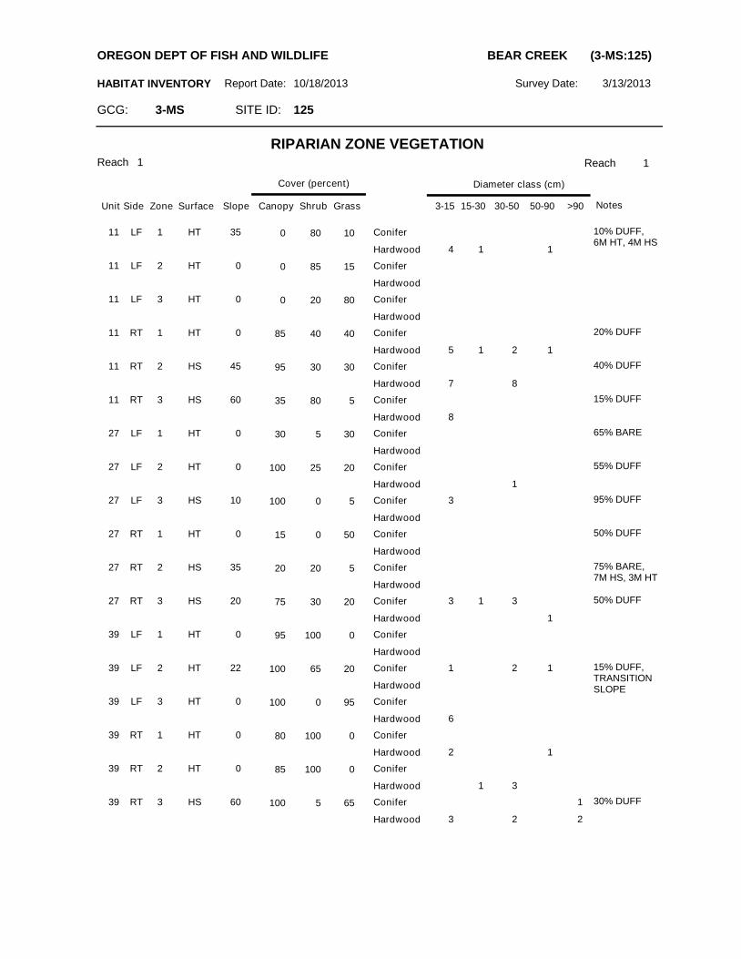
Reach 1 1
HABITAT INVENTORY Report Date:
RIPARIAN ZONE VEGETATION
Reach
Slope Canopy ShrubSurfaceZoneSideUnit
Cover (percent)
Grass 3-15 15-30 30-50 50-90 >90
Diameter class (cm)
Notes
SITE ID: 125GCG: 3-MS
OREGON DEPT OF FISH AND WILDLIFE BEAR CREEK (3-MS:125)
11 LF 1 HT 35 0 80 10
4 1 1
10% DUFF, 6M HT, 4M HS
Conifer
Hardwood
11 LF 2 HT 0 0 85 15 Conifer
Hardwood
11 LF 3 HT 0 0 20 80 Conifer
Hardwood
11 RT 1 HT 0 85 40 40
5 1 2 1
20% DUFFConifer
Hardwood
11 RT 2 HS 45 95 30 30
7 8
40% DUFFConifer
Hardwood
11 RT 3 HS 60 35 80 5
8
15% DUFFConifer
Hardwood
27 LF 1 HT 0 30 5 30 65% BAREConifer
Hardwood
27 LF 2 HT 0 100 25 20
1
55% DUFFConifer
Hardwood
27 LF 3 HS 10 100 0 5 3 95% DUFFConifer
Hardwood
27 RT 1 HT 0 15 0 50 50% DUFFConifer
Hardwood
27 RT 2 HS 35 20 20 5 75% BARE, 7M HS, 3M HT
Conifer
Hardwood
27 RT 3 HS 20 75 30 20 3 1 3
1
50% DUFFConifer
Hardwood
39 LF 1 HT 0 95 100 0 Conifer
Hardwood
39 LF 2 HT 22 100 65 20 1 2 1 15% DUFF, TRANSITION SLOPE
Conifer
Hardwood
39 LF 3 HT 0 100 0 95
6
Conifer
Hardwood
39 RT 1 HT 0 80 100 0
2 1
Conifer
Hardwood
39 RT 2 HT 0 85 100 0
1 3
Conifer
Hardwood
39 RT 3 HS 60 100 5 65 1
3 2 2
30% DUFFConifer
Hardwood
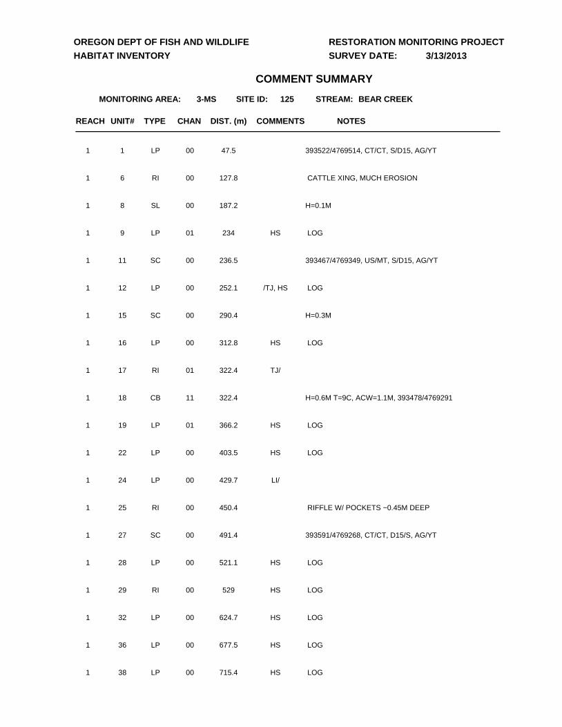
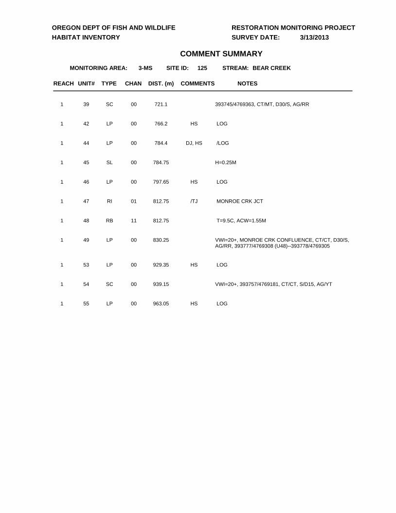
UNIT# TYPE CHAN DIST. (m) NOTES
3-MS 125 BEAR CREEK
COMMENTS
MONITORING AREA: SITE ID:
OREGON DEPT OF FISH AND WILDLIFE
HABITAT INVENTORY
RESTORATION MONITORING PROJECT
SURVEY DATE:
STREAM:
COMMENT SUMMARY
3/13/2013
REACH
1 LP 00 47.5 393522/4769514, CT/CT, S/D15, AG/YT 1
6 RI 00 127.8 CATTLE XING, MUCH EROSION1
8 SL 00 187.2 H=0.1M 1
9 LP 01 234 LOGHS1
11 SC 00 236.5 393467/4769349, US/MT, S/D15, AG/YT 1
12 LP 00 252.1 LOG/TJ, HS1
15 SC 00 290.4 H=0.3M 1
16 LP 00 312.8 LOGHS1
17 RI 01 322.4 TJ/1
18 CB 11 322.4 H=0.6M T=9C, ACW=1.1M, 393478/47692911
19 LP 01 366.2 LOGHS1
22 LP 00 403.5 LOGHS1
24 LP 00 429.7 LI/1
25 RI 00 450.4 RIFFLE W/ POCKETS ~0.45M DEEP1
27 SC 00 491.4 393591/4769268, CT/CT, D15/S, AG/YT 1
28 LP 00 521.1 LOGHS1
29 RI 00 529 LOGHS1
32 LP 00 624.7 LOGHS1
36 LP 00 677.5 LOGHS1
38 LP 00 715.4 LOGHS1
UNIT# TYPE CHAN DIST. (m) NOTES
3-MS 125 BEAR CREEK
COMMENTS
MONITORING AREA: SITE ID:
OREGON DEPT OF FISH AND WILDLIFE
HABITAT INVENTORY
RESTORATION MONITORING PROJECT
SURVEY DATE:
STREAM:
COMMENT SUMMARY
3/13/2013
REACH
39 SC 00 721.1 393745/4769363, CT/MT, D30/S, AG/RR 1
42 LP 00 766.2 LOGHS1
44 LP 00 784.4 /LOGDJ, HS1
45 SL 00 784.75 H=0.25M 1
46 LP 00 797.65 LOGHS1
47 RI 01 812.75 MONROE CRK JCT/TJ1
48 RB 11 812.75 T=9.5C, ACW=1.55M1
49 LP 00 830.25 VWI=20+, MONROE CRK CONFLUENCE, CT/CT, D30/S, AG/RR, 393777/4769308 (U48)--393778/4769305
1
53 LP 00 929.35 LOGHS1
54 SC 00 939.15 VWI=20+, 393757/4769181, CT/CT, S/D15, AG/YT 1
55 LP 00 963.05 LOGHS1
D
D
#*
#* 125125
393000.000000
393000.000000
394000.000000
394000.000000
4769
000.00
0000
4769
000.00
0000
4770
000.00
0000
4770
000.00
0000
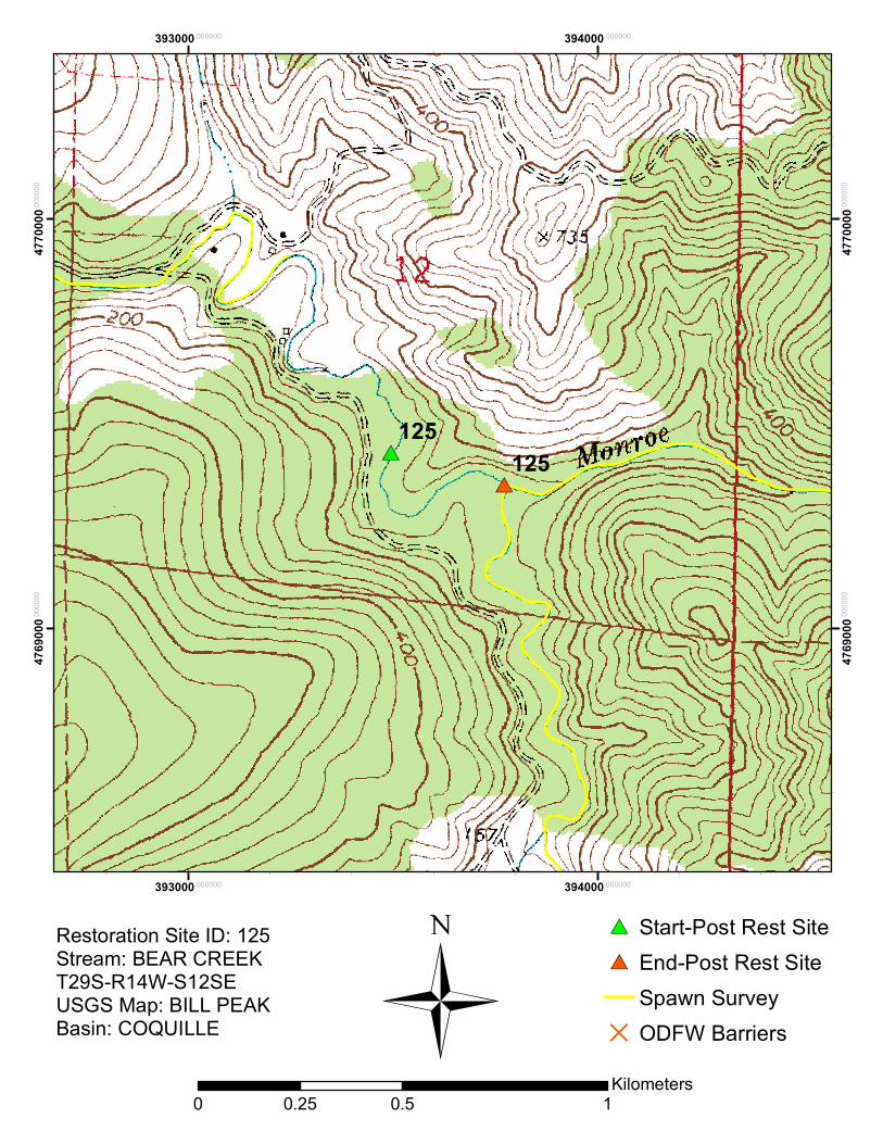
Restoration Site ID: 125Stream: BEAR CREEKT29S-R14W-S12SEUSGS Map: BILL PEAKBasin: COQUILLE
#* Start-Post Rest Site#* End-Post Rest Site
Spawn SurveyD ODFW Barriers
0 0.5 10.25Kilometers
Ü
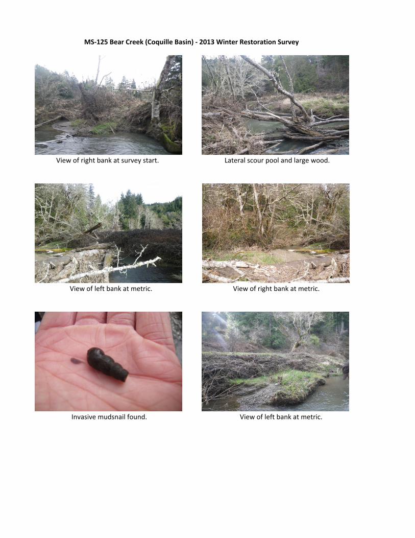
View of right bank at survey start. Lateral scour pool and large wood.
View of left bank at metric. View of right bank at metric.
Invasive mudsnail found. View of left bank at metric.
MS‐125 Bear Creek (Coquille Basin) ‐ 2013 Winter Restoration Survey