Ocean Colour Remote Sensing in Turbid Waters Lecture 3 ...
23
IOCCG Summer School 2014 “Ocean Colour remote sensing in turbid coastal waters” (c) Kevin Ruddick, OD Nature, RBINS 2014 Ocean Colour Remote Sensing in Turbid Waters Lecture 3 (Applications, Conclusions, The Future) by Kevin Ruddick with support from RBINS/REMSEM researchers, past and present (Ana Dogliotti, Bouchra Nechad, Griet Neukermans, Youngje Park, Dimitry Vanderzande, Quinten Vanhellemont, Barbara Van Mol) and BELCOLOUR project partners
Transcript of Ocean Colour Remote Sensing in Turbid Waters Lecture 3 ...

IOCCG Summer School 2014 “Ocean Colour remote sensing in turbid coastal waters” (c) Kevin Ruddick, OD Nature, RBINS 2014
Ocean Colour Remote Sensing inTurbid Waters
Lecture 3(Applications, Conclusions, The Future)
by Kevin Ruddick
with support from RBINS/REMSEM researchers, past and present
(Ana Dogliotti, Bouchra Nechad, Griet Neukermans, YoungjePark, Dimitry Vanderzande, Quinten Vanhellemont, Barbara
Van Mol) and BELCOLOUR project partners

IOCCG Summer School 2014 “Ocean Colour remote sensing in turbid coastal waters” (c) Kevin Ruddick, OD Nature, RBINS 2014
APPLICATIONS
Some examples in turbid coastal waters(very Belgian-focussed)

IOCCG Summer School 2014 “Ocean Colour remote sensing in turbid coastal waters” (c) Kevin Ruddick, OD Nature, RBINS 2014
App #1: Coastal eutrophication
• Eutrophication = excessive supply of nutrients (e.g. fromagriculture/industry/homes via rivers)
• Water quality monitoring (EU Water Framework Directive)
CHLa 90 percentile (MERIS,2005)Belgian CHLa 90% Mar-Oct 2005-2010,
Water Framework Directive product
[Image: D. Vanderzande]

IOCCG Summer School 2014 “Ocean Colour remote sensing in turbid coastal waters” (c) Kevin Ruddick, OD Nature, RBINS 2014
App #2, Coastal water quality monitoring
• e.g. Monthly mean chlorophyll a (April 2003-2005) [Y.Park, MARCOAST project]
Full MERIS data Subsampled MERIS data
=> Seaborne sampling can be reduced from ~20 points to about 9
Main limitations are:• Chlorophyll a is just one of many aspects of coastal water quality (heavy metals, organic pollutants, etc.)• Quality of CHL a data may be suspect in coastal waters: effects of CDOM and Non-algae Particles ...• ... especially very close to coast (<1 nautical mile): atmospheric correction problems inc. adjacency effects
Future perspectives:• Improvement of spatial resolution (1km ... 300m)• Improvement of processing close to coast• Improvement of quality control, flagging suspect data

IOCCG Summer School 2014 “Ocean Colour remote sensing in turbid coastal waters” (c) Kevin Ruddick, OD Nature, RBINS 2014
App #3. Harmful Algae Blooms
• Level 1 (RGB TOA) or CHL a maps• e.g. Baltic Nodularia spumigena [Kahru, MODIS-AQUA]
~150km
Main limitations are:• No species information (in general)• Toxic/harmful species may not dominate• Surface information only• HABs in estuaries, lakes, ports may have small size (<1km)
Future perspectives:• Integration with in situ species information from moorings/continuous "ferrybox" flow cytometer instruments• Integration with ecosystem models

IOCCG Summer School 2014 “Ocean Colour remote sensing in turbid coastal waters” (c) Kevin Ruddick, OD Nature, RBINS 2014
App #4, Aquaculture/fisheries
• Satellite images show spatial variability of Chl a concentration (potential food for aquaculture)
[MERIS April 2003-2005; processed by Y. Park]
Main limitations are:• Economic factors are dominant • Fish/Shellfish production may be weakly correlated with Chlorophyll a• Surface information only• Remotely sensed Chlorophyll a quality
Future perspectives:• Integration with fish/shellfish productionecosystem models

IOCCG Summer School 2014 “Ocean Colour remote sensing in turbid coastal waters” (c) Kevin Ruddick, OD Nature, RBINS 2014
App #5, Sediment transport
• E.g. sediment transport model results from RBINS-SUMO team • Satellite TSM data used for initialisation and surface validation
Main limitations are:• Near-surface TSM only (no info on bottom erosion/deposition and bed transport)• Daily data available cheap/free for 1km (… 250m-MODIS/MERIS) BUT smaller scale apps less frequent, more expensive (ASTER, SPOT, LANDSAT, RapidEye, airborne, etc.) and more difficult to process (atmospheric correction!)
Future perspectives:• Closer integration with sediment transport model• Very high resolution data easier to obtain (small satellites, Unmanned Airborne Vehicules)?• Particle size as well as concentration?

IOCCG Summer School 2014 “Ocean Colour remote sensing in turbid coastal waters” (c) Kevin Ruddick, OD Nature, RBINS 2014
App #6 Ecosystem Modelling (eutrophication)
• 3D-MIRO&CO model [Lancelot et al, 2005; Lacroix et al, 2007]
ECOSYSTEM MODEL
calculates Primary Production
Meteo. info
e.g. PAR
calculate PAR (light) availability in water column
PAR attenuation (/m), annual average [Ruddick and Lacroix, 2008; COMETS]
Main limitations are:• Limited temporal resolution
Future perspectives:• Synergy remote sensing/model• Synergy polar/geostationary
TSM (KPAR) forcing
CHL validation

IOCCG Summer School 2014 “Ocean Colour remote sensing in turbid coastal waters” (c) Kevin Ruddick, OD Nature, RBINS 2014
App #7 – Fish biology• Wavelength of maximally
transmitted light (WMTL) may affect genetic adaptation of fish
• Possible future applications: link between light climate (habitat) and visual predators? e.g. Rio de La Plata Estuary, Argentina
[Larmuseau et al, 2009]
[Dogliotti et al, 2011]

IOCCG Summer School 2014 “Ocean Colour remote sensing in turbid coastal waters” (c) Kevin Ruddick, OD Nature, RBINS 2014
MiscellaneousData Processing in turbid waters
IOCCG Summer School 2014 “Ocean Colour remote sensing in turbid coastal waters” (c) Kevin Ruddick, OD Nature, RBINS 2014
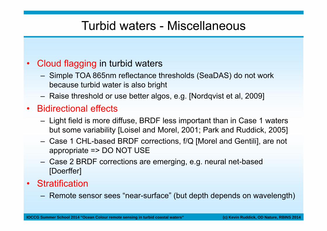
Turbid waters - Miscellaneous
• Cloud flagging in turbid waters– Simple TOA 865nm reflectance thresholds (SeaDAS) do not work
because turbid water is also bright– Raise threshold or use better algos, e.g. [Nordqvist et al, 2009]
• Bidirectional effects– Light field is more diffuse, BRDF less important than in Case 1 waters
but some variability [Loisel and Morel, 2001; Park and Ruddick, 2005]– Case 1 CHL-based BRDF corrections, f/Q [Morel and Gentili], are not
appropriate => DO NOT USE– Case 2 BRDF corrections are emerging, e.g. neural net-based
[Doerffer]
• Stratification– Remote sensor sees “near-surface” (but depth depends on wavelength)

IOCCG Summer School 2014 “Ocean Colour remote sensing in turbid coastal waters” (c) Kevin Ruddick, OD Nature, RBINS 2014
MERIS image 31.3.2004 (quasi true colour)MERIS image 31.3.2004 (Suspended matter)
Miscellaneous
• Quality flagging and product uncertainty estimation are growing research field:– E.g. a) Spectral fit-based uncertainty, b) multitemporal EOF
[Sirjacobs et al, 2011], c) multi-factor a priori uncertainty estimation
MERIS image 31.3.2004 (suspended matter QCed)
e.g. MERIS Product Confidence Flag [Processing: Y.Park]

IOCCG Summer School 2014 “Ocean Colour remote sensing in turbid coastal waters” (c) Kevin Ruddick, OD Nature, RBINS 2014
DINEOF
Mean = log10(µg/l)Spatial Modes
Temporal Modes
Singular Values
RECOLOUR project REconstruction of COLOUR scenes
Filling clouds … and quality control [Sirjacobs et al, 2011]
D. Sirjacobs, et al. Cloud filling of ocean color and sea surface temperature remote sensing products over the Southern North Sea by the Data Interpolating Empirical Orthogonal Functions methodology. Journal of Sea Research, 65(1):114-130. 2011.

IOCCG Summer School 2014 “Ocean Colour remote sensing in turbid coastal waters” (c) Kevin Ruddick, OD Nature, RBINS 2014
CONCLUSIONS and FUTURE PERSPECTIVES

IOCCG Summer School 2014 “Ocean Colour remote sensing in turbid coastal waters” (c) Kevin Ruddick, OD Nature, RBINS 2014
Ocean colour remote sensing in turbid waters
Capabilities Limitations Research
Parameter TSM, CHLA, Kd Just TSM, CHLa, KdNo vertical structureNo flux info
Size? Organic?ModelsModels
Temporal ~Daily since 2003Near Real Time (~2h)
Clouds!No tidal info
GeostationaryGeostatistics
Spatial 300m-1000km
Conc. 0.1-500 g/m3 Extreme high conc. Short Wave IR
Accuracy Absolute: 30-50% TSM?Relative: good
Particle optics/mass
Issues Near land (~1km)Atmospheric Corr.CHL in turbid waters
Adjacency algosSWIR/Geostats/…
e.g. MERIS/MODIS, different for airborne or high res satellite

IOCCG Summer School 2014 “Ocean Colour remote sensing in turbid coastal waters” (c) Kevin Ruddick, OD Nature, RBINS 2014
Optical Remote Sensing – future systems
Platform Sensor
Processing/DistributionRemote Sensing Reflectance
0.000
0.010
0.020
0.030
0.040
400 450 500 550 600 650 700 750 800
Wavelength (nm)

IOCCG Summer School 2014 “Ocean Colour remote sensing in turbid coastal waters” (c) Kevin Ruddick, OD Nature, RBINS 2014
Optical Remote Sensing – future systems
Platform Geostationary
Hourly GOCI data since 2010 (Korea/Japan/China)
For Europe in 2020 …or earlier?
Pointable minisats
e.g. Rapideye: daily revisit, 5m
Unmanned airborne
OCTOCOPTER
[terraluma.net]
GATEWING X100
[www.gatewing.com]

IOCCG Summer School 2014 “Ocean Colour remote sensing in turbid coastal waters” (c) Kevin Ruddick, OD Nature, RBINS 2014
• TSM dynamics: tidal resuspension, advection of river plumes, etc.
[Ruddick et al 2012. Variability of suspended particulate matter in the Bohai Sea from the Geostationary Ocean Imager (GOCI). Ocean Science Journal. 47(3):331-345]
Bohai Sea (<60m)
GOCI
12.6.2011
00:16 UTC01:16 UTC02:16 UTC03:16 UTC04:16 UTC05:16 UTC06:16 UTC07:16 UTC
00:1601:1602:1603:1604:1605:1606:1607:16
120°E 124°E
40°N
38°N
Total Suspended Matter [gm-3]
200kmCHINA
NK
Outlier data

IOCCG Summer School 2014 “Ocean Colour remote sensing in turbid coastal waters” (c) Kevin Ruddick, OD Nature, RBINS 2014
Daily Average Total Suspended Matter [gm-3] Number of pixels in day
GOCI imagery for Bohai Sea, 12.6.2011200km
[Ruddick et al 2012. Variability of suspended particulate matter in the Bohai Sea from the Geostationary Ocean Imager (GOCI). Ocean Science Journal. 47(3):331-345]

IOCCG Summer School 2014 “Ocean Colour remote sensing in turbid coastal waters” (c) Kevin Ruddick, OD Nature, RBINS 2014
• Coefficient of Variation over day => natural or artificialvariability
• Relevant for automatic outlier detection?
GOCI imagery for Bohai Sea, 12.6.2011
Total Suspended Matter, Coefficient of Variation = Standard Deviation/Mean
≥2 pixels/day ≥4 pixels/day
[Ruddick et al 2012. Variability of suspended particulate matter in the Bohai Sea from the Geostationary Ocean Imager (GOCI). Ocean Science Journal. 47(3):331-345]
Look at other papers in GOCI Special Issue of Ocean Science Journal 47(3), 2012 edited by Ryu and Ishizaka

IOCCG Summer School 2014 “Ocean Colour remote sensing in turbid coastal waters” (c) Kevin Ruddick, OD Nature, RBINS 2014
CONCLUSIONS
• Turbid waters have high socio-economic importance– User need => more intensive use of r/s for science, monitoring, etc.
• Processing problems include:– CHL retrieval in presence of high non-algal particle absorption– Aerosol correction where near infrared marine reflectance non-zero
• Many new algorithms are products are emerging:– Inherent Optical Properties– Spectral and PAR diffuse attenuation, turbidity– Specific phytoplankton blooms– Quality and/or uncertainity estimates
• What does the future hold?– High frequency data from geostationary (SEVIRI, GOCI, …)– More and more information on particles (size, type, organic content…)– High spatial resolution (Landsat-8, Rapideye, Sentinel-2, Pléiades, Unmanned
Airborne Vehicles)– Hardware improvements very fast …

IOCCG Summer School 2014 “Ocean Colour remote sensing in turbid coastal waters” (c) Kevin Ruddick, OD Nature, RBINS 2014
Very high res sats, e.g. Pléiades2 pointable sats,up to daily, 2m multisp., 50cm panchro, <1000€ for 100km2
Port of Zeebrugge 17.7.2014ATCOR and SPM retrieval feasible[Processing: Q. Vanhellemont]

IOCCG Summer School 2014 “Ocean Colour remote sensing in turbid coastal waters” (c) Kevin Ruddick, OD Nature, RBINS 2014
Acknowledgements
• Much of the content provided here was funded by the Belgian Science Policy Office (BELSPO) BELCOLOUR-2 project
• NASA, ESA and KORDI/KOSC for MODIS-AQUA, Meris and GOCI data


![Classifying Natural Waters with the Forel-Ule Colour Index ......Classifying Natural Waters with the Forel-Ule Colour ... that has a longstanding history [2,6,7] and a standard output](https://static.fdocuments.in/doc/165x107/6110de5fa9a98235401b5afc/classifying-natural-waters-with-the-forel-ule-colour-index-classifying-natural.jpg)